Embed Size (px)
Citation preview

Issue No: 1
NGR: TR 364 657
Planning Ref: TH/08/TEMP/0014
Client: William Verry Ltd
August 2008
Archaeological Evaluation Report
Arc
ha
eo
log
ica
l Eva
lua
tion
Re
po
rt
Portal House SchoolPortal House School
NewingtonNewington
KentKent
o a

Client Name: William Ltd
Client Ref No:
Document Title: Portal House School, Kent
Document Evaluation
Issue Number:
National Grid Reference: TR 364 657 Planning Reference: 14
OA Job Number: 3985Site Code: Invoice Code: KSReceiving Museum: TBC see archivesMuseum Accession No: TBC see archives
Prepared by: Position:Date:
Neil Lambert Supervisor8th August 2008
Checked by: Alan HardyPosition: Senior Project ManagerDate: 8th August 2008
Approved by: Nick ShepherdPosition: Head of FieldworkDate: 8th August 2008
Document File Location Schools
Graphics File Location HouseSchool,
Illustrated by Amy Tiffany Hemingway
Disclaimer:This has been prepared for the tilled project or part thereof and should not be relied upon or used forany other project without an independent check being carried out as its suitability and prior authority of
Oxford Archaeology being obtained. Archaeology accepts no responsibility or liability for the ofthis being used for a purpose other than the purposes for it commissioned.Any usingor relying on the document for such other purposes agrees, and by use or be taken to theiragreement to Oxford Archaeology for all loss or Oxford Archaeology accepts noresponsibility or liability for this to any party other than the by it commissioned.
Oxford ArchaeologyOxford ArchaeologicalUnit Ltd 2008
Janus House Osney Mead Oxford OX2 OES(0044) 01865 263800 e: [email protected] (0044)01865793496 w: www.oxfordarch.co.uk
Oxford Archaeological Unit Limited is a Registered Charity No: 285627

Oxford Archaeology Portal House School KS1RPH08
Archaeological Evaluation Report
© Oxford Archaeological Unit Ltd. May 2008\\Server1\projects\Kent Schools\Evaluation Fieldwork\7_William Verry Construction\Portal House\EvalRep\PH eval
report.doc
i
Portal House School
Newington
Kent
NGR TR 364 657
ARCHAEOLOGICAL EVALUATION REPORT
CONTENTS
Summary ................................................................................................................................... 1
1 Introduction ....................................................................................................................... 1
1.1 Location and scope of work .......................................................................................... 1
1.2 Geology and topography ............................................................................................... 1
2 Archaeological and historical background ........................................................................ 1
2.2 Introduction ................................................................................................................... 1
2.3 Previous archaeological work........................................................................................ 2
2.4 Known archaeology....................................................................................................... 2
3 Evaluation Aims ................................................................................................................ 5
4 Evaluation Methodology ................................................................................................... 5
4.1 Scope of fieldwork ........................................................................................................ 5
4.2 Fieldwork methods and recording ................................................................................. 5
4.3 Finds .............................................................................................................................. 5
4.4 Palaeo-environmental evidence..................................................................................... 5
5 Results ............................................................................................................................... 5
5.1 Description of Trenches ................................................................................................ 5
5.2 Finds .............................................................................................................................. 6
5.3 Palaeo-environmental remains ...................................................................................... 6
6 Discussion and Interpretation ............................................................................................ 7
Appendix 1 Archaeological Context Inventory..................................................................... 8
Appendix 2 Worked Flint...................................................................................................... 9
Appendix 3 Summary of Site Details.................................................................................. 10
LIST OF FIGURES
Fig. 1 Site location
Fig. 2 Excavated trench layout at Portal House
Fig. 3 Trench 2 plan and sections

Oxford Archaeology Portal House School KS1RPH08
Archaeological Evaluation Report
© Oxford Archaeological Unit Ltd. May 2008\\Server1\projects\Kent Schools\Evaluation Fieldwork\7_William Verry Construction\Portal House\EvalRep\PH eval
report.doc
1
SUMMARY
Between 7th and 11th April Oxford Archaeology (OA) carried out a field
evaluation at Portal House School, Newington, Kent (formerly Newington
Infant School) on behalf of Land Securities Trillium (NGR TR 364 657).
The evaluation consisted of eight mechanically excavated trenches. Of
these, only one contained any features of any archaeological significance.
Trench 2 contained two linear features and the base of a small pit or
posthole. The only recovered finds were worked and burnt flint from one
of the linear features.
1 INTRODUCTION
1.1 Location and scope of work
1.1.1 Between 7th and 11th April 2008 Oxford Archaeology (OA) carried out a field
evaluation at Portal House School, Newington, Kent (Fig. 1) on behalf of Land
Security Trillium in respect of a planning application for redevelopment of the school
(Formerly Newington Infant) and in accordance with a specification set by Kent
County Council. The development site is centred on NGR TR 364 657 and is c 2.9
hectares in area.
1.2 Geology and topography
1.2.1 The underlying geology of the site is Cretaceous Upper Chalk, which is overlain at
the north-east end of the site by Pleistocene and recent Head Brickearth (older), and
in the north-west by Pleistocene and recent Head Brickearth (younger) (GSGB, 1980,
Sheet 274). The site is located at an approximate height of 43 m OD, and slopes
gently from the north-east to the south west.
2 ARCHAEOLOGICAL AND HISTORICAL BACKGROUND
2.1.1 The following background is summarised from the desk-based assessment report (OA
2007).
2.2 Introduction
2.2.1 There is one Scheduled Monument within the study area, an Anglo Saxon cemetery
(SAMKE250 c 903 m south-west of the site). There are no Registered Parks or
Gardens or Historic Battlefields within the site or the wider study area.
2.2.2 There are no Listed Buildings within the site. The nearest Listed Building is over 600
m to the south There are also two non-listed Historic Buildings recorded in the
National Monuments Record (NMR) and County Heritage Environment Record
(HER).
Oxford Archaeology Portal House School KS1RPH08
Archaeological Evaluation Report
© Oxford Archaeological Unit Ltd. May 2008\\Server1\projects\Kent Schools\Evaluation Fieldwork\7_William Verry Construction\Portal House\EvalRep\PH eval
report.doc
2
2.3 Previous archaeological work
2.3.1 There have been no recorded archaeological investigations within the site, but twelve
within the wider study area. Five of these investigations recorded no significant
archaeological remains, three recorded prehistoric activity, three recorded Roman
activity, one recorded medieval artefacts , and one recorded only undated features.
2.4 Known archaeology
2.4.1 The HER and NMR do not record any archaeological entities within the site. Map
regression has highlighted the presence of a post-medieval chalk pit and various field
boundaries.
The Palaeolithic and Mesolithic periods (c 500,000 BC to 4000 BC)
2.4.2 Palaeolithic populations were hunter-gatherers. Little remains to indicate Palaeolithic
communities apart from artefacts mainly consisting of stone tools and animal remains.
Many of these are likely to have been disturbed from their original depositional
sequence by later glacial, riverine, estuarine and human activity.
2.4.3 There is extensive evidence for Lower Palaeolithic activity in Kent. Many flint
collections have been retrieved from the Thames gravels, whilst other rivers in Kent
have also produced Palaeolithic material. Hominid presence was not limited to the
river courses, however, with artefacts dating to the Palaeolithic period having been
found as surface finds in east and west Kent.
2.4.4 There are no archaeological artefacts or features of the Palaeolithic period recorded
within the site or study area.
2.4.5 Evidence for early and mid Mesolithic activity is more common but still, in the main,
comprises isolated surface finds or artefacts retrieved from rivers. By the later
Mesolithic period, microliths (very small flint tools) were geometric in shape, and
there have been many discoveries throughout Kent of artefacts of this nature. These
finds are among the most common of any phase of post-glacial hunter gatherer
activity in Kent, and may indicate an increase in population during this time.
2.4.6 Mesolithic activity within the study area is indicated by the discovery of a Mesolithic
Thames pick, found in 1962 c 605m to the south of the site.
The Neolithic period (c 4000-2400 BC)
2.4.7 The emergence of the settled farming societies of the Neolithic period was a gradual
process, with certain areas developing faster than others. Kent appears to have been
one of the first to undergo the transition.
2.4.8 There are no archaeological artefacts or features of the Neolithic period recorded
within the site. Within the wider study area a crouched inhumation of the Neolithic

Oxford Archaeology Portal House School KS1RPH08
Archaeological Evaluation Report
© Oxford Archaeological Unit Ltd. May 2008\\Server1\projects\Kent Schools\Evaluation Fieldwork\7_William Verry Construction\Portal House\EvalRep\PH eval
report.doc
3
period was found in a pit alongside the disarticulated remains of a second individual c
640 m south of the site.
The Bronze Age (c 2400-700 BC)
2.4.9 During the Bronze Age, increasing population occurred alongside an intensification
of land use and a change in farming methods. Natural divisions of land such as river
lines and ridges became more important as boundaries, and rivers became important
communication routes. This is apparent in Kent, as the settlements within the Thames
Valley became politically and socially dominant, and there was a dramatic growth in
settlement throughout the region.
2.4.10 There are no recorded archaeological artefacts or features from the Bronze Age
period within the site. Within the wider study area, however, there is much evidence
for Bronze Age activity. The closest of which are Bronze Age crouched inhumations
located c 100m south east of the site).
The Iron Age (c 700BC- AD 43)
2.4.11 During the Early Iron Age, traces of settlement have been found mainly concentrated
in eastern Kent, specifically on the Isle of Thanet and other coastal areas. Middle
Iron Age settlements are noticeably rare throughout the county, but an expansion in
population during the Late Iron Age is reflected in a widespread settlement of Kent.
2.4.12 Despite the regional pattern, there is very little evidence for Iron Age activity within
the study area, which is in contrast to the large amount of Bronze Age and Roman
activity. The only recorded features of this period are two pits amongst a series of
cropmark field enclosures, located some 650 m to the south of the site.
The Romano-British Period (AD 43-410)
2.4.13 During the Roman period, the Wantsum Channel, a topographic depression separating
the Isle of Thanet from the rest of Kent, was a river open at both ends to the sea,
making the Isle of Thanet an island. The fort of Regulbium (Reculver) and Rutupiae
(Richborough) were built to protect the contemporary eastern coast of mainland Kent.
2.4.14 There are many known villas throughout western Kent, but noticeably fewer in
eastern Kent, with the exception of the Isle of Thanet where at least nine are known.
There is one possible villa site approximately 330 m south-west of the site.
2.4.15 With this wealth of Roman activity within the Isle of Thanet it is of no surprise that
the study area is respectively rich in recorded archaeology of the Roman period.
However, there is no recorded archaeology of this period within the site.
The early medieval period (AD410-1066)
2.4.16 There is little archaeological evidence for the period following the decline of Roman
infrastructure in the 5th to 6th centuries AD. In Kent evidence for the 5th to 8th
centuries almost exclusively comes from cemeteries, which are abundant, especially
in the east of the county.

Oxford Archaeology Portal House School KS1RPH08
Archaeological Evaluation Report
© Oxford Archaeological Unit Ltd. May 2008\\Server1\projects\Kent Schools\Evaluation Fieldwork\7_William Verry Construction\Portal House\EvalRep\PH eval
report.doc
4
2.4.17 There are at least three such cemeteries within Ramsgate known to have been in use
during the early medieval period, the most extensively excavated of which, a
Scheduled Monument (SAMKE 250), lies partly within the study area. Anglo Saxon
inhumations have also been found at three other locations within the study area, one
of which lies very close to the site (c 90 m to the south-east).
2.4.18 The recorded archaeology of the early medieval period lies to the south of the site,
nearer to the coast. It is likely that the early medieval settlement was centred around
the church of St Lawrence which is located c 730 m south-east of the site.
The later medieval period (AD1066-1550)
2.4.19 The study area contains extensive evidence of later medieval activity. However, as with
the early medieval period, all of the later medieval activity is located to the south of the
study area, and is unlikely to have directly affected or encroached upon the site.
The post-medieval period (AD1550+)
2.4.20 Hall’s 1792 map of the Isle of Thanet is the earliest detailed map of the site and Study
Area to be identified. The site is clearly shown as being situated outside the
settlement centre of St Lawrence. Hasted’s map of the Isle of Thanet (1800) shows St
Lawrence to have expanded to the east and south but not to the west towards the site.
It also shows Ramsgate to have expanded to the west; the two settlements are close
to becoming one large town by this date.
2.4.21 The 1840 Tithe Map of the parish of St Lawrence-in-Thanet shows the development
site to be divided into four separate plots of land, all of which are recorded in the
accompanying Tithe Apportionment as having been utilised as arable land. It also
shows a circular feature in the south-west of the site which is also shown on
subsequent OS maps and labelled as a chalk pit. The Tithe Map also shows a lane
and field boundary, neither of which survives.
2.4.22 The 1877 1st edition OS map through to the Provisional edition OS map (1948) show
no additional features on the land occupied by the site, until the construction of
Newington Infant School in the 1950s.

Oxford Archaeology Portal House School KS1RPH08
Archaeological Evaluation Report
© Oxford Archaeological Unit Ltd. May 2008\\Server1\projects\Kent Schools\Evaluation Fieldwork\7_William Verry Construction\Portal House\EvalRep\PH eval
report.doc
5
3 EVALUATION AIMS
3.1.1 The principal objective of the evaluation was to determine the quality, character, date
and extent of any archaeological remains present on the site.
4 EVALUATION METHODOLOGY
4.1 Scope of fieldwork
4.1.1 The evaluation consisted of eight evaluation trenches. These were each 20 m long and
c. 2 m wide.
4.2 Fieldwork methods and recording
4.2.1 The overburden was removed using a mechanical excavator fitted with a toothless
bucket, working under close archaeological supervision. Excavation proceeded to the
first archaeological horizon or to undisturbed natural geology, whichever was
encountered first. The trenches were then cleaned by hand and any revealed features
were sampled to determine their extent and nature, and to retrieve finds and
environmental samples.
4.2.2 All features and deposits encountered were issued a unique context number. A plan
was drawn of each trench at a scale of 1:50, and a sample section of the edge of the
trench was drawn at a scale of 1:10. Each excavated feature was also recorded in
section at a scale of 1:10. Colour transparency and black-and-white photographs were
taken of each feature, as well as more general shots of each trench. Digital
photography was also used. All recording was conducted in accordance with the
procedures detailed in the OA Fieldwork Manual (OAU 1992).
4.3 Finds
4.3.1 Finds recovered by hand during the course of the excavation are bagged by context.
Finds of special interest, when found, are given a unique small find number.
4.4 Palaeo-environmental evidence
4.4.1 Bulk environmental samples (40 l) are collected from any suitable archaeological
deposits.
5 RESULTS
5.1 Description of Trenches
5.1.1 The evaluation comprised a total of eight trenches, which were located across the site
(Fig.2). These were used to ascertain the density of the archaeological features and
their overall condition in terms of survival and potential for further study.

Oxford Archaeology Portal House School KS1RPH08
Archaeological Evaluation Report
© Oxford Archaeological Unit Ltd. May 2008\\Server1\projects\Kent Schools\Evaluation Fieldwork\7_William Verry Construction\Portal House\EvalRep\PH eval
report.doc
6
Empty trenches
5.1.2 Of the eight trenches in this evaluation, seven were found to be devoid of
archaeological features, other than modern service trenches. (Trenches 1, 3, and 7
contained modern services, but nothing more, while Trenches 4, 5, and 8 contained
no features at all.) All of the trenches had topsoil overlying a subsoil layer. In
Trenches 7 and 8, the original ground level had been built up, presumably during
landscaping associated with the school. The buried former land surface appeared in
section as a band of topsoil.
5.1.3 Topsoil and cultivation soils were removed by machine in all trenches, to the top of
the Pleistocene/ head deposits. This was a firm mid orange brown silty clay
(102/210/302/402/503/602/703/803). It was overlain by a mid yellow brown firm
sandy clay subsoil layer (102/203/301/401/502/601/702/802).
Trenches containing archaeological features
Trench 2 (Fig. 3)
5.1.4 Trench 2 was aligned approximately E-W. It measured 20 m long and 1.7 m wide.
The average depth to the top of undisturbed Head deposits (210) was 0.72 m.
5.1.5 Layer 210 was cut by a N-S ditch (204), displaying a very shallow ‘U’ - shaped
profile and measuring 0.90 m wide x 0.20 m deep. The mid grey silty clay fill (205)
produced a small quantity of worked flint (see below).
5.1.6 To the south of ditch 204 was a second shallow gully (206), also oriented N-S and cut
into the natural (210). The gully measured up to 0.42 m wide x 0.16 m deep, and
contained a grey silty clay fill (207) that produced no finds.
5.1.7 To the south of gully 206 was a small posthole (208), measuring 0.29 m in diameter x
0.05 m deep. The grey silty clay fill (209) produced no finds.
5.1.8 All three features were sealed by a layer of grey/brown silty clay subsoil (203),
averaging 0.30 m in depth. This was in turn overlaid by a possible buried topsoil
(202), similar in character to that found in Trenches 7 and 8, and a modern levelling
layer (201) followed finally by the topsoil (201).
5.2 Finds
5.2.1 The only finds recovered from the site was a small quantity of flint material. This
included both worked and burnt pieces. They were all recovered from fill (205) of
feature 204 (Fig 3).
5.3 Palaeo-environmental remains
5.3.1 No deposits suitable for palaeo-environmental sampling were encountered.
Oxford Archaeology Portal House School KS1RPH08
Archaeological Evaluation Report
© Oxford Archaeological Unit Ltd. May 2008\\Server1\projects\Kent Schools\Evaluation Fieldwork\7_William Verry Construction\Portal House\EvalRep\PH eval
report.doc
7
6 DISCUSSION AND INTERPRETATION
6.1.1 The evaluation has shown little evidence for significant archaeological remains in the
investigated area. There was little sign of modern disturbance in any of the trenches,
but there has clearly been some truncation caused by ploughing in the past. The
archaeological features that were uncovered were all concentrated to the west of the
site in Trench 2. The features comprised a ditch, a gully and either a pit or posthole
base. They were heavily truncated and only one feature, ditch 204, contained any
artefacts, a small quantity of burnt and worked flint from ditch 204, tentatively dated
to the Neolithic period (Trench 2 Fig. 3).
6.1.2 The low concentration of archaeological features found across the site is consistent
with the fact that it has, in historical periods at least, been located at some distance
from local centres of settlement.
6.1.3 The excavation of the trenches during the course of this evaluation has shown that
recent activity is unlikely to have had a great affect on the potential survival of
archaeological features. However, agricultural activity appears to have truncated the
identified archaeology (in Trench 2). There is evidence of extensive landscaping in
the north-western part of the site, indicated by the presence of a buried topsoil in
Trenches 2 (layer 202), 7 (layer 701) and 8 (layer 801). This is most likely to have
been associated with construction of the school or subsequent landscaping of the
grounds.

Oxford Archaeology Portal House School KS1RPH08
Archaeological Evaluation Report
© Oxford Archaeological Unit Ltd. May 2008\\Server1\projects\Kent Schools\Evaluation Fieldwork\7_William Verry Construction\Portal House\EvalRep\PH eval
report.doc
8
APPENDICES
APPENDIX 1 ARCHAEOLOGICAL CONTEXT INVENTORY
Trench Ctxt
No
Type Width
(m)
Thick.
(m)
Comment Finds Date
1
100 Layer 0.36 Topsoil
101 Layer 0.14 Subsoil
102 Layer Natural
2
200 Layer 0.15 Topsoil
201 Layer 0.15 Levelling layer
202 Layer 0.25 Possible buried topsoil
203 Layer 0.30 Subsoil
204 Cut 0.94 0.22 Ditch
205 Fill 0.94 0.22 Fill of Ditch 204 Flint ?Neolithic
206 Cut 0.42 0.16 Gully
207 Fill 0.42 0.16 Fill of Gully 206
208 Cut 0.29 0.05 Pit / Posthole
209 Fill 0.29 0.05 Fill of 208
210 Layer Natural
3
300 Layer 0.40 Topsoil
301 Layer 0.28 Subsoil
302 Layer Natural
4
400 Layer 0.25 Topsoil
401 Layer 0.15 Subsoil
402 Layer Natural
5
500 Layer 0.25 Topsoil
501 Layer 0.10 Subsoil
502 Layer 0.30 Subsoil
503 Layer Natural
6
Oxford Archaeology Portal House School KS1RPH08
Archaeological Evaluation Report
© Oxford Archaeological Unit Ltd. May 2008\\Server1\projects\Kent Schools\Evaluation Fieldwork\7_William Verry Construction\Portal House\EvalRep\PH eval
report.doc
9
600 Layer 0.33 Topsoil
601 Layer 0.10 Subsoil
602 Layer Natural
7
700 Layer 0.30 Topsoil
701 Layer 0.20 Possible buried topsoil
702 Layer 0.18 Subsoil
703 Layer Natural
8
800 Layer 0.48 Topsoil
801 Layer 0.35 Possible buried topsoil
802 Layer 0.40 Subsoil
803 Layer Natural
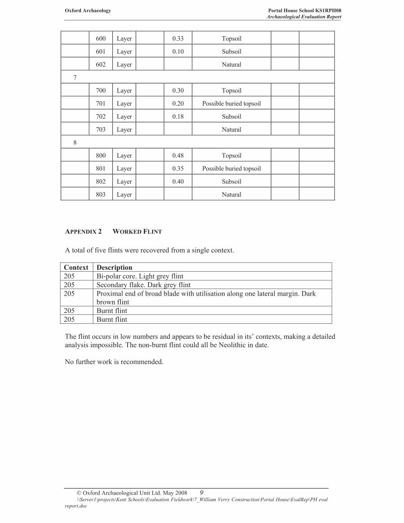
APPENDIX 2 WORKED FLINT
A total of five flints were recovered from a single context.
Context Description
205 Bi-polar core. Light grey flint
205 Secondary flake. Dark grey flint
205 Proximal end of broad blade with utilisation along one lateral margin. Dark
brown flint
205 Burnt flint
205 Burnt flint
The flint occurs in low numbers and appears to be residual in its’ contexts, making a detailed
analysis impossible. The non-burnt flint could all be Neolithic in date.
No further work is recommended.
Oxford Archaeology Portal House School KS1RPH08
Archaeological Evaluation Report
© Oxford Archaeological Unit Ltd. May 2008\\Server1\projects\Kent Schools\Evaluation Fieldwork\7_William Verry Construction\Portal House\EvalRep\PH eval
report.doc
10
APPENDIX 3 SUMMARY OF SITE DETAILS
Site name: Portal House School
Site code: KS2RPH08
Grid reference: TR 364 657
Type of evaluation: Eight 20 m x 1.7 m mechanically excavated trenches.
Date and duration of project: The fieldwork was carried out between 7th and 11th April
2008.
Summary of results: Oxford Archaeology (OA) carried out a field evaluation at Portal
House School, Newington, Kent (formerly Newington Infant School) on behalf of Land
Securities Trillium (NGR TR 364 657). The evaluation consisted of eight mechanically
excavated trenches. Of these, only one contained any archaeological features:
Trench 2 contained two shallow gullies and the base of a small pit or posthole. Residual burnt
and worked flint (tentatively dated to the Neolithic period) was found in one of the gullies;
Location of archive: The archive is currently held at OA, Janus House, Osney Mead, Oxford,
OX2 0ES, and will be deposited at a suitable local Museum in due course.


Reproduced from the Explorer 1:25,000 scale by permission of the Ordnance
Survey on behalf of The Controller of Her Majesty's Stationery Office
© Crown Copyright. All rights reserved. Licence No. AL 100005569 Figure 1: Site location
Ser
ver
go/I
thru
Q/K
EN
TS
DB
A/N
ewin
gto
n P
rim
ary S
chool,
Ram
sgat
e/G
S/2
5.0
2.0
7
FF
LONDON
OXFORD
NORWICH
BIRMINGHAM
ER
N
Site location
165000
166000
167000
635000 636000 637000 638000


Figure 3 : Trench 2 plan and sections
N
Serv
erg
o/I
thru
Q/K
S2R
PH
08/K
S2R
PH
EV
/Port
al H
ouse S
chool, N
ew
ingto
n/A
H/1
7.0
4.0
8
200
201
202
203
205
209
210
200
201
202
203
207 210210
210
210
207
210
204
206
208
210
209
205
WE
204
208
206
45.59 mOD
NWSE45.15 mOD
WE45.68 mOD
Trench 2Section 201
Trench 2Section 203
Trench 2Section 202
Trench 2Plan 200
Section 2
02
Section 203
1:25
0 1 m
Section 2
01
1:100
0 5 m


Di rec to r : D av id Jen n ing s , B A M I FA F SA
O xfo rd A rc h aeo lo g ic a l Un i t i s a
P r i va t e L im i t ed C omp an y , N o : 161 8597
and a Reg i s te red Char i t y , N o : 285 627
OA N or th
M i l l 3
M oor L ane
L anc as te r L A 1 1 GF
t : +44 ( 0 ) 1524 541 000
f : + 44 ( 0 ) 1524 848 606
e : oanor t h@ th eh um an jou r n ey .n e t
w :h t t p : / / th ehum an jou r n ey .n e t
Hea d Of f i ce/ R eg i s t e red O f f ice
Janus Hou se
O sney M ead
O xfo rd O X2 0 ES
t : +44 ( 0 ) 1865 263 800
f : + 44 ( 0 ) 1865 793 496
e : i n fo@t hehu man j ou r ney .ne t
w : h t t p : / / t h e h u m a n j o u r n e y . n e t
OA E a s t
15 T r a fa lga r Way
B ar H i l l
Cambr idgesh i re
CB23 8SQ
t : +44 (0 )1 22 3 85 05 00
f : + 44 (0 )1223 850599
e : oaeas t @t hehu man j ou r ney .ne t
w :h t t p : / / th ehum an jou r ney .ne t /o aea s t
OA Méd i te r r a n ée
115 Rue M er lo t
ZA C L a L ouvade
34 130 M aug u io
F ranc e
t : +33 ( 0 ) 4 . 67 .57 .86 .92
f : + 33 ( 0 ) 4 . 67 .42 .65 .93
e : oamed@ oamed. f r
w : h t tp : / /o am ed. f r /