Embed Size (px)
Citation preview
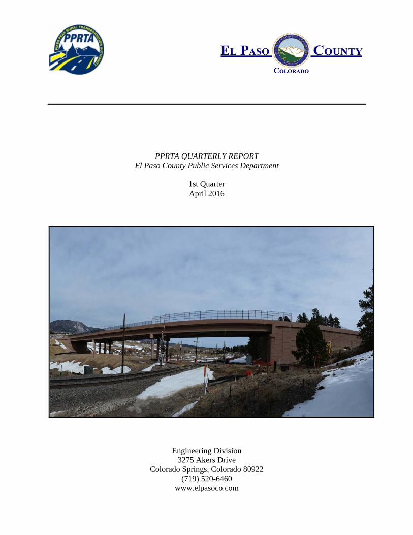
PPRTA QUARTERLY REPORT El Paso County Public Services Department
1st Quarter April 2016
Engineering Division 3275 Akers Drive
Colorado Springs, Colorado 80922 (719) 520-6460
www.elpasoco.com
2
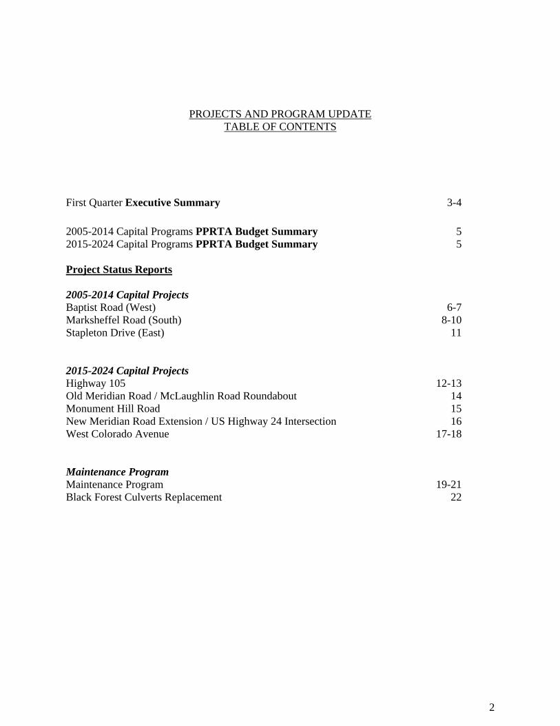
PROJECTS AND PROGRAM UPDATE
TABLE OF CONTENTS
First Quarter Executive Summary 3-4 2005-2014 Capital Programs PPRTA Budget Summary 2015-2024 Capital Programs PPRTA Budget Summary
5 5
Project Status Reports 2005-2014 Capital Projects Baptist Road (West) Marksheffel Road (South) Stapleton Drive (East) 2015-2024 Capital Projects Highway 105 Old Meridian Road / McLaughlin Road Roundabout Monument Hill Road New Meridian Road Extension / US Highway 24 Intersection West Colorado Avenue
6-7 8-10
11
12-13 14 15 16
17-18
Maintenance Program Maintenance Program Black Forest Culverts Replacement
19-21
22
3
Executive Summary The first quarter saw continued progress with the County’s PPRTA capital projects as well as significant work completed for the 2016 maintenance program. The final four El Paso County projects for the 2005-2014 capital program are advancing with Stapleton Road East substantially completed, Baptist Road West approaching substantial completion, Marksheffel Road South under construction, and Meridian Road South in the design phase. Progress continues on the initial projects of the 2015-2024 capital program with Highway 105, Meridian Road/McLaughlin Road Roundabout, Monument Hill Road, and New Meridian/US Highway 24 Intersection in various stages of design. The Baptist Road (West) project is approaching a substantial completion milestone. During this period the old bridge over Monument Creek and the former Baptist Road west of Old Denver Rd were removed and work commenced on the water quality ponds and drainage elements slated to be constructed in the old foot print of Baptist Road. Traffic has been using the new alignment and bridge since December. Wildcat Construction has progressed roadway and drainage construction on the Marksheffel South project in multiple segments of the corridor, taking advantage of completed property acquisition efforts and ongoing utility relocation efforts. Property acquisition continues to advance; however, there are still several key properties that must be obtained to allow utility relocation in the north to proceed. El Paso County will work with the contractor to maximize construction opportunities on those segments where property has been obtained, while we complete the remaining property acquisition. The Stapleton Drive (East) Extension project construction was substantially completed in the fourth quarter of 2015. The project was opened to traffic on November 18, 2015. Permit and project closeout activities continue through the first quarter of 2016. Preliminary design continues for the Highway 105 corridor with initial emphasis focused on the federally funded Project A between Woodmoor and Lake Woodmoor Drive. Environmental clearance coordination with CDOT and FHWA continues related to that segment. Preliminary design for the rest of the corridor is also underway. The preliminary design will build on the Corridor Planning/Conceptual Design effort completed by El Paso County in 2012. The design for the Old Meridian Road/McLaughlin Road Roundabout project is continuing by the El Paso County Engineering Division. This roundabout will improve the poorly aligned intersection in the Falcon Town Center, widen and upgrade Old Meridian Road to US Highway 24, and provide additional drainage and pedestrian enhancements in the surrounding area. Conceptual design for Monument Hill Road continued in the first quarter. The consultant team has finished gathering data and is now preparing the Conceptual Alternatives Report. Preliminary design of the New Meridian Road Extension/US Highway 24 Intersection is in progress, approximately 95% complete in the first quarter. Improvements include removing the
4
traffic signal at Old Meridian Road/US 24 and converting access control at this location to a right-in/right-out; and completing New Meridian Road /US 24 as a signalized intersection with adequate turn lanes at all approaches. This project is being designed and will be constructed in conjunction with the federally funded Falcon Park & Ride project and the Meridian Road Extension project, which was an “A” list project from the 2004 capital project list. The West Colorado Avenue project is a joint effort with City of Manitou Springs, City of Colorado Springs and EPC. During the first quarter, final design advanced and utility coordination continued. Project briefings were also provided to the City of Manitou City Council, City of Colorado Springs City Council and the El Paso County Board of County Commissioners. Significant work was completed in the first quarter with respect to the 2016 maintenance program. The Crack Seal Program was nearly completed and over fifty percent of the Concrete Surface Drainage Program was completed. The Concrete Surface Drainage Program completed of 14,331 linear feet of curb and gutter, 15,102 linear feet of sidewalk, 10 cross pans, and 34 pedestrian ramps. An Invitation for Bid for construction of the Black Forest Culverts Replacement project was advertised and awarded in the first quarter of 2016. El Paso County received federal-aid funds to construct the project and PPRTA maintenance funds are the local match. The project will replace two, large diameter corrugated metal pipes beneath Black Forest Road at Kettle Creek.
5
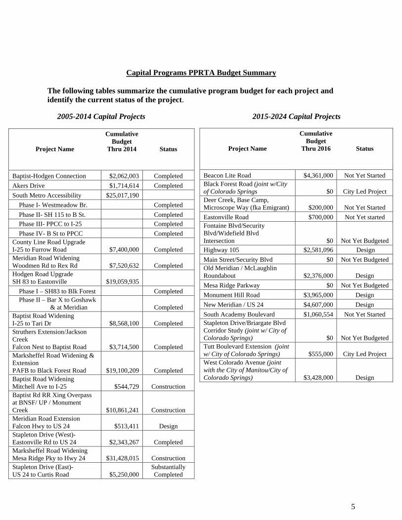
Capital Programs PPRTA Budget Summary The following tables summarize the cumulative program budget for each project and identify the current status of the project. 2005-2014 Capital Projects 2015-2024 Capital Projects
Project Name
Cumulative Budget
Thru 2014 Status
Baptist-Hodgen Connection $2,062,003 Completed
Akers Drive $1,714,614 Completed
South Metro Accessibility $25,017,190
Phase I- Westmeadow Br. Completed
Phase II- SH 115 to B St. Completed
Phase III- PPCC to I-25 Completed
Phase IV- B St to PPCC Completed County Line Road Upgrade I-25 to Furrow Road $7,400,000 Completed Meridian Road Widening Woodmen Rd to Rex Rd $7,520,632 Completed Hodgen Road Upgrade SH 83 to Eastonville $19,059,935
Phase I – SH83 to Blk Forest Completed Phase II – Bar X to Goshawk & at Meridian Completed Baptist Road Widening I-25 to Tari Dr $8,568,100 Completed Struthers Extension/Jackson Creek Falcon Nest to Baptist Road $3,714,500 Completed Marksheffel Road Widening & Extension PAFB to Black Forest Road $19,100,209 Completed Baptist Road Widening Mitchell Ave to I-25 $544,729 Construction Baptist Rd RR Xing Overpass at BNSF/ UP / Monument Creek $10,861,241 Construction Meridian Road Extension Falcon Hwy to US 24 $513,411 Design Stapleton Drive (West)- Eastonville Rd to US 24 $2,343,267 Completed Marksheffel Road Widening Mesa Ridge Pky to Hwy 24 $31,428,015 Construction Stapleton Drive (East)- US 24 to Curtis Road $5,250,000
Substantially Completed
Project Name
Cumulative Budget
Thru 2016 Status
Beacon Lite Road $4,361,000 Not Yet Started Black Forest Road (joint w/City of Colorado Springs $0 City Led Project Deer Creek, Base Camp, Microscope Way (fka Emigrant) $200,000 Not Yet Started
Eastonville Road $700,000 Not Yet started Fontaine Blvd/Security Blvd/Widefield Blvd Intersection $0 Not Yet Budgeted
Highway 105 $2,581,096 Design
Main Street/Security Blvd $0 Not Yet Budgeted Old Meridian / McLaughlin Roundabout $2,376,000 Design
Mesa Ridge Parkway $0 Not Yet Budgeted
Monument Hill Road $3,965,000 Design
New Meridian / US 24 $4,607,000 Design
South Academy Boulevard $1,060,554 Not Yet Started Stapleton Drive/Briargate Blvd Corridor Study (joint w/ City of Colorado Springs) $0 Not Yet Budgeted Tutt Boulevard Extension (joint w/ City of Colorado Springs) $555,000 City Led Project West Colorado Avenue (joint with the City of Manitou/City of Colorado Springs) $3,428,000 Design
6
Project Status Reports: 2005-2014 Capital Projects
Baptist Road (West) Project Description: This project consists of two of the A-list projects: Baptist Rd widening from Interstate 25 to Forest Lakes Drive and the Baptist Road railroad crossing at the UP/BNSF railroad. The key elements of this project include a 3 span bridge over the RR tracks and Monument Creek, retaining walls for the bridge approaches, a roundabout at the Old Denver Highway/ Baptist Rd intersection, roadway improvements to the connecting roadways, modifications to the Santa Fe trailhead parking area, drainage improvements, utility relocations, and rehabilitation and enhancement of the Prebles Meadow Jumping Mouse habitat, disturbed by the project. Project Team: Designer: Felsburg, Holt & Ullevig (FHU) Construction Manager: CH2M Hill Contractor: SEMA Construction Cost Summary: Total Project Budget $13,155,970
PPRTA budget - $11,405,970 BRRTA contribution $750,000 (supplemental to above) DOLA grant - $1,000,000
Contracts authorized - $12,985,936
Schedule summary: Complete Property Acquisition – 3rd Quarter 2015 RR Construction & Maintenance Agreement – 3rd Quarter 2015 Construction 2015/2016 (15 month duration) Utility Relocation 2015/2016 Progress/Status: During this period, the existing bridge over Monument Creek was demolished, and the
former Baptist Road west of the roundabout removed. This allowed the final utility relocation work and drainage elements to be completed in the area formerly occupied by Baptist Road. This work included grading and construction of outlet structures for the two water quality ponds that will capture and treat the project stormwater flows prior to discharging into Monument Creek.
Fencing and landscaping elements including an irrigation system are being finalized in the Santé Fe trailhead area.
Site preparation for the rehabilitation of the PMJM habitat area disturbed by the project is underway. Maintenance of this area to ensure proper growth and revegetation will continue for approximately two years.
Contractor expects to substantially complete all of the remaining work in the second quarter, approximately 1 year after construction began.
Foundations for the artwork for the roundabout area were completed. The sculptures are being fabricated and are anticipated to be installed in the second quarter.
7
Coordination with key stakeholders including the UPRR, utility companies, the Town Of Monument, and adjacent property owners continues.
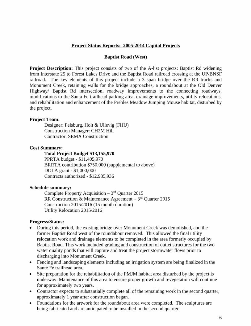
Baptist Rd –West – construction of water quality pond
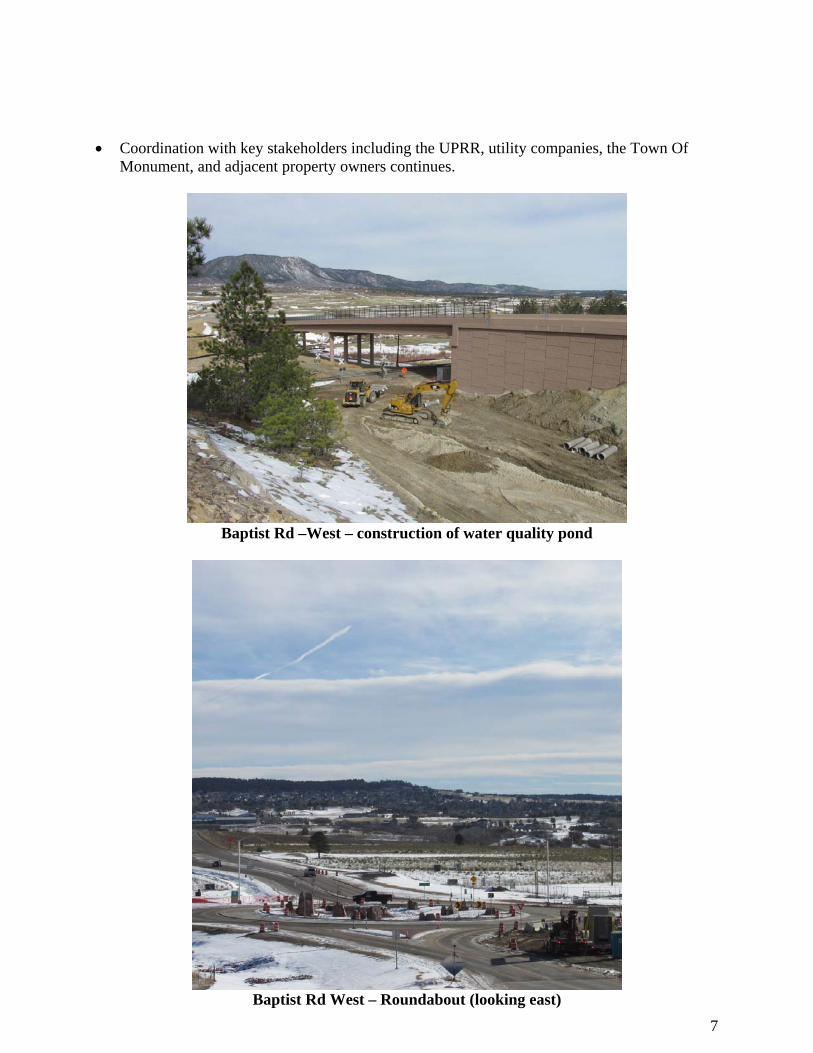
Baptist Rd West – Roundabout (looking east)
8
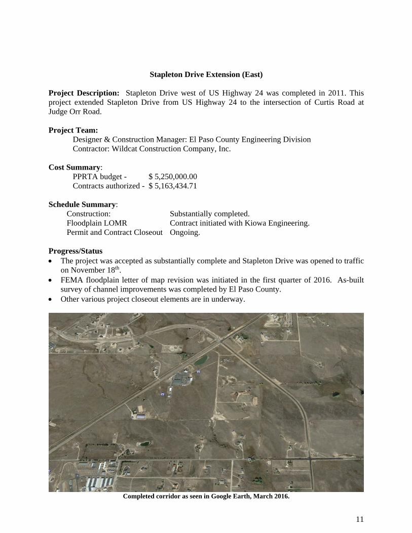
Marksheffel Road (South)
Project Description: This project will access, document, design and construct the transportation and safety improvements for the 11 mile corridor that extends from SH 24 to the future connection with Mesa Ridge Parkway and also includes the short stretch of roadway beyond this future connection to the existing terminus at C&S and Link Road on the south. The proposed improvements are broken into four zones: Zone 1 – US 24 to Peterson Air Force Base (PAFB) east gate – this section will be
reconstructed to 4 lanes with auxiliary lanes and signal modifications at the intersections. Zone 2 - PAFB east gate to Drennan – this section will be reconstructed as a 2 lane section
with shoulders. Portions of this section will follow the existing roadway, and portions will follow a new alignment that will eliminate the sharp horizontal curves, and improve the vertical profile, resulting in an increase in the overall safety along this stretch. The north leg of the Drennan Road intersection will be reconfigured accordingly.
Zone 3 – This zone picks up at the end of the existing 4 lane section south of Bradley and extends to the future Mesa Ridge Parkway connection. This section will be constructed as a 2 lane section with the continuous center turn lane and shoulders.
Zone 4 – Extends from the future Mesa Ridge Parkway connection to Link Rd/C&S intersection – This section will remain a 2 lane section but will be reconstructed to add shoulders and to reconfigure the severe horizontal curve just east of the Link Rd/C&S intersection. This zone is being constructed in conjunction with the capital project but is being funded with PPRTA maintenance funds.
Project Team: Designer: Parsons Brinkerhoff Construction Manager: AECOM Contractor: Wildcat Construction Company, Inc. Cost Summary: PPRTA budget - $31,428,015 Contracts authorized - $ 30,825,743 Schedule Summary: Complete Property Acquisition – 2016 Construction 2016/2017 (18 month duration) Utility Relocation 2015/2016 Progress/Status Wildcat Construction has commenced construction throughout the corridor. Earthwork to
establish the new roadway grades and installation of drainage facilities is underway in Zones 3 & 4, and in the new alignment portion of Zone 2. Fencing, clearing and grubbing and installation of erosion control measures are underway in all zones as property becomes available for construction.
Property acquisition continues but has taken longer than originally planned. It is anticipated that all of the properties will be available for construction in the next quarter. The property acquisition delays are primarily with properties within the City limits and have required the contractor to re-phase his work from that which was originally planned to take advantage of
9
property that has been obtained. These delays have also impacted the ability to start some of the major utility relocations in Zones 1 & 2, which will also impact the contractor’s plans for these areas as well. Our construction management team is working closely with the contractor to advance construction in those areas where property is available.
Utility relocation is proceeding where possible. CSU Electric has been able to relocate some of their facilities in Zone 1 ahead of the contractor beginning work. Other CSU Electric relocations will need to be done in conjunction with the contractor, especially in areas where grades are changing.
MVEA has substantially completed the relocation of its overhead line in zones 3 & 4, allowing the contractor to advance the roadway and utility relocation in this area. Century Link, Black Hills Energy, and Comcast are also relocating facilities as required where conflicts have been identified.
Weekly utility coordination meetings are held with representatives of the utility companies to identify conflicts and schedule relocation activities in conjunction with the planned construction.
Project coordination with the key governmental entities along this corridor continues. Key governmental stakeholders include El Paso County, City of Colorado Springs, City of Fountain, CDOT, Pikes Peak Area Council of Governments, and Peterson Air Force Base.
Coordination activities include the planned closure of Marksheffel from PAFB east gate to Drennan Road beginning in May to reconstruct that 3.5 mile portion of the roadway. Traffic will be detoured around this area using Bradley Road and Powers Blvd.
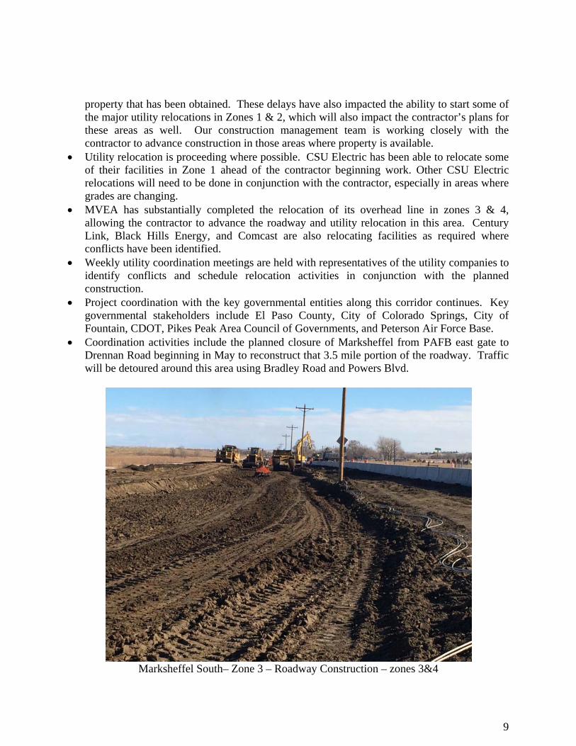
Marksheffel South– Zone 3 – Roadway Construction – zones 3&4
10
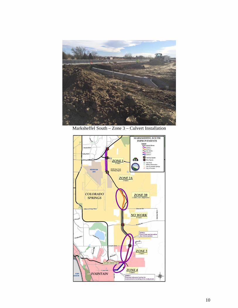
Marksheffel South – Zone 3 – Culvert Installation
11
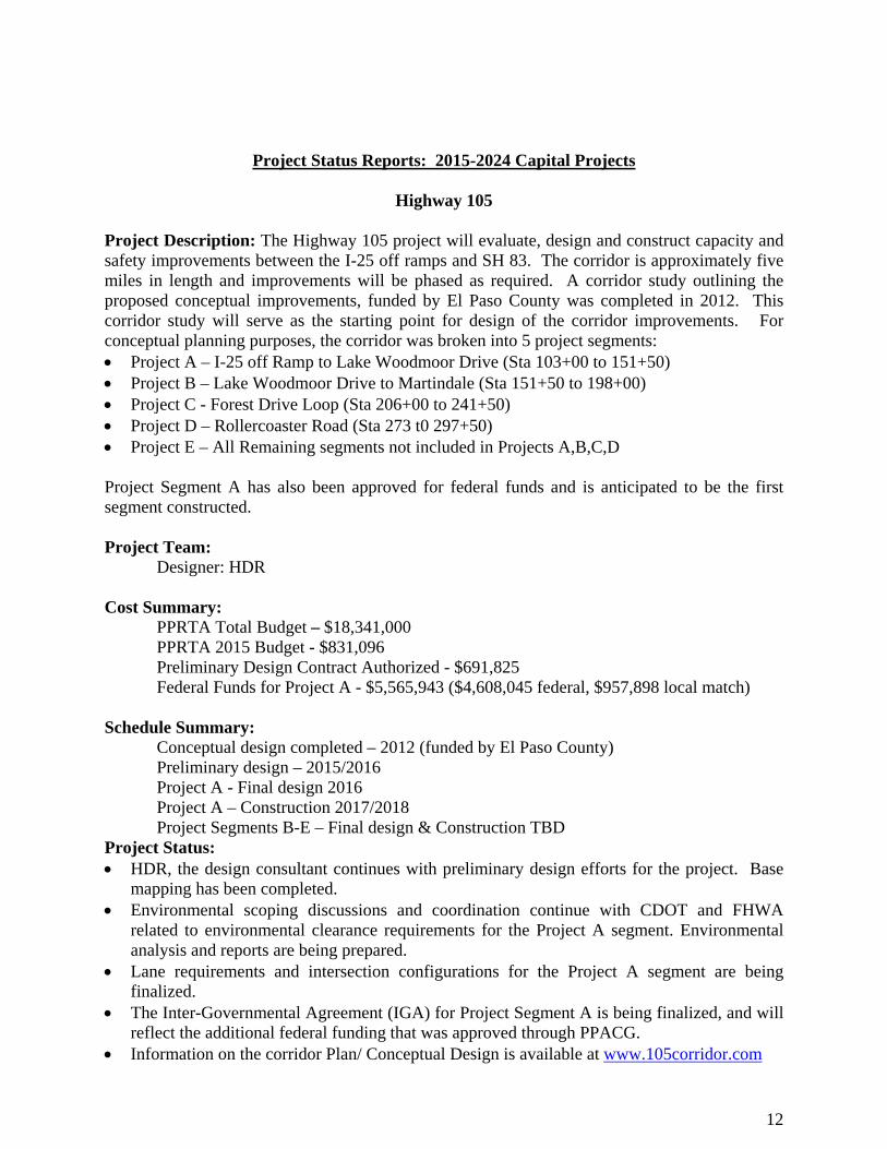
Stapleton Drive Extension (East)
Project Description: Stapleton Drive west of US Highway 24 was completed in 2011. This project extended Stapleton Drive from US Highway 24 to the intersection of Curtis Road at Judge Orr Road. Project Team:
Designer & Construction Manager: El Paso County Engineering Division Contractor: Wildcat Construction Company, Inc.
Cost Summary:
PPRTA budget - $ 5,250,000.00 Contracts authorized - $ 5,163,434.71
Schedule Summary: Construction: Substantially completed. Floodplain LOMR Contract initiated with Kiowa Engineering. Permit and Contract Closeout Ongoing.
Progress/Status The project was accepted as substantially complete and Stapleton Drive was opened to traffic
on November 18th. FEMA floodplain letter of map revision was initiated in the first quarter of 2016. As-built
survey of channel improvements was completed by El Paso County. Other various project closeout elements are in underway.
Completed corridor as seen in Google Earth, March 2016.
12
Project Status Reports: 2015-2024 Capital Projects
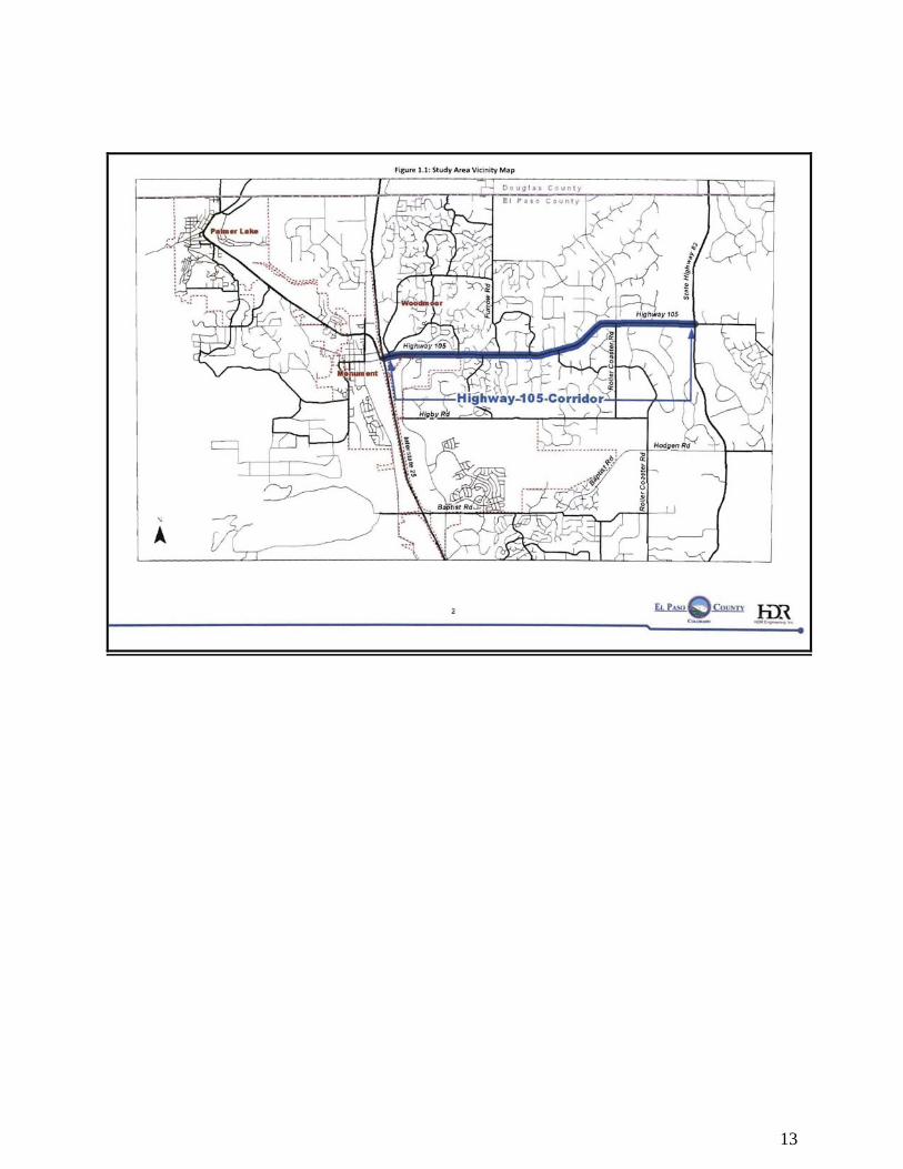
Highway 105
Project Description: The Highway 105 project will evaluate, design and construct capacity and safety improvements between the I-25 off ramps and SH 83. The corridor is approximately five miles in length and improvements will be phased as required. A corridor study outlining the proposed conceptual improvements, funded by El Paso County was completed in 2012. This corridor study will serve as the starting point for design of the corridor improvements. For conceptual planning purposes, the corridor was broken into 5 project segments: Project A – I-25 off Ramp to Lake Woodmoor Drive (Sta 103+00 to 151+50) Project B – Lake Woodmoor Drive to Martindale (Sta 151+50 to 198+00) Project C - Forest Drive Loop (Sta 206+00 to 241+50) Project D – Rollercoaster Road (Sta 273 t0 297+50) Project E – All Remaining segments not included in Projects A,B,C,D Project Segment A has also been approved for federal funds and is anticipated to be the first segment constructed. Project Team:
Designer: HDR Cost Summary:
PPRTA Total Budget – $18,341,000 PPRTA 2015 Budget - $831,096 Preliminary Design Contract Authorized - $691,825 Federal Funds for Project A - $5,565,943 ($4,608,045 federal, $957,898 local match)
Schedule Summary:
Conceptual design completed – 2012 (funded by El Paso County) Preliminary design – 2015/2016 Project A - Final design 2016 Project A – Construction 2017/2018 Project Segments B-E – Final design & Construction TBD
Project Status: HDR, the design consultant continues with preliminary design efforts for the project. Base
mapping has been completed. Environmental scoping discussions and coordination continue with CDOT and FHWA
related to environmental clearance requirements for the Project A segment. Environmental analysis and reports are being prepared.
Lane requirements and intersection configurations for the Project A segment are being finalized.
The Inter-Governmental Agreement (IGA) for Project Segment A is being finalized, and will reflect the additional federal funding that was approved through PPACG.
Information on the corridor Plan/ Conceptual Design is available at www.105corridor.com
13
14
Vicinity Map
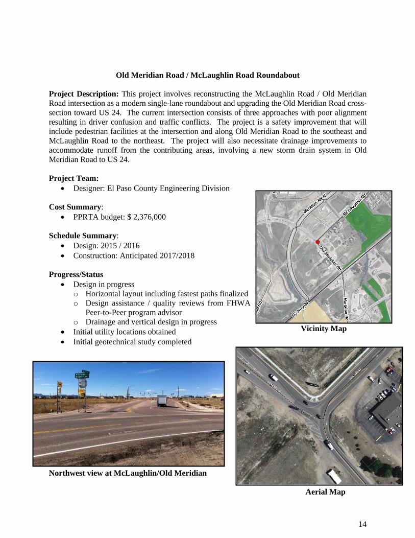
Old Meridian Road / McLaughlin Road Roundabout Project Description: This project involves reconstructing the McLaughlin Road / Old Meridian Road intersection as a modern single-lane roundabout and upgrading the Old Meridian Road cross-section toward US 24. The current intersection consists of three approaches with poor alignment resulting in driver confusion and traffic conflicts. The project is a safety improvement that will include pedestrian facilities at the intersection and along Old Meridian Road to the southeast and McLaughlin Road to the northeast. The project will also necessitate drainage improvements to accommodate runoff from the contributing areas, involving a new storm drain system in Old Meridian Road to US 24. Project Team:
Designer: El Paso County Engineering Division Cost Summary:
PPRTA budget: $ 2,376,000 Schedule Summary:
Design: 2015 / 2016 Construction: Anticipated 2017/2018
Progress/Status
Design in progress o Horizontal layout including fastest paths finalized o Design assistance / quality reviews from FHWA
Peer-to-Peer program advisor o Drainage and vertical design in progress
Initial utility locations obtained Initial geotechnical study completed
Northwest view at McLaughlin/Old Meridian Aerial Map
15
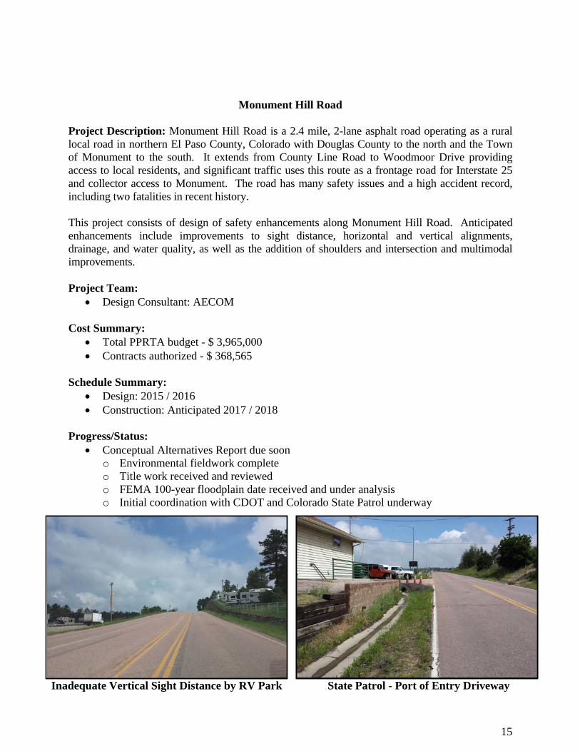
Monument Hill Road
Project Description: Monument Hill Road is a 2.4 mile, 2-lane asphalt road operating as a rural local road in northern El Paso County, Colorado with Douglas County to the north and the Town of Monument to the south. It extends from County Line Road to Woodmoor Drive providing access to local residents, and significant traffic uses this route as a frontage road for Interstate 25 and collector access to Monument. The road has many safety issues and a high accident record, including two fatalities in recent history. This project consists of design of safety enhancements along Monument Hill Road. Anticipated enhancements include improvements to sight distance, horizontal and vertical alignments, drainage, and water quality, as well as the addition of shoulders and intersection and multimodal improvements. Project Team:
Design Consultant: AECOM
Cost Summary: Total PPRTA budget - $ 3,965,000 Contracts authorized - $ 368,565
Schedule Summary:
Design: 2015 / 2016 Construction: Anticipated 2017 / 2018
Progress/Status:
Conceptual Alternatives Report due soon o Environmental fieldwork complete o Title work received and reviewed o FEMA 100-year floodplain date received and under analysis o Initial coordination with CDOT and Colorado State Patrol underway
Inadequate Vertical Sight Distance by RV Park State Patrol - Port of Entry Driveway
16
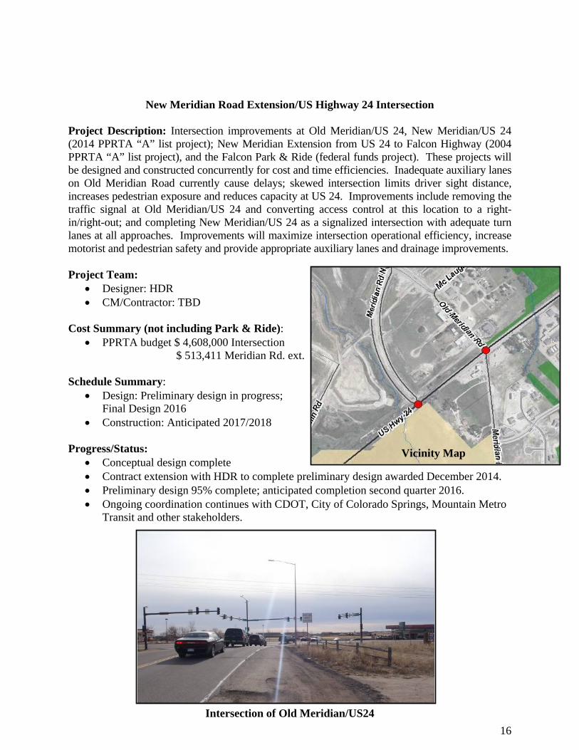
New Meridian Road Extension/US Highway 24 Intersection
Project Description: Intersection improvements at Old Meridian/US 24, New Meridian/US 24 (2014 PPRTA “A” list project); New Meridian Extension from US 24 to Falcon Highway (2004 PPRTA “A” list project), and the Falcon Park & Ride (federal funds project). These projects will be designed and constructed concurrently for cost and time efficiencies. Inadequate auxiliary lanes on Old Meridian Road currently cause delays; skewed intersection limits driver sight distance, increases pedestrian exposure and reduces capacity at US 24. Improvements include removing the traffic signal at Old Meridian/US 24 and converting access control at this location to a right-in/right-out; and completing New Meridian/US 24 as a signalized intersection with adequate turn lanes at all approaches. Improvements will maximize intersection operational efficiency, increase motorist and pedestrian safety and provide appropriate auxiliary lanes and drainage improvements. Project Team:
Designer: HDR CM/Contractor: TBD
Cost Summary (not including Park & Ride):
PPRTA budget $ 4,608,000 Intersection $ 513,411 Meridian Rd. ext.
Schedule Summary: Design: Preliminary design in progress;
Final Design 2016 Construction: Anticipated 2017/2018
Progress/Status:
Conceptual design complete Contract extension with HDR to complete preliminary design awarded December 2014. Preliminary design 95% complete; anticipated completion second quarter 2016. Ongoing coordination continues with CDOT, City of Colorado Springs, Mountain Metro
Transit and other stakeholders.
Intersection of Old Meridian/US24
Vicinity Map
17
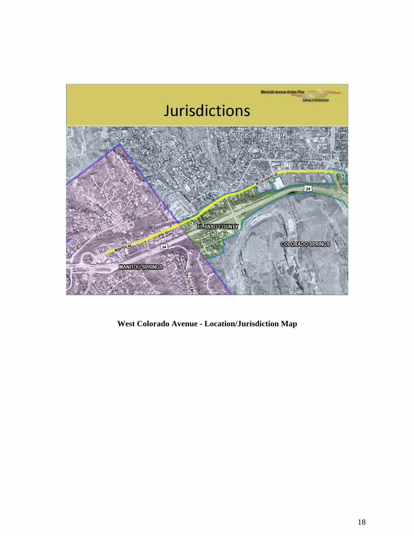
West Colorado Avenue
Project Description: This project is a joint effort with City of Manitou Springs, City of Colorado Springs. The Corridor Study phase developed recommendations for short term transportation and safety improvements and a long range livable, walkable, economic vision for the 1.5 miles of West Colorado and Manitou Avenues between North 31st Street and the US 24 interchange. The planning phase of the project (funded by CDOT) concluded with a Public Open House on March 20, 2013 in which the preferred three lane option, as recommended by citizens and stakeholders, was presented to the public. The three lane option involves one traffic lane in each direction eastbound and westbound and a center left-turn lane. A dedicated left turn lane would reduce accidents, primarily caused by cars stopping to make left turns on the current cross-section. The preliminary design phase (funded by CDOT) was completed in late 2014 and resulted in 30 percent design plans for the corridor.
Project Team: Design Consultant: FHU
Cost Summary: o Total project budget - $15,580,475 (CDOT RPP budget - $800,000, PPRTA budget -
$12,178,000, RAMP budget - $2,602,475 2015 PPRTA budget - $3,428,000; Contracts authorized to date - $ 2,296,984
Schedule: Corridor Study- Complete (2013) Preliminary Design (30%)-Complete (2014) Final Design (90%)-In progress
Progress/Status: Project website: www.westsideavenueplan.com Final design is approaching 90% complete for most project elements, and the WAAP project
team anticipates a Final Office Review (FOR) submittal for team review by April 2016. Utility design and coordination with CSU regarding utility relocation responsibilities and
cost sharing continue. Property acquisition activities are continuing including identification of needs, discussions
with impacted property owners, development of legal descriptions and appraisals. The project team continues to coordinate and provide project updates to the key community
stakeholders and municipal partners including the Organization of Westside Neighbors (OWN). Project briefings were also provided to the City of Manitou City Council, City of Colorado Springs City Council and the El Paso County Board of County Commissioners.
18
West Colorado Avenue - Location/Jurisdiction Map
19
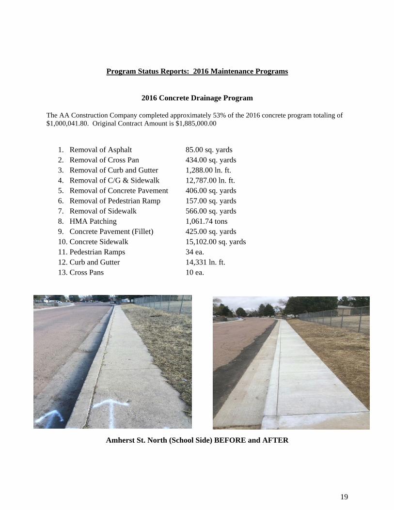
Program Status Reports: 2016 Maintenance Programs
2016 Concrete Drainage Program
The AA Construction Company completed approximately 53% of the 2016 concrete program totaling of $1,000,041.80. Original Contract Amount is $1,885,000.00
1. Removal of Asphalt 85.00 sq. yards 2. Removal of Cross Pan 434.00 sq. yards 3. Removal of Curb and Gutter 1,288.00 ln. ft. 4. Removal of C/G & Sidewalk 12,787.00 ln. ft. 5. Removal of Concrete Pavement 406.00 sq. yards 6. Removal of Pedestrian Ramp 157.00 sq. yards 7. Removal of Sidewalk 566.00 sq. yards 8. HMA Patching 1,061.74 tons 9. Concrete Pavement (Fillet) 425.00 sq. yards 10. Concrete Sidewalk 15,102.00 sq. yards 11. Pedestrian Ramps 34 ea. 12. Curb and Gutter 14,331 ln. ft. 13. Cross Pans 10 ea.
Amherst St. North (School Side) BEFORE and AFTER
20
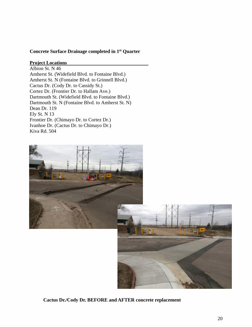
Concrete Surface Drainage completed in 1st Quarter Project Locations Albion St. N 46 Amherst St. (Widefield Blvd. to Fontaine Blvd.) Amherst St. N (Fontaine Blvd. to Grinnell Blvd.) Cactus Dr. (Cody Dr. to Cassidy St.) Cortez Dr. (Frontier Dr. to Hallam Ave.) Dartmouth St. (Widefield Blvd. to Fontaine Blvd.) Dartmouth St. N (Fontaine Blvd. to Amherst St. N) Dean Dr. 119 Ely St. N 13 Frontier Dr. (Chimayo Dr. to Cortez Dr.) Ivanhoe Dr. (Cactus Dr. to Chimayo Dr.) Kiva Rd. 504
a
Cactus Dr./Cody Dr. BEFORE and AFTER concrete replacement
21
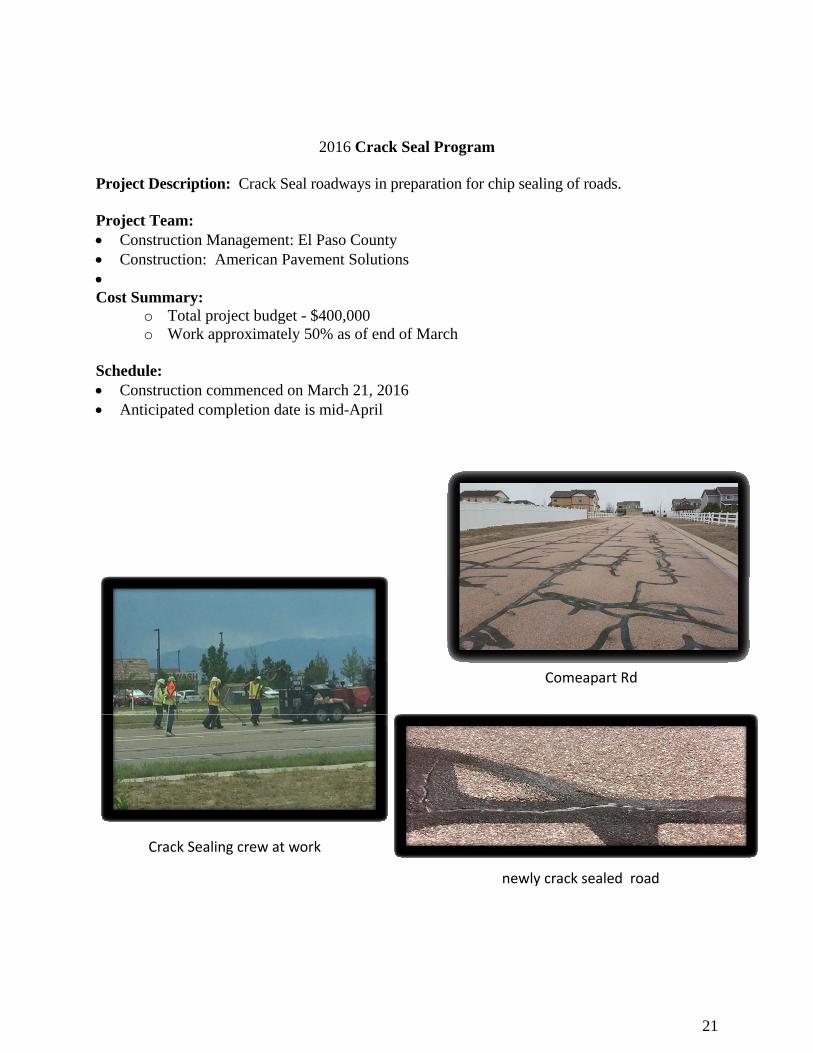
2016 Crack Seal Program
Project Description: Crack Seal roadways in preparation for chip sealing of roads. Project Team: Construction Management: El Paso County Construction: American Pavement Solutions Cost Summary:
o Total project budget - $400,000 o Work approximately 50% as of end of March
Schedule: Construction commenced on March 21, 2016 Anticipated completion date is mid-April
Crack Sealing crew at work
newly crack sealed road
Comeapart Rd
22
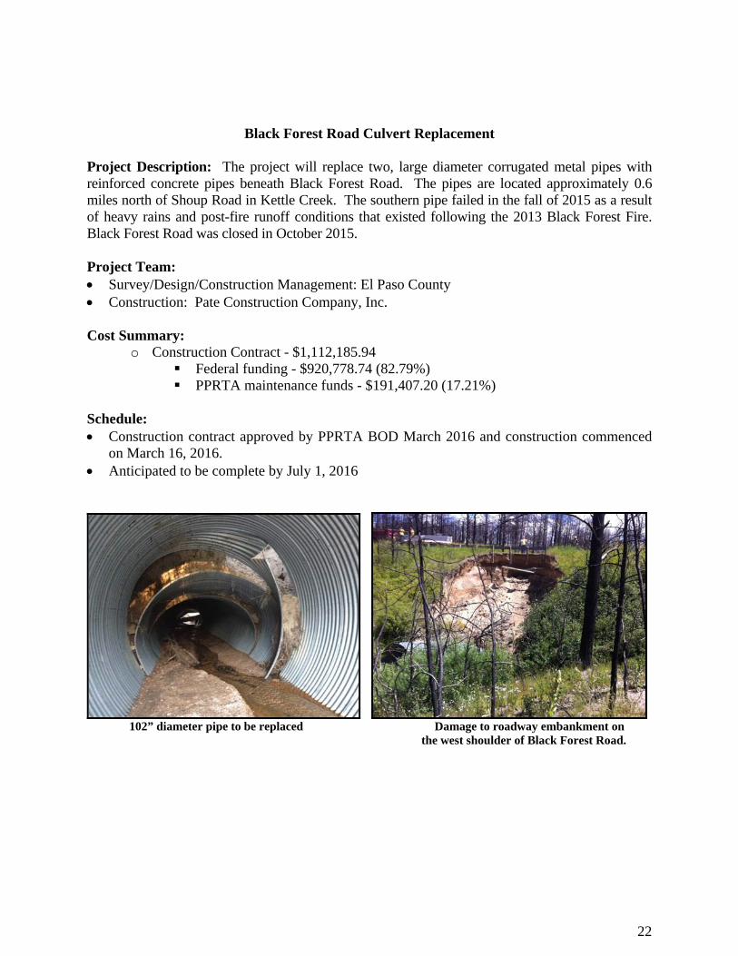
Black Forest Road Culvert Replacement
Project Description: The project will replace two, large diameter corrugated metal pipes with reinforced concrete pipes beneath Black Forest Road. The pipes are located approximately 0.6 miles north of Shoup Road in Kettle Creek. The southern pipe failed in the fall of 2015 as a result of heavy rains and post-fire runoff conditions that existed following the 2013 Black Forest Fire. Black Forest Road was closed in October 2015. Project Team: Survey/Design/Construction Management: El Paso County Construction: Pate Construction Company, Inc. Cost Summary:
o Construction Contract - $1,112,185.94 Federal funding - $920,778.74 (82.79%) PPRTA maintenance funds - $191,407.20 (17.21%)
Schedule: Construction contract approved by PPRTA BOD March 2016 and construction commenced
on March 16, 2016. Anticipated to be complete by July 1, 2016
102” diameter pipe to be replaced Damage to roadway embankment on the west shoulder of Black Forest Road.