Embed Size (px)
Citation preview
Practical 3D photogrammetry for the conservation an d documentation
of Cultural Heritage
Michael WAAS1 | David ZELL2
1 International Conservation Center – Città di Roma / 2 Independent
Abstract: The past few years has seen many developments in the world of 3D modeling of architectural and
archaeological heritage. One of these developments is the expansion of 3D photogrammetry modeling
programs into the practical and affordable world. Utilizing open-source software such as Meshlab, freeware
such as 123D Catch, and licensed software such as Agisoft PhotoScan Pro, it is now cost-effective to utilize
photogrammetry on any project. These programs offer the world of practical heritage conservation an
innovative and powerful tool for documentation, visualization/virtualization, and planning. This paper reports
on the results of developing a low-cost methodology to pursue photogrammetry in the conservation of
cultural heritage and in archaeology in the State of Israel. Compared to high-cost alternatives such as laser
scanning, which has been utilized in Israel before, the results have shown how effective photogrammetry is
and can be for conservation and documentation of cultural heritage. Some of the applications include high-
resolution rectified models of effectively 2D planes (mosaics, wall and ceiling paintings), conservation
planning on small and large-scale cultural heritage sites, and the documentation of archaeological sites in 2D
and 3D. By approaching photogrammetry from a low-cost level, it not only encourages its application in the
field, it allows professionals at all levels to engage with the technology and to learn how to utilize the
technology, whereas previously the application of the technology has been restricted to institutions and
companies with enough capital and resources to spend learning and utilizing the technology and to hobbyists
and other interested professionals, many of whom helped push the field towards lower costs.
Keywords: photogrammetry, conservation, heritage, documentation
Introduction: Digital Tools for Conservation of Her itage in Israel
The modern State of Israel is one of the world’s leading places for heritage travel and archaeology, dating
back to the origins of the Grand Tour (BARAM & ROWAN 2004). In the two centuries since archaeological
work began in what was then the Ottoman Sanjak of Syria and the Sanjak of Jerusalem, over 30,000 sites
have been uncovered and documented in the State of Israel. The sheer number of sites combined with the
diverse and difficult climates and lack of monetary resources and time, cause many of these sites to not
have proper documentation and conservation.
Digital tools for archaeology and heritage documentation are a recent phenomenon in the State of Israel. It
has only been in the past decade that laser scanning has begun to be utilized as a tool for documentation
and conservation of heritage sites such as the walls of Jerusalem and the site of Masada. Laser scanning is
an effective and known tool in Israel; however, it is not a cost-effective tool and can only be utilized by sites
with appropriate funding. Digital photogrammetry is also a known tool in Israel but until now, it has only been
International Conference on Cultural Heritage and New Technologies | Vienna | 2013
2
used for digitizing small artifacts. For large-scale sites, only academic digs have begun utilizing digital
photogrammetry in the State (KILLEBREW, et al. 2013). To answer this question, as a student intern with
the Saving the Stones program of the International Conservation Center – Città di Roma in Old Acre, Israel,
Waas approached a series of case studies utilizing freeware and open-source software to create
photogrammetric models of sites in Israel (WAAS n.d.). The conclusion of that project found that digital
photogrammetry could answer many of the issues facing the documentation and conservation of sites
throughout Israel, but that there were limitations with the programs tested. This paper is the second stage of
that project and focused our testing on professional paid software, further pushing the boundaries of what
digital photogrammetry could offer in the field of conservation in Israel while remaining cost-effective and
time-effective.
For this stage of the project, we determined three main objectives that we would examine:
1. How can 3D-modeling technology for conservation and documentation of cultural heritage be used
successfully in Israel?
2. How can we establish a practical and low-cost methodology to implement this technology in Israel?
3. Can conservation planning be done directly on the 3D models?
We approached three case studies in three very different environments in the State of Israel: a wall at Tel
Yokneam; a painted ceiling in Old Akko; and the latrine at Beit She’an.
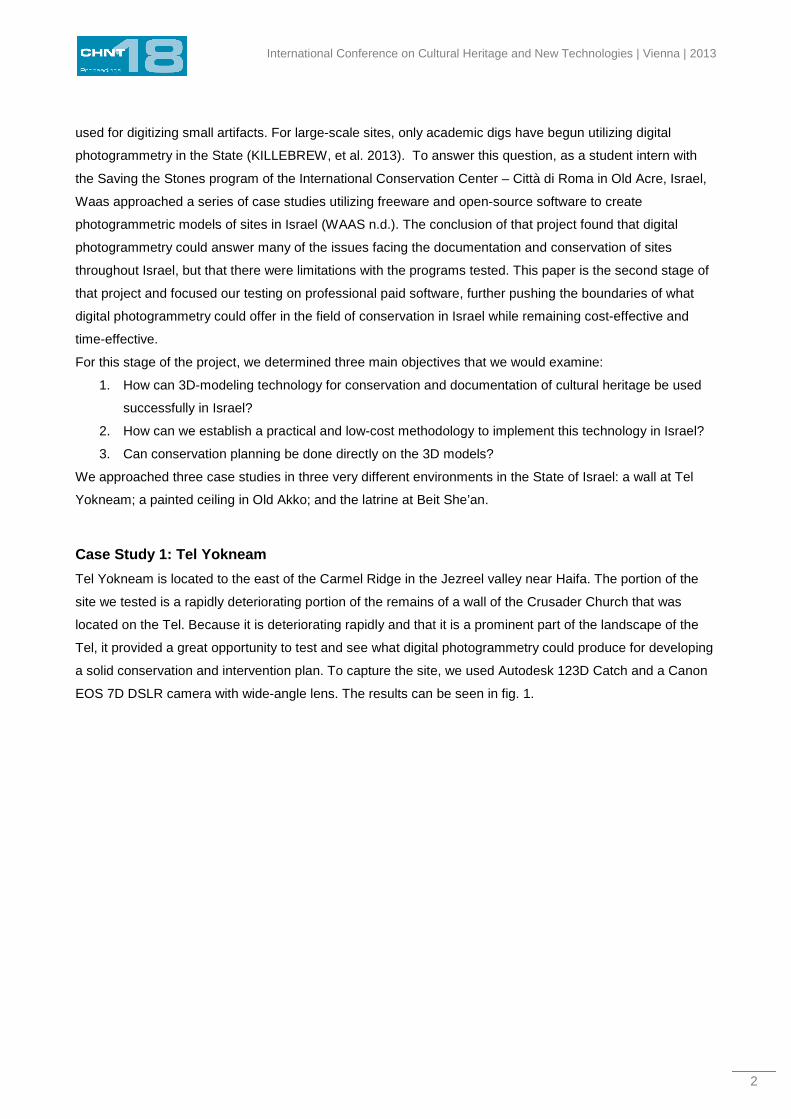
Case Study 1: Tel Yokneam
Tel Yokneam is located to the east of the Carmel Ridge in the Jezreel valley near Haifa. The portion of the
site we tested is a rapidly deteriorating portion of the remains of a wall of the Crusader Church that was
located on the Tel. Because it is deteriorating rapidly and that it is a prominent part of the landscape of the
Tel, it provided a great opportunity to test and see what digital photogrammetry could produce for developing
a solid conservation and intervention plan. To capture the site, we used Autodesk 123D Catch and a Canon
EOS 7D DSLR camera with wide-angle lens. The results can be seen in fig. 1.
Waas | Zell – Practical 3D photogrammetry for the conservation and documentation of CH
3
Fig. 1 – Model and elevations of the wall of the Church
The results were excellent. To process the model and to produce the orthorectified elevations a combination
of Adobe Photoshop and Sketchup was used. For our needs in conservation in Israel, this presented a clear
example of how powerful the technology could be for documentation while achieving our goals of low-cost
and time-efficient application of digital photogrammetry for conservation. However, this site is small in scale
and comparatively straightforward and simple. In addition, as we later discovered (WAAS, n.d.), 123D Catch
performs admirably well on small-scale sites such as this wall, but the larger the site, the more distorted and
difficult to process it became. For our second and third case studies, we utilized Agisoft Photoscan Pro (trial
edition) to understand what professional paid software could offer us in the conservation world.
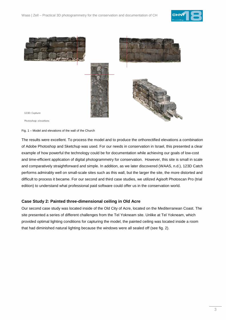
Case Study 2: Painted three-dimensional ceiling in Old Acre
Our second case study was located inside of the Old City of Acre, located on the Mediterranean Coast. The
site presented a series of different challenges from the Tel Yokneam site. Unlike at Tel Yokneam, which
provided optimal lighting conditions for capturing the model, the painted ceiling was located inside a room
that had diminished natural lighting because the windows were all sealed off (see fig. 2).
International Conference on Cultural Heritage and New Technologies | Vienna | 2013
4
Fig. 2 – Photo of the ceiling showing the sealed windows inside of the room.
The home belonged to a prominent Beiruti family that moved to Ottoman Acre in the late 19th century and
now belongs to a private owner awaiting conservation and redevelopment. In the Old City of Acre, before
any development can be approved legally, the building has to undergo a documentation, which includes the
historic documentation, urban survey, engineering report, and conservation proposal. For this building, the
historic documentation was performed by the author (WAAS).
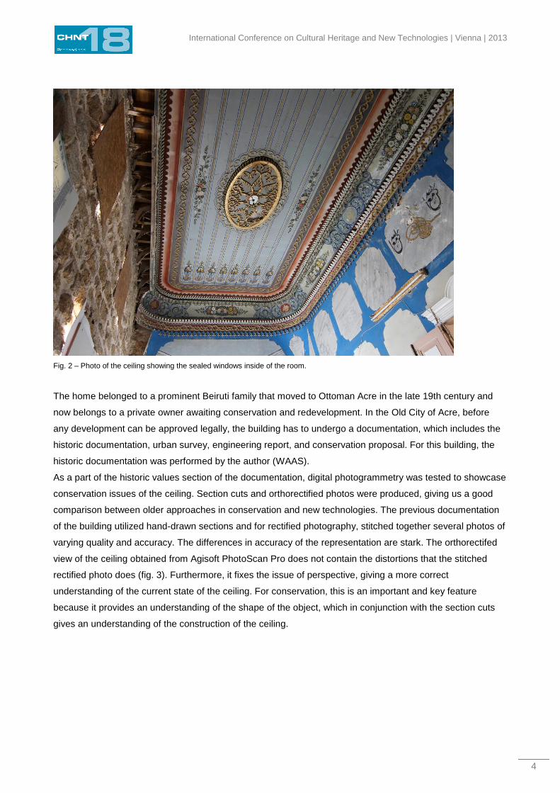
As a part of the historic values section of the documentation, digital photogrammetry was tested to showcase
conservation issues of the ceiling. Section cuts and orthorectified photos were produced, giving us a good
comparison between older approaches in conservation and new technologies. The previous documentation
of the building utilized hand-drawn sections and for rectified photography, stitched together several photos of
varying quality and accuracy. The differences in accuracy of the representation are stark. The orthorectifed
view of the ceiling obtained from Agisoft PhotoScan Pro does not contain the distortions that the stitched
rectified photo does (fig. 3). Furthermore, it fixes the issue of perspective, giving a more correct
understanding of the current state of the ceiling. For conservation, this is an important and key feature
because it provides an understanding of the shape of the object, which in conjunction with the section cuts
gives an understanding of the construction of the ceiling.
Waas | Zell – Practical 3D photogrammetry for the conservation and documentation of CH
5
Fig. 3 – Top: Orthorectified view of the ceiling produced utilizing digital photogrammetry in Agisoft PhotoScan Pro. Bottom:
Orthorectified photo produced by stitching together three separate analog photos (1998).
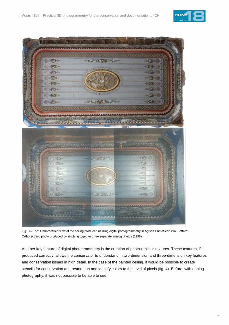
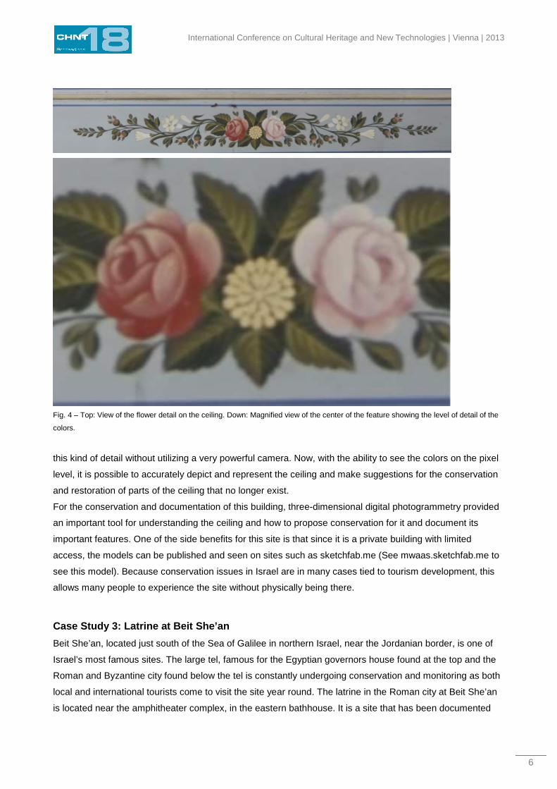
Another key feature of digital photogrammetry is the creation of photo-realistic textures. These textures, if
produced correctly, allows the conservator to understand in two-dimension and three-dimension key features
and conservation issues in high detail. In the case of the painted ceiling, it would be possible to create
stencils for conservation and restoration and identify colors to the level of pixels (fig. 4). Before, with analog
photography, it was not possible to be able to see
International Conference on Cultural Heritage and New Technologies | Vienna | 2013
6
Fig. 4 – Top: View of the flower detail on the ceiling. Down: Magnified view of the center of the feature showing the level of detail of the
colors.
this kind of detail without utilizing a very powerful camera. Now, with the ability to see the colors on the pixel
level, it is possible to accurately depict and represent the ceiling and make suggestions for the conservation
and restoration of parts of the ceiling that no longer exist.
For the conservation and documentation of this building, three-dimensional digital photogrammetry provided
an important tool for understanding the ceiling and how to propose conservation for it and document its
important features. One of the side benefits for this site is that since it is a private building with limited
access, the models can be published and seen on sites such as sketchfab.me (See mwaas.sketchfab.me to
see this model). Because conservation issues in Israel are in many cases tied to tourism development, this
allows many people to experience the site without physically being there.
Case Study 3: Latrine at Beit She’an
Beit She’an, located just south of the Sea of Galilee in northern Israel, near the Jordanian border, is one of
Israel’s most famous sites. The large tel, famous for the Egyptian governors house found at the top and the
Roman and Byzantine city found below the tel is constantly undergoing conservation and monitoring as both
local and international tourists come to visit the site year round. The latrine in the Roman city at Beit She’an
is located near the amphitheater complex, in the eastern bathhouse. It is a site that has been documented
Waas | Zell – Practical 3D photogrammetry for the conservation and documentation of CH
7
and conserved before so it gave us an opportunity to update the documentation and use the opportunity to
monitor how the previous conservation works have survived.
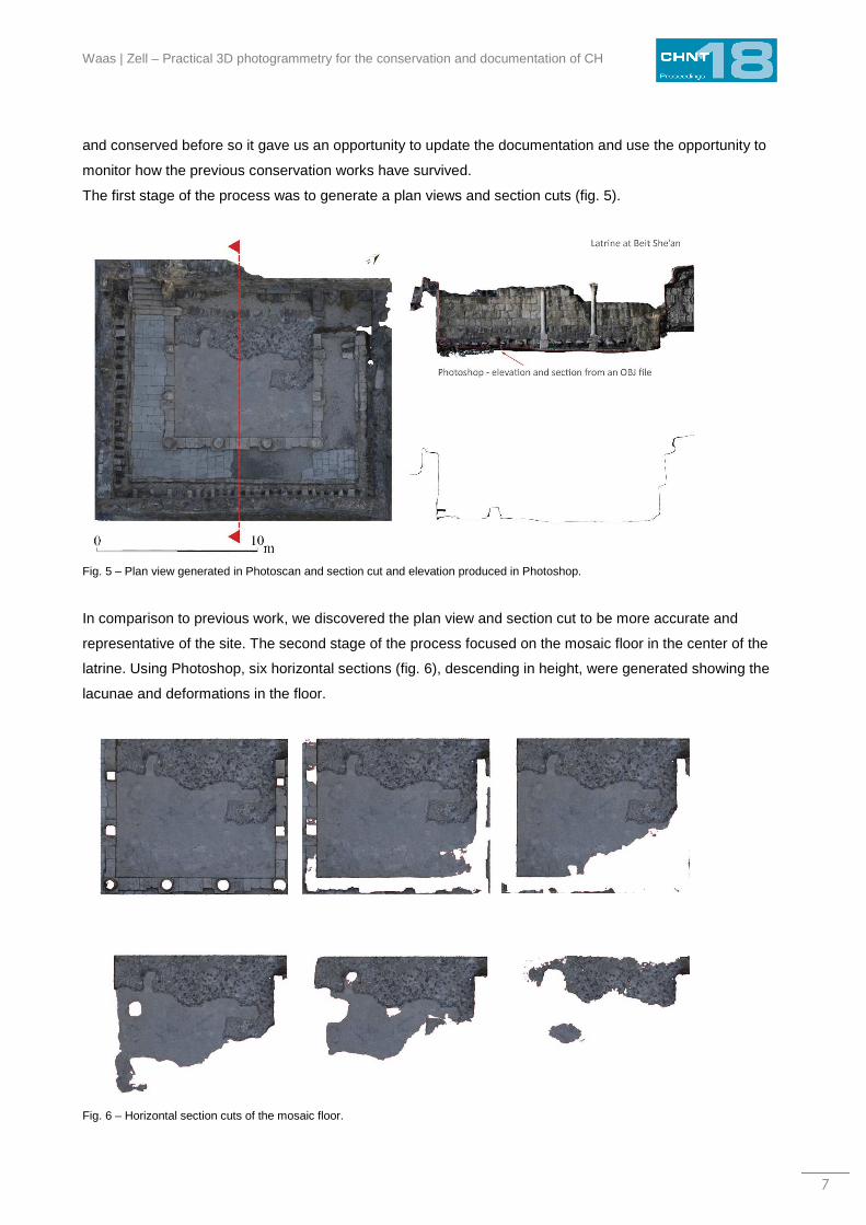
The first stage of the process was to generate a plan views and section cuts (fig. 5).
Fig. 5 – Plan view generated in Photoscan and section cut and elevation produced in Photoshop.
In comparison to previous work, we discovered the plan view and section cut to be more accurate and
representative of the site. The second stage of the process focused on the mosaic floor in the center of the
latrine. Using Photoshop, six horizontal sections (fig. 6), descending in height, were generated showing the
lacunae and deformations in the floor.
Fig. 6 – Horizontal section cuts of the mosaic floor.
International Conference on Cultural Heritage and New Technologies | Vienna | 2013
8
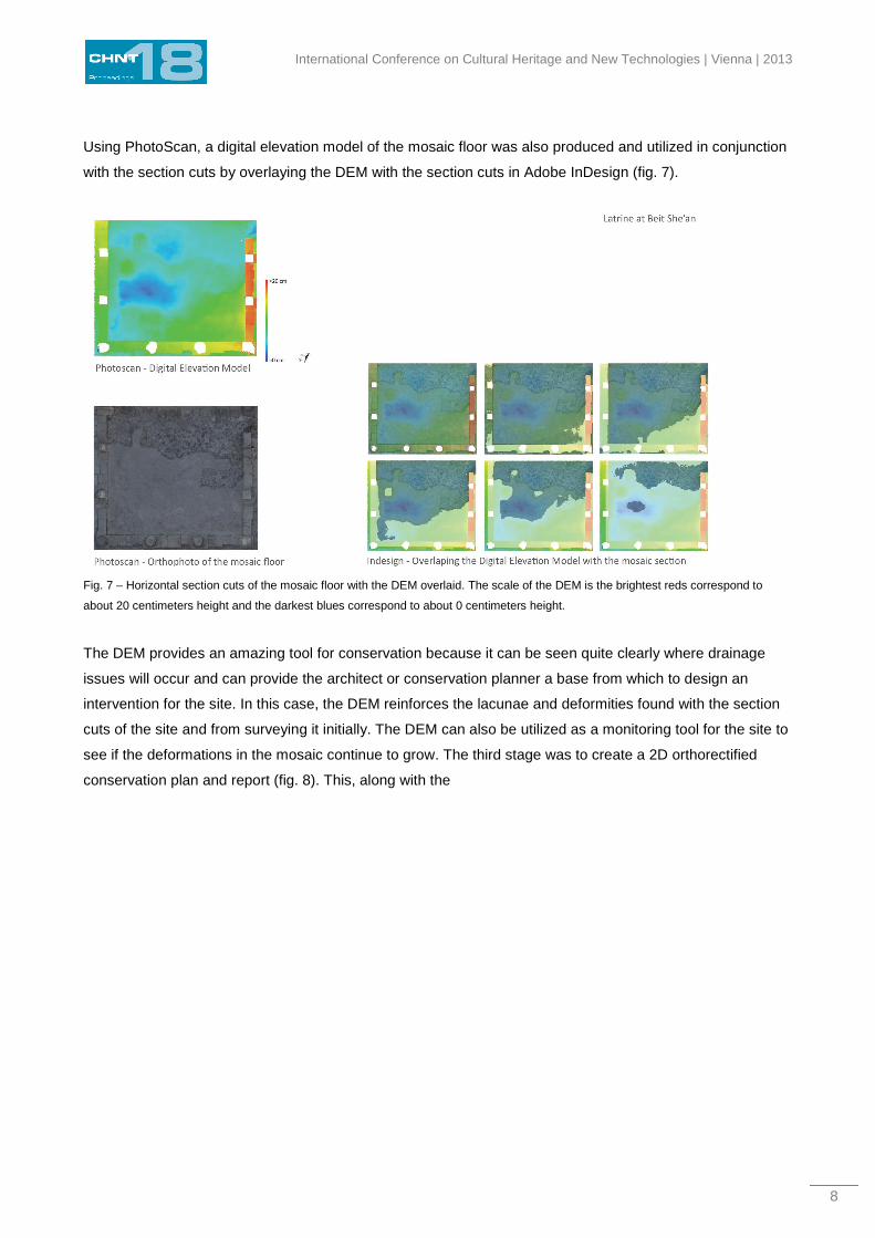
Using PhotoScan, a digital elevation model of the mosaic floor was also produced and utilized in conjunction
with the section cuts by overlaying the DEM with the section cuts in Adobe InDesign (fig. 7).
Fig. 7 – Horizontal section cuts of the mosaic floor with the DEM overlaid. The scale of the DEM is the brightest reds correspond to
about 20 centimeters height and the darkest blues correspond to about 0 centimeters height.
The DEM provides an amazing tool for conservation because it can be seen quite clearly where drainage
issues will occur and can provide the architect or conservation planner a base from which to design an
intervention for the site. In this case, the DEM reinforces the lacunae and deformities found with the section
cuts of the site and from surveying it initially. The DEM can also be utilized as a monitoring tool for the site to
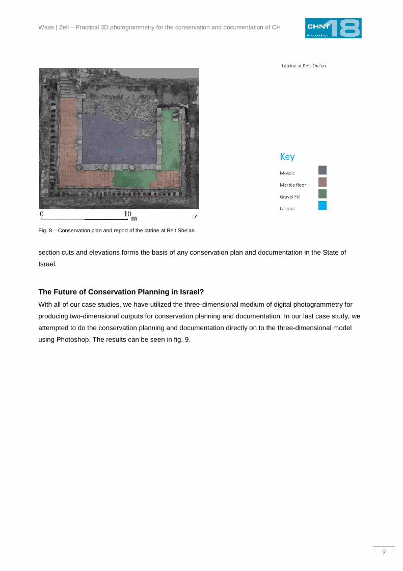
see if the deformations in the mosaic continue to grow. The third stage was to create a 2D orthorectified
conservation plan and report (fig. 8). This, along with the
Waas | Zell – Practical 3D photogrammetry for the conservation and documentation of CH
9
Fig. 8 – Conservation plan and report of the latrine at Beit She’an.
section cuts and elevations forms the basis of any conservation plan and documentation in the State of
Israel.
The Future of Conservation Planning in Israel?
With all of our case studies, we have utilized the three-dimensional medium of digital photogrammetry for
producing two-dimensional outputs for conservation planning and documentation. In our last case study, we
attempted to do the conservation planning and documentation directly on to the three-dimensional model
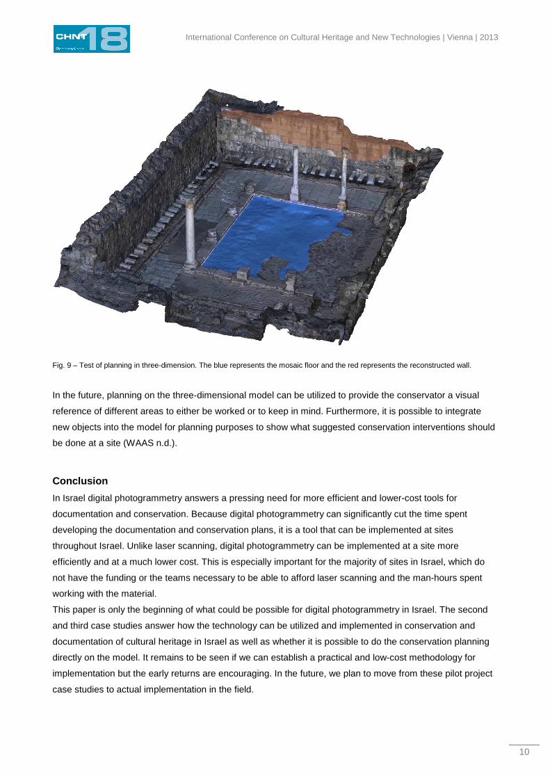
using Photoshop. The results can be seen in fig. 9.
International Conference on Cultural Heritage and New Technologies | Vienna | 2013
10
Fig. 9 – Test of planning in three-dimension. The blue represents the mosaic floor and the red represents the reconstructed wall.
In the future, planning on the three-dimensional model can be utilized to provide the conservator a visual
reference of different areas to either be worked or to keep in mind. Furthermore, it is possible to integrate
new objects into the model for planning purposes to show what suggested conservation interventions should
be done at a site (WAAS n.d.).
Conclusion
In Israel digital photogrammetry answers a pressing need for more efficient and lower-cost tools for
documentation and conservation. Because digital photogrammetry can significantly cut the time spent
developing the documentation and conservation plans, it is a tool that can be implemented at sites
throughout Israel. Unlike laser scanning, digital photogrammetry can be implemented at a site more
efficiently and at a much lower cost. This is especially important for the majority of sites in Israel, which do
not have the funding or the teams necessary to be able to afford laser scanning and the man-hours spent
working with the material.
This paper is only the beginning of what could be possible for digital photogrammetry in Israel. The second
and third case studies answer how the technology can be utilized and implemented in conservation and
documentation of cultural heritage in Israel as well as whether it is possible to do the conservation planning
directly on the model. It remains to be seen if we can establish a practical and low-cost methodology for
implementation but the early returns are encouraging. In the future, we plan to move from these pilot project
case studies to actual implementation in the field.
Waas | Zell – Practical 3D photogrammetry for the conservation and documentation of CH
11
Acknowledgements
We would like to thank the following people for their help and support during this project: Yaara Shealtiel and
Ido Rozental for allowing us to test the methodology on their project of the public beach at Caeasarea and
providing feedback about the usage of laser scanning on the same project, the conservation and
archaeology team of Beit She’an for providing materials about the latrine, Dr. Ann Killebrew and Jamie
Quartermaine for showing us how they are implementing photogrammetry as part of the Tel Akko Total
Archaeology field school and for always being open and happy to share information. Finally, we would like to
thank Dr. Kamil Sari, director of the division of supervision, research and conservation policy of the Israel
Antiquities Authority, and Shelley-Anne Peleg, director of the International Conservation Center – Città di
Roma, for their support and encouragement to explore digital photogrammetry as a tool for conservation in
Israel as part of Waas’ student project as part of the Saving the Stones: Practical Conservation Training
Internship.
References Akbaylar, İ., 2007. DOCUMENTATION OF A VERNACULAR HOUSE WITH CLOSE-RANGE DIGITAL PHOTOGRAMMETRY. In XXI
International CIPA Symposium, Athens, Greece. pp. 1–6.
Alkheder, S., Alshawabkeh, Y & Haala, N, 2009. Developing a documentation system for desert palaces in Jordan using 3D laser
scanning and digital photogrammetry. Journal of Archaeological Science, 36(2), pp.537–546. Available at:
http://linkinghub.elsevier.com/retrieve/pii/S0305440308002513 [Accessed May 12, 2013].
Alshawabkeh, Yahya & Haala, Norbert, 2004. Integration of Digital Photogrammetry and Laser Scanning for Heritage Documentation.
International Archives of Photogrammetry Remote Sensing and Spatial Information Sciences, 35(5), pp.424–429. Available at:
http://citeseerx.ist.psu.edu/viewdoc/download?doi=10.1.1.65.6104&rep=rep1&type=pdf.
Anon, 2003. ICOMOS CHARTER- PRINCIPLES FOR THE ANALYSIS, CONSERVATION AND STRUCTURAL RESTORATION OF
ARCHITECTURAL HERITAGE. , pp.1–3. Available at: http://www.icomos.org/victoriafalls2003/iscarsah.doc.
Arias, P. et al., 2005. Control of structural problems in cultural heritage monuments using close-range photogrammetry and computer
methods. Computers Structures, 83(21-22), pp.1754–1766. Available at: http://linkinghub.elsevier.com/retrieve/pii/S0045794905001094
[Accessed May 12, 2013].
Arias, P. et al., 2007. Digital photogrammetry, GPR and computational analysis of structural damages in a mediaeval bridge.
Engineering Failure Analysis, 14(8), pp.1444–1457. Available at: http://linkinghub.elsevier.com/retrieve/pii/S135063070700043X
[Accessed March 23, 2013].
Baram U. and Rowan Y. 2004. Archaeology after Nationalism: Globalization and the Consumption of the Past. In: U. Baram and Y.
Rowan, eds. Marketing Heritage: Archaeology and the Consumption of the Past. Walnut Creek, California: Altamira Press. Pp. 3-23.
Boehler, W. & Marbs, A., 2004. 3D Scanning and Photogrammetry for Heritage Recording : a Comparison. In Proc. 12th International
Conference on Geoinformatics, University of Gävle, Sweden. pp. 7–9. Available at:
http://scholar.google.com/scholar?q=intitle:3d+scanning+and+photogrammetry+for+heritage+recording:+a+comparison#0.
Denard, H. ed., 2009. THE LONDON CHARTER FOR THE COMPUTER-BASED VISUALISATION OF CULTURAL HERITAGE, DRAFT
2.1. In London: King’s College, pp. 1–13. Available at:
http://www.londoncharter.org/fileadmin/templates/main/docs/london_charter_2_1_en.pdf.
El-hakim, S.F., Picard, M. & Godin, G., 2004. Detailed 3D Reconstruction of Heritage Sites with Integrated. IEEE Computer Graphics
and Applications, pp.21–29.
International Conference on Cultural Heritage and New Technologies | Vienna | 2013
12
Galizia, M. & Santagati, C., 2012. GIS is/and Knowledge: Documenting and Managing Catania’s Historic Urban Heritage. Journal of
Civil Engineering and Architecture, 6(8), pp.1014–1020.
El Garouani, A. & Alobeid, A., 2013. Digital Surface Model generation for 3D City Modeling (Fez, Morocco). In Eighth National GIS
Symposium in Saudi Arabia, Dammam, Saudi Arabia. pp. 1–10.
Godin, G. et al., 2002. Active optical 3D imaging for heritage applications. IEEE Computer Graphics and Applications, 22(5), pp.24–35.
Available at: http://ieeexplore.ieee.org/lpdocs/epic03/wrapper.htm?arnumber=1028724.
Green, S., Bevan, A. & Shapland M. 2014. A comparative assessment of structure from motion methods for archaeological research. In
Journal of Archaeological Sciences, 46, pp. 173-181.
Guarnieri, a, Remondino, F & Vettore, A., 2006. Digital Photogrammetry and Tls Data Fusion Applied To Cultural Heritage 3D Modeling,
Citeseer. Available at: http://citeseerx.ist.psu.edu/viewdoc/download?doi=10.1.1.72.3963&rep=rep1&type=pdf.
Guidi, G., Beraldin, J. & Atzeni, C., 2004. High-Accuracy 3-D Modeling of Cultural Heritage: The Digitizing of Donatello’s “Maddalena”.
IEEE Transctions of Image Processing, 13(3), pp.370–380.
ICOMOS, 1996. PRINCIPLES FOR THE RECORDING OF MONUMENTS , GROUPS OF BUILDINGS AND SITES ( 1996 ). In 11th
ICOMOS General Assembly in Sofia, October 1996. pp. 49–52. Available at: http://www.icomos.org/charters/archives-e.pdf.
ICOMOS, 2008. THE ICOMOS CHARTER FOR THE INTERPRETATION AND PRESENTATION OF CULTURAL HERITAGE SITES. In
pp. 1–8. Available at: www.icomos.org/charters/interpretation_e.pdf .
Koutsoudis, A., Arnaoutoglou, F. & Chamzas, C., 2007. On 3D reconstruction of the old city of Xanthi. A minimum budget approach to
virtual touring based on photogrammetry. Journal of Cultural Heritage, 8(1), pp.26–31. Available at:
http://linkinghub.elsevier.com/retrieve/pii/S1296207406001130 [Accessed March 23, 2013].
Lerma, J.L. et al., 2010. Terrestrial laser scanning and close range photogrammetry for 3D archaeological documentation: the Upper
Palaeolithic Cave of Parpalló as a case study. Journal of Archaeological Science, 37(3), pp.499–507. Available at:
http://linkinghub.elsevier.com/retrieve/pii/S0305440309003781 [Accessed March 7, 2013].
Milan, D.J., Heritage, G.L. & Hetherington, D., 2007. Application of a 3D laser scanner in the assessment of erosion and deposition
volumes and channel change in a proglacial river. Earth Surface Processes and Landforms, 32(11), pp.1657–1674. Available at:
http://dx.doi.org/10.1002/esp.1592.
Milshtein, F. 1998 Documentation of Hazardous Structures, Old Acre: Building [Number withheld].
[manuscript] Israel Antiquities Authority Akko office archive
Olson, B.R. et al., 2013. The Tel Akko Total Archaeology Project (Akko, Israel): Assessing the suitability of multi-scale 3D field recording
in archaeology. Journal of Field Archaeology, 38(3), pp.244–262. Available at:
http://www.maneyonline.com/doi/abs/10.1179/0093469013Z.00000000056 [Accessed February 20, 2014].
Pavlidis, G. et al., 2007. Methods for 3D digitization of Cultural Heritage. Journal of Cultural Heritage, 8(1), pp.93–98. Available at:
http://linkinghub.elsevier.com/retrieve/pii/S129620740600121X [Accessed April 4, 2013].
Remondino, Fabio, 2011. Heritage Recording and 3D Modeling with Photogrammetry and 3D Scanning. Remote Sensing, 3(6),
pp.1104–1138. Available at: http://www.mdpi.com/2072-4292/3/6/1104/ [Accessed March 8, 2013].
Remondino, Fabio & El-Hakim, S., 2006. Image-Based 3D Modelling : a Review. The Photogrammetric Record, 21(115), pp.269–291.
Available at: http://onlinelibrary.wiley.com/doi/10.1111/j.1477-9730.2006.00383.x/full.
Ruther, H., Smit, J. & Kamamba, D., 2012. A Comparison of Close-Range Photogrammetry to Terrestrial Laser Scanning for Heritage
Documentation. South African Journal of Geomatics, 1(2), pp.149–162. Available at:
http://www.sajg.org.za/index.php/sajg/article/view/37.
Waas | Zell – Practical 3D photogrammetry for the conservation and documentation of CH
13
Sansoni, G., Trebeschi, M. & Docchio, F., 2009. State-of-The-Art and Applications of 3D Imaging Sensors in Industry, Cultural Heritage,
Medicine, and Criminal Investigation. Sensors, 9(1), pp.568–601. Available at: http://www.mdpi.com/1424-8220/9/1/568/ [Accessed
March 14, 2013].
Schouteden, J. et al., 2001. Image-Based 3D Acquisition Tool for Architectural Conservation. International Archives of Photogrammetry
Remote Sensing and Spatial Information Sciences, 34(5/C7), pp.300–305. Available at:
http://scholar.google.com/scholar?hl=en&btnG=Search&q=intitle:Image-based+3d+acquisition+tool+for+architectural+conservation#0.
Taibi, G. et al., 2013. CRABNEBULA DIGITAL SUITE , AN ALGORITHM OF SURVEY AND 3D MODELLING FOR THE
PRESERVATION AND MANAGEMENT OF URBAN HERITAGE. International Archives of Photogrammetry Remote Sensing and
Spatial Information Sciences, 30(5/W1), pp.227–234.
Vatan, M et al., 2005. USING PHOTOGRAMMETRIC DATA FOR ESTABLISHING 3D FINITE ELEMENT MODEL OF A MASONRY
AQUEDUCT. In CIPA 2005 XX International Symposium, Torino, Italy. pp. 1–4.
Vatan, Meltem, 2009. The use of 3D laser scanning technology in preservation of historical structures. Conservation News.
Walford, A., A New Way to 3D Scan,
Waas, M. Practical 3D Photogrammetry for the Conservation and Documentation of Cultural Heritage. [in press] Israel Antiquities
Authority Conservation Department.
Yastikli, N., 2007. Documentation of cultural heritage using digital photogrammetry and laser scanning. Journal of Cultural Heritage,
8(4), pp.423–427. Available at: http://linkinghub.elsevier.com/retrieve/pii/S1296207407001082 [Accessed April 2, 2013].
Zhou, M. et al. eds., 2011. Revive the Past. In Proceeding of the 39th Conference on Computer Applications and Quantitative Methods
in Archaeology. Amsterdam: Pallas Publications, p. 393.
Imprint:
Proceedings of the 18th International Conference on Cultural Heritage and New Technologies 2013 (CHNT 18, 2013)
Vienna 2014
http://www.chnt.at/proceedings-chnt-18/
ISBN 978-3-200-03676-5
Editor/Publisher: Museen der Stadt Wien – Stadtarchäologie
Editorial Team: Wolfgang Börner, Susanne Uhlirz
The editor’s office is not responsible for the linguistic correctness of the manuscripts.
Authors are responsible for the contents and copyrights of the illustrations/photographs.