Embed Size (px)
Citation preview
Prairie Rose Wind Farm
Geronimo Wind Energy, LLC | 5050 Lincoln Drive #420, Edina, MN 55436| P 952.988.9000 | F 952.988.9001
Project Description:
The Prairie Rose Project is a Large Wind Energy Conversion System (LWECS), as defined in the Wind Siting Act, Minnesota Stat. §216F.01. The Project is located in Rock Minnesota, on Approximately 12734 Acres. The project will have an electrical generating capacity of up to 200 megawatts (mW), consisting from 66 to 133 wind turbine generators. The Developer has not made a final selection on turbines for the Project and proposes to permit the Project for a range in turbine size from 1.5 to 3.0 MW. The application uses the General Electric (GE) 1.5 MW machine as a representative turbine for the 1.5 MW Class, the Suzlon 2.1 MW machine as a representative turbine for the 2.1 MW Class, the GE 2.5 MW machine as a representative turbine for the 2.5 MW Class and the Vestas 3.0 MW machine as a representative turbine for the 3.0 MW Class. Together these four turbines span the spectrum of the turbine models in the 1.5 to 3.0 MW range. The Applicant may elect to select turbines by other turbine vendors in the 1.5 to 3.0 MW range. Associated facilities include gravel access roads, interconnecting to the Anson Natural Gas Plant in Sioux Falls, South Dakota, permanent meteorological towers and wind electrical collection system. There is the potential for as yet undetermined utility connections to occur outside of the submitted area; if and when the location of these connections is determined an additional data request will be completed. This project will use standard construction methods associated with wind energy conversion system parks at the time of construction. The Project is expected to come online in 2010.
Current/Past Land Use: The area is predominantly agricultural with a mix of livestock and cropping activities and has, historically been under this use post settlement. Some of this farmland may have been recently converted to conservation uses in the form of CRP, Reinvest in Minnesota or other conservation programs that included both private and public ownership. A number of both current and uninhabited farmsteads are located within the project boundaries. Because of the large size of this project a number of non-agricultural industrial and commercial uses may be present but are as yet to be identified by the developer. These may range from gravel pits to private stores and service providers.

RE: Prairie Rose Wind Farm
file:///C|/...deruyte/Desktop/PR%20Appendix%20A%20Temp/NHIS%20Contacts%202009/RE%20Prairie%20Rose%20Wind%20Farm.htm[5/13/2010 7:05:40 AM]
From: Patrick Smith [[email protected]]Sent: Wednesday, November 19, 2008 6:57 PMTo: Lisa JoyalSubject: RE: Prairie Rose Wind FarmAttachments: PrairieRose_v3.dbf; PrairieRose_v3.prj; PrairieRose_v3.sbn; PrairieRose_v3.sbx;
PrairieRose_v3.shp; PrairieRose_v3.shp.xml; PrairieRose_v3.shx
Hi Lisa, Attached is how we are planning on moving our footprint based on your comments. I am currently working out what routs our electrical collector system will take and would greatly appreciate any guidance you have. These wouldbe smaller lines, probably above ground in the already existing Road ROW. I am assuming that you would like us to avoid cutting into what lookto me like potential habitat corridors. I had originally planned two lines, one along Co. Rd 7 and one along Tw Hywy 76 straight to the border. These lines need to be as short and straight as I can make them because their cost can go way up and hurt our project.
Best, Patrick -----Original Message----- From: Lisa Joyal [mailto:[email protected]] Sent: Tuesday, November 18, 2008 10:57 AM To: Patrick Smith Subject: Re: Prairie Rose Wind Farm
Hi Patrick,
I've attached two GIS shapefiles (NAD 83, UTM Zone 15N) of preliminary MCBS Sites of Biodiversity Significance within Pipestone and Rockcounties. These shapefiles, and the biodiversity rankings within them, are preliminary and are subject to change. They are not final products andshould not be construed as such. Please do not share these shapefiles and do not include the layers in any maps that will be publicly distributed. Please note that the shapes where DRAFT_BIOD = ? in Rock County are the Sites that were surveyed in 2008.
Thank you,
Lisa
~~~~~~~~~~~~~~~~~~~~~~~~~~~~~~~~~~ Lisa Joyal Endangered Species Environmental Review Coordinator NHIS Data Distribution Coordinator Division of Ecological Resources MinnesotaDepartment of Natural Resources 500 Lafayette Road, Box 25 St. Paul, MN 55155
phone: 651-259-5109 fax: 651-296-1811 [email protected] www.mndnr.gov/eco
Re: Prairie Rose Wind Farm
file:///C|/...top/PR%20Appendix%20A%20Temp/NHIS%20Contacts%202009/Re%20Prairie%20Rose%20Wind%20Farm2.htm[5/13/2010 7:05:40 AM]
From: Patrick Smith [[email protected]]Sent: Saturday, January 31, 2009 12:18 PMTo: [email protected]: Re: Prairie Rose Wind Farm
Hi Lisa,
The redrafted boundary I sent you is still our target area. On Monday I will send you a couple maps showing what our collector system plancurrently is. We are moving forward with the project there at a steady rate as far as land acquisition, I'm waiting to hear back from our utilitypartner in mid february and then we will probably move into scheduling environmental reviews need.
Thank you for your help, Patrick
----- Original Message ----- From: Lisa Joyal <[email protected]> To: Patrick Smith Sent: Fri Jan 30 17:11:27 2009 Subject: RE: Prairie Rose Wind Farm
Hi Patrick,
Thank you for sending the revised boundary. Is this still the working boundary?
Also, I tried reviewing the Co. Rd. 7 and Hwy 76 routes, but our road coverage often has mistakes in it and I'm not sure that I'm looking at the rightplace. If you would still like me to look at this, please send a map. I promise to respond in a timely manner.
Please accept my apologies for the slow response to your email.
Sincerely,
Lisa
~~~~~~~~~~~~~~~~~~~~~~~~~~~~~~~~~~ Lisa Joyal Endangered Species Environmental Review Coordinator NHIS Data Distribution Coordinator Division of Ecological Resources Minnesota Department of Natural Resources 500 Lafayette Road, Box 25 St. Paul, MN 55155
phone: 651-259-5109 fax: 651-296-1811 [email protected] www.mndnr.gov/eco
>>> "Patrick Smith" <[email protected]> 11/19/2008 6:57 PM >>>

Re: Prairie Rose Wind Farm
file:///C|/...top/PR%20Appendix%20A%20Temp/NHIS%20Contacts%202009/Re%20Prairie%20Rose%20Wind%20Farm2.htm[5/13/2010 7:05:40 AM]
Hi Lisa, Attached is how we are planning on moving our footprint based on your comments. I am currently working out what routs our electrical collector system will take and would greatly appreciate any guidance you have. These would be smaller lines, probably above ground in the already existing Road ROW. I am assuming that you would like us to avoid cutting into what look to me like potential habitat corridors. I had originally planned two lines, one along Co. Rd 7 and one along Tw Hywy 76 straight to the border. These lines need to be as short and straight as I can make them because their cost can go way up and hurt our project.
Best, Patrick -----Original Message----- From: Lisa Joyal [mailto:[email protected]] Sent: Tuesday, November 18, 2008 10:57 AM To: Patrick Smith Subject: Re: Prairie Rose Wind Farm
Hi Patrick,
I've attached two GIS shapefiles (NAD 83, UTM Zone 15N) of preliminary MCBS Sites of Biodiversity Significance within Pipestone and Rock counties. These shapefiles, and the biodiversity rankings within them, are preliminary and are subject to change. They are not final products and should not be construed as such. Please do not share these shapefiles and do not include the layers in any maps that will be publicly distributed. Please note that the shapes where DRAFT_BIOD = ? in Rock County are the Sites that were surveyed in 2008.
Thank you,
Lisa
~~~~~~~~~~~~~~~~~~~~~~~~~~~~~~~~~~ Lisa Joyal Endangered Species Environmental Review Coordinator NHIS Data Distribution Coordinator Division of Ecological Resources Minnesota Department of Natural Resources 500 Lafayette Road, Box 25 St. Paul, MN 55155
phone: 651-259-5109 fax: 651-296-1811 [email protected] www.mndnr.gov/eco

HDR Engineering, Inc. 701 Xenia Avenue South, Suite 600
Minneapolis, MN 55416-3636 Phone (763) 591-5400 Fax (763) 591-5413 www.hdrinc.com
Page 1 of 4
Meeting Notes Subject: Geronimo Wind Projects
Client: Geronimo Wind Project No:112145 and 113498
Project: Prairie Rose* Meeting Location:
Minnesota Valley National Wildlife Refuge, Bloomington, MN and Conference Call
Meeting Date: July 21, 2009 Notes by: Mike DeRuyter
*NOTE: ALTHOUGH SEVERAL GERONIMO WIND PROJECTS WERE DISCUSSED AT THIS MEETING, THESE MINUTES HAVE BEEN EDITED TO ONLY INCLUDE THE PORTIONS OF THE DISCUSSION RELEVANT TO THE PRAIRIE ROSE PROJECT
ATTENDEES: Mike North – (conference call) Minnesota DNR Regional Environmental Assessment Ecologist, Central Region, [email protected] 320-255-4279, ext. 235 John Schaldweiler – (conference call) Minnesota DNR , Ecological Resources Regional Manager, South Region, [email protected], 507-359-6003 Todd Mattson – HDR, Senior Environmental Project Manager, [email protected], 763-278-5931 Mike DeRuyter – HDR, Environmental Scientist, [email protected], 763-591-5479 Patrick Smith – Geronimo, Environmental Specialist, [email protected], 952-988-9000 Charlie Daum – Geronimo, Director of Development, [email protected], 952-988-9000 Justin Pickar – Geronimo, Development Associate, [email protected], 952-988-9000 Kevin Mixon – (conference call) Minnesota DNR, Regional Environmental Assessment Ecologist, South region, [email protected] , 507-359-6073 Nick Snavely – (conference call) Minnesota DNR, Assistant Area Wildlife Manager, [email protected], 320-255-4279 Rich Davis – USFWS Fish and Wildlife Biologist, [email protected], 612-725-3548, ext. 2214
HDR Engineering, Inc. 701 Xenia Avenue South, Suite 600
Minneapolis, MN 55416 Phone (763) 591-5400 Fax (763) 591-5413 www.hdrinc.com
Page 2 of 4
TOPICS DISCUSSED Introduce Geronimo Projects Near term projects and schedule Site characterization Additional Wildlife Studies
ACTION/NOTES Geronimo Projects: Multiple projects in early development stages throughout the state, including the 100 MW Prairie Rose Wind Farm in Rock County. Near Term Projects and Schedules: Prairie Rose is slated for 2010 construction. Site characterization studies are in progress, and Minnesota Large Wind Energy Conversion System (LWECS) permits will be required by the Department of Commerce (DOC). The LWECS application for the project will be submitted to the DOC this fall, with approvals and pre-construction meetings expected in June or July, 2010. Geronimo is considering participation in the U.S. Department of Energy’s loan guarantee program. While details about this program are not yet fully understood, this would be a non-discretionary federal funding mechanism that is expected to trigger NEPA review at an EA level. Site Characterization: HDR described habitat, land cover, general characterization of the Prairie Rose site. Prairie Rose has several parcels within the project boundary ranked by the county biological survey (CBS) as “below”. These areas were observed as heavily grazed pasture/grassland, with rock outcrops, which have potential to include native prairie remnants and support rare plants and/or wildlife. The remainder of the project boundary is cropland. The project boundary is surrounded by CBS sites, primarily to the west and south, some of which border the project boundary. There are records of state and federally listed endangered and threatened species within those areas. In addition, streams with records of Topeka shiners are located in all directions from the project boundary. Although no records have been found within the project boundary, tributaries of these streams occur within the site. The DNR commented that their November 14, 2008 letter to Geronimo indicated the presence of western prairie fringed orchid within the Study Area. Patrick Smith said that the project boundary was altered in response to the letter to exclude the known records of western prairie fringed orchid and most of the CBS sites. DNR staff noted the change but asked that Geronimo double check the records for the revised project boundary. They also pointed out that native prairie remnants and rock outcrops within the site may support listed plants not identified by the CBS. DNR staff said that a native prairie protection plan will be required as part of the LWECS. They also asked whether shallow bedrock and outcrops would create geotechnical problems with construction. The DNR asked how many turbines are proposed at the site. Patrick Smith said 63 turbines are currently planned for the project. HDR presented a broad overview of the LWECS schedule. Layouts will be developed in August, field surveys will be completed this fall, and the LWECS permits will be submitted to the DOC in October. The plan is to hold site meetings with the agencies and have permit approvals in place in spring, 2010, with construction planned for mid-summer to autumn, 2010. Geronimo is exploring the possibility of applying for the U.S. Department of Energy’s loan guarantee program, which is a federal discretionary funding mechanism for wind projects that is part of the
HDR Engineering, Inc. 701 Xenia Avenue South, Suite 600
Minneapolis, MN 55416 Phone (763) 591-5400 Fax (763) 591-5413 www.hdrinc.com
Page 3 of 4
stimulus plan. This will trigger NEPA review, although the exact process has not been worked out. USFWS staff expressed concern about project effects on Topeka shiner habitat near the Prairie Rose project. He recommended avoiding disturbance to channels in the site, to use best management practices (BMPs) to minimize erosion and sedimentation, to address long-term erosion potential from turbine foundations or access roads into streams, and to protect tributaries. DNR staff pointed out that the Stormwater Pollution Prevention Plan (SWPPP) required as part of the National Pollutant Discharge Elimination System (NPDES) permit will likely address the erosion/sedimentation issues. USFWS staff recommended avoiding the stream in the southeast corner of the site, to protect it with a setback or buffer, and to not increase the sediment or runoff to the stream from existing levels. He indicated that he will send a recommended buffer width to Geronimo. DNR staff asked whether smoke discharge could conflict with a wind farm, as it sometimes creates conflicts with transmission lines during prescribed burns for management purposes. HDR and Geronimo staff said they did know of any conflicts with smoke discharge near wind farms. HDR said that site characterization studies are being completed based on USFWS wind farm siting guidelines. Emphasis will be placed on avoidance of significant habitat and features. Geronimo has committed to developing an Avian and Bat Protection Plan (ABPP) that will include specific commitments to project design standards that minimize impacts to birds and bats. HDR asked whether there are any specific issues regarding migratory birds that USFWS has, and how they want them addressed. USFWS staff said they had not looked at the Prairie Rose site in regard to avian issues. DNR staff from the Rock County area said they are recommending avian mortality studies for wind projects. They are developing protocol that they will send to Geronimo in a few weeks, and will review the Prairie Rose site to provide comment in the next 2 to 3 weeks. They said to expect the survey protocol to consist of pedestrian surveys in a 100 meter radius around each turbine base for 5 days per week between April 1st and November 15th
DNR staff also said they are working on a guidance document for wind projects that will include recommendations for setbacks from natural features. He said the draft document is not available yet, but they expect to adopt the draft in August or September. He said to expect the following setbacks to be included in the draft recommendations:
. They anticipate that this method will accurately measure mortality during the spring, breeding season, and fall, to account for any mortality during the season.
1,000 feet from Public Waters 600 feet from Circular 39 Types 3, 4, and 5 wetlands ¼ mile from native prairie 5 rotor diameter from WMAs in all directions
Other areas that DNR staff want avoided, based on input from regional and Natural Heritage Program staff
HDR asked if any industry comments had been solicited during the development of these recommendations. DNR staff said that industry comment was not requested because the guidance is based solely on DNR’s mission as an agency to protect the resource.

HDR Engineering, Inc. 701 Xenia Avenue South, Suite 600
Minneapolis, MN 55416 Phone (763) 591-5400 Fax (763) 591-5413 www.hdrinc.com
Page 4 of 4
HDR asked if the recommendations are based on any scientific research relating to wind turbine impacts. DNR staff said that the 600 foot setback from Type 3, 4, and 5 wetlands is included in many county ordinances, and the 1,000 foot setback from Public Waters is meant to avoid shadow flicker and other impacts to Public Waters. DNR staff emphasized that the forthcoming guidance will be only be recommendations, not requirements, and that there would be flexibility based on site specific circumstances. DNR staff asked how long the leases would be. Geronimo said they would be for 20 years, with three 10-year extensions possible. DNR staff asked that during installation of collector lines, vehicles would be cleaned off after passing through wetland areas in order to avoid spreading exotic species.

Date: July 31, 2009
Type of Notification: New
Project: Prairie Rose
County: Rock
State: Minnesota
Project Sponsor: Geronimo Wind Energy - Patrick Smith [email protected]
Turbine Description:
Number of Turbines: N/A Turbine Hub Height AGL (meters): 80 Turbine Blade Diameter (meters): 80 - 101 Maximum Blade Tip Height AGL (meters): 120 – 130.5
Turbine Locations: N/A
Wind Farm Boundary Points:
Identifier Latitude Longitude Pt1 43:44:52.800 096:12:43.200 Pt2 43:44:52.800 096:24:18.000 Pt3 43:51:36.000 096:24:18.000 Pt4 43:51:36.000 096:12:43.200
Maps:


HDR Engineering, Inc. 701 Xenia Avenue South, Suite 600 Minneapolis, MN 55416
Phone (763) 591-5400 Fax (763) 591-5413 www.hdrinc.com
ONE COMPANY I Many Solutions SM
August 6, 2009
Mr. Dave Studenski U.S. Army Corps of Engineers Attn: OP-R 1114 South Oak Street La Crescent, MN 55947-1338 RE: Prairie Rose Wind Project in Rock County, MN
Dear Mr. Studenski: HDR Engineering, Inc. (HDR) is currently gathering environmental information for the Prairie Rose Wind Project, proposed by Geronimo Wind Energy, LLC (Geronimo) in Rock County, MN (Figure 1-1). The proposed project will be up to 100 MW. This fall, Geronimo will submit a Site Permit Application for a Large Wind Energy Conversion System to the Minnesota Public Utilities Commission (PUC). Typically wind facility construction includes erecting wind turbines and constructing associated facilities such as gravel access roads, an underground collector system and overhead 34.5 kV and 115 kV transmission lines. Although final turbine locations, access roads and electrical connections have not been determined at this time, the table below identifies Township sections potentially affected by the project:
Table 1 – Sections within Project Boundary
Township Name
Township Range Section
Denver 104N 45W 5-8; 17-20; 29-30 Rose Dell 104N 46W 1-2; 11-14; 23-27; 34-35
We welcome any comments the U.S. Army Corps of Engineers may have at this time or throughout the permit application process. In particular, HDR requests your review of the sections identified in Table 1 for jurisdictional waters or other potential permit requirements for the USACE. Your comments will be incorporated into the PUC review process for the project.

Prairie Rose Wind Project U.S. Army Corps of Engineers August 6, 2009 Page 2
HDR Engineering, Inc. 701 Xenia Avenue South, Suite 600 Minneapolis, MN 55416
Phone (763) 591-5400 Fax (763) 591-5413 www.hdrinc.com
Enclosed is a map detailing the location and project boundary of the Prairie Rose project area to facilitate your review. If you require further information or have questions regarding this matter, please call me at (763) 278-5925.
Sincerely,
Mike DeRuyter Environmental Scientist Enclosures: Figure 1-1, Project Vicinity Map
Cc: Patrick Smith, Geronimo Wind Energy, LLC

Pipestone CountyRock County
Min
ne
sota
Jasper
Edgerton
Hardwick
Hatfield
Ihlen
TroskyT105 R46 T105 R45
T104 R46 T104 R45
T103 R47 T103 R46 T103 R45
Figure 1-1. Project Vicinity MapPrairie Rose Wind FarmGeronimo Wind Energy
Rock County, MN
LegendProject BoundaryCitiesTownshipsCounty Boundary
0 1 2 3 40.5Miles
Map
Doc
umen
t: (Z
:\Ger
onim
o\11
2145
_Pra
irie_
Ros
e\m
ap_d
ocs\
mxd
\LW
EC
S_P
erm
it_A
pplic
atio
n\Fi
g1-1
_Pro
ject
Vic
inity
Map
.mxd
)7/
30/2
009
-- 9
:39:
06 A
M
SD MNIA Lyon
O’BrienSioux
Murray
Nobles
Pipestone
Rock
Lake
Lincoln
Minnehaha
Moody
Turner
Project Boundary

HDR Engineering, Inc. 701 Xenia Avenue South Minneapolis, MN 55416-3636
Phone (763) 591-5400 Fax (763) 591-5413 www.hdrinc.com
August 4, 2009 David Birkholz Minnesota Department of Commerce 85 7th
St. Paul, MN 55155 Place East, Suite 500
RE: Project Notice
Proposed Prairie Rose Wind Project Rock County, Minnesota
Dear David:
Geronimo Wind Energy, (Geronimo) is exploring development of the “Prairie Rose Wind Project” (Project) in Rock County, Minnesota. This Project includes a 22-square-mile study area. Geronimo has contracted with HDR Engineering, Inc. (HDR) to provide environmental and permitting services for the project. HDR is currently developing a constraint analysis for the Project study area. On behalf of Geronimo, HDR would like to coordinate with your office to review existing data and discuss potential cultural resource issues for this planning effort. Detailed discussion of specific cultural resource issues will occur as project plans, the survey process, and the report process become clear.
The Project site is in the northwestern part of Rock County. A table of Study Area legal descriptions (Table 1) is below and a map is enclosed. Information concerning the proposed number of turbines, megawatt output, access roads, underground cabling alignments, overhead transmission lines, substations footprints, and operation/maintenance buildings has not been determined.
Table 1. Prairie Rose Study Area Legal Descriptions
County Township Range Section Rock 104 46 1, 2, 11-14, 23-27, 34, 35 Rock 104 45 5-8, 17-20, 29, 30
HDR understands that at this time, the Project does not involve a federal undertaking and is therefore not subject to federal Section 106 historic preservation regulations or guidance. The Project is, however, subject to regulations associated with:
• The Minnesota Wind Siting Act (Minnesota Statutes Chapter 216F) • The Minnesota Administrative Rules Chapter 7836 Wind Siting • The Minnesota Department of Commerce, Energy Facility, Permitting, Siting, and Routing
Department’s PUC LWECS Site permit • Minnesota Statute Chapter 138.661-138.699 (Minnesota Historic Sites Act)

David Birkholz Minnesota Department of Commerce Prairie Rose Wind Project August 4, 2009
Page 2
• The Minnesota Pollution Control Agency’s (PCA) National Pollutant Discharge Elimination System (NPDES) Permit No: MN R100001 (Appendix A, Part G. Discharges Affecting Historic Places Or Archeological Sites)
HDR understands that additional coordination with your office may be needed pursuant to these regulations and guidance.
HDR intends to review cultural resource site forms and surveys to establish the known properties in the project vicinity, review Government Land Office maps for additional information, and Geographic Information System-developed maps. The information we collect will be used for Project planning and to identify potential Project constraints. We will coordinate with your staff to collect data on file at your office.
We look forward to discussing the project and our data collection efforts with you or your staff. If you have any questions or comments please contact me at (763) 278-5992 or by e-mail at [email protected].
Sincerely,
HDR Engineering, Inc. Stephen Sabatke Archaeologist cc: Kelly Gragg-Johnson SHPO Review and Compliance Associate Scott Anfinson State Archaeologist Michael S. DeRuyter HDR Environmental Scientist Patrick Smith Geronimo Environmental Specialist Enclosures: Project Location Map
HDR Engineering, Inc. 701 Xenia Avenue South Minneapolis, MN 55416-3636
Phone (763) 591-5400 Fax (763) 591-5413 www.hdrinc.com
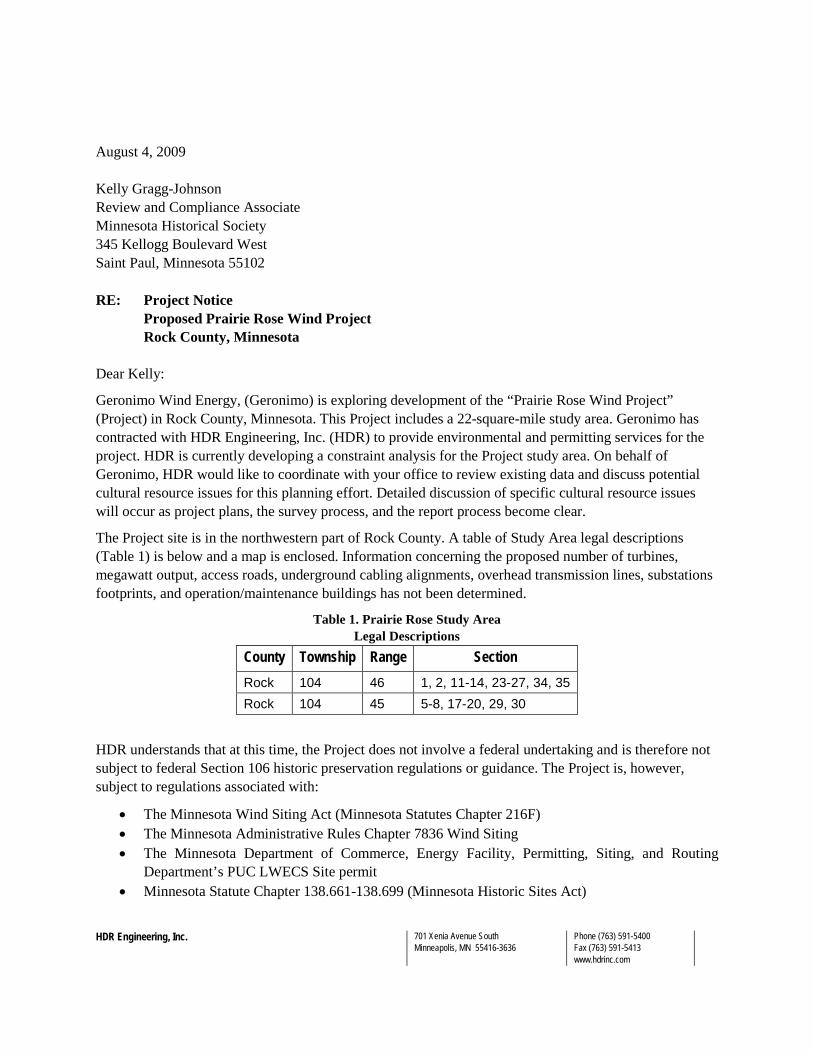
August 4, 2009 Kelly Gragg-Johnson Review and Compliance Associate Minnesota Historical Society 345 Kellogg Boulevard West Saint Paul, Minnesota 55102 RE: Project Notice
Proposed Prairie Rose Wind Project Rock County, Minnesota
Dear Kelly:
Geronimo Wind Energy, (Geronimo) is exploring development of the “Prairie Rose Wind Project” (Project) in Rock County, Minnesota. This Project includes a 22-square-mile study area. Geronimo has contracted with HDR Engineering, Inc. (HDR) to provide environmental and permitting services for the project. HDR is currently developing a constraint analysis for the Project study area. On behalf of Geronimo, HDR would like to coordinate with your office to review existing data and discuss potential cultural resource issues for this planning effort. Detailed discussion of specific cultural resource issues will occur as project plans, the survey process, and the report process become clear.
The Project site is in the northwestern part of Rock County. A table of Study Area legal descriptions (Table 1) is below and a map is enclosed. Information concerning the proposed number of turbines, megawatt output, access roads, underground cabling alignments, overhead transmission lines, substations footprints, and operation/maintenance buildings has not been determined.
Table 1. Prairie Rose Study Area Legal Descriptions
County Township Range Section Rock 104 46 1, 2, 11-14, 23-27, 34, 35 Rock 104 45 5-8, 17-20, 29, 30
HDR understands that at this time, the Project does not involve a federal undertaking and is therefore not subject to federal Section 106 historic preservation regulations or guidance. The Project is, however, subject to regulations associated with:
• The Minnesota Wind Siting Act (Minnesota Statutes Chapter 216F) • The Minnesota Administrative Rules Chapter 7836 Wind Siting • The Minnesota Department of Commerce, Energy Facility, Permitting, Siting, and Routing
Department’s PUC LWECS Site permit • Minnesota Statute Chapter 138.661-138.699 (Minnesota Historic Sites Act)

Kelly Gragg-Johnson Minnesota Historical Society Prairie Rose Wind Project August 4, 2009
Page 2
• The Minnesota Pollution Control Agency’s (PCA) National Pollutant Discharge Elimination System (NPDES) Permit No: MN R100001 (Appendix A, Part G. Discharges Affecting Historic Places Or Archeological Sites)
HDR understands that additional coordination with your office may be needed pursuant to these regulations and guidance.
HDR intends to review cultural resource site forms and surveys to establish the known properties in the project vicinity, review Government Land Office maps for additional information, and Geographic Information System-developed maps. The information we collect will be used for Project planning and to identify potential Project constraints. We will coordinate with your staff to collect data on file at your office.
We look forward to discussing the project and our data collection efforts with you or your staff. If you have any questions or comments please contact me at (763) 278-5992 or by e-mail at [email protected].
Sincerely,
HDR Engineering, Inc. Stephen Sabatke Archaeologist cc: David Birkholz Minnesota Department of Commerce Scott Anfinson State Archaeologist Michael S. DeRuyter HDR Environmental Scientist Patrick Smith Geronimo Environmental Specialist Enclosures: Project Location Map
HDR Engineering, Inc. 701 Xenia Avenue South Minneapolis, MN 55416-3636
Phone (763) 591-5400 Fax (763) 591-5413 www.hdrinc.com
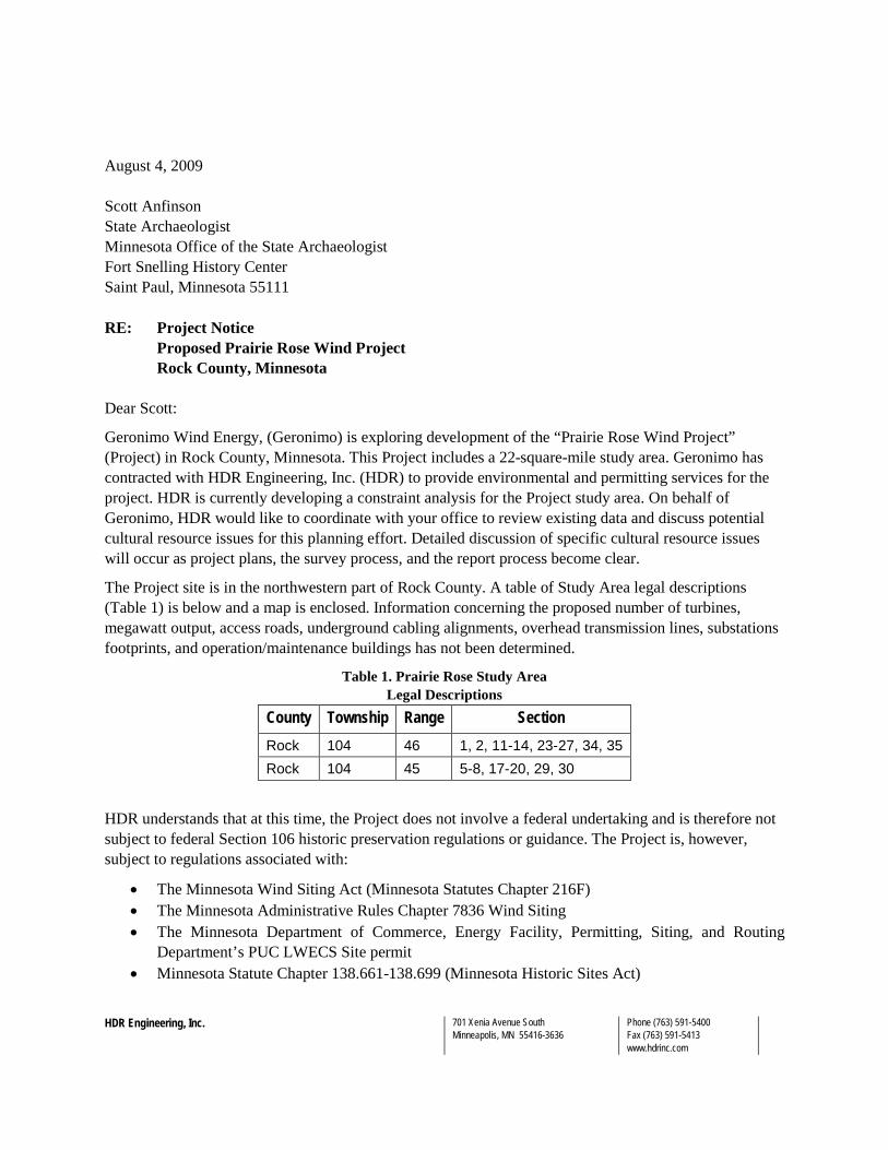
August 4, 2009 Scott Anfinson State Archaeologist Minnesota Office of the State Archaeologist Fort Snelling History Center Saint Paul, Minnesota 55111 RE: Project Notice
Proposed Prairie Rose Wind Project Rock County, Minnesota
Dear Scott:
Geronimo Wind Energy, (Geronimo) is exploring development of the “Prairie Rose Wind Project” (Project) in Rock County, Minnesota. This Project includes a 22-square-mile study area. Geronimo has contracted with HDR Engineering, Inc. (HDR) to provide environmental and permitting services for the project. HDR is currently developing a constraint analysis for the Project study area. On behalf of Geronimo, HDR would like to coordinate with your office to review existing data and discuss potential cultural resource issues for this planning effort. Detailed discussion of specific cultural resource issues will occur as project plans, the survey process, and the report process become clear.
The Project site is in the northwestern part of Rock County. A table of Study Area legal descriptions (Table 1) is below and a map is enclosed. Information concerning the proposed number of turbines, megawatt output, access roads, underground cabling alignments, overhead transmission lines, substations footprints, and operation/maintenance buildings has not been determined.
Table 1. Prairie Rose Study Area Legal Descriptions
County Township Range Section Rock 104 46 1, 2, 11-14, 23-27, 34, 35 Rock 104 45 5-8, 17-20, 29, 30
HDR understands that at this time, the Project does not involve a federal undertaking and is therefore not subject to federal Section 106 historic preservation regulations or guidance. The Project is, however, subject to regulations associated with:
• The Minnesota Wind Siting Act (Minnesota Statutes Chapter 216F) • The Minnesota Administrative Rules Chapter 7836 Wind Siting • The Minnesota Department of Commerce, Energy Facility, Permitting, Siting, and Routing
Department’s PUC LWECS Site permit • Minnesota Statute Chapter 138.661-138.699 (Minnesota Historic Sites Act)
Scott Anfinson Minnesota Office of the State Archaeologist Prairie Rose Wind Project August 4, 2009
Page 2
• The Minnesota Pollution Control Agency’s (PCA) National Pollutant Discharge Elimination System (NPDES) Permit No: MN R100001 (Appendix A, Part G. Discharges Affecting Historic Places Or Archeological Sites)
HDR understands that additional coordination with your office may be needed pursuant to these regulations and guidance.
HDR intends to review cultural resource site forms and surveys to establish the known properties in the project vicinity, review Government Land Office maps for additional information, and Geographic Information System-developed maps. The information we collect will be used for Project planning and to identify potential Project constraints. We will coordinate with your staff to collect data on file at your office.
We look forward to discussing the project and our data collection efforts with you or your staff. If you have any questions or comments please contact me at (763) 278-5992 or by e-mail at [email protected].
Sincerely,
HDR Engineering, Inc. Stephen Sabatke Archaeologist cc: David Birkholz Minnesota Department of Commerce Patrick Smith Geronimo Environmental Specialist Michael S. DeRuyter HDR Environmental Scientist Kelly Gragg-Johnson SHPO Review and Compliance Associate Enclosures: Project Location Map
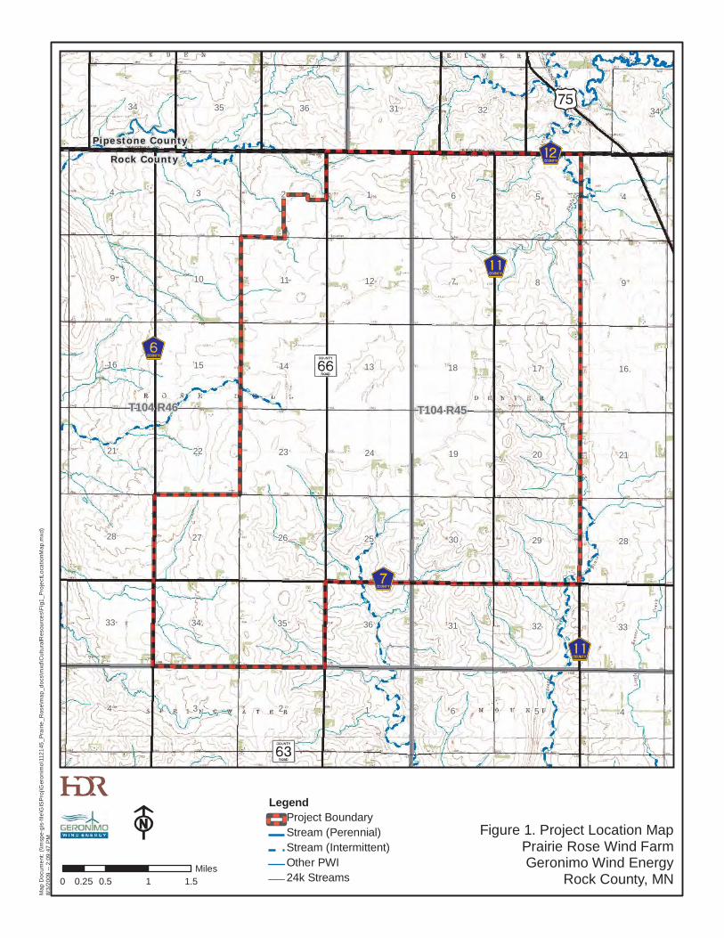
Pipestone County
Rock County
34 35 36 31 32 34
4 3 2 1 6 5 4
9 10 11 12 7 8 9
16 15 14 13 18 17 16
21 22 23 24 19 20 21
28 27 26 25 30 29 28
33 34 35 36 31 32 33
4 3 2 1 6 5 4
T104 R46 T104 R45
Figure 1. Project Location MapPrairie Rose Wind FarmGeronimo Wind Energy
Rock County, MN
LegendProject BoundaryStream (Perennial)Stream (Intermittent)Other PWI24k Streams0 0.5 1 1.50.25
Miles
Map
Doc
umen
t: (\\
msp
e-gi
s-fil
e\G
ISP
roj\G
eron
imo\
1121
45_P
rairi
e_R
ose\
map
_doc
s\m
xd\C
ultu
ralR
esou
rces
\Fig
1_P
roje
ctLo
catio
nMap
.mxd
)8/
3/20
09 --
2:0
9:47
PM
HDR Engineering, Inc. 701 Xenia Avenue South Minneapolis, MN 55416-3636
Phone (763) 591-5400 Fax (763) 591-5413 www.hdrinc.com
March 10, 2010 Mr. Dave Studenski U.S. Army Corps of Engineers Attn: OP-R 1114 South Oak Street La Crescent, MN 55947-1338 RE: Prairie Rose Wind Farm and 115 kV Transmission Line in Rock and Pipestone Counties, MN. Dear Mr. Studenski: Geronimo Wind Energy LLC (Geronimo) sent you a letter in contacted you in August 2009, requesting USACE comments in regard to the proposed Prairie Rose Wind Project in Rock County, Minnesota. Recently, the project boundary has changed and now includes additional sections adjacent to the previous project boundary (Figure 1-2) in Rock and Pipestone Counties. The project nameplate capacity will be 101 MW. In addition, Geronimo is proposing to construct a 115 kV High Voltage Transmission Line (HVTL) which would run between the project substation, located within the wind farm project boundary, and Xcel Energy’s Split Rock Substation, located near Brandon, SD. The proposed route would run parallel to Rock County Highway 7 and Rose Dell Township Road 72 (Figure 1-1). This spring, Geronimo will submit a Site Permit Application for a Large Wind Energy Conversion System and a Route Permit Application for a HVTL to the Minnesota Public Utilities Commission (PUC). Typically, wind facility construction includes erecting wind turbines and constructing associated facilities such as gravel access roads, and an underground and/or aboveground 34.5 kV collector system. Although final turbine locations, access roads, and electrical connections have not been determined at this time, the tables below identify Township sections potentially affected by the project:

Prairie Rose Wind Project U.S. Army Corps of Engineers March 10, 2010
Page 2
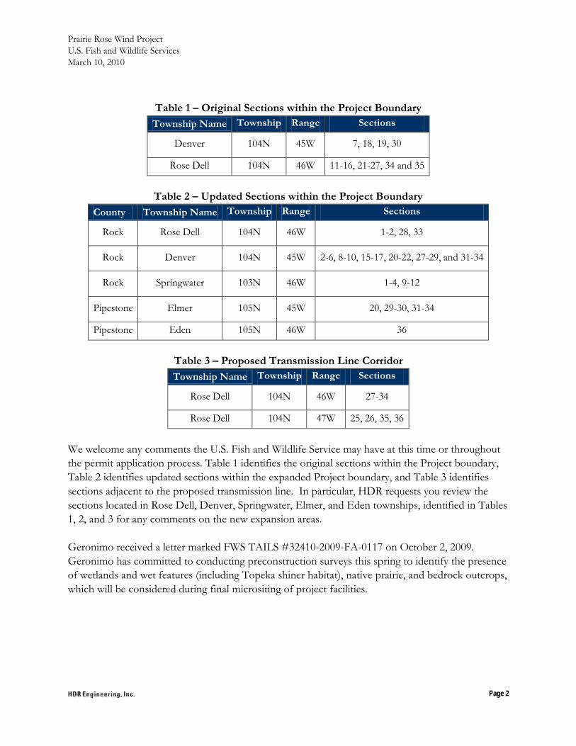
Table 1 – Original Sections within the Project Boundary Township Name Township Range Sections
Denver 104N 45W 7, 18, 19, 30
Rose Dell 104N 46W 11-16, 21-27, 34 and 35
Table 2 – Updated Sections within the Project Boundary
County Township Name Township Range Sections
Rock Rose Dell 104N 46W 1-2, 28, 33
Rock Denver 104N 45W 2-6, 8-10, 15-17, 20-22, 27-29, and 31-34
Rock Springwater 103N 46W 1-4, 9-12
Pipestone Elmer 105N 45W 20, 29-30, 31-34
Pipestone Eden 105N 46W 36
Table 3 – Proposed Transmission Line Corridor Township Name Township Range Sections
Rose Dell 104N 46W 27-34
Rose Dell 104N 47W 25, 26, 35, 36
We welcome any comments the U.S. Army Corps of Engineers may have at this time or throughout the permit application process. Table 1 identifies the original sections within the Project boundary, Table 2 identifies updated sections within the expanded Project boundary, and Table 3 identifies sections adjacent to the proposed transmission line. In particular, HDR requests you review the sections located in Rose Dell, Denver, Springwater, Elmer, and Eden townships, identified in Tables 1, 2, and 3 for any comments on the new expansion areas. Geronimo received a letter marked 2009-03763-DAS on August 27, 2009. Geronimo has committed to conducting preconstruction surveys this spring to identify the presence of wetlands and wet features (including Topeka shiner habitat), which will be considered during final micrositing of project facilities.
Prairie Rose Wind Project U.S. Army Corps of Engineers March 10, 2010
Page 3
Enclosed are maps detailing the location and project boundary of the Prairie Rose Wind Farm and 115 kV Transmission Line. If you require further information or have questions regarding this matter, please call me at (763) 591-5479. Sincerely, Mike DeRuyter Environmental Scientist Enclosures: Figure 1-1 - Project Location Map (Transmission Line) Figure 1-2 – Project Location Map (Wind Farm) Cc: Patrick Smith, Geronimo Wind Energy, LLC
HDR Engineering, Inc. 701 Xenia Avenue South Minneapolis, MN 55416-3636
Phone (763) 591-5400 Fax (763) 591-5413 www.hdrinc.com
March 10, 2010 Mr. Kevin Mixon Regional Environmental Assessment Ecologist Minnesota Department of Natural Resources Division of Ecological Resources Region 4 261 Highway 15 South New Ulm, MN 56073-8915 RE: Prairie Rose Wind Farm and 115 kV Transmission Line in Rock and Pipestone Counties, MN. Dear Mr. Mixon: Geronimo Wind Energy LLC (Geronimo) contacted you in July 2009, requesting MNDNR comments in regards to the proposed Prairie Rose Wind Project in Rock County, Minnesota. Recently, the project boundary has changed and now includes additional sections adjacent to the previous project boundary (Figure 1-2) in Rock and Pipestone Counties. The project nameplate capacity will be 101 MW. In addition, Geronimo is proposing to construct a 115 kV High Voltage Transmission Line (HVTL) which would run between the project substation, located within the wind farm project boundary, and Xcel Energy’s Split Rock Substation, located near Brandon, SD. The proposed route would run parallel to Rock County Highway 7 and Rose Dell Township Road 72 (Figure 1-1). This spring, Geronimo will submit a Site Permit Application for a Large Wind Energy Conversion System and a Route Permit Application for a HVTL to the Minnesota Public Utilities Commission (PUC). Typically, wind facility construction includes erecting wind turbines and constructing associated facilities such as gravel access roads, and an underground and/or aboveground 34.5 kV collector system. Although final turbine locations, access roads, and electrical connections have not been determined at this time, the tables below identify Township sections potentially affected by the project:

Prairie Rose Wind Project Minnesota Department of Natural Resources March 10, 2010
Page 2
Table 1 – Original Sections within the Project Boundary Township Name Township Range Sections
Denver 104N 45W 7, 18, 19, 30
Rose Dell 104N 46W 11-16, 21-27, 34 and 35
Table 2 – Updated Sections within the Project Boundary County Township Name Township Range Sections
Rock Rose Dell 104N 46W 1-2, 28, 33
Rock Denver 104N 45W 2-6, 8-10, 15-17, 20-22, 27-29, and 31-34
Rock Springwater 103N 46W 1-4, 9-12
Pipestone Elmer 105N 45W 20, 29-30, 31-34
Pipestone Eden 105N 46W 36
Table 3 – Proposed Transmission Line Corridor Township Name Township Range Sections
Rose Dell 104N 46W 27-34
Rose Dell 104N 47W 25, 26, 35, 36
We welcome any comments the Minnesota Department of Natural Resources may have at this time or throughout the permit application process. Table 1 identifies the original sections within the Project boundary, Table 2 identifies updated sections within the expanded Project boundary, and Table 3 identifies sections adjacent to the proposed transmission line. In particular, HDR requests you review the sections located in Rose Dell, Denver, Springwater, Elmer, and Eden townships, identified in Tables 1, 2, and 3 for any comments on the new expansion areas. Geronimo received a letter from you dated August 3, 2009. Geronimo has committed to conducting preconstruction surveys this spring to identify the presence of wetlands and wet features (including Topeka shiner habitat), native prairie, and bedrock outcrops, which will be considered during final micrositing of project facilities. Enclosed are maps detailing the location and project boundary of the Prairie Rose Wind Farm and 115 kV Transmission Line. If you require further information or have questions regarding this matter, please call me at (763) 591-5479.
Prairie Rose Wind Project Minnesota Department of Natural Resources March 10, 2010
Page 3
Sincerely, Mike DeRuyter Environmental Scientist Enclosures: Figure 1-1 - Project Location Map (Transmission Line) Figure 1-2 – Project Location Map (Wind Farm) Cc: Patrick Smith, Geronimo Wind Energy, LLC

HDR Engineering, Inc. 701 Xenia Avenue South Minneapolis, MN 55416-3636
Phone (763) 591-5400 Fax (763) 591-5413 www.hdrinc.com
March 10, 2010 Ms. Elise M. Doucette Minnesota Pollution Control Agency Environmental Review Division 520 Lafayette Road North St. Paul, MN 55155-4194 RE: Prairie Rose Wind Farm and 115 kV Transmission Line in Rock and Pipestone Counties, MN. Dear Ms. Doucette: Geronimo Wind Energy LLC (Geronimo) recently received comments from you in a letter dated February 16, 2010, regarding the Certificate of Need Notice Plan for the Prairie Rose 115 kV transmission line in Rock County, Minnesota. The proposed transmission line is in support of Geronimo’s proposed Prairie Rose Wind Farm in Rock and Pipestone Counties, Minnesota. The project nameplate capacity will be 101 MW. The 115 kV High Voltage Transmission Line (HVTL) that would run between the project substation, located within the wind farm project boundary, and Xcel Energy’s Split Rock Substation, located near Brandon, SD. The proposed route would run parallel to Rock County Highway 7 and Rose Dell Township Road 72 (Figure 1-1). This spring, Geronimo will submit a Site Permit Application for a Large Wind Energy Conversion System and a Route Permit Application for a HVTL to the Minnesota Public Utilities Commission (PUC). Typically, wind facility construction includes erecting wind turbines and constructing associated facilities such as gravel access roads, and an underground and/or aboveground 34.5 kV collector system. Although final turbine locations, access roads, and electrical connections have not been determined at this time, the tables below identify Township sections potentially affected by the project:

Prairie Rose Wind Project Minnesota Pollution Control Agency March 10, 2010
Page 2
Table 1 –Sections within the Project Boundary County Township Name Township Range Sections
Rock Rose Dell 104N 46W 1-2, 11-16, 21-28, and 33-35
Rock Denver 104N 45W 2-7, 8-10, 15-19, 20-22, 27-30, and 31-34
Rock Springwater 103N 46W 1-4, 9-12
Pipestone Elmer 105N 45W 20, 29-30, 31-34
Pipestone Eden 105N 46W 36
Table 2 – Proposed Transmission Line Corridor Township Name Township Range Sections
Rose Dell 104N 46W 27-34
Rose Dell 104N 47W 25, 26, 35, 36
We welcome any comments the Minnesota Pollution Control Agency may have at this time or throughout the permit application process. Table 1 identifies the sections within the Project boundary and Table 2 identifies sections adjacent to the proposed transmission line. Enclosed are maps detailing the location and project boundary of the Prairie Rose Wind Farm and 115 kV Transmission Line. If you require further information or have questions regarding this matter, please call me at (763) 591-5479. Sincerely, Mike DeRuyter Environmental Scientist Enclosures: Figure 1-1 - Project Location Map (Transmission Line) Figure 1-2 – Project Location Map (Wind Farm) Cc: Patrick Smith, Geronimo Wind Energy, LLC
HDR Engineering, Inc. 701 Xenia Avenue South Minneapolis, MN 55416-3636
Phone (763) 591-5400 Fax (763) 591-5413 www.hdrinc.com
March 10, 2010 Ms. Lisa Joyal Minnesota Department of Natural Resources Natural Heritage Program 500 Lafayette Road St. Paul, MN 55155-4025 RE: Prairie Rose Wind Farm and 115 kV Transmission Line in Rock and Pipestone Counties, MN. Dear Ms. Joyal: Geronimo Wind Energy LLC (Geronimo) contacted you in October 2008, requesting a search of the Natural Heritage Information Service (NHIS) database and DNR comments in regards to the proposed Prairie Rose Wind Project in Rock County, Minnesota. Recently, the project boundary has changed and now includes additional sections adjacent to the previous project boundary (Figure 1-2) in Rock and Pipestone counties. The project nameplate capacity will be 101 MW. In addition, Geronimo is proposing to construct a 115 kV High Voltage Transmission Line (HVTL) which would run between the project substation, located within the wind farm project boundary, and Xcel Energy’s Split Rock Substation, located near Brandon, South Dakota. The proposed route would run parallel to Rock County Highway 7 and Rose Dell Township Road 72 (Figure 1-1). This spring, Geronimo will submit a Site Permit Application for a Large Wind Energy Conversion System and a Route Permit Application for an HVTL to the Minnesota Public Utilities Commission (PUC). Typically, wind facility construction includes erecting wind turbines and constructing associated facilities such as gravel access roads and an underground and/or aboveground 34.5 kV collector system. Although final turbine locations, access roads, and electrical connections have not been determined at this time, the tables below identify Township sections potentially affected by the project:

Prairie Rose Wind Project Minnesota Department of Natural Resources March 10, 2010
Page 2
Table 1 – Original Sections within the Project Boundary Township Name Township Range Sections
Denver 104N 45W 7, 18, 19, 30
Rose Dell 104N 46W 11-16, 21-27, 34 and 35
Table 2 – Updated Sections within the Project Boundary
County Township Name Township Range Sections
Rock Rose Dell 104N 46W 1-2, 28, 33
Rock Denver 104N 45W 2-6, 8-10, 15-17, 20-22, 27-29, and 31-34
Rock Springwater 103N 46W 1-4, 9-12
Pipestone Elmer 105N 45W 20, 29-30, 31-34
Pipestone Eden 105N 46W 36
Table 3 – Proposed Transmission Line Corridor Township Name Township Range Sections
Rose Dell 104N 46W 27-34
Rose Dell 104N 47W 25, 26, 35, 36
We welcome any comments the Minnesota Department of Natural Resources may have at this time or throughout the permit application process, and request a revised search of the NHIS database. Table 1 identifies the original sections within the Project boundary, Table 2 identifies updated sections within the expanded Project boundary, and Table 3 identifies sections adjacent to the proposed transmission line. In particular, HDR requests you review the sections located in Rose Dell, Denver, Springwater, Elmer, and Eden townships, identified in Tables 1, 2, and 3, for NHIS data in the new expansion areas. Geronimo received NHIS response # ERDB 20090193 on November 14, 2008, which detailed the known occurrences of rare species in the vicinity of the project, as well as Minnesota County Biological Survey Sites of Biodiversity Significance in the original project boundary. In addition, the attached e-mail correspondence includes follow-up conversations between Geronimo and the DNR after the NHIS response was received. Geronimo has committed to conducting preconstruction surveys this spring to identify the presence of native prairie and bedrock outcrops, which will be considered during final micrositing of project facilities.
Prairie Rose Wind Project Minnesota Department of Natural Resources March 10, 2010
Page 3
Enclosed are maps detailing the location and project boundary of the Prairie Rose Wind Farm and 115 kV Transmission Line. If you require further information or have questions regarding this matter, please call me at (763) 591-5479. Sincerely, Mike DeRuyter Environmental Scientist Enclosures: Figure 1-1 - Project Location Map (Transmission Line) Figure 1-2 – Project Location Map (Wind Farm) Copy of e-mail correspondence Cc: Patrick Smith, Geronimo Wind Energy, LLC

HDR Engineering, Inc. 701 Xenia Avenue South Minneapolis, MN 55416-3636
Phone (763) 591-5400 Fax (763) 591-5413 www.hdrinc.com
March 22, 2010 David Birkholz Minnesota Department of Commerce 85 7th
St. Paul, MN 55155 Place East, Suite 500
RE: Project Notice; Revised Prairie Rose Wind Farm Boundary and Transmission Line Rock and Pipestone Counties, Minnesota
Dear David:
As described in a letter HDR sent you on August 4, 2009, Geronimo Wind Energy (Geronimo) is developing the 101 MW Prairie Rose Wind Farm in Rock County, Minnesota. In that letter Geronimo defined the original Prairie Rose Wind Farm boundary as encompassing an approximately 22-square mile study area. This letter is being sent to you because the project boundary has recently been expanded, and an associated transmission line corridor has been identified for the proposed Project. The Project now includes a 55-square-mile study area in Rock and Pipestone counties as well as a 6-mile 115 kV transmission line in Rock County (please note the T-line will extend an additional 19 miles into South Dakota). Geronimo contracted with HDR Engineering, Inc. (HDR) to provide environmental and permitting services for the Project. HDR is currently creating an archaeological work plan for the layout of the Project area. On behalf of Geronimo, HDR would like to coordinate with your office to review existing data and discuss potential cultural resource issues for this revised planning effort. Detailed discussion of specific cultural resource issues will occur as project plans, the survey process, and the report process become clear.
As a response to the original August 4, 2009, letter, SHPO sent a letter to HDR on September 9, 2009 (SHPO number 2009-3187). The SHPO response letter indicated that SHPO views their responsibilities to this project as pursuant to the Minnesota Historic Sites Act and the Minnesota Field Archaeology Act. In addition, the letter indicated that an archaeological resource survey should be conducted in the project area and acknowledges that at this time no federal regulations (such as Section 106 of the National Historic Preservation Act of 1966 and 36CFR800) have been triggered.
The Wind Project Boundary is in the northwestern part of Rock County and southwestern part of Pipestone County. Sections included within the expanded wind farm project boundary and transmission line corridor are shown in Table 1 and Table 2, respectively, and on the enclosed map. Information concerning the proposed number and location of turbines, access roads, underground cabling alignments, substation footprints, and operation/maintenance buildings has not been determined.
David Birkholz Minnesota Department of Commerce March 22, 2010
Page 2
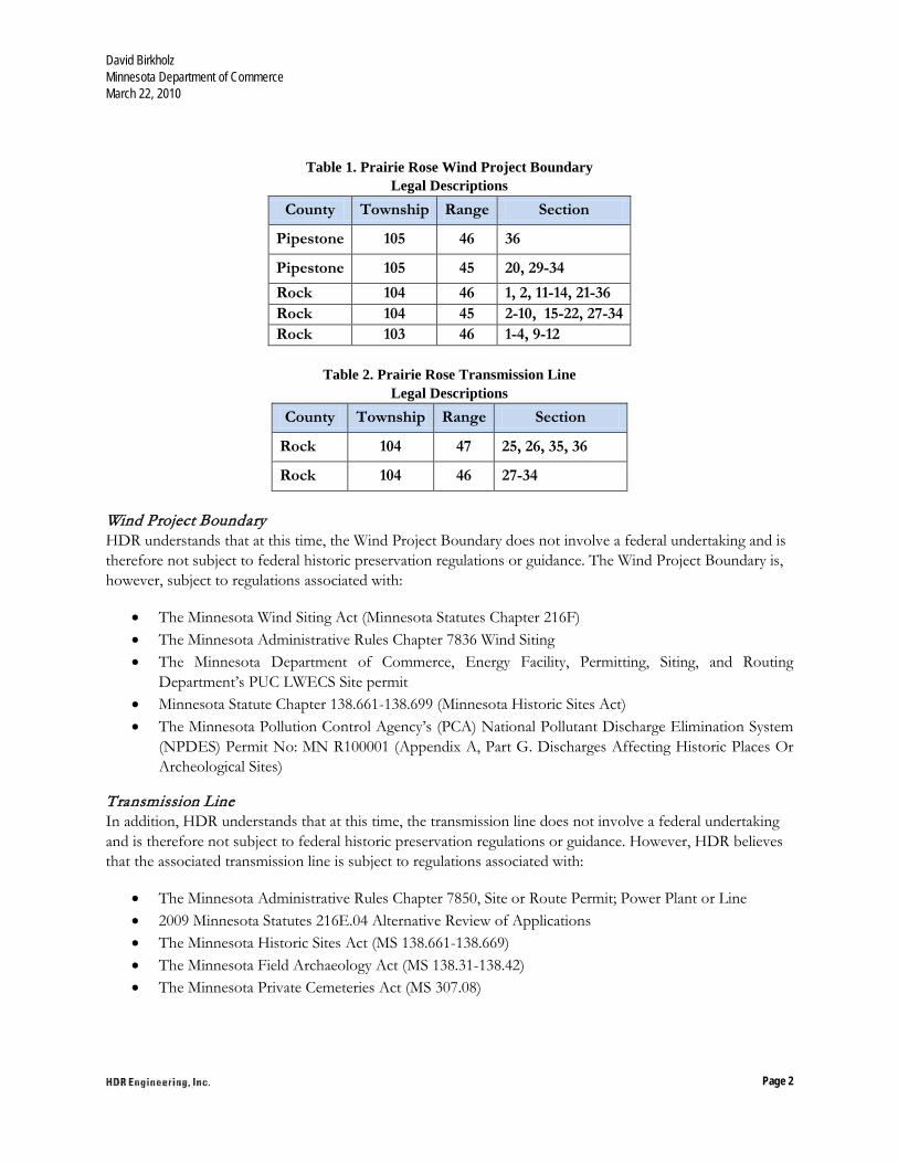
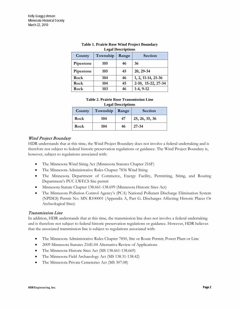
Table 1. Prairie Rose Wind Project Boundary Legal Descriptions
County Township Range Section
Pipestone 105 46 36
Pipestone 105 45 20, 29-34 Rock 104 46 1, 2, 11-14, 21-36 Rock 104 45 2-10, 15-22, 27-34 Rock 103 46 1-4, 9-12
Table 2. Prairie Rose Transmission Line
Legal Descriptions County Township Range Section
Rock 104 47 25, 26, 35, 36
Rock 104 46 27-34 Wind Project Boundary HDR understands that at this time, the Wind Project Boundary does not involve a federal undertaking and is therefore not subject to federal historic preservation regulations or guidance. The Wind Project Boundary is, however, subject to regulations associated with:
• The Minnesota Wind Siting Act (Minnesota Statutes Chapter 216F) • The Minnesota Administrative Rules Chapter 7836 Wind Siting • The Minnesota Department of Commerce, Energy Facility, Permitting, Siting, and Routing
Department’s PUC LWECS Site permit • Minnesota Statute Chapter 138.661-138.699 (Minnesota Historic Sites Act) • The Minnesota Pollution Control Agency’s (PCA) National Pollutant Discharge Elimination System
(NPDES) Permit No: MN R100001 (Appendix A, Part G. Discharges Affecting Historic Places Or Archeological Sites)
Transmission Line In addition, HDR understands that at this time, the transmission line does not involve a federal undertaking and is therefore not subject to federal historic preservation regulations or guidance. However, HDR believes that the associated transmission line is subject to regulations associated with:
• The Minnesota Administrative Rules Chapter 7850, Site or Route Permit; Power Plant or Line • 2009 Minnesota Statutes 216E.04 Alternative Review of Applications • The Minnesota Historic Sites Act (MS 138.661-138.669) • The Minnesota Field Archaeology Act (MS 138.31-138.42) • The Minnesota Private Cemeteries Act (MS 307.08)
David Birkholz Minnesota Department of Commerce March 22, 2010
Page 3
HDR understands that additional coordination with your office may be needed pursuant to these regulations and guidance.
HDR has completed the following tasks:
• Reviewed cultural resource site forms and surveys in the revised project area to establish the known properties in the project vicinity
• Reviewed Government Land Office maps for additional information • Created Geographic Information System maps to analyze the project area
To date, seven archaeological resources, 13 historic facility resources, and seven previous cultural resource reports have been reviewed and found to correspond with the study area. Zero archaeological resources and three historic facility resources are located within either the Wind Farm Boundary or transmission line corridor. In addition, one of these resources, a bridge (RK-RSD-002), is listed on the NRHP. This bridge was reportedly built in 1907 and is a reinforced-concrete, low-rise, filled-spandrel, barrel-vault arch, with very slightly flared wing-wall abutments. Geronimo will consider this resource in its Project plans, Project construction, and facility operation. The information gathered to date tells us that if an archaeology resource is found it will probably be small, with only a slight chance of there being an archaeological resource of substantial size. In addition, based on the information we have gathered to date, any additional historic facilities found will probably be of a similar quality as those already identified and could be associated with the late 19th to early 20th
Additional information may be needed; if so, HDR will coordinate with your staff.
centuries. HDR believes additional resources of these types and nature can be found in the Project area.
We look forward to discussing the Project and our data collection efforts with you or your staff. If you have any questions or comments please contact me at (763) 278-5992 or by e-mail at [email protected].
Sincerely,
HDR Engineering, Inc. Stephen Sabatke Archaeologist cc: Scott Anfinson, State Archaeologist Kelly Gragg-Johnson, SHPO Review and Compliance Associate Michael DeRuyter, HDR Environmental Scientist Patrick Smith, Geronimo Director of Environmental Planning Enclosures: Project Location and Transmission Line Maps

HDR Engineering, Inc. 701 Xenia Avenue South Minneapolis, MN 55416-3636
Phone (763) 591-5400 Fax (763) 591-5413 www.hdrinc.com
March 22, 2010 Kelly Gragg-Johnson Review and Compliance Associate Minnesota Historical Society 345 Kellogg Boulevard West Saint Paul, Minnesota 55102 RE: Project Notice; Revised Prairie Rose Wind Farm Boundary and Transmission Line Rock and Pipestone Counties, Minnesota
Dear Kelly:
As described in a letter HDR sent you on August 4, 2009, Geronimo Wind Energy (Geronimo) is developing the 101 MW Prairie Rose Wind Farm in Rock County, Minnesota. In that letter Geronimo defined the original Prairie Rose Wind Farm boundary as encompassing an approximately 22-square mile study area. This letter is being sent to you because the project boundary has recently been expanded, and an associated transmission line corridor has been identified for the proposed Project. The Project now includes a 55-square-mile study area in Rock and Pipestone counties as well as a 6-mile 115 kV transmission line in Rock County (please note the T-line will extend an additional 19 miles into South Dakota). Geronimo contracted with HDR Engineering, Inc. (HDR) to provide environmental and permitting services for the Project. HDR is currently creating an archaeological work plan for the layout of the Project area. On behalf of Geronimo, HDR would like to coordinate with your office to review existing data and discuss potential cultural resource issues for this revised planning effort. Detailed discussion of specific cultural resource issues will occur as project plans, the survey process, and the report process become clear.
As a response to the original August 4, 2009, letter, SHPO sent a letter to HDR on September 9, 2009 (SHPO number 2009-3187). The SHPO response letter indicated that SHPO views their responsibilities to this project as pursuant to the Minnesota Historic Sites Act and the Minnesota Field Archaeology Act. In addition, the letter indicated that an archaeological resource survey should be conducted in the project area and acknowledges that at this time no federal regulations (such as Section 106 of the National Historic Preservation Act of 1966 and 36CFR800) have been triggered.
The Wind Project Boundary is in the northwestern part of Rock County and southwestern part of Pipestone County. Sections included within the expanded wind farm project boundary and transmission line corridor are shown in Table 1 and Table 2, respectively, and on the enclosed map. Information concerning the proposed number and location of turbines, access roads, underground cabling alignments, substation footprints, and operation/maintenance buildings has not been determined.
Kelly Gragg-Johnson Minnesota Historical Society March 22, 2010
Page 2
Table 1. Prairie Rose Wind Project Boundary Legal Descriptions
County Township Range Section
Pipestone 105 46 36
Pipestone 105 45 20, 29-34 Rock 104 46 1, 2, 11-14, 21-36 Rock 104 45 2-10, 15-22, 27-34 Rock 103 46 1-4, 9-12
Table 2. Prairie Rose Transmission Line
Legal Descriptions County Township Range Section
Rock 104 47 25, 26, 35, 36
Rock 104 46 27-34 Wind Project Boundary HDR understands that at this time, the Wind Project Boundary does not involve a federal undertaking and is therefore not subject to federal historic preservation regulations or guidance. The Wind Project Boundary is, however, subject to regulations associated with:
• The Minnesota Wind Siting Act (Minnesota Statutes Chapter 216F) • The Minnesota Administrative Rules Chapter 7836 Wind Siting • The Minnesota Department of Commerce, Energy Facility, Permitting, Siting, and Routing
Department’s PUC LWECS Site permit • Minnesota Statute Chapter 138.661-138.699 (Minnesota Historic Sites Act) • The Minnesota Pollution Control Agency’s (PCA) National Pollutant Discharge Elimination System
(NPDES) Permit No: MN R100001 (Appendix A, Part G. Discharges Affecting Historic Places Or Archeological Sites)
Transmission Line In addition, HDR understands that at this time, the transmission line does not involve a federal undertaking and is therefore not subject to federal historic preservation regulations or guidance. However, HDR believes that the associated transmission line is subject to regulations associated with:
• The Minnesota Administrative Rules Chapter 7850, Site or Route Permit; Power Plant or Line • 2009 Minnesota Statutes 216E.04 Alternative Review of Applications • The Minnesota Historic Sites Act (MS 138.661-138.669) • The Minnesota Field Archaeology Act (MS 138.31-138.42) • The Minnesota Private Cemeteries Act (MS 307.08)
Kelly Gragg-Johnson Minnesota Historical Society March 22, 2010
Page 3
HDR understands that additional coordination with your office may be needed pursuant to these regulations and guidance.
HDR has completed the following tasks:
• Reviewed cultural resource site forms and surveys in the revised project area to establish the known properties in the project vicinity
• Reviewed Government Land Office maps for additional information • Created Geographic Information System maps to analyze the project area
To date, seven archaeological resources, 13 historic facility resources, and seven previous cultural resource reports have been reviewed and found to correspond with the study area. Zero archaeological resources and three historic facility resources are located within either the Wind Farm Boundary or transmission line corridor. In addition, one of these resources, a bridge (RK-RSD-002), is listed on the NRHP. This bridge was reportedly built in 1907 and is a reinforced-concrete, low-rise, filled-spandrel, barrel-vault arch, with very slightly flared wing-wall abutments. Geronimo will consider this resource in its Project plans, Project construction, and facility operation. The information gathered to date tells us that if an archaeology resource is found it will probably be small, with only a slight chance of there being an archaeological resource of substantial size. In addition, based on the information we have gathered to date, any additional historic facilities found will probably be of a similar quality as those already identified and could be associated with the late 19th to early 20th
Additional information may be needed; if so, HDR will coordinate with your staff.
centuries. HDR believes additional resources of these types and nature can be found in the Project area.
We look forward to discussing the Project and our data collection efforts with you or your staff. If you have any questions or comments please contact me at (763) 278-5992 or by e-mail at [email protected].
Sincerely,
HDR Engineering, Inc. Stephen Sabatke Archaeologist cc: Scott Anfinson State Archaeologist David Birkholz, Minnesota Department of Commerce Michael DeRuyter, HDR Environmental Scientist Patrick Smith, Geronimo Director of Environmental Planning Enclosures: Project Location and Transmission Line Maps

HDR Engineering, Inc. 701 Xenia Avenue South Minneapolis, MN 55416-3636
Phone (763) 591-5400 Fax (763) 591-5413 www.hdrinc.com
March 22, 2010 Scott Anfinson State Archaeologist Minnesota Office of the State Archaeologist Fort Snelling History Center Saint Paul, Minnesota 55111 RE: Project Notice; Revised Prairie Rose Wind Farm Boundary and Transmission Line Rock and Pipestone Counties, Minnesota
Dear Scott:
As described in a letter HDR sent you on August 4, 2009, Geronimo Wind Energy (Geronimo) is developing the 101 MW Prairie Rose Wind Farm in Rock County, Minnesota. In that letter Geronimo defined the original Prairie Rose Wind Farm boundary as encompassing an approximately 22-square mile study area. This letter is being sent to you because the project boundary has recently been expanded, and an associated transmission line corridor has been identified for the proposed Project. The Project now includes a 55-square-mile study area in Rock and Pipestone counties as well as a 6-mile 115 kV transmission line in Rock County (please note the T-line will extend an additional 19 miles into South Dakota). Geronimo contracted with HDR Engineering, Inc. (HDR) to provide environmental and permitting services for the Project. HDR is currently creating an archaeological work plan for the layout of the Project area. On behalf of Geronimo, HDR would like to coordinate with your office to review existing data and discuss potential cultural resource issues for this revised planning effort. Detailed discussion of specific cultural resource issues will occur as project plans, the survey process, and the report process become clear.
As a response to the original August 4, 2009, letter, SHPO sent a letter to HDR on September 9, 2009 (SHPO number 2009-3187). The SHPO response letter indicated that SHPO views their responsibilities to this project as pursuant to the Minnesota Historic Sites Act and the Minnesota Field Archaeology Act. In addition, the letter indicated that an archaeological resource survey should be conducted in the project area and acknowledges that at this time no federal regulations (such as Section 106 of the National Historic Preservation Act of 1966 and 36CFR800) have been triggered.
The Wind Project Boundary is in the northwestern part of Rock County and southwestern part of Pipestone County. Sections included within the expanded wind farm project boundary and transmission line corridor are shown in Table 1 and Table 2, respectively, and on the enclosed map. Information concerning the proposed number and location of turbines, access roads, underground cabling alignments, substation footprints, and operation/maintenance buildings has not been determined.

Scott Anfinson Minnesota Office of the State Archaeologist March 22, 2010
Page 2
Table 1. Prairie Rose Wind Project Boundary Legal Descriptions
County Township Range Section
Pipestone 105 46 36
Pipestone 105 45 20, 29-34 Rock 104 46 1, 2, 11-14, 21-36 Rock 104 45 2-10, 15-22, 27-34 Rock 103 46 1-4, 9-12
Table 2. Prairie Rose Transmission Line
Legal Descriptions County Township Range Section
Rock 104 47 25, 26, 35, 36
Rock 104 46 27-34 Wind Project Boundary HDR understands that at this time, the Wind Project Boundary does not involve a federal undertaking and is therefore not subject to federal historic preservation regulations or guidance. The Wind Project Boundary is, however, subject to regulations associated with:
• The Minnesota Wind Siting Act (Minnesota Statutes Chapter 216F) • The Minnesota Administrative Rules Chapter 7836 Wind Siting • The Minnesota Department of Commerce, Energy Facility, Permitting, Siting, and Routing
Department’s PUC LWECS Site permit • Minnesota Statute Chapter 138.661-138.699 (Minnesota Historic Sites Act) • The Minnesota Pollution Control Agency’s (PCA) National Pollutant Discharge Elimination System
(NPDES) Permit No: MN R100001 (Appendix A, Part G. Discharges Affecting Historic Places Or Archeological Sites)
Transmission Line In addition, HDR understands that at this time, the transmission line does not involve a federal undertaking and is therefore not subject to federal historic preservation regulations or guidance. However, HDR believes that the associated transmission line is subject to regulations associated with:
• The Minnesota Administrative Rules Chapter 7850, Site or Route Permit; Power Plant or Line • 2009 Minnesota Statutes 216E.04 Alternative Review of Applications • The Minnesota Historic Sites Act (MS 138.661-138.669) • The Minnesota Field Archaeology Act (MS 138.31-138.42) • The Minnesota Private Cemeteries Act (MS 307.08)
Scott Anfinson Minnesota Office of the State Archaeologist March 22, 2010
Page 3
HDR understands that additional coordination with your office may be needed pursuant to these regulations and guidance.
HDR has completed the following tasks:
• Reviewed cultural resource site forms and surveys in the revised project area to establish the known properties in the project vicinity
• Reviewed Government Land Office maps for additional information • Created Geographic Information System maps to analyze the project area
To date, seven archaeological resources, 13 historic facility resources, and seven previous cultural resource reports have been reviewed and found to correspond with the study area. Zero archaeological resources and three historic facility resources are located within either the Wind Farm Boundary or transmission line corridor. In addition, one of these resources, a bridge (RK-RSD-002), is listed on the NRHP. This bridge was reportedly built in 1907 and is a reinforced-concrete, low-rise, filled-spandrel, barrel-vault arch, with very slightly flared wing-wall abutments. Geronimo will consider this resource in its Project plans, Project construction, and facility operation. The information gathered to date tells us that if an archaeology resource is found it will probably be small, with only a slight chance of there being an archaeological resource of substantial size. In addition, based on the information we have gathered to date, any additional historic facilities found will probably be of a similar quality as those already identified and could be associated with the late 19th to early 20th
Additional information may be needed; if so, HDR will coordinate with your staff.
centuries. HDR believes additional resources of these types and nature can be found in the Project area.
We look forward to discussing the Project and our data collection efforts with you or your staff. If you have any questions or comments please contact me at (763) 278-5992 or by e-mail at [email protected].
Sincerely,
HDR Engineering, Inc. Stephen Sabatke Archaeologist cc: David Birkholz Minnesota Department of Commerce Kelly Gragg-Johnson SHPO Review and Compliance Associate Michael DeRuyter HDR Environmental Scientist Patrick Smith Geronimo Director of Environmental Planning Enclosures: Project Location and Transmission Line Maps
HDR Engineering, Inc. 701 Xenia Avenue South Minneapolis, MN 55416-3636
Phone (763) 591-5400 Fax (763) 591-5413 www.hdrinc.com
March 10, 2010 Mr. Richard Davis U.S. Fish and Wildlife Service Twin Cities Field Office 4101 American Boulevard East Bloomington, MN 55425 RE: Prairie Rose Wind Farm and 115 kV Transmission Line in Rock and Pipestone Counties, MN. Dear Mr. Davis: Geronimo Wind Energy LLC (Geronimo) contacted you in July 2009, requesting USFWS comments in regards to the proposed Prairie Rose Wind Project in Rock County, Minnesota. Recently, the project boundary has changed and now includes additional sections adjacent to the previous project boundary (Figure 1-2) in Rock and Pipestone Counties. The project nameplate capacity will be 101 MW. In addition, Geronimo is proposing to construct a 115 kilovolt (kV) High Voltage Transmission Line (HVTL) which would run between the project substation, located within the wind farm project boundary, and Xcel Energy’s Split Rock Substation, located near Brandon, SD. The proposed route would run parallel to Rock County Highway 7 and Rose Dell Township Road 72 (Figure 1-1). This spring, Geronimo will submit a Site Permit Application for a Large Wind Energy Conversion System and a Route Permit Application for a HVTL to the Minnesota Public Utilities Commission (PUC). Typically, wind facility construction includes erecting wind turbines and constructing associated facilities such as gravel access roads, and an underground and/or aboveground 34.5 kV collector system. Although final turbine locations, access roads, and electrical connections have not been determined at this time, the tables below identify Township sections potentially affected by the project:
Prairie Rose Wind Project U.S. Fish and Wildlife Services March 10, 2010
Page 2
Table 1 – Original Sections within the Project Boundary Township Name Township Range Sections
Denver 104N 45W 7, 18, 19, 30
Rose Dell 104N 46W 11-16, 21-27, 34 and 35
Table 2 – Updated Sections within the Project Boundary
County Township Name Township Range Sections
Rock Rose Dell 104N 46W 1-2, 28, 33
Rock Denver 104N 45W 2-6, 8-10, 15-17, 20-22, 27-29, and 31-34
Rock Springwater 103N 46W 1-4, 9-12
Pipestone Elmer 105N 45W 20, 29-30, 31-34
Pipestone Eden 105N 46W 36
Table 3 – Proposed Transmission Line Corridor Township Name Township Range Sections
Rose Dell 104N 46W 27-34
Rose Dell 104N 47W 25, 26, 35, 36
We welcome any comments the U.S. Fish and Wildlife Service may have at this time or throughout the permit application process. Table 1 identifies the original sections within the Project boundary, Table 2 identifies updated sections within the expanded Project boundary, and Table 3 identifies sections adjacent to the proposed transmission line. In particular, HDR requests you review the sections located in Rose Dell, Denver, Springwater, Elmer, and Eden townships, identified in Tables 1, 2, and 3 for any comments on the new expansion areas. Geronimo received a letter marked FWS TAILS #32410-2009-FA-0117 on October 2, 2009. Geronimo has committed to conducting preconstruction surveys this spring to identify the presence of wetlands and wet features (including Topeka shiner habitat), native prairie, and bedrock outcrops, which will be considered during final micrositing of project facilities.
Prairie Rose Wind Project U.S. Fish and Wildlife Services March 10, 2010
Page 3
Enclosed are maps detailing the location and project boundary of the Prairie Rose Wind Farm and 115 kV Transmission Line. If you require further information or have questions regarding this matter, please call me at (763) 591-5479. Sincerely,
Mike DeRuyter Environmental Scientist Enclosures: Figure 1-1 - Project Location Map (Transmission Line) Figure 1-2 – Project Location Map (Wind Farm) Cc: Patrick Smith, Geronimo Wind Energy, LLC

Pipestone County
Rock County
T105 R46Eden
T105 R45Elmer
T104 R46Rose Dell
T104 R45Denver
T103 R46Spring Water
T103 R45Mound
21 22 23 24 19 20 21 22 23 24
28 27 25 30 29 28 26 25
33 34 35 36 31 32 34 35 36
4 3 2 1 6 5 4 3 2
9 10 11 12 7 8 9 10 11
16 15 14 13 18 17 16 15 14
21 22 23 24 19 20 21 22 23
28 27 26 25 30 29 28 27 26
33 34 35 36 31 32 33 34 35
4 3 2 1 6 5 4 3 2
9 10 11 12 7 8 9 10 11
Figure 1-2 Project Location MapPrairie Rose Wind Project
Geronimo Wind EnergyRock County, MN
LegendProject BoundaryCounty Boundary0 0.5 1 1.5 20.25
Miles
Map
Doc
umen
t: (\\
msp
e-gi
s-fil
e\G
ISP
roj\G
eron
imo\
1121
45_P
rairi
e_R
ose\
map
_doc
s\m
xd\L
WE
CS
_Per
mit_
App
licat
ion\
Fig1
-2_P
roje
ctLo
catio
nMap
.mxd
)3/
8/20
10 --
3:2
3:40
PM
So
uth
Da
ko
taM
inn
eso
ta
T104 R47Rose Dell
T104 R46Rose Dell
T103 R47Spring Water
T103 R46Spring Water
14 13 18 17 16 15
23 24 19 20 21 22
26 25 30 29 28 27
35 36 31 32 33 34
2 6 5 4 3
11 12 7 8 9 10
14 13 18 17 16 15
Cou
nty
Rd
51
County Hwy 7
County Rd 63
County Hwy 20
County Hwy 7
Cou
nty
Rd
59C
ount
y R
d 59
State Hwy
23
Cou
nty
Hw
y 6
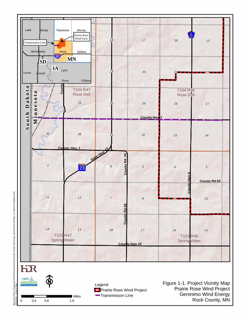
Figure 1-1. Project Vicinity MapPrairie Rose Wind Project
Geronimo Wind EnergyRock County, MN
LegendPrairie Rose Wind ProjectTransmisison Line
0 0.8 1.60.4Miles
Map
Doc
umen
t: (\\
msp
e-gi
s-fil
e\G
ISP
roj\G
eron
imo\
1121
45_P
rairi
e_R
ose\
map
_doc
s\m
xd\T
Line
\Fig
1-1_
Pro
ject
Vici
nity
Map
.mxd
)2/
25/2
010
-- 3
:26:
17 P
M
SD MN
IA Lyon
O’BrienSioux
Murray
Nobles
Pipestone
Rock
Lake
Lincoln
Minnehaha
Moody
Turner
Prairie RoseWind Farm
Transmission Line


DNR Information: 651-296-6157 ● 1-888-646-6367 ● TTY: 651-296-5484 ● 1-800-657-3929
An Equal Opportunity Employer Who Values Diversity
Phone: (651) 259-5109 E-mail: [email protected] April 30, 2010 Correspondence # ERDB 20090193-0003 Mike DeRuyter HDR Engineering, Inc. 701 Xenia Avenue South, Suite 600 Minneapolis, MN 55416 RE: Natural Heritage information in the vicinity of the proposed Prairie Rose Wind Farm Dear Mr. DeRuyter,
As requested, the Minnesota Natural Heritage Information System has been queried to determine if any rare species or other significant natural features are known to occur within an approximate one-mile radius of the revised project boundary. Because the changes to the project boundary are substantial, this letter replaces the previous Natural Heritage letter dated November 14, 2008. The query results identify several rare features that have been documented within the search area (for details, see the enclosed database reports; please visit the Rare Species Guide at http://www.dnr.state.mn.us/rsg/index.html for more information on the biology, habitat use, and conservation measures of these rare species). Please address the following issues in the Public Utilities Commission (PUC) Site Permit Application for this project:
• Blanding’s turtles (Emydoidea blandingii), a state-listed threatened species, have been reported
from the vicinity of the proposed project. Although we have no records from directly within the project site, turtles have been documented in Poplar Creek which extends into the project boundary and may occur in the wetlands and waterways within the project boundary. Blanding’s turtles also use upland areas up to and over a mile distant from wetlands and streams. Uplands are used for nesting, basking, periods of dormancy, and traveling between wetlands. Because of the tendency to travel long distances over land, Blanding’s turtles regularly travel across roads and are therefore susceptible to collisions with vehicles. Any added mortality can have a large impact to populations of Blanding’s turtles, as these turtles have a low reproduction rate that depends upon a high survival rate to maintain population levels. Other factors contributing to the decline of this species include wetland drainage and degradation, and the development of upland habitat.
For your information, I have attached a Blanding’s turtle fact sheet that describes the habitat use and life history of this species. The fact sheet also provides two lists of recommendations for avoiding and minimizing impacts to this rare turtle. Please refer to the first list of recommendations for your project. These include specific recommendations regarding wetlands, utilities, and vegetation management that will pertain to this project. If greater protection for turtles is desired, the second list of additional recommendations can also be implemented. For further assistance regarding the Blanding’s turtle, please contact Lisa Gelvin-Innvaer, DNR Regional Nongame Specialist, at 507-359-6033.
County Township (N) Range (W) Section(s)
Rock
104 47 25, 26, 35, 36 104 46 1, 2, 11-14, 21-36 104 45 2-10, 15-22, 27-34 103 46 1-4, 9-12
Pipestone 105 45 20, 29-34 105 46 36
Minnesota Department of Natural Resources
500 Lafayette Road
St. Paul, Minnesota 55155-4025
Division of Ecological Resources, Box 25

The attached flyer should be given to all contractors working in the area. If Blanding’s turtles are encountered on site, please remember that state law and rules prohibit the destruction of threatened or endangered species, except under certain prescribed conditions. If turtles are in imminent danger they should be moved by hand out of harm’s way, otherwise they should be left undisturbed. Please report observations of Blanding’s turtles in the project area to Lisa Gelvin-Innvaer.
• The streams within the project boundary are either federally designated as critical habitat for the
Topeka shiner (Notropis topeka), a federally-listed endangered and state-listed special concern species, or flow into waterways that are federally designated as such. The plains topminnow (Fundulus sciadicus), a state-listed species of special concern, has also been documented in these streams. These two species are adversely impacted by actions that alter stream hydrology or decrease water quality. To minimize potential impacts, please see the enclosed recommendations for working in Topeka shiner habitat.
• Burrowing owls (Speotyto cunicularia), a state-listed endangered species, have nested in pastures
within the project boundary in the past, and in 2007 this species successfully nested in a soybean field less than five miles from the project boundary. Burrowing owls typically use open, grazed pastures or native prairies populated by burrowing mammals. Given the extreme rarity of this species, the existence of suitable habitat within the project boundary, the proximity of a recent nest, and the potential risk of this species for collisions with wind turbines (see http://www.energy.ca.gov/2008publications/CEC-500-2008-080/CEC-500-2008-080.PDF), we recommend that a pre-construction survey for burrowing owls be conducted to determine if they are currently using the area and, if so, to assist in the placement of the turbines (the USFWS recommends a ¼ mile buffer from burrowing owl territories; see http://www.fws.gov/wyominges/Pages/Species/Species_SpeciesConcern/Raptors.html). Please contact me before any survey work is initiated, as we will need to discuss potential surveyors, survey protocol, and other requirements.
Other rare grassland birds have also been documented in the area: the short-eared owl (Asio flammeus; this record is not on the enclosed reports), a state-listed bird of special concern, and the upland sandpiper (Bartramia longicauda), a Species in Greatest Conservation Need as identified in Minnesota’s Comprehensive Wildlife Conservation Strategy (http://www.dnr.state.mn.us/cwcs/index.html). Wind farms can affect birds due to collision mortality, displacement due to disturbance, habitat fragmentation, and habitat loss. Potential impacts to grassland birds are a significant concern because many of these species are declining in number nationwide. Given the potential for grassland birds in the area, the proximity of the project to Sites of Biodiversity Significance and native prairie, and the potential for wind turbines to cause avian mortality, we also encourage pre- and post-construction avian monitoring in general.
• The Minnesota County Biological Survey (MCBS) has identified several Sites of Biodiversity Significance within the project boundary. Sites of Biodiversity Significance have varying levels of native biodiversity and are ranked based on the relative significance of this biodiversity at a statewide level. Factors taken into account during the ranking process include the number of rare species documented within the site, the quality of the native plant communities in the site, the size of the site, and the context of the site within the landscape (for more information please refer to the enclosed MCBS guidelines). The Sites within the project boundary contain rare native plant communities and several state-listed plants and animals. Two of the native plant communities, Mesic Prairie and Crystalline Bedrock Outcrop: Sioux Quartzite Subtype, have a state rank of 2, which means that they are imperiled in Minnesota and are very vulnerable to

extirpation from the state. The other two communities, Basswood – Bur Oak – (Green Ash) Forest and Seepage Meadow/Carr Tussock: Sedge Meadow, have a state rank of 3 and are also vulnerable to extirpation in Minnesota. (GIS shapefiles of MCBS Sites of Biodiversity Significance and MCBS Native Plant Communities can be downloaded from the DNR Data Deli at http://deli.dnr.state.mn.us.) Given the rarity of these communities and the presence of state-listed plants and animals (see more detailed discussion below), we recommend avoidance of all Sites of Biodiversity Significance (except those rated ‘Below’) regardless of property ownership (please see the enclosed map). Avoidance of these areas will alleviate most of the Natural Heritage concerns addressed in this letter. A short summary of the Sites located within the project is listed below. A more detailed discussion of the different native plant communities follows this Site summary.
The Sites of Moderate Biodiversity Significance in T104N R46W Section 2 (#85 and 86
on enclosed map), T104N R45W Section 34 (#189), T104N R46W Section 27 (#102), and T104N R46W Section 34 (#112) contain Crystalline Bedrock Outcrops and several state-listed plants.
The Site of Moderate Biodiversity Significance (#52) in T105N R45W Sections 31 and
32 contains state-listed plants and Crystalline Bedrock Outcrop and Seepage Meadow/Carr Tussock native plant communities.
The Site of Moderate Biodiversity Significance (#51) adjacent to Poplar Creek and its
tributaries is an important buffer that likely provides habitat for Blanding’s turtles and also allows the natural meandering of streams designated as critical habitat for Topeka shiners.
The Site of Moderate Biodiversity Significance (#110) in T104N R45W Section 32
contains Crystalline Bedrock Outcrops and a buffer around Beaver Creek which is federally designated as critical habitat for Topeka shiners.
The Sites of High Biodiversity Significance (#10 and 212) in T104N R46W Section 28
contain over 400 acres of native prairie and abundant rock outcrops that are in excellent condition. This is one of the best outcrop areas on private land in Minnesota and numerous state-listed plants have been documented here.
Several Sites of High Biodiversity Significance (#68, 192, 193, and 194) along ridge on
the eastern edge of the project boundary contain Mesic Prairie, Crystalline Bedrock Outcrop and Seepage Meadow/Carr Tussock native plant communities. Again, several state-listed plants have been documented here.
Routing the proposed transmission line south of Highway 7 and Township Road 72 will
avoid impacting two Sites of Moderate Biodiversity Significance (#15 and 211).
Sites ranked as Below do not meet the minimum biodiversity threshold for statewide significance. These sites, however, may have conservation value at the local level as habitat for native plants and animals, corridors for animal movements, buffers surrounding higher quality natural areas, or as areas with high potential for restoration of native habitat.

• The Crystalline Bedrock Outcrops within the project boundary contain several state-listed endangered (Wolf’s spike-rush, Eleocharis wolfii; blackfoot quillwort, Isoetes melanopoda; hairy water clover, Marsilea vestita) and threatened (pigmyweed, Crassula aquatica; short-pointed umbrella-sedge, Cyperus acuminatus; mud plantain, Heteranthera limosa; slender plantain, Plantago elongata) plant species. These rare species are part of the distinctive flora that exists in bedrock outcrop communities. This flora consists of many species of vascular plants, mosses, and lichens that occur in no other habitat in Minnesota. Rock outcrop communities are small features that are embedded in a matrix of prairie, savanna, woodland, forest, or marsh vegetation. They are perhaps more usefully considered as an assemblage of several plant communities including a bare rock community composed mostly of lichens, a crevice and thin soil community with specialized vascular plants, a deeper soil community with prairie or woodland species, and a rainwater pool community supporting aquatic plants. The outcrops within the project area are a rare subtype of bedrock outcrop that has been documented on quartzite at scattered locations in Rock, Pipestone, and Cottonwood counties.
Given the rarity of these communities and the presence of state-listed threatened and endangered plants, bedrock outcrop communities within the project area will need to be avoided. Minnesota’s endangered species law (Minnesota Statutes, section 84.0895) and associated rules (Minnesota Rules, part 6212.1800 to 6212.2300 and 6134) prohibit the taking of threatened or endangered species without a permit. Please note that issuance of permits is discretionary, negotiations can take several months, and the applicant must document that there are no feasible alternatives to the taking. In addition, please note that Crystalline Bedrock Outcrop native plant communities (of which jurisdictional wetlands are a part) qualify as “Rare Natural Communities” under the Minnesota Wetland Conservation Act. Minnesota Rules 8420.0548, Subp. 3 states that a wetland replacement plan for activities that modify a rare natural community must be denied if the local government unit determines that the proposed activities will permanently adversely affect the natural community. If you have any questions regarding this, please contact Doug Norris, the DNR Wetlands Program Coordinator, at 651-259-5125.
• As noted above, the project area contains several native prairie remnants. In the mid-1800s,
eighteen million acres of prairie covered Minnesota. Given that more than 99% of Minnesota’s prairies have been destroyed and more than one-third of Minnesota's endangered, threatened, and special concern species are now dependent on the remaining small fragments of Minnesota's prairie ecosystem, we feel that all prairie remnants merit protection. We also recommend that turbines and other infrastructure be distant enough from native prairies as to allow for prairie management, such as prescribed burning.
Western prairie fringed orchids (Platanthera praeclara), a federally-listed threatened and state-listed endangered plant species, have been documented within a prairie remnant just outside of the project area. Western prairie fringed orchids usually occur in remnant native prairies and sedge meadows, but have also been observed at disturbed sites.
The phlox moth (Schinia indiana), a state-listed species of special concern, has been
documented in nearby prairie remnants.
As mentioned above, several rare grassland birds have the potential to use the native prairie remnants within the project boundary.
Given the rarity of this native plant community, the potential for state-listed species to occur within it, and the presence of the bedrock communities embedded within the prairies, disturbance within prairie remnants should be avoided. Please contact me if avoidance of prairie remnants is not feasible, as animal and botanical surveys will likely be required. We will need to discuss potential contractors, survey protocol, and other requirements before any survey work is initiated. If applicable, please send me a copy of the native prairie protection and management plan (Section III.C.6. of the Site Permit). The plan should include measures to avoid impacts to native prairie and measures to mitigate for impacts if unavoidable.
• MCBS has also identified two Seepage Meadow/Carr Tussock native plant communities in the project boundary within Sites of Biodiversity Significance. These native plant communities may provide habitat for the western prairie fringed orchid and may qualify as “Rare Natural Communities” under the Minnesota Wetland Conservation Act. Please contact me if avoidance of these wetlands is not feasible, as botanical surveys will likely be required.
• Minnesota’s endangered species law (Minnesota Statutes, section 84.0895) and associated rules
(Minnesota Rules, part 6212.1800 to 6212.2300 and 6134) prohibit the taking of threatened or endangered species without a permit. If it is determined that the project or requisite surveys will impact any species listed as either endangered or threatened, you will need to contact Rich Baker, Minnesota Endangered Species Coordinator, at 651-259-5073 to discuss the endangered species permitting process.
• The PUC Site Permit Application should clearly document the potential impacts to the above rare
features, and identify any avoidance or mitigation measures (e.g., fact sheet recommendations) that will be implemented.
• Please send me a copy of the Preconstruction Biological Preservation Survey (Section III.D.1. of
the Site Permit) required by the PUC.
• Given the presence of federally-listed species (western prairie fringed orchid and Topeka shiner) within and near the project area, I recommend that you contact the U.S. Fish & Wildlife Service, at 612 725-3548, to discuss all applicable federal regulations.
• Further guidance on wind farm siting can be found at
http://www.fws.gov/midwest/Eco_Serv/wind/index.htm.
The Natural Heritage Information System (NHIS), a collection of databases that contains information about Minnesota’s rare natural features, is maintained by the Division of Ecological Resources, Department of Natural Resources. The NHIS is continually updated as new information becomes available, and is the most complete source of data on Minnesota's rare or otherwise significant species, native plant communities, and other natural features. However, the NHIS is not an exhaustive inventory and thus does not represent all of the occurrences of rare features within the state. Therefore, ecologically significant features for which we have no records may exist within the project area.
The enclosed results include an Index Report and a Detailed Report of records in the Rare Features Database, the main database of the NHIS. To control the release of specific location information, which might result in the destruction of a rare feature, both reports are copyrighted.
The Index Report provides rare feature locations only to the nearest section, and may be reprinted, unaltered, in an environmental review document (e.g., EAW or EIS), municipal natural resource plan, or

report compiled by your company for the project listed above. If you wish to reproduce the index report for any other purpose, please contact me to request written permission. The Detailed Report is for your personal use only as it may include specific location information that is considered nonpublic data under Minnesota Statutes, section 84.0872, subd. 2. If you wish to reprint or publish the Detailed Report for any purpose, please contact me to request written permission.
This letter does not constitute review or approval by the Department of Natural Resources as a whole. Instead, it identifies issues regarding known occurrences of rare features and potential effects to these rare features. Additional rare features for which we have no data may be present in the project area, or there may be other natural resource concerns associated with the proposed project. For these concerns, please contact your DNR Regional Environmental Assessment Ecologist, Kevin Mixon, at 507-359-6073. Please be aware that additional site assessments or review may be required.
Thank you for consulting us on this matter, and for your interest in preserving Minnesota's rare natural resources. An invoice will be mailed to you under separate cover. Sincerely,
Lisa Joyal
Natural Heritage Review Coordinator enc. Rare Features Database: Index Report Rare Features Database: Detail Report Rare Features Database Reports: An Explanation of Fields Blanding’s Turtle Fact Sheet and Flyer USFWS Topeka Shiner Recommendations MCBS Guidelines Map cc: Jamie Schrenzel, DNR Doug Norris, DNR Rich Baker, DNR Fred Harris, DNR
Kevin Mixon, DNR Lisa Gelvin-Innvaer, DNR Richard Davis, USFWS Phil Delphey, USFWS

Page 1 of 19Minnesota Natural Heritage Information SystemIndex Report of records within 1 mile radius of:ERDB #20090193-0003 - Prairie Rose Wind Farm
Multiple TRSPipestone and Rock Counties
Printed April 2010 Data valid for one year
Rare Features Database:EO ID #
Last Observed Date
GlobalRank
StateRank
MNStatus
FederalStatusElement Name and Occurrence Number
Vertebrate Animal
S4B G5 1989-06-05Bartramia longicauda (Upland Sandpiper) #221 NONT103N R45W S7 ; Rock County
9749
S2 G4 1996-07-25Emydoidea blandingii (Blanding's Turtle) #1064 THRT105N R45W S35, T105N R45W S25 ; Pipestone County
34467
S3 G4 2006-07-18Fundulus sciadicus (Plains Topminnow) #19 SPCT105N R45W S26, T105N R45W S27 ; Pipestone County
33481
S3 G4 2007-05-24Fundulus sciadicus (Plains Topminnow) #26 SPCT105N R45W S33 ; Pipestone County
35215
S3 G3 2008-05-(28-30) or 2008-06-(25-26)Pipestone
LENotropis topeka (Topeka Shiner) #41 SPCT105N R45W S26, T105N R44W S31, T105N R45W S36, T105N R45W S27, T [...] ; Pipestone County
22341
S3 G3 2006-05-17LENotropis topeka (Topeka Shiner) #53 SPCT104N R46W S30, T104N R46W S19 ; Rock County
23297
S3 G3 2006-07-12LENotropis topeka (Topeka Shiner) #54 SPCT103N R47W S2, T103N R47W S1, T103N R47W S3 ; Rock County
23296
S3 G3 1999-08-17LENotropis topeka (Topeka Shiner) #67 SPCT104N R45W S32, T103N R45W S5 ; Rock County
25644
S3 G3 2007-05-(21 or 22 or 23)
LENotropis topeka (Topeka Shiner) #68 SPCT105N R45W S33 ; Pipestone County
25643
S3 G3 1999-08-17LENotropis topeka (Topeka Shiner) #69 SPCT105N R45W S16, T105N R45W S21 ; Pipestone County
25642
S3 G3 2007-05-(21 or 22 or 23)
LENotropis topeka (Topeka Shiner) #80 SPCT104N R46W S5, T105N R46W S35, T104N R46W S3 ; Pipestone, Rock County
25714
S1B,SNRM G4 1983-08-19Speotyto cunicularia (Burrowing Owl) #4 ENDT104N R45W S9 ; Rock County
1448
S1B,SNRM G4 1990Speotyto cunicularia (Burrowing Owl) #18 ENDT103N R45W S19, T103N R45W S7 ; Rock County
8681
Copyright 2010, Division of Ecological Resources, State of Minnesota DNR
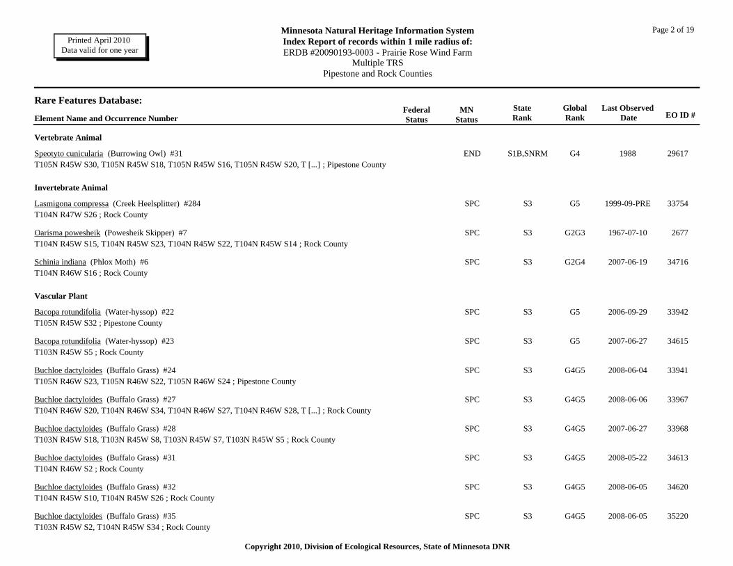
Page 2 of 19Minnesota Natural Heritage Information SystemIndex Report of records within 1 mile radius of:ERDB #20090193-0003 - Prairie Rose Wind Farm
Multiple TRSPipestone and Rock Counties
Printed April 2010 Data valid for one year
Rare Features Database:EO ID #
Last Observed Date
GlobalRank
StateRank
MNStatus
FederalStatusElement Name and Occurrence Number
Vertebrate Animal
S1B,SNRM G4 1988Speotyto cunicularia (Burrowing Owl) #31 ENDT105N R45W S30, T105N R45W S18, T105N R45W S16, T105N R45W S20, T [...] ; Pipestone County
29617
Invertebrate Animal
S3 G5 1999-09-PRELasmigona compressa (Creek Heelsplitter) #284 SPCT104N R47W S26 ; Rock County
33754
S3 G2G3 1967-07-10Oarisma powesheik (Powesheik Skipper) #7 SPCT104N R45W S15, T104N R45W S23, T104N R45W S22, T104N R45W S14 ; Rock County
2677
S3 G2G4 2007-06-19Schinia indiana (Phlox Moth) #6 SPCT104N R46W S16 ; Rock County
34716
Vascular Plant
S3 G5 2006-09-29Bacopa rotundifolia (Water-hyssop) #22 SPCT105N R45W S32 ; Pipestone County
33942
S3 G5 2007-06-27Bacopa rotundifolia (Water-hyssop) #23 SPCT103N R45W S5 ; Rock County
34615
S3 G4G5 2008-06-04Buchloe dactyloides (Buffalo Grass) #24 SPCT105N R46W S23, T105N R46W S22, T105N R46W S24 ; Pipestone County
33941
S3 G4G5 2008-06-06Buchloe dactyloides (Buffalo Grass) #27 SPCT104N R46W S20, T104N R46W S34, T104N R46W S27, T104N R46W S28, T [...] ; Rock County
33967
S3 G4G5 2007-06-27Buchloe dactyloides (Buffalo Grass) #28 SPCT103N R45W S18, T103N R45W S8, T103N R45W S7, T103N R45W S5 ; Rock County
33968
S3 G4G5 2008-05-22Buchloe dactyloides (Buffalo Grass) #31 SPCT104N R46W S2 ; Rock County
34613
S3 G4G5 2008-06-05Buchloe dactyloides (Buffalo Grass) #32 SPCT104N R45W S10, T104N R45W S26 ; Rock County
34620
S3 G4G5 2008-06-05Buchloe dactyloides (Buffalo Grass) #35 SPCT103N R45W S2, T104N R45W S34 ; Rock County
35220
Copyright 2010, Division of Ecological Resources, State of Minnesota DNR
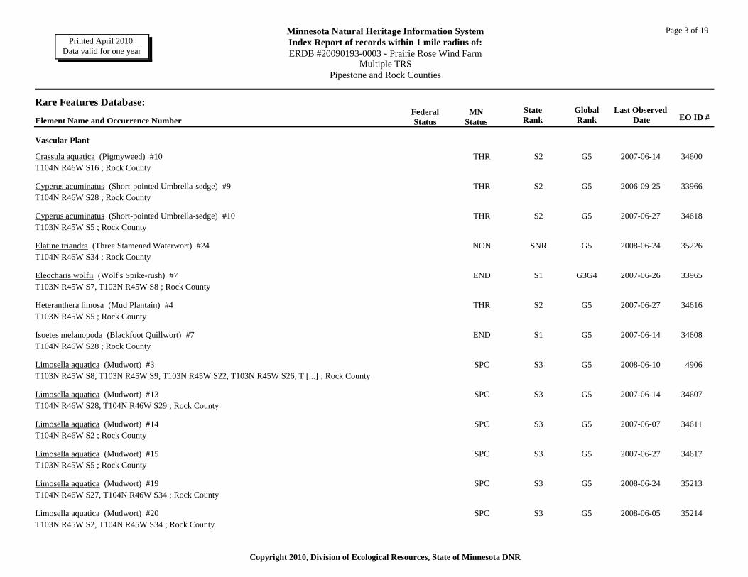
Page 3 of 19Minnesota Natural Heritage Information SystemIndex Report of records within 1 mile radius of:ERDB #20090193-0003 - Prairie Rose Wind Farm
Multiple TRSPipestone and Rock Counties
Printed April 2010 Data valid for one year
Rare Features Database:EO ID #
Last Observed Date
GlobalRank
StateRank
MNStatus
FederalStatusElement Name and Occurrence Number
Vascular Plant
S2 G5 2007-06-14Crassula aquatica (Pigmyweed) #10 THRT104N R46W S16 ; Rock County
34600
S2 G5 2006-09-25Cyperus acuminatus (Short-pointed Umbrella-sedge) #9 THRT104N R46W S28 ; Rock County
33966
S2 G5 2007-06-27Cyperus acuminatus (Short-pointed Umbrella-sedge) #10 THRT103N R45W S5 ; Rock County
34618
SNR G5 2008-06-24Elatine triandra (Three Stamened Waterwort) #24 NONT104N R46W S34 ; Rock County
35226
S1 G3G4 2007-06-26Eleocharis wolfii (Wolf's Spike-rush) #7 ENDT103N R45W S7, T103N R45W S8 ; Rock County
33965
S2 G5 2007-06-27Heteranthera limosa (Mud Plantain) #4 THRT103N R45W S5 ; Rock County
34616
S1 G5 2007-06-14Isoetes melanopoda (Blackfoot Quillwort) #7 ENDT104N R46W S28 ; Rock County
34608
S3 G5 2008-06-10Limosella aquatica (Mudwort) #3 SPCT103N R45W S8, T103N R45W S9, T103N R45W S22, T103N R45W S26, T [...] ; Rock County
4906
S3 G5 2007-06-14Limosella aquatica (Mudwort) #13 SPCT104N R46W S28, T104N R46W S29 ; Rock County
34607
S3 G5 2007-06-07Limosella aquatica (Mudwort) #14 SPCT104N R46W S2 ; Rock County
34611
S3 G5 2007-06-27Limosella aquatica (Mudwort) #15 SPCT103N R45W S5 ; Rock County
34617
S3 G5 2008-06-24Limosella aquatica (Mudwort) #19 SPCT104N R46W S27, T104N R46W S34 ; Rock County
35213
S3 G5 2008-06-05Limosella aquatica (Mudwort) #20 SPCT103N R45W S2, T104N R45W S34 ; Rock County
35214
Copyright 2010, Division of Ecological Resources, State of Minnesota DNR

Page 4 of 19Minnesota Natural Heritage Information SystemIndex Report of records within 1 mile radius of:ERDB #20090193-0003 - Prairie Rose Wind Farm
Multiple TRSPipestone and Rock Counties
Printed April 2010 Data valid for one year
Rare Features Database:EO ID #
Last Observed Date
GlobalRank
StateRank
MNStatus
FederalStatusElement Name and Occurrence Number
Vascular Plant
S3 G5 2008-06-05Limosella aquatica (Mudwort) #21 SPCT104N R45W S23 ; Rock County
35216
S3 G5 2008-06-06Limosella aquatica (Mudwort) #22 SPCT104N R45W S3 ; Rock County
35217
S1 G5 2008-06-26Marsilea vestita (Hairy Water Clover) #4 ENDT103N R45W S7 ; Rock County
34601
S1 G5 2007-06-28Marsilea vestita (Hairy Water Clover) #5 ENDT104N R46W S28 ; Rock County
34604
S1 G5 2007-06-07Marsilea vestita (Hairy Water Clover) #6 ENDT104N R46W S2 ; Rock County
34612
S1 G5 2007-06-27Marsilea vestita (Hairy Water Clover) #7 ENDT103N R45W S5 ; Rock County
34619
S1 G5 2008-06-05Marsilea vestita (Hairy Water Clover) #10 ENDT103N R45W S2, T104N R45W S34 ; Rock County
35229
SNR G5 2008-05-22Myosotis verna (Forget-me-not) #19 NONT104N R46W S2 ; Rock County
35231
SNR G5 2008-05-22Myosotis verna (Forget-me-not) #20 NONT104N R46W S27, T104N R46W S34 ; Rock County
35232
SNR G5 2008-06-05Myosotis verna (Forget-me-not) #21 NONT104N R45W S23 ; Rock County
35233
SNR G5 2008-06-05Myosotis verna (Forget-me-not) #22 NONT104N R45W S34 ; Rock County
35234
SNR GNR 2008-06-25Plagiobothrys scouleri (Meadow Popcorn-flower) #1 NONT103N R45W S8, T103N R45W S7 ; Rock County
34625
SNR GNR 2007-06-14Plagiobothrys scouleri (Meadow Popcorn-flower) #2 NONT104N R46W S28 ; Rock County
34626
Copyright 2010, Division of Ecological Resources, State of Minnesota DNR
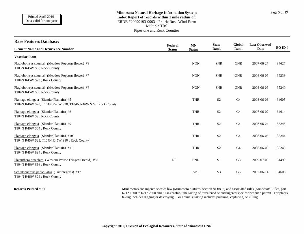
Page 5 of 19Minnesota Natural Heritage Information SystemIndex Report of records within 1 mile radius of:ERDB #20090193-0003 - Prairie Rose Wind Farm
Multiple TRSPipestone and Rock Counties
Printed April 2010 Data valid for one year
Rare Features Database:EO ID #
Last Observed Date
GlobalRank
StateRank
MNStatus
FederalStatusElement Name and Occurrence Number
Vascular Plant
SNR GNR 2007-06-27Plagiobothrys scouleri (Meadow Popcorn-flower) #3 NONT103N R45W S5 ; Rock County
34627
SNR GNR 2008-06-05Plagiobothrys scouleri (Meadow Popcorn-flower) #7 NONT104N R45W S23 ; Rock County
35239
SNR GNR 2008-06-06Plagiobothrys scouleri (Meadow Popcorn-flower) #8 NONT104N R45W S3 ; Rock County
35240
S2 G4 2008-06-06Plantago elongata (Slender Plantain) #5 THRT104N R46W S20, T104N R46W S28, T104N R46W S29 ; Rock County
34605
S2 G4 2007-06-07Plantago elongata (Slender Plantain) #6 THRT104N R46W S2 ; Rock County
34614
S2 G4 2008-06-24Plantago elongata (Slender Plantain) #9 THRT104N R46W S34 ; Rock County
35243
S2 G4 2008-06-05Plantago elongata (Slender Plantain) #10 THRT104N R45W S23, T104N R45W S10 ; Rock County
35244
S2 G4 2008-06-05Plantago elongata (Slender Plantain) #11 THRT104N R45W S34 ; Rock County
35245
S1 G3 2009-07-09LTPlatanthera praeclara (Western Prairie Fringed Orchid) #83 ENDT104N R46W S16 ; Rock County
31490
S3 G5 2007-06-14Schedonnardus paniculatus (Tumblegrass) #17 SPCT104N R46W S29 ; Rock County
34606
Records Printed = 61 Minnesota's endangered species law (Minnesota Statutes, section 84.0895) and associated rules (Minnesota Rules, part 6212.1800 to 6212.2300 and 6134) prohibit the taking of threatened or endangered species without a permit. For plants, taking includes digging or destroying. For animals, taking includes pursuing, capturing, or killing.
Copyright 2010, Division of Ecological Resources, State of Minnesota DNR
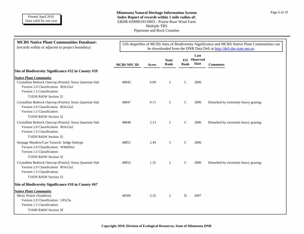
Page 6 of 19Minnesota Natural Heritage Information SystemIndex Report of records within 1 mile radius of:ERDB #20090193-0003 - Prairie Rose Wind Farm
Multiple TRSPipestone and Rock Counties
Printed April 2010 Data valid for one year
AcresMCBS NPC ID
MCBS Native Plant Communities Database:(records within or adjacent to project boundary)
StateRank
EORank
Last Observed
Date Comments
GIS shapefiles of MCBS Sites of Biodiversity Significance and MCBS Native Plant Communities can be downloaded from the DNR Data Deli at http://deli.dnr.state.mn.us.
Site of Biodiversity Significance #52 in County #59
Native Plant CommunityCrystalline Bedrock Outcrop (Prairie): Sioux Quartzite Sub 0.09
Version 2.0 Classification: ROs12a2Version 1.5 Classification:
48845 2 C 2006
T105N R45W Section 32
Crystalline Bedrock Outcrop (Prairie): Sioux Quartzite Sub 0.11Version 2.0 Classification: ROs12a2Version 1.5 Classification:
48847 2 C 2006 Disturbed by extremely heavy grazing.
T105N R45W Section 32
Crystalline Bedrock Outcrop (Prairie): Sioux Quartzite Sub 2.13Version 2.0 Classification: ROs12a2Version 1.5 Classification:
48848 2 C 2006 Disturbed by extremely heavy grazing.
T105N R45W Section 32
Seepage Meadow/Carr Tussock: Sedge Subtype 2.44Version 2.0 Classification: WMs83a1Version 1.5 Classification:
48851 3 C 2006
T105N R45W Section 32
Crystalline Bedrock Outcrop (Prairie): Sioux Quartzite Sub 1.35Version 2.0 Classification: ROs12a2Version 1.5 Classification:
48852 2 C 2006 Disturbed by extremely heavy grazing.
T105N R45W Section 32
Site of Biodiversity Significance #10 in County #67
Native Plant CommunityMesic Prairie (Southern) 2.35
Version 2.0 Classification: UPs23aVersion 1.5 Classification:
49569 2 D 2007
T104N R46W Section 28
Copyright 2010, Division of Ecological Resources, State of Minnesota DNR

Page 7 of 19Minnesota Natural Heritage Information SystemIndex Report of records within 1 mile radius of:ERDB #20090193-0003 - Prairie Rose Wind Farm
Multiple TRSPipestone and Rock Counties
Printed April 2010 Data valid for one year
Mesic Prairie (Southern) 4.20Version 2.0 Classification: UPs23aVersion 1.5 Classification:
49570 2 D 2007
T104N R46W Section 28
Mesic Prairie (Southern) 0.50Version 2.0 Classification: UPs23aVersion 1.5 Classification:
49571 2 D 2007
T104N R46W Section 28
Mesic Prairie (Southern) 1.88Version 2.0 Classification: UPs23aVersion 1.5 Classification:
49572 2 D 2007
T104N R46W Section 28
Mesic Prairie (Southern) 0.90Version 2.0 Classification: UPs23aVersion 1.5 Classification:
49573 2 D 2007
T104N R46W Section 28
Crystalline Bedrock Outcrop (Prairie): Sioux Quartzite Sub 3.87Version 2.0 Classification: ROs12a2Version 1.5 Classification:
49574 2 AB 2007
T104N R46W Section 28
Crystalline Bedrock Outcrop (Prairie): Sioux Quartzite Sub 0.56Version 2.0 Classification: ROs12a2Version 1.5 Classification:
49575 2 C 2007
T104N R46W Section 28
Basswood - Bur Oak - (Green Ash) Forest 0.72Version 2.0 Classification: MHs38bVersion 1.5 Classification:
49580 3 NR 2007 Open grown oaks in lightly grazed pasture.
T104N R46W Section 28
Mesic Prairie (Southern) 0.54Version 2.0 Classification: UPs23aVersion 1.5 Classification:
49581 2 B 2007 Pasture with good dominance by native species and good native flora. Managed with periodic light grazing. Contains abundant outcrops in excellent condition.
T104N R46W Section 29T104N R46W Section 28
Copyright 2010, Division of Ecological Resources, State of Minnesota DNR

Page 8 of 19Minnesota Natural Heritage Information SystemIndex Report of records within 1 mile radius of:ERDB #20090193-0003 - Prairie Rose Wind Farm
Multiple TRSPipestone and Rock Counties
Printed April 2010 Data valid for one year
Mesic Prairie (Southern) 0.23Version 2.0 Classification: UPs23aVersion 1.5 Classification:
49582 2 B 2007 Pasture with good dominance by native species and good native flora. Managed with periodic light grazing. Contains abundant outcrops in excellent condition.
T104N R46W Section 29T104N R46W Section 28
Mesic Prairie (Southern) 0.11Version 2.0 Classification: UPs23aVersion 1.5 Classification:
49583 2 NR 2007
T104N R46W Section 28
Mesic Prairie (Southern) 0.46Version 2.0 Classification: UPs23aVersion 1.5 Classification:
49584 2 B 2007 Pasture with good dominance by native species and good native flora. Managed with periodic light grazing. Contains abundant outcrops in excellent condition.
T104N R46W Section 28
Mesic Prairie (Southern) 2.08Version 2.0 Classification: UPs23aVersion 1.5 Classification:
49593 2 NR 2007
T104N R46W Section 28
Mesic Prairie (Southern) 3.07Version 2.0 Classification: UPs23aVersion 1.5 Classification:
49712 2 D 2007
T104N R46W Section 28
Crystalline Bedrock Outcrop (Prairie): Sioux Quartzite Sub 0.91Version 2.0 Classification: ROs12a2Version 1.5 Classification:
49722 2 C 2007
T104N R46W Section 29T104N R46W Section 28
Mesic Prairie (Southern) 1.58Version 2.0 Classification: UPs23aVersion 1.5 Classification:
50233 2 NR 2007
T104N R46W Section 29T104N R46W Section 28
Copyright 2010, Division of Ecological Resources, State of Minnesota DNR

Page 9 of 19Minnesota Natural Heritage Information SystemIndex Report of records within 1 mile radius of:ERDB #20090193-0003 - Prairie Rose Wind Farm
Multiple TRSPipestone and Rock Counties
Printed April 2010 Data valid for one year
Mesic Prairie (Southern) 0.28Version 2.0 Classification: UPs23aVersion 1.5 Classification:
50234 2 NR 2007
T104N R46W Section 29T104N R46W Section 28
Crystalline Bedrock Outcrop (Prairie): Sioux Quartzite Sub 0.50Version 2.0 Classification: ROs12a2Version 1.5 Classification:
50235 2 C 2007
T104N R46W Section 29T104N R46W Section 28
Mesic Prairie (Southern) 0.11Version 2.0 Classification: UPs23aVersion 1.5 Classification:
50289 2 B 2007 Pasture with good dominance by native species and good native flora. Managed with periodic light grazing. Contains abundant outcrops in excellent condition.
T104N R46W Section 29T104N R46W Section 28
Mesic Prairie (Southern) 0.27Version 2.0 Classification: UPs23aVersion 1.5 Classification:
50290 2 B 2007 Pasture with good dominance by native species and good native flora. Managed with periodic light grazing. Contains abundant outcrops in excellent condition.
T104N R46W Section 29T104N R46W Section 28
Mesic Prairie (Southern) 0.07Version 2.0 Classification: UPs23aVersion 1.5 Classification:
50291 2 B 2007 Pasture with good dominance by native species and good native flora. Managed with periodic light grazing. Contains abundant outcrops in excellent condition.
T104N R46W Section 28
Mesic Prairie (Southern) 0.17Version 2.0 Classification: UPs23aVersion 1.5 Classification:
50292 2 B 2007 Pasture with good dominance by native species and good native flora. Managed with periodic light grazing. Contains abundant outcrops in excellent condition.
T104N R46W Section 28
Mesic Prairie (Southern) 0.05Version 2.0 Classification: UPs23aVersion 1.5 Classification:
50293 2 B 2007 Pasture with good dominance by native species and good native flora. Managed with periodic light grazing. Contains abundant outcrops in excellent condition.
T104N R46W Section 28
Copyright 2010, Division of Ecological Resources, State of Minnesota DNR

Page 10 of 19Minnesota Natural Heritage Information SystemIndex Report of records within 1 mile radius of:ERDB #20090193-0003 - Prairie Rose Wind Farm
Multiple TRSPipestone and Rock Counties
Printed April 2010 Data valid for one year
Crystalline Bedrock Outcrop (Prairie): Sioux Quartzite Sub 0.61Version 2.0 Classification: ROs12a2Version 1.5 Classification:
50294 2 A 2007 Fairly undisturbed rock outcrops with high diversity including numerous pools.
T104N R46W Section 28
Mesic Prairie (Southern) 0.63Version 2.0 Classification: UPs23aVersion 1.5 Classification:
50295 2 B 2007 Pasture with good dominance by native species and good native flora. Managed with periodic light grazing. Contains abundant outcrops in excellent condition.
T104N R46W Section 28
Crystalline Bedrock Outcrop (Prairie): Sioux Quartzite Sub 7.53Version 2.0 Classification: ROs12a2Version 1.5 Classification:
50296 2 A 2007 Outstanding remnant of little-disturbed rock outcrops and prairie. Numerous ephemeral rainwater pools with high diversity of rock outcrop specialist plants. pools.
T104N R46W Section 29T104N R46W Section 28
Mesic Prairie (Southern) 0.40Version 2.0 Classification: UPs23aVersion 1.5 Classification:
50316 2 D 2007
T104N R46W Section 28
Mesic Prairie (Southern) 0.90Version 2.0 Classification: UPs23aVersion 1.5 Classification:
50317 2 D 2007
T104N R46W Section 28
Mesic Prairie (Southern) 1.03Version 2.0 Classification: UPs23aVersion 1.5 Classification:
50318 2 D 2007
T104N R46W Section 28
Mesic Prairie (Southern) 142.43Version 2.0 Classification: UPs23aVersion 1.5 Classification:
50319 2 D 2007 Pasture dominated mostly by nonnatives but with abundant native grasses. Diversity very low.
T104N R46W Section 29T104N R46W Section 28
Crystalline Bedrock Outcrop (Prairie): Sioux Quartzite Sub 24.93Version 2.0 Classification: ROs12a2Version 1.5 Classification:
50323 2 AB 2007 Exposed outcrops in drainages within large pasture. Outstanding diversity of rock outcrop specialist plants. Within degraded prairie pasture.
T104N R46W Section 28
Copyright 2010, Division of Ecological Resources, State of Minnesota DNR
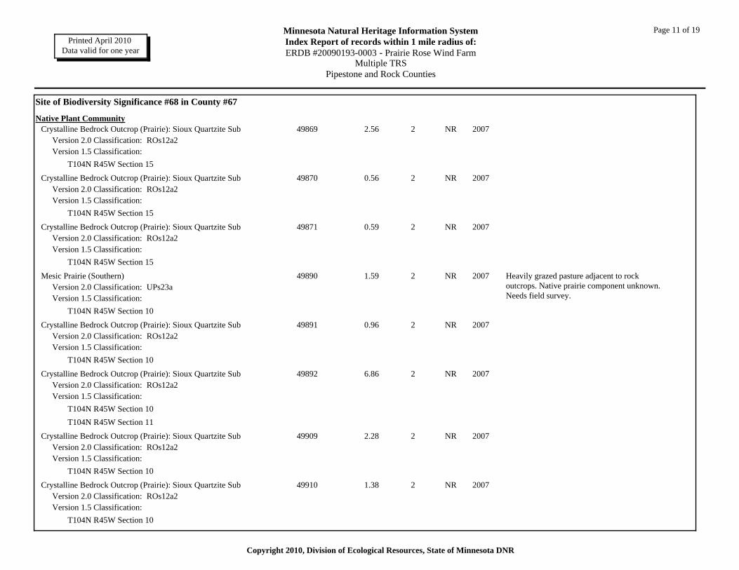
Page 11 of 19Minnesota Natural Heritage Information SystemIndex Report of records within 1 mile radius of:ERDB #20090193-0003 - Prairie Rose Wind Farm
Multiple TRSPipestone and Rock Counties
Printed April 2010 Data valid for one year
Site of Biodiversity Significance #68 in County #67
Native Plant CommunityCrystalline Bedrock Outcrop (Prairie): Sioux Quartzite Sub 2.56
Version 2.0 Classification: ROs12a2Version 1.5 Classification:
49869 2 NR 2007
T104N R45W Section 15
Crystalline Bedrock Outcrop (Prairie): Sioux Quartzite Sub 0.56Version 2.0 Classification: ROs12a2Version 1.5 Classification:
49870 2 NR 2007
T104N R45W Section 15
Crystalline Bedrock Outcrop (Prairie): Sioux Quartzite Sub 0.59Version 2.0 Classification: ROs12a2Version 1.5 Classification:
49871 2 NR 2007
T104N R45W Section 15
Mesic Prairie (Southern) 1.59Version 2.0 Classification: UPs23aVersion 1.5 Classification:
49890 2 NR 2007 Heavily grazed pasture adjacent to rock outcrops. Native prairie component unknown. Needs field survey.
T104N R45W Section 10
Crystalline Bedrock Outcrop (Prairie): Sioux Quartzite Sub 0.96Version 2.0 Classification: ROs12a2Version 1.5 Classification:
49891 2 NR 2007
T104N R45W Section 10
Crystalline Bedrock Outcrop (Prairie): Sioux Quartzite Sub 6.86Version 2.0 Classification: ROs12a2Version 1.5 Classification:
49892 2 NR 2007
T104N R45W Section 10T104N R45W Section 11
Crystalline Bedrock Outcrop (Prairie): Sioux Quartzite Sub 2.28Version 2.0 Classification: ROs12a2Version 1.5 Classification:
49909 2 NR 2007
T104N R45W Section 10
Crystalline Bedrock Outcrop (Prairie): Sioux Quartzite Sub 1.38Version 2.0 Classification: ROs12a2Version 1.5 Classification:
49910 2 NR 2007
T104N R45W Section 10
Copyright 2010, Division of Ecological Resources, State of Minnesota DNR

Page 12 of 19Minnesota Natural Heritage Information SystemIndex Report of records within 1 mile radius of:ERDB #20090193-0003 - Prairie Rose Wind Farm
Multiple TRSPipestone and Rock Counties
Printed April 2010 Data valid for one year
Mesic Prairie (Southern) 14.03Version 2.0 Classification: UPs23aVersion 1.5 Classification:
49911 2 NR 2007 Heavily grazed pasture adjacent to rock outcrops. Native prairie component unknown. Needs field survey.
T104N R45W Section 10
Crystalline Bedrock Outcrop (Prairie): Sioux Quartzite Sub 0.71Version 2.0 Classification: ROs12a2Version 1.5 Classification:
49912 2 NR 2007
T104N R45W Section 10
Crystalline Bedrock Outcrop (Prairie): Sioux Quartzite Sub 0.80Version 2.0 Classification: ROs12a2Version 1.5 Classification:
49913 2 NR 2007
T104N R45W Section 10
Crystalline Bedrock Outcrop (Prairie): Sioux Quartzite Sub 1.02Version 2.0 Classification: ROs12a2Version 1.5 Classification:
49914 2 NR 2007
T104N R45W Section 10
Crystalline Bedrock Outcrop (Prairie): Sioux Quartzite Sub 0.51Version 2.0 Classification: ROs12a2Version 1.5 Classification:
49915 2 NR 2007
T104N R45W Section 10T104N R45W Section 11
Mesic Prairie (Southern) 9.19Version 2.0 Classification: UPs23aVersion 1.5 Classification:
49916 2 NR 2007 Heavily grazed pasture adjacent to rock outcrops. Native prairie component unknown. Needs field survey.
T104N R45W Section 10T104N R45W Section 11T104N R45W Section 15T104N R45W Section 14
Mesic Prairie (Southern) 68.13Version 2.0 Classification: UPs23aVersion 1.5 Classification:
49926 2 NR 2007 Heavily grazed pasture adjacent to rock outcrops. Native prairie component unknown. Needs field survey.
T104N R45W Section 10T104N R45W Section 11T104N R45W Section 14
Copyright 2010, Division of Ecological Resources, State of Minnesota DNR
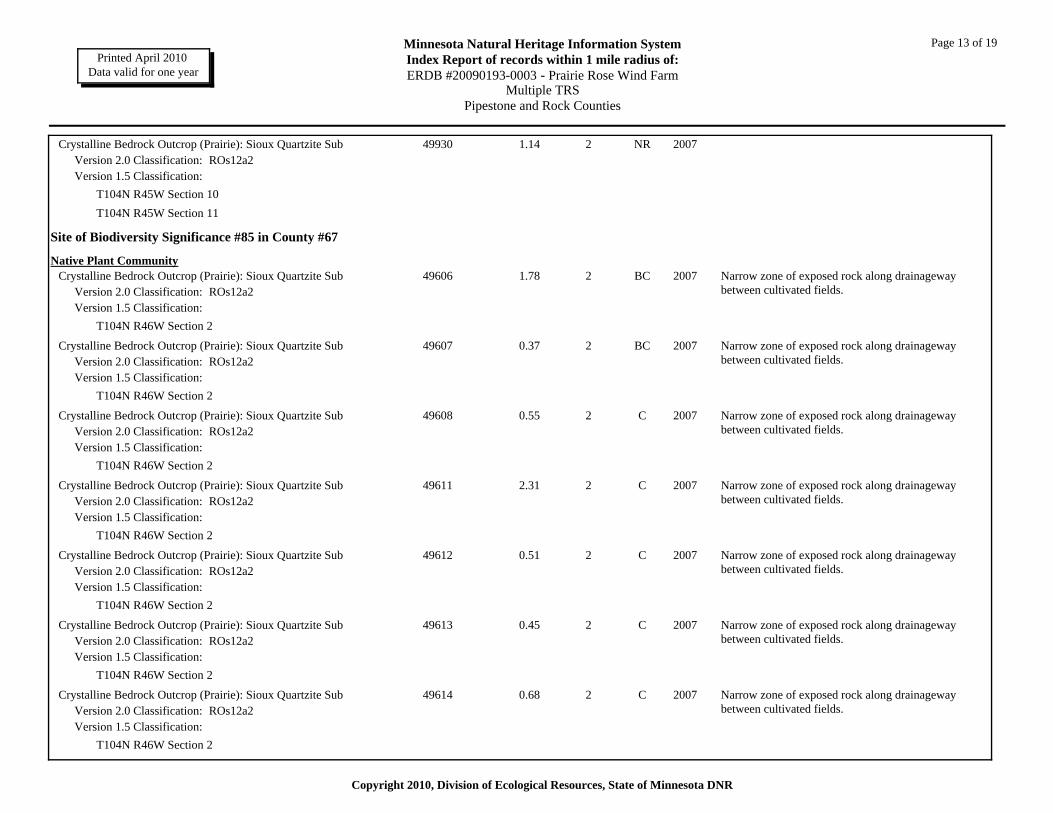
Page 13 of 19Minnesota Natural Heritage Information SystemIndex Report of records within 1 mile radius of:ERDB #20090193-0003 - Prairie Rose Wind Farm
Multiple TRSPipestone and Rock Counties
Printed April 2010 Data valid for one year
Crystalline Bedrock Outcrop (Prairie): Sioux Quartzite Sub 1.14Version 2.0 Classification: ROs12a2Version 1.5 Classification:
49930 2 NR 2007
T104N R45W Section 10T104N R45W Section 11
Site of Biodiversity Significance #85 in County #67
Native Plant CommunityCrystalline Bedrock Outcrop (Prairie): Sioux Quartzite Sub 1.78
Version 2.0 Classification: ROs12a2Version 1.5 Classification:
49606 2 BC 2007 Narrow zone of exposed rock along drainageway between cultivated fields.
T104N R46W Section 2
Crystalline Bedrock Outcrop (Prairie): Sioux Quartzite Sub 0.37Version 2.0 Classification: ROs12a2Version 1.5 Classification:
49607 2 BC 2007 Narrow zone of exposed rock along drainageway between cultivated fields.
T104N R46W Section 2
Crystalline Bedrock Outcrop (Prairie): Sioux Quartzite Sub 0.55Version 2.0 Classification: ROs12a2Version 1.5 Classification:
49608 2 C 2007 Narrow zone of exposed rock along drainageway between cultivated fields.
T104N R46W Section 2
Crystalline Bedrock Outcrop (Prairie): Sioux Quartzite Sub 2.31Version 2.0 Classification: ROs12a2Version 1.5 Classification:
49611 2 C 2007 Narrow zone of exposed rock along drainageway between cultivated fields.
T104N R46W Section 2
Crystalline Bedrock Outcrop (Prairie): Sioux Quartzite Sub 0.51Version 2.0 Classification: ROs12a2Version 1.5 Classification:
49612 2 C 2007 Narrow zone of exposed rock along drainageway between cultivated fields.
T104N R46W Section 2
Crystalline Bedrock Outcrop (Prairie): Sioux Quartzite Sub 0.45Version 2.0 Classification: ROs12a2Version 1.5 Classification:
49613 2 C 2007 Narrow zone of exposed rock along drainageway between cultivated fields.
T104N R46W Section 2
Crystalline Bedrock Outcrop (Prairie): Sioux Quartzite Sub 0.68Version 2.0 Classification: ROs12a2Version 1.5 Classification:
49614 2 C 2007 Narrow zone of exposed rock along drainageway between cultivated fields.
T104N R46W Section 2
Copyright 2010, Division of Ecological Resources, State of Minnesota DNR

Page 14 of 19Minnesota Natural Heritage Information SystemIndex Report of records within 1 mile radius of:ERDB #20090193-0003 - Prairie Rose Wind Farm
Multiple TRSPipestone and Rock Counties
Printed April 2010 Data valid for one year
Crystalline Bedrock Outcrop (Prairie): Sioux Quartzite Sub 0.71Version 2.0 Classification: ROs12a2Version 1.5 Classification:
49689 2 C 2007 Narrow zone of exposed rock along drainageway between cultivated fields.
T104N R46W Section 2
Site of Biodiversity Significance #86 in County #67
Native Plant CommunityCrystalline Bedrock Outcrop (Prairie): Sioux Quartzite Sub 2.26
Version 2.0 Classification: ROs12a2Version 1.5 Classification:
50210 2 CD 2008
T104N R46W Section 2
Site of Biodiversity Significance #102 in County #67
Native Plant CommunityCrystalline Bedrock Outcrop (Prairie): Sioux Quartzite Sub 7.38
Version 2.0 Classification: ROs12a2Version 1.5 Classification:
50228 2 AB 2008 Excellent plant diversity on shallow soils over bedrock and cracks. Growing in robust pillows of rock spikemoss. Site is highly drought-prone. Ephemeral pools are nearly absent. Trash piles at south end.
T104N R46W Section 27
Crystalline Bedrock Outcrop (Prairie): Sioux Quartzite Sub 0.51Version 2.0 Classification: ROs12a2Version 1.5 Classification:
50232 2 AB 2008 Excellent plant diversity on shallow soils over bedrock and cracks. Growing in robust pillows of rock spikemoss. Site is highly drought-prone. Ephemeral pools are nearly absent. Trash piles at south end.
T104N R46W Section 27
Site of Biodiversity Significance #110 in County #67
Native Plant CommunityCrystalline Bedrock Outcrop (Prairie): Sioux Quartzite Sub 2.86
Version 2.0 Classification: ROs12a2Version 1.5 Classification:
50237 2 NR 2008 Much exposed rocks in drainages within sloping pasture. Likely contains rare plants.
T104N R45W Section 32
Crystalline Bedrock Outcrop (Prairie): Sioux Quartzite Sub 1.17Version 2.0 Classification: ROs12a2Version 1.5 Classification:
50238 2 NR 2008 Much exposed rocks in drainages within sloping pasture. Likely contains rare plants.
T104N R45W Section 32
Copyright 2010, Division of Ecological Resources, State of Minnesota DNR
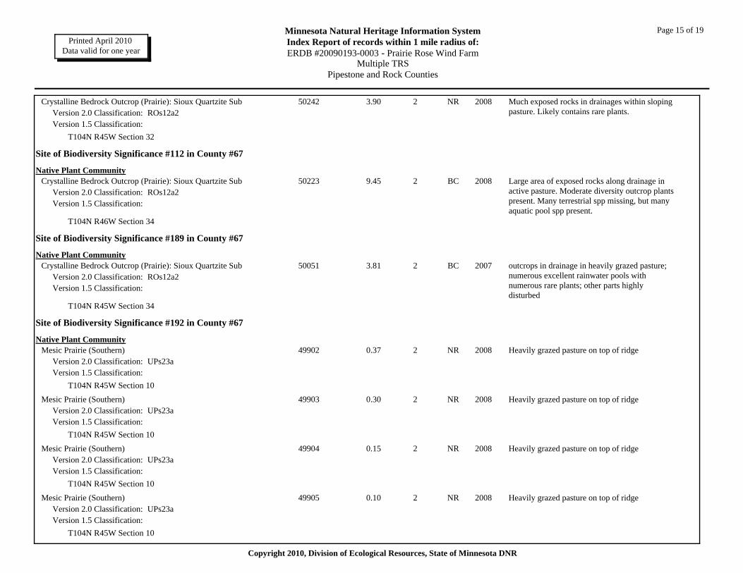
Page 15 of 19Minnesota Natural Heritage Information SystemIndex Report of records within 1 mile radius of:ERDB #20090193-0003 - Prairie Rose Wind Farm
Multiple TRSPipestone and Rock Counties
Printed April 2010 Data valid for one year
Crystalline Bedrock Outcrop (Prairie): Sioux Quartzite Sub 3.90Version 2.0 Classification: ROs12a2Version 1.5 Classification:
50242 2 NR 2008 Much exposed rocks in drainages within sloping pasture. Likely contains rare plants.
T104N R45W Section 32
Site of Biodiversity Significance #112 in County #67
Native Plant CommunityCrystalline Bedrock Outcrop (Prairie): Sioux Quartzite Sub 9.45
Version 2.0 Classification: ROs12a2Version 1.5 Classification:
50223 2 BC 2008 Large area of exposed rocks along drainage in active pasture. Moderate diversity outcrop plants present. Many terrestrial spp missing, but many aquatic pool spp present.
T104N R46W Section 34
Site of Biodiversity Significance #189 in County #67
Native Plant CommunityCrystalline Bedrock Outcrop (Prairie): Sioux Quartzite Sub 3.81
Version 2.0 Classification: ROs12a2Version 1.5 Classification:
50051 2 BC 2007 outcrops in drainage in heavily grazed pasture; numerous excellent rainwater pools with numerous rare plants; other parts highly disturbed
T104N R45W Section 34
Site of Biodiversity Significance #192 in County #67
Native Plant CommunityMesic Prairie (Southern) 0.37
Version 2.0 Classification: UPs23aVersion 1.5 Classification:
49902 2 NR 2008 Heavily grazed pasture on top of ridge
T104N R45W Section 10
Mesic Prairie (Southern) 0.30Version 2.0 Classification: UPs23aVersion 1.5 Classification:
49903 2 NR 2008 Heavily grazed pasture on top of ridge
T104N R45W Section 10
Mesic Prairie (Southern) 0.15Version 2.0 Classification: UPs23aVersion 1.5 Classification:
49904 2 NR 2008 Heavily grazed pasture on top of ridge
T104N R45W Section 10
Mesic Prairie (Southern) 0.10Version 2.0 Classification: UPs23aVersion 1.5 Classification:
49905 2 NR 2008 Heavily grazed pasture on top of ridge
T104N R45W Section 10
Copyright 2010, Division of Ecological Resources, State of Minnesota DNR
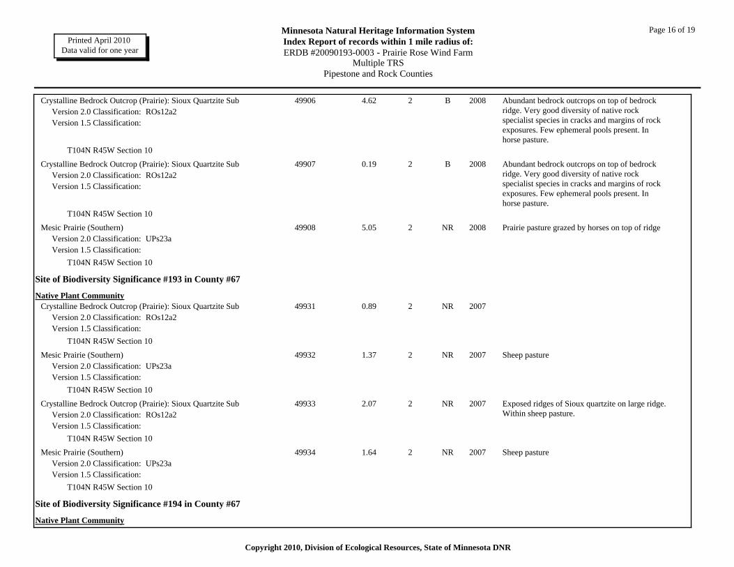
Page 16 of 19Minnesota Natural Heritage Information SystemIndex Report of records within 1 mile radius of:ERDB #20090193-0003 - Prairie Rose Wind Farm
Multiple TRSPipestone and Rock Counties
Printed April 2010 Data valid for one year
Crystalline Bedrock Outcrop (Prairie): Sioux Quartzite Sub 4.62Version 2.0 Classification: ROs12a2Version 1.5 Classification:
49906 2 B 2008 Abundant bedrock outcrops on top of bedrock ridge. Very good diversity of native rock specialist species in cracks and margins of rock exposures. Few ephemeral pools present. In horse pasture.
T104N R45W Section 10
Crystalline Bedrock Outcrop (Prairie): Sioux Quartzite Sub 0.19Version 2.0 Classification: ROs12a2Version 1.5 Classification:
49907 2 B 2008 Abundant bedrock outcrops on top of bedrock ridge. Very good diversity of native rock specialist species in cracks and margins of rock exposures. Few ephemeral pools present. In horse pasture.
T104N R45W Section 10
Mesic Prairie (Southern) 5.05Version 2.0 Classification: UPs23aVersion 1.5 Classification:
49908 2 NR 2008 Prairie pasture grazed by horses on top of ridge
T104N R45W Section 10
Site of Biodiversity Significance #193 in County #67
Native Plant CommunityCrystalline Bedrock Outcrop (Prairie): Sioux Quartzite Sub 0.89
Version 2.0 Classification: ROs12a2Version 1.5 Classification:
49931 2 NR 2007
T104N R45W Section 10
Mesic Prairie (Southern) 1.37Version 2.0 Classification: UPs23aVersion 1.5 Classification:
49932 2 NR 2007 Sheep pasture
T104N R45W Section 10
Crystalline Bedrock Outcrop (Prairie): Sioux Quartzite Sub 2.07Version 2.0 Classification: ROs12a2Version 1.5 Classification:
49933 2 NR 2007 Exposed ridges of Sioux quartzite on large ridge. Within sheep pasture.
T104N R45W Section 10
Mesic Prairie (Southern) 1.64Version 2.0 Classification: UPs23aVersion 1.5 Classification:
49934 2 NR 2007 Sheep pasture
T104N R45W Section 10
Site of Biodiversity Significance #194 in County #67
Native Plant Community
Copyright 2010, Division of Ecological Resources, State of Minnesota DNR
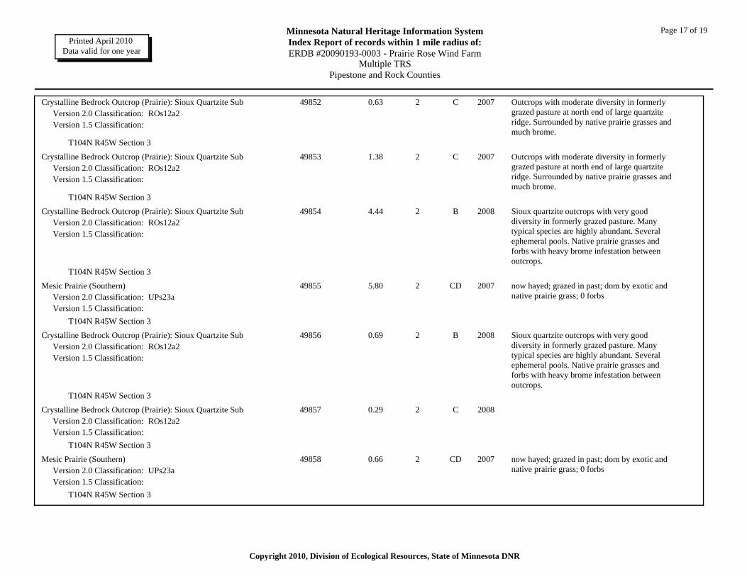
Page 17 of 19Minnesota Natural Heritage Information SystemIndex Report of records within 1 mile radius of:ERDB #20090193-0003 - Prairie Rose Wind Farm
Multiple TRSPipestone and Rock Counties
Printed April 2010 Data valid for one year
Crystalline Bedrock Outcrop (Prairie): Sioux Quartzite Sub 0.63Version 2.0 Classification: ROs12a2Version 1.5 Classification:
49852 2 C 2007 Outcrops with moderate diversity in formerly grazed pasture at north end of large quartzite ridge. Surrounded by native prairie grasses and much brome.
T104N R45W Section 3
Crystalline Bedrock Outcrop (Prairie): Sioux Quartzite Sub 1.38Version 2.0 Classification: ROs12a2Version 1.5 Classification:
49853 2 C 2007 Outcrops with moderate diversity in formerly grazed pasture at north end of large quartzite ridge. Surrounded by native prairie grasses and much brome.
T104N R45W Section 3
Crystalline Bedrock Outcrop (Prairie): Sioux Quartzite Sub 4.44Version 2.0 Classification: ROs12a2Version 1.5 Classification:
49854 2 B 2008 Sioux quartzite outcrops with very good diversity in formerly grazed pasture. Many typical species are highly abundant. Several ephemeral pools. Native prairie grasses and forbs with heavy brome infestation between outcrops.
T104N R45W Section 3
Mesic Prairie (Southern) 5.80Version 2.0 Classification: UPs23aVersion 1.5 Classification:
49855 2 CD 2007 now hayed; grazed in past; dom by exotic and native prairie grass; 0 forbs
T104N R45W Section 3
Crystalline Bedrock Outcrop (Prairie): Sioux Quartzite Sub 0.69Version 2.0 Classification: ROs12a2Version 1.5 Classification:
49856 2 B 2008 Sioux quartzite outcrops with very good diversity in formerly grazed pasture. Many typical species are highly abundant. Several ephemeral pools. Native prairie grasses and forbs with heavy brome infestation between outcrops.
T104N R45W Section 3
Crystalline Bedrock Outcrop (Prairie): Sioux Quartzite Sub 0.29Version 2.0 Classification: ROs12a2Version 1.5 Classification:
49857 2 C 2008
T104N R45W Section 3
Mesic Prairie (Southern) 0.66Version 2.0 Classification: UPs23aVersion 1.5 Classification:
49858 2 CD 2007 now hayed; grazed in past; dom by exotic and native prairie grass; 0 forbs
T104N R45W Section 3
Copyright 2010, Division of Ecological Resources, State of Minnesota DNR
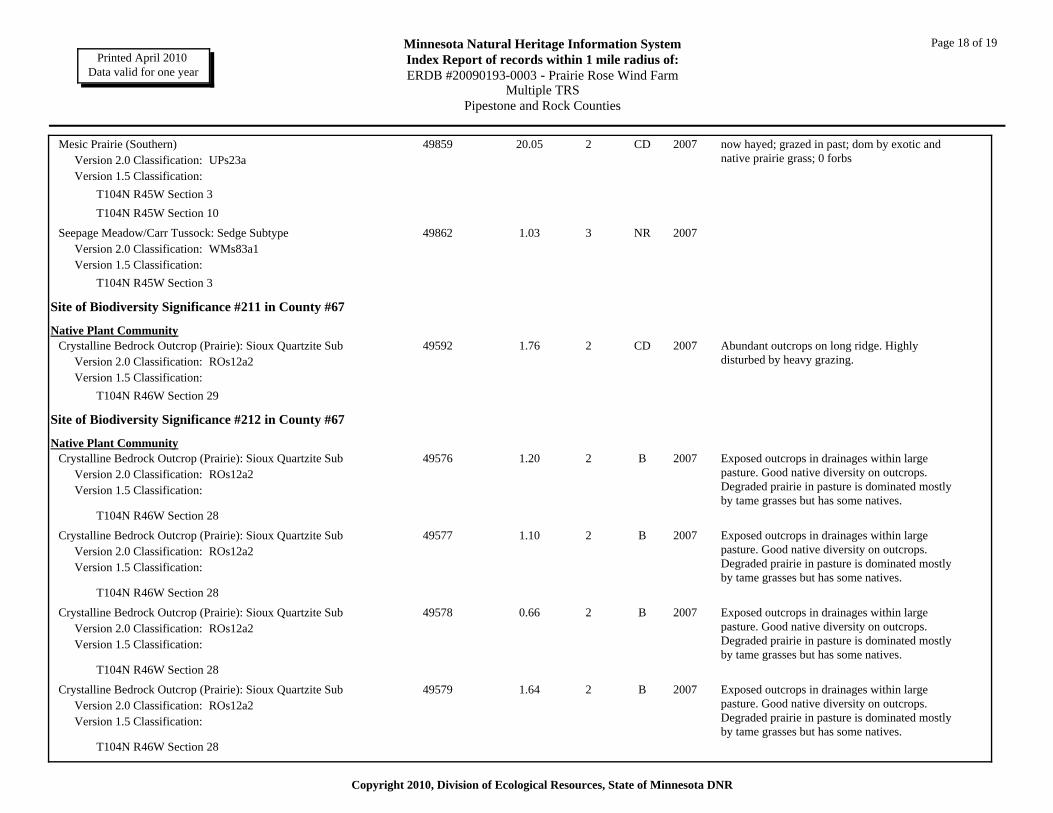
Page 18 of 19Minnesota Natural Heritage Information SystemIndex Report of records within 1 mile radius of:ERDB #20090193-0003 - Prairie Rose Wind Farm
Multiple TRSPipestone and Rock Counties
Printed April 2010 Data valid for one year
Mesic Prairie (Southern) 20.05Version 2.0 Classification: UPs23aVersion 1.5 Classification:
49859 2 CD 2007 now hayed; grazed in past; dom by exotic and native prairie grass; 0 forbs
T104N R45W Section 3T104N R45W Section 10
Seepage Meadow/Carr Tussock: Sedge Subtype 1.03Version 2.0 Classification: WMs83a1Version 1.5 Classification:
49862 3 NR 2007
T104N R45W Section 3
Site of Biodiversity Significance #211 in County #67
Native Plant CommunityCrystalline Bedrock Outcrop (Prairie): Sioux Quartzite Sub 1.76
Version 2.0 Classification: ROs12a2Version 1.5 Classification:
49592 2 CD 2007 Abundant outcrops on long ridge. Highly disturbed by heavy grazing.
T104N R46W Section 29
Site of Biodiversity Significance #212 in County #67
Native Plant CommunityCrystalline Bedrock Outcrop (Prairie): Sioux Quartzite Sub 1.20
Version 2.0 Classification: ROs12a2Version 1.5 Classification:
49576 2 B 2007 Exposed outcrops in drainages within large pasture. Good native diversity on outcrops. Degraded prairie in pasture is dominated mostly by tame grasses but has some natives.
T104N R46W Section 28
Crystalline Bedrock Outcrop (Prairie): Sioux Quartzite Sub 1.10Version 2.0 Classification: ROs12a2Version 1.5 Classification:
49577 2 B 2007 Exposed outcrops in drainages within large pasture. Good native diversity on outcrops. Degraded prairie in pasture is dominated mostly by tame grasses but has some natives.
T104N R46W Section 28
Crystalline Bedrock Outcrop (Prairie): Sioux Quartzite Sub 0.66Version 2.0 Classification: ROs12a2Version 1.5 Classification:
49578 2 B 2007 Exposed outcrops in drainages within large pasture. Good native diversity on outcrops. Degraded prairie in pasture is dominated mostly by tame grasses but has some natives.
T104N R46W Section 28
Crystalline Bedrock Outcrop (Prairie): Sioux Quartzite Sub 1.64Version 2.0 Classification: ROs12a2Version 1.5 Classification:
49579 2 B 2007 Exposed outcrops in drainages within large pasture. Good native diversity on outcrops. Degraded prairie in pasture is dominated mostly by tame grasses but has some natives.
T104N R46W Section 28
Copyright 2010, Division of Ecological Resources, State of Minnesota DNR
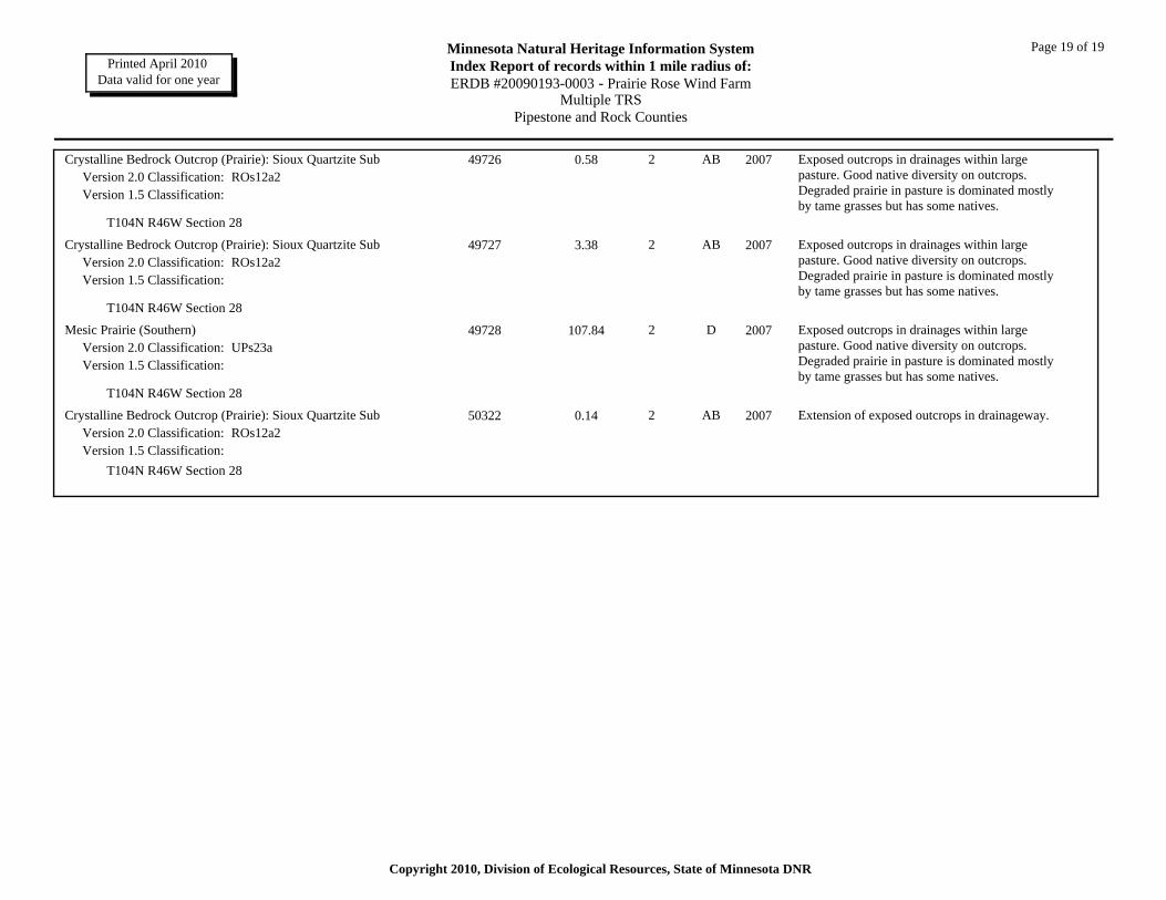
Page 19 of 19Minnesota Natural Heritage Information SystemIndex Report of records within 1 mile radius of:ERDB #20090193-0003 - Prairie Rose Wind Farm
Multiple TRSPipestone and Rock Counties
Printed April 2010 Data valid for one year
Crystalline Bedrock Outcrop (Prairie): Sioux Quartzite Sub 0.58Version 2.0 Classification: ROs12a2Version 1.5 Classification:
49726 2 AB 2007 Exposed outcrops in drainages within large pasture. Good native diversity on outcrops. Degraded prairie in pasture is dominated mostly by tame grasses but has some natives.
T104N R46W Section 28
Crystalline Bedrock Outcrop (Prairie): Sioux Quartzite Sub 3.38Version 2.0 Classification: ROs12a2Version 1.5 Classification:
49727 2 AB 2007 Exposed outcrops in drainages within large pasture. Good native diversity on outcrops. Degraded prairie in pasture is dominated mostly by tame grasses but has some natives.
T104N R46W Section 28
Mesic Prairie (Southern) 107.84Version 2.0 Classification: UPs23aVersion 1.5 Classification:
49728 2 D 2007 Exposed outcrops in drainages within large pasture. Good native diversity on outcrops. Degraded prairie in pasture is dominated mostly by tame grasses but has some natives.
T104N R46W Section 28
Crystalline Bedrock Outcrop (Prairie): Sioux Quartzite Sub 0.14Version 2.0 Classification: ROs12a2Version 1.5 Classification:
50322 2 AB 2007 Extension of exposed outcrops in drainageway.
T104N R46W Section 28
Copyright 2010, Division of Ecological Resources, State of Minnesota DNR