Embed Size (px)
Citation preview

PREHISTORIC OCCUPATIONS IN THE HARDWOOD BOTTOMS ALONG THE DEEP FORK OF THE NORTH CANADIAN RIVER
IN OKMULGEE COUNTY, OKLAHOMA:
ARCHEOLOGICAL INVESTIGATIONS AT 34OG13 by
Robert Bartlett, Lauren O’Shea and John Taylor Montoya
Oklahoma Department of Transportation Environmental Programs Division Cultural Resources Program, 200 NE 21st Street Oklahoma City, Oklahoma Reports in Highway Archeology, Number 19 April, 2015

PREHISTORIC OCCUPATIONS IN THE HARDWOOD BOTTOMS ALONG THE DEEP FORK OF THE NORTH CANADIAN RIVER
IN OKMULGEE COUNTY, OKLAHOMA:
ARCHEOLOGICAL INVESTIGATIONS AT 34OG13
by
Robert Bartlett, Lauren O’Shea and John Taylor Montoya
Oklahoma Department of Transportation Environmental Programs Division Cultural Resources Program, 200 NE 21st Street Oklahoma City, Oklahoma Reports in Highway Archeology, Number 19 April, 2015


Acknowledgments
We would like acknowledge to work of various crew members including Valli Marti, James Marti and Stance Hurst. Kudos are given to “Butch” for his excellent operation of the Badger during machine excavations. Darren Saliba, ODOT Division VIII Engineer and Dawn Sullivan, ODOT Environmental Programs Division Engineer merit appreciation for assistance with the project as well.
i


Table of Contents Acknowledgements .................................................................................................................... i Table of Contents ..................................................................................................................... iii List of Figures ............................................................................................................................v List of Tables .............................................................................................................................v Introduction ................................................................................................................................1
Project Description ................................................................................................................2 Site Setting .................................................................................................................................3
Environmental Setting ...........................................................................................................3 Cultural Background .............................................................................................................7
Paleo-Indian ........................................................................................................................7 Archaic ...............................................................................................................................7 Woodland ...........................................................................................................................9 Arkansas Valley Caddoan ................................................................................................10 Historic .............................................................................................................................11
Archeological Sites in the Vicinity of 34OG13 ..................................................................13 Site Investigations ....................................................................................................................15
Trench A ..............................................................................................................................16 Trench A Hand Excavated Units .........................................................................................17 Trench B ..............................................................................................................................18 Trench B Hand Excavated Units .........................................................................................19 Trench C ..............................................................................................................................20 Trench C Hand Excavated Units .........................................................................................21 Trench D ..............................................................................................................................22 Trench D Hand Excavated Units .........................................................................................22 Summary of Excavations .....................................................................................................26
Analysis and Descriptions of Recovered Materials .................................................................27 Chipped Stone Tools ...........................................................................................................27 Lithic Debitage ....................................................................................................................33 Groundstone ........................................................................................................................37 Fire Fractured Rock .............................................................................................................39 Botanical Analysis ...............................................................................................................39 Analysis Summary ..............................................................................................................40
Conclusions and Recommendations ........................................................................................43 Summary of Prehistoric Occupations .................................................................................44 Recommendations ...............................................................................................................48 References ................................................................................................................................51
iii


List of Figures
Figure 1. Location of 34OG13 ..................................................................................................1 Figure 2. Aerial map showing the environs surrounding ..........................................................6 Figure 3. Artifacts from 34OG26 ............................................................................................13 Figure 4. Area of investigations of 34OG13 ...........................................................................16 Figure 5. Trenches A and B at 34OG13 and soil profile at north end of Trench A ................17 Figure 6. Schematic view and profile of Trench C at 34OG13 ..............................................20 Figure 7. Schematic view of Trench D and view of Test Units D-1, D-4 and Feature D-1 ...23 Figure 8. Plan view of and feature profiles of Feature D-1 ....................................................24 Figure 9. Complete bifacial stone tools recovered from 34OG13 ..........................................27 Figure 10. Dalton tool of Boone chert recovered from the surface of 34OG13 .....................28 Figure 11. Likely Dalton tool recovered from the surface of 34OG13 ..................................29 Figure 12. Duncan/Hanna like point recovered from the surface of 34OG13 ........................30 Figure 13. Biface fragments recovered from 34OG13 ...........................................................31 Figure 14. Endscraper recovered from 34OG13 .....................................................................31 Figure 15. Dorsal and ventral face of flake tool recovered from Test Unit D-4.....................32 Figure 16. Graver and flake tool recovered from the surface of 34OG13 ..............................33 Figure 17. Mano recovered from the surface of 34OG13 .......................................................37 Figure 18. Small groundstone tool recovered from 34OG13 .................................................38 Figure 19. Milling slab recovered from 34OG13 ...................................................................39 Figure 20. Location of 34OG13 and other prehistoric sites situated along the Deep Fork ....46
List of Tables
Table 1. Lithic debitage recovered from Trench A Test Units. ..............................................18 Table 2. FCR recovered from Trench A Test Units................................................................18 Table 3. Lithic debitage recovered from Trench B Test Units. ..............................................19 Table 4. FCR recovered from Trench B Test Units ................................................................19 Table 5. Lithic debitage recovered from Trench C Test Units ..............................................21 Table 6. FCR recovered from Trench C Test Units ...............................................................22 Table 7. Lithic debitage recovered from Trench D Test Units ..............................................25 Table 8. FCR recovered from Trench D Test Units................................................................26 Table 9. Lithic debitage recovered from surface contexts at 34OG13 ...................................35 Table 10. Lithic debitage recovered from 34OG13 excavations ............................................36 Table 11. Flake types recovered from the surface, Trench D and Trench A-C at 34OG13 ...41
v


Introduction
The following report documents Phase II subsurface archaeological testing of 34OG13 conducted by the Oklahoma Department of Transportation (ODOT) Cultural Resources Program in conjunction with Project BRFY-056C(229); J/P 08139(04), the SH 56 bridge replacement project over the Deep Fork River (Figure 1). The project includes elevation of the highway grade to prevent roadway flooding as well as a realignment to eliminate unsafe curves to the northeast of the site location. The testing program entailed machine excavated trenches and hand excavation of 1 x 1 m and .5 x .5 m test units. The archeological testing was designed to investigate possible multiple prehistoric occupations or components. Based on the results of the test excavations, it appears that the prehistoric occupations of 34OG13 does not contain sufficient substantive information to merit inclusion of 34OG13 in the National Register of Historic Places (NRHP) within the Area of Potential Effect (APE) for this project. Areas outside the limits of the APE (project right-of-way) were not investigated and may contain more substantial deposits than those presented here. However, the information gathered by the investigation does provide some useful information regarding prehistoric occupations on the site and is presented in this report.
Figure 1. Location of 34OG13 in T13N, R12E (adapted from the U.S.G.S. Okmulgee Lake 1973 7.5 Quad).
1

Project Description
Project BRFY-056C(229); J/P 08139(04), involves replacement of the SH 56 bridge over the Deep Fork of the North Canadian River along with elevation of the road bed to prevent roadway flooding. After crossing the Deep Fork River in the SE 1/4 of Section 10, T13N, R12E, the existing (pre 2003) highway follows a northeasterly route along the southeast side of the river before turning east into Okmulgee. Site 34OG13 is situated in the --------------------------------------------------- (Figure 1). The project includes a realignment of SH56 to the south and east of the existing R/W through this area to correct unsafe curves in the vicinity of the water plant. The new R/W ranges from 60-75 meters in width and crosses approximately 120 meters of the site area. The project is approximately 1.75 miles (2.8 km) in total length.
2

Site Setting
Site 34OG13 was recorded in May of 1957 by Mr. and Mrs. J. B Evers. The site is positioned on a sand covered (Eufaula Fine Sand Undulating) terrace adjacent to the Deep Fork River and SH 56. The site occupies a cleared field with oak/hickory forest to the east and south. The field slopes downward toward the trees to the south. The site was once cultivated but has been pasture for the last several years. Cultural material reported by the Evers includes chipped stone flakes, four contracting-stem (Gary) points, three small, side-notched points with short, wide stems, one wide-stemmed “bunt” with barbs and a center notch, two end scrapers, one side scraper, a metate and broken manos. In October of 1978 the site was visited by T. Baugh and S. Thomas of the University of Oklahoma, who reported the discovery of one stemmed biface and several flakes.
On February 21, 1996, and February 17th, 1999, the site was subject of an archaeological survey for Project BRFY-056C(229); J/P 08139(04). During the initial surveys, a sparse lithic scatter, comprised mostly of small, biface thinning flakes of Boone chert was observed on the surface. In the 1999 survey a corner removed dart point, similar to Hanna/Duncan points was found on the surface. A sparse scatter of flakes was dispersed across a relatively level area northeast of the terrace slope above the river. Several shovel probes were excavated across the site, revealing a deep deposit of fine sand is present over the site area. A small number of flakes along with pieces of fire fractured sandstone were recovered from the probes. Fire fractured sandstone and a few flakes were also observed along the edges of a small borrow pit on the eastern edge of the site area. This small borrow area of approximately 1,775 square meters, may have been intended as a small pond, however, does. not tend to hold water. While not over 1 m in depth, the exposed walls provided a view of the sandy soil as well as exposed artifacts. In addition to the 43 flakes and single Dalton point collected from the exposed walls of the pit by the 1996 and 1999 surveys, fire fractured rock (FCR) was observed mostly along the southwest wall of the pit. Based on the findings of the 1996 and 1999 surveys, cultural material appears sparse, however, it was recommended that the site be further investigated using machine excavated trenches to examine the site stratigraphy and soil profiles for buried cultural deposits and/or paleosols within the sand that may contain cultural material. Testing was to be supplemented by hand excavation of 1 x 1 m test units as needed to further evaluate any findings produced during trenching.
Environmental Setting
Site 34OG13 is situated on a terrace adjacent to the Deep Fork of the North Fork of the Canadian River (hereafter, for the sake brevity, referred to as the Deep Fork River), in western Okmulgee County. Much of western Okmulgee County lies within the Eastern Sandstone Cuesta Plains geomorphic province of Oklahoma while much of the eastern portion lies within the Claremore Cuesta Plains (Curtis et al 2008:8). The area is characterized by generally rolling topography punctuated by steep hills and cuestas of remnant Pennsylvanian sandstone and shales. Receiving an average annual rainfall of 40", the region is primarily covered in mixed oak scrub forest with interspersed areas of open tall
3

grass prairie. The vegetation is part of a larger transitional ecotone between the Southeastern forests and that portion of the grass dominated Southern Plains known as the Osage Savanna (Morris et al. 1976, Blair and Hubbell 1938). Portions of the Tallgrass Prairie of the Claremore Cuesta Plains extend into the eastern of southern portions of Okmulgee County while Post oak-Blackjack forest, often referred to as the Cross Timbers covers much of the portions of the county within the Eastern Sandstone Cuesta Plains (Hoagland 2008:9). Bottomland hardwood forests containing a variety of tree species including elm, hackberry, ash, red and silver maple, river birch, and oak occurs along the Deep Fork River (ibid). Site 34OG13 is uniquely situated in area where the Tallgrass Prairie, Post-Blackjack oak/hickory upland forest and bottomland hardwood forest are all in close proximity (Figure 2) With its headwaters in Oklahoma and Logan Counties of central Oklahoma, the Deep Fork River enters western Okmulgee County flowing northeastward before bending south to follow a south/southeastward direction toward the southeast corner of the county. The river drains a total of 2,537 square miles (6570.8 square km) and flows into the North Canadian River about 175 km east/southeast of its headwaters. The confluence of the Deep Fork River with the North Canadian River is 45 km southeast of 34OG13. The streams in the western and southern portions of the county drain into the Deep Fork River (Canadian River drainage basin) while streams in northeastern Okmulgee County fall within the Arkansas River drainage basin. The Arkansas River channel is 40 km northeast of 34OG13 at its closest proximity to the site. Specifically, the site setting is a sand mantled terrace formation adjacent to the Deep Fork’s east bank, approximately 10-15 m above the river channel. The sand is unconsolidated undulating Eufaula Fine Sand Undulating and is documented in a northeast/southwest trending line along the current edge of the terrace (USDA 1968:14;Sheet 35). These soils are formed in sandy sediments of Pleistocene age (USDA 2015). Loamy soils occur just east and south of the site boundaries (USDA 1968: Sheet 35). The soil profiles observed in the trenches on 34OG13 are generally consistent with the described profile for Eufaula soils except that the Ap horizon included in the soil survey descriptions was absent in many areas of the site, likely due to erosion and wind deflation while under cultivation. The site occupies a cleared field with oak/hickory forest to the east and south. The field is generally level with downward slopes to the west/southwest toward the Deep Fork River. A slight rise in elevation occurs in a wooded area just south of the site. The 1897 General Land Office map for T13N, R12E indicates that the site was once forested while the area west of the river was a lowland marsh. Much of the forest covering the terrace east and south of 34OG13 was cleared during the 20th century, however, the area west and north of the river remains marshy. Beyond the marsh, approximately 1.2 km west of 34OG13, steep sandstone hills covered in mixed hickory and oak forest rise 82 m above the flood plain. The environs surrounding the Deep Fork River in Okmulgee County include an expanse of hardwood bottom land forest that is seasonally inundated by flooding of the Deep Fork River (Figure 2). This seasonal flooding creates areas of marshland and wetlands with abundant floral resources attractive to many animals including migratory birds. While most of the forest has been lost to modern activities, preservation efforts include the establishment of the
4

Deep Fork National Wildlife Refuge along the river in Okmulgee County and the State designated Deep Fork Wildlife Management Area. These protected areas attest to the importance of the natural diversity present in these environments. The rich, bottom land forest/wetland habitat is known to contain up to 500 taxa of vascular plants including 75 species of woody plants (Hoagland and Johnson 2005). This diverse habitat attracts a variety of fauna as well including up to 149 bird species, and 59 fish species (Deep Fork Wildlife Refuge 2015). Common mammals include white-tailed deer, gray and fox squirrel, coyote, eastern cotton tail, swamp rabbit, raccoon and opossum (ibid). While studies investigating the flora and fauna present along the Deep Fork in prehistoric times has not been conducted, it is likely the seasonal flooding and the resulting floral and faunal diversity of the bottomland forest has been extant for some time and was present during many of the prehistoric occupations of the site. The Deep Fork River is very sinuous through Okmulgee County with many oxbow lakes, cutoffs, sloughs and wetlands created as the stream meanders toward the Canadian River. Today much of the wetland has been lost due to upstream damming and stream channeling as well as land clearing and conversion of land to agricultural use. The 1897 General Land Office Map for T13N, R12E shows the area to be heavily timbered. Though much is now second growth forest, the portions of the Deep Fork River bottom land forest and associated wetlands though Okmulgee County and adjacent to 34OG13 retain much of its natural character, though less in areal magnitude than its pre modern disturbance extent. The river channel is commonly 20-35m in width and 3-6 m below the flood plain through Okmulgee County. The Deep Fork River floodplain varies from 1-2 km wide in the vicinity of 34OG13 and up to 3-4 km wide in areas 10-11 km south and north of 34OG13. In fact the floodplain at the location of 34OG13 is at its narrowest (1km) for quite some distance south and north of the site. This was likely a favored location for crossing the river and the seasonally flooded floodplain during prehistoric times.
5

Figure 2. Aerial map showing the environs surrounding 34OG13 along the Deep Fork River. Tallgrass prairie, mixed oak/hickory forest and bottom land hardwood forest with wetlands all occur in proximity to 34OG13. Note the meandering nature of the Deep Fork, cutoff lakes and areas subject to seasonal/periodic flooding. Most of the areas subject to flooding contain wetlands and bottomland hardwood forest and are now part of the Deep Fork National Wildlife Refuge.
6
Cultural Background At present, archaeological information regarding prehistoric habitations in Okmulgee County is sparse. The county currently has 35 recorded archaeological sites, 17 of which document prehistoric occupations. However, diagnostic artifacts recovered from these 17 sites represent cultures spanning over 10,000 years. The following discussion presents a general cultural background pertinent to the area. Paleoindian (11,000 – 9,000 B.C.E) Early Paleo-Indian occupations, including Clovis (B.C.E.11,000-8,500) and Folsom (B.C.E.8,500-8,000) sites have occasionally been documented in western Oklahoma (Anderson 1975; Bement 1999, 2005; Hofman and Graham 1998; Leonhardy 1966). These western Oklahoma sites provide evidence of big game hunting traditions during the Late Pleistocene and Early Holocene. While no Clovis sites are known in eastern Oklahoma, Clovis points have been documented in the forested areas of eastern Oklahoma as well as areas of the Osage Savanna just north of Okmulgee County (Hofman and Wyckoff 1991). No Folsom sites have been recorded in eastern Oklahoma though one Folsom point has been documented in Tulsa County (Hofman 1993) and a probable Folsom preform manufactured from Johns Valley chert from southeast Oklahoma was found at 34OG10 on a sandy terrace of the Deep Fork River just south of 34OG13 (Wyckoff and Bement 1994). This same site has also produced several Dalton and Plainview like points (Spann 1998). Dalton occupations in southeastern Oklahoma during the early Holocene are in evidence at sites such as Quince (34AT134) in southeast Oklahoma (Perttula 2014) and the McKellips site about 50 kms southeast of 34OG13 (Ballenger 1997). It is likely that Dalton people adapted to living in the forested uplands of eastern Oklahoma but wandered as far as the Osage Savanna during forays (Wyckoff and Bartlett 1995). If the rich diversity of flora and fauna present in the bottom land forest today was present in prehistoric times it would have been an attractive resource area for prehistoric people. Archaic (B.C.E. 6,000 - 1 C.E.) Early to middle Holocene occupations in the region are poorly documented. It is likely that the Dalton tool tradition continued into early Archaic times. In eastern Oklahoma, the Dalton tradition appears to have been preceded by the Packard Complex, an early tool tradition defined after lanceolate (Agate Basin-like) and side-notched dart points were recovered from the type site (34MY66) (Wyckoff 1985, 1989). Though some stratigraphic mixing is possible (see Wyckoff 1985) the bifaces underlay a Dalton component and were positioned adjacent to a hearth that dated to approximately B.C.E. 7800. Wyckoff (1984) has linked the location of these Paleo-Indian cultural markers to the eastward spread of the prairie during the early Holocene and a continued dependence on big game hunting by inhabitants of eastern Oklahoma. Aside from the recovery of these few isolated finds in northeast Oklahoma, little else is known of the Packard complex. Middle Holocene occupations in the area are known from investigations along Bell Cow
7
Creek, a tributary to the Deep Fork River in Lincoln County. Here, Calf Creek bifaces evidence Middle Archaic occupations. Faunal remains recovered from Middle Archaic levels at Bell Cow shelter indicate the availability of small game such as box turtle and cotton tail rabbit, as well deer and bison (Girard and Carr 1995) More recently, an isolated bison skull with a Calf Creek dart point imbedded in the frontal bone was found by an avocational archaeologist in a sandbar along the Arkansas River in Tulsa County (Bement et al. 2005). This aids in substantiating a notion that bison were still available during the Hypsithermal and were being hunted by the inhabitants of east-central Oklahoma between 5000 and 3000 years ago. Late Archaic (B.C.E. 1500 - 1 C.E.) occupations in the area suggest that subsistence strategies for this time period mirror those of the middle Holocene. West of Okmulgee County, sites such as Roulston-Rodgers portray groups of mobile foragers repeatedly returning to a particular camp spot where food was cooked in rock-filled hearths or roasting ovens (Wyckoff and Brooks 1983). The rocks, when cleaned from these cooking features, accumulated through time into large burned rock middens. Southeast of Okmulgee County, Late Archaic groups began using a predominance of contracting-stemmed points (Gary points) to hunt deer and small game. These Late Archaic groups began incorporating an increasing number of specialized tools such as stemmed hoes, bifacial knives, double-bitted axes, grinding stones, and drills into their tool kits in order to obtain an assortment of food items or for constructing households that would support an increasingly sedentary lifestyle and larger populations. Though the majority of Late Archaic sites in east-central Oklahoma are notably open habitations without mounds, or are quarry/workshop sites with light artifact scatters reflecting lithic procurement and stone tool manufacture, a large number of sites in southeast Oklahoma, particularly in the Wister valley and Poteau Basin of LeFlore County, begin to express more intensive levels of occupation (Bell 1980; Galm 1984; Galm and Flynn 1978). Defined by an extensive use of riparian environments that resulted in the formation of sheet middens and occupation midden mounds that were likely to have been used on an intermittent basis year-round, Late Archaic Wister Phase groups in southeastern Oklahoma also develop an extensive tool kit that included both expanding- and contracting-stemmed as well as corner-notched dart points, various forms of ground stone, and numerous bone and shell tools. An increasing amount of non-local materials such as copper and marine shell begin to appear at Wister Phase sites, traded into the region from long distances. For an extensive period of time, Wister Phase groups maintained semi-permanent residences or base camps across southeastern Oklahoma from which they exploited lacustrine, riparian and forest-edge environments in their hunt for deer and small game while also gathering mussels, nuts and a variety of plants. Most importantly, Wister Phase groups begin to display new patterns of disposal of the dead, primarily as flexed or secondary burials underneath or within occupation middens. Grave furniture is occasionally associated with Wister Phase interments, but this practice appears to have been more an indicator of individual status rather than common tradition (Galm and Flynn 1978). Northeast of Okmulgee County, Wyckoff (1984) describes a cultural manifestation of the
8
Late Archaic known as the Lawrence Phase, based upon analysis of the type site in Nowata County (Baldwin 1969). Like the Wister Phase, icons of Lawrence Phase groups include stratified sheet middens and occupation midden mounds, burned rock middens, bifacially prepared knives and drills, a large variety of ground stone tools, and a dependence on deer and small game obtained from riparian, lacustrine, and forest settings. Unlike Wister Phase groups, however, Lawrence Phase people exhibited a preference for corner-notched styles of dart points, exploiting lithic resources from the Ozark Plateau as well as the Flint Hills region of Kay County. In fact, long distance exchange carried out by Lawrence Phase groups was only evident within the chipped stone inventory where contact was principally with groups from southeastern Missouri, southern Kansas, and north-central Oklahoma. At least one flake of obsidian at the Lawrence Site indicates contact with sources either in the Jemez Mountain region of New Mexico, or the Yellowstone region in Wyoming (Baldwin 1969:81). Woodland (1 - 800 C.E.) Around 1 C.E., a notable change in the artifact inventories of groups from eastern Oklahoma took place. Due to an influx of people or ideas from the north and east, ceramics were introduced to the region heralding the onset of the Woodland tradition. Although the Woodland Period in Oklahoma appears to have been culturally continuous from the Archaic, a number of changes in artifact assemblages accompany the introduction of ceramics. Primarily, there is an increase in the number and size of formally produced grinding tools such as manos and metates and a general reduction in the size of chipped stone points in Woodland assemblages. Though few organic remains have been found to substantiate the argument, it is thought that the Woodland Period signifies a change in subsistence strategies from hunting/gathering and foraging to a larger dependence upon horticulture. Site material and midden stratification also suggests a change in settlement patterns from small, highly mobile groups to larger, semi-sedentary populations. However, even with a sense that groups are becoming increasingly sedentary, a number of sites such as Graham, Rock Creek, Roulston-Rodgers, 34OF38 and 34OF39 in east-central Oklahoma as well as sites within the boundaries of Copan and Skiatook Reservoirs in north-central Oklahoma indicate that general processing camps are still being operated by mobile foragers throughout the Woodland Period (Gettys et al. 1976; Vehik 1980; Vehik and Pailes 1979; Wyckoff and Brooks 1983). In addition to cordmarked pottery and hunter-gatherer toolkits, these processing camps have produced a number of burned rock mounds formed by the accumulation of material scooped from hearths or roasting ovens. In southeastern Oklahoma, the same Woodland Period differences can be seen. Changes in social organization and technology begin to subsume the Middle through Late Archaic Wister Phase occupants. Known as the Fourche Maline tradition, Woodland Period populations in the Poteau Basin begin to increase and new sites begin to appear at regular intervals along small drainages (Galm 1984). Subsistence evidence, occupational features, and settlement patterns parallel those established during the Wister Phase with the exception of ceramics in the artifact assemblages and a reduction in expanding-stemmed/corner-notched points in favor of contracting-stemmed points (Gary points). As in the Wister Phase, Fourche Maline sites are maintained through intermittent but persistent use.
9
Northeast of Okmulgee County, Woodland manifestations begin with the Delaware “A” focus, followed by the Cooper focus and the Delaware “B”. Delaware “A” is viewed as a continuation of the region’s Late Archaic traditions. As with Fourche Maline groups to the south, Delaware “A” assemblages exhibit a nominal but expanding use of plain and cordmarked pottery and a preponderance of contracting-stemmed dart points (Gary and Langtry), though straight-stemmed, large, expanding-stemmed, or small barbed points continue to be used. Based upon artifact inventories from two sites (34DL33 and 34DL49) it is thought that the later Cooper focus is a Kansas City or Illinois Hopewellian intrusion into northeastern Oklahoma. This conclusion is based upon a predominance of Hopewell-like corner-notched dart points at Cooper focus sites. The final Woodland manifestation in northeastern Oklahoma, Delaware “B”, is considered a result of early Caddoan influences. Investigations of the Reed and Guffy sites along the Neosho River suggest that proto-Spiro focus groups prompted the transition of Cooper focus groups into the Delaware “B” traditions which become Arkansas Caddoan by 1000 C.E. (Vehik 1984). Arkansas Valley Caddoan (800 - 1600 C.E.) By 800 C.E., cultural characteristics of east-central Oklahoma were considered to be a localized expressions of Middle Mississippian traditions known as the Arkansas Valley Caddoan. Lasting until approximately 1600 C.E., sequences or phases of this cultural tradition were developed based upon changes in artifact assemblages of eastern Oklahoma sites as well as the nature and development of public and mortuary architecture in major ceremonial mound centers such as Harlan, Norman, and Spiro. According to Bell (1984), the formative Caddoan Phase (Harlan Phase) was a continuation of the Fourche Maline culture but with widespread expansion north to the Oklahoma-Kansas border, east into Missouri, south as far as the Kiamichi River and west as far as Lake Eufala with possible attempts at colonizing areas further west in the prairie-plains. Groseclose Mound is the most western and only Harlan Phase expression in the Lake Eufaula area of McIntosh County (Largent 1995). Other Harlan Phase sites in the region include Harlan Mounds near Tahlequah in Cherokee County, and Spiro mounds in Sequoyah County. Arkansas Caddoan sites without mounds have been identified and take the form of farmsteads, specialized activity sites, base camps, and a few small villages. Along with greater sedentism, larger populations, the advent of public architecture, and the use of elaborate sumptuary and prestige goods, traits of the early Arkansas Caddoans include wider varieties of shell, grog, and sand tempered vessels, some exotic tradeware, small side- and corner-notched points and knives, chipped stone hoes, an extensive catalogue of ground stone tools, bone and wood tools and decorations (such as earspools, hairpins, and beads), along with prodigious amounts of trade goods such as chipped stone (Alibates agatized dolomite, Arkansas novaculite, Kay County chert, and obsidian), galena crystals, marine shells (particularly conch shells), and sheet copper. Arkansas Caddoan traditions in east-central Oklahoma become increasingly elaborate through time, developing larger and more solidly built structures, developing more elaborate
10
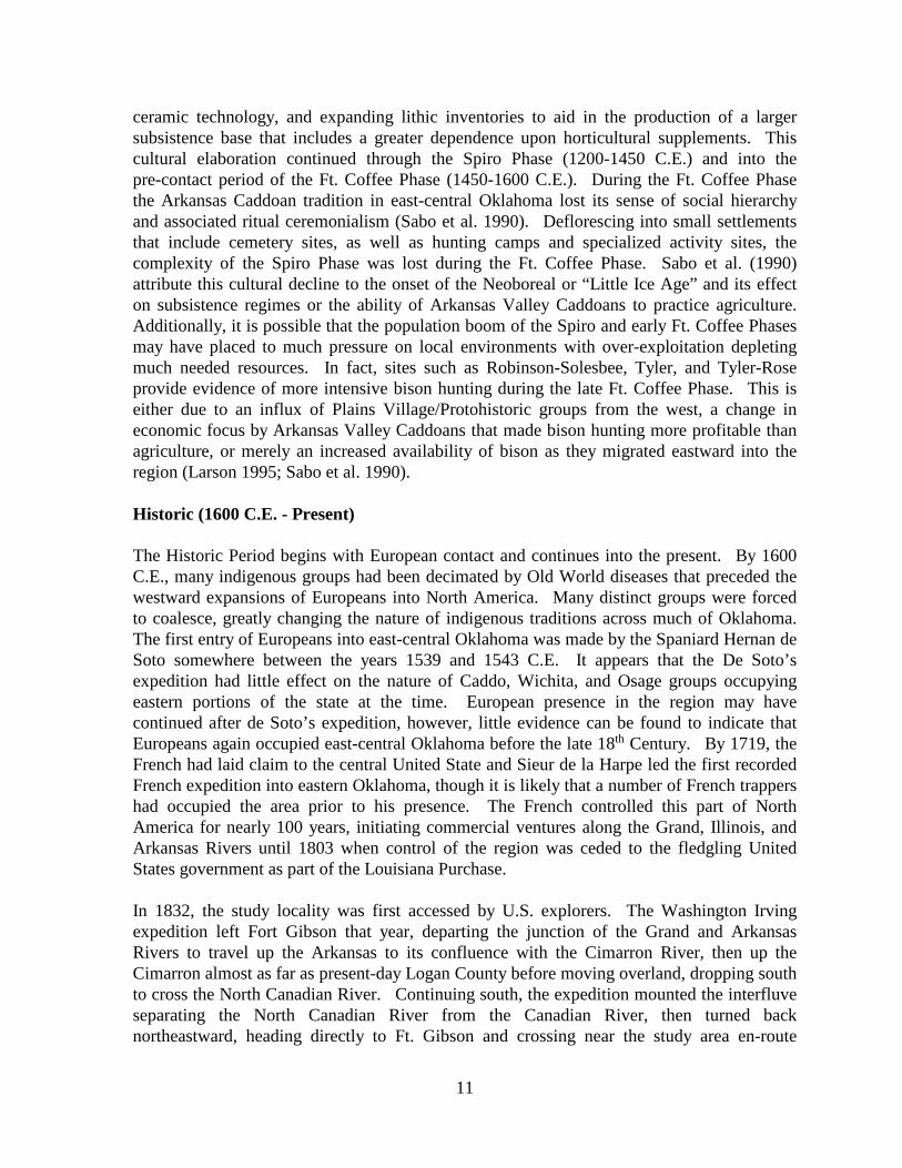
ceramic technology, and expanding lithic inventories to aid in the production of a larger subsistence base that includes a greater dependence upon horticultural supplements. This cultural elaboration continued through the Spiro Phase (1200-1450 C.E.) and into the pre-contact period of the Ft. Coffee Phase (1450-1600 C.E.). During the Ft. Coffee Phase the Arkansas Caddoan tradition in east-central Oklahoma lost its sense of social hierarchy and associated ritual ceremonialism (Sabo et al. 1990). Deflorescing into small settlements that include cemetery sites, as well as hunting camps and specialized activity sites, the complexity of the Spiro Phase was lost during the Ft. Coffee Phase. Sabo et al. (1990) attribute this cultural decline to the onset of the Neoboreal or “Little Ice Age” and its effect on subsistence regimes or the ability of Arkansas Valley Caddoans to practice agriculture. Additionally, it is possible that the population boom of the Spiro and early Ft. Coffee Phases may have placed to much pressure on local environments with over-exploitation depleting much needed resources. In fact, sites such as Robinson-Solesbee, Tyler, and Tyler-Rose provide evidence of more intensive bison hunting during the late Ft. Coffee Phase. This is either due to an influx of Plains Village/Protohistoric groups from the west, a change in economic focus by Arkansas Valley Caddoans that made bison hunting more profitable than agriculture, or merely an increased availability of bison as they migrated eastward into the region (Larson 1995; Sabo et al. 1990). Historic (1600 C.E. - Present) The Historic Period begins with European contact and continues into the present. By 1600 C.E., many indigenous groups had been decimated by Old World diseases that preceded the westward expansions of Europeans into North America. Many distinct groups were forced to coalesce, greatly changing the nature of indigenous traditions across much of Oklahoma. The first entry of Europeans into east-central Oklahoma was made by the Spaniard Hernan de Soto somewhere between the years 1539 and 1543 C.E. It appears that the De Soto’s expedition had little effect on the nature of Caddo, Wichita, and Osage groups occupying eastern portions of the state at the time. European presence in the region may have continued after de Soto’s expedition, however, little evidence can be found to indicate that Europeans again occupied east-central Oklahoma before the late 18th Century. By 1719, the French had laid claim to the central United State and Sieur de la Harpe led the first recorded French expedition into eastern Oklahoma, though it is likely that a number of French trappers had occupied the area prior to his presence. The French controlled this part of North America for nearly 100 years, initiating commercial ventures along the Grand, Illinois, and Arkansas Rivers until 1803 when control of the region was ceded to the fledgling United States government as part of the Louisiana Purchase. In 1832, the study locality was first accessed by U.S. explorers. The Washington Irving expedition left Fort Gibson that year, departing the junction of the Grand and Arkansas Rivers to travel up the Arkansas to its confluence with the Cimarron River, then up the Cimarron almost as far as present-day Logan County before moving overland, dropping south to cross the North Canadian River. Continuing south, the expedition mounted the interfluve separating the North Canadian River from the Canadian River, then turned back northeastward, heading directly to Ft. Gibson and crossing near the study area en-route
11
(Morris et al. 1976). Between the years 1825 and 1833, the study area was part of the land deals that transferred property held by various tribes in the region to the U.S. government and from the U.S. government back to other tribes requiring relocation. In this fashion, the Osage ceded their claims on the northern half of the state to the United States in 1825 and in 1833 the southern portion of the former Osage territory (that pertaining to this study) was distributed to the Creek Nation while the northern portion of the property became known as the Cherokee Outlet. Euro-American expansion and the traumas associated with the Civil War continuously transformed the character of Creek culture and property holdings in Oklahoma. Between 1833 and 1865, Creek territory was reduced by half from that of their original allotment. Additionally, the Creeks were forced to admit seven additional tribes, the Apalachicola, the Hitchiti, the Koasati, the Alabama, the Natchez, the Tuskegee, and the Yuchi (Morris et al. 1976). Pressures of the Civil War effectively split the Creek Nation from the outset. “The Lower Muscogee (Creek) Nation of Oklahoma went with the South, while...the Upper Muscogee (Creek) Nation of Oklahoma fought for the North” (Largent 1995:28). According to Wright (1951), Creeks of Euro-American heritage often fought for the South while full-blood members often fought for the North–essentially the same government that had repressed them and organized their forced removal to Oklahoma. Slavery on Creek property was abolished following the war causing numerous freedmen settlements to spring up along the Verdigris and Arkansas Rivers. Even with the all of this social turmoil, the Creek Nation of Oklahoma was able to ratify a brief constitution immediately following the Civil War on 12 October, 1867. The new constitution called for a two-house National Council and a principal chief who was given the authority of law enforcement for the Nation. The constitution mandated that a trial by jury preside over both criminal as well as civil cases (Morris et al. 1976). By June 28, 1898, however, all tribal courts were abolished due to alleged corruption and illegal property transactions and the United States courts were given complete jurisdiction over Indian lands, authorizing the Dawes Commission to make property allotments to individuals in the tribes based upon tribal rolls (McReynolds 1954). Oklahoma and Indian Territory were established as separate entities following the passage of the Organic Act by Congress in May of 1890. Known collectively as the Twin Territories, political wrangling ensued as many parties lobbied their terms for statehood. In general, representatives from Oklahoma Territory saw benefit in joining both territories together as a single state in which the agricultural production of the west could enhance the timber and mineral production of the east. Representatives of Indian Territory did not agree and in 1905, tribal representatives of Indian Territory made a bid for statehood separate from Oklahoma Territory. Prior to this bid for statehood, a constitution was written by the representatives of Indian Territory and a territorial president was elected. The document for statehood, known as the Sequoyah Constitution went before the U.S. House of Representatives as a bill in December of 1905. The bill was tabled in Congress and lay inactive until after the passage of the June 16, 1906 Enabling Act in which Congress called for joining the Twin Territories. Combination of the two territories required the
12

development of a new constitutional government with duly elected representatives. Those requirements were met by September of 1907 and on 16 November, 1907, President Theodore Roosevelt proclaimed Oklahoma the 46th state (McReynolds 1954). After statehood, the development of farming, ranching, and industrial capacity in east-central Oklahoma quickly resulted in a burgeoning population. One of the first railroads crossing the study area was constructed by the Kansas, Oklahoma, and Gulf (K.O.&G) Company. The K.O.&G. connected the railheads of Durant with Tulsa. Railroads opened Oklahoma to national markets seeking the produce, timber, and minerals extracted from the state. Okmulgee County is underlain by seams of bituminous coal that, when extracted, were initially used as an energy source for rail travel but are today used primarily for electricity generation, and steel production. The study area also lies on the eastern edge of a giant gas field stretching westward across most of the state. This gas field produces over one trillion cubic feet of natural gas per year (Morris et al. 1976). Archeological sites in the Vicinity of 34OG13 Okmulgee County has very few archeological sites recorded. Currently there are about 17 prehistoric sites recorded in the County. The majority of these prehistoric occupations are recorded along the Deep Fork River including nine documented sites in the vicinity of 34OG13. Site 34OG14 is recorded across the Deep Fork River about 900 m southwest of the site. Along with lithic debitage, a Gray type point, manos, a pestle and a possible hafted stone axe are reported from the site (Evers 1957). About 500 m south of 34OG13, site 34OG26, recorded during the 34OG13 investigations, was observed to contain burned sandstone and has produced a dual faced mano as well as Dalton drill of Johns Valley chert (Figure 3).
Figure 3. Left: dual faced mano from 34OG26; right: Dalton Drill of Johns Valley chert from 34OG26. A cluster of prehistoric sites is documented on a sandy terrace of the Deep Fork River about 8 kms southeast of 34OG13. Like 34OG13 and 34OG26, these sites (34OG 10 & 34OG18-21) occur in Eufaula Fine Sand which is described by the site recorders as 2-4 feet and up to 10 feet in thickness. This cluster of sites were recorded and visited by various amateur and professional archeologists beginning in the 1950’s. In addition to a historic
13
Creek component, the sites have produced side notched arrow points, contracting and rectangular stem dart points, and Dalton type points. Manos, a limestone hoe and quantities of burned sandstone are also reported from this cluster of sites. About 25 kms west of 34OG13, two prehistoric sites containing small mounds of burned sandstone have been radiocarbon dated to about AD 690 (Vehik 1980:42). These two sites are located on a tributary to the Deep Fork River about 6 km south of the river channel. The radiocarbon date and rather sparse lithic assemblage recovered by the site investigation indicate a Woodland occupation of the site. While the chipped stone assemblage, including the debitage is sparse, most of the assemblage is dominated by Frisco chert and Ogallala quartzite (Vehik 1980:50).
14

Site Investigations Formal test excavations were performed between April 27, 2001 and May 2, 2001, consisting of four machine excavated trenches (Trenches A, B, C & D) as well as three hand excavated 1 x 1 m test units, one 1 x 2 m test unit and eight .5 x .5 m test units (Figure 3). The excavations were designed to assess the stratigraphy, content, and integrity of the prehistoric occupation(s). The previous surveys of the site in 1996 and 1999 established that a deep, fine sand covered the site and that some prehistoric cultural materials lie at least 1 meter deep in the sandy terrace deposits. Though sparse, cultural material, mostly lithic debitage was observed on the surface. Most was observed around the exposed walls of a small borrow pit located in the southeastern portion of the site (Figure 3). Aside from the exposed area around the small, approximately 625 square meter borrow/pond area, no particular concentrations of surface material was present, and the surface finds were generally sparse. The exposures around the borrow area contained fire cracked rock (FCR), 43 flakes and a Dalton point. A total of 69 flakes, two projectile points, a small scraper, three biface fragments and a mano comprise the remainder of the surface collection, most all of which were found west and north of the small borrow pit. The trenching stage of subsurface investigation was designed to explore potential site stratigraphy and potential for intact buried deposits. The trenches were excavated by a Badger (a telescoping hydraulic boom trencher) with a 1.5 m wide bucket. After removing the upper 20 cm of plow zone, the machine excavated in approximate 10 cm levels while monitored by an archeologist. The Badger was ideal for controlled excavation of the levels in the fine sandy soil. Trenches A and B were 30 m in length and Trenches C and D were 15 m in length resulting in 135 m2 of area investigated by trenching. At the ends of each trench, an approximately 2 x 2 m area was machine excavated to depths ranging from 1.5 m to 2.5 m Below Surface Level (BSL) to examine profiles for potentially buried deposits and or soil horizons. One end was dug prior to excavations along the length of each trench to allow for an examination of the soil profile for evidence of potential buried soils or horizons of cultural material. The profiles were cleaned and examined, and a decision was then made in regards to the maximum depth of the machine excavations. The trenches were then machine excavated in approximated 10 cm levels while monitored by an archeologist. Upon the exposure of potential intact deposits or features, the machine excavation was halted at that depth for that trench and hand excavations initiated. Trench D was the only trench where potential intact deposits were encountered during machine excavations. The Trenches were excavated in the sequence C, D, A and B. The end of each trench was excavated deeper to examine the deeper profiles similar to the pits dug at the beginning of each trench. Each trench was dug by controlled machine excavations in 10 cm levels to a depth just above the highest horizon observed to potentially contain cultural materials in the profiles of the initial 2 x 2 m excavation at the beginning of each trench. The presence of burned rock occurred at depths varying from 70 cm BSL in Trenches A and B, to 60 cm in Trench C, and 20 cm BSL in Trench D. Further investigation was conducted with hand excavated test units from the floor of each trench, with the exception of Test Unit D-4 which was excavated along the edge of Trench D to investigate a burned rock feature. All hand excavations were in 10 cm arbitrary levels and screened through 1/4" mesh.
15

Figure 4. View of project plan sheet scaled and overlaid on 1995 aerial photograph depicting the area of investigations of 34OG13.
Trench A
Trench A was a 30 x 1.5 m north/south trench excavated near the approximate center of the project area approximately 10 m east of the edge of the slope along the west edge of the site. At the north end, 4 m of the trench was dug to 2 m BSL and 2 m of the south end was dug 2 m BSL. Sparsely scattered, fire fractured sandstone was observed between 70 and 80 cm BSL in the profile of these sections No evidence for organic materials, horizons or buried soils was observed in the 2 m deep profiles. Soils in the 2m profile consisted of light brown, fine sand from the surface to a depth of 20 cm, underlain by a tan, fine sand with weak discontinuous clay lamellae to a depth of 70-80 cm. Beginning at about 1 m BSL, the lamellae, which are wavy, but run parallel to the surface, become thicker, more distinct and continuous and are present at 5 cm-10 cm intervals to the base of the profile at 1.5m BSL (Figure 3). The remainder of the trench was dug to 70 cm BSL or just above the depth where the fire fractured sandstone was observed in the 1.5m soil profile. Hand excavated units were then employed to investigate the potential cultural deposit at the 70-80 cm depth.
16
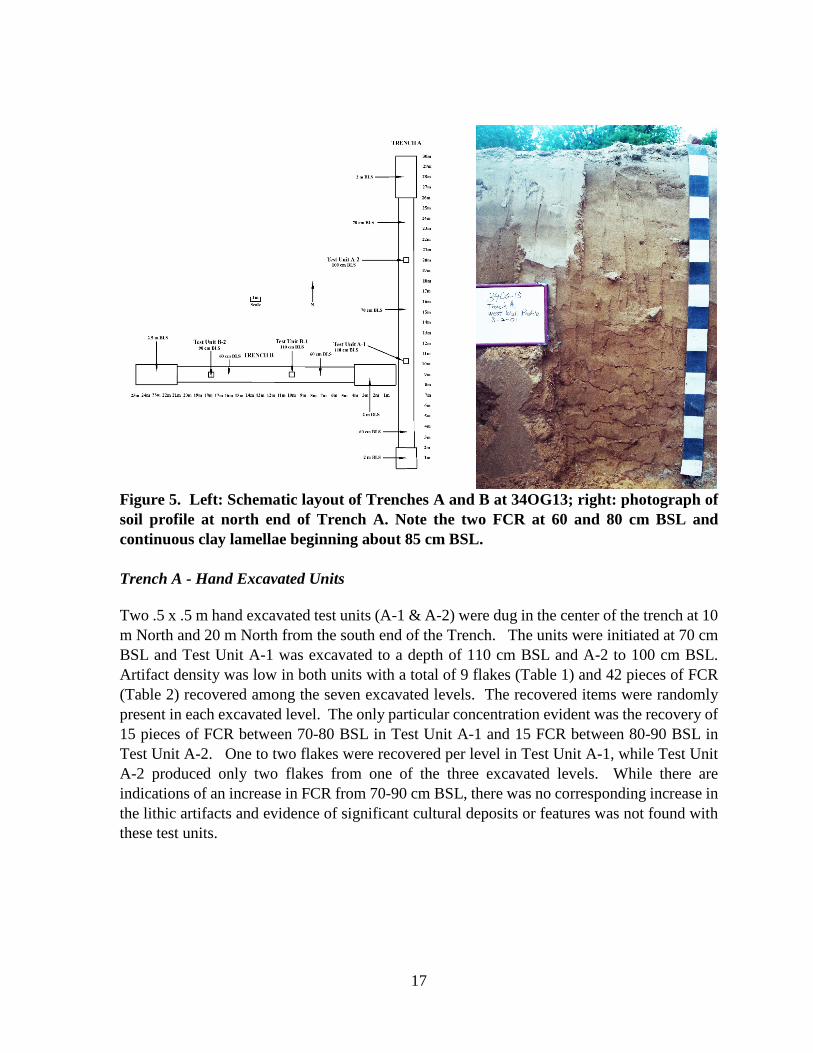
Figure 5. Left: Schematic layout of Trenches A and B at 34OG13; right: photograph of soil profile at north end of Trench A. Note the two FCR at 60 and 80 cm BSL and continuous clay lamellae beginning about 85 cm BSL. Trench A - Hand Excavated Units Two .5 x .5 m hand excavated test units (A-1 & A-2) were dug in the center of the trench at 10 m North and 20 m North from the south end of the Trench. The units were initiated at 70 cm BSL and Test Unit A-1 was excavated to a depth of 110 cm BSL and A-2 to 100 cm BSL. Artifact density was low in both units with a total of 9 flakes (Table 1) and 42 pieces of FCR (Table 2) recovered among the seven excavated levels. The recovered items were randomly present in each excavated level. The only particular concentration evident was the recovery of 15 pieces of FCR between 70-80 BSL in Test Unit A-1 and 15 FCR between 80-90 BSL in Test Unit A-2. One to two flakes were recovered per level in Test Unit A-1, while Test Unit A-2 produced only two flakes from one of the three excavated levels. While there are indications of an increase in FCR from 70-90 cm BSL, there was no corresponding increase in the lithic artifacts and evidence of significant cultural deposits or features was not found with these test units.
17

Table 1. Lithic debitage recovered from Trench A Test Units. Provenience Material P S T BF BP Total
T.U. A-1 (50x50cm) Level 1 70-80cm BSL Boone - - - 2 - 2 Level 2 80-90 cm BSL Boone - - - 1 - 1 Level 3 90-100cm BSL Boone - - 1 1 - 2 Level 4 100-110cm BSL
Boone - - - 2 - 2
Sub Total 0 0 1 6 0 7 T.U. A-2(50x50cm)
Level 1 70-80cm BSL Unidentified Chert - - 2 - - 2 Level 2 80-90 cm BSL - - - - - 0 Level 3 90-100cm BSL - - - - - 0 Sub Total 0 0 2 0 0 2
Total 0 0 3 6 0 9
Table 2. FCR recovered from Trench A Test Units. Provenience
Maximum Length
(cm) Maximum Thickness
(cm) Total Weight
(kg) 0-5 5-10 10-15 0-2 2-4 4-6 6-8
T.U. A-1(50x50cm) Level 1 70-80cm BSL 4 10 1 9 4 2 - 15 1.85 Level 2 80-90cm BSL - 5 - 2 2 1 - 5 .846 Level 3 90-100cm BSL - 3 0 1 1 - 1 3 .55 Level 4 100-110cm BSL 1 - - 1 - - - 1 .038
Sub Total 4 18 1 13 7 3 1 24 3.284 T.U. A-2(50x50cm)
Level 1 70-80cm BSL - 2 - - 2 - - 2 .315 Level 2 80-90 cm BSL 2 10 3 2 10 3 - 15 2.80 Level 3 90-100cm BSL - 1 0 0 1 0 0 1 .068 Sub Total 2 13 3 2 13 3 0 18 3.183
Total 6 31 4 15 20 6 1 42 6.467 Trench B
Trench B was a 30 x 1.5 m east/west trench excavated west of Trench A and intersecting Trench A between 8-10 m North. This trench was designed to investigate the southwest facing terrace slope and was the deepest of the trenches. The eastern 4 m of the trench was dug to a depth of 2 m. The 4 m at the west end of the trench was excavated to a depth of 2.5 m where an orange clay was observed beginning at 2.4 m BSL. This deeper excavation was an attempt to reach deeper into the terrace deposits in search of a buried soil or cultural horizon. This was the only portion of the site where trenching this deep was feasible since it was on the west facing slope of the terrace and the machine could excavate deeper before collapse of the trench walls was a concern. The profiles of Trench B are identical to those observed in Trench A with some scattered fractured sandstone from 60-80 cm BSL and clay lamellae that become
18

thicker, more distinct and continuous at 1 m BSL. No evidence of buried organic deposits or soil development was observed. The remainder of the trench was dug to 60-70 cm BSL or just above the depth where the fire fractured sandstone was observed. Hand excavated units were then employed to investigate the potential cultural deposit observed in the profiles.
Trench B - Hand Excavated Units
Two .5 x .5 m hand excavated test units (B-1 & B-2) were dug in the center of the trench at 10 m West and 18 m West. Test Unit B-1 was excavated to a depth of 110 cm BSL and B-2 to 90 cm BSL. Artifact density was low in both units with an overall total of 3 flakes (Table 3) and 25 pieces of FCR (Table 4) recovered. A biface fragment was recovered from Test Unit B-1 between 70-80 cm BSL. No evidence of intact substantial cultural deposits was found with these test units.
Table 3. Lithic debitage recovered from Trench B Test Units. Provenience Material P S T BF BP Total
T.U. B-1(50x50cm) Level 1 60-70cm BSL Boone - - 1 - - 1 Level 2 70-80 cm BSL - - - - - - 0 Level 3 80-90cm BSL Ogallala
quartzite - - 1 - - 1
Sub Total 0 0 2 0 0 2 T.U. B-2 (50x50cm)
Level 1 60-70cm BSL Boone - - 1 - - 1 Level 2 70-80 cm BSL - - - - - - 0 Level 3 80-90cm BSL - - - - - - 0
Sub Total 0 0 1 0 0 1 Total 0 0 3 0 0 3
Table 4. FCR recovered from Trench B Test Units.
Provenience
Maximum Length (cm)
Maximum Thickness (cm)
Total Weight (kg)
0-5 5-10 10-15 0-2 2-4 4-6 6-8 T.U. B-1 (50x50cm)
Level 1 60-70cm BSL 2 1 1 2 2 - - 4 .453 Level 2 70-80 cm BSL - 5 - 2 - 2 1 5 .909 Level 3 80-90cm BSL - 2 2 - 4 - - 4 .884 Level 4 90-100cm BSL - 1 1 - 1 1 - 2 .494
Sub Total 2 9 3 4 7 3 1 19 2.740 T.U. B-2(50x50cm)
Level 1 60-70cm BSL - - - - - - - 0 0 Level 2 70-80 cm BSL 3 2 - 3 1 1 - 5 .388 Level 3 80-90cm BSL 1 - - - 1 - - 1 .054 Sub Total 4 2 0 3 2 1 1 6 .442
Total 6 11 3 7 9 4 1 25 3.182
19

Trench C
Trench C, a 15 x 1.5 m north/south trench was excavated in a level area near the northern edge of the project area. This area was selected for trenching due to the fact it is within the center of observed surface materials and appears to be one of the lesser disturbed areas of the site within the R/W. At the north and south ends of the trench, 2 m of the trench was dug 2 m deep. Like Trench A and B, sparsely scattered, fire fractured sandstone was observed in the 2 m profiles between 70 and 80 cm BSL. While the same clay lamellae observed in Trenches A & B are present, no evidence of organic materials, horizons or buried soils was observed in the 2 m deep profiles which exhibited the same basic attributes as those described for Trench A and B (Figure 6). The remainder of the trench was dug to 60 cm BSL or just above the depth where the fire-fractured sandstone was observed. Hand excavated units were then employed to investigate the potential cultural deposit at the 70-80 cm depth.
Figure 6. Left: Schematic plan view of Trench C; right: photograph of Trench C soil profile at south end of trench. Note FCR at 70 and 90 cm BSL and continuous clay lamellae beginning about 80 cm BSL.
20

Trench C - Hand Excavated Units
A 1 x 1 m hand excavated test unit (C-1) was dug in the center of the trench floor between 3 m North and 4 m North to a depth of 90 cm BSL. In addition to being located amid the largest density of surface materials observed within the project area, the 1 x 1 m unit was initiated to provide larger sample size to compare with the smaller .5 x .5 m test units. A .5 x .5 m hand excavated test unit was excavated in the trench floor at 10 m North to a depth of 90 cm BSL. Artifact density was low in both test units with an overall total of 24 flakes (Table 5) and 108 pieces of FCR recovered (Table 6). Test Unit C-1 produced 10 flakes among the three excavated levels as well 100 pieces of FCR. Most of the FCR (N=75) derive from 60-70 cm BSL, however, the FCR was scattered throughout the level and no evidence of an associated feature was present. Lithic debitage recovery rates were low for all levels with no more than 2 flakes present in any level.
Table 5. Lithic debitage recovered from Trench C Test Units. Provenience Material P S T BF BP Total
T.U. C-1(1x1m) Level 1 60-70cm BSL
Florence A Chert - - - 1 - 1
Oolagah Chert - - 1 - - 1 Johns Valley Chert - - - 1 - 1 Level 2 70-80 cm BSL
Boone - - 1 1 - 2
Ogallala Quartzite - - 1 - - 1 Johns Valley Chert - - 1 - - 1 Unidentified Chert - 1 - - - 1 Level 3 80-90cm BSL
Boone - - 1 1 - 2
Sub Total 0 1 5 4 0 10 T.U. C-2 (50x50cm)
Level 1 60-70cm BSL
Boone - - - 1 - 1
Level 2 70-80 cm BSL
- - - - - - 0
Level 3 80-90cm BSL
- - - - - - 0
Sub Total 0 0 0 1 0 1 Total 0 1 5 5 0 11
21

Table 6. FCR recovered from Trench C Test Units. Provenience
Maximum Length
(cm) Maximum Thickness
(cm) Total Weight
(kg) 0-5 5-10 10-15 0-2 2-4 4-6 6-8
T.U. C-1 (1x1m) Level 1 60-70cm BSL 27 44 4 45 26 4 - 75 5.643 Level 2 70-80 cm BSL 4 13 - 12 4 1 - 17 1.312 Level 3 80-90cm BSL 3 5 - 6 2 - - 8 .397
Sub Total 34 62 4 63 32 5 0 100 7.148 T.U. C-2(50x50cm)
Level 1 60-70cm BSL 1 1 - - 2 - - 2 .282 Level 2 70-80 cm BSL 2 2 - 3 1 - - 4 .393 Level 3 80-90cm BSL - 2 - 2 - - - 2 .193 Sub Total 3 5 0 5 3 0 0 8 .868
Total 37 67 4 68 35 5 0 108 8.016
Trench D
Trench D, a 15 x 1.5 m northeast/southwest trench was excavated in a level area in the center of the R/W and adjacent to the small borrow pit. Fractured sandstone and flakes had been observed along the northern edges of the pit and the trench was positioned to best investigate the lesser disturbed area adjacent to the pit. Therefore, the Trench was oriented northeast/southwest to parallel the small borrow pit. The southwest end of the trench was excavated to a depth of 1.5 m for a length of 2 m while the northeast end was excavated for a length of 3 m to a depth of 1.5 m. The 1.5 m deep profiles at each end of the trench were similar to those previously observed in Trench A, B and C where the only evidence of cultural material was the sparsely scattered, fractured sandstone located between 60-80 cm BSL. During the controlled machine excavations a shallow cultural feature (Feature D-1) comprised of a distinct layer of burned rock was encountered along the southern trench wall at approximately 3 m northeast. The burned rock feature was visible in the wall profile between 20 and 40 cm BSL. Due to the presence and shallow depth of the burned rock feature, the remainder of the trench was machine excavated only to 20 cm BSL to avoid disturbing any associated deposits. Test units were initiated from this level to investigate any cultural deposits which may be associated with the feature. Trench D - Hand Excavated Units A total of four hand excavated test units including two 1 x 1 m (D-1 & D-2), one .5 x .5 m (D-3) and one 70 cm x 2 m (D-4) units were dug to further investigate Trench D. Test Units D-1 and D-2 were located in the center of the trench between 4 m and 6 m northeast to explore the area in association with Feature D-1. A moderate scatter of fractured sandstone was uncovered in Test Unit D-1 between 20 cm and 30 cm BSL most of which was concentrated in two small piles in the southeast corner of the unit in close proximity to Feature D-1(Figure 7). Four flakes were recovered from the same level. No dark soil, organic material or charcoal was observed. Test Unit D-2, immediately northeast of D-1, produced a light scatter of fractured sandstone in the same level, most of which was adjacent to Test Unit D-1. Unit D-2 was excavated to 60 cm BSL and contained a low artifact density (Table 7 & 8).
22
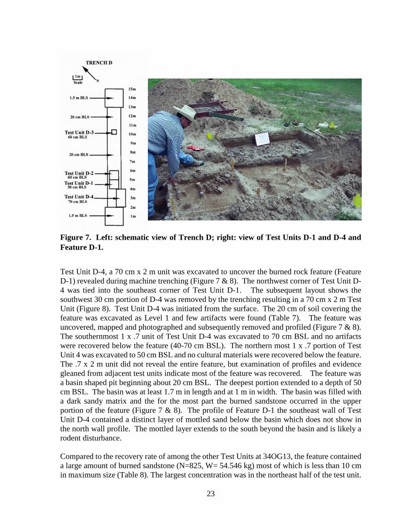
Figure 7. Left: schematic view of Trench D; right: view of Test Units D-1 and D-4 and Feature D-1.
Test Unit D-4, a 70 cm x 2 m unit was excavated to uncover the burned rock feature (Feature D-1) revealed during machine trenching (Figure 7 & 8). The northwest corner of Test Unit D-4 was tied into the southeast corner of Test Unit D-1. The subsequent layout shows the southwest 30 cm portion of D-4 was removed by the trenching resulting in a 70 cm x 2 m Test Unit (Figure 8). Test Unit D-4 was initiated from the surface. The 20 cm of soil covering the feature was excavated as Level 1 and few artifacts were found (Table 7). The feature was uncovered, mapped and photographed and subsequently removed and profiled (Figure 7 & 8). The southernmost 1 x .7 unit of Test Unit D-4 was excavated to 70 cm BSL and no artifacts were recovered below the feature (40-70 cm BSL). The northern most 1 x .7 portion of Test Unit 4 was excavated to 50 cm BSL and no cultural materials were recovered below the feature. The .7 x 2 m unit did not reveal the entire feature, but examination of profiles and evidence gleaned from adjacent test units indicate most of the feature was recovered. The feature was a basin shaped pit beginning about 20 cm BSL. The deepest portion extended to a depth of 50 cm BSL. The basin was at least 1.7 m in length and at 1 m in width. The basin was filled with a dark sandy matrix and the for the most part the burned sandstone occurred in the upper portion of the feature (Figure 7 & 8). The profile of Feature D-1 the southeast wall of Test Unit D-4 contained a distinct layer of mottled sand below the basin which does not show in the north wall profile. The mottled layer extends to the south beyond the basin and is likely a rodent disturbance. Compared to the recovery rate of among the other Test Units at 34OG13, the feature contained a large amount of burned sandstone (N=825, W= 54.546 kg) most of which is less than 10 cm in maximum size (Table 8). The largest concentration was in the northeast half of the test unit.
23
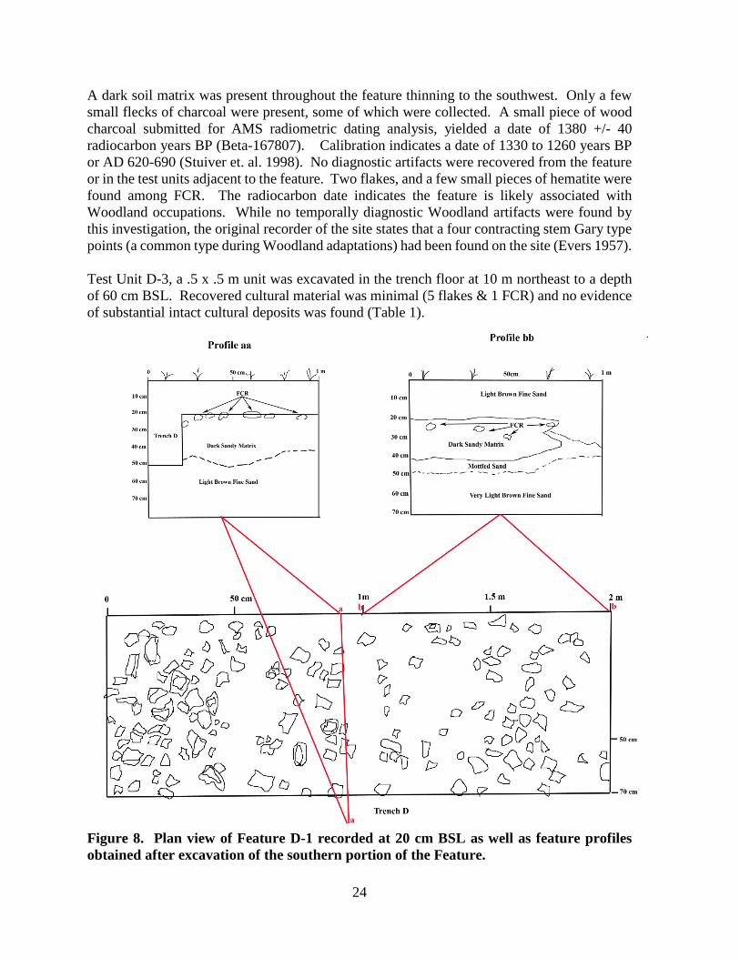
A dark soil matrix was present throughout the feature thinning to the southwest. Only a few small flecks of charcoal were present, some of which were collected. A small piece of wood charcoal submitted for AMS radiometric dating analysis, yielded a date of 1380 +/- 40 radiocarbon years BP (Beta-167807). Calibration indicates a date of 1330 to 1260 years BP or AD 620-690 (Stuiver et. al. 1998). No diagnostic artifacts were recovered from the feature or in the test units adjacent to the feature. Two flakes, and a few small pieces of hematite were found among FCR. The radiocarbon date indicates the feature is likely associated with Woodland occupations. While no temporally diagnostic Woodland artifacts were found by this investigation, the original recorder of the site states that a four contracting stem Gary type points (a common type during Woodland adaptations) had been found on the site (Evers 1957). Test Unit D-3, a .5 x .5 m unit was excavated in the trench floor at 10 m northeast to a depth of 60 cm BSL. Recovered cultural material was minimal (5 flakes & 1 FCR) and no evidence of substantial intact cultural deposits was found (Table 1).
Figure 8. Plan view of Feature D-1 recorded at 20 cm BSL as well as feature profiles obtained after excavation of the southern portion of the Feature.
24

Table 7. Lithic debitage recovered from Trench D Test Units.
Provenience Material P S T BF BP Total T.U. D-1(1x1m)
Level 1 20-30cm BSL Boone - - 3 1 - 4 Sub Total 0 0 3 1 0 4
T.U. D-2 (1x1m) Level 1 20-30cm BSL Boone - - - 2 - 2 Unidentified Chert 1 - 1 - - 2 Oolagah. Chert - - 1 - - 1 Level 2 30-40 cm BSL Boone 1 - - 1 - 2 Unidentified Chert - - 1 - - 1 Oolagah Chert - - 1 - - 1 Level 3 40-50cm BSL Boone - 1 2 3 - 6 Oolagah Chert - - - 1 - 1 Level 4 50-60cm BSL Boone - - 2 1 - 3
Sub Total 2 1 8 8 0 19 T.U. D-3 (50x50cm)
Level 1 20-30cm BSL Boone - - 2 1 - 3 Unidentified Chert - - - 1 - 1
Level 2 30-40cm BSL Boone - - - - 1 1 Level 3 40-50cm BSL - - - - - - 0 Level 4 50-60cm BSL - - - - - - 0
Sub Total 0 0 2 2 1 5
T.U. D-4 (70 cm x2m) Level 1 0-20 cm BSL Boone - - 2 2 - 4 Unidentified Chert - - - 1 - 1 Level 2 20-40cm BSL Boone - - 2 - - 2
Sub Total 0 0 4 3 0 7 Total 2 1 17 14 1 35
25

Table 8. FCR recovered from Trench D Test Units Provenience
Maximum Length
(cm) Maximum Thickness
(cm) Total Weight
(kg) 0-5 5-10 10-15 0-2 2-4 4-6 6-8
T.U. D-1 (1x1m) Level 1 20-30cm BSL 36 55 1 40 45 7 - 92 1.463
Sub Total 36 55 1 40 45 7 - 92 1.463 T.U. D-2(1x1m)
Level 1 20-30cm BSL 6 4 - 4 6 - - 10 .620 Level 2 30-40 cm BSL 15 9 - 14 10 - - 24 1.285 Level 3 40-50cm BSL 4 2 - 4 2 - - 6 .316 Level 4 50-60cm BSL 2 7 - 2 7 - - 9 .517 Sub Total 27 22 0 24 25 - - 49 2.738
T.U D-3 (50x50cm) Level 1 20-30 cm BSL 1 - - - 1 - - 1 .052 Sub Total 1 0 0 0 1 0 0 1 .052 T.U.D-4 (70 cm x 2 m) Level 1 0-20 cm BSL 12 2 - 7 6 1 - 14 .558 Level 2 20-40 cm BSL 456 360 9 400 391 34 - 816 53.268
Sub Total 468 362 9 407 397 35 0 839 53.826 Total 532 439 10 471 468 42 0 981 58.079
Summary of Excavations The excavations at 34OG13 revealed one prehistoric, basin shaped feature, associated with a layer of burned rock in Trench D occurring 20-40 cm BSL. The feature is dated to 1380 +/-40 BP (AD 660). No diagnostic artifacts were recovered at this level from or from any of the test units. The distribution of lithic debitage is low in all test units with no apparent concentrations vertically or horizontally. Fire fractured sandstone occurred in all four trenches from 20 cm BSL in Trench D to 110cm BSL in Trench A. Trench D produced a concentration including an intact burned rock feature at 20 cm BSL. Though varied in number both vertically and horizontally in the investigated area, there is an apparent increase in the occurrence of FCR at 60-80 cm BSL in the areas of Trench A and Trench C. However, no evidence for significant intact cultural deposits at these levels was found during the testing. The presence of continuous clay lamellae beginning about 80 cm BSL in the sand profiles in Trenches A-C at 34OG13could be useful age indicators if adequately studied (Holliday and Rawling 2005). The FCR feature (D-1) encountered 20-40 cm BSL in Trench D represents an intact cultural feature in the upper levels of 34OG13. However, this was the only such deposit encountered in the excavations which entailed 135 square meters of machine excavations, most of which was carried to a depth of 60-70 cm BSL.
26

Analysis and Description of Recovered Materials The prehistoric items recovered by this investigation include chipped stone tools (N=8), flake tools (N=4), lithic debris (N=170), ground stone tools (N=3), and fire fractured rock (N=1152). While a majority of the chipped stone artifacts (tools and debitage) derive from disturbed surface contexts, analysis was undertaken to seek any distinctions among technological attributes, lithic materials, or other indications which may indicate cultural attributions between the items recovered by the excavations. An intact, burned rock feature likely dating to around AD 660 was encountered in the upper 20-40 cm of the site in Trench D. Though numbers are low, fire cracked rock (FCR) and flakes were found in excavated levels down to 110 cm Below Surface Level (BSL) in Trenches A-C. There is an apparent consistent occurrence of FCR between 60-80 cm BSL. If the intact feature and artifacts in the upper levels of the site and the FCR and recovered artifacts in the lower levels of the site represent different cultural components it may be manifest in the recovered assemblage. Trenches A, B and C were excavated in 10 cm levels by machine down to 60 cm BSL, except Trench A which was excavated down to 70 cm BSL. From that point hand excavations were carried out to sample the levels below. Trench D machine excavations encountered a layer of FCR at 20 cm BSL and Trench D hand excavations began at 20 cm BSL except Test Unit D-4 in which hand excavations were initiated from the surface. Therefore, all the recovered artifacts are described collectively as well as by excavation units within each Trench. The artifact descriptions includes analysis of each artifact category recovered from both surface and excavated contexts. Chipped Stone Tools A total of 12 items are included in this category including two complete diagnostic stemmed bifaces and a stemmed biface reworked into a gouge like tool (Figure 9), four biface fragments, one unifacial endscraper and four flake tools. All but two of the items, a biface fragment from Test Unit B-2, and a flake tool from Test Unit D-4 were recovered from surface contexts.
Figure 9. Complete bifacial stone tools recovered from 34OG13.
27
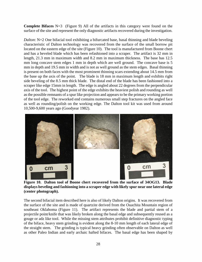
Complete Bifaces N=3 (Figure 9) All of the artifacts in this category were found on the surface of the site and represent the only diagnostic artifacts recovered during the investigation. Dalton: N=2 One bifacial tool exhibiting a bifurcated base, basal thinning and blade beveling characteristic of Dalton technology was recovered from the surface of the small borrow pit located on the eastern edge of the site (Figure 10). The tool is manufactured from Boone chert and has a beveled blade which has been refashioned into a scraper. The artifact is 32 mm in length, 21.3 mm in maximum width and 8.2 mm in maximum thickness. The base has 12.5 mm long concave stem edges 1 mm in depth which are well ground. The concave base is 5 mm in depth and 19.5 mm in width and is not as well ground as the stem edges. Basal thinning is present on both faces with the most prominent thinning scars extending about 14.5 mm from the base up the axis of the point. The blade is 18 mm in maximum length and exhibits right side beveling of the 8.5 mm thick blade. The distal end of the blade has been fashioned into a scraper like edge 15mm in length. The edge is angled about 22 degrees from the perpendicular axis of the tool. The highest point of the edge exhibits the heaviest polish and rounding as well as the possible remnants of a spur like projection and appears to be the primary working portion of the tool edge. The reworked end contains numerous small step fractures on the angled face as well as rounding/polish on the working edge. The Dalton tool kit was used from around 10,500-9,600 years ago (Goodyear 1982).
Figure 10. Dalton tool of Boone chert recovered from the surface of 34OG13. Blade displays beveling and fashioning into a scraper edge with likely spur near one lateral edge (center photograph). The second bifacial item described here is also of likely Dalton origins. It was recovered from the surface of the site and is made of quartzite derived from the Ouachita Mountain region of southeast Oklahoma (Figure 11). The artifact represents the blade and partial stem of a projectile point/knife that was likely broken along the basal edge and subsequently reused as a gouge or adz like tool. While the missing stem attributes prohibit definitive diagnostic typing of the biface, heavy stem grinding is evident along the 8-10 mm length of each lateral edge of the straight stem. The grinding is typical heavy grinding often observable on Dalton as well as other Paleo Indian and early archaic hafted bifaces. The basal edge has been shaped by
28
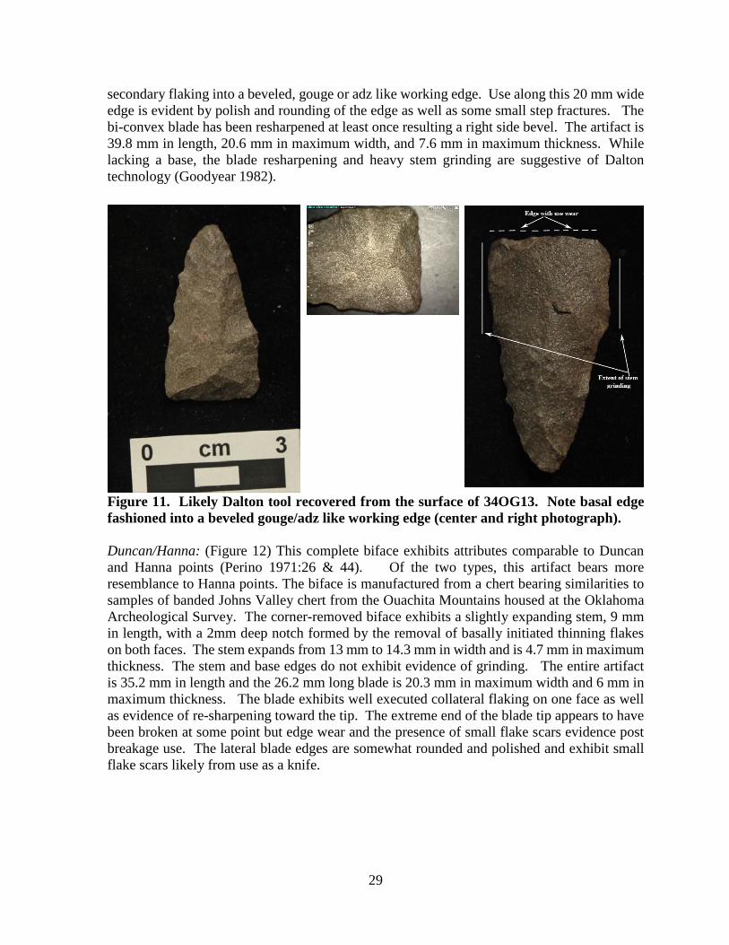
secondary flaking into a beveled, gouge or adz like working edge. Use along this 20 mm wide edge is evident by polish and rounding of the edge as well as some small step fractures. The bi-convex blade has been resharpened at least once resulting a right side bevel. The artifact is 39.8 mm in length, 20.6 mm in maximum width, and 7.6 mm in maximum thickness. While lacking a base, the blade resharpening and heavy stem grinding are suggestive of Dalton technology (Goodyear 1982).
Figure 11. Likely Dalton tool recovered from the surface of 34OG13. Note basal edge fashioned into a beveled gouge/adz like working edge (center and right photograph). Duncan/Hanna: (Figure 12) This complete biface exhibits attributes comparable to Duncan and Hanna points (Perino 1971:26 & 44). Of the two types, this artifact bears more resemblance to Hanna points. The biface is manufactured from a chert bearing similarities to samples of banded Johns Valley chert from the Ouachita Mountains housed at the Oklahoma Archeological Survey. The corner-removed biface exhibits a slightly expanding stem, 9 mm in length, with a 2mm deep notch formed by the removal of basally initiated thinning flakes on both faces. The stem expands from 13 mm to 14.3 mm in width and is 4.7 mm in maximum thickness. The stem and base edges do not exhibit evidence of grinding. The entire artifact is 35.2 mm in length and the 26.2 mm long blade is 20.3 mm in maximum width and 6 mm in maximum thickness. The blade exhibits well executed collateral flaking on one face as well as evidence of re-sharpening toward the tip. The extreme end of the blade tip appears to have been broken at some point but edge wear and the presence of small flake scars evidence post breakage use. The lateral blade edges are somewhat rounded and polished and exhibit small flake scars likely from use as a knife.
29
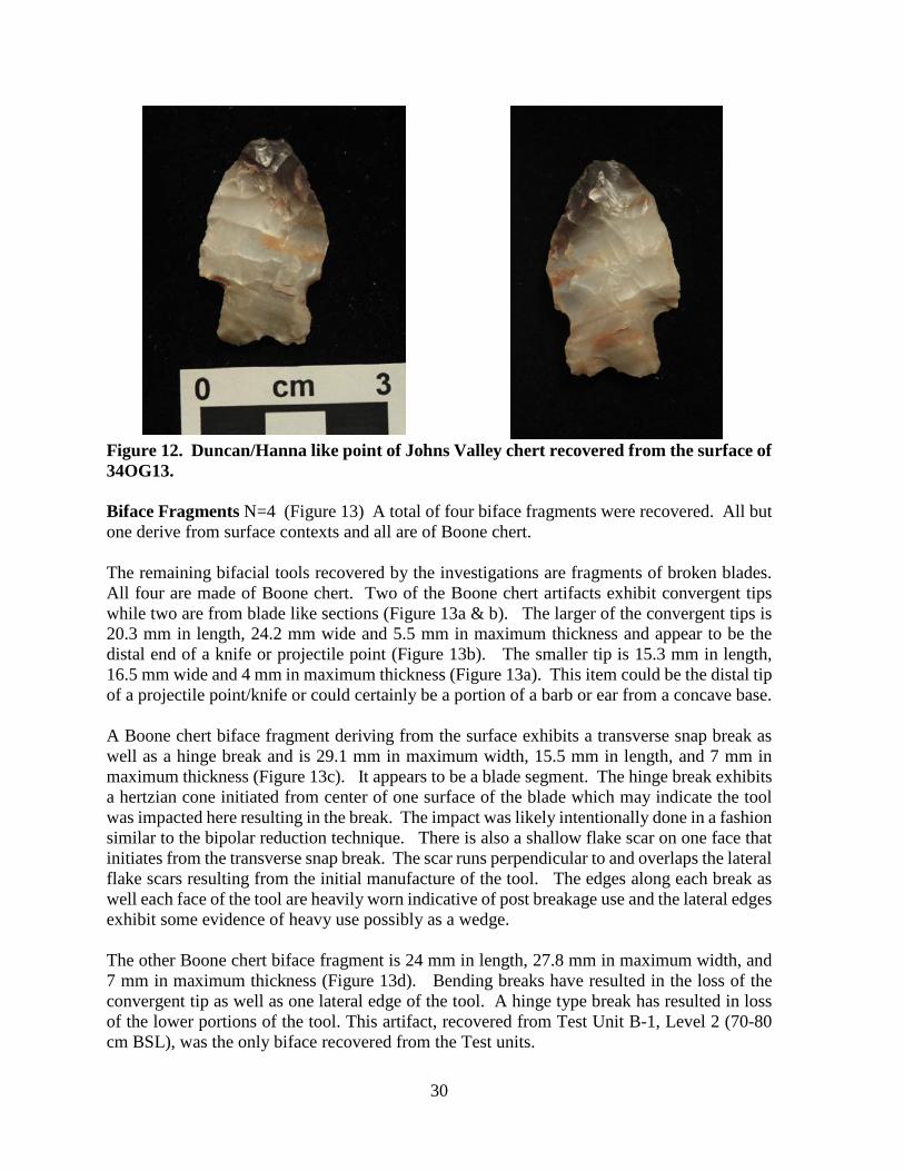
Figure 12. Duncan/Hanna like point of Johns Valley chert recovered from the surface of 34OG13. Biface Fragments N=4 (Figure 13) A total of four biface fragments were recovered. All but one derive from surface contexts and all are of Boone chert. The remaining bifacial tools recovered by the investigations are fragments of broken blades. All four are made of Boone chert. Two of the Boone chert artifacts exhibit convergent tips while two are from blade like sections (Figure 13a & b). The larger of the convergent tips is 20.3 mm in length, 24.2 mm wide and 5.5 mm in maximum thickness and appear to be the distal end of a knife or projectile point (Figure 13b). The smaller tip is 15.3 mm in length, 16.5 mm wide and 4 mm in maximum thickness (Figure 13a). This item could be the distal tip of a projectile point/knife or could certainly be a portion of a barb or ear from a concave base. A Boone chert biface fragment deriving from the surface exhibits a transverse snap break as well as a hinge break and is 29.1 mm in maximum width, 15.5 mm in length, and 7 mm in maximum thickness (Figure 13c). It appears to be a blade segment. The hinge break exhibits a hertzian cone initiated from center of one surface of the blade which may indicate the tool was impacted here resulting in the break. The impact was likely intentionally done in a fashion similar to the bipolar reduction technique. There is also a shallow flake scar on one face that initiates from the transverse snap break. The scar runs perpendicular to and overlaps the lateral flake scars resulting from the initial manufacture of the tool. The edges along each break as well each face of the tool are heavily worn indicative of post breakage use and the lateral edges exhibit some evidence of heavy use possibly as a wedge. The other Boone chert biface fragment is 24 mm in length, 27.8 mm in maximum width, and 7 mm in maximum thickness (Figure 13d). Bending breaks have resulted in the loss of the convergent tip as well as one lateral edge of the tool. A hinge type break has resulted in loss of the lower portions of the tool. This artifact, recovered from Test Unit B-1, Level 2 (70-80 cm BSL), was the only biface recovered from the Test units.
30
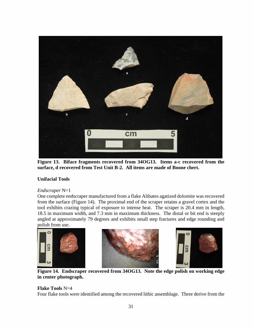
Figure 13. Biface fragments recovered from 34OG13. Items a-c recovered from the surface, d recovered from Test Unit B-2. All items are made of Boone chert. Unifacial Tools Endscraper N=1 One complete endscraper manufactured from a flake Alibates agatized dolomite was recovered from the surface (Figure 14). The proximal end of the scraper retains a gravel cortex and the tool exhibits crazing typical of exposure to intense heat. The scraper is 20.4 mm in length, 18.5 in maximum width, and 7.3 mm in maximum thickness. The distal or bit end is steeply angled at approximately 79 degrees and exhibits small step fractures and edge rounding and polish from use.
Figure 14. Endscraper recovered from 34OG13. Note the edge polish on working edge in center photograph. Flake Tools N=4 Four flake tools were identified among the recovered lithic assemblage. Three derive from the
31

surface collection while one was recovered from an excavated context in Test Unit D-4 in association with Feature D-1. A tool made on a flake of Oolagah chert and exhibits a graver like projection which exhibits minor use wear. Minor use wear occurs along the flake edges adjacent to the graver as well. In addition, a burin occurs on the opposite edge from the graver. At its thickest point, the flake tool has a ridge across the ventral face which forms the center axis for both the burin and graver points (Figure 15). Two lateral edges also display micro flaking likely resulting from use. The tool, recovered from Test Unit D-4 in association with Feature D-1, is 24.5mm in maximum length, 18mm in width and 5.5 mm in maximum thickness.
Figure 15. Dorsal and ventral face of flake tool recovered from Test Unit D-4. Tool is made from Oolagah chert. The second flake tool described here was found on the surface. The tool is also made from a flake of Oolagah chert with the distal and proximal ends removed by snap type transverse breaks. One lateral flake edge is also removed by a snap like fracture. The result is a tool with sharp graver like projections at each end (Figure 16). Both of the small chisel like points exhibit some degree of wear suggesting use. The tool is 36.5 mm in maximum length, 21 mm in maximum width and 4 mm in maximum thickness.
32
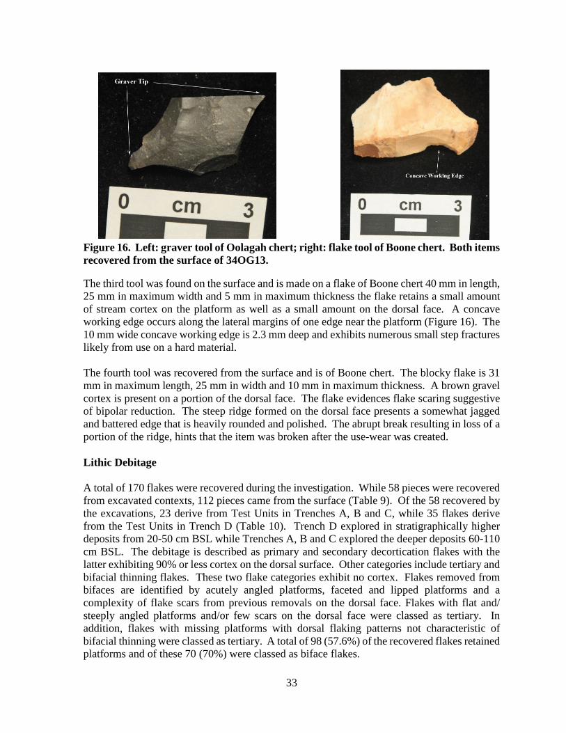
Figure 16. Left: graver tool of Oolagah chert; right: flake tool of Boone chert. Both items recovered from the surface of 34OG13. The third tool was found on the surface and is made on a flake of Boone chert 40 mm in length, 25 mm in maximum width and 5 mm in maximum thickness the flake retains a small amount of stream cortex on the platform as well as a small amount on the dorsal face. A concave working edge occurs along the lateral margins of one edge near the platform (Figure 16). The 10 mm wide concave working edge is 2.3 mm deep and exhibits numerous small step fractures likely from use on a hard material. The fourth tool was recovered from the surface and is of Boone chert. The blocky flake is 31 mm in maximum length, 25 mm in width and 10 mm in maximum thickness. A brown gravel cortex is present on a portion of the dorsal face. The flake evidences flake scaring suggestive of bipolar reduction. The steep ridge formed on the dorsal face presents a somewhat jagged and battered edge that is heavily rounded and polished. The abrupt break resulting in loss of a portion of the ridge, hints that the item was broken after the use-wear was created. Lithic Debitage A total of 170 flakes were recovered during the investigation. While 58 pieces were recovered from excavated contexts, 112 pieces came from the surface (Table 9). Of the 58 recovered by the excavations, 23 derive from Test Units in Trenches A, B and C, while 35 flakes derive from the Test Units in Trench D (Table 10). Trench D explored in stratigraphically higher deposits from 20-50 cm BSL while Trenches A, B and C explored the deeper deposits 60-110 cm BSL. The debitage is described as primary and secondary decortication flakes with the latter exhibiting 90% or less cortex on the dorsal surface. Other categories include tertiary and bifacial thinning flakes. These two flake categories exhibit no cortex. Flakes removed from bifaces are identified by acutely angled platforms, faceted and lipped platforms and a complexity of flake scars from previous removals on the dorsal face. Flakes with flat and/ steeply angled platforms and/or few scars on the dorsal face were classed as tertiary. In addition, flakes with missing platforms with dorsal flaking patterns not characteristic of bifacial thinning were classed as tertiary. A total of 98 (57.6%) of the recovered flakes retained platforms and of these 70 (70%) were classed as biface flakes.
33
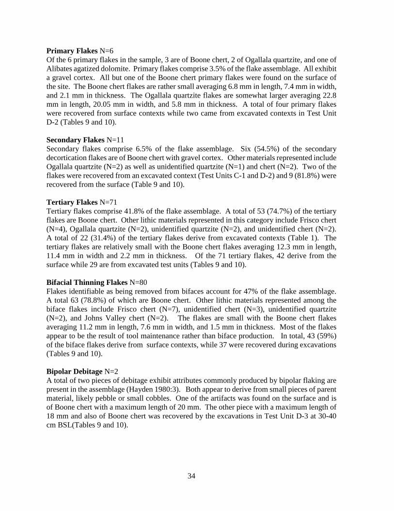
Primary Flakes N=6 Of the 6 primary flakes in the sample, 3 are of Boone chert, 2 of Ogallala quartzite, and one of Alibates agatized dolomite. Primary flakes comprise 3.5% of the flake assemblage. All exhibit a gravel cortex. All but one of the Boone chert primary flakes were found on the surface of the site. The Boone chert flakes are rather small averaging 6.8 mm in length, 7.4 mm in width, and 2.1 mm in thickness. The Ogallala quartzite flakes are somewhat larger averaging 22.8 mm in length, 20.05 mm in width, and 5.8 mm in thickness. A total of four primary flakes were recovered from surface contexts while two came from excavated contexts in Test Unit D-2 (Tables 9 and 10). Secondary Flakes N=11 Secondary flakes comprise 6.5% of the flake assemblage. Six (54.5%) of the secondary decortication flakes are of Boone chert with gravel cortex. Other materials represented include Ogallala quartzite (N=2) as well as unidentified quartzite (N=1) and chert (N=2). Two of the flakes were recovered from an excavated context (Test Units C-1 and D-2) and 9 (81.8%) were recovered from the surface (Table 9 and 10). Tertiary Flakes N=71 Tertiary flakes comprise 41.8% of the flake assemblage. A total of 53 (74.7%) of the tertiary flakes are Boone chert. Other lithic materials represented in this category include Frisco chert (N=4), Ogallala quartzite (N=2), unidentified quartzite (N=2), and unidentified chert (N=2). A total of 22 (31.4%) of the tertiary flakes derive from excavated contexts (Table 1). The tertiary flakes are relatively small with the Boone chert flakes averaging 12.3 mm in length, 11.4 mm in width and 2.2 mm in thickness. Of the 71 tertiary flakes, 42 derive from the surface while 29 are from excavated test units (Tables 9 and 10). Bifacial Thinning Flakes N=80 Flakes identifiable as being removed from bifaces account for 47% of the flake assemblage. A total 63 (78.8%) of which are Boone chert. Other lithic materials represented among the biface flakes include Frisco chert (N=7), unidentified chert (N=3), unidentified quartzite (N=2), and Johns Valley chert (N=2). The flakes are small with the Boone chert flakes averaging 11.2 mm in length, 7.6 mm in width, and 1.5 mm in thickness. Most of the flakes appear to be the result of tool maintenance rather than biface production. In total, 43 (59%) of the biface flakes derive from surface contexts, while 37 were recovered during excavations (Tables 9 and 10). Bipolar Debitage N=2 A total of two pieces of debitage exhibit attributes commonly produced by bipolar flaking are present in the assemblage (Hayden 1980:3). Both appear to derive from small pieces of parent material, likely pebble or small cobbles. One of the artifacts was found on the surface and is of Boone chert with a maximum length of 20 mm. The other piece with a maximum length of 18 mm and also of Boone chert was recovered by the excavations in Test Unit D-3 at 30-40 cm BSL(Tables 9 and 10).
34
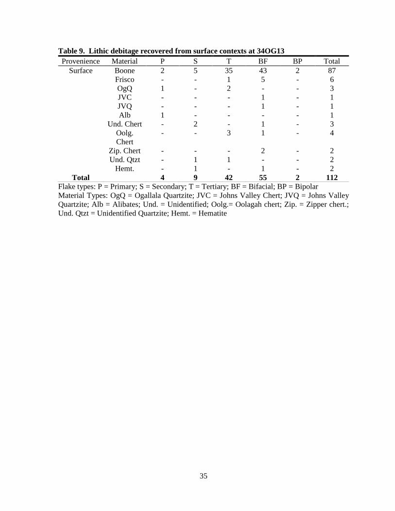
Table 9. Lithic debitage recovered from surface contexts at 34OG13 Provenience Material P S T BF BP Total
Surface Boone 2 5 35 43 2 87 Frisco - - 1 5 - 6 OgQ 1 - 2 - - 3 JVC - - - 1 - 1 JVQ - - - 1 - 1 Alb 1 - - - - 1 Und. Chert - 2 - 1 - 3 Oolg.
Chert - - 3 1 - 4
Zip. Chert - - - 2 - 2 Und. Qtzt - 1 1 - - 2 Hemt. - 1 - 1 - 2
Total 4 9 42 55 2 112 Flake types: P = Primary; S = Secondary; T = Tertiary; BF = Bifacial; BP = Bipolar Material Types: OgQ = Ogallala Quartzite; JVC = Johns Valley Chert; JVQ = Johns Valley Quartzite; Alb = Alibates; Und. = Unidentified; Oolg.= Oolagah chert; Zip. = Zipper chert.; Und. Qtzt = Unidentified Quartzite; Hemt. = Hematite
35

Table 10. Lithic debitage recovered from 34OG13 excavations.
Provenience Material P S T BF BP Total T.U. A-1 (50x50cm)
Level 1 70-80cm BSL Boone - - - 2 - 2 Level 2 80-90 cm BSL Boone - - - 1 - 1 Level 3 90-100cm BSL Boone - - 1 1 - 2 Level 4 100-110cm BSL Boone - - - 2 - 2
Sub Total 0 0 1 6 0 7 T.U. A-2(50x50cm)
Level 1 70-80cm BSL Unidentified Chert - - 2 - - 2 Level 2 80-90 cm BSL - - - - - 0 Level 3 90-100cm BSL - - - - - 0 Sub Total 0 0 2 0 0 2
Total Trench A 0 0 3 6 0 9 T.U. B-1(50x50cm)
Level 1 60-70cm BSL Boone - - 1 - - 1 Level 2 70-80 cm BSL - - - - - 0 Level 3 80-90cm BSL Ogallala Quartzite - - 1 - - 1
Sub Total 0 0 2 0 0 2 T.U. B-2 (50x50cm)
Level 1 60-70cm BSL Boone - - 1 - - 1 Level 2 70-80 cm BSL - - - - - 0 Level 3 80-90cm BSL - - - - - 0
Sub Total 0 0 1 0 0 1 Total Trench B 0 0 3 0 0 3 T.U. C-1(1x1m)
Level 1 60-70cm BSL Florence A - - - 1 - 1 Oolagah Chert - - 1 - - 1 Johns Valley chert - - - 1 - 1 Level 2 70-80 cm BSL Boone - - 1 1 - 2 Ogallala Quartzite - - 1 - - 1 Johns Valley Chert - - 1 - - 1 Unidentified Chert - 1 - - - 1 Level 3 80-90cm BSL Boone - - 1 1 - 2
Sub Total 0 1 5 4 0 10 T.U. C-2 (50x50cm)
Level 1 60-70cm BSL Boone - - - 1 - 1 Level 2 70-80 cm BSL - - - - - 0 Level 3 80-90cm BSL - - - - - 0
Sub Total 0 0 0 1 0 1 Total Trench C 0 1 5 5 0 11 T.U. D-1(1x1m)
Level 1 20-30cm BSL Boone - - 3 1 - 4 Sub Total 0 0 3 1 0 4
T.U. D-2 (1x1m) Level 1 20-30cm BSL Boone - - - 2 - 2 Unidentified Chert 1 - 1 - - 2 Oolagah Chert - - 1 - - 1 Level 2 30-40 cm BSL Boone 1 - - 1 - 2 Unidentified Chert - - 1 - - 1 Oolagah. Chert - - 1 - - 1 Level 3 40-50cm BSL Boone - 1 2 3 - 6 Oolagah Chert - - - 1 - 1 Level 4 50-60cm BSL Boone - - 2 1 - 3
Sub Total 2 1 8 8 0 19 T.U. D-3 (50x50cm)
Level 1 20-30cm BSL Boone - - 2 1 - 3 Unidentified chert - - - 1 - 1
Level 2 30-40cm BSL Boone - - - - 1 1 Level 3 40-50cm BSL - - - - - - 0 Level 4 50-60cm BSL - - - - - - 0
Sub Total 0 0 2 2 1 5
T.U. D-4 (1x2m) Level 1 0-20 cm BSL Boone. - - 2 2 - 4 Unidentified Chert - - - 1 - 1 Level 2 20-40cm BSL Boone - - 2 - - 2
Sub Total 0 0 4 3 0 7 Total Trench D 2 1 17 14 1 35
Sub Total Trenches 2 2 28 25 1 58 Sub Total Surface 4 9 42 55 2 112
Grand Total 6 11 70 80 3 170
36
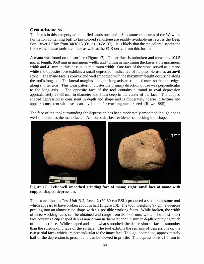
Groundstone N=3 The items in this category are modified sandstone tools. Sandstone exposures of the Wewoka Formation containing buff to tan colored sandstone are readily available just across the Deep Fork River 1.2 km from 34OG13 (Oakes 1963:137). It is likely that the tan colored sandstone from which these tools are made as well as the FCR derive from this formation. A mano was found on the surface (Figure 17). The artifact is unbroken and measures 104.5 mm in length, 95.8 mm in maximum width, and 42.mm in maximum thickness at its maximum width and 41 mm in thickness at its minimum width. One face of the stone served as a mano while the opposite face exhibits a small depression indicative of its possible use as an anvil stone. The mano face is convex and well smoothed with the maximum height occurring along the tool’s long axis. The lateral margins along the long axis are rounded more so than the edges along shorter axis. This wear pattern indicates the primary direction of use was perpendicular to the long axis. The opposite face of the tool contains a round to oval depression approximately 29-33 mm in diameter and 6mm deep in the center of the face. The cupped shaped depression is consistent in depth and shape and is moderately coarse in texture and appears consistent with use as an anvil stone for cracking nuts or seeds (Rowe 1995). The face of the tool surrounding the depression has been moderately smoothed though not as well smoothed as the mano face. All four sides bear evidence of pecking into shape.
Figure 17. Left: well smoothed grinding face of mano; right: anvil face of mano with cupped shaped depression. The excavations in Test Unit B-2, Level 2 (70-80 cm BSL) produced a small sandstone tool which appears to have broken about in half (Figure 18). The tool, weighing 97 gm, evidences pecking into an almost cube shape with six possible working faces. While broken, the width of three working faces can be obtained and range from 50-53.5 mm. wide. The most intact face contains a cup shaped depression 27mm in diameter and 5.5 mm in depth occupying much of the intact face. While shaped and somewhat smoothed, the depression surface is smoother than the surrounding face of the surface. The tool exhibits the remains of depressions on the two partial faces which are perpendicular to the intact face. Though incomplete, approximately half of the depression is present and can be viewed in profile. The depression is 21.5 mm in
37

diameter and 6mm in depth. The shape is more of a cone shaped depression rather than a cup shaped depression as on the intact face. Though half this face is missing the face would appear to have been about the same width as the intact face of the tool. Evidence of a third depression is evident on the face opposite the cone- shaped depression. However, only the outer most portion of the depression remains as most of the face was lost by breakage. The measurable portion that remains is 16mm x 6 mm and 2.5mm in depth. Similar to the other two depression, this one occurs roughly in the center of the working face. The small size of this tool would seem to prohibit its use as an anvil stone as it would be highly subject to breakage. Given the intentional shaping, it would also seem unlikely the tool would be used in a manner likely to result in breakage early in its use life. The differing shapes of the two depressions from which full attributes can be obtained indicate the possibility the depressions on each face result from differing usages (Rowe 1995)
Figure 18. Small groundstone tool with one intact cupped shaped depression and two partial depressions. The final groundstone item is a milling slab recovered from Trench A at an undetermined depth and made from a roughly square shaped piece of sandstone (Figure 19). While the two larger faces of the stone exhibit evidence of use and modification, the sides do not exhibit evidence of intentional shaping. One side of the stone is irregular in shape while the other three are rectangular and roughly even across the face and it is likely the basic shape of the stone is natural. The main, roughly square, working face of the tool exhibits a smoothed face which is 104 mm in maximum width. While smooth, the face is not even across the top with some undulations varying up to 3 mm. The slab weighs 1,420 gm and is 63 mm in maximum thickness. The opposite face exhibits evidence of minimal smoothing which could be the result of use rather than intentional shaping. An irregularly shaped depression occurs in the center of the face. The surface of the depression is somewhat battered in appearance. This could be the result of use as an anvil stone for cracking nuts or possible bipolar reduction of small stone pebbles. The presence of three bipolar flakes in the lithic assemblage indicates bipolar
38

reduction of chert occurred on the site. Depressions in anvil stones resulting from bipolar reduction often are irregular in shape and present a battered appearance (Rowe 1995).
Figure 19. Left: Smooth milling face of milling slab; right: anvil face of milling slab. Note rough outline shape of depression, possibly due to bipolar lithic reduction. Fire Fractured Rock (FCR) N=1152 Weight = 76.412 kg All of the fire fractured rock recovered during the investigation derives from the excavations. Sandstone outcrops of the Wewoka formation are present across the Deep Fork River the closest source being about 1.2 km from 34OG13. While FCR was observed on the surface, none was collected. Most (N=825; W= 53.988 kg) was recovered from Test Unit D-4 and comprised the burned rock feature. The majority of this rock (N=825, W= 54.546 kg ) was recovered from Feature D-1 (Table 8). The recovered rock consists of tabular to round shaped pieces of sandstone. Most of the FCR are small rocks with a total of 50.5% of the total amount of FCR is less than 5 cm in maximum length and 47.5% are 5-10 cm in maximum dimension. A total of 48.7% are 2 cm or less in maximum thickness and 46.2% are 2-4 cm in maximum thickness. The rock is composed of some tabular pieces, many fragmented pieces as well as some naturally weathered and stream rolled cobbles. When considering the FCR recovered from the deeper levels of the site (Trenches A, B and C) and that recovered from the upper levels (Trench D) some differences are present. The percentage of FCR recovered from Trenches A-C 5-10 cm in maximum length is 62.3% and those over 10 cm 6.3%. The percentage of FCR recovered from Trench D, of 5-10 cm in maximum length is 47.6% with only 1.8% falling above 10 cm in maximum length. Whether this trend is the result of different prehistoric components or sampling bias due to the large amount of FCR recovered from the intact feature D-1 in Horizon A cannot be discerned. However, it is an interesting trend. Botanical Analysis Flotation A two liter sample of soil obtained from the dark sandy matrix associated with the burned rock layer (Feature D-1) between 30-40 cm BSL was collected and subject to flotation. The light fraction was run through nested screens of 2 mm, 1 mm, .5 mm and .25 mm wire mesh. Small
39
fragments of unidentifiable charred materials and wood are present in samples from each mesh. Modern rootlets occur in varying amounts in each mesh sample comprising more by volume in each sequentially smaller mesh size. The 2 mm, 1 mm and .5 mm samples were sorted under a microscope for identifiable seeds. The 2 mm sample weighing .16 gm, with minor contamination with modern rootlets, contained no identifiable seeds. The remaining samples had moderate contamination in the form of modern rootlets. The 1 mm sample, weighing .19 gm contained one charred Amaranthus sp. seed. The .5 mm, sample weighing .17 gm contained four charred Amaranthus sp. seed, one modern thistle (Cirsium sp.) seed and one modern Nettle (Urtica sp.) seed.
The charred amaranth seed could very well be a result of prehistoric activities associated with the burned rock layer (Feature D-1). However, only five were found and they easily could be spurious to most any activity involving Feature D-1. The two modern thistle and nettle seeds demonstrate how readily seeds can migrate through the sandy soil on the site. The possibility that the few charred amaranth seed recovered may have migrated through the sand to the matrix surrounding the feature is also a possibility.
The few charred plant remains recovered by the flotation provide little information regarding the prehistoric activities associated with Feature D-1.
Analysis Summary While sparse, the lithic assemblage from 34OG13 does provide clues to prehistoric activities at 34OG13. The recovered stone tool assemblage includes three hafted bifaces, all recovered from the surface of the site. These include a Dalton point with a heavily used blade fashioned into a scraper and spur like tool. A likely Dalton point on which the basal edge has been fashioned into a gouge like working edge, and a complete Hanna/Duncan like point. These diagnostic tools, could represent use of the site during Early Archaic and Middle Archaic periods. Lacking among the hafted biface assemblage are broken stems, bases and blades with impact fractures which would indicate hunting activities. Also lacking are bifaces that might expected to be discarded due to retooling activities such as broken stems, and blades reworked to the point of being no longer useful. In addition very little in the way of stone tool production is evidenced in the assemblage. Early stage flakes in the stone tool manufacturing process are lacking as are pieces of shatter and blocky debris commonly produced in the early stages of stone tool production. Thick, early stage bifaces are not present and the assemblage lacks unfinished bifaces with breakage typical of production failures. The debitage assemblage contains low percentages of primary and secondary flakes commonly produced in the early stages of stone tool production. Those that are present in the assemblage (N=17; 10%) exhibit a gravel cortex and are derived from small cobbles. Most (N=10) are of Boone chert. The remainder include one each of Alibates, Ogallala Quartzite, unidentified quartzite, hematite and four of unidentified chert. Most (N=13; 76.4%) of these early stage flakes derive from the surface assemblage. Among the four recovered by the excavations, three, all of which are Boone chert are from the Trench D Test Unit D-2 excavations between 20-50 cm BSL. The one secondary flake from 70-80 cm BSL in Test Unit C-1 is of unidentified chert.
40

The interior flakes present in the site assemblage contain a high percentage of flakes identifiable as deriving from bifaces. A total of 80 (47%) of the entire 34OG13 assemblage are indentifiable as biface flakes. Most all are small flakes typical of those produced by tool edge retouching and shaping. Lacking in the assembalge are larger biface thinning flakes. Of the total interior flakes in the site assemblage (N=150) 53.3 % are identifiable as being removed from bifaces. The surface assemblage contains 55 biface flakes which comprise 49.2% of the surface assemblage while the 42 tertiary flakes comprise 37.5% of the surface assemblage. The majority (80.4%) of the 97 interior flakes(tertiary and biface) from the surface are of Boone chert. Other material represented in the surface assemblage of interior flakes include six Frisco chert, two Ogallala Quartzite one each of Johns Valley chert and Johns Valley Quartzite, one unidentified chert, two of Zipper chert and four of Oolagah chert. The interior flakes recovered by the excavations in Trenches A-C include 11 each of biface and tertiary flakes. Each represents 47.8% of the recovered flakes from the deeper levels of the site. Most (60.8%) of the 23 flakes are Boone chert. Other lithic materials represented include one heat treated Florence A chert; two of Ogallala Quartzite; two unidentified chert; two of Johns Valley chert and one of Oolagah chert. The 31 interior flakes recovered from the Trench D excavations include 14 (40%) flakes removed from bifaces and 17 (48.6%) tertiary flakes. Most (64.5%) of the 31 flakes are of Boone chert. Other lithic materials represented include four of unidentified chert and three of Oolagah chert. While sample size is small, Oolagah chert comprises 9.7% of the debitage assemblage from the Trench D excavations. Though the sample size is very low, there are some interesting trends. There are a total of 11 different lithic materials represented in the surface collection. A total of 7 different materials are present in the lower levels of the site (Trenches A-C) and a total of three different lithic materials occur in the assemblage recovered from the upper levels of the site (Trench D). Of note in the latter is the presence of three flakes of Oolagah chert. In addition one tool of Oolagah chert was recovered in association with Feature D-1. In addition, there is an apparent increase in the presence of flakes identifiable as removed from bifaces in the lower levels of the site (Table 11). Table 11. Flake types recovered from the surface, Trench D and Trench A-C at 34OG13 by percentage.
Provenience P S T BF BP Total % Boone Surface 3.8% 8% 37.5% 49.1% 1.8% 112 77.7%
Trench D 5.8% 2.9% 48.6% 40% 2.8% 35 77.1% Trench A-C 0 4.3% 47.8% 47.8% 0 23 60.8%
Total 6 11 70 80 3 170 74.7% % Boone Chert 50% 54.5% 75.7% 80% 100% - -
The assemblage contains three groundstone tools most likely associated with plant processing. These include a mano and milling slab. Both of these tools present depressions possibly used in the processing of seeds and/or nuts and possibly bipolar lithic reduction. The smaller broken
41

tool with a depression or a portion of a depression on all three of its remaining faces is somewhat of an enigma. Its small size and low weight would seem to prohibit its use in activities involving hammering or smashing with blows. Its multi faced nature may indicate its use for processing different materials. The recovered FCR assemblage also indicates some trends as discussed above involving some differences in the average size of the rock between the upper and lower levels of the site. Much of the sample from the upper levels derives from Feature D-1. It is likely that the feature as well as majority of the FCR on the site is associated with plant processing or cooking activities.
42
Conclusions and Recommendations The investigation of 34OG13 included 127.5 m2 of machine excavated trenching and the hand excavation of three 1 x 1 m, one 1 x 2 m, and six .5 x .5 m test units. The test units and machine excavations exposed fire fractured sandstone at two seemingly separate levels. One level found in Trench D from 20-40 cm BSL consists of Feature D-1 and an associated scatter in adjacent test units and the other occurs from 60-90 cm BSL as a dispersed scatter observed in the trench profiles and the test units in Trenches A, B and C. The investigations of these potentially discreet occupations, did not produce temporally diagnostic materials, varied artifact assemblages, or significant organic remains. In fact organic preservation on the site appears to be poor. However, a radiometric date was obtained from a small piece of charcoal recovered from Feature D-1 and produced a date of around AD 660. While the chipped stone inventory recovered from the site suggests multiple prehistoric occupations through time, no diagnostic markers were recovered in a context that would distinguish any temporal or cultural differences between the upper and lower excavated levels of the site. However, the analysis resulted in some potential variances in the excavated materials recovered from the upper levels of the site (Trench D) and the deeper excavated levels of the site (Trenches A-C). Trench D Feature D-1, a burned rock feature recovered at 20-40 cm BSL, 20 is the only evidence exposed in the 127.5 m² of machine excavations that indicates an occupation level may remain on the site. A total of 4 m² of hand excavation was conducted to investigate the feature and the area around it. Although this feature was largely intact, very few artifacts were associated with it, and no other features or evidence of significant intact cultural deposits were observed from this depth anywhere else in the test trenching. Therefore, it appears that the cultural occupation represented by Feature D-1 is ephemeral in nature. A radiocarbon date of AD 660 was obtained from a small piece of charcoal derived from the dark sandy matrix associated with feature D-1. Floatation of a 2 liter sample of this matrix produced little in the way botanical remains. Only 4 charred amaranth and two modern seeds were recovered. While no diagnostic stone artifacts were recovered in association with the feature, one flake tool made of Oolagah chert was recovered in association with the feature. The flake assemblage recovered by the test units in Trench D produced a small assemblage of lithic debitage. Though a small sample (N=35), three lithic materials are represented including Boone chert (77.1%), Oolagah chert (8.6%) and unidentified chert (14.2%). Of interest here is the occurrence of Oolagah chert in association with the feature (3 debitage flakes and one flake tool). A total of four flakes and one flake tool of this chert were also recovered from the surface of the site. Only one flake of Oolagah chert was recovered deeper than 50 cm BSL (Test Unit C-1 60-70 BSL). Trenches A-C Excavations in Trenches A, B & C recovered items from the deeper levels of the site. These levels are characterized by a sparse and dispersed scatter of fire fractured pieces of sandstone and a few chipped stone flakes occurring for the most part from 60-90 cm BSL. Fire fractured rock was observed in profiles at the beginning and end of each machine excavated trench where a total of 34.5 square meters were machine excavated to a depth of approximately 2 m an depth
43
soil profiles cleaned and examined. Scattered FCR was observed in these deep profiles at 60-100 cm BSL. Exploration of these deeper levels was conducted using 2.5 m² of hand excavated units initiated from the floor of Trenches A, B, and C. Most units were established at 60 cm BSL and excavated to 90-100 cm BSL. The items recovered from the test units include one biface fragment of Boone chert, 23 chipped stone flakes, and 172 pieces of FCR. The flakes represent a greater variety of lithic raw materials than the flake assemblage recovered from the Trench D explorations of the upper levels of the site. Among the flakes are one primary flake, 13 tertiary flakes, and 9 biface flakes. A total of 60.8% of the flakes are of Boone chert. Other chipped stone materials include two flakes of Ogallala quartzite (8.7%), three flakes of unidentified chert (13%) , two flakes of Johns Valley chert (8.7%) and one each of Florence A chert (4.3%) and Oolagah chert (4.3%). In addition a small groundstone tool was recovered in Test Unit B-2 at 70-80 cm BSL. While not diagnostic, the tool is likely associated with processing of plant resources. When considering the FCR recovered from the deeper levels of the site (Trenches A, B and C) and that recovered from the upper levels (Trench D) some differences are present. The percentage of FCR recovered from Trenches A-C of 5-10 cm in maximum length is 62.3% and those over 10 cm 6.3%. The percentage of FCR recovered from Trench D, of 5-10 cm in maximum length is 47.6% with only 1.8% falling above 10 cm in maximum length. Whether this trend toward slightly larger rocks in the deeper levels of the site is the result of different prehistoric components, natural weathering factors, or sampling bias due to the large amount of FCR recovered from the intact feature D-1 cannot be discerned. However, it is an interesting trend. Exploration of the deeper levels of the site in Trenches A-C did not reveal any noteworthy soil changes, noticeable concentrations of rock or artifacts, no evidence of organic preservation, and produced only a sparse assemblage of non-diagnostic flakes. Based upon the recovered data, the deeper levels of the site probably contain the remains of a series of sparse and ephemeral occupations, or a more substantive occupation which has been deflated and/or dispersed by post-depositional environmental and human factors. Other interpretations could be that the materials relates to the roughly contemporaneous occupations relating to feature D-1 and have become dispersed and buried. This latter scenario is doubtful given the consistent occurrence of the FCR at 60-90 cm BSL and the general lack of FCR in soil profiles and excavated levels 40-60 cm BSL. In either case the deeper levels of 34OG13 within the Area of Potential Effect explored by this investigation appears to contain insufficient content or context for significant archaeological data. Summary of Prehistoric Occupations The majority of diagnostics previously reported as surface finds from 34OG13 (including Gary type and stemmed bifaces) suggests a Late Archaic to Early Woodland occupation of 34OG13. The radiometric date derived from a charcoal sample recovered from Feature D-1 in Horizon B (20-40 cm BSL) produced a date of 1330-1260 BP or AD 620-690. This date falls well within the Woodland period and is consistent with some of the diagnostic artifacts reported from the site. However, the few diagnostic artifacts recovered during this investigation represent an earlier technology that greatly precedes the time period at which Feature D-1 was
44

radiometrically dated. The single Dalton point/scraper and likely Dalton point/gouge recovered from the surface during this investigation may be evidence of use of the site by Dalton peoples some 10,000 years ago. While no other definitive evidence of Dalton occupation was found on 34OG13, a Dalton drill was found on 34OG26, an adjacent site positioned on the same terrace as 34OG13 about 480 m south of 34OG13. Additionally, Dalton artifacts have been reported from 34OG21 and 34OG10 situated on sandy deposits along the Deep Fork River 7.8 km southeast of 34OG13 (Figure 20). Finds such as these may be evidence of Dalton excursions along the Deep Fork River Valley some 9,600-10,000 years ago. The McKellips site (34MI136), located about 50 km southeast of 34OG13 near the confluence of the Deep Fork River with the North Canadian River, contains a Dalton component with chipped stone stools made of chert from both the Ozark Plateau and the Ouachita Mountains (Ballenger 1997). The evidence gleaned from 34OG13 as well as other sites along the Deep Fork River such as 34OG26 and 34OG10 (Wyckoff and Bement 1994) suggests that people using the Dalton tool kit as early as 9000-10000 years were utilizing the area which today contain hardwood bottoms. Given that the Dalton tools documented from 34OG13 and 34OG26 are made of stone derived from the Ozark Plateau and the Ouachita Mountains of eastern Oklahoma may be indicative of forays made into the tall grass prairie regions and Deep Fork River hardwood bottoms by groups living in or frequenting these eastern regions. The Duncan/Hanna-like point found on the site’s surface may be evidence of occupation of the Deep Fork terraces some 4500-3000 years ago ( Perino 1971:26). This artifact is manufactured of Johns Valley chert derived from the Ouachita Mountains of southeast Oklahoma. However, no other definitive evidence of occupations dating to the middle Holocene were found by this investigation. While no diagnostic artifacts were recovered by the excavations, the radiometric date of 1380 +/- 40 radiocarbon years BP (AD 690) obtained from charcoal recovered from Feature D-1 suggests the feature relates to Woodland occupations some 1300 years ago. The function of the burned rock feature could not be determined. However, the feature is of similar age as two burned rock features investigated at 34OF38-39 in Okfuskee County on a tributary to Buckeye Creek 25 kms southwest of 34OG13 (Vehik 1980). A radiocarbon date of approximately 1298 BP (AD 690) associated with one of these mounds (Vehik 1980:42) suggests a roughly contemporaneous occupation of both sites. Buckeye Creek is a tributary of the Deep Fork River and 34OF38-39 are situated about 6 km from the Deep Fork River channel and 4 km from the bottom land forest along the river channel. Similar to site 34OG13, sites 34OF38-39 also contain very little in the way of lithic debitage and stone tools. However, the lithic materials represented at each site are substantially different with Frisco chert and Ogallala quartzite comprising the dominate materials in the assemblages (27% and 25% respectively) with Boone chert comprising 11% (Vehik 1980:35). Site 34OG13 is dominated by cherts mainly from the east (Boone chert), but also contains materials from the southeast (Ouachita Mountains chert and quartzite) and north (Oolagah chert) while the assemblage from 34OF38-39 is dominated by material from the south (Frisco chert) and west (Ogallala quartzite). These assemblages may represent different groups visiting areas along the Deep Fork River, possibly for the exploitation of the diverse plant resources available in the hardwood bottoms and wetlands. If so, further research on archeological sites in the area may address questions of
45
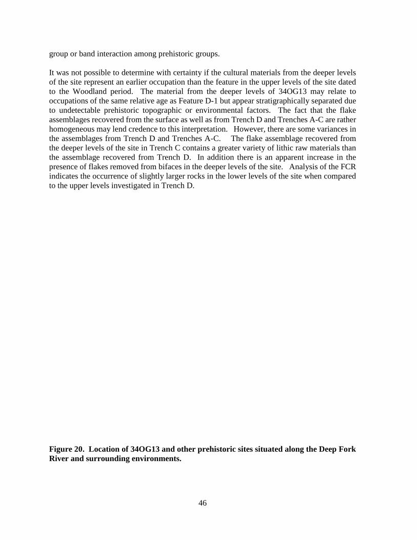
group or band interaction among prehistoric groups.
It was not possible to determine with certainty if the cultural materials from the deeper levels of the site represent an earlier occupation than the feature in the upper levels of the site dated to the Woodland period. The material from the deeper levels of 34OG13 may relate to occupations of the same relative age as Feature D-1 but appear stratigraphically separated due to undetectable prehistoric topographic or environmental factors. The fact that the flake assemblages recovered from the surface as well as from Trench D and Trenches A-C are rather homogeneous may lend credence to this interpretation. However, there are some variances in the assemblages from Trench D and Trenches A-C. The flake assemblage recovered from the deeper levels of the site in Trench C contains a greater variety of lithic raw materials than the assemblage recovered from Trench D. In addition there is an apparent increase in the presence of flakes removed from bifaces in the deeper levels of the site. Analysis of the FCR indicates the occurrence of slightly larger rocks in the lower levels of the site when compared to the upper levels investigated in Trench D.
Figure 20. Location of 34OG13 and other prehistoric sites situated along the Deep Fork River and surrounding environments.
46

If the deeper levels of the site represent earlier occupations than the radiometricly dated Woodland occupation, then the flake assemblage reflects little difference between Woodland and earlier adaptations in the area. The sparse number of flakes recovered both from the surface and subsurface investigations in all trenches are dominated by small biface thinning and retouch flakes reflecting the resharpening and maintenance of stone tools manufactured chiefly of Boone chert. It appears that finished stone tools were brought to the site, then were used and maintained during occupation. The noticeable absence of significant amounts of debitage in all levels of the site relating to tool manufacture and other stages of lithic reduction appears to suggest a short term, limited-purpose occupation, rather than more intensive activities associated with a more sedentary camp/village. The recovery of three groundstone tools during the course of this investigation and the reported recovery of a mano and metate by Evers in 1957, suggests that plant processing was an important activity conducted by the site’s prehistoric inhabitants. The location of 34OG13, as well as other prehistoric sites in the vicinity are situated in a location with easy access to bottomland forest, wetlands, mixed oak/hickory forest and tall grass prairie (Figure 20). The presence of these sites may be strategic as locations from which prehistoric occupants could readily obtain plants resources and the materials, such as sandstone to process them. If it is assumed that the Dalton tools at 34OG13 represent a Late Paleo Indian or early Archaic occupation of the site (which is in line with evidence of Dalton occupations at 34OG26 and 34OG10) and further assumed that the Hanna/Duncan point represents a middle to late Archaic use of the site and Feature D-1 evidence Woodland occupations some 1,500 years ago, then site 34OG13 has witnessed multiple prehistoric occupations over a roughly 9,000 year time frame. While the archeological investigations at 34OG13 did not result in a substantial amount of archeological materials, it is one of the few formal archeological investigations of prehistoric occupations in Okmulgee County. The information gleaned from the archeological investigations and review of available information on other prehistoric sites along the Deep Fork River indicates that the locations have been visited over an extended period of time by prehistoric peoples. The recovery of tools diagnostic of Dalton and middle Archaic occupations at 34OG13 as well as other nearby sites may be clues to earlier cultural deposits present in the sand covered terraces along the Deep Fork River. There is further evidence in the way of a variety of groundstone tools reported from these sites that one of the activities occurring at these locations involves the processing of plant materials. The occurrence of fire fractured rock on most all the sites indicates that heating and cooking activities were also taking place at these locations. The lack of lithic debitage resulting from early stage lithic production as well as the sparse nature of the debitage assemblage indicates that production of chipped stone tools on the site was not a regular activity. The debitage analysis indicates that maintenance of stone tools occurred on the site and that it is likely that most chipped stone tools brought to the site in completed state. Evidence of bipolar reduction on the site indicates that small pieces of chert were reduced on the site to supplement tool needs. The lack of broken projectile points, and lack of impact type fractures on the biface fragments indicates that hunting and retooling for hunting was not a primary activity on the site. Many of the chipped stone tools recovered present multiple different working edges including spurs, gravers, burins, a gouge and scrapers. Many of these tools are useful in working both hard materials such as wood and bone and soft
47

materials such as hides and plants. Given the lack of evidence for the hunting of large game animals on the site, the working of hard and soft plant materials is a viable interpretation. While the flotation sample from Feature D-1 did not produce firm evidence of plant processing, the feature does appear to relate to cooking activities. The occurrence of burned rock in all trenches and excavation units indicates that cooking was a primary activity on the site. The presence of groundstone stools further supports this notion. Other prehistoric occupations near 34OG13 are evidenced at sites such as 34OG10, 34OG14, 34OG26 and 34OG18-21, all of which are situated on sandy terraces adjacent to the Deep Fork River (Figure 20). According to the archeological site forms, these sites have produced a variety of groundstone tools including stone celts at 34OG21, manos at 34OG10, 34OG14 and 34OG21, a pestle from 34OG14 and stone axes from 34OG14 and 34OG21. The presence of these tools evidences the use of plant materials during the occupation of these sites. In addition, quantities of burned sandstone which are likely the result cooking activities are reported from all of these sites. Further, there is evidence that the sites were utilized by different cultural groups over many thousands of years. Feature D-1, an apparent cooking feature, at 34OG13 appears to provide evidence of Woodland occupations of the area. The occurrence of Boone chert as well as Oolagah chert in the upper levels of the site associated with the feature suggests that Woodland groups from the east and north east were visiting the hardwood bottoms along the Deep Fork River around AD 660. Sites 34OF38-39, located along a tributary of the Deep Fork River about 25 km west of 34OG13 also produced burned rock features which have produced a radiocarbon date of around AD 690. Like 34OG13, chipped stone tools and debitage at these Okfuskee County sites is sparse. However, unlike 34OG13 which is dominated by Boone chert, the lithic assemblage from these site is dominated by Frisco chert and Ogallala quartzite. Material indicate a more of a southern and western orientation for the sites Woodland occupants whereas the Boone chert and Oolagah chert at 34 OG13 may evidence occupation of the area by groups oriented to the east and north of the area. Of the sites mentioned above, only 34OG13 has been subject to any definitive analysis or formal archeological investigations and the evidence indicates that plant use and processing was an integral activity at the site. This may also be true for many of the sites along the Deep Fork River, however, the documented occurrence of other tools including stone dart and arrow points on some sites may indicate hunting activities are associated with the use of some sites. It is certain that the rich bottom land forest present along the Deep Fork River provided a valuable and varied resource for both gathering and hunting activities for the prehistoric visitors to the locations. Recommendations Although one intact prehistoric feature was discovered by this investigation, the evidence indicates that the prehistoric materials on 34OG13 are the result of short term, ephemeral occupations of the site, likely during the Woodland period. The recovered cultural material, consisting primarily of small bifacial thinning and retouch flakes and small pieces of fire cracked rock, is sparse and for the most part widely dispersed and lacking strong contextual associations. Based upon the work documented in this report, it is believed that the area of 34OG13 examined by this investigation lacks prehistoric cultural deposits containing the integrity or content to produce significant information meriting the site’s eligibility for
48

nomination to the NRHP. In this regard, no further work was recommended within the project APE. It should be stressed that this investigation was confined to the proposed SH-56 realignment R/W. Thus, the potential for significant deposits on 34OG13 outside the project area remains undetermined. In addition, site 34OG26, located about 500 m south of 34OG26 should be avoided. To avoid the necessity of additional archaeological investigations, it is recommended that these areas not be used for off-site activities such as borrow removal.
49


References Anderson, A. D. 1975 The Cooperton Mammoth: An Early Man Bone Quarry. Great Plains Journal
14:130-173. Baldwin, Jane 1969 The Lawrence Site, NW-6: A Non-ceramic Site in Nowata County, Oklahoma.
Bulletin of the Oklahoma Anthropological Society No. 18:67-118. Oklahoma City, Oklahoma.
Ballenger, Jesse 1997 The McKellips Site: Contributions to Dalton Occupation, Technology and
Mobility from Eastern Oklahoma,. Paper on file at the Oklahoma Archeological Survey, Norman Ok.
Bell, Robert E. 1980 Fourche Maline: An Archaeological Manifestation in Eastern Oklahoma. In
Caddoan and Poverty Point Archaeology: Essays in Honor of C.H. Webb. Louisiana Archaeological Society Bulletin 6:83-125.
1984 Arkansas Valley Caddoan: The Harlan Phase. In Prehistory of Oklahoma. Pp.
221-240. Edited by Robert E. Bell. Academic Press, Inc., New York. Bement, Leland C. 2005 Buffalo Chips in the Mammoth Patch: Investigating Clovis Bison Hunting at
the Jake Bluff Site, NW Oklahoma. Prehistoric People of Oklahoma No. 5. Oklahoma Archaeological Survey, Norman.
Bement, Leland C., Ernest L. Lundelius, Jr., and Richard A Ketcham 2005 Hoax or History: A Bison Skull with Embedded Calf Creek Projectile Point.
Plains Anthropologist 195:221-226. Blair, W. F. and t. h. Hubble 1938 The Biotic Districts of Oklahoma. The American Midland Naturalist. Vol 20:
425-455. Curtis, Neville M., William Ham and Kenneth S. Johnson 2008 Geomorphic Provinces of Oklahoma. In Earth Sciences and Mineral resources
of Oklahoma. Edited by Kenneth Johnson and Kenneth Luza. Oklahoma Geological Survey, University of Oklahoma. Norman Ok.
Deep Fork Wildlife Refuge 2015 http://www.fws.gov/nwrs/threecolumn.aspx?id=2147520412 Accessed March
12, 2015. Evers, J. B. 1957 Archeological Site Form for 34OG13. Site Form on File at the Oklahoma
Archeological Survey, University of Oklahoma. Norman Oklahoma. Galm, Jerry R. 1984 Arkansas Valley Caddoan Formative: The Wister and Fourche Maline Phases.
In Prehistory of Oklahoma. Pp. 199-220. Edited by Robert E. Bell. Academic Press, Inc., New York.
51

Galm, Jerry R. and Peggy Flynn 1978 The Cultural Sequences at the Scott (34LF11) and Wann (34LF27) Sites and
Prehistory of the Wister Valley. Archaeological Research and Management Center, Research Series No. 3. The University of Oklahoma, Norman.
Gettys, Marshall, Robert Layhe, and Sheila Bobalik 1976 Birch Creek and Skiatook Reservoirs: Preliminary Report upon Archaeological
Investigations in 1974. Oklahoma River Basin Survey, Archaeological Site Report No. 31.
Girard, Jeffery and Helen S. Carr 1995 Archaeological Investigations at the Bellcow Site (34LN29) Lincoln County,
Oklahoma. Oklahoma Anthropological Society Memoir No. 6 Goodyear, Albert 1982 The Chronological Position of the Dalton Horizon in the Southeastern United
States. American Antiquity 47(2):382-395. Holliday, Vance T., and J. Elmo Rawling III 2006 Soil-geomorphic relations of lamellae in eolian sand on the High Plains of Texas
and New Mexico. Geoderma Vol. 131, pp. 154-180. Hayden, Brian 1980 Confusion in the Bipolar World: Bashed Pebbles and Splintered Pieces. Lithic
Technology Vol. 9, No. 1, pp. 2-7 Hoagland, Bruce
2008 Vegetation of Oklahoma. In Earth Sciences of Oklahoma. Edited by Kenneth S. Johnson and Kenneth V. Luza. Oklahoma Geological Survey, University of Oklahoma, Norman Ok.
Hoagland, Bruce W. and Forrest Johnson 2005 Vascular Flora of the Deep Fork River in Okmulgee, Creek and Okfuskee
Counties, Oklahoma. Publications of the Oklahoma Biological Survey 2nd Series. Vol. 6 pp. 15-29. Oklahoma Biological Survey, Norman Oklahoma.
Hofman, Jack 1993 An Initial Survey of the Folsom Complex in Oklahoma. Bulletin of the Oklahoma Anthropological Society 41:85-119.
Hofman, Jack and Don Wyckoff 1991 Clovis Occupation in Oklahoma. Current Research in the Pleistocene 8:29-33. Hofman, Jack L. and Russell W. Graham 1998 The Paleo-Indian Cultures of the Great Plains. In Archaeology on the Great
Plains. Edited by W. Raymond Wood. University Press of Kansas, Lawrence. Largent, Floyd B. 1995 Cultural Resource Investigations of Three Park Areas at Lake Eufaula,
McIntosh and Pittsburgh Counties, Oklahoma. Miscellaneous Report of Investigations No. 70. U.S. Army Corps of Engineers, Tulsa District, Tulsa, Oklahoma.
Leonhardy, Frank C., 1966 Domebo: A Paleo-Indian Mammoth Kill Site in the Prairie Plains. Contributions
of the museum of the great Plains No. 1. Lawton Oklahoma.
52

McReynolds, Edwin C. 1954 Oklahoma: A History of the Sooner State. University of Oklahoma Press,
Norman. Morris, John W., Charles R. Goins, and Edwin C. McReynolds 1976 Historical Atlas of Oklahoma, 2nd Addition, Revised and Enlarged. University
of Oklahoma Press, Norman. Oakes, Malcom C 1963 Geology and Water Resources Okmulgee County. Oklahoma Geological Survey
Bulletin 91. Oklahoma geological Survey, University of Oklahoma. Norman Ok.
Perino, Gregory 1971 Guide to the Identification of Certain American Indian Projectile Points.
Oklahoma Anthropological Society Special Bulletin No. 4. Perttula, Timothy 2014 The Late Paleoindian Occupation of the Western Ouachita Mountains of
Southeast Oklahoma: the Archeology of Component V at the Quince Site. Journal of Northeast Texas Archaeology. Vol. 49, pp;1-42.
Rowe, Roger 1995 Towards Cupstone Classification: An Experimental Approach. Ohio
Archeologist Volume 45, No. 3: 11-17. Sabo, G., III, A.M. Early, Jeremy C. Rose, B.A. Burnett, Louis Vogele, Jr., and J.P. Harcourt 1990 Human Adaptation in the Ozark and Ouachita Mountains. Arkansas
Archaeological Survey Research Series No. 31. Arkansas Archaeological Survey, Fayetteville.
Spann, Joe 1998 Archeological Site Form for 34OG21. Site Form on File at the Oklahoma
Archeological Survey, University of Oklahoma. Norman Oklahoma. Stuiver M., P.J. Reimer, E. Bard, J.W. Beck, G.S. Burr, K.A. Hughen, B. Kromer, G.
McCormac, J. van der Plicht and M. Spurk 1998 INTCAL98 Radiocarbon Age Calibration, 24000-0 cal BP Radiocarbon 40(3)
1041-1083 USDA 1968 Soil Survey Okmulgee County Oklahoma. United State Department of Agriculture. Washington DC. USDA
2015 https://soilseries.sc.egov.usda.gov/OSD_Docs/E/EUFAULA.html. Accessed on April 2 2015.
Vehik, Rain 1980 Archaeological Test Excavations of Two Burned Rock Mounds (34OF-38 and
34OF-39) in Okfuskee County, Oklahoma. Archaeological Research and Management Center Project Report Series No 6. The University of Oklahoma, Norman.
Vehik, Susan C. 1984 The Woodland Occupations. In Prehistory of Oklahoma. Pp. 175-197. Edited
by Robert E. Bell. Academic Press, Inc., New York.
53
Vehik, Susan C. And Richard A. Pailes 1979 Excavations in the Copan Reservoir of Northeastern Oklahoma and
Southeastern Kansas (1974). Archaeological Research and Management Center, Research Series No. 4.
Wright, M.H. 1951 A Guide to the Indian Tribes of Oklahoma. University of Oklahoma Press,
Norman. Wyckoff, Don G. 1984 The Foragers: Eastern Oklahoma. In Prehistory of Oklahoma. Pp. 119-160.
Edited by Robert E. Bell. Academic Press, Inc., New York. 1985 The Packard Complex: Early Archaic, Pre-Dalton Occupations on the Prairie-
Woodlands Border. Southeastern Archaeology 4:1-26. Wyckoff, Don G. and Robert Bartlett 1995 Living on the Edge: Late Pleistocene-Early Holocene Cultural Interaction along
the Southeastern Woodlands-Plains Border. In Native American Interactions. Edited by Michael Nassaney and Kenneth Sassaman. University of Tennessee Press. Knoxville Tennessee.
Wyckoff, Don G. and Lee Bement 1994 An Unfinished biface from Okmulgee County. Oklahoma Anthropological
Society Newsletter Vol. 42(6): 3-4 Wyckoff, Don G. and Robert L. Brooks 1983 Oklahoma Archaeology: A 1981 Perspective. Archaeological Resource Survey
Report No. 16. Oklahoma Archaeological Survey, Norman.
54