Embed Size (px)
Citation preview
ACKNOWLEDGEMENTS
Thompson (1973) published the first modern geologic map of the Nogal Peak quadrangle and surrounding areas at 1:62,500-scale (15-minute). Without this previous contribution our endeavors would have been much more arduous and time consuming. Thompson’s major units and stratigraphy are used herein (Thompson, 1966; 1972) except for modifications outlined in paragraphs below. Several other geologic maps exist for small areas within or near the mining areas (e.g., Black 1977). Moore et al. (1988) mapped the Mescalero Apache lands along the southern strip of the quadrangle (1:24,000 scale). After field checking their work along the reservation boundary, we have used most of their contacts. Fieldwork was conducted by standard methods (topographic maps, air photography, binoculars, rock hammers, hand lenses, GPS devices, brunton compasses, four-wheel drive trucks, and boot leather) on all non-reservation lands. Robert Runnels (Runnels Outfitter and Guide Service, Capitan, New Mexico) provided horses and packers for two horse pack trips into remote parts of the White Mountain Wilderness. We thank J. Michael Timmons (New Mexico Bureau of Geology and Mineral Resources) for logistical and tactical support. High Mesa Petrographics (Los Alamos, NM) prepared high-quality thin sections while ALS Laboratory Group (Reno, NV) performed the new chemical analyses appearing in the Appendix 1. 40/39Ar dates were obtained from L. Peters and W. McIntosh whereas X-ray diffraction analyses were provided by Virgil Lueth (all NMBG&MR). Stacy Timmons (NMBG&MR) loaned us equipment to collect a small suite of environmental water samples. The State Map Program jointly supported by the U.S. Geological Survey and the NMBG&MR funded much of this geologic map. Substantial funding was also received from Otero County, New Mexico.
PHYSIOGRAPHY AND LAND USE
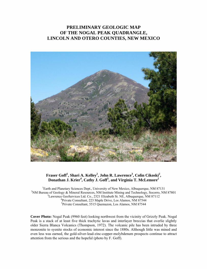
Nogal Peak quadrangle occupies the core of the White Mountain Wilderness in the Sierra Blanca (White Mountains) and lies only a few scant miles west and northwest of Ruidoso, New Mexico (Figures 1 and 2). The landscape consists of a deeply dissected, north-trending horst of mostly mid-Tertiary volcanic rocks and associated sediments intruded by three somewhat younger dioritic to syenitic stocks. Just west of the quadrangle, the Sierra Blanca is offset from the Tularosa Basin by a number of prominent normal faults. Sierra Blanca Peak, barely south of the quadrangle, is just over 12,000 feet tall whereas the Tularosa Basin lies at roughly 4000 to 6000 feet, making this pair of features one of the largest and most spectacular horst-graben offsets in the United States (Figure 3). Within Nogal Peak quadrangle the maximum elevation is about 11,770 feet on the north shoulder of Sierra Blanca Peak (Figure 4) and the minimum elevation is just less than 6800 feet in the NW and SW corners. Nogal Peak (9957 feet, cover photo) dominates the landscape on the north edge of the quadrangle. Rio Ruidoso in the southeast, Rio Bonito in the east, Rito Nogal in the northeast, and Three Rivers and tributaries to the west drain most of Nogal Peak quadrangle. Forest service roads 107, 108 and 400 access the northeastern part of the quad whereas NM Highway 532 accesses the southeastern part of the quad and Ski Apache resort. Forest service road 579 ends about a mile west of the southwest part of the quad at Three Rivers Campground. A few private lands and active mining claims occur in the northeast part of the quad and a couple of ranches border the west part of the quad. The Mescalero Apache Indian Reservation occupies a strip about 1.5 miles wide along the entire southern edge of the quad. Because the rugged White Mountain Wilderness occupies so much of the quad, portions of the west and north are most conveniently studied by back packing or horse packing.
3
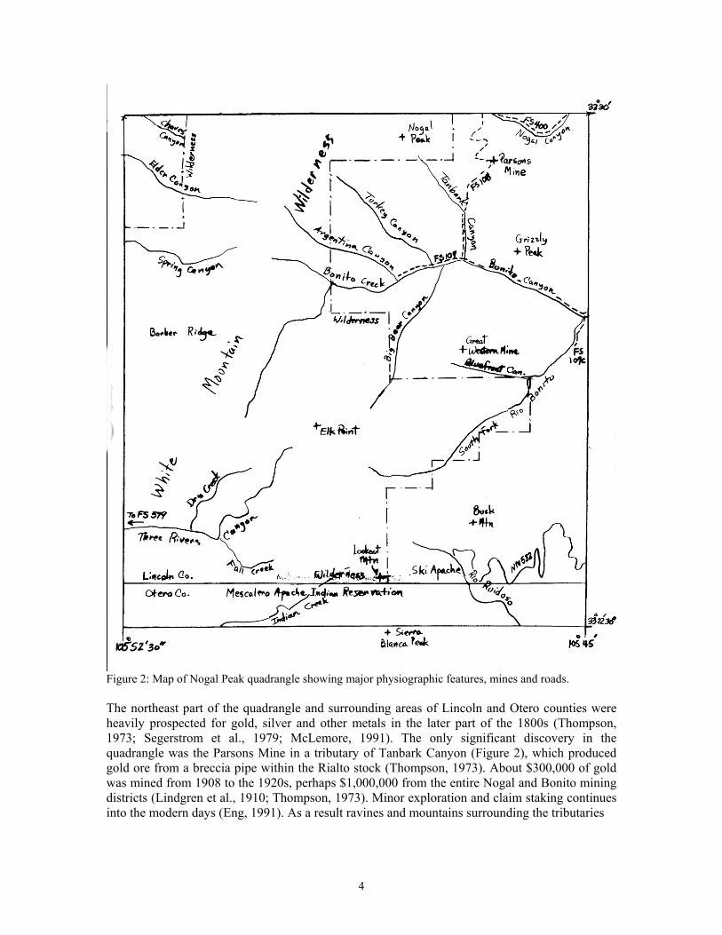
Figure 2: Map of Nogal Peak quadrangle showing major physiographic features, mines and roads. The northeast part of the quadrangle and surrounding areas of Lincoln and Otero counties were heavily prospected for gold, silver and other metals in the later part of the 1800s (Thompson, 1973; Segerstrom et al., 1979; McLemore, 1991). The only significant discovery in the quadrangle was the Parsons Mine in a tributary of Tanbark Canyon (Figure 2), which produced gold ore from a breccia pipe within the Rialto stock (Thompson, 1973). About $300,000 of gold was mined from 1908 to the 1920s, perhaps $1,000,000 from the entire Nogal and Bonito mining districts (Lindgren et al., 1910; Thompson, 1973). Minor exploration and claim staking continues into the modern days (Eng, 1991). As a result ravines and mountains surrounding the tributaries
4
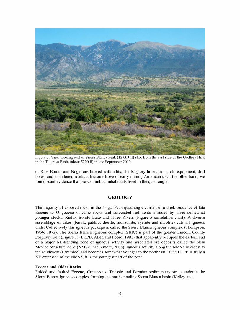
Figure 3: View looking east of Sierra Blanca Peak (12,003 ft) shot from the east side of the Godfrey Hills in the Tularosa Basin (about 5200 ft) in late September 2010. of Rios Bonito and Nogal are littered with adits, shafts, glory holes, ruins, old equipment, drill holes, and abandoned roads, a treasure trove of early mining Americana. On the other hand, we found scant evidence that pre-Columbian inhabitants lived in the quadrangle.
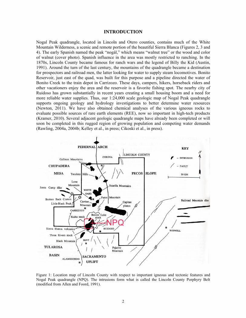
GEOLOGY The majority of exposed rocks in the Nogal Peak quadrangle consist of a thick sequence of late Eocene to Oligocene volcanic rocks and associated sediments intruded by three somewhat younger stocks: Rialto, Bonito Lake and Three Rivers (Figure 5 correlation chart). A diverse assemblage of dikes (basalt, gabbro, diorite, monzonite, syenite and rhyolite) cuts all igneous units. Collectively this igneous package is called the Sierra Blanca igneous complex (Thompson, 1966; 1972). The Sierra Blanca igneous complex (SBIC) is part of the greater Lincoln County Porphyry Belt (Figure 1) (LCPB, Allen and Foord, 1991) that apparently occupies the eastern end of a major NE-trending zone of igneous activity and associated ore deposits called the New Mexico Structure Zone (NMSZ, McLemore, 2008). Igneous activity along the NMSZ is oldest to the southwest (Laramide) and becomes somewhat younger to the northeast. If the LCPB is truly a NE extension of the NMSZ, it is the youngest part of the zone. Eocene and Older Rocks Folded and faulted Eocene, Cretaceous, Triassic and Permian sedimentary strata underlie the Sierra Blanca igneous complex forming the north-trending Sierra Blanca basin (Kelley and
5
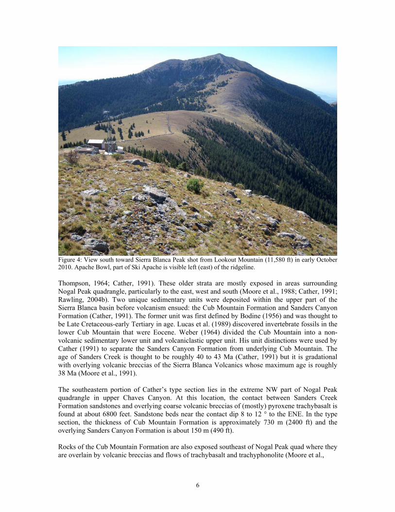
Figure 4: View south toward Sierra Blanca Peak shot from Lookout Mountain (11,580 ft) in early October 2010. Apache Bowl, part of Ski Apache is visible left (east) of the ridgeline. Thompson, 1964; Cather, 1991). These older strata are mostly exposed in areas surrounding Nogal Peak quadrangle, particularly to the east, west and south (Moore et al., 1988; Cather, 1991; Rawling, 2004b). Two unique sedimentary units were deposited within the upper part of the Sierra Blanca basin before volcanism ensued: the Cub Mountain Formation and Sanders Canyon Formation (Cather, 1991). The former unit was first defined by Bodine (1956) and was thought to be Late Cretaceous-early Tertiary in age. Lucas et al. (1989) discovered invertebrate fossils in the lower Cub Mountain that were Eocene. Weber (1964) divided the Cub Mountain into a non-volcanic sedimentary lower unit and volcaniclastic upper unit. His unit distinctions were used by Cather (1991) to separate the Sanders Canyon Formation from underlying Cub Mountain. The age of Sanders Creek is thought to be roughly 40 to 43 Ma (Cather, 1991) but it is gradational with overlying volcanic breccias of the Sierra Blanca Volcanics whose maximum age is roughly 38 Ma (Moore et al., 1991). The southeastern portion of Cather’s type section lies in the extreme NW part of Nogal Peak quadrangle in upper Chaves Canyon. At this location, the contact between Sanders Creek Formation sandstones and overlying coarse volcanic breccias of (mostly) pyroxene trachybasalt is found at about 6800 feet. Sandstone beds near the contact dip 8 to 12 ° to the ENE. In the type section, the thickness of Cub Mountain Formation is approximately 730 m (2400 ft) and the overlying Sanders Canyon Formation is about 150 m (490 ft). Rocks of the Cub Mountain Formation are also exposed southeast of Nogal Peak quad where they are overlain by volcanic breccias and flows of trachybasalt and trachyphonolite (Moore et al.,
6
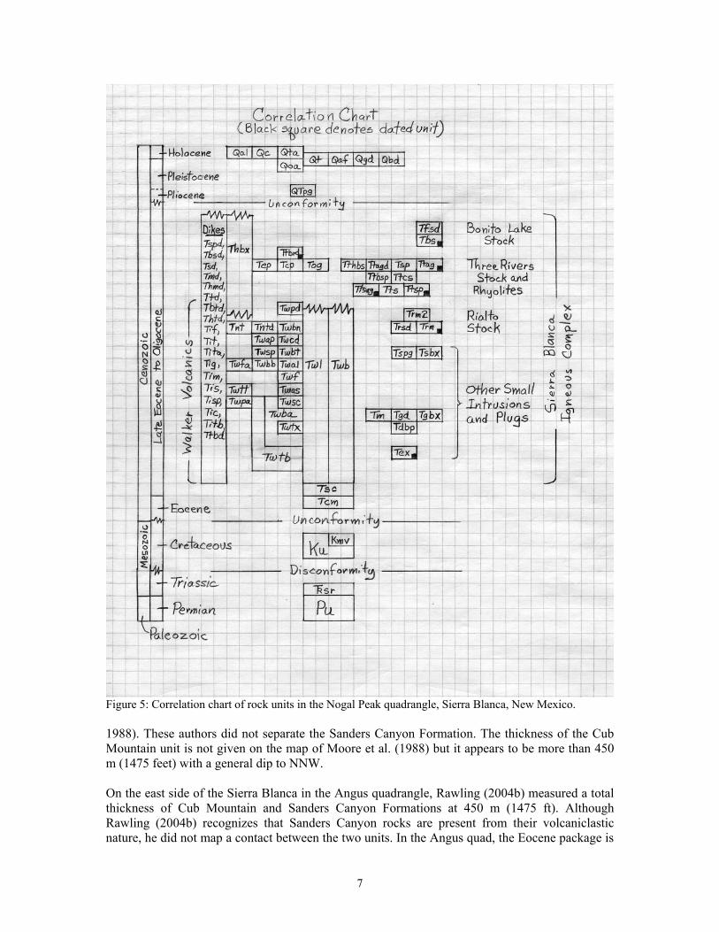
Figure 5: Correlation chart of rock units in the Nogal Peak quadrangle, Sierra Blanca, New Mexico. 1988). These authors did not separate the Sanders Canyon Formation. The thickness of the Cub Mountain unit is not given on the map of Moore et al. (1988) but it appears to be more than 450 m (1475 feet) with a general dip to NNW. On the east side of the Sierra Blanca in the Angus quadrangle, Rawling (2004b) measured a total thickness of Cub Mountain and Sanders Canyon Formations at 450 m (1475 ft). Although Rawling (2004b) recognizes that Sanders Canyon rocks are present from their volcaniclastic nature, he did not map a contact between the two units. In the Angus quad, the Eocene package is
7
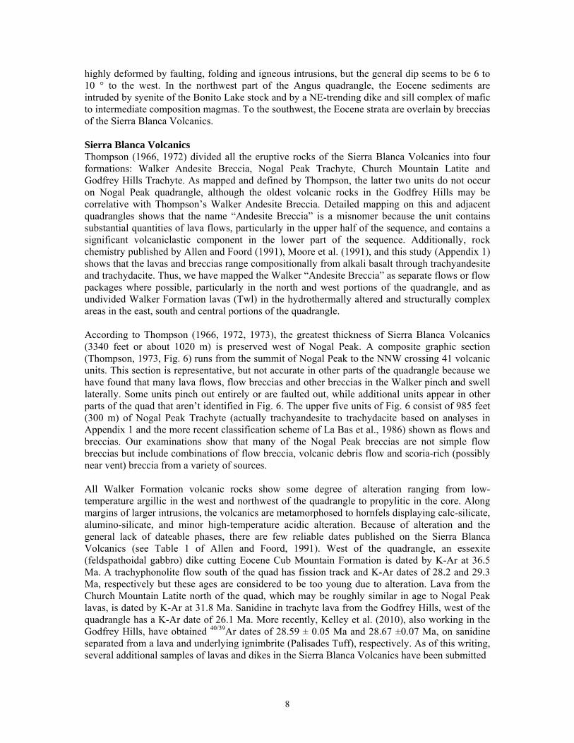
highly deformed by faulting, folding and igneous intrusions, but the general dip seems to be 6 to 10 ° to the west. In the northwest part of the Angus quadrangle, the Eocene sediments are intruded by syenite of the Bonito Lake stock and by a NE-trending dike and sill complex of mafic to intermediate composition magmas. To the southwest, the Eocene strata are overlain by breccias of the Sierra Blanca Volcanics. Sierra Blanca Volcanics Thompson (1966, 1972) divided all the eruptive rocks of the Sierra Blanca Volcanics into four formations: Walker Andesite Breccia, Nogal Peak Trachyte, Church Mountain Latite and Godfrey Hills Trachyte. As mapped and defined by Thompson, the latter two units do not occur on Nogal Peak quadrangle, although the oldest volcanic rocks in the Godfrey Hills may be correlative with Thompson’s Walker Andesite Breccia. Detailed mapping on this and adjacent quadrangles shows that the name “Andesite Breccia” is a misnomer because the unit contains substantial quantities of lava flows, particularly in the upper half of the sequence, and contains a significant volcaniclastic component in the lower part of the sequence. Additionally, rock chemistry published by Allen and Foord (1991), Moore et al. (1991), and this study (Appendix 1) shows that the lavas and breccias range compositionally from alkali basalt through trachyandesite and trachydacite. Thus, we have mapped the Walker “Andesite Breccia” as separate flows or flow packages where possible, particularly in the north and west portions of the quadrangle, and as undivided Walker Formation lavas (Twl) in the hydrothermally altered and structurally complex areas in the east, south and central portions of the quadrangle. According to Thompson (1966, 1972, 1973), the greatest thickness of Sierra Blanca Volcanics (3340 feet or about 1020 m) is preserved west of Nogal Peak. A composite graphic section (Thompson, 1973, Fig. 6) runs from the summit of Nogal Peak to the NNW crossing 41 volcanic units. This section is representative, but not accurate in other parts of the quadrangle because we have found that many lava flows, flow breccias and other breccias in the Walker pinch and swell laterally. Some units pinch out entirely or are faulted out, while additional units appear in other parts of the quad that aren’t identified in Fig. 6. The upper five units of Fig. 6 consist of 985 feet (300 m) of Nogal Peak Trachyte (actually trachyandesite to trachydacite based on analyses in Appendix 1 and the more recent classification scheme of La Bas et al., 1986) shown as flows and breccias. Our examinations show that many of the Nogal Peak breccias are not simple flow breccias but include combinations of flow breccia, volcanic debris flow and scoria-rich (possibly near vent) breccia from a variety of sources. All Walker Formation volcanic rocks show some degree of alteration ranging from low-temperature argillic in the west and northwest of the quadrangle to propylitic in the core. Along margins of larger intrusions, the volcanics are metamorphosed to hornfels displaying calc-silicate, alumino-silicate, and minor high-temperature acidic alteration. Because of alteration and the general lack of dateable phases, there are few reliable dates published on the Sierra Blanca Volcanics (see Table 1 of Allen and Foord, 1991). West of the quadrangle, an essexite (feldspathoidal gabbro) dike cutting Eocene Cub Mountain Formation is dated by K-Ar at 36.5 Ma. A trachyphonolite flow south of the quad has fission track and K-Ar dates of 28.2 and 29.3 Ma, respectively but these ages are considered to be too young due to alteration. Lava from the Church Mountain Latite north of the quad, which may be roughly similar in age to Nogal Peak lavas, is dated by K-Ar at 31.8 Ma. Sanidine in trachyte lava from the Godfrey Hills, west of the quadrangle has a K-Ar date of 26.1 Ma. More recently, Kelley et al. (2010), also working in the Godfrey Hills, have obtained 40/39Ar dates of 28.59 ± 0.05 Ma and 28.67 ±0.07 Ma, on sanidine separated from a lava and underlying ignimbrite (Palisades Tuff), respectively. As of this writing, several additional samples of lavas and dikes in the Sierra Blanca Volcanics have been submitted
8
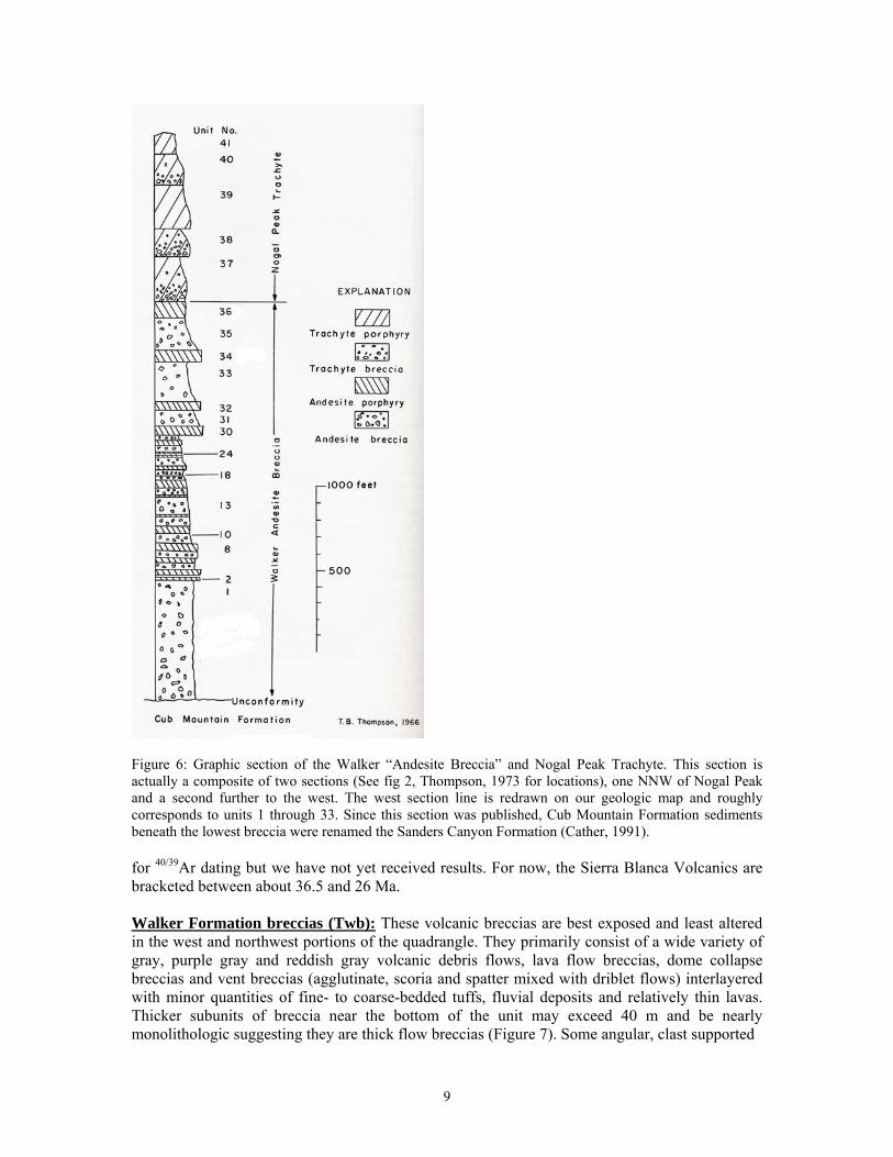
Figure 6: Graphic section of the Walker “Andesite Breccia” and Nogal Peak Trachyte. This section is actually a composite of two sections (See fig 2, Thompson, 1973 for locations), one NNW of Nogal Peak and a second further to the west. The west section line is redrawn on our geologic map and roughly corresponds to units 1 through 33. Since this section was published, Cub Mountain Formation sediments beneath the lowest breccia were renamed the Sanders Canyon Formation (Cather, 1991). for 40/39Ar dating but we have not yet received results. For now, the Sierra Blanca Volcanics are bracketed between about 36.5 and 26 Ma. Walker Formation breccias (Twb): These volcanic breccias are best exposed and least altered in the west and northwest portions of the quadrangle. They primarily consist of a wide variety of gray, purple gray and reddish gray volcanic debris flows, lava flow breccias, dome collapse breccias and vent breccias (agglutinate, scoria and spatter mixed with driblet flows) interlayered with minor quantities of fine- to coarse-bedded tuffs, fluvial deposits and relatively thin lavas. Thicker subunits of breccia near the bottom of the unit may exceed 40 m and be nearly monolithologic suggesting they are thick flow breccias (Figure 7). Some angular, clast supported
9
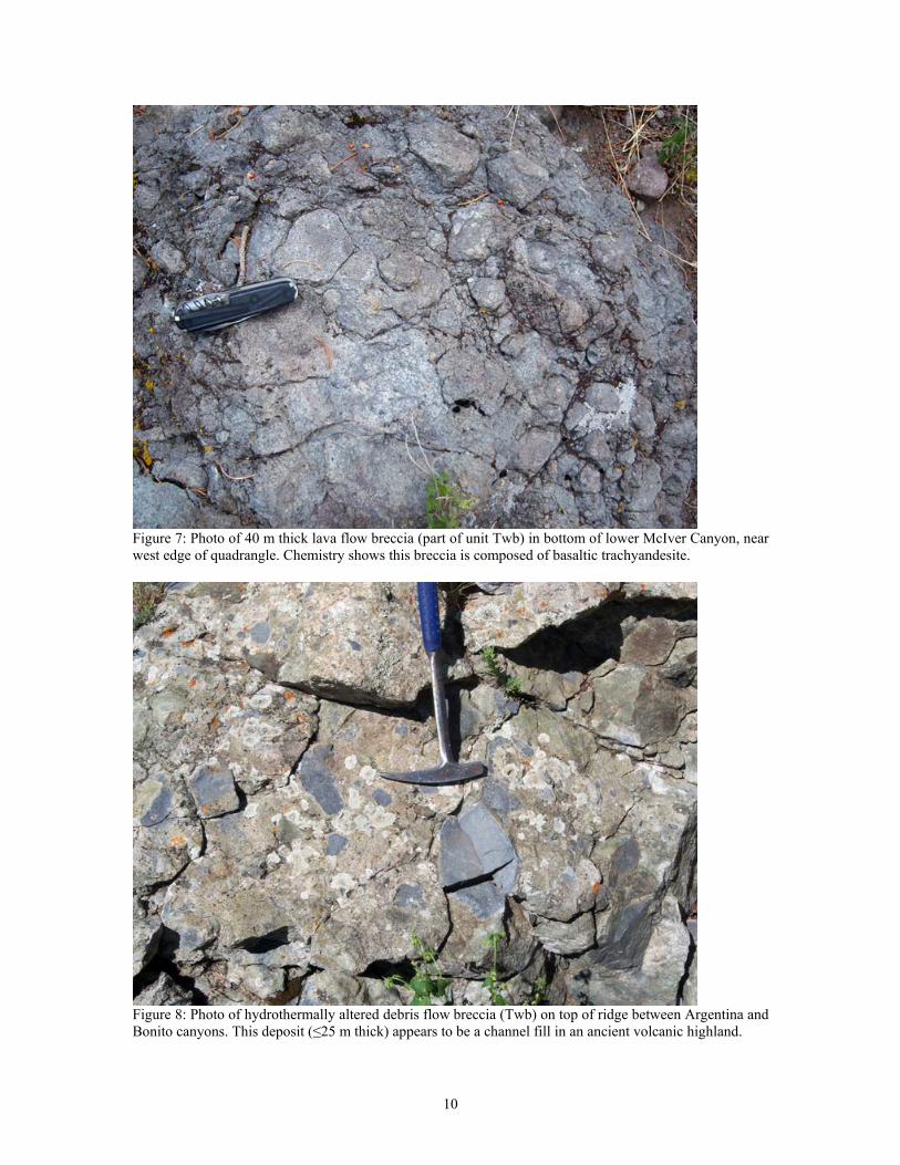
Figure 7: Photo of 40 m thick lava flow breccia (part of unit Twb) in bottom of lower McIver Canyon, near west edge of quadrangle. Chemistry shows this breccia is composed of basaltic trachyandesite.
Figure 8: Photo of hydrothermally altered debris flow breccia (Twb) on top of ridge between Argentina and Bonito canyons. This deposit (≤25 m thick) appears to be a channel fill in an ancient volcanic highland.
10
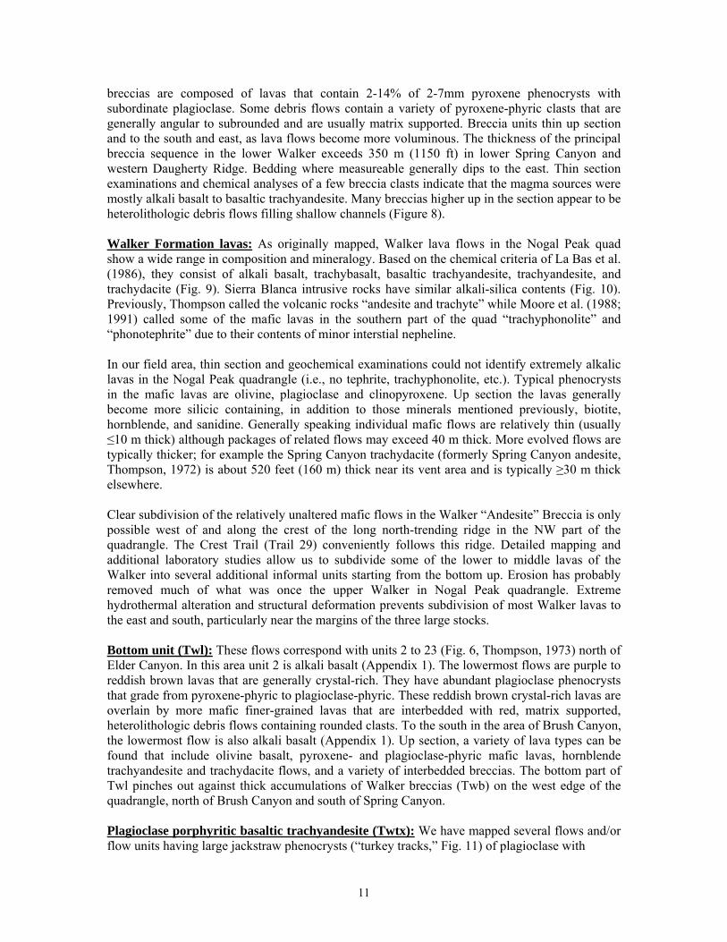
breccias are composed of lavas that contain 2-14% of 2-7mm pyroxene phenocrysts with subordinate plagioclase. Some debris flows contain a variety of pyroxene-phyric clasts that are generally angular to subrounded and are usually matrix supported. Breccia units thin up section and to the south and east, as lava flows become more voluminous. The thickness of the principal breccia sequence in the lower Walker exceeds 350 m (1150 ft) in lower Spring Canyon and western Daugherty Ridge. Bedding where measureable generally dips to the east. Thin section examinations and chemical analyses of a few breccia clasts indicate that the magma sources were mostly alkali basalt to basaltic trachyandesite. Many breccias higher up in the section appear to be heterolithologic debris flows filling shallow channels (Figure 8). Walker Formation lavas: As originally mapped, Walker lava flows in the Nogal Peak quad show a wide range in composition and mineralogy. Based on the chemical criteria of La Bas et al. (1986), they consist of alkali basalt, trachybasalt, basaltic trachyandesite, trachyandesite, and trachydacite (Fig. 9). Sierra Blanca intrusive rocks have similar alkali-silica contents (Fig. 10). Previously, Thompson called the volcanic rocks “andesite and trachyte” while Moore et al. (1988; 1991) called some of the mafic lavas in the southern part of the quad “trachyphonolite” and “phonotephrite” due to their contents of minor interstial nepheline. In our field area, thin section and geochemical examinations could not identify extremely alkalic lavas in the Nogal Peak quadrangle (i.e., no tephrite, trachyphonolite, etc.). Typical phenocrysts in the mafic lavas are olivine, plagioclase and clinopyroxene. Up section the lavas generally become more silicic containing, in addition to those minerals mentioned previously, biotite, hornblende, and sanidine. Generally speaking individual mafic flows are relatively thin (usually ≤10 m thick) although packages of related flows may exceed 40 m thick. More evolved flows are typically thicker; for example the Spring Canyon trachydacite (formerly Spring Canyon andesite, Thompson, 1972) is about 520 feet (160 m) thick near its vent area and is typically ≥30 m thick elsewhere. Clear subdivision of the relatively unaltered mafic flows in the Walker “Andesite” Breccia is only possible west of and along the crest of the long north-trending ridge in the NW part of the quadrangle. The Crest Trail (Trail 29) conveniently follows this ridge. Detailed mapping and additional laboratory studies allow us to subdivide some of the lower to middle lavas of the Walker into several additional informal units starting from the bottom up. Erosion has probably removed much of what was once the upper Walker in Nogal Peak quadrangle. Extreme hydrothermal alteration and structural deformation prevents subdivision of most Walker lavas to the east and south, particularly near the margins of the three large stocks. Bottom unit (Twl): These flows correspond with units 2 to 23 (Fig. 6, Thompson, 1973) north of Elder Canyon. In this area unit 2 is alkali basalt (Appendix 1). The lowermost flows are purple to reddish brown lavas that are generally crystal-rich. They have abundant plagioclase phenocrysts that grade from pyroxene-phyric to plagioclase-phyric. These reddish brown crystal-rich lavas are overlain by more mafic finer-grained lavas that are interbedded with red, matrix supported, heterolithologic debris flows containing rounded clasts. To the south in the area of Brush Canyon, the lowermost flow is also alkali basalt (Appendix 1). Up section, a variety of lava types can be found that include olivine basalt, pyroxene- and plagioclase-phyric mafic lavas, hornblende trachyandesite and trachydacite flows, and a variety of interbedded breccias. The bottom part of Twl pinches out against thick accumulations of Walker breccias (Twb) on the west edge of the quadrangle, north of Brush Canyon and south of Spring Canyon. Plagioclase porphyritic basaltic trachyandesite (Twtx): We have mapped several flows and/or flow units having large jackstraw phenocrysts (“turkey tracks,” Fig. 11) of plagioclase with
11
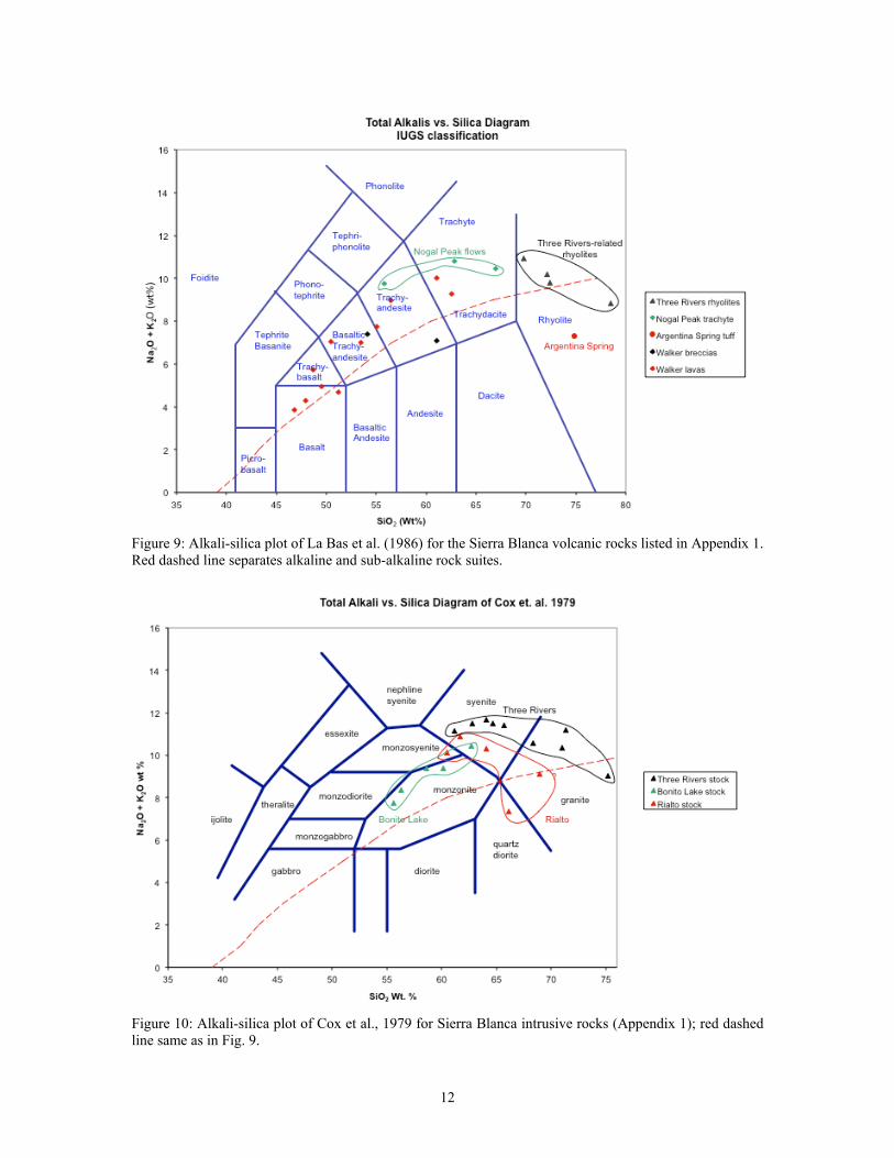
Figure 9: Alkali-silica plot of La Bas et al. (1986) for the Sierra Blanca volcanic rocks listed in Appendix 1. Red dashed line separates alkaline and sub-alkaline rock suites.
Figure 10: Alkali-silica plot of Cox et al., 1979 for Sierra Blanca intrusive rocks (Appendix 1); red dashed line same as in Fig. 9.
12
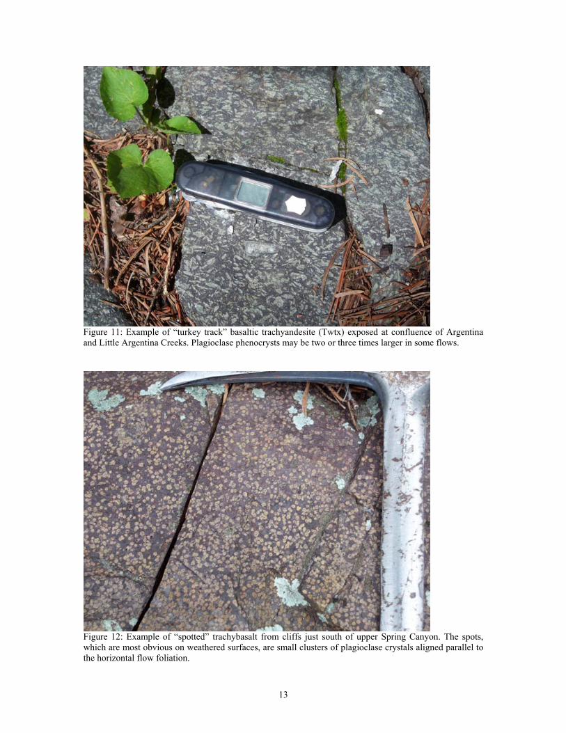
Figure 11: Example of “turkey track” basaltic trachyandesite (Twtx) exposed at confluence of Argentina and Little Argentina Creeks. Plagioclase phenocrysts may be two or three times larger in some flows.
Figure 12: Example of “spotted” trachybasalt from cliffs just south of upper Spring Canyon. The spots, which are most obvious on weathered surfaces, are small clusters of plagioclase crystals aligned parallel to the horizontal flow foliation.
13
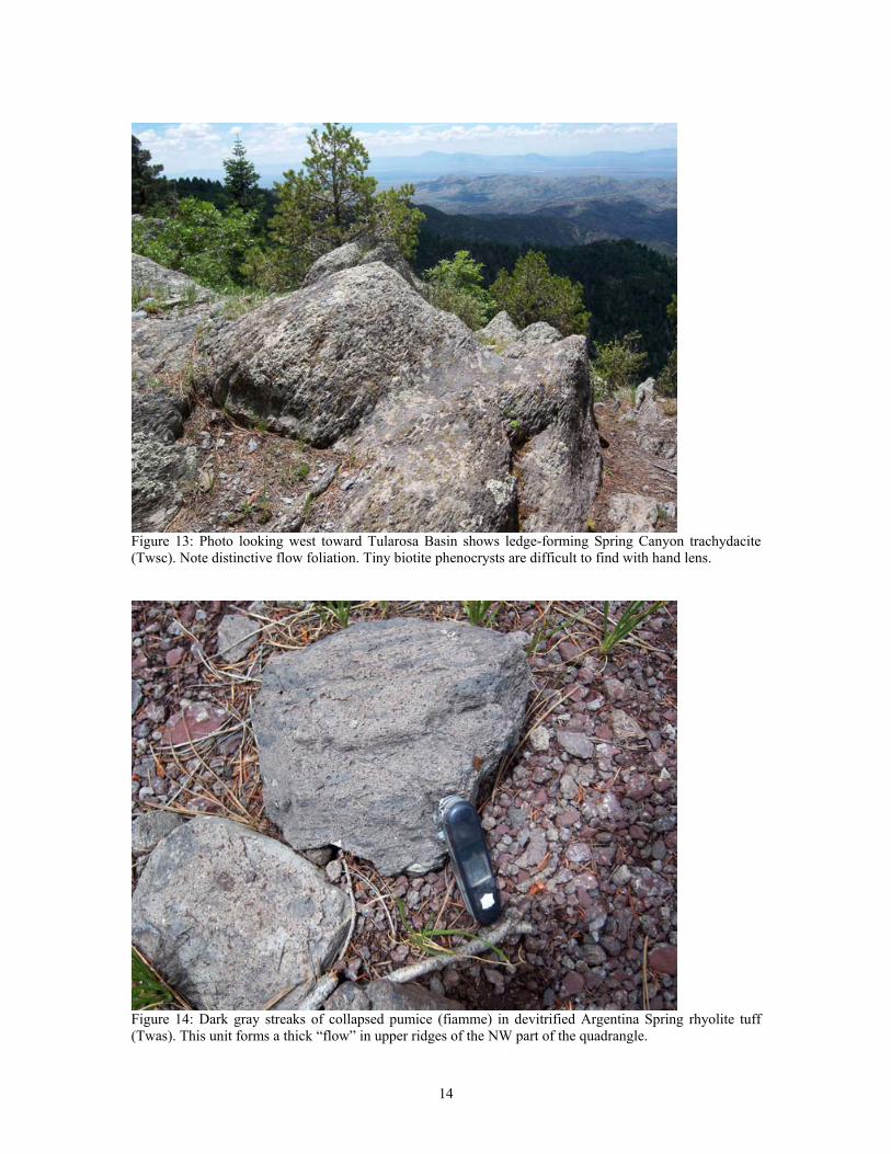
Figure 13: Photo looking west toward Tularosa Basin shows ledge-forming Spring Canyon trachydacite (Twsc). Note distinctive flow foliation. Tiny biotite phenocrysts are difficult to find with hand lens.
Figure 14: Dark gray streaks of collapsed pumice (fiamme) in devitrified Argentina Spring rhyolite tuff (Twas). This unit forms a thick “flow” in upper ridges of the NW part of the quadrangle.
14
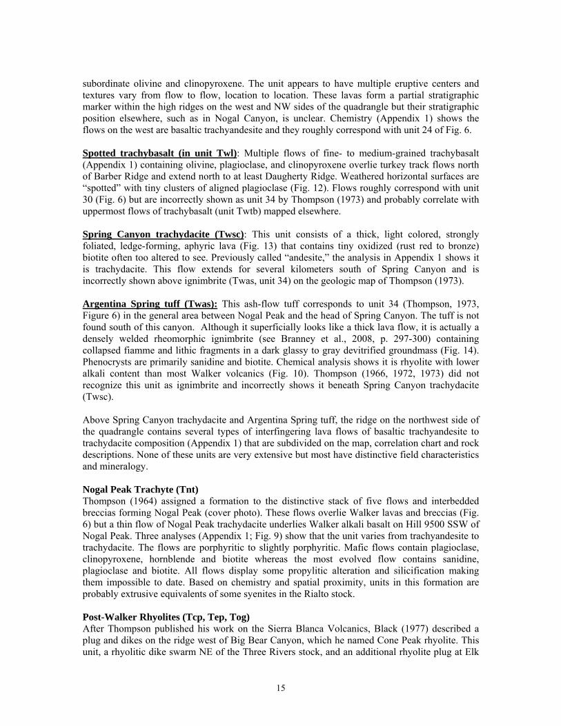
subordinate olivine and clinopyroxene. The unit appears to have multiple eruptive centers and textures vary from flow to flow, location to location. These lavas form a partial stratigraphic marker within the high ridges on the west and NW sides of the quadrangle but their stratigraphic position elsewhere, such as in Nogal Canyon, is unclear. Chemistry (Appendix 1) shows the flows on the west are basaltic trachyandesite and they roughly correspond with unit 24 of Fig. 6. Spotted trachybasalt (in unit Twl): Multiple flows of fine- to medium-grained trachybasalt (Appendix 1) containing olivine, plagioclase, and clinopyroxene overlie turkey track flows north of Barber Ridge and extend north to at least Daugherty Ridge. Weathered horizontal surfaces are “spotted” with tiny clusters of aligned plagioclase (Fig. 12). Flows roughly correspond with unit 30 (Fig. 6) but are incorrectly shown as unit 34 by Thompson (1973) and probably correlate with uppermost flows of trachybasalt (unit Twtb) mapped elsewhere. Spring Canyon trachydacite (Twsc): This unit consists of a thick, light colored, strongly foliated, ledge-forming, aphyric lava (Fig. 13) that contains tiny oxidized (rust red to bronze) biotite often too altered to see. Previously called “andesite,” the analysis in Appendix 1 shows it is trachydacite. This flow extends for several kilometers south of Spring Canyon and is incorrectly shown above ignimbrite (Twas, unit 34) on the geologic map of Thompson (1973). Argentina Spring tuff (Twas): This ash-flow tuff corresponds to unit 34 (Thompson, 1973, Figure 6) in the general area between Nogal Peak and the head of Spring Canyon. The tuff is not found south of this canyon. Although it superficially looks like a thick lava flow, it is actually a densely welded rheomorphic ignimbrite (see Branney et al., 2008, p. 297-300) containing collapsed fiamme and lithic fragments in a dark glassy to gray devitrified groundmass (Fig. 14). Phenocrysts are primarily sanidine and biotite. Chemical analysis shows it is rhyolite with lower alkali content than most Walker volcanics (Fig. 10). Thompson (1966, 1972, 1973) did not recognize this unit as ignimbrite and incorrectly shows it beneath Spring Canyon trachydacite (Twsc). Above Spring Canyon trachydacite and Argentina Spring tuff, the ridge on the northwest side of the quadrangle contains several types of interfingering lava flows of basaltic trachyandesite to trachydacite composition (Appendix 1) that are subdivided on the map, correlation chart and rock descriptions. None of these units are very extensive but most have distinctive field characteristics and mineralogy. Nogal Peak Trachyte (Tnt) Thompson (1964) assigned a formation to the distinctive stack of five flows and interbedded breccias forming Nogal Peak (cover photo). These flows overlie Walker lavas and breccias (Fig. 6) but a thin flow of Nogal Peak trachydacite underlies Walker alkali basalt on Hill 9500 SSW of Nogal Peak. Three analyses (Appendix 1; Fig. 9) show that the unit varies from trachyandesite to trachydacite. The flows are porphyritic to slightly porphyritic. Mafic flows contain plagioclase, clinopyroxene, hornblende and biotite whereas the most evolved flow contains sanidine, plagioclase and biotite. All flows display some propylitic alteration and silicification making them impossible to date. Based on chemistry and spatial proximity, units in this formation are probably extrusive equivalents of some syenites in the Rialto stock. Post-Walker Rhyolites (Tcp, Tep, Tog) After Thompson published his work on the Sierra Blanca Volcanics, Black (1977) described a plug and dikes on the ridge west of Big Bear Canyon, which he named Cone Peak rhyolite. This unit, a rhyolitic dike swarm NE of the Three Rivers stock, and an additional rhyolite plug at Elk
15
Point were mentioned by Segerstrom et al. (1979, p. 14). We dated a NE-trending rhyolite dike that cuts the east margin of the Three Rivers stock at 25.4 ± 0.8 Ma. In addition, we identified an aphyric rhyolitic flow on the east margin of the quadrangle (Oak Grove rhyolite) that may be related to the same pulse of volcanism as the dikes. All of these rhyolitic manifestations occur on or near the margin of the Three Rivers stock and overlie or cut typical Walker breccias and lava flows; thus, these eruptions are unique from the Walker and probably related to the stock. Cone Peak rhyolite (Tcp): This unit was first described by Black (1977) as a small plug and associated dikes of biotite rhyolite. We found many more small dikes and additional small, plug-like bodies flanking the northwest side of the Three Rivers stock. All samples show variable amounts of hydrothermal alteration and silicification. Chemical analyses presented by Black show extreme leaching of alkali components but our analysis of a dike from the east side of Big Bear Creek shows considerably less alteration (Appendix 1; Fig. 9). Because of proximity and rhyolitic chemistry, it is probably derived from late-stage alkali granite melts in the Three Rivers stock. Black did not elevate Cone Peak rhyolite to formal stratigraphic status, nor do we. Elk Point rhyolite (Tep): This plug consists of highly porphyritic, flow-banded rhyolite with large Kspar phenocrysts. “Fresh” material is found only in the northwest part of the plug; most of it is highly silicified and brecciated (Segerstrom et al., 1979). Elk Point rhyolite lies in fault contact with the Three Rivers stock and is chemically similar to alkali granites in the stock (Figs. 9 and 10). Oak Grove rhyolite (Tog): This rhyolite is extremely aphyric and flow-banded with rare quartz microphenocrysts. The lava unconformably overlies mafic Walker breccias on the east edge of the quadrangle and is chemically similar to alkali granites of the Three Rivers stock (Figs. 9 and 10). A nearby porphyritic flow of probable trachydacite composition occupies the same stratigraphic position but, lacking chemistry, we have placed it within the uppermost Walker lava package. Intrusive Rocks Essexite Plug (Tex): A small plug of essexite (feldspathoidal gabbro, Williams et al., 1954) intrudes lower to middle Sierra Blanca mafic lavas and breccias at the head of Eagle Creek in the southeast corner of the quadrangle (Moore et al., 1988). The rock is medium- to course-grained containing large phenocrysts of Kspar in a matrix of plagioclase, clinopyroxene, olivine, minor biotite and interstitial nepheline. Propylitic alteration is pervasive but the unit has a K-Ar date of 32.8 ± 1.2 Ma on altered plagioclase and biotite. We consider this to be a minimum age. A recently obtained whole rock Ar40/39 date is 30.0 ± 0.5 Ma, which we consider to be a date on alteration resulting from intrusion of the adjacent Three Rivers stock. Syenite, Monzonite and Diorite Plugs (Tspg, Tm, Tgd, Tdbp): A north-trending trio of small syenite and syenite breccia plugs lies along the ridge crest between Aspen and Little Bear canyons. The northern body is rather course-grained. A small plug of monzonite intrudes middle Sierra Blanca volcanics in the southwest corner of the quadrangle (Moore et al., 1988). Primary minerals consist of plagioclase, clinopyroxene and minor Kspar and the rock displays propylitic alteration. The plug is not dated but is overlain by a small roof pendant of trachybasalt and is cut by NW-trending syenite dikes. A smaller, hydrothermally altered plug with associated radiating dikes intrudes middle Walker lavas at Grizzly Peak, just north of Bonito Creek (Black, 1977). Petrographically, the plug has a mineral composition closer to diorite. Similar dikes of diorite (or monzonite) are apparently cut by intrusions of the Rialto Stock, suggesting that the latter body is younger. West of the plug, a small circular area of propylitically-altered, monzonite intrusion breccia is found in a small arm of Washington Creek (Black, 1977). One tiny plug of altered
16
monzonite or diorite that contains small cavities filled with poor-quality amethyst, is located in a saddle just SW of Nogal Peak, Finally, we found a large plug of diorite porphyry in the upper reaches of Dark Betty Canyon. Rialto Stock (Trm, Trm2): The Rialto stock (Thompson, 1972; Allen and Foord, 1991; Moore et al., 1991) is an irregular 3-km2-body with a north-south elongation that straddles the many arms of Tanbark Canyon. Petrographically, the stock is composed of medium- to fine-grained “monzonitic” rocks containing plagioclase, clinopyroxene, hornblende, biotite, minor Kspar and quartz. We have mapped two phases of the stock: Phase 1 is the initial and slightly dominant phase comprising roughly 60% of the unit. Phase 2 intrudes Phase 1 and is composed of NNE-trending lenticular bodies to broad dikes that are usually finer-grained and contain substantially more biotite, Kspar and quartz. These dikes probably merge into a larger intrusive body at depth. We do not recognize the six late intrusive phases of Gander (1982) within Nogal Peak quadrangle. The Rialto stock intrudes middle (?) Sierra Blanca volcanics; contacts are usually high-angle, sometimes faulted. A single K-Ar date on hornblende and biotite from Phase 1 (?) “monzonite” is 31.4 ± 1.3 Ma (Moore et al., 1991). We have submitted additional samples of the stock for 40/39Ar and U-Pb dating. According the analyses presented in Appendix 1 and the naming schemes of Cox et al. (1979) and De La Roche et al. (1980), the Rialto stock, Phase 1 is mostly syenite and the Phase 2 unit is quartz diorite (or “tonalite,” Williams et al., 1954). Most specimens display some combination of propylitic, phyllic and argillic alteration with secondary quartz and occasionally epidote in veins and fractures. Propylitic alteration is more pervasive around the margins of the stock whereas phyllic alteration later modified to argillic alteration is most common within the stock interior (see also Thompson, 1973). Numerous intermediate-composition dikes of varying texture cut the stock, many too altered to clearly identify. A medium-grained syenite dike roughly 1 km long and ≥60 m wide is exposed in the ridge south of Bonito Creek and the Rialto stock. Much of this dike is quite fresh and has been submitted for 40/39Ar dating. Chemically, this dike is similar to Phase 1 of the Rialto stock. Bonito Lake Stock (Tbs): This intrusive body covers an area of 19 km2, much of it exposed in the Angus quadrangle east of Nogal Peak quad (Rawling, 2004b). Our examinations show it to be a single large body of medium- to coarse-grained monzonite, syenite and syenite porphyry containing plagioclase, hornblende, biotite, Kspar, minor clinopyroxene and minor interstial quartz (see also Thompson, 1972; Allen and Foord, 1991). Using representative analyses from Constantopoulos (2007; Appendix 1) and the schemes of Cox et al. (1979) and De La Roche et al. (1980), the rocks of the Bonito Lake stock are appropriately named syenite to syenodiorite (the latter is equivalent to most rocks called monzonite, Williams et al., 1954). Coarser grained, quartz-free syenodiorite is found near the west margin of the unit. The stock is intruded by numerous dikes of diorite to aplite from many meters to a few centimeters wide, respectively. Diorite and syenodiorite dikes contain virtually no quartz and more clinopyroxene. Aplite dikes contain fine-grained quartz, Kspar, and minor biotite in a sugary matrix. Late-stage quartz has graphic texture. Black (1977, plate 2) measured the trends of roughly 100 joints in the Bonito Lake stock, which have pronounced NNE trends in the north part of the body but NE and NW trends in the south part. Most specimens display various amounts of propylitic alteration. This is overprinted by later argillic alteration. A single K-Ar date on biotite of 26.6 ± 1.4 Ma is reported by Thompson (1972) for a specimen from an unidentified location. We have submitted additional samples of the stock for 40/39Ar and U-Pb dating.
17
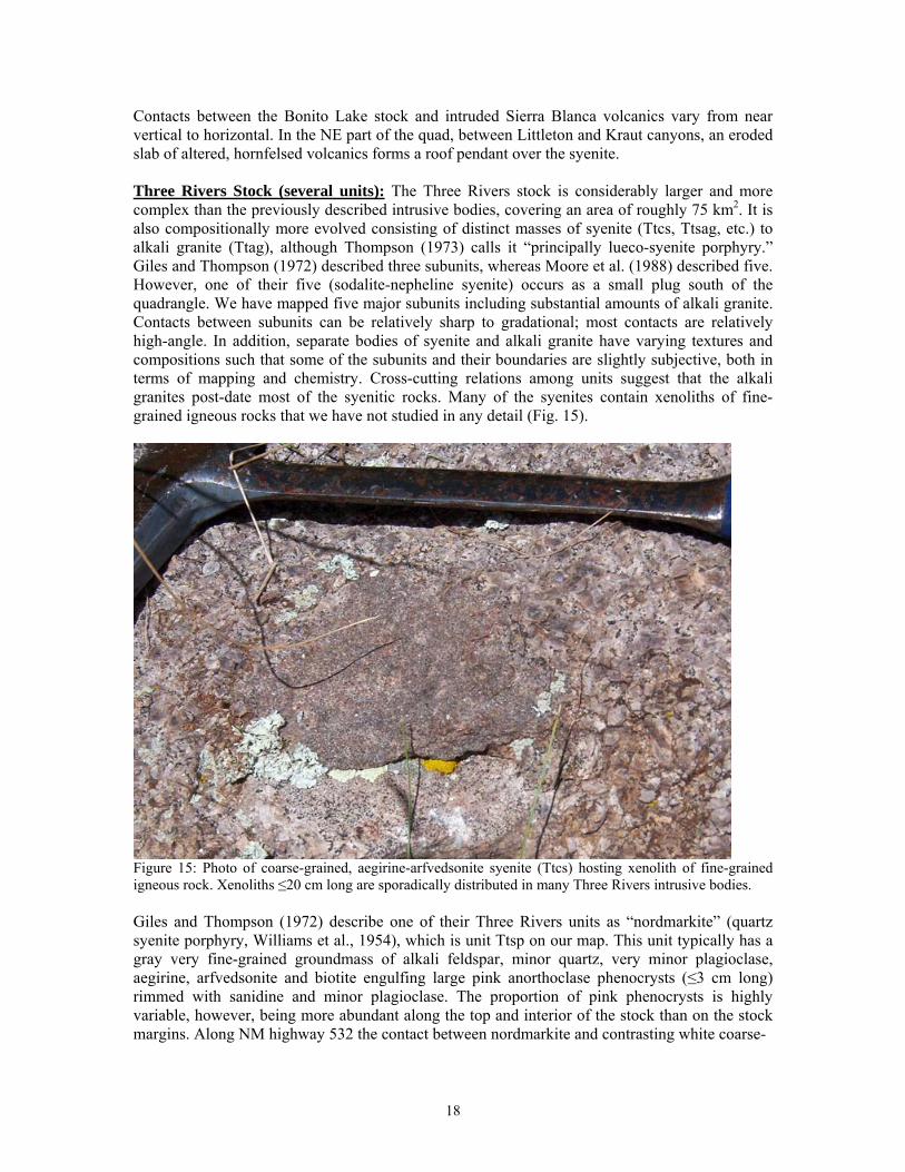
Contacts between the Bonito Lake stock and intruded Sierra Blanca volcanics vary from near vertical to horizontal. In the NE part of the quad, between Littleton and Kraut canyons, an eroded slab of altered, hornfelsed volcanics forms a roof pendant over the syenite. Three Rivers Stock (several units): The Three Rivers stock is considerably larger and more complex than the previously described intrusive bodies, covering an area of roughly 75 km2. It is also compositionally more evolved consisting of distinct masses of syenite (Ttcs, Ttsag, etc.) to alkali granite (Ttag), although Thompson (1973) calls it “principally lueco-syenite porphyry.” Giles and Thompson (1972) described three subunits, whereas Moore et al. (1988) described five. However, one of their five (sodalite-nepheline syenite) occurs as a small plug south of the quadrangle. We have mapped five major subunits including substantial amounts of alkali granite. Contacts between subunits can be relatively sharp to gradational; most contacts are relatively high-angle. In addition, separate bodies of syenite and alkali granite have varying textures and compositions such that some of the subunits and their boundaries are slightly subjective, both in terms of mapping and chemistry. Cross-cutting relations among units suggest that the alkali granites post-date most of the syenitic rocks. Many of the syenites contain xenoliths of fine-grained igneous rocks that we have not studied in any detail (Fig. 15).
Figure 15: Photo of coarse-grained, aegirine-arfvedsonite syenite (Ttcs) hosting xenolith of fine-grained igneous rock. Xenoliths ≤20 cm long are sporadically distributed in many Three Rivers intrusive bodies. Giles and Thompson (1972) describe one of their Three Rivers units as “nordmarkite” (quartz syenite porphyry, Williams et al., 1954), which is unit Ttsp on our map. This unit typically has a gray very fine-grained groundmass of alkali feldspar, minor quartz, very minor plagioclase, aegirine, arfvedsonite and biotite engulfing large pink anorthoclase phenocrysts (≤3 cm long) rimmed with sanidine and minor plagioclase. The proportion of pink phenocrysts is highly variable, however, being more abundant along the top and interior of the stock than on the stock margins. Along NM highway 532 the contact between nordmarkite and contrasting white coarse-
18
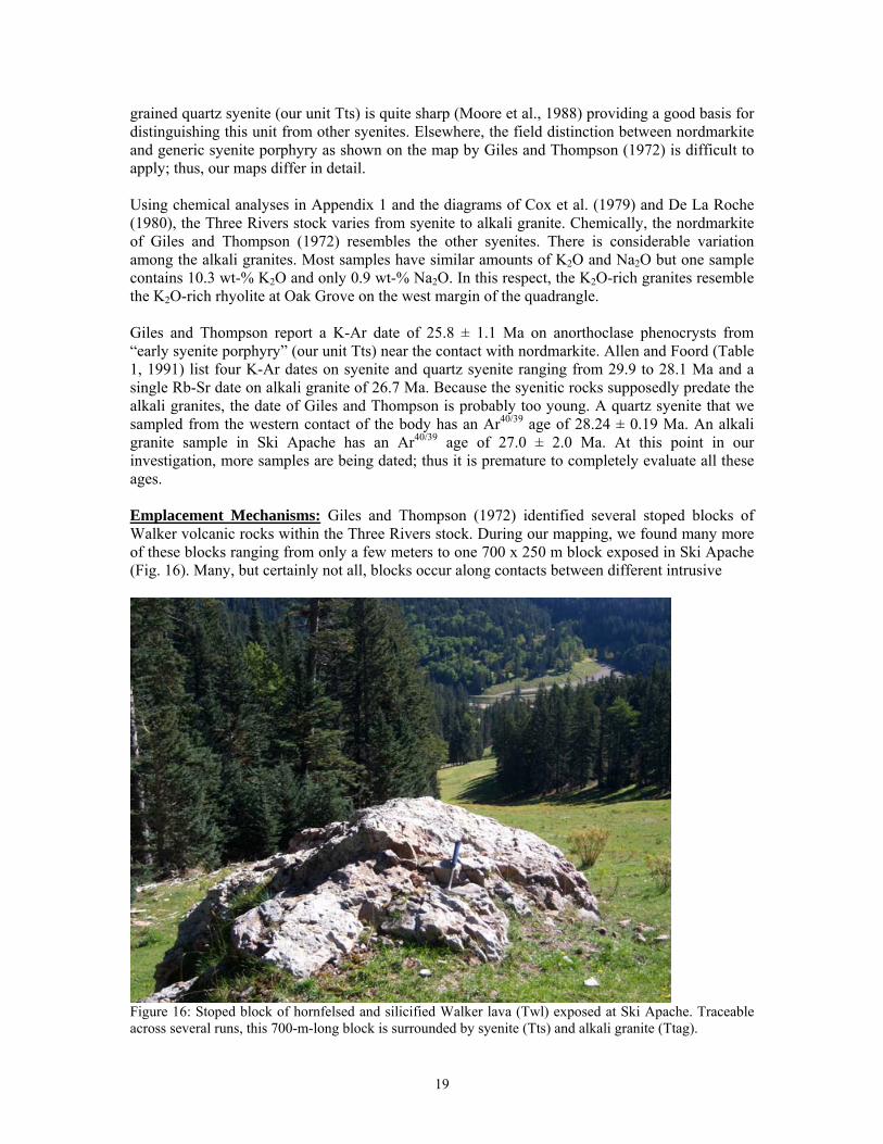
grained quartz syenite (our unit Tts) is quite sharp (Moore et al., 1988) providing a good basis for distinguishing this unit from other syenites. Elsewhere, the field distinction between nordmarkite and generic syenite porphyry as shown on the map by Giles and Thompson (1972) is difficult to apply; thus, our maps differ in detail. Using chemical analyses in Appendix 1 and the diagrams of Cox et al. (1979) and De La Roche (1980), the Three Rivers stock varies from syenite to alkali granite. Chemically, the nordmarkite of Giles and Thompson (1972) resembles the other syenites. There is considerable variation among the alkali granites. Most samples have similar amounts of K2O and Na2O but one sample contains 10.3 wt-% K2O and only 0.9 wt-% Na2O. In this respect, the K2O-rich granites resemble the K2O-rich rhyolite at Oak Grove on the west margin of the quadrangle. Giles and Thompson report a K-Ar date of 25.8 ± 1.1 Ma on anorthoclase phenocrysts from “early syenite porphyry” (our unit Tts) near the contact with nordmarkite. Allen and Foord (Table 1, 1991) list four K-Ar dates on syenite and quartz syenite ranging from 29.9 to 28.1 Ma and a single Rb-Sr date on alkali granite of 26.7 Ma. Because the syenitic rocks supposedly predate the alkali granites, the date of Giles and Thompson is probably too young. A quartz syenite that we sampled from the western contact of the body has an Ar40/39 age of 28.24 ± 0.19 Ma. An alkali granite sample in Ski Apache has an Ar40/39 age of 27.0 ± 2.0 Ma. At this point in our investigation, more samples are being dated; thus it is premature to completely evaluate all these ages. Emplacement Mechanisms: Giles and Thompson (1972) identified several stoped blocks of Walker volcanic rocks within the Three Rivers stock. During our mapping, we found many more of these blocks ranging from only a few meters to one 700 x 250 m block exposed in Ski Apache (Fig. 16). Many, but certainly not all, blocks occur along contacts between different intrusive
Figure 16: Stoped block of hornfelsed and silicified Walker lava (Twl) exposed at Ski Apache. Traceable across several runs, this 700-m-long block is surrounded by syenite (Tts) and alkali granite (Ttag).
19
phases or near the stock boundary. In all cases, these blocks are hornfelsed and silicified but their original volcanic textures remain. Several roof pendants of Walker volcanics also occur on top of the stock. The most impressive is the continuous pendant capping the west margin of the stock in upper Three Rivers and Dry Creek canyons, but other large pendants occur south of Elk Point and the Great Western Mine. The latter two are deformed and faulted along the stock margin. Vertical contacts of the stock with Walker wall rock are difficult to find even though the contact is easy to map. One such location occurs in the bed of lower Dry Creek where quartz syenite cuts Walker basalt lava. Although hornfelsed, the lava still retains its texture of plagioclase, augite and olivine. Paterson et al. (1991) discuss pluton emplacement mechanisms at some length. Many controversies remain on the subject. Giles and Thompson (1972) proposed a three-component, “concentric shell” model for emplacement of the stock, which we think is too simplistic. To us, the stock shows strong evidence for a) initial, non-concentric injections of several chemically similar syenite melts, b) concurrent stoping of country rocks during each injection, c) later intrusion of more centralized but chemically variable alkali granite melts, and d) final doming and faulting of the stock roof, which is easily observed along some stock margins (Paterson et al., 1991, fig. 1). Dikes: Abundant dikes of various compositions, mineralogy, ages, widths, and orientations cut the Sierra Blanca volcanics and all intrusive bodies with the exception of the essexite plug. A full study of the dikes is far beyond the scope of this mapping project. We did not analyze many dikes; thus, our descriptions are based primarily on field, hand lens, and a few thin section examinations. Most of the dikes are mafic to intermediate in composition, although they cover a full range of trachybasalt to alkali rhyolite compositions. Some dikes are courser grained and fully crystallized, appearing to be gabbro, diorite, monzonite and syenite. Most dikes show some degree of argillic to propylitic alteration and are not suitable for dating. The northeast-trending mafic dike swarms described by Elston (1991), Moore et al. (1988) and Rawling (2004b) are not found on Nogal Peak quadrangle. Those that occur to the east are termed a dike and sill complex of diorite to latite. This unit underlies the Bonito Lake stock and Sierra Blanca Volcanics (?) but cuts the Eocene Cub Mountain Formation (Rawling, 2004b). Further northeast, the dike swarm consists of a wide variety of alkali diabase with subordinate latite, phonolite and rhyolite that intrude Cretaceous rocks (Elston, 1991). South of Nogal Peak quadrangle, a spectacular zone of alkali gabbro to monzogabbro dikes comprise up to 70% of exposed rocks in the Black Mountain area (Moore et al., 1988). This swarm cuts Cretaceous rocks, underlies the Sierra Blanca Volcanics, trends beneath Sierra Blanca Peak, and is thought to be about 38.5 Ma (Moore et al., 1991).
IGNEOUS GEOCHEMISTRY AND PETROGRAPHY
We obtained 26 chemical analyses of volcanic and intrusive rocks in the Nogal Peak quadrangle and combined them with selected analyses from previous studies to determine up-to-date rock names and ranges in composition (Appendix 1; Figures 9 and 10). First we want to reiterate that most volcanic rocks in the quadrangle are best classified as slightly alkaline to alkaline in chemistry and are best identified by names such as alkali basalt, trachybasalt (hawaiite), basaltic trachyandesite, etc. Rocks mapped as Nogal Peak Trachyte are substantially enriched in Na2O + K2O, yet these rocks are still classified as trachyandesite to trachydacite in the scheme of La Bas et al. (1986) or as benmoreite to trachyte in the slightly older scheme of Cox et al. (1979). As such, the Sierra Blanca Volcanics erupted in the Nogal Peak quadrangle fall within typical
20
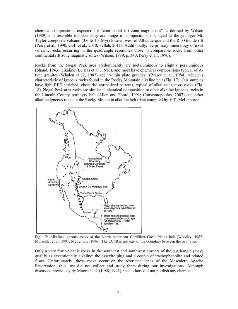
chemical compositions expected for “continental rift zone magmatism” as defined by Wilson (1989) and resemble the chemistry and range of compositions displayed at the younger Mt. Taylor composite volcano (3.6 to 1.3 Myr) located west of Albuquerque and the Rio Grande rift (Perry et al., 1990; Goff et al., 2010; Fellah, 2011). Additionally, the primary mineralogy of most volcanic rocks occurring in the quadrangle resembles those in comparable rocks from other continental rift zone magmatic suites (Wilson, 1989, p. 340; Perry et al., 1990). Rocks from the Nogal Peak area predominantly are metaluminous to slightly peraluminous (Shand, 1943), alkaline (Le Bas et al., 1986), and most have chemical compositions typical of A-type granites (Whalen et al., 1987) and “within plate granites” (Pearce et al., 1984), which is characteristic of igneous rocks found in the Rocky Mountain alkaline belt (Fig. 17). Our samples have light-REE enriched, chondrite-normalized patterns, typical of alkaline igneous rocks (Fig. 18). Nogal Peak area rocks are similar in chemical composition to other alkaline igneous rocks in the Lincoln County porphyry belt (Allen and Foord, 1991; Constantopoulos, 2007) and other alkaline igneous rocks in the Rocky Mountain alkaline belt (data compiled by V.T. McLemore).
Fig. 17: Alkaline igneous rocks of the North American Cordillera-Great Plains belt (Woolley, 1987; Mutschler et al., 1991; McLemore, 1996). The LCPB is just east of the boundary between the two types. Only a very few volcanic rocks in the southeast and southwest corners of the quadrangle (may) qualify as exceptionally alkaline: the essexite plug and a couple of trachyphonolite and related flows. Unfortunately, these rocks occur on the restricted lands of the Mescalero Apache Reservation; thus, we did not collect and study them during our investigations. Although discussed previously by Moore et al. (1988; 1991), the authors did not publish any chemical
21
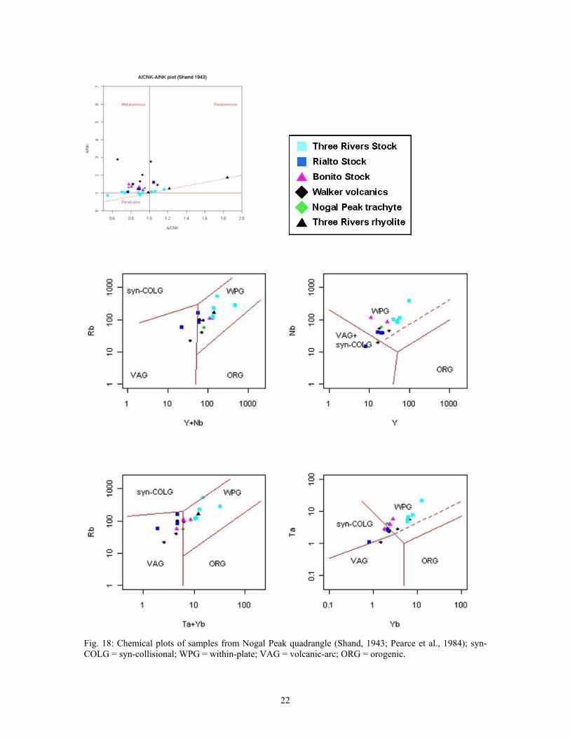
Fig. 18: Chemical plots of samples from Nogal Peak quadrangle (Shand, 1943; Pearce et al., 1984); syn-COLG = syn-collisional; WPG = within-plate; VAG = volcanic-arc; ORG = orogenic.
22
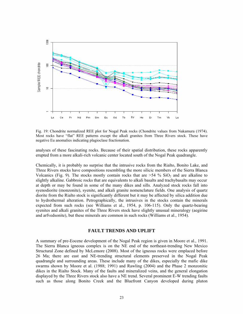
Fig. 19: Chondrite normalized REE plot for Nogal Peak rocks (Chondrite values from Nakamura (1974). Most rocks have “flat” REE patterns except the alkali granites from Three Rivers stock. These have negative Eu anomalies indicating plagioclase fractionation. analyses of these fascinating rocks. Because of their spatial distribution, these rocks apparently erupted from a more alkali-rich volcanic center located south of the Nogal Peak quadrangle. Chemically, it is probably no surprise that the intrusive rocks from the Rialto, Bonito Lake, and Three Rivers stocks have compositions resembling the more silicic members of the Sierra Blanca Volcanics (Fig. 9). The stocks mostly contain rocks that are >54 % SiO2 and are alkaline to slightly alkaline. Gabbroic rocks that are equivalents to alkali basalts and trachybasalts may occur at depth or may be found in some of the many dikes and sills. Analyzed stock rocks fall into syenodiorite (monzonite), syenite, and alkali granite nomenclature fields. One analysis of quartz diorite from the Rialto stock is significantly different but it may be affected by silica addition due to hydrothermal alteration. Petrographically, the intrusives in the stocks contain the minerals expected from such rocks (see Williams et al., 1954, p. 106-115). Only the quartz-bearing syenites and alkali granites of the Three Rivers stock have slightly unusual mineralogy (aegirine and arfvedsonite), but these minerals are common in such rocks (Williams et al., 1954).
FAULT TRENDS AND UPLIFT
A summary of pre-Eocene development of the Nogal Peak region is given in Moore et al., 1991. The Sierra Blanca igneous complex is on the NE end of the northeast-trending New Mexico Structural Zone defined by McLemore (2008). Most of the igneous rocks were emplaced before 26 Ma; there are east and NE-trending structural elements preserved in the Nogal Peak quadrangle and surrounding areas. These include many of the dikes, especially the mafic dike swarms shown by Moore et al. (1988; 1991) and Rawling (2004) and the Phase 2 monzonitic dikes in the Rialto Stock. Many of the faults and mineralized veins, and the general elongation displayed by the Three Rivers stock also have a NE trend. Several prominent E-W trending faults such as those along Bonito Creek and the Bluefront Canyon developed during pluton
23
emplacement. These are associated with several E-W trending mineralized veins and breccia zones. Sometime around 25 Ma, the region around the quadrangle was subjected to development of the north-trending Rio Grande rift. This structural trend is reflected by later north-trending faults in the quadrangle and the pronounced north-trending boundary between the Sierra Blanca and Tularosa Basin. Uplift of the Sierra Blanca since 25 Ma has caused deep erosion that has removed most of the upper and middle Sierra Blanca volcanics, unroofed the tops of the various intrusive bodies, and exposed the veins and other mineralized zones in the quadrangle. Presently, the boundary between the Sierra Blanca and the Tularosa Basin coincides with a major structural and thermal transition in the Earth’s crust, the boundary between the Rio Grande rift and the eastern Great Plains tectonic provinces (Reiter and Chamberlin, 2011).
NOGAL PEAK MINING DISTRICT
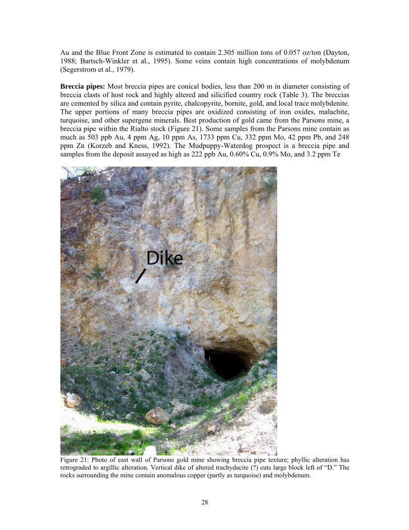
The Nogal mining district surrounds the town of Nogal (originally called Dry Gulch and then Parsons) in parts of T8, 9, 10, 11S, R11, 12, 13E in southern Lincoln County and includes several small mining camps or subdistricts (Figure 20; as defined by Griswold, 1959; File and Northrop, 1966): Vera Cruz, Parsons (Rialto), Bonito, Nogal, and Alto (Cedar Creek/Eagle Creek)). The district covers portions of the Nogal Peak, Angus, Church Mountain, and Nogal topographic quadrangles. Four types of mineral deposits found in the Nogal district include placer gold, Ag-Pb-Zn (±Au) and low Ag-Au fissure veins, gold breccia pipe deposits, and porphyry molybdenum-copper deposits. Hydrothermal alteration is extensive in the mining district.
The Nogal mining district is part of the Rocky Mountain alkaline belt, a north-south belt of alkaline-igneous rocks and crustal thickening roughly coinciding with the Great Plains physiographic margin along the Basin and Range (Rio Grande rift), and the Rocky Mountains physiographic province that is associated with relatively large quantities of gold, fluorite, rare-earth elements, uranium, and other elements. This belt continues northward into Canada and southward into Mexico (Figure 17; Mutschler et al., 1985, 1991; Bonham, 1988; Richards, 1995; McLemore, 1996). In Lincoln County, this belt is locally called the Lincoln County porphyry belt (Thompson, 1972, 1991c; Woodward, 1991; Fulp and Wooward, 1991a; Allen and Foord, 1991; McLemore and Zimmerer, 2009). Mining and Exploration History Placer gold was discovered in Dry Gulch about 1865. The oldest mining claim was in 1863 (Seagerstrom et al., 1979). By 1868, veins at the American mine were found. However, the area was part of the Mescalero Indian Reservation until 1882, after which exploration and mining began in earnest (Jones, 1904; Lindgren et al., 1910; Wells and Wootton, 1940). The Parsons mine was claimed in 1884 and by 1918, 75,000 short tons of low-grade ore were produced from that mine (Griswold, 1959, 1964; Griswold and Missaghi, 1964). In 1902-1910, the Parsons Mining Co. consolidated many of the claims near the mine. The Rialto (Fulmer) claims were first located for gold in 1894; molybdenum became of interest in the 1950s. In 1957, Climax Molybdenum Co. drilled in the Rialto (Fulmer) area and found the grade averaged 0.2% Mo (Griswold, 1959; Griswold and Missaghi, 1964; Seagerstrom et al., 1979). Several companies explored and drilled in the area in the late 1970s and 1980s. Pioneer Metals Corp. explored the Great Western and Bonito mines in 1988-1989 and still controls some claims in the district. In 1989, the breccia deposits at Great Western were estimated to contain
24
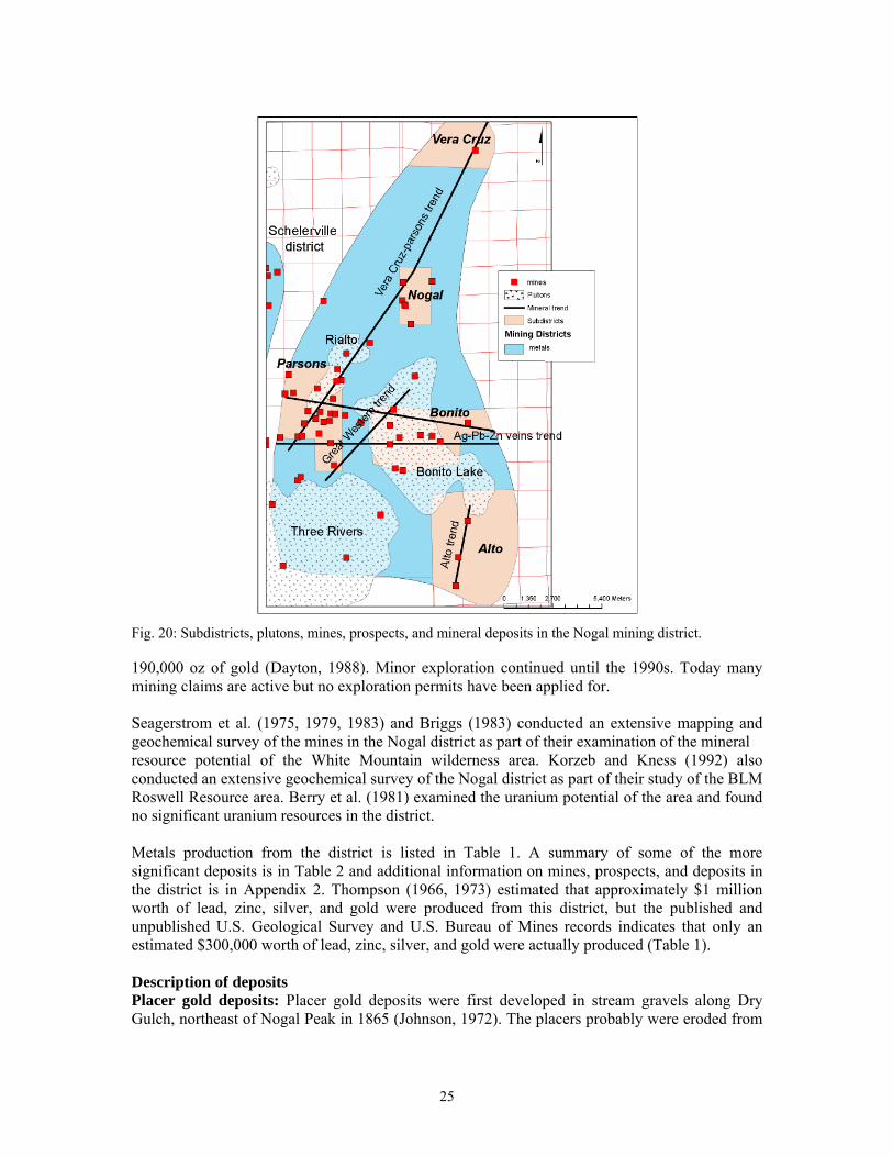
Fig. 20: Subdistricts, plutons, mines, prospects, and mineral deposits in the Nogal mining district. 190,000 oz of gold (Dayton, 1988). Minor exploration continued until the 1990s. Today many mining claims are active but no exploration permits have been applied for. Seagerstrom et al. (1975, 1979, 1983) and Briggs (1983) conducted an extensive mapping and geochemical survey of the mines in the Nogal district as part of their examination of the mineral resource potential of the White Mountain wilderness area. Korzeb and Kness (1992) also conducted an extensive geochemical survey of the Nogal district as part of their study of the BLM Roswell Resource area. Berry et al. (1981) examined the uranium potential of the area and found no significant uranium resources in the district. Metals production from the district is listed in Table 1. A summary of some of the more significant deposits is in Table 2 and additional information on mines, prospects, and deposits in the district is in Appendix 2. Thompson (1966, 1973) estimated that approximately $1 million worth of lead, zinc, silver, and gold were produced from this district, but the published and unpublished U.S. Geological Survey and U.S. Bureau of Mines records indicates that only an estimated $300,000 worth of lead, zinc, silver, and gold were actually produced (Table 1). Description of deposits Placer gold deposits: Placer gold deposits were first developed in stream gravels along Dry Gulch, northeast of Nogal Peak in 1865 (Johnson, 1972). The placers probably were eroded from
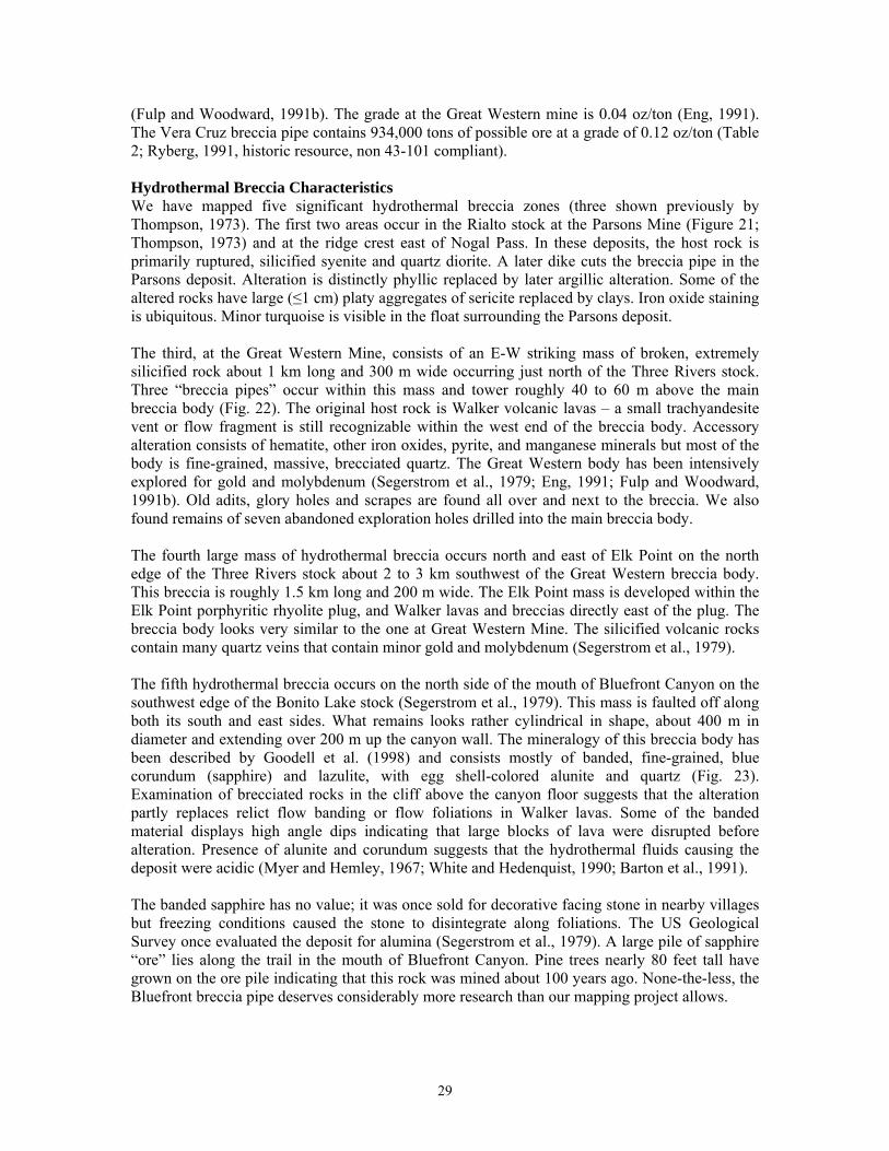
25
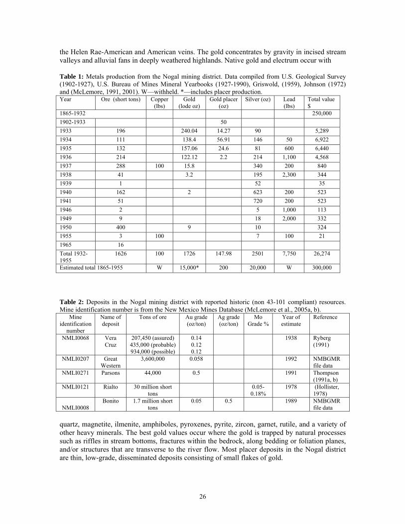
the Helen Rae-American and American veins. The gold concentrates by gravity in incised stream valleys and alluvial fans in deeply weathered highlands. Native gold and electrum occur with Table 1: Metals production from the Nogal mining district. Data compiled from U.S. Geological Survey (1902-1927), U.S. Bureau of Mines Mineral Yearbooks (1927-1990), Griswold, (1959), Johnson (1972) and (McLemore, 1991, 2001). W—withheld. *—includes placer production. Year Ore (short tons) Copper
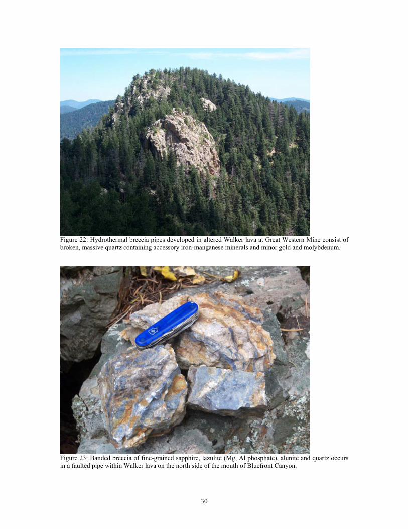
(lbs) Gold
(lode oz) Gold placer
(oz) Silver (oz) Lead
(lbs) Total value $
1865-1932 250,000 1902-1933 50 1933 196 240.04 14.27 90 5,289 1934 111 138.4 56.91 146 50 6,922 1935 132 157.06 24.6 81 600 6,440 1936 214 122.12 2.2 214 1,100 4,568 1937 288 100 15.8 340 200 840 1938 41 3.2 195 2,300 344 1939 1 52 35 1940 162 2 623 200 523 1941 51 720 200 523 1946 2 5 1,000 113 1949 9 18 2,000 332 1950 400 9 10 324 1955 3 100 7 100 21 1965 16 Total 1932-1955
1626 100 1726 147.98 2501 7,750 26,274
Estimated total 1865-1955 W 15,000* 200 20,000 W 300,000
Table 2: Deposits in the Nogal mining district with reported historic (non 43-101 compliant) resources. Mine identification number is from the New Mexico Mines Database (McLemore et al., 2005a, b).
Mine identification
number
Name of deposit
Tons of ore Au grade (oz/ton)
Ag grade (oz/ton)
Mo Grade %
Year of estimate
Reference
NMLI0068 Vera Cruz
207,450 (assured) 435,000 (probable) 934,000 (possible)
0.14 0.12 0.12
1938 Ryberg (1991)
NMLI0207 Great Western
3,600,000 0.058 1992 NMBGMR file data
NMLI0271 Parsons 44,000 0.5 1991 Thompson (1991a, b)
NMLI0121 Rialto 30 million short tons
0.05-0.18%
1978 (Hollister, 1978)
NMLI0008
Bonito 1.7 million short tons
0.05 0.5 1989 NMBGMR file data
quartz, magnetite, ilmenite, amphiboles, pyroxenes, pyrite, zircon, garnet, rutile, and a variety of other heavy minerals. The best gold values occur where the gold is trapped by natural processes such as riffles in stream bottoms, fractures within the bedrock, along bedding or foliation planes, and/or structures that are transverse to the river flow. Most placer deposits in the Nogal district are thin, low-grade, disseminated deposits consisting of small flakes of gold.
26
Porphyry molybdenum-copper deposits The porphyry molybdenum-copper deposits are found in the northern portion of the Rialto stock near Nogal Peak and along the northern and eastern portions of the Three Rivers stock. Both the Rialto and Three Rivers stocks are alkaline and high in F and Nb (Giles and Thompson, 1972; Segerstrom et al., 1979; Westra and Keith, 1981). The deposit in the Rialto stock consists of disseminated sulfides and thin veinlets in a brecciated zone in monzonite and consists of quartz, pyrite, molybdenite, and copper sulfide minerals. Four zones are recognized: 1) inner molybdenite zone, 2) magnetite zone, 3) copper-rich zone that truncates the molybdenite and magnetite zones along the southern portion of the deposit, and 4) extensive lead-zinc zone on the eastern and southern portions of the stock (Thompson, 1968; Segerstrom et al., 1979). Molybdenum decreases outwards from the central molybdenite breccia zone (Thompson, 1973; Gander, 1982). The host rocks are extensively altered by silicification, sericitization, kaolinization, and pyritization (Griswold and Missaghi, 1959; Giles and Thompson, 1972; Thompson, 1973; Westra and Keith, 1981). The Rialto porphyry molybdenum deposit is estimated to contain 27 million metric tons (30 million short tons) of 0.05-0.18% Mo (Hollister, 1978, historic resource, non 43-101 compliant). The deposits in the Three Rivers stock are in silicic altered zones. Three styles of mineralization are found: 1) thin fracture coatings of molybdenite and fine-grained disseminations in quartz veinlets, 2) molybdenite in breccia zones, and 3) fine-grained disseminations of molybdenite in high silica rocks (Giles and Thompson, 1972; Segerstrom et al., 1979). Purple euhedral fluorite is found in miarolitic cavities and open fractures throughout the Three Rivers stock, but is most noticeable in the syenites. Very low-grade molybdenum also is found in the Cone Peak rhyolite plug just northwest of the Three Rivers stock (Black, 1977a, b).
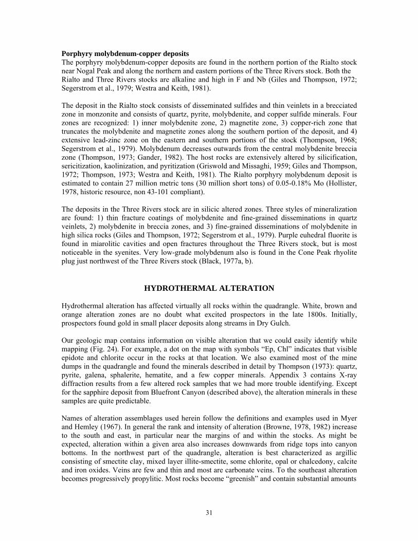
HYDROTHERMAL ALTERATION Hydrothermal alteration has affected virtually all rocks within the quadrangle. White, brown and orange alteration zones are no doubt what excited prospectors in the late 1800s. Initially, prospectors found gold in small placer deposits along streams in Dry Gulch. Our geologic map contains information on visible alteration that we could easily identify while mapping (Fig. 24). For example, a dot on the map with symbols “Ep, Chl” indicates that visible epidote and chlorite occur in the rocks at that location. We also examined most of the mine dumps in the quadrangle and found the minerals described in detail by Thompson (1973): quartz, pyrite, galena, sphalerite, hematite, and a few copper minerals. Appendix 3 contains X-ray diffraction results from a few altered rock samples that we had more trouble identifying. Except for the sapphire deposit from Bluefront Canyon (described above), the alteration minerals in these samples are quite predictable. Names of alteration assemblages used herein follow the definitions and examples used in Myer and Hemley (1967). In general the rank and intensity of alteration (Browne, 1978, 1982) increase to the south and east, in particular near the margins of and within the stocks. As might be expected, alteration within a given area also increases downwards from ridge tops into canyon bottoms. In the northwest part of the quadrangle, alteration is best characterized as argillic consisting of smectite clay, mixed layer illite-smectite, some chlorite, opal or chalcedony, calcite and iron oxides. Veins are few and thin and most are carbonate veins. To the southeast alteration becomes progressively propylitic. Most rocks become “greenish” and contain substantial amounts
31
Figure 24: Photo of lime green epidote crystallized on fractured surface in hydrothermally altered Walker lava flow and debris flow breccia near Bonito Seep. Such alteration is commonly seen in the central portions of the Nogal Peak quadrangle. of illite-smectite, illite, chlorite, chalcedony or quartz, calcite, pyrite, and epidote. Near stock margins or within some parts of the stocks, we have observed actinolite-tremolite, specular hematite, magnetite and adularia. Veins become more abundant and broader, and a few are small bonanza quartz veins. Presence of epidote indicates that temperatures once exceeded 220 °C and presence of actinolite-tremolite suggests that temperatures exceeded 350 °C (Browne, 1978, 1982; Reyes, 1990; Simmons et al., 1992; Goff and Gardner, 1994, fig. 7). These temperatures match those determined independently by Douglass and Campbell (1994). Because epidote is a key indicator for higher-temperature epithermal conditions, we have drawn a dashed line on our map (Epidote Line) that indicates where epidote becomes visually obvious in many rock exposures. Southeast of this line, exploration for base and precious metals is possible; northwest of the line, exploitable deposits of precious and base metals probably do not exist unless they are very deeply buried. We have also outlined a few areas that show intense phyllic (sericite) alteration (quartz-illite-pyrite), most of which is now undergoing secondary argillic alteration (pyrite altering to various Fe-oxides; rock matrix altering to opal and kaolinite). These phyllic zones occur within the Rialto stock, especially near and north of the Parsons Mine (Thompson, 1973), along the SE margin of the Rialto stock just west and south of Washington Canyon, and within an area surrounding the Great Western Mine. Black (1977b) has also outlined an area of phyllic alteration in the Bonito Lake stock just east of Kraut Canyon and the boundary of Nogal Peak quadrangle.
DISTRICT ZONATION AND ORIGIN OF THE DEPOSITS
32
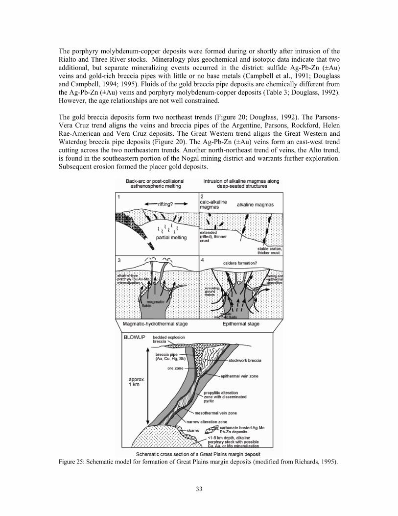
The porphyry molybdenum-copper deposits were formed during or shortly after intrusion of the Rialto and Three River stocks. Mineralogy plus geochemical and isotopic data indicate that two additional, but separate mineralizing events occurred in the district: sulfide Ag-Pb-Zn (±Au) veins and gold-rich breccia pipes with little or no base metals (Campbell et al., 1991; Douglass and Campbell, 1994; 1995). Fluids of the gold breccia pipe deposits are chemically different from the Ag-Pb-Zn (±Au) veins and porphyry molybdenum-copper deposits (Table 3; Douglass, 1992). However, the age relationships are not well constrained. The gold breccia deposits form two northeast trends (Figure 20; Douglass, 1992). The Parsons-Vera Cruz trend aligns the veins and breccia pipes of the Argentine, Parsons, Rockford, Helen Rae-American and Vera Cruz deposits. The Great Western trend aligns the Great Western and Waterdog breccia pipe deposits (Figure 20). The Ag-Pb-Zn (±Au) veins form an east-west trend cutting across the two northeastern trends. Another north-northeast trend of veins, the Alto trend, is found in the southeastern portion of the Nogal mining district and warrants further exploration. Subsequent erosion formed the placer gold deposits.
Figure 25: Schematic model for formation of Great Plains margin deposits (modified from Richards, 1995).
33
It has not been proven that the mineral deposits associated with the Lincoln County porphyry belt or even the Rocky Mountain alkaline belt are genetically related to the igneous rocks; however, it is likely that they are. Supporting evidence for a magmatic origin includes: 1) fluid inclusion and stable isotope data from the Nogal deposits (Douglass, 1992; Douglass and Campbell, 1994, 1995), 2) fluid inclusion, stable isotope, and age data from the Capitan quartz-REE-Th veins (Phillips et al., 1991; Campbell et al., 1995; Dunbar et al., 1996), 3) nature of stock work molybdenum deposits at Sierra Blanca, Three Rivers stock (Thompson, 1968, 1973), 4) close spatial association of mineral deposits with igneous rocks, 5) presence of skarn deposits along the contacts of igneous rocks in other areas of the Lincoln County porphyry belt, and 6) similarity to other deposits at Cripple Creek, Colorado and elsewhere where a magmatic origin is favored (Thompson et al., 1985; Porter and Ripley, 1985; Thompson, 1992; Maynard et al., 1989, 1990; Kelley and Luddington, 2002). Initial strontium isotope ratios from rocks of the Sierra Blanca igneous complex range from 0.7038 to 0.7045 and suggest a deep crustal or upper mantle source (Thompson, 1995). Sulfur isotopes from the Nogal deposits range from -3.1 to -0.3 per mil and suggest a meteoritic source (Thompson, 1995). It is likely that the co-occurrence of Au, Cu, Fe, Mo, F, W, and other elements is the result of several complex magmatic fractionation and differentiation events and tectonic subenvironments, which overlap near the Great Plains margin. The association of lineaments and other major structures with igneous rocks and mineral deposits in New Mexico suggests that near vertical deep-seated fracture systems probably channeled the magmas and resulting hydrothermal fluids (McLemore and Zimmerer, 2009). Once the magmas and fluids reached shallow levels, local structures and wall rock compositions determined the final character and distribution of intrusions and mineralization. Figure 25 summarizes the general formation of GPM deposits in New Mexico. Evidence suggests that complex, multiple intrusions are needed to generate the hydrothermal fluids necessary to produce GPM mineral deposits. The more productive districts, such as those at Nogal and White Oaks occur in areas of complex magmatism that lasted for more than 5 Ma and resulted in intrusions of different ages. In areas such as the Capitan Mountains, where intrusive activity occurred in less than 5 Ma, only localized minor Au, Ag, and REE occurrences are found (McLemore and Phillips, 1991).
OUTLOOK FOR MINERAL RESOURCE POTENTIAL IN THE FUTURE
Gold, silver, base metals Many companies have explored the Nogal mining district looking for gold, silver and base metals. Although resources were identified in several deposits (Table 2), no significant production has occurred since 1965 (Table 1), other than very minor placer gold production. However, as the price of gold increases, companies will continue to re-examine the Nogal district because:
• Some gold and silver have been produced in the past • Gold deposits have been found that are not yet mined and could be in the future (Table 2) • The mineralized trends offer favorable exploration areas • The alkaline igneous rocks and the mineralized veins and breccia pipes indicate potential
for undiscovered deposits in the subsurface. Some of the favorable areas for gold in the Nogal district are in or near the White Mountain Wilderness Area or in the National Forest and likely will require more strict reclamation standards. Detailed geochemical and geophysical surveys are recommended to delineate potential drilling sites for undiscovered deposits in favorable areas outside the wilderness boundary. It is
34
unlikely that any exploration will occur for base metals in this district because these deposits are too small and low grade to be economic. Rare earth elements Rare earth elements (REE) are increasingly becoming more important in our technological society and are used in many of our electronic devices. REE include the 15 lanthanide elements (atomic number 57-71), yttrium (Y, atomic number 39), and scandium (Sc; McLemore, 2010) and are commonly divided into two chemical groups, the light REE (La through Eu) and the heavy REE (Gd through Lu, Sc, and Y). REE are lithophile elements (or elements enriched in the crust) that have similar physical and chemical properties, and, therefore, occur together in nature. However, REE are not always concentrated in easily mined economic deposits and only a few deposits in the world account for current production (Committee on Critical Mineral Impacts of the U.S. Economy, 2008; Hedrick, 2009). The U.S. once produced enough REE for U.S. consumption, but since 1999 more than 90% of the REE required by U.S. industry have been imported from China (Haxel et al., 2002; Kramer, 2010). However, the projected increase in demand for REE in China, India, U.S., and other countries has resulted in new exploration and production from known and undiscovered deposits in the U.S. and elsewhere (Gleason, 2011). REE deposits (associated with Th and Zr) have been reported from New Mexico (McLemore et al., 1988a, b; McLemore, 2010), but were not considered important exploration targets in the past because other deposits in the world met the demand in past years. However, with the projected increase in demand and potential lack of available production from the Chinese deposits, these areas in New Mexico are being re-examined for their REE potential. The Lincoln County porphyry belt has known REE, Th and Zr deposits (i.e., Capitan Mountains, McLemore and Phillips, 1991; Gallinas Mountains, McLemore, 2010; Pajarito, McLemore, 1990, Sherer, 1990) and the alkaline rocks in the Nogal district are similar in composition to alkaline rocks found with known REE deposits in the world, suggesting a potential for REE in the Nogal district. Available geochemical studies and known mineralogy throughout the Nogal district indicate elevated concentrations of REE (Segerstrom et al., 1979; Constantopoulos, 2007; NURE data; this study), but the REE concentrations are not high enough to warrant additional exploration in the district at this time. Fluorite is associated with most REE deposits and fluorite is found throughout the Three Rivers stock (Giles and Thompson, 1972; Segerstrom et al., 1979), suggesting a higher potential for REE in this intrusive complex. Segerstrom et al. (1979) report a single sample from the head of Indian Creek in the SW part of the Wilderness area that contains elevated REE attributed to presence of the mineral xenotime in syentite. One of our samples (F09-35, Appendix 1) is an alkali granite at the head of the eastern Ski Apache chair lift containing 2850 ppm Zr. Zirconium at this level is 5 to 10 times the values in standard granite and rhyolite. This sample also contains slightly elevated Th (28.9 ppm). In thin section, this rock contains abundant zircon. The sample was taken just north of the Mescalero Apache Reservation boundary. Presumably, this phase of unit Ttag, which is coarser grained than most, continues to the south, but we did not attempt to map it out. Any future exploration for REE, Zr, and Th on Nogal Peak quadrangle should focus on the breccia pipes, alkali granite bodies, rhyolites, related dikes, and quartz veins of the Rialto and Three Rivers stock. Tellurium Tellurium (Te) is increasingly used in the manufacture of cadmium-tellurium (Cd-Te) solar cells. In solar cells, the thin films are typically 3-300 microns and approximately 8 grams of Te is used per solar panel, or approximately 696.8 kg of Te for 10 MW of photovoltaic (PV) production (http://greenecon.net/solar-energy-limits-possible-constraints-in-tellurium-production/solar-
35
stocks.html, accessed on May 3, 2010). Tellurium is commonly associated with gold deposits in the Rocky Mountain alkaline belt, but only recently has tellurium become economic interesting. Tellurium can be found as a native metal, but it is more commonly found in more than 40 minerals, many of which are telluride minerals. Calaverite (AuTe2) is the common Au-telluride mineral and sylvanite ((Au,Ag)Te2) is the common Au-Ag telluride mineral. However, tellurium minerals have not been recognized in the Nogal district. Only one deposit has been examined for their tellurium content, the Mudpuppy-Waterdog deposit, where as much as 7.1 ppm Te has been reported from the veins (Fulp and Woodward, 1991b). Analyzed samples from this study indicate Te is very low (Appendix 1). Additional geochemical studies of the deposits including Te are recommended as other investigations are conducted.
HYDROGEOCHEMISTRY
A major impetus for geologic mapping of the Sierra Blanca is to gain better understanding of geology and climate controls on water resources (i.e., Newton, 2011). Thus, at the request of S. Timmons and T. Newton (NMBG&MR), we collected 10 water samples for isotope and chemical analyses that issue from a variety of rock types (Appendix 4). The sample locations span an elevation range of 3355 to 2390 m (11,000 down to 7840 ft) in hopes of showing an elevation gradient with respect to δD/δ18O recharge models. Ice Spring, for example, has the highest discharge elevation of any spring in the quadrangle (Figure 26). Some samples were also collected for tritium to get data on water ages and circulation times. The laboratory data will not be discussed here but the interested reader is encouraged to link with the Tularosa Basin hydrogeology project at http://geoinfo.nmt.edu/resources/water/home.html for more information. For the Nogal Peak quadrangle sampling campaign, we measured field parameters of five spring waters with a model YSI 556 Multiprobe using company procedures. We also collected a 250-ml sample of raw water for anion chemistry and a 125-ml sample of filtered (0.45 micron), acidified (10 drops spec. pure HNO3) water for cation chemistry at these sites. Polypropylene bottles were used for the chemistry samples. We also collected a 1-liter bottle of raw water for tritium (3H) analysis and a 30-ml bottle of raw water for D/18O analysis. For the remaining five sites, we measured temperature and pH with a calibrated digital thermometer with thermocouple and used pH-sensitive papers (see Trujillo et al., 1987 or Goff et al., 2002 for field procedures). A stable isotope sample was also collected at these remaining sites. Flow rates of the 10 samples vary from 200 to ≤1 liters per minute. All collected waters discharge at ≤13.3 °C and all waters are near neutral in pH except for NPW10-5 (pH = 4.3). This latter water is downstream of a zone of intense phyllic (and secondary advanced argillic) alteration and probably contains dilute sulfuric acid from oxidation of pyrite. The waters of three other sites (NPW10-1, -3, and -4) contain visible Fe-oxide precipitates and/or are associated with hydrothermally altered rocks (Figure 27). Five of the 10 water samples were analyzed in situ for several other parameters and for complete chemistry (NPW10-1, -2, -4, -6 and -9). All samples have relatively high ORP (oxidation-reduction potential) and DO (dissolved oxygen) suggesting that they are near surface waters. All samples have low total dissolved solids (TDS) and specific conductivity except for those at the collapsed mine adit (NPW10-1) and Washington Spring (NPW10-4), which both discharge in and near the Rialto stock. The former issues from silicified syenite with quartz veins and the latter flows from a monzonite dike zone. The stock near the springs displays intense phyllic (quartz-pyrite-illite) and secondary advanced argillic (kaolinite-
36
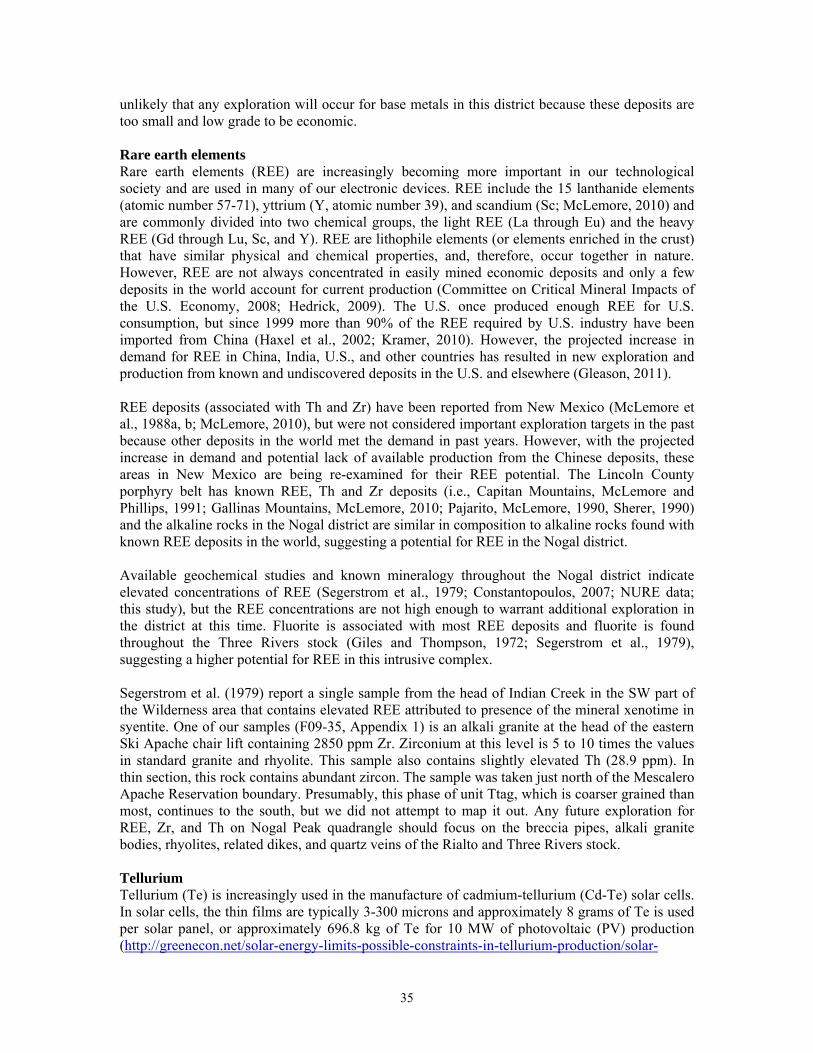
Fig. 26: Photo of Ice Spring, which issues from Three Rivers quartz syenite at 3355 m elevation.
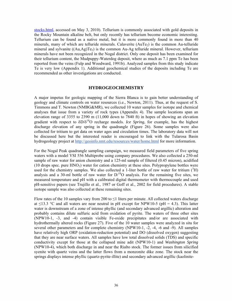
Fig. 27: Photo of Fe-rich cold spring south of Great Western Mine in upper Bluefront Canyon.
37
opal-iron oxide) alteration whereas rocks outside the stock contain propylitic alteration (epidote-chlorite-illite-calcite-quartz-pyrite). There are many other interesting cold springs within the quadrangle that could be sampled in the future. These include:
1. Skull Spring and others within Tanbark and adjacent ravines of the Rialto stock 2. Littleton Spring and others within Littleton and Kraut canyons, Bonito Lake stock 3. Several unnamed springs in the major drainages and ridges of the Three Rivers stock 4. Vanishing Spring within the Ski Apache and “Black Pipe” Spring south of Elk Point
(UTN NAD 27 423419/3698054, 10,420 ft). 5. The numerous springs issuing from Walker volcanic lavas and breccias in the west and
northwest parts of the quadrangle. Of those in the last group, several springs including Canyon Spring and Spring Cabin Spring discharge from the head to the bottom of Spring Canyon that could potentially show both isotopic variations due to elevation changes and chemical variations due to changing lithologies. These sites are accessible by Trail 27.
ROCK DESCRIPTIONS
Note: Due to restricted access on Mescalero Apache tribal lands, the geology of the southern strip of the quadrangle (the portion on Otero County) is adapted from the geologic map of Moore et al. (1988). We field checked their geology along the tribal land boundary and made a few changes appropriate to this map. Igneous rock names follow the general petrographic descriptions of Williams et al. (1954) or, if chemistry is available (Appendix 1), the classification schemes of Cox et al. (1979), De La Roche (1980) and La Bas et al. (1986). Thin section descriptions of about 30 samples appear in Appendix 5. For hand colored maps, a suitable color palette is a Prismacolor® 72 Color Set (indicated for units below) or an equivalent brand. Quaternary Qal Alluvium—Deposits of sand, gravel and silt in main valley bottoms; locally
includes stream terraces, alluvial fans, and canyon wall colluvium; valley floor alluvium is typically finer-grained, silt- and sand-dominated deposits with interbedded gravel beds, whereas low terrace deposits are predominantly sand and gravel. Qal is mostly Holocene in age; maximum thickness of various alluvium deposits is uncertain but may exceed 15 m (Canary yellow – PC916).
Qc (Qco) Colluvium—Poorly sorted slope-wash and-mass wasting deposits from local
sources; mapped only where extensive or where covering critical relations; thickness can locally exceed 15 m (Sand – PC940).
Qta Talus deposits—Angular rock-debris deposits at the heads of high cliffs in
southern map area; composed mostly of syenitic blocks (Moore et al., 1988) (Sand – PC940).
Qt Terrace deposits—Deposits of pebble to boulder size gravel with a sandy matrix
underlying terrace surfaces located approximately 5 to 15 m above local base level; mapped only in upper Salazar Canyon; deposits are only a few meters thick (French grey 20% - PC1069).
38
Qls Landslides—Poorly sorted debris that has moved chaotically down steep slopes; slumps or block slides partially, to completely intact, that have moved down slope; slumps and block slides usually display some rotation relative to their failure plane; ages vary from Holocene to mid- to late-Pleistocene; thicknesses vary considerably depending on the size and nature of the landslide (Beige – PC997).
Qaf Alluvial fans—Typically fan-shaped deposits of coarse to fine gravel and sand,
silt, and clay within and at the mouths of valleys; associated with present drainages and usually not incised; grades into alluvial deposits along main channels; probably Holocene to middle Pleistocene in age; maximum exposed thickness about 15 m (Deco yellow – PC1011).
Qgd Glacial deposits—Bull Lake and Pinedale age glacial deposits at the head of the
north fork Rio Ruidoso on high slopes in southern map area (Moore et al., 1988) (Warm grey 50% - PC1054).
Qbd Glacial boulder deposits—Glacial outwash debris in southeastern quadrangle
composed of unsorted boulders, cobbles and pebbles of crystalline rocks eroded from the Three Rivers Stock (Moore et al., 1988) (French grey 70% - PC1074).
Qoa Older alluvium—Older deposits of alluvium now undergoing erosion in the
mouths of some streams in northwest part of quadrangle; maximum thickness about 15 m (Light peach – PC927).
Plio-Pleistocene QTpg Palomas Gravel—Fans of course syenite-rich gravel deposited in the
southeastern map area (Moore et al., 1988) (Cool grey 20% - PC1060). Oligocene to Upper Eocene Thbx Mineralized hydrothermal breccia—White to pale gray to orange to blue
breccia zones and pipes with secondary mineralization caused by severe hydrothermal alteration in and around the three major stocks; most are probably associated with hydrothermal explosions; most need substantially more investigation. The Blue Front Canyon deposit on SW margin of Bonito Lake stock consists of a 200-m-high faulted pipe of banded quartz-alunite-corundum rock within Walker lavas (Twl); Great Western Mine deposit on north edge of Three Rivers stock consists of three aligned silicified breccia pipes >1 km in length of quartz with minor Fe-oxides and pyrite; Elk Point deposit on NW edge of Three Rivers stock consists of similar silicified breccia zone about 1.5 km long; Parsons deposit in southern Rialto stock contains large blocks and fragments of intrusive rocks in a silicified pipe cut by a later dike; unnamed deposit in Rialto stock east of Nogal Pass consists of two pipes of brecciated, silicified intrusive rocks; age of breccia formation is assumed to post-date emplacement of stocks; thickness and dimensions of each deposit are highly variable (Vermillion – PC921).
Bonito Lake Stock and Associated Dikes Tfsd Fine-grained syenodiorite dikes—Green to dark green, fine-grained dikes with
sparse but conspicuous phenocrysts of white to pink alkali feldspar in groundmass of plagioclase, clinopyroxene and opaque oxides; occasionally has “bird’s eye” appearance; alteration consists of quartz, sericite, chlorite, epidote, actinolite-tremolite, and smudgy magnetite; no obvious calcite; dikes cut Bonito Lake syenite (Tbs) but are not dated and are 1 to 3 m wide (too thin to color).
39
Tbs Bonito Lake syenite to syenodiorite—Gray to salt-and-pepper, medium- to
coarse-grained, hypidiomorphic granular syenite in northeast map area; contains plagioclase, Kspar, minor quartz (≤2%), biotite, hornblende and clinopyroxene (Thompson, 1972; Black, 1978; Constantopoulos, 2007); accessories consist of apatite, sphene, zircon, ilmenite and magnetite; alteration minerals consist of epidote, chlorite, sericite and Fe-oxides; margins of intrusive body are generally dioritic containing more plagioclase and mafic minerals than core syenite; commonly contains aplite dikes about 0.1 to 0.5 m wide consisting of fine-grained quartz, potassium feldspar, minor biotite and rare magnetite; interstitial quartz often has graphic texture with Kspar. K-Ar date on biotite is 26.6 ± 1.4 Ma (Thompson, 1972); maximum exposed thickness about 425 m (Pink – PC929).
Three Rivers Stock and Associated Dikes, Plugs and Flows Ttbrd Biotite rhyolite dikes—Two northeast- to east-trending dikes that cut
“nordmarkite” (Ttsp) and Walker Group lavas (Twl) on the east margin of the quadrangle; part of the NE-trending rhyolite dike swarm further to the east mentioned by Segerstrom et al. (1979, p. 14); dikes are 1 to 3 m wide; consist of white, nearly aphyric, mildly altered rhyolite with sparse phenocrysts of Kspar and biotite in a silicified (or devitrified) groundmass with tiny quartz, Kspar, sericite and smudgy opaque oxides; Kspar phenocrysts are zoned. Preliminary Ar40/39 age on biotite from northern dike is 25.4 ± 0.8 Ma (too thin to color).
Tog Oak Grove rhyolite—Flow of white to gray, aphyric rhyolite on east edge of the
quadrangle just west of Oak Grove campground; contains microphenocrysts of quartz in flow-banded groundmass that is devitrified and spherulitic; lava displays flow-banding with extreme folding; may be contemporaneous with rhyolite dikes above although no biotite is visible; overlies Walker Group breccia (Twb); age unknown; maximum exposed thickness about 20 m (Mulberry – PC995).
Tcp/Tcpd Cone Peak rhyolite—Several small plugs and many thin dikes (Tcpd) of gray to
white, slightly porphyritic rhyolite containing phenocrysts of small quartz, Kspar, biotite and sparse plagioclase; groundmass and phenocrysts usually altered and silicified (Black, 1977). Intrusions occur around NW margin of Three Rivers stock and do not cut the stock. Intrusions cut Walker Group lavas and breccias (Twl and Twb). Age unknown; thickness at Cone Peak is about 40 m (Mulberry – PC995).
Tep Elk Point rhyolite—Plug of gray, flow-banded, porphyritic rhyolite containing
large phenocrysts of Kspar in devitrified to silicified groundmass having smaller crystals of Kspar, quartz, plagioclase, biotite, hornblende, opaque oxides, and rare tiny apatite; plug previously identified as rhyolite by Segerstrom et al. (1979). “Fresh” rhyolite found only at the NW corner of the plug where considerable intrusion breccia is visible; rhyolite is progressively silicified and brecciated further to the south and SE until the original rhyolite texture and mineralogy is lost; cuts Walker Group lavas and breccias (Twl and Twb); in fault contact with Three Rivers stock; age unknown; maximum exposed thickness roughly 200 m in Little Bear Canyon (Mulberry – PC995).
Ttagd Alkali granite dikes—Fine- to coarse-grained, pale pink to pale tan to salt-and-
pepper dikes from 0.5 to 80 m wide; contain Kspar, quartz, minor plagioclase, minor biotite, arfvedsonite, trace sphene, apatite, zircon and opaque minerals. Thin dike on east edge of quadrangle cuts Walker Group lava and breccia (Twl
40
and Twb); other dikes within interior of stock are much thicker and cut various syenite units; ages of various dikes unknown (Carmine red – PC926).
Tsp Syenite Porphyry Plugs—Two small plugs on ridge crest just north of Three
Rivers stock in general vicinity of UTM 421000/3700000; consist of gray syenite with sparse phenocrysts of Kspar, biotite and clinopyroxene in fine-grained devitrified to altered groundmass of Kspar, minor plagioclase and biotite; alteration consists of chlorite, sericite, silica, minor Fe-oxides and epidote; cuts Walker Group lavas and breccias (Twl and Twb); cut by dikes of Tspd and Tbsd; ages unknown but appear to be associated with Three Rivers stock based on mineralogy and proximity; maximum exposed thickness ≤45 m (Blush pink – PC928).
Ttag Alkali granite—Fine- to medium-grained, equigranular to slightly porphyritic,
pale gray to salt-and-pepper granite composed of Kspar, quartz, and minor plagioclase; commonly contains interstitial and graphic intergrowths of quartz-alkali feldspar. Mafic minerals consist of biotite ± arfvedsonite ± aegirine. Accessory minerals consist of apatite, magnetite, ilmenite, sphene and zircon. Some areas contain sparse larger crystals of alkali feldspar. Some zones contain essentially no mafic minerals. Alteration phases consist of epidote, sericite, chlorite and Fe-oxides. This unit forms several, relatively small to large intrusive bodies throughout the stock. According to Giles and Thompson (1972), Segerstrom et al. (1979 and Moore et al. (1988), anomalous molybdenum concentrations (as MoS2) are associated with this unit but we found no veinlets, veins, pods, or streaks of molybdenite during our mapping. Rb-Sr age (whole rock) from unknown site is 26.7 ± 1.2 Ma (Moore et al., 1991); preliminary Ar40/39 date on arfvedsonite from body at top of eastern chair lift, Ski Apache is 27 ± 2 Ma. Maximum exposed thickness is ≥700 m (Carmine red – PC926).
Tthbs Hornblende-biotite syenite plug—Tiny, ≤50-m-diameter plug of white to light
gray, slightly porphyritic syenite; rock is very fresh, containing larger crystals of Kspar and smaller hornblende and biotite in a groundmass of tiny plagioclase, opaque oxides, some quartz, and clinopyroxene; also contains rare tiny zircon and apatite; intrudes syenite; SE edge of plug abuts very small stoped block of hydrothermally altered Walker Group trachyandesite or trachybasalt (Twl); age unknown; thickness unknown (Magenta – PC930).
Ttbsp/Ttbsd Biotite syenite porphyry—Small intrusion and nearby dike (Ttbsd) of pinkish-
gray, sparsely porphyritic syenite; contains large Kspar phenocrysts with microcline twinning in fine-grained, granular groundmass having small Kspar, biotite, a bit of plagioclase and quartz, opaque oxides, and rare tiny apatite and zircon. Intrudes Walker Group lavas, Twl (as roof pendant) and Ttsp (“nordmarkite”); in fault contact with Twl and Twb; age unknown; maximum exposed thickness about 270 m (Magenta – PC930).
Ttcs/Ttqcs Coarse-grained syenite—Light gray, very coarse-grained, hypidiomorphic
granular syenite consisting primarily of “hash” of large Kspar (anorthoclase) surrounded by small interstial Kspar and quartz (some with graphic texture), aegirine, arfvedsonite, opaque oxides, tiny apatite, rare rutile and zircon; no apparent plagioclase; a zone of more quartz-rich syenite (Ttqcs) is found on the east margin of the unit; sporadically contains ≤10 cm enclaves of fine-grained igneous (?) rock; intruded by thin porphyritic dikes of fine-grained, equigranular alkali granite (?) containing Kspar and clinopyroxene phenocrysts and
41
unidentified blue and purple minerals; various units not dated; maximum exposed thickness about 650 m (Process red – PC994).
Ttsag Quartz syenite to alkali granite—Highly variable, but voluminous unit of
medium-grained, light gray to bluish gray, equigranular to porphyritic, quartz syenite to granite; syenite is dominant; contains Kspar (often large and distinctly blue-gray) partly rimmed by other feldspar; blue-gray phenocrysts are most plentiful at higher elevations and western margin in the unit; plagioclase sparse to absent; quartz sparse to ≥10 modal percent; quartz is interstitial and may have graphic texture; contains minor arfvedsonite, aegirine, and/or biotite; some specimens contain augite; accessory minerals are opaque oxides, apatite, sphene, and zircon; may contain minor muscovite; alteration minerals consist of epidote, chlorite, sericite and Fe-oxides. K-Ar date on biotite is 28.1 ± 1.7 Ma (Moore et al., 1988); preliminary Ar40/39 date on Kspar from west contact in Three Rivers canyon is 28.24 ± 0.19 Ma; maximum exposed thickness is ≥850 m (Pink – PC929).
Tts Syenite and syenite porphyry—Medium- to coarse-grained, light gray to very
pale pink, hypidiomorphic granular syenite usually containing abundant large crystals of potassium feldspar and interstitial quartz; graphic texture common; plagioclase sparse to absent; contains minor biotite and arfvedsonite; accessories consist of apatite, sphene, zircon, magnetite and ilmenite; alteration minerals are quartz, chlorite, sericite, minor epidote and Fe-oxides; contains sporadic ≤8 cm enclaves of fine-grained igneous rock. K-Ar age on anorthoclase is 25.8 ± 1.1 Ma (Giles and Thompson, 1972), a date we consider much too young. Cuts unit Ttsp; maximum exposed thickness about 600 m (Deco pink – PC1014).
Ttsp Quartz syenite porphyry—Very distinctive unit of coarse-grained, brownish
gray to rose, quartz syenite (nordmarkite, Williams et al., 1954; Giles and Thompson, 1972) with abundant, large crystals of pinkish Kspar in a granular matrix of Kspar, minor quartz and plagioclase, arfvedsonite, aegirine ± biotite. Kspar phenocrysts may be rimmed by sanidine and plagioclase. Accessory minerals are apatite, zircon, ilmenite and magnetite. Alteration minerals are sericite, chlorite, epidote, and Fe-oxides. Near contacts with country rocks or in the apparent roof zone, the phenocryst content of the syentite may exceed 70%. Contains sporadic ≤10 cm enclaves of fine-grained igneous rock; K-Ar date on arfvedsonite is 29.9 ± 1.8 Ma (Allen and Foord; 1991; Moore et al., 1991); preliminary Ar40/39 age on large Kspar from east of Buck Mountain is 28.95 ± 0.18 Ma; maximum exposed thickness ≥730 m (Blush pink – PC928).
Rialto Stock and Associated Dikes Trm2 Monzonite to quartz diorite—Secondary intrusive phase of Rialto stock
consists of white to gray, weakly porphyritic, fine-grained quartz diorite having phenocrysts of plagioclase in groundmass of plagioclase, minor Kspar, euhedral biotite, hornblende, and small quartz (≤10%). Accessory phases are fine-grained magnetite, ilmenite and apatite. Occurs as extensive swarm of NE-trending dikes and possible sills that intrude stage 1 Rialto syenite and Walker Group metavolcanic rocks (Twl and Twb). Hydrothermal and supergene alteration processes have resulted in pervasive bleaching and limonite-staining with generally strong alteration ranging from phyllic (quartz ± sericite ± pyrite) to locally argillic. Mineralization occurs as ubiquitous fine-grained pyrite (oxidized) and small veins of lead, zinc and molybdenum sulfides (Thompson, 1973) that currently appear as narrow hematite-goethite gossans. Age of unit is yet to be determined; maximum exposed thickness about 280 m (Deco pink – PC1014).
42
Trsd Quartz syenite dike—Broad, NE-trending dike of salt-and-pepper, slightly pink,
medium-grained, hypidiomorphic granular, quartz syenite containing plagioclase, Kspar, quartz, biotite, hornblende, a bit of clinopyroxene and opaque oxides with trace zircon, sphene, and apatite; alteration very minor; occurs on prominent ridge south of Bonito Creek and west of Big Bear Creek; dike is up to 20 m wide; cuts hydrothermally altered Walker Group lavas (Twl and Twb); age unknown (Parma violet – PC1008).
Trm Syenite—Initial (stage 1) intrusion of Rialto stock; greenish gray, medium- to
coarse-grained, hypidiomorphic granular syenite containing plagioclase, Kspar, and sparse anhedral quartz (≤5%); mafic minerals consist of clinopyroxene, hornblende and biotite; accessories consist of sphene, rutile, apatite and magnetite. Propylitic alteration is generally mild to intense near margins of stock or in deep canyon exposures of unit, consisting of epidote, tremolite-actinolite, calcite, chlorite, illite, quartz, adularia, hematite and pyrite; alteration of syenite near core of stock is generally phyllic (quartz, pyrite, sericite) with later overprint of dispersed silica and Fe-oxide staining. K-Ar date on hornblende is 31.4 ± 1.3 Ma (Thompson, 1973); maximum exposed thickness is 300 m (Pink – PC929).
Other Small Intrusions and Plugs Tspg/Tsbx Syenite plugs—Three small plugs on ridge between Aspen and Little Bear
canyons. The northern plug consists of pale pinkish gray, medium-grained, hypidiomorphic granular syenite containing Kspar, plagioclase, biotite, hornblende and opaque oxides; alteration consists of epidote, actinolite (?) and Fe-oxides. The central plug consists of gray syenite porphyry with large Kspar in granular matrix of plagioclase, clinopyroxene, biotite and opaque oxides; alteration is epidote, chlorite and Fe-oxides. The southern plug (Tsbx) consists of gray, silicified, fine- to medium-grained syentite breccia containing clasts of mafic volcanic rocks up to 10 cm long in matrix of altered Kspar, plagioclase, clinopyroxene, biotite and smudgy opaque oxides; alteration is silica, chlorite and epidote (?). The plugs probably represent the top of a small syenite stock; intrude hydrothermally altered Walker Group lavas (Twl); maximum exposed thickness about 35 m; ages unknown (Burnt ochre – PC943).
Tm Monzonite to diorite plugs—Greenish gray, fine- to medium-grained monzonite
to diorite plugs containing abundant plagioclase and sparse to very sparse Kspar; mafic minerals are clinopyroxene and lesser amounts of hornblende and biotite; most specimens show alteration to clay, chlorite, calcite, and quartz ± epidote. Tiny knob west of Nogal Peak cuts Walker Group breccias (Twb) and contains small vugs of amethystine quartz. Small plug in Nogal Canyon intrudes altered Walker lavas (Twl); exposed thickness about 100 m. Lenticular intrusion in SW map area identified by Moore et al. (1988) is overlain by trachybasalt lava and cut by two syenite porphyry dikes (Tspd); exposed thickness about 220 m. Ages of various features are unknown (Dark green – PC908).
Tgd/Tgbx Grizzly Peak diorite—Plug-like body and associated radiating dikes (Tmd) of
greenish-gray, medium- to course-grained, hypidiomorphic granular diorite consisting almost entirely of plagioclase and clinopyroxene; has a small amount of tiny interstitial quartz and Kspar (?); unit is thoroughly altered to chlorite, epidote, sericite, secondary quartz, minor calcite, and smudgy magnetite; cut by small veinlets of epidote and quartz. A small, poorly exposed zone of diorite intrusion breccia (Tgbx) occurs on the slope west of the plug. Unit intrudes
43
hydrothermally altered Walker lavas (Twl). Age unknown; maximum exposed thickness of Grizzly Peak is ≤100 m (Copenhagen blue – PC906).
Tdbp Dark Betty diorite porphyry—Small, circular intrusion on south side of upper
Dark Betty Canyon containing conspicuous phenocrysts and phenocryst clots of white plagioclase ≤1.5 cm long in greenish gray, fine-grained groundmass of plagioclase, clinopyroxene, opaque oxides and rare olivine. Texture of plagioclase phenocrysts closely resembles texture in unit Twtx described below and may be source of some Twtx lavas. Alteration consists of chlorite, epidote, silica and calcite. Intrudes hydrothermally altered Walker lavas (Twl); a highly silicified zone occurs on the SE margin of the intrusion; exposed thickness is about 310 m; age unknown (Indigo blue – PC901).
Tex Feldspathoidal gabbro porphyry—Plug of very dark gray to splotchy black and
white, feldspathoidal gabbro (essexite; Williams et al., 1954; Moore et al., 1988) in southeast corner of map; contains large (≤3 cm) phenocrysts of pinkish potassium feldspar and white plagioclase in a highly altered, medium-grained groundmass of nepheline, clinopyroxene, olivine, biotite and smudgy magnetite; alteration phases consist of epidote, chlorite, sericite, calcite, quartz and Fe-oxides. Intrudes Walker Group lavas and breccias (Twl and Twb); K-Ar date on “fresh” gabbro is 32.8 ± 1.2 Ma (Moore et al., 1988); preliminary Ar40/39 date on hydrothermally altered gabbro is 30.5 ± 0.5 Ma, presumably affected by the adjacent Three Rivers stock. Maximum exposed thickness is 185 m (Lilac – PC956).
Dikes (all generic dikes: Crimson red – PC924) Tspd/Tbsd/ Syenite porphyry dikes—Gray, fine- to medium-grained syenite containing Thsd sparse phenocrysts of potassium feldspar, plagioclase, biotite, clinopyroxene ±
hornblende; a few dikes of this type have hornblende as dominant mafic phase; some dikes more than 10 m wide; intrudes Twl, Twb and Tsp; those in the south map area may be associated with the Three Rivers stock; ages of various dikes unknown.
Tsd Syenite dikes—Light gray, medium to course-grained dikes containing alkali
feldspar, plagioclase, clinopyroxene, hornblende, biotite and sparse quartz; dikes are 1 to 50 m wide; ages unknown.
Tmd/Thmd Monzonite to diorite dikes—Gray to greenish gray, medium- to course-grained
dikes containing plagioclase, clinopyroxene ± hornblende ± biotite; dikes are generally 1 to 6 m wide; rare dikes are more than 25 m wide; ages unknown.
Ttd Porphyritic hornblende trachydacite dikes—An unusual bluish gray, fine-
grained porphyritic dike with NNE trend can be traced as fins or as float for a distance of several kilometers through units Twb and Twl on SW side of quadrangle; contains phenocrysts of plagioclase and hornblende in a groundmass of plagioclase, clinopyroxene, magnetite, apatite and hornblende; dike has variable width of 5 to 50 m. Another dike of porphyritic hornblende trachydacite trends ENE in the vicinity of Argentina Spring.
Tbtd/Thtd Biotite and hornblende trachydacite to alkali rhyolite dikes—Gray to tan,
slightly porphyritic dikes containing sparse phenocrysts of Kspar, plagioclase ± biotite ± hornblende ± quartz; dikes typically 1 to 6 m wide; ages unknown.
44
Ttbd Clinopyroxene-phyric trachybasalt dikes—Greenish black, fine-grained, porphyritic basalt with conspicuous clinopyroxene ≤2 cm in diameter in intersertal groundmass of plagioclase, olivine, clinopyroxene and magnetite; olivine has iddingsite rims; plagioclase is slightly aligned; clinopyroxene is zoned and contains olivine inclusions; alteration consists of quartz, calcite, Fe-oxides, chlorite, and epidote; dikes generally ≤3 m wide; ages of dikes unknown.
Tif Felsite—White, fine-grained, aphyric, felsic dikes, 1 to 5 m wide; ages unknown. Tit Trachyte—Light to dark gray porphyritic dikes with 15 to 25% plagioclase laths
10 to 20 mm long set in an equigranular to fine-grained matrix of dark green pyroxene and feldspar. The plagioclase laths are often distinctively aligned parallel to the margins of the dikes. Dikes are generally 1 to 4 m wide; ages of dikes unknown.
Tita Porphyritic trachyandesite—Dikes and small sills of light gray to purple gray
porphyry with 5 to 15% of 1 to 10 mm diameter plagioclase phenocrysts, dark green pyroxene, black hornblende, opaque oxides ± potassium feldspar; some dikes may grade into more equigranular textures (Tig). Dikes often contain syenitic and sedimentary xenoliths; dikes in center and east of quadrangle are altered to silica, calcite, clay, chlorite and epidote; dikes generally 1 to 12 m wide; ages of dikes unknown.
Tig Alkali gabbro to syenogabbro—Salt-and-pepper, fine- to medium-grained,
equigranular dikes and small sills containing plagioclase and pyroxene phenocrysts; may grade into more porphyritic dikes (Tita); generally 2 to 6 m wide; ages of dikes unknown.
Tim Megacrystal trachyte porphyry—Greenish gray porphyritic dikes and sills with
megacrysts of embayed hornblende and/or green pyroxene that are up to 2 to 4 cm across; groundmass contains hornblende ± biotite; may contain xenoliths of pink coarse-grained syenite; dikes may be up to 20 m across; ages of dikes unknown.
Tis/Tisp Syenite—Pink, medium-grained, equigranular dikes and sill composed of
potassium feldspar, green pyroxene, occasional biotite and sparse quartz; some contain large Kspar (Tisp). Dikes may be up to 20 m across; ages of dikes unknown.
Tic Mafic clot syenite—White sparsely porphyritic dikes with about ±7 %
conspicuous clots of altered mafic minerals; dike rock contains phenocrysts of Kspar and plagioclase in matrix of plagioclase, clinopyroxene and biotite; cuts Tita dikes; ages unknown.
Titb Trachybasalt—Black to gray dikes containing phenocrysts of plagioclase in
groundmass of plagioclase, olivine, clinopyroxene ± phlogopite; dikes may be up to 10 m in width; ages of dikes unknown.
Oligocene to Upper Eocene Sierra Blanca Volcanics
45
Tnt/Tntd Nogal Peak Trachyte—White to pale pinkish gray, slightly porphyritic to aphyric lavas with intercalated flow and flow breccia; at Nogal Peak lavas consist of five flows having a total thickness of 300 m (Thompson, 1972, 1973; see Fig. 6); flows contain phenocrysts of plagioclase in a trachytic matrix of fine plagioclase, clinopyroxene, biotite, hornblende, sparse sanidine and devitrified glass with accessory apatite and magnetite. Alteration minerals include epidote, chlorite, sericite, quartz and Fe-oxides. Some flows include fragments of trachyandesite from underlying units. The contact with the underlying Walker Volcanic Breccia (our name, Twb) appears to be conformable. West and southwest of Nogal Peak, the unit consists of a single flow of gray, slightly porphyritic, medium- to fine-grained lava containing phenocrysts of plagioclase in a trachytic matrix of plagioclase, clinopyroxene, Kspar, biotite (?) and hornblende (?); mafic phases are completely altered to sericite, chlorite, clays, silica, calcite, smudgy opaque oxides and minor limonite. This flow is intruded by dikes (Tntd) of similar mineralogy but coarser texture; maximum exposed thickness of flow is ≤35 m. Rocks of this formation generally overlie Walker Volcanic Breccia (Twb) but flow at Hill 9500 underlies basalt (Twbn). Various flows and dike are not dated but a K-Ar age of 31.8 ± 1.3 Ma (Thompson, 1972) has been obtained on glass from the Church Mountain latite, which occupies a similar stratigraphic position as Nogal Peak Trachyte (Tnt = Peach – PC939; Tntd = Orange – PC918).
Walker Volcanic Breccia (formerly Walker Andesite Breccia of Thompson, 1972, 1973)
Twl Lava-rich unit, undivided—Aphyric to porphyritic lavas consisting of tephrite, alkali basalt, trachybasalt, basaltic trachyandesite, trachyandesite, phonolite and minor trachyte (Moore et al., 1988). The sequence generally becomes more trachytic higher in the section and the proportion of interbedded breccia is ≤40%. Individual flows of distinctive texture and/or mineralogy can be broken out in the winding cliffs of the escarpments along the west and north edges of the quadrangle. Elsewhere, pervasive hydrothermal alteration and poor exposure prevent effective separation of individual flows. Lava at base of unit in western Three Rivers Canyon is tephrite or trachybasalt containing phenocrysts of clinopyroxene in greenish black groundmass of plagioclase, altered olivine, magnetite and devitrified glass; alteration minerals are chlorite, calcite and Fe-oxides. Alteration minerals are epidote, chlorite and clay. Bluish gray lava and flow-breccia sequence in lower Blue Front canyon contains phenocrysts of plagioclase in a highly devitrified groundmass of plagioclase, clinopyroxene and altered phlogopite (?). Light gray slightly porphyritic trachyandesite or trachyte flows midway up the north slope of Brush Canyon contains phenocrysts of hornblende and plagioclase in groundmass of plagioclase, clinopyroxene, magnetite and devitrified glass. Unit also occurs as roof pendants and hornfelsed septa above and between the stocks described above. Near contacts, the volcanic rocks are altered to cordierite- and/or andalusite-bearing, pyroxene hornfels with scattered occurrences of dumortierite and topaz (Giles and Thompson, 1972). Thickness of individual flows is rarely greater than 20 m. Unit is ≥500 m thick on west side of quadrangle, 400 m thick in NE corner of quadrangle, and 475 m thick east of South Fork Rio Bonito. None of the flows of map unit Twl have been dated due to hydrothermal alteration (Jade green – PC1021).
The following subunits, youngest to oldest, have been mapped separately from the undivided Walker lava sequence:
46
Twpd Porphyritic trachydacite east of Highway 532—Gray, porphyritic, slightly trachytic lava containing phenocrysts of Kspar, plagioclase, biotite, opaque oxides and minor quartz in groundmass of tiny plagioclase, clinopyroxene and silicified glass; alteration consists of silica, sericite, chlorite, and smudgy opaque oxides; overlies Walker lavas and breccias (Twl and Twb); occupies same stratigraphic position as Oak Grove rhyolite (Tog) and could conceivably be associated with Three Rivers stock; age unknown; thickness about 20 m (Yellow ochre – PC942).
Twbn Alkali basalt of Hill 9500—Dark greenish gray to black lava and minor scoria
deposits capping hill SSW of Nogal Peak; contains small but conspicuous phenocrysts of clinopyroxene and plagioclase in groundmass of plagioclase, clinopyroxene, iddingsitized olivine, opaque oxides and altered glass; alteration consists of clay, sericite, silica, calcite and chlorite; overlies flow of Nogal Peak Trachyte (Tnt); cut by biotite syenite dike (Tbsd); age unknown; thickness about 15 m (Copenhagen blue – PC906).
Twcd Porphyritic trachydacite north of Argentina Spring—Gray, coarse porphyritic
lava containing large phenocrysts of plagioclase and Kspar (?) in trachytic matrix of plagioclase, clinopyroxene, opaque oxides and devitrified glass; alteration consists of silica, clay, sericite and chlorite; overlies Twfa; age unknown; thickness about 50 m (Yellow orange – PC1002).
Twfa Fine-grained trachydacite north of Argentina Spring—Dark gray to black,
aphanitic, trachytic lavas containing a few very small phenocrysts of plagioclase and biotite in an altered groundmass of plagioclase, clinopyroxene, opaque oxides and tiny Kspar (?); alteration consists of silica, sericite, Fe-oxides and chlorite; underlies Twcd and overlies Twas; age unknown; maximum thickness about 60 m (Lime peel – PC1005).
Twap Basaltic trachyandesite of Argentina Peak—Dark gray to reddish black,
medium-grained lavas containing a few small phenocrysts of plagioclase in an altered, felty groundmass of plagioclase, clinopyroxene, olivine, and magnetite; alteration consists of hematite, limonite, silica, sericite and chlorite; southern part of unit contains probable vent area; overlies Twf and Twas; age unknown; thickness about 60 m (Grass green – PC909).
Twsp/Twspd Aphyric trachyandesite of Spring Point—Eroded plug, associated flows and
east-trending dike (Twspd) of dark gray to black trachyandesite; contains very rare phenocrysts of plagioclase in very fine-grained altered groundmass of plagioclase, magnetite, clinopyroxene, and rare biotite; alteration consists of silica, sericite, chlorite and a little hematite; overlies Twf; age unknown; maximum exposed thickness about 50 m (Parrot green – PC1006).
Twbt Basaltic trachyandesite of Hill 9395—Dark gray to black, sparsely porphyritic,
fine-grained lavas containing phenocrysts of plagioclase in completely altered groundmass of tiny plagioclase, clinopyroxene, olivine and opaque oxides; contains sparse gabbroic xenoliths; alteration consists of silica, sericite, chlorite, Fe-oxides and epidote; Hill 9395 is probable vent area; hill to south capped by Twbt is eroded flow; overlies Twbb; age unknown; maximum thickness about 20 m (Aquamarine – PC905).
47
Twbb/Twal Basaltic trachyandesite flows, agglutinate and breccia—Lumped unit of gray thin driblet flows and dark red agglutinate, spatter, scoria, breccia and tuff representing multiple eruptive events; most specimens contain plagioclase, clinopyroxene and olivine; upper material is probably associated with lavas of Hill 9395; contains thin bed (±3 m) of white accretionary lapilli tuff layers (Twal) in ravine east of Trail 25; several layers contain balls ≤0.5 cm in diameter of opalized mud with a few tiny feldspar and magnetite crystals; unit Twbb underlies lavas of Twbt and is cut by various dikes and plugs; overlies units Twf, Twsc and Twtb; ages of various deposits unknown; maximum thickness about 100 m (Twbb = Burnt ochre – PC943; Twal = Poppy red – PC922).
Twf Aphyric trachybasalt south of Argentina Spring—Multiple flows of dark gray
to greenish gray aphyric basalt with sparse phenocrysts of plagioclase and clinopyroxene in altered groundmass of plagioclase, clinopyroxene, opaque oxides and olivine; alteration consists of silica, Fe-oxides, sericite, chlorite and epidote (?); unit extends south to Spring Point area; underlies Twbb, Twsp and Twap; overlies Twas and Twsc; ages of various flows unknown; maximum exposed thickness about 130 m (Peacock – PC1027).
Twas Argentina Spring tuff—Black to gray to pale tan, slightly welded to densely
welded, lithic-rich, biotite rhyolite ash flow tuff (ignimbrite); contains flattened welded pumice (fiamme) with maximum aspect ratio of ≥25:1; bottom of unit resembles reomorphic tuff (Branney et al., 2008); small abundant phenocrysts consist of sanidine, plagioclase, biotite, opaque oxides, ≤2 % quartz and tiny altered hornblende (?) in banded eutaxitic groundmass; some bands contain spherulites; pumice, spherulites and bands contain deuteric tridymite and fine alkali feldspar; alteration consists of silica, sericite and Fe-oxides; lithic fragments consist of white chert to fine-grained sandstone and a variety of light to dark-colored volcanic rocks; also contains flattened mafic clots; upper layers of unit conceivably represent another tuff (Bucky Pasture tuff) in Godfrey Hills to west; source of tuff is unclear; underlies Twf, Twap, Twfa, and Tnt; interbedded in Twb; overlies Twsc and Twl; age unknown; maximum thickness is roughly 100 m (Poppy red – PC922).
Twsc Spring Canyon trachydacite (formerly trachyandesite of Spring Canyon,
Thompson, 1972, 1973)—Thick, cliff-forming lava of aphyric, flow-banded trachydacite; contains very sparse small phenocrysts of plagioclase in felty groundmass of tiny plagioclase, clinopyroxene, biotite and magnetite; some specimens are spotted with clots of tiny plagioclase; biotite is difficult to find at many locations; alteration consists of minor quartz, sericite and Fe-oxides; vent area for unit is just east of Hill 9350; overlies various Walker lavas and breccias (Twl and Twb); underlies Twas, Twf and Twbb; age unknown; maximum exposed thickness near vent is 110 m (Goldenrod – PC1034).
Twtt Porphyritic trachydacite tuff east of Little Bear Canyon—Possible eroded
vent of brownish gray, porphyritic, fragmental tuff; caps small hill on ridge north of Cone Peak; contains phenocrysts of plagioclase, Kspar (?), magnetite, very altered biotite and hornblende, and rare quartz; lithics consist of mafic volcanic rocks. Tuff is quite altered containing silica, sericite, chlorite, smudgy opaque oxides, other Fe-oxides and sparse epidote; overlies Walker lavas and minor
48
interbedded breccias (Twl); age unknown; thickness about 30 m (Sunburst yellow – PC917).
Twpa Porphyritic trachyandesite—Circular, vent-like body of dark gray, massive to
scoriaceous trachyandesite with 0.5 cm long phenocrysts of plagioclase in groundmass of plagioclase, clinopyroxene and altered glass; surrounded by hydrothermal breccia at Great Western Mine; alteration consists of clay, silica, Fe-oxides, and chlorite; maximum exposed thickness about 40 m; age unknown (Apple green – PC912).
Twtx Plagioclase porphyritic trachybasalt to basaltic trachyandesite—Distinctive
group of related lavas distributed throughout north and west quadrangle; consists of dark gray to gray porphyritic lavas that contain large jackstraw plagioclase and plagioclase clots; typical specimens contain 15-20% elongate plagioclase laths up to 2 cm long in a groundmass of plagioclase, clinopyroxene, altered olivine, opaque oxides and glass. Lava in lower Nogal Canyon (NE corner of quadrangle) contains additional groundmass phlogopite (?); alteration consists of silica, calcite, sericite, chlorite, epidote, and Fe-oxides. Between upper Barber Ridge and Brush Canyon areas, Twtx consists of two superimposed lava flows separated by layer of Twba; stratigraphic relations elsewhere are uncertain, although the unit probably occurs in the central part of the Walker lava package (Twl); ages of various flows unknown; maximum thickness is roughly 25 m (Violet – PC932).
Twba Porphyritic trachyandesite—Black to gray to blue-gray flows and flow
breccias of porphyritic trachyandesite containing phenocrysts of plagioclase ± Kspar in groundmass of plagioclase, clinopyroxene ± hornblende ± biotite and devitrified glass; generally displays argillic to weak propylitic alteration; overlies Twb in northwest slopes of quadrangle; interbedded with both Twtx and Twtb; various flows not dated; maximum exposed thickness about 245 m (True blue – PC903).
Twtb Trachybasalt and tephrite—Dark gray, fine-grained trachybasalt to tephrite
lavas that form conspicuous thin (≤20 m) shelves within unit Twb described below and forms a package of flows (often with spotted texture) and interbedded breccias in the northwest part of the quadrangle; flows interbedded in Twb are equivalent to unit Tvtf of Moore et al., (1988); usually contains small phenocrysts of clinopyroxene ± iddingsitized olivine; groundmass consists of plagioclase, augite, magnetite, apatite, olivine ± biotite ± nepheline; generally displays argillic to weak propylitic alteration; overlies Cub Mountain Formation (Tcm) in the SE corner of quadrangle; individual flows not dated; maximum exposed thickness about 260 m (Imperial violet – PC1007).
Twb/Twbc Breccia-rich unit, undivided—Purple gray to reddish brown volcanic breccia
consisting of flow breccia, debris flows, mudflows, minor pyroclastic deposits, minor lava flows and subordinate vent breccia; clasts consist primarily of aphyric to porphyritic tephrite, trachybasalt and trachyandesite (unit Tsb of Thompson, 1972, 1973). Typical breccia fragments are 5 to 20 cm in diameter although some are more than 1 m across; breccia fragments generally constitute more than 50% of the rock; most fragments are rimmed with earthy red hematite. The breccia matrix is fine-grained containing alteration products of Fe-oxides, clay, zeolites, calcite and chlorite ± epidote. An analysis of a large clinopyroxene-porphyritic clast from a thick monolithologic breccia in lowermost Spring Canyon area (west
49
end of cross section A-A’) is basaltic trachyandesite. Base of unit is not exposed throughout most of Nogal Peak quadrangle. Maximum thickness is at least 550 m. Another breccia-rich horizon occurs beneath the Nogal Peak trachyte near the northern edge of the quadrangle. This horizon consists of roughly 150 m of purple gray to reddish gray volcanic breccia with 25% interlayered lava flows of alkali basalt to trachyte composition and is equivalent to a roof pendant of volcanic breccia overlying the NW portion of the Rialto Stock. Some areas of breccia particularly rich in agglutinate, scoria and spatter are mapped separately (Twbc). Age of the lower breccia is unknown but is estimated to be between 38 and 32 Ma (Thompson, 1972; Moore et al., 1991) (Twb = French grey 50% - PC1072; Twbc = Terra cotta – PC944).
Late Eocene Tsc Sanders Canyon Formation—Gray to purple gray volcaniclastic sediments
consisting of sandstone, mudstone and minor conglomerate (Cather, 1991); provenance of most volcanic detritus is thought to be derived from intermediate composition volcanic sources to the southwest; contains some interfingering lenses of Sierra Blanca derived pebbles and cobbles near the top of unit; contact with overlying Walker breccia (Twb) is gradational; contact with underlying Cub Mountain Formation (Tcm) is also somewhat gradational; type reference section for Sanders Canyon Formation (Tcm) occurs in vicinity of Chavez Canyon in northwest map area; age is thought to be Eocene; thickness in reference section is 150 m (Burnt ochre – PC943).
Eocene Tcm Cub Mountain Formation—Sediments composed of interlayered, white to
yellowish brown arkosic sandstone and red, maroon, and greenish gray mudstone, siltstone and fine-grained sandstone (Bodine, 1956; Moore et al., 1988). Unit contains thin lenses of chert, quartzite-pebble conglomerate and silicified wood. Unconformably overlain by units Tsc, Twb, and Twtb. Age is thought to be Eocene (Cather, 1991). Exposed thickness in map area is roughly 65 m (Goldenrod – PC1034).
Upper Cretaceous Kmv Mesa Verde Group—Interbedded, light gray, yellowish gray, and reddish gray,
massive to medium-bedded, fine- to medium-grained sandstone of continental margin or overbank river deposit origin (Moore et al, 1988); medium-dark gray carbonaceous siltstone; and a few coal beds in carbonaceous siltstone; exposed only in extreme SW corner of quadrangle where thickness is roughly 30 m (True green – PC910).
Ku Cretaceous rocks, undivided (cross sections only)—Undivided stack of
sedimentary rocks consisting of Mesa Verde Group (Upper Cretaceous), Mancos Shale (middle to upper Cretaceous), and Dakota sandstone (lower to middle Cretaceous); see Rawling, 2004b for distinguishing characteristics of each unit. Most of this stack is not exposed on Nogal Peak quadrangle. Aggregate thickness is about 680 m (Rawling, 2004b) (True green – PC910).
Triassic TRsr Santa Rosa Formation (cross section B-B’ only)—Gray to bluish gray
limestone and dolomite; unit is not exposed on Nogal Peak quadrangle; estimated thickness ≤45 m; see Rawling, 2004b for distinguishing characteristics (Cool gray 70% - PC1065).
50
Permian Pu Permian rocks, undivided (cross section B-B’ only)—Undivided stack of
sedimentary rocks consisting of Grayburg Formation (upper Permian), San Andres Formation (middle to upper Permian), and Yeso Formation (middle Permian); this stack is not exposed on Nogal Peak quadrangle; estimated thickness ≤925 m; see Rawling, 2004b for distinguishing characteristics (Light aqua – PC992).
51
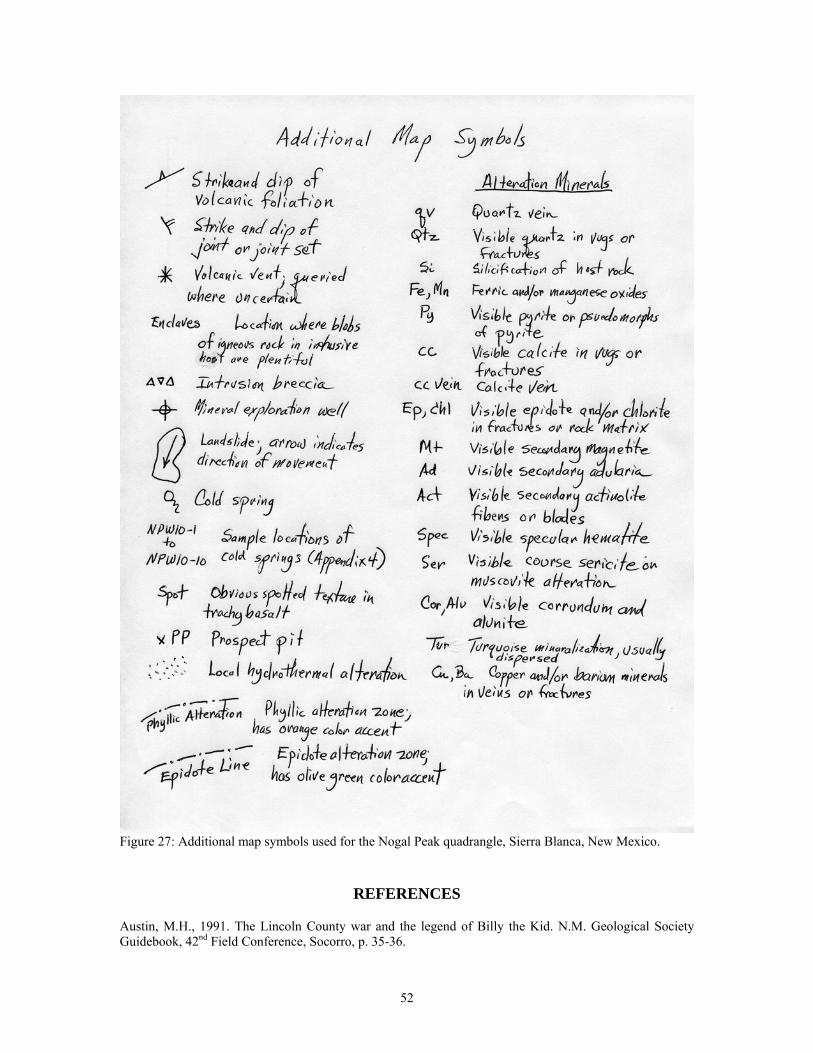
Figure 27: Additional map symbols used for the Nogal Peak quadrangle, Sierra Blanca, New Mexico.
REFERENCES
Austin, M.H., 1991. The Lincoln County war and the legend of Billy the Kid. N.M. Geological Society Guidebook, 42nd Field Conference, Socorro, p. 35-36.
52
Allen, M.S. and Foord, E.E., 1991. Geological, geochemical and isotopic characteristics of the Lincoln County porphyry belt, New Mexico: Implications for regional tectonics and mineral deposits, in (Barker, J.M., Kues, B.S., Austin, G.S., Lucas, S.G., eds.), Geology of the Sierra Blanca, Sacramento and Capitan Ranges, New Mexico. New Mexico Geological Society, Guidebook 42, p. 97-113. Bartsch-Winkler, S.B. and Donatich, A.J., eds., 1995. Mineral and Energy Resources of the Roswell Resource Area, East-Central New Mexico. U.S. Geological Survey, Bulletin 2063, 145 p. Barton, M.D., Ilchik, R.P., and Marikos, M.A., 1991. Metasomatism, in (Kerrick, D.M., ed.) Contact Metamorphism - Reviews in Mineralogy, Vol. 26. Mineralogical Society of America, Washington, D.C., p. 321-350. Berry, V.P., Nagy, P.A. Spreng, N.W., Banes, C.W., and Smouse, D., 1981. Tularosa quadrangle, New Mexico. U.S. Department of Energy, GJO-014(82), 22 p. Black, K.D., 1977a. Geology and uranium mineralization of the Cone Peak rhyolite, Lincoln County, New Mexico. Geological Society America, Abstracts with Programs, v. 9, no. 6, p. 709. Black, K.D., 1977b. Petrology, alteration, and mineralization of two Tertiary intrusives, Sierra Blanca igneous complex, New Mexico. M.S. thesis, Colorado State University, Fort Collins, 124 pp. Bodine, M.W., Jr,. 1956.Geology of the Capitan coal field, Lincoln County, New Mexico. N.M. Bureau of Mines and Mineral Resources, Circular 35, 27 pp. Bonham, H.F., Jr., 1988. Models for volcanic-hosted epithermal precious metal deposits, in Bulk mineable precious metal deposits of the western United States. Geological Society of Nevada, Symposium Proceedings, p. 259-271. Branney, M.J., Bonnichsen, B., Andrews, G.D.M., Ellis, B., Barry, T.L., and McCurry, M., 2008. ‘Snake River (SR)-type’ volcanism at the Yellowstone hotspot track: distinctive products from unusual, high-temperature silicic super-eruptions. Bulletin of Volcanology, v. 70, p. 293-214. Brazie, M.E., 1979. An assessment of runoff and erosion and the possible effects of mining operations in the Nogal Creek drainage basin, Lincoln County, New Mexico. M.S. thesis, Colorado School of Mines, Golden, CO, 126 p. Briggs, J.P., 1983. Mineral investigation of an addition to the White Mountain Wilderness, Lincoln County, New Mexico. U.S. Bureau Mines, MLA-33-83, 11 p. Browne, P.R.L., 1978. Hydrothermal alteration in active geothermal fields. Annual Reviews of Earth and Planetary Science, v. 6, pp. 229–250. Browne, P.R.L., 1982. Hydrothermal Alteration, in (Hochstein, M.P, ed.) Introduction to Geothermal Prospecting. Geothermal Institute, University of Auckland, New Zealand, p. 85-89. Campbell, A.R., Banks, D.A., Phillips, R.S., and Yardley, B.W.D., 1995. Geochemistry of the Th-U-REE mineralizing fluid, Capitan Mountains, New Mexico, USA. Economic Geology, v. 90, p. 1273-1289. Campbell, A.R., Porter, J.A., and Scott E. Douglass, S.E., 1991. Fluid inclusion investigation of the mid-Tertiary Helen Rae gold mine, Nogal district, New Mexico, in (Barker, J.M., Kues, B.S., Austin, G.S., Lucas, S.G., eds.), Geology of the Sierra Blanca, Sacramento and Capitan Ranges, New Mexico. New Mexico Geological Society, Guidebook 42, p. 317-321. Cather, S.M., 1991. Stratigraphy and provenance of Upper Cretaceous and Paleogene strata of the western Sierra Blanca basin, New Mexico, in (Barker, J.M., Kues, B.S., Austin, G.S., Lucas, S.G., eds.), Geology of
53
the Sierra Blanca, Sacramento and Capitan Ranges, New Mexico. New Mexico Geological Society, Guidebook 42, p. 265-275. Cikoski, C.T., Koning, D.J., Kelley, S.A., and Zeigler, K., 2011. Preliminary geologic map of the Church Mountain quadrangle, Lincoln County, New Mexico. N.M. Bureau of Geology and Mineral Resources Open-file geologic map OF-GM-XXX: scale 1:24,000. Committee on Critical Mineral Impacts of the U.S. Economy, 2008. Minerals, Critical Minerals, and the U.S. Economy. Committee on Earth Resources, National Research Council, ISBN: 0-309-11283-4, 264 p., http://www.nap.edu/catalog/12034.html. Constantopoulos, J., 2007. Geochemistry of the Bonito Lake stock, Lincoln County, New Mexico: Petrogenesis and hydrothermal alteration. Rocky Mountain Geology, v. 42, p. 137-155. Cox, K.G., Bell, J.D., and Pankhurst, R.J., 1979. The Interpretation of Igneous Rocks. Allen and Unwin, London, 450 p. Dayton, S.H., 1988. Exploration roundup—projects. Engineering and Mining Journal, v. 189, no 3, p. 119-131. De la Roche, H., Leterrier, J., Grandeclaude, P., and Marchal, M., 1980. A classification of volcanic and plutonic rocks using R1R2-diagram and major element analyses – Its relationships with current nomenclature. Chemical Geology, v. 29, p. 183-210. Douglass, S.E., 1992. Characterization of alkaline rock-hosted precious and base metal mineralization in the Nogal mining district, Lincoln County, New Mexico. M.S. thesis, New Mexico Institute of Mining and Technology, Socorro, 122 p. Douglass, S.E., and Campbell, A.R., 1994. Characterization of alkaline rock-related mineralization in the Nogal Mining District, Lincoln County, New Mexico. Economic Geology, v. 89, p. 1306-1321. Douglass, S.E. and Campbell, A.R., 1995. Characterization of alkaline rock-related mineralization in the Nogal mining district, Lincoln County, New Mexico, Reply. Economic Geology, v. 90, no. 4, p. 985-987. Elston, W.E., 1991. The Capitan dike-and-sill swarm (Lincoln County, New Mexico) revisited, in (Barker, J.M., Kues, B.S., Austin, G.S., Lucas, S.G., eds.), Geology of the Sierra Blanca, Sacramento and Capitan Ranges, New Mexico. New Mexico Geological Society, Guidebook 42, p. 72-74. Eng, S.L., 1991. Ore mineralogy and paragenesis, Great Western Mine, Lincoln County, New Mexico, in (Barker, J.M., Kues, B.S., Austin, G.S., Lucas, S.G., eds.), Geology of the Sierra Blanca, Sacramento and Capitan Ranges, New Mexico. New Mexico Geological Society, Guidebook 42, p. 51-52. Fellah, K., 2011. Petrogenesis of the Mount Taylor volcanic field and comparison with the Jemez Mountains volcanic field, New Mexico. MS thesis, Washington State University, Pullman, 98 p. File, L. and Northrop, S.A., 1966. County, township, and range locations of New Mexico's mining districts. New Mexico Bureau of Mines and Mineral Resources, Circular 84, 66 p. Fulp, M.S. and Woodward, L.A., 1991a. Mineral deposits of the New Mexico alkalic province. Geological Society of America, Abstracts with Programs, v. 23, p. 23. Fulp, M.S. and Woodward, L.A., 1991b. The Mudpuppy-Waterdog prospect, an alkalic copper-gold porphyry system in the Nogal-Bonito mining district, Lincoln County, New Mexico, in (Barker, J.M., Kues, B.S., Austin, G.S., Lucas, S.G., eds.) Geology of the Sierra Blanca, Sacramento and Capitan Ranges, New Mexico. New Mexico Geological Society, Guidebook 42, p. 327-328.
54
Gander, M.J., 1982. The geology of the northern part of the Rialto stock, Sierra Blanca igneous complex, New Mexico. M.S. thesis, Colorado State University, Fort Collins, 132 pp. Giles, D.L., and Thompson, T.B., 1972. Petrology and mineralization of a molybdenum-bearing alkalic stock, Sierra Blanca, New Mexico. Geological Society of America Bulletin, v. 83, p. 2129-2148. Gleason, W., 2011. Mountain Pass Mine: At the heart of the rare earths resurgence. Mining Engineering, v. 63, p. 33-37. Goff, F., and Gardner, J.N., 1994. Evolution of a mineralized geothermal system, Valles caldera, New Mexico. Economic Geology, v. 89, p. 1803-1832. Goff, F., Kelley, S.A., Osburn, G.A., Lawrence, J.R., Goff, C.J., Ferguson, C., McIntosh, W.C., Fellah, K., Dunbar, N.W., and Wolff, J.A., 2010. Evolution of Mount Taylor composite volcano, New Mexico. Abstract, New Mexico Geology, v. 32(2), p. 63. Goff, F., Bergfeld, D., Janik, C.J., Counce, D., and Murrell, M., 2002. Geochemical data on waters, gases, scales, and rocks from the Dixie Valley region, Nevada. Los Alamos National Laboratory, Report LA-13972-MS, 71 pp. Goodell, P.C., Lueth, V.W., and Gresock, M., 1998. Lazulite occurrences in southern New Mexico. New Mexico Geology, May, v. 20, p. 65. Griswold, G.B., 1959. Mineral deposits of Lincoln County, New Mexico. New Mexico Bureau of Mines and Mineral Resources, Bulletin 67, p. 1-117. Griswold, G.B., 1964. Mineral resources of Lincoln Count, in (Ash, S. R. and Davis, L. V., eds.), Ruidoso Country. New Mexico Geological Society, Guidebook 15, p. 148-151. Griswold, G.B. and Missaghi, F., 1964. Geology and geochemical survey of a molybdenum deposit near Nogal Peak, Lincoln County, New Mexico. New Mexico Bureau of Mines and Mineral Resources, Circular 67, 29 p. Haxel, G.B., Hedrick, J.B., and Orris, G.J., 2002. Rare earth elements—critical resources for high technology. U.S. Geological Survey, Fact Sheet 087-02, 4 p., http://pubs.usgs.gov/fs/2002/fs087-02/fs087-02.pdf. Hedrick, J.B., 2009. Rare earths (advanced release). U.S. Geological Survey, 2007 Minerals Yearbook, 20 p. Hollister, V.F., 1978. Porphyry molybdenum deposits, in (A. Sutukov, ed.) International Molybdenum Encyclopedia 1778-1978, v. 1, Resources and production. Santiago, Chile, Alexander Sutukov, Internet Publications, p. 270-288. Johnson, M. G., 1972. Placer gold deposits of New Mexico. U.S. Geological Survey, Bulletin 1348, 46 p. Jones, F.A., 1904. New Mexico mines and minerals. Santa Fe, New Mexican Printing Company, 349 p. Kelley, K.D. and Luddington, S., 2002. Cripple Creek and other alkaline-related gold deposits in the southern Rocky Mountains, USA: influence of regional tectonics. Mineralium Deposita, v. 37, p. 38-60. Kelley, V.C., and Thompson, T.B., 1964. Tectonics and general geology of the Ruidoso-Carrizozo region, central New Mexico. N.M. Geological Society Guidebook, 15th Field Conference, Socorro, p. 110-121.
55
Kelley, S.A., Kempter, K. Koning, D., Goff, F., 2011. Preliminary geologic map of the Godfrey Peak quadrangle, Lincoln and Otero counties, New Mexico. N.M. Bureau of Geology and Mineral Resources, open-file geologic map XXX, 1:24,000 scale. Korzeb, S.L. and Kness, R.F., 1992. Mineral resource investigation of the Roswell Resource Area, Chavez, Curry, DeBaca, Guadalupe, Lincoln, Quay and Roosevelt Counties, New Mexico. U. S. Bureau of Mines, Open-file Report MLA 12-92, 220 p. Kramer, D., 2010. Concern grows over China’s dominance of rare-earth metals. Physics Today, May, p. 22-24. Krauskopf, K.B., 1979. Introduction to Geochemistry. McGraw-Hill, New York, 617 pp. La Bas, M.J., Le Maitre, R.W., Streckeisen, A., and Zanettin, B., 1986. A chemical classification of volcanic rocks based on the total alkali-silica diagram. Journal of Petrology, v. 27, p. 745-750. Lindgren, W., Graton, L.C., and Gordon, C.H., 1910. The ore deposits of New Mexico. U.S. Geological Survey, Professional Paper 68, 361 p. Lucas, S.G., Cather, S.M., Sealy, P., and Hutchison, J.H., 1989. Stratigraphy, paleontology, and depositional systems of the Eocene Cub Mountain Formation, Lincoln County, New Mexico – A preliminary report. New Mexico Geology, v. 11, p. 11-17. Maynard, S.R., Martin, K.W., Nelson, C.J., and Schutz, J.L., 1989. Geology and gold mineralization of the Ortiz Mountains, Santa Fe County, New Mexico. Society of Mining Engineers, Preprint No. 89-43, 9 p. Maynard, S.R., Nelson, C.J., Martin, K.W., and Schutz, J.L., 1990. Geology and gold mineralization of the Ortiz Mountains, Santa Fe County, New Mexico. Mining Engineering, August, p. 1007-1011. McLemore, V.T., 1990. Background and perspectives on the Pajarito Mountains yttrium-zirconium deposit, Mescalero Apache Indian Reservation, Otero County, New Mexico. New Mexico Geology, v. 12, p. 22. McLemore, V.T., 1991. Pajarito Mountain yttrium-zirconium deposit, Mescalero Apache Indian Reservation, Otero County, New Mexico. in (Barker, J.M., Kues, B.S., Austin, G.S., Lucas, S.G., eds.) Geology of the Sierra Blanca, Sacramento and Capitan Ranges, New Mexico. New Mexico Geological Society, Guidebook 42, p. 30-32. McLemore, V.T., 1991. Base- and precious-metal deposits in Lincoln and Otero Counties, New Mexico, in (Barker, J.M., Kues, B.S., Austin, G.S., Lucas, S.G., eds.) Geology of the Sierra Blanca, Sacramento and Capitan Ranges, New Mexico. New Mexico Geological Society, Guidebook 42, p. 305-309. McLemore, V.T., 1996. Great Plains Margin (alkalic-related) gold deposits in New Mexico, in (Cyner, A.R. and Fahey, P.L., eds.) Geology and ore deposits of the American Cordillera. Geological Society of Nevada Symposium Proceedings, Reno/Sparks, Nevada, April 1995, p. 935-950. McLemore, V.T., 2001. Silver and gold in New Mexico. New Mexico Bureau of Geology and Mineral Resources, Resource Map 21, 60 p. w/1:1,000,000 scale. McLemore, V.T., 2008. Potential for Laramide porphyry copper deposits in southwestern New Mexico. N.M. Geological Society Guidebook, 59th Field Conference, Socorro, p. 141-150. McLemore, V.T., 2010, Geology and mineral deposits of the Gallinas Mountains, Lincoln and Torrance Counties, New Mexico; preliminary report: New Mexico Bureau of Geology and Mineral Resources, Open-file report OF-532, 92 p., http://geoinfo.nmt.edu/publications/ openfile/downloads/OFR500-599/526-550/532/ofr_532.pdf.
56
McLemore, V.T., Hoffman, G., Smith, M., Mansell, M., and Wilks, M., 2005a. Mining districts of New Mexico. New Mexico Bureau of Geology and Mineral Resources, Open-file Report 494, CD-ROM. McLemore, V. T., Krueger, C. B., Johnson, P., Raugust, J. S., Jones, G.E., Hoffman, G.K. and Wilks, M., 2005b. New Mexico Mines Database. Society of Mining, Exploration, and Metallurgy, Mining Engineering, February, p. 42-47. McLemore, V.T., North, R.M., and Leppert, S., 1988a. Rare-earth elements (REE), niobium and thorium districts and occurrences in New Mexico. New Mexico Bureau of Mines and Mineral Resources, Open-file Report OF-324, 28 p. McLemore, V.T., North, R.M., and Leppert, S., 1988b. Rare-earth elements (REE) in New Mexico. New Mexico Geology, v. 10, p. 33-38. McLemore, V.T. and Phillips, R.S., 1991. Geology of mineralization and associated alteration in the Capitan Mountains, Lincoln County, New Mexico, in (Barker, J.M., Kues, B.S., Austin, G.S., Lucas, S.G., eds.) Geology of the Sierra Blanca, Sacramento and Capitan Ranges, New Mexico. New Mexico Geological Society, Guidebook 42, p. 291-298. McLemore, V.T. and Zimmerer, M., 2009. Magmatic activity and mineralization along the Capitan, Santa Rita, And Morenci Lineaments, in The Chupadera Mesa Area, Central New Mexico. New Mexico Geological Society Guidebook 60, p. 375-386. Meyer, C. and Hemley, J.J., 1967. Wall rock alteration, in (Barnes, H.L., ed.) Geochemistry of Hydrothermal Ore Deposits. Holt, Rinehart and Winston, New York, p. 166-235. Miyashiro, A., 1978. Nature of alkalic volcanic rock series. Contributions to Mineralogy and Petrology, v. 66, p. 91-104. Moore, S.L., Foord, E.E., Meyer, G.A., and Smith, G.W., 1988. Geologic map of the northwestern part of the Mescalero Apache Indian Reservation, Otero County, New Mexico. U.S. Geological Survey, Miscellaneous Investigations Map I-1895, 1:24,000 scale, color. Moore, S.L., Thompson, T.B., and Foord, E.E., 1991. Structure and igneous rocks of the Ruidoso region, New Mexico, in (Barker, J.M., Kues, B.S., Austin, G.S., Lucas, S.G., eds.) Geology of the Sierra Blanca, Sacramento and Capitan Ranges, New Mexico. New Mexico Geological Society, Guidebook 42, p. 137-145. Mutschler, F.E., Griffin, M.E., Stevens, D.S. and Shannon, S.S., Jr., 1985. Precious metal deposits related to alkaline rocks in the North American Cordillera-an interpretive review. Transactions Geological Society of South America, v. 88, p. 355-377. Mutschler, F.E., Mooney, T.C., and Johnson, D.C., 1991. Precious metal deposits related to alkaline igneous rocks-a space-time trip through the Cordillera. Mining Engineering, v. 43, p. 304-309. Newton, T., 2011. The Sacramento Mountains hydrogeology study: how geology and climate affect our water resources. New Mexico Earth Matters, Winter 2011, 4 p. Paterson, S.R., Vernon, R.H., and Fowler, T.K., 1991. Aureole Tectonics, in (Kerrick, D.M., ed.) Contact Metamorphism - Reviews in Mineralogy, Vol. 26. Mineralogical Society of America, Washington, D.C., p. 673-722. Pearce, J.A., Harris, N.B.W. and Tindle, A.G., 1984. Trace element discrimination diagrams for the tectonic interpretation of granitic rocks. Journal of Petrology, v. 24, p. 956–983.
57
Perry, F.V., Baldridge, W.S., DePaolo, D.J., and Shafiqullah, M., 1990, Evolution of a magmatic system during continental extension: The Mount Taylor volcanic field, New Mexico. Journal of Geophysical Research, v. 95, p. 19,327-19,348. Phillips, R.S., Campbell, A.R., and McLemore, V.T., 1991. Th-U-REE quartz/fluorite veins, Capitan pluton, New Mexico: evidence for a magmatic/hydrothermal origin, in (Barker, J.M., Kues, B.S., Austin, G.S., Lucas, S.G., eds.) Geology of the Sierra Blanca, Sacramento and Capitan Ranges, New Mexico. New Mexico Geological Society, Guidebook 42, p. 129-136. Porter, A., Jr. and Hasenohr, E.J., 1984. Gold, silver, lead, and manganese concentrations of the Helen Rae mine, Nogal mining district, Lincoln County, New Mexico. New Mexico Journal of Science, v. 24, no. 2, pp. 27-28. Porter, E.W. and Ripley, E.M., 1985. Petrologic and stable isotope study of the gold-bearing breccia pipe at the Golden Sunlight deposit, Montana. Economic Geology, v. 80, p. 1689-1706. Rawling, G., 2004a. Preliminary geologic map of the Ruidoso quadrangle, Lincoln and Otero counties, New Mexico. N.M. Bureau of Geology and Mineral Resources, open-file geologic map 93, 1:24,000 scale (color). Rawling, G., 2004b. Preliminary geologic map of the Angus 7.5 minute quadrangle, Lincoln County, New Mexico. N.M. Bureau of Geology and Mineral Resources, open-file geologic map 95, 1:24,000 scale (color). Reiter, M., and Chamberlin, R.M., 2011. Alternative perspectives of crustal and upper mantle phenomena along the Rio Grande rift. GSA Today, v. 21, p. 4-9. Reyes, A.G., 1990. Petrology of Philippine geothermal systems and the application of alteration mineralogy to their assessment. Journal of Volcanology and Geothermal Research, v. 43, p. 274–309. Richards, J.P., 1995. Alkalic-type epithermal gold deposits—a review, in (Thompson, J.F.H., ed.) Magmas, fluids, and ore deposits. Mineralogical Association of Canada, Short Course Series, v. 23, p. 367-400. Ryberg, G.E., 1991. Geology of the Vera Cruz mine and breccia pipe, Lincoln County, New Mexico, in (Barker, J.M., Kues, B.S, Austin, G.S., and Lucas, S.G., eds.) Geology of the Sierra Blanca, Sacramento, and Capitan Ranges, New Mexico. New Mexico Geological Society, Guidebook 42, p. 329-332. Segerstrom, K., Hladky, F.R., and Briggs, J.P., 1983. Mineral resource potential of the southeast addition to the White Mountain Wilderness, Lincoln County, New Mexico. U.S. Geological Survey, Open-file Report 83-0594, 9 p. Segerstrom, K., Stotelmeyer, R.B., Williams, F.E., and Cordell, L., 1975. Mineral resources of the White Mountain Wilderness and adjacent areas, Lincoln County, New Mexico (with a section on aeromagnetic interpretation). U.S. Geological Survey, Open-file Report 75-0385, 253 p. Segerstrom, K., Stotelmeyer, R.B., Williams, F.E., and Cordell, L., 1979. Mineral resources of the White Mountain Wilderness and adjacent areas, Lincoln County, New Mexico. U.S. Geological Survey, Bulletin 1453, 135 p. Shand, S.J., 1943. The Eruptive Rocks, 2nd edition. John Wiley, New York, 444 p. Sherer, R.L., 1990. Pajarito yttrium-zirconium deposit, Otero County, New Mexico. New Mexico Geology, v. 12, p. 21. Simmons, S.F., Browne, P.R.L., and Brathwaite, R.L., 1992. Active and extinct hydrothermal systems of the North Island, New Zealand. Society of Economic Geologists, Guidebook Series, v. 15, 121 p.
58
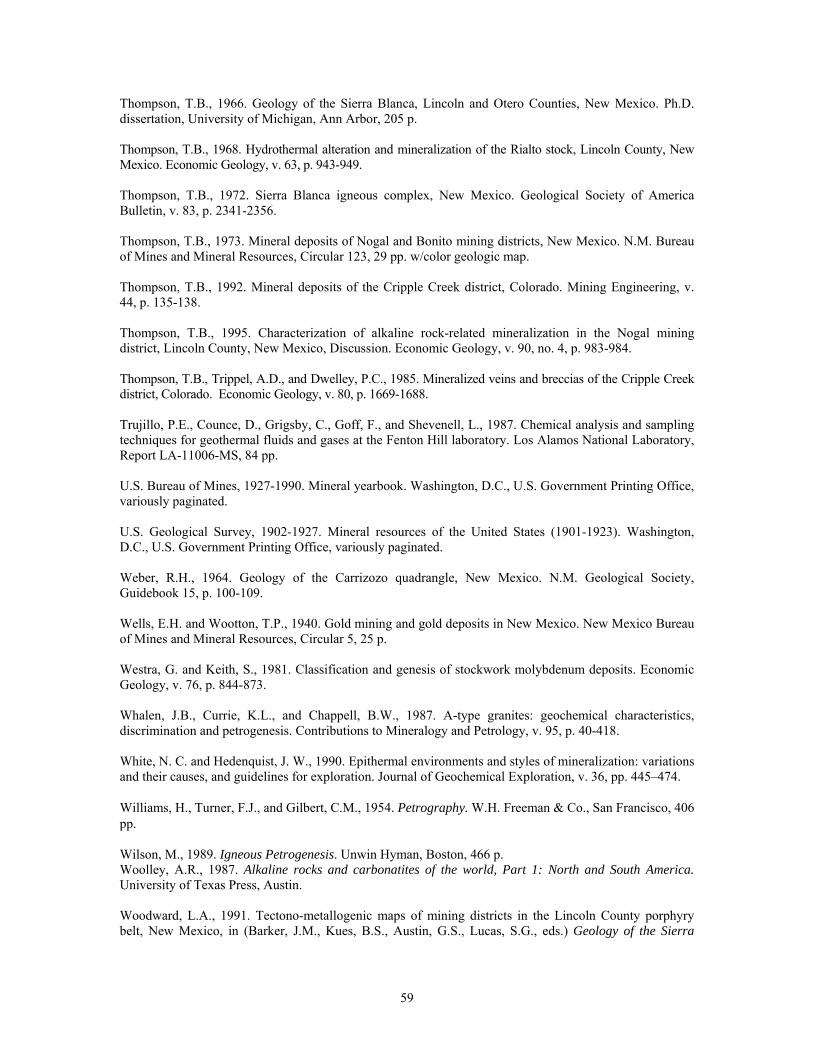
Thompson, T.B., 1966. Geology of the Sierra Blanca, Lincoln and Otero Counties, New Mexico. Ph.D. dissertation, University of Michigan, Ann Arbor, 205 p. Thompson, T.B., 1968. Hydrothermal alteration and mineralization of the Rialto stock, Lincoln County, New Mexico. Economic Geology, v. 63, p. 943-949. Thompson, T.B., 1972. Sierra Blanca igneous complex, New Mexico. Geological Society of America Bulletin, v. 83, p. 2341-2356. Thompson, T.B., 1973. Mineral deposits of Nogal and Bonito mining districts, New Mexico. N.M. Bureau of Mines and Mineral Resources, Circular 123, 29 pp. w/color geologic map. Thompson, T.B., 1992. Mineral deposits of the Cripple Creek district, Colorado. Mining Engineering, v. 44, p. 135-138. Thompson, T.B., 1995. Characterization of alkaline rock-related mineralization in the Nogal mining district, Lincoln County, New Mexico, Discussion. Economic Geology, v. 90, no. 4, p. 983-984. Thompson, T.B., Trippel, A.D., and Dwelley, P.C., 1985. Mineralized veins and breccias of the Cripple Creek district, Colorado. Economic Geology, v. 80, p. 1669-1688. Trujillo, P.E., Counce, D., Grigsby, C., Goff, F., and Shevenell, L., 1987. Chemical analysis and sampling techniques for geothermal fluids and gases at the Fenton Hill laboratory. Los Alamos National Laboratory, Report LA-11006-MS, 84 pp. U.S. Bureau of Mines, 1927-1990. Mineral yearbook. Washington, D.C., U.S. Government Printing Office, variously paginated. U.S. Geological Survey, 1902-1927. Mineral resources of the United States (1901-1923). Washington, D.C., U.S. Government Printing Office, variously paginated. Weber, R.H., 1964. Geology of the Carrizozo quadrangle, New Mexico. N.M. Geological Society, Guidebook 15, p. 100-109. Wells, E.H. and Wootton, T.P., 1940. Gold mining and gold deposits in New Mexico. New Mexico Bureau of Mines and Mineral Resources, Circular 5, 25 p. Westra, G. and Keith, S., 1981. Classification and genesis of stockwork molybdenum deposits. Economic Geology, v. 76, p. 844-873. Whalen, J.B., Currie, K.L., and Chappell, B.W., 1987. A-type granites: geochemical characteristics, discrimination and petrogenesis. Contributions to Mineralogy and Petrology, v. 95, p. 40-418. White, N. C. and Hedenquist, J. W., 1990. Epithermal environments and styles of mineralization: variations and their causes, and guidelines for exploration. Journal of Geochemical Exploration, v. 36, pp. 445–474. Williams, H., Turner, F.J., and Gilbert, C.M., 1954. Petrography. W.H. Freeman & Co., San Francisco, 406 pp. Wilson, M., 1989. Igneous Petrogenesis. Unwin Hyman, Boston, 466 p. Woolley, A.R., 1987. Alkaline rocks and carbonatites of the world, Part 1: North and South America. University of Texas Press, Austin. Woodward, L.A., 1991. Tectono-metallogenic maps of mining districts in the Lincoln County porphyry belt, New Mexico, in (Barker, J.M., Kues, B.S., Austin, G.S., Lucas, S.G., eds.) Geology of the Sierra
59
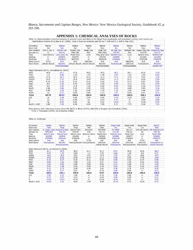
Blanca, Sacramento and Capitan Ranges, New Mexico. New Mexico Geological Society, Guidebook 42, p. 283-290.
APPENDIX 1: CHEMICAL ANALYSES OF ROCKS
60
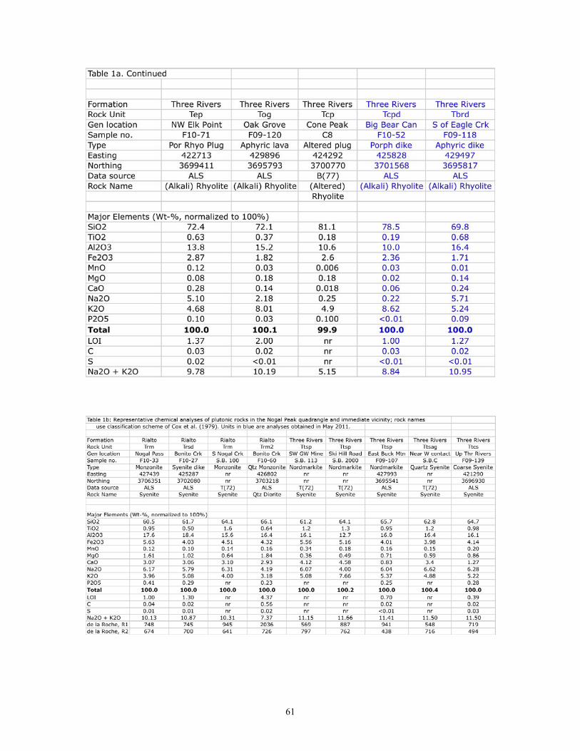
61
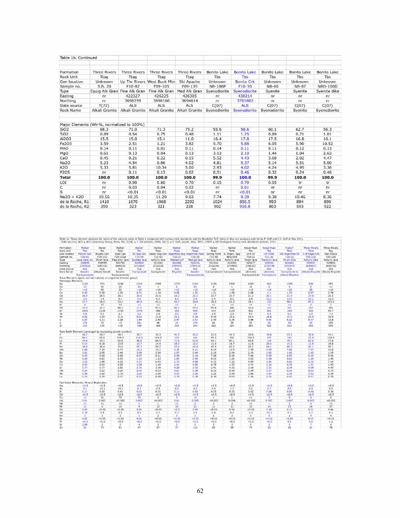
62
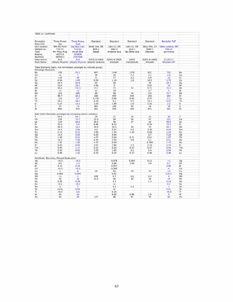
63
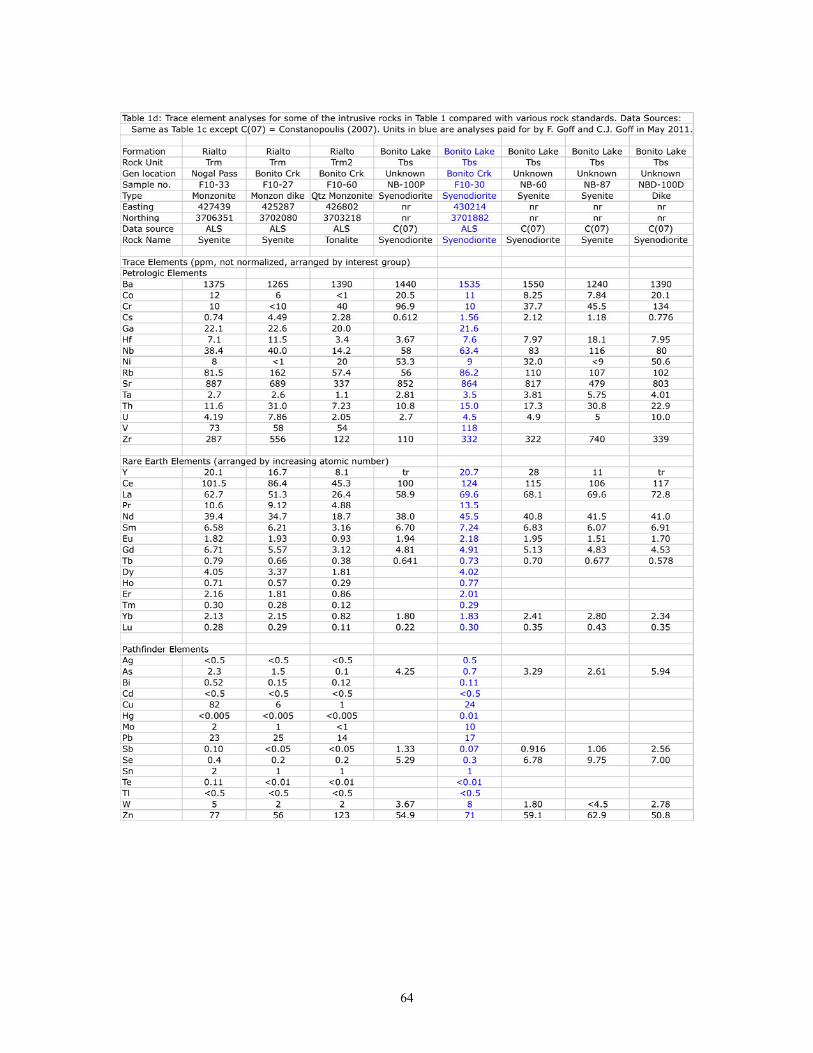
64
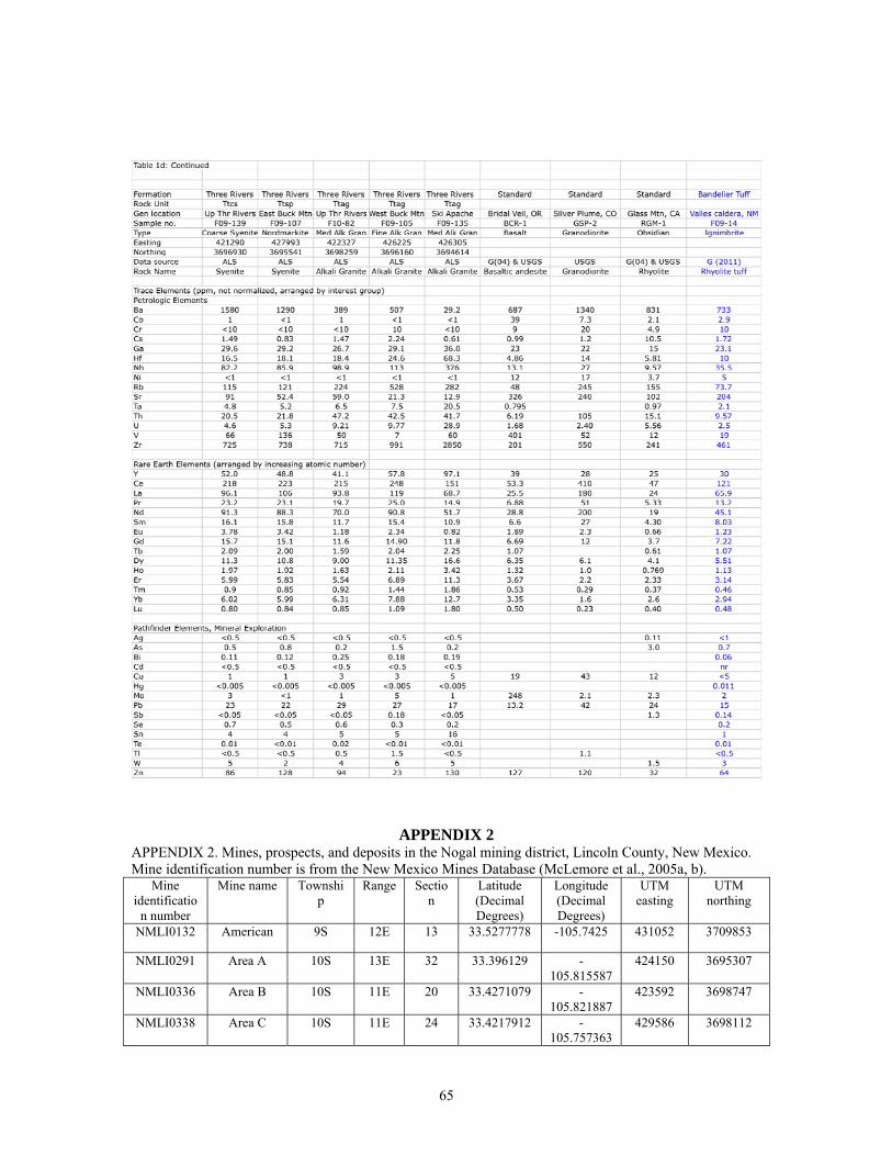
APPENDIX 2 APPENDIX 2. Mines, prospects, and deposits in the Nogal mining district, Lincoln County, New Mexico. Mine identification number is from the New Mexico Mines Database (McLemore et al., 2005a, b).
Mine identificatio
n number
Mine name Township
Range Section
Latitude (Decimal Degrees)
Longitude (Decimal Degrees)
UTM easting
UTM northing
NMLI0132 American 9S 12E 13 33.5277778 -105.7425 431052 3709853
NMLI0291 Area A 10S 13E 32 33.396129 -105.815587
424150 3695307
NMLI0336 Area B 10S 11E 20 33.4271079 -105.821887
423592 3698747
NMLI0338 Area C 10S 11E 24 33.4217912 -105.757363
429586 3698112
65
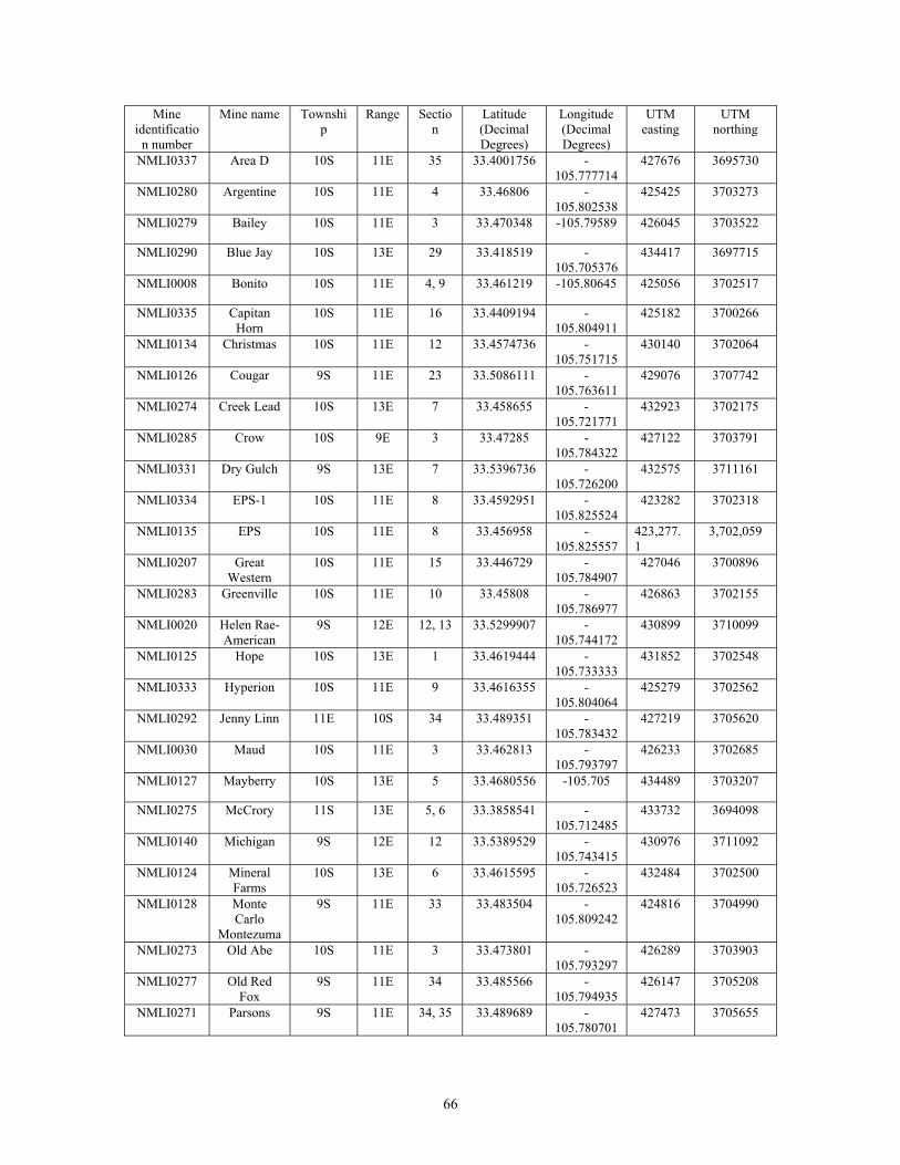
Mine identificatio
n number
Mine name Township
Range Section
Latitude (Decimal Degrees)
Longitude (Decimal Degrees)
UTM easting
UTM northing
NMLI0337 Area D 10S 11E 35 33.4001756 -105.777714
427676 3695730
NMLI0280 Argentine 10S 11E 4 33.46806 -105.802538
425425 3703273
NMLI0279 Bailey 10S 11E 3 33.470348 -105.79589 426045 3703522
NMLI0290 Blue Jay 10S 13E 29 33.418519 -105.705376
434417 3697715
NMLI0008 Bonito 10S 11E 4, 9 33.461219 -105.80645 425056 3702517
NMLI0335 Capitan Horn
10S 11E 16 33.4409194 -105.804911
425182 3700266
NMLI0134 Christmas 10S 11E 12 33.4574736 -105.751715
430140 3702064
NMLI0126 Cougar 9S 11E 23 33.5086111 -105.763611
429076 3707742
NMLI0274 Creek Lead 10S 13E 7 33.458655 -105.721771
432923 3702175
NMLI0285 Crow 10S 9E 3 33.47285 -105.784322
427122 3703791
NMLI0331 Dry Gulch 9S 13E 7 33.5396736 -105.726200
432575 3711161
NMLI0334 EPS-1 10S 11E 8 33.4592951 -105.825524
423282 3702318
NMLI0135 EPS 10S 11E 8 33.456958 -105.825557
423,277.1
3,702,059
NMLI0207 Great Western
10S 11E 15 33.446729 -105.784907
427046 3700896
NMLI0283 Greenville 10S 11E 10 33.45808 -105.786977
426863 3702155
NMLI0020 Helen Rae-American
9S 12E 12, 13 33.5299907 -105.744172
430899 3710099
NMLI0125 Hope 10S 13E 1 33.4619444 -105.733333
431852 3702548
NMLI0333 Hyperion 10S 11E 9 33.4616355 -105.804064
425279 3702562
NMLI0292 Jenny Linn 11E 10S 34 33.489351 -105.783432
427219 3705620
NMLI0030 Maud 10S 11E 3 33.462813 -105.793797
426233 3702685
NMLI0127 Mayberry 10S 13E 5 33.4680556 -105.705 434489 3703207
NMLI0275 McCrory 11S 13E 5, 6 33.3858541 -105.712485
433732 3694098
NMLI0140 Michigan 9S 12E 12 33.5389529 -105.743415
430976 3711092
NMLI0124 Mineral Farms
10S 13E 6 33.4615595 -105.726523
432484 3702500
NMLI0128 Monte Carlo
Montezuma
9S 11E 33 33.483504 -105.809242
424816 3704990
NMLI0273 Old Abe 10S 11E 3 33.473801 -105.793297
426289 3703903
NMLI0277 Old Red Fox
9S 11E 34 33.485566 -105.794935
426147 3705208
NMLI0271 Parsons 9S 11E 34, 35 33.489689 -105.780701
427473 3705655
66
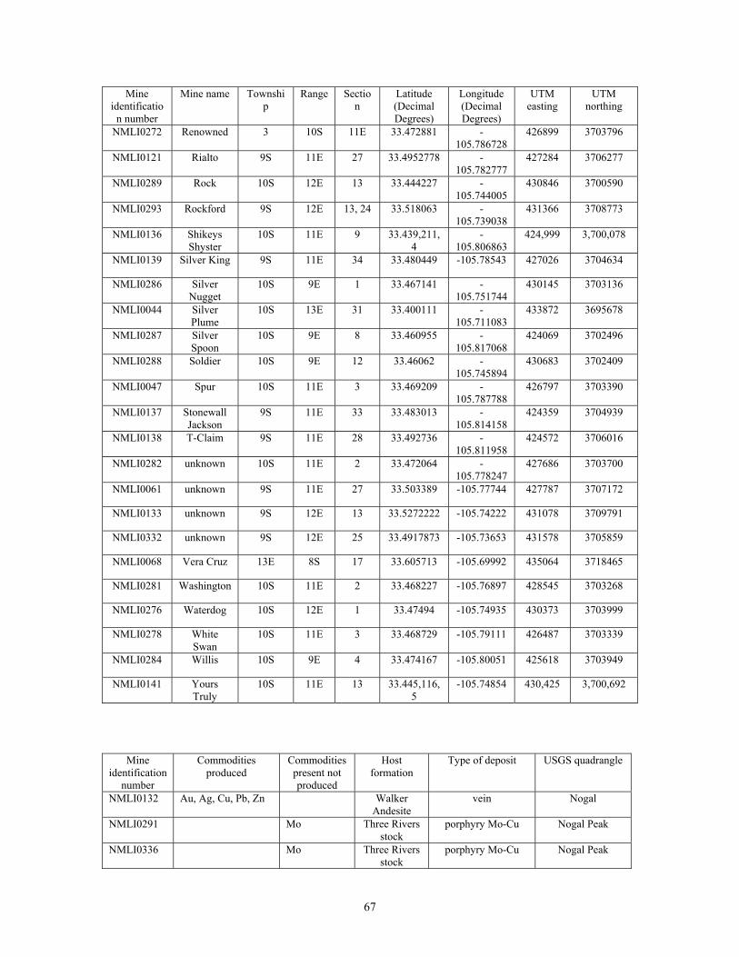
Mine identificatio
n number
Mine name Township
Range Section
Latitude (Decimal Degrees)
Longitude (Decimal Degrees)
UTM easting
UTM northing
NMLI0272 Renowned 3 10S 11E 33.472881 -105.786728
426899 3703796
NMLI0121 Rialto 9S 11E 27 33.4952778 -105.782777
427284 3706277
NMLI0289 Rock 10S 12E 13 33.444227 -105.744005
430846 3700590
NMLI0293 Rockford 9S 12E 13, 24 33.518063 -105.739038
431366 3708773
NMLI0136 Shikeys Shyster
10S 11E 9 33.439,211,4
-105.806863
424,999 3,700,078
NMLI0139 Silver King 9S 11E 34 33.480449 -105.78543 427026 3704634
NMLI0286 Silver Nugget
10S 9E 1 33.467141 -105.751744
430145 3703136
NMLI0044 Silver Plume
10S 13E 31 33.400111 -105.711083
433872 3695678
NMLI0287 Silver Spoon
10S 9E 8 33.460955 -105.817068
424069 3702496
NMLI0288 Soldier 10S 9E 12 33.46062 -105.745894
430683 3702409
NMLI0047 Spur 10S 11E 3 33.469209 -105.787788
426797 3703390
NMLI0137 Stonewall Jackson
9S 11E 33 33.483013 -105.814158
424359 3704939
NMLI0138 T-Claim 9S 11E 28 33.492736 -105.811958
424572 3706016
NMLI0282 unknown 10S 11E 2 33.472064 -105.778247
427686 3703700
NMLI0061 unknown 9S 11E 27 33.503389 -105.77744 427787 3707172
NMLI0133 unknown 9S 12E 13 33.5272222 -105.74222 431078 3709791
NMLI0332 unknown 9S 12E 25 33.4917873 -105.73653 431578 3705859
NMLI0068 Vera Cruz 13E 8S 17 33.605713 -105.69992 435064 3718465
NMLI0281 Washington 10S 11E 2 33.468227 -105.76897 428545 3703268
NMLI0276 Waterdog 10S 12E 1 33.47494 -105.74935 430373 3703999
NMLI0278 White Swan
10S 11E 3 33.468729 -105.79111 426487 3703339
NMLI0284 Willis 10S 9E 4 33.474167 -105.80051 425618 3703949
NMLI0141 Yours Truly
10S 11E 13 33.445,116,5
-105.74854 430,425 3,700,692
Mine identification
number
Commodities produced
Commodities present not produced
Host formation
Type of deposit USGS quadrangle
NMLI0132 Au, Ag, Cu, Pb, Zn Walker Andesite
vein Nogal
NMLI0291 Mo Three Rivers stock
porphyry Mo-Cu Nogal Peak
NMLI0336 Mo Three Rivers stock
porphyry Mo-Cu Nogal Peak
67
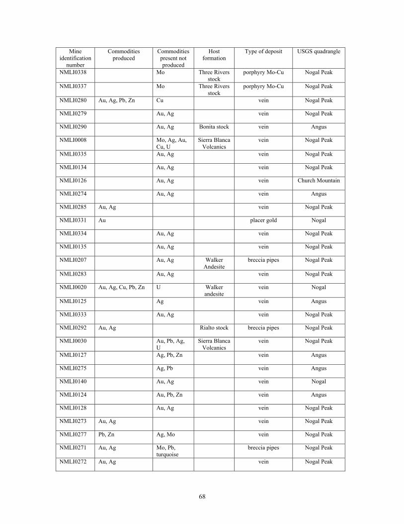
Mine identification
number
Commodities produced
Commodities present not produced
Host formation
Type of deposit USGS quadrangle
NMLI0338 Mo Three Rivers stock
porphyry Mo-Cu Nogal Peak
NMLI0337 Mo Three Rivers stock
porphyry Mo-Cu Nogal Peak
NMLI0280 Au, Ag, Pb, Zn Cu vein Nogal Peak
NMLI0279 Au, Ag vein Nogal Peak
NMLI0290 Au, Ag Bonita stock vein Angus
NMLI0008 Mo, Ag, Au, Cu, U
Sierra Blanca Volcanics
vein Nogal Peak
NMLI0335 Au, Ag vein Nogal Peak
NMLI0134 Au, Ag vein Nogal Peak
NMLI0126 Au, Ag vein Church Mountain
NMLI0274 Au, Ag vein Angus
NMLI0285 Au, Ag vein Nogal Peak
NMLI0331 Au placer gold Nogal
NMLI0334 Au, Ag vein Nogal Peak
NMLI0135 Au, Ag vein Nogal Peak
NMLI0207 Au, Ag Walker Andesite
breccia pipes Nogal Peak
NMLI0283 Au, Ag vein Nogal Peak
NMLI0020 Au, Ag, Cu, Pb, Zn U Walker andesite
vein Nogal
NMLI0125 Ag vein Angus
NMLI0333 Au, Ag vein Nogal Peak
NMLI0292 Au, Ag Rialto stock breccia pipes Nogal Peak
NMLI0030 Au, Pb, Ag, U
Sierra Blanca Volcanics
vein Nogal Peak
NMLI0127 Ag, Pb, Zn vein Angus
NMLI0275 Ag, Pb vein Angus
NMLI0140 Au, Ag vein Nogal
NMLI0124 Au, Pb, Zn vein Angus
NMLI0128 Au, Ag vein Nogal Peak
NMLI0273 Au, Ag vein Nogal Peak
NMLI0277 Pb, Zn Ag, Mo vein Nogal Peak
NMLI0271 Au, Ag Mo, Pb, turquoise
breccia pipes Nogal Peak
NMLI0272 Au, Ag vein Nogal Peak
68
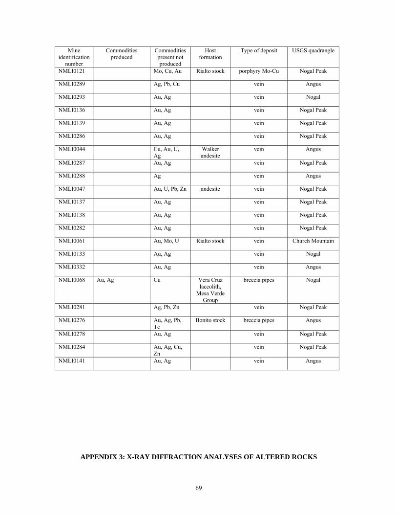
Mine identification
number
Commodities produced
Commodities present not produced
Host formation
Type of deposit USGS quadrangle
NMLI0121 Mo, Cu, Au Rialto stock porphyry Mo-Cu Nogal Peak
NMLI0289 Ag, Pb, Cu vein Angus
NMLI0293 Au, Ag vein Nogal
NMLI0136 Au, Ag vein Nogal Peak
NMLI0139 Au, Ag vein Nogal Peak
NMLI0286 Au, Ag vein Nogal Peak
NMLI0044 Cu, Au, U, Ag
Walker andesite
vein Angus
NMLI0287 Au, Ag vein Nogal Peak
NMLI0288 Ag vein Angus
NMLI0047 Au, U, Pb, Zn andesite vein Nogal Peak
NMLI0137 Au, Ag vein Nogal Peak
NMLI0138 Au, Ag vein Nogal Peak
NMLI0282 Au, Ag vein Nogal Peak
NMLI0061 Au, Mo, U Rialto stock vein Church Mountain
NMLI0133 Au, Ag vein Nogal
NMLI0332 Au, Ag vein Angus
NMLI0068 Au, Ag Cu Vera Cruz laccolith,
Mesa Verde Group
breccia pipes Nogal
NMLI0281 Ag, Pb, Zn vein Nogal Peak
NMLI0276 Au, Ag, Pb, Te
Bonito stock breccia pipes Angus
NMLI0278 Au, Ag vein Nogal Peak
NMLI0284 Au, Ag, Cu, Zn
vein Nogal Peak
NMLI0141 Au, Ag vein Angus
APPENDIX 3: X-RAY DIFFRACTION ANALYSES OF ALTERED ROCKS
69
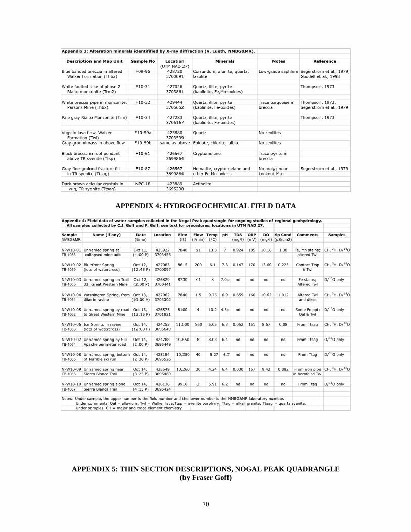
APPENDIX 4: HYDROGEOCHEMICAL FIELD DATA
APPENDIX 5: THIN SECTION DESCRIPTIONS, NOGAL PEAK QUADRANGLE (by Fraser Goff)
70
General Comments: Locations use US Geological Survey, Nogal Peak 7.5 minute topographic quadrangle, UTM NAD 27 (1982) and US Forest Service, White Mountain Wilderness map (1988), unless otherwise noted. Textures, petrology and rock names generally follow the examples in Williams et al. (1954). Rock names use classification schemes of Cox et al. (1979) for plutonic rocks and La Bas et al. (1986) for volcanic rocks. The Sierra Blanca volcanic rocks adjacent to diorite to granite intrusive bodies are too altered to date. Most samples contain chlorite + sericite and/or chlorite + epidote. However, many of the intrusive rocks contain fresh biotite and Kspar and have sparse to abundant zircon. Rock samples that appear to be dateable are flagged in the descriptions. Abbreviations: Kspar = generic potassium feldspar (variety noted if possible); plag = plagioclase, qtz = quartz, bio = biotite, hbd = hornblende (arfvedsonite noted if possible), opx = orthopyroxene, cpx = clinopyroxene, ol = olivine; mt = magnetite, ilm = ilmenite, ser = sericite, chl = chlorite, cc = calcite, ep = epidote, trem-act = tremolite-actinolite, Fe-oxide = generic low-temperature secondary iron oxide(s). F09-79a: Bonito Lake syenite w/ aplite vein Location: 0430310/3702074 Cliff north side of FS 107 near junction with FS 107c. Relations: Syenite is cut by several types of dikes and veins; intrudes Walker volcanic package Syenite (Unit Tbs) Color & Texture: White, slightly salt-n-pepper, medium-grained, hypidiomorphic granular Primary: Kspar, some with plag cores, many large plag, brown bio, dark green hbd (blue-green pleochroism), minor qtz (2%), rare zircon and sphene Secondary: Kspar has pervasive qtz-ser alteration; chl pervasive in some mafic minerals Comments: Similar sample submitted for Ar40/39 date (F10-30); also submitted for U-Pb date Petrographic Name: Altered biotite-hornblende syenite (Syenodiorite, F10-30, Appendix 1) Aplite (not shown on map; only 15 cm wide) Color & Texture: White, fine-grained granular Primary; Kspar, qtz, minor bio, mt, has late stage graphic texture in Kspar-qtz Secondary: Virtually none Comments: Bio is dateable Petrographic Name: Biotite aplite F09-79b: Bonito Lake syenite dike (Unit Tfsd) Location: Same as F09-79a Relations: North-trending dike cuts main syentite body Color & Texture: Gray-green, fine-grained, hypidiomorphic granular; a few larger, whitish feldspar phenocrysts give rock a “birds eye” texture in hand sample Primary: Plag, Kspar, cpx, mt; larger feldspars appear rounded Secondary: Qtz, ser, chl, ep, trem-act, smudgy mt, minor Fe-oxides, no obvious cc; larger cpx altered to chl and act Petrographic Name: Altered fine-grained syenite F09-80a: Rialto monzonite, phase 1 (Unit Trm) Location: 0426386/3702879 Near mouth of Bear Creek Relations: Intrudes Walker volcanic package Color & Texture: Greenish gray, medium-grained, hypidiomorphic granular Primary: Plag, cpx, some Kspar, minor bio and hbd, mt; did not find zircon Secondary: Highly altered rock: Chl, ep, trem-act, secondary mt and qtz, Fe-oxides
71
Petrographic Name: Altered diorite (or monzonite?) F09-82: Nogal Peak trachyte lava (Unit Tnt) Location: 042541/370652 Summit of Nogal Peak Relations: Youngest and highest flow in Nogal Peak Trachyte of Thompson (1972, 1973). Color & Texture: Pale pinkish white, slightly splotchy, slightly porphyritic, trachytic texture Primary: Plag, cpx, bio, hbd (?), apatite, mt, sparse Kspar (?); cpx looks unusual Secondary: Contrary to Thompson (1973), this rock is highly altered to chl, qtz-ser, ep, Fe-oxides; silicified groundmass Comment: See F10-51 below Petrographic Name: Altered sparsely porphyritic trachydacite F09-88: Porphyritic trachybasalt lava (Unit Twtx – similar to Goat Canyon lavas, see below) Location: 042919/370650 Bottom of Nogal Canyon near NE edge of quadrangle Relations: Part of Walker lava package; intruded by Rialto and Bonito Lake intrusive bodies Color & Texture: Dark gray, very porphyritic, slightly trachytic Primary: Large plag, rounded ol replaced by Ti-rich phlogopite, small nepheline (?), need microprobe to verify; groundmass contains small plag, mt, cpx (?) Secondary: Glass is altered to qtz-ser, contains chl, ep and clay Comment: Texture resembles F09-162a below Petrographic Name: Coarse plagioclase-porphyritic trachybasalt F09-93: Rialto monzonite, phase 1 (Unit Trm) Location: 042566/370364 Bottom of Turkey Canyon near Trail 40 Relations: Intrudes Walker volcanic package Color & Texture: Greenish-gray, medium- to coarse-grained, hypidiomorphic granular Primary: Plag, cpx, mt; no obvious apatite or zircon Secondary: Original minerals are psuedomorphed; ep, cc, chl, qtz-ser; adularia-ep-qtz in veinlets Major comment: In the field, this sample looks relatively fresh but in thin section it is really “hammered!” Petrographic Name: Altered monzonite (or syenite?) F09-102: Three Rivers porphyritic syenite (Unit Tts) Location: 042741/369465 Hwy 532 about 1 km east of Ski Apache Relations: Syenite body intrudes Walker volcanic package; locally has enclaves Color & Texture: Whitish gray, coarse-grained, hypidiomorphic granular Primary: Big milky Kspar (anorthoclase), interstial qtz and Kspar, some qtz has graphic texture, bio, minor blue-green hbd, mt, ilm; tiny apatite and zircon, no plag Secondary: Ser on Kspar cleavage, chl, minor ep, qtz-ser, Fe-oxide Comment: Zircon is dateable Petrographic Name: Porphyritic biotite quartz syenite F09-105: Three Rivers alkali granite (Unit Ttag) Location: 042623/369617 On Trail 25 west of Buck Mountain Relations: This and similar granite bodies apparently intrude syenite Color and Texture: Pale light gray, fine-grained, equigranular; almost aplitic Primary: Sparse small Kspar (anorthoclase) phenocrysts: groundmass of 80% Kspar, interstial qtz, bio, mt, ilm, apatite; zircon, if present, is not obvious; no plag Secondary: Ser, minor chl, Fe-oxides Comment: Submitted for Ar40/39 date; chemical analysis listed in Appendix 1 Petrographic Name: Biotite (alkali) granite
72
F09-107: Three Rivers syenite porphyry (Unit Ttsp; equivalent to nordmarkite of Giles and Thompson, 1972; nordmarkite = quartz-bearing alkali syenite, Williams et al., 1954, p. 114) Location: 0427993/3695541 East flank of Buck Mountain above Hwy 532 Relations: Intrudes Walker volcanic package Color & Texture: Pinkish gray, porphyritic; granular minerals around large anorthoclase Primary: Large Kspar (anorthoclase); groundmass of small Kspar, qtz, very minor plag, two types of cpx (one is aegirine), hbd (arfvedsonite), bio, mt, ilm, tiny zircon Secondary: Sample is amazingly fresh! Very little ser, chl, Fe-oxide Comment: Ar40/39 age on Kspar is 28.95 ± 0.18 Ma; chemical analysis listed in Appendix 1 Petrographic Name: Biotite-arfvedsonite-aegirine syenite porphyry F09-118: Three Rivers biotite rhyolite dike (Ttbrd) Location: 0429849/36966650 On 180° bend, Hwy 532 Relations: NE-trending dike cuts main syenite body Color & Texture: White to pale gray, very fine-grained to aphanitic groundmass, sparsely porphyritic, hyalopilitic texture Primary: Kspar, sparse but seemingly fresh bio, groundmass qtz and Kspar; Kspar zoned Secondary: Kspar altered to qtz-ser; groundmass altered to secondary silica, ser, smudgy mt Comments: Similar dike (F09-116) has Ar40/39 age on bio of 25.4 ± 0.8 Ma (integrated age; recoil) Petrographic Name: Slightly altered biotite rhyolite (chemical analysis listed in Appendix 1) F09-120: Aphyric, flow-banded felsic lava (Unit Tog) Location: 0429896/3695793 Along Hwy 532 near east margin of quadrangle Relations: Lava unconformably overlies typical Walker volcanic breccia Color & Texture: Whitish, aphyric, tightly flow-banded, spherulitic Primary: Tiny sparse crystals of what appears to be qtz and possibly Kspar Secondary: Groundmass is devitrified; contains tiny alkali feldspar; slightly silicified Comment: Chemical analysis listed in Appendix 1 Petrographic Name: Aphyric alkali rhyolite (from chemistry) F09-129: Essexite Porphyry Plug (Unit Tex; Moore et al., 1988; essexite is a type of feldspathoidal gabbro, Williams et al., 1954, p. 66) Location: 042883/369357 SE of Hwy 532 Relations: Small intrusion cutting Walker volcanic package at head of Eagle Creek Color & Texture: Splotchy black and white, porphyritic, fine-grained granular; slightly sheared Primary: Large Kspar (orthoclase); groundmass of Kspar, minor plag, phlogopite, (nepheline, cpx, ol?); the latter phases are so altered that their presence is deduced from shape and association Secondary: Black smudgy mt, ep, cc, qtz, ser, chl, zeolite, rutile, Fe-oxide; really “hammered!” Comments: Whole rock Ar40/39 date is 30.5 ± 0.5 Ma (integrated age; affected by alteration) Petrographic Name: Phlogopite alkali gabbro (or mica feldspathoidal gabbro) F09-132: Monzonite porphyry dike (Unit Tmd) Location: 043016/369493 Along Hwy 532 near east margin of quad Relations: NW-trending dike cuts Walker volcanic breccia; overlain by aphyric lava (F09-120) Color & Texture: Dark yellow-green, splotchy, porphyritic; fine-grained granular groundmass Primary: Plag, cpx, bio, hbd (?), mt, possibly smaller Kspar, tiny apatite Secondary: Plag altered to qtz-ser-chl; mafic phenocrysts altered to chl-ep; groundmass is highly silicified containing fine chl, ser, qtz, ep Petrographic Name: Altered monzonite (or diorite?) porphyry
73
F09-134 Three Rivers alkali granite w/ aplite vein Location: 042646/369471 Near top of eastern Ski Apache chairlift Relations: Part of Three Rivers stock; aplite cuts granite Granite (Unit Ttag) Color and Texture: Light gray, medium-grained, hypidiomorphic granular Primary: Kspar, lots of qtz, aegirine, arfvedsonite, mt, minor tiny bio, zircon; some qtz has graphic texture Secondary: Contains minor qtz-ser-chl alteration of mafic phases Comment: zircon is dateable Petrographic Name: Arfvedsonite-aegirine alkali granite Vein (much too small to map; only 10 cm wide) Color and Texture: White to light gray, fine-grained, equigranular; has finer grained (chill) margin with granite Primary: Qtz, Kspar, bio, mt Secondary: A little Fe-oxide Petrographic Name: Biotite aplite F09-135: Three Rivers alkali granite (Unit Ttag) Location: 042631/369464 Top of east chair lift, Ski Apache Relations: Part of Three Rivers stock; appears to intrude surrounding syenites Color & Texture: Salt-and-pepper, medium-grained, hypidiomorphic granular Primary: Kspar, interstial qtz (some graphic texture), sparse small plag, aegirine, arfvedsonite, bio, mt, ilm, lots of zircon Secondary: Bio is oxidized; arfvedsonite altered to chl; some qtz-ser Comment: Ar40/39 date on amphibole is 27 ± 2 Ma; also submitted for U-Pb date (so much zircon!); chemical analysis listed in Appendix 1; contains less alkalis than other granites in stock Petrographic Name: Biotite-arfvedsonite-aegirine granite F09-136: Three Rivers porphyritic syenite (Unit Ttsag) Location: 042583/369448 Ski Apache summit ridge road Relations: Part of Three Rivers stock; apparently predates the granites Color & Texture: Bluish gray, coarse-grained, hypidiomorphic granular; with anorthoclase phenocrysts (see F09-140c) Primary: Big rounded bluish Kspar (anorthoclase); groundmass of small Kspar, minor plag, interstitial qtz (some graphic texture), arfvedsonite, bio, zircon, lots of sphene Secondary: Minor qtz-ser Comment: Dateable zircon Petrographic Name: Porphyritic biotite-arfvedsonite quartz syenite F09-137: Porphyritic trachybasalt dike (Ttbd; designation may be different on adjacent quad) Location: 0417952/3696005 On Trail 44 east of campground, E edge Godfrey Peak quad Relations: NW-trending dike cuts Walker volcanic breccia Color & Texture: Greenish black, porphyritic, slightly ophitic, highly altered Primary: Big plag and a few altered ol phenocrysts, fine-grained groundmass of plag, cpx (titanaugite), mt Secondary: Cc, clay, ser, chl, silica, ep, Fe-oxides Petrographic Name: Altered porphyritic trachybasalt F09-138: Basalt lava as breccia clast (Within Unit Twb) Location: 041837/369618 Above and north of Trail 44; east of campground, west of TR stock Relations: Large clast of cpx porphyritic mafic lava in Walker volcanic breccia; many lava types
74
Color & Texture: Greenish black, medium-grained, slightly porphyritic Primary: Sparse large cpx phenocrysts in hand sample; smaller cpx and plag phenocrysts in thin section; groundmass of cpx, plag, ol, mt; altered glass Secondary: Chl, cc, qtz-ser, ep, Fe-oxides; olivine completely altered Comment: Similar lava chemically analyzed (F09-156; Appendix 1) Petrographic Name: Altered cpx-porphyritic alkali olivine basalt F09-139: Three Rivers coarse-grained syenite (Unit Ttcs; “ultra porphyritic” syenite) Location: 0423222/3697580 Along Trail 25, east of Three Rivers canyon Relations: Part of Three Rivers stock; apparently intrudes other syenites and granites Color & Texture: Gray, very coarse-grained, hypidiomorphic granular; rock contains enclaves of finer-grained igneous rock Primary: Hash of large rounded Kspar (anorthoclase) surrounded by smaller interstial Kspar and qtz (some graphic texture), aegirine, arfvedsonite, mt, ilm, tiny apatite; rare rutile (?); no apparent zircon; no plag Secondary: Minor qtz-ser, Fe-oxides Comment: Chemical analysis in Appendix 1 Petrographic Name: Coarse-grained aegirine-arfvedsonite syenite F09-140c: Three Rivers syenite (Unit Ttsag) Location: 042009/369584 Trail 44 in main Three Rivers canyon Relations: Sample is 30 m east of intrusive contact with Walker volcanic lava package Color & Texture: Light gray, medium- to coarse-grained, hypidiomorphic granular; has blue-gray anorthoclase phenocrysts Primary: A few larger Kspar (anorthoclase) in groundmass of Kspar, interstial qtz (some graphic texture), minor cpx, arfvedsonite, mt, ilm, very minor plag and bio, sphene, zircon Secondary: Minor qtz-ser, Fe-oxides Comment: Ar40/39 date on Kspar is 28.24 ± 0.19 Ma (good spectra); zircon dateable Petrographic Name: Arfvedsonite quartz syenite F09-143: Three Rivers syenite & metavolcanic wall rock Location: 042018/369680 Contact exposed in bed of Dry Creek, Trail 46 Relations: Syenite intrudes Walker lava package; vertical contact Syenite (Unit Ttsag) Color & Texture: Light gray, Medium- to coarse-grained, hypidiomorphic granular Primary: Kspar, minor interstial qtz, arfvedsonite, very sparse bio and cpx, mt, ilm, sphene, zircon, no plag Secondary: Minor ser, Fe-oxides Comment: Probably dateable Petrographic Name: Arfvedsonite (quartz) syenite Metavolcanic (Unit Twl) Color & Texture: Pale gray, smudgy, slightly porphyritic, hornfelsed Primary: Larger plag and a few cpx in groundmass of plag, cpx, ol, small mt Secondary: Chl, ser, ep, qtz Petrographic Name: Hornfelsed porphyritic olivine basalt F09-144: Three Rivers alkali granite (Unit Ttsag) Location: 042027/369793 On ridge NW of Dry Creek Relations: Intrudes Walker volcanic package; just south of contact with Ttag Color & Texture: Pale brownish-gray, medium-grained, hypidiomorphic to equigranular
75
Primary: Kspar, interstial qtz (some graphic), a bit of plag (?), mt, ilm; altered bio and hbd (?); apatite, sphene, tiny zircon Secondary: Rock is sheared; mafic minerals altered to qtz-ser, Fe-oxides Petrographic Name: Altered quartz syenite to alkali granite F09-153: Cpx-porphyritic trachybasalt dike (Unit Ttbd) Location: 041904/3695262 On ridge in SW part of quadrangle Relations: West-trending dike and small plug cuts lower part of Walker volcanic breccia and lower part of lava package Color & Texture: Greenish black, fine-grained, porphyritic; has large (≤2 cm) cpx phenocrysts; in thin section, texture is intersertal with slightly aligned plag Primary: Plag, ol, cpx, mt; cpx phenocrysts are zoned, some contain ol inclusions; a few tiny cpx clots; ol has iddingsite rims Secondary: Chl, ep, cc, Fe-oxides, qtz Petrographic Name: Altered cpx-porphyritic trachybasalt F09-157: Hbd-porphyritic trachyandesite flow (Within unit Twl) Location: 0418927/3697965 North wall of Brushy Canyon Relations: Flow in Walker volcanic lava package; about 50 ft thick Color & Texture: Gray, slightly porphyritic, intersertal texture Primary: Plag and hbd phenocrysts; groundmass contains small plag, cpx, opx, glass, mt Secondary: Hbd altered to mt, qtz, ser-chl; plag altered to ser, qtz, cc; opx altered to mt, qtz, chl, Fe-oxides Comment: Altered hbd is easily confused with cpx in field Petrographic Name: Altered hbd-porphyritic trachyandesite F09-162a: Porphyritic (turkey track) trachyandesite (Unit Twtx) Location: 0420705/3699235 In upper part of Goat Canyon near Trail 47 Relations: Flow(s) in Walker volcanic lava package Color and Texture: Spotted black-and-white, very porphyritic; phenocrysts make “turkey tracks” Primary: Abundant large plag phenocrysts (≥2 cm), minor cpx phenocrysts; groundmass of small plag, altered ol, cpx, mt Secondary: Qtz, ser, chl, cc, ep, Fe-oxide Comment: Chemistry listed in Appendix 1 Petrographic Name: Altered plagioclase-porphyritic basaltic trachyandesite F10-11: Grizzly Peak diorite dike (Tmd – actual plug is Tgd) Location: 0428506/3703714 Just below summit of peak Relations: Part of extensive dike and plug complex at Grizzly Peak; cuts altered Walker lavas, minor interlayered breccia Color and Texture: Greenish-gray, medium-grained, hypidiomorphic granular Primary: Plag, cpx, minor small Kspar (?), interstitial qtz, mt Secondary: Chl, ep, ser, qtz, minor cc, smudgy mt; small veinlets of ep, qtz Petrographic Name: Altered diorite to monzonite F10-27: Biotite-hornblende syenite dike (Trsd) Location: 0425287/3702080 On ridge south of Bonito Creek Relations: NE-trending dike is up to 60 ft wide; cuts Walker lava package; resembles Rialto Color and Texture: “Salt-and-pepper,” slightly pink, medium-grained, hypidiomorphic granular Primary: Plag, Kspar, qtz, bio, hbd, small cpx, mt, ilmenite, trace zircon, sphene, apatite Secondary: Very fresh rock, minor ser, qtz
76
Comment: Submitted for Ar40/39 date; chemical analysis listed in Appendix 1 Petrographic Name: Biotite-hornblende syenite F10-36: Biotite trachydacite dike (Unit Tbtd) Location: 0421665/3703472 On Trail 50 SW of Argentina Peak Relations: West- to NW-trending dike cuts Walker lava package; traceable for 0.5 km Color & Texture: Pale rusty-brown, fine-grained to aphyric, slightly porphyritic, slightly banded Primary: Small bio, Kspar, plag phenocrysts; groundmass of tiny plag, Kspar, bio, qtz (?), mt Secondary: Qtz, ser, cc, Fe-oxides Comment: Fresh bio could be dated Petrographic Name: Slightly altered biotite trachydacite (practically a rhyolite, Appendix 1) F10-37: Welded biotite rhyolite tuff (Unit Twas) Location: 0422208/3704970 About 80 ft down slope (west) of Trail 25 Relations: Tuff interlayered in Walker lava package; higher up by trail, the rock looks like lava Color & Texture: In outcrop, dark gray to black lithic-rich tuff; lithics flattened parallel to layering. In thin section, dark brownish gray, banded, slightly porphyritic lithic tuff with odd eutaxitic texture and a lot of small crystals. Banded groundmass of glass is partially devitrified and replaced by small spherulites. Very odd rock; lithics are chert to fine-grained sandstone, trachybasalt, andesite, silicic volcanics Primary: Sanidine (partly altered), plagioclase, some with sanidine rims, biotite, possible small hbd (now altered), sparse quartz (≤2 %), mt, ilmenite, tiny sparse zircon, apatite and sphene; spherulites and bands contain small tridymite and alkali feldspar Secondary: Fairly intense qtz, ser, Fe-oxides Comment: Bio is dateable; lower part of reomorphic unit; aspect ratio, 5 fiammi: 14.2 ± 4.1 (1σ) Petrographic Name: Welded biotite rhyolite tuff (analysis in Appendix 1). F10-39: Medium-grained trachybasalt lava, Argentina Peak (Unit Twap) Location: 0422016/3704110 On thin ridge north of peak Relations: Youngest flow in local area; caps the summit and ridge of the peak; overlies a fine-grained flow which in turn overlies the “reomorphic tuff” Color & Texture: Reddish-black medium-grained, intersertal Primary: A few small phenocrysts of plag; groundmass of felty plag, tiny altered cpx and ol, mt Secondary: Hematite, other Fe-oxide, qtz, ser, chl Petrographic Name: Altered trachybasalt (Basaltic trachyandesite, Appendix 1) F10-40: Aphyric mafic lava, Spring Point (Unit Twsp) Location: 0421566/3702246 Small cliff on west side of plug forming the “point” Relations: Youngest lava in local area; similar looking flows drape area to east Color & Texture: Dark gray to black, very fine-grained, aphyric, slightly trachytic Primary: A few plag microphenocrysts; groundmass of plag, mt, tiny cpx, a few tiny bio Secondary: A little hematite, qtz, ser, chl Comment: Submitted for Ar40/39 date; chemical analysis listed in Appendix 1 Petrographic Name: Aphyric (biotite) trachyandesite F10-41: Cpx-porphyritic lava as breccia clast (in Unit Twb) Location: 0418845/3703815 Extreme west end of ridge north of Spring Canyon Relations: Clast is >1 m in diameter; within thick, monolithologic breccia locally exposed in bottom of Walker breccia package; looks like collapse breccia or thick (>60 m) flow breccia Color & Texture: Gray, medium-grained, porphyritic, intersertal Primary: Plagioclase, cpx, altered ol, mt; very minor altered Kspar (?)
77
Secondary: Severely altered; qtz, ser, cc, chl, Fe-oxide; no ep Petrographic Name: Altered cpx-porphyritic trachybasalt (Basaltic trachyandesite, Appendix 1) F10-43: Biotite trachydacite lava, Spring Canyon (Unit Twsc) Location: 0421692/3703328 Just north of junction Trails 50 and 25 in pass at 8780 ft Relations: Thick flow extends more than 1 mile south of collection site; underlies “reomorphic tuff;” equivalent to Spring Canyon andesite of Thompson (1973, figure 2, geologic map) Color & Texture: Dark gray, fine-grained, flow banded; foliated surfaces sometimes spotted Primary: Very sparse, tiny plag phenocrysts; trachytic groundmass of tiny felted plag, mt, rare oxidized bio and tiny, tiny cpx; bio hard to find at all locations Secondary: Minor qtz, ser, Fe-oxide Comment: Submitted for Ar40/39 date (groundmass dateable); chemical analysis in Appendix 1 Petrographic Name: Biotite trachydacite (or Aphyric trachydacite) F10-44: Spotted trachybasalt lava (in unit Twl; directly underlies Twsc) Location: 0420969/3702664 West-facing cliff roughly 200 ft below main ridge top Relations: One of several similar flows beneath Spring Canyon lava (F10-43) Color & Texture: Black, aphanitic, trachytic, spotted, no phenocrysts (boring!) Primary: Tiny plag, cpx, ol, mt in black glass; rare slightly larger plag; spots are accumulations of plag with little glass Secondary: Qtz, ser, hematite, Fe-oxide, chl; cc (and possibly fine opal and zeolite) in cracks and vesicles; fine ep? Comment: Trachybasalt, Appendix 1 Petrographic Name: Altered aphyric trachybasalt F10-51: Nogal Peak Trachyte (Unit Tnt) Location: 0425877/3706357 Southeast flank of Nogal Peak Relations: Lowest of five somewhat similar flows and interlayered breccias (Flow 37, Thompson, 1973; Figure 6). Color & Texture: Greenish-gray, slightly porphyritic, slightly trachytic, obviously altered Primary: Plag, hbd, bio, cpx, mt; possibly some tiny altered Kspar (?) Secondary: Rock is thoroughly altered; plag gone to qtz, ser, cc; hbd gone to chl, mt, ep, qtz, ser (some coarse grained like muscovite) Comment: Chemical analyses listed in Appendix 1 Petrographic Name: Altered porphyritic trachyandesite F10-52: Cone Peak rhyolite dike (Unit Tcpd; plugs are Tcp) Location: 0425828/3701568 On bluff 8405 east of Big Bear Creek Relations: Dike cuts Walker lava package; mineralogy is similar to dikes and plug west of Big Bear Creek named Cone Peak rhyolite (Black, 1977). Color & Texture: Light gray to white, slightly porphyritic, aphanitic groundmass Primary: Small phenocrysts of qtz, Kspar, bio, sparse plag; a few graphic intergrowths of qtz and Kspar; much of qtz is embayed (out of equilibrium); qtz contains melt inclusions Secondary: Groundmass is silicified; Kspar altered to ser; bio gone to mt and other Fe-oxides Comment: Chemical analysis listed in Appendix 1 Petrographic Name: Altered porphyritic biotite rhyolite F10-60: Rialto monzonite intrusive, Phase 2 (Unit Trm2) Location: 0426802/3703218 North side of FS 107 west of Tanbark Canyon Relations: Second main phase of Rialto stock; intrudes Walker volcanics and Trm Color & Texture: Gray, fine-grained, hypidiomorphic granular
78
Primary: Plag, some small Kspar, hbd, fresh bio, interstial qtz, mt, small altered cpx (?) Secondary: Qtz, ser, chl, Fe-oxide; no apparent ep Comment: Submitted for Ar40/39 date (bio is dateable); chemical analysis listed in Appendix 1 Petrographic Name: Altered hornblende-biotite quartz diorite F10-65: Opalized accretionary lapilli tuff (Thin layer of Twal in Twbb) Location: 0421116/3700136 In ravine just east of Trail 25 Relations: Thin bed of rhyolitic tuff (±3 m) interlayered in scoria and agglutinate-rich Walker volcanic breccia (unit Twbb); laterally traceable for ±80 m Color & Texture: White to gray thin beds of clay-rich mud; some beds with balls ≤0.5 cm diam Primary: Balls are accretionary lapilli formed of concentric layers of fine mud and tiny crystals (Fisher and Schminke, 1984); a few small crystals of altered feldspar and mt in beds Secondary: Mud altered to opal, clay (and ser?); feldspar altered to qtz, ser, cc; beds cut by tiny veinlets of opal and cc; rare, tiny stains of bright blue turquoise (?) Petrographic Name: Opalized accretionary lapilli tuff F10-66: Basaltic trachyandesite lava (Unit Twbt) Location: 0421170/3700996 Summit of hill 9395 east of Trail 25 Relations: Probable vent area; overlies scoria-rich Walker breccia (Twbb) and flow Twsc (above) Color & Texture: Dark gray to black, fine-grained, sparsely porphyritic, trachytic Primary: Small plag phenocrysts; groundmass contains tiny plag, cpx, iddingsitized ol, mt, rare apatite; groundmass glass completely altered; lava contains sparse gabrroic xenoliths Secondary: Qtz, ser, chl, ep, Fe-oxide Petrographic Name: Altered basaltic trachyandesite F10-71: Porphyritic rhyolite plug of Elk Point (Unit Tep) Location: 0422713/3699411 On low hill just east of Trail 35 NW of Elk Point Relations: Rhyolite intrudes mixture of Walker breccias and lavas; rhyolite is only “fresh” at this location; otherwise highly silicified and brecciated Color and Texture: Light to dark gray, coarsely porphyritic, some flow banding Primary: Large Kspar (sanidine?) and smaller phenocrysts of Kspar, qtz, plag, hbd, bio, mt; tiny apatite Secondary: Qtz, ser, smudgy mt, chl (?); large Kspar partially altered; groundmass silicified Comment: Chemical analysis listed in Appendix 1 Petrographic Name: Altered porphyritic hornblende-biotite rhyolite F10-73: Biotite syentite porphyry (Unit Ttbsp) Location: 0423693/3698091 Just south of hill 10518 and Trail 33 Relations: Small intrusion within Three Rivers stock; mapped as nordmarkite (Thompson, 1973) Color & Texture: Pinkish-gray, sparsely porphyritic, fine-grained granular groundmass Primary: Large Kspar (anorthoclase?) phenocrysts with microcline (herringbone) twinning; fairly fresh groundmass contains small crystals of Kspar, a bit of plag and qtz, mt, bio, tiny apatite and zircon Secondary: Minor qtz, ser, Fe-oxides Comment: Zircon is dateable Petrographic Name: Biotite syenite porphyry F10-76: Medium-grained alkali granite dike (Unit Ttag) Location: 0423406/3696889 On Trail 25 SE of hill 10826 Relations: Broad NE-trending dike (±50 m wide) cuts very coarse-grained syentite, TR stock Color & Texture: “Salt and pepper,” medium-grained, hypidiomorphic granular
79
Primary: Large Kspar (orthoclase?) surrounded by smaller Kspar, interstial qtz, arfvedsonite (blue pleochroism), bio, mt, tiny zircon; some Kspar and qtz have graphic texture; arfvedsonite projects into qtz; very fresh rock Secondary: A bit of ser Comment: Zircon and bio are dateable Petrographic Name: Biotite-arfvedsonite alkali granite F10-77b: Fine-grained hornblende-biotite syentite plug (Unit Tthbs) Location: 0423713/3696588 On Trail 25 in saddle between low hills Relations: Small (±50 m diameter) plug-like body intruding coarse-grained syenite, TR stock Color & Texture: Light gray, porphyritic, fine-grained granular Primary: Very fresh; contains larger Kspar (anorthoclase?), and smaller bio and hbd in groundmass of tiny plag, mt, some qtz, and rare cpx; rare tiny zircon and apatite Secondary: Minor qtz, ser, chl Comment: Bio and zircon dateable Petrographic Name: Hornblende-biotite quartz syenite F10-82: Medium-grained alkali granite (Unit Ttag) Location: 0422327/3698259 Just NW of Trail 44 in Three Rivers canyon Relations: Large intrusion within the Three Rivers stock Color & Texture: Light gray, medium- to fine-grained, hypidiomorphic to equigranular Primary: Kspar (orthoclase?), qtz, biotite, mt; a bit of arfvedsonite; some graphic texture Secondary: Qtz, sericite, Fe-oxide, chlorite (?) Comment: Chemical analysis in Appendix 1 Petrographic Name: Biotite alkali granite NPQ-004: Aphyric trachydacite lava (Unit Twfa) Location: 0422385/3704903 On low ridge west of Trail 25, north of Argentina Spring Relations: overlies Twas (F10-37) described above Color & Texture: Dark gray to black, aphanitic, trachytic, a few very small phenocrysts Primary: Sparse small plag and bio in groundmass of plag, cpx, tiny Kspar (?) and glass Secondary: Qtz, ser, Fe-oxides, chl (?) Comment: Texture is quite different than F10-37; analysis in Appendix 1 Petrographic Name: Aphyric trachydacite F10-90: Syenite porphyry (Unit Ttsp) Location: 0428861/3695282 On Hwy 532 west of Windy Point Relations: Large intrusive body in TR stock; equivalent to nordmarkite (Thompson, 1972; 1973) Color & Texture: Dark pinkish brown, porphyritic, fine-grained granular; slightly fractured Primary: Large Kspar (anorthoclase) phenocrysts; smaller crystals of Kspar; minor qtz and plag, mt, bio, cpx, a bit of altered hbd; sparse tiny apatite Secondary: Qtz, ser, chl (?); a few tiny qtz veinlets Petrographic Name: (Altered) Biotite Syenite Porphyry F10-91: Porphyritic trachydacite lava (Unit Twpd) Location: 0429958/3695162 Just east of Hwy 532, near east edge of quadrangle Relations: Unconformably overlies Walker breccias and lavas; may be related to TR stock Color & Texture: Gray, porphyritic, slightly trachytic Primary: Kspar (sanidine), plag, bio, mt, qtz; groundmass has plag and cpx Secondary: Qtz, ser, chl, smudgy mt, other Fe-oxide; groundmass is silicified Petrographic Name: Altered porphyritic biotite trachydacite (possibly rhyolite?)
80
81
F10-97: Porphyritic trachydacite tuff (Unit Twtt) Location: 0424275/3701109 On hill just north of Cone Peak Relations: Possible vent of tuff cutting horizontal Walker volcanics and minor breccias Color & Texture: Brownish-gray, porphyritic, fragmental, minor mafic volcanic lithics Primary: Plag, Kspar, mt, very altered bio and hbd, rare qtz Secondary: Quite altered; qtz, ser, chl, smudgy mt, other Fe-oxide; tiny ep (?) Petrographic Name: Altered porphyritic trachydacite tuff NPC-18: Porphyritic quartz syenite (Unit Ttsag) Location: 0423889/3695238 SW of Trail 25 in head of unnamed canyon Relations: Large intrusive body in Three Rivers stock Color & Texture: Light gray w/bluish gray spots, slightly porphyritic, medium-grained, hypidiomorphic granular Primary: Large, bluish gray Kspar (anorthoclase), quite a bit of interstial qtz, bio, smaller Kspar, a bit of tiny sphene, zircon; very fresh rock Secondary: Very little secondary qtz, ser Comment: Resembles F09-136 & F09-140c but no obvious arfvedsonite and less sphene Petrographic Name: Porphyritic biotite quartz syenite F11-26: Porphyritic trachydacite lava (unit Tnt) Location: 0424585/3705748 west side of Hill 9500 SW of Nogal Peak Relations: Underlies basalt lava (Twbn); overlies thin layer of breccia (Twb) Color & Texture: Light gray, porphyritic, trachytic Primary: Altered aligned plagioclase and smaller blocky sanidine; altered bio and hbd (?) Secondary: Silica, ser, chl, clay, smudgy opaque oxides Comment: Trachyte texture very obvious but so is alteration; analysis in Appendix 1 Petrographic Name: (Altered) Porphyritic biotite trachydacite