Embed Size (px)
Citation preview
PRELIMINARY MINERAL RESOURCE STUDY OF THE UINTAH AND OURAY RESERVATION, UTAH
By
C. William Keighin M. H. Hibpshman
U. S. Geological Survey U. S. Bureau of Mines
Administrative Report BIA-4
1975
CONTENTS
SUMMARY AND CONCLUSIONS . . . . . . . . . . . . . . . . . . . . . . . . . . . . . . . . . . . . . . . . . . . . . . . . . 1
INTRODUCTION . . . . . . . . . . . . . . . . . . . . . . . . . . . . . . . . . . . . . . . . . . . . . . . . . . . . . . . . . . . . . . . . 1
GEOLOGIC SETTING . . . . . . . . . . . . . . . . . . . . . . . . . . . . . . . . . . . . . . . . . . . . . . . . . . . . . . . . . . . . 2
Stratigraphy . . . . . . . . . . . . . . . . . . . . . . . . . . . . . . . . . . . . . . . . . . . . . . . . . . . . . . . . . . . . . . . 3
MINERAL RESOURCES . . . . . . . . . . . . . . . . . . . . . . . . . . . . . . . . . . . . . . . . . . . . . . . . . . . . . . . . . . 4
Energy Resources. . . . . . . . . . . . . . . . . . . . . . . . . . . . . . . . . . . . . . . . . . . . . . . . . . . . . . . . . . . 4
Introduction . . . . . . . . . . . . . . . . . . . . . . . . . . . . . . . . . . . . . . . . . . . . . . . . . . . . . . . . . 4
Oil and Gas . . . . . . . . . . . . . . . . . . . . . . . . . . . . . . . . . . . . . . . . . . . . . . . . . . . . . . . . . 4
Bituminous Rocks . . . . . . . . . . . . . . . . . . . . . . . . . . . . . . . . . . . . . . . . . . . . . . . . . . . . 7
Solid Hydrocarbons . . . . . . . . . . . . . . . . . . . . . . . . . . . . . . . . . . . . . . . . . . . . . . . . . . 10
Gilsonite. . . . . . . . . . . . . . . . . . . . . . . . . . . . . . . . . . . . . . . . . . . . . . . . . . . . . 10
Oil Shale. . . . . . . . . . . . . . . . . . . . . . . . . . . . . . . . . . . . . . . . . . . . . . . . . . . . . . . . . . .11
Coal . . . . . . . . . . . . . . . . . . . . . . . . . . . . . . . . . . . . . . . . . . . . . . . . . . . . . . . . . . . . . . 12
Uranium . . . . . . . . . . . . . . . . . . . . . . . . . . . . . . . . . . . . . . . . . . . . . . . . . . . . . . . . . . . 13
Metallic Mineral Resources . . . . . . . . . . . . . . . . . . . . . . . . . . . . . . . . . . . . . . . . . . . . . . . . . . 13
Copper . . . . . . . . . . . . . . . . . . . . . . . . . . . . . . . . . . . . . . . . . . . . . . . . . . . . . . . . . . . . 13
Gold . . . . . . . . . . . . . . . . . . . . . . . . . . . . . . . . . . . . . . . . . . . . . . . . . . . . . . . . . . . . . . 14
Minor Metals . . . . . . . . . . . . . . . . . . . . . . . . . . . . . . . . . . . . . . . . . . . . . . . . . . . . . . . 14
Nonmetallic Mineral Resources. . . . . . . . . . . . . . . . . . . . . . . . . . . . . . . . . . . . . . . . . . . . . . . 15
Phosphate . . . . . . . . . . . . . . . . . . . . . . . . . . . . . . . . . . . . . . . . . . . . . . . . . . . . . . . . . . 15
Saline Minerals . . . . . . . . . . . . . . . . . . . . . . . . . . . . . . . . . . . . . . . . . . . . . . . . . . . . . 16
Nahcolite . . . . . . . . . . . . . . . . . . . . . . . . . . . . . . . . . . . . . . . . . . . . . . . . . . . . 16
Gypsum . . . . . . . . . . . . . . . . . . . . . . . . . . . . . . . . . . . . . . . . . . . . . . . . . . . . . . . . . . . 16
Zeolites. . . . . . . . . . . . . . . . . . . . . . . . . . . . . . . . . . . . . . . . . . . . . . . . . . . . . . . . . . . . 16
Stone . . . . . . . . . . . . . . . . . . . . . . . . . . . . . . . . . . . . . . . . . . . . . . . . . . . . . . . . . . . . . 16
Sand and Gravel . . . . . . . . . . . . . . . . . . . . . . . . . . . . . . . . . . . . . . . . . . . . . . . . . . . . . 17
MINERAL LEASING . . . . . . . . . . . . . . . . . . . . . . . . . . . . . . . . . . . . . . . . . . . . . . . . . . . . . . . . . . . . 17
MARKETS . . . . . . . . . . . . . . . . . . . . . . . . . . . . . . . . . . . . . . . . . . . . . . . . . . . . . . . . . . . . . . . . . . . . 18
RECOMMENDATION FOR FUTURE WORK. . . . . . . . . . . . . . . . . . . . . . . . . . . . . . . . . . . . . . . . 18
REFERENCES . . . . . . . . . . . . . . . . . . . . . . . . . . . . . . . . . . . . . . . . . . . . . . . . . . . . . . . . . . . . . . . . . 20
_________________________________________________________________________________________________
Preliminary Mineral Resource Study of the Uintah and Ouray Reservation, Utah C. William Keighin and M. H. Hibpshman
SUMMARY AND CONCLUSIONS
Development of known mineral resources on
the Uintah and Ouray Indian Reservation probably
will be confined to expanded production of oil and
gas by conventional methods and to extraction of
modest amounts of sand and gravel.
Oil shale may have some development poten
tial provided exploration can prove sufficient
reserves in the Avintaguin Canyon-Indian Canyon
area. If an adequate reserve is confirmed a success
ful commercial process for production must be
developed. Therefore, under the most favorable
conditions, any development of an oil shale indus
try on the reservation likely will be several decades
away.
Although moderate coal resources exist on
these Indian lands, the coal is low-Btu material that
probably can be used only for conventional power
generation. Because of the lack of a large resource,
the absence of strippable reserves, the low-Btu
value of the coal, the distance from adequate
transportation facilities, and the large quantities of
coal found in more accessible areas of Utah, it is
doubtful that any significant development of coal
on the reservation will occur in the near future.
Bituminous sandstones on the reservation
contain large quantities of oil, but there has been
no serious attempt to recover the oil in other than
small amounts for use as a natural asphalt paving
material. The problem is the same as with coal;
larger, richer deposits occur off the reservation
which probably will be developed first. Until
exploration more accurately determines the size,
saturation, and depth of the Indian owned deposits,
it is impossible either to plan development of the
oil impregnated deposits or to accurately assess
their value.
Enough copper carbonate may exist on the
reservation to sustain a small mining operation. An
exploration program would be necessary to deter
mine (1) the amount of resource present, (2) the
location of the best material, and (3) the size of
operation the resource would sustain. Recovery of
the silver and uranium contained in the copper
deposits probably is not economic at this time.
Exploration to determine if minable gold placers
exist on the reservation also would be useful for
long-range planning.
Phosphate resources within the reservation do
not appear large or rich enough to warrant explora
tion. The construction materials, stone and sand
and gravel, are widespread over the area and will
be developed as needs arise. Other nonmetals such
as trona, dawsonite and the zeolites may be pres
ent.
INTRODUCTION
This report was prepared for the U. S. Bureau
of Indian Affairs by the U. S. Geological Survey
and the U. S Bureau of Mines under an agreement
to compile and summarize available information
on the geology, mineral resources, and potential for
economic development of certain Indian lands.
Source material was published and unpublished
reports, as well as personal communication. There
was no field work.
BIA Administrative Report 4 (1975) 1
_________________________________________________________________________________________________
Preliminary Mineral Resource Study of the Uintah and Ouray Reservation, Utah C. William Keighin and M. H. Hibpshman
The Uintah and Ouray Indian Reservation
includes parts of Duchesne, Grand, Uintah1 and
Wasatch Counties in northeastern Utah (Figure 1).
The reservation is an irregular-shaped area of
1,008,152 acres, of which about 970,000 acres is
tribally-owned, 24 acres is government-owned, and
nearly 38,000 acres is allotted to individual In
dians. In addition, the tribe controls subsurface
rights on another 192,000 acres. Over the years,
some tribal and allotted land has been sold to
private interests. However, the Indians retained
subsurface rights on most of the land sold. In
addition to the main reservation, small areas of
Indian land are scattered along White River and in
the region south of White River, east of the reser
vation, and north of the Grand County line. Most
of these small areas are leased for agricultural
purposes.
The reservation, located within the Uinta
Basin, is an area of relatively rough topography
drained by the Duchesne, Uinta, White, and Green
Rivers. U. S. Highway 40 passes through the area
from east to west, and state roads and highways
allow access to the north and south (Figure 1).
Roads built by the Bureau of Indian Affairs also
afford access to the southern part of the reserva
tion.
1The National Board of Geographic Names applies the spelling "Uintah to political subdivisions, such as counties, reservations, etc., and the spelling "Uinta" to mountains, streams, and other geographic features. The word "Uintah" is believed to mean "That (country) at the foot of longleaf timber pines, clear stream flowing" (Unterman and Unterman, 1964).
Principal towns in the region are Vernal (popu
lation 3,908), Duchesne (population 1,094), and
Roosevelt (population 2,005). Bureau of Indian
Affairs and Tribal Council facilities are in the
village of Ft. Duchesne.
GEOLOGIC SETTING
The Uinta Basin is a major sedimentary basin
of the western-central Rocky. Mountain province.
It is bounded by the Uinta Mountain uplift on the
north and by the Wasatch Mountain uplift and the
eastern faulted margin of the Wasatch Plateau on
the west (Figure 2). On the southwest and south the
basin is bounded by the San Rafael Swell and the
Uncompampahgre uplift. The southern basin edge
is usually considered to be the Book and Roan
Cliffs, escarpments of Upper Cretaceous and
Lower Tertiary Formations which dip northwest,
north, and northeast into the basin. The northwest-
southeast- trending salt folds of the northern
Paradox basin plunge beneath the Book Cliffs in
the southernmost part of the basin, and the two
downwarps merge imperceptibly in this area. On
the east the Uinta Basin is separated from the
Piceance basin of northwest Colorado by the
Douglas Creek arch which parallels the Utah
Colorado boundary (Ritzma, 1972).
The Uinta Basin took shape in latest Creta
ceous and Paleocene time when the then-dominant
north-south tectonic and sedimentation patterns of
Cretaceous time shifted to west-east in response to
rapid uplift of the Uinta Mountains. The Uintahs
impose a dominant west-east trend through most of
the basin; however, structures in the southeast
portion have a strong northwest grain reflecting the
BIA Administrative Report 4 (1975) 2
_________________________________________________________________________________________________
Preliminary Mineral Resource Study of the Uintah and Ouray Reservation, Utah C. William Keighin and M. H. Hibpshman
buried older Uncompahgre and Paradox trends of
this area.
The basin is strongly asymmetric. Dips on the
southwest and southeast flanks range from a few to
15º. The north flank is highly complex with major
faulting, steep to overturned beds, and multiple
unconformities which allow youngest Eocene
rocks to lie unconformably on Precambrian. The
basin axis is close to the mountain flank and
migrates northward with depth.
The Uinta Basin is filled with 30,000 to 32,000
feet of sediments in its northern and deepest por
tion. These are subdivided as follows:
Tertiary (Eocene-Paleocene) 55%
Upper Cretaceous 25%
Triassic-Lower Cretaceous 10%
Paleozoic 10%
Although by far the greatest portion of the
rocks exposed on the reservation are of Tertiary
age, some pre-Tertiary age rocks are exposed on
the northern and northwestern boundaries (Figure
3). There are reported occurrences of coal and
phosphate-bearing material in the pre-Tertiary
rocks, but the resource potential is somewhat
limited because these rocks dip rather steeply to
the south and thus become deeply buried toward
the central part of the reservation.
Formation of the Uinta Basin began in
Paleocene or Eocene time (55-65 million years
ago) and has been sporadically active since then
(Cashion, 1967, p. 1; Osmund, 1964). On the north
flank of the basin, rocks of pre- and Early Tertiary
age (65 million years and older) dip steeply to the
south and are buried beneath younger rocks. On the
south flank of the basin, the rocks dip gently to the
north; these rocks are also buried by younger rocks
lying over the central portion of the Uinta Basin.
During Eocene time (38-50 million years ago)
large amounts of sediment from adjacent higher
areas were deposited in various lacustrine and
fluvial environments in the basin. These sediments,
assigned to the Wasatch, Green River, and Uinta
Formations (Figure 3) are perhaps more than
15,000 feet thick in the center of the basin, and
contain important mineral resources (Cashion,
1967, p. 1).
Much of the area now occupied by the Uinta
Basin was covered by a large lake named Lake
Uinta by Bradley (1930) during Eocene time.
Lacustrine marlstone, oil shale, limestone, silt
stone, and sandstone of the Green River Formation
were deposited in the lake. During the lake's
expansionary periods, fluvial beds were deposited
that are now beneath and peripheral to the lake
deposits. The fluvial deposits form the shale,
sandstone, and conglomerate of the Wasatch
Formation. As the lake receded, fluvial beds were
deposited peripheral to it, and finally covered the
entire lake area. These beds form the Uinta Forma
tion (Cashion, 1967, p. 5).
Stratigraphy
The stratigraphy of the Uinta Basin is given in
Table 1 and the correlation of the various units are
shown in Figure 4 (Untermann and Untermann,
1964, p. 15).
BIA Administrative Report 4 (1975) 3
_________________________________________________________________________________________________
Preliminary Mineral Resource Study of the Uintah and Ouray Reservation, Utah C. William Keighin and M. H. Hibpshman
MINERAL RESOURCES
Energy Resources
�����������
The Uinta Basin is a rich source of many
energy-producing minerals. The greatest portion of
the energy resources are hydrocarbons, in the
forms of coal, oil and gas, oil shale, bituminous
sandstone and limestone, and to a much smaller
degree gilsonite.
Cretaceous and older rocks contain many
productive oil and gas zones. However, the major
portion of the energy production from the Uinta
basin is from Tertiary rocks, and the distribution of
the energy minerals is directly related to their
depositional environment. The general distribution
of hydrocarbons in Upper Cretaceous and Tertiary
formations in the Uinta basin is shown on Figure 5.
����������
Commercial production of oil and natural gas
began in the Uinta Basin around 1948; since then
production has steadily increased.
Three important fields are Cedar Rim, Bluebell
and Altamont. All have had important discoveries
made at the transition zone between the Green
River and Wasatch Formations, both of Eocene
age. Recent exploration and development strongly
suggests that all of the fields are on the same trend,
and further exploration might extend the trend to
the west. Cedar Rim, Bluebell, and Altamont all
produce from stratigraphic traps, and apparently
from fractured clastic rocks, or in the case of
Altamont, from dense carbonate or highly calcare
ous shale (Baker and Lucas, 1972). Entrapment at
Altamont is at the transition between the Green
River source rocks and the generally nonporous
Wasatch red facies. The Altamont field lies on the
south flank of the Uinta Basin, where a late Ter
tiary uplift produced a classical stratigraphic trap
(Baker and Lucas, 1972).
The transition between typical Wasatch and
typical Green River deposition was apparently the
habitat for the formation of vast quantities of
associated natural gas. The depositional environ
ment during the waning stages of Lake Uinta was
a less favorable habitat for the formation of crude
oil and natural gas, and only small accumulations
seem to be present in the transition from the Green
River to the Uinta Formation (Ritzma, 1972).
The Cedar Rim and Bluebell fields are similar
in detail, and are described by Peterson (1973a,
1973b). Earlier production from the Bluebell field
was, from the lower Green River Formation, about
6,000 feet higher in the stratigraphic section than
the transition zone which was discovered in late
1967.
The general distribution of the oil and gas
producing fields on and near reservation lands is
shown on Figure 6.
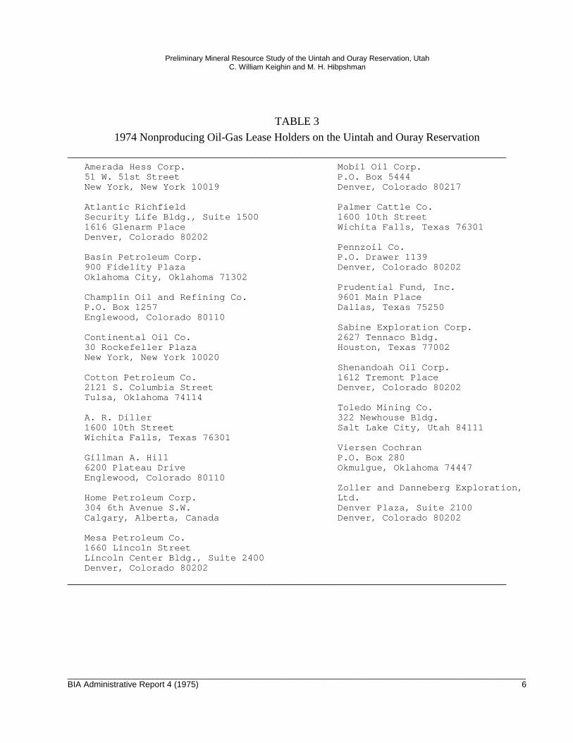
Table 2 lists oil and gas companies producing
from the Uintah and Ouray Reservation in 1974.
Table 3 lists companies and individuals holding
nonproducing leases on the reservation.
Recent activity has centered around the
Altamont-Bluebell area. In 1970, the Altamont
field yielded 238,939 barrels of oil and 166,599
thousand cubic feet (Mcf) of gas. During 1973, the
BIA Administrative Report 4 (1975) 4
_________________________________________________________________________________________________
______________________________________________________________________________
______________________________________________________________________________
Preliminary Mineral Resource Study of the Uintah and Ouray Reservation, Utah C. William Keighin and M. H. Hibpshman
same field yielded 5,572,414 barrels of oil and barrels of oil, and 616,314 Mcf of gas, and in 1973,
6,829,281 Mcf of gas. production increased to 7,350,889 barrels of oil
In 1970, the Bluebell field yielded 1,439,179 and 6,257,542 Mcf of gas.
TABLE 2
1974 Oil and Gas Producers on the Uintah and Ouray Reservation.
Amoco Production Corp.Security Life BuildingDenver, Colorado 80202
Belco Petroleum Corp.630 Third AvenueNew York, New York 10017
Brinkerhoff Drilling Co.600 Denver Club BuildingDenver, Colorado 80302
Chevron Oil Corp.P.O. Box 599Denver, Colorado 94104
Diamond Shamrock Corp.First National Bank Bldg.Box 631Amarillo, Texas 79105
Exxon Corp. of AmericaP.O. Box 120 Denver, Colorado 80201
Flying Diamond Corp.*Suite 900, 1700 BroadwayUnited Bank Center Denver, Colorado 80202
Friar Oil Corp.21 Felt Building Salt Lake City, Utah 84111
Gas Producing Enterprise1050 17th Street, 21st FloorDenver, Colorado 80202
Gulf Oil Corp.Gulf BuildingP.O. Box 1166Pittsburgh, Pennsylvania 15230
Husky Oil Corp.600 S. Cherry StreetDenver, Colorado 80222
Koch IndustriesP.O. Box 2256Wichita, Kansas 67201
Mapco900 Oil Center BuildingTulsa, Oklahoma 74119
Mountain Fuel Supply Co.P.O. Box 11368Salt Lake City, Utah 84139
Phillips Petroleum Co.7801 E. BelleviewEnglewood, Colorado 80110
Shell Oil Corp.1700 BroadwayDenver, Colorado 80202
Sun Oil Co.1720 S. Bellaire, Suite 300Denver, Colorado 80222
Texaco, Inc.135 East 42 nd StreetNew York, New York 10017
Union Oil Co.Union Oil Center461 South Boylston StreetLos Angeles, California 90017
*May no longer produce from the reservation.
BIA Administrative Report 4 (1975) 5
_________________________________________________________________________________________________
______________________________________________________________________________
______________________________________________________________________________
Preliminary Mineral Resource Study of the Uintah and Ouray Reservation, Utah C. William Keighin and M. H. Hibpshman
TABLE 3
1974 Nonproducing Oil-Gas Lease Holders on the Uintah and Ouray Reservation
Amerada Hess Corp. Mobil Oil Corp. 51 W. 51st Street P.O. Box 5444 New York, New York 10019 Denver, Colorado 80217
Atlantic RichfieldSecurity Life Bldg., Suite 15001616 Glenarm PlaceDenver, Colorado 80202
Basin Petroleum Corp.900 Fidelity PlazaOklahoma City, Oklahoma 71302
Champlin Oil and Refining Co.
Palmer Cattle Co.1600 10th StreetWichita Falls, Texas 76301
Pennzoil Co.P.O. Drawer 1139Denver, Colorado 80202
Prudential Fund, Inc.9601 Main Place
P.O. Box 1257 Dallas, Texas 75250Englewood, Colorado 80110
Sabine Exploration Corp.Continental Oil Co. 2627 Tennaco Bldg.30 Rockefeller Plaza Houston, Texas 77002New York, New York 10020
Shenandoah Oil Corp.Cotton Petroleum Co. 1612 Tremont Place2121 S. Columbia Street Denver, Colorado 80202Tulsa, Oklahoma 74114
Toledo Mining Co.A. R. Diller1600 10th StreetWichita Falls, Texas 76301
Gillman A. Hill6200 Plateau DriveEnglewood, Colorado 80110
Home Petroleum Corp.304 6th Avenue S.W.Calgary, Alberta, Canada
322 Newhouse Bldg.Salt Lake City, Utah 84111
Viersen CochranP.O. Box 280Okmulgue, Oklahoma 74447
Zoller and Danneberg Exploration,Ltd.Denver Plaza, Suite 2100Denver, Colorado 80202
Mesa Petroleum Co.1660 Lincoln StreetLincoln Center Bldg., Suite 2400Denver, Colorado 80202
BIA Administrative Report 4 (1975) 6
_________________________________________________________________________________________________
_____________________________________________________________________________
______________________________________________________________________________
_____________________________________________________________________ _________
Preliminary Mineral Resource Study of the Uintah and Ouray Reservation, Utah C. William Keighin and M. H. Hibpshman
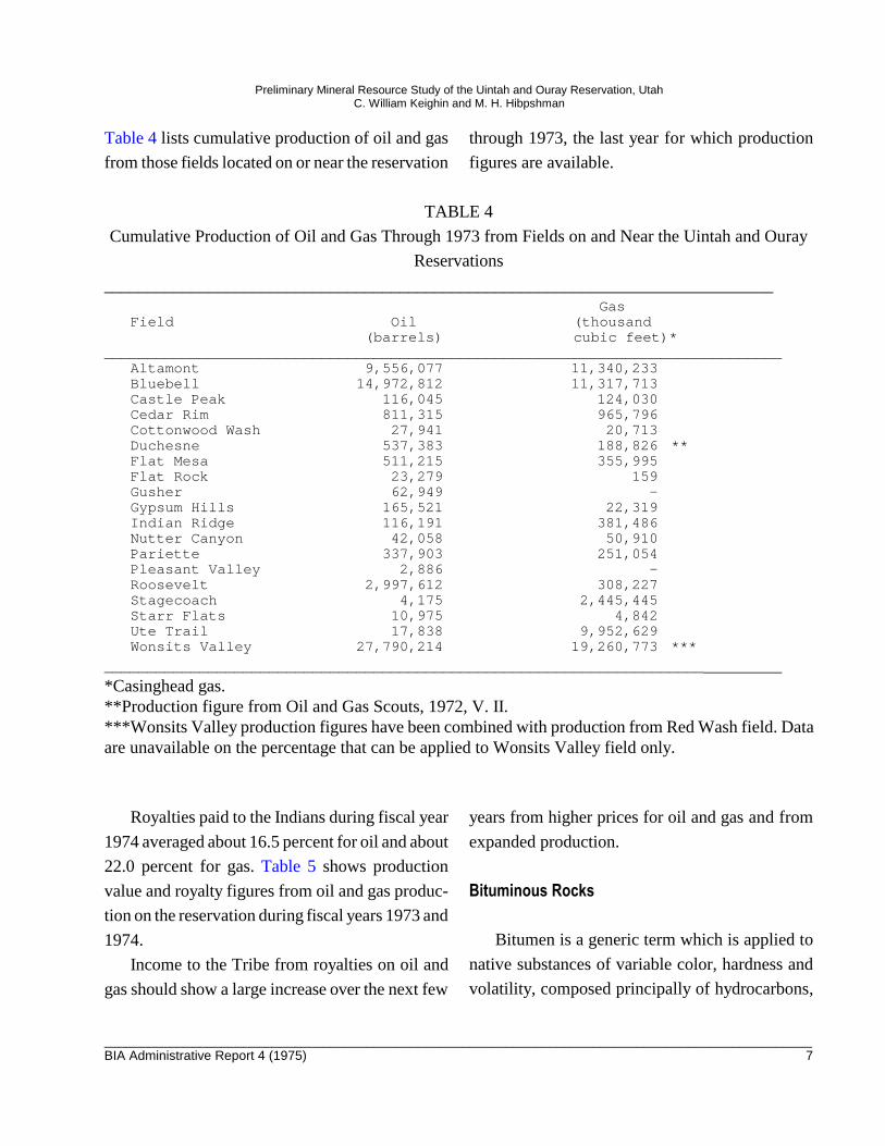
Table 4 lists cumulative production of oil and gas through 1973, the last year for which production
from those fields located on or near the reservation figures are available.
TABLE 4
Cumulative Production of Oil and Gas Through 1973 from Fields on and Near the Uintah and Ouray
Reservations
GasField Oil (thousand
(barrels) cubic feet)*
Altamont 9,556,077 11,340,233 Bluebell 14,972,812 11,317,713 Castle Peak 116,045 124,030 Cedar Rim 811,315 965,796 Cottonwood Wash 27,941 20,713 Duchesne 537,383 188,826 ** Flat Mesa 511,215 355,995 Flat Rock 23,279 159 Gusher 62,949 -Gypsum Hills 165,521 22,319 Indian Ridge 116,191 381,486 Nutter Canyon 42,058 50,910 Pariette 337,903 251,054 Pleasant Valley 2,886 -Roosevelt 2,997,612 308,227 Stagecoach 4,175 2,445,445 Starr Flats 10,975 4,842 Ute Trail 17,838 9,952,629 Wonsits Valley 27,790,214 19,260,773 ***
*Casinghead gas.**Production figure from Oil and Gas Scouts, 1972, V. II.***Wonsits Valley production figures have been combined with production from Red Wash field. Dataare unavailable on the percentage that can be applied to Wonsits Valley field only.
Royalties paid to the Indians during fiscal year years from higher prices for oil and gas and from
1974 averaged about 16.5 percent for oil and about expanded production.
22.0 percent for gas. Table 5 shows production
value and royalty figures from oil and gas produc-�������������
tion on the reservation during fiscal years 1973 and
1974. Bitumen is a generic term which is applied to
Income to the Tribe from royalties on oil and native substances of variable color, hardness and
gas should show a large increase over the next few volatility, composed principally of hydrocarbons,
BIA Administrative Report 4 (1975) 7
_________________________________________________________________________________________________
Preliminary Mineral Resource Study of the Uintah and Ouray Reservation, Utah C. William Keighin and M. H. Hibpshman
substantially free from oxygenated bodies, some
times associated with mineral matter, the non--
mineral constituents being fusable and largely
soluble in carbon disulfide. Bituminous sandstone
refers to sandstone which contains variable
amounts of bitumen in its pore spaces (Kayser,
1966).
The location of the oil-impregnated rocks in
and near the reservation is shown on Figure 7. The
significant deposits of bituminous rocks are obvi
ously within, or on the edges of, the Uinta Basin,
and the most significant appear to be outside
reservation boundaries. Within the Uinta Basin,
most deposits and reserves occur in the Green
River, Uinta, Duchesne River, and Wasatch For
mations of Eocene age. The Asphalt Ridge deposit
occurs in the Uinta and Duchesne River Forma
tions (Eocene) and Mesaverde Formation (late
Cretaceous) (Picard and High, 1970; Byrd, 1970).
The White-rock deposit occurs in the Navajo
Sandstone of Jurassic age (Ritzma, 1968). The
Deep Creek Nose deposit, a potentially large
deposit, occurs in the Duchesne River Formation,
in sandstone and conglomerate overlying the
Mancos shale and Duchesne River Formations.
The Tabiona deposits are localized in the Current
Creek (late Cretaceous and Paleocene age) and
Eocene Uinta Formations; these sandstone units do
not appear to be greater than 25 feet thick and are
of very limited areal extent. The Myton Bench
bituminous sandstones occur in highly lenticular
units of the Uinta Formation and appear to have
limited commercial value (Covington, 1963). The
Hill Creek deposits appear to be an extension of
the P.R. Spring deposits, but of a lower grade.
Physical properties of the bituminous rocks are
a very important factor in the evaluation of the
deposits. Porosity, permeability, grain size distri
bution, and cementing material have a direct
bearing on the degree of bituminous saturation and
probability of successful extraction of the bitumen
(Kayser, 1966, p. 39). The degree of cementation
influences not only migration of bitumen, but also
cost of mining and crushing. Oil migration may
have taken place laterally along bedding planes,
through permeable sandstone or limestone forma
tions, or along lateral or vertical passages formed
by faults, fractures, or joints. Fractures and joints
associated with faulting are often very important
migration routes. In addition, faults frequently
form barriers to migration and may cause entrap
ment. Usually, however, stratigraphic factors,
principally porosity and permeability, appear to be
more important than structure (Ritzma, 1968).
Although the potential resource contained in
the bituminous rocks may be large, several prob
lems may limit successful exploitation in the
foreseeable future. Large-scale operations are apt
to be restricted by a limited water supply. Surface
deposits, if sufficiently large, may be amenable to
strip mining. The bitumen-bearing rocks dip
towards the interior of the basin, and development
of the more deeply buried deposits will depend on
in situ thermal processes, which are not yet eco
nomically feasible.
The largest bituminous sandstone deposit,
known as the Hill Creek deposit, contains an
estimated 1.2 billion bbls of oil, of which 350
million bbls is in measured reserves. The remain
der falls in the indicated and inferred categories
(Ritzma, 1974). The Hill Creek deposit probably
BIA Administrative Report 4 (1975) 8
_________________________________________________________________________________________________
Preliminary Mineral Resource Study of the Uintah and Ouray Reservation, Utah C. William Keighin and M. H. Hibpshman
does not belong to the Tribe. Part of it is in Naval
Shale Oil Reserve No. 2 and the remaining part on
the reservation probably belongs to the Federal
Government, but ownership needs clarification. It
would be worthwhile to determine if oil contained
in the bituminous sandstone inside the Naval Oil
Shale reserve is reserved in the same manner as oil
contained in the oil shale. No known development
has occurred on the Hill Creek deposit.
The second largest bituminous sandstone
deposit is in the White Rocks area. Only a small
part of the deposit is believed to extend onto the
reservation. According to Ritzma (1974), past
development on the White Rocks deposit has
consisted of "Experimental mining and extraction
of oil (pilot plants operated successfully for short
period), in-situ experiments (steam flood and
thermal), and core drilling."
The third largest oil sand occurrence at least
partly on Indian land is the Willow Creek deposit.
The Utah Geological and Mineral Survey estimates
the deposit contains 20 to 25 million barrels of oil
in place (Ritzma, 1974). According to Hurlbut,
Kersich, and McCullough (1974) oil saturation of
the sands is poor, 2 to 8 gallons per ton, and the
deposit occurs under several hundred feet of
overburden. However, they estimated the deposit
contains about 44.0 million barrels of oil in two
zones on Indian lands. This figure is nearly twice
as much as the Utah Geological and Mineral
Survey estimated for the entire deposit.
The fourth largest oil sand, now known as the
Pariette deposit and formerly called Myton Bench
or Myton area, actually consists of several small
deposits. The entire area contains an estimated 10
to 12 million barrels of oil (Ritzma, 1974). Most of
the deposit, however, is not controlled by the
Tribe, and the extent of their ownership is un
known. There has been no, known development on
the deposit.
A smaller deposit on Indian lands is the Little-
water Hills occurrence, formerly known as Deep
Creek Nose. The oil content is estimated to be
10-12 million barrels (Ritzma, 1974). Overburden
ranges from 0 to about 500 feet, and there are one
or two pay zones. There has been no known devel
opment.
Another oil impregnated sandstone, wholly on
Indian-controlled land, is the Lake Fork deposit.
Estimates of oil-in-place are 6.5 to 10 million
barrels by the Utah Geological and Mineral Survey
(Ritzma, 1974) and 9.5 million barrels by Hurlbut,
Kersich, and McCullough (1974). Overburden
thickness has been placed at 0 to 450 feet and total
thickness of the pay zone at 10 feet by the consul
tants and 5 to 70 feet by the Utah Survey. At least
two authorities agree that this deposit has little
economic significance. Covington (1963) states
that the sands ate not rich enough to use as asphalt
paving material, indicating that saturation is poor,
and Hurlburt, Kersich, and McCullough (1974)
state that "the deposit cannot be strip mined and
reserves are too small to make the deposit eco
nomic for underground mining." However, the
Garner Construction Co. reportedly is interested in
using the deposit for asphalt paving material.
Because of the disagreement concerning the thick
ness of the pay zone, exploration would be desir
able to better define both the pay zones or zones
and degree of saturation.
The Chapita Wells occurrence has been desig
nated as a medium small (7.5 to 8 million barrels)
BIA Administrative Report 4 (1975) 9
_________________________________________________________________________________________________
Preliminary Mineral Resource Study of the Uintah and Ouray Reservation, Utah C. William Keighin and M. H. Hibpshman
deposit (Ritzma, 1974). The deposit, actually a
group of small individual occurrences, is in the
Hill Creek Extension of the Reservation. Some
land in and near the deposits is not owned by the
Tribe, and they do not control the mineral rights.
No development has been recorded at this location,
and the economic possibilities are unknown.
The Tabiona deposit, estimated to contain
about 4.6 million barrels of oil, is entirely on
Indian land (Ritzma, 1974). There is no develop
ment and the commercial possibilities are un
known.
The Spring Branch deposit is estimated by the
Utah Geological and Mineral Survey to contain
only 1.5 to 2.0 million-barrels of oil (Ritzma,
1974). Hurlbut, Kersich, and McCullough (1974)
estimate the deposits contains as much as 3.7
million barrels, but state that the deposit is uneco
nomic at present because the saturation is only 9.4
barrels per ton. Still, they believe the deposit may
be strippable. There has been no development on
the deposit to date. An examination to determine
the size, thickness, and degree of saturation of this
deposit would be useful.
�����������������
Solid hydrocarbons of the Uinta basin occur
only to a minor extent on the Uintah and Ouray
Reservation. All current mining is for gilsonite and
is centered around the community of Bonanza
several miles east of the reservation. The other
hydrocarbons, wurtzilite, tabbyite, ingramite,
albertite, and ozokerite (ozocerite), have not been
mined for several years. According to Nackowski,
Fisher, and Beer (1963), reserves of wurtzilite,
ozokerite, and tabbyite combined do not exceed
3,000 tons. Ozokerite is not known to occur on the
reservation.
Gilsonite.--Gilsonite is a solid amorphous
asphaltic bitumen which occurs in distinct veins
and veinlets in the Tertiary nonmarine sediments
of the gently downwarped Uinta Basin. These
veins continue unbroken for miles and maintain
relatively constant thickness. Most of the veins are
vertical and are filled with massive gilsonite,
showing clean contacts with little or no impregna
tion or saturation of the vein walls. The veins fill
vertical tensional cracks in the competent sedimen
tary beds, and generally extend downward until
they reach the incompetent mudstone of the Uinta
Formation and the oil shales of the Green River
Formation (Crawford and Pruitt, 1963). Hunt and
others (1954) concluded that the gilsonite is de
rived from the upper Green River Formation oil
shales, and flowed upward into the open tensional
cracks.
Three systems of gilsonite veins cross the
reservation. Two veins of the Fort Duchesne
system mark the northern extent of gilsonite veins
in the Uinta Basin. One or the other of these veins,
which are as much as 4 feet thick and 3 miles long,
were mined from the late 1880's until 1946. The
Pariette system south of Myton in Duchesne
County is the western extremity of known gilsonite
deposits in Utah. This system has a total length of
9 miles, with veins approximately 18 inches wide
at the surface and increasing to approximately 40
inches at a depth of 1,500 feet. The Willow Creek
and Ouray systems, south of Chapita Wells, are in
relatively unexplored areas, but are known to
BIA Administrative Report 4 (1975) 10
_________________________________________________________________________________________________
Preliminary Mineral Resource Study of the Uintah and Ouray Reservation, Utah C. William Keighin and M. H. Hibpshman
contain at least five moderate-sized gilsonite veins,
and a number of other veins whose dimensions and
quality are not well known (Crawford and Pruitt,
1963).
Except for minor quantities near Fort Duchesne
and some small uneconomic veins near Ouray, the
area resources are not Indian-owned.
Hurlbut, Kersich, and McCullough (1974)
suggest that a geophysical investigation using
electrical resistivity methods might lead to discov
ery of gilsonite veins that have no surface expres
sion.
��������
Oil shale which may be a significant economic
resource, is neither oil nor shale. The host rock is
usually a magnesian marlstone with a high organic
content and inorganic constituents such as dolo
mite, calcite, and clay minerals. The rock was
formed by compression of abundant plant and
animal life deposited in Lake Uinta during Eocene
time (Cashion, 1967; Quigley and Price, 1963).
When oil shale is heated under the proper condi
tions, oil is released.
The oil shale of interest in the Uinta basin is
restricted to the Green River Formation. Rich oil
shales of the Piceance Creek basin of northwestern
Colorado also occur in the Green River Formation.
Depositional conditions differed between the two
basins, however, leading to more rapid changes in
quality and quantity of oil shale across the Uinta
Basin. Many rich areas have been found, but these
appear to be more erratic in areal extent and more
subject to vertical variation than the Colorado
deposits (Smith and Stanfield, 1964).
Oil shale prospects in the eastern Uinta Basin
have been more extensively investigated because
outcrop information is more abundant and depths
to subsurface deposits are shallower, and more
drilling has been done on the Naval Oil Shale
Reserve. The oil shale is more deeply buried in the
western and central parts of the Uinta Basin.
Although oil shale occurs over a large portion
of the reservation, much of it is too low in grade or
is too deep to be considered economic (Figure 8).
Also, large areas of known oil shale occurring on
the reservation are not controlled by the Indians.
For example, in the southern part of the reserva
tion, the U. S. Government owns most of the shale;
some of the area is within Naval Oil Shale Reserve
No. 2. Nevertheless, some shale under Indian
control on the reservation may have commercial
possibilities. The study by Hurlbut and others
(1974) indicates that at least one 20-foot bed of oil
shale in the Avintaguin Canyon area in the south
western corner of the reservation may approach
commercial grade, and the lowermost of three oil
shale beds averaged 35 gallons of crude shale oil to
the ton. This bed may contain between 100 and
185 million barrels of oil. The study also recom
mends further exploration. An exploratory drilling
program would provide the necessary information
to evaluate the area and determine its commercial
possibilities.
The Tribal Council and employees of the Ute
Research Laboratories state that Paradox Produc
tion Co. is interested in leasing the Avintaguin
Canyon oil shale. The company, which owns oil
shale claims in the canyon adjacent to the reserva
tion (Figure 8) reports that shale on its property
contains about 50,000 bbls of oil per acre. Recent
BIA Administrative Report 4 (1975) 11
_________________________________________________________________________________________________
Preliminary Mineral Resource Study of the Uintah and Ouray Reservation, Utah C. William Keighin and M. H. Hibpshman
work by the Laramie Energy Research Center at
Laramie, Wyo., indicates that the 50,000-bbl figure
is not unrealistic. Two cores taken by the company
on land adjacent to the reservation were recently
analyzed by the Laramie facility. Both cores
showed an average of about 31 bbls per ton
through an 18-foot section or about 40,000 bbls per
acre. The company has indicated that a
50,000-bbl-per-day plant might be feasible, pro
vided enough shale is available.
����
Minable beds of coal are found in the Frontier
Sandstone Member of the Mancos Shale and in the
Mesaverde Group, both of Late Cretaceous age
(Schell, 1964). These beds are described by Huddle
and McCann (1947) and Huddle, Mapel, and
McCann (1951), and crop out in the northwestern
portion of the reservation. Essentially the entire
reservation is underlain by coal-bearing rocks, but
readily available coal occurs only near areas of
outcrop. Because the coal-bearing strata dip toward
the center of the Uinta Basin, the coal may be
3,000 feet below the land surface only a few miles
from the outcrop, and may be as much as 20,000
feet below the surface in the center of the basin
(Averitt, 1972). Near-surface coal on the reserva
tion is in two fields, the eastern or Vernal field and
the western or Tabby Mountain (Blacktail Moun
tain) field. Development in those portions of the
fields on Indian-controlled lands has been slight,
but there are small, abandoned mines in both areas.
Production probably has not exceeded a few
thousand tons from either field. One existing coal
lease on 200 acres of reservation land (Figure 9) is
held by the Red Creek Coal Corp. The property
contains the abandoned Redden mine, which was
opened in a coalbed about 27 feet thick that dips to
the south about 50º. Production probably did not
exceed a thousand tons from both the strip and
underground operations.
Coal owned by the tribe in the northeastern
corner of the reservation is part of the Vernal field.
All of the coal is in the Frontier Formation and the
only significant coal is a single steeply dipping bed
3 to 6 feet thick (Hurlbut, et al., 1974).
All coal in the northwest part of the reservation
is in the Tabby Mountain (Blacktail Mountain)
field. According to Doelling and Graham (1972),
the entire field, including both the Frontier and
Mesaverde beds, contains about 231.1 million tons
of coal.
Hurlbut, Kersich, and McCullough (1974)
report that lands held by the Indians contain about
62.0 million tons of "semi-proven" coal resources
plus 97.0 million tons of "possible" coal reserves
in five beds, each 5 feet thick or more, and at a
depth of less than 3,000 feet. This coal is in an area
between Red Creek and Currant Creek, the only
area on the reservation that contains worthwhile
quantities of minable coal.
The coal on the reservation is ranked as high
volatile C bituminous. Analyzed samples contain
7500 to 12,000 Btu value. The coal is noncoking,
and cannot be used for metallurgical purposes.
About the only use for reservation coal would be
for power generation.
Recent work by A. E. Lindquist, USBM,
indicates that coal owned by the Tribe may be
insufficient to warrant a coal-gasification plant. To
amortize the capital investment, the life of a coal--
BIA Administrative Report 4 (1975) 12
_________________________________________________________________________________________________
Preliminary Mineral Resource Study of the Uintah and Ouray Reservation, Utah C. William Keighin and M. H. Hibpshman
gasification plant necessarily would be about 35
years. A plant using 7,500 Btu coal requires about
9.2 million tons of coal per year, and a plant using
12,000-Btu coal requires about 5.8 million tons per
year. Therefore, a gasification plant using reserva
tion coal would require between 203 million and
322 million tons of reserves. The Tribe probably
does not have 200 million tons of minable coal.
Moreover, coal beds on the reservation are steeply
dipping (about 50º) making it impossible to strip
mine to any great depth. U.S. Bureau of Mines
(1971) does not list any reserves in Duchesne or
Uintah Counties.
Overall, it is deemed unlikely that a large mine
or mines will be developed on the reservation in
the foreseeable future. However, the tribe has
indicated that it has been approached by interested
companies.
�����
Small, non-commercial, low-grade uranium
deposits occur within the reservation (Figure 10)
(Cohenour, 1969).
The most common type of uranium occurrence
in the Uinta Formation is a copper-uranium-carbon
association found in a zone centered near Ouray
(Figure 10). The highest grade mineralization
occurs in carbonized wood, bones, turtle shells,
and logs. The logs are generally found on the
flanks of paleochannels; each log is surrounded by
a halo of azurite and malachite. Only secondary
uranium minerals have been identified and copper
is generally more abundant than uranium. Some
uranium has also been noted in carbonaceous
shales, but there is essentially no uranium in
noncarbonaceous sediments (Noble and Annes,
1957, p. 17). Locally uraniferous opal in a caliche--
like material coats fracture surfaces and bedding
planes in the Uinta Formation (Cohenour, 1969).
The Green River Formation has a high potential
tonnage of weakly mineralized rock (Noble and
Annes, 1957), but it contains no known uranium
deposits of ore grade. There are no obvious guides
to uranium in the Green River Formation, although
deposition was probably controlled by finely
divided carbon trash disseminated in calcareous
siltstone and calcareous clayey mudstone.
A uranium occurrence has been reported in
fresh water limestone of unknown age ten miles
south of Highway 40 (Beroni and McKeown, 1952,
P. 13).
Metallic Mineral Resources
������
Copper mineral occurrences have been known
in the Uinta sandstone for many years (Butler and
others, 1920; Roberts, 1964) and although sporadic
prospecting has been done, there appears to have
been no commercial production. The most signifi
cant mineralization appears to be near the junction
of the Green and Duchesne Rivers, although the
weak uranium mineralization usually occurs with
copper mineralization (Figure 10).
The copper typically occurs in the sandstone in
close association with plant remains. Portions of
the plant remains have been replaced by copper
minerals, primarily chalcocite. Near the surface the
copper minerals have all been oxidized and now
are primarily malachite, a copper carbonate. If a
BIA Administrative Report 4 (1975) 13
_________________________________________________________________________________________________
Preliminary Mineral Resource Study of the Uintah and Ouray Reservation, Utah C. William Keighin and M. H. Hibpshman
large proportion of plant fragments has been
replaced, the copper mineralization may be of high
grade. The copperbearing rock is confined to
lenses containing abundant plant remains; how
ever, the mineralization, extending through a
thickness of about 10 feet, is not limited to concen
trations around carbonized material.
Copper content of the ore varies, but a mine
near the reservation southwest of Ouray has proven
reserves of about 100,000 tons averaging 1.17
percent copper and minor quantities of gold, silver,
and uranium. The mine, owned by Lloyd Ash of
Pleasant Grove, is being developed and work to
date has consisted of upgrading access to the mine
and clearing and leveling about 3 acres to be used
as leach pads. Several small dams have been
constructed, and about 1 mile of pipeline has been
installed to pump water from Pariette Draw to
fiberglass tanks installed at the mine site. Mining
at a rate of about 10,000 tons per year is scheduled
to begin in the late spring of 1975. Processing will
consist of leaching with sulfuric acid supplied by
Kennecott Corp. of Bingham.
Another copper deposit on the reservation
occurs east of Green River north of Ouray. The
Tribe does not own the minerals but two claims
have been staked by Lawrence Jenks, a tribe
member. Mineralization on these two claims is in
the Uinta Formation and is of the same type de
scribed for deposits west of the river.
����
Accumulations of gold in river gravels proba
bly occur on Indian land along the Green River in
Uintah and Grand Counties. Attempts to mine
placer deposits upstream (Figure 10) from the
reservation between 1905 and 1942 resulted,
however, in only a small annual recovery. The
highest production was in 1941 when a combined
total of 334 ounces of gold was recovered from all
placers along the Green River (Johnson, 1973).
The gold is reported to be in a fine, flourlike
form that is very difficult to recover. Source of the
gold probably was the Precambrian rocks of north
western Colorado. Dredging operations were
attempted at Horseshoe Bend, Jensen, and below
Split Mountain gorge, about 25 to 35 air-miles
above the reservation boundary, but they were
unsuccessful. Gravels dredged in 1910 reportedly
averaged $0.60 to $1.75 per cubic yard. Percent
recovery is unknown. Gold also is known to occur
in placers along the Green River in Grand County,
but the grade has not been determined.
Total reserves of gold contained in placer
gravels along the Green River on Indian land are
unknown but could be substantial. However, the
average content is low, and the gold is difficult to
recover because of its finely divided form. Never
theless, field reconnaissance and sampling to
determine the extent and grade of the placers
would clarify the uncertainties.
�����������
Minor occurrences of several other metals are
reported on and near the reservation. Ilsemannite,
an amorphous, water-soluble molybdenum salt
(Mo308 nH20), is reported to occur in the Bridger
formation on the south side of the Duchesne River
valley in Uintah County. An attempt was made to
BIA Administrative Report 4 (1975) 14
_________________________________________________________________________________________________
Preliminary Mineral Resource Study of the Uintah and Ouray Reservation, Utah C. William Keighin and M. H. Hibpshman
market the mineral as a dye, but was unsuccessful
(Pruitt, 1961). Little else is known of the deposit.
An uneconomic manganese deposit is reported
in an area several miles east of the reservation.
Manganese is not known to occur on the reserva
tion (Pruitt, 1961).
Nonmetallic Mineral Resources
Nonmetallic resources of the Uintah and Ouray
Reservation and environs are widespread, but,
except for sand and gravel and possibly minor
quantities of stone, they have not been developed.
Resources on or near the reservation include
phosphate, sand and gravel, stone, gypsum,
dawsonite, and possibly zeolites and trona.
���������
Phosphate of potential economic importance on
the reservation is found in the Meade Peak phos
phatic shale member of the Phosphoria Formation
of Permian age (Figure 9). This member contains
large resources of low-grade rock amenable to strip
mining, but these resources are found primarily off
the reservation, near Vernal (Cheney, 1957a, p. 7).
Phosphate rock is produced by the Stauffer Chemi
cal Co. from its Cherokee mine north of Vernal.
Most phosphate rock occurring in Duchesne or
Uintah Counties is outside reservation boundaries.
No phosphate rock occurs near Indian lands in
Wasatch County, and Grand County has no known
phosphate rock deposits. A known deposit on
Indian land occurs along the northern border of the
reservation near the community of Hanna. Also, an
80-acre area of phosphate rock is in the northeast
corner of the reservation at White Rocks Canyon in
Uintah County. According to Pruitt (1961) and
consultants Hurlbut, Kersich and McCullough
(1974), the latter deposit probably is not economic.
It consists of three phosphate beds 1.75 feet thick,
1.5 feet thick, and 4.7 feet thick. The first two beds
contain about 27 percent P205 and the third about
20 percent P205. The two richer beds probably are
too thin to be mined. The thicker bed possibly
could be exploited, but it contains only ab out
700,000 tons to a depth of 1,250 feet, the limit to
which it could be mined. The entire deposit is
estimated to contain some 2.2 million tons of
resources.
The deposit along the northern boundary of the
reservation near Hanna is in two parts, one on each
side of the North fork of the Duchesne River.
Analytical data on samples taken from these
deposits is reported by Nackowski and others
(1963). All were low in grade, and the richest was
only 18.75 percent P205. Williams (1942) confirms
the low grade of the phosphate rock, reporting an
analysis of a sample from about the same area to
be only 2.95 percent P205. He states "Mining of
phosphate in Duchesne County at the present time
would be marginal or not feasible due to the
narrow widths, low grade, and steep dip of the
phosphate beds."
Although Gere (1964, p. 201) reports rather
large low-grade phosphate reserves for Duchesne
County, his estimates include some resources off
the reservation, and may be optimistic. The two
areas discussed by Coffman and Service (1967, p.
138) total about 300 acres of above-drainage level
Meade Peak. The Mackentire Draw area contrib
utes about 35 acres, and the remaining 265 acres is
BIA Administrative Report 4 (1975) 15
_________________________________________________________________________________________________
Preliminary Mineral Resource Study of the Uintah and Ouray Reservation, Utah C. William Keighin and M. H. Hibpshman
found in the Rock Creek area. In an 11.5-foot zone
in the Mackentire Draw area there could be 11
million tons of at least 14 percent P205" The Rock
Creek area, using a 4.8-foot zone of 18 percent or
greater, P205, should contain roughly 5.5 million
tons above drainage level and 1.8 million tons for
each 100 feet below drainage level (Coffman and
Service, 1967, p. 138).
Overall, it appears unlikely that phosphate
deposits on reservation lands could be exploited
economically in the foreseeable future. It is equally
doubtful that further exploration would signifi
cantly change that outlook.
�������������
Nahcolite.--Nahcolite (NaHCO3) occurs in the
Uinta and Green River Formations of Eocene age
(Hite, 1964). It was first reported from a Sun Oil
Co. well in the NE¼NE¼ sec. 22, T. 9 S., R. 20 E.,
where it occurred in a zone approximately 525 feet
thick, the top of which is 1,745 feet below the
surface. The best mineralized interval was 5 feet
thick and averaged 60 percent nahcolite. A well
drilled by Continental Oil Co. in the
NE¼SW¼NE¼ sec. 17, T. 4 S., R. 4 W., Uinta
Special Meridian, may also have penetrated bedded
deposits of sodium minerals between depths of
2,902 and 3,582 feet (Hite, 1964). Dane (1955)
reported the occurrence of nahcolite and shortite
[Na2Ca2(C03)2] in the Carter Oil Co. Joseph Smith
No. 1 well located in the SE¼ SE¼ sec. 16, T. 3
S., R. 5 W., Uinta Special Meridian, a few miles
north of Duchesne. The nahcolite was observed in
a section 20 feet thick at a depth of 3,600 feet.
Nahcolite is a potential source of soda ash, but
any development on reservation lands would face
serious competition from the nearby established
Wyoming trona fields. Nielson (1969) reported
that nahcolite is effective as an air pollution con
trol agent in removing sulfur compounds from
stack gases. If this use becomes economically
feasible, there is a possibility of development of
the nahcolite underlying reservation lands.
�����
Gypsum (CaS04 2H20) has been noted in the
northeastern corner of the reservation in the Car
mel Formation. Except for local use as a plaster, it
has not been mined (Pruitt, 1961). It is unlikely
that gypsum deposits in the area can be developed,
owing to the distance from railroads and lack of a
significant local market.
�������
Zeolites have been reported to occur in the
Green River Formation east of the reservation
(Pruitt, 1961), indicating they possibly may be
present in the same formation on the reservation.
No such discoveries have yet been noted, however.
�����
Stone resources are widespread over the reser
vation. However, no high-value stone, such as
marble or slate, occurs in the area. The available
resources of low-value sandstone and limestone
probably will be in only small demand within the
foreseeable future.
BIA Administrative Report 4 (1975) 16
_________________________________________________________________________________________________
Preliminary Mineral Resource Study of the Uintah and Ouray Reservation, Utah C. William Keighin and M. H. Hibpshman
���������������
Sand and gravel deposits are widespread on the
reservation, both as alluvium in existing streams
and as older terrace deposits adjacent to such
streams. Deposits related to ancient streams also
are found in many areas of the reservation. Sand
and gravel owned by the Indians is currently being
produced from only one deposit. The Uinta Basin
Concrete Products Co. of Roosevelt has a permit to
extract sand and gravel from 100 acres in the
eastern part of the reservation. During 1973,
20,158 cubic yards of sand and gravel was mined
for which the Indians received $1,924 in royalty. In
1974, the company removed 55,275 cubic yards
and paid the Indians $0.06 per yard for a total of
$3,316. The importance of a sand and gravel
resource in an area of low population density, such
as the reservation, is negligible.
MINERAL LEASING
Federal regulations require established royalty
and rental fees for mineral leases on the Uintah and
Ouray Indian Reservation in Utah. Also, bonds
must be posted by the lessee for each lease. The
bonds are as follows, except as noted.
For less than 80 acres $1,000
For 80 acres and less than
120 acres 1,500
For 120 acres and not more than
160 acres 2,000
For each additional 40 acres, or
part thereof, above 160 acres 500
The bond for minerals other than oil and gas
may be less, provided the Secretary of the Interior,
with consent of the Tribe, agrees; or a lessee may
file a bond of $15,000 for all leases in one state if
the total acreage does not exceed 10,240. A lessee
may also file a bond of $75,000 for nationwide
coverage.
Lessees may acquire more than one lease, but
a single lease may not exceed 2,560 acres for
minerals other than coal. Ordinarily, coal leases
also are limited to 2,560 acres, but upon applica
tion, leases can be combined. Leases may be made
for any specified term not to exceed 10 years. A
diagram of the procedure for obtaining leases and
mining permits is shown in Figure 11.
Royalties and rentals for oil and gas leases are
set by the Secretary of the Interior. The law pro
vides that $1.25 per acre per annum be paid by the
lessee in advance and that the royalty shall be at
least 12.5 percent. For minerals other than oil and
gas, rental payments are set at $1.00 per acre and a
development expenditure of not less than $10.00
per acre per year.
Unless otherwise authorized by the Commis
sioner of Indian Affairs, the minimum rates for
minerals other than oil and gas shall be as follows:
"(a) For substances other than gold, silver,
copper, lead, zinc, tungsten, coal,
asphaltum and allied substances, oil, and
gas, the lessee shall pay quarterly or as
otherwise provided in the lease, a royalty
of not less than 10 percent of the value, at
the nearest shipping point, of all ores,
metals, or minerals marketed."
BIA Administrative Report 4 (1975) 17
_________________________________________________________________________________________________
Preliminary Mineral Resource Study of the Uintah and Ouray Reservation, Utah C. William Keighin and M. H. Hibpshman
"(b) For gold and silver the lessee shall pay
quarterly or as otherwise provided in the
lease, a royalty of not less than 10 percent
to be computed on the value of bullion as
shown by mint returns after deducting
forwarding charges to the point of sale; and
for copper, lead, zinc, and tungsten, a
royalty of not less than 10 percent to be
computed on the values of ores and con
centrates as shown by reduction returns
after deducting freight charges to the point
of sale."
"(c)For coal the lessee shall pay quarterly
or as otherwise provided in the lease, a
royalty of not less than 10 cents per ton of
2,000 pounds of mine run, or coal as taken
from the mine, including what is com
monly called 'slack'."
"(d) For asphaltum and allied substances
the lessee shall pay quarterly or as other
wise provided in the lease, a royalty of not
less than 10 cents per ton of 2,000 pounds
on crude material or not less than 60 cents
per ton on refined substances."
In addition to the Federal regulations, the tribe
requires that some Indians be hired by any firm
extracting minerals from reservation lands.
The Tribe presently owns only the surface
rights in the easternmost part of the reservation and
over most of its southern extension. The Tribal
Council is currently preparing legislation to be
presented to the present congress (94th Congress,
First Session) for restoration of mineral rights in
the area. Part of Naval Oil Shale Reserve No. 2 is
in the area.
MARKETS
Markets exist for most mineral commodities
found within the reservation. Sand and gravel and
stone however have a limited local market. Petro
leum and natural gas reserves are being developed
at a rapid rate, but most of the production is ex
ported. A limited national market exists for
gilsonite, but because substitutes exist for most
uses of this material competition is strong.
Bituminous sandstones have found a limited
local use as road asphalt, but their greatest promise
is as a source of petroleum products.
Only sand and gravel, crushed stone, and minor
quantities of bituminous sandstones could be used
locally. All other mineral commodities occurring
on the reservation must find their way into the
national market.
RECOMMENDATION FOR FUTURE WORK
1) Determine the status of mineral rights on
reservation land to determine which land can offer
economic benefits to the Tribe.
2) Encourage commercial oil companies to
continue exploration, especially on the Altamont
trend.
BIA Administrative Report 4 (1975) 18
_________________________________________________________________________________________________
Preliminary Mineral Resource Study of the Uintah and Ouray Reservation, Utah C. William Keighin and M. H. Hibpshman
3) Continue mapping of near-surface coal
deposits exposed in the northwest portion of the
reservation.
4) Initiate exploration for near-surface, second
ary copper mineralization. Although it appears that
these deposits are scattered and probably of low
tonnage, the copper present should be amenable to
low cost extraction by heap leaching methods.
5) Define extent and grade of oil shale by
examination of existing well log data, extended
field mapping, and perhaps drilling 2 to 4 core
holes in the west-central portion of the reservation.
6) Determine ownership, extent, and oil con
tent of bituminous sandstones to evaluate their
potential and plan for development.
BIA Administrative Report 4 (1975) 19
_________________________________________________________________________________________________
Preliminary Mineral Resource Study of the Uintah and Ouray Reservation, Utah C. William Keighin and M. H. Hibpshman
REFERENCES
Abraham, H., 1945, Asphalts and allied
substances: Raw materials and manufactured
products: v. 1, 5th ed., New York, D. Van
Nostrand, Co., Inc., pp. 152-153, 185-186,
250-258, 291-292, 296.
_____1960, Asphalts and allied substances: v. 1,
6th ed., New York, D. Van Nostrand, Co., Inc.,
pp. 223-228.
Anderson, D. W., and Picard, M. D., 1972, Stratig
raphy of the Duchesne River Formation
(Eocene-Oligocene?), northern Uinta Basin,
northeastern Utah: Utah Geol. and Mineralogy.
Survey Bull. 97, 29 p.
Andrews, D. A., and Hunt, C. B., 1948, Geologic
map of eastern and southern Utah: U.S. Geol.
Survey Prelim. Oil and Gas Map 70.
Averitt, Paul, 1972, Coal, in Mallory, W. W., ed.,
Geologic atlas of the Rocky Mountain Region,
Rocky Mtn. Assoc. Geologists, pp. 297-299.
Baker, D. A., and Lucas, P. T., 1972, Major dis
covery in Utah: Strat trap production may
cover 280+ square miles: World Oil, pp. 65-68.
Ball, J. 0., 1947, Extraction of asphaltic materials
from bituminous sands: Compass, v. 24, No. 3,
pp. 133-146.
Bardsley, S. R., and Algermissen, S. T., 1965,
How to evaluate oil shale by well log analysis:
World Oil, v. 161, No. 2, pp. 94-97.
Belser, C., 1949, Oil shale resources of Colorado,
Utah, and Wyoming: Petroleum Dev. and
Technol. AIME, v. 179, pp. 72-82.
Beroni, E. P., and McKeown, F. A., 1952, Recon
naissance for uraniferous rocks in northwestern
Colorado, southwestern Wyoming, and north
eastern Utah: U.S. Geol. Survey Rept. TEI
308-A, 41 p.
Bradley, W. H., 1930, The varves and climate of
the Green River epoch: U.S. Geol. Survey
Prof. Paper 158-E, 24 p.
Bullock, K. C., 1970, Iron deposits of Utah: Utah
Geol. and Mineralogy. Survey Bull. No. 88,
101 p.
Bunn, J. R., 1952, Petroleum possibilities in the
Uinta Basin: Petroleum Eng., v. XXIV, No. 3,
pp. A62-A76.
Buss, W. R., 1951, Bibliography of Utah geology
to Dec. 31, 1950: Utah Geol. and Mineralogy.
Survey Bull. No. 40, 219 p.
Buss, W. R., and Goeltz, N. S., 1974, Bibliography
of Utah geology, 1950-1970: Utah Geol. and
Mineralogy. Survey Bull. No. 103, 285 p.
Butler, B. S., Loughlin, G. F., Heikes, V. C., and
others, 1920, The ore deposits of Utah: U.S.
Geol. Survey Prof. Paper 111, 672 p.
Byrd, W. D., 11, 1970, P. R. Springs oil--
impregnated sandstone deposit Uintah and
Grand Counties, Utah: Utah Geol. and Miner
alogy. Survey Spec. Studies 31, 34 p.
Cashion, W. B., 1961, Potential oil shale reserves
of the Green River Formation in the southeast
ern Uinta Basin, Colorado and Utah: U.S.
Geol. Survey Prof. Paper 424C, pp. 22-24.
_____1967, Geology and fuel resources of the
Green River Formation southeastern Uinta
Basin, Utah, and Colorado: U.S. Geol. Survey
Prof. Paper 548, 48 p.
BIA Administrative Report 4 (1975) 20
_________________________________________________________________________________________________
Preliminary Mineral Resource Study of the Uintah and Ouray Reservation, Utah C. William Keighin and M. H. Hibpshman
Cheney, T. M., 1957a, Phosphate in Utah and an
analysis of the stratigraphy of the Park City and
the Phosphoria Formation, Utah--A prelimi
nary report: Utah Geol. and Mineralogy. Sur
vey Bull. 59, 54 p.
_____1957b, Phosphate in Utah: Utah Geol. and
Mineralogy. Survey Bull. No. 59, 54 p.
Childers, B. S., and Smith, B. W., eds., 1970,
Abstract of theses concerning the geology of
Utah to 1966: Utah Geol. and Mineralogy.
Survey Bull. No. 86, 233 p.
Clark, A. F., and Newton, R. F., 1924, Utah hydro
carbons: Utah Geol. and Mineralogy. Survey
Bull. 15, pp. 33-46.
Clark, F. R., 1912, Coal near Thompson, Grand
County, Utah: U.S. Geol. Survey Bull. 541, pp.
453-477.
Clark, J., 1957, Geomorphology of the Uinta
basin: in Seal, 0. G., Guidebook to the geology
of the Uinta Basin, Intermtn. Assoc. of Petro
leum Geologists, pp. 17-20.
Coffman, J. S., and Service, A. L., 1967, An evalu
ation of the western phosphate industry and its
resources: 4. Wyoming and Utah: U.S. Bur.
Mines Rept. Inv. 6934, 158 p.
Cohenour, R. E., 1969, Uranium in Utah: in
Jensen, M. E., ed., Guidebook of northern
Utah: Utah Geol. and Mineralogy. Survey Bull.
82.
Covington, R. E., 1963, Bituminous sandstone and
limestone deposits of Utah: in Crawford, A. L.,
ed., Oil and gas possibilities of Utah,
re-evaluated: Utah Geol. and Mineralogy.
Survey Bull. 54-266 p.
_____-1965, Some possible applications of ther
mal recovery in Utah: Jour. of Petroleum
Technol. v. 17, No. 11, p. 1277-1284.
Crawford, A. L., 1949, Gilsonite and related hy
drocarbons of the Uinta Basin, Utah: Article in
oil and gas possibilities of Utah. Utah Geol.
and Mineralogy. Survey, pp. 235-260.
_____1961, Ozokerite: A possible new source:
Utah Geol. and Mineralogy. Survey Reprint 32,
12 p.
_____1963, Surface structure and stratigraphy of
Utah: Utah Geol. Survey Bull. No. 54A, 175 p.
Crawford, A. L., and Buranek, A. M., 1957, Utah
iron deposits: College of Mines and Mineral
Industries, Univ. of Utah, Circ. No. 24, 17 p.
Crawford, A. L., and Pruitt, R. G., 1963, Gilsonite
and other bituminous resources of central
Uintah County, Utah, in oil and gas possibili
ties of Utah re-evaluated: Utah Geol. and
Mineralogy. Survey Bull. No. 54, pp. 215-224.
Crittenden, M. D., Wallace, C. A., and Sheridan,
M. J., 1967, Mineral resources of the high
Uintas primitive area, Utah: U.S. Geol. Survey
Bull. No. 1230, 27 p.
Culbertson, W., Dyni, J. R., and Brobst, D. 1,
1967, Eocene Green River Formation-multiple
mineral resource, abs.: AAPG Bull., v. 51, No.
9, p. 1900.
Dane, C. H., 1955, Stratigraphic and facies rela
tionships of the upper part of the, Green River
Formation and the lower part of the Uinta
Formation in Duchesne, Uintah, and Wasatch
Counties, Utah: U.S. Geol. Survey Oil and Gas
Inv. Chart OC-52.
BIA Administrative Report 4 (1975) 21
_________________________________________________________________________________________________
Preliminary Mineral Resource Study of the Uintah and Ouray Reservation, Utah C. William Keighin and M. H. Hibpshman
Directory of the Mining Industry of Utah 1965,
1966, Utah Geol. and Mineralogy. Survey Bull.
No. 79, pp. 36, 45-48, 86, 91.
Doelling, H. H., and Graham, R. L., 1972, Eastern
and northern Utah coal fields: Utah Geol.
Survey Monograph Series No. 2, pp. 281-321.
Eisenberg, J. M., 1949, The Green River oil shales:
Earth Science Digest, v. 4, No. 2, pp. 13-16.
Eldridge, G. H., 1896, The uintaite deposits of
Utah: U.S. Geol. Survey Ann. Rept. pt. 1, pp.
915-949.
Erickson, M. P., 1952, New locality for shortite:
Am. Mineralogist, v. 37, Nos. 3-4, pp.
342-344.
Fene, W. J., 1928, The mining of gilsonite in Utah:
U.S. Bur. of Mines Inf. Circ. 6069, 6 p.
Fisher, D. J., 1936, The Book Cliffs coal field in
Emery and Grand Counties, Utah: U.S. Geol.
Survey Bull. No. 852, 104 p.
Gale, H. S., 1910, Coal fields of northwestern
Colorado and northeastern Utah: U.S. Geol.
Survey Bull. No. 415, pp. 204-219.
Geology and economic deposits of east central
Utah: Intermtn. Assoc. Geologists, Seventh
Ann. field conf., 1956, 225 p.
Gere, W. C., 1964, Phosphate, in Mineral and
water resources of Utah: U.S. Cong. 88th 2nd
sess., Comm. Interior and Insular Affairs,
Comm. Print, pp. 195-205.
Gold Placers in Utah--A compilation, 1966: Utah
Geol. and Mineralogy. Survey Circ. 47, 29 p.
Goode, H.D., and Feltis, R. D., 1962, Water
production from oil wells of the Uinta Basin,
Uintah and Duchesne Counties, Utah: Utah.
Geol. and Mineralogy. Survey Water--
Resources Bull. 1, 29 p.
Hager, D., 1952, Oil and gas in the Uinta Basin:
Petroleum Engineer, v. 24, No. 3, pp.
A41-A45.
Hansen, G. C., and Saville, H. C., 1955, Drilling
records for oil and gas in Utah: Utah Geol. and
Mineralogy. Survey Bull. No. 50, 116 p.
Hansen, G. H., and Bell, M. M., 1949, Oil and gas
possibilities of Utah: Utah Geol. and Mineral
ogy. Survey, 341 p.
Heylmun, E. B., 1964, Shallow gas and gas possi
bilities in east and south central Utah: Utah
Geol. and Mineralogy. Survey Spec. Studies
No. 8, 40 p.
Hite, R. J., 1964, Salines, in Mineral and Water
Resources of Utah: U.S. Cong. 88th, 2nd sess.,
Comm. Interior and Insular Affairs, Comm.
Print, p. 11.
Huddle, J. W., and McCann, F. T., 1947, Geologic
map of Duchesne River area, Wasatch and
Duchesne Counties, Utah: U.S. Geol. Survey
Oil and Gas Inv. Prelim. map 75.
Huddle, J. W., Mapel, W. J., and McCann, F. T.,
1951, Geology of the Moon Lake area,
Duchesne County, Utah: U.S. Geol. Survey Oil
and Gas Inv. Map OM-115.
Hunt, J. M., Stewart, F., and Dickey, P. A., 1954,
Origin of hydrocarbons of Uinta Basin, Utah:
Am. Assoc. Petroleum Geologists Bull., v. 38,
pp. 1671-1698.
Hurlbut, Kersich, and McCullough, 1974, Mineral
R e s o u r c e s a n d W a t e r
Requirements--Uinta-Ouray Indian Reserva
tion. A consultants, report for Ute Research
Laboratories and the Uinta and Ouray Indian
Tribes, 83 p.
BIA Administrative Report 4 (1975) 22
_________________________________________________________________________________________________
Preliminary Mineral Resource Study of the Uintah and Ouray Reservation, Utah C. William Keighin and M. H. Hibpshman
Johnson, M. C., 1973, Placer gold deposits of
Utah: U.S. Geol. Survey Bull. 1357, 26 p.
Johnson, H. S., Jr., 1959, Uranium resources of the
Green River and Henry Mountains districts,
Utah--A regional synthesis: U.S. Geol. Survey
Bull. No. 1087, pp. 59-104.
Kayser, R. B., 1966, Bituminous sandstone depos
its Asphalt Ridge: Utah Geol. and Mineralogy.
Survey Spec. Studies 19, 62 p.
Kemmerer, J. L., Jr., 1934, Gilsonite: M.S. Thesis,
Univ. of Utah, 61 p.
Kinney, D. M., 1955, Geology of the Uinta
River-Brush Creek area, Duchesne and Uintah
Counties, Utah: U.S. Geol. Survey Bull. 1007,
185 p.
Lindquist, A. E., 1975, Status of and potential for
coal gasification in the United States: U.S. Bur.
Mines (in press) manuscript prepared at
Intermtn. Field Operations Center, Denver
Federal Center, Denver, Colorado.
Lupton, C. T., 1912, The Deep Creek district of the
Vernal Coal Field, Uintah County, Utah: U.S.
Geol. Survey Bull. 471-1, pp. 579-628.
Mahoney, S. R., and Kunkel, R., 1963, Geology
and oil and gas possibilities of east central
Utah, in oil and gas possibilities of Utah
re-evaluated: Utah Geol. and Mineralogy.
Survey Bull. No. 53, pp. 353-380.
Mardirosian, C. A., 1966, Mining districts and
mineral deposits of Utah: Map. Salt Lake City,
privately printed, scale 1:750,000.
Marsell, R. E., 1964, Geomorphology of the Uinta
Basin--A brief sketch, -in Sabatka, E. F., ed.,
Guidebook to the geology and mineral re
sources of the Uinta Basin: Intermtn. Assoc.
Petroleum Geologists, Thirteenth Ann. Field
Conf., pp. 29-40.
Mauger, R. L., Kayser, R. B., and Gwynn, J. W.,
1973, A sulfur isotopic study of Uinta Basin
hydrocarbons: Utah Geol. and Mineralogy.
Survey Spec. Studies 41, 17 p.
Miller, D. F., 1956, The Hill Creek area, in geol
ogy and economic deposits in east central
Utah: Intermtn. Assoc. Petroleum Geologists
Seventh Ann. Field Conf. 1956: pp. 199-201.
Murray, A. N., 1949, The gilsonite deposits of the
Uinta Basin, Utah: The Tulsa Geologists Soc.
Digest, v. XVIII, pp. 104-106.
Nackowski, M. P., Fisher, D., and Beer, L., 1963,
Mineral resources of Duchesne County, Utah:
Univ. Agri. Experiment Sta. Bull., v. 54, No.
20, 97 p.
Nielsen, I., 1969, The amazing Piceance mineral
suite and its industrial potential for energy- oil-
metals- chemicals: Eng. Mining Jour., pp.
57-60.
Noble, E. A., and Annes, E. C., Jr., 1957, Recon
naissance for uranium in the Uinta Basin of
Colorado and Utah: U.S. Atomic Energy
Comm., RME-94, 22 p.
Osmund, J. C., 1964, Tectonic history of the Uinta
Basin, Utah, in Sabatka, E. F., ed., Guidebook
to the geology and mineral resources of the
Uinta Basin: Intermtn. Assoc. of Petroleum
Geologists, 277 p.
BIA Administrative Report 4 (1975) 23
_________________________________________________________________________________________________
Preliminary Mineral Resource Study of the Uintah and Ouray Reservation, Utah C. William Keighin and M. H. Hibpshman
Parker, E. W., 1896, Asphaltum: U.S. Geol. Sur
vey Seventeenth Ann. Rept., pt. 3, pp. 755-757.
Peterson, P. R., 1973a, Cedar Rim area: Utah
Geol. and Mineralogy. Survey Oil and Gas
Field Studies No. 10.
_____1973b, Bluebell field: Utah Geol. and Min
eralogy. Survey Oil and Gas Studies No. 12, 4
p.
Picard, M. D., and High, L. R., Jr., 1970,
Sedimentology and oil impregnated lacustrine
and fluvial sandstone, P. R. Spring area, south
east Uinta Basin, Utah: Utah Geol. and Miner
alogy. Survey Spec. Studies 33, 32 p.
Pruitt, R. G., 1961, Mineral resources of Uintah
County, Utah: Utah Geol. Survey Bull. 71, 101
p.
Quigley, M. D., and Price, J. R., 1963, Green River
oil shale potential in Utah, in Crawford, A. L.,
ed., Oil and gas possibilities of Utah,
re-evaluated: Utah Geol. and Mineralogy.
Survey Bull. 54, pp. 207-213.
Remington, N. C., 1959, A history of the gilsonite
industry: Univ. of Utah, M.S. Thesis, 338 p.
Richardson, G. B., 1909, Reconnaissance of the
Book Cliffs coal field: U.S. Geol. Survey Bull.
No. 371, 55 p.
Ritzma, H. R., 1968, Preliminary location map
oil-impregnated rock deposits of Utah: Utah
Geol. and Mineralogy. Survey Map No. 25.
_____1969, Oil impregnated sandstone deposits of
Utah--A progress report: Interstate Oil Com
pact Commission, Comm. Bull. VII, No. 2, pp.
24-34.
_____1972, Uinta Basin, in Mallory, W. W., ed.,
Geologic atlas of the Rocky Mtn. Region:
Rocky Mtn. Assoc. Geologists, pp. 276-278.
_____1974, Location map of oil-impregnated rock
deposits of Utah: Utah Geol. and Mineralogy.
Survey Map 33, 2 sheets.
Ritzma, H. R., and Seely, DeBenneville, K., 1969,
Determination of oil shale potential, Green
River Formation, Uinta Basin, northeast Utah:
Utah Geol. and Mineralogy. Survey Spec.
Studies 26, 15 p.
Roberts, C. J., 1964, Copper, in Mineral and water
resources of Utah: U.S. Cong. 88th, 2nd sess.,
Comm. Interior and Insular Affairs, Comm.
Print.
Robinson, H. M., 1916, Ozokerite in central Utah:
U.S. Geol. Survey Bull. 641A, pp. 1-16.
Sabatka, E. F., 1964,ed., Utah's hydrocarbon
storehouse: Guidebook to the Geology and
Mineral Resources of the Uinta Basin.
Intermtn. Assoc. of Petroleum Geologists, 277
p.
Schell, E. M., 1964, Coal in the Uinta Basin, Utah,
in Sabatka, E. F., ed., Guidebook to the geol
ogy and mineral resources of the Uinta Basin:
Intermtn. Assoc. Petroleum Geologists, Thir
teenth Ann. Field Conf., pp. 253-257.
Schultz, A. R., 1919, A geologic reconnaissance of
the Uinta Mountains, northern Utah with
special reference to phosphate: U.S. Geol.
Survey Bull. 690C, pp. 31-94.
Service, A. L., and Peterson, N. S., 1967, An
analysis of the western phosphate industry and
its resources: U.S. Bur. Mines Rept. Inv. 6935,
131 p.
BIA Administrative Report 4 (1975) 24
_________________________________________________________________________________________________
Preliminary Mineral Resource Study of the Uintah and Ouray Reservation, Utah C. William Keighin and M. H. Hibpshman
Shea, G. B., and Higgins, R. V., 1952, Separation
and utilization studies of bitumens from bitu
minous sandstones of the Vernal and Sunny-
side, Utah deposits: U.S. Bur. Mines Rept. Inv.
4871, 28 p.
Smith, J. W., and Stanfield, K. E., 1964, Oil yields
and properties of Green River oil shales in
Uinta Basin, Utah, in Sabatka, E. F., ed.,
Guidebook to the geology and mineral re
sources of the Uinta Basin: Intermtn. Assoc.
Petroleum Geologists, Thirteenth Ann. Field
Conf., pp. 213-221.
Unterman, G. E., and Unterman, B. R., 1964,
Geology of Uinta County: Utah Geol. and
Mineralogy. Survey Bull. 72, 112 p.
U.S. Bureau of Mines, 1971, Strippable coal re
serves in the United States: U.S. Bur. Mines
Inf. Circ. 8531, p. 50.
U.S. Code of Federal Regulations, April 1, 1974,
Title 25 Indians. Part 171 Leasing of Tribal
Lands for Mining. Spec. Ed. of Federal Regis
ter, pp. 229-284.
U.S. Department of Commerce, 1970, U.S. Census
of Population for Utah: pp. 46-11 through
46-12.
_____,1974, Federal and State Reservations and
Indian trust areas, pp. 521-523.
U.S. Geological Survey, Utah Geol. and Mineral
ogy. Survey, and Utah Water and Power Board,
1964, Mineral and water resources of Utah:
Prepared for U.S. Senate Committee on Inte
rior and Insular Affairs, Washington, D. C.,
275 p.
Wells, L. F., 1958, A petroleum occurrence in the
Uinta Basin, in Habitat of Oil--A symposium:
Weeks, L. G., ed., pp. 344-365.
Williams, J. S., 1942, Phosphate in Utah: Utah
Agriculture Exp. Station Bull. No. 290, 44 p.
Wilson, S. R., and Biggs, P., 1973, Mineral re
sources at Ute Indian Unit, central Utah pro
ject, Duchesne and Uintah Counties, Utah.
Halfway Hollow, La Point, Harmston, Blue
bell, and Altonah Reservoir Sites: U.S. Bur.
Mines Reservoir Examination Rept., 14 p.
Winchester, D. E., 1919, Oil shale of the Uinta
Basin northeastern Utah: U.S. Geol. Survey
Bull. No. 691B, pp. 27-50.
Wood, R. E., and Ritzma, H. R., 1972, Analyses
from oil impregnated sandstone deposits in
Utah: Utah Geol. and Mineralogy. Survey
Spec. Studies No. 39, 19 p.
BIA Administrative Report 4 (1975) 25
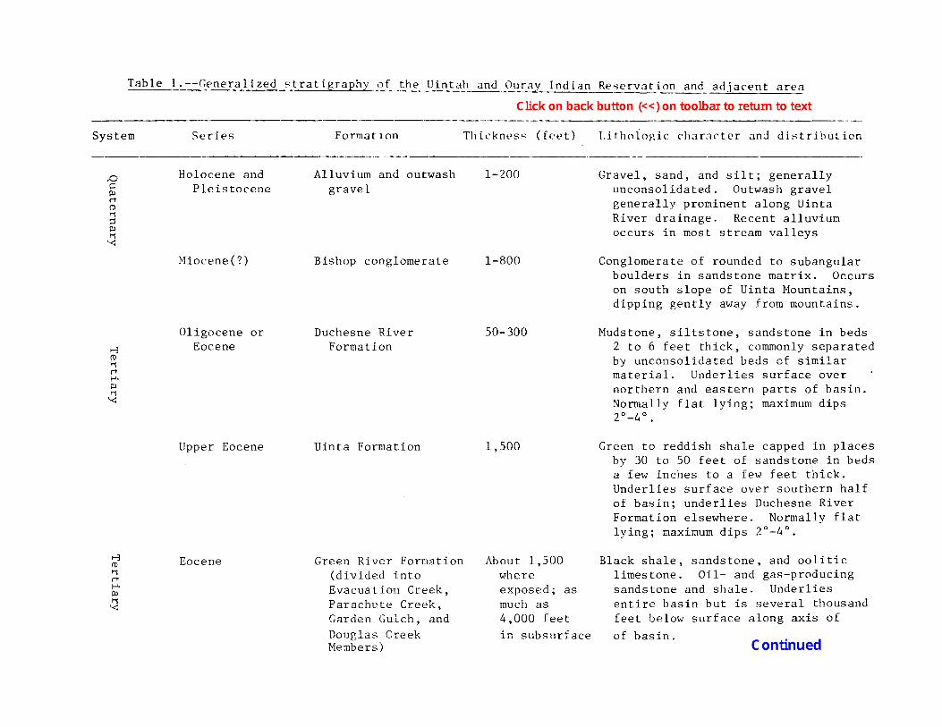
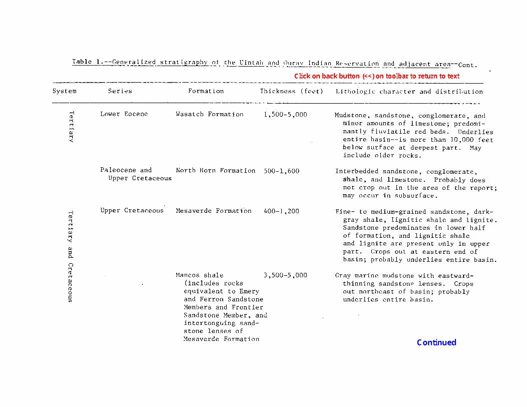
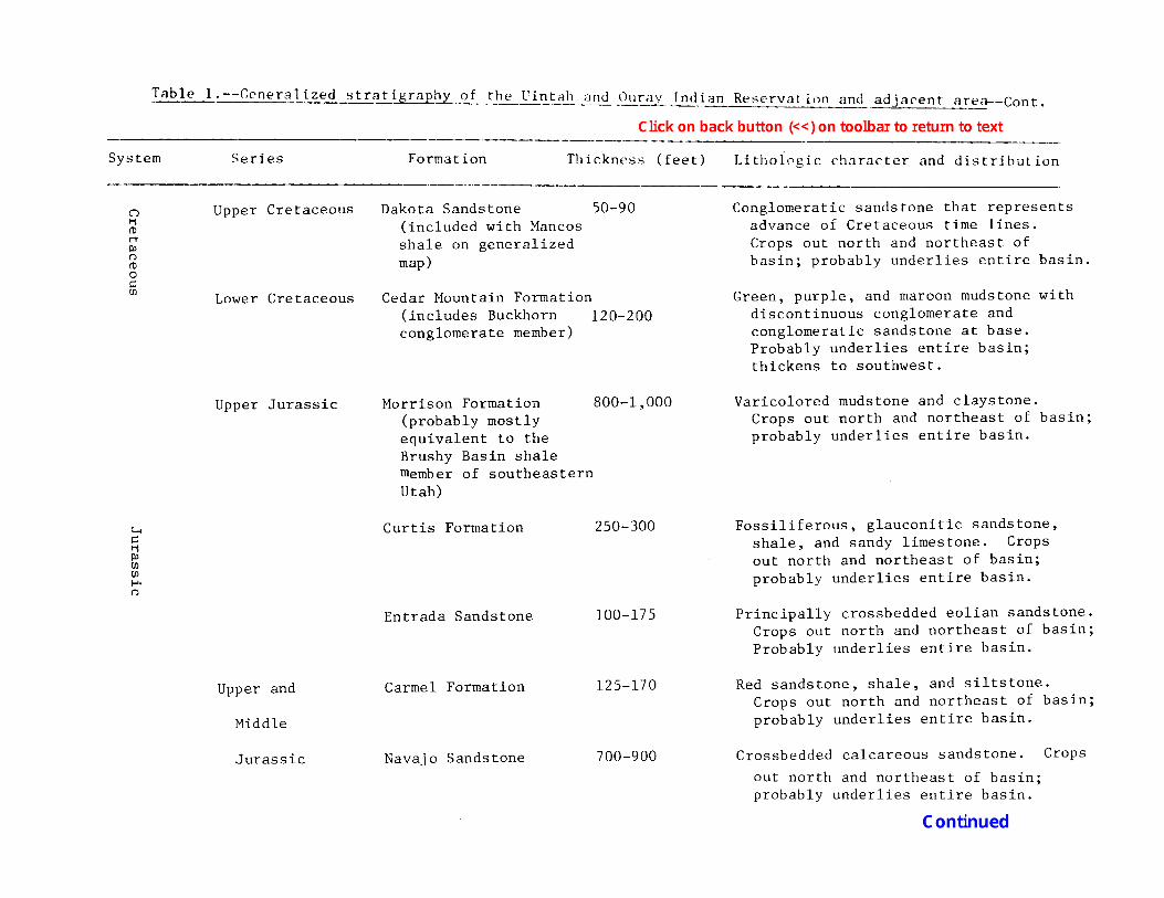
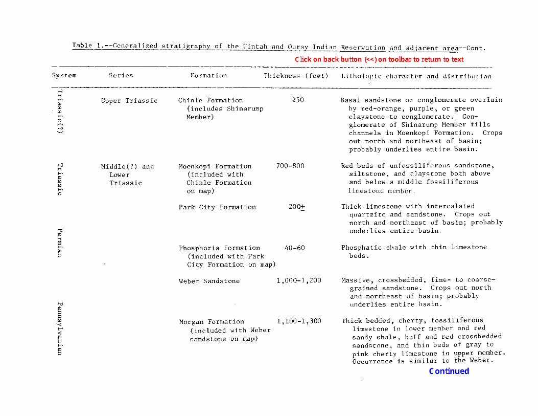
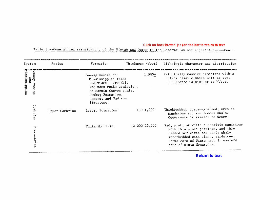
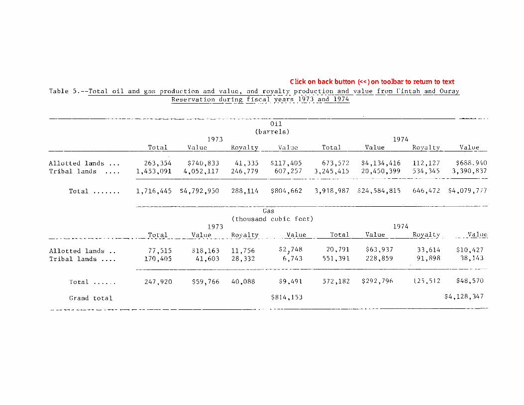
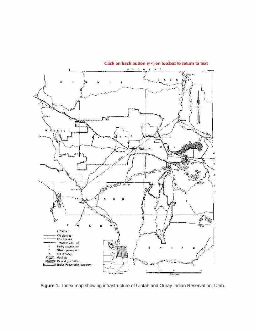
Figure 1. Index map showing infrastructure of Uintah and Ouray Indian Reservation, Utah.
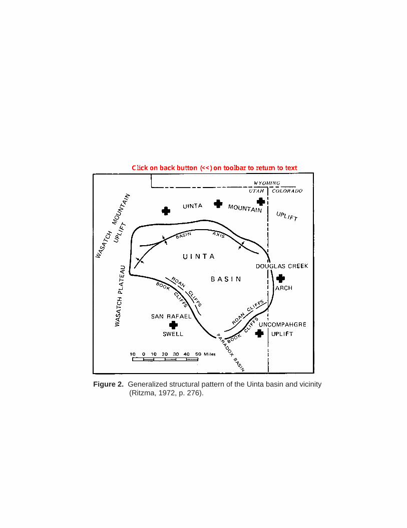
Figure 2. Generalized structural pattern of the Uinta basin and vicinity (Ritzma, 1972, p. 276).
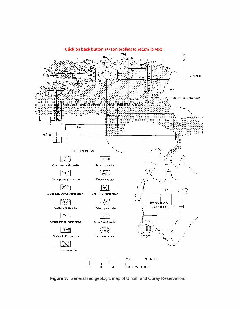
Figure 3. Generalized geologic map of Uintah and Ouray Reservation.
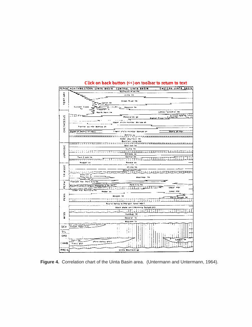
Figure 4. Correlation chart of the Uinta Basin area. (Untermann and Untermann, 1964).
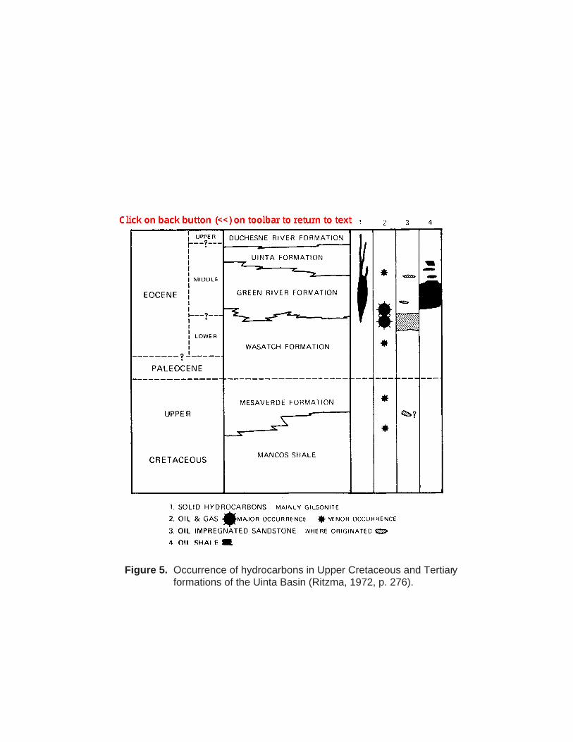
Figure 5. Occurrence of hydrocarbons in Upper Cretaceous and Tertiary formations of the Uinta Basin (Ritzma, 1972, p. 276).
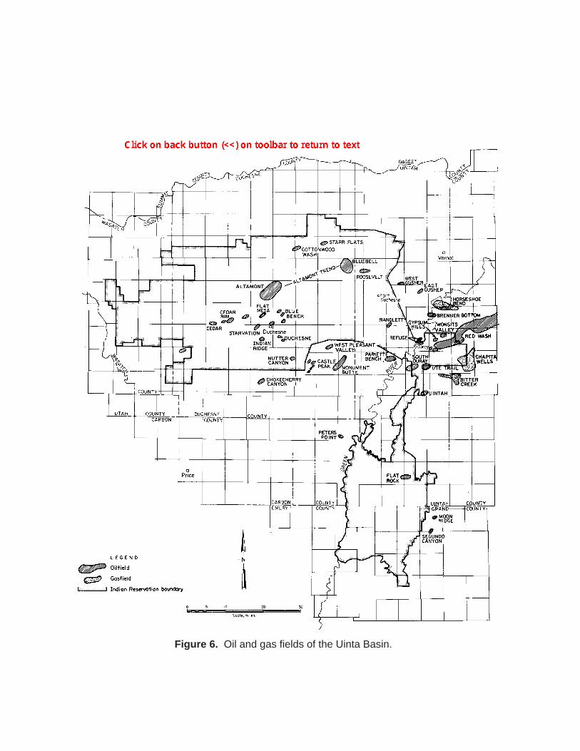
Figure 6. Oil and gas fields of the Uinta Basin.
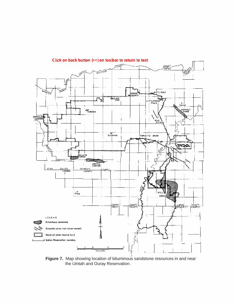
Figure 7. Map showing location of bituminous sandstone resources in and near the Uintah and Ouray Reservation.
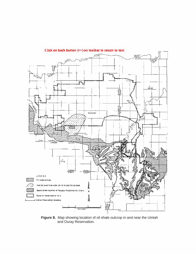
Figure 8. Map showing location of oil shale outcrop in and near the Uintah and Ouray Reservation.
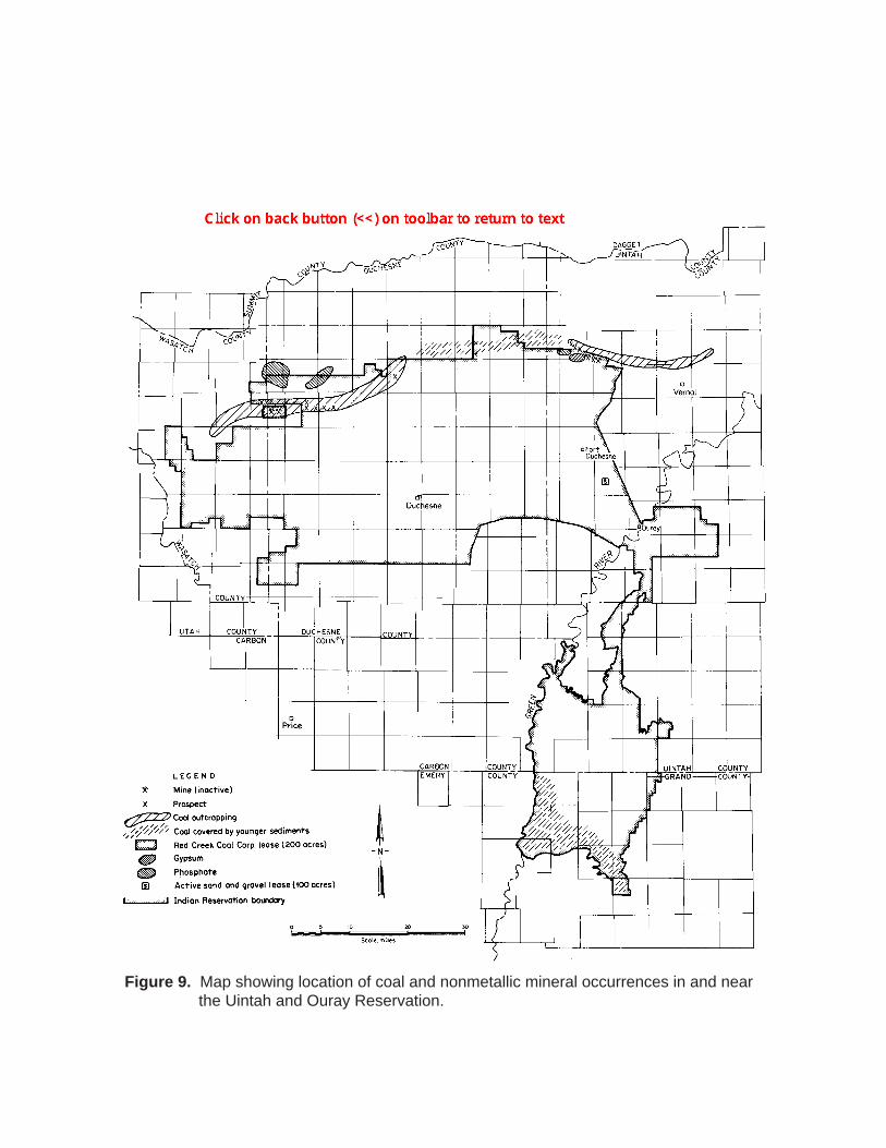
Figure 9. Map showing location of coal and nonmetallic mineral occurrences in and near the Uintah and Ouray Reservation.
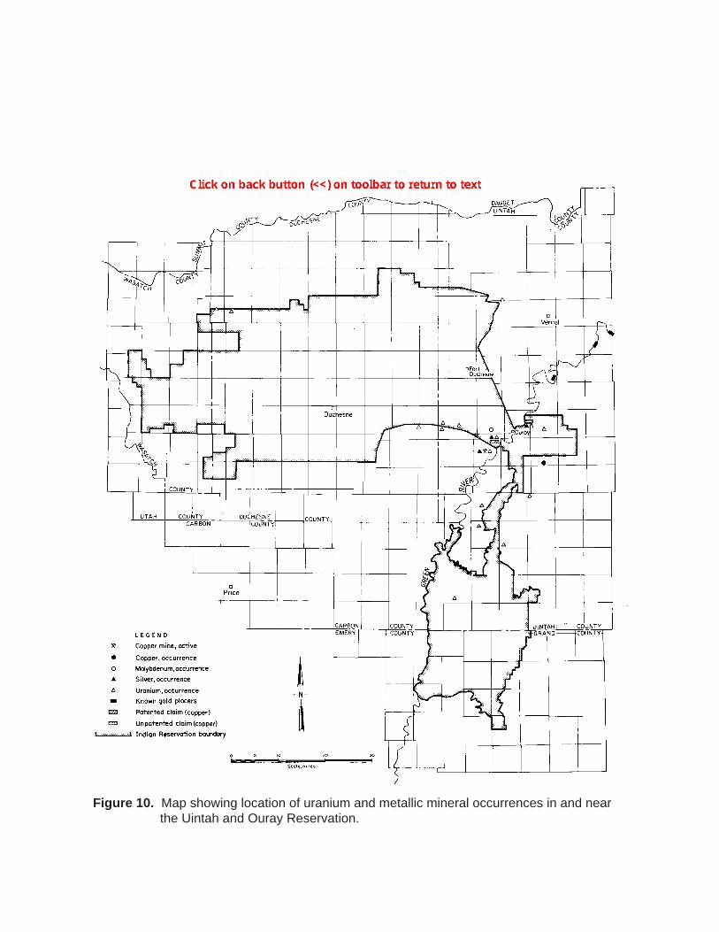
Figure 10. Map showing location of uranium and metallic mineral occurrences in and near the Uintah and Ouray Reservation.
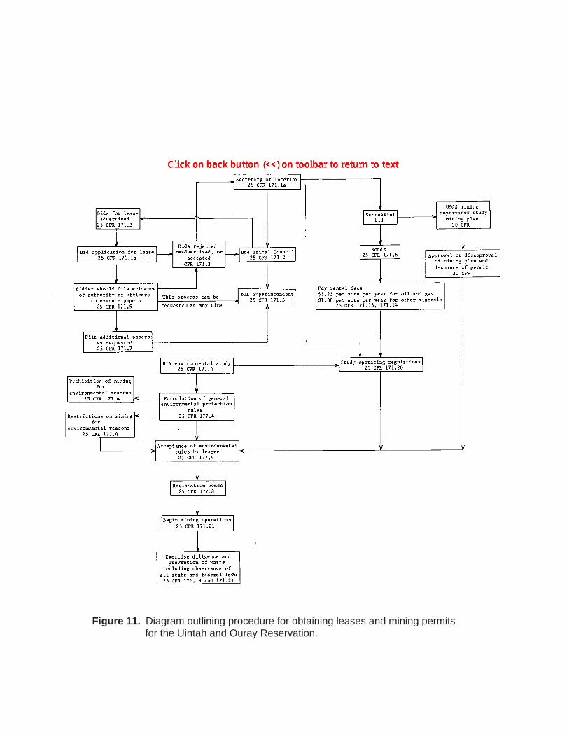
Figure 11. Diagram outlining procedure for obtaining leases and mining permits for the Uintah and Ouray Reservation.