Embed Size (px)
Citation preview
UNITED STATES DEPARTMENT OF THE INTERIOR Oscar L. Chapman, Secretary
GEOLOGICAL SURVEY W. E. Wrather. Director
Bulletin 948-E
PRELIMINARY REPORT ON CORUNDUM
DEPOSITS IN THE BUCK CREEl( PERIDOTITE
CLAY COUNTY, NORTH CAROLINA
BY
JARVIS B. HADLEY
Strategic Minerals Investigations, 1945 (Pages 103-128)
UNITED STATES
GOVERNMENT PRINTING OFFICE
WASHINGTON : 1949
For sale by the Superintendent of Documents, U. S. Government Printing Office, Washington 25, D. C. Price 60 eents

CONTENTS
Page
Abstract.... . . . . . . . . . . . . . . . . . • . . . . . . . . • . . . . . . . . . . . . . . . . . . 103 Introduction............... . . . . . . . . . . . . . . . . . . • . . . • . . . . . . . 105
Current investigations............................... 105 Location, culture, ownership. . . . . . . . . . . • . . . . . . . . . . . . . 106 Previous work in the area ........•................... 107 Economic history of the deposits ......•.............. 107
Rock Units........................ . . . . . . . . . . . . . . . . . • . • . . . 108 Roan gneiss and Carolina gneiss ...................... 108 Pegma ti tes. . • . . • . . . . . . . . . . . . • . . . . . . . . . . . . . . • . . . • . . . . . 109 Peridot! te.. . . . . . ..• . . • . . . • • . . • . . . . • . . . . . • . . . . • . . • . . • • 109
Duni te........................................... 109 Troctolite and troctolite-amphibolite .......•.... 110 Edeni te-amphiboli te.............................. lll A..mphibole gneiss.. . . • . . • • . . . . • . . . • • . . . . . • • • • . . . • . 112 Chlori tic rocks.................................. 112
Structure................. • . • • . . . . . . . • . • . • . . • • • • . . . • • • . . . 113 Corundum deposits........................................ 114
Vein deposits........................................ 114 Mineralogy of veins ......•.....•....•..•..••.•..• 114 Structure and size of veins •..•....•..•..•••••.•• 118 Origin of the vein deposits .•...•..••...••....... 118 Quality and distribution of corundum ......••..•.. 118
Disseminated deposits in amphibolite •...•...•.•..•... 119 Mineralogy..... . . . . . • . . • . . • . . . . . • . • . . . • • . • . • . . • . . 119 Size and distribution............................ 120 Origin of corundum in the disseminated deposits .• 120 Quality and distribution of corundum •.......•.... 120
Descriptions of workings.... . . . . . . . . . • . . . . • . • . • • . • . . . . . . . 122 Big Shaft mine. . . . . • . . . . . . • . . . . . . . • . . . • . . . . . . . . . • . . . • 123 Herbert mine....... . . . • . . . • . . . . . • . • . . . . . • . • . . . . . . . . • • 123 Hart, Hutchison, Ledford and Burrell prospects ..••..• 124 South Extension prospect ....•.........••......•..•... 124 Other prospects............ . . . . . . . . . . . • . . . . . . . • • . . . . . 124
Reserves and economic possibilit.ies...................... 125 Reserves in vein deposits............................ 125 Reserves in disseminated deposits .....••.•.....•...•. 128 Economic possibilities ..•..••.••.•..•......•...•.•... 128
ILLUSTRATIONS
Plate 45. Geologic map and sections of the Buck Creek peridotite body, Clay County,
Page
N . C . . . . • . . . . . . . . . . . . . . . . . . . . . . . . . • . • • • In po eke t 46. Geologic map and sections of the
Corundum Knob area, Buck Creek corun-d~m district, Clay County, N.c ........ In pocket
47. Geology and topography of the eastern part of the Buck Creek area, Clay County, N. C •••....••........•.••...... In pocket
48. Geology of the Big Shaft (Cullakeenee) mine, Buck Creek corundum district, Clay Count•y, N. C •••••.•.•.••••••.••... In pocket
III
IV ILLUSTRATIONS--Continued
Page
Figure 14. Index map of western North Carolina
Table
showing location of co~mdum deposits •.••••. 106 15. Types of veins, Buck Creek corundum
district, Clay County, N. C. A, Barren feldspar-hornblende vein in dunite, prospect trench 250 feet south of Big Shaft (sketched from outcrop). ~' Hornblende-corundum vein in sheared and altered dunite, Burrell cut (from photograph}. Q, Feldspar-hornblende vein in sheared and altered troctolite-amphibolite, South Extension cut (sketched from outcrop). D, Part of hornblende vein in dunite, Penland cut, Corundum Knob (sketched from outcrop) ••.•••••••••.•.•••••• 115
16. Geologic map of the Herbert mine area, Buck Creek corundum distriet, Clay County, N. C............................... . . . . . . . . . 117
TABLES
3. Surface dimensions and average assays of corundum-bearing amphibolite bodies in
Page
the Corundum Knob area, Buck Creek, N.c.~ •• 122 4. Estimated reserves of corundum in vein
deposits, Buck Creek area, Clay County, N. C... • • • • • • • • • • • • • • • • • • • • • • • • • • • • • • • • • • • • • 126
5. Reserves of corundum and corundum ore in amphibolite bodies in the Corundum Knob area, Buck Creek, Clay County, N.C •.••..... 127
A PRELIMINARY REPORT ON
CORUNDUM DEPOSITS ~N THE BUCK CREEK PERIDOTITE
CLAY COUNTY, NORTH CAROLINA
By Jarvis B. Hadley
ABSTRACT
Corundum deposits at several localities in western North Carolina were investigated early in 1945 by the Geological Survey, United States Department of the Interior, to determine whether taey would help to relieve a critical shortage of certain types of abrasive needed in war industries. A part of the Geological Survey's study was carried on in cooperation with a comprehensive program of exploring corundum deposits in North and South Carolina and Georgia begun in 1943 by the Bureau of Mines, also of the Department of the Interior. Districts studied by the Survey party include the Corundum Hill and Mincey mines in Macon County, the McChastain mine in Jackson County and the Buck Creek area in Clay County, all in North Carolina.
The Buck Creek area in southeastern Clay County is easily reached from Franklin, N.C., 22 miles distant via U. S. Route 64. In this area corundum deposits, which have been worked intermittently since 1875, occur in dunite and associated amphibolite. The principal dunite body occupies nearly half a square mile and is a more-or-less concordant, wedge-shaped sheet injected into north-dipping hornblende gneiss and mica gneiss. Within the dunite are lenslike bodies of troctolite as much as 70 feet wide and 1,500 feet long. They are composed of olivine with various amounts of calcic plagioclase feldspar, together with secondary enstatite, amphibole, and spinel. Locally these rocks have been altered to amphibolite, chlorite-amphibole schist, or chlorite-olivine-serpentine rock. Minor faults trending more or less parallel with the dunite body offset some of the troctolite and amphibolite lenses by horizontal displacements of as much as 100 feet. Faults, shear zones, and abundant joints in the dunite have served as passageways for hydrothermal solutions that have formed veins of actinolite, anthophyllite, vermiculite, talc, and chlorite.
Two distinct types of corundum deposits are present: deposits associated with these veins, and disseminated deposits in amphibolite. Vein deposits are found throughout the dunite body, but the more important ones occur in the Big Shaft mine
103

104 STRATEGIC MINERALS INVESTIGATIONS, 1945
and nearby prospects in the eastern part of the district. They contain corundum together with sadie plagioclase, hornblende, zoisite, and minor amounts of margarita. These minerals form veinlike bodies as much as 5 feet wide and 100 or more feet long within the actinolite-vermiculite veins. Most of the feldspar-hornblende bodies are barren, but some contain coarsely crystalline, blue-gray cor!mdum in pods, lenses, narrow veinlets, or large isolated grains irregularly distributed in the other minerals. Some bodies, rarely more than a foot wide, are composed of white corundum crystals surrounded by chlorite or hornblende without other minerals. A few of the larger veins follow shear zones extending for 100 feet or more parallel to the contacts of the dunite body; smaller veins, however, have no preferred orientation.
The corundum content of the veins is very erratic and difficult to estimate. In general the grade of individual deposits appears to range between 5 and 30 percent corundum.
Disseminated corundum deposits are found only in narrow zones of amphibolite that have resulted from alteration of the outer and narrower parts of troctolite lenses. Such amphibolite bodies range in width from 3 to 14 feet and are as much as 450 feet long. They are composed of calcic feldspar and bright-green amphibole in which are disseminated small grains (less than 0.1 inch) of red or pink corundum and chromite. Some corundum crystals as much as a quarter of an inch thick and one inch long occur in narrow veinlets cutting amphibolite. The corundum content of samples of the amphibolite taken and assayed by the Bureau of Mines ranges from less than 1 percent to 15.4 percent; the average grade of individual amphibolite bodies appears to range between 2.5 and 8 percent.
Corundum from the vein deposits makes good coarse abrasives of the type needed to relieve wartime shortages, but reserves in the Buck Creek area are small. About 100 tons of corundum is inferred to exist in six bodies having an average grade of 10 percent corundum. .Perhaps 20 tons of corundum could be obtained at the Big Shaft mine from two easily accessible bodies estimated to contain 30 to 40 percent corundum.
Disseminated co~~ndum in the Buck Creek area is too finegrained to yield critically needed abrasives, but it may be valuable for optical work. A total of about 2,700 tons of this corundum is inferred to exist in five bodies containing 100,000 tons of amphibolite within 100 feet of the surface in an area of 16 acres. Of this tonnage, about 12,500 tons is ore of higher grade estimated to contain between 5 and 8 percent corundlun; the remainder probably averages about 2.5 percent corundum.
The possibility of producing corundum in the Buck Creek area seems to depend on the prospects of e9tablishing a concentrating plant based on the utilization of the disseminated deposits. Whether such a plant could be made to pay is questionable because of the competition of artificial abrasives and the low grade of the larger part of the deposits.

CORUNDUM DEPOSITS, WESTERN NORTH CAROLINA 105
INTRODUCTION
From 1878 until 1900 the States of North Carolina and Georgia furnished the world's only large-scale production of abrasive corundum as distinct from emery. Production from these deposits had ceased by 1906, but the position of corundum thus established in American industry was maintained thr,Jugh th8 first two decades of the twentieth century by Canadian deposits and more recently by shipments of corundum from South Africa. Although artificial abrasives manufactured since about 1905 have supplanted corundum to a considerable degree, certain operations in metal and optical grinding are still dependent on corundum. The advent of World War II sharply increased the need of corundum for these purposes and at the same time shipments from South Africa, the only source of supply in 1940, became both insufficient and uncertain.
Current investigat_ions
Accordingly, several governmental agencies undertook to investigate the possibilities of again producing corundum in the southeastern states, particularly in North Carolina, South Carol-ina, and Georgia. A111ong them were the North Carolina State Division of Mineral Resources, the War Production Board, and the United States Department of the Interior, represented by the Bureau of Mines and the Geological Survey. The Bureau of Mines in 1943 began a comprehensive program of exploration for corundum in the three States mentioned, involving topographic mapping, trenching, sampling, and rehabilitating old workings. Deposits thus explored included: in Georgia, the Hog Creek prospect in Towns County and the Track Rock prospect in Union County; in South Carolina, the Rickard mine in York County; and, in North Carolina, the Corundum Hill and Mincey mines and the Rough KJ1ob prospect in Macon Count~r, and the Buck Creek area in Clay County. During the month of January 1945 Mr. Eugene Dawson of t"!:1e Miscellaneous Minerals Di v lsi on of the War Production Board with a crew of two men dug several test pits along the major streams in the Buck Creek area in an unsuccessful attempt to locate placer deposits of corundum.
In January 1945 toward the close of the Bureau of Mines' project, an investigation of the Buck Creek area and other corundum localitles was begu.n by the Geologlcal Survey. Four and one-half months were spent in the field for the Geological Survey by J. B. Hadle-y and Jacob Freedman, under the direction of R. A. Laurence. Most of the work was done in cooperation with the Bureau of Mines project at Buck Creek, with T. J. Ballard, project engineer, in charge, who provided topographic maps and sample data used in this report. Much of the information obtained in the Buck Creek area could not have been gained but for the Bureau's explorations, whereby more than 9,000 feet of surface trenches were dug, two mines unwatered, 250 feet of underground tunnel driven, and many samples taken and assayed. The writer is grateful for the many courtesies extended to the Geological Survey party by Mr. E. C. Soper of Franklin, and for helpful information given by Messrs. Andrew J. Evans of Gneiss, James Higdon of Ellijay, and Fowler Ledford of Shooting Creek, N. C.
106 STRATEGIC MINERALS INVESTIGATIONS, 1945
Both the Geological Survey and the Bureau of Mines devoted the greater part of these investigations to the Buck Creek area. Other corundum localities in North Carolina investigated by the Geological Survey party include the Corundum Hill and Mincey mines in Macon County, the McChastain mine in Jackson County, and several prospects in Macon, Jackson, and Tr&nsylvania Counties. Accounts of these deposits will be found in separate reports.
Location, culture, and ownership
The Buck Creek area is located in the eastern part of Clay County, 6 miles north of the North Carolina-Georgia State line (fig. 14). The nearest town is Hayesville, population 336, 19 miles west of the area; but Franklin, population 1,250, 22 miles northeast, is a better source of most supplies. A paved road between Franklin and Hayesville (U. S. Route 64) passes through the southeastern corner of the area. Knoxville, Tenn., is 140 miles by road north of the area, and Atlanta, Ga., is 150 miles to the south.
Figure 14.--Index map of western North Carolina showing location of corundum deposits.

CORUNDUM DEPOSITS, WESTERN NORTH CARQLINA 107
The Buck Creek area is at elevations ranging from 3,200 to 4, 000 feet above sea level in the. heart of the Nantahala Range in the broad southern part of the Blue Ridge physiographic province. It is shown in the southeast corner of the map of the Nantahala quadrangle, U. S. Geological Survey Topographic Atlas. Buck Creek, a tributary of the Nantahala River, flows northwest across the eastern part of the area. Buck Creek Ranch, a summer resort in the western part of the area, and a nearby year-round farm are the only habitations. Part of the area is in the Nantahala National Forest; the rest of the area and the rights to all of the mineral deposits belong to Mr. W. T. Latham of Franklin, owner of the ranch.
Previous work in the area
A large-scale topographic and geologic map of the Buck Creek area (scale about 1 inch to 1,400 feet) made in 1894 by J. V. Lewis and Chas. E. Cooke was published with a very brief description of the geology in Bulletin 11 of the North Carolina Geological Survey (1896). The same map with minor changes was published in 1905 by Pratt and Lewis l7 together with a more comprehensive description of the rocks and corundum deposits. Much of this material was recapitulated in Bulletin 269 of the U. S. Geological Survey.g/ A brief summary of the principal corundum localities in North Carolina including the.Buck Creek area was published by the State of North Carolina in 1943.~
During the present investigation of the Buck Creek deposits the topography of an area of about 1 square mile was mapped by plane table, the larger part by the Bureau of Mines on a scale of 100 feet to one inch, and a smaller part by the Survey party on a scale of 500 feet to one inch. The geology of the whole area was mapped by the Geological Survey party on the above-mentioned base maps (pl. 45). Detailed geologic maps of the principal excavations were made on scales of 50 and 20 feet to one inch. Fifty mineral specimens were determined microscopically in the field, and a few thin sections were studied after the field work was completed.
Economic history of the corundum deposits
Although attention was attracted early to the Buck Creek corundum deposits and prospecting went on there until the end of the major period of corundum mining in the southeastern states, no deposits were found large enough for a sustained mining operation. The first prospecting in the Buck Creek area was done by a Major Bryson in 1875, but for seventeen years thereafter nothing was done beyond a period of prospecting lasting six months in 1877, and another of nine months in 1887
]j Pratt, J. R., and Lewis, J. V., Corundum and the peridot! tes of western North Carolina: North Carolina Geol. Survey, vol. 1, 1905.
2/ Pratt, J. R., Corundum and its occurrence and distribution in the United States: U. s. Geol. Survey Bull. 269, 1906.
Jl White, William A., Report of investigation: Corundum in North Carolina, NOrth Carolina Division of Mineral Resources, Advance Report (in cooperation with the Tennessee Valley Authority), 15 pp. mim., Raleigh, 1943.
857813 0 - 50 - 2
108 STRAT~GIC MINERALS INVESTIGATIONS, 1945
when 200 tons of corundum are said to have been taken out. In 1892 operations on a more liberal scale were begun by Gregory Hart, who sank the Big S~aft (pls. 47 and 48) and opened several cuts on the opposite slope. According to Pratt and Lewis: "Considerable quantities of corundum were taken out at this time, but nothing was shipped. Most of the product was in large massive blocks with feldspar and black hornblende and there was no economic method of crushing and cleaning it. 11
After eighteen months of work, the property was purchased in 1893 by the Hampden Emery and Corundum Co. of Massachusetts. Corundum ore already mined was hauled 30 miles to the company's Cullasaja mill near Corundum Hill, but little mining was done.
Attention then shifted to the western part of the area, where in 1903 and 1904 the Herbert mine was active and said to be the only producing mine in the southeast. The only corundum mill to be erected in the Buck Creek area was established about this time on the site of the present Buck Creek Ranch, but both mine and mill were closed by 1906. Mr. Latham reports that considerable corundum found in the old mill was shipped in 1914. Although there was an important revival of mining at Corundum Hill during the first world war, no more work was done at Buck Creek other than occasional shipments of specimens to collectors and mineral dealers until the government activities in 1943.
From 1881 to 1895 inclusive, the market price of domestic corundum, as summarized in Bureau of Mines Information Circular 7295, ranged generally from $150 to $200 per short ton. This price was presumabl¥ for 90 percent corundum and compares with prices from ~69 to ~107 for similar grades from Africa in 1941-43.
ROCK UNITS
Roan gneiss and Carolina ~
The country rock in the Buck Creek area consists largely of hornblende gneiss and mica gneiss, designated by Keith i/ as Roan gneiss and Carolina gneiss, respectively. The Roan gneiss is a slabby, dark rock, which consists of medium- or fine-grained plagioclase feldspar and black hornblende, the latter ran0ing from 40 to 80 percent of the rock. Variations in mineral content occur more or less layerwise, parallel to a fairly well developed foliation, causing the rock to break into slabs ranging from an inch to a foot in thickness. The few good exposures of fresh rock are found in cuts along the Perry Gap road; elsewhere, the hornblende gneiss has weathered to a platy, orange-red soil.
The mica gneiss is composed of quartz, feldspar, biotite, and mus cov 1 te. It occ~1rs chiefly along the northern edge of the mapped area where it is interlayered in part with hornblende gneiss. A body of mica gneiss of unknown extent appears also in the southwest part of the area. The most accessible exposures are in cuts along the Perry Gap road and at the road bend north of Buck Creek Ranch.
4/ Keith, Arthur, U. S. Geological Survey Geol. Atlas, Nantahala folio (no. i43), 1907.

CORUNDUM DEPOSITS, WESTERN NORTH CAROLINA 109
Pegma tites
A few dikes of pegmatite a foot or less wide occur here and there in the Roan gneiss and Carolina gneiss. In the Roan gneiss they are composed of coarse white feldapar and quartz; in the Carolina gneiss they contain muscovite and garnet as well.
The peridotite body in the BUck Creek area is reported to be the largest in the Appalachian region, with the exception of the body near Webster in Jackson County, N. C. The area occupied by the peridotite of the Buck Creek region is a little more than 300 acres or a little less than half a square mile. At the present erosion level the peridotite is exposed in a main area of about 225 acres and a subsidiary area of about 80 acres. In these two areas are found dunite, troctolite, amphibolite, amphibolite gneiss, chlorite-olivine-serpentine rocks and chlorite-talc-amphibole rocks.
Duni te
More than 90 percent of the main body is light-colored, medium-grained dunite composed of granular, yellowish-green olivine, accompanied by serpentine, chlorite, and chromite. Locally the dunite is darker green or gray because of abnormally large amounts of chlorite or chromite. Serpentine has partially replaced olivine at many places yet most of the olivine, except at the borders of the body, appears relatively fresh under a hand lens. Where deeply weathered, the dunite forms a distinctive reddish-brown soil characterized by granular texture and unaltered chlorite flakes. The relatively abundant outcrops are brown or dun-colored and have typically rounded and solution-pitted surfaces resembling those of dolomite outcrops. Elsewhere the dunite is covered by a thin layer of soil which is easily removed in trenching.
Optical properties of olivine from the dunite indicate that it contains about 90 percent forsterite (Mg2Si04} and 10 percent fayalite (FezSi04). An analysis of partially serpentinized dunite from Buck Creek given by Hunter~ is shown below.
Chemical analysis of partially serpentinized dunite, Buck Creek, Clay County, N. C.
MgO • SiOz Fe203 •• Ti02, Cr203,
and Al203 •• CaO • • • • • Ignition loss •
Percent 46.52 38.70 10.70
2.52 0.56 1.77
100.77
2{ Hunter, Oharles B., Jbrsterite olivine deposits of ~ortb Carolina and Georgia: North Carolina Division of Mineral Resources :Bull. 41, p. 110, 1941.
110 STRATEGIC MINERALS INVESTIGATIONS, 1945
Troctolite and troctolite-amphibolite
About eight percent of the main peridotite body at the present erosion surface is composed of troctolite, together with amphibolite and various chloritic rocks resulting from alteration of troctolite. Both the troctolite and the amphibolite are more resistant to erosion than the dunite and are generally found on ridges and steeper slopes.
The troctolite is composed of olivine, (Mg,Fe)2 Si04, calcic plagioclase, largely CaAl2Si20S, chromite, and zones of secondary silicates intermediate in composition, developed along the boundaries between these minerals. The olivine and plagioclase (calcic bytownite) appear as rounded aggregates of anhedral grains. The intermediate silicates are too finegrained to be identified under a hand lens but under a microscope they are seen to be arranged in two principal zones as follows: zone 1, adjacent to the olivine, is composed of enstatite; zone 2, adjacent to the plagioclase, is composed of anhedral grains of a pale-bluish amphibole most of which is thickly intergrown with minute vermiform or rodlike grains of spinel. These·zones are characteristic of th~ rocks in which both olivine and plagioclase occur, and have been variously termed corrosion mantles, reaction rims, or coronas.
A wide variety of these rocks exists, ranging from those containing 75 percent or more olivine and a very small amount of plagioclase to those containing mostly plagioclase and intermediate silicates and very little olivine. In troctolite with considerable olivine the feldspars range from 2 to 10 millimeters in diameter and are sheathed by coronas about 1 millimeter thick. Weathered surfaces of this type of troctolite are rough, the sheathed feldspars standing out as knobs in the less resistant olivine. In finer-grained troctolite, the feldspar and olivine grains are only a millimeter or two in di~eter, whereas the coronas have nearly the same thickness. Hence the intermediate silicates are relatively more abundant in the finer-grained types, which have a bluish, aphantlc appearance, weathering light brown. Some of these rocks contain little or no olivine and so much of the intermediate silicates that they have been call.ed amphibolite. To avoid confusion with the edenite-amphibolite, described below, they are here referred to as troctolite-amphibolite.
A layered arrangement is common in some of the troctolites, the layers ranging from a fraction of an inch to several inches thick and differing in the proportions of olivine and feldspar present. Similarly, layers of troctolite-amphibolite commonly differ in the proportions of feldspar and intermediate silicates present. At a few places, layers of anorthosite several inches thick contain a small amount of intermediate silicates forming pellets scattered through the rock. Troctolite with large amounts of olivine is generally not layered.
In several of the trenches and cuts, the upper few feet of the troctolite-amphibolite is altered to a very soft pale green or white mineral of undetermined composition, possibly sepiolite. In the outcrops the mineral is waxy, but on exposure to the air it apparently dries out, becoming lighter colored and earthy. At one place a few grains of red corundum were found in it. It commonly enclosed small masses of pale-brown limonitic material ar~nged in indistinct layers, probably

CORUNDUM DEPOSITS, WESTERN NORTH CAROLINA 111
representing decomposed olivine or enstatite. In addition to replacing the rocks wholesale, the sepiolite(?) is commonly found filling fault fractures in troctoli~e and amphibolite.
Edenite-amphibollte
Closely associated with the troctolite is amphibolite composed largely of calcic plagioclase and an aluminous amphibole (edenite). The amphibole generally makes up between 45 and 95 percent of the rock, the remainder being largely bytownite or anorthite. Small disseminated grains of corundum and chromite are generally present and small flakes of amesite(?) are common. Spinel is generally absent but may be abundant locally in minute grains. In the hand specimen the color of the amphibole ranges from pale green to bright emerald green, the more intense color being generally associated with coarser texture. Thus the color of the amphibolite as a whole ranges from greenish gray to brilliant green, depending upon the amount and color of the amphibole present.
In many of the specimens studied, coronoid texture characteristic of the troctolite is more or less well preserved in the amphibolite. It is most evident in aggregates of clear, fine-3rained amphibole, or of amphibole and spinel, surrounding plagioclase grains or masses of recrystallized enstatite. In the coarser-grained amphibolite, however, enstatite and all traces of coronoid texture are absent, and chromi te and corundum are almost universal accessories. The edenite-amphibolite thus appears to have resulted from an alteration of troctoliteamphibolite, in which the fine-grained enstatite and amphibole of the coronas has been changed to coarser-grained edenite with little change in the feldspar. The two rocks grade into each other by various degrees of change in texture and mineral content and are commonly very hard to distinguish in the field. TI~e coarser and greener amphibolite is shown as "edeniteamphibolite" on plate 46, but ·its outcrop is too narrow to show in the smaller-scale map, plate 45.
Both the troctolite and the associated amphibolite occur within the dunite in long lenticular bodies that fall structurally into two groups, marginal and transverse. The marginal group includes nine lenses which lie along the outer boundary of the main peridotite body, particularly along its southern edge. The transverse group comprises eleven lenses and a few dikes which are transverse to the peridotite boundaries and extend well into the peridotite body; this type is well displayed in the vicinity of Corundum Knob.
Bodies of the marginal group range from 10 feet wide and 150 feet long to lenses 70 feet wide and 1,500 feet long. They lie closely parallel to the adjacent peridotite borders at distances ranging from a few feet to 100 feet from them. The troctolite in these lenses is generally olivine rich (30 to 90 percent olivine), relatively coarse-grained and massive.
Bodies of the transverse group range from lenses a few inches wide to one north and west of Corundum Knob which is 50 feet wide and 1,500 feet long, extending almost entirely across the main peridotite body. Commonly the larger bodies are composed of two or mor& parallel lenses separated through1most or all of their length by a few feet of dunite. Several of the smaller transverse lenses are short, blunt-ended bodies
112 STRATEGIC MINERALS INVESTIGATIONS, 1945
extending from the peridotite margin 100 feet or so into the dunite. On the west slope of Corundum Knob, a transverse dike of troctolite-amphibolite 15 to 20 feet wide and 250 feet long is attached to a marginal lens of the same rock. A somewhat similar dike appears to be represented by residual boulders near the Big Shaft. The rocks in the transverse group of lenses are feldspar rich and finer-grained than those in the marginal bodies, so that minerals of the intermediate zones are relatively abundant and olivine is inconspicuous. Hence most of the transverse lenses are classed as troctolite-amphibolite. The contacts of these lenses with the dunite, as seen in the many cuts and trenches on Corundum Knob, are always sharp and steeply dipping. The larger lenses are more or less distinctly layered parallel to their walls. The lenses appear to pinch out or may pass into thin slivers of amphibolite intercalated in the dunite. Such an occurrence is exposed in the eastern part of the Shook trench (pl. 46), where parallel sheets of troctolite-amphibolite 0.3 to 3.0 inches thick are separated by layers of dunite 0.3 to 18 inches thick.
At several places in the longer marginal lens northwest of Corundum Knob, olivine-rich troctolite is cut by small transverse dikes of feldspar-rich troctolite-amphibolite. Thus the transverse bodies appear to be younger than the marginal ones, and are presumably younger than the dunite which encloses them.
Amphibole gneiss
The marginal lens along the southeast side of the main peridotite body contains a pale greenish-gray foliated rock composed of plagioclase and a nearly colorless amphibole. Similar rock occupies two lenticular bodies in the eastern part of the subsidiary body. This rock closely resembles the coarsertextured phases of the edenite-amphibolite but is paler and more uniform and lacks the gradation to troctolite. It apparently does not contain corundum. 'As the rock is not wellexposed, little could be learned of its relations to the other rock units except that it commonly borders troctolite.
Chloritic rocks
A common rock in the subsidiary body and in parts of the main paridotite is composed of chlorite with various amounts of green amphibole, serpentine, and olivine. Tne proportions of these minerals differ widely from place to place, but the most ab,~dant types are chlorite-olivine-serpentine rock and chlorite-talc-amphibole schist. In the bulbous western part of the subsidiary body and in the marginal lens at the northwest boundary of the main body west of Chestnut Knob, these rocks show remnants of troctolitic texture and gradations to olivinerich troctolite in which the intermediate silicates have been altered to chlorite and amphibole. In many places in the subsidiary body this alteration appears to have been accompanied by the development of foliation which has obliterated the original troctolitic texture.

CORUNDUM DEPOSITS, WESTERN NORTH CAROLINA 113
STRUCTIJRE
The foliation and layering in the Roan gneiss and Carolina gneiss in most of the area strikes more or less due east and dips to the north. North of the main peridotite body, the dips range from 30° to 40°; south of it they are somewhat steeper, ranging from 450 to 600. Several north-plunging folds as much as 100 feet across appear in the hornblende gneiss along the southern border of the main peridotite body. The larger peridotite mass has the form of a wedge-shaped body 8,000 feet in strike length and about 2,000 feet thick at its eastern end. The western part of the body appears to be essentially concordant with the regional foliation in the enclosing hornblende gneiss. At the eastern end of the body this foliation departs from its regional trend and wraps around the peridotite with steep easterly dips. In detail, the contacts of the peridotite trend about parallel with the foliation of the adjacent gneiss, and, from their expression in relation to the topography, they appear to dip also more or less in concordance with the gneiss. The body as a whole thus probably dips 40° or 50° to the north. At the northeast corner of the sheet a blunt projection of the peridotite juts northward into the gneiss; and a short wedgeshaped projection very poorly exposed, extends eastward along the foliation of the gneiss at the southeast corner of the main body.
In the vicinity of Corundum Knob, the transverse troctoliteamphibolite lenses are offset by many faults which were apparently unrecognized until exposed in the recent excavations. The average trend of these faults is west-northwest, parallel to the long dimension of the peridotite body; they dip 70° S. to 30° N. with northward dips predominating (see pl. 46). Along the faults the lenses are displaced as ~1ch as 100 feet, resulting in pronounced horizontal drag of the troctolite layers. Where troctolite-amphibolite has been ·brought against dunite, the faults are commonly marked by zones of chlorite~~phibole schist in which the foliation tends to parallel the fault planes. Within the troctolite-amphibolite, the faults are marked by zones a foot or less wide of sheared amphibolite commonly altered to sepiolite(?). In the dunite they are marked by zones of chlorite, talc, anthophyllite, and vermiculite, minerals that have obviously been produced by hydrothermal alteration since the fault movements.
The dunite of the main body abounds with joints, along many of which hydrothermal minerals have formed (seep. 114). Others are not mineralized, or they co~tain thin layers of serpentine, commonly the stiff fibrous variety, picrolite. In the interior of the main body the joints have random attitudes, but at some places along the margins of the body closely spaced subparallel joints are more or less parallel to the outer contacts of the peridotite. Such joints dip 20° to 45° NE. along the southwestern boundary west of Corundum Knob and 30° N. along the northern boundary east of Chestnut Knob. They have probably resulted from late shearing movements in the marginal parts of the peridotite.
The subsidiary body is a sheet more than 2 miles long and 100 to 600 feet thick. It confofidS more or less closely to the north and east boundaries of the larger body from which it is separated by a septum of gneiss ranging in thickness from 30 feet to more than 500 feet. The sheet appears to dip northward and eastward somewhat more steeply than the main body with which it may be connected at some distance below the surface.
114 STRATEGIC MINERALS INVESTIGATIONS, 1945
The component units of the sheet are little exposed and were traced largely by means of float. In the eastern part of the sheet they are apparently lenticular bodies either marginal to, or somewhat diverging from, the contacts of the sheet as a whole, some actually crossing the sheet diagonally. Foliation in several of the units in the eastern part of the sheet dips uniformly eastward at a steep angle and presumably reflects an eastward dip of this part of the sheet. The northwestern part of the sheet is so little exposed that almost nothing is known of its structure or of the distribution of rocks within it. Steeply dipping foliation in most of the observed outcrops indicates a steep dip to the north. Where the sheet is crossed by the Perry Gap road, the foliation diverges widely from the general trend; also the topographic expression of the contacts suggests a low dip to the north. Both of these features are believed to be due to local deformation of a steeply dipping sheet.
CORUNDUM DEPOSITS
Two types of corundum deposits, very different in mineralogy, structure, and distribution, are found in the Buck Creek area. They are: (1) vein deposits, including bodies of the plumasite or albitite type, and (2) disseminated deposits in amphibolite. The veins occur throughout the main peridotite body, generally in dunite, rarely in troctolite-amphibolite. Disseminated deposits are restricted to the amphibolite bodies and are best developed on Corundum Knob.
Vein deposits
The dunite contains an enormous number of veins characterized by actinolite and vermiculite or chlorite. Nearly 200 of these veins were measured in the artificial exposures in the area and many more were seen but not measured. They commonly range from an inch to a foot in width; more rarely veins 2 or 3 feet wide or even 10 feet wide are present.
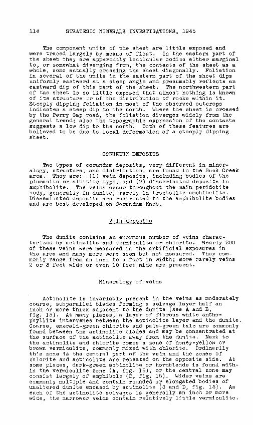
Mineralogy of veins
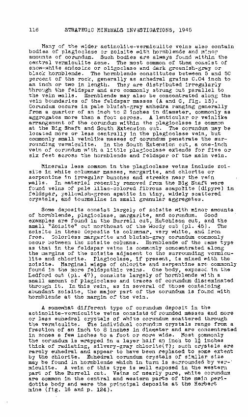
Actinolite is invariably present in the veins as moderately coarse, subparallel blades forming a selvage layer half an inch or more thick adjacent to the duntte (see A and B, fig. 15). At many places, a layer of fibrous white anthophyllite intervenes between the actinolite layer and the dunite. Coarse, emerald-green chlorite and pale-green talc are commonly found between the actinolite blades and may be concentrated at the surface of the actinolite away from the dunite. Next to the actinoli~e and chlorite comes a zone of honey-yellow or brown vermiculite, commonly mixed with chlorite. Ordinarily this zone is the central part of the vein and the zones of chlorite and actinolite are repeated on the opposite side. At some places, dark-green actinolite or hornblende is found within the vermiculite zone (A, fig. 15), or the central zone may consist largely of amphibole (D, fig. 15). Wider veins are commonly multiple and contain rounded or elongated bodies of unaltered dunite encased by actinolite (C and D, fig. 15). As each of the actinolite selvages is generally an inch or more wide, the narrower veins contain relatively little vermiculite.

0
CORUNDUM DEPOSITS, WESTERN NORTH CAROLINA
A Dunite
Actinolite- tremolite Vermiculite and chlorite Hornblende
·:.'":-·:~< .. ·. ': :. : ·.· ·_ Sodic plagioclase with trails of ·. disseminated hornblende
I I I! I I
I I I J J I. I
B
c
Dunite D
Actinolite -tremolite Coarse hornblende
Chlorite-talc schist surrounding remnants of dunite encased in actinolite
Hornblende with sodic plagioclase
~~~~~-- Dunite
Figure 15.--Types of veins, Buck Creek corundum district, Clay County, N. C.:
!, Barren feldspar-hornblende vein in dunite, prospect trench 250 feet south of Big Shaft (sketched from outcrop).
~, Hornblende-corundum vein in sheared and altered dunite, Burrell cut (from photograph).
Q, Feldspar-hornblende vein in sheared and altered troctolite-amphibolite, South Ext ens ion cut (sketched from outcrop).
Q, Part of hornblende vein in dunite, Penland cut, Corundum Knob (sketched from outcrop).
857813 0 - 50 - 3
115
116 STRATEGIC MINERALS INVESTIGATIONS, 1945
Many of the wider actinolite-vermiculite veins also contain bodies of plagioclase or zoisite with hornblende and minor amm.mts of corundum. Such bodies are always found within the central vermiculite zone. The most common of them consist of snow-white andesine or oligoclase and dark greenish-gray or black hornblende. The hornblende constitutes between 5 and 50 percent of the rock, generally as anhedral grains 0.04 inch to an inch or two in length. They are distributed irregularly through the feldspar and are commonly strung out parallel to the vein walls. Hornblende may also be concentrated along the vein boundaries of the feldspar masses (A and C, fig. 15)r Corundum occurs in pale bluish-gray anhedra ranging generally from a quarter of an inch to 2 inches in diameter, commonly as aggregates more than a foot across. A lenticular or veinlike arrangement of the corundum within the plagioclase is common at the Big Shaft and South Extension cut. The corundum may be located more or less centrally in the plagioclase vein, but commonly small veinlike masses of corundum penetrate the surrounding vermiculite. In the South Extension cut, a one-inch vein of corundum with a little plagioclase extends for five or six feet across the hornblende and feldspar of the main vein.
Minerals less co~on in the plagioclase veins include zoisite in white columnar masses, margarita, and chlorite or serpentine in irregular bunches and streaks near the vein walls. In material recently removed from the Big Shaft were found veins of pale lilac-colored fibrous scapolite (dipyre) in feldspar, yellowish-green apatite in tiny, widely scattered crystals, and tourmaline in small granular aggregates.
Some deposits consist largely of zoisite with minoi' amounts of hornblende, plagioclase, margari te, and corundum. G·ood examples are found in the Burrell cut, Hutchison cut, and the small "Zoisite" cut northeast of the Woody cut (pl. 45). The zoisite in these deposits is columnar, very white, and iron free. Jolorless margarita and bluish-gray corundum corr.monly occur between the zoisite columns. Hornblende of the same type as that in the feldspar veins is commonly concentrated along the margins of the zoisite adjacent to the surrounding vermiculite and chlorite. Plagioclase, if present, is mixed ·with the zoisite. Marginal wisps of chlorite and serpentine are, commonly found in the more feldspathic veins. One body, exposec. in the Ledford cut (pl. 47), consists largely of hornblende with a small amount of plagioclase and traces of corundum dis~.eminated through it. In this vein, as in several of those contalning abundant zoisite, the major part of the corundum is fo·LLnd with hornblende at the margin of the vein.
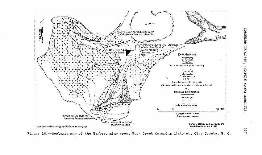
A somewhat different type of corundum deposit in the actinolite-vermiculite veins consists of rounded masses and more or less euhedral crystals of white corundum scattered through the vermiculite. ~1e individual corundum crystals range from a fraction of an inch to 8 inches in diameter and are concentrated in zones a few inches to a foot or more wide. Most commonly the corundum is wrapped in a layer half an inch to 1~ inches thick of radiating, silvery-gray chlorite(?); such crystals are rarely euhedral and appear to have been replaced to some extent by the chlorite. Euhedral corundum crystals of similar size may be found in hornblende which in turn is surrounded by ver- · miculite. A vein of this type is well exposed in the western part of the Burrell cut. Veins of nearly pure, white corundum are common in the central and western parts of the main peridotite body and were the principal deposits at the Herbert mine (fig. 16 and p. 124).
I"
%~~ ... "' ~,.: zu ... >= ::>"' G::Z >-!:
:II
i//11. ~\\.~ll1J,.1\\IIU ~t
~\,\\\If
if .;§~
' DUMP
1....A<:j"42-ft.level;dunite with stringer~
1 afialc.chlorite;drift to __ __. ... ,.,,\IUJII,, I south filled~.--......---· 11 .,,•''1~"""' i ''chlo,;i~~--- + ~''1' 1 ruy · + + + ~~Uhiol
+ ~i\1110.~ +f
EXPLANATION
Tole-anthophyllite schist outcrop
Dunite outcrop 6"f1o _
Chlorite-talc-octinol ite vein (Showing width and dip; dashed where inferred)
?5T Strike and dip of foliation
Rim of cut
'~--Underground workings
20 o 60 Feet ' ~
Contour interval 5 feet Datum is mean sea level
Surface geolo&Y by J. B. Hadley and Jacob Freedman, Apm 1945
Figure 16.--Geologic map or the Herbert mine area, Buck Creek Corundum district, Clay County, N. c.
0 0 :::0 C1
g ~
~ '1:1 0 (/.) H 1-3 (/.)
~ 1-3 gj z z 0
~ i:G
0 > ~ t;-t H z >
f-' f-' -.J
118 STRATEGIC MINERALS INVESTIGATIONS, 1945
Structure and size of veins
The actinolite-vermiculite veins follow joints and shear zones in the dunite. Some of the larger and more continuous fractures are shear zones which are more or less parallel to the adjacent contacts of the peridotite body as at the Big Shaft, or are located along contacts between amphibolit~ and dunite as in the South Extension cut. Measurements of nearly 200 of the smaller veins show that they have no preferred orientation.
The feldspar or zoisite bodies in the actinolite-vermiculite veins range from narrow veinlike bodies a few inches wide and a few feet long to large lenticular masses, one of which, 5 feet wide and 100, possibly 200, feet long, is exposed in trenches south of the Big Shaft (pls. 46 and 48}. Some bodies as much as 27 feet wide were partly uncovered in the trenches but were not sufficiently exposed to reveal their actual sizes or shapes. Commonly feldspar-zoisite bodies occur at the intersections of the enclosing veins where t~ey may be branched, as in the trench 250 feet south of the Big Shaft (pl. 46), in the South Extension cut, and elsewhere. A few small veins of zoisite and calcic plagioclase (bytownite) without hornblende are found in the amphibolite of Corundum Knob; locally they follow the faults that offset the amphibolite bodies.
Origin of the vein deposits
Evidence in the Buck Creek area, though as yet incomplete and inconclusive, suggests that the hornblende-feldspar-zoisite bodies and the accompanying actinolite-chlorite veins are the result of hydrothermal replacement of dunite rather than the desilication of pegmatite magma. The evidence for a hydrothermal origin includes: (1) the small size of many of the hornblende-feldspar bodies; (2) the constant association of bodies with veins of characteristically hydrothermal minerals such as actinolite, chlorite, and talc; (3) replacement by these minerals of dunite in the vein walls and of fragments of dunite in the veins; (4) the presence of monomineralic veins of corundum, zoisite, or hornblende.
The minera~izing agent was chemically related to granite pegmatites. It contained much soda, alumina, silica, and lime and smaller amounts of chlorine, sulfur, boron and phosphorus, all of which appear in minerals in the feldspar-hornblende~ zoisite bodies. TI1e actinolite-vermiculite veins were formed by replacement of dunite along previously existing fractures. In this process, silica, lime, alumina, and water were added to the dunite, and magnesia and iron removed (to maintain constant volume). Locally along the larger channelways these substances together with soda were deposited to form the feldsparhornblende bodies.
Quality and distribution of corundum
Of more than 75 feldspar-hornblende bodies seen in the area, corundum was found in only 20 percent. In these bodies, moreover, the distribution of corundum is so varied that visual
CORUNDUM DEPOSITS, WESTERN NORT:I CAROLINA 119
estimate or accurate sampling of the grade is difficult, and the results cannot be projected much beyond what can actually be seen.
The only quantitative data available are those from bulk lots of run-of-mine or hand-sorted material. A selected sample of feldspar-hornblende rock taken by the Bureau of Mines from the Big Shaft assayed 45 percent corundum; a lot of 6,400 pounds, sorted and hand-cobbed for shipment to the American Abrasive Co., was reported to contain 50 percent corundum. A smaller selected sample from the South Extension cut assayed 16 percent corundum. At the Burrell cut a 1,500-pound lot of run-of-mine rock from t~e zoisite vein and the corundumhornblende vein assayed 13 percent corundum. Other feldsparzoisite-hornblende veins were estimated to contain from 2 to 10 percent corundum over widths of 2 to 4 feet (see table 4).
Vein corundum is coarse-grained, very pure, and nearly always has pseudocubic parting well developed, which makes it exceptionally good wheel-grain material for coarse grinding or 11 snagging11 wheels.
Disseminated d~~h~s in amphibolite
Mineralogy
Corundum-bearing amphibolite associated with troctolite has been described in a general way on pages 110-112. The average corundum-bearing amphibolite is composed of bytownite-anorthite (25 to 50 percent) and emerald-green amphibole, which is nearly colorless in thin section and has optical properties corresponding more or less to edenite, an "aluminous tremoliteactinoli te .n Disseminated cor,.lndum is usually present in anhedral grains, less commonly in tiny basal plates, which .range in size in different specimens from 0.03 mm. to 2.0 mm. in diameter. Most of it is bright red or pink, but some of it is white. Rounded grains of dark-brown chromite as much as 0.8 mm. across are always present and are commonly mixed with corundum. In the Maney cut, a lens of pure chromite an inch wide and 18 inches long was found in unusually dark-green amphibolite. ~~e color of both edenite and corundum is more intense where chromite and corundum are most abundant, giving rise to 8trikingly handsome specimens of emerald-green amphibolite (the smaragdite of earlier writers) containing rich ruby-red corundum. In several specimens edenite is more intensely colored around individual chromite grains, indicating that chromium may be the coloring agent. At several places small amounts of blue kyanite were found in the amphibolite and also in veins cutting it.
Red or pink corundum without other minerals is also concentrated in veinlets cutting the amphibolite. The veinlets range from paper-thinness to about a quarter of an inch thick and are generally only a few feet long. Corundum in the wider veins always occurs as basal ·plates, as much as an inch in diameter, parallel to the veins and commonly separated from one another by several inches of barren vein. Zones one-eighth to half an inch wide, in which corundum, chromite, and green edenite are concentrated, probably follow earlier-formed chromite-rich layers. Commonly the amphibolite breaks along the corundum veins, giving an exaggerated impression of the corundum content of the rock.
120 STRATEGIC MINERALS INVESTIGATIONS, 1945
Size and distribution
The corundlw-bearing amphibolites pass into barren troctolite-a~phibolite by almost indistinguishable changes in the grain size and the amount of amphibole present. Because of this gradation and the fact that the corundum of the leaner amphibolites is microscopic in size, it is hard to tell corundun-bearing rock from barren rock in the field. Accordingly, sparsely disseminated corundum in these deposits may be more widespread than is now recognized. Zones assaying 2 percent or :nore corundum can be recognized easily. They occur either as zones along the margins of the larger troctolite lenses or as separate narrow lenses within the dunite. In either case, the corundum-bearing rock forms narrow bodies ranging from 3 feet to more than 10 feet in thickness and extending 400 feet or more along the strike. Five clearly defined bodies of corundum-bearing amphibolite were found in the Moses, Basco, Shook, Penland, Maney and Enloe trenches on Corundum Knob (see pl. 46). In addition a large body, exposed in the Knob, Barrett, and Sand cuts, contains more irre6ularly distributed corundum much of which is in veinlets cutting both amphibolite and troctolite. As the corundum-bearing bodies are exposed almost solely in the cuts and trenches, their strike lengths could not be measured closely. The most reasonable dimensions of the six bodies are given in table 3.
Small amounts of red corundum, both disseminated and in veinlets, are found in the large marginal body of troctoliteamphibolite near the South Extension cut, and in the small lens marked with the dip symbol on the west slope of CorundlW Knob.
Origin of corundum in the disseminated deposits
The disseminated cor_mdum in the edeni te-amphiboli te appears to have resulted from concentration of alumina originally contained in the plagioclase of the troctolite. The first step in this process was the development of the coronas along the boundaries between grains of plagioclase and olivine in the troctolice. In this stage, an intergrowth of spinel and amphibole apparently replaced part o! the plagioclase, producing a relative concentration of alumina in the mineral spinel (MgO.Al203 ). In the second stage, the spinel was destroyed as additional a:::nphibole (edenite) was formed, and the excess alumina from the spinel was deposited as corundlW. Much of this corundum was deposited around or replaced disseminated grains of magnesia-rich aluminian chromite originally present in the troctolite, thus accounting for the common association of corundum and chromite in the edenite-amphibolite. Some of the alumina, however, wandered out into local fractures in the amphibolite and was deposited as larger crystals in the crosscutting veins.
Quality and distribution of corundum
The amount of corundum in the amphibolite bodies was determined principally from samples taken along the walls of the cuts. Because of the extreme toughness of the amphibolite, regular channel or linear chip samples were not taken; instead, grab samples were taken as uniformly as possible, generally
CORUNDUM DEPOSITS, WESTE~~ NORTH CAROLINA 121
through 5- or 10-foot intervals, across the corundum-bearing portions of the lenses (see pl. 46). The weight of the sample from each interval was about 500 pounds. In addition, assays were made on bulk shipments of rock as mined from several of the cuts.
The samples were assayed at the Bureau of Mines Laboratory at College Park, Md., and the procedure is outlined by Mr. Alton Gabriel of that laboratory as follows:
( 1) The sample was ground through 4o mesh.
(2) A 50 to 75 gram representative fraction was cut out from the bulk sample on a Jones splitter.
(3) The minus-200-mesh fraction of the representative sample was screened out and weighed. The oversize (plus-200-mesh) was subjected to sink and float separation in methylene iodide. The float fraction was weighed.
(4) The eink portion was sized into minus-48-plus-100 and minus~lOO-plus-200-mesh fractions and weighed.
(5) Grain counts on 1.000 particles were made on each sink fraction and on the minus-200-mesh material. The float fractions were examined petrographically and grain counts of 1 1 000 particles were made on the fractions if any corundum was found trapped in the float.
(6) Calculations were made of corundum content to the head sample with corrections for the specific gravity of the respective minerals.
!his method gave acceptable value~ as demonstrated b,y the closeness of check analyees and by the material balance obtained on flotation products (concentrates and tails) calculated back to the head sample analysis. The method, however. is long and time-consuming.
To make determinations more rapidly, a modified Fraser-Reid acid-leach method was tried, whereby the gangue minerals were decomposed with hydrofluoric, sulfuric, and hydrochloric acids. By this method, such minerals in the sa~ple as feldspar, micas, amphibole, and zoisite were easily removed, although a double acid treatment was necessary for the leaner samples. The dried residue was weighed as corundum. Microscopic examination of the residue showed, however, that kyanite and chromite as well as corund~~ were not appreciably attacked by the acids, and that the assays were too high where these minerals were present. Such assays were corrected on the basis of grain counts made on the residues.
Samples of the amphibolite bodies thus assayed yielded from 0.35 percent corundum {Sand cut) to 15.4 percent {Maney cut). Locations of samples are shown on plate 47. Every sample taken contained some corundum, although several contained less than 2 percent, the least amount general~y visible in hand specimens. The average corundum content of 11 samples covering 111 feet of sample length from the Knob, Barrett, and Sand cuts is 2.4 percent. This figure is also the average of three samples covering 37 feet of sample length from two smaller bodies exposed in the Shook and Penland cuts. The narrow amphibolite zone in the Moses and Basco cuts is richer, three samples averaging 5.8 percent corundum. A 1-ton shipment selected for

122 STRATEGIC MINERALS INVESTIGATIONS, 1945
ore-dressing tests from the Knob, Barrett, and Sand cuts assayed 5 percent corundum, about twice the average assay of the distributed samples of the same body. A similar 1,700-pound shipment from the 5- to 7-foot zone in the Maney cut assayed 15.4 percent corundum. Hence it may be assumed, by analogy with the samples just mentioned, that the average grade of the zone is about 8 percent. This percentage accords with the appearance of the rock in the Maney cut, where the most abundant disseminated corundum was seen, some specimens being estimated at 15 percent corundum. A list of the principal corundum-bearing amphibolite bodies in the Corundum Knob area, with their surface dimensions and average assays is given in table 3 below.
Table 3.--Surface dimensions and average assays of corundumbearing amphibolite bodies in the Corundum Knob area,
Buck Creek, N. C.
Average Strike Average Location width length percent Number of
(feet) (feet) corundum samples
Moses-Basco cuts 4 to 5 450 5.8 3 Shook-Penland cuts 8 200 2.4 2 Shook cut 14 70 2.3 l Maney cut 6 150 8.0(est.) 1 Knob-Sand-Barrett cuts 30(?) 300 2.4 11 Enloe cut 3 40(?) Not sampled
The corundum in the disseminated deposits appears to be less ':tseful as an abrasive than that i:1 the vein deposits. Basal parting is characteristic of the larger grains, the smaller ones having generally no parting. T'.:1.is parting tends in crushing to produce flat or wedge-shaped fragments which are less desirable for coarse abrasives than the square-cornered grains yielded by pseudocubic (rhombohedral) parting. Also the greater part of the disseminated corundum is so fine-grained that it is unsuitable for wheel-grains, which should be between 12 and 24 mesh. Ore-dressing tests on the sample from the Maney cut indicate that much of the corundum is not freed in sizes greater than 48-mesh. By separation of minus 48-mesh material in heavy liquids, 78.5 percent of the corundum was recovered in a product containing 89.6 percent corundum.
The hardness and other qualities of the disseminated corundum are good. Very few stones are good gem material.
DESCRIPTIONS OF WORKINGS
The principal workings in the Buck Creek area comprise the Big Shaft mine at the eastern end of the area, the Herbert mine near the western end, and several prospect cuts in the area between the ~ines. Many other prospect cuts and pits are scattered over the area, but most of them are so caved and
CORUNDUM DEPOSITS, WESTERN NORTH CAROLINA 123
overgrown with vegetation that little or nothing can be seen in them. The two mines and all of the more important prospects in the eastern part of the area were reopened by the Bureau of Mines. They include the Hart, Hutchison, Ledford, and Burrell cuts located on the slope opposite the Big Shaft. Two smaller cuts, the Woody and Zoisite cuts, were also reopened, and a new shaft and cut started (South Extension) near the eastern boundary of the peridotite south of the Big Shaft. Several older cuts, not reopened, are on the slope west of Chestnut Knob, and one is west of the Herbert mine. All of these workings are in the main peridotite body. Only one small cut was found in the subsidiary body, although a few more are shown in this body on the earlier maps.
Big Shaft mine
The older part of the Big Shaft mine consists of a surface cut 70 feet long and 15 to 20 feet deep (subsequently backfilled) and an inclined shaft nearly 100 feet deep, from which two snort drifts extend at the 42-foot level. In reopening the mine in 1944, the Bureau of Mines drove an adit 250 feet long to intersect the shaft (see map and sections, pl. 48). Explored in these workings is a zone of sheared and altered dunite which strikes N. 20° W. and dips 50° E. The sheared zone consists of chlorite and venniculite a few inches to 4 feet thick between dunite walls. In the north part of the mine a single shear zone ls seen, but in the southern part, several steeply dipping branches occur, one of which can be traced 200 feet south of the mine.
Within the main shear zone and several of the branches are lenses of feldspar-hornblende rock l to 3 feet wide. One such lens, well exposed in the shaft and adit, has a strike length of 25 feet, a dip length of 20 feet and a maximum thickness of 3 feet. It appears ~o rake perhaps 30° N. Masses of blue-gray corundum as much as 6 inches across are irregularly distributed in it. A similar corundum-bearing vein a foot or two wide is seen above the south drift at the 42-foot level. It probably represents the lower part of a lens that ha& been partly removed from the surface cut. All the other large feldspar bodies in the mine are barren although a few smaller corundum-bearing feldspar veins a foot or less wide are found in various attitudes in the footwall of the shear zone.
No record is known of the production of the mine as such. From the dimensions of the surface cut it appears likely that 300 tons of ore containing 100 tons or so of corundum may have been removed, accounting for at least half the reported production from the area. Seven or eight tons of feldspar-hornblende rock estimated to contain between 30 and 40 percent corundum were taken out by the Bureau of Mines in driving the adit and cleaning out the old south drift. '
Herbert mine
The Herbert mine, 1,500 feet southwest of Buck Creek Ranch, was pumped out and examined by the Bureau of Mines in 1S44 but was flooded again at the time of the Geological Survey party's visit. According toT. J. Ballard, the underground workings
124 STRATEGIC MINERALS INVESTIGAriONS, 1945
consist of an 8 by 8 vertical shaft 42 feet deep with levels at 18, 25, 32, and 42 feet (see fig. 16). The openings are entirely in dunite and chlorite veins. No corundum was seen underground. A for.mer workman in the mine said that a vein of white cor~ndum 18 inches wide was found in the northwest corner of the shaft at the 32-foot level, but this vein has evidently been mined out and the area backfilled. On the surface several chlorite veins in dunite were worked to shallow depths. Pratt and Lewis report that they consisted of nearly pure white corundum, 3 to 6 inches wide. Several pounds of corundum fragments gathered from the surface and tested in the ~ureau of Mines laboratory proved to be exceptionally good wheel-grain matepial. The reported production of the mine is only a few tons (seep. 108).
Hart, Hutchison, Ledford and Burrell prospects
In the Hart, Hutchison, Ledford and Burrell prospects are feldspar-hornblende-zoisite bodies containing some corundum (see pl. 47). The three eastern cuts are in veins striking north or ~orthwest and dipping steeply east, more or less parallel to the eastern boundary of the main peridotite body. Inspection of the several trenches in their vicinity shows that the bodies in these cuts are not continuous and they do not lie in a continuous fracture. The vein in the Burrell cut strikes east-northeast, parallel to the trend of the nearest peridotite boundary, but dips steeply southward. A list of the corundumbearing bodies in these cuts, with their dimensions and estimated grades, is given in table 4.
South Extension pr~~ct
Corundum-bearing feldspar-hornblende veins discovered in the South Extension prospect were located by tracing float. The bodies are in dunite and talc-chlorite schist near the contact between dunite and an amphibolite body which contains small amounts of disseminated corundum. Where a 2-foot vein intersects a less steeply dipping 1-foot vein, a feldsparhornblende body 4 feet wide carries some blue-gray corundum. Here an inclined shaft was started by the Bureau of Mines late in January 1945 but was stopped at a depth of 7 feet at the closing of the project. This vein was considered the most promising in the area. In another cut across the same contact 60 feet northeast, stringers of feldspar· 3 to 12 inches thick occur in a 3-foot zone of talc-chlorite schist and may represent the continuation of the vein at the shaft.
Other prospects
A group of three cuts just above the Perry Gap road west of Chestnut Knob was worked about 1900 and is called the Heaton cuts. They were not reopened during the project. The more easterly of the two larger cuts is on the contact between amphibolite and dunite. Specimens on the dump include edeniteamphibolite, troctolite, and anorthosite. Anorthositic amphibolite with large grains of deep-red corundum is similar to some rocks in the Maney cut. White or pale-pink corundum occurs with margarita and pale-blue kyanite(?). Some boulders on the dump are estimated to contain 10 percent corundum.
CORUNDUM DEPOSITS, WESTERN NORTH CAROLINA 125
The western of the two larger cuts exposes a lens of troctolite-amphibolite 6 to 8 feet thick, trending east-west and dipping 50° N. No corundum was seen, but some red corundum is reported to have been found there.
The southern cut is in troctolite-amphibolite with distinct layering dipping 15° to 20° NE. A specimen on the dump shows white corundum and zoisite veinlets in edenite-amphibolite, but no corundum was seen in place.
The Cat-eye cut, 600 feet southwest of 'the top of Chestnut Knob, was in the past the source of fine specimens of coarse white corundum with intense blue colors distributed irregularly through it. Some of it was in the form of radiating blue and white plates, known locally as 11 cat-eye corundum11 and much sought for gems. A ton or two of ore, mined long ago and stored in a bin now rotted away, is still there although much picked over by mineral collectors. The Bureau of Mines started to reopen this cut, but stopped before the main part of the cut was reached. Several small feldspar veins could be seen.
RESERVES AND ECONOMIC POSSIBILITIES
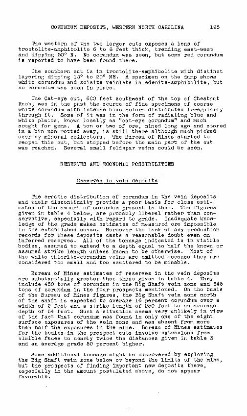
Reserves in vein deposits
The erratic distribution of corundum in the vein deposits and their discontinuity provide a poor basis for close estimates of the amount of corundum present in them. The figures given in table 4 below, are probably liberal rather than conservative, especially with regard to grade. Inadequate knowledg~ of the grade makes estimates of measured ore impossible in the established sense. Moreover the lack of any production records for these deposits casts a reasonable doubt even on inferred reserves. All of the tonnage indicated is in visible bodies, assumed to extend to a depth equal to half the known or assumed strike length unless known to be otherwise. Most of the white chlorite-corundum veins are omitted because they are considered too small and too scattered to be minable.
Bureau of Mines estimates of reserves in the vein deposits are substantially greater than those given in table 4. They include 450 tons of corundum in the Big Shaft vein zone and 345 tons of corundum in the four prospects mentioned. On the basis of the Bureau of Mines figures, the Big Shaft vein zone north of the shaft is expected to average 16 percent corundum over a width of 2 feet and a strike length of 250 feet to an average depth of 64 feet. Such a situation seems very unlikely in view of the fact that corundum was found in only one of the eight surface exposures of the vein zone and was absent from more than half the exposures in the mine. Bureau of Mines estimates for the bodies.in the prospect cuts involve extensions from visible faces to nearly twice the distances given in table 3 and an average grade 50 percent higher.
Some additional tonnage might be discovered by exploring the Big Shaft vein zone below or beyond the limits of the mine, but the prospects of finding important new deposits there, especially in the amount postulated above, do not appear favorable.
Locati·on
Big Shaft (above 42-ft. level)
Big Shaft (adit level}
South Extension Hutchison prospect Ledford prospect Burrell prospect
Table 4.--Estimated reserves of corundum in vein deposits, Buck Creek area, Clay County, N. C.
Dimensions (feet) Estimated Strike Dip 'rnick- Tons percent Short tons corundum length length ness ore corundum Indicated Inferred
50 10 1.5 63 40 -- 25
10 15 2.0 25 40 10 --30 20 3.0 150 10 3 12 50 25 4.0 400 5 -- 20 60 30 3.0 450 10 5 40 35 20 2.0 120 10 2 10
Total (maximum dip length 30 feet) 1,108 10.3 20 107
1-' N O"l
Cll
~ ~ Q H 0
~ H ~
~ ~ Cll
H
~ Cll 8 H Q
~ H 0 ~ Cll "' 1-' <0 ~ c.n
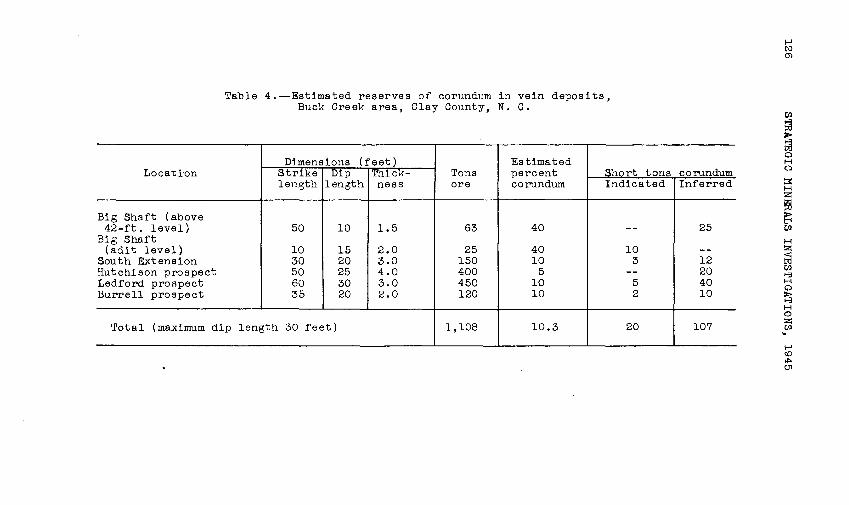
Table 5.--Reserves of corundum and corundum ore in amphibolite bodies in the Corundum Knob area, Buck Creek, Clay County, North Carolina
--
Dimensions (feet) Location Length Thick- !Depth Short tons Percent Short tons
ness ore corundum corundum
Moses-Basco 300 4 20 2,000 4.8 96 Moses-Basco 300 . 4 80 8 000 4.8 384
480 Knob-Sand 300 30 20 15,000 2.4 360 Knob-Sand 300 30 80 60 000 2.4 1,440
1 800 Penland-Shook 150 8 20 2,000 2.5 50 Penland-Shook 150 8 50 5.000 2.5 125
1?5 Shook 70 14 20 1,630 2.5 40 Shook 70 14 20 1.630 2.5 40
80 Maney 100 6 20 1,000 8.0 80 Maney 100 6 30 1,500 8.0 120
200
Total to 20 feet below surface 21.630 2.9 626
Total below indicated ore to maximum depth of 100 feet 76,130 2.8 2,110
Grand total (indicated and inferred in round figures) 98,000 2.8 2,700
----
Class
Indicated Inferred
Indicated Inferred
Indicated Inferred
Indicated Inferred
Indicated Inferred
Indicated
Inferred
---
0 0 ::0 q
s ~
t:; lxj
"' 0 C/.) H ~ C/.)
~
~ ~ ~
~ ::0
~ 0 !I> :::0 0 t"i H z >
1-' ro ~

128 STRATEGIC MINERALS INVESTIGATIONS, 1945
Reserves in disseminated deposits
The deposits of disseminated corundum in the amphibolite bodies are more completely sampled and geologically more amenable to estimates of reserves than the vein deposits. About 2,700 short tons of corundum are thought to exist in five bodies containing nearly 100,000 tqns of amphibolite averaging 2.8 percent corundum. Of this amount, about one-fifth is indicated ore within 20 feet of the surface and could be mined from open cuts. About one-fourth of the total tonnage is ore of higher grade averaging 5.5 percent corundum; the rest averages about 2.5 percent corundum. Dimensions and grade and tonnage figures for the sampled bodies on Corundum Knob are given in table 5. The only other large amphibolite body known to contain disseminated corundum, near the South Extension cut at the eastern end of the main peridotite body, is too poorly exposed to permit estimates of its corundum content.
Economic possibilities
The possibility of producing corundum in the Buck Creek area appears to depend upon the prospects of establishing a concentrating plant based on the utilization of the disseminated deposits. The estimated reserves in the vein deposits are not large enough to warrant such a plant and only a small part of them could be hand-cobbed so as to be sold as "boulder corundum11 (ore containing 50 to 80 percent corundum, priced in 1941 at $42 per ton). A sufficient tonnage of disseminated corundum ore appears to be present in the area, although it is questionable whether the grade of much of it is such that recovery of corundum could be made to pay the costs of mining and milling, which would presumably depend upon the prevailing price of corundum and cost of labor. Very little of the product would yield premium wheel-grain material, with which artificial abrasives do not as yet successfully compete, but much of it might be valuable for optical abrasives.
0


![jJo Gemm 29(3) 129-147eprints.gla.ac.uk/931/1/Jo_Gemm_29(3)_129-147.pdfGem corundum deposits in Vietnam Pham Van Long], Hoàng Quang Vinh2, Virginie Garnier3, Gaston Giuliani4 Daniel](https://img.pdfslide.net/doc/110x75/5e2d7875aa487d207c0db04c/jjo-gemm-293-129-3129-147pdf-gem-corundum-deposits-in-vietnam-pham-van-long.jpg)