Embed Size (px)
Citation preview
C1.0Sheet 1 of 3
(615
) 297
-516
6
Nas
hville
, Ten
nesse
e 37
204
516
Hea
ther
Pla
ce
Land P
lannin
g & Z
onin
g
Con
sulti
ng Civ
il E
nginee
ring
Surv
eyin
g
Nashville, Davidson County, Tennessee
Being Parcels 21 and 22 on Tax Map 105-09
14th and Wedgewood
ADAM
JOSEPH SEGER
D&A Project #15001
14th & Wedgewood
DATE: January 29, 2015
Sheet Schedule1 C1.0 Notes and Project Standards2 C2.0 Existing Conditions and Layout Plan3 C3.0 Grading and Landscape Plans
DISTURBED AREA = 0.25 ACRES
TOTAL AREA = 0.25 ACRES = 10,729.26 S.F.
Development Summary
Property Information1727 14th Ave. S.Nashville TN 37212Tax Map 105-09 Parcel 21Zoned: M6
1729 14th Ave. S.Nashville TN 37212Tax Map 105-09 Parcel 22Zoned: M6
Council District 17 (Sandra Moore)
Owner of RecordTax Map 105-09 Parcel 21Brennon Mobley1727 14th Ave. S.Nashville TN 37212Phone: 615-613-5915Email: [email protected]
Tax Map 105-09 Parcel 22Metro Gov't BT Back TaxPO Box 196300Nashville TN 37219
Developer1727 14th Ave. S.Nashville TN 37212Brennon MobleyPhone: 615-613-5915Email: [email protected]
Civil EngineerDale and Associates516 Heather PlaceNashville, Tennessee 37204Contact: Adam Seger, PEPhone: 615-297-5166Email: [email protected]
Survey Provided byS & A Surveying, Inc.306 Bluegrass CircleLebanon, Tennessee 37090Phone: 615-394-7564
Flood NoteThis Property does Not Lie Within a FloodHazard Area as Depicted on the CurrentFlood Insurance Rate Maps (FIRM) Number47037C0218F, Not printed.
Site AreaTotal area - 10,729.26 sq ft or 0.25 Acres
Electric ServiceNashville Electric Service1214 Church StreetNashville, TN 37246Phone: (615) 747-6807
Water ServiceMetro Water Services1600 2nd Avenue NorthNashville, TN 37208Phone: (615) 862-4598, Ext 4
Sewer ServiceMetro Water Services1600 2nd Avenue NorthNashville, TN 37208Phone: (615) 862-4598, Ext 4
Gas ServiceNashville GasPhone: (615) 734-0734
Utility LocationTennessee One-CallPhone: 800-351-1111
SPECIFIC PLAN DEVELOPMENT SUMMARY
Use Multifamily - 4 units Property zoning Surrounding Zoning R-6 & RM20 Minimum lot size Not ApplicaableNumber of Residential Units/Density 4 unitsFAR 0.60 max / 0.1.21 proposedISR 0.70 max / 0.60 proposedStreet Setbacks 20' from 14th Ave, 12' from Wedgewood Ave. Side yard 5' from North property line Rear yard 20' from Alley Height standards 3 stories / 45 feet max (measured from the rear to the roofline) Front height standard shall be 2 stories
Parking and AccessRamp Location and Number One access from Alley Distance to nearest existing ramp (Min. 30' Alley Access to Wedgewood 60 L.F.Distance to intersection Property at Intersection of 14th and Wedgewood 165 L.F. to Alley # 434 Required Parking 8 stalls required Provided Parking 10 stalls provided
**Note: Specific into setbacks encroachments permitted by SP: 6 Ft. - Covered Porches(Not to encroach into Right Of Way) 2 Ft. - Bay Windows 6 Ft. - Stoops & Balconies
Stormwater Notes1. Stormwater for this site will be treated by a rain garden on the east side of the property.
2. This site is responsible for water quality treatment in accordance with the Metro StormWater Management Manual. In order to provide the full water quality treatment of 80% TSSremoval.
3. Final design of stormwater treatment will be provided during the Final SP process and willmeet the requirements of the Stormwater Management Manual.
4. This drawing is for illustration purposes to indicate the basic premise of the development.The final lot count and details of the plan shall be governed by the appropriate regulations atthe time of final application. R6 zoning shall be used for any standards not specified in thisSP.
Utility Notes11. Water and sewer service to be provided by Metro Water Services.
12. Water and sewer services are schematically shown. Final water and sewer service locationswill be provided during Final SP process.
13. Water service shall be provided by an 8" public water line extension. Individual water metersshall be provided for each unit in meter bank.
14. Sewer service shall be provided via a proposed 8" sewer main with 6" service laterals to eachunit.
Public Works Notes1. The developers final construction drawings shall comply with the design standards
established by the Department of Public Works. Final design may vary based upon fieldconditions.
Architectural NotesA. Building facades fronting a street shall provide a minimum of one principal entrance
(doorway) and a minimum of 25% glazing. Building elevations shall be required with thefinal Site Plan. Building 4 shall have facade requirements on front and side.
B. Windows shall be vertically oriented at a ration of 2:1 or greater.
C. EIFS and vinyl siding shall be prohibited on front facade, excluding areas above roof line.
D. Finished ground floors and porches shall be elevated a minimum of 18 inches to a maximumof 36 inches from the abutting average ground elevation.
E. Porches shall provide a minimum of six feet in depth.
General Plan Consistency Note
This property falls within the sub-area #10 or Green Hills-Midtown community plan. The land usepolicy is T4 NM (transect 4, Neighborhood Maintenance). Appropriate uses include residential orcivic benefit with density ranging up to RM20 (20 units/acre) if supported by a specific site planbased zoning request.
Building setbacks, scale and mass should blend well with the existing streetscape with alleyaccess when available or side access when it is not.
The proposed specific plan will provide for rear loaded, single family attached product which isallowed within the policy. By combining the two parcels, the proposed plan will continue to carrythe existing character of the Wedgewood corridor in this area. It also eliminates any directaccess to 14th and proposes all alley loaded product, which helps preserve the existingstreetscapes and lends into the goals of the existing policy. The plan creates a development thatworks well within its surroundings and provides walkable access and routes to all publicways itabuts, as well as provides very close access to Belmont University across Wedgewood.
In closing, the development's perception from the street will match its surrounds and meets thecritical planning goals of appropriate infill and walkability, all while preserving the natural features(existing spring and waterway such as nearly 1 acre of tree canopy) of the subject site.
Standard SP Notes1. The purpose of this SP is to receive preliminary approval to permit a development
consisting of a 5 residential units.
2. Any excavation, fill or disturbance of the existing ground elevation must be done inaccordance with Stormwater Management Ordinance No. 78-840 & approved bythe Metropolitan Department of Water Services.
3. This Property does Not Lie Within a Flood Hazard Area as Depicted on the CurrentFlood Insurance Rate Maps (FIRM) Number 47037C0218F, Not printed.
4. All public sidewalks are to be constructed in conformance with Metro Public Workssidewalk design standards.
5. Wheel chair accessible curb ramps, complying with applicable Metro Public Worksstandards, shall be constructed at street crossings.
6. The required fire flow shall be determined by the Metropolitan Fire Marshal's office,prior to the issuance of a building permit.
7. Size driveway culverts per the design criteria set forth by the Metro StormwaterManual (minimum driveway culvert in Metro right of way is 15" cmp).
8. Metro Water Services shall be provided sufficient & unencumbered ingress &egress at all times in order to maintain, repair, replace & inspect any stormwaterfacilities within the property.
9. Individual water and/or sanitary sewer service lines are required for each unit.
10. Solid waste pickup to be provided by dumpster, stored on a concrete pad, asshown on this plan.
11. Minor modifications to the preliminary SP plan may be approved by the planningcommission or its designee based upon final architectural, engineering or sitedesign and actual site conditions. All modifications shall be consistent with theprinciples and further the objectives of the approved plan. Modifications shall not bepermitted, except through an ordinance approved by metro council that increasethe permitted density or floor area, add uses not otherwise permitted, eliminatespecific conditions or requirements contained in the plan as adopted through thisenacting ordinance, or add vehicular access points not currently present orapproved.
12. For any development standards, regulations and requirements not specificallyshown on the SP plan and/or included as a condition of commission or councilapproval, the property shall be subject to the standards, regulations andrequirements of the R6 zoning district as of the date of the applicable request orapplication.
13. The development of this project shall comply with the requirements of the adoptedtree ordinance 2008-328 (Metro Code Chapter 17.24, Article II, tree protection andreplacement; and Chapter 17.40, Article x, tree protection and replacement procedures).
14. Ownership for units may be divided by a horizontal property regime or a subdivisionwith a minimum lot size of 1,000 sq ft.
Case 2015SP-025-001
Notes and Project Standards
Preliminary SP
Z:\P
RO
\15\15001\P
relim
SP
\15001.d
wg
, 3/19/2015 11:12:07 A
M
PERMITS:
Existing Conditions, Site Layout and Utilities Plan C2.0Sheet 2 of 3
(615
) 297
-516
6
Nas
hville
, Ten
nesse
e 37
204
516
Hea
ther
Pla
ce
Land P
lannin
g & Z
onin
g
Con
sulti
ng Civ
il E
nginee
ring
Surv
eyin
g
ADAM
JOSEPH SEGER
Bei
ng
Par
cels
21 a
nd 2
2 o
n T
ax M
ap 1
05-0
9
1727 1
4th
Ave.
S.
14th
an
d W
ed
gew
oo
d
Nas
hvill
e, D
avid
son
C
oun
ty, T
enn
esse
e
Pre
limin
ary
SP
D&A Project #1500114th & Wedgewood
Drawing Date: January 29, 2015
REVISIONS:Planning Comments 2/12/15
Property Area = 10,729.26 sq ft or 0.25 AcresArea of Disturbance = 0.25 acres
SCALE: 1" = 20'
20 0 20 40 60
Stormwater Notes1. Stormwater for this site will be treated by a rain garden on the east side of the property.
2. This site is responsible for water quality treatment in accordance with the Metro StormWater Management Manual. In order to provide the full water quality treatment of 80% TSSremoval.
3. Final design of stormwater treatment will be provided during the Final SP process and willmeet the requirements of the Stormwater Management Manual.
Utility Notes1. Water and sewer service to be provided by Metro Water Services.
2. Water and sewer services are schematically shown. Final water and sewer service locationswill be provided during Final SP process.
3. Water service shall be provided by an 8" public water line extension. Individual water metersshall be provided for each unit in meter bank.
4. Sewer service shall be provided via a proposed 8" sewer main with 6" service laterals to eachunit.
Public Works Notes1. The developers final construction drawings shall comply with the design standards
established by the Department of Public Works. Final design may vary based upon fieldconditions.
Architectural NotesA. Building facades fronting a street shall provide a minimum of one principal entrance
(doorway) and a minimum of 25% glazing. Building elevations shall be required with thefinal Site Plan. Building 4 shall have facade requirements on front and side.
B. Windows shall be vertically oriented at a ration of 2:1 or greater.
C. EIFS and vinyl siding shall be prohibited on front facade, excluding areas above roof line.
D. Finished ground floors and porches shall be elevated a minimum of 18 inches to a maximumof 36 inches from the abutting average ground elevation.
E. Porches shall provide a minimum of six feet in depth.
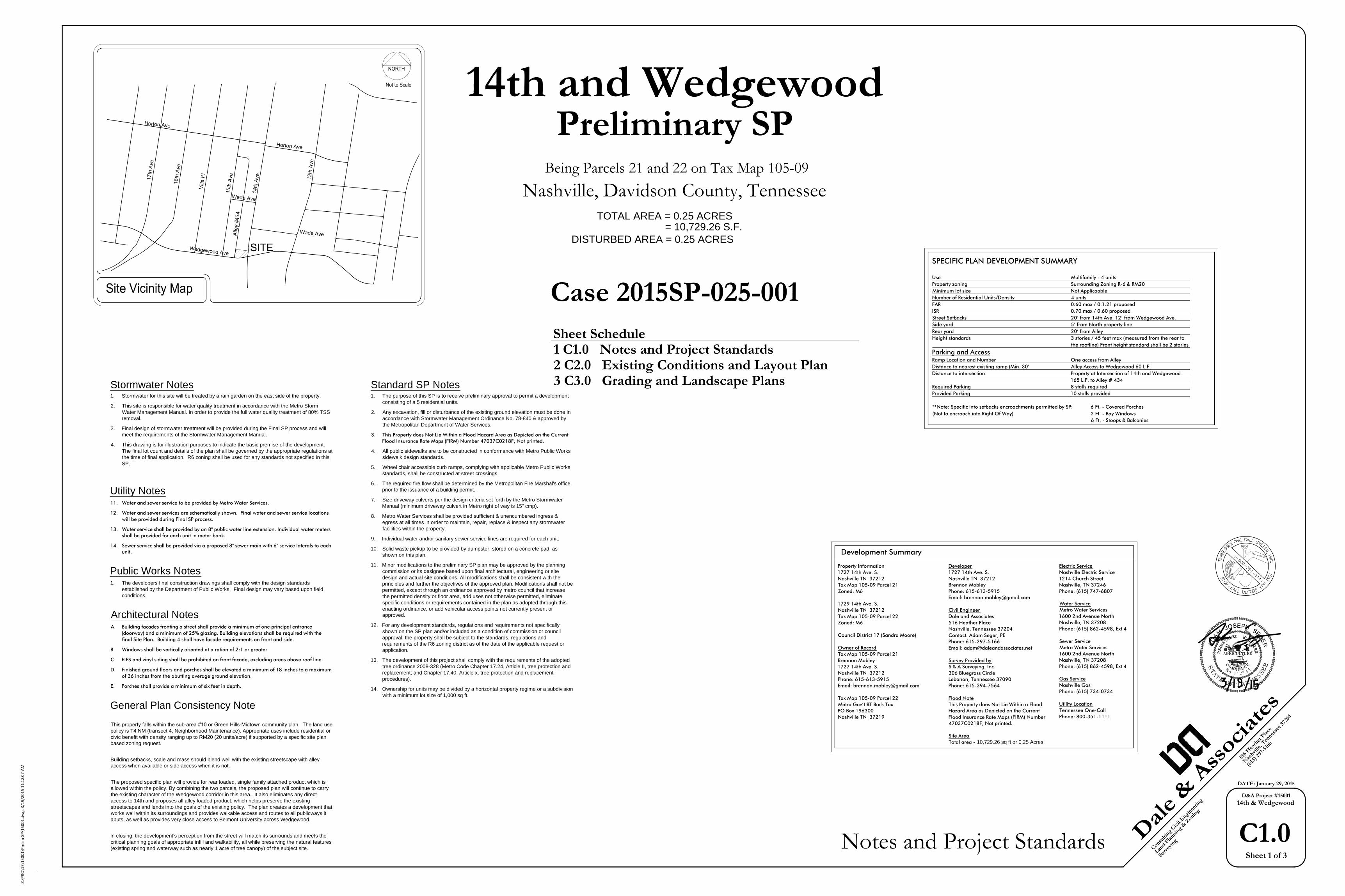
Existing ConditionsScale 1" = 20'
Site Layout and Utility PlanScale 1" = 20'
Pre / Post CalculationsPre-developmentTotal site area = 0.25 acres Pre-developed impervious = 0.09 ac @ 98 Pre-developed grass = 0.15 ac @ 69 Composite CN = 80Post-developmentTotal site area = 0.25 acres Post-developed impervious = 0.15 ac @ 98 Post-developed green space = 0.10 ac @ 69 Composite CN = 86
Preliminary calculations above shows that this project will increasethe amount of runoff generated by this site . Onsite mitigation shall beprovided through the proposed rain gardens to ensure no adverseimpacts & all water quantity requirements are met.
Development SummaryProperty Information1727 14th Ave. S.Nashville TN 37212Tax Map 105-09 Parcel 21Zoned: M6
1729 14th Ave. S.Nashville TN 37212Tax Map 105-09 Parcel 22Zoned: M6
Council District 17 (Sandra Moore)
Owner of RecordTax Map 105-09 Parcel 21Brennon Mobley1727 14th Ave. S.Nashville TN 37212Phone: 615-613-5915Email: [email protected]
Tax Map 105-09 Parcel 22Metro Gov't BT Back TaxPO Box 196300Nashville TN 37219
Civil EngineerDale and Associates516 Heather PlaceNashville, Tennessee 37204Contact: Adam Seger, PEPhone: 615-297-5166Email: [email protected]
Flood NoteThis Property does Not Lie Within aFlood Hazard Area as Depicted on theCurrent Flood Insurance Rate Maps(FIRM) Number 47037C0218F, Notprinted.
Case 2015SP-025-001
SOLID WASTE ENCLOSUREN.T.S.
6' screen fence /wall at dumpster
6' opaque gates
6" pipe bollards (typ)
8'-0"
3'-0"
8'-0"
3'-0"
14'-0"sloped
6" conc. dumpsterpad 8'x14'
Note:1. Any required excavation within
the protection zone shall beexcavated by hand.
2. No stockpiling or storage ofmaterials is permitted within thelimits of the protection area.
3. Continuous barrier of 4' highchain link fencing with temporarysignage delineating boundariesof tree protection fencing.
4. Fencing to encompass the criticalroot zone or 1.5 x the dripline ofthe tree, min. 10' squareprotected area required.
5. Filling may be allowed in certainareas, see grading plans.
Contractors responsibility to acquire treeremoval permits.
Undisturbed soil
Dri
plin
e ra
dius
x 1
.5
Dri
plin
e ra
dius
x 1
.5
Dri
plin
e
Dri
plin
e
Temporary signage
8' max.
4' m
in.
Drive 4' metal fence post intoundisturbed ground (10' o.c. max.
TREE PROTECTION FENCING DETAILN.T.S.
Z:\P
RO
\15\15001\P
relim
SP
\15001.d
wg
, 3/19/2015 11:12:19 A
M
PERMITS:
Grading and Landscape Plan C3.0Sheet 3 of 3
(615
) 297
-516
6
Nas
hville
, Ten
nesse
e 37
204
516
Hea
ther
Pla
ce
Land P
lannin
g & Z
onin
g
Con
sulti
ng Civ
il E
nginee
ring
Surv
eyin
g
D&A Project #1500114th & Wedgewood
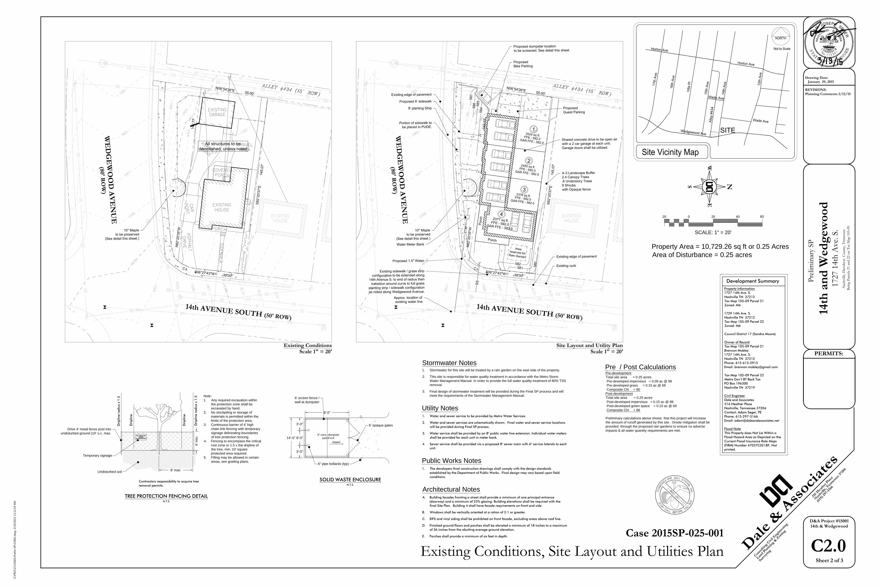
Grading PlanScale 1" = 20'
Landscape PlanScale 1" = 20'
Bei
ng
Par
cels
21 a
nd 2
2 o
n T
ax M
ap 1
05-0
9
1727 1
4th
Ave.
S.
14th
an
d W
ed
gew
oo
d
Nas
hvill
e, D
avid
son
C
oun
ty, T
enn
esse
e
Pre
limin
ary
SP
Tree Density NotesMetro tree density requirements will be addressed in final construction documents. Atthe preliminary phase of this project no tree information is available.
0.25 ac - 0.15 ac = 0.1 ac x 14 = 2 tdu's req'd 2 @ 0.5 (2" cal tree) = 1 tdu's prop
Note: Existing trees to be preserved have not been included in the required TDU..
Drawing Date: January 29, 2015
REVISIONS:Planning Comments 2/12/15
Property Area = 10,729.26 sq ft or 0.25 AcresArea of Disturbance = 0.25 acres
SCALE: 1" = 20'
20 0 20 40 60
Development SummaryProperty Information1727 14th Ave. S.Nashville TN 37212Tax Map 105-09 Parcel 21Zoned: M6
1729 14th Ave. S.Nashville TN 37212Tax Map 105-09 Parcel 22Zoned: M6
Council District 17 (Sandra Moore)
Owner of RecordTax Map 105-09 Parcel 21Brennon Mobley1727 14th Ave. S.Nashville TN 37212Phone: 615-613-5915Email: [email protected]
Tax Map 105-09 Parcel 22Metro Gov't BT Back TaxPO Box 196300Nashville TN 37219
Civil EngineerDale and Associates516 Heather PlaceNashville, Tennessee 37204Contact: Adam Seger, PEPhone: 615-297-5166Email: [email protected]
Flood NoteThis Property does Not Lie Within aFlood Hazard Area as Depicted on theCurrent Flood Insurance Rate Maps(FIRM) Number 47037C0218F, Notprinted.
Stormwater Notes1. Stormwater for this site will be treated by a rain garden on the east side of the property.
2. This site is responsible for water quality treatment in accordance with the Metro StormWater Management Manual. In order to provide the full water quality treatment of 80% TSSremoval.
3. Final design of stormwater treatment will be provided during the Final SP process and willmeet the requirements of the Stormwater Management Manual.
Utility Notes1. Water and sewer service to be provided by Metro Water Services.
2. Water and sewer services are schematically shown. Final water and sewer service locationswill be provided during Final SP process.
3. Water service shall be provided by an 8" public water line extension. Individual water metersshall be provided for each unit in meter bank.
4. Sewer service shall be provided via a proposed 8" sewer main with 6" service laterals to eachunit.
Public Works Notes1. The developers final construction drawings shall comply with the design standards
established by the Department of Public Works. Final design may vary based upon fieldconditions.
Architectural NotesA. Building facades fronting a street shall provide a minimum of one principal entrance
(doorway) and a minimum of 25% glazing. Building elevations shall be required with thefinal Site Plan. Building 4 shall have facade requirements on front and side.
B. Windows shall be vertically oriented at a ration of 2:1 or greater.
C. EIFS and vinyl siding shall be prohibited on front facade, excluding areas above roof line.
D. Finished ground floors and porches shall be elevated a minimum of 18 inches to a maximumof 36 inches from the abutting average ground elevation.
E. Porches shall provide a minimum of six feet in depth.
ADAM
JOSEPH SEGER
Case 2015SP-025-001
Z:\P
RO
\15\15001\P
relim
SP
\15001.d
wg
, 3/19/2015 11:12:33 A
M
2931
BE
RR
Y H
ILL
DR
IVE
SU
ITE
200
NA
SH
VIL
LE, T
N 3
7204
Pho
ne: (
615)
269
-924
8 Fa
x: (6
15) 6
27-1
298
emai
l: qu
irkde
sign
s@co
mca
st.n
etQ
UIR
K D
ES
IGN
S
PHONE:W335-0732H298-1508
REVISION
PROJECT NO:
COPYRIGHT 2007QUIRK DESIGNS
SHEET 1
C1
Bre
nnon
Mob
ley
1727
14t
h Av
e So
uth
Nas
hvill
e, ,
TN 3
7212
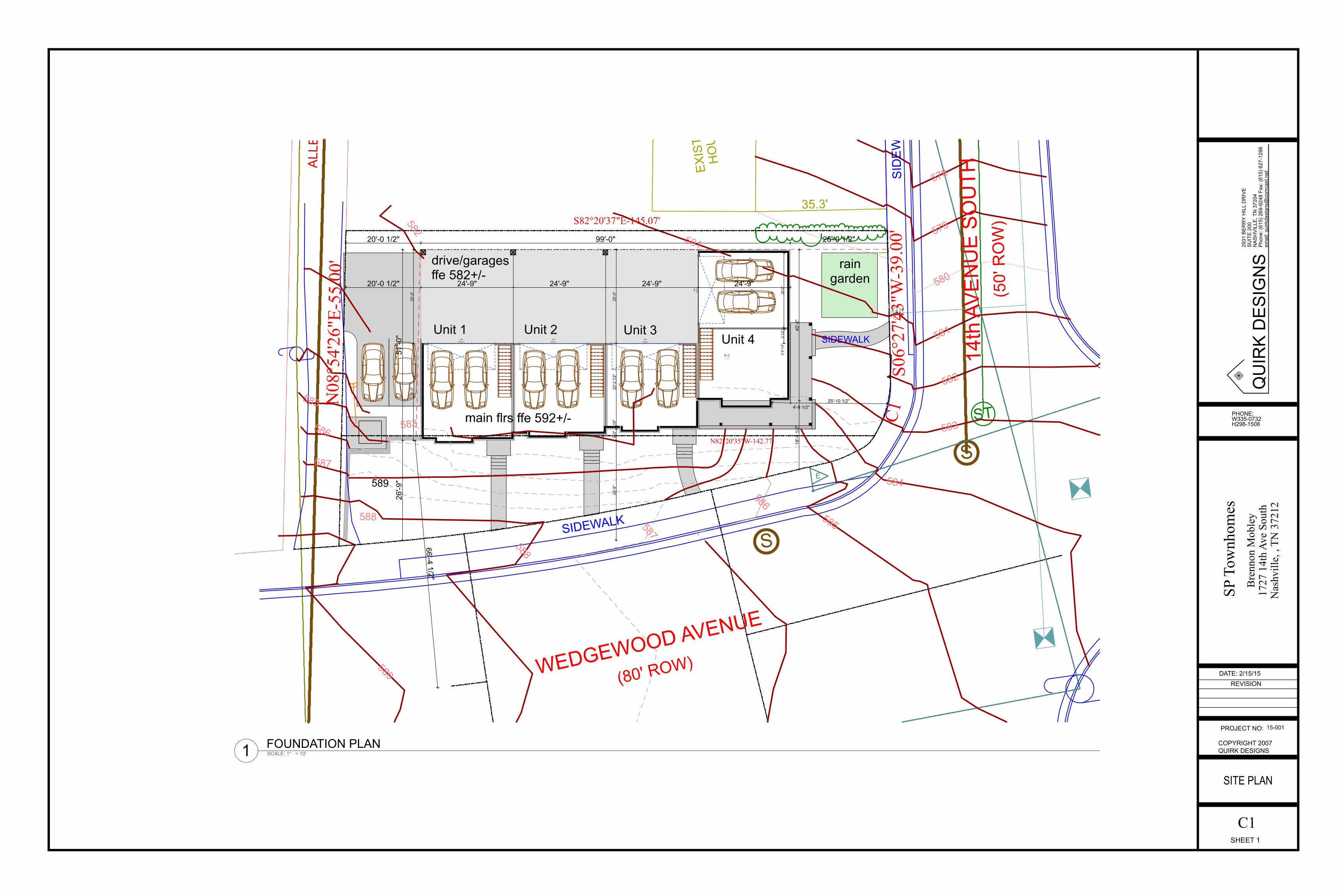
SITE PLAN
SP T
ownh
omes
15-001
DATE: 2/15/15
D3318' by 7'
D3418' by 7'
D3518' by 7'
D36
18' b
y7'
20'-0 1/2" 99'-0" 26'-0 1/2"
26'-9
"51
'-0"
18'-4
1/2
"40
'-5"
66'-4 1/2"
3'-8
1/2
"5
1/2"
20'-0
"20'-0 1/2" 24'-9" 24'-9" 24'-9" 24'-9"
26'-0
"25
'-0"
26'-9
"3'
-0"
10"
22'-2
1/2
"25
'-0"
4'-9 1/2"25'-10 1/2"
ST
S
W
E
S
ALL
EY
#434
(15'
RO
W)
14th
AV
EN
UE
SO
UTH
(50'
RO
W)
SID
EW
ALK
WEDGEWOOD AVENUE
(80' ROW)
EXIS
TIN
GH
OU
SE
SIDEWALK
589
588
587
586
585
584
583
582
581
580
579
578
582
583
585
586
587
588
581
N08
°54'
26"E
-55.
00'
S82°20'37"E-145.07'
S06°
27'4
3"W
-39.
00'
N82°20'35"W-142.77'
C1
35.3'
SIDEWALK
raingarden
drive/garagesffe 582+/-
main flrs ffe 592+/-
Unit 1 Unit 2 Unit 3Unit 4
589
4-1A: 511.80 sq ft
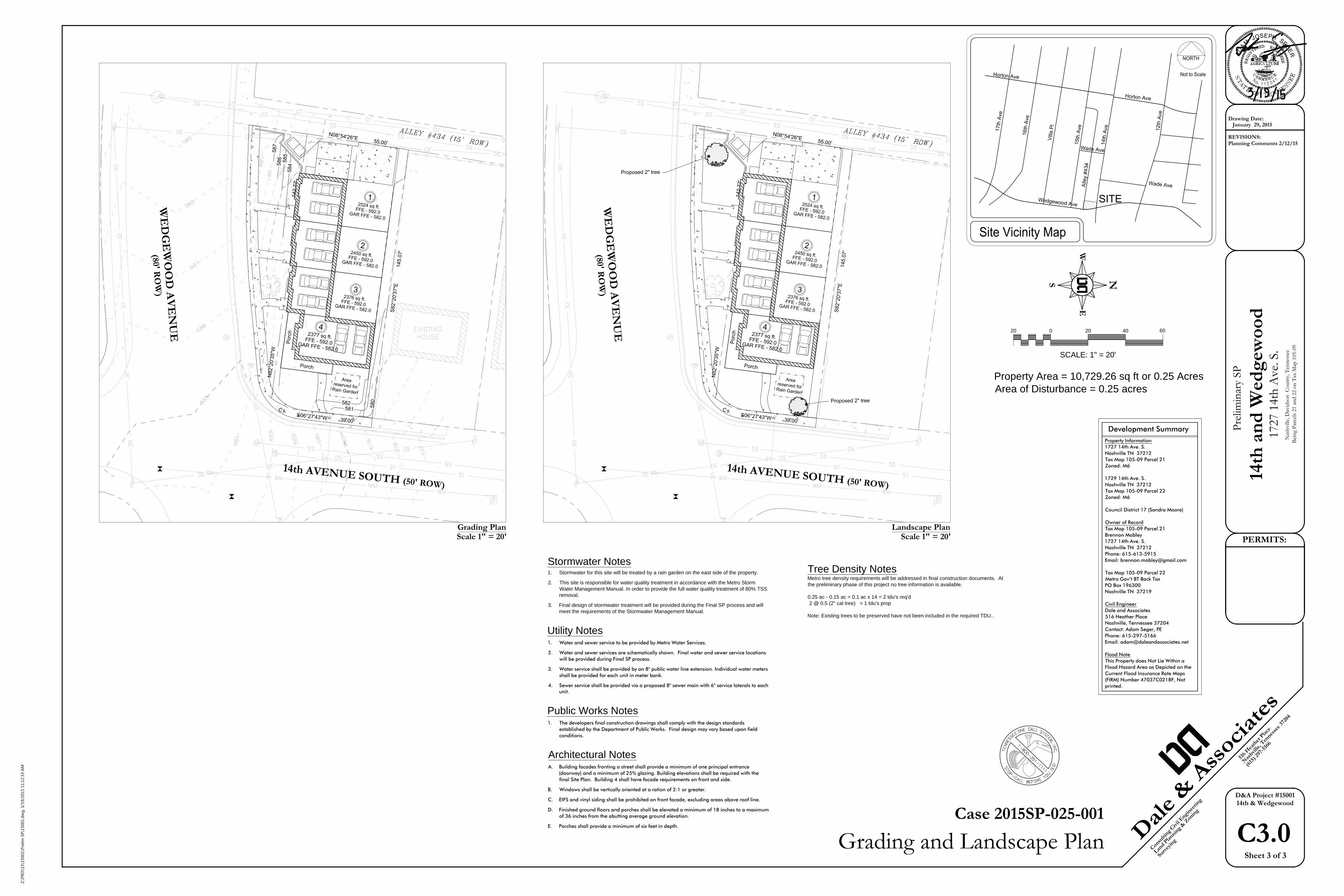
SCALE: 1" = 10'1 FOUNDATION PLAN
2931
BE
RR
Y H
ILL
DR
IVE
SU
ITE
200
NA
SH
VIL
LE, T
N 3
7204
Pho
ne: (
615)
269
-924
8 Fa
x: (6
15) 6
27-1
298
emai
l: qu
irkde
sign
s@co
mca
st.n
etQ
UIR
K D
ES
IGN
S
PHONE:W335-0732H298-1508
REVISION
PROJECT NO:
COPYRIGHT 2007QUIRK DESIGNS
SHEET 2
A1
Bre
nnon
Mob
ley
1727
14t
h Av
e So
uth
Nas
hvill
e, ,
TN 3
7212
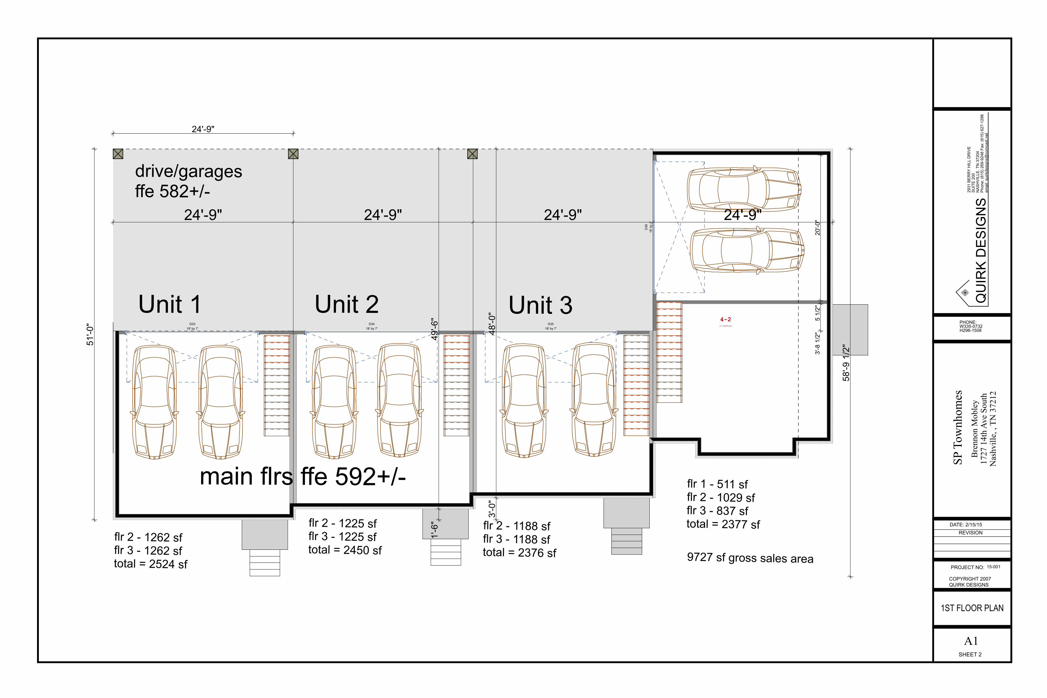
1ST FLOOR PLAN
SP T
ownh
omes
15-001
DATE: 2/15/15
D3318' by 7'
D3418' by 7'
D3518' by 7'
D36
18' b
y7'
58'-9
1/2
"
3'-8
1/2
"5
1/2"
20'-0
"24'-9" 24'-9" 24'-9" 24'-9"
1'-6
"49
'-6"
24'-9"
51'-0
"
3'-0
"48
'-0"
drive/garagesffe 582+/-
main flrs ffe 592+/-
Unit 1 Unit 2 Unit 3
flr 2 - 1262 sfflr 3 - 1262 sftotal = 2524 sf
flr 2 - 1225 sfflr 3 - 1225 sftotal = 2450 sf
flr 2 - 1188 sfflr 3 - 1188 sftotal = 2376 sf
flr 1 - 511 sfflr 2 - 1029 sfflr 3 - 837 sftotal = 2377 sf
9727 sf gross sales area
4-2A: 1,029.04 sq ft
2931
BE
RR
Y H
ILL
DR
IVE
SU
ITE
200
NA
SH
VIL
LE, T
N 3
7204
Pho
ne: (
615)
269
-924
8 Fa
x: (6
15) 6
27-1
298
emai
l: qu
irkde
sign
s@co
mca
st.n
etQ
UIR
K D
ES
IGN
S
PHONE:W335-0732H298-1508
REVISION
PROJECT NO:
COPYRIGHT 2007QUIRK DESIGNS
SHEET 3
A2
Bre
nnon
Mob
ley
1727
14t
h Av
e So
uth
Nas
hvill
e, ,
TN 3
7212
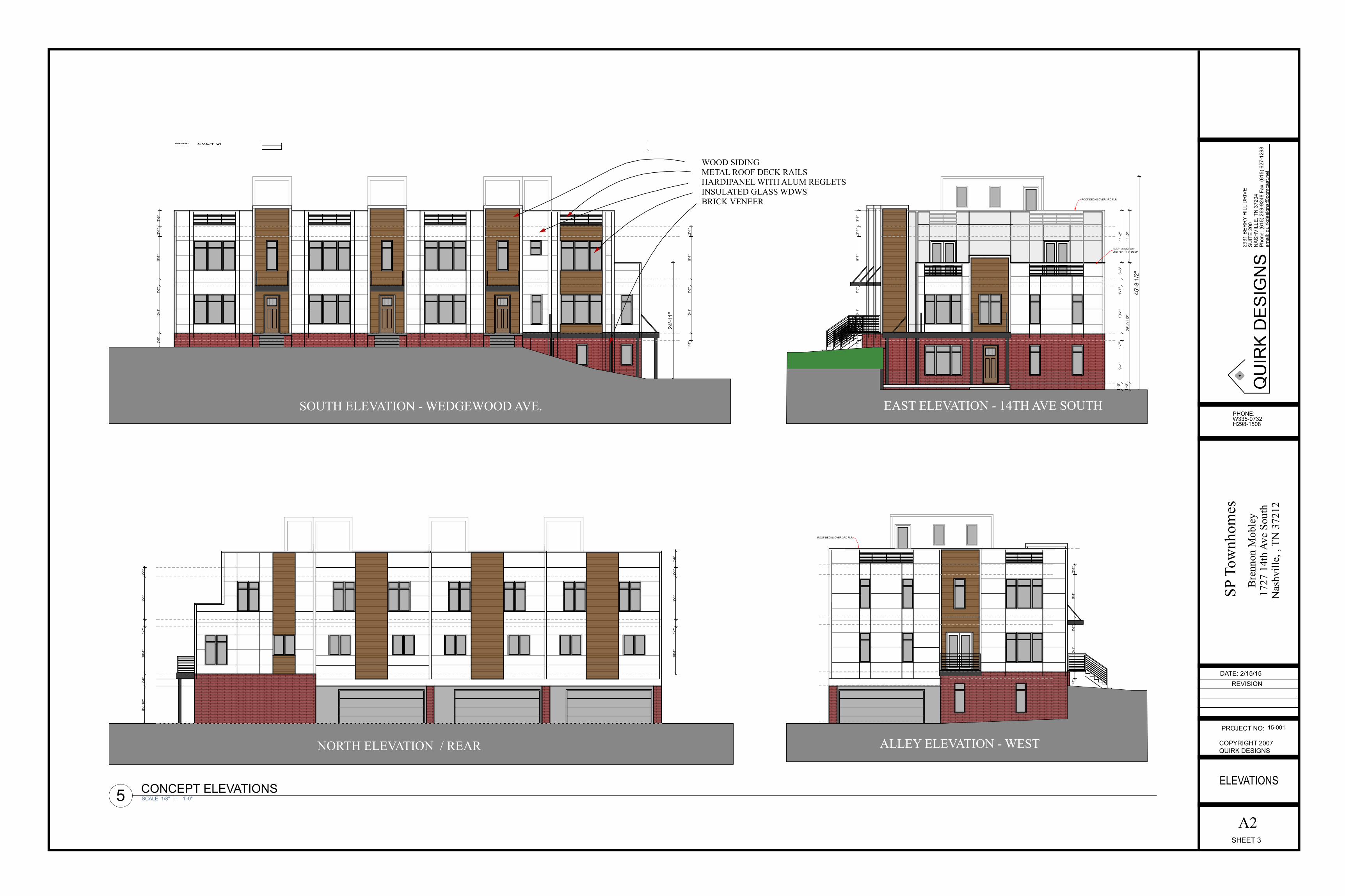
ELEVATIONS
SP T
ownh
omes
15-001
DATE: 2/15/15
1'-7
"10
'-1"
1'-7
"9'
-1"
2'-1
"
1'-7
"10
'-1"
1'-7
"9'
-1"
2'-1
"3'
-6"
3'-0
"10
'-1"
1'-7
"9'
-1"
2'-1
"3'
-6"
45'-8
1/2
"
24'-1
1"
8'-0
1/2
"2'
-8"
10'-1
"1'
-7"
9'-1
"2'
-1"
10'-1
"1'
-7"
9'-1
"2'
-1"
3'-6
"
1'-7
"10
'-1"
1'-7
"9'
-1"
2'-1
"
ROOF DECKS OFF2ND FLR - 4' 9" DEEP
ROOF DECKS OVER 3RD FLR
ROOF DECKS OVER 3RD FLR
flr 2 - 1262 sfflr 3 - 1262 sftotal = 2524 sf 9727 sf gross sales area
1'-6
"9'
-1"
1'-7
"10
'-1"
1'-7
"3'
-6"
11'-2
"1'
-6"
25'-9
1/2
"11
'-2"
SOUTH ELEVATION - WEDGEWOOD AVE.
ALLEY ELEVATION - WEST
EAST ELEVATION - 14TH AVE SOUTH
NORTH ELEVATION / REAR
SCALE: 1/8" = 1'-0"5 CONCEPT ELEVATIONS
WOOD SIDINGMETAL ROOF DECK RAILSHARDIPANEL WITH ALUM REGLETSINSULATED GLASS WDWSBRICK VENEER