Embed Size (px)
Citation preview

Maryland Avenue Southwest PlanWashington, DCApril 2012
Prepared by:
Prepared for:
District of Columbia Office of Planning
Government of the District of ColumbiaVincent C. Gray, Mayor


Sour
ce: L
ibra
ry o
f Con
gres
s G
eogr
aphy
and
Map
s D
ivis
ion
Cove
r im
age
sour
ce: J
osep
h R.
Pas
sonn
eau
Contents1.0 Background..............................................................................
Maryland Avenue Study Area Snapshot...................................
Goals For The Plan....................................................................
2.0 Synthesis.....................................................................................
2.1 Land Use............................................................................
2.2 Transit................................................................................
2.3 Connections.........................................................................
2.4 Public Realm.....................................................................
3.0 Recommendations.............................................................
3.1 Provide Connections........................................................
3.2 Enhance The Public Realm.............................................
3.3 Improve Transit Access.....................................................
3.4 Diversify Land Uses.........................................................
4.0 Building Momentum.........................................................
Executive SummaryThe Maryland Avenue Southwest (SW) Plan (“the Plan”) presents an opportunity for the District, with the objective of restoring the L’Enfant street grid and turning an office enclave of 60,000 office workers into a residential mixed-use neighborhood, just south of the National Mall. The study area is located in Ward 6, and is bounded by 6th and 12th Streets, SW, along the Maryland Avenue SW corridor.
The Plan was initiated by the Office of Planning (OP) in February 2011. It summarizes the viability of decking and establishing Maryland Avenue SW, currently occupied by the rail corridor, and creates a framework to build mixed-use development as land is conveyed from federal to private use. It also provides options for a reconstructed Avenue and multi-modal facility at L’Enfant Station that integrates VRE, Metrorail, and Metro Bus services, and envisions accommodating MARC, Amtrak, commuter buses and the Streetcar system in the future.
The vision for the Maryland Avenue corridor is to serve as the spine of a livable and walkable neighborhood for residents, tourists and office workers –one that is visually and physically connected to the Capitol and integrated into the environmental systems of the National Capital Planning Commission’s Southwest Ecodistrict. Recommendations in the Plan provide for novel live near your work housing, year-round event programming in signature open spaces, abundant bicycle facilities, and new multi-modal services.
Near term improvements, like underpass enhancements, should be the immediate focus for implementation in order to change the office-only perceptions and create better north-south linkages between the National Mall and waterfront. However, building the reconstructed Avenue is critical to the long term evolution of downtown, particularly as additional redevelopment opportunities unfold in Southwest.
Critical partnerships and additional planning are necessary to make the vision for Maryland Avenue a reality, beginning with the establishment of ownership arrangements and funding toolkit strategies. Both a street and park, with opportunities to filter and reuse rainwater, establish tree canopy, generate electricity and improve walkability, Maryland Avenue will be a livable green amenity that defines an emerging neighborhood.
1-1
1-8
1-9
2-1
2-2
2-6
2-10
2-14
3-1
3-2
3-6
3-12
3-16
4-1


Maryland Avenue SW Plan / Background 1-1
BackgroundThe Maryland Avenue Southwest (SW) Plan was initiated to study the feasibility of reconstructing a major missing link in the L’Enfant street grid, Maryland Avenue SW and creating a more diverse land use mix in the heart of the Southwest Rectangle. In addition to connectivity enhancements, this plan identifies the redevelopment opportunities, open space improvements, zoning tools, and the next steps necessary to achieve the livable mix of uses called for in the Comprehensive Plan.
Located between the Tidal Basin, the National Mall and the Southwest Freeway, the Southwest Rectangle exists as a monoculture of office development known for its modern architecture and a federal workforce of approximately 60,000 employees. Maryland Avenue SW, the mirror image of Pennsylvania Avenue, exists in fragments punctuated by inhospitable public spaces. Success as an office destination goes hand in hand with barren streets after business hours and a noticeable lack of residential development. Despite the present challenges, a convergence of changing conditions has poised Southwest Washington for a renaissance.
Major redevelopment is coming to Southwest (see diagram on page 1-2). The Wharf, with approximately 1,300 residential units, 675 hotel rooms, 900,000 square feet (sf) of office, 120,000 sf of cultural use and 300,000 sf of retail, will activate the waterfront. The Dwight D. Eisenhower Memorial will be constructed at Maryland Avenue and 6th Street SW. New hotel development is soon to compliment the retail renovation at L’Enfant Plaza. The General Services Administration (GSA) has sponsored building renovations and public space improvements are under construction at 3rd and C Streets SW and the GSA is considering the conveyance of four sites along Maryland Avenue, hereafter referred to as the “ GSA parcels”, out of the Federal inventory.
Building on the Monumental Core Framework Plan, the National Capital Planning Commission (NCPC) started the Southwest Ecodistrict Initiative to determine how to revitalize the district, re-establish the street grid, increase the mix of uses and manage most of the energy, water and waste within the district. This includes strategies to improve 10th Street SW to connect the Mall to the waterfront and renovate or
1.0
Sour
ce: A
ECOM
Maryland Avenue SW Study AreaThis diagram depicts the study area for the Maryland Avenue SW Plan, the Southwest Ecodistrict and the broader Southwest Rectangle.
Sour
ce: O
P an
d N
CPC
► Note: The Southwest Rectangle is the broader area of impact for the Maryland Avenue corridor study area. Alternatives and recommendations presented in the plan will impact areas within the Southwest Rectangle and beyond. Similarly, future planning beyond the corridor study area, particularly related to transportation issues, will effect alternatives and recommendations in the plan. Broader citywide relationships should be considered throughout subsequent planning and design.
Federal Buildings
Private Buildings
Southwest Rectangle Boundary
Southwest Ecodistrict (NCPC)
Maryland Avenue SW Plan
Potential GSA Conveyance Sites
1/4 Mile

1-2 Maryland Avenue SW Plan / Background
redevelop the Department of Energy (DOE) Complex, the GSA Regional Headquarters and Wilbur Wright building, among others. These individual opportunities are all linked by the Maryland Avenue SW corridor and reestablishing this symbolic and functional connection can fundamentally change the future appeal, vitality and character of the Southwest Rectangle.
The District’s Comprehensive Plan supports the restoration of Maryland and Virginia Avenues as connecting diagonal streets and important corridors that respect reciprocal views and pedestrian movement. In anticipation of a future land conveyance of federal properties adjacent to the historic Maryland Avenue vista, the Comprehensive Plan gives guidance to generate “neighborhood livability standards for the creation of a new mixed-use neighborhood as part of any redevelopment of the Maryland Avenue SW area.”
Through participation in NCPC’s Southwest Ecodistrict Task Force Initiative to create a sustainable neighborhood, the District of Columbia Office of Planning (OP) kicked-off the Maryland Avenue SW Plan in January 2011. This plan provides a guiding framework for development surrounding Maryland Avenue as land transfers to private control. It also outlines the city’s preferred concepts for reconstructing the Avenue in relation to expanding transit opportunities in Southwest and at Union Station.
Context DiagramThis diagram depicts the changing conditions surrounding Maryland Avenue.
Potential Areas of Reuse or Redevelopment
Existing Decking At Portals
Proposed Decking on Maryland Ave and 9th Street
Proposed On-grade Enhancements
GSA Conveyance Parcels
Southwest Ecodistrict Boundary
Historic Right-of-ways and Viewsheds
Proposed 10th Street Enhancements Under Study by NCPC
1/4 Mile
Pierre L’Enfant’s 1791 Plan for Washington defined the physical and symbolic character of the nation’s capital through its arrangement of buildings, parks, roadways, and views. The plan calls for “grand traverse avenues,” including Maryland Avenue. As planned by L’Enfant, Maryland Avenue was a 160’ wide diagonal thoroughfare connecting the U.S. Capitol building with the Potomac River. Specifically, the 1791 L’Enfant Plan called for 10’ wide foot ways and 30’ wide walks of trees on both sides of an 80’ wide carriage way. The early development of Maryland Avenue followed this design.
Over time, the character of the Avenue changed. As early as 1818, the Potomac Bridge, located in the vicinity of the existing Long Bridge, connected Maryland Avenue to Virginia. By 1888, railroad lines had been established between Reservation 113, where Maryland and Virginia Avenues intersect, and the Long Bridge over the Potomac River, limiting connectivity in and around the Maryland Avenue corridor. An Act of Congress in 1901 allowed the rail to elevate and depress its tracks on both Maryland and Virginia Avenues, and led to the elimination of grade crossings. Urban Renewal, which began in 1945 in Southwest DC and ended in 1973 with the construction of a hotel at L’Enfant Plaza, removed the portions of the Maryland Avenue roadway next to the railroad tracks, further restricting connectivity in the study area. Urban Renewal planning transformed a mixed-use community into a pattern of superblock office development.

Maryland Avenue SW Plan / Background 1-3
Left: View along Maryland Avenue with The Portals in the foreground
Right: Maryland Avenue at 10th Street, view to the west
Sour
ce: N
CPC
Sour
ce: O
P
For the latter part of the 20th century, single office-use development and bisecting infrastructure, transporting thousands of people daily, have reinforced the character of Southwest Rectangle as a poorly connected urban office enclave in the midst of major tourist destinations like the National Mall and waterfront. The first steps were taken to reestablish Maryland Avenue in the 1980’s at The Portals. After years of advocacy by architect Arthur Cotton Moore and Republic Properties, construction started in late 1989, including decking Maryland Avenue over the railroad tracks west of 12th Street. Today, the Federal Government’s interest in improving livability through revitalization of the National Mall, building modernization and the Southwest Ecodistrict Initiative, offer the opportunity to leverage local and national interest to reinvent this part of the District as an animated crossroads linking the National Mall, Southwest waterfront, and region.
The Purpose of the Plan
The purpose of the study is to build on previous efforts through a public participatory process so that the city can gain an understanding of the complexities, aspirations and guidelines to be acknowledged when revitalizing the Avenue and developing federal property that may be conveyed into private ownership. OP established an agency project team and identified an Advisory Committee to explore alternatives for
the reconstruction of Maryland Avenue between 9th and 12th Streets, SW. Through an 8-month participatory process, a plan was developed to establish a development and land-use framework for Maryland Avenue that will guide revitalization through the reconstruction of the historic L’Enfant avenue into a lively mixed-use and green boulevard with strong connectivity through Washington’s core.
Past and Concurrent Planning EffortsIn addition to the reconstruction of Maryland Avenue SW at The Portals site, the following local, federal and district planning efforts provide context for the study:
• National Gateway: As part of the National Gateway project, CSX is planning significant infrastructure upgrades along its railway corridor. The National Gateway is a plan to create a more efficient rail route linking Mid-Atlantic ports with Midwestern markets, thereby improving the flow of rail traffic between these regions through increased use of double-stack trains. Key improvements in DC include reconstruction of the Virginia Avenue Tunnel in SE, and track lowerings along the historic Maryland Avenue right-of-way under 10th Street SW, the I-395 ramp and 12th Street SW which offer opportunities to set the stage for a decked Maryland Avenue above the rail corridor.

1-4 Maryland Avenue SW Plan / Background
• Zoning Regulations Review: The City-wide Zoning Regulations Review process recommends creating a new set of zones for an expanded downtown area to include the Southwest Rectangle. Under this proposed zoning, the study area would have a limited height for non-residential uses and a density bonus for residential uses with the intent of incentivizing housing.
• Center City Action Agenda: The 2008 Center City Action Agenda, by OP, proposes the establishment of a transit network that creates a highly accessible downtown and supports additional development, new districts, and destinations like the Southwest Waterfront.
• Monumental Core Framework Plan: In 2009, NCPC and the Commission of Fine Arts (CFA), completed the Monumental Core Framework Plan to repair the urban fabric by restoring the street grid, decking over highways, and redeveloping superblocks to improve the public realm, integrate open space, increase development density, and improve the mix of uses.
• Federal Land Conveyance: On June 10, 2010, President Obama issued the “Presidential Memorandum: Disposing of Unneeded Federal Real Estate.” As a result, GSA is considering conveying four sites along the historic Maryland Avenue corridor out of the Federal inventory.
• Comprehensive Plan Amendment Act of 2010: The District Comprehensive Plan was amended to include language that will enhance the livability of federally dominated precincts in the Southwest Rectangle. For land that may shift from federal to private or municipal use, the Comprehensive Plan encourages residential, retail and cultural uses, as well as the reconstruction of historic rights-of-way. The future land use map, shown on page 1-5, was not amended in 2010 and will need to be modified to support a mixed-use neighborhood. If approved by Council, this small area plan will provide guidance to supplement the Comprehensive Plan in the interim.
• Passenger Rail Planning: Amtrak, VRE and MARC are currently studying the expansion of Union Station and L’Enfant commuter rail station to accommodate significant increases in high speed and passenger rail services over the next 20-30 years. In addition, the District Department of Transportation (DDOT) will be initiating the Long Bridge Study in 2012 to analyze long-term multi-modal improvements for the future operations of high speed and inter-city passenger rail, commuter rail, transit, bike and pedestrian and freight services over the Potomac River.
• Southwest Ecodistrict Initiative: Building on the Monumental Core Framework Plan, NCPC is currently undertaking the
The 1791 L’Enfant Plan
The 2009 Monumental Core Framework Plan study area illustration
Sour
ce: J
osep
h R.
Pas
sonn
eau
The 1901 McMillan Plan
Sour
ce: J
osep
h R.
Pas
sonn
eau
Sour
ce: N
CPC

Maryland Avenue SW Plan / Background 1-5
Southwest Ecodistrict Task Force Initiative. The Task Force, is comprised of the following federal and local agencies: NCPC, OP, DC Office of the Deputy Mayor for Planning and Economic Development (DMPED), DDOT, GSA, DOE, HUD, CFA, EPA, Architect of the Capitol, FAA, NPS, Smithsonian Institution, Department of Education, US Commission of Fine Arts, US Department of Agriculture and the US Postal Service. NCPC formed the Southwest Ecodistrict Task Force to develop recommendations on how to transform the area surrounding 10th Street SW and Maryland Avenue into a livable and sustainable place to work and live. The initiative seeks to create a national showcase of sustainability by capturing, managing, and reusing energy, waste, and water beyond a single building to a group of buildings within the Ecodistrict.
The Planning ProcessThe Maryland Avenue SW Plan is a supporting piece of the overall Southwest Ecodistrict Task Force Initiative focusing on infrastructure, development, transit and public space issues along the historic Maryland Avenue corridor. OP, and consultant team, coordinated closely with NCPC, GSA, DDOT, DMPED and other agency partners throughout the planning process. The Maryland Avenue planning effort included the following general steps:
• Goals and Objectives: OP developed and refined goals and objectives for the plan based upon initial project team observations, and a combination of stakeholder, agency and public input.
• Construction Feasibility Study: The project team completed a high level infrastructure feasibility assessment and analysis of decking over and realigning the CSX rail tracks to create Maryland Avenue SW. The assessment identified feasibility issues and opportunities for a variety of alternatives, as well as construction cost estimates.
• Market Analysis Report: Concurrently, the project team evaluated current real estate market conditions and trends in the broader study area including current supply, as well as planned and proposed development projects, and conducted a market demand analysis.
• Alternatives and Recommendations: Based on the results of the Feasibility Study and Market Analysis, the project team developed land use and massing alternatives for build-out. Through stakeholder, agency and public input, a preferred approach to the new Maryland Avenue SW was identified, along with zoning, urban design, public realm and transit recommendations.
Sketch of “City Pier” in The Wharf, the future SW Waterfront development
Sour
ce: H
offm
an-M
adis
on W
ater
front
Model view of one of the proposals for the future Eisenhower Memorial site
Sour
ce: G
ehry
Par
tner
ship
2006 Comprehensive Plan -Future Land Use Map showing “Production, Distribution,and Repair” and “High Density Commercial” along the Maryland Avenue right-of-way
Sour
ce: O
P

1-6 Maryland Avenue SW Plan / Background
Sour
ce: A
ECOM
Sour
ce: O
P
Left: The convergence and quantity of transit services is one of the study area’s greatest strengths
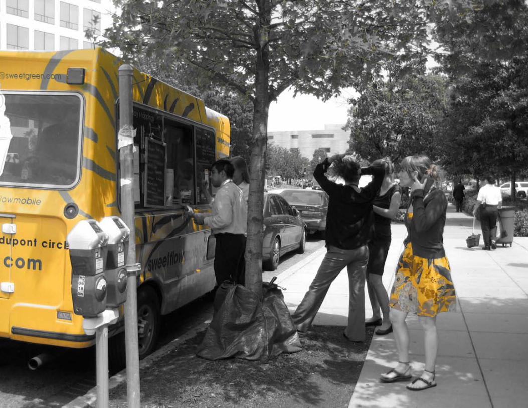
Right: Lunchtime queue at food truck on 7th Street SW demonstrates desire for more retail and restaurant sources
PN HoffmanBoston PropertiesBMS Real Estate ServicesClark Enterprises Inc. Piedmont Office Realty Trust, Inc.
In addition to Advisory Committee meetings, OP hosted a series of public meetings on February 17, May 19 and July 14, 2011 to obtain feedback on goals, alternatives and recommendations. Between March 22 and April 6, OP received 400 responses to a 10-question survey that was issued to gain information about what office workers and residents like and dislike in the study area. Lastly, OP presented to the Southwest Ecodistrict Task Force for their input on March 10 and July 6, 2011, with a working group meeting on May 6, 2011.
The Maryland Avenue SW Plan Advisory Committee helped guide the development of the Plan. The Advisory Committee participated in four meetings, led by OP and AECOM consultant team (hereafter referred to as the “team”), where they identified opportunities and goals, reviewed consultant analysis, provided input on alternatives for the Avenue and developed draft recommendations.
The following organizations were represented on the Maryland Avenue SW Plan Advisory Committee. The list includes property owners along Maryland Avenue and in the broader neighborhood, as well as transit and railway operators. The Advisory Committee met with the team on March 16, May 17, June 23 and July 14, 2011.
AmtrakVirginia Railway ExpressCSXWMATAAdvisory Neighborhood Commission 6DCultural TourismPenn Quarter Neighborhood AssociationCIM GroupRepublic Properties CorporationThe JBG Companies

Maryland Avenue SW Plan / Background 1-7
Left: OP staff conducted an online survey and interviewed people on the street
Right: Joint public meetings occurred between the Maryland Avenue SW Plan and Southwest Ecodistrict Task Force planning efforts
Sour
ce: N
CPC
The 10 questions of the survey are listed here along with the top rated responses:
1. Why do you frequent this area? - 88% work nearby
2. How often do you come here? - 89% come daily
3. How do you typically get to this part of the city? - 71% come by Metrorail
4. What physical enhancements are most needed here? - 62% chose “parks and opens spaces”
5. Why would this be an enhancement? - 33% said “it would give me better access to goods and
services”6. What do you like most about this area of the city?
- 39% said “close to the National Mall and Southwest Waterfront
7. What land uses are most needed here? - 80% chose “restaurant/cafe”
8. What would encourage you to live here? - 25% said “If there were neighborhood amenities”
9. How much do you spend on food and beverage per week here? - 32% spend between $26 and $50
10. What food and beverage options do you use here? - 68% bring food and beverages from home
0
50
100
150
200
250
300 March 22 - April 6, 2011 Survey results: What physical enhancements are most needed here (rank top 4)?
Sour
ce: O
P
First Rank
Second Rank
Third Rank
Fourth Rank
Num
ber o
f Res
pons
es

1-8 Maryland Avenue SW Plan / Background
Maryland Avenue Study Area SnapshotEarly in the process, district and federal agencies gathered to discuss observations and impressions of Maryland Avenue SW, the GSA parcels and the overall Ecodistrict. The group focused on the strengths, weaknesses, opportunities and threats within the study area and the resulting snapshot captures the discussion.
StrengthsAdvantages of the Maryland Avenue corridor/GSA parcels:
• Proximity to tourist destinations, including National Mall, Smithsonian institutions and waterfront.
• Federal government presence, representing over 10 agencies, including seven federal headquarters. Employee constituents provide regular use of the study area.
• Reservation 113 at the heart of the study area is a critical, symbolically important open space in the L’Enfant and McMillan plans.
• L’Enfant Plaza is one of the largest Metro transfer points and the area is well served by transit.
• The Avenue is on direct axis of the U.S. Capitol.
Weaknesses Disadvantages of the Maryland Avenue corridor/GSA parcels:
• There is not enough residential and cultural activity after business hours to support new retail.
• GSA parcels are currently zoned C-3-C, a high density commercial zone that allows mixed uses, but does not incentivize residential uses.
• Limited size of GSA parcels along the CSX right-of-way restricts infill options.
• Intermodal transfers are not intuitive and there is not enough railroad tracks to support increasing demand for passenger, freight and commuter ridership.
• Grade changes and roadway configurations make it challenging to connect Maryland Avenue with 9th and 11th Streets, SW.
• Sound of moving freight trains can be interruptive and noisy.
Opportunities Ideas that can achieve overall goals or overcome weaknesses:
• Future increasing transit demand on VRE, Metrorail, Metrobus, and planned streetcar along 7th Street.
• Nearly 6,000 residents currently living with a 10 minute walk to Maryland Avenue.
• Future public realm enhancement of Eisenhower Memorial and 10th Street.
• Major private development sites, including The Wharf, L’Enfant Plaza and The Portals, can provide additional development opportunity.
• Shape of GSA parcels favors residential or hotel development rather than office.
Threats Constraints to be considered when evaluating opportunities:
• Although the shapes of the GSA parcels are more appropriate for residential or hotel, developing office space may yield better return in the short term.
• Grade constraints and railroad requirements may cause a future Maryland Avenue to undulate in elevation.
• New restaurants will be in competition with internal office cafeterias.
• The 12th street expressway currently crosses the Maryland Avenue corridor without stopping. Any future intersection between these streets must resolve this issue.
• Decking over the railroad will be a significant investment. Funding constraints may complicate implementation.
• The Avenue right-of-way has been formally closed between 9th and 12th Streets SW. Reestablishing the 160’ wide Avenue will require the cooperation of multiple property owners (see map on page 1-9).

Maryland Avenue SW Plan / Background 1-9
Goals For The PlanOP considered the Comprehensive Plan guidance in light of the study area’s strengths, weaknesses opportunities and threats discussed previously when developing goals for the planning effort. Four goals emerged and were vetted with the Advisory Committee and the public.
• Identify the best land-use mix to fulfill the Comprehensive Plan goals of creating a more lively and sustainable community around the Avenue, while developing funding strategies to pay for infrastructure improvements.
• Identify approaches to improve access and connect Maryland Avenue SW to the street grid, a wide range of transit options, destinations and key activity corridors – like the Southwest Waterfront, National Mall, Independence Avenue, 7th and 10th Streets – and nearby neighborhoods.
• Recommend the best reconstruction alternatives for Maryland Avenue SW that are economically feasible, work with existing and planned infrastructure constraints, create a lively urban environment, and connect with the rest of the city.
• Create urban design and public realm guidelines that foster the creation of a sustainable and quality urban environment and builds upon and helps implement the Southwest Ecodistrict goals, Comprehensive Plan, Monumental Core Framework Plan, and Center City Action Agenda.
This document provides background information, input, analysis, recommendations, and a checklist of actions to be considered when building Maryland Avenue and developing adjacent infill sites. The “Synthesis” and “Recommendations” chapters are organized by the goals identified during the planning process. “Synthesis” combines stakeholder input, observations and consultant analysis, which form the basis for recommendations. “Recommendations” include a combination of principles and guidelines. The final chapter, “Building Momentum”, was developed with the assistance of local and agency representatives with the intent to help stakeholders make informed decisions as plans for Maryland Avenue progress from concept to fruition. It also includes action items that will help jump-start transformation in the Southwest Rectangle prior to construction of Maryland Avenue SW. Additional information on public input, market, development and engineering feasibility is available from OP.
Property Ownership DiagramIllustration of the multiple property owners adjacent to and within the 160’ historic Maryland Avenue right-of-way and Virginia Avenue corridor and streets adjacent to Reservation 113. The historic right-of-way has been closed between 12th and 9th Streets SW.
District Right-Of-Way (sidewalks, streets, overpasses, metro entrance)
NPS Property (open spaces)
Federal Property (parking lots, vacant lot)
Railroad Property (rail)
Private Property (building -2 floors)
Historic Maryland Avenue right-of-way
600 Feet
Independence Avenue SW
D Street SW
7th
Stre
et S
W
9th
Stre
et S
W
10th
Stre
et S
W
12th
Stre
et S
W
6th
Stre
et S
W
C Street SW
4th
Stre
et S
W
Maryland Avenue SW
FAAOrville Wright
FAAWilbur Wright
DOE
GSA
370 L’Enfant Promenade
Reservation 197
Reservation 113


Maryland Avenue SW Plan / Synthesis 2-1
SynthesisFollowing initial meetings with study area stakeholders, the Advisory Committee, the public, and federal and District agencies, the team prepared independent analyses of engineering feasibility, market trends and development capacity. Then, with the plan goals in mind, the team synthesized summary findings. These summary findings became the basis for the recommendations discussed in the next section.
The input received, analysis undertaken and summary findings derived can be organized into four interrelated elements that align with the four goals for the plan: land use, transit, connections and public realm.
2.0
Sour
ce: O
P

2-2 Maryland Avenue SW Plan / Synthesis
InputCurrently, the Southwest Rectangle is dominated by office uses resulting in minimal activity after work hours. This lack of vitality acts as a barrier between the National Mall and residents of the Southwest Waterfront neighborhood. The adjacent community realizes that the uniform land use is an issue and welcomes a more livable atmosphere. Input obtained through community meetings and the 10-question survey suggests the most desired uses in the study area are additional restaurants and cafés, residential development, retail shopping opportunities, and parks and open space.
AnalysisThe team prepared a Market Analysis that identified economic trends influencing future development in the study area and surrounding portions of Southwest Washington. Projections were developed for a number of potential future land uses, and the analysis discussed changes needed to attract those uses. The following is a summary of the Market Analysis findings for the Southwest Rectangle:
• Establishing a mix of uses within the Southwest Rectangle will require developing significant residential (approximately 1,000- units at a minimum) and hotel uses. Retail uses will follow.
• The 10 year demand for residential is limited due to pipeline projects under construction (city-wide construction pipeline accounts for 5 years of demand) and planned/conceptual pipeline beyond.
• Attracting residential demand requires connected, appealing streetscapes and park amenities as well as incentivizing residential over office development.
• Residential development can be encouraged through a combination of density bonuses, and Housing Credits which allow residential uses to perform similarly to office proformas.
2.1 Land UseIdentify the best land-use mix to achieve Comprehensive Plan goals of creating a more lively and sustainable community around the Avenue.
0
5
10
15
20
25
30
May 19, 2011 public meeting survey results: What uses are missing in the study area?
3.4The resulting recommendations from the input, analysis and summary of this section can be found in section 3.4 on page 3-16.
* The team learned from office workers that healthy dining options are desired.
*

Maryland Avenue SW Plan / Synthesis 2-3
• The 10 year demand for hotel development in the Southwest Rectangle is 300 rooms. Another 300 rooms can be absorbed by 2030. This takes into account hotel development planned at L’Enfant Plaza and the Wharf.
• Data suggests that the study area will absorb any office use constructed regardless of what is in the pipeline.
• Attracting additional retail requires developing residential and hotel uses and limiting internal cafeterias within federal offices.
• The maximum 10 year demand for retail is 100,000 sf without new residential or hotel development in the Southwest Rectangle.
• The demand for cultural uses depends on the desirability of the specific museum content and entertainment options. Entertainment uses can add vitality beyond business hours and contribute to branding the neighborhood but must be evaluated on a case-by-case basis.
• Cultural uses are best located at Reservation 113 and along Independence Ave, 10th Street, and proximate to the waterfront.
Infill development will play a critical role in augmenting the land use mix in the study area. The team examined the infill development potential adjacent to Maryland Avenue. The parcels are currently zoned C-3-C (medium-high density, high-bulk development) with a maximum floor area ratio (FAR) of 6.5. Currently, an owner can seek a planned unit development (PUD) approval to realize up to 8.0 FAR. As part of the ongoing city-wide Zoning Regulations Review (ZRR), the area could be rezoned to allow higher density development in the Maryland Avenue Study area. While the PUD option is still available, the potential new zones could allow up to 10.0 FAR and include provisions for incentivizing residential development.
The team first explored the development capacity of the GSA parcels being considered by GSA for conveyance out of the Federal inventory. Approximate footprints for each parcel were delineated using sketches provided by GSA as a guide as well as street right-of-way lines and the historic 160’ Maryland Avenue right-of-way as boundaries. It is important to note that the legal boundaries of these sites are currently being determined and they are subject to change.
If developed as mixed-use residential, the four GSA parcels represent a yield of approximately 400,000 to 500,000 sf (400-500 residential units) under the current zoning based on their assumed footprints and if a PUD process was successfully undertaken. New higher density zoning considered as part of the ZRR could potentially allow up to So
urce
: AEC
OM
Sour
ce: V
iva
Gro
up, I
nc.
Sour
ce: A
ECOM
Public amenities establish an identity which lead to demand for residential.
Residential development creates population that attract retail amenities.

2-4 Maryland Avenue SW Plan / Synthesis
approximately 620,000 sf (620 residential units) if the sites developed as mixed-use residential, a significant increase over the existing zoning, even with the PUD increase. While this level of development is significant and quality development of these parcels is critical to the revitalization of the Southwest Rectangle, it should be noted that these four parcels cannot solely support the desired minimum amount of residential uses. Additional development or redevelopment opportunities are needed to reach the threshold of 1,000-units. Considering this, the team examined redevelopment and infill development on private properties and two federal properties adjacent to the Avenue.
The additional properties include:
A. Capital Gallery - Ground floor infill development at Capital Gallery East of 7th Street SW
B. Reporters Building - Redevelopment of the under-developed site east of 7th Street SW
C. GSARegionalOfficeBuilding - Renovation/redevelopment of the existing federal offices between 7th and 9th Street SW
Development CapacityThis diagram depicts the additional property considered
GSA Parcels
Maryland Ave SW Corridor
Additional Development Capacity
D. North of Postal Service - Modest air rights development over the D Street SW right-of-way West of 10th Street SW
E. North of Potomac Center - Expansion of Potomac Center northward to adjoin the historic right-of-way
F. The USDA Cotton Annex and adjacent land - Reuse of the existing structure and development on the parking area to the east. In addition, the District right-of-way between Parcel 1 and the Maryland Avenue corridor would become redundant if Maryland Avenue is reconstructed. This excess right-of-way and the small portion of NPS Reservation 197 not within the 160’ corridor could be used to expand Parcel 1
G. The Portals - Completion of two remaining buildings
The following tables analyze the residential development capacity of the GSA parcels and additional sites considered based on existing zoning regulations and potential new zones from the ZRR. These are approximate area estimates made by OP through coordination with the GSA.
600 Feet
G
GE
D
F CB
A
A
Independence Avenue SW
D Street SW9th
Stre
et S
W10th
Stre
et S
W
11th
Stre
et S
W
12th
Stre
et S
W
6th
Stre
et S
W
C Street SW
4th
Stre
et S
W
Maryland Avenue SW
Virginia Avenue SW
C Street SW
14th
Stre
et S
W
D Street SW 7th
Stre
et S
W
Orville Wright
Wilbur Wright

Maryland Avenue SW Plan / Synthesis 2-5
Land Use Summary• Establishing a mix of uses within the Southwest Rectangle will
require developing a proximate critical mass of residential and hotel uses. A minimum of 1,000 residential units is needed to attract significant retail amenities.
• The 1,000-residential unit threshold can only be reached if the GSA parcels are aggregated with adjacent land and/or residential uses are developed on other sites within the Southwest Ecodistrict. Aggregating the GSA parcels with adjacent land before conveyance is unlikely. Scenarios studied for the broader Southwest Ecodistrict study area by NCPC yield as much as 1,800 residential and hotel units combined.
• The potential redevelopment of GSA parcels plus additional infill and redevelopment along Maryland Avenue can yield over 3 million sf total development assuming a 10.0 FAR, creating opportunities for additional residential, office and retail. Redevelopment of the DOE Complex can provide even greater opportunity.
• Many issues will affect phasing, timing and implementation of the Avenue and associated development. Surrounding potential
Development Capacity of GSA Conveyance Parcels Existing Zoning C-3-C Potential New Zones
Footprint (sf) Acres Capacity at 6.5 FAR (sf) Capacity at 8.0 FAR (sf) Capacity at 10.0 FAR (sf)
Parcel 1 9,950 0.23 64,675 79,600 99,500
Parcel 2 24,000 0.55 156,000 192,000 240,000
Parcel 3 19,650 0.45 127,725 157,200 196,500
Parcel 4 8,400 0.19 54,600 67,200 84,000
Totals 62,000 1.42 403,000 496,000 620,000
Development Capacity of Potential Redevelopment Sites Existing Zoning C-3-C Potential New Zones
Footprint (sf) Acres Capacity at 6.5 FAR (sf) Capacity at 8.0 FAR (sf) Capacity at 10.0 FAR (sf)
A Capital Gallery 13,700 0.31 13,700 13,700 13,700
B Reporters Building 37,000 0.85 240,500 296,000 370,000
C GSA R.O.B. 102,000 2.34 663,000 816,000 1,020,000
D North of Postal Service 5,000 0.11 10,000 10,000 10,000
E North of Potomac Center 9,800 0.22 63,700 78,400 98,000
F Cotton Annex + Adjacent Land
Reuse + 30,000
Reuse + 0.68
313,000 358,000 418,000
G The Portals 92,500 2.12 601,250 740,000 925,000
Totals 290,000 6.63 1,905,150 2,312,100 2,854,700
changes to the DOE complex and near-term improvements to the railroad alone could have a significant impact on how development progresses. Because of the many ways in which Southwest may change and variability in the order of those changes, it would be too restrictive to mandate a particular use on a particular parcel. The Southwest Ecodistrict Task Force is developing recommendations on how to increase the mix of uses, improve connectivity, and achieve a livable and sustainable community in a manner that captures, manages, and reuses a majority of the water, energy, and waste within the Ecodistrict. While the Task Force recommendations are currently under review, they will provide flexibility to revitalize the Ecodistrict under a number of rehabilitation, infill, and redevelopment scenarios.
• The proposed high density zones contemplated through the Zoning Regulations Review (ZRR) encompass an area larger than the Southwest Ecodistrict study area and can yield up to 10.0 FAR. The proposed zones are anticipated to include mechanisms to incentivize residential development and promote the density needed to achieve the District’s land use aspirations so that residents have more opportunities to live closer to where they work.

2-6 Maryland Avenue SW Plan / Synthesis
InputDiscussions with CSX, Amtrak, VRE, and WMATA all resulted in a common understanding: a four-track system along Maryland Avenue is optimal for passenger and freight rail and L’Enfant Plaza Station is a popular commuting destination:
• Approximately 20,000 riders exit and enter L’Enfant Plaza Metro Station on an average weekday. On an average weekend day, only 5,000 riders exit and enter the same station.
• Over 19,000 riders use the VRE system on an average weekday, and 40% of those trips start or end at the L’Enfant commuter rail station. Over 30,000 riders use the MARC system on and average weekday, which terminates at Union Station.
Pedestrian access to the Metro and commuter rail station, however is disjointed and cumbersome. These challenges will compound as ridership grows for all transit modes, including VRE, Metrorail and Metrobus. As a point of reference, Union Station enhancements are currently being planned to accommodate a doubling of MARC and VRE commuter rail services with new options for storage and more efficient Amtrak function. Many MARC riders work in the study area and would prefer to disembark at the L’Enfant commuter rail station. Currently they must transfer to Metro at Union Station and then change trains to arrive at L’Enfant Plaza Station. WMATA has identified bottlenecks in the system at L’Enfant and the DC Streetcar is currently planned for 7th Street. These issues point to a need to expand the L’Enfant commuter rail station and better connect pedestrians between transit modes.
According to VRE and Amtrak, expansion of the L’Enfant commuter rail station involves doubling the VRE platform length and adding at least one new platform to accommodate “high platform” trains like the ones used by Amtrak and MARC. Depending on the allocation of track space, it may be appropriate to consider a center platform between passenger tracks and two platforms flanking the passenger tracks to accommodate optimal operations for both high and low platform trains.
2.2 TransitIdentify approaches that improve access and connect the Avenue to a wide range of transit options, destinations and key activity corridors.
3.3The resulting recommendations from the input, analysis and summary of this section can be found in section 3.3 on page 3-12.
Improving connections between transit modes will involve establishing more direct, intuitive pedestrian paths and enhancing entrances to the L’Enfant Metro Station.
AnalysisThe team looked at three fundamental means of expanding the station. Option A centered the expanded station on the 8th Street axis either in a curved alignment north of the GSA Regional Office Building or in a straight alignment through the GSA site. The straight alignment proves problematic as it requires the coordinated redevelopment of three parcels north of D Street. Also, the necessary grade of the tracks would require an artificial elevation of D and 7th Streets SW. The tracks would dramatically limit future development potential of three sites and the consequences of elevating the roads to the south could impact the character of historic and newly renovated buildings.
The curved alignment is also problematic as the rail station would have difficulty meeting accessibility requirements. The vertical curvature of the rail profile in this area would limit the length of the platforms to the extent that this alignment has limited viability.

Maryland Avenue SW Plan / Synthesis 2-7
Study Area Transit OptionsMany modes of transit converge in the study area: Metrobus, VRE, DC Streetcar, Metrorail’s orange, blue, green and yellow lines, CSX, Amtrak and potentially MARC in the future.
Sour
ces:
(clo
ckw
ise
from
top)
Liv
ing-
in-W
ashi
ngto
nDC.
com
, M.V
. Jan
tzen
, Mar
k W
ellb
orn,
Liv
ing-
in-
Was
hing
tonD
C.co
m, A
ECOM
, Joh
n H
. Gra
y, AE
COM
Intermodal Connectivity Options ConsideredThis diagram illustrates the three locations considered for the expansion of the commuter rail station platform.
Maryland Ave SW Corridor
L’Enfant commuter rail station platform options
600 Feet
Independence Avenue SW
D Street SW9th
Stre
et S
W
10th
Stre
et S
W
11th
Stre
et S
W
12th
Stre
et S
W 6th
Stre
et S
WC Street SW
4th
Stre
et S
W
Maryland Avenue SW
Virginia Avenue SW
C Street SW14th
Stre
et S
W
D Street SW
7th
Stre
et S
W
Orville Wright
Wilbur Wright

2-8 Maryland Avenue SW Plan / Synthesis
Two other alternatives were studied in greater detail. Option B examines station improvements in the vicinity of the existing L’Enfant Plaza Station. Option C contemplates creating a new L’Enfant Station below the new Maryland Avenue.
While Option C would improve transit access to future infill development and could take advantage of construction synergy with the Avenue, the width of the station would conflict with 370 L’Enfant Promenade and the profile of the track through the station would limit the length of the platforms significantly. Option C also imagines redeveloping the GSA Regional Office Building to create an intermodal hub south of Reservation 113. This is a compelling idea that could be considered further in comparison to the potential Reporters Building intermodal location suggested in Option B.
Option B, however, has greater advantages. Option B allows for the station to be enhanced in the near-term, with greater flexibility in design due to its above grade construction. The expanded commuter rail station is closer to the existing Metro entrances, bus routes and the planned transit along 7th Street SW, and benefits from the appropriate length of level, straight track. In Option B, transit connectivity and capacity could be enhanced without prerequisite redevelopment,
however additional transit rider amenities and connectivity could be gained through redevelopment of the Reporters Building East of 7th Street SW. Depending on the width of the eventual expanded rail station configuration, Virginia Avenue may need to be narrowed or reconfigured to accommodate the freight rail tracks. In this case, an alley will be necessary for continued access to the garage entrances of buildings along Virginia Avenue between 4th and 6th Streets.
600 Feet
Potential Intermodal Hub
Rail Road Corridor
Underground Metrorail
Parks and Open Space
GSA Parcels
Future DC Streetcar Line
Metro Bus Routes
Intermodal Connectivity Option B
Examines station improvements in the vicinity of the existing L’Enfant Station
Independence Avenue SW
D Street SW
7th
Stre
et S
W
9th
Stre
et S
W
10th
Stre
et S
W
11th
Stre
et S
W
12th
Stre
et S
W
6th
Stre
et S
W
3rd
Stre
et S
W
C Street SW 5th
Stre
et S
W
Maryland Avenue SW
Virginia Avenue SW
FAA
FAA
DOE
GSA370 L’Enfant Promenade
HUD
Capital Gallery
DOEUS
PS
Poto
mac
Ce
nter
Orville Wright
Wilbur Wright

Maryland Avenue SW Plan / Synthesis 2-9
Transit Summary
• Four-track alignment is optimal for expanding freight and passenger services and improving access to Union Station.
• A new Maryland Avenue SW will significantly improve neighborhood transit connectivity.
• Reservation 113 will be a community focal point and can serve as a stronger gateway to transit facilities.
• Community input suggests that planning for the Avenue must accommodate improved north/south connections as well as east/west.
• Expansion of the L’Enfant station in its current location, as shown in Option B, has advantages over other options. The Virginia Avenue track is straight and level and improvements to the station can be made independent of redevelopment. Adjacent redevelopment can further improve connectivity.
Potential Intermodal Hub
Rail Road Corridor
Underground Metrorail
Parks and Open Space
GSA Parcels
Future DC Streetcar Line
Metro Bus Routes
600 Feet
Intermodal Connectivity Option C Contemplates creating a new L’Enfant station below the new Maryland Avenue
Independence Avenue SW
D Street SW
7th
Stre
et S
W
9th
Stre
et S
W
10th
Stre
et S
W
11th
Stre
et S
W
12th
Stre
et S
W
6th
Stre
et S
W
3rd
Stre
et S
W
C Street SW 5th
Stre
et S
W
Maryland Avenue SW
Virginia Avenue SW
FAA
FAA
DOE
370 L’Enfant Promenade
HUD
Capital Gallery
DOE
USPS
Poto
mac
Ce
nter
Reporter’s Bldg
Orville Wright
Wilbur Wright

2-10 Maryland Avenue SW Plan / Synthesis
InputMaryland Avenue SW is currently a disjointed series of street segments and voids in the urban fabric of Southwest Washington. A new public realm above the enclosed railroad can improve pedestrian and vehicular connectivity but there are a number of ways this could be configured. Before contemplating decking scenarios, future railroad operations must be considered. Both the passenger and freight rail services along Maryland Avenue are planned to expand, necessitating four tracks total and a rail alignment that will directly impact the grade of any new street above. The grade of that new street in turn affects potential connections to adjoining streets. Through discussions with CSX, a 21’ clearance was the minimum identified between the tracks and deck structure above.
2.3 ConnectionsIdentify the best reconstruction alternatives for the Avenue that are economically feasible, work with existing and planned infrastructure constraints, create a lively urban environment and connect with the rest of the city.
AnalysisAs part of the engineering feasibility analysis, the team mapped a number of plan and profile options for the railroad in concert with the circulation alternatives considered for the decking above. CSX has already identified the need to lower the tracks to achieve the desired clearances for the National Gateway at 10th Street SW, the I-395 ramp and 12th Street SW, but additional changes are needed to keep the decked Avenue at an appealing elevation and maximize public amenities. Specifically, the railroad bridges over the 9th Street expressway and 7th Street must be rebuilt to accommodate a lower track grade and horizontal alignments that preserve the majority of Reservation 113 for use as a significant public park. The team studied three conceptual circulation alternatives which differed first in the extent of vehicular circulation, second in the treatment of Reservation 113 and thirdly in the travel lane configuration along the corridor.
3.1The resulting recommendations from the input, analysis and summary of this section can be found in section 3.1 on page 3-2.
Section 1B
Section 1A
4 Track Railroad
4 Track Railroad
160’
160’
Prop
erty
Lin
e
44’
44’
Prop
erty
Lin
e
Alternative 1 - Maryland Avenue SW as a BoulevardAlternative 1 includes a boulevard type roadway with landscaped median extending from 12th Street SW to 9th Street SW and from 7th Street SW to 6th Street SW. A new 9th Street SW connects independence Avenue, Maryland Avenue and D Street SW.
Independence Avenue SW
1A
1B
600 Feet
Reservation 113
FAA
FAA Eisenhower Memorial
DOE
GSA
Portals
370 L’Enfant Promenade
D Street SW
7th
Stre
et S
W
9th
Stre
et S
W
10th
Stre
et S
W
11th
Stre
et S
W
12th
Stre
et S
W
6th
Stre
et S
W
4th
Stre
et S
W
C Street SW
C Street SW
D Street SW Ramp
9th Street SW Ramp
53
Orville Wright
Wilbur Wright

Maryland Avenue SW Plan / Synthesis 2-11
Alternative 2 - Maryland Avenue SW as a Linear ParkAlternative 2 includes a center roadway section from 12th street to 10th Street SW and a ramp connection to D street SW. Maryland Avenue between 10th Street SW and Reservation 113 would be a linear park. The 9th Street streetscape would be improved to allow 2 way traffic east of the 9th Street tunnel access ramp.
Section 2B
Section 2A2A
2B
600 Feet
Reservation 113
FAA
FAA Eisenhower Memorial
DOE
GSA
Portals
370 L’Enfant Promenade
Independence Avenue SW
D Street SW
7th
Stre
et S
W
9th
Stre
et S
W
10th
Stre
et S
W
11th
Stre
et S
W
12th
Stre
et S
W
6th
Stre
et S
W
4th
Stre
et S
W
C Street SW
C Street SW
Ramp to D Street SW
4 Track Railroad
4 Track Railroad
Section 3B
Section 3A4 Track Railroad
4 Track Railroad
53
160’
44’
160’
44’
160’
160’
Prop
erty
Lin
ePr
oper
ty L
ine
Orville Wright
Wilbur Wright
Alternative 3 - Complete Square at Reservation 113Alternative 3 includes a center roadway alignment between 12th Street SW and Reservation 113. This concept explores shifting the railroad corridor to the south and establishing a square at Reservation 113.
3A
3B
600 Feet
Reservation 113
FAA
FAA Eisenhower Memorial
DOE
GSA
Portals
370 L’Enfant Promenade
Independence Avenue SW
D Street SW
7th
Stre
et S
W
9th
Stre
et S
W
10th
Stre
et S
W
11th
Stre
et S
W
12th
Stre
et S
W
6th
Stre
et S
W
4th
Stre
et S
W
C Street SW
C Street SW
Ramp to D Street SW
Orville Wright
Wilbur Wright

2-12 Maryland Avenue SW Plan / Synthesis
The alternatives were derived from the work of previous planning studies, as well as discussions with the Advisory Committee and District staff. Elevations and profiles are approximate.
Through future planning and design, alternatives must be analyzed in the context of broader rail and transit planning issues to identify the best option. However, for the purposes of this analysis, the most advantageous circulation alternative is a combination of the three ideas. The narrow center roadway concept prioritizes pedestrian and bicycle traffic accommodates modest vehicular connectivity for vibrancy, provides flexibility to stage events, and supports both existing and proposed development. (see pages 2-10 and 2-11).
Maryland Avenue SW SectionSection along the centerline of Maryland Avenue SW illustrating the proposed decking over the railroad - view to the southeast
The following chart compares the attributes and implications of each alternative:
Alternative 1 - Boulevard Alternative 2 - Linear Park Alternative 3 - Complete square at Reservation 113• Significant public park at Reservation 113• Elegant framed views to the Capitol• Maximized connectivity for all transportation modes• Street supports vitality and connectivity• Street supports access to the new development
• Significant public park at Reservation 113• Potential to frame views of the Capitol• Additional useable green space • Gradual ramp on the north side of the railroad allows the grade of the
9th Street and C Street intersection to match existing grade• Less impact on the Orville Wright building
• Significant public park at Reservation 113• Elegant framed views to the Capitol• Maximized connectivity for all transportation modes• Center roadway provides best opportunity to close the street
for festivals and gatherings• Center roadway provides best opportunity to capture and filter
run off without compromising the RR enclosure and flexibility to address idiosyncratic conditions
• Median cannot be of a consistent gracious width. The 370 L’Enfant Promenade building and the D Street ramp restrict the width. The resulting median would be too narrow for comfortable use
• The vertical profile of C Street will be modified to meet the elevation of 9th street. A new transition between the FAA Orville Wright entry plaza and C Street will be necessary
• Requires a new access road and terraced landscape along the west side of the FAA Orville Wright building to provide access to the loading area and southwest garage ramp
• The potential 9th Street connection from Maryland Avenue SW to D Street SW would have an excessive slope for a street
• Earth Day Park, currently located between 9th Street SW and the 9th Street expressway ramp, must be reconfigured
• Lack of visual access from adjacent streets may make the park space difficult to police at night
• Interrupted east/west connections for vehicles including buses, taxis and fire and EMS
• As shown in section 2B on page 2-11, a park built over the railroad would be 20’ higher than the current elevation of Reservation 113
• Office use at terrace level within 370 L’Enfant Promenade building could mean a lack of park activation. Current configuration of the ceiling heights, elevator cores and three other entry points make a new lobby on Maryland Avenue SW unlikely in the near term
• The ramp connection from 10th Street to D Street SW would negatively impact loading and visual access to lobbies of adjacent buildings
• Requires complete demolition and redevelopment of three blocks North of D Street before implementation is possible
• Development potential of those three blocks will be dramatically limited by the shifted rail corridor
• Railroad corridor will preclude activated space at street level south of Reservation 113
• The ramp connection from 10th Street to D Street SW would negatively impact loading and visual access to lobbies of adjacent buildings
Bene
fits
Cha
lleng
es

Maryland Avenue SW Plan / Synthesis 2-13
Maryland Avenue SW SectionSection along the centerline of Maryland Avenue SW illustrating the proposed decking over the railroad - view to the southeast
As part of the engineering feasibility analysis, rough order of magnitude costs estimates were prepared. The boulevard alternative and linear park alternative were comparable in construction cost. A similar structural system is needed to span the railway and support either the roadway or the plantings and features that may be included in the linear park. Any additional cost for the new 9th Street in the boulevard alternative is largely offset by the increased costs for a park landscape over the railroad structure in the linear park alternative. The linear park concept would only be significantly cheaper if the railroad was not enclosed to the same extent as the boulevard alternative. The following chart breaks down the estimated costs for the boulevard alternative:
Projected Costs of Maryland Avenue SW Construction
Item R.O.M. Cost
4 Track RR alignment & RR bridges $100,500,000
Structure over the RR $80,500,000
Streetscape, utilities and connections to street grid (9th, 10th, 11th, etc.) $76,000,000
L’Enfant Station Expansion $43,000,000
Subtotal $300,000,000
Contingency (15%) $45,500,000
Construction management & professional services $83,500,000
Total $429,000,000
Rough order of magnitude estimates are based on recent unit costs for similar ongoing projects in the Metropolitan Washington region and industry standard practices for allocating escalation and contingencies. Additional cost estimating information can be made available by OP upon request.
Circulation Summary• Establishing a center roadway section for Maryland Avenue has the
advantages of maximizing pedestrian space, and accommodating inconsistent conditions along the southern edge. This concept simultaneously accommodates pedestrians, bicycles and the modest vehicular circulation desired by adjacent private property owners.
• 370 L’Enfant Promenade, located between 10th Street and 9th Street, north of D Street SW, is a unique private property that encroaches into the original 160’ wide right-of-way. The lower two floors of this building and the parking garage cross the historic line. Any new Avenue configuration will need to work with the two-floor building projection and ensure the lower floors have adequate access to light and ventilation.
• D Street SW Intersects with 12th Street SW within the 160’ historic corridor. D Street rises westward via a ramp from below the 12th Street Expressway. This connection will need to be maintained in any Avenue design.
• The linear park and boulevard concept are comparable in cost due to similar construction to enclose the railroad and a relative balance between additional street construction along 9th Street and the cost of landscape over structure within the park.
• Re-establishing Maryland Avenue Southwest will cost approximately $429 million including the new streetscape, structure to enclose the railroad, L’Enfant commuter rail station improvements, connections to the street grid and four- track railroad enhancements.
• The new 9th Street, from C Street to Independence Avenue, could be phased to connect to Maryland Avenue at a later time, in concert with future DOE enhancements.

2-14 Maryland Avenue SW Plan / Synthesis
2.4 Public RealmCreate urban design and public realm guidelines that foster a sustainable and quality urban environment and build on Southwest Ecodistrict, Comprehensive Plan, Monumental Core Framework Plan and Center City Action Agenda recommendations.
InputCurrently, pedestrians use the study area because they have business there, they need to get to work, they are visiting National Mall, or they live south of the freeway. The fractured public realm within the study area lacks character and comfort. It is also common for people to be interrupted by the sound of moving trains. The only route for pedestrians walking from the L’Enfant Plaza Metro Station to The Portals is the D Street, SW sidewalks under 10th Street. This is the only east/west connection and it involves inadequate, narrow sidewalks, unmarked crossings of connecting streets and the foreboding 10th Street underpass. Residents in the nearby Southwest neighborhood have identified many other obstacles that inhibit south/north access to the study area. These hurdles include: missing crosswalks to 10th Street via Banneker Overlook, restricted access from the 9th Street overpass to L’Enfant Plaza, icy conditions crossing the 7th Street overpass in winter, unpleasant rail underpass between 2nd and 7th Streets with stagnant puddles of water, insufficient lighting and crumbling stonework. During public meetings, attendees suggested prioritizing bicycle and pedestrian circulation over vehicles, as the study area is so well served by transit, and exploring opportunities for public art south of the study area in the 4th Street freeway underpass.
AnalysisNational Mall or waterfront visitors, employees on lunch break, and nearby residents will all benefit from the same types of public realm amenities. Shaded areas to sit and people-watch, ample and accessible sidewalks, and pedestrian-oriented lighting and wayfinding elements are needed throughout the Southwest Rectangle.
Today, the public realm is of poor environmental quality, unsustainable, disconnected, and unfriendly. A vast majority of streetscapes and public spaces are impervious and discharge run-off directly into the storm drain system. In the areas where green space can be found, high demand and high pedestrian volumes cause damage to the plantings and maintenance concerns.
Inhospitable pedestrian conditions - 7th Street SW
Inhospitable pedestrian conditions - D Street SW
Sour
ce: A
ECOM
Sour
ce: A
ECOM
3.2The resulting recommendations from the input, analysis and summary of this section can be found in section 3.2 on page 3-6.

Maryland Avenue SW Plan / Synthesis 2-15
Quotes from the public about Maryland Avenue
“Maryland Avenue should be a grand boulevard”
“The entire study area needs more green space”
“Pedestrian comfort, bike lanes and other modes of transit should be prioritized”
“Wayfinding and transit access should be improved”
“Green spaces and building facades need the most improvement”
“If Maryland Avenue is reconstructed, there should be a focus to make north-south connections”
Sour
ce: A
ECOM
Pedestrian Circulation DiagramThis diagram illustrates potential connectivity to be gained through reestablishing Maryland Avenue SW and redeveloping the DOE Complex.
Existing public sidewalks
Potential future public sidewalks
600 Feet
Independence Avenue SW
D Street SW
9th
Stre
et S
W
10th
Stre
et S
W
11th
Stre
et S
W
12th
Stre
et S
W 6th
Stre
et S
WC Street SW
4th
Stre
et S
W
Maryland Avenue SW
Virginia Avenue SW
C Street SW
14th
Stre
et S
W
D Street SW 7th
Stre
et S
W
Reservation 113

2-16 Maryland Avenue SW Plan / Synthesis
Public Realm Summary• The significance of Maryland Avenue as a L’Enfant diagonal
corridor and vista should be considered in its design. It has both a symbolic and a functional connection to the Capitol and can be one of the key streets connecting the National Mall with the waterfront. Monumental relationships should be preserved, but pedestrian scale elements will be critical to transforming the study area.
• Maryland Avenue and Reservation 113 should be constructed as high performance landscapes that balance durability, amenity and environmental benefit.
• Reservation 113 can be the public space center piece of the new neighborhood.
• Sidewalks and spaces must be designed for extensive pedestrian traffic and accessibility along pedestrian desire lines.
• The public realm improvements should emphasize expanding the tree canopy significantly.
• Flexible gathering areas of varying size will be appropriate for all users and could provide opportunities to take pressure off of the National Mall and Pennsylvania Avenue.
• Take advantage of wayfinding elements that offer interpretation opportunities for sustainability, history and architecture.
Examples of desired public realm amenitiesTop: Bicycle Station, Washington DC
Bottom: Bryant Park, NYC
Sour
ce: S
ilver
Spr
ing
Trai
lsSo
urce
: J B
loug
h

Maryland Avenue SW Plan / Synthesis 2-17
Sour
ce: A
ECOM
Examples of desired public realm amenitiesClockwise from top: The High Line, NYC; Centennial Olympic Park, Atlanta, GA; Tokyo Midtown, Tokyo, Japan; and Wharf District Park, Boston, MA.
Sour
ce: A
ECOM
Sour
ce: A
ECOM
Sour
ce: A
ECOM

Maryland Avenue SW Plan / Recommendations 3-1
RecommendationsThe vision set forth in the Framework Plan and the goals of the Southwest Ecodistrict are to transform the Maryland Avenue and 10th Street and corridors into vibrant well-connected places to live, work, and visit in a manner that creates a national showcase of sustainability. The ultimate goal for the Maryland Avenue corridor is to serve as the spine of a livable and walkable neighborhood, one that is visually and physically connected to the U.S. Capitol and integrated into the environmental systems of the Southwest Ecodistrict. To achieve this lofty and worthwhile goal, the following plan recommendations are organized into four key areas:
► Provide Connections - plan for the reestablishment and decking of Maryland Avenue as a continuous corridor that improves pedestrian and vehicular circulation patterns, affords redevelopment of key underutilized parcels, create new intersections at 9th, 10th and 11th Streets SW and reinforces the prominence of the historic L’Enfant vista toward the Capitol Building.
► Enhance the Public Realm - initiate physical improvements to the Maryland Avenue streetscape and transform Reservation 113 into a dynamic urban park to provide the attractive setting necessary to redefine the corridor as a prestigious address.
► Improve Transit Access - capitalize on the presence of multiple modes of transportation by emphasizing alternatives to motor vehicles, improving transit stations, and focusing activity around transit stops.
► Diversify Land Use - encourage residential and hotel development throughout the corridor by targeting underutilized sites for priority uses. Achieve a more diverse and balanced mix of uses to complement the strong office presence.
3.0
Sour
ce: O
P

3-2 Maryland Avenue SW Plan / Recommendations
Reestablishing Maryland Avenue can tie together otherwise isolated development with the planned vitality of 10th Street and the future transit enhancements and urban park amenities at Reservation 113. The costs of any decking scenario are significant. To that end, the preferred cross section and Avenue configuration should serve as many community needs as possible, including protection of the historic L’Enfant right-of-way as publicly accessible space, featured vistas to the U.S. Capitol, vehicular circulation to support connectivity, and access new development and pedestrian amenities that promote an active urban environment.
To meet these needs the design of the future Maryland Avenue shall:
► Provide a center street section flanked by wide park-like open space on either side.
► Provide for controlled intersections, promoting pedestrian safety, at 9th,10th and 12th Streets, and preferably at 11th Street.
► Provide for modest vehicular circulation along the Avenue and around Reservation 113 to support infill development, vitality and community needs.
► Incorporate underpass improvements along D, 4th, 6th and 7th Streets SW where there is opportunity for maintenance, art and lighting improvements that increase pedestrian safety and movement through the study area.
► Minimize the impacts to adjacent properties with well designed terraces, stairs and ramps that support pedestrian mobility and experience.
► Respect the historic 160’ wide L’Enfant vista and right-of-way for Maryland Avenue and maximize views to the Capitol.
3.1 Provide ConnectionsIdentify the best reconstruction alternatives for the Avenue that are economically feasible, work with existing and planned infrastructure constraints, create a lively urban environment and connect with the rest of the city.
► Reinforce the concept of a connected series of signature open spaces as recommended in the Monumental Core Framework Plan and maximize the amount of open green space at Reservation 113.
► Establish a consistent streetscape with unifying design features along the length of the Avenue and around Reservation 113.
► Improve pedestrian access to an expanded L’Enfant commuter rail station and between Maryland Avenue SW and D Street SW.
The center roadway section is preferable to median concepts as it emphasizes usable, shaded, amenitized pedestrian space while conducting modest vehicular circulation. A significant advantage of the center roadway section is the creation of a consistent, elegant, landscape relationship to the Capitol along the centerline and the flexibility to vary the landscape treatment at the edge of the right-of-way to relate to idiosyncratic existing conditions and provide unique amenities associated with adjacent development. On street parking and drop-off areas at building entries can also be incorporated. Another advantage for this configuration is the ability to program the street and space for small and large local and national events.
The proposed intersection at Maryland Avenue and 11th Street will require special consideration as the 12th street expressway currently occupies the 11th Street corridor. While early analysis suggests that there are limited prudent alternatives to an intersection and that the expressway volumes are relatively low, changing the expressway to include a controlled intersection at the Avenue will require a detailed transportation analysis to confirm that any implications to the Southwest Freeway operations are acceptable.
2.3This section builds upon the input, analysis and summary of section 2.3 located on page 2-10.

Maryland Avenue SW Plan / Recommendations 3-3
Preferred Circulation
Illustration of the proposed Maryland Avenue SW Birdseye view looking northeast along Maryland Avenue at 12th Street SW
500 Feet (Approx.)
Base
aer
ial s
ourc
e: G
oogl
e Ea
rth
Existing streets
Improved streets, new streets and enhanced streetscapes
Potential configuration of streets or alleys as recommended by the Southwest Ecodistrict Task Force
Pedestrian access
Mar
yland
Ave
nue
SW

3-4 Maryland Avenue SW Plan / Recommendations
Approximate Elevations DiagramIllustration of the study area depicting approximate elevations at key intersections. Additional studies will be required (see chapter 4, Building Momentum) for discussion on the steps forward.
This shifting topography could offer a continuously rewarding view of the Capitol for pedestrians moving west to east across Reservation 113, and a dramatic view of the Capitol for rail commuters as they exit under the decked Avenue. Roof limits will step down in height with the elevation of the Avenue, affording the opportunity for programmable roof terraces with views to the Capitol.
500 Feet (Approx.)
The existing Southwest Rectangle street grid is characterized by disconnected streets at multiple levels. The preferred alignment for Maryland Avenue will connect a number of levels to establish the new street grade, remove barriers and create a more connected, rational grid. The necessary continued presence of the railroad and its transition from below Maryland Avenue to above Virginia Avenue requires the grade to slope across Reservation 113 toward C and 7th Streets. While a flat grade would be the most flexible, the anticipated slopes for the streets and the park itself allow a number of compelling design solutions. The sloped grade could be organized into a series of multiple stepped terraces or larger, level plateaus with a steeper transition between. The street grades for the new 9th Street and C Street on the west and north sides of Reservation 113 are anticipated to be sloped at a modest 5% approximately. This gentle incline provides for accessibility and mimics prevailing grades of many active District streets. Terraced or inclined landscapes offer vantage points and three dimensional interest not found in flatter parks. For example, the upper plateau above the rail line will offer unique views across
Reservation 113, 7th Street, the eastern length of Maryland Avenue and the Eisenhower Memorial to the Capitol. The slope itself offers opportunities for artwork, water features and green terraces and walls. While the railroad profile creates a non-traditional condition, those grade relationships can lead to an expressive design, a community gathering point and transit gateway that is itself a work of sculpture.
Establishing a new 9th Street SW will necessitate the relocation of Earth Day Park. This park is currently located between 9th Street SW and the 9th Street expressway ramp. The original intent of Earth Day Park, to demonstrate economically and environmentally beneficial Federal land management practices, can be made more visible and meaningful by incorporating solar technology and low impact stormwater management at a larger scale into the new 9th Street corridor from Independence Avenue to D Street SW. The segment of 9th Street from Independence Avenue to C Street SW can be built after Maryland Avenue is connected around Reservation 113 to allow for coordinated timing with enhancements to the DOE Complex.
Base
aer
ial s
ourc
e: G
oogl
e Ea
rth
45’ Elev.
27’ Elev.
24’ Elev.
19’ Elev.
53’ Elev.
32’ Elev.
46’ Elev.
26’ Elev.42’ Elev.
38’ Elev.
RR 38’ Elev.
Reservation 113
D Street SW
Independence AvenueFuture Eisenhower
Memorial
6th St SW
7th St SW
9th St SW
C Street SW
10th St SW
11th St SW
12th St SW
C Street SW18’ Elev.
28’ Elev.
27’ Elev.
27’ Elev.
Maryland AvenueVirginia Avenue
24’ Elev.

Maryland Avenue SW Plan / Recommendations 3-5
Example of a highly used terraced public space at the Seattle Sculpture Park in Seattle, WA
Sour
ce: W
eiss
/Man
fredi
Arc
hite
cts
Key map to views on right
600 Feet
A
B
CC Street SW
A. Bird’s eye view northeast from the corner of 9th Street and the Maryland Avenue corridor
9th Street SW
B. Eye-level view south from the corner of 9th Street and Independence Avenue SW showing the proposed slope up to C Street next to the existing 9th Street Expressway entrance.
Independence Avenue SW
9th Street SW
D Street SW
C Street SW
9th St SW
Independence Ave SW
Maryland Avenue SW
7th St SW
4th St SW
6th St SWReservation 113
C. Eye-level view east from the corner of 9th and C Streets showing the slope of C Street down to 7th Street SW next to the Orville Wright building garage access road.
9th Street SW
C Street SW FAA Garage
Access

3-6 Maryland Avenue SW Plan / Recommendations
The Avenue currently lacks spacial definition and activity. Future development can create the missing street wall and interest needed to frame the Avenue and organize the access points and street level uses to add vitality to the streetscape. In order for future development to achieve the desired land use mix and introduce a critical mass of residential infill, building envelopes should be maximized to the extent practical. To establish continuity and encourage activity, development along Maryland Avenue SW shall:
► Orient new building facades to frame and define the 160’ historic Maryland Avenue corridor and Reservation 113. To the extent practical, facades shall meet the edge of the historic right-of-way along the length of each block to create a defined street wall effect. Development within the 160’ L’Enfant vista would be an adverse effect.
► Optimize the maximum available building height and envelope as appropriate to maximize the private development potential of transit-oriented infill sites. Per “The Height Act”, Title 11 § 199.1 of the DC Municipal Regulations, the allowable building heights are determined by the width of the street right-of-way on which they front plus 20’ with a maximum cap of 130’. Height will be measured from the midpoint of the adjacent curb plus a 2% gradient up to the property line (up to 12” higher than the curb). Based on the Height Act, all four of the GSA parcels along the Maryland Avenue corridor are eligible for the 130’ maximum building height. Any proposed development should be designed to complement and minimize the impact on the surrounding buildings particularly parcel 4.
► Incorporate significant architectural features which frame and accentuate Reservation 113 and the intersection of Maryland Avenue SW and 10th Street SW.
► Encourage transit-oriented development. All parking should be underground, or screened by retail or other uses from the street if located at or above grade. No parking minimums should be required.
► Adhere to street frontage design requirements along Maryland Avenue SW from 6th to 12th Streets such as:
- A majority of the ground floor façade shall consist of transparent windows, display windows and or doorways.
- A 14’ minimum clear floor to ceiling height shall be encouraged for ground floor retail uses. This is subject to the type of desired retail and shall be targeted to selected retail nodes identified on page 3-17.
- A significant entrance for each building shall be located on the Avenue.
- Unless found necessary, and approved by the District, service driveways and loading dock access shall not be located along Maryland Avenue; service access shall be provided by future alleys being considered by the Southwest Ecodistrict Task Force or via front curb surface.
► Be designed to allow for the future construction of, and anticipated connection to Maryland Avenue, should the development precede the decking and improved public realm.
The Maryland Avenue Streetscape itself is vital to supporting a new neighborhood. At a minimum it must contribute to the sustainable goals of the Southwest Ecodistrict, be comfortable, inviting, and safe for visitors, residents and commuters alike. However, it can be much more. Maryland Avenue has a unique symbolic alignment and due to its width and relatively low traffic demands, it has the potential to be as much of a park as it is a street - a place where recreation, relaxation, commerce, urban ecology and transportation coexist simultaneously. To achieve this potential, the streetscape of Maryland Avenue shall:
► Provide public amenities such as:
- Connected, continuous sidewalks along the curbline and along building facades.
- A unifying allée of shade trees consistently spaced from the centerline, to frame monumental site lines to the Capitol and provide a continuous canopy on either side of the street.
3.2 Enhance The Public RealmCreate urban design and public realm guidelines that foster a sustainable and quality urban environment and build on Southwest Ecodistrict, Comprehensive Plan, Monumental Core Framework Plan and Center City Action Agenda recommendations.
2.4This section builds upon the input, analysis and summary of section 2.4 located on page 2-14.

Maryland Avenue SW Plan / Recommendations 3-7
Typical Preferred Section Section depicting rail corridor and D Street segment below, when applicable. The streetscape would be supported above the railroad by a combination of continuous wall and pier-supported structures. The support structures and necessary ventilation requirements vary along the length of Maryland Avenue due to geometric constraints and adjacent conditions.
Public Realm DiagramDiagram highlighting the expanded public realm enhancements along the Maryland Avenue Corridor and adjacent public spaces recommended by the Southwest Ecodistrict Task Force.
500 Feet (Approx.)
Base
aer
ial s
ourc
e: G
oogl
e Ea
rth
Public space
14’33’
33’33’
33’
14’
D Street SW between 11th and 10th Streets SW

3-8 Maryland Avenue SW Plan / Recommendations
- A series of distinctive garden-like planting areas beneath the canopy, providing a variety of seating, dining and interactive recreation opportunities.
- Grade level planting areas to maximize visibility below the continuous tree canopy.
- Flexible spaces for events of varying size (street segments can be closed to facilitate gatherings).
- Generous bicycle facilities, such as bicycle share locations, water fountains, compressed air and secure parking.
- On street parking in locations that support retail development and minimize conflicts with pedestrians and bicyclists.
► Provide sustainable infrastructure elements within the Maryland Avenue corridor including:
- Storm water filtering and collection system which directs sidewalk and street runoff through bioretention gardens to infiltration zones either along the edge of the right of way or other systems with the Ecodistrict.
- A piezoelectric generation pilot study (see following page) along the Railroad to determine the viability and cost benefit of incorporating the technology on a larger scale with the city. Electricity generated by passing trains could be used to power lighting and other amenities along Maryland Avenue.
Example of curbside bioretention facility at the Yards, Washington DC
Sour
ce: A
ECOM
Run-off Capture DiagramIllustration depicting how run-off in the typical preferred section will be directed to the 33’-wide green ways off the cartway and away from the buildings. These vegetated areas will naturally filter the run-off and what is not absorbed by roots will then drain into another infiltration area or water harvesting system for reuse.
D Street SW
Filtering zone
Filtering zone Run-off
To infiltration area or water harvesting system To infiltration area or
water harvesting system

Maryland Avenue SW Plan / Recommendations 3-9
PiezoelectricityPiezoelectricity is an electrical charge generated in response to pressure. Innovative technologies are being developed to harness the power generated by vehicles on roads of Oregon, foot traffic in rail stations of Tokyo, people on the dance floors of London, and trains on the railways of Israel.
The diagrams opposite depict how recently created piezoelectric generators can replace normal rail pads. Creators of this technology, Innowattch Energy Harvesting Systems, estimates that 10-20 ten-car trains per hour can produce up to 120KWh of renewable electricity per hour.. This technology could be incorporated into the infrastructure of the Maryland Avenue to power street lights, traffic signals and community amenities.
Sour
ce: I
nnow
attc
h Lt
d.
Left: Example of significant architectural feature, Realtors Building, Washington DC.
Right: Concept for allowing light into lower levels of 370 L’Enfant Promenade
Sour
ce: A
ECOM
Undulating Glass Skylight
Reflective Wall
Sour
ce: C
huck
Cho
i So
urce
: Mar
c Cr
amer

3-10 Maryland Avenue SW Plan / Recommendations
The preferred cross section allows a landscape with a clear, overall structure and dynamic interest and variety. The arcade of shade trees, spaced approximately 20’ perpendicular to the street and 42’ along the street, create a consistent, rhythm that enhances shade for pedestrians, biomass and wildlife habitat. Within this framework, below the canopy, the green space can be segmented into a series of individually crafted gardens, each with its own character. These park segments can offer seating areas, rain gardens, meadows, interactive fountains, dining opportunities, settings for art, retail kiosks, bike share stations, etc. The design of each segment can relate to its position along the street. Segments near the corners where restaurants and retail establishments are located can provide outdoor dining and gathering areas, while segments closer to residential or hotel entries can manage run-off and provide for opportunities for quiet relaxation.
While below grade conditions may occasionally necessitate elevated planters, park segments shall be at sidewalk grade or slightly below to accept run-off whenever possible. Minimizing elevated planters will open views throughout the right-of-way, remove potential barriers and improve water quality. The size of the park space encourages public use and is of sufficient width and length to capture and filter run off even on steeper slopes such as the block from 12th to 11th Street.
Lighting will be a critical component of public safety and placemaking. The width of the right of way will require more than typical street lighting to achieve the desired atmosphere and pedestrian comfort. Lighting along the street, sidewalk and within the park space shall be of contemporary design and use the best available technology for energy efficiency and color rendition.
Illustration of proposed Maryland Avenue, west of 10th Street - looking west

Maryland Avenue SW Plan / Recommendations 3-11

3-12 Maryland Avenue SW Plan / Recommendations
Proximity to multiple transit modes and signature employment, recreation and cultural destinations was identified as the greatest strength of the Southwest Rectangle. At the same time, missing streetscapes, parks and streets hinder access near the National Mall, the Southwest Waterfront and the Capitol. Building a new Maryland Avenue over the railroad is an opportunity to leverage transportation assets by improving pedestrian access to each transit service and intermodal transfers between them. To address this opportunity, design of the future Maryland Avenue shall:
► Prioritize safe, convenient and inviting bicycle and pedestrian circulation.
► Identify the best reconstruction alternatives for the Avenue that are economically feasible, work with existing and planned infrastructure constraints, create a lively urban environment and connect with the rest of the city.
► Provide for continued use of D Street SW with an improved intersection at 12th Street and provisions for connections to The Portals.
► Provide for improved transit connections and urban park amenities at Reservation 113 to serve the neighborhood. Institute wayfinding and transit shelter/facility enhancements.
► Enhance multi-modal transit connectivity by linking pedestrians to a reconstructed intermodal L’Enfant commuter rail station that integrates VRE, Metrorail, and Metro Bus services, and envisions accommodating MARC, Amtrak, commuter/tour/inter-city buses and the Streetcar system in the future as benefits to the facility.
► Accommodate a four-track railroad system below the deck to improve capacity for freight rail operations and facilitate expanded passenger service to and from Union Station.
► Consider opportunities for long term electrification of passenger rail lines to enhance service for MARC and Amtrak and improved logistics at Union Station.
The expanded intermodal station could employ a number of configurations, and connectivity between transit modes can be achieved in a number of ways of varying intensity. The appropriate connections, timing, and proper allocation of track and platform space are programmatic elements to be determined through a more detailed planning process with transit providers and railroad stakeholders. However, the intermodal planning and transit access concepts described here depict one way the expanded station could be configured and how it could be connected to Reservation 113 and Maryland Avenue. The team studied railroad plan and profiles to verify feasibility. While this configuration allows for the expansion of intermodal facilities prior to any redevelopment, additional intuitive pathways and amenities could connect transit modes if the Reporters building or GSA Regional Office Building were redeveloped. A configuration like the one shown opposite could be phased in over time. In the near term, the addition of a more direct staircase from the L’Enfant Plaza terrace above D street SW to 10th Street SW could intuitively connect pedestrians leaving the Metro to 10th Street destinations and the western extent of a new Maryland Avenue SW.
It is important to note that railway providers have different perspectives about future electrification along the Maryland Avenue corridor. CSX, who owns and maintains the tracks, identified the potentially hindering impact that electrification would have on the interoperability of the 4 track system that serves multiple railway providers. If two tracks are electrified for passenger trains, the low clearance under Maryland Avenue would preclude double stack freight cars from using those two tracks if needed. In addition, MARC and VRE functions may be impacted because of their current operational needs.
At the same time, Amtrak sees value and flexibility in not precluding the possibility of electrified passenger rail service through this corridor. Electrification would allow for the Penn line of the MARC system to extend its service to the L’Enfant Station and potentially to Virginia. The proposed 21’ clearance below Maryland Avenue is less than typically desired for electrified passenger service. However, precedents exist for electrified passenger service with less than 21’ clearance in low speed conditions.
If electrification is to be pursued at this location, future discussions are necessary between the District, Amtrak, VRE, MARC and CSX to outline the relevant issues surrounding potential electrification, its implications to freight movement and rail operations and its benefits to commuting patterns in Virginia, Maryland and Washington (see preliminary planning on page 4-3).
3.3 Improve Transit AccessIdentify approaches that improve access and connect the Avenue to a wide range of transit options, destinations and key activity corridors.
2.2This section builds upon the input, analysis and summary of section 2.2 located on page 2-6.

Maryland Avenue SW Plan / Recommendations 3-13
Bird’s Eye View of Reservation 113View to the southeast from the corner of 9th and C Streets
Existing Metro Portal
Potential Metro Portal
Pedestrian Node
Potential New Development
Underground Metro Rail Station
Street level Metro Bus and Streetcar boarding areas
Potential passenger platforms
Railroad Tracks
Primary pedestrian circulation
Additional pedestrian connection associated with redevelopment
Potential Transit Connections Diagram illustrating a potential scenario for intermodal transit connections. For additional study by WMATA and transit providers
400 Feet
View Below
D Street SW
C Street SW
7th Street SW
6th Street SW
4th Street SW
C Street SW
10th Street SW
Elevated pedestrian greenway over 7th Street SW from Reservation 113 to Passenger Rail Station
Expanded L’Enfant Station with four-track system
Maryland Avenue SW

3-14 Maryland Avenue SW Plan / Recommendations
Maryland Avenue SW
Existing L’Enfant Metrorail Entrance
Elevated Greenway to Reservation 113
Section view depicting proximity and potential connectivity between transit modes7th Street SW section between Maryland Avenue SW and D Street SW - looking east. Additional study should address the impact of the expanded commuter rail station on adjacent streets, like Virginia Avenue, and operational and safety issues associated with platform configurations.
100 Feet

Maryland Avenue SW Plan / Recommendations 3-15
Expanded L’Enfant commuter rail station with four-track system
Potential future development
Existing reporters building
Boarding area for Streetcar Metrobus
Potential future pedestrian connection between commuter rail station and Metrorail associated with redevelopment
D Street SW
Boarding for Metrobus on D Street

3-16 Maryland Avenue SW Plan / Recommendations
Analysis of development capacity and available sites demonstrates that infill and redevelopment along Maryland Avenue can significantly improve the land use mix within the Southwest Ecodistrict. However incentives, community amenities and additional development sites are needed to establish minimum targets for residential development. Considering that context, development along Maryland Avenue shall:
► Be subject to zoning that will help achieve the desired mix of uses outlined in the Comprehensive Plan, specifically increasing the concentration of high-density residential development. Incentivize housing and maximize transit-oriented development, and allow for the option to develop office uses.
► Contribute to the overall Southwest Ecodistrict goal of 30% of new development being residential or hotel uses. Exceeding a minimum of 1,000 residential units in proximity is preferable.
► Include a variety of neighborhood and visitor-related uses along Maryland Avenue, such as retail, restaurant, service, entertainment, cultural, grocery, and hotel or inn uses that appropriately complement residential uses.
► Incorporate ground floor retail at key commercial nodes identified on page 3-17, including the 10th Street intersection, Reservation 113 and L’Enfant Station, to help activate the Avenue and support the community.
► Accommodate a cultural/commemorative destination at the SW corner of Maryland Avenue and 10th Street over D Street.
The anticipated new high density zones, currently considered in the ongoing Zoning Regulations Review (ZRR), include mechanisms necessary to achieve the desired land use mix. By developing residential uses, a developer can take advantage of a significant density incentive. Through the ZRR, it is proposed that if a developer wishes to build commercial uses greater than the FAR permitted in the downtown areas, they can do so through the purchase of Housing Credits from a residential development. Residential must be developed with or before commercial can be considered. Housing Credits are proposed to replace the current method of acquiring extra density via Transferable
Development Rights (TDR). Because residential development is a necessity for improved livability, it is recommended that the current commercial FAR limit of 6.5 be the established FAR limit in any proposed new zone, with additional density allowed through the purchase of Housing Credits if development exceeds 6.5 FAR.
Through a combination of the proposed housing credit system and increased FAR, a new zone could allow a mix of all intended uses while incentivizing residential development. The Plan does not intend to target specific uses for each parcel. There are many factors that will influence the phasing and location of development within the Southwest Ecodistrict and maintaining the flexibility for the study area to develop in response to those conditions is critical. Through new zoning, the land use mix for the larger Southwest Rectangle will diversify over time.
The Comprehensive Plan Amendment Act of 2010 gives guidance to require minimum residential densities and use innovative zoning to link development potential to infrastructure improvements. The project team studied both types of zoning tools for Maryland Avenue –to use density requirements to either build residential or generate infrastructure funds. The team found that a density increase could have a greater effect supporting residential development than contributing funds to the construction of Maryland Avenue. The density increment on the four GSA parcels alone could result in at least 200 units, contributing significantly to the residential potential of the area. The same density increment would not generate an equivalently proportional contribution to the estimated infrastructure costs. The team concluded that without additional height, there is not sufficient density incentive to support both residential development and infrastructure improvements and that other sources of funding are more appropriate for Maryland Avenue construction. These potential sources are highlighted on page 4-2.
As mentioned earlier, it is not the intent of this plan to dictate uses on individual parcels due to the need for flexibility to address changing market conditions as redevelopment and infrastructure plans evolve. However it is possible to examine the development sites along Maryland Avenue and outline potential uses that make sense for each. Potential uses for each parcel are outlined on page 3-18. The desired use mix described in new zones can be achieved in the Southwest Rectangle in a number of combinations and permutations.
3.4 Diversify Land UseIdentify the best landuse mix to achieve Comprehensive Plan goals of creating a more lively and sustainable community around the Maryland Avenue SW.
2.1This section builds upon the input, analysis and summary of section 2.1 located on page 2-2.

Maryland Avenue SW Plan / Recommendations 3-17
Zoning in the Southwest Rectangle
Sour
ce: O
P
Future Land Use along Maryland Avenue SW
Retail Nodes
1/4 Mile
500 Feet (Approx.)
Base
aer
ial s
ourc
e: G
oogl
e Ea
rth
Existing C-3-C, Proposed New Zone Districts
Existing TDR
Southwest Ecodistrict
Mixed-Use Residential (high density)

3-18 Maryland Avenue SW Plan / Recommendations
300 Feet (Approx.)
Proposed GSA Parcel 1 - If Maryland Avenue is reestablished, the ramp from the 12th Street Expressway to 12th Street SW will be redundant. If this excess ramp right-of-way is then combined with NPS Reservation 197 and the parking area east of the Cotton Annex, Parcel 1 could expand to accommodate a number of uses including, residential, hotel and office.
Proposed GSA Parcel 2 - Parcel 2 is in a prime location for residential, and ground floor retail.
Proposed GSA parcel 3 - Parcel 3 is shaped in a manner that favors residential or hotel development over significant office uses. Ground floor retail, arts or other active uses are encouraged at the intersections of Maryland Avenue and 10th Street and Maryland Avenue and 9th Street.
Proposed GSA parcel 4 - The shape and size of parcel 4 lend the site towards residential or hotel development with opportunities for ground floor retail. The height and northern façade of this building will need to consider the scale and historical significance of the FAA Wilbur Wright building to the north.
Capital Gallery - The triangular spaces adjacent to Maryland Avenue and the railroad are opportunities to expand the ground floor commercial uses, frame the street wall with activating retail and potentially connect to the expanded L’Enfant commuter rail station.
GSARegionalOfficeBuilding - Renovation or redevelopment of the Regional Office Building is a critical opportunity. The location and size of this parcel can support consolidated federal office space as well as a new mix of residential or retail uses with connections to transit, potential commuter bus transfers and Reservation 113. In a renovation scenario, the loading area would need to be reconfigured to accommodate a southern shift in the railroad alignment at a minimum. Access to Reservation 113 should be explored with any renovation or redevelopment.
Reporters Building - This underdeveloped site is opportune for redevelopment to achieve mixed-use development and better connections between transit modes.
North of Postal Service - Development of this modest site involves decking over D Street SW below. Its modest size and prominent location support cultural or commemorative amenities integrated into the new Maryland Avenue and 10th Street streetscapes.
North of Potomac Center - Potomac Center could be expanded northward to frame the Maryland Avenue streetwall and increase office space.
Cotton Annex - The underutilized cotton annex could be renovated to support office uses, residential, cultural or hotel.
The Portals - The remaining portals development is already approved for retail and office uses. Additional consideration should be given to incorporating residential development with views of the tidal basin and Potomac park.
Maryland Avenue SW Master PlanIllustration of proposed Maryland Avenue and potential adjacent infill/redevelopment
Existing Buildings
Potential redevelopment of the DOE Complex - under study by NCPC
Potential redevelopment along Maryland Avenue SW
Existing Metrorail entrance
C Street SW
10th St SW
11th St SW
12th St SW
1
2Cotton Annex
North of Postal Service
North of Potomac Center

Maryland Avenue SW Plan / Recommendations 3-19
Base
aer
ial s
ourc
e: G
oogl
e Ea
rth
Reservation 113
D Street SW
Independence AvenueFuture Eisenhower
Memorial
7th St SW
9th St SW
C Street SW6th St SW
Maryland Avenue SW
3
4
GSA Office Building
Capital Gallery
Reporters Building
FAAOrville Wright
FAAWilbur Wright


Maryland Avenue SW Plan / Building Momentum 4-1
4.0
Sour
ce: A
ECOM
Building MomentumThe guidelines identified in the previous chapter are recommendations for building a well-connected and mixed-use corridor. Challenges to overcome, funding opportunities and implementation steps are identified in the following pages, and will help stakeholders make informed decisions as plans for Maryland Avenue progress. Implementation steps shall be informed by plan recommendations.
Near term focus - The Southwest evolution has already begun. GSA green renovations to Federal Office Building Number 8 and the Mary Switzer building are currently turning parking lots into parks. One block away, the Eisenhower Memorial will be constructed adjacent to Maryland Avenue in 2015. If one also considers the coming development at The Wharf and L’Enfant Plaza, it becomes clear that the wave of redevelopment and revitalized public realm will move forward from the east and south. In the near term, implementation attention should be focused on keeping this wave moving from east to west and south to north, block by block.
Enhancing the public realm along Maryland Avenue between 6th and 7th Streets, developing GSA Parcel 4 as a hotel, residential or other advantageous use, and encouraging expansion of the Capital Gallery commercial space are all improvements that do not require rail enhancements and could add market-supported amenities in the near term. Simultaneously, interim improvements can be made to Reservation 113 to better establish a more accessible and attractive
community atmosphere. Metrorail entrance enhancements should also be considered through coordination with WMATA (see section 3.3).
Beyond their need for maintenance, the underpasses along D, 4th, 6th and 7th Streets SW are highly visible opportunities for art and lighting improvements that increase pedestrian safety and streetscape appeal. Other pedestrian improvements, beyond the southern edge of the study area identified on page 2-14, include signage, lighting and bridge connections. Interim connections are also being explored at The Warf and should be coordinated.
While planning for the more intensive Maryland Avenue infrastructure, near term enhancements will set stage for change and should be studied. For example, it is feasible to build a portion of the public realm along the northern edge of the Maryland Avenue corridor before the street is completed. As the future of the DOE Complex becomes clearer, development along Maryland Avenue can ideally integrate with and accentuate that destination. Planning for, funding and building the reconstructed Avenue is critical to the long term evolution of Southwest. But building on the near term momentum should be the early focus for implementation. This early activity in concert with Southwest Ecodistrict planning efforts can begin to change the “office-only” perceptions and create a more connected and viable neighborhood for tourists, nearby residents and office workers.
Trends DiagramIllustrating how urban revitalization trends can be connected to and converge on Maryland Avenue SW.
Momentum created by ongoing and near term renovations and redevelopment
1/4 Mile (Approx.)
Base
aer
ial s
ourc
e: G
oogl
e Ea
rth
Potential redevelopment of DOE (Forrestal)
Waterfront redevelopment (The Wharf)
Cultural and public space improvements
Reservation 113
I-395, SW Freeway
Independence Avenue
Future Eisenhower
Memorial
7th St SW
12
th St SW
14th St SW
Maryland
Avenue SW
4th St SW
C St SW
Virginia Avenue SW
6th St SW
National Mall Revitalization (to the north)

4-2 Maryland Avenue SW Plan / Building Momentum
Study area workers on lunch break
Sour
ce: O
P
Challenges to Building Maryland AvenueChallenges to overcome:
• Assembling the rights to construct and maintain the 160’ wide avenue between the individual federal, district and private entities who currently control the land (see property ownership diagram on page 1-9).
• Funding improvements in the current context of limited District debt capacity and previously obligated DDOT federal transportation allocations.
• Private development adjacent to the Avenue will not be able to pay for all of the infrastructure.
• Detailed evaluation of the potential Maryland Avenue intersection with the 12th Street expressway along the 11th Street corridor.
• Resolution of future plans for the GSA Regional Office Building.
• Resolution of future plans for the DOE Complex.
• Relationship between the 370 L’Enfant Promenade property and the connections between the public/private realm and access to light and air to leasable office space at lower levels.
• Potential narrowing or reconfiguration of Virginia Avenue to accommodate an expanded L’Enfant commuter rail station.
• Addressing issues at federal buildings impacted by elevation changes resulting from decking the Avenue.
Funding opportunities to consider:
It is unlikely that one source of funds will pay for all of the infrastructure to be built. A toolkit of funding sources will be necessary due to the scale, complexity and cost of the Avenue. Each source of funds has its own limitations and prerequisites as well. A creative funding approach using a blend of strategies is needed. Potential sources to be used in combination include:
• Federal transit grants• Tax Increment Financing or Federal PILOT funds• Land sale proceeds from the four GSA parcels conveyed out of
the Federal Inventory• FTA discretionary funds for new starts/small starts• Federal Railroad Infrastructure Fund loans• TIGER grants• Developer contributions• Contributions from freight and passenger railroads
Maryland Avenue is not isolated from other improvements needed along the rail corridor from Union station into Virginia. The toolkit approach to Maryland Avenue construction can benefit the planning objectives of the District, Federal government, railroad/commuter/transit operators and adjacent property owners. There is the potential to leverage funding for Southwest multi-modal and intermodal infrastructure improvements in the context of regional infrastructure improvements such as Union Station and the Long Bridge. The four-track alignment through Southwest creates benefits for the District, Maryland and Virginia. Transit rail, freight rail and associated jurisdictions could pursue funding together for mutually beneficial enhancements.

Maryland Avenue SW Plan / Building Momentum 4-3
Preliminary PlanningL’Enfant commuter rail station and railroad planning - Before design of the Avenue can be completed, planning for the rail corridor and L’Enfant Station is needed to create a common understanding among the District, passenger rail services, CSX and transit services for the four-track system, and expansion of L’Enfant Station to augment commuter connections. Future planning should address the benefits of electrification compared to its inherent interoperability limitations and resolve a common direction. It should also address the impact of the expanded station on adjacent streets, as well as safety, operational and platform space issues associated with the four-track system. As introduced on page 3-8, a piezoelectric pilot study can also be initiated. In order to help develop a holistic strategy for rail planning, the District will need to communicate recommendations identified in this plan through its future roles in Union Station, National Gateway and Long Bridge planning.
Transportation planning - A detailed transportation operations planning study, meeting DDOT standards, is needed for Maryland Avenue and the surrounding Ecodistrict to analyze how new development and new connectivity will influence the surrounding street grid and confirm the necessary cross section for each street. This planning should take into account enhanced transit connectivity and the use mix described in this plan and the Southwest Ecodistrict Task Force recommendations. This study, or series of studies, should pay particular attention to how the 12th Street expressway would interact with a new Maryland Avenue at 11th Street and evaluate any prudent alternatives to a controlled intersection. This work will be a precursor to a potentially concurrent NEPA process and Interchange Justification Report needed to alter the expressway ramp.
Funding toolkit - Partnership development, along with a creative funding approach, is needed (see funding opportunities to consider on page 4-2). Railway operators and associated jurisdictions should pursue mutually beneficial resources and enhancements.
Creating The Foundation
Update future land use map - OP will need to revise the District Comprehensive Plan future land use map, shown on page 1-5 as “Production, Distribution, and Repair” and “High Density Commercial” along Maryland Avenue, during the next amendment cycle. The revision will characterize the Southwest Rectangle as a mixed-use neighborhood and ensure that the future land use map is consistent with the Amendment Act of 2010 and this plan (see section 3.4). If approved by Council, this small area plan will provide guidance to supplement the Comprehensive Plan in the interim. OP will coordinate with NCPC on this action step.
Conveyance of Federal property - The transfer of the four GSA parcels to the private sector is encouraged. The Maryland Avenue corridor should be developed under the proposed higher density zones to meet the specific objectives of this plan, the Southwest Ecodistrict and Comprehensive Plan, by incentivizing residential development.
Provisions for establishing and maintaining a new Avenue - District and federal agencies will need to collaborate with railroad operators to determine the optimal means of establishing a new public access right-of-way for Maryland Avenue, above the railroad, where it was previously closed between 9th and 12th Streets in the 1970’s. This should include a preliminary analysis of existing ownership conditions. Five different public and private entities control the 160’ historic corridor today and all parties should assist in determining if access will be provided via a reopened right-of-way, a public access easement or other agreeable means. This agreement should provide for the access needed to construct the Avenue, protect the operational envelope for the railroad, protect the L’Enfant vista and address existing adjacent buildings and streetscape maintenance. Once an agreement is in place, there are existing local administrative steps for establishing a right-of-way that will need to be followed.
There are three teps necessary to address challenges and develop the partnerships that can begin to transform Southwest.
See the previous chapter (page 3-1 to page 3-19) for the complete list of recommendations that shall be integrated into these steps.
STEP 1: Create the Foundation
STEP 2:Preliminary Planning
STEP 3:Preliminary Design

4-4 Maryland Avenue SW Plan / Building MomentumSo
urce
: OP
Sour
ce: A
ECOM
Preliminary DesignPreliminary design for rail system and Avenue structure - Preliminary design of the four-track system and the structure to support Maryland Avenue should proceed based upon a historic resource analysis, the provisions for public access and maintenance, railroad planning, and transportation planning steps. Additional study of pedestrian and passenger rail views to the Capitol, as well as building height and roof design, should be considered in conjunction with designing the profile of the Avenue. Impacts of rail noise on pedestrians and office occupants should also be analyzed. By establishing the more detailed profile of Maryland Avenue, adjacent properties can be designed with building entries and first floors to tie in to the Avenue properly. It would also be feasible then to build a portion of the public realm along the northern edge of the Maryland Avenue corridor, before the structure to support the street is completed, to connect pedestrians along the corridor and to building entries as an interim step.
Streetscape materials and furnishings - A study of desired paving, planting, wayfinding elements and street furnishings is needed for Maryland Avenue and the overall Ecodistrict. This study should involve District, federal and community stakeholders in an effort to identify the appropriate coherent palette of materials and means of maintenance.
Reservation 113 Design Competition - The design of Reservation 113 should be coordinated with the renovation or redevelopment of the GSA Regional Office Building. Designs for both should be addressed simultaneously through a design competition following the railroad and transportation planning and preliminary design of the Maryland Avenue structure. The competition could include a longer term design as well as advantageous interim improvements to the Reservation, achievable prior to the completion of Maryland Avenue west of 9th Street SW.

Maryland Avenue SW Plan / Building Momentum 4-5
Sour
ce: A
ECOM
Sour
ce: A
ECOM
Looking ForwardA restored Maryland Avenue will be a central catalyst for new vibrancy in Southwest:
• Redevelopment along the Avenue will attract new residents and tourists with cultural destinations, shopping and dining, and a desirable L’Enfant street address.
• New streetscapes and a revitalized Reservation 113 will welcome visitors, residents and workers alike.
• Existing Southwest residents will have safer pedestrian connections to the National Mall and Downtown, and new access to neighborhood serving retail options.
• The daily workforce will enjoy open space enhancements and benefit from improved transit.
All of these improvements targeted between ongoing revitalization efforts at the National Mall and waterfront, will make the Maryland Avenue one of the most accessible places in the city. Improvements will provide novel live near your work housing with exciting views to the Capitol, year-round event programming in signature open spaces,
abundant bicycle facilities, and new multi-modal services similar to Union Station. In addition, the Southwest Ecodistrict will play a vital role in featuring green technology. A new neighborhood identity for Southwest should be reinforced; branding should emphasize sustainability, recreation and healthy living and result in new amenities for residents, tourists, and office workers -like farmers markets, innovative retail options, and attractions for tourists.
Adjusting the railroad and building the new avenue is a complex undertaking with significant challenges to implementation. Critical partnerships and additional planning are necessary to make this a reality, beginning with the establishment of ownership arrangements and funding toolkit strategies. By building on the momentum already occurring in the Southwest, it is possible to achieve a realization of L’Enfant’s original vision. Both a street and park, with opportunities to filter and reuse rainwater, establish tree canopy, generate electricity and improve walkability, Maryland Avenue will be a livable green spine that defines the new character of an emerging neighborhood.


Maryland Avenue SW Plan / Building Momentum 4-7
AcknowledgementsThe Maryland Avenue SW Plan is an initiative led by the Office of Planning (OP) in cooperation with the National Capital Planning Commission (NCPC) through the Southwest Ecodistrict Task Force Initiative. AECOM served as the consultant team that completed the technical feasibility analysis and assisted with recommendation development. Particular acknowledgements go to federal and local agency representatives, the Maryland Avenue SW Plan Advisory Committee and the public, who provided guidance and input through preparation of the Plan.
Prepared By:
District of Columbia Vincent C. Gray, MayorHarriet Tregoning, Director of the Office of PlanningRosalynn Hughey, Deputy Director, Citywide & Neighborhood PlanningJennifer Steingasser, Deputy Director, Development Review & Historic PreservationGeraldine Gardner, Associate Director for Neighborhood PlanningJoyce Tsepas, Ward 2 Community Planner, Project ManagerArlova Jackson, Zoning Update ManagerDan Emerine, Development Review SpecialistAndrea Limauro, Sustainability PlannerMelissa Bird, Ward 6 Community PlannerArt Rodgers, Senior Housing PlannerAndrew Lewis, Senior Historic Preservation Specialist
Agency Partners:
District Department of TransportationTerry Bellamy, DirectorJamie Henson, Ward 6 Transportation PlannerEulois Cleckley, Manager, Freight and Motor Carrier Planning
District Department of the EnvironmentChristophe A. G. Tulou, DirectorNina Albert, Special Assistant to the DirectorDan Guilbeault, Senior Environmental Planner
Deputy Mayor of Planning and Economic DevelopmentVictor L. Hoskins, Deputy MayorJared Kahn, Project Manager
National Capital Planning CommissionMarcel C. Acosta, Executive DirectorBill Dowd, Director of Physical PlanningElizabeth Miller, Senior Urban PlannerDiane Sullivan, Sustainability Planner
Consultant Team:
AECOMAlan Harwood AICP, Principal in ChargeRyan Bouma ASLA, Project ManagerMichael Jelen PE Sam Pickard PEMac NicholsChristine GrazianoClaire Sale AICPManqing TaoStephanie WinnikiEmily Leckvarcik RLA
Advisory Committee:
Mary Montgomery, AmtrakChristine Hoeffner, VREKevin Hurley, CSXDanielle Wesolek, WMATABob Craycraft, Advisory Neighborhood Commission 6D01Linda Donavan Harper, Cultural TourismJo-Ann Neuhaus, Penn Quarter Neighborhood AssociationTerra Weirich, CIM GroupSteve Grigg, Republic Properties CorporationBritt Snider, The JBG CompaniesMatt Steenhoek, PN HoffmanJake Stroman, Boston PropertiesLarry McCulley, BMS Real Estate ServicesDebbie Ohlmacher, Clark Enterprises Inc. Charlie Boswell, Piedmont Office Realty Trust, Inc.
Special Contributions and Thanks:
Arthur Cotton Moore FAIAJoseph Bender, Stanmore AssociatesJeff Mack, CIM GroupStephen Flippin, CSXJeff Gerlach, AmtrakKaren Coble, Lincoln Property CompanyAndrew McIntyre, The JBG CompaniesRon McBee, Advisory Neighborhood Commission 6DDavid Crotts, Office of the Chief Financial OfficerGenevieve Hanson, GSABrett Banks, GSATim Sheckler, GSA

1100 4th Street SW, Suite E650 | Washington, DC 20024
Phone: (202) 442-7600 | Fax: (202) 442-7638