Embed Size (px)
Citation preview

L&IL
W D
eep
Geo
logi
c R
epos
itory
Bru
ce S
ite
Geo
scie
nce
Inve
stig
atio
nsO
verv
iew
and
Sta
tus
Pres
enta
tion
to C
NSC
/NR
Can
/EC
Sta
ffO
ttaw
a, O
ntar
io
Sept
embe
r 7, 2
007

1
Pres
enta
tion
Out
line
●D
GR
Geo
scie
nce
Wor
k Pr
ogra
m: B
ackg
roun
d
●D
GR
Geo
scie
nce:
Attr
ibut
es (S
afet
y C
ase)
●D
GR
Geo
scie
nce
Proj
ect O
rgan
izat
ion
●St
atus
Pha
se I
Site
Cha
ract
eris
atio
n Ac
tiviti
es
●Q
uest
ions

Bru
ce N
ucle
ar S
ite -
Loca
tion

Bru
ce N
ucle
ar S
ite -
Dee
p G
eolo
gic
Rep
osito
ry

4
Geo
scie
nce
�D
GR
Bac
kgro
und/
Con
sens
us
●G
eote
chni
cal F
easi
bilit
y S
tudy
(Gol
der,
2002
)!
Mul
tiple
Lin
es o
f Rea
soni
ng
●A
ltern
ativ
e M
edia
Stu
dy (M
azur
ek, 2
004)
!O
EC
D/N
EA
FE
PC
AT
!G
SC
/MN
R/O
GS
Pee
r Rev
iew
●G
eosc
ienc
e S
C P
lan
(Inte
ra, 2
006)
!In
tera
SC
wor
king
gro
up
!G
eosc
ienc
e R
evie
w G
roup
!C
NS
C S
take
hold
erin
g/R
evie
w

5
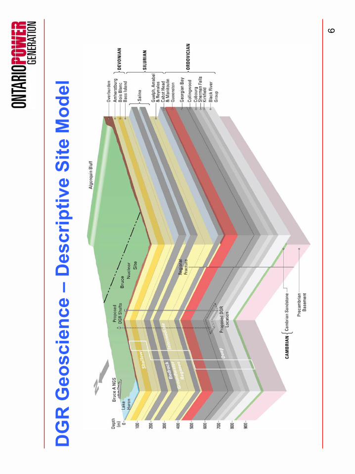
Des
crip
tive
Site
Mod
el: R
egio
nal S
cale
6
DG
R G
eosc
ienc
e �
Des
crip
tive
Site
Mod
el

�G
eolo
gica
lly s
tabl
e sh
ale
and
argi
llace
ous
limes
tone
form
atio
ns th
at
are
geom
etric
ally
sim
ple,
pre
dict
able
and
of l
arge
late
ral e
xten
t;
�A
ctiv
e fa
ultin
g an
d se
ism
icity
is c
ompa
rabl
e to
Shi
eld
setti
ng;
�A
rgilla
ceou
s lim
esto
ne fo
rmat
ion
that
will
hos
t DG
R w
ill p
rovi
dest
able
, virt
ually
dry
ope
ning
s;
�M
ultip
le h
oriz
onta
lly la
yere
d lo
w p
erm
eabi
lity
bedr
ock
form
atio
ns
encl
ose
and
over
lie th
e D
GR
(mul
ti-ba
rrier
s);
�R
egio
nal s
tress
regi
me
(hor
izon
tally
com
pres
sive
) fav
ours
seal
ing
of
verti
cal f
ract
ures
/faul
ts;
�M
ass
trans
port
is d
iffus
ion
dom
inat
ed.
The
deep
gro
undw
ater
flow
sy
stem
s ar
e sa
line
(>10
0 g/
L), s
tagn
ant a
nd a
ncie
nt s
how
ing
no
evid
ence
of g
laci
al p
ertu
rbat
ion
or c
ross
-form
atio
nal f
low
; and
�S
hallo
w g
roun
dwat
er re
sour
ces
in th
e up
per d
olom
itic
bedr
ock
aqui
fer s
yste
m a
re h
ydro
geol
ogic
ally
isol
ated
.
Bru
ce N
ucle
ar S
ite -
Geo
scie
nce
Attr
ibut
es

8
Geo
scie
nce
Site
Cha
ract
eris
atio
n Pl
an -
Org
aniz
atio
nPr
elim
inar
y Sa
fety
Rep
ort
(D
GR
Saf
ety
Case
)
Site
Cha
ract
eris
atio
n L
ead
Cont
ract
or
Geo
scie
nce
Rev
iew
G
roup
Geo
sphe
re E
volu
tion/
Safe
ty A
ttrib
utes
-
Geo
logi
c H
isto
ry -
Mic
higa
n B
asin
-
Bed
rock
Str
atig
raph
y - P
redi
ctab
le
- G
roun
dwat
er C
ompo
sitio
n/Ag
e -
Gro
undw
ater
Flo
w R
ates
/Pat
tern
s
-
Diffu
sion
Dom
inan
ce
- Lo
ng-te
rm G
eolo
gic/
Hyd
roge
olog
ic S
tabi
lity
- Lo
ng-te
rm R
epos
itory
Sta
bilit
y -
Long
-term
Clim
ate
Chan
ge -
Nat
ural
Res
ourc
e Po
tent
ial (
Intru
sion
) -
Gas
and
Oil
Mig
ratio
n
Des
crip
tive
Geo
sphe
re M
odel
Rep
ort
- C
once
ptua
l Geo
sphe
re M
odel
- G
eosp
here
Dat
a Se
t
Geo
logi
c M
odel
Hyd
roge
olog
ic M
odel
Geo
mec
hani
cal M
odel
Bruc
e N
ucle
ar S
ite S
ite-S
peci
fic In
vest
igat
ions
OPG
Geo
scie
nce
Geo
synt
hesi
s Re
port
- Cha
ract
eris
atio
n U
ndis
turb
ed S
yste
m
- Ass
essm
ent R
epos
itory
Indu
ced
Dis
turb
ance
s- A
sses
smen
t Lon
g-te
rm E
volu
tion
G
eosy
nthe
sis
L
ead
Con
trac
tor
Safe
ty A
sses
smen
t
Envi
ronm
enta
l Ass
essm
ent
Rep
osito
ry E
ngin
eerin
g
Geo
synt
hesi
s
Des
crip
tive
Geo
sphe
re
Mod
el
Sum
mar
y to
EA

9
●M
ulti-
year
ste
pwis
e in
vest
igat
ive
prog
ram
to c
olle
ct th
e da
ta
requ
ired
to m
eet G
SC
P o
bjec
tives
●P
hase
1 fo
cuse
d on
sev
eral
initi
atio
n ta
sks,
2-D
sei
smic
sur
veys
, es
tabl
ishm
ent o
f loc
al s
eism
ogra
ph n
etw
ork
& s
hallo
w b
edro
ck
mon
itorin
g w
ells
, dril
ling
and
test
ing
of tw
o de
ep v
ertic
al b
oreh
oles
(D
GR
-1 a
nd D
GR
-2),
initi
al e
xplo
rato
ry la
bora
tory
test
ing
prog
ram
, an
d gr
ound
wat
er m
onito
ring.
●S
ubse
quen
t pha
sed
will
focu
s on
dril
ling
and
test
ing
of a
dditi
onal
de
ep v
ertic
al b
oreh
ole(
s) a
nd in
clin
ed b
oreh
ole(
s) to
tria
ngul
ate
DG
R, d
eep
stra
tigra
phy
& h
ead,
in-s
itu s
tress
test
ing
off-s
ite),
expa
nded
labo
rato
ry te
stin
g pr
ogra
m a
nd g
roun
dwat
er m
onito
ring.
Geo
scie
nce
�Sc
ope
of S
CP

10
Mai
n Ph
ase
1 W
ork
Elem
ents
●R
e-es
tabl
ish
shal
low
bed
rock
mon
itorin
g w
ells
(US
-ser
ies
wel
ls):
Fall
07
●E
xpan
d se
ism
ic (e
arth
quak
e) m
onito
ring
netw
ork:
Sum
mer
200
7
●2-
D s
eism
ic re
flect
ion
surv
eys:
Oct
06
●B
oreh
ole
drilli
ng, c
ore
logg
ing
and
field
test
ing
(DG
R-1
& 2
): D
ec 0
6 -A
ug 0
7
●O
ppor
tuni
stic
gro
undw
ater
sam
plin
g fo
r geo
chem
ical
/isot
ope
test
ing
(6 a
ttem
pts,
4 s
ucce
ssfu
l D
GR
-1; 1
suc
cess
ful a
ttem
pt D
GR
-2):
Mar
-Ju
ly 0
7
●B
oreh
ole
geop
hysi
cal l
oggi
ng: M
ay 0
7 (D
GR
1) A
ug 0
7 (D
GR
2)
●S
tradd
le-p
acke
r hyd
raul
ic te
stin
g: J
un/J
uly
07 (D
GR
1) A
ug/S
ept 0
7 (D
GR
2)
●In
stal
latio
n of
long
-term
mul
ti-le
vel g
roun
dwat
er m
onito
ring
wel
ls: S
ept 0
7 (D
GR
1) a
nd N
ov 0
7 (D
GR
2)
●La
bora
tory
cor
e te
stin
g fo
r min
eral
ogy/
petro
grap
hy, p
orew
ater
char
acte
rizat
ion,
diff
usio
n,
perm
eabi
lity,
por
osity
, geo
mec
hani
calp
rope
rties
: Feb
07
�S
ept 0
7
●D
eep
bedr
ock
hydr
ogeo
logi
cm
onito
ring:
Oct
07

11
2-D
Sei
smic
Sur
veys

12
Plan
of 2
-D S
eism
ic S
urve
y
13
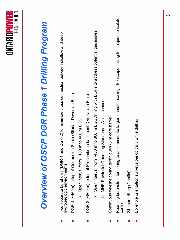
Ove
rvie
w o
f GSC
P D
GR
Pha
se 1
Dril
ling
Prog
ram
●Tw
o se
para
te b
oreh
oles
(DG
R-1
and
DG
R-2
) to
min
imiz
e cr
oss
conn
ectio
n be
twee
n sh
allo
w a
nd d
eep
hydr
ogeo
logi
cen
viro
nmen
ts
●D
GR
-1 (~
460m
) to
top
of Q
ueen
ston
Shal
e (S
iluria
n-D
evon
ian
Fms)
!O
pen
inte
rval
from
~18
0 m
to 4
60 m
BG
S
●D
GR
-2 (~
860
m) t
o to
p of
Pre
cam
bria
n ba
sem
ent (
Ord
ovic
ian
Fms)
!O
pen
inte
rval
from
~46
0 m
to 8
60 m
BG
SDril
ling
with
BO
Psto
add
ress
pot
entia
l gas
issu
es
!M
NR
Pro
vinc
ial O
pera
ting
Stan
dard
s (W
ell L
icen
ses)
●C
ontin
uous
wire
line
corin
g te
chni
ques
(3 m
cor
e ba
rrel)
●R
eam
ing
bore
hole
afte
r cor
ing
to a
ccom
mod
ate
larg
er d
iam
eter
cas
ing
-tel
esco
pe c
asin
g te
chni
ques
to is
olat
e zo
nes
●24
hou
r dril
ling
(2 s
hifts
)
●Bo
reho
le o
rient
atio
n su
rvey
s pe
riodi
cally
whi
le d
rillin
g

14
DG
R-1
& 2
Dril
l Site

15
DG
R-1
& 2
Dril
ling
and
Stra
tigra
phy
Elevation Meters
250
200
150
100
50 0 50 100
150
200
300
250
350
400
450
500
600
550
650
700
DG
R-2
Gro
uted
Ste
elC
asin
g O
pen
Bore
hole
DG
R-1
US-
4
Bois
Bla
nc D
lst
Amhe
rstb
urg
Lmst
Bass
Isla
nd D
lst
Salin
a A2
-mem
ber D
lst
Salin
a C
-mem
ber S
hale
Salin
a B-
mem
ber D
lst/A
nhyd
rite
Salin
a A1
-mem
ber S
hale
Gue
lph
Dls
t
Cab
ot H
ead
Shal
eM
anito
ulin
Dls
t
Que
enst
on S
hale
Geo
rgia
n B
ay S
hale
Blue
Mou
ntai
n Sh
ale
Cob
ourg
Lm
st
Sher
man
Fal
l Lm
st
Kirk
field
Lm
st
Cob
ocon
k Lm
st
Gul
l Riv
er L
mst
Shad
ow L
ake
Slts
t/Sst
Cam
bria
n Ss
t
Prec
ambr
ian
Base
men
t
Salin
a F-
mem
ber S
hale
Salin
a E-
mem
ber D
lst
Rep
osito
ry H
oriz
on

16
DG
R-1
Blo
wou
t P
reve
nti
onB
low
out
Pre
ven
tion
(BO
P)
Equ
ipm
ent
(BO
P)
Equ
ipm
ent

17
Cor
ing
Bits
Dia
mon
d Im
preg
nat
ed B
itD
iam
ond
Impr
egn
ated
Bit
Pol
y D
iam
ond
Cry
stal
(P
DC
) B
itP
oly
Dia
mon
d C
ryst
al (
PD
C)
Bit

18
DG
R-2
TD
= 8
62.2
5 m
BG
SA
ugus
t 3, 2
007
DG
R-1
Sta
rt D
ate
Dec
embe
r 11,
200
6

19
Maj
or F
indi
ngs
●O
ther
than
20
m o
ffset
at s
urfa
ce, b
edro
ck g
eolo
gy h
as b
een
cons
iste
nt w
ith p
redi
ctio
ns
●Fo
rmat
ion
hydr
aulic
and
geo
mec
hani
calp
rope
rties
app
ear c
onsi
sten
t with
exp
ecta
tions
(Que
enst
onan
d C
obou
rgsh
ales
appe
ar c
ompe
tent
)
●D
iski
ng o
f cor
e in
Blu
e M
ount
ain
and
Col
lingw
ood
shal
eslim
iting
abi
lity
to c
olle
ct in
tact
sam
ples
for l
ab
test
ing.
No
evid
ence
of b
oreh
ole
brea
kout
s in
Ord
ovic
ian
shal
esin
DG
R-2
●Zo
ne o
f los
t dril
ling
fluid
circ
ulat
ion
foun
d at
~14
0 m
in B
ass
Isla
nds
dolo
ston
e
●Fl
owin
g ar
tesi
an c
ondi
tions
with
in C
ambr
ian
sand
ston
e (u
p to
70
L/m
in) c
onsi
stin
g of
sal
ine
grou
ndw
ater
●Li
mite
d op
portu
nitie
s fo
r gro
undw
ater
sam
plin
g du
ring
drill
ing
belo
w S
alin
a F
Mem
ber s
hale
●N
o si
gnifi
cant
oil
or g
as o
ccur
renc
es d
etec
ted
durin
g dr
illing
●Po
rew
ater
extra
ctio
n fro
m th
e lo
w p
oros
ity a
nd p
erm
eabi
lity
Ord
ovic
ian
shal
esan
d lim
esto
nes
rem
ains
a
chal
leng
e

20
DG
R-1
Dril
ling
Seq
uenc
e~
~~
~~
~~
~~
~~
~~
~~
~~
~~
~~
~~
~~
~~
~~
~~
~~
~~
~~
~
Elevation Meters
250
200
150
100
50 0 50 100
150
200
300
250
350
400
450
500
600
550
650
700
Bois
Bla
nc D
lst
Amhe
rstb
urg
Lmst
Bass
Isla
nd D
lst
Salin
a A
2-m
embe
r Dls
t
Salin
a C
-mem
ber S
hale
Salin
a B
-mem
ber D
lst/A
nhyd
rite
Salin
a A
1-m
embe
r Sha
le
Gue
lph
Dls
t
Cabo
t Hea
d S
hale
Man
itoul
in D
lst
Que
enst
on S
hale
Geo
rgia
n B
ay S
hale
Blue
Mou
ntai
n Sh
ale
Cobo
urg
Lmst
Sher
man
Fal
l Lm
st
Kirk
field
Lm
st
Cobo
conk
Lm
st
Gul
l Riv
er L
mst
Shad
ow L
ake
Slts
t/Sst
Cam
bria
n Ss
t
Prec
ambr
ian
Bas
emen
t
Salin
a F-
mem
ber S
hale
Salin
a E
-mem
ber D
lst
Rep
osito
ry H
oriz
on
Dep
th(m
BG
S)
25 178
450
Sur
face
Cas
ing
Cor
ing
toF-
shal
eR
eam
ing
&S
et C
asin
gC
orin
gto
Que
enst
on
13 3
/8�
9 5/
8�
6�
6�~
~~
~~
~~
~~
~~
~~
~~
~~
~~
~~
~~
~~
~~
~~
~~
~~
~~
~~
~
Elevation Meters
250
200
150
100
50 0 50 100
150
200
300
250
350
400
450
500
600
550
650
700
Bois
Bla
nc D
lst
Amhe
rstb
urg
Lmst
Bass
Isla
nd D
lst
Salin
a A
2-m
embe
r Dls
t
Salin
a C
-mem
ber S
hale
Salin
a B
-mem
ber D
lst/A
nhyd
rite
Salin
a A
1-m
embe
r Sha
le
Gue
lph
Dls
t
Cabo
t Hea
d S
hale
Man
itoul
in D
lst
Que
enst
on S
hale
Geo
rgia
n B
ay S
hale
Blue
Mou
ntai
n Sh
ale
Cobo
urg
Lmst
Sher
man
Fal
l Lm
st
Kirk
field
Lm
st
Cobo
conk
Lm
st
Gul
l Riv
er L
mst
Shad
ow L
ake
Slts
t/Sst
Cam
bria
n Ss
t
Prec
ambr
ian
Bas
emen
t
Salin
a F-
mem
ber S
hale
Salin
a E
-mem
ber D
lst
Rep
osito
ry H
oriz
on
Dep
th(m
BG
S)
25 178
450
Sur
face
Cas
ing
Cor
ing
toF-
shal
eR
eam
ing
&S
et C
asin
gC
orin
gto
Que
enst
on
13 3
/8�
9 5/
8�
6�
6�
Hol
e
diam
(inch
)
Hol
e di
am(m
m)
Cas
ing
(inch
)C
asin
g (m
m)
17 ½
�44
5 m
m13
3/8
�34
0 m
m
12 ¼
�31
8 m
m9
5/8�
245
mm
6 ¼
�16
0
mm

21
DG
R-2
Dril
ling
Seq
uenc
e
Hol
e
diam
(inch
)
Hol
e di
am(m
m)
Cas
ing
(inch
)C
asin
g (m
m)
24�
610
mm
20�
508
mm
17 ½
�44
5 m
m13
3/8
�34
0 m
m
12 ¼
�31
8 m
m9
5/8�
245
mm
6 ¼
�16
0 m
m
~~
~~
~~
~~
~~
~~
~~
~~
~~
~
~~
~~
~~
~~
~~
~~
~~
~~
~~
~
Elevation Meters
250
200
150
100
50 0 50 100
150
200
300
250
350
400
450
500
600
550
650
700
Boi
s B
lanc
Dls
t
Am
hers
tbur
g Lm
st
Bas
s Is
land
Dls
t
Sal
ina
A2-
mem
ber D
lst
Sal
ina
C-m
embe
r Sha
leS
alin
a B
-mem
ber D
lst/A
nhyd
rite
Sal
ina
A1-
mem
ber S
hale
Gue
lph
Dls
t
Cab
ot H
ead
Sha
leM
anito
ulin
Dls
t
Que
enst
on S
hale
Geo
rgia
n B
ay S
hale
Blu
e M
ount
ain
Sha
le
Cob
ourg
Lm
st
She
rman
Fal
l Lm
st
Kirk
field
Lm
st
Cob
ocon
k Lm
st
Gul
l Riv
er L
mst
Sha
dow
Lak
e S
ltst/S
stC
ambr
ian
Sst
Pre
cam
bria
n B
asem
ent
Sal
ina
F-m
embe
r Sha
le
Sal
ina
E-m
embe
r Dls
t
Rep
osito
ry H
oriz
on
Dep
th(m
BG
S)
25 178
450
650
850
Sur
face
Cas
ing
Rot
ary
Dril
l to
F-sh
ale
(Set
Cas
ing)
Rot
ary
Dril
l to
Que
enst
on(S
et C
asin
g)
Cor
ing
toP
reca
mbr
ian
13 3
/8�
9 5/
8�
20�
6�
~~
~~
~~
~~
~~
~~
~~
~~
~~
~
~~
~~
~~
~~
~~
~~
~~
~~
~~
~
Elevation Meters
250
200
150
100
50 0 50 100
150
200
300
250
350
400
450
500
600
550
650
700
Boi
s B
lanc
Dls
t
Am
hers
tbur
g Lm
st
Bas
s Is
land
Dls
t
Sal
ina
A2-
mem
ber D
lst
Sal
ina
C-m
embe
r Sha
leS
alin
a B
-mem
ber D
lst/A
nhyd
rite
Sal
ina
A1-
mem
ber S
hale
Gue
lph
Dls
t
Cab
ot H
ead
Sha
leM
anito
ulin
Dls
t
Que
enst
on S
hale
Geo
rgia
n B
ay S
hale
Blu
e M
ount
ain
Sha
le
Cob
ourg
Lm
st
She
rman
Fal
l Lm
st
Kirk
field
Lm
st
Cob
ocon
k Lm
st
Gul
l Riv
er L
mst
Sha
dow
Lak
e S
ltst/S
stC
ambr
ian
Sst
Pre
cam
bria
n B
asem
ent
Sal
ina
F-m
embe
r Sha
le
Sal
ina
E-m
embe
r Dls
t
Rep
osito
ry H
oriz
on
Dep
th(m
BG
S)
25 178
450
650
850
Sur
face
Cas
ing
Rot
ary
Dril
l to
F-sh
ale
(Set
Cas
ing)
Rot
ary
Dril
l to
Que
enst
on(S
et C
asin
g)
Cor
ing
toP
reca
mbr
ian
13 3
/8�
9 5/
8�
20�
6�

22
DG
R-1
& 2
Dril
ling
Sum
mar
y~
~~
~~
~~
~~
~~
~~
~~
~~
~~
~~~~
~~~~
~~~~
~~~~
~~~
Elevation Meters25
0
200
150
100
50 0 50 100
150
200
300
250
350
400
450
500
600
550
650
700
DG
R-2
Gro
uted
Ste
elCa
sing
O
pen
Bore
hole
DGR-
1U
S-4
Boi
s B
lanc
Dls
t
Am
hers
tbur
g Lm
st
Bas
s Is
land
Dlst
Sal
ina
A2-m
embe
r Dlst
Sal
ina
C-m
embe
r Sha
leS
alin
a B-
mem
ber D
lst/A
nhyd
rite
Sal
ina
A1-m
embe
r Sha
le
Gue
lph
Dls
t
Cab
ot H
ead
Sha
leM
anito
ulin
Dls
t
Que
ensto
n Sh
ale
Geo
rgia
n B
ay S
hale
Blu
e M
ount
ain
Sha
le
Cob
ourg
Lm
st
She
rman
Fal
l Lm
st
Kirk
field
Lm
st
Cob
ocon
k Lm
st
Gul
l Riv
er L
mst
Sha
dow
Lak
e S
ltst/S
stC
ambr
ian
Sst
Pre
cam
bria
n Ba
sem
ent
Sal
ina
F-m
embe
r Sha
le
Sal
ina
E-m
embe
r Dls
t
Rep
osito
ry H
oriz
on
20 71 124
168
178
218
246
260
276
411
434
448
527
655
700
768
0.0
371
622
738
798
855
847Depth (mBGS)
OG
W-1
% R
ecov
ery
>80%
25-1
00%
>80%
>90%
90-1
00%
5-90
%
0-90
%<5
0%25
-100
%>9
0%85
-90%
85-9
0%>9
0%
>95%
RQ
D
OG
W-2
OG
W-3
OG
W-4
OG
W-5
OG
W-6
OG
W-7
~~
~~
~~
~~
~~
~~
~~
~~
~~
~
~~~~
~~~~
~~~~
~~~~
~~~
Elevation Meters25
0
200
150
100
50 0 50 100
150
200
300
250
350
400
450
500
600
550
650
700
DG
R-2
Gro
uted
Ste
elCa
sing
O
pen
Bore
hole
DGR-
1U
S-4
Boi
s B
lanc
Dls
t
Am
hers
tbur
g Lm
st
Bas
s Is
land
Dlst
Sal
ina
A2-m
embe
r Dlst
Sal
ina
C-m
embe
r Sha
leS
alin
a B-
mem
ber D
lst/A
nhyd
rite
Sal
ina
A1-m
embe
r Sha
le
Gue
lph
Dls
t
Cab
ot H
ead
Sha
leM
anito
ulin
Dls
t
Que
ensto
n Sh
ale
Geo
rgia
n B
ay S
hale
Blu
e M
ount
ain
Sha
le
Cob
ourg
Lm
st
She
rman
Fal
l Lm
st
Kirk
field
Lm
st
Cob
ocon
k Lm
st
Gul
l Riv
er L
mst
Sha
dow
Lak
e S
ltst/S
stC
ambr
ian
Sst
Pre
cam
bria
n Ba
sem
ent
Sal
ina
F-m
embe
r Sha
le
Sal
ina
E-m
embe
r Dls
t
Rep
osito
ry H
oriz
on
20 71 124
168
178
218
246
260
276
411
434
448
527
655
700
768
0.0
371
622
738
798
855
847Depth (mBGS)
OG
W-1
% R
ecov
ery
>80%
25-1
00%
>80%
>90%
90-1
00%
5-90
%
0-90
%<5
0%25
-100
%>9
0%85
-90%
85-9
0%>9
0%
>95%
RQ
D
OG
W-2
OG
W-3
OG
W-4
OG
W-5
OG
W-6
OG
W-7

23
Logg
ing
and
Pre
serv
ing
of R
ock
Cor
e

24
DG
R-1
(371
-374
m B
GS
)S
alin
a A
0 M
embe
r abo
ve G
uelp
hFm
DG
R-1
(451
-454
m B
GS
)U
pper
Que
enst
onFo
rmat
ion

25
Sam
plin
g an
d St
orag
e of
Roc
k C
ore

26
Labo
rato
ry T
estin
g Pr
ogra
m●
Geo
logi
c Te
stin
g-
Min
eral
ogy
�O
ptic
al M
icro
scop
y, X
RD
-G
eoch
emis
try �
XRF,
Li D
iges
tion
-C
atio
nEx
chan
ge �
CEC
, Ion
Pop
ulat
ions
, Ads
orpt
ion
Isot
herm
s-
Poro
sity
Stru
ctur
e �
SEM
, XAS
/CM
T●
Gro
undw
ater
/Por
ewat
erTe
stin
g-
Mas
ter V
aria
bles
& M
ajor
Ions
-Tr
ace
Elem
ents
& E
nviro
nmen
tal I
soto
pes
�18
O, 2 H
, 3 H, 87
Sr-
Rad
iois
otop
es �
129 I,
36C
l, 14
C, 4 H
e-
Gas
es �
Rn,
He,
Ar,
Ne,
N2,
CH
4-
Dril
l Wat
er T
race
rs �
Fluo
resc
ein,
3 H
●D
iffus
ion
& P
etro
phys
ical
Test
ing
-D
iffus
ion
Test
ing
�ve
rtica
l pla
nar a
nd ra
dial
thro
ugh-
diffu
sion
test
s-
Gas
& L
iqui
d Pe
rmea
bilit
y &
Poro
sity
-G
as E
ntry
Pre
ssur
e
●G
eom
echa
nica
lTes
ting
-U
niax
ialC
ompr
essi
on T
ests
-
Swel
ling
Test
s �
free
and
sem
i-con
fined
-Sl
ake
Dur
abili
ty T
ests
-Ex
pand
ed T
est P
rogr
am in
Pha
se 2
/3

27
Labo
rato
ry T
estin
g Pr
ogra
m: P
ore
Flui
d C
hem
istr
ies
Adv
ectiv
eD
ispl
acem
ent
Aqu
eous
Lea
chin
g
Uni
vers
ity o
f Ber
n

28
To P
ump
Hea
t Bat
h
Sam
ple
Col
d tra
p
Uni
vers
ity o
f Ber
nIs
otop
ic E
xcha
nge
Uni
vers
ity o
f Otta
wa
Vacu
um D
istil
latio
n
Labo
rato
ry T
estin
g Pr
ogra
m:
Stab
le Is
otop
es

29
Uni
vers
ity o
f New
Bru
nsw
ick
Labo
rato
ry T
estin
g Pr
ogra
m:
Effe
ctiv
e D
iffus
iviti
es
�65
mm
�20 mm
�20
mm
�11
mm
�PB
�φw
�NB

30
Bor
ehol
e Te
stin
g Pr
ogra
m●
Sta
ndar
d bo
reho
le g
eoph
ysic
al lo
gs
─ge
nera
l bor
e ho
le c
ondi
tions
(qua
litat
ive
indi
catio
ns o
f stre
ss re
gim
e an
d ro
ck q
ualit
y)
─st
ratig
raph
ic/h
ydro
geol
ogic
info
rmat
ion
─as
sist
in fo
rmat
ion
pick
s
●FE
C lo
ggin
g
─se
mi-q
uant
itativ
e as
sess
men
t of b
oreh
ole
perm
eabi
lity
─se
t tar
gets
for h
ydra
ulic
test
ing
●S
tradd
le p
acke
r tes
ting
─de
taile
d te
stin
g fo
r for
mat
ion
hydr
aulic
con
duct
ivity
and
pre
ssur
es
●W
estb
ayca
sing
inst
alla
tions
─gr
ound
wat
er s
ampl
ing
and
pres
sure
mon
itorin
g (D
GR
1)
─lo
ng-te
rm p
ress
ure
mon
itorin
g (D
GR
2)

31
Bor
ehol
e G
eoph
ysic
s
●C
ontra
ctor
�C
olog
(Den
ver,
Col
orad
o)●
Logs
com
plet
ed:
─C
alip
er─
Acou
stic
tele
view
er─
Vide
o─
Nat
ural
gam
ma
─C
ompe
nsat
ed D
ensi
ty─
Nor
mal
resi
stiv
ity─
Spec
tral g
amm
a─
Dua
l neu
tron
─Fu
ll w
avef
orm
son
ic─
Tem
pera
ture
& F
luid
resi
stiv
ity

32
Bor
ehol
eG
eoph
ysic
alLo
ggin
g

33
Bor
ehol
eG
eoph
ysic
alLo
ggin
g
DG
R-1
(0-4
70 m
BG
S)

34
Bor
ehol
eG
eoph
ysic
alLo
ggin
g
DG
R-2
(640
-840
m B
GS)

35
FEC
Log
ging
●Pe
rform
ed b
y R
AS (D
enve
r, C
olor
ado)
●As
sist
ed b
y Sa
ndia
(Ric
k Be
auhe
im)
─Fl
uid
man
agem
ent
─Te
st g
uida
nce
●Lo
g ru
n in
DG
R-1
onl
y (M
ay 9
) ●
Test
ing
appr
oach
:─
Bore
hole
flui
d re
plac
emen
t. R
emov
e dr
illin
g br
ine,
repl
ace
with
tra
ced
fresh
wat
er─
Run
mul
tiple
FE
C lo
gs u
p an
d do
wn
hole
�na
tura
l gra
dien
t (n
o pu
mpi
ng)

36
FEC
Log
ging

37
FEC
Res
ults
FEC
Res
ults

38
Stra
ddle
Pac
ker T
estin
g
●Su
bcon
tract
ed to
San
dia
(Car
lsba
d, N
M)
●C
usto
m b
uilt
tool
stri
ng─
TAM
pac
kers
─Pa
rosc
ient
ific
pres
sure
gau
ges
─D
ownh
ole
shut
-in v
alve
s (2
)!
elec
tric
(ser
vo a
ctua
ted)
!hy
drau
lic─
Puls
e ge
nera
tors
(2)
!lin
ear d
ispl
acem
ent m
easu
rem
ent
!fix
ed v
olum
e─
Sand
iaD
AS
traile
r

Stra
ddle
Pac
ker
Prob
ean
dTr
aile
r Fl
uid
Mon
itorin
gEq
uipm
ent

40
Stra
ddle
Pac
ker
Tool
Stra
ddle
Pac
ker
Tool
and
DA
S tr
aile
ran
d D
AS
trai
ler

41
Wes
tbay
Cas
ing
Inst
alla
tion
●M
P55
syst
ems
●D
GR
1─
Gro
undw
ater
sam
plin
g ─
Pres
sure
pro
filin
g─
~20
pack
er is
olat
ed in
terv
als
●D
GR
2─
Long
term
mon
itorin
g (~
1 y
ear)
with
ded
icat
ed M
OS
DAX
sy
stem
─Po
ssib
le s
ampl
ing
thro
ugh
pres
sure
por
ts s
ubse
quen
tly─
~20
pack
er is
olat
ed in
terv
als,
~5
MO
SDAX
inte
rval
s

42
Inst
alla
tion
of L
ong-
Term
Mon
itorin
g C
asin
gsW
estb
ayM
P55
Syst
ems

43
Pac
ker
-ind
epen
dent
hy
drau
lic in
flatio
n
Pum
ping
Por
t-h
ydra
ulic
co
nduc
tivity
test
ing
and
purg
ing
Cas
ing
-var
iabl
e le
ngth
sMonitoring Zone
Mea
sure
men
t Por
t-i
n-si
tu m
easu
rem
ent,
low
-k te
stin
g, a
nd fl
uid
sam
plin
g
Mul
ti-le
vel W
estb
ayIn
stru
men
tatio
n

44
Mic
ro-S
eism
icity
: Sei
smog
raph
Net
wor
k PO
LAR
IS/G
SC

45
Geo
synt
hesi
s�
Def
initi
onA
geo
scie
ntifi
c ex
plan
atio
n of
the
over
all u
nder
stan
ding
of s
itech
arac
teris
tics,
attr
ibut
es a
nd e
volu
tion
(pas
t and
futu
re) a
s th
ey re
late
to
dem
onst
ratin
g lo
ng-te
rm D
GR
per
form
ance
and
saf
ety.
i) a
desc
riptio
n of
the
undi
stur
bed
syst
em;
ii) a
n as
sess
men
t of r
epos
itory
indu
ced
dist
urba
nces
; and
iii) a
n as
sess
men
t of g
eolo
gica
l lon
g-te
rm s
tabi
lity/
evol
utio
n.
Act
iviti
es:
�R
egio
nal G
eosc
ienc
e St
udie
s�
Bas
in H
isto
ry; S
truct
ural
Geo
logy
; Hyd
roge
oche
mis
try; I
soto
pe S
yste
mat
ics
Geo
mec
hani
cs, N
umer
ical
Flo
w S
yste
m A
naly
ses,
Gla
ciat
ion
�Si
te-S
peci
fic N
umer
ical
Stu
dies
�H
ydro
geol
ogy;
Geo
mec
hani
cal
�G
eosc
ient
ific
Dat
a In
tegr
atio
n �
Sci
entif
ic V
isua
lizat
ion/
Dat
a M
anag
emen
t/Com
mun
icat
ion

46
Geo
synt
hesi
s: O
bjec
tives
i)to
ass
ess
and
reaf
firm
the
geos
cien
tific
sui
tabi
lity
of th
epr
opos
ed D
GR
con
cept
;
ii)to
yie
ld in
form
atio
n to
sup
port
deve
lopm
ent o
f a s
ite-s
peci
ficre
posi
tory
siti
ng/d
esig
n;
iii)
to p
rovi
de e
vide
nce
on a
geo
scie
ntifi
c ba
sis
for r
epos
itory
safe
ty a
t tim
efra
mes
of 1
00,0
00 y
ears
and
bey
ond;
iv)
to p
rovi
de a
sci
entif
ical
ly s
ound
bas
is fo
r Saf
ety
Ass
essm
ent;
and
v)to
con
tribu
te to
the
deve
lopm
ent o
f an
inte
grat
ed re
posi
tory
Saf
ety
Cas
e.

47
Geo
synt
hesi
s�
Activ
ities
Pha
se I
Reg
iona
l Stu
dies
�R
egio
nal G
eolo
gic
Fram
ewor
k (G
L/W
ater
loo)
�R
egio
nal H
ydro
geol
ogy
(Wat
erlo
o)�
Pet
role
um G
eolo
gy A
sses
smen
t (G
L/G
olde
r)�
Hyd
roge
oche
mis
tryA
sses
smen
t (W
ater
loo)
�G
eom
echa
nica
lAss
essm
ent (
GL/
Laur
entia
n)�
Long
-term
Clim
ate
Cha
nge
(Uof
T)
Num
eric
al M
etho
ds
�H
ydro
geol
ogic
Mod
ellin
g(W
ater
loo)
�G
eom
echa
nica
lMod
ellin
g(It
asca
)
Geo
synt
hesi
sR
epor
t�
Dra
ft G
eosy
nthe
sis
Rep
ort (
GL)
�Fi
nal G
eosy
nthe
sis
Rep
ort (
GL)

48
Mic
higa
n B
asin
-St
ratig
raph
y
Lak
e H
uron
Lak
e M
ichi
gan
4700
m
Geo
logi
cal
Fra
mew
ork
50x
ex.

49
Bru
ce S
ite T
opog
raph
y/O
GSR
Wel
l Dat
abas
e
Ele
vatio
n (m
abo
ve o
r bel
ow S
ea L
evel
)
300
Wel
ls O
GS
R
Dat
abas
e

50
Fo
rmat
ion
Co
lou
r00
_Ant
rim01
_Tra
vers
e_G
p02
_Dun
dee
03_D
etro
it_R
iver
_Gp
04_B
ois_
Bla
nc05
_Bas
s_Is
land
s06
_G_U
nit
07_F
_Uni
t08
_F_S
alt
09_E
_Uni
t10
_D_U
nit
11_B
_and
_C_U
nits
12_B
_Anh
ydrit
e__S
alt
13_A
_2_C
arbo
nate
14_A
_2_A
nhyd
rite_
_Sal
t15
_A_1
_Car
bona
te16
_A_1
_Eva
porit
e_0
17_N
iaga
ran_
0_0_
0_0
18_R
eyna
les_
_Fos
sil_
Hill
19_C
abot
_Hea
d20
_Man
itoul
in21
_Que
enst
on22
_Geo
rgia
n_B
ay__
Blu
e_M
tn_1
_123
_Cob
ourg
_024
_She
rman
_Fal
l25
_Kirk
field
26_C
oboc
onk
27_G
ull_
Riv
er28
_Sha
dow
_Lak
e29
_Cam
bria
n30
_Pre
cam
bria
n
170
km
204
km
Bru
ce S
ite: R
egio
nal G
eolo
gy (1
)

51
Form
atio
nC
olou
r00
_Ant
rim01
_Tra
vers
e_G
p02
_Dun
dee
03_D
etro
it_R
iver
_Gp
04_B
ois_
Blan
c05
_Bas
s_Is
land
s06
_G_U
nit
07_F
_Uni
t08
_F_S
alt
09_E
_Uni
t10
_D_U
nit
11_B
_and
_C_U
nits
12_B
_Anh
ydrit
e__S
alt
13_A
_2_C
arbo
nate
14_A
_2_A
nhyd
rite_
_Sal
t15
_A_1
_Car
bona
te16
_A_1
_Eva
porit
e_0
17_N
iaga
ran_
0_0_
0_0
18_R
eyna
les_
_Fos
sil_
Hill
19_C
abot
_Hea
d20
_Man
itoul
in21
_Que
enst
on22
_Geo
rgia
n_Ba
y__B
lue_
Mtn
_1_1
23_C
obou
rg_0
24_S
herm
an_F
all
25_K
irkfie
ld26
_Cob
ocon
k27
_Gul
l_R
iver
28_S
hado
w_L
ake
29_C
ambr
ian
30_P
reca
mbr
ian
Bru
ce S
ite: R
egio
nal G
eolo
gy (2
)

52
Reg
iona
l H
ydro
geoc
hem
istr
y-R
evie
w

53
Reg
iona
l Hyd
roge
oche
mis
try:
Sta
ble
Isot
opes
-80
-70
-60
-50
-40
-30
-20
-100 -1
0.0
-8.0
-6.0
-4.0
-2.0
0.0
2.0
4.0
δ18O
� S
MO
W
δ2H � SMOW
MIS
SIS
SIP
PIA
N S
AN
DS
TON
E - M
I
DEV
ON
IAN
CA
RB
ON
ATE
S -
MI
SIL
UR
IAN
CA
RB
ON
ATE
S -
MI
SIL
UR
IAN
F S
ALT
- M
I
SIL
UR
IAN
A2
SA
LT -
MI
SIL
UR
IAN
SA
ND
STO
NES
- A
P
OR
DO
VIC
IAN
CA
RB
ON
ATE
S -
MI
OR
DO
VIC
AN
SA
ND
STO
NE
- MI
CA
MB
RIA
N S
AN
DS
TON
E - M
I
PR
ECA
MB
RIA
N -
MI
GM
WL
A2 S
ALT
F SA
LT

54
Site
Cha
ract
eris
atio
n �
Num
eric
al M
odel
ling
Elev
atio
n (m
)61
- 17
517
5 - 2
11.1
5421
1.15
4 - 2
48.6
9224
8.69
2 - 2
86.2
3128
6.23
1 - 3
23.7
6932
3.76
9 - 3
61.3
0836
1.30
8 - 3
98.8
4639
8.84
6 - 4
36.3
8543
6.38
5 - 4
73.9
2347
3.92
3 - 5
11.4
6251
1.46
2 - 5
49N
o D
ata
Tow
nshi
psBe
droc
kR
iver
sAl
gonq
uin
Arch
Boun
daryN
80
816
24Ki
lom
eter
s

55
Site
Cha
ract
eris
atio
n �
Num
eric
al M
odel
ing
Ave
rage
Lin
ear V
eloc
ities
(m/a
)

Clim
ate
Cha
nge:
Gla
ciat
ion/
Perm
afro
st
-15
-10-505
Basal Temperature (C)
-120
-100
-80
-60
-40
-20
0Ti
me
Bef
ore
Pres
ent (
kyr)
051015202530
Ice Normal Stress (MPa)
Tem
pera
ture
Nor
mal
Stre
ss
-120
-100
-80
-60
-40
-20
0Ti
me
Bef
ore
Pres
ent (
kyr)
-300
0
-250
0
-200
0
-150
0
-100
0
-5000
Depth Below Ground Surface (m)
-15
-10
-50510
15
20
25
30
35
40
45
50
55
60
Temperature (C)
Uof
T

57
Que
stio
ns?