Embed Size (px)
Citation preview

PRECAMBRIAN ROCKS OF THE TELEMARK AREA
IN SOUTH CENTRAL NORWAY. NO. VI
PRIMARY SEDIMENTARY STRUCTURES IN
PRECAMBRIAN QUARTZITES OF TELEMARK,
SOUTHERN NORWAY, AND THEIR
ENVIRONMENTAL SIGNIFICANCE
INDRA B. SINGH
Mineralogisk-Geologisk Museum, Oslo, Norway
SINGH, INDRA B.: Primary sedimentary structures in Precambrian quartz
ites of Telemar k, Southern Norway, and their environmental significance.
Norsk Geologisk Tidsskrift, Vol. 49, pp. 1-31. Oslo 1969.
Primary sedimentary structures of the Precambrian quartzites of the
Telemark area, S. Norway, are described. The most prominent and
widespread feature is the alternating sand/clay (now quartzite/phyllite)
succession visible in most of the bedding types. Cross-bedding is the
most common bedding type; at places it shows herringbone cross
stratification. Other bedding types recorded are: lenticular and fiaser
bedding, paraHel bedding, wavy bedding and ripple laminations. Ripple
marks of the symmetrical and asymmetrical oscillation ripple type are
more common. Some rare ripple mark patterns are: rhomboid ripple
marks, 'micro-ripples', interference ripp!e marks, ripple marks with
rounded crests and pointed troughs, and ripple marks with flat crests.
Raindrop imprints, erosional channels and unconformities, penecon
temporaneous deformation structures, and ball and pillow structures are
also found. The presence of bioturbate structures suggests the existence
of organisms during the depositional history of these rocks (- 1500-900
m.y. B. P.). On the basis of primary sedimentary structures i t is concluded
that deposition in this area was rapid and detrital material was present
in abundance. Deposition took place mainly in a shallow sea to inter
tictal flat environment under the prevailing tida! currents.
Abstract .
lntroduction .
Geology of the Telemark region
Primary sedimentary structures
A. Ripple marks .
B. Cross-bedding
C. Ripp!e lamination .
D. Lenticular and fiaser bedding
E. ParaHel bedding ..
F. Wavy bedding
G. Raindrop imprints
H. Erosional channels and erosional unconformities
I. Penecontemporaneous deformation structures .
2
2
5
5
10
16
19
21
23
24
25
26

2 INDRA B. SINGH
J. Bioturbate structures ..
K. Other structures ..
Discussion ..
Acknow ledgements
References ..
INTRODUCTION
26
28
29
29
30
Weil preserved primary sedimentary structures are not uncommon in the
Precambrian rocks. Usuaily, previous descriptions of these structures are
scanty and detailed environmental studies have rarelybeen made. In Precam
brian sediments, where organic remains are usuaily absent, one has to rely
almost entirely on the primary sedimentary structures in order to understand
the conditions of deposition. In a recent publication Gavelin & Russel (1967) have described primary sedimentary structures in Precambrian quartzites of
Sweden.
In the last decades much information on the origin and mode of occurrence
of primary sedimentary structures has been made available through the study
of recent environments and by flume experiments. This ailows a safer inter
pretation of the depositional history than before.
The purpose of the present paper is to record and describe primary sedi
mentary structures in the Precambrian quartzites of the Telemark area,
S. Norway. A comparison with primary sedimentary structures of recent
sediments has been attempted for the purpose of drawing conclusions about
the depositional conditions of the quartzites.
GEOLOGY OF THE TELEMARK REGION Some earlier works on the geology of the Telemark are by Werenskiold
(1919, 1912), Bugge (1931), and Wyckoff (1934). Recently the geology of
the Telemark area has been described by Dons (1960 a and b) and the present
short account of the geology is based mainly on the publications by Dons.
The Telemark suite, i.e. the Telemark supracrustal rocks, consists of sedi
ments, lavas, and tuffs, with a maximum thickness of about 4000 m. Absolute
age determination based on the minerals from quartz veins and granite peg
matites which crosscut the sediments gives an age of 1500-900 million years.
Table l (p. 3) gives the sequence of rocks, which is divided into 3 groups:
Rjukan Group - Two formations; the Tuddal Formation (below) and the
Vemork Formation (above). There are mainly lavas and tuffs in the Tuddal
Formation. The Vemork Formation is composed of basic lavas, tuffs, biotite
schists, and pebbly arkoses as weil as quartz schists and quartzites. No
augular unconformity has been observed between the two formations.
Seljord Group- The thickness of this group has been estimated as more
than 2000 metres near Rjukan. There is locaily an augular unconformity
between this group and the underlying Rjukan Group. The most common
rock types are quartzites; rarer are conglamerates and schists.

SEDIMENTARY STRUCTURES IN PRECAMBRIAN QUARTZITES 3
iELJORO GROUP A & A 8
::::::: �
·-�•.•. { Red quartzlte , conglamerate :;-�·}': ::::;.;:.:. Seljord White and red quartzite
:.-.":�·:/· .:7.-:-.-.:. quartzite -Schists .::.-· . ._:;: :.::_.:.::.: etc. with Ouartzite and calc.quartz schists �-�·;-..:·: .: . . ." .. congl. (, -Schists ����: �:;��:�· basic sills Ouartzite (Gausta) with arkose, congl.,etc:.
)ivisions within column B refer to those recognized in the !ju kan quadranqle and N E part of Kviteseid quadrangle.
UUKAN GROUP Mainly basic lavas and tuffs. Vemork formation. Mainly acid lavas with agglomerate. Tuddal formation. In the Nisser area strongly metamorphosed acid lava ?
THE TELEMARK SUITE
� ''Leptite:"qranulite'; amphibolites, agglomerates, etc. � (Supracrustals of the Bandok group ?)
BANOAK GROUP
Quartz schlsts with conglamerates Marble Basic lava with fossiliferous (?) bed Acid lava Basic lava with 1-4 sandstone or conglamerate beds, polymictic conglamerate at the top
Ouartzite with conglamerate Acid lava Ouartzite with conglomera te. Symbol for Seljord quartzite also used for basal part of Bandok group
In the west (Heydalsmo-Vinje) supposed lower unih occur.
Table l. From legend to map compiled by J. A. Dons (Dons 1960a).
Fig. J. Location map (based on part of map published by Dons 1960a). Ratehed areas along
roads show where primary sedimentary structures have been studied. Black = basic intrusions,
mainly sills (not distinguished in Seljord quartzite). Variously orientated dashes (as in Ve
huskjerringa) = gneiss granite and granite, partly older, partly younger than the supracrus
tals. The key map shows the location of the map area in southern Norway.

4 INDRA B. SlNGH
Fig. 2. SymmetricaJ oscillation ripple marks. Two rippled surfaces superimposed on each
other, separated by a thin clayey layer are seen in a vertical section. Flatdal, Telemark. l div.
of the scale = J centimetre. The same scale has been used in several other illustrations in this
paper.
Fig. 3. AsymmetricaJ oscil
lation ripple marks. Flatdal,
Telemark. Length of the
barnmer = 42 centimetres,
length of the barnmer head
= 14.5 centimetres. The same
barnmer has been used in
many other illustrations
in this paper.
Bandak Group - Consists of aeid and basic lavas and sediments rieh in
quartz. Locally there is an angular uneonformity between this and the under
lying Seljord Group.
Dons (1963) deseribed ripple marks and mud eraeks from quartzites in
Telemark. Some fossil-like features were deseribed by him (1959) as Tele
markites enigmaticus.
Quartzites of all the three groups contain similar primary sedimentary

SEDIMENTARY STRUCTURES IN PRECAMBRIAN QUARTZITES 5
structures. In the area studied by the present author the rocks classified as
belonging to the Rjukan Group are of samewhat uncertain stratigraphic
position.
For the sake of convenience, quartzites of all the 3 groups have been referred to as the quartzites of Telemark in this paper. Sedimentologically, the quartzites of the 3 groups are so similar that this is not unreasonable for the
purpose of environmental studies. Fig. l shows the area in which primary sedimentary structures have been
studied. The area has undergone tectonism and metamorphism of the lower amphibolite facies. Meta-sediments are represented mainly by quartzites and phyllites. The quartzite was originally deposited as sand and the phyllite as
mud or clay. Considering this fact while comparing the primary sedimentary structures of the quartzites of Telemark with those of recent sediments, the terms sand (quartzite) and mud or clay (phyllite) have often been used in this paper.
PRIMARY SEDIMENTARY STRUCTURES
Pettijohn & Potter (1964) restrict this term to structures formed at the time of deposition or shortly thereafter and before consolidatian of the rock in which they are found. This definition is followed here. Most of the terms
used are explained and illustrated by Pettijohn & Potter (1964) and Shrock (1948).
A. Ripple marks
In the quartzites of Telemark a number of different types have been recog
nized. The most common forms are oscillation ripple marks, both symmetrical (Fig. 2) and asymmetrical (Fig. 3). Dons (1963) describes different types of ripple marks and mentions a symmetrical oscillation ripple mark with foreset laminae only in one direction, but does not discuss its origin. Such types of symmetrical oscillation ripple marks may originate in one of two ways:
l) By the reworking of a current ripple mark through wave action, so that only the shape of the ripple mark is modified, whereas the intemal structure of a current ripple mark is preserved. However, in this case one would expect a few laminae of a symmetrical oscillation ripple mark. Such
laminae were not observed by Dons or the present author. ·
2) Oscillation ripple marks of symmetrical shape, but with asymmetrical interior structure, may be produced by wave action near shore, where advancing waves make foreset laminae, while back-wash is not strong enough to produce laminae but is strong enough to maintain the symmetry of the ripple mark. McKee (1965) demonstrated in flume experiments the formation of such ripple marks by waves. Such ripple marks can also be produced by inter-
6 INDRA B. SINGH
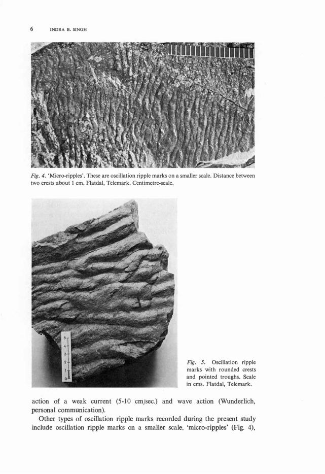
Fig. 4. 'Micro-ripples'. These are oscillation ripple marks on a smaller scale. Distance between
two crests a bo ut l cm. Flatdal, Telemark. Centimetre-scale.
Fig. 5. Oscillation ripple
marks with rounded crests
and pointed troughs. Scale
in cms. Flatdal, Telemark.
action of a weak current (5-10 cmjsec.) and wave action (Wunderlich,
personal communication).
Other types of oscillation ripple marks recorded during the present study
include oscillation ripple marks on a smaller scale, 'micro-ripples' (Fig. 4),

SEDIMENTARY STRUCTURES IN PRECAMBRIAN QUARTZITES 7
Fig. 6. Oscillation ripple marks with rounded crests and pointed troughs. These are not pure oscillation ripple marks but have certainly been somewhat later modified probably due to change in water leve! and current action. Åmot, Telemark.
Fig. 7. Oscillation ripple marks showing several different directions and grading into current ripple marks at the left side of the photo. Such surfaces occur commonly on intertidal flats. Åmot, Telemark.
and oscillation ripple marks with flatterred crests. Hattening of crests is due to the washing away of a rippled surface. Both 'micro-ripples' and flat-toppat ripples are often met with on intertidal flats, and may be considered typical for an intertidal flat environment. Thus Tanner (1962) considers the flattopperl ripple mark to be a good indicator of very shallow water.
Very often oscillation ripple marks in the quartzites of Telemark show
rounded crests and pointed troughs (Figs. 5 and 6). According to Evans (1941, 1949) such ripple marks are f o und in narrow helts near the shore, and result from the action of slowly dying waves following a storm. Such ripple marks are also very common on intertidal flats (Reineck, personal communi
cation).

8 INDRA B. SINGH
Fig. 8. Current ripple marks. Direction of current from lower left corner to upper right corner. Åmot, Telemark.
Fig. 9. Lingoid or cuspate ripple marks. Current from right to left. Road section Åmot-Vinje,
Telemark.
Fig. 7 shows a rippled surface on which two directional oscillation ripple
marks are present. These grade into current ripple marks in the depression
where, even during low tides, some water could flow. Such surfaces are
characteristic of intertidal flats. Interference ripple marks, sometimes forming
'tadpole nests' (Shrock 1948) are also recorded. They, too, are indicators of
very shallow water.
Simons & Richardson (1961) regard current ripples as bed forms restricted
to the lower flow-regime and formed at various current velocities depending
SEDIMENTARY STRUCTURES IN PRECAMBRIAN QUARTZITES 9
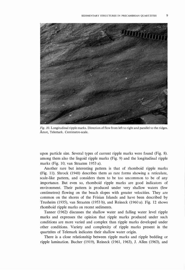
Fig. JO. Longitudinal ripple marks. Direction of flow from left to right and paraBel to the ridges.
Åmot, Telemark. Centimetre-scale.
upon partide size. Several types of current ripple marks were found (Fig. 8).
among them also the lingoid ripple marks (Fig. 9) and the longitudinal ripple
marks (Fig. 10; van Straaten 1953 a).
Another rare but interesting pattern is that of rhomboid ripple marks (Fig. 11). Shrock (1948) describes them as rare forms showing a reticulate,
scale-like pattern, and considers them to be too uncommon to be of any
importance. But even so, rhomboid ripple marks are good indicators of
environment. Their pattern is produced under very shallow waters (few
centimetres) flowing on the beach slopes with greater velocities. They are common on the shores of the Frisian Islands and have been described by
Trusheim (1935), van Straaten (1953 b), and Reineck (1960 a). Fig. 12 shows
rhomboid ripple marks on recent sediments.
Tanner (1962) diseosses the shallow water and falling water level ripple
marks and expresses the opinion that ripple marks produced under such
conditions are more varied and complex than ripple marks developed under
other conditions. Variety and complexity of ripple marks present in the
quartzites of Telemark indicates their shallow water origin.
There is a close relationship between ripple marks and ripple bedding or
ripple lamination. Bucher (1919), Reineck (1961, 1963), J. Allen (1963), and

10 INDRA B. SINGH
Fig. 11. Rhomboid ripple marks. Note the reticulate scale-like pattern. Direction of flow from upper to lower side. In the lower right corner is a surface with asymmetrica! oscillation ripple marks. Road seetian Åmot-Vinje, Telemark.
McKee (1965) point out the close relationship between ripple marks and several bedding types and these are further discussed with respective bedding types.
B. Cross-bedding
The term cross-bedding has been used here in the sense of Otto (1938). and as defined by Potter & Pettijohn (1963): 'Cross-bedding' is a stmcture confined to a single sedimentation unit consisting of intemal bedding, called foreset bedding, inclined to the principal surface of accumulation'. In this paper the term 'foreset laminae' has been used in preference to 'foreset
bedding'. Cross-bedding is the most common type of bedding present in the quart
zites of Telemark. The thickness of a cross-bedded unit may vary from a few millimetres to tens of metres.

SEDIMENTARY STRUCTURES IN PRECAMBRIAN QUARTZITES 11
Fig. 12. Rhomboid ripple marks from a modem intertidal flat of the North Sea, Mellum Island, Germany. Length of the knife approx. 50 centimetres.
Fig. 13. Planar cross-stratification with regular surfaces of erosion. Road section Åmot-Dalen, Telemark.

12 INDRA B. SINGH
Fig. 14. Planar cross-stratification with irregular surface of erosion (arrow). Åmot, Telemark.
The classification of cross-bedded unit presents many problems and no unanimous opinion exists as to how this should be done. Where possible the terms given in this paper have been used in the same sense as their quoted original author(s) intended. The following are the main types of crossbedded units recorded in quartzites of Telemark.
Planar cross-stratification (McKee & Weir 1953). Two types are distinguished in the present paper; l) the lower surface of erosion is regular (Fig. 13), and 2) the lower surface of erosion is irregular (Fig. 14).
Trough cross-stratification (McKee & Weir 1953). This feature has been observed both on a megascale (Fig. 15) as weil as on a smaller scale (Fig. 16). Some authors prefer to use the term 'festoon bedding' for the same feature.
Herringbane cross-stratification (Shrock 1948). This term is applied to cross-stratified layers with opposite directions of foreset laminae in adjacent layers. This feature has been observed in Telemark on a megascale as weil as a smaller scale. One sees this feature quite often within normal crossstratified units. Such herringbone cross-stratification has been recorded in modem tidal sediments of the North Sea (Hiilsemann 1955, van Straaten
1954, Reineck 1963, 1967). At a few places in the quartzites of Telemark, a modified form of herring
bone cross-stratification has been recorded. In this case two adjacent quartzitic layers with foreset laminae in opposite directions are always separated by phyllitic (clayey) layers from a few millimetres to 1-2 centimetres thick (Fig. 17). This feature may be considered as characteristic of a tida! environment. Cross-stratified sand was most probably deposited during ebb and flood, whereas the mud settled during periods of quiscene, e. g. high tide and low tide.

SEDIMENTARY STRUCTURES IN PRECAMBRIAN QUARTZITES 13
Fig. 15. Trough cross-stratification on a mega-scale. Note the weil preserved foreset laminae. Road-section Åmot-Totak, Telemark. Centimetre-scale.
Cross-stratification with overturned foreset lamination. At several locali
ties some units of cross-stratification show overturned foreset laminae (Fig.
18). McKee, Reynolds & Baker (1962) produced a similar structure in flume
study experiments and termed it an 'intraformational recumbent fold'. Cole
man & Gagliano (1965) observed these features in a delta-front environment
of the Mississippi river. This structure is produced by the drag of strong
sediment-laden currents across the bottom.

14 INDRA B. SINGH
Fig. 16. Trough cross-stratification on smaller scale. Some of the 'festoons' have been inked in on the photograph. Road section Åmot-Totak, Telemark. Scale in centimetres (20).
Fig. 17. Herring bane cross-stratification. No te the cross-stratified units with opposite directions of foreset laminae. Two units are separated by a thin clayey layer. Flatdal, Telemark.

SEDIMENTARY STRUCTURES IN PRECAMBRIAN QUARTZITES 15
Fig. 18. Cross-stratified units. One of the units shows the overturned foreset laminations .. Lines have been drawn on the outcrop with a marker pen. Flatdal, Telemark.
Fig. 19. Mega-ripple bedding. Units are separated by a thin clayey layer. Flatdal, Telemark.
Mega-ripple bedding. (Reineck 1963). In principle this is the same as the
planar cross-bedding. The name denotes its origin due to mega-ripples (dunes)
of the lower flow regime. Fig. 19 shows mega-ripple bedding in Telemark.

16 INDRA B. SINGH
Fig. 20. Ripple lamination-in-ph�se (arrow). This is interbedded with paraHel bedding. Åmot, Telemark.
Fig. 21. Ripple-drift-lamination, most clearly developed in the upper part of the photo. Flatdal, Telemark.
In conclusion one may state that the cross-stratified units were deposited
due to interaction of migrating small ripples and megaripples in the lower
flow regime.
C. Ripple lamination
Ripple laminae are intemal sediment structures related to ripple marks. The
process of ripple drifting has been discussed by Reineck (1961). McKee
SEDIMENTARY STRUCTURES IN PRECAMBRIAN QUARTZITES 17
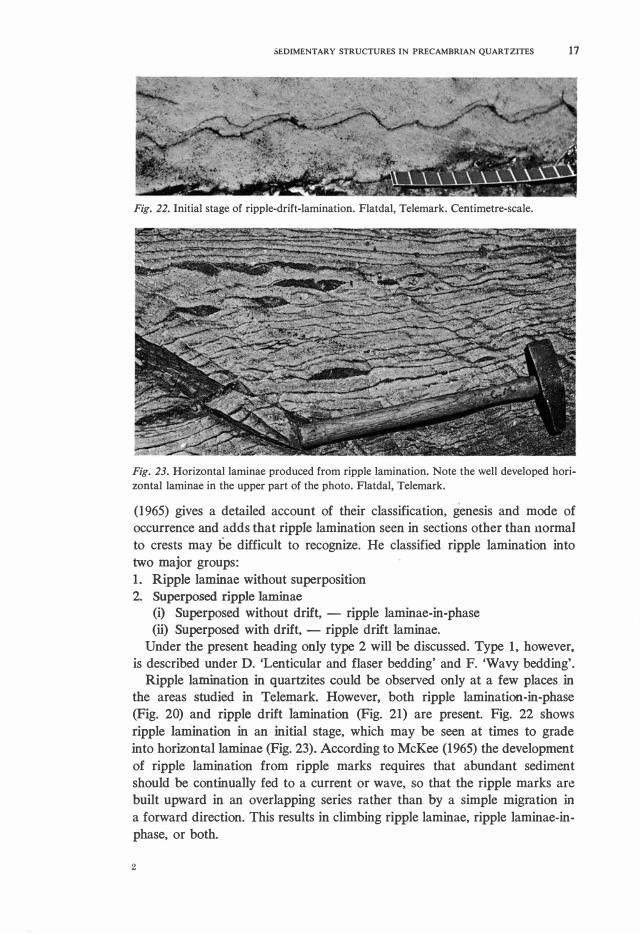
Fig. 22. Initial stage of ripple-drift-lamination. Flatdal, Telemark. Centimetre-scale.
Fig. 23. Horizontal laminae produced from ripple lamination. Note the well developed horizontal laminae in the upper part of the photo. Flatdal, Telemark.
(1965) gives a detailed account of their classification, genesis and mode of occurrence and adds that ripple Iaminatian seen in sections other than normal to crests may be difficult to recognize. He classified ripple laminatlon into two major groups: l. Ripple laminae without superposition 2. Superposed ripple laminae
(i) Superposed without drift, - ripple laminae-in-phase (ii) Superposed with drift, - ripple drift laminae.
Under the present heading only type 2 will be discussed. Type l, however, is described under D. 'Lenticular and fiaser bedding' and F. 'Wavy bedding'.
Ripple laminatlon in quartzites could be observed only at a few places in
the areas studied in Telemark. However, both ripple lamination-in-phase (Fig. 20) and ripple drift lamination (Fig. 21) are present. Fig. 22 shows ripple lamination in an initial stage, which may be seen at times to grade into horizontal laminae (Fig. 23). According to McKee (1965) the development of ripple lamination from ripple marks requires that abundant sediment should be continually fed to a current or wave, so that the ripple marks are built upward in an overlapping series rather than by a simple migration in
a forward direction. This results in climbing ripple laminae, ripple laminae-inphase, or both.
2
18 INDRA B. SINGH
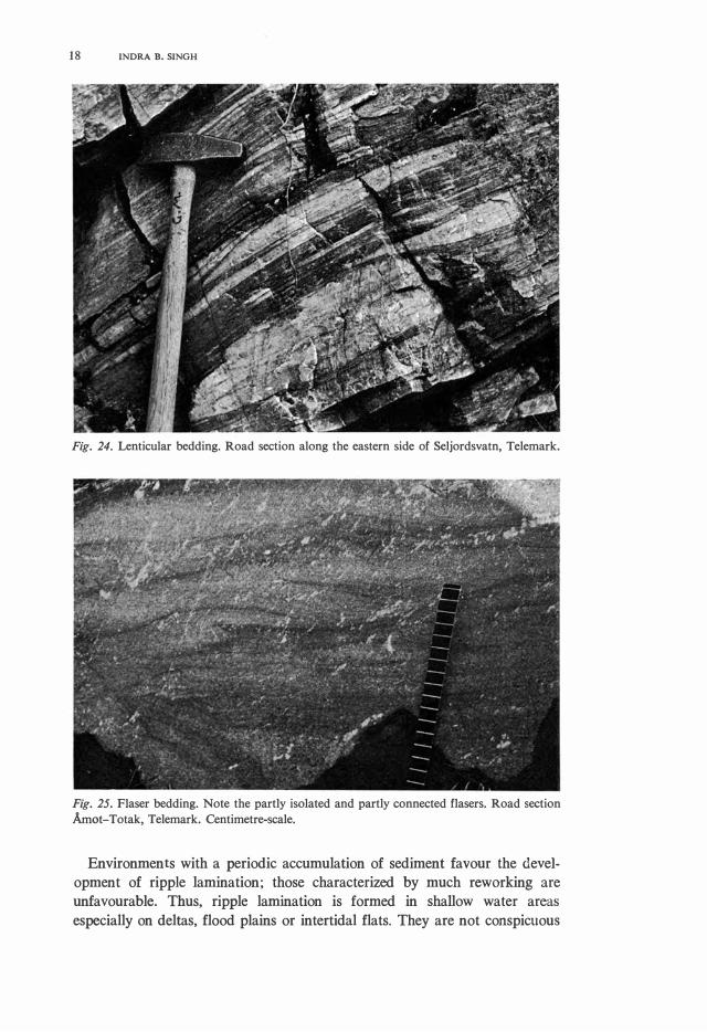
Fig. 24. Lenticular bedding. Road section along the eastern side of Seljordsvatn, Telemark.
Fig. 25. Fiaser bedding. Note the partly isolated and partly connected flasers. Road section Åmot-Totak, Telemark. Centimetre-scale.
Environments with a periodic accumulation of sediment favour the development of ripple lamination; those characterized by much reworking are unfavourable. Thus, ripple lamination is formed in shallow water areas especially on deltas, flood plains or intertidal flats. They are not conspicuous

SEDIMENTARY STRUCTURES IN PRECAMBRIAN QUARTZITES 19
Fig. 26. Lenticular bedding with completely preserved oscillation ripple marks. Cheveron-like structure can be partly seen in the lenticles. Flatdal, Telemark.
Fig. 27. Lenticular bedding with completely preserved oscillation ripple marks from the intertidal flats of the North Sea. Photo - Senekenberg Institut, Wilhelmshaven, Germany.
on intertidal flats hut ma y be common locally in tidal channel deltas (Reineck,
personal communication).
D. Lenticular and fiaser bedding (Linsen und Flaser-Schichtung).
Lenticular bedding is very common in the quartzites of Telemark (Fig. 24).
Fiaser bedding has also been observed (Fig. 25) and at places fiaser-bedding
has been found in which complete oscillation ripple marks are preserved
(Fig. 26). An illustration of this feature from a modern intertidal flat shows
the similarity (Fig. 27). lt has also been described by Reineck (1967).

20 INDRA B. SINGH
O 2cm
Fig. 28. 'Misch' flat bedding. Note the irregular sand lenticles embedded in clayey matrix. Road section Åmot-Vinje, Telemark.
Fig. 29. Finely laminated sand/clay bedding. Flatdal, Telemark.
In addition, there are thick successions of lenticular and lenticular-like
bedding features which after metamorphism and slight deformation appear
similar to conglomerates (Singh 1968). Features appearing similar to lenti
cular bedding, hut on a smaller scale, and regarded by Reineck (1967) as
typical of 'misch' flats (tidal flats where sand and mud components are equal
in amount) have also been found (Fig. 28).
Fiaser-bedding is produced when both sand and mud is present in suspen
sion and there are periods of current alternating with periods of quiescence
(Häntzschel 1936, Reineck 1960 b). At times sand is deposited in the form
of ripple marks when the current is strong enough. During quiescent periods,
mud settles down from the suspension into the troughs, or sometimes covers
the ripples completely. Repetition of this process gives rise to fiaser bedding.

SEDIMENTARY STRUCTURES IN PRECAMBRIAN QUARTZITES 21
Fig. 30. Coarsely Iaminated sand/clay bedding. Thickness of individual sand and clay layers is almost equal. Road section along the eastern side of Seljordsvatn, Telemark.
If a preponderance of mud is deposited, the result is the formation of rippled
lenses of sand embedded in a muddy matrix and this gives rise to lenti
cular bedding. Lenticular bedding is also produced by incomplete ripple marks
(Reineck 1960 b). Ideal conditions for the formation of this bedding are found in a shaHow
sea with tidal currents. Häntzschel (1936), van Straaten 1954 and Reineck
(1960 b, 1963) have shown that lenticular bedding is at present being formed
in the shaHow water and intertidal flat areas of the southem North Sea.
Coleman & Gagliano (1965) observed lenticular bedding in the Mississippi
delta.
E. Parallel bedding
Two types of paraHel bedding may be distinguished:
l. finely laminated sandjclay bedding 2. coarsely laminated sandjclay bedding.
Numerous examples of both bedding types have been found in the quartzites of Telemark At places, paraHel bedding occurs in thick successions.
In Telemark these layers can be foHowed for tens of metres, but at some
is measured in a few millimetres (Fig. 29). Such individual layers may, in
some cases, also represent parts of foreset laminae of a cross-bedded unit.
However, in most cases finely laminated sandjclay bedding is the result of
deposition from suspension. Richter (1927) and LUders (1930) called it a
rhythmicaHy laminated bedding. Wunderlich (1967) describes finely lamina
ted sandfclay bedding produced by the formation of 'very flat current ripple
marks'.

22 INDRA B. SINGH
Fig. 3 1. Coarsely Iamirrated sand/clay bedding. Thicker sandy layers separated by thin clayey layers. Flatdal, Telemark.
Fig. 32. Pinching out of individual layers in a coarsely laminated sand/clay bedding. Road section along the eastem side of Seljordsvatn, Telemark. Centimetre-scale.
Fig. 33. Wavy bedding. lndividual sandy layers are always separated by thin clayey layers. Flatdal, Telemark. Centimetre-scale.

SEDIMENTARY STRUCTURES IN PRECAMBRIAN QUARTZITES 23
Fig. 34. Wavy bedding in an otherwise paraHel bedded sequence. Flatdal, Telemark. Centimetre-scale.
Coarsely laminated sandfclay bedding, in which the thickness of individual
layers is several centimetres, can be divided into two groups:
l. when the thickness of sand and clay layers is equal (Fig. 30),
2. when thick sandy layers are separated by thin clayey layers (Fig. 31).
In Telemark these layers can be followed for tens of metres, hut at some
places pinching out of individual layers is a common feature (Fig. 32).
It is not possible to say whether some of this paraHel beddings was formed
by horizontal laminae, produced in the upper flow regime (cf. Harms &
Fahnestock 1965), or was deposited from suspension in a flow regime with
less energy than that required for ripples.
Finely laminated sandfclay bedding and coarsely laminated sandjclay bed
ding is common in shallow seas and intertidal flats of the North Sea where
prevailing tidal currents are present (Reineck 1963, 1967).
F. Wavy bedding
Wavy bedding is characterized by undulatory bounding surfaces and is related
to ripple bedding. In the quartzites of Telemark rippled quartzitic layers of
wavy bedded units are always separated by thin phyllitic layers (Fig. 33).
Sometimes wavy bedded units are present within an otherwise parallel bedded
sequence (Fig. 34).

24 INDRA B. SINGH
Fig. 35. Raindrop imprints on asymmetrical oscillation ripple marks. Note the better presservation of raindrop imprints on the crestal parts of the ripple marks. Road section ÅmotVinje, Telemark. Centimetre-scale.
Fig.36.Acloser view of raindrop imprints. Road section Åmot-Vinje, Telemark. Centimetrescale.
G. Raindrop imprints
Beautifully preserved raindrop imprints (Figs. 35, 36) have been found on a
rippled surface of the Bandak Group. The raindrop imprints are better pres
erved on the crestal parts of the ripples than in the troughs. This is because
at the time of the rain, the crestal parts were drier than the troughs and

SEDIMENTARY STRUCIURES IN PRECAMBRIAN QUARTZITES 25
Fig. 37. Raindrop im
prints on a rippled surface. Intertidal flat of the North Sea.
Fig. 38. An erosional unconformity. Road section Åmot-Höydalsmo, Telemark. Centimetrescale.
rain could make better impact on the drier parts. The elliptical shape of the impact eraters is most probably due to an oblique direction of the rain (cf. Shrock 1948). The effect of tectonic deformation at this locality seems to be negligible. The sediment at this locality was originally a silty fine sand.
This feature can be taken as an indication of desposition in an area with
intermittent periods of dryness, e. g. an intertidal flat environment. For
comparison, Fig. 37 shows raindrop imprints on a rippled surface from a
modern intertidal flat.
H. Erosional channels and erosional unconformities
In a basin of deposition intermittent erosion may take place. Two cross
stratified units are usually separated by an erosional surface. Sometimes

26 INDRA B. SJNGH
Fig. 39. A small erosional channel in a cross-stratified sequence. Åmot, Telemark.
Fig. 40. An erosional channel within a cross-stratified unit. Åmot, Telemark.
erosion produces angular erosional unconformities (Fig. 38) and erosional channels of varying shape and size (Figs. 39 and 40).
Channels are a common feature in the environment of intertidal flats.
l. Penecontemporaneous deformation structures
At some outcrops were observed small scale tension faults extending up to a few centimetres, and restricted to a few beds only (Fig. 41). Such features
are considered as having been formed during deposition due to processcs
like slumping and are common in areas of rapid sedimentation.
J. Bioturbale st ruetures
Bioturbate structures are those features which are produced by the activity of organisms in the sedim�nts at the time of deposition, or shortly after.
Bioturbate features tend to destroy primary bedding formed by inorganic
agencies. Schäfer ( 1956) distinguishes two types of bioturbate structures:
SEDIMENTARY STRUCTURES IN PRECAMBRIAN QUARTZITES 27
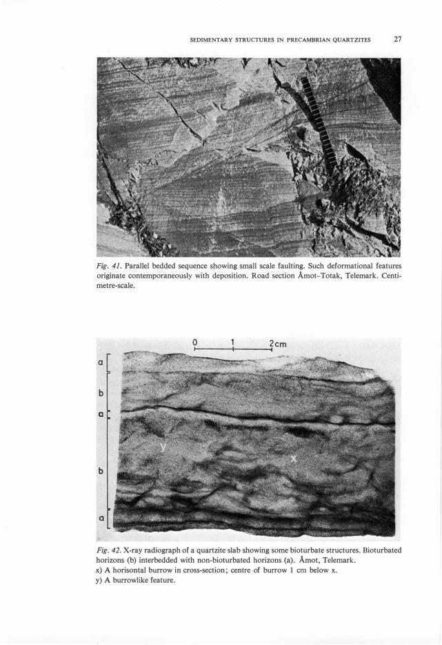
Fig. 41. ParaHel bedded sequence showing small scale faulting. Such deformational features
originate contemporaneously with deposition. Road section Åmot-Totak, Telemark. Centi
metre-scale.
o�----�----�2 cm
a[
b
a
b
a
Fig. 42. X-ray radiograph of a quartzite slab showing some bioturbate structures. Bioturbated
horizons (b) interbedded with non-bioturbated horizons (a). Åmot, Telemark.
x) A horisontal burrow in cross-section; centre of burrow l cm below x.
y) A burrowlike feature.

28 INDRA B. SINGH
o
Fig. 43. X-ray radiograph of a bioturbated horizon.
2cm
a) A simple burrow without 'spreites' b) A burrow with 'spreites'. Bedding has been completely destroyed except in the lowermost and the uppermost parts. Åmot, Telemark.
l. Fossitextura deformativa; formless bioturbate features appearing as 'mot
tled structures' or irregular flecks of different sediment types.
2. Fossitextura figurativa; bioturbate structures with definite forms, such
as burrows.
Some of the samples from the quartzites of Telemark show mottled struc
tures which look very similar to bioturbate structures. A few slabs were
investigated in detail, with the aid of X-ray radiographs. Results were good, as the bioturbate features then became much clearer. In a few samples it
was possible to distinguish between bioturbated and non-bioturbated parts
(Fig. 42).
Usually, bedding in the bioturbated horizons has been completely destroyed,
but sometimes it is still partly visible. In addition, it is possible to recognize
three types of regular burrows. One type is a harizontal burrow, having a
diameter of about 1.5 centimetres (Fig. 42); the seeond type is an inclined
burrow, l centimetre in diameter and about 2-3 centimetres in length (Fig.
43) without 'spreiten' and the third type is an inclined burrow with 'spreiten'.
The presence of these burrows and bioturbated horizons in the Precambrian
quartzites of Telemark is of palaeontological importance, because it indicates
Iife at the time the sediments were deposited (,_. 1500-900 m. y. B. P.).
Moreover, burrows of approximately 1.5 centimetres in diameter would, of
course, demand organisms of a sufficiently large size.
K. O t her structures Other sedimentary structures, which have not been discussed in detail here,
include slump structures (Dons 1960 b), mud eraeks (Dons 1963), and ball
and pillow structures.

DISCUSSION
SEDIMENTARY STRUCTURES IN PRECAMBRIAN QUARTZITES 29
The Precambrian quartzites of Telemark occupy a large area in the central
part of Southem Norway, and the present work was restricted only to a few
weil-exposed road-sections. Thus conclusions regarding the regional environ
ment of deposition must be generalized.
Almost all the features encountered in these quartzites are found in the
present day shallow sea environments with tidal currents. A very common
and well-developed feature is the alternating sandfclay succession. The exami
nation of lenticular bedding, fiaser bedding, wavy bedding or paraHel bedding
always shows the presence of sandy layers separated by thin clayey layers.
This feature is likewise common in cross-bedded units. lt is easy to imagine
the formation of such an alternating sequence in a tida! current environment.
The sand is deposited during periods of current activity such as ebb and
flood, while the mud sett!� at high and low water when there are periods
of quiescence.
The presence of herringbane cross-bedding indicates the existence of
prevailing tida! currents in two opposing directions while raindrop imprints
and mudcracks show that at times the area was subaerial. In a tida! current
environment such areas would represent intertidal flats. Features like rhom
boid ripple marks, 'micro-ripples', interference ripple marks, ripples with
rounded crests, and ripples with flat tops are known to occur in abundance
on modem intertidal flats and can only be formed under shallow water
conditions.
Features like cross-stratification with overturned foreset laminations suggest
an abundance of detritat material.
The occurrence of bioturbate features indicates: a) The presence of or
ganisms during the time of deposition of the quartzites of Telemark. b) The
presence of !arge regular burrows further suggests that organisms of reason
ab le size were present, although no fossils of sheil-hearing organisms ha ve
been found. c) The rate of sedimentation, at !east during the deposition of
bioturbated layers, was such that living organisms had enough time to destroy the primary bedding.
Ripple lamination, found commonly on flood plains, deltas, and deltas of
intertidal flat channels have been found at a few localities. However, it seems Iikely that the delta environment, if present at all, was not common.
In conclusion, it may be stated that the main sedimentary evidence suggests
that the Precambrian quartzites of Telemark were deposited in a slowly
subsiding basin where there was an abundance of sediment under very shallow
water to intertidal flat conditions. These conditions of deposition were main
tamed throughout the thick sequence of Telemark supracrustals.
ACKNOWLEDGEMENTS
I am most grateful to Professors Tom. F. W. Barth and H. Neuroann for
providing working facilities at the Mineralogisk-Geologisk Museum, Uni
versity of Oslo, Norway. Thanks are extended to head curator J. A. Dons

30 INDRA B. SINGH
and Dr. Chandra D. P. Singh of the same museum for their help and eneou
ragement during field work. Both accompanied me in the field, gave me
unpublished information, and suggested the area of study.
I also wish to acknowledge the help of Dr. H. E. Reineck, Wilhelmshaven,
W. Germany, who kindly permitted me to make use of the collections at the
Senekenberg Institute for the comparative work, for permission to publish
some photographs from this collection, and for constructive and critical dis
cussions. Dr. F. Wunderlich, Wilhelmshaven, is thanked for many stimulating
discussions, for information concerning recent sediments, and for providing
the photograph of raindrop imprints from a modern intertidal flat. The
advice and assistance of Dr. Werner, Kiel, W. Germany, and Mr. Ihlen-Sopp,
Oslo, in making X-ray radiographs are gratefully acknowledged.
An earlier draft of the manuscript was criticized by head curator J. A.
Dons, Prof. K. Krejci-Graf, Frankfurt, W. Germany, and Drs. H.-E. Reineck
and F. Wunderlich, Wilhelmshaven, W. Germany. However, the views ex
pressed herein are entirely the author's responsibility. Punds for this work
were provided by NORAD and the Mineralogisk-Geologisk Museum's
Telemark Project.
REFERENCES
Mineralogisk-Geologisk Museum,
Sars gate l, Oslo 5, Norway
21st May 1968
ALLEN, J. R. L. 1963: The classification of cross-stratified units, with notes on their origin.
Sedimentology, 2, 93-114. BUCHER, W. H. 1919: On ripples and related sedimentary surface forms and their palaeo
geographic interpretations. Am. Jour. Sci. 47, 149-210, 241-269.
BuooE, C. 1931: Geologiske Undersökelser i Telemark. Norsk Geol. Tidsskr. 12, 149-170.
CoLEMAN, J. M. & GAGLIANO, S. M. 1965: Sedimentary structures: Mississippi River Deltaic
Plain. Soc. Econ. Pal. Min., Special publication No. 12, 133-148. Tulsa.
DoNs, J. A. 1959: Fossils(?) of Precambrian age from Haugli in Telemark, S. Norway. Norsk
Geol. Tidsskr. 39, 249-262.
DoNs, J. A. 1960a: Telemark supracrustals and associated rocks (pp. 49-58). In O. Holtedahl
(ed.): Geology of Norway. Norges Geol. Undersök. 208. 540 pp.
DoNs, J. A. 1960b: The stratigraphy of supracrustal rocks, granitization and tectonics in the
precambrian Telemark area, Southern Norway. Guide to excursions, No. A10. Internat.
Geol. Conifr., XXI session, Norden 1960. 30 pp.
DoNs, J. A. 1963: Precambrian rocks of central Telemark, Norway: 11. Ripple marks and
mud cracks. Norsk Geol. Tidsskr. 43, 477-495.
EVANs, O. F. 1941: The classification of wave formed ripple marks. Jour. Sed. Petrology 11,
37-41.
EvANs, O. F. 1949: Ripple marks as an aid in determining depositional environment and rock
sequence. Jour. Sed. Petrology 19 (2), 82-86.
GAVELIN, S. & RussELL, R. V. 1967: Primary sedimentary structures from the Precambrian
of southeastern Sweden. Geol. Fören. i Stockholm Förhand/. 89, 74-104.
HÄNTSCHEL, W. 1936: Die schichtungs-formen rezenter flachmeer Ablagerungen im Jade
Gebiet Senckenbergiana 18, 316-356.
SEDIMENTARY STRUCTURES IN PRECAMBRIAN QUARTZITES 31
HARMs, J. C. & FAHNESTOCK, R. K. 1965: Stratification bed forms and flow phenomena (with
an example from Rio Grande). Sac. Econ. Pal. Min., Special publication No. 12, 84-115. Tulsa.
HOLSEMANN, J. 1955: Grossrippeln und Schrägschichtungs-Geflige im Nordsee Watt und in der Molasse. Senckenbergiana Lethaea 36, 359-388.
Lt.iDERS, K. 1930: Entstehung der Gezeitenschichtung auf den Watten im Jadebusen. Sencken
bergiana 12 (4/5), 229-254. McKEE, E. D. 1965: Experiments on ripple laminations. Sac. Econ. Pal. Min., Special pub
lication No. 12, 66-83. Tulsa. McKEE, E. D., REYNOLDS, M. A. & BAKER, C. H. JR. 1962: Experiments on intraformational
recumbent folds in cross-bedded sand. U.S. Geol. Surv., Prof paper 450-D, 151-155. McKEE, E. D. & WEIR, G. W. 1953: Terminology for stratification and cross-stratification in
sedimentary rocks. Bull. Geol. Sac. Am. 64, 381-390. OTTo, G. H. 1938: The sedimentation unit and its use in field sampling. Jour. Geol. 46, 569-582. PETTIJOHN, F. J. & POTTER, P. E., 1964: Atlas and glossary of primary sedimentary structures.
370 pp. Springer-Verlag. Berlin. POTTER, P. E. & PETTIJOHN, F. J. 1963: Paleocurrents and basin analysis. 296 pp. Academic
Press lnc., New York. REINECK, H. E. 1960a: Ober den Sandtransport des Sandriffsandes. Forschungsste/le Nordeney
der Niedersächsischen Wasser Wirtschaftsverwaltung, Jahresbericht, 1959, Band XI, 21-38. REINECK, H. E. 1960b: Ober die Entstehung von Linsen und Flaserschichten. Abh. Deut.
Akad. Wiss. Berlin, Kl. 3, l, 369-374. REINECK, H. E. 1961: Sedimentbewegungen an Kleinrippeln in Watt. Senckenbergiana Lethaea
42, 51-61. REINECK, H. E. 1963: Sedimentgefiige im Bereich der Siidlichen Nordsee. Abh. Senckenberg.
Naturforsch. Ges., 505, 1-138. REINECK, H. E. 1967: Layered sediments of tida! flats, beaches and shelf bottoms of the North
Sea.Jn 'Estuaries'; Amer. Ass. for the Advancement of Sci., 191-205. RICHTER, Ruo. 1927: Die fossilen Fährten und Bauten der Wiirmer. Paläont. Zeitschr. 9,
193-240. ScHÄFER, W. 1956: Wirkungen der Benthos-organismen auf der jungen Schichtverband.
Senckenbergiana Lethaea 37, 183-263. ScHROCK, R. R. 1948: Sequence in layered rocks. 507 pp. McGraw-Hill, New York, N.Y. SIMONs, D. B. & RicHARDsoN, E. V. 1961: Forms of bed roughness in alluvial channels. Am.
Soc. Civil Engineers, Proc. v. 87, no. HY3, 87-105. (Cit. in McKEE, 1965). SINGH, I. B. 1968: Lenticular and lenticular-like bedding in the Precambrian supracrustals,
Telemark Suite, Southern Norway. Norsk Geol. Tidsskr. 48, 165-170
TANNER, W. F. 1962: Falling water leve! ripple marks. Trans. Gulf Coast Assoc. Geol. Sac., 12,
295-301. TRUSHEIM, F. 1935: Naturspiel oder Organismus? Senckenbergiana, 17, 167. VAN STRAATEN, L. M. J. U. 1953a: Megaripples in the Dutch Wadden See and in the Basin of
Areachou (France). Geol. en Mijnbouw, 15, 1-11. VAN STRAATEN, L. M. J. U. 1953b: Rhythmic patteros on Dutch North Sea beaches. Geol.
en Mijnbouw, n.s.2, 1-13. VAN STRAATEN, L. M. J. U. 1954: Composition and structure of recent marine sediments in
the Netherlands. Leidse Geol. Mededel. 19, 1-110. WERENSKIOLD, W. 1910: Om 0st-Telemarken (Engl. Summary). Norges Geol. Undersök. 53,
1-70. WERENSKIOLD, W. 1912: Tekst til geologisk kart over strökene mellom Sretersdalen og Rin
gerike. Norges Geol. Undersök. 66, 1-43. WUNDERLICH, F. 1967: Feinblättrige Wechselschichtung und Gezeitenschichtung. Sencken
bergiana Lethaea 48 (3/4), 337-343. WYCKOFF, D. 1934: Geology of the Mt. Gausta region in Telemark, Norway. Norsk Geol.
Tidsskr. 13, 1-72.