Embed Size (px)
Citation preview

Priority Connectivity Projects in the Upper Connecticut River Mitigation and Enhancement Fund (MEF) Service Area
Appalachian Mountain Club
Cathy Poppenwimer Kenneth D. Kimball
October 12, 2016 (First version dated April 30, 2011)
(Second version dated August 12, 2013)
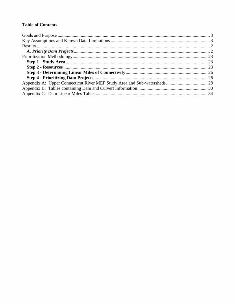
Table of Contents Goals and Purpose .................................................................................................................................... 3 Key Assumptions and Known Data Limitations ...................................................................................... 3 Results....................................................................................................................................................... 2
A. Priority Dam Projects ...................................................................................................................... 2 Prioritization Methodology ..................................................................................................................... 23
Step 1 - Study Area ........................................................................................................................... 23 Step 2 - Resources ............................................................................................................................. 23 Step 3 - Determining Linear Miles of Connectivity ....................................................................... 26 Step 4 - Prioritizing Dam Projects .................................................................................................. 26
Appendix A: Upper Connecticut River MEF Study Area and Sub-watersheds .................................... 28 Appendix B: Tables containing Dam and Culvert Information............................................................. 30 Appendix C: Dam Linear Miles Tables ................................................................................................. 34
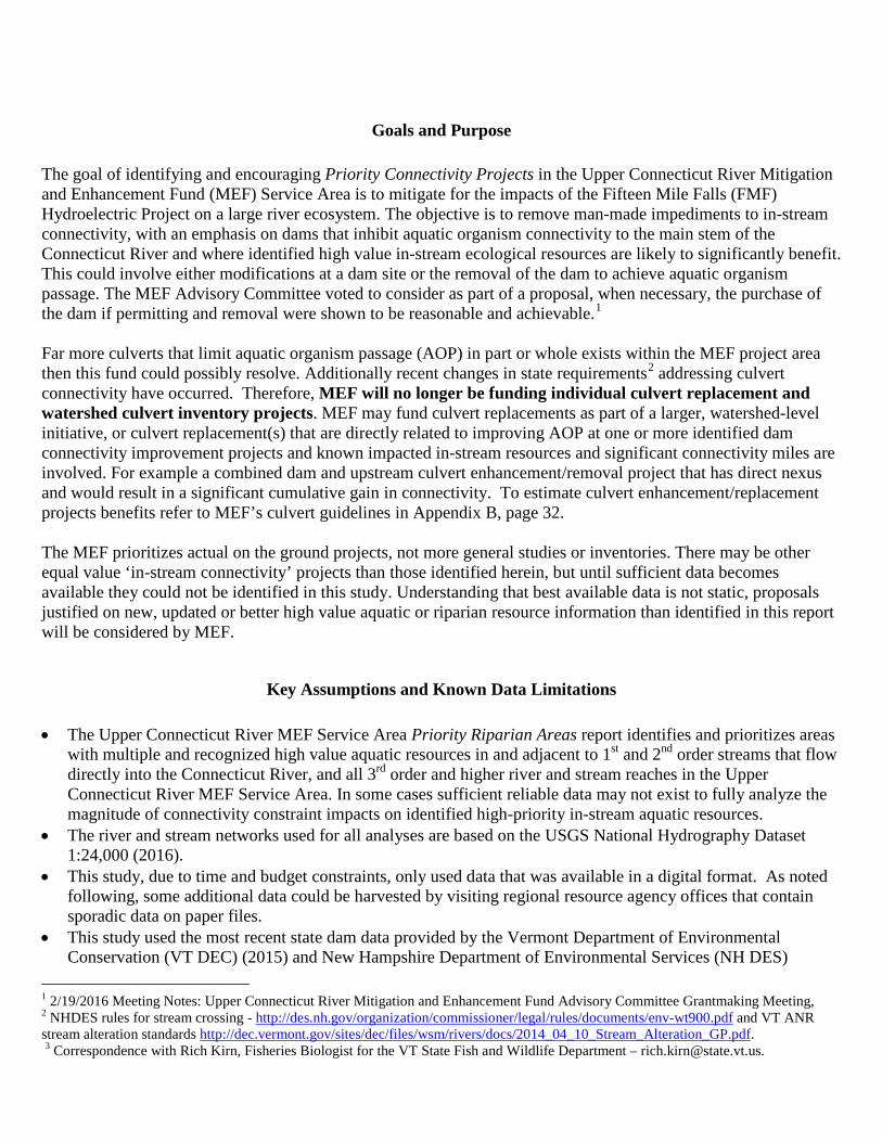
Goals and Purpose The goal of identifying and encouraging Priority Connectivity Projects in the Upper Connecticut River Mitigation and Enhancement Fund (MEF) Service Area is to mitigate for the impacts of the Fifteen Mile Falls (FMF) Hydroelectric Project on a large river ecosystem. The objective is to remove man-made impediments to in-stream connectivity, with an emphasis on dams that inhibit aquatic organism connectivity to the main stem of the Connecticut River and where identified high value in-stream ecological resources are likely to significantly benefit. This could involve either modifications at a dam site or the removal of the dam to achieve aquatic organism passage. The MEF Advisory Committee voted to consider as part of a proposal, when necessary, the purchase of the dam if permitting and removal were shown to be reasonable and achievable.1 Far more culverts that limit aquatic organism passage (AOP) in part or whole exists within the MEF project area then this fund could possibly resolve. Additionally recent changes in state requirements2 addressing culvert connectivity have occurred. Therefore, MEF will no longer be funding individual culvert replacement and watershed culvert inventory projects. MEF may fund culvert replacements as part of a larger, watershed-level initiative, or culvert replacement(s) that are directly related to improving AOP at one or more identified dam connectivity improvement projects and known impacted in-stream resources and significant connectivity miles are involved. For example a combined dam and upstream culvert enhancement/removal project that has direct nexus and would result in a significant cumulative gain in connectivity. To estimate culvert enhancement/replacement projects benefits refer to MEF’s culvert guidelines in Appendix B, page 32. The MEF prioritizes actual on the ground projects, not more general studies or inventories. There may be other equal value ‘in-stream connectivity’ projects than those identified herein, but until sufficient data becomes available they could not be identified in this study. Understanding that best available data is not static, proposals justified on new, updated or better high value aquatic or riparian resource information than identified in this report will be considered by MEF.
Key Assumptions and Known Data Limitations • The Upper Connecticut River MEF Service Area Priority Riparian Areas report identifies and prioritizes areas
with multiple and recognized high value aquatic resources in and adjacent to 1st and 2nd order streams that flow directly into the Connecticut River, and all 3rd order and higher river and stream reaches in the Upper Connecticut River MEF Service Area. In some cases sufficient reliable data may not exist to fully analyze the magnitude of connectivity constraint impacts on identified high-priority in-stream aquatic resources.
• The river and stream networks used for all analyses are based on the USGS National Hydrography Dataset 1:24,000 (2016).
• This study, due to time and budget constraints, only used data that was available in a digital format. As noted following, some additional data could be harvested by visiting regional resource agency offices that contain sporadic data on paper files.
• This study used the most recent state dam data provided by the Vermont Department of Environmental Conservation (VT DEC) (2015) and New Hampshire Department of Environmental Services (NH DES)
1 2/19/2016 Meeting Notes: Upper Connecticut River Mitigation and Enhancement Fund Advisory Committee Grantmaking Meeting, 2 NHDES rules for stream crossing - http://des.nh.gov/organization/commissioner/legal/rules/documents/env-wt900.pdf and VT ANR stream alteration standards http://dec.vermont.gov/sites/dec/files/wsm/rivers/docs/2014_04_10_Stream_Alteration_GP.pdf. 3 Correspondence with Rich Kirn, Fisheries Biologist for the VT State Fish and Wildlife Department – [email protected].
2
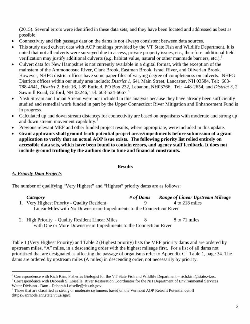
(2015). Several errors were identified in these data sets, and they have been located and addressed as best as possible.
• Connectivity and fish passage data on the dams is not always consistent between data sources. • This study used culvert data with AOP rankings provided by the VT State Fish and Wildlife Department. It is
noted that not all culverts were surveyed due to access, private property issues, etc., therefore additional field verification may justify additional culverts (e.g. habitat value, natural or other manmade barriers, etc.).3
• Culvert data for New Hampshire is not currently available in a digital format, with the exception of the mainstem of the Ammonoosuc River, Clark Brook, Eastman Brook, Israel River, and Oliverian Brook. However, NHFG district offices have some paper files of varying degree of completeness on culverts. NHFG Districts offices within our study area include: District 1, 641 Main Street, Lancaster, NH 03584, Tel: 603-788-4641, District 2, Exit 16, I-89 Enfield, PO Box 232, Lebanon, NH03766, Tel: 448-2654, and District 3, 2 Sawmill Road, Gilford, NH 03246, Tel: 603-524-6667.4
• Nash Stream and Indian Stream were not included in this analysis because they have already been sufficiently studied and remedial work funded in part by the Upper Connecticut River Mitigation and Enhancement Fund is in progress.
• Calculated up and down stream distances for connectivity are based on organisms with moderate and strong up and down stream movement capability.5
• Previous relevant MEF and other funded project results, where appropriate, were included in this update. • Grant applicants shall ground truth potential project areas/impediments before submission of a grant
application to verify that an actual AOP issue exists. The following priority list relied entirely on accessible data sets, which have been found to contain errors, and agency staff feedback. It does not include ground truthing by the authors due to time and financial constraints.
Results A. Priority Dam Projects The number of qualifying “Very Highest” and “Highest” priority dams are as follows:
Category # of Dams Range of Linear Upstream Mileage 1. Very Highest Priority - Quality Resident 9 4 to 218 miles
Linear Miles with No Downstream Impediments to the Connecticut River
2. High Priority - Quality Resident Linear Miles 8 8 to 71 miles with One or More Downstream Impediments to the Connecticut River
Table 1 (Very Highest Priority) and Table 2 (Highest priority) lists the MEF priority dams and are ordered by upstream miles, “A” miles, in a descending order with the highest mileage first. For a list of all dams not prioritized that are designated as affecting the passage of organisms refer to Appendix C: Table 1, page 34. The dams are ordered by upstream miles (A miles) in descending order, not necessarily by priority.
3 Correspondence with Rich Kirn, Fisheries Biologist for the VT State Fish and Wildlife Department – [email protected]. 4 Correspondence with Deborah S. Loiselle, River Restoration Coordinator for the NH Department of Environmental Services Water Division - Dam - [email protected]. 5 Those that are classified as strong or moderate swimmers based on the Vermont AOP Retrofit Potential cutoff (https://anrnode.anr.state.vt.us/sga/).
3
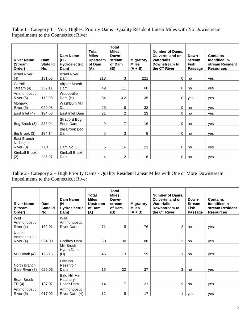
Table 1 - Category 1 – Very Highest Priority Dams - Quality Resident Linear Miles with No Downstream Impediments to the Connecticut River
River Name (Stream Order)
Dam State Id No.
Dam Name (H - Hydroelectric Dam)
Total Miles Upstream of Dam (A)
Total Miles Down- stream of Dam (B)
Migratory Miles (A + B)
Number of Dams, Culverts, and or Waterfalls Downstream to the CT River
Down- Stream Fish Passage
Contains Identified In-stream Resident Resources
Israel River (4) 131.03
Israel River Dam 218 3 221 0 no yes
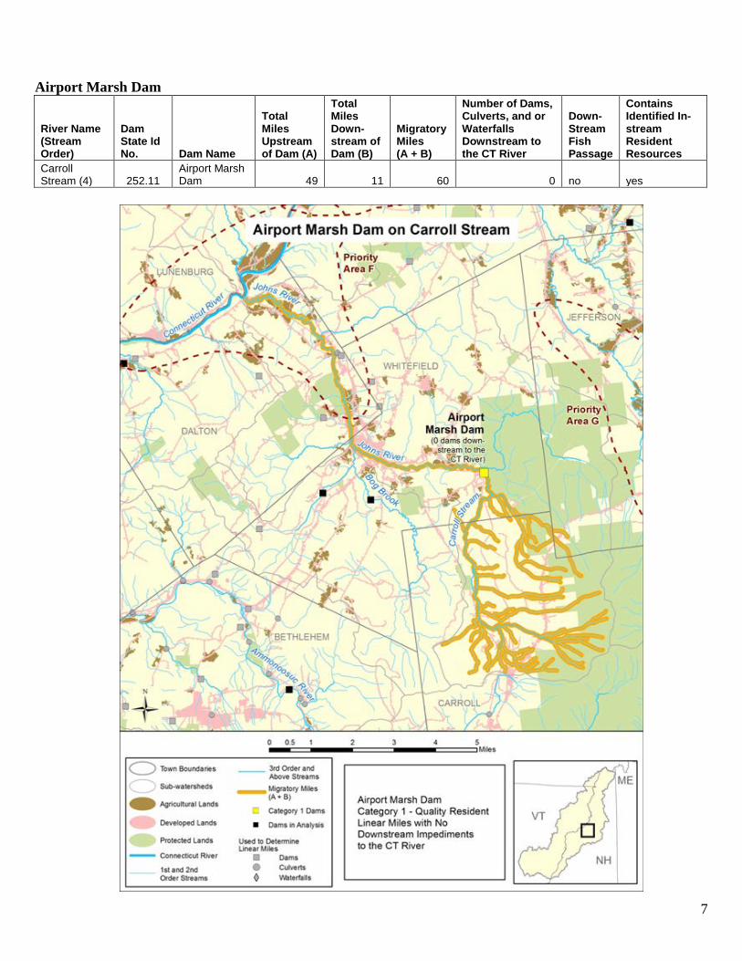
Carroll Stream (4) 252.11
Airport Marsh Dam 49 11 60 0 no yes
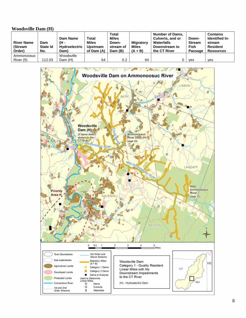
Ammonoosuc River (5) 112.03
Woodsville Dam (H) 34 0.2 35 0 yes yes
Mohawk River (5) 049.03
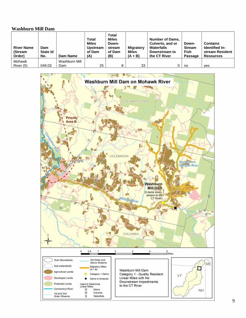
Washburn Mill Dam 25 8 33 0 no yes
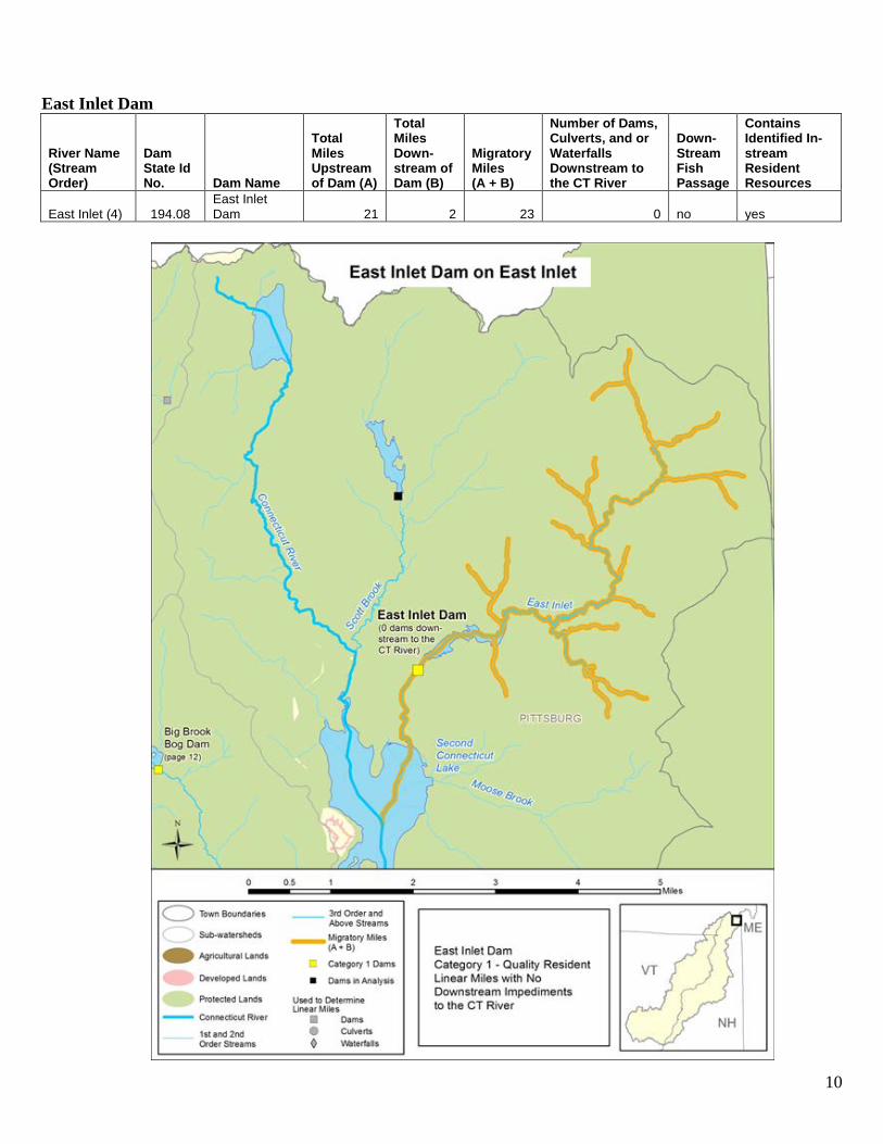
East Inlet (4) 194.08 East Inlet Dam 21 2 23 0 no yes
Bog Brook (3) 225.04 Stratford Bog Pond Dam 9 7 16 0 no yes
Big Brook (3) 194.14 Big Brook Bog Dam 6 3 9 0 no yes
East Branch Nulhegan River (3) 7.04 Dam No. 6 5 16 21 0 no yes
Kimball Brook (2) 225.07
Kimball Brook Dam 4 2 6 0 no yes
Table 2 - Category 2 – High Priority Dams - Quality Resident Linear Miles with One or More Downstream Impediments to the Connecticut River
River Name (Stream Order)
Dam State Id No.
Dam Name (H - Hydroelectric Dam)
Total Miles Upstream of Dam (A)
Total Miles Down- stream of Dam (B)
Migratory Miles (A + B)
Number of Dams, Culverts, and or Waterfalls Downstream to the CT River
Down- Stream Fish Passage
Contains Identified In-stream Resident Resources
Wild Ammonoosuc River (4) 132.01
Wild Ammonoosuc River Dam 71 5 76 2 no yes
Upper Ammonoosuc River (4) 024.08 Godfrey Dam 50 30 80 3 no yes
Mill Brook (4) 125.16
Mill Brook Hydro Dam (H) 46 13 59 1 no yes
North Branch Gale River (3) 025.03
Littleton Reservoir Dam 15 22 37 3 no yes
Bean Brook-TR (4) 137.07
Bald Hill Fish Hatchery Upper Dam 14 7 21 9 no yes
Ammonoosuc River (5) 017.02
Ammonoosuc River Dam (H) 12 5 17 1 yes yes

4
River Name (Stream Order)
Dam State Id No.
Dam Name (H - Hydroelectric Dam)
Total Miles Upstream of Dam (A)
Total Miles Down- stream of Dam (B)
Migratory Miles (A + B)
Number of Dams, Culverts, and or Waterfalls Downstream to the CT River
Down- Stream Fish Passage
Contains Identified In-stream Resident Resources
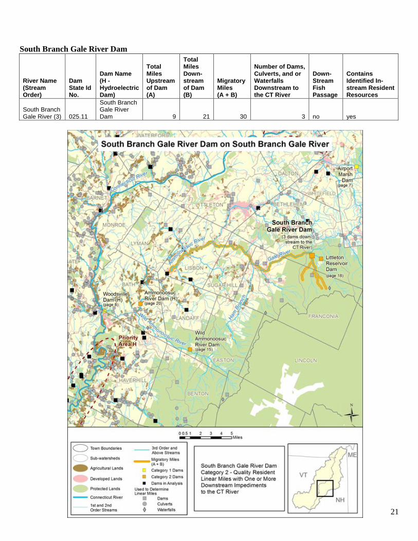
South Branch Gale River (3) 025.11
South Branch Gale River Dam 9 21 30 3 no yes
Zealand River (3) 025.04
Zealand River Dam 8 13 21 5 no yes
The following maps provide an overview of the location of the ‘Very Highest’ and ‘Highest’ priority dams and then the specifics for each dam. In the individual dam maps the priority areas from the Priority Riparian Areas in the Upper Connecticut River Mitigation and Enhancement Fund (MEF) Service Area report are included.

5
Map 1 The “Very Highest” and “Highest” Priority Dams that Impede Connectivity in the MEF Service Area

6
Category 1 - Very Highest Priority: Quality Resident Linear Miles with No Downstream Impediments to the Connecticut River Israel River Dam
River Name (Stream Order)
Dam State Id No.
Dam Name (H - Hydroelectric Dam)
Total Miles Upstream of Dam (A)
Total Miles Down- stream of Dam (B)
Migratory Miles (A + B)
Number of Dams, Culverts, and or Waterfalls Downstream to the CT River
Down- Stream Fish Passage
Contains Identified In-stream Resident Resources
Israel River (4) 131.03
Israel River Dam 218 3 221 0 no yes
7
Airport Marsh Dam
River Name (Stream Order)
Dam State Id No. Dam Name
Total Miles Upstream of Dam (A)
Total Miles Down- stream of Dam (B)
Migratory Miles (A + B)
Number of Dams, Culverts, and or Waterfalls Downstream to the CT River
Down- Stream Fish Passage
Contains Identified In-stream Resident Resources
Carroll Stream (4) 252.11
Airport Marsh Dam 49 11 60 0 no yes
8
Woodsville Dam (H)
River Name (Stream Order)
Dam State Id No.
Dam Name (H - Hydroelectric Dam)
Total Miles Upstream of Dam (A)
Total Miles Down- stream of Dam (B)
Migratory Miles (A + B)
Number of Dams, Culverts, and or Waterfalls Downstream to the CT River
Down- Stream Fish Passage
Contains Identified In-stream Resident Resources
Ammonoosuc River (5) 112.03
Woodsville Dam (H) 64 0.2 64 0 yes yes
9
Washburn Mill Dam
River Name (Stream Order)
Dam State Id No. Dam Name
Total Miles Upstream of Dam (A)
Total Miles Down- stream of Dam (B)
Migratory Miles (A + B)
Number of Dams, Culverts, and or Waterfalls Downstream to the CT River
Down- Stream Fish Passage
Contains Identified In-stream Resident Resources
Mohawk River (5) 049.03
Washburn Mill Dam 25 8 33 0 no yes
10
East Inlet Dam
River Name (Stream Order)
Dam State Id No. Dam Name
Total Miles Upstream of Dam (A)
Total Miles Down- stream of Dam (B)
Migratory Miles (A + B)
Number of Dams, Culverts, and or Waterfalls Downstream to the CT River
Down- Stream Fish Passage
Contains Identified In-stream Resident Resources
East Inlet (4) 194.08 East Inlet Dam 21 2 23 0 no yes
11
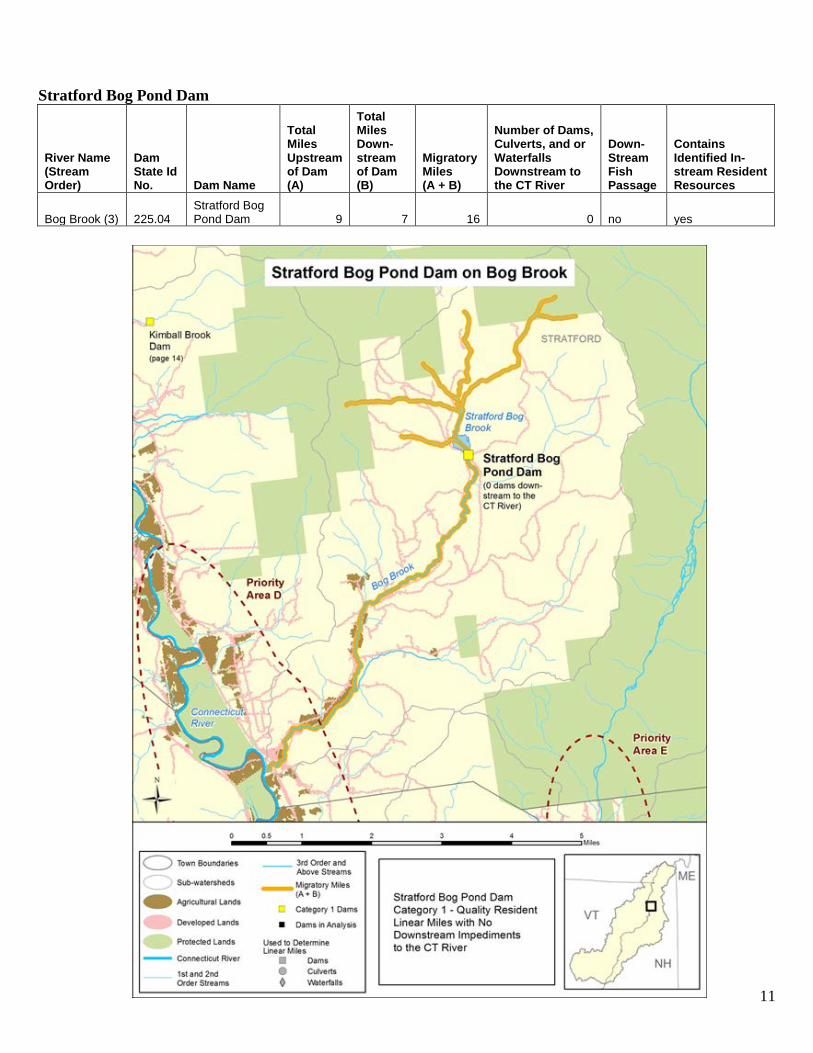
Stratford Bog Pond Dam
River Name (Stream Order)
Dam State Id No. Dam Name
Total Miles Upstream of Dam (A)
Total Miles Down- stream of Dam (B)
Migratory Miles (A + B)
Number of Dams, Culverts, and or Waterfalls Downstream to the CT River
Down- Stream Fish Passage
Contains Identified In-stream Resident Resources
Bog Brook (3) 225.04 Stratford Bog Pond Dam 9 7 16 0 no yes
12
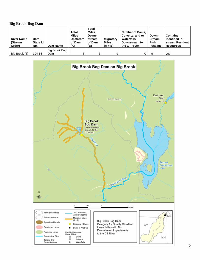
Big Brook Bog Dam
River Name (Stream Order)
Dam State Id No. Dam Name
Total Miles Upstream of Dam (A)
Total Miles Down- stream of Dam (B)
Migratory Miles (A + B)
Number of Dams, Culverts, and or Waterfalls Downstream to the CT River
Down- Stream Fish Passage
Contains Identified In-stream Resident Resources
Big Brook (3) 194.14 Big Brook Bog Dam 6 3 9 0 no yes
13
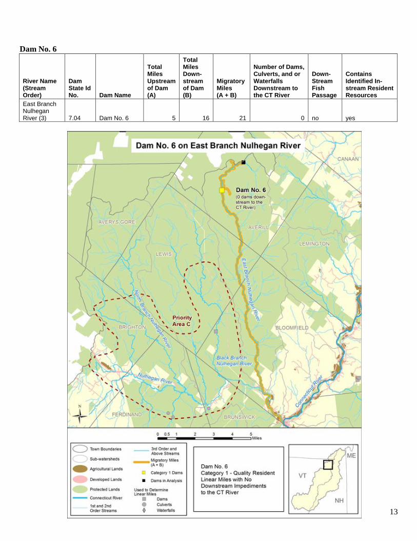
Dam No. 6
River Name (Stream Order)
Dam State Id No. Dam Name
Total Miles Upstream of Dam (A)
Total Miles Down- stream of Dam (B)
Migratory Miles (A + B)
Number of Dams, Culverts, and or Waterfalls Downstream to the CT River
Down- Stream Fish Passage
Contains Identified In-stream Resident Resources
East Branch Nulhegan River (3) 7.04 Dam No. 6 5 16 21 0 no yes
14
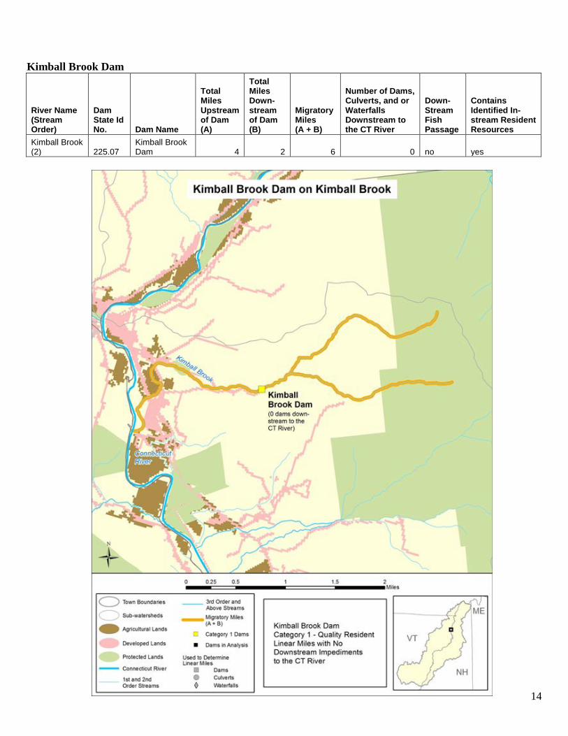
Kimball Brook Dam
River Name (Stream Order)
Dam State Id No. Dam Name
Total Miles Upstream of Dam (A)
Total Miles Down- stream of Dam (B)
Migratory Miles (A + B)
Number of Dams, Culverts, and or Waterfalls Downstream to the CT River
Down- Stream Fish Passage
Contains Identified In-stream Resident Resources
Kimball Brook (2) 225.07
Kimball Brook Dam 4 2 6 0 no yes

15
Category 2 - High Priority: Quality Resident Linear Miles with One or More Downstream Impediments to the Connecticut River Wild Ammonoosuc River Dam
River Name (Stream Order)
Dam State Id No.
Dam Name (H - Hydroelectric Dam)
Total Miles Upstream of Dam (A)
Total Miles Down- stream of Dam (B)
Migratory Miles (A + B)
Number of Dams, Culverts, and or Waterfalls Downstream to the CT River
Down- Stream Fish Passage
Contains Identified In-stream Resident Resources
Wild Ammonoosuc River (4) 132.01
Wild Ammonoosuc River Dam 71 5 76 2 no yes
16
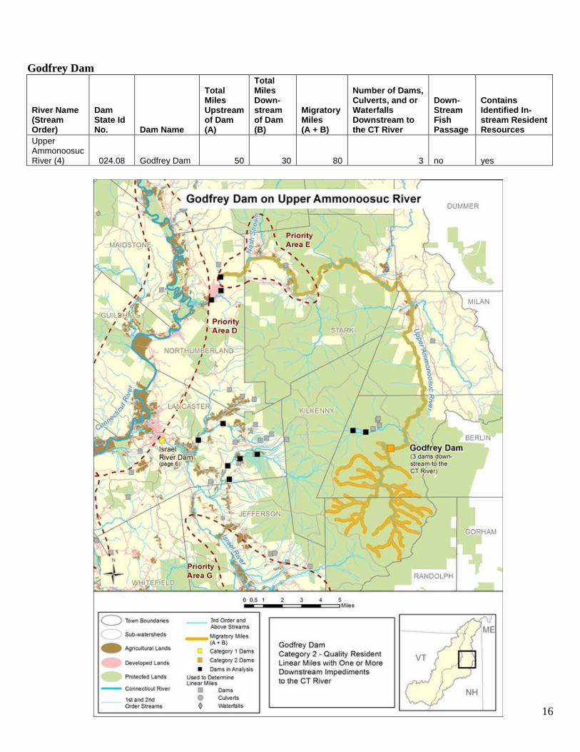
Godfrey Dam
River Name (Stream Order)
Dam State Id No. Dam Name
Total Miles Upstream of Dam (A)
Total Miles Down- stream of Dam (B)
Migratory Miles (A + B)
Number of Dams, Culverts, and or Waterfalls Downstream to the CT River
Down- Stream Fish Passage
Contains Identified In-stream Resident Resources
Upper Ammonoosuc River (4) 024.08 Godfrey Dam 50 30 80 3 no yes

17
Mill Brook Hydro Dam (H)
River Name (Stream Order)
Dam State Id No.
Dam Name (H - Hydroelectric Dam)
Total Miles Up-stream of Dam (A)
Total Miles Down- stream of Dam (B)
Migratory Miles (A + B)
Number of Dams, Culverts, and or Waterfalls Downstream to the CT River
Down- Stream Fish Passage
Contains Identified In-stream Resident Resources
Mill Brook (4) 125.16 Mill Brook Hydro Dam (H) 46 13 59 1 no yes
18
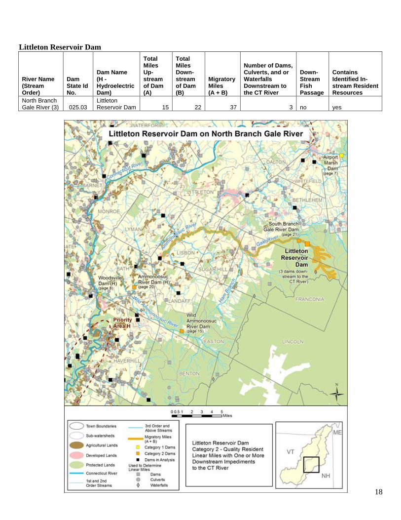
Littleton Reservoir Dam
River Name (Stream Order)
Dam State Id No.
Dam Name (H - Hydroelectric Dam)
Total Miles Up-stream of Dam (A)
Total Miles Down- stream of Dam (B)
Migratory Miles (A + B)
Number of Dams, Culverts, and or Waterfalls Downstream to the CT River
Down- Stream Fish Passage
Contains Identified In-stream Resident Resources
North Branch Gale River (3) 025.03
Littleton Reservoir Dam 15 22 37 3 no yes
19
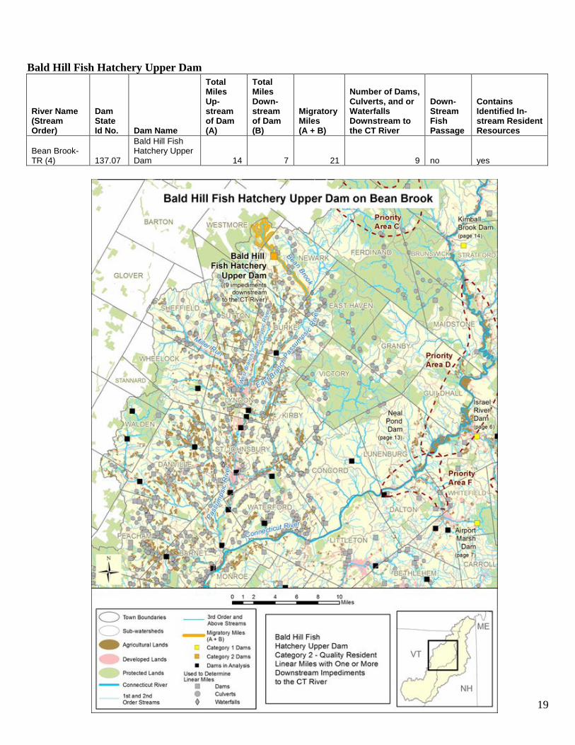
Bald Hill Fish Hatchery Upper Dam
River Name (Stream Order)
Dam State Id No. Dam Name
Total Miles Up-stream of Dam (A)
Total Miles Down- stream of Dam (B)
Migratory Miles (A + B)
Number of Dams, Culverts, and or Waterfalls Downstream to the CT River
Down- Stream Fish Passage
Contains Identified In-stream Resident Resources
Bean Brook-TR (4) 137.07
Bald Hill Fish Hatchery Upper Dam 14 7 21 9 no yes
20
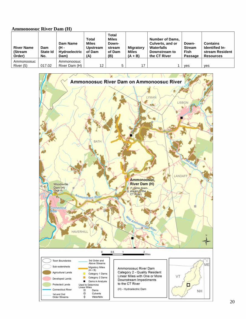
Ammonoosuc River Dam (H)
River Name (Stream Order)
Dam State Id No.
Dam Name (H - Hydroelectric Dam)
Total Miles Upstream of Dam (A)
Total Miles Down- stream of Dam (B)
Migratory Miles (A + B)
Number of Dams, Culverts, and or Waterfalls Downstream to the CT River
Down- Stream Fish Passage
Contains Identified In-stream Resident Resources
Ammonoosuc River (5) 017.02
Ammonoosuc River Dam (H) 12 5 17 1 yes yes
21
South Branch Gale River Dam
River Name (Stream Order)
Dam State Id No.
Dam Name (H - Hydroelectric Dam)
Total Miles Upstream of Dam (A)
Total Miles Down- stream of Dam (B)
Migratory Miles (A + B)
Number of Dams, Culverts, and or Waterfalls Downstream to the CT River
Down- Stream Fish Passage
Contains Identified In-stream Resident Resources
South Branch Gale River (3) 025.11
South Branch Gale River Dam 9 21 30 3 no yes

22
Zealand River Dam
River Name (Stream Order)
Dam State Id No.
Dam Name (H - Hydroelectric Dam)
Total Miles Upstream of Dam (A)
Total Miles Down- stream of Dam (B)
Migratory Miles (A + B)
Number of Dams, Culverts, and or Waterfalls Downstream to the CT River
Down- Stream Fish Passage
Contains Identified In-stream Resident Resources
Zealand River (3) 025.04
Zealand River Dam 8 13 21 5 no yes
23
Prioritization Methodology Step 1 - Study Area The study area is the entire Upper Connecticut River Mitigation and Enhancement Fund region (Appendix A: Map 1, page 28 and Map 2, page 29). Step 2 - Resources The assessment procedures and results for each of the 108 sub-watersheds were based on the following: 1. River/Stream Connectivity Impediments
a. Dams,6 culverts,7 and waterfalls8 were the basis of this analysis. The following criteria were used to reduce the number of dams, culverts, and waterfalls in the analysis to those that were deemed to be most relevant for the purposes of this study (in-stream connectivity, with a nexus, to larger river ecosystem) (Map 1, page 5).
1. Dams a. Dams included in the priority ranking analysis are designated as affecting the
passage of organisms, and i. Are <100ft from all 3rd order and higher river/stream reaches, and all 1st
and 2nd order streams that flow directly into the Connecticut River (note: due to registration errors some dams did not align with the streams, so a 100 ft buffer was applied).
ii. Are rated as affecting the passage of aquatic organisms that do not contain both upstream and downstream fish passage (Appendix B: Table 1, page 30).
b. Dams not included in the priority ranking analysis (but are used to determine linear miles of connectivity) are those dams designated as not affecting the passage of organisms, or
i. Are located at or near the end of a 1st order stream (less than 0.5 miles). ii. Are built on waterfalls (e.g. McIndoe Falls Dam because built on
McIndoe Falls) (Appendix B: Table 2, page 30). iii. Are located on 1st and 2nd order streams that do not flow directly into the
Connecticut River.
6 Dam location and status were reviewed by fisheries biologists, Diane Timmins, Len Gerardi and Rich Kirn. Dams included in the analysis were approved by the biologist. If the biologist was unsure of the dam status, the dam was included. 7 Culvert data provided by the VT DEC, Agency of Natural Resources, https://anrnode.anr.state.vt.us/SGA/datasets/exports.aspx?rowFilter=Basin,the Profile School’s Ammonoosuc River Fish Barrier Study, 2013 Upper Connecticut Mitigation and Enhancement, Priority Area 6, Stream Crossing Assessment Project, Evaluating Aquatic Organism Passage (AOP) by the Connecticut River Watershed Council and Trout Unlimited and the NH Geological Survey at NHDES. 8 VT waterfall data is provided by the Windham Regional Commission for the West River Watershed Vermont. NH waterfall data is provided by Parsons, Greg and Kate B. Watson. 2010. New England Waterfalls A Guide to More Than 400 Cascades and Waterfalls. The Countryman Press, Woodstock, VT. http://newenglandwaterfalls.com/ and US Geological Survey/NH OEP.
24
c. Dams not included in the priority ranking analysis are those dams designated as not affecting the passage of organisms and not used to determine linear miles of dams and culverts.
i. Are not affecting the passage of aquatic organisms. Dams with up and down stream fish passage (Appendix B: Table 1, page 30)
ii. Are > 100ft from all streams. iii. NH dams with a status of ruins, not built and removed. iv. VT dams as determined by state biologist and with a status of deleted and
removed. 2. Culverts
a. Culverts included in the analysis which are designated as affecting the passage of organisms used to determine linear miles of dams, and
i. Are <50ft from all streams9 (note: due to registration errors some culverts did not align with the streams, so a 50 ft buffer was applied).
ii. Aquatic Organism Passage (AOP) level of either gray, orange, or red:10 (Appendix B: Table 3, page 31):
1. Gray level - reduced AOP for all aquatic organisms. 2. Orange level - no AOP for all aquatic organisms except adult
salmonids. 3. Red level - no AOP for all aquatic organisms including adult
salmonids. 3. Waterfalls
a. Waterfalls included in the analysis which are designated as affecting the passage of organisms used to determine linear miles of dams, and
i. Are <50ft from all streams (note: due to registration errors some waterfalls did not align with the streams, so a 50 ft. buffer was applied).
2. In-stream Resources
a. The following in-stream resources identified in the Priority Riparian Areas in the Upper Connecticut River Mitigation and Enhancement Fund Service Area report were used to prioritize dams. These include:11
i. Special Concern, Threatened and Endangered Animal Species12 1. Federal Listed Species
a. Dwarf Wedge mussel13 2. State Special Concern Species
a. Finescale Dace b. Northern Redbelly Dace
9 Dam (100ft) and culvert (50ft) registrations errors differ due to stream order. 10 Vermont Stream Geomorphic Assessment, Agency of Natural Resources, https://anrnode.anr.state.vt.us/sga/. 11 The following in-stream resources were not included in this analysis: Osprey and Bald Eagle since their movements are not directly affected by stream/river impediments; Eastern Brook Trout Protection and Enhancement Watersheds were eliminated due to recommendations of expert opinion (Rich Kern, Mark Prout, and Dianne Timmins, personal communications and emails) that this data is not likely at a resolution scale to be useful for this analysis and could lead to incorrect prioritizations. 12 Special Concern Species, Threatened, and Endangered Animal Species information was provided by NH Natural Heritage Bureau (2016), NH Fish and Game (2016) , and VT Fish & Wildlife Dept. (2016). 13 Dwarf Wedge mussel location information is represented as a linear macrosite based on Ethan Nedeau 2009 publication Distribution, Threats, and Conservation of the Dwarf Wedge mussel (Alasmidonta heterodon) in the Middle and Northern Macrosites of the Upper Connecticut River and is represented separately from the Special Concern Species. This information has not changed based on correspondence with Ethan Nedeau.

25
c. Wood Turtles d. Northern Leopard Frogs e. Round Whitefish
ii. Aquatic Areas 1. River and Stream (Lotic) Cores – (2010 – University of Massachusetts - Connect the
Connecticut project) a. These areas were identified as representing relatively high ecological integrity,
high current habitat values for brook trout, and habitat for anadromous fish.
26
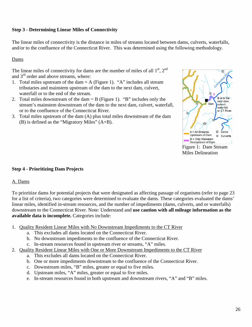
Step 3 - Determining Linear Miles of Connectivity The linear miles of connectivity is the distance in miles of streams located between dams, culverts, waterfalls, and/or to the confluence of the Connecticut River. This was determined using the following methodology. Dams The linear miles of connectivity for dams are the number of miles of all 1st, 2nd and 3rd order and above streams, where: 1. Total miles upstream of the dam = A (Figure 1). “A” includes all stream
tributaries and mainstem upstream of the dam to the next dam, culvert, waterfall or to the end of the stream.
2. Total miles downstream of the dam = B (Figure 1). “B” includes only the stream’s mainstem downstream of the dam to the next dam, culvert, waterfall, or to the confluence of the Connecticut River.
3. Total miles upstream of the dam (A) plus total miles downstream of the dam (B) is defined as the “Migratory Miles” (A+B).
Step 4 - Prioritizing Dam Projects A. Dams To prioritize dams for potential projects that were designated as affecting passage of organisms (refer to page 23 for a list of criteria), two categories were determined to evaluate the dams. These categories evaluated the dams’ linear miles, identified in-stream resources, and the number of impediments (dams, culverts, and or waterfalls) downstream to the Connecticut River. Note: Understand and use caution with all mileage information as the available data is incomplete. Categories include: 1. Quality Resident Linear Miles with No Downstream Impediments to the CT River
a. This excludes all dams located on the Connecticut River. b. No downstream impediments to the confluence of the Connecticut River. c. In-stream resources found in upstream river or streams, “A” miles.
2. Quality Resident Linear Miles with One or More Downstream Impediments to the CT River a. This excludes all dams located on the Connecticut River. b. One or more impediments downstream to the confluence of the Connecticut River. c. Downstream miles, “B” miles, greater or equal to five miles. d. Upstream miles, “A” miles, greater or equal to five miles. e. In-stream resources found in both upstream and downstream rivers, “A” and “B” miles.
Figure 1: Dam Stream Miles Delineation

27
Developing Summary Table for Decision Tree For a list of all dams that were designated as affecting the passage of organisms within the study area refer to Appendix C: Table 1 on page 34. For dams on the Connecticut River refer to Appendix C: Table 2 on page 39. The dams are ordered by upstream miles (A miles) in a descending order.

28
Appendix A: Upper Connecticut River MEF Study Area and Sub-watersheds Map 1 Upper Connecticut River MEF Study Area HUC 12 Sub-watersheds

29
Map 2 Upper Connecticut River MEF Study Area HUC-10 Sub-watersheds

30
Appendix B: Tables containing Dam and Culvert Information Table 1 Dams with Upstream and/or Downstream Passage14 River Name Dam Id
Number Dam Name Upstream
Passage Downstream Passage
Connecticut River
94.14 Wilder Dam Yes Yes 175.03 Ryegate/Dodge Falls No Yes 12.14 McIndoes Falls Dam No Interim Facilities
Ammonoosuc River
112.03 Woodsville Dam No Yes 17.02 Ammonoosuc Dam No Yes 138.01 Lisbon Dam No Yes 140.01 Littleton Dam/Apthorp No Yes
Passumpsic River
12.04 Roy Brothers Mfg. Co./East Barnet Dam
No Yes
12.03 Passumpsic Dam No Yes 179.03 Gage Dam No Yes 179.01 Arnold Falls Dam No Interim 179.12 Pierce Mills Dam No Interim 119.03 Vail Dam No Interim
Third Branch White River 21.01 Bethel Mills No Yes Table 2 Dams Built on Waterfalls River Name Dam Id
Number Dam Name Impediment Impediment Name
Sleepers River 179.14 U.S. Fish Hatchery Cascade Emerson Falls Connecticut River 12.14 McIndoes Falls15 Waterfall McIndoe Falls Wells River 138.05 Boltonville No. 11 Waterfall Boltonville Falls Stevens River 12.06 Barnet No. 14 Cascade Barnet Falls Phillips Brook 221.10 Crystal Falls Hydro Dam Cascade Crystal Falls Third Branch White River
21.01 Bethel Mills Waterfall Bethel Falls
14Connecticut River Coordinator’s Office, Restoring Migratory Fish to the Connecticut River Basin, Appendix G. Fish Passage Requirements Within the Connecticut River Basin, http://www.fws.gov/r5crc/stuff/appg.html#table. Note: The status of passage for some dams may change with the decision to discontinue the Connecticut River Atlantic salmon restoration program. 15 In the digital data base this is listed as a single dam, though it actually includes three dams – McIndoes, Comerford, and Moore that are located on the inundated 15 Miles Falls reach.

31
Table 3 Definition of Aquatic Organism Passage The following information is provided strictly for background information. MEF is not funding individual culvert removal projects. MEF may fund culvert projects as part of a larger, watershed-level initiative, or culvert replacements that are directly related to further improving AOP at one or more identified dam connectivity improvement projects and known impacted in-stream resources and significant connectivity miles are involved. Aquatic Organism Passage, Geomorphic Compatibility, Retrofit Potential16
AOP Coarse Screen AOP Geomorphic Compatibility AOP Retrofit Potential
Green Full AOP for all aquatic organisms
Green
Structure is fully compatible geomorphically
H High probability the existing culvert can be retrofitted 20 < GC < 25
Gray Reduced AOP for all aquatic organisms
Light Green
Structure is mostly compatible geomorphically
M Medium probability the existing culvert can be retrofitted 15 < GC < 20
Orange
No AOP for all aquatic organisms except adult salmonids
Yellow
Structure is partially compatible geomorphically L Low probability the
existing culvert can be retrofitted 10 < GC < 15
Red
No AOP for all aquatic organisms including adult salmonids
Orange
Structure is mostly incompatible geomorphically
Pos 1
For strong swimmers 5 < GC < 10 (left)
Red
Structure is fully incompatible geomorphically
Pos 2
For moderate swimmers 0 < GC < 5 (center)
Pos 3
For weak swimmers (right)
16 Vermont Stream Geomorphic Assessment, Agency of Natural Resources, https://anrnode.anr.state.vt.us/sga/
32
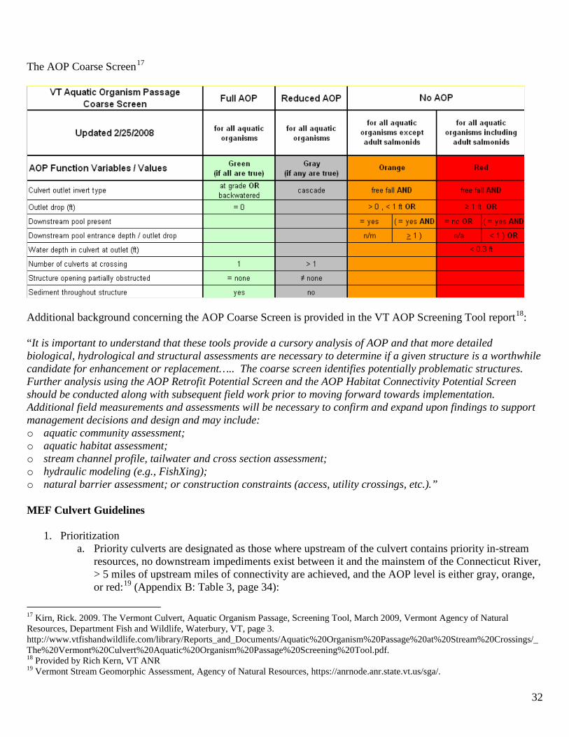
The AOP Coarse Screen17
Additional background concerning the AOP Coarse Screen is provided in the VT AOP Screening Tool report18: “It is important to understand that these tools provide a cursory analysis of AOP and that more detailed biological, hydrological and structural assessments are necessary to determine if a given structure is a worthwhile candidate for enhancement or replacement….. The coarse screen identifies potentially problematic structures. Further analysis using the AOP Retrofit Potential Screen and the AOP Habitat Connectivity Potential Screen should be conducted along with subsequent field work prior to moving forward towards implementation. Additional field measurements and assessments will be necessary to confirm and expand upon findings to support management decisions and design and may include: o aquatic community assessment; o aquatic habitat assessment; o stream channel profile, tailwater and cross section assessment; o hydraulic modeling (e.g., FishXing); o natural barrier assessment; or construction constraints (access, utility crossings, etc.).” MEF Culvert Guidelines
1. Prioritization a. Priority culverts are designated as those where upstream of the culvert contains priority in-stream
resources, no downstream impediments exist between it and the mainstem of the Connecticut River, > 5 miles of upstream miles of connectivity are achieved, and the AOP level is either gray, orange, or red:19 (Appendix B: Table 3, page 34):
17 Kirn, Rick. 2009. The Vermont Culvert, Aquatic Organism Passage, Screening Tool, March 2009, Vermont Agency of Natural Resources, Department Fish and Wildlife, Waterbury, VT, page 3. http://www.vtfishandwildlife.com/library/Reports_and_Documents/Aquatic%20Organism%20Passage%20at%20Stream%20Crossings/_The%20Vermont%20Culvert%20Aquatic%20Organism%20Passage%20Screening%20Tool.pdf. 18 Provided by Rich Kern, VT ANR 19 Vermont Stream Geomorphic Assessment, Agency of Natural Resources, https://anrnode.anr.state.vt.us/sga/.

33
i. Gray level - reduced AOP for all aquatic organisms. ii. Orange level - no AOP for all aquatic organisms except adult salmonids.
iii. Red level - no AOP for all aquatic organisms including adult salmonids. 2. Low priority culverts are those designated as not affecting the passage of organisms (Green level - full
AOP for all aquatic organisms), are located at or near the end of a 1st order stream (less than 0.5 miles), < 5 miles of connectivity are achieved, and/or no in-stream resources are located upstream of the culvert.
3. Determining Linear Miles of Connectivity a. Total miles upstream of the culvert = A
(Figure 2). “A” includes all stream tributaries and mainstem upstream of the culvert to the next dam, culvert, waterfall, or to the end of the stream.
b. Total miles downstream of the culvert = B (Figure 2). “B” includes only the stream’s mainstem downstream to the next dam, culvert, waterfall, or the confluence of the Connecticut River.
c. Total miles upstream of the culvert (A) plus total miles downstream of the culvert (B) is defined as the “Migratory Miles” (A+B).
Figure 2: Culvert Stream Mile Delineation

34
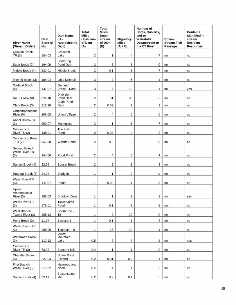
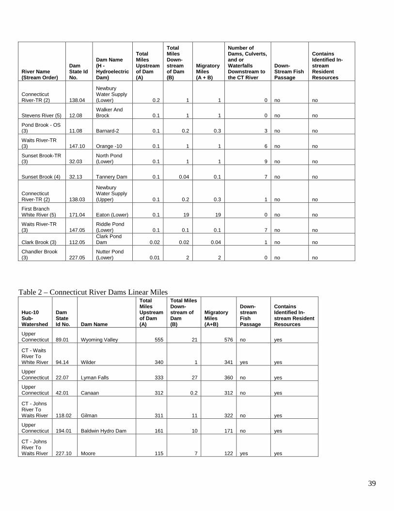
Appendix C: Dam Linear Miles Tables Table 1 – Dams that Affect the Passage of Organisms that are not on the Connecticut River
River Name (Stream Order)
Dam State Id No.
Dam Name (H - Hydroelectric Dam)
Total Miles Upstream of Dam (A)
Total Miles Down- stream of Dam (B)
Migratory Miles (A + B)
Number of Dams, Culverts, and or Waterfalls Downstream to the CT River
Down- Stream Fish Passage
Contains Identified In-stream Resident Resources
Upper Ammonoosuc River (5) 182.04 Red Dam 220 1 221 2 no yes
Israel River (4) 131.03 Israel River Dam 218 3 221 0 no yes
Ammonoosuc River (5) 138.01
Lower Lisbon Dam (H) 214 6 220 2 yes yes
Passumpsic River (6) 119.03 Vail (H) 150 1 151 6 yes no
Waits River (6) 24.01 Bradford (H) 95 1 96 0 no no
Ammonoosuc River (4) 025.01
Bethlehem Dam 78 8 86 4 no yes
Wild Ammonoosuc River (4) 132.01
Wild Ammonoosuc River Dam 71 5 76 2 no yes
Ammonoosuc River (4) 140.01
Apthorp Dam (H) 59 15 74 3 yes no
Passumpsic River (6) 12.04
Roy Bros. Mfg. Co. (H) 54 1 55 0 yes no
Upper Ammonoosuc River (4) 024.08 Godfrey Dam 50 30 80 3 no yes
Carroll Stream (4) 252.11
Airport Marsh Dam 49 11 60 0 no yes
Mill Brook (4) 125.16
Mill Brook Hydro Dam (H) 46 13 59 1 no yes
Garland Brook (3) 131.24
Garland Brook Dam 36 2 38 2 no yes
Passumpsic River (6) 179.03 Gage (H) 36 2 38 2 yes yes
Second Branch White River (5) 21.03 Hyde 34 28 62 0 no no
Ammonoosuc River (5) 112.03
Woodsville Dam (H) 34 0.2 34 0 yes yes
Joes Brook (4) 58.02 West Danville No. 15 (H) 34 4 38 1 no no
East Branch Passumpsic River (5) 37.01
East Burke (Lumber Co.) 31 9 40 7 no yes
Otter Brook (4) 131.05 Otter Brook Dam 31 4 35 1 no no
Pettyboro Brook (3) 017.14
Pettyboro Brook Hydro (H) 29 4 33 2 no yes

35
River Name (Stream Order)
Dam State Id No.
Dam Name (H - Hydroelectric Dam)
Total Miles Upstream of Dam (A)
Total Miles Down- stream of Dam (B)
Migratory Miles (A + B)
Number of Dams, Culverts, and or Waterfalls Downstream to the CT River
Down- Stream Fish Passage
Contains Identified In-stream Resident Resources
Steam Mill Brook (4) 218.02 Goslants Mill 27 7 34 2 no no
First Branch White River (5) 47.03 Whitney 26 4 30 6 no no
Mohawk River (5) 049.03 Washburn Mill Dam 25 8 33 0 no yes
Bog Brook (3) 252.12 Bog Brook 24 9 33 0 no no
Ogontz Brook (4) 138.02 Ogontz Brook Dam 23 4 27 3 no yes
East Inlet (4) 194.08 East Inlet Dam 21 2 23 0 no yes
Middle Brook (4) 231.03 Geer 18 3 21 5 no no
Tabor Branch (4) 53.04 Corinth-4 18 0.3 18 2 no no
Deception Brook (3) 039.01
Cherry Mountain Brook Dam 18 1 19 6 no yes
Oliverian Stream (4) 112.02
Oliverian Stream Dam 18 4 22 0 no no
Clay Brook (3) 146.26 Post Pond Outlet Dam 18 3 21 0 no no
Sleepers River (4) 58.10
Fairbanks Morse 17 4 21 5 no no
Second Branch White River (5) 162.02 Gulf Road 16 9 25 1 no no
Passumpsic River (6) 119.02
Great Falls (H) 16 2 18 5 no no
Crawford Brook (3) 039.03
Recreation Lake 16 3 19 6 no yes
First Branch White River (5) 211.03 Grants Mill 16 3 19 5 no no
Caleb Brook (4) Private Dam - Caleb Brook 16 2 18 2 no no
Ompompanoosuc River (5) 206.18
Montague Rod and Reel Co. (Upper) 15 5 20 4 no no
First Branch White River (5) 211.06
Farnham Bros. 15 0.2 15 4 no no
North Branch Gale River (3) 025.03
Littleton Reservoir Dam 15 22 37 3 no yes
Oliverian Brook (3) 023.06
Oliverian Dam, Baker Site 1 15 6 21 1 no yes
Bean Brook-TR (4) 137.07
Bald Hill Fish Hatchery Upper Dam 14 7 21 9 no yes
Upper Ammonoosuc River (5) 182.02
Weston Dam (H) 14 2 16 0 no no

36
River Name (Stream Order)
Dam State Id No.
Dam Name (H - Hydroelectric Dam)
Total Miles Upstream of Dam (A)
Total Miles Down- stream of Dam (B)
Migratory Miles (A + B)
Number of Dams, Culverts, and or Waterfalls Downstream to the CT River
Down- Stream Fish Passage
Contains Identified In-stream Resident Resources
Ompompanoosuc River-TR (4) 206.01 Lake Fairlee 14 2 16 5 no no
Jail Brook (4) 47.04 Lyons Mill 13 2 15 7 no no
Ammonoosuc River (5) 017.02
Ammonoosuc River Dam (H) 12 5 17 1 yes yes
Pearl Lake (3) 138.06 Pearl Lake Dam 12 4 16 3 no yes
Ricker Pond-TR (4) 88.05 Lake Groton 12 1 13 3 no no
Passumpsic River (6) 179.01
Arnold Falls (H) 11 2 13 3 yes no
Passumpsic River (6) 12.03
Passumpsic (H) 11 5 16 1 yes no
Marden Brook (3) 131.30 Marden Brook Hydro 10 7 17 1 no no
Ogontz Brook (3) 145.04 Ogontz Camp Dam 10 3 13 4 no yes
First Branch White River (5) 171.03 Eaton (Upper) 10 0.1 10 1 no no
Miles Stream (3) 52.01 Miles Pond 9 5 14 0 no no
Charles Brown Brook (3) 146.01
Norwich Reservoir 9 3 12 1 no yes
Mohawk River - TR (4) 049.28
Cummings Fire Pond Dam 9 1 10 1 no yes
West Branch Ammonoosuc (3) 024.21
West Branch Dam 9 32 41 3 no no
Mill Brook (3) 132.04 Chandler Pond Dam 9 4 13 3 no yes
Sunset Brook (4) 32.04 Sunset Lake 9 0.1 9 8 no no
Bog Brook (3) 225.04 Stratford Bog Pond Dam 9 7 16 0 no yes
Connecticut River-TR (3) 73.01 Lake Morey 9 0.1 9 3 no no
South Branch Gale River (3) 025.11
South Branch Gale River Dam 9 21 30 3 no yes
Zealand River (3) 025.04 Zealand River Dam 8 13 21 5 no yes
Pond Brook (3) 11.01 Silver Lake 8 0.5 9 5 no no
Garland Brook - TR (3) Garland - Mill 8 1 9 2 no yes
Natural Swale (3) 108.10 Farm Pond 8 1 9 0 no no
Johns River - TR (3) 252.09
Burns Lake Dam 7 9 16 0 no no
Halls Brook (4) 138.10 Old Stone (H) 7 4 11 0 no no

37
River Name (Stream Order)
Dam State Id No.
Dam Name (H - Hydroelectric Dam)
Total Miles Upstream of Dam (A)
Total Miles Down- stream of Dam (B)
Migratory Miles (A + B)
Number of Dams, Culverts, and or Waterfalls Downstream to the CT River
Down- Stream Fish Passage
Contains Identified In-stream Resident Resources
Wells River (4) 138.06 Adams Paper Co. (H) 7 1 8 0 no no
South Branch Wells River (3) 88.06 Noyes Pond 7 14 21 2 no no
Tuttle Brook (3) 039.04 Tuttle Brook Dam 6 0.3 6 6 no yes
Waterman Brook (3) 112.09
Upper Mountain Lake Dam 6 0.5 7 2 no yes
Stiles Brook (3) 227.01 Stiles Pond 6 0.2 6 3 no no
Big Brook (3) 194.14 Big Brook Bog Dam 6 3 9 0 no yes
Stevens River (4) 12.01 Harveys Lake 6 7 13 3 no no
Camp Brook (3) 108.07 Storrs Pond Dam 5 0.5 6 0 no no
Dartmouth Brook (3) 039.20
Dartmouth Brook Dam 5 0.1 5 7 no yes
East Branch Nulhegan River (3) 7.04 Dam No. 6 5 16 21 0 no yes
First Branch White River (5) 47.05 Reed Mill 4 0.01 4 8 no no
Steam Mill Brook-TR (3) 218.01 Coles Pond 4 5 9 3 no no
Kimball Brook (2) 225.07 Kimball Brook Dam 4 2 6 0 no yes
Tabor Branch (4) 53.03 Worthley 4 9 13 1 no no
Middle Brook (3) 231.02 Keefe Site 2 4 1 5 11 no no
Mink Brook - TR (3) 108.09
TR Mink Brook Dam 4 9 13 0 no yes
Passumpsic River (6) 179.12
Pierce Mills (H) 4 5 9 4 yes no
Waits River - TR (3) 208.10 Topsham - 10 4 0.1 4 3 no no
Waits River-TR (3) 147.04
Riddle Pond (Upper) 4 0.1 4 8 no no
Camp Brook (3) 108.06
Upper Reservoir Dam 4 2 6 1 no no
Sunset Brook-TR (3) 32.02
North Pond (Upper) 4 0.1 4 10 no no
South Wheelock Branch-TR (3) 241.01
Chandler Pond 4 0.1 4 12 no no
East Branch Nulhegan River (3) 7.05 Conway 3 3 6 1 no yes
Mill Brook (3) 157.04 Johnson 3 0.4 3 7 no no
Wells River (4) 88.01 Ricker Pond 3 11 14 2 no no
38
River Name (Stream Order)
Dam State Id No.
Dam Name (H - Hydroelectric Dam)
Total Miles Upstream of Dam (A)
Total Miles Down- stream of Dam (B)
Migratory Miles (A + B)
Number of Dams, Culverts, and or Waterfalls Downstream to the CT River
Down- Stream Fish Passage
Contains Identified In-stream Resident Resources
Quation Brook-TR (3) 184.03
Crescent Lake 3 1 4 7 no no
Scott Brook (2) 194.09 Scott Bog Pond Dam 3 3 6 0 no no
Middle Brook (4) 231.01 Middle Brook 3 0.1 3 7 no no
Mitchell Brook (3) 184.04 Lake Mitchell 3 2 5 4 no no
Garland Brook (4) 131.07
Garland Brook II Dam 3 7 10 1 no yes
No. 9 Brook (3) 024.18 Diversion Pond Dam 2 31 33 3 no no
Clark Brook (3) 112.20 Clark Pond Dam 2 0.02 2 1 no no
Ompompanoosuc River (6) 206.08 Union Village 2 4 6 0 no no
Abbot Brook-TR (3) 200.07 Malmquist 2 1 3 7 no no
Connecticut River-TR (2) 138.01
The Fish Pond 2 0.02 2 2 no no
Connecticut River - TR (2) 057.08 Wildlife Pond 2 0.5 3 0 no no
Second Branch White River-TR (3) 244.06 Rood Pond 2 4 6 4 no no
Sunset Brook (4) 32.09 Sunset Brook 2 6 8 3 no no
Roaring Brook (3) 24.02 Blodgett 1 1 2 0 no no
Waits River-TR (3) 147.07 Peake 1 0.02 1 3 no no
Upper Ammonoosuc River (5) 182.03 Brooklyn Dam 1 1 2 1 no yes
Wells River-TR (3) 175.01
Ticklenaked Pond 1 0.1 1 5 no no
West Branch Tweed River (3) 188.12
Sherburne - 12 1 9 10 0 no no
Pond Brook (3) 11.07 Barnard-1 1 0.1 1 4 no no
Waits River - TR (3) 208.09 Topsham - 9 1 18 19 1 no no
Waterman Brook (3) 112.12
Lower Mountain Lake 0.5 6 7 1 no yes
Connecticut River-TR (3) 73.02 Bancroft Mill 0.4 1 1 0 no no
Chandler Brook (3) 227.04
Nutter Pond (Upper) 0.2 0.01 0.2 1 no no
First Branch White River (5) 211.02
Haywood and Noble 0.2 4 4 3 no no
Sunset Brook (4) 32.11 Buxtonssaes Mill 0.2 0.2 0.4 5 no no
39
River Name (Stream Order)
Dam State Id No.
Dam Name (H - Hydroelectric Dam)
Total Miles Upstream of Dam (A)
Total Miles Down- stream of Dam (B)
Migratory Miles (A + B)
Number of Dams, Culverts, and or Waterfalls Downstream to the CT River
Down- Stream Fish Passage
Contains Identified In-stream Resident Resources
Connecticut River-TR (2) 138.04
Newbury Water Supply (Lower) 0.2 1 1 0 no no
Stevens River (5) 12.08 Walker And Brock 0.1 1 1 0 no no
Pond Brook - OS (3) 11.08 Barnard-2 0.1 0.2 0.3 3 no no
Waits River-TR (3) 147.10 Orange -10 0.1 1 1 6 no no
Sunset Brook-TR (3) 32.03
North Pond (Lower) 0.1 1 1 9 no no
Sunset Brook (4) 32.13 Tannery Dam 0.1 0.04 0.1 7 no no
Connecticut River-TR (2) 138.03
Newbury Water Supply (Upper) 0.1 0.2 0.3 1 no no
First Branch White River (5) 171.04 Eaton (Lower) 0.1 19 19 0 no no
Waits River-TR (3) 147.05
Riddle Pond (Lower) 0.1 0.1 0.1 7 no no
Clark Brook (3) 112.05 Clark Pond Dam 0.02 0.02 0.04 1 no no
Chandler Brook (3) 227.05
Nutter Pond (Lower) 0.01 2 2 0 no no
Table 2 – Connecticut River Dams Linear Miles
Huc-10 Sub-Watershed
Dam State Id No. Dam Name
Total Miles Upstream of Dam (A)
Total Miles Down-stream of Dam (B)
Migratory Miles (A+B)
Down-stream Fish Passage
Contains Identified In-stream Resident Resources
Upper Connecticut 89.01 Wyoming Valley 555 21 576 no yes
CT - Waits River To White River 94.14 Wilder 340 1 341 yes yes
Upper Connecticut 22.07 Lyman Falls 333 27 360 no yes
Upper Connecticut 42.01 Canaan 312 0.2 312 no yes
CT - Johns River To Waits River 118.02 Gilman 311 11 322 no yes
Upper Connecticut 194.01 Baldwin Hydro Dam 161 10 171 no yes
CT - Johns River To Waits River 227.10 Moore 115 7 122 yes yes
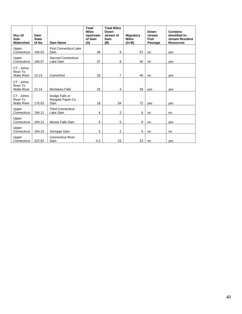
40
Huc-10 Sub-Watershed
Dam State Id No. Dam Name
Total Miles Upstream of Dam (A)
Total Miles Down-stream of Dam (B)
Migratory Miles (A+B)
Down-stream Fish Passage
Contains Identified In-stream Resident Resources
Upper Connecticut 194.02
First Connecticut Lake Dam 48 9 57 no yes
Upper Connecticut 194.07
Second Connecticut Lake Dam 37 8 45 no yes
CT - Johns River To Waits River 12.13 Comerford 33 7 40 no yes
CT - Johns River To Waits River 12.14 McIndoes Falls 25 4 29 yes yes
CT - Johns River To Waits River 175.03
Dodge Falls or Ryegate Paper Co. Dam 18 54 72 yes yes
Upper Connecticut 194.11
Third Connecticut Lake Dam 4 2 6 no no
Upper Connecticut 194.13 Moose Falls Dam 4 5 9 no yes
Upper Connecticut 194.10 Schoppe Dam 3 2 5 no no
Upper Connecticut 222.02
Connecticut River Dam 0.2 23 23 no yes