Embed Size (px)
Citation preview

PROCEEDINGS
Istanbul University-Cerrahpaşa Department of GeologyFaculty of Engineering
TurkeyOctober 14-21, 2018
IGCP 610 “From the Caspian to Mediterranean: Environmental Change and Human Response during the
Quaternary” 13 18(20 - 20 )INQUA IFG POCAS “Ponto-Caspian Stratigraphy and
Geochronology” (2017-2020)
INTERNATIONAL GEOSCIENCE PROGRAMME

Editorial BoardEditor-in-Chief Allan GILBERT, Fordham University, U.S.A.
Associated Editor Valentina YANKO-HOMBACH, Odessa I.I. Mechnikov National University, Ukraine; Avalon Institute of Applied Science, Canada
Organizers and Sponsors:Istanbul University
Avalon Institute of Applied Science, Winnipeg, Canada
Joint Plenary Conference and Field Trip of IGCP 610 and INQUA IFG POCAS
October 14-21, 2019, Antalya, Turkey
PROCEEDINGS
i
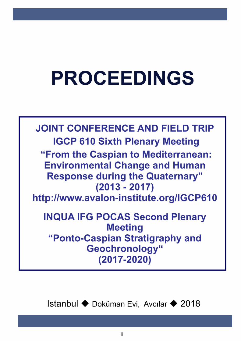
JOINT CONFERENCE AND FIELD TRIP IGCP 610 Sixth Plenary Meeting
“From the Caspian to Mediterranean: Environmental Change and Human Response during the Quaternary”
(2013 - 2017)http://www.avalon-institute.org/IGCP610
INQUA IFG POCAS Second Plenary Meeting
“Ponto-Caspian Stratigraphy and Geochronology“
(2017-2020)
Istanbul Doküman Evi, Avcılar 2018
PROCEEDINGS
ii

ISSN 978-605-245-321-6
©IGCP 610-INQUA IFG POCAS all rights reserved
iii
iv
Cited as: A. Gilbert, and V. Yanko-Hombach, V. (Eds.), 2018. Proceedings of UNESCO - IUGS – IGCP 610 and INQUA IFG POCAS Joint Plenary Conference and Field Trip, October 14-21, 2018, Antalya, Turkey. Doküman Evi, Avcilar, Istanbul, 202 p. ISSN 978-605-245-321-6
v
CONTENTS
Organizing and Executive Committee ....................................................................................viii
Scientific Committee...............................................................................................................viii
International Advisory Committee.........................................................................................viii
Editorial Board of Proceedings ................................................................................................. ix
Editorial Board of Field Trip Guide.......................................................................................... ix
Editorial Board of QISpecial Volume....................................................................................... ix
Aims and Scope......................................................................................................................... ix
Welcome...................................................................................................................................xii
Venue .......................................................................................................................................xii
Acknowledgments................................................................................................................... xiv
PART I. IGCP 610 PROGRESS REPORT (2013-2017)........................................................... 1
Yanko-Hombach, V.
PART II. PROCEEDINGS
Coastal zone reaction to sea-level fluctuations ........................................................................ 27
Badyukova, E.N.
Development of the Sefidrud delta on the background of the Caspian Sea level fluctuations 30
Badyukova E.N., and Svitoch A.A.
First results of stable oxygen isotope analysis of Upper Pleistocene sediments in the North Caspian basin............................................................................................................................ 34
Berdnikova, A.A., Garova, E.S., Wesselingh, F.P., Yanina, T.A., Stoica, M., and van de Velde, S.
Climate and environmental changes in the Northern Caspian Sea region during the Holocene.................................................................................................................................................. 37
Bolikhovskaya, N.S.
Interactions between two different realms in the Marmara gateway: An overview on Quaternary stratigraphy with new findings (NW Turkey) ....................................................... 44
Büyükmeriç, Y., Alçiçek, H., and Alçiçek, M.C.
Chronostratigraphical correlation of Ponto-Caspian and Mediterranean basins for the reconstruction of water exchange and the first peopling of Europe......................................... 46
Chepalyga, A.L.
The formation of deep sea features during conditions of Mediterranean Sea desiccation and appearance of negative pressure in the Earth's mantle............................................................. 50
Esin, N.V., and Esin, N.I.
Quaternary development of southern Levant caves: window to Out of Africa hominin migration .................................................................................................................................. 54
Frumkin, A., Langford, B., Marder, O., and Ullman, M.
Anthropomorphic images in Azerbaijan’s landscape and their possible significance ............. 58
Gallagher, R.
Observations of Caspian strandlines, their use as highstand indicators with consideration for their implications with regard to regional geomorphology, paleodrainage, and biodiversity.. 69

vi
Gallagher, R.
Timing of mud volcanic activity in the South Caspian and its environmental impact ............ 77
Huseynov, D.A., Aliyeva, E.H-M., and Kangarli, T.N.
The Quaternary ostracod assemblages of the Apsheron archipelago....................................... 81
Javadova, A., Zenina, M., and Rzaeva, E.
The prospects of creating UNESCO geoparks as a geoecological tool to preserve the geoheritage of Azerbaijan ........................................................................................................ 84
Kangarli, T.N., Huseynov, D.A., Aliyeva, E.H., Rashidov, T.M., and Kangarli, I.T.
On the question of the Pleistocene-Holocene boundary on the northwestern shelf of the Black Sea based on micropaleontological data .................................................................................. 88
Kondariuk, T., and Mudryk, I.
Tectonically modified coastal shoreline in the Marmara region, NW Turkey: Evidence from Byzantine archaeological sites ................................................................................................. 94
Koral, H., Tur, H., Aydıngün, Ş., and İşbil, D.
The Late Pleistocene Hyrcanian Passage in the Manych Depression...................................... 97
Kurbanov, R., Yanina, T., Murray, A., Borisova, O., and Semikolennykh, D.
The loess-soil sequences in the Lower Volga area: stratigraphy, geochronology and paleogeography ...................................................................................................................... 102
Kurbanov, R., Yanina, T., Murray, A., Buylaert, J.-P., Stevens, T., Rogov, V., Streletskaya, I., Belyaev, V., Makeev, A., Lebedeva, M., Rusakov, A., Svistunov, M., Yarovaya, S., Taratunina N., and Költringer, Ch.
Optically-stimulated luminescence ages of the Early Khvalynian “Chocolate clays” of the Lower Volga........................................................................................................................... 105
Kurbanov, R., Murray, A., Yanina, T., Thompson, W., Svistunov, M., and Yarovaya, S.
Opposite marine and coastal environmental consequences of the Caspian rapid sea level fall................................................................................................................................................ 107
Lahijani, H., Seydvalizadeh, M., and Azizpour, J.
New data about grain-size and geochemical characterization of Baer knolls sediments in the Volga delta region .................................................................................................................. 109
Lobacheva, D.M.
Grain-size and geochemical characterization of Baer knolls sediments in the Volga delta .. 112
Makshaev, R.R., Lobacheva, D.M., Zastrozhnov, A.S., Zastrozhnov, D.A., and Tkach, N.T.
Dinoflagellate marker species of the relic Paratethyan seas: Pannonian to Caspian basins .. 116
Mudie, P.J. Richards, K., Rochon, A., and Bakrač, K.
Palynology of Core 38 and its implications for understanding climate and salinity changes of the Late Pleistocene (Neoeuxinian) Black Sea Lake ............................................................. 120
Mudryk, I., and Mudie, P.J.
On the genetic significance of fluid inclusions in minerals from the ejects of mud volcanoes in the Azov-Black Sea region..................................................................................................... 124
Naumko, I.М.
Quaternary volcanoes of Shavnabada and Tavkvetili (Georgia): Hazards for the Azerbaijan-Turkey oil and gas pipelines?................................................................................................. 127
Okrostsvaridze, A., Bluashvili, D., Skhirtladze, I., and Avkofashvili, I.

vii
Known examples of submerged archaeological sites from Turkey ....................................... 131
Öniz, H., and Dönmez, G.
Paleogeographic reconstruction of Karkinitsky Bay (the northwestern Black Sea shelf) ..... 133
Pedan, G., and Dragomyretska, O.
Use of complex geological, geochemical, and geophysical data for determination of Upper Miocene transgression in West Kuban depression of the Western Ciscaucasus.................... 137
Pinchuk, T.N., and Fursina, A.B.
Eastern Paratethys – Mediterranean connections during the Neogene and Quaternary......... 140
Popov, S.V., Golovina, L.A., and Goncharova, I.A.
Sedimentology and source of sand barriers of the southeastern Caspian Sea (Amirabad to Ashuradeh) ............................................................................................................................. 146
Rahimi, E., and Lak, R.
Geomorphological Evolution of Plains of Gorgan during Khvalynian Transgression of Caspian Sea (Golestan Province of Iran) ............................................................................... 150
Semikolennykh, D., Kurbanov, R., Khoshravan, H., and Belyayev, B.
Meiobenthos of abandoned oil wells in the northern Caspian Sea ........................................ 153
Sergeeva N.G., and Vodovsky N.B.
Role of migrations in cultural exploration of the Lower Danube region in early prehistory. 158
Smyntyna, O.V.
Paleoanthropological study of the population inhabiting the Taman Peninsula at the end of the Golden Horde period.............................................................................................................. 162
Vasilyev, S.V., Borutskaya, S.B., and Frizen, S.Yu.
The role of climatic stress in the life of the ancient civilizations of the Fertile Crescent ...... 167
Yakovleva, N., and Matygin, A.
What have we learned from the Yenikapı-Istanbul excavations regarding environmental, climatic, and cultural changes in the Holocene? ................................................................... 171
Yalçın, M.N.
The Caspian Sea during the Anthropocene ............................................................................ 176
Yanina, T., Khoshravan, H., and Svitoch, A.
The Caspian - Black Sea - Mediterranean corridor: Water exchange and migrations of fauna during the lastclimatic macrocycle......................................................................................... 179
Yanina, T., Sorokin, V., and Svitoch, A.
The Ponto-Caspian biostratigraphy, sea level, and salinity reconstructions using benthic foraminifera as the main tool ................................................................................................. 185
Yanko-Hombach, V.
Seroglazovka locality: Key Quaternary site of the North Caspian Depression, Russia......... 191
Zastrozhnov, A., Danukalova, G., Golovachev, M., Osipova, E., Yakovlev, A., Yakovleva, T., Kurmanov, R., and Zenina, M.
The Baer Knolls of the Caspian Depression as Late Quaternary aeolian landforms: pros and cons, or only pros? ................................................................................................................. 195
Zastrozhnov, D.A., Zastrozhnov, A.S., Spiridonov, V.A., and Kayukov, A.E.
Ostracod assemblages on the outer northeastern Black Sea shelf during the last 300 years . 199
Zenina, M.A., Murdmaa, I.O., Koluchkina, G.A., Aliev, R., and Dorokhova E.V.

viii
ORGANIZING AND EXECUTIVE COMMITTEE
President and Chairman of the Organizing Committee
Hayrettin KORAL, Turkey
hkoral @istanbul.edu.tr
Executive Director Valentina YANKO-HOMBACH, Ukraine, Canada [email protected]
Executive Secretary Duygu İŞBİL, Turkey
Administrator Irena MOTNENKO, Canada
Yildirim GÜNGÖR, Turkey
Hakan ÖNİZ, Turkey
Members
Elif APAYDIN POŞLUK, Turkey
Hayrettin KORAL, Turkey
Hakan ÖNİZ, Turkey
Field Trips
Yildirim GÜNGÖR, Turkey
SCIENTIFIC COMMITTEE
Valentina YANKO-HOMBACH, Canada, Ukraine
Olena SMYNTYNA, Ukraine
Nicolae PANIN, Romania
Allan GILBERT, U.S.A. Tamara YANINA, Russia
Hayrettin KORAL, Turkey Fuat ŞAROĞLU, Turkey
Mehmet Celal ÖZDOĞAN, Turkey Namik YALÇIN, Turkey
INTERNATIONAL ADVISORY COMMITTEE
Elmira ALIEVA, Azerbaijan Petra MUDIE, Canada
Geoff BAILEY, UK Dimitris SAKELLARIOU, Greece
Helmut BRÜCKNER, Germany Ronald MARTIN, U.S.A.
Antonio CARUSO, Italy Nelly SERGEEVA, Ukraine
Nikolay ESIN, Russia Avtandil OKROSTSVARIDZE, Georgia
Nicholas FLEMMING, UK Avraham RONEN, Israel
ix
Alexander KISLOV, Russia Yücel YILMAZ, Turkey
EDITORIAL BOARD OF PROCEEDINGS
Allan GILBERT, U.S.A. Editors
Valentina YANKO-HOMBACH, Canada, Ukraine
EDITORIAL BOARD OF FIELD TRIP GUIDE
Editors Hayrettin KORAL, Turkey
Hayrettin KORAL, Turkey
Hakan ÖNİZ, Turkey
Authors
Yildirim GÜNGÖR, Turkey
EDITORIAL BOARD OF QI SPECIAL VOLUME
Editor-in-Chief Thijs van Kolfschoten, The Netherlands
Guest Editor Valentina YANKO-HOMBACH, Canada, Ukraine
AIMS AND SCOPE
The meetings of IGCP 610 and INQUA Focus Group POCAS (SACCOM 1709F) are carried out jointly in order to bring the international communities of both projects together to solve a number of contentious issues involving stratigraphy, geochronology, geological history, archaeology, and anthropology of the Caspian-Black Sea-Mediterranean Corridor [“CORRIDOR”].
The main goal of the IGCP 610 Project is to provide cross-disciplinary and cross-regional correlation of geological, archaeological, environmental, and anthropological records in order to (a) explore interrelationships between environmental change and human adaptation during the Quaternary, (b) create a networking and capacity-building structure to develop new interdisciplinary research initiatives, and (c) provide guidance to heritage professionals, policy makers, and the wider public on the relevance of studying the “CORRIDOR” for a deeper understanding of Eurasian history, environmental changes and their relevance, as well as past and future impacts on humans.

x
The main goal of the INQUA Focus Group POCAS created within the INQUA SACCOM for the term 2017-2020 is to study the geology of the Ponto-Caspian region during the Quaternary. The main activities of POCAS are oriented toward solving existing contradictions employing, if needed, new work in the field via a wide range of multidisciplinary scientists and modern research methods and equipment.
The “CORRIDOR” is perfectly suited for these purposes. (1) It encompasses the large chain of intercontinental basins—the Caspian, Black (together called Ponto-Caspian), Marmara, Aegean, and Eastern Mediterranean (Levantine) seas—with their connecting straits and coasts. Here, sea-level changes are clearly expressed due to geographical location and semi-isolation from the World Ocean, which makes the “CORRIDOR” a paleoenvironmental amplifier and a sensitive recorder of climatic events. Periodic connection/isolation of the basins during the Quaternary predetermined their specific environmental conditions and particular hydrologic regimes, and thus, the area, and especially the Ponto-Caspian, represents a “natural laboratory” to study the responses of semi-isolated and isolated basins to GCC. (2) It has rich sedimentary and geomorphologic archives that document past environmental changes. (3) It has a substantial archaeological, anthropological, and historical record. (4) It is easily accessible for study.
To achieve the main goal and objectives, the Projects incorporate six dimensions, each addressed by integrating existing data and testing of hypotheses: 1. The geological dimension examines the sedimentary record of vertical sea-level fluctuations and lateral coastline change. 2. The paleoenvironmental dimension integrates paleontological, palynological, and sedimentological records to reconstruct paleolandscapes. 3. The archaeological dimension investigates cultural remains. 4. The paleoanthropological dimension studies responses of different Homo species to environmental change. 5. The mathematical dimension provides GIS-aided mathematical modeling of climate and sea-level changes, and human dispersal linked to paleo-environmental variation that can be meaningfully compared with current global changes. 6. The geo-information dimension grasps the "big picture" of geoarchaeological events over the duration of the Quaternary. Particular attention will be given to synthesizing the wealth of literature published in local languages, stored in archives, and largely unknown or ignored in the West.
Study sites include the Caspian, Azov-Black Sea, Marmara, Eastern and Western Mediterranean. These sites are characterized by rich sedimentary, geomorphological, archaeological, paleoanthropological, and historical records providing a superb opportunity to assess the influence of climate and sea-level change on human development.
So far, five IGCP 610 Plenary Conferences and Field Trips were carried out in the following regions: 2013 – Western Georgia; 2014 – Azerbaijan; 2015 – Russia (Northern Caspian); 2016 – Eastern Georgia (Inner Kartli and Kakheti regions); 2017 – Palermo, Italy.
The final (Sixth) conference and Field Trip of IGCP 610 will be carried out together with the Second Conference and Field Trip of INQUA Focus Group POCAS in Antalya, Turkey (Mediterranean region) in 2018 (Fig. 1).

xi
Figure 1. The Caspian-Black Sea-Mediterranean “CORRIDOR”: in yellow are the locations of IGCP 521-INQUA 501 meeting and field trip sites (2005-2011); in other colors are sites studied by the ongoing IGCP 601 Project: 2013 – Tbilisi, Western Georgia; 2014 – Baku, Azerbaijan; 2015 –Astrakhan’ (Volga Delta), Russia; 2016 – Tbilisi, Eastern Georgia; 2017 – Palermo, Italy; 2018 – Antalya, Turkey.
The Field Trips are focused on observation of geological characteristics of Quaternary and Pliocene stratotypes as well as key archaeological and paleontological sites. All of them are easily accessible for further study and cooperative investigations in various laboratories around the world.
The Sixth Plenary Meeting and Field Trip of IGCP 610 and the Second Meeting of POCAS will focus on the late Miocene-Plio/Pleistocene geological history of the eastern Mediterranean of southern Turkey along the central Taurid Mountains. This subject is very important in shedding light and achieving a better understanding of tectonic-climatic interactions during the Plio/Quaternary period in this region.
The meeting and related activities will be held in world-popular Mediterranean coastal setting of Antalya Province located in the Active Alpine Mountain Belt, Turkey. The meeting and accommodation will be in Antalya. The meeting will be held in a centrally located a resort hotel suggested for accommodation (4 stars, http://www.thecornerpark.com/) on the world famous Konyaalti Beach setting of the Antalya Metropolitan Municipality (http://www.antalya.bel.tr/?l=en). This site offers a magnificent sea view, mountain view and city view all together.
The two days of the Conference will be devoted to oral presentations and posters, and four days will be devoted to geological field trips that focus on the field outcrops of the Miocene, Plio-Quaternary and archeological periods.

xii
It is expected that meeting will bring together multidisciplinary scientists from all over the world to enhance the West-East scientific dialogue and provide a foundation for collaboration on correlation and integration of subjects covered by the conference as previous IGCP 610, IGCP 521, and INQUA 0501 meetings have done.
The meeting will cover eight days in total. Two days (15-16 October) will be spent in Plenary Sessions, and four days (17-20 October) will be dedicated to the Field Trips.
WELCOME
On behalf of the Organizing and Executive Committees as well as the University of Palermo, Italy, and Avalon Institute of Applied Science, Canada, we are delighted to welcome you to the Joint Meeting and Field Trip of IGCP 610 and INQUA POCAS Focus Group that will be held in Antalya, Turkey, on October 14-21, 2018.
It is expected that the joint conference will bring together multidisciplinary scientists from all over the world and in the process enhance West-East scientific dialogue by providing a supportive background for collaboration regarding the correlation and integration of discoveries on the influence of climatically/tectonically induced sea-level changes and coastline migration on humanity. This is an area of strategic importance not only for all coastal countries but also for at least 17 other countries sharing a drainage basin that is one-third the size of the European continent.
The Joint Meeting has been organized and sponsored by the University of Istanbul, Turkey, and Avalon Institute of Applied Science, Winnipeg, Canada.
We are happy to welcome to Turkey distinguished specialists and students in the Humanities, Earth, and Life Sciences from countries around the world.
We wish you a very pleasant stay in Italy.
Sincerely, Organizing and Executive Committees
VENUE
Antalya is a city and Mediterranean Sea port in southwestern Turkey (Fig. 2).
Figure 2. View of Antalya city.
xiii
It is situated on the Gulf of Antalya. This area has been inhabited since the earliest times. Evidence of human habitation dating back to the early Paleolithic age (150,000-200,000) years has been discovered in the Karain cave, 30 km (19 mi) of the north of Antalya city. Other artifacts dating back to the Mesolithic (Beldibi Cave), Neolithic Bademağaci Höyüğü) and more recent periods show that the area has been populated by various civilizations throughout the ages.
Records from the Hittite period refer to the area as part of the "Lukka Lands" (from which "Lycia" is derived) and document the lively interaction going on between provinces in the second millennium BC. Like their descendants, the Lukkans or Lycians were known for their seamanship and demonstrated a fiery independent spirit. Neither the Hittites, nor the Kingdom of Arzawa on the west coast, could ever keep them at peace for long. There are also tales of the migration of the Akha clan to the area after the Trojan war.
The western parts of the gulf was in Lycia, the east in Pamphylia. Antalya was part of the Lydian Kingdom from the 7th century BC until Lydia was defeated by the Persians during the battle of Sardis in 546 BC. The Macedonian commander Alexander the Great ended Persian rule and in around 334 BC conquered the cities of the area one by one—except for Termessos and Sillyon which managed to repulse his armies in 333 BC.
Ancient city, Attalia, was founded as a seaport in the 2nd century BCE by Attalus II Philadelphus, a king of Pergamum. It was bequeathed to the Romans by his successor, Attalus III Philometor Euergetes. The “Hadrian Gate,” a marble portal of three identical arches, was built to commemorate a visit by the emperor Hadrian in 130 CE. St. Paul, the Apostle, and St. Barnabas embarked from the seaport on their evangelical mission to Antioch.
During the mid-Byzantine era (the 5th and 6th centuries), the city of Antalya grew beyond the city walls. It was a Byzantine stronghold and an important embarkation point for troops going to Palestine during the Crusades. The army of Louis VII sailed from Antalya for Syria in 1148, and the fleet of Richard I of England rallied here before the conquest of Cyprus.
The area was conquered by the Seljuk Turks and recaptured by the Byzantines again and again from 1076 onwards. It was captured by the Turkish Seljuk ruler Kay-Khusraw in 1207 and soon became the most important town and port of the region. At one stage Turkish lord Kilij Arslan had a palace here. In 1220 Byzantine rule ended for the last time. A town to the east of the city called Alanya (Alaiye), name given by the Seljuk ruler Alaeddin Keyqubad I, also grew and throve during 13th century in the Seljuk period.
Although it was first occupied by the Ottoman sultan Bayezid I in 1391, its incorporation into the Ottoman Empire was delayed until the late 15th century because of the disruption caused by the invasion of Timur (Tamerlane). Antalya was also occupied by the Kingdom of Cyprus between 1361 and 1373. The area passed through many hands before its final occupation by the Ottoman Empire under Murad II in 1432. Ottoman rule of the coast persisted until the end of the First World War, when Antalya was briefly occupied by Italian troops in the tripartite agreement of 1917 for the postwar division of the Ottoman Empire before becoming part of the Republic of Turkey in 1921.
Antalya is one Turkey's principal holiday resorts in the Mediterranean region. It is an attractive city with shady palm-lined boulevards, a prize-winning marina on the Mediterranean. In the picturesque old quarter, Kaleici, narrow winding streets and old wooden houses abut the ancient city walls. Lately, many foreigners have bought and continue to buy property in and around Antalya for their holidays or for the retirement. It became a popular area especially for the German and Russian nationals. During the winter months its population is around two million, but in the summer times it doubles.

xiv
It is possible to find all of the world cuisine in touristic hotels and restaurants. However, local meals special to the region are well-known such as Saç kavurmasi (dried lamb fried on iron plate), Tandir kebabi (Tandoor kebab), Kölle (stewed wheat, bean, pea and horsebean), and Hibeş (spread of tahin, cumin, red pepper flakes and lemon juice).
There are many sites of historical and archaeological interest all over Antalya Province (Fig. 8). They include the Pisidian city of Ariassos along the Antalya-Burdur highway; Olympos and Rhodiapolis in the district of Kumluca; Andriake, Antiphellos, Apallai, Myra, Phellos in the district of Kale; Apollonia, Hysa, Ilysa, Istloda, Teimiusa in the district of Üçağiz (SW Antalya); Idyros, Chimaera (burning stone) and the Lycian city of Phaselis in the district of Kemer; The church of Saint Nicholas in Demre.
Xanthos-Letoon, listed in World Heritage list of UNESCO, is a remarkable archaeological complex, representing the most unique extant architectural example of the ancient Lycian Civilization. It was one of the most important cultures of the Iron Age in Anatolia. The inscriptions engraved in rock or on huge stone pillars on the site are crucial for a better understanding of the history of the Lycian people and their Indo-European language.
There are also many beautiful natural-cultural sites to visit in Antalya .
Düden Waterfall is one of the natural beauties that symbolizes the city is located approximately 10 km northeast of Antalya city centre. Lower part of Düden Waterfall is on the road to Lara Beach. It is on the southeast of city centre and floods from 40 metre high cliffs.
Kurşunlu Waterfall is on 7th km after the turning point to Isparta road. The waterfall is inside of the deep green valley.
Lara-Konyaalti Beaches: The Lara beach which is approximately 10 km east of Antalya city centre and the Konyaalti beach which is on the west coast of city centre are the best coasts of the city.
Yivli Minaret: First Turkish monument in Antalya according to the epigraph on the monument. It was built in the reign of Anatolian Seljukian Sultan Alaeddin Keykubat (1219 -1236). Its brick laid body consists of 8 semicylinders. It was built by an architect named Tavaşi Balaban in the period of a Turkish principality, Hamitoğullari.
More information about Antalya and its surroundings is available at the following website:
https://www.antalya.bel.tr/?l=en
https://en.wikipedia.org/wiki/Antalya
ACKNOWLEDGMENTS
We gratefully acknowledge the support and hospitality of the Turkish organizers, the Istanbul University, for hosting the Joint Meeting and Field Trip of IGCP 610 and INQUA POCAS Focus Group. Support has also been received from the Avalon Institute of Applied Science, Canada.
We are indebted also to Prof. Dr. Hayrettin KORAL, the President and the Chairman of the Organizing Committee of the Coneference, for the extraordinary efforts in organizing the conference and field trips. Particular appreciation is extended to Hakan ÖNİZ, Turkey Yildirim GÜNGÖR, Turkey for arranging the Field Trips and preparing the Field Trip Guide.

xv
Furthermore, we are also very grateful to Duygu İŞBİL, Turkey, the Executive Secretary of the Conference.
We gratefully recognize the assistance of Prof. Allan GILBERT together with Prof. Dr. Valentina YANKO-HOMBACH for editing and layout of the Conference Proceedings.
To the Scientific Committee, we offer sincere thanks for evaluating submissions and managing the abstract review process. The Scientific Committee, in turn, wishes to thank the anonymous reviewers for their efforts in providing useful comments on submitted papers.
For her prompt action, we extend our appreciation to the Project and website administrator Dr. Irena MOTNENKO.
Prof. Dr. Valentina Yanko-Hombach Co-Leader of IGCP 610 and INQUA POCAS Focus Group Executive Director of the Joint Meeting

1
PART I. IGCP 610 PROGRESS REPORT (2013-2017)
Yanko-Hombach, V. 1, 2
1 Odessa I.I. Mechnikov National University, 2 Dvoryanskaya Str., Odessa 65082, Ukraine [email protected]
2 Avalon Institute of Applied Science, 976 Elgin Avenue, Winnipeg MB R3E 1B4, Canada [email protected]
Website address(es) related to the project http://www.avalon-institute.org/IGCP610/index.php - main http://www.geogr.msu.ru/science/projects/unesco/ http://www.geoecomar.ro/website/proiecte.html http://archaeology-ethnology.onu.edu.ua/?p=1096 https://www.facebook.com/groups/180481035443572/ http://vk.com/album115218532_181815723
1. List of countries involved in the project IGCP 610-INQUA POCAS community includes about 260 scientists from 21 countries: Azerbaijan, Belgium, Bulgaria, Canada, Georgia, Germany, Greece, France, Israel, Italy, Kazakhstan, Latvia, Romania, Russia, The Netherlands, Switzerland, Turkey, Turkmenistan, UK, Ukraine, and USA.
The IGCP 610 project commenced on 1 April 2013. Since that time, it has served as a focal point for correlation of scientific data obtained by research projects dealing with environmental change and human response in a variety of settings within the Caspian-Black Sea-Mediterranean Corridors [CORRIDORS] during the Quaternary. In general, five years of IGCP 610 activity have been carried out in strict agreement with the Working Plan [http://www.avalon-institute.org/IGCP610/work_plan.php].
Its main goal is to provide cross-disciplinary and cross-regional correlation of geological, archaeological, environmental, and anthropological records in order to (a) explore interrelationships between environmental change and human adaptation during the Quaternary, (b) create a networking and capacity-building structure to develop new interdisciplinary research initiatives, and (c) provide guidance to heritage professionals, policy makers, and the wider public on the relevance of studying the “CORRIDOR” for a deeper understanding of Eurasian history, environmental changes and their relevance, and likely future impact on humans.
This project has a triple focus: (1) geological history, (2) paleoenvironmental change (climate, sea level, coastline migration), and (3) human response (migration, subsistence strategy, physical and cultural adaptation, etc.) to environmental changes. Six dimensions of evidence are explored by integrating existing data and hypothesis testing: 1. The geological dimension examines the sedimentary record of vertical sea-level fluctuations and lateral coastline change. 2. The paleoenvironmental dimension integrates paleontological, palynological, and sedimentological records to reconstruct paleolandscapes. 3. The archaeological dimension investigates cultural remains. 4. The paleoanthropological dimension studies responses of different Homo species to environmental change. 5. The mathematical dimension provides GIS-aided mathematical modeling of climate, sea-level change, and human dispersal linked to environmental change. 6. The geo-information dimension will try to grasp the "big picture" of geoarchaeological events throughout the Quaternary. Attention is constantly given to
2
synthesizing the wealth of literature published in local languages, stored in archives, and largely unknown in the West.
This Project succeeds IGCP 521 “Black Sea-Mediterranean Corridor during the last 30 ky: sea level change and human adaptation” (2005-2010) that collected, integrated, and analyzed much scientific data and established a strong international team of multidisciplinary scientists from 32 countries. That Project examined the “CORRIDOR” for the last 30 ky only. The new IGCP Project begins in the early Quaternary, examining responses of pre-modern humans to environmental change, and includes the Central Asian basins thereby covering the Eurasian cascade more completely and involving scientists from countries farther east. It links Europe and Asia more closely in the successive conferences and field trips, and like its predecessor, the new Project improves our understanding of the geoscientific factors affecting global environment in order to improve human living conditions; increases understanding of geological processes and concepts of global climate change [GCC], including socially relevant issues; and improves standards, methods, and techniques of carrying out geological and archaeological research, including the transfer of geological and geotechnological knowledge between industrialized and developing countries.
The Project’s wide scope provides a superb opportunity to collaborate with other ongoing/past projects, as well as the MAB Programme of the UNESCO Strategy for Action on Climate Change, LOICZ, IGBP, and especially with SPLASHCOS, in which two co-leaders of this Project (V. Yanko-Hombach and O. Smyntyna) were members of the Management Committee. The Project complements the IGU Commission on Coastal Systems, INQUA CMP, and TERPRO Commissions, with which IGCP 521 cooperated previously through the INQUA 501 project, as well as the HaBCom, SACCOM, and PALCOMM Commissions. The Project also collaborates with geological surveys, archaeological expeditions, and corresponding museums in all countries bordering the “CORRIDOR.”
The Project is linked to the EU-ITN programme "Drivers of Pontocaspian biodiversity rise and demise"; EU-WAPCOAST BS-ERA.NET 076 “Water Pollution Prevention Options for Coastal Zonеs and Tourist Arеas: Application to the Danube Delta Front Area”; ICOMOS - The International Council on Monuments and Sites; COCONET “Towards COast to COast NETworks of marine protected areas (from the shore to the high and deep sea), coupled with sea-based wind energy potential”; SPLASHCOS “Submerged Prehistoric Archaeology and Landscapes of the Continental Shelf”; “Study of the formation processes and spatial distribution of methane in the Black Sea and theoretical considerations of their influence on basin eco- and geosystems,” supported by the Ministry of Education and Science of Ukraine; and “Paleogeographical evolution of the Gulf of Taman with special regard to the underwater excavations in Phanagoria” funded by the University of Cologne and Russian Foundation for Basic Research (RFBR); and the series of projects supported by RFBR: № 14-05-00227 "Environmental evolution of the Caspian and Black Sea under the multiscale changes of climate," № 13-05-00086 “Pont-Manych-Caspian oceanographic system in the late Pleistocene: Systematics and correlation of events, evaluation of character and degree of interaction, paleogeographic consequences in the region,” № 13-05-00242 “Radioisotope stratification of age and synchronization of the Quaternary deposits of the Ponto-Caspian,” № 13-05-00625 “Peculiarities of the evolution of relief in the Northern Caspian region in the late Pleistocene: Main stages of the development, chronology, and correlation with climatic rhythms in the Black Sea-Caspian region,” № 14-05-00227 “Regularities of evolution of environment of the Caspian Sea and the Black Sea in the conditions of multi-scale climate changes”?; and several others. Disseminating the project events and activities via regular updating of Project websites and mailing list of the project contributors, which increased from 957 in 2013 to 1054 in 2014, as well as social networks (Facebook for English and non-

3
English-speakers, and Вконтакте for mostly Russian speakers) https://www.facebook.com/groups/180481035443572/ http://vk.com/album115218532_181815723
The International Focus Group POCAS [IFG] “Ponto-Caspian stratigraphy and geochronology“ was created within the INQUA SACCOM for the term 2017-2020. It is devoted to the study of the geology of the Ponto-Caspian region during the Quaternary as a single geographic entity, bypassing linguistic/political/disciplinary boundaries, linking continents (Europe and Asia) more closely, and encouraging East-West dialogue and cooperation among researchers.
The main activities of IFG POCAS are oriented toward solving the existing contradictions, employing new work in the field if needed. This will be done by involving a wide range of multidisciplinary scientists and modern research methods and equipment. The major challenge will be the involvement of young scientists as well as graduate and undergraduate students to participate in the research and integration of available and newly obtained data. It is of great importance to do this because, so far, there are few specialists (particularly in the developing countries) trained in modern methods and techniques (e.g., isotopic analysis, geochemistry, paleontology, and different types of dating).
The planned activities include: 1. A number of annual workshops and training schools that will be organized by IFG POCAS. Organization of annual workshops oriented toward discussion of the most debated and diverse outcomes in geomorphology, stratigraphy, paleogeography, paleontology, and geochronology. These workshops will allow us to get closer to a more reasonable and realistic understanding of the evolution of the natural environment in this vast region. The first workshop was held in Moscow, Russia, in spring of 2017. It laid out a plan for future activities. The workshop was focused on disputed issues and the identification of the main ways to solve them. A great number of young researchers and students from developing countries was involved.
2. Establishing the Information Internet-Portal on the geological history of the region within the SACCOM website, linked to the most important published materials, including maps. This will allow young scientists to become readily familiar with the main problems under discussion.
3. Establishing an open database of multilingual literature, published and stored in archives. This will include also rare classic papers published in the pre-Soviet and Soviet period. A translation of the most important works is planned.
4. Establishing the open GIS database – Geoportal. This will contain the existing sections of Quaternary deposits that will be linked to the regional interactive map as well as to publications where they are described. The Geoportal will be supplemented by tools enabling interactive work with layers, bridging publications, adding sections, building profiles, etc. This will dramatically increase progress in the generalization of the currently obtained results. Any researcher will be able to find specific data that he/she needs and largely eliminate the current problem of absence of translations of works provided by Russian researchers; these works represent a massive amount of data that surpass all other publications.
2. Plenary Conferences and Field Trips of IGCP 610 The First Plenary Conference and Field Trip of IGCP 610 was organized by the Institute of Earth Sciences, Ilia State University and the Avalon Institute of Applied Science, Winnipeg, Canada, and hosted by Ilia State University, on 12-19 October 2013, in Tbilisi, Georgia (Yanko-Hombach, 2016). President of the conference was Prof. Zurab Javakhishvili.

4
Executive Director was Prof. Valentina Yanko-Hombach. One hundred and fifty one scientists from 19 countries contributed to the conference; 66% of them were from developing countries (Fig. 1). Their peer-reviewed contributions are assembled in a 182-page Conference Proceedings volume (Gilbert and Yanko-Hombach, 2013).
0
5
10
15
20
25
30
35
Austra
lia
Azerb
aijan
Belgium
Portu
gal
The N
ethe
rland
sIsr
ael
UK
Canad
a
Germ
any
Greec
eIta
lyIra
n
Sweatze
rland
Roman
ia
Franc
e
Georg
ia
Turke
y
Ukrain
e
Russia
Country
Num
ber o
f con
trib
utor
s
66%
34%
Figure 1. Number of countries and contributors to IGCP 610 First Plenary Conference and Field Trips. The circle shows the percentage of scientists from developing (red) and developed (blue) countries, respectively.
The two days of Technical Sessions were organized into four panels and five Oral/Poster sessions. Panel 1 was titled “STRATIGRAPHY AND PALEOENVIRONMENTAL RECONSTRUCTIONS” (Moderators: Nikolay Panin, Romania, and Andrei Chepalyga, Russia) and included 24 presentations with two key-note talks by Prof. Teller (Canada) and Prof. Okrostsvaridze with co-authors (Georgia). The presentations covered a wide range of topics including Quaternary geomorphology, geology, stratigraphy, paleogeography, volcanism, seismicity, and mineral resources of the Ponto-Caspian and Marmara region. Panel 2 was titled “RECENT ECOSYSYTEMS” (Moderators: Nelly Sergeeva, Russia, and Valentina Yanko-Hombach, Ukraine, Canada) and included four presentations on recent fauna of the Black Sea. Panel 3 was titled “ARCHAEOLOGY, HISTORY, AND ETHNOLOGY” (Moderators: Nikoloz Tushabramishvili, Georgia, and Olena Smyntyna, Ukraine) and included ten presentations. The presentations covered a wide range of topics, such as Paleolithic of Georgia, new data on Oldowan migration to Europe via the northern Black Sea Corridor in the light of the latest discoveries in the northern Caucasus and Dniester Valley, the Aegean route: an alternative route for Neanderthals and Anatomically Modern Humans (AMHs) traveling from Asia to Europe and vice-versa. Panel 4 was entitled “MODELING” (Moderators: Nikolay Esin and Alexander Kislov, Russia) and included four presentations, such as a mathematical model of Black Sea coast and shelf evolution during the Quaternary period, etc.
The POSTER session included 17 posters that were organized into five topics: GEODYNAMICS AND ACTIVE TECTONICS (Moderator: Hayrettin Koral, Turkey), RECENT ECOSYSTEMS (Moderators: Nelly Sergeeva, Russia, and Valentina Yanko-Hombach, Ukraine, Canada), SEA LEVEL CHANGES AND PALEOENVIRONMENTAL RECONSTRUCTIONS (Moderators: Nikolay Panin, Romania, and Andrei Chepalyga, Russia), and PALYNOLOGY AND PALEONTOLOGY (Moderators: Petra Mudie, Canada, and Valentina Yanko-Hombach, Ukraine, Canada), ARCHAEOLOGY, HISTORY, and ETHNOLOGY (Moderators: Nikoloz Tushabramishvili, Georgia, and Olena Smyntyna,
5
Ukraine). The Technical Sessions were followed by the Round Table that enabled the formation of 12 Working Groups for the Project and the selection of their coordinators. It also led to decisions about future strategy in running the project. For more details see the Conference Programme.
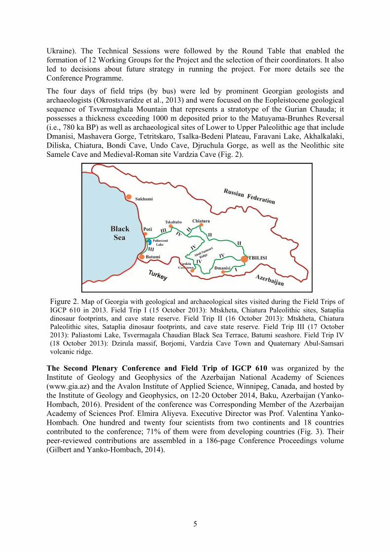
The four days of field trips (by bus) were led by prominent Georgian geologists and archaeologists (Okrostsvaridze et al., 2013) and were focused on the Eopleistocene geological sequence of Tsvermaghala Mountain that represents a stratotype of the Gurian Chauda; it possesses a thickness exceeding 1000 m deposited prior to the Matuyama-Brunhes Reversal (i.e., 780 ka BP) as well as archaeological sites of Lower to Upper Paleolithic age that include Dmanisi, Mashavera Gorge, Tetritskaro, Tsalka-Bedeni Plateau, Faravani Lake, Akhalkalaki, Diliska, Chiatura, Bondi Cave, Undo Cave, Djruchula Gorge, as well as the Neolithic site Samele Cave and Medieval-Roman site Vardzia Cave (Fig. 2).
Figure 2. Map of Georgia with geological and archaeological sites visited during the Field Trips of IGCP 610 in 2013. Field Trip I (15 October 2013): Mtskheta, Chiatura Paleolithic sites, Sataplia dinosaur footprints, and cave state reserve. Field Trip II (16 October 2013): Mtskheta, Chiatura Paleolithic sites, Sataplia dinosaur footprints, and cave state reserve. Field Trip III (17 October 2013): Paliastomi Lake, Tsvermagala Chaudian Black Sea Terrace, Batumi seashore. Field Trip IV (18 October 2013): Dzirula massif, Borjomi, Vardzia Cave Town and Quaternary Abul-Samsari volcanic ridge.
The Second Plenary Conference and Field Trip of IGCP 610 was organized by the Institute of Geology and Geophysics of the Azerbaijan National Academy of Sciences (www.gia.az) and the Avalon Institute of Applied Science, Winnipeg, Canada, and hosted by the Institute of Geology and Geophysics, on 12-20 October 2014, Baku, Azerbaijan (Yanko-Hombach, 2016). President of the conference was Corresponding Member of the Azerbaijan Academy of Sciences Prof. Elmira Aliyeva. Executive Director was Prof. Valentina Yanko-Hombach. One hundred and twenty four scientists from two continents and 18 countries contributed to the conference; 71% of them were from developing countries (Fig. 3). Their peer-reviewed contributions are assembled in a 186-page Conference Proceedings volume (Gilbert and Yanko-Hombach, 2014).

6
0
5
10
15
20
25
30
35
40
45
Russia
Azerb
aijan
Georg
ia
Ukrain
e
Roman
ia
The N
ethe
rland
sUK
Turke
yIta
ly
Franc
e
Canad
a
Germ
any
Bulgar
ia
Sweatze
rland
Belgium
Latvi
a
USA
Country
Num
ber o
f con
trib
utor
s 29%
71%
Figure 3. Number of countries and contributors to the IGCP 610 Second Plenary Conference and Field Trips in Baku, Azerbaijan. The circle shows the percentage of scientists from developing (red) and developed (blue) countries, respectively.
The meeting was focused on the whole spectrum of Quaternary geological sequences exposed in the terraces and ridges of the Caspian region. This includes the stratotype of the Mountain of Bakinian stage (ca. 600–450 ka BP) located in the suburbs of Baku on the Absheronian Peninsula; major exposures in the southwestern part of the peninsula of Garagush mountain, Bakinskie Ushi. This includes outcrops of Quaternary deposits at Garamaryam and Turianchay in the Ajinour region, and Bozdag located in the Middle Kura region, which is a reference section of the marine sediments of the Bakinian stage in western Azerbaijan. The Neogene-Quaternary boundary and the Matuyama-Brunhes Reversal with Olduvai and Jaramillo episodes were traced. The archaeological sites in Gobustan with its famous petroglyphs of Mesolithic age were observed. Plans included visits to some archaeological and historical places in Baku: the Shirvanshakh Palace constructed during the period from the XIIIth to the XVIth century; the Maiden Tower (the most mysterious monument of Baku) of which the unique construction has no analogs in the East. The Palace complex and Maiden Tower are included in the UNESCO list of World heritage sites. The participants also visited the historical-cultural reserve of Lagich that dates from the XV-XIX centuries, the first Christian Church in the Caucasus dated to the Ist century, excavations of an ancient town located in the suburbs of Gabala city, which for six centuries (until the VIth century) was the capital of Caucasian Albania, and famous for the beautiful wall paintings of Khan Palace in the old Sheki town.
The two days of Technical Sessions were organized into five panels and five Oral/Poster sessions. Panel 1 was titled “RECENT ECOSYSYTEMS AND PROCESSES”—moderators: Nelly Sergeeva (Russia) and Valentina Yanko-Hombach (Ukraine, Canada)—and included five ORAL presentations. The presentations covered a range of topics on recent environments and ecosystems of the Caspian-Black Sea-Mediterranean Corridors. Panel 2 was titled “STRATIGRAPHY, PALEONTOLOGY, AND PALEOENVIRONMENTAL RECONSTRUCTIONS”—moderators: Nikolay Panin (Romania) and Andrey Chepalyga (Russia)—and included 19 ORAL presentations with a key-note talk by Profs. Yanina and Svitoch (Russia). The presentations covered a range of topics on Quaternary ecostratigraphy and paleogeographic reconstructions of the Ponto-Caspian and Marmara region. Panel 3 was titled “TECTONICS”—moderator: Hayrettin Koral (Turkey)—and included three presentations on the earthquakes of Eastern Turkey, interrelationships between sea-level

7
changes and tectonics along the southern Black Sea coasts of Turkey, and modern active tectonics in Azerbaijan. Panel 4 was titled “MODELING”—moderators: Nikolay Esin and Alexander Kislov (Russia)—and included five presentations devoted to modeling of coastline migration, climate change and infilling of the Black Sea by Mediterranean salt water over the course of the Holocene transgression. Panel 5 was titled “ARCHAEOLOGY, HISTORY, AND ETHNOLOGY” —moderators: Andrey Chepalyga (Russia) and Olena Smyntyna (Ukraine)—and included five presentations with a key-note talk by I. Babaev (Azerbaijan). The presentations were devoted to the North Black Sea passageway for the first peopling of Europe, ties between Southeast Caucasus and Mediterranean countries in antiquity, influence of paleoecological changes on migration and economic activities of the Neolithic people of Azerbaijan, and archaeological landscape of Gobustan at the end of the upper Pleistocene and early Holocene.
The POSTER session included 23 poster presentations that were organized into five topics: GEOMORPHOLOGY—moderator: Ekaterina Badyukova (Russia); RECENT ECOSYSTEMS AND ENVIRONMENTAL MONITORING—moderators: Nelly Sergeeva (Russia) and Valentina Yanko-Hombach (Ukraine, Canada); SEA LEVEL CHANGES AND PALEOENVIRONMENTAL RECONSTRUCTIONS—moderators: Nikolay Panin (Romania) and Andrey Chepalyga (Russia); PALYNOLOGY AND PALEONTOLOGY—moderators: Petra Mudie (Canada) and Valentina Yanko-Hombach (Ukraine, Canada); ARCHAEOLOGY, HISTORY, AND ETHNOLOGY—moderators: Mehmet Özdoğan (Turkey) and Olena Smyntyna (Ukraine). The Technical Sessions were followed by the Round Table that enabled participants to discuss the progress of IGCP 610 and to plan future strategy in running the project. For more details see the Conference Programme.
The five days of field trips (by bus) were led by prominent Azerbaijani geologists and archaeologists and were focused on the Apsheronian stage sediments, the classic stratotype of the Mountain of Bakinian stage, examples of the rapid Caspian Sea level changes in the Pleistocene successions, Azerbaijan mud volcanoes, Western Azerbaijan and the Greater Caucasus continuous outcrop of Quaternary continental sediments of the Ajinour, reference outcrop of the marine Bakinian sediments at Bozdag, as well as archaeological sites of Gobustan, Gabala, and historical sites of Baku and Lagich (Fig. 4; Aliyeva and Kengerli, 2014).
Figure 4. Map of Azerbaijan with geological and archaeological sites visited during the Field Trips of IGCP 610 in 2014.

8
The Third Plenary Conference and Field Trip of IGCP 610 was organized by the M.V. Lomonosov Moscow State University, Astrakhan State University, Astrakhan Museum-Reserve, Russia, and the Avalon Institute of Applied Science, Winnipeg, Canada, and hosted by the Astrakhan Museum-Reserve. President of the conference was Prof. Tamara Yanina. Executive Director was Prof. Valentina Yanko-Hombach. The Meeting and Field Trip were held in the Northern Caspian region in the city of Astrakhan and the Astrakhan region. One hundred seven scientists from 14 countries contributed to the conference; 77% of them were from developing countries (Fig. 5). Their peer-reviewed contributions are assembled in a 220-page Conference Proceedings volume (Gilbert et al., 2015).
Figure 5. Number of countries and contributors to IGCP 610 Third Plenary Meeting and Field Trips. The circle shows the percentage of scientists from developing (red) and developed (blue) countries, respectively.
The two days of Technical Sessions were organized into five panels and five Oral/Poster sessions. Panel 1 was titled “PANEL 1: RECENT ECOSYSYTEMS AND PROCESSES”—moderators: Nelly Sergeeva (Russia) and Valentina Yanko-Hombach (Ukraine, Canada)—and included three ORAL presentations. The presentations covered a range of climate, precipitation, and faunal migration in the “CORRIDORS.” Panel 2 was titled “STRATIGRAPHY, PALEONTOLOGY, AND PALEOENVIRONMENTAL RECONSTRUCTIONS”—moderators: Nikolay Panin (Romania) and Andrey Chepalyga (Russia)—and included 15 ORAL presentations with two key-note talks given by Tamara Yanina and others (Russia) and Nikolay V. Esin and others (Russia, Ukraine, Canada). The presentations covered a range of topics on the processes of formation within the “CORRIDORS” and the Paratethys Sea-Lake degradation, origin and taxonomy of the Quaternary Ponto-Caspian foraminifera and mollusks, morphodynamics of loess watersheds, changes of landscape and migration of humans, correlation of marine and continental deposits, ecostratigraphy, etc. Panel 3 was titled “TECTONICS”—moderator: Nikolai Esin (Russia) and Hayrettin Koral (Turkey)—and included three presentations on the neotectonics of Anatolia in the crossroads of an evolving orogen (key-note), vertical movements of the coast and shelf of the Black and Mediterranean seas and their impact on coastal processes, and seismic-geotechnical hazard zonation. Panel 4 was titled “MODELING”—moderators: Nikolay Esin and Alexander Kislov (Russia)—and included two presentations devoted to modeling of climate and marine ecosystems. Panel 5 was titled “ARCHAEOLOGY,
9
HISTORY, AND ETHNOLOGY”—moderators: Andrey Chepalyga (Russia) and Olena Smyntyna (Ukraine)—and included six presentations with a key-note talk by A. Chepalyga (Russia). The presentations were devoted to new data on the North Black Sea corridor of the first European migrations focused on the discovery of multilayered Oldowan sites in Crimea (key-note); reconstruction of the archaeological landscape of the western shore of the Caspian Sea at the end of the upper Pleistocene-Early Holocene; paleoanthropology of the Yamna-culture populations in the Kumo-Manych depression: craniological specificity of the Yamna culture people from the Lower Volga region; paleoanthropology of fossil hominins from the Levant and Iraq; and response of humans to global climate change in the NW Black Sea region at the Pleistocene-Holocene boundary.
The POSTER session included 34 poster presentations with wide range of subjects on geophysics, morphotectonics, structure and genesis of islands, remote sensing, transgressive-regressive sea-level changes and coastline migration, economy of Late Mesolithic-Early Neolithic communities with respect to climate changes, marine habitats, lithostratigraphy, paleogeography, palynology (diatoms, pollen, NPP), deepwater peloids, modern fauna of the anoxic zone as a remnant of the ancient anoxic biosphere, mud volcanoes, underground freshwater sources, micro-(foraminifera) and macrozoobenthic communities, environmental stress caused by the Danube discharge into the Black Sea, and the first evidence of Lower Paleolithic open-air sites in Eastern Georgia.
The Technical Sessions were followed by the Round Table that enabled participants to discuss the progress of IGCP 610 and to plan future strategy in running the project. One of the key problems that participants discussed was organizing the Fourth Plenary Meeting and Field Trip in 2016. According to our working plan, it should have been held in Crimea. But due to the geopolitical problems (no need to discuss it here), this was impossible to organize. Therefore, it was decided to run the meeting and field trips in Eastern Georgia with purpose to focus on the pre-Pleistocene and Pleistocene geological history of the Eastern Paratethys remnants.
The five days of field trips (by bus) were led by prominent Russian geologists and archaeologists and were focused on the archaeological sites “Selitrennoe Gorodische,” Gorodishche Samosdelka, and Pleistocene stratotypes and important outcrops Cherniy Yar, Nizhnee Zaimische, Tsagan-Aman, Lenino, Seroglazovka as well as the Baer Knolls and Volga Delta (Yanina et al., 2015).
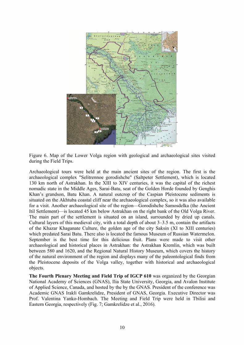
Field trips were focused on the spectrum of Quaternary geological sequences exposed within sections of the Lower Volga area. This includes major exposures in the Volga valley between Astrakhan and Volgograd: Cherniy Yar – Nizhnee Zaimische, Kopanovka, Lenino, and Seroglazka. The conference participants were able to see deposits of the Baku, Early Khazarian, Late Khazarian, Khvalynian, and Novocaspian transgressions, and the continental sediments separating them: Singilsky, Chernoiarsky, and Atel. Participants were able to select samples for faunal, palynological, and other tests. They also observed the Baer knolls (named for Karl Baer, who described them for the first time in the 19th century), which are east-west elongated ridges in the Caspian Lowland, a unique natural formation that has no analogues in the world (Fig. 6; Yanina et al., 2015).
10
Figure 6. Map of the Lower Volga region with geological and archaeological sites visited during the Field Trips.
Archaeological tours were held at the main ancient sites of the region. The first is the archaeological complex "Selitrennoe gorodishche" (Saltpeter Settlement), which is located 130 km north of Astrakhan. In the XIII to XIV centuries, it was the capital of the richest nomadic state in the Middle Ages, Sarai-Batu, seat of the Golden Horde founded by Genghis Khan’s grandson, Batu Khan. A natural outcrop of the Caspian Pleistocene sediments is situated on the Akhtuba coastal cliff near the archaeological complex, so it was also available for a visit. Another archaeological site of the region—Gorodishche Samosdelka (the Ancient Itil Settlement)—is located 45 km below Astrakhan on the right bank of the Old Volga River. The main part of the settlement is situated on an island, surrounded by dried up canals. Cultural layers of this medieval city, with a total depth of about 3–3.5 m, contain the artifacts of the Khazar Khaganate Culture, the golden age of the city Saksin (XI to XIII centuries) which predated Sarai Batu. There also is located the famous Museum of Russian Watermelon. September is the best time for this delicious fruit. Plans were made to visit other archaeological and historical places in Astrakhan: the Astrakhan Kremlin, which was built between 580 and 1620, and the Regional Natural History Museum, which covers the history of the natural environment of the region and displays many of the paleontological finds from the Pleistocene deposits of the Volga valley, together with historical and archaeological objects.
The Fourth Plenary Meeting and Field Trip of IGCP 610 was organized by the Georgian National Academy of Sciences (GNAS), Ilia State University, Georgia, and Avalon Institute of Applied Science, Canada, and hosted by the by the GNAS. President of the conference was Academic GNAS Irakli Gamkrelidze, President of GNAS, Georgia. Executive Director was Prof. Valentina Yanko-Hombach. The Meeting and Field Trip were held in Tbilisi and Eastern Georgia, respectively (Fig. 7; Gamkrelidze et al., 2016).

11
Figure 7. Map of the Eastern Georgia region with geological and archaeological sites visited during the Field Trips.
It focused on the pre-Pleistocene and Pleistocene geological history of the Eastern Paratethys remnants within Eastern Georgia. This subject is very important in shedding light and achieving a better understanding of a possible mechanism of separation of the Eastern Paratethys into the individual seas leading to formation of the Black and Caspian Seas
The 218-page Proceedings of the Fourth Plenary Meeting (Gilbert and Yanko-Hombach, 2016) contain contributions from 107 scientists from two continents and 17 countries; 89% of the contributors are from developing countries (Fig. 8).
Figure 8. Number of countries and contributors to IGCP 610 Fourth Plenary Meeting and Field Trips. The circle shows the percentage of scientists from developing (red) and developed (blue) countries, respectively.

12
About 50% of participants are female. This particular conference was characterized by an especially high number of young scientists and students.
The two days of Technical Sessions were organized into five panels with 25 Oral and 31 Poster presentaions. Panel 1 was titled “GENERAL QUESTIONS OF THE CORRIDOR”—moderators: Nikolay Esin (Russia) and Alexander Kislov (Russia)—and included four ORAL presentations including a key-note talk “Geological structure of Georgia and geodynamic evolution of the Caucasus” given by Academician GNAS Gamkrelidze, I. (Georgia). Three other presentations covered syntheses of the IGCP 610 results, pointing out some controversies and paradoxes; general tectonic/geologic framework of the Caspian Sea and its water connection with the Black Sea and Mediterranean; and the evolution of the Akchagylian Sea area and coastline based upon mathematical modeling. Panel 2 was titled “RECENT ECOSYSTEMS AND PROCESSES”—moderators: Nelly Sergeeva (Russia) and Valentina Yanko-Hombach (Ukraine, Canada)—and included 5 ORAL presentations that covered a range of topics on the glacier variation dynamics in East Georgia under the impact of modern climate change; porosity and deterioration of stone building material in Istanbul; collections of the Central Soil Museum as a foundation for soil-ecological monitoring of the Caspian-Black Sea-Mediterranean Corridor territory; foraminifera as indicators of environmental stress in marine ecosystems; and retrospective data about underwater landscapes and the meiobenthos in the northeastern part of the Black Sea given by Turkish, Russian, Ukrainian, and Canadian scientists. Panel 3: QUATERNARY AND UPPER NEOGENE PALEONTOLOGY, PALYNOLOGY, AND STRATIGRAPHY OF THE CORRIDORS—moderators: Nikolay PANIN (Romania) and Petra MUDIE (Canada)— included ten ORAL presentations that covered a range of topics on Western Georgia as a refuge for Tertiary elements of Eurasian floras (key-note); palynoclimatostratigraphy of the Pleistocene deposits in Trlica Cave; pollen-based reconstruction of the Plio-Pleistocene vegetation and climate change in the North Caucasus; the last interglacial vegetation patterns on the northern margins of the Black Sea; Middle Miocene marine mollusks in northernmost Anatolia and their biostratigraphic responses to changing paleogeography; the Karangatian epoch (MIS 5e) in the Black Sea basin; malacofauna of the Kerch Strait during the Late Pleistocene-Holocene: paleogeographical analysis; Quaternary molluscan faunas of the Sinop peninsula; new data on the stratigraphy of Quaternary sediments of the Manych depression; analysis of South Caspian deep sedimentation from marine cores given by the Ukrainian, Turkish, Russian, Canadian, and Iranian scientists. PANEL 4: PALEOENVIRONMENTAL AND PALEOGEOGRAPHIC RECONSTRUCTIONS OF THE CORRIDORS—moderators: Tamara YANINA (Russia) and Elmira ALIEVA (Azerbaijan)—included six ORAL presentations devoted to pedogenetic response to climatic fluctuations within the last glacial-interglacial cycle in the lower Volga basin; new data on correlation of the paleogeographic events of the Caspian Sea and Russian Plain in the late Pleistocene; history of Caspian Sea level oscillations in the late Pleistocene; pioneer dendroclimatological research in western and southwestern Turkmenistan; and clay mineral provenance of lower Khvalynian deposits in the Middle and Lower Volga River valley; and new results on structure of the Srednyaya Akhtuba reference section given by Russian and Turkmenistan scientists. PANEL 5: ANTHROPOLOGY, ARCHAEOLOGY, AND HISTORY—moderators: Sergey VASILIEV (Russia) and Olena SMYNTYNA (Ukraine)—included four ORAL presentations covering anthropological records of the Caucasus in the Paleolithic (key-note); re-assessing East Mediterranean sea-level trends: 3000 years of archaeological indicators in Greece and Israel; the origin of artifacts of bone and shell from the Khvalynsk Eneolithic cemeteries (Northern Caspian region); soils of Scythian settlements as paleoenvironmental archives in the area of Late Holocene migration pathways through the East European steppe; and

13
paleoanthropological research into the early medieval Coptic cemetery of Wadi Naqlun in the Fayoum Oasis (Egypt) given by Israeli, Greek, Italian, Ireland, and Russian scientists.
The POSTER session included 25 presentations. Each presenter was allotted five minutes to present his or her poster orally. Poster sessions covered a wide range of subjects on magnetometric investigations, remote sensing, palynology; hydrology and landscape characteristics, sea-level rise, climate change, paleoenvironmental reconstructions, petrography, facies analysis, geochemistry, mud volcanism, diatom analysis, Quaternary continental flood basalts, the unique Cave City of Vardzia in Georgia, geometry and kinematic evolution of a thrust-top basin, vegetation and climatic changes, coastal laws in Turkey, paleoclimate, loess-soil complexes, petrography based on SEM-analysis and optical microscopy, sea impact on human adaptation, optically stimulated luminescence dating, malacofauna, and paleogeography of the Corridor given by Romanian, Turkish, Bulgarian, Canadian, Ukrainian, Taiwanese, and Russian scientists.
The Technical Sessions were followed by the Round Table that enabled participants to discuss the progress of IGCP 610 and to plan future strategy in running the project. One of the key problems that participants discussed was organizing the Fifth Plenary Meeting and Field Trip in 2017. A majority of participants voted to organize it in Italy with a goal to study GSSP outcrops.
The four days of field trips (by bus) (Fig. 7) were led by prominent Georgian geologists and archaeologists described above.
The 19-page Field Trip Guide describes the large sequences of freshwater-continental sediments of the Miocene, Pliocene, and post-Pliocene that fill all major depressions of the Kartli and Kakheti depressions, a variety of uplift regimes during the Quaternary, and archaeological and historic sites within Eastern Georgia (Gamkrelidze et al., 2016; http://www.avalon-institute.org/IGCP610/pdf/Field_Trip_Guide_IGCP_610_2016.pdf).
A special Volume of Quaternary International “IGCP 610 III” collected about 15 articles presented at the meeting. It is planned for publication in 2017.
The project was highlighted at the First National television channel of Georgia and GNAS website (http://science.org.ge/newsite) where letters of gratitude from conference participants should be uploaded. It generated much public information showing its significant impact.
Overall, the meeting provided an excellent opportunity for international discussion of different methods and interpretations used to analyze the history of a huge geographical area from the Caspian to the Mediterranean during the full duration of the Quaternary. It also emphasized the importance of studying the Pre-Quaternary geological history in order to reveal continuity in its development. The meeting encouraged an exchange of data and publications, as well as encouraged future collaboration between physical and social scientists over the Globe. It brought together multidisciplinary scientists from all over the world, and in the process enhanced West-East scientific dialogue by providing a supportive background for collaboration regarding the correlation and integration of discoveries on the influence on humans of climatically/tectonically induced sea-level changes and coastline migration. The meeting encouraged the younger generation to engage in the multidisciplinary study of the region using advanced analytical techniques and methodologies for geoarchaeological investigations.
Archaeological and historic sites were observed in Mtskheta (listed as a World Heritage site by UNESCO); the Graklianis Hill near Kaspi that shows evidence of human presence possibly going back 300,000 years. The site contains a temple to a fertility goddess from the 7th century BC, a pit-type burial cemetery from the Early Bronze Age, and the remains of a

14
building from around 450-350 BC; the building consists of three rooms with three storage rooms. The site had been occupied between the Chalcolithic and the Late Hellenistic periods. In 2015, a mysterious script was discovered on the altar of a fertility goddess's temple, predating those previously known in the area by at least a thousand years; Uplistsikhe, "The Lord's Fortress," is an ancient rock-hewn town in Eastern Georgia some 10 km east of the town of Gori. Built on a high rocky prominence on the left bank of the Mtkvari River, it contains various structures dating from the Early Iron Age to the Late Middle Ages, and it is notable for the unique combination of various styles of rock-dwelling cultures from Anatolia and Iran, as well as the co-existence of pagan and Christian architecture. Uplistsike is identified by archaeologists as one of the oldest urban settlements in Georgia. More information about field trips can be obtained from the Field Trip Guide (Gamkrelidze et al., 2016).
The Fifth Plenary Meeting and Field Trip of IGCP 610 was organized by the University of Palermo, and Avalon Institute of Applied Science, Canada, and hosted by the the University of Palermo. President of the conference was Prof. Antonio Caruso, Italy. Executive Director was Prof. Valentina Yanko-Hombach. The Meeting and Field Trip were held in Palermo and southern Italy (Sicily and Calabria), respectively (Fig. 9; Caruso et al., 2017).
Figure 9. Map of the Southern Sicily with geological and archaeological sites visited during the Field Trips. A. Extent of the outcrops of Messinian evaporites in the different Sicilian basins with indication of the major structural features. B. Distribution of the “Calcare di base outcrops” and major evaporitic units (Lower Gypsum and Halite units) with indication of most of the sulphur mines and location of the studied sections (from Caruso et al., 2015).

15
The Fifth Plenary Meeting and Field Trip of IGCP 610 and the First Meeting of POCAS was focused on the Plio/Pleistocene geological history of the central Mediterranean of southern Italy (Sicily and Calabria). This subject is very important in shedding light and achieving a better understanding of climate evolution during the Plio/Quaternary.
The 239-page Proceedings of the Joint Plenary Conference (Gilbert and Yanko-Hombach, 2017) and Field Trip of IGCP 610 and INQUA IFG POCAS, Palermo, Italy contain contributions from 109 scientists from two continents and 14 countries; 61% of the contributors are from developing countries (Fig. 10).
Figure 10. Number of countries and contributors to Joint Plenary Conference and Field Trip of IGCP 610 and INQUA IFG POCAS. The circle shows the percentage of scientists from developing (red) and developed (blue) countries, respectively.
About 50% of participants are female. The conference was characterized by high number of young scientists and students.
The Joint Plenary Conference and Field Trip of IGCP 610 and INQUA IFG POCAS made the following possible for the participants: (1) To discuss the actual status of both projects and progress made by participants. Particular attention was paid to scientific approaches for integrating environmental, anthropological, ethnological, and archaeological data in order to trace the history of ancient humans from the Caspian to Mediterranean during the entire duration of the Quaternary. (2) To introduce young scientists, especially from the Eastern countries, to new analytical techniques and state-of-the-art interpretation of data. (3) Encourage east-west dialogue and integrate researchers from different countries into the international R&D community, as well as contribute to the preservation of cultural and religious heritage through the discussion of ancient cultures, civilizations, and their legends.
The two days of Technical Sessions were organized into four panels with 24 Oral presentations.
Panel 1: GENERAL QUESTIONS OF THE CORRIDOR – moderators: Nikolay Esin (Russia) and Alexander Kislov (Russia) – included three ORAL presentations with a key-note talk “Brief history of the astronomical tuning of the Plio/Pleistocene GSSPs outcropping in Sicily (Southern Italy)” given by Prof. Caruso, A.. Two other presentations covered possible social-climatic consequences of changeability of circulation in Hadley’s cell; and global
16
geological processes in the Caspian-Mediterranean region during the Miocene-Pleistocene; given by Italian, Ukrainian, Russian, and Canadian scientists.
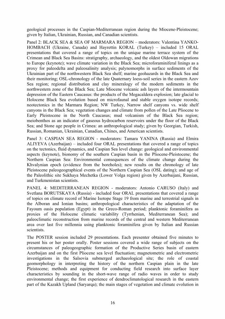
Panel 2: BLACK SEA & SEA OF MARMARA REGION – moderators: Valentina YANKO-HOMBACH (Ukraine, Canada) and Hayrettin KORAL (Turkey) – included 15 ORAL presentations that covered a range of topics on the unique marine terrace system of the Crimean and Black Sea Basins: stratigraphy, archaeology, and the oldest Oldowan migrations to Europe (keynote); wave climate variation in the Black Sea; microforaminiferal linings as a proxy for paleodelta and paleosalinity analysis; palynomorphs in surface sediments of the Ukrainian part of the northwestern Black Sea shelf; marine geohazards in the Black Sea and their monitoring; OSL-chronology of the late Quaternary loess-soil series in the eastern Azov Sea region; regional distribution and clay mineralogy of the modern sediments in the northwestern zone of the Black Sea; Late Miocene volcanic ash layers of the intermountain depression of the Eastern Caucasus: the products of the Megacaldera explosion; late glacial to Holocene Black Sea evolution based on microfaunal and stable oxygen isotope records; neotectonics in the Marmara Region; NW Turkey, Narrow shelf canyons vs. wide shelf canyons in the Black Sea; vegetation changes and climate from pollen of the Late Pliocene to Early Pleistocene in the North Caucasus; mud volcanism of the Black Sea region; meiobenthos as an indicator of gaseous hydrocarbon reservoirs under the floor of the Black Sea; and Stone age people in Crimea: an anthropological study; given by Georgian, Turkish, Russian, Romanian, Ukrainian, Canadian, Chines, and American scientists.
Panel 3: CASPIAN SEA REGION - moderators: Tamara YANINA (Russia) and Elmira ALIYEVA (Azerbaijan) – included four ORAL presentations that covered a range of topics on the tectonics, fluid dynamics, and Caspian Sea level change: geological and environmental aspects (keynote), bionomy of the southern Caspian basin in the Pliocene-Pleistocene; the Northern Caspian Sea: Environmental consequences of the climate change during the Khvalynian epoch (evidence from the boreholes); new results on the chronology of late Pleistocene paleogeographical events of the Northern Caspian Sea (OSL dating); and age of the Paleolithic site Sukhaya Mechetka (Lower Volga region) given by Azerbaijani, Russian, and Turkmenistan scientists.
PANEL 4: MEDITERRANEAN REGION - moderators: Antonio CARUSO (Italy) and Svetlana BORUTSKAYA (Russia) - included four ORAL presentations that covered a range of topics on climate record of Marine Isotope Stage 19 from marine and terrestrial signals in the Alboran and Ionian basins; anthropological characteristics of the adaptation of the Fayoum oasis population (Egypt) in the Greco-Roman period; planktonic foraminifera as proxies of the Holocene climatic variability (Tyrrhenian, Mediterranean Sea); and paleoclimatic reconstruction from marine records of the central and western Mediterranean area over last five millennia using planktonic foraminifera given by Italian and Russian scientists.
The POSTER session included 29 presentations. Each presenter obtained five minutes to present his or her poster orally. Poster sessions covered a wide range of subjects on the circumstances of paleogeographic formation of the Productive Series basin of eastern Azerbaijan and on the first Pliocene sea level fluctuation; magnetometric and electrometric investigations in the Salsovia submerged archaeological site; the role of coastal geomorphology in interpreting the history of the northern Caspian plain in the late Pleistocene; methods and equipment for conducting field research into surface layer characteristics by sounding in the short-wave range of radio waves in order to study environmental change; the first experience of dendroclimatological research in the eastern part of the Kazakh Upland (Saryarqa); the main stages of vegetation and climate evolution in

17
the Kuban River Delta Region during the last 7.4 ka and their correlation with sea-level fluctuations of the Black Sea; the role of the Black Sea shelf techno-geological system in the integrated management of rational resource use; monitoring of climate oscillations in the Mediterranean Sea over the last two millennia using planktonic foraminifera; dynamics of the Black Sea coast and vertical movements of the shelf in the late Pleistocene-Holocene; integrating high resolution Mid-Pleistocene sea surface temperature and productivity estimates from alkenone proxies with marine and terrestrial climate signals; first discoveries of Oligocene diatomic flora in the section of Pirakashkul (Shamakhi-Gobustan zone); paleoenvironmental reconstructions at the Pleistocene- Holocene boundary in the Black Sea based upon benthic foraminifera; geoacoustic and gas geochemical signs of hydrate presence on the continental slope north-east of the Black Sea; chemical composition of Lower Khvalynian deposits in the Middle and Lower Volga region; small mammal faunas from the Mikulino (=Eemian) marine and liman deposits of the Black Sea; vortices of the Cretan straits of the eastern Mediterranean and the Black Sea shelf; evaluation of geological hazards for the Trans-Caucasus Caspian oil and gas pipelines in the Abul-Samsari volcanic ridge section; hydrogeochemical evolution of limans of the northwestern Black Sea region in connection with the problem of their use as salt sources; sedimentary structure and late Holocene evolution of the coastal embayment on the southeastern coastline of the Crimean peninsula (Black Sea); unknown morphotypes as permanent representatives in the Black Sea anoxic and sulfidic bottom sediments; petrographic description of Chokrak-Spirialis Miocene deposits of Eastern Azerbaijan; Holocene environments of the Volga River Delta: inferred from diatom assemblages in sediments of the Rycha River Channel; correlation of the Late Quaternary sediments of the Eastern Mediterranean and Ponto-Caspian basins; adjustment theory in the study of human responses to global climate change in the Northwestern Black Sea region at the Pleistocene-Holocene boundary; paleogeographic stages of development of the Iranian coast of the Caspian Sea in the Holocene; biodiversity of the Volga River delta mollusks in the Holocene; paleogeography of the Atelian period in the lower Volga region; Apsheron Deposits (Late Early Pleistocene) of the Lower Volga (Astrakhan Arch) given by Romanian, Turkish, Canadian, Ukrainian, Turkmenian, Russian, and American scientists.
The Technical and Poster Sessions were followed by the Round Table that enabled participants to discuss the progress of IGCP 610 and to plan future strategy in running the project. It was decided to ask for one year of the Project extension (if possible with some funding) to summarize Project' activities in a series of selected papers in the next IGCP 610 special volume of the Quaternary International, a paper in Epizodes, and organizing the IGCP 610-INQUA POCAS Second Joint Plenary Conference and Field Trip in Istanbul, Turkey, planned for September 30-October 7, 2018.
The five days of field trips (by bus) were led by prominent Italian geologists and archaeologists described above and shown in Fig. 9. The 49-page Field Trip Guide describes the (1) Messinian-Zanclean GSSP that provides a complete sedimentary record from the onset of the MSC up to the restoration of the normal marine conditions in the basal Zanclean and displays the classical succession of the Lower Gypsum, the Upper Gypsum and the “Lago-Mare” deposits. (2) The Capo Rossello area (Southern Sicily, Italy) that represents one of the most beautiful and complete sedimentary successions of upper Messinian to lower Pleistocene, and is particularly suitable for the study of the Plio/Pleistocene boundary. (3) Punta di Maiata that forms a beautiful natural cliff where outcrop calcareous and marly limestones of the Trubi Fm outcrop. (4) Punta Piccola - Zanclean/Piacenzian GSSP. (5) The Gelasian GSSP. (6) The almond field of Monte San Nicola with the local succession: cyclic sedimentation and sapropel clusters. (7) The Nicola bed: a close encounter with the Gelasian GSSP. (8) The Gibliscemi section, 150 m thick that is one the most complete and beautiful

18
section of the Miocene in the Mediterranean basin. (9) Agrigento Valle dei Templi (Valley of the Temple) that is an archaeological area of Sicily characterized by its exceptional state of conservation and a series of important Doric temples of the Greek period. It corresponds to the ancient Akragas nucleus originating from the city of Agrigento (Caruso et al., 2017; http://www.avalon-institute.org/IGCP610/pdf/Field_Trip_Guide_IGCP_610_2017.pdf).
Overall, the meeting provided an excellent opportunity for international discussion of different methods and interpretations used to analyze the history of a huge geographical area from the Caspian to the Mediterranean during the full duration of the Quaternary. It also emphasized the importance of studying the Pre-Quaternary geological history in order to reveal continuity in its development. The meeting encouraged an exchange of data and publications, as well as encouraged future collaboration between physical and social scientists over the Globe. It brought together multidisciplinary scientists from all over the world, and in the process enhanced West-East scientific dialogue by providing a supportive background for collaboration regarding the correlation and integration of discoveries on the influence on humans of climatically/tectonically induced sea-level changes and coastline migration. The meeting encouraged the younger generation to engage in the multidisciplinary study of the region using advanced analytical techniques and methodologies for geoarchaeological investigations.
A special Volume of Quaternary International “IGCP 610 IV” collected a number of papers presented at the meeting. It is planned for publication in 2018-2019.
3. Workshops, Summer Schools, Simposia (selected)
Workshop in Sozopol (Bulgaria, September 2013)
Workshop in Kirklareli (Turkey, September 2014)
Workshop in Ahtopol (Bulgaria, December 2014)
Workshop “Late Pleistocene of the Caspian Sea: Paleogeography, Correlation with Events in the Black Sea Region and Russian Plain” (Moscow, Russia, April 2015)
Workshop “Caspian Sea Level Change from the from the Point of View of Geomorphology” (Moscow, Russia, November 2015)
Summer School in Kalmykia (May 2014)
Summer School in the Danube Delta on-board the floating laboratory boat “Halmyris” (Romania, summer 2013, 2014, 2015)
School-seminar for young researchers "Methods of deltaic systems study in the South of Russia" held at the Faculty of Geography of Moscow State University in March 2017.
Joint Plenary Conference and Field Trip of IGCP 610 and INQUA IFG POCAS, Palermo, Italy, 1-9 October 2017
All-Russian conference “Questions of geomorphology and paleogeography of the sea coasts and shelf. P.A.Kaplin’s memories. M.V. Lomonosov Moscow State University, Russia, on February 2-3, 2017. Special session on the IGCP 610 Project.
All-Russian conference “Actual problems of the modern palynology” Moscow, M.V. Lomonosov Moscow State University, Russia, on June 5-8, 2017. Special Ponto-Caspian session.

19
International youth school-conference "Where East meets West: Pontocaspia, the historical dimension of the evolution of a unique biodiversity", Azov, Astrakhan, Russia, August 21 - September 3, 2017.
All-Russian meeting "Fundamental problems of the Quaternary: Results of studying and main directions of further researches", Moscow, Russia, September 25-29, 2017.
Lost and future worlds: marine palaeolandscapes and the historic impact of long-term climate change, the Royal Society at Chicheley Hall, Buckinghamshire, May 15-16, 2017.
4. Field Studies (2013-2017) The field studies were performed in the:
Caspian region:
Middle and Lower Volga region. In the Middle Volga region (works manager R. Makshaev) in the territory of Saratov and in the northern part of the Volgograd region, sediments of the Khvalyn transgression of the Caspian Sea in the outcrops along the river were studied. In the Lower Volga region (supervisors T. Yanina and R. Kurbanov) in the territory of the Volgograd region, the key sections of the Caspian Pleistocene Srednyaya Akhtuba, Leninsk, Raigorod were studied; in the territory of Kalmykia—section of the Tsagan-Aman; in the Astrakhan region—section of Seroglazka. All studied sections have a complex structure, which is typical of a large valley, periodically flooded by the Caspian Sea. Stratigraphic reference points are deposits containing Caspian malacofauna Didacna Eichwald. The key sections most fully reflect the history of transgressive-regressive events in the Caspian Sea and its relation to glacial-interglacial events on the Russian plain. Сomprehensive stratigraphic and palaeogeographic analysis of the sediments from the outcrops and radiocarbon dating of mixed-age sediments (H. Arslanov), thorium-uranium (V. Kuznetsov), and OSL (R. Kurbanov, N. Sychev, N. Tkach) were done; OSL was conducted for the first time on the Lower Volga. In the outcrop Seroglazka, sediments lying below the Volga River water edge revealed by borehole drilling to the depth of 40 meters (works manager R. Kurbanov). The core is currently being studied.
A borehole was drilled to a depth of 20 m (works manager R. Kurbanov) in order to study the Holocene history of the Caspian Sea and the influence of Volga deltaic systems on the sea level fluctuations in the territory of the modern Volga delta. By now, we have an algological study of the core (E. Schtyrkova).
Expeditionary investigations covered the Eastern coast of the Caspian Sea (supervisor R. Kurbanov). The work was conducted in Turkmenistan in the Gulf of Kara-Bogaz-Gol and the Uzboy River, and in Kazakhstan, on the Mangyshlak Peninsula. The studies were preliminary in nature; in subsequent years they will continue. For arid regions of Turkmenistan and Kazakhstan, dendrochronological and dendroclimatic studies have been carried out (A. Berdnikov and R. Kurbanov). The resulting chronology shows a significant climate response and is potentially suitable for paleogeographic reconstructions.
Field investigations (supervisor R. Kurbanov) were held in the Manych valley. The natural outcrops in the Eastern Manych valley near the Chograysky dam, near the settlement Zunda-Tolga, in the cliffs of lake Manych-Gudilo were studied. Burtasskie (middle of the Late Pleistocene), Khvalynian, and Holocene sediment exposures occur in these outcrops. In the Manych valley, deep boreholes were drilled (70-40 m) which
20
yielded a full core. Two boreholes were drilled in the central part of the Manych depression, in the area of lake Manych-Gudilo. Four boreholes were drilled in the eastern part of the depression. The core is currently being studied by complex of methods.
The cores of two boreholes from of the North Caspian Sea (supervisor T. Yanina and V. Sorokin) were studied by lithological, malacofaunal, partially palynological and geochronological methods. The study allowed us to add to the picture of paleogeographic development of the Caspian Sea in the Late Pleistocene and the reaction of its natural environment to the global climate events.
Malacofauna is an important component of the ecosystem of the Caspian Sea. Evolution of the biodiversity of mollusk fauna of the Caspian Sea during the last 10 kyr was analyzed using the results of field investigations within different areas. The biodiversity of mollusks depends on the parameters of the aquatic environment, which reflect climate changes followed by the transformation of regional water balance. The result was a change in thermal conditions, level and salinity of water bodies. Biodiversity of the New Caspian basin and water bodies of the Volga River delta were strongly affected by the anthropogenic factor, i.e., the biological invasion and acclimatization of Azov-Black Sea species which appeared to be much more competitive than the Caspian Sea autochthones. The present-day areas of Caspian endemics are smaller than potential areas of their distribution. Anthropogenic transformation of natural ecosystems of the Caspian Sea region destroys their uniqueness, thus contributing to the global loss of biodiversity.
Field investigations to identify the evolution of the natural environment during the Holocene have been made in the Don delta and in the Rostov region (supervisor R. Kurbanov). The borehole to a depth of 20 m penetrated the Holocene sediments of the Delta. The core is currently being studied by a complex of methods.
Field studies were conducted in the Kuban delta (head V. Dikarev) in order to study the geomorphologic situation, obtain information about the evolution of the delta's natural systems in the period from the Late Pleistocene to modern times in terms of different scales of climate change. Field studies covered the deltaic region of Kuban in the Azov and Black seas. Here natural outcrops of recent deposits were studied. In the delta, there are archaeological sites of importance for paleogeographic reconstruction of the studied natural region, so the expedition team carried out geoarcheological observations (V. Dikarev and A. Porotov). In different parts of the modern Kuban delta (near the villages of Achuevo and Tikhovsky), two boreholes were drilled to a depth of 20 m each. Based on the complex of methods of the core study, paleogeographic reconstructions were performed.
An important feature of work in 2016-2017 was the active participation of students and young scientists along with the professionals, who made a significant contribution to knowledge of the environment of the region. The youth involvement in the implementation of plans was at all stages of work—from field research and collecting field materials for analytical processing, discussion of results, and participation in writing of papers and preparation of presentations. It should be noted that the use of materials of expeditions by students in their qualification works.
In Turkmenistan, Cheleken geological sections have been studied and samples from the Bakinian, Urundzhikian, Khazarian, and Khvalynian strata were collected.

21
Black Sea
On the Kerch Strait coast, Holocene geological sequences were investigated.
On the Kerch Peninsula, the outcrop at Eltigen (Late Pleisticene) was studied and dating of sediments by OSL was performed.
The northwestern part of the Black Sea shelf adjacent to the Romanian part of the Danube delta was investigated on board the Romanian research vessel “Mare Nigrum” focusing on the investigation of how the Danube River discharge influences environmental conditions and benthic ecosystems on the Black Sea shelf using foraminifera to delineate affected areas (supervisor V. Yanko-Hombach).
This study examined the relationship between the distribution of meiobenthos and concentrations of hydrocarbon gases, primarily methane, in the sediments of the northwestern part of the Black Sea. Based on the dual analysis of abiotic characteristics (physical and chemical parameters of the water column, gasmetrical, geochemical, lithological, mineralogical properties of the sediment) and biotic ones (quantitative and taxonomic composition of foraminifers, nematodes, and ostracods), the possibility was explored of using meiobenthos as an indicator of gaseous hydrocarbons stored under the seabed (supervisor V. Yanko-Hombach).
In Iznik Lake (Turkey), Middle Pleistocene geological sequences were studied.
In Moldova, Crimea, the Taman peninsula, Eastern Thrace, the Bosporus coast and Aşaği Pinar, and the Danube delta, particular attention was paid to geoarchaeological evidence
An important feature of this work is the active participation of students and young scientists along with the professionals; they made a significant contribution to the quest for knowledge of the regional environment. This youth involvement in the implementation of plans was at all stages of work: field research and collecting field materials for analytical processing, discussion of results, participation in the writing of papers, preparation of presentations, and use of materials of expeditions for their BSc and MSc diplomas. The fieldwork projects permitted the collection of several hundred samples that were treated in different laboratories by various techniques. In particular, the first optical luminescence dates of strata in geological sections were obtained.
5. IGCP 610 special sessions at large international fora 2013: “Under the Sea: Archaeology and Palaeolandscapes” (Szczecin, Poland, September 2013)
2014: “Recent Problems on Lithology of Sedimentary Basins of Ukraine and Adjacent Territories” (Kiev, Ukraine, October 2014)
2014: “Geography and Geology in Secondary Education: the Modern State and Problems” (Odessa, Ukraine, October 2014)
2015: XXI International School of Marine Geology (Moscow, November 2015)
2015: All-Russian Conference "VII Shchukin readings" (Moscow, May 2015)
2015: All-Russian Conference “Actual Problems of Paleogeography and Stratigraphy of the Pleistocene” with international participation (Moscow, Russia, June 2015)
2015: “IGCP 610 Quaternary stratigraphy of the Ponto-Caspian region” at the 2nd International Congress on Stratigraphy - STRATI 2015 (Graz, Austria, July 2015)

22
2015: IGU Regional Conference 2015 "Geography, Culture and Society for Our Future Earth" (Moscow, Russia, August 2015)
2015: IGCP 610 Session #37125 “From the Caspian to Mediterranean: Environmental Change and Human Response during the Quaternary (IGCP 610)” at the GSA Annual Assembly (Baltimore, USA, November 2015)
2016: Symposium “From the Caspian to the Mediterranean: Environmental change and human response during the Quaternary: IGCP610” at the 35th International Geological Congress (Cape Town, South Africa, August 2016)
2016: Special session "SSP4.5 From the Caspian to Mediterranean: Environmental Change and Human Response during the Quaternary (IGCP 610)" at the European Geosciences Union General Assembly (Vienna, Austria, April 2016)
2017: European Geosciences Union General Assembly 2017. Vienna, Austria, on April 23-28, 2017. Special session on the IGCP 610 Project
2017: PAGES 5 Open Science Meeting Clobal challenges for our common future. Zaragoza, Spain, on May 9-13, 2017. Special session on the IGCP 610 Project.
2017: XXII International Scientific Conference (School) on Marine Geology “Geology of the seas and oceans”, Institute of Oceanology, Moscow, Russia, 20-24 November 2017. Special Caspian session.
6. IGCP 610 Special Volumes 2013: Peer-Reviewed Conference Proceedings of IGCP 610 First Plenary Conference
2013: Field Trip Guide of IGCP 610 First Plenary Conference
2014: Peer-Reviewed Special Volume of the international scientific journal Stratigraphy and Sedimentology of Oil-Gas Basins
2014: Peer-Reviewed Conference Proceedings of IGCP 610 Second Plenary Conference
2014: Field Trip Guide of IGCP 610 Second Plenary Conference
2015: Special Volume of the journal Quaternary International devoted to IGCP 610 studies
2015: Peer-Reviewed Conference Proceedings of IGCP 610 Third Plenary Conference
2015: Field Trip Guide of IGCP 610 Third Plenary Conference
2016: Peer-Reviewed Conference Proceedings of IGCP 610 Fourth Plenary Conference.
2016: Field Trip Guide of IGCP 610 Fourth Plenary Conference
2017: Peer-Reviewed Conference Proceedings and Field Trip Guide of the Fifth Joint Plenary Conference and Field Trip of IGCP 610 and INQUA IFG POCAS.
2017: Field Trip Guide of the Fifth IGCP 610 Joint Plenary Conference and Field Trip of IGCP 610 and INQUA IFG POCAS
7. Linkage with other projects and organizations
EU-ITN programme "Drivers of Pontocaspian biodiversity rise and demise" (2015-2019)
EU-WAPCOAST BS-ERA.NET 076 “Water Pollution Prevention Options for Coastal Zones and Tourist Arеas: Application to the Danube Delta Front Area”
Uncovering the Mediterranean salt giant (MEDSALT) COST Action CA15103

23
ICOMOS The International Council on Monuments and Sites
COCONET “Towards COast to COast NETworks of marine protected areas (from the shore to the high and deep sea), coupled with sea-based wind energy potential,” supported by EU
ECOST-MEETING-TD0902-090310-001280 SPLASHCOS “Submerged Prehistoric Archaeology and Landscapes of the Continental Shelf”
Project № 539 “Study of the formation processes and spatial distribution of methane in the Black Sea and theoretical considerations of their influence on basin eco- and geosystems,” supported by the Ministry of Education and Science of Ukraine (2015-2017)
Project № 557 “Theoretically justify interaction between nature and human society in the northwestern Black Sea during the late Pleistocene and Holocene” supported by the Ministry of Education and Science of Ukraine (2016-2018)
Project № 11-05-00093 “Caspian region: Peculiarities of development of the environment under climate and sea level change,” supported by the Russian Foundation for Fundamental Research (2011-2013)
Project № 12-05-01052 “Evolution of the relief of the Azov and Black Sea coast, climate, and sea level change: Comparative analysis and chronology of environmental processes for the last 20 ka,” supported by the Russian Foundation for Fundamental Research (2012-2014)
Project № 13-05-00086 “Pont-Manych-Caspian oceanographic system in the late Pleistocene: Systematics and correlation of events, evaluation of character and degree of interaction, paleogeographic consequences in the region,” supported by the Russian Foundation for Fundamental Research (2013-2015)
Project № 13-05-00242 “Radioisotope stratification of age and synchronization of the Quaternary deposits of the Ponto-Caspian,” supported by the Russian Foundation for Fundamental Research (2013-2015)
Project № 13-05-00625 “Peculiarities of the evolution of relief in the Northern Caspian region in the late Pleistocene: Main stages of the development, chronology, and correlation with climatic rhythms in the Black Sea-Caspian region,” supported by the Russian Foundation for Fundamental Research (2013-2015)
Project № 12-05-31281 “Khvalynian epoch in the history of the Caspian region: Paleoclimates and environmental evolution,” supported by the Russian Foundation for Fundamental Research (2012-2014)
Project № 14-04-00227 "Environmental evolution of the Caspian and Black Sea under climate changes," supported by the Russian Foundation for Fundamental Research (2014-2016)
8. Scientific results
Establishing the Reference List of main publications on Project subjects; a majority are published in Russian, and their titles required transliteration and translation into English
Collecting the data set on chronometric data
Correlating the Regional Stratigraphic Scales

24
Establishing a reference collection on Ponto-Caspian foraminifera (supplemented by SEM images) and mollusks
Collecting a series of regional paleogeographic and geological maps
Continuing the development of a common geochronological frame necessary for correlating major events in human prehistory and history with global environmental changes
Collaborative Danube Delta studies of samples from the delta front to the outer shelf enabling the quantification of differences among palynology processing methods and revealing a new paradigm for palynomorph distribution models in microtidal semi-enclosed basins
Collaborative Danube Delta studies from the delta front to the outer shelf on soft and hard-shelled meiobenthos (nematodes, polychaetes, foraminifera, ostracoda, etc.) and mollusksDeveloping a model for the filling of the Black Sea basin by Mediterranean salt water during the Holocene
Developing a model for the processes of Caspian-Mediterranean corridor formation and Paratethys Sea-Lake degradation
Observations of geological characteristics of Quaternary stratotypes as well as key archaeological and paleontological sites in Georgia, Azerbaijan, and Russia with further investigations of samples in various laboratories around the world
The study of archaeological sites including Gobustan with its famous petroglyphs of the Mesolithic age. Plans included visits to some archaeological and historical places in Baku: the Shirvanshakh Palace constructed during the period from the XIIIth to the XVIth century; the Maiden Tower (the most mysterious monument of Baku) of which the unique construction has no analogues in the East
Detailed study of chocolate clays in the Middle and Lower Volga region that have enabled the discovery of a direct correlation between their occurrence and morphology of relief. Material collected by the expedition is currently being studied using palynologic, lithologic, geochronologic, malacofaunal, and micropaleontologic methods
Development of a Holocene stratigraphic scale for the Iranian coast of the Caspian Sea
Obtaining new material for paleogeographic reconstructions of the Caspian basin from biostratigraphic analysis of five boreholes recovered in the North Caspian. Two marine strata that are absent on the coasts were discovered. Also, obtained a series of new radiocarbon dates for sediments and events of the late Pleistocene in the Caspian.
9. Disseminating the project events and activities Via regular updating of Project websites and mailing list of the project contributors, which increased from 957 in 2013 to 1039 in 2014 to 1310 in 2015, and 1350 in 2016 as well as social networks (Facebook for English and non-English-speakers, and Вконтакте for mostly Russian speakers):
https://www.facebook.com/groups/180481035443572/, http://vk.com/album115218532_181815723
10. Social benefits

25
Implementing cultural heritage projects, open-air site museums, training centers in schools with the possibility of conducting experimental research, working together with local Governmental and Non-Governmental Organizations across the Caspian-Black Sea-Mediterranean Corridors that we study as a single geographic unit, bypassing linguistic and political boundaries, and thus encouraging East-West dialogue, cooperation, and integration of researchers from different countries into the international R&D community; enhancing our understanding of the links between environmental change and human adaptation, contributing to an improvement in human living conditions (especially for those at risk from coastal flooding), and promoting the wise use of the Earth as a human habitat; and preserving human heritage by addressing and clarifying existing archaeological, ethnological, and paleoanthropological questions concerning the evolution of human subsistence strategies, social and ideological spheres in the light of environmental change, and human physical and cultural adaptation theory.
11. Educational, training or capacity building activities The Project has enabled participants to visit relevant sites in the Caspian region of the CORRIDORS under the guidance of local experts with on-site discussion of scientific issues; formed a platform for young undergraduate and postgraduate students to benefit from international exposure and interaction with scientists from different parts of the world and varied specialties in order to cultivate traditions of “European style” scientific fora as well as scientific discussion and informal meetings. This also promoted their interest in particular specialties and motivated them to learn foreign languages in order to improve communication skills with western colleagues.
It has also promoted a multidisciplinary approach in paleoenvironmental studies; this has encouraged students in geology to take archaeological courses, and vice versa. This has also stimulated teachers to modify their curricula for undergraduate and graduate students, and promoted the preparation of several MA and PhD theses on subjects within the IGCP 610 project.
It has encouraged the establishment of direct contacts between western and eastern youth, creating the background for better understanding of modern priorities in the developing world of science and humanities.
It has exposed the younger generation in developing countries to new analytical techniques and state-of-the-art data interpretation in the field of sustainable development and environmental risk protection, as well as human cultural development; it has also informed the wider public about the evolution of the environment during the Quaternary.
12. Activities planned Efforts are ongoing:
To maximize IGCP 610 exposure via diffusion of results in key international journals and updates of our web pages to ensure wide accessibility and increased interactive potential for project participants, the scientific community at large, relevant agencies, and the public
To consolidate scientific achievements as a basis for developing future strategies To continue to augment the funding base with upcoming and submitted research
proposals through various funding agencies To publish the next special volume of Quaternary International devoted to the
achievements of IGCP 610 To publish the paper summarizing IGCP 610 activities in Quaternary Perspective
26
References Aliyeva, E., and Kangarli, T. 2014. Field Trip Guide of IGCP 610 Second Plenary
Conference and Field Trip “From the Caspian to Mediterranean: Environmental Change and Human Response during the Quaternary” 12-20 October 2014, Baku, Azerbaijan. Nafta-Press, Baku, 186 p. ISSN 2218-9165.
Caruso, A., Capraro, L., Di Stefano, A., and Marino, M. (Eds.). 2017. Field Trip Guide of UNESCO - IUGS – IGCP 610 and INQUA IFG POCAS Joint Plenary Conference and Field Trip, October 1-9, 2017, Palermo, Italy. University of Palermo, 258 p. ISBN 978-88-940049-2-2
Gamkrelidze, I., Okrostsvaridze, A., and Gagnidze, N. 2016. Field Trip Guide of the IGCP 610 Fourth Plenary Conference and Field of IGCP 610 Project “From the Caspian to Mediterranean: Environmental Change and Human Response during the Quaternary” 2-9 October 2016 , Tbilisi, Georgia. Published by the Georgian National Academy of Sciences, 19 p. ISSN 978-9941-0-9178-0
Gilbert, A., and Yanko-Hombach, V., (Eds.). 2013. Proceedings of UNESCO - IUGS – IGCP 610 “From the Caspian to Mediterranean: Environmental Change and Human Response during the Quaternary” First Plenary Conference and Field Trip, Ilia State University, October 12-19, 2013, Tbilisi, Georgia. LTD “Sachino”, Tbilisi, 182 p. ISBN 978-9941-0-5991-9.
Gilbert, A., Yanko-Hombach, V., (Eds.). 2014. Proceedings of UNESCO - IUGS – IGCP 610 “From the Caspian to Mediterranean: Environmental Change and Human Response during the Quaternary” Second Plenary Meeting and Field Trip, 12-20 October 2014, Baku, Azerbaijan. International Scientific Journal “Stratigraphy and Sedimentology of Oil-Gas Basins” No.1. Nafta-Press, Baku, 186 p. ISSN 2218-9165.
Gilbert, A., Yanko-Hombach, V., and Yanina, T., (Eds.). 2015. Proceedings of UNESCO - IUGS - IGCP 610 “From the Caspian to Mediterranean: Environmental Change and Human Response during the Quaternary” Third Plenary Meeting and Field Trip, September 22-30, 2015, Astrakhan, Russia. Publishing House “Krasnogorskiy” of the Moscow county, 220 p. ISBN 978-5-906731-24-1.
Gilbert, A., and Yanko-Hombach, V., (Eds.). 2016. Proceedings of UNESCO - IUGS - IGCP 610 “From the Caspian to Mediterranean: Environmental Change and Human Response during the Quaternary” Fourth Plenary Meeting and Field Trip, October 2-9, 2016, Tbilisi, Georgia. Published by the Georgian National Academy of Sciences, 218 p. ISSN 978-9941-0-9178-0
Gilbert, A., and Yanko-Hombach, V., (Eds.). 2017. Proceedings of UNESCO - IUGS – IGCP 610 and INQUA IFG POCAS Joint Plenary Conference and Field Trip, October 1-9, 2017, Palermo, Italy. University of Palermo, 258 p. ISBN 978-88-940049-1-5.
Okrostsvaridze, A., Janelidze, Z., and Tushabramishvili, N., 2013. Field Trip Guide of the IGCP 610 First Plenary Conference and Field of IGCP 610 Project “From the Caspian to Mediterranean: Environmental Change and Human Response during the Quaternary” 12-19 October 2013, Tbilisi, Georgia. Tbilisi: LTD “Sachino”, 16 p. ISBN – 978-9941-0-6000-7.
Yanina, T., Svitoch, A., Kurbanov, R., Vasiliev, D., and Pigarev, E. 2015. Field Trip Guide of the IGCP 610 Third Plenary Conference and Field of IGCP 610 Project “From the Caspian to Mediterranean: Environmental Change and Human Response during the Quaternary” 22-30 September 2015, Astrakhan, Russia. Publishing House “Krasnogorsckiy” of the Moscow county, 44 p. ISBN – 978-9941-0-6000-7.
Yanko-Hombach, V. 2016. Editorial to IGCP 610 Special Volume of Quaternary International 409: 1-7.

27
PART II. PROCEEDINGS
COASTAL ZONE REACTION TO SEA-LEVEL FLUCTUATIONS
Badyukova, E.N.
Lomonosov Moscow State University, Faculty of Geography, Moscow, Russia, [email protected]
Keywords: barrier-lagoon system, nearshore, coastal plain, slopes ratio, erosion The reaction of the coastal zone to sea-level rise is considered in this presentation. Around the Caspian Sea, lowlands are widespread. During sea-level oscillations, these lowlands were flooded when sea-level rose and drained when it regressed. Detailed studies along the coast of Dagestan in the late twentieth century— when the level of the Caspian Sea rose by more than 2 m—have shown that the development of the coastal zone during transgression depended upon the slopes of both the coastal plain and the nearshore slope.
Consider what happens when the sea level drops significantly. The ratio of the slope angles of the coastal lowland and the nearshore change as deep regression reveals a steeper underwater slope. Then, a subsequent rise in sea level leads to erosion of the regressive terrace and cliffs or ledges of erosion in loose sediments that were formed (Fig. 1).
Figure 1. Variations in slope ratio. Novocaspian coastal bar erosion during the latest Caspian Sea transgression.

28
On the coastal plain, where the primary slope of the land over which the sea transgresses is less than the slope of the nearshore, lagoons form behind the bars as the result of flooding by ground and sea waters. The size of the lagoons is limited and depends on the magnitude and rate of sea-level rise, the width of the coastal plain, and the amount of sediments in the coastal zone forming the bar. When sea level rises, the lagoon becomes deeper, the bar “crawls” into it and buried. In the Fig.2C the first stage is observed (1995), with the continuing sea-level rise the bar will be buried. . Thus the coastline of the sea will move towards the land. The flooded bars record ancient shorelines and are widespread on the submarine sea slopes (Fig. 2).
Figure 2. Formation of a barrier-lagoon system and its response to the rate of sea-level rise: a-fast sea-level rise; b-slow sea-level rise; c-bar collapses into the lagoon.
Therefore, the sand and gravel material composing the bar lies atop the lagoon deposits with a sharp contact so that they are laterally replaced by bar sediments, having the same age and form at the same sea level. Erosion occurs on the seaward side of the lagoon-barrier system, which moves against the background of the sea level as it rises toward the land. But in spite of erosion, the coast in this case looks like an accumulative one. The movement of the bar leads to the erosion of the of the regressive terrace and lagoon deposits on the underwater slope, where they are washed away by waves. We recorded such a situation on the Dagestan coast. The roots of reeds that grew in the lagoon were exposed on the underwater slope, and after some time, as the nearshore profile developed, they were destroyed by waves.
It is known that the bottom erosion starts at a depth of 1/3 the wave length. In this area, wave length in the coastal zone can reach about 20 m, and therefore, nearshore erosion begins from a depth of about 7 m when it forms a profile. This means that if sea level continues to rise, at least 7 m of sediment will be washed away from the top of the coastal plain. Remaining deposits will be covered by marine sediments, where the more coarse-grained will be replaced vertically by fine-grained sediments, as the sea becomes deeper because of the transgression (Fig. 3).
None of the outcrops on the Lower Volga and along the rivers in the Northern Caspian Lowland have such deposits, however. Moreover, in most of them, lagoonal chocolate clays lie directly on subaerial or alluvial deposits (Fig. 4), i.e., no outcrops have the trangressive series of marine Khvalynian deposits. That is why we would like to repeat again that there were no deep Atelian regression and, subsequently, the Great Khvalynian transgression.

29
Figure 3. Nearshore erosion during the latest Caspian sea-level rise. Profiles near the town Caspiysk, Dagestan.
This transgression is, in fact, one of positive oscillations of Caspian Sea level on the background of gradual regression after the Khazarian transgression (Badyukova, 2016). During these positive oscillations, lagoon-transgressive terraces containing Khvalynian chocolate clays were formed (Badyukova, Solovieva, 2013).
Figure 4. Outcrops and quarries along the Lower Volga.
In conclusion, it should be noted, that the malacofauna in the lagoon-barrier systems are different from those of the open Caspian Sea, so in paleo-reconstructions, it is important to allocate the locations, depths of the lagoons, and the nature of their isolation from the sea. The malacofauna assemblages in them are different in the initial stages of transgression, the maximum, and the subsequent regression stage. At the same time, in the open sea, faunal communities persist unchanged.
Acknowledgments This study was supported by the Russian Scientific Foundation (Project № 16 - 17 – 10103) and is a contribution to the IGCP 610 project “From the Caspian to Mediterranean: Enviromental Change and Human Response during the Quaternary.”
References Badyukova, E.N., and Solovieva, G. D. 2003. Lagunno-transgressivnye terrasy [Lagoon-
transgressive terraces]. Geomorfologia 3: 36-43. (In Russian) Badyukova, E.N. 2016. History of Caspian Sea level oscillations in the Late Pleistocene (if
there was a Great Khvalynian transgression and a deep Atelian regression?). In A.S. Gilbert and V.Yanko-Hombach, (Eds.), Proceedings of the Fourth Plenary Conference of IGCP 610 “From the Caspian to Mediterranean: Enviromental Change and Human response during the Quaternary” pp. 22-25. Tbilisi, Georgia.

30
DEVELOPMENT OF THE SEFIDRUD DELTA ON THE BACKGROUND OF THE CASPIAN SEA LEVEL FLUCTUATIONS
Badyukova E.N. 1, and Svitoch A.A. 2 1,2 Lomonosov Moscow State University, Faculty of Geography, Moscow, 1 Leninskye Gory,
Russia 1,2 [email protected]
Keywords: sections, clays, coastal zone, sea-level fluctuations, paleogeography Introduction In recent years, there have been several new articles on the structure of the Caspian Iranian coastal plain (Kazanci and Gulbabazadeh, 2013; Kakroodi et al., 2015). Despite this fact, in the history of its development at the end of the Pleistocene, there are, in our opinion, a number of unresolved problems. One of them is the history of the Caspian sea-level fluctuations. In a recently published work by one of the authors of this article, it was stated that there was no deep Atelian regression, and hence no subsequent Great Khvalynian transgression. This transgression occurred but not from the level of Atelian regression (i.e. -150 m) as is commonly believed) (Badyukova, 2017). From these new positions, data are considered on the structure of the Iranian coastal plain that have been published in recent years.
Materials and methods During fieldwork, a detailed geomorphological description of the seaside plain and the coasts of Gilan was carried out with the sampling of mollusk shells as well as the drawing of profiles from the coastline to the Novocaspian terraces. In total, 64 areas located in the Western Gilan part of the Iranian coast were charted and described, and about 50 profiles were obtained (Fig. 1). A number of published works examined the geological and geomorphological structure of the shore and concluded that there were extensive lagoons on the coastal plain, which were later blocked by alluvial and alluvial fan deposits, which formed an aggradation plain (Badyukova et al., 2012).
Figure 1. Study area: 1 – points of the coastal zone receiving detailed description; 2 – sections where dense heavy clays are exposed; 3 – borehole L (Kazanci and Gulbabazadeh, 2013).

31
The aggradation plain occupies almost the entire coastal plain, except for the recent marine terrace and the areas near the towns of Astara and Anzali, where lagoons of the Novocaspian and modern age are located. Judging by the investigated sections (Fig. 1 – pts 3, 4, 6), silty lagoon deposits with a lot of shells (including Cerastoderma glaucum) show a sharp contact with overlying boulder-gravel deposits composing the regressive terraces.
Results
Interesting data were obtained from outcrops on the sides of erosional cuttings at many rivers, in wells and quarries, lying at higher levels (Fig.1 – pts 1, 10, 24, 25, 31.33, 35, 37, 39, 40). In all outcrops located at different hypsometric levels, under thick layers of alluvial and alluvial fan deposits, a clear contact with red-brown or bluish-gray, very dense clay and silt occurs (which is important to emphasize as this clay is not at all similar to the lagoon sediments). These deposits are very heavily eroded, so they are often observed not only on the banks of rivers, but even directly in their beds. Visible clay layers in some sections have thickness up to 4 m or even more (for example, at pt 35, Fig. 2). Unfortunately, the deposits do not contain shells of mollusks, thereby excluding the possibility of determining their absolute age.
Figure 2. The outcrops along the rivers and in the quarries.
Early Khvalynian marine terraces on the surface of the coastal plain are not revealed, as they are covered by a thick layer of alluvial and alluvial fan material. Accumulation of this material continued for a long time; currently, it forms the surface of the coastal plain up to the foothills. After the deposition of massive layers of boulder-pebble sediments, an erosional phase began. As a result, incised valleys were formed, and later a series of terraces and wide floodplains developed within them.
Analysis of the geological and geomorphological structure of the coastal plain suggests that the accumulation of such massive alluvial-alluvial fan deposits, followed by their erosion and then the formation of wide valleys with a series of terraces and wide floodplains requires a lot of time. Unfortunately, we have not found any mollusk shells that could allow us to identify

32
the age of the terraces. Fragments of the sea terraces are preserved only on the slopes of mountains and on the sides of river valleys at their exit to the plain (Fig.1 – pts 1, 5, 8, 9, 10).
An interesting detailed study of the Sefidrud River delta and the southern coast of the Caspian Sea is provided in the article by Kazanci and Gulbabazadeh (2013), which suggests another history of the Caspian sea-level fluctuations in the Late Pleistocene. This assumption is consonant to our ideas about the history of the development of the Northern Caspian plain during the Late Pleistocene.
Discussion Previously, a detailed study of the literature and field studies showed that in all known sections along the Lower Volga and the rivers of the Volga-Ural interfluve, there are no Khvalynian transgressive sediments of an open sea. This permits the conclusion that there was no deep Atelian regression nor an ensuing Great Khvalynian transgression.
The following suggestions are made. There was a Great Early Khazarian transgression, the level of which, according to the literature and field research data, was slightly lower than the Early Khvalynian transgression (Badyukova et al., 2015). Then, against the background of a gradual Caspian Sea level drop, there were positive oscillations. The Early and Late Khvalynian transgressions were among these oscillations.
Each regression led to riverine incision, increasing the accumulation of alluvial materials at their mouths, as well as the formation and extension to the Caspian Sea of new deltas and avandeltas. Here, according to the data of Kazanci and Gulbabazadeh (2013), alluvial-delta deposits with a clear contact lie on the very plastic, compact gray clays. These offshore sediments are exposed in the borehole Log L (Fig. 3) and, probably, in most of the outcrops along rivers described in this thesis (Fig. 2). Possibly, comparable offshore deposits were in the borehole at a depth of about 28 m in the southeastern part of the Iranian coast. Grey plastic clay and loam were discovered here, whose age according to Pliocene-Pleistocene ostracods, is 20,120 cal yr BP. (Kakroodi et al., 2015).
During the latest transgressions, river mouths flooded and extensive lagoons formed on the surface of the low-lying regressive terraces developed by that time. The development occurred according to the same scenario that we observed in the Caspian Sea coastal zone at the end of the twentieth century, and that was also discovered in the analysis of borehole L (Kazanci and Gulbabazadeh, 2013).
Figure 3. Cross section and model of the Sefidrud delta (Kazanci and Gulbabazadeh, 2013).

33
As can be seen from the materials presented in Fig. 3, in the sections on the profile, a deep regression in the Late Pleistocene (Atelian), between the Khazarian and Khvalynian transgressions is not fixed. The delta series consistently moved towards the sea, lying on the offshore sediments formed during the high transgressions of the Caspian Sea.
Conclusion Thus, against the general background of sea-level retreat during Khvalynian time, there were transgressive oscillations. Early and Late Khvalynian transgressions were some of these oscillations. During this time, stairs of marine terraces were formed. So, it is impossible to correlate deposits exposed in outcrops and boreholes located across the stretch of coastlines. In contrast to the Northern Caspian plain, lagoons were not formed on the Iranian coast during Khvalynian time, as there was a large pitch on the coastal plain. In this case, lagoons would not have formed. This thesis constitutes only a preliminary view; further studies are required in order to confirm or refute the presented schema of Caspian sea-level fluctuations in the coastal zone of Iran during the Late Pleistocene.
Acknowledgments The work was realized with support from the Russian Foundation for Basic Research, Project 17-55-560012.
References Badyukova, E.N. 2017. The role of coastal geomorphology in interpreting the history of the
Northern Caspian plain in the Late Pleistocene. In A.S. Gilbert and V.Yanko-Hombach, (Eds.), Proceedings of the Fifth Plenary Conference of IGCP 610 “From the Caspian to Mediterranean: Enviromental Change and Human response during the Quaternary”, pp. 34-38. Palermo, Italy.
Badyukova, E.N., Svitoch, A.A., Yanina, T.A., Makshaev, R.R., Oshchepkov, G.V., and Khomchenko, D. 2015. Geological and geomorphologic structure of the eastern foot of the Yergeni hills (preliminary results). In A.S. Gilbert and V.Yanko-Hombach, (Eds.), Proceedings of the Third Plenary Conference of IGCP 610 “From the Caspian to Mediterranean: Enviromental Change and Human response during the Quaternary”, pp. 21-23. Astrakhan. Russia.
Badyukova, E.N., Svitoch, A.A., and Sheikhi, B. 2012. Geomorphology and development history of Iran's Caspian coast in the Holocene. Stratigraphy and sedimentology of oil-gas basins, 1, pp. 52-74.
Kakroodi, A.A., Leroy, S.A.G., Kroonenberg, S.B., Lahijani, H.A.K., Alimohammadian, H., Boomer, I., and Goorabi, A. 2015. Late Pleistocene and Holocene sea-level change and coastal paleoenvironment evolution along the Iranian Caspian shore. Marine Geology, 361, pp. 111-125.
Kazanci, N., and Gulbabazadeh, T. 2013. Sefidrud delta and Quaternary evolution of the southern Caspian lowland, Iran. Marine and Petroleum Geology, 44, pp.120-139.

34
FIRST RESULTS OF STABLE OXYGEN ISOTOPE ANALYSIS OF UPPER PLEISTOCENE SEDIMENTS IN THE NORTH CASPIAN
BASIN
Berdnikova, A.A. 1, Garova, E.S. 2, Wesselingh, F.P. 3, Yanina, T.A. 4, Stoica, M. 5, and van de Velde, S. 6
1,2,4 Lomonosov Moscow State University, Faculty of Geography, Leninskye gory, 1, Moscow, Russia 119991
3,6 Naturalis Biodiversity Center, P.O. Box 9517, 2300 RA Leiden, The Netherlands 3 [email protected]
6 [email protected] 5 University of Bucharest, Faculty of Geology and Geophysics, 1 Nicolae Balcescu Street,
Bucharest, Romania [email protected]
Keywords: ostracods, paleoenvironment, climate change Late Pleistocene sedimentary evolution of the North Caspian basin (Bezrodnykh et al., 2015, 2017; Bezrodnykh and Sorokin, 2016; Bolikhovskaya et al., 2017; Sorokin et al., 2018; Yanina et al., 2018). These studies are based on high and low frequency seismic-acoustic profiles and on deposits sampled by drilling on the shelf during the course of prospecting research. The obtained core was analyzed using lithological, faunistic, palynological, and geochronological (radiocarbon) methods.
Here, we report on stable oxygen isotope analyses from core KОР-4, which was bored to a depth of about 60 m on a structure Shirotnaya in the northwestern Caspian area, where the bottom lies at 11 m below the Caspian Sea surface. Isotope analyses were carried out on ostracods, and species identifications were made by Prof. M. Stoica (Bucharest University). Measurements of δ18O content were made in the Geosciences Laboratory of Utrecht University under the guidance of Prof. L. Lourens. In total, 133 samples were analyzed, and for each sample, we used three ostracod specimens (Fig. 1).
The lower part of the core covers lower Khazarian sediments (late Middle Pleistocene) and contains both regressive and transgressive sediments. The δ18O ratios for regressive (-1.22‰) and transgressive (-7.46‰) sediments are very different. The Upper Khazarian sediments that form the base of the Late Pleistocene sedimentary unit contain a basal regressive interval. Throughout the upper Khazarian, isotope ratios are higher during lowstands/regressions (0.58‰) and lower during transgressions (-7.04‰). Hyrcanian transgressive sediments overlay Upper Khazarian intervals: they are separated by an erosion surface. The Hyrcanian interval is characterized by high amplitude changes in δ18O ratios: records vary from -3.37‰ in lower part (near the erosion boundary, reflecting low Caspian Sea levels) to -10.62‰ in the middle part (maximum transgression) and again up to -3.65‰ in the upper part of the layer, showing a regression that marks the onset of the Atelian regressive stage. The δ18O ratios of upper Khazarian-Hyrcanian sediments show a similar pattern as those of the lower Khazarian intervals: lowstands correspond to high ratios and highstands to low ratios.
The very low δ18O ratios (-10.55‰) found at the bottom of the interval overlying the base of the Atelian interval is remarkable. Such values indicate near freshwater conditions at the time.

35
The regressive Atelian sediments lie in paleodepressions, filled with freshwater river sediments (Bezrodnykh et al., 2015, 2017).
Figure 1. Isotope curve of КОР-4 core from the North Caspian basin.
The δ18O ratios in the Khvalynian interval range from -13.46‰ to 1.16‰. The isotopic curve reflects a number of states of the Khvalynian basin level. The initial stage of the Khvalynian basin is characterized by low δ18O ratios, indicating the contribution of atmospheric water/runoff in the North Caspian basin. Clay layers contain relatively deep-sea mollusk fauna (Yanina et al., 2018) and show the high water levels of the Khvalynian transgression that are also characterized by the δ18O ratio peak (1.16‰). We explain this high ratio by active water exchange with the Middle Caspian basin that must have driven the influx of more saline waters. Unfortunately, a major part of the Khvalynian sediments in this core could not be characterized by isotope data. In the upper part, we observed minimum δ18O ratios of -13.46‰, which indicates a significant freshwater influx. It is the final evolutionary stage of the Khvalynian transgression, caused by increasing runoff from the Volga drainage basin (Yanina et al., 2018).

36
Only one δ18O value of -1.62‰ was recorded for the Mangyshlakian layer; δ18O values in the Novocaspian layer are -6.24 and -5.86‰. The last value corresponds with the isotopic composition of the North Caspian water today. The δ18O value of -6.24‰ represents the atmospheric component in the water balance of the North Caspian basin during the maximum of Novocaspian transgression.
Our first isotopic results show climate factors driving Caspian Sea level fluctuation during the Late Pleistocene. Insignificant peaks of lighter δ18O ratios (meaning an increase in the meteorological component affecting the water balance) characterize small-scale warm transgressions: Late Khazarian and Novocaspian, which took place during the interglacials. High Caspian Sea levels during the Late Khazarian basin are also well reflected in the isotope ratios.
The maximum influence of freshwater inflow into the North Caspian basin was during the Khvalynian. Obviously, both a decrease in evaporation and an increase in runoff took place due to glacier and permafrost melting in the Volga drainage basin. With significant transgressive rise of the Caspian Sea level, a salt water influx from the Middle Caspian basin occurred that is recorded in high δ18O ratios in the North Caspian basin.
Further study of Caspian sea sediments by isotope methods will permit further interesting results and settle some debated issues in the paleogeography of the Caspian region.
Acknowledgements
The authors are thankful to Arnould van Dijk, Lucas Lourens (Utrecht University), and all colleagues for assistance and collaboration. This research was supported by the project PRIDE (Pontocaspian RIse and Demise) (the isotope analysis) and partly by the Russian Science Foundation Project No. 16-17-10103.
References Bezrodnykh, Yu.P., and Sorokin, V.M. 2016. On the age of the Mangyshlakian deposits of the
Northern Caspian Sea. Quaternary Research 85(2): 245-254. Bezrodnykh, Yu.P., Deliya, S.V., Romanyuk, B.F., Sorokin, V.M., and Yanina, T.A. 2015.
New data on the upper Quaternary stratigraphy of the North Caspian Sea. Doklady Earth Sciences 462(1): 479-483.
Bezrodnykh, Yu.P., Romanyuk, B.F., Sorokin, V.M., and Yanina, T.A. 2017. First data on the radiocarbon age of the Atelian deposits in the North Caspian region. Doklady Earth Sciences 473(1): 277-280.
Bolikhovskaya, N.S., Yanina, T.A., and Sorokin V.M. 2017. Prirodnaya obstanovka atelskoy epohi po dannym palinologicheskogo analiza. Vestnik Moskovskogo universiteta. Seriya 5: Geographiya 6: 96-101. (In Russian)
Sorokin, V., Yanina, T., Bezrodnykh, Yu., and Romanyuk, B. 2018. Identification and age of submarine Girkanian sediment beds (upper Pleistocene) in the Caspian Sea. Quaternary International 465(A): 152-157.
Yanina, T., Sorokin, V., Bezrodnykh, Yu., and Romanyuk, B. 2018. Late Pleistocene climatic events reflected in the Caspian Sea geological history (based on drilling data). Quaternary International 465(A): 130-141.

37
CLIMATE AND ENVIRONMENTAL CHANGES IN THE NORTHERN CASPIAN SEA REGION DURING THE HOLOCENE
Bolikhovskaya, N.S.
Faculty of Geography, M.V. Lomonosov Moscow State University, Moscow, Russia 119991 [email protected]
Keywords: Lower Volga region, pollen analysis, 14C dating, vegetation and climate reconstructions, Caspian Sea transgressions and regressions Introduction Changes in landscape conditions in the northern Caspian Sea during the last 10,000 years are associated with climate change and fluctuations in the level of the Caspian basin. Using data on geology, geomorphology, history, archaeology, and malacology, as well as results of radiocarbon (14C) dating, P.V. Fedorov, O.K. Leontyev, G.I. Rychagov, S.I. Varushchenko, A.A. Svitoch, and others have defined coastline hypsometry and the ages of a hierarchy of multiple transgressions and regressions of the Caspian Sea during the Holocene.
Climatic conditions and plant communities of the littoral areas during the Mangyshlak regression, during the maximum of the New Caspian transgression, and during different phases of the Late Atlantic period have been reconstructed from palynological analyses of Caspian Sea bottom sediments and from analyses of lake, alluvial, and subaerial deposits of the northwestern and northeastern sectors of the Caspian region by T.A. Abramova (1980, 1985), V.A. Vronsky (1980, 1987), V.L. Yakhimovich et al. (1986), and others.
A holistic understanding of vegetation and climate evolution during the entire modern interglacial epoch has been hampered by a lack of data for the Caspian sequences that possess the full representation of Holocene sediments, sufficient palynological characteristics, and a series of 14C dates. In the late 1980s, the first results were obtained (Bolikhovskaya, 1990) from a comprehensive palynological study of sediments that were fully dated by 14C, and this allowed us to reconstruct a continuous sequence of changes in vegetation and climate of the Lower Volga during the Holocene. Using materials from our subsequent research, we compared Holocene climatic and vegetation successions from the Volga-Akhtuba floodplain and the Volga delta, and identified patterns of landscape and climatic changes that have been occurring in the study area over the last 10,000 years (Bolikhovskaya and Kasimov, 2008, 2010).
This publication presents the main results of detailed reconstructions of changes in zonal vegetation types and the transformation of the zonal and intrazonal plant communities in the Holocene landscapes of the Lower Volga region that occurred under the impact of global climate fluctuations and changes in edaphic conditions. These reconstructions were based on a comprehensive palynological analysis and radiocarbon dating of paleogeographic sequences that were the most informative regarding the Holocene period. The reconstructed paleoclimatic events were correlated with the Caspian Sea transgressive-regressive phases of the Holocene. A detailed periodization scheme of individual paleoclimatic events has been developed, and this scheme can now serve as a framework for subsequent climato-stratigraphical and paleogeographical studies of the Northern Caspian region during the Holocene. The reconstructed chronological paleo-boundaries of vegetation, landscape, and climate change phases may serve as a climato-stratigraphical framework for subsequent paleogeographical studies of the Holocene in the Caspian basin. Furthermore, these findings

38
may help to understand the magnitude of the transformation in Holocene landscapes of the Northern Caspian region during various transgressive and regressive epochs.
Materials, methods, study area
The main object of these research efforts was the Northern Caspian Sea region, specifically the Volga-Akhtuba floodplain, as it is the most indicative in palynological respect. Its vegetation (as shown by the results of this study) actively responded to climate change and the congruent Caspian Sea level fluctuations. A spore-pollen analysis of sediments from two sections near the site of Solenoye Zajmishche (47°54' N, 46°10' E; about -19-20 m asl — i.e., above sea level — and 5 km south of the city of Chernyi Yar, Astrakhanskaya oblast) was performed. Section 1 was a 5-meter thick layer uncovered by а well at a dry oxbow lake developed on the surface of a high floodplain. A detailed climato-stratigraphical interpretation was performed using palynological analysis of 50 samples taken at 10-cm intervals and 14C dating of five samples (Table 1). It appeared that the process of accumulation of oxbow-lake clays continued through the entire Holocene. In the outcrop of the sediments, Section 2 uncovered a high floodplain towering 6-7 meters above the river’s edge. Representative data have been obtained for the upper 3 m of the exposed sequence. On the basis of pollen assemblages, it can be dated to the late Subboreal and Subatlantic periods of the Holocene.
Table 1. Radiocarbon and calendar dates for Holocene sediments from sections at Solenoe Zajmishche
Sample Number
Depth, m
14С dates, yrs BP
Calendar (calibrated) dates, BP
(ca. 14С yrs BP)
1 4.75–5.00 9560±60 11060–10970
2 4.50–4.75 8500±100 9500
3 2.25–2.50 3200±60 3440–3400
4 2.00–2.25 2540±130 2620
5 0.30–0.50 900±60 900–800
Palynological data were also derived from a 10-m thick layer penetrated by borehole N22 in the littoral area of the Volga Delta (45°43' N, 47°55' E) (-22 m asl) at the Damchik site of the Astrakhan Nature Reserve. The absolute age of this section’s sediments was determined by our colleagues in an international project from six 14C AMS dates; they varied from 7287 ± 44 to 3316 ± 34 BP. The Holocene geological record in the sequences of the Volga delta (Kroonenberg and Hoogendoorn, 2008) is incomplete, which has been confirmed by rigorous palynological and algological investigation of four sections from the delta carried out by K. Richards (2018; see also Richards et al., 2014).
Results and conclusions A detailed climato-stratigraphical subdivision of the sediments studied and a description of 26 phases in the development of vegetation and climate during the Holocene in the Lower Volga region were performed using the palynological data and results of 14C dating obtained in this study (Table 2).

39
Table 2. Climatic stages of the Holocene in the Lower Volga Region, their characteristics and ages according to pollen analysis and 14С dating of the deposits from Solenoe Zajmishche
14С ages of climatic stages, years BP
Holocene
Subdivisions Conventional Calibrated
Zonal vegetation
Climate
200 – 0 250 – 0 Semi-desert Relatively warm and arid
400 – 200 500 – 250 Semi-desert Temperature fall, humidification
700 – 400 670 – 500 Semi-desert Temperature rise, humidification
900 – 700 840 – 670 Semi-desert Temperature fall, aridization
SA-3
1100 – 900 1030 – 840 Dry steppe Cool and arid
1300 – 1100 1270–1030 Steppe Temperature rise, humidification
1500 – 1300 1400–1270 Dry steppe Temperature fall, aridization
1700 – 1500 1600–1400 Steppe Relatively warm and relatively humid
1800 – 1700 1720–1600 Steppe Warm and arid
SA-2
2100 – 1800 2080–1720 Steppe Relatively warm and relatively humid
2300 – 2100 2340–2080 Dry steppe Temperature fall, continentalization
SA-1
2500 – 2300 2600–2340 Steppe Temperature fall, humidification
2700 – 2500 2780–2600 Steppe Relatively warm and arid
SB-3
3500 – 2700 3770–2780 Forest-steppe Relatively warm, humidification
SB-2
3700 – 3500 4040–3770 Dry steppe and semi-desert with Chenopodiaceae -
Temperature fall, aridization

40
Artemisia assemblages
4200 – 3700 4770–4040 Forest-steppe; mixed forests with broad-leaved, birch, and conifer stands
Warm and humid climate
(III climatic optimum)
4800 – 4200 5540–4770 Forest-steppe Temperature fall and humidification rise
SB-1
5000 – 4800 5740–5540 Forest-steppe Temperature fall, aridization
AT-2
6100 – 5000 6970–5740 Forest-steppe; mixed forests with hornbeam, beech, elm, lime, birch, and conifer stands
Warm and humid
(II – main - climatic optimum)
7400 – 6100 8240–6970 Steppe Warm and relatively arid
7600 – 7400 8400–8240 Dry steppe with Chenopodiaceae - Artemisia assemblages
Temperature fall, aridization
AT-1
8000 – 7600 8900–8400 Steppe Warm and relatively humid
8300 – 8000 9350–8900 Steppe Temperature fall, continentalization
BO-2 8500 – 8300 9500–9350 Forest-steppe; mixed forests with hornbeam, elm, lime, birch, and conifer
Warm and humid
(I climatic optimum)
BO-1 9200 – 8500 10250–9500
Steppe with Chenopodiaceae assemblages, park pine forests
Cool, continentalization
PB-2 10000–9200 11500–10250
Forest-steppe dominated by Picea, Pinus, Abies
Relatively cool and humid
We correlated the reconstructed paleoclimatic events to the Caspian Sea level fluctuations defined according to geological, geomorphological, malacological, and other studies. The research presented herein established the following dependencies in landscape-climatic changes in the Lower Volga region and in climate-dependent sea-level fluctuations of the Caspian Sea during the Holocene.

41
1) Over the past 10,000 years (11,500 cal yrs), there were several changes in the vegetation cover and climate of the Lower Volga region. Palynological data indicate at least 26 phases in the evolution of the Holocene landscapes and climate of this territory. During the Early and Middle Holocene, in the interval ~10,000–2500 BP, forest-steppe and steppe landscapes dominated under a more favorable and humid (compared to modern time) climate in the study area. These landscapes underwent seven forest-steppe and seven steppe non-consecutive phases during their development. In the Late Holocene, in the interval ~2500–900 BP, there were eight phases that reflect the transformation of zonal and intrazonal phytocoenoses. During the last 900 years, the territory of the Lower Volga became the area of development of desert-steppe and desert landscapes, for which at least four climato-phytocoenotic alternations were identified; these phases reflected fluctuations of heat and moisture availability.
2) The main feature of the evolution of climatic processes in this region during the Holocene was expressed in the distinct climatic optima that corresponded to the maxima of heat and moisture supply. The Late Atlantic optimum (~6100–5000 BP) was the main optimum and the time of development of forest-steppe landscapes. The amount of thermophilic arboreal pollen in the pollen assemblages that represent this period reached 31%. Mixed oak forest with an admixture of common and Caucasian hornbeam (Carpinus betulus, C. caucasica), oriental beech (Fagus orientalis), different species of elm (Ulmus laevis, U. foliacea), linden (Tilia cordata), birch, and other trees, and coniferous forests comprised the forest belt of the Lower Volga floodplain. The Late Boreal (~8500–8300 BP) and the Middle Subboreal (~4200–3700 BP) optima were close in character and characterized by a lesser heat availability and greater moisture supply. They were both marked by the dominance of forest-steppe and, in some phases, of steppe landscapes. However, they differed from the Atlantic optimum by less favorable conditions for the growth of broad-leaved tree stands and by less participation of broad-leaf species in the forests. The amount of pollen from broad-leaf species in the pollen assemblages that describe these periods did not exceed 21–23%. It is possible to correlate these three phases to the maximal transgressive stages of the New Caspian basin with a high degree of confidence.
3) The existence of the transgressive stages of the Caspian Sea is also supported by the phases of cold and relatively humid climate. First, this is expressed in the presence of the forest-steppe phase in the interval ~10,000–9200 BP, which corresponds to the Sartass stage when, within the part of the Northern Caspian region free from the sea, there were widespread sparse pine forests and isolated forest stands dominated by spruce and fir. The phases of cooling and humidization were also identified in the intervals ~4800–4200, 2500–2300, and 400–200 BP. Transgressive stages of the sea correlate also with the phases of warming and humidization of climate in the intervals ~8000–7600, 3500–2700, 2100–1800, 1700–1500, 1300–1100, and 700–400 years BP.
4) Regressions of different ranks may correspond to the reconstructed minima of heat and moisture (the periods of cold and dry climate), as well as to the intervals of significant warming and aridization (the periods of relatively warm and dry climate). Two of the most significant minima of heat and moisture availability correlate with the Early Subboreal sub-period and to the first half of the Late Subatlantic sub-period. The first minimum corresponds to the time of the Mangyshlak regression of the Caspian Sea (~9200–8500 BP), while the second minimum corresponds to the Derbent regression (1500–700 BP). Within the interval 8500–1500 BP, there was one phase of rapid warming and aridization of climate (~2700–2500 BP) and five phases of sharp cooling and aridization of climate (in the intervals ~8300–8000, 7600–7400, 5000–4800, 3700–3500, and 2300–2100 BP) that may correspond to a short-term but pronounced drop in the Caspian Sea’s level. The most significant decrease relates to the intervals ~7600–7400 and 3700–3500 BP. All phases of cooling and aridization

42
of climate were marked by the prevalence of dry steppes and semideserts within the study region; there, xerophitic Artemisia and Chenopodiaceae communities dominated the vegetation.
5) Based on the reconstructed climatic and vegetation successions, two paleogeographic models of the Caspian Sea in post-Mangyshlak time may be proposed. The first model is based on the fact that the Late Subatlantic interval, characterized by the dominance of semidesert and desert landscapes, is very different in phytocenological and climatical respect (with the exception of the last phase of the Subboreal period ~2700–2500 BP) from the entire preceding part of the Holocene. It should be also noted that the last (the newest) 700-year-long phase of development of the Caspian basin is closer to regressive than transgressive in paleo-climatic respect. The alternative model is close to the models developed by O.K. Leont’ev and G.I. Rychagov (1982), and A.N. Varuschenko et al. (1980), except for the interpretation of a regressive phase in the interval of ~5000–3500 BP. We suggest that this phase was developing as a pulse regressive phase (as determined from the palynological data) ~5000–4800 BP. This phase was replaced by a transgressive phase ~4800–3700 BP followed by a new pronounced pulse decrease in the Caspian Sea level ~3700–3500 BP.
Acknowledgments The research was supported by Russian Science Foundation (Project No 16-17-10103).
References Abramova, T.A. 1980. Izmeneniye uvlazhnennosti Kaspijskogo regiona v golotsene po
palinologicheskim dannym [Change in moisture of the Caspian region during the Holocene identified based on palynological data]. Kolebaniya uvlazhnennosti Aralo-Kaspijskogo regiona v golotsene [Fluctuations of Moisture in the Aral-Caspian Region in the Holocene]. Moscow: Nauka, pp. 71-74. (In Russian)
Abramova, T.A. 1985. Paleogeograficheskiye usloviya Aralo-Kaspijskogo regiona v pozdne-golotsenovoye vrem'a (po palinologicheskim dannym) [Paleogeographic conditions of the Aral-Caspian region in late Holocene time (from palynological data)]. Rel'yef i klimat [Relief and Climate]. Moscow: VGO, pp. 91-100. (In Russian)
Bolikhovskaya, N.S. 1990. Palinoindikatsiya izmeneniya landshaftov Nizhnego Povolzh’ya v posledniye desyat’ tys'ach let [Palynological indication of environment changes in the Lower Volga region during the last 10,000 yrs]. Voprosy geologii i geomorfologii Kaspijskogo morya [Issues of Geology and Geomorphology of the Caspian Sea]. Moscow, Nauka, pp. 52-68. (In Russian)
Bolikhovskaya, N.S., and Kasimov, N.S. 2010. The evolution of climate and landscapes of the Lower Volga Region during the Holocene. Geography, Environment, Sustainability N 2 (vol. 3), 78-97.
Bolikhovskaya, N.S., and Kasimov, N.S. 2008. Landshaftno-klimaticheskiye izmeneniya na territorii Nizhnej Volgi v posledniye 10 tysyach let [Landscape and climate variability of the Lower Volga River Region during the last 10 kyrs]. In N.S. Bolikhovskaya and P.A. Kaplin, (Eds.), Problemy paleogeografii i stratigrafii plejstotsena [Problems of Pleistocene Paleogeography and Stratigraphy]. Vol. 2: The Collection of Scientific Works, Moscow: Geographical Faculty of Lomonosov Moscow State University, pp. 99-117. (In Russian)
Kroonenberg, S.B., and Hoogendoorn, R.M. 2008. Field Excursion Volga delta. Field Excursion Volga delta. An analogue for Paleo-Volga deposits. Delft University Technology. pp. 1-39.

43
Leont'ev, O.K., and Rychagov, G.I. 1982. O golotsenovoj istorii Kaspijskogo morya [On the Holocene history of the Caspian Sea]. Geograficheskiye issledovaniya chetvertichnogo perioda [Quaternary Geographical Research]. M.: MGU, pp. 134-146. (In Russian)
Richards, K. 2018. Studies in Caspian palynology: Six million years of vegetation, climate and sea level change. PhD thesis. Amsterdam, 269 pp.
Richards, K., Bolikhovskaya, N.S., Hoogendoorn, R.M., Kroonenberg, S.B., Leroy, S.A.G., and Athersuch, J. 2014. Reconstructions of deltaic environments from Holocene palynological records in the Volga delta, northern Caspian Sea. The Holocene 24(10): 1226-1252.
Varuschenko, A.N., Varuschenko, S.I., and Klige, R.K. 1980. Izmeneniye urovnya Kaspijskogo morya v pozdnem plejstotsene-golotsene [Changes in the Caspian Sea level in the Late Pleistocene-Holocene]. Kolebaniya uvlazhnennosti Aralo-Kaspijskogo regiona v golotsene [Moisture Fluctuations of the Aral-Caspian Region in the Holocene]. Moscow: Nauka, pp. 79-89. (In Russian)
Vronsky, V.A. 1980. Golotsenovaya istoriya Kaspijskogo morya po palinologicheskim dannym [Holocene history of the Caspian Sea from palynological data]. Kolebaniya uvlazhnennosti Aralo-Kaspijskogo regiona v golotsene [Fluctuations of Moisture in the Aral-Caspian Region in the Holocene]. Moscow: Nauka, pp. 74-79. (In Russian)
Vronsky, V.A. 1987. Stratigrafiya i paleogeografiya Kaspijskogo morya v golotsene [Stratigraphy and paleogeography of the Caspian Sea during the Holocene]. Izvestiya Akademii Nauk SSSR. Geologiya [Bulletin of the USSR Academy of Sciences. Geology] 2, pp. 73-82. (In Russian)
Yakhimovich, V.L., Nemkova, V.K., Dorofeev, P.I., and Popova-L’vova, M.G., Suleymanova, F.I., Khabibullina, G.A., Alimbekova, L.I., and Latysheva, E.K. 1986. Plejstotsen nizhnego techeniya r. Ural. [Pleistocene in the Lower Reaches of the Ural River]. Ufa. (In Russian)

44
INTERACTIONS BETWEEN TWO DIFFERENT REALMS IN THE MARMARA GATEWAY: AN OVERVIEW ON QUATERNARY
STRATIGRAPHY WITH NEW FINDINGS (NW TURKEY)
Büyükmeriç, Y. 1, Alçiçek, H. 2, and Alçiçek, M.C. 3
1 Bülent Ecevit Üniversitesi, Mühendislik Fakültesi, Jeoloji Mühendisliği Bölümü, 67100 İncivez-Zonguldak/Türkiye
[email protected] 2, Pamukkale Üniversitesi, Mühendislik Fakültesi, Jeoloji Mühendisliği Bölümü,
Kınıklı/Denizli/Türkiye 2 [email protected] 3 [email protected]
Keywords: Çanakkale, Pleistocene, Holocene, Pontocaspic system, Mediterranean, episodic connections Episodic connections between the Pontocaspian lakes of the Caspian, Black Sea, and Mediterranean basins were controlled by climate change, tectonic configuration of interconnecting basins, and sea- level fluctuations. On the basis of isotopic data from the Zonguldak/Sofular cave (Badertscher et al., 2011), twelve overflow phases from the Caspian into the Black Sea, and six marine transgressions from the Marmara into the Black Sea basins have been proposed for last 670 ka. These various connections did cause rapid and strong changes in salinity and nutrient regimes, which determined the type of fauna that could became established in the Marmara-Black Sea region, an area where sudden faunal replacements were common.
The Marmara Sea basin is located between and Mediterranean and Black seas. Middle and late Pleistocene deposits exposed in the region contain marine mollusk faunas and endemic “Pontocaspian” faunas. The latter also have been documented from the adjacent Iznik Basin (İslamoğlu, 2009; Meriç et al., 2018). The earliest fossil molluscan data recorded in the Marmara basin reveal a Pontocaspian assemblage of Chaudian (middle Pleistocene) stage from Gelibolu (Taner, 1983). New molluscan findings from the Çanakkale area confirm the Chaudian age (early middle Pleistocene). Similar to the Gelibolu section (Taner, 1983), new outcrops from the Çanakkale region possibly indicate the presence of several Pontocaspian overflow episodes. Terrace successions surrounding the Iznik Lake basin contain Pontocaspian faunas that shed light on their evolution during the middle Pleistocene (Eoeuxinian) (İslamoğlu, 2009). Fossil specimens recovered from cores contain an interval with Pontocaspian mollusks in the Marmara basin. They represent several outflow phases from the Black Sea during the latest Pleistocene (Surozhian and Neoeuxinian) (İslamoğlu and Tchepalyga, 1998; Taviani et al., 2014; Büyükmeriç, 2016; Meriç et al., 2018). Surozhian mollusks were also encountered in the Iznik lake drill core samples (Meriç et al., 2018). The finding of the Black Sea stages (Chaudian, Eoeuxinian, and Neoeuxinian) shows that the Marmara region was at times the southwestern extension of the Pontocaspian system. Intervals in the middle-to-late Pleistocene and early Holocene provided the open marine connections between the Mediterranean and Black Sea basins, as determined in the outcrops at Yalova (Büyükmeriç et al., 2016) and Çanakkale (Erol, 1969, 1985, 1992; Erol and Nuttal, 1972; Erol and İnal, 1982; Taner, 1981, and this work). The marine connections occurred four times during possibly during MIS9, MIS7, MIS5e and also MIS5c. New faunal finds from Çanakkale are very similar to the contemporary Black Sea euryhaline faunas rather than the full marine Mediterranean ones. Thus new faunal findings from the area concerns
45
Uzunlarian and Karangatian type of faunas of the Black Sea region that have a remarkably similar composition given the absence of typical stenohaline and tropic/subtropic Tyrrhennian mollusks in the region in intervening times.
Work is currently ongoing to assemble further data from the westernmost part of the Marmara region, and additional fossil mollusk occurrences will improve our understanding of the role of the Marmara region. However, new and detailed age determinations will be required from tectonically uplifted deposits in order to improve the stratigraphic resolution between the basins.
References Badertscher, S., Fleitmann, D., Cheng, H., Edwards, R.L., Göktürk, O.M., Zumbühl, A.,
Leuenberge, and M., Tüysüz, O. 2011. Pleistocene water intrusions from the Mediterranean and Caspian seas into the Black Sea. Nature Geoscience 4: 236-239.
Büyükmeriç, Y. 2016. Postglacial floodings of the Marmara Sea (Turkey): Molluscs and sediments tell the story. Geo-Marine Letters 36 (4): 307-321.
Büyükmeriç,Y., Wesselingh, F.P., and Alçiçek, M.C. 2016. Middle-late Pleistocene marine molluscs from Izmit Bay area (eastern Marmara Sea, Turkey) and the nature of Marmara-Black Sea corridors (Izmit Bay, eastern Marmara Sea). Quaternary International 401: 153-161.
Erol, O. 1969. Çanakkale boğazı çevresinin jeomorfolojisi hakkında ön not: A preliminary rapport on the geomorphology of the Çanakkale area: The Dardanelle (Turkey). Coğrafya Araştırma Dergisi 2: 53-71.
Erol, O. 1985. Çanakkale yöresi güney kesiminin jeomorfolojisi. Jeomorfoloji Dergisi 13:1-8. Erol, O. 1992. Çanakkale yöresinin jeomorfolojisi ve neotektoniği. Türkiye Petrol Jeologları
Derneği Bülteni 4(1): 147-165. Erol, O., and Nuttal, C.P. 1972. Çanakkale yöresinin bazı denizel Kuvaterner depoları.
Coğrafya -Araştırma Dergisi 5/6: 27-91. Erol, O., and İnal, A. 1980. Çanakkale yöresi Karacaviran köyü çevresindeki Kuvaterner
depoları ve denizel fosilleri. Jeomorfoloji Dergisi 9: 1-35. İslamoğlu, Y. 2009. Middle Pleistocene bivalves of the İznik lake basin (Eastern Marmara,
NW Turkey) and a new paleobiogeographical approach. International Journal of Earth Sciences 98:1981-1990.
İslamoğlu, Y., and Tchepalyga, A.L. 1998. The environmental changes determined with Molluscan assemblages during the Neoeuxinian-Holocene stages in the Sea of Marmara. Geological Bulletin of Turkey 41: 55-62.
Meriç, E., Nazik, A., Yümün, Z.Ü., Büyükmeriç, Y., Avşar, N., Yıldız, A., Sagular, E.K., Koral, H., and Gökaşan, E. 2018. Fauna and flora of drilling and core data from the İznik lake: The Marmara and The Black Sea connection. Quaternary International (in press).
Taner, G. 1981. Gelibolu yarımadasının denizel Kuvaterner molluskaları. Jeomorfoloji Dergisi 10: 71-117.
Taner, G. 1983. Hamzaköy Formasyonu'nun Çavda (Baküniyen) Bivalvleri, Gelibolu Yarımadası. Türkiye Jeoloji Kurumu Bülteni 26(1): 59-64.
Taviani, M., Angeletti, L., Çağatay, M.N., Gasperini, L., Polonia, A., and Wesselingh, F.P. 2014. Sedimentary and faunal signatures of the post-glacial marine drowning of the Pontocaspian Gemlik lake (Sea of Marmara). Quaternary International 345:11–17.

46
CHRONOSTRATIGRAPHICAL CORRELATION OF PONTO-CASPIAN AND MEDITERRANEAN BASINS FOR THE RECONSTRUCTION OF
WATER EXCHANGE AND THE FIRST PEOPLING OF EUROPE
Chepalyga, A.L.
Institute of Geography RAS, Moscow, Russia 119017 [email protected]
Keywords: Caspian, Black Sea, marine terrace and basins correlation, Oldowan culture, initial peopling of Europe Chronostratigraphical correlation On the basis of detailed interdisciplinary studies of marine sediments and terraces, a correlation table (International Commission) was prepared and dated according to paleomagnetic research and marine terrace cycles of the South coast of Crimea (SCC) (Table 1).
Neogene Pliocene Early Pliocene Zanklian stage of the Mediterranean Sea correlates with the Kimmerian stage of the Black Sea basin, dated 5.2-3.6 Mya by correlation with the upper part of the Gilbert paleomagnetic chron above the Thvera subchron.
In the Caspian Sea, it corresponds to the Productive (Balahan) series of the same age.
Late Pliocene In the Mediterranean Sea, it is the Piacenzian stage and basin, the age of which is distinguished by a duration of the Gauss paleomagnetic chron (3.6-2.6 Mya).
In the Black Sea, the coeval stage is an isolated basin of the Early Kuyalnik, while in the Caspian Sea, it is the Early-Akchagylian demimarine basin, connected by bilateral water exchange with the Mediterranean Sea by the Euphrates Strait.
Anthropocene (Pleistocene s.l.) Paleopleistocene (Early Pleistocene) The Gelasian basin of the Mediterranean Sea, dated 2.6-1.8 Mya within the frames of Marine Isotope Stages (MIS) 103-63 and the upper part of the Matuyama chron higher than Olduvai event is coeval in the Black Sea with the Late-Kuyalnik basin, which is represented in the SCC by 6-7 marine terraces (XII-XVIII terraces). These terrace cycles could become the basis for more detailed stratigraphic units.
In the Caspian Sea, it correlates with the Late Akchagylian marine basin (2.6-1.8 Mya). This basin marks its maximal transgression, reaching in the west the Taman and Crimea, forming the Azov-Kuban Gulf. In the south, it had a wider connection with the Mediterranean Sea by the abovementioned Euphrates Strait.

47Table 1. Chronostraigraphic correlation of the Ponto-Caspian and Mediterranean basins and Oldowan cultute on the way of the first peopling of Europe
48
Eopleistocene (Early Pleistocene)
In the Mediterranean Sea, the Calabrian basin and stage, dated 1.8-0.8 Mya, is framed by MIS 62-20 and subdivided into 3 substages: Santernian, Emilian, and Sicilian.
In the Black Sea, it correlates with the Gurian basin of the same age and is represented by 3 substages: the Early Gurian freshened basin (Guriantian), the Middle Gurian brackish isolated basin (Natanebian), and the Late Gurian brackish basin with the first Chaudian mollusk fauna of Caspian type (Tsvermagalian).
The Gurian basin is represented in the coast by 5-6 marine terraces (VII-XI terraces), which could be the basis for the elaboration of a detailed chronology by using 200,000-year cycles (double orbital cycles).
In the Caspian Sea, the Gurian and Calabrian basins correlate with the Apsheronian isolated basin with two stages of formation, divided at the level of the Cobb Mountain event (1.2 Mya).
Early-Apsheronian (1.8-1.2 Mya) demifreshwater basin had a unilateral discharge via the Euphrates spillway Strait to the Mediterranean Sea after its basin level dropped.
Late Apsheronian (1.2-0.8 Mya) isolated brackish water basin is of the recent Caspian Sea type.
Neopleistocene (= Middle-Upper Pleistocene) In the Mediterranean Sea, the Neopleistocene includes the Ionian and Tyrrhenian stages. In the Ponto-Caspian Sea, it is divided into 3 units: Early, Middle, and Late. The Early Neopleistocene is represented in the Black Sea by the Chaudian basin and stage, correlated with the Brunhes chron (younger than 0.8 Ma) and possessing 3 substages: Emonian – regressive isolated basin, Early Chauda (Cape Chauda), and Late Chauda (Epichauda=Karadeniz) which dates the first connection with the Mediterranean Sea via the Sea of Marmara on the basis of Mediterranean Sea mollusk intrusion.
In the Caspian Sea at this time, there was the Bakunian brackish water basin with 3 substages: Turkian, Early Baku, and Late Baku.
Middle Neopleistocene (Late Middle Pleistocene) In the Black Sea depression, this time is represented by the Paleoeuxinian (IV terrace) and the Uzunlarian (III terrace) basins.
In the Caspian depression, the Early Khazarian basin formed.
Late Neopleistocene (Late Pleistocene) This time in the region of the recent Mediterranean Sea produced the Tyrrhenian basin, while in the recent Black Sea region, there was the Karangatian basin with 3 substages of II marine terrace (Sochi, Agoi, Ashe) corresponding to marine stages MIS 5a (80 ky), 5c (80-100 ky), and 5e (125 ky).
In the Caspian region, it is the Late Khazarian basin of the Last Interglacial (Mikulino) time.
On the way of initial peopling of Europe
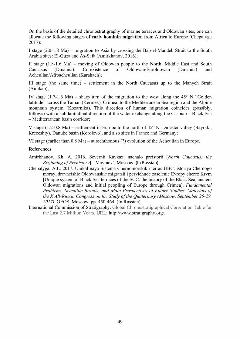
49
On the basis of the detailed chronostratigraphy of marine terraces and Oldowan sites, one can allocate the following stages of early hominin migration from Africa to Europe (Chepalyga 2017):
I stage (2.0-1.8 Ma) – migration to Asia by crossing the Bab-el-Mandeb Strait to the South Arabia sites: El-Guza and As-Safa (Amirkhanov, 2016);
II stage (1.8-1.6 Ma) – moving of Oldowan people to the North: Middle East and South Caucasus (Dmanisi). Co-existence of Oldowan/Euroldowan (Dmanisi) and Acheulian/Afroacheulian (Karahach);
III stage (the same time) – settlement in the North Caucasus up to the Manych Strait (Ainikab);
IV stage (1.7-1.6 Ma) – sharp turn of the migration to the west along the 45 N “Golden latitude” across the Taman (Kermek), Crimea, to the Mediterranean Sea region and the Alpine mountain system (Kozarnika). This direction of human migration coincides (possibly, follows) with a sub latitudinal direction of the water exchange along the Caspian – Black Sea – Mediterranean basin corridor;
V stage (1.2-0.8 Ma) – settlement in Europe to the north of 45 N: Dniester valley (Bayraki, Kreceshty), Danube basin (Korolevo), and also sites in France and Germany;
VI stage (earlier than 0.8 Ma) – autochthonous (?) evolution of the Acheulian in Europe.
References Amirkhanov, Kh. A. 2016. Severnii Kavkaz: nachalo preistorii [North Caucasus: the
Beginning of Prehistory]. "Mavraevʺ, Moscow. (In Russian) Chepalyga, A.L. 2017. Unikal’naya Sistema Chernomorskikh terras UBC: istoriya Chernogo
moray, drevneishie Oldowanskie migratsii i pervichnoe zaselenie Evropy cherez Krym [Unique system of Black Sea terraces of the SCC: the history of the Black Sea, ancient Oldowan migrations and initial peopling of Europe through Crimea]. Fundamental Problems, Scientific Results, and Main Prospectives of Future Studies: Materials of the X All-Russia Congress on the Study of the Quaternary (Moscow, September 25-29, 2017). GEOS, Moscow. pp. 450-464. (In Russian)
International Commission of Stratigraphy. Global Chronostratigraphical Correlation Table for the Last 2.7 Million Years. URL: http://www.stratigraphy.org/.

50
THE FORMATION OF DEEP SEA FEATURES DURING CONDITIONS OF MEDITERRANEAN SEA DESICCATION AND APPEARANCE OF
NEGATIVE PRESSURE IN THE EARTH'S MANTLE
Esin, N.V. 1, and Esin, N.I. 2 1, 2 Shirshov Institute of Oceanology, Russian Academy of Sciences, 1-g Prostornaya Str.,
Gelendzhik, Krasnodar region, Russia 353467 1 [email protected]
Keywords: Messinian Salinity Crisis, Black Sea, the mechanism of formation of deep-sea basins One of the unsolved problems in the evolution of the Black Sea and a number of other seas is the determination of the time of formation of their deep-sea basins and the corresponding mechanism of sedimentary material immersion in the mantle. Various hypotheses have been proposed to explain this process (for example: Andrusov, 1893; Dobrynin, 1922). Muratov (1955, 1979) considered the Black Sea as the “mother geosyncline,” the main one in the system of partial deflections. The absence of the granite layer in the sedimentary cover of the sea and the reduced thickness of the basalt layer gave rise to a large number of hypotheses about the processes taking place in the Earth’s mantle. A number of these hypotheses are considered by Arkhipov and Terekhov (1989). Special difficulties arose when explaining the high velocity of the sediment movement downward. The velocity of “collapse” was not compensated for by the rate of sedimentation.
In the proposed report, changes in the Earth’s mantle pressure are considered to explain the peculiarities of the vertical motion of the sediment. During the Messinian Event (desiccation of the Mediterranean Sea), the layer of water in it decreased by 1500 m (Garcia-Castellanos et al., 2009). Consequently, the pressure on 1 m2 of the bottom decreased by 1500 tons, and by 1 km2 – by 15·108 tons. Since the area of the Mediterranean Sea is more than 2,500,000 km2,
after the desiccation of the layer of water with a height of 1500 m, the total pressure on the entire sea decreased by approximately 2,500,000·15·108 = 37.5·1013 tons. In fact, the pressure decreased by a somewhat smaller amount due to the fact that the layer of evaporated water decreases from the center of the sea to its shores.
In such a situation, the bottom of the sea will experience upward pressure with about the same force as that with which the layer of evaporated water was pressing on the bottom (to compensate for the pressure of the evaporated layer of water). In order to simplify the task, we consider magma as an incompressible viscous-plastic body.
The bottom of the Mediterranean Sea (when it lifted up) “drew” magma from the Earth’s mantle, where negative pressure occurs. This pressure acts on the surface of the mantle and is directed into it, and accordingly, it draws into the mantle the sediment or pieces of the Earth’s crust theoretically from its entire surface. Thus, under conditions of mantle negative pressure, when the bottom of the Mediterranean Sea is rising, the sedimentary layer (in our case the sedimentary layer of the Black Sea) moves downward under the action of two forces: the force of the retracting of sediment into the mantle of the Earth, and the increasing gravity due to the filling of the deepening basin with water (Fig. 1). In such a situation, a compensating sedimentation is not required to shift the sediment downward. The additional negative pressure (that appears in the mantle) pulls the sediment or crust into the mantle and promotes its downward movement, increasing in the process the uncompensated sedimentation.

51
Figure 1. A – The Mediterranean Sea during the Messinian Salinity Crisis (MSC) (Anzidei et al., 2014). B – Schema of the section through the Mediterranean-Black Sea corridor: before MSC (1); during MSC (2). C – illustration of the pressure distribution inside the magma: before MSC (1); during MSC (2).

52
When the sediment is submerged in magma, the processes begin with its heating, phase transformations, decrease in the volume of the rock, and increase in density. The features of this process are well described in the monograph The Earth’s Crust and the History of Development of the Black Sea Depression (Muratov, 1975). According to some authors, the granite layer of the Black Sea sediment eventually turns into basalt. In our opinion, it plunges into magma, softens, and dissipates in it. In this case, the magma is converted into a very viscous non-uniform liquid.
The process of converting granite into basalt covers very large areas. In each section of this area, the sediment is in a different stage of completion for these phase transformations and has a different density. Therefore, different areas at different times shift downwards, forming numerous orogenic “pits,” which are currently found using seismic methods. The whole process of formation of the Black Sea deep-sea basin is considered by a number of scientists as a continuous process of orogenic pit formation. They believe that the general deepening of the sea did not occur as a result of a “single” collapse of the bottom, but as a result of numerous orogenic “failures” on the bottom of the Black Sea.
According to geological materials, the age of the Black Sea basin is 5 million years (Muratov, 1975). If, however, we take into account the conclusions of this work, the more accurate date of the beginning of the formation of the deep-water basin coincides with the date of the Messinian Salinity Crisis of the Mediterranean Sea. According to current concepts, the Messinian Salinity Crisis began about 5.6 million years ago (Bache et al., 2015). The layer of evaporites up to 3 km thick was formed as a result of this Salinity Crisis. After the formation of the Gibraltar Strait and the re-filling of the Mediterranean Sea with water, the “weight” of the sea increased and the reverse process began: the magma pressures went up.
According to Muratov, the lower layer of the Earth’s crust within the Black Sea depression is a recycled granite layer. This crust is characteristic of the inner seas (Muratov, 1975), including the Tyrrhenian Sea. The age of this sea is also estimated at 5 million years (Muratov, 1975). Probably, such seas should include the Caspian and Marmara seas. The peculiarity of these seas is that an important role in the formation of the basin was played by the effect of negative pressure, which arose when the layer of water in the Mediterranean Sea was reduced. Under the action of negative pressure, the vast deep “pits” were created but not the structured or deformed layers.
References Andrusov, N.I. 1893. O sostoyanii basseyna Chernogo morya v pliocenovuyu epoxu [On the
state of the Black Sea basin in the Pliocene epoch]. Вull. Асаd. Sci. St. Petersburg 3, pp.437-448. (In Russian)
Anzidei, M., Lambeck, K., Antonioli, F., Furlani, S., Mastronuzzi, G., Serpelloni, E., and Vanucci, G. 2014. Coastal structure, sea-level changes and vertical motion of the land in the Mediterranean. In I.P. Martini and H.R.Wanless, (Eds.), Sedimentary Coastal Zones from High to Low Latitudes: Similarities and Differences. Geological Society, London, Special Publication 388(1), https://doi.org/10.1144/SP388.20.
Arkhipov, I.V., and Terekhov, A.A. 1989. Razvitie predstavlenij o geologicheskoj prirode i vozraste Chernogo morya [Development of ideas about the geological nature and age of the Black Sea]. In Stroenie i evolyutsiya zemnoj kory i verkhnej mantii Chernogo moray [The structure and evolution of the Earth's crust and upper mantle of the Black Sea], pp. 6-9. Nauka, Moscow. (In Russian)
Bache, F., Gargani, J., Suc, J.-P., Gorini, C., Rabineau, M., Popescu, S.-M., Leroux, E., Jouannic, G., Do Couto, D., Rubino, J.-L., Olivet, J.-L., Clauson, G., Dos Reis, A.T., and Aslanian, D. 2015. Messinian evaporite deposition during sea level rise in the Gulf
53
of Lyons (Western Mediterranean). Marine and Petroleum Geology 66, Pt. 1, pp. 262-277.
Dobrynin, B.F. 1922. K geomorfologii Kryma [On the geomorphology of Crimea]. Zemlevedenie [Geography], pp. 78-92. Laspi, “Krym.” (In Russian)
Garcia-Castellanos, D., Estrada, F., Jiménez-Munt, Gorini, C., Fernàndez, M., Vergés, J., and DeVicente, R. 2009. Catastrophic flood of the Mediterranean after the Messinian salinity crisis. Nature 462, pp. 778–781.
Muratov, M.V. 1955. Istoriya tektonicheskogo razvitiya glubokoy vpadiny Chernogo morya i eyo vozmozhnoe proiskhozhdenie [The history of the tectonic development of the deep basin of the Black Sea and its possible origin]. Bulletin of the Moscow Society of Naturalists, Department of Geology 30, no. 5, pp. 27-50. (In Russian)
Muratov, M.V. 1975. Istoriya geologicheskogo razvitiya vpadiny Chernogo morya i okruzhayushhej ee oblastej [History of the geological development of the Black Sea basin and its surrounding areas]. In Zemnaya kora i istoriya razvitiya Chernomorskoj vpadiny [Earth’s Crust and History of the Development of the Black Sea Basin], pp. 123-128. Nauka, Moscow. (In Russian)
Muratov, M.V. 1979. Tektonika i istoriya razvitiya alpiyskoy geosinklonalnoy oblasti yuga evropeyskoy chasti SSSR i sopryazhennykh stran [Tectonics and the History of the Development of the Alpine Geosynclinal Region of the South of the European Part of the USSR and its Associated Countries]. Moscow, USSR Academy of Sciences. (Tectonics of the USSR vol. 2). (In Russian)

54
QUATERNARY DEVELOPMENT OF SOUTHERN LEVANT CAVES: WINDOW TO OUT OF AFRICA HOMININ MIGRATION
Frumkin, A. 1, Langford, B. 2, Marder, O. 3, and Ullman, M. 4 1 Israel Cave Research Center, Institute of Earth Sciences, The Hebrew University of
Jerusalem, Jerusalem, 91904, Israel. 1 [email protected]
2 [email protected] 3 Archaeology Division, Ben-Gurion University of the Negev, POB 653, Beer Sheva 84105,
Israel
4 Israel Cave Research Center, Institute of Earth Sciences, and the Institute of Archaeology, The Hebrew University of Jerusalem, Jerusalem, 91905, Israel
Keywords: Paleolithic, terra-rossa, colluvium, mass wasting, soil erosion, filled cave During recent years, previously unknown Paleolithic caves have been discovered in Israel. Some of these, in southwestern Samaria, Mt. Carmel, and Galilee contain excellent archives of hominin remains in the Levant Out of Africa corridor. Recent finds in two caves present a new picture and chronology of Homo sapiens chronology and migration along this corridor (Hershkovitz et al., 2015, 2018).
Archaeological and archaeozoological evidence in some sites indicate previous access to the cave from the surface, followed by blockage of the entrance by colluvial sediments. Such modifications can indicate changes of surface processes, such as hillslope erosion and accumulation. Normally, hillslope erosional history is difficult to decipher as most of the material is washed down, accumulating at the foot of the slope. Understanding prehistoric land-use decisions and human use of such caves depends upon our knowledge of mass-wasting processes during and after the phases of occupation.
The life of a cave ends either by complete filling, collapse, or both. During the 20th century, prior to recent intensive construction works, filled caves were rarely observed. The remains of the cave, cut by natural subaerial denudation, included deposits of stalagmitic breccia and carnivore remains. Recent finds indicate that the distribution of filled caves is more significant than previously assumed (Frumkin et al., 2016).
While rapid and total filling by colluvium is possible in a cave with a large opening at a hillslope, caves whose only opening is in a vertical cliff may be better protected from hillslope mass-wasting processes. Such a cave with an inward inclination of the floor may accumulate thick anthropogenic deposits. The cliff also protects the cave entrance from the elements, such as rainfall, wind, and sunshine. Consequently, most studied Paleolithic caves are located in cliff-faces (Ullman et al., 2013). When denudation opens a hole, or chimney, in the roof of such caves, colluvial filling can be enhanced.
Most prehistoric caves are located high above the local ravine beds, so they could not be flooded by surface streams during the mid- to late Pleistocene. The deposits in the caves could originate from internal geogenic or anthropogenic processes (Frumkin et al., 2009), or from subaerial processes associated with the setting of the caves on hillslopes or cliff faces. Some of the caves are completely filled with sediments and seem to have had a semi-vertical, pit-like entrance which promoted colluvial filling. Abundant terra-rossa type clays within the cave fills are observed both in the field and by detailed micromorphological studies (e.g.,

55
Karkanas et al., 2007). These pit-like caves act as sediment traps within the hillslope colluvial systems. They have no natural exits for the sediments, so the trapped material is preserved within the cave, enabling the reconstruction of hillslope erosional history. They respond rapidly to environmental changes upslope from the caves, where terra-rossa forms and is transferred downslope (Fuchs, 2007). In addition, terra-rossa soil can penetrate shallow caves through fractures and dissolution voids. Colluvial terra-rossa is not the only fill. The exact mass-wasting process responsible for depositional sequences within the pit-like caves is often difficult to ascertain because these sediments are often poorly stratified, and homogenized by bioturbation. They can be either fine grained or coarse grained, producing crude stratification. Pit-like caves can be potentially filled by slow mass-wasting processes, such as slope wash or creep, as well as more rapid landslides, rockfalls, earthflow, and slumps. However, the rapid phenomena are less likely in the discussed setting of mostly moderate slopes of massive carbonate rocks, unless the hillslopes were covered by a thick layer of rock fragments and terra-rossa clay. The combination of such disintegrated material together with extreme precipitation events and an earthquake could have triggered rapid mass-wasting events on some of the hillslopes. In addition, the pit-like caves also served as long-term traps for wind-borne dust, the main source of local terra-rossa, which was particularly common during glacial periods (Frumkin and Stein, 2004).
The pit caves have thus acted as traps and ‘time capsules’ for various surface and internal geogenic sediments. However, it still remains to be proven if their faunal assemblages represent reliable samples of the terrestrial megafauna (e.g., Yeshurun, 2013), or if their fossil records are biased by preferential processes, such as attraction of Dama mesopotamica to water at Rantis Cave (Speth, 2013).
Diffusive processes may act on various slope gradients, while landslides require a combination of environmental conditions, such as slope gradient, mechanical strength of the hillslope, vegetation density, and fluid pore pressure, associated with precipitation events. A mass-wasting event can be triggered by an earthquake, erosion of the hillslope toe, extreme rainfall events, vegetation loss due to abrupt climate change, fire, or human activity. Differentiation between such processes and causes is hardly possible, but some constraints may be suggested using available evidence. The Holocene underwent increasing anthropogenic impact on hillslope processes, which could also affect the pit-like caves.
The mass wasting can hardly be associated with tectonic events, because western Israel apparently became tectonically stable at least since the early mid-Pleistocene, prior to the occupation period of the prehistoric caves (Bar, 2009; Ryb et al., 2012). However, some evidence may indicate renewed uplift during the last 200 ka.
Disappearance of vegetation on the hillslopes would lead to events of colluvial mass wasting, eventually stripping the slope of its terra-rossa soil cover, which would be deposited in pit-like caves (Frumkin et al., 2016), as well as in alluvial wadis and valleys. This scenario agrees with dating evidence, although other colluvial events could contribute as well. In addition to such episodic events, gradual colluviation of materials into the depression, including transportation of soil and dust materials, could also take place.
The environmental change must have affected also the human use of caves. Ultimately, filling by colluvial sediments would cause the abandonment of an inhabited cave, which would lose its environmental advantage for humans. On the other hand, as noted above, radiometric dating (e.g., Marder et al., 2011) indicates that filling could take place over tens thousands of years. Such a slow rate of filling may be explained by a relatively moderate hillslope. However, the ages are consistent also with rapid filling event(s).

56
Eventually, pedosediments became the major deposits in pit-like caves. This occurred during and after human occupation at Qesem and Emanuel caves, as well as during and after the accumulation of faunal remains at Rantis (Frumkin et al., 2016). The transported soil materials are heterogeneous but retain the terra-rossa features of reddish clays, iron staining, and dust contribution. The terra-rossa-like clays are not the only colluvial materials washed into the caves. When the hillslopes were stripped of their soil cover, rock fragments were colluviated into the caves, too. Wetness and occasional water-logging in the caves produced vertic and hydromorphic features locally. Water saturated with calcium-carbonates from dissolution of carbonate rocks and anthropogenic ash could transform the mixed soil material locally into anthropogenic breccia, depending on runoff and slope gradient outside and inside the caves.
Conversely, horizontal, non-filled caves did not experience intensive colluviation. This is attributed to their setting within cliff-faces where the horizontal entrances have not allowed major accumulation of colluvium. Some of them have open chimneys that were not large enough to allow major colluvial intrusions. Some of the present-day chimneys may not have existed during the Pleistocene. During long periods of surface denudation and cave-roof collapse, such chimneys can enlarge and transform the dominant sedimentation process in the cave. Such enlargement has affected some of the filled caves.
Horizontal, cliff-face caves are the typical type of Paleolithic cave sites known in the Levant. It is clear that such unfilled caves became primary targets for prehistoric investigations because of their present-day visibility from a distance. Some Paleolithic caves demonstrate signs of hillslope retreat and collapse, so the presently remaining cave area is smaller compared with the occupation period. Some caves have lost much of their ceiling area by collapse since their Paleolithic occupation periods. In addition to hillslope-retreat, the susceptibility to collapse is controlled by several geologic factors, such as cavity size, as well as roof thickness, lithology, and fractures. Caves with cliff entrances are easily observed from a distance, so many have been investigated during the 20th century.
Recent filled cave discoveries alleviate previous inherent research biases in prehistoric caves. Partly filled Paleolithic caves have been discovered in Galilee (e.g., Marder et al., 2013; Hershkovitz et al., 2015). The limited number of known totally filled caves can indicate the potential for yet-undiscovered Paleolithic caves in other regions. Additional filled caves will undoubtedly be truncated by construction works in the future, while ‘traditional’ horizontal, cliff-face Paleolithic caves are still being discovered by new cave surveys (e.g., Ullman et al., 2013; Davidovich, 2015). Sedimentological and pedological analysis of the yet-unstudied cave deposits would enrich our knowledge of natural hillslope processes, environmental change, and human occupation.
References Bar, O. 2009. The Shaping of the Continental Margin of Central Israel Since the Late Eocene
– Tectonics, Morphology and Stratigraphy. PhD thesis, Ben-Gurion University of the Negev, Beer-Sheva, Israel.
Davidovich, U. 2015. Ureide Cave. In Frumkin, A. (ed.), Atlas of the Holy Land - Judean Desert Caves. Magnes, Jerusalem, pp. 364-365. (In Hebrew)
Frumkin, A., and Stein, M. 2004. The Sahara - East Mediterranean dust and climate connection revealed by strontium and uranium isotopes in a Jerusalem speleothem. Earth and Planetary Science Letters 217, 451-464.
Frumkin, A., Karkanas, P., Bar-Matthews, M., Barkai, R., Gopher, A., Shahack-Gross, R., and Vaks, A. 2009. Gravitational deformations and fillings of aging caves: the example of Qesem karst system, Israel. Geomorphology 106, 154-164.
57
Frumkin, A., Langford, B., Marder, O., and Ullman, M. 2016. Paleolithic caves and hillslope processes in south-western Samaria, Israel: Environmental and archaeological implications. Quaternary International 398, 246-258.
Fuchs, M. 2007. An assessment of human versus climatic impacts on Holocene soil erosion in NE Peloponnese, Greece. Quaternary Research 67, 349-356.
Hershkovitz, I., Marder, O., Ayalon, A., Bar-Matthews, M., Yasur, G., Boaretto, E., Caracuta, V., Alex, B., Frumkin, A., Goder-Goldberger, M., Gunz, P., Holloway, R.L., Latimer, B., Lavi, R., Matthews, A., Slon, V., Bar-Yosef Mayer, D., Berna, F., Bar-Oz, G., Yeshurun, R., May, H., Hans, M.G., Weber, G.W., and Barzilai, O. 2015. Levantine cranium from Manot Cave (Israel) foreshadows the first European modern humans. Nature 520, 216-219.
Hershkovitz, I., Weber, G.W., Quam, R., Duval, M., Grün, R., Kinsley, L., Ayalon, A., Bar-Matthews, M., Valladas, H., Mercier, N., Arsuaga, J.L., Martinón-Torres, M., de Castro, J.M.B., Fornai, C., Martín-Francés, L., Sarig, R., May, H., Krenn, V.A., Slon, V., Rodríguez, L., García, R., Lorenzo, C., Carretero, J.M., Frumkin, A., Shahack-Gross, R., Bar-Yosef Mayer, D.E., Cui, Y., Wu, X., Peled, N., Groman-Yaroslavski, I., Weissbrod, L., Yeshurun, R., Tsatskin, A., Zaidner, Y., and Weinstein-Evron, M. 2018. The earliest modern humans outside Africa. Science 359(6374), pp. 456-459.
Karkanas, P., Shahack-Gross, R., Ayalon, A., Bar-Matthews, M., Barkai, R., Frumkin, A., Gopher, A., and Stiner, M.C. 2007. Evidence for habitual use of fire at the end of the Lower Paleolithic: Site formation processes at Qesem Cave, Israel. Journal of Human Evolution 53, 197-212.
Marder, O., Yeshurun, R., Lupu, R., Bar-Oz, G., Belmaker, M., Porat, N., Ron, H., and Frumkin, A. 2011. Mammal remains at Rantis Cave, Israel, and middle-late Pleistocene human subsistence and ecology in the Southern Levant. Journal of Quaternary Science 26, 769-780.
Marder, O., Alex, B., Ayalon, A., Bar-Matthews, M., Bar-Oz, G., Bar-Yosef Mayer, D., Berna, F., Boaretto, E., Caracuta, V., Frumkin, A., Goder-Goldberger, M., Hershkovitz, I., Latimer, B., Lavi, R., Matthews, A., Weiner, S., Weiss, U., Yas’ur, G., Yeshurun, R., and Barzilai, O. 2013. The Upper Paleolithic of Manot Cave, Western Galilee, Israel: The 2011-12 excavations. Antiquity 337(87), 277-284.
Ryb, U., Matmon, A., Porat, N., and Katz, O. 2012. From mass-wasting to slope stabilization – putting constrains on a tectonically induced transition in slope erosion mode: a case study in the Judea Hills, Israel. Earth Surface Processes and Landforms 38, 551-560.
Speth, J.D. 2013. Thoughts about hunting: Some things we know and some things we don't know. Quaternary International 297, 176-185.
Ullman, M., Hovers, E., Goren-Inbar, N., and Frumkin, A. 2013. Levantine cave dwellers: geographic and environmental aspects of early humans use of caves: a case study from Wadi Amud, northern Israel. In M. Filippi, and P. Bosak, (Eds.), Proceedings of 16th International Congress of Speleology, vol. 1. Brno, pp. 169-174.
Yeshurun, R. 2013. Middle Paleolithic prey-choice inferred from a natural pitfall trap: Rantis Cave, Israel. In J.L. Clark and J.D. Speth, (Eds.), Zooarchaeology and Modern Human Origins: Human Hunting Behavior During the Later Pleistocene. Vertebrate Paleobiology and Paleoanthropology Series. Springer, New York, pp. 45-58.

58
ANTHROPOMORPHIC IMAGES IN AZERBAIJAN’S LANDSCAPE AND THEIR POSSIBLE SIGNIFICANCE
Gallagher, R.
Independent Researcher, c/o 170 Gardiner Drive, Aberdeen, AB12 5SA, UK [email protected]
Keywords: animism, zoomorphism, anthropomorphism, Azerbaijan, Besh Barmak, Egypt, cultural connections, Gobustan, deluge, Cosmas Indicopleustes, Durupınar, Noah, Fairy Castle Introduction Azerbaijan is a land of mystery and intrigue. While history is largely silent on its ancient past, archaeology informs us that its inhabitants were deeply spiritual, believed in life after death and in the supernatural (Geyushev, 1999). Ancient beliefs involving the worship of natural phenomena were essentially animistic, with the sun and moon playing important roles. The abundant rock art at Gobustan also provides insight into past environments, cultures, and beliefs. However, what is not generally known is that there are large anthropomorphic carvings in the countryside that have so far gone unnoticed by academia. These carvings were also not obvious to the author at first and only became apparent after many exploration trips into the countryside in search of Stone Age and Early Bronze Age sites. This paper aims to raise awareness of the anthropomorphic image phenomenon and consider its potential significance.
Anthropomorphism For anyone exploring the countryside, the large anthropomorphic images are not readily noticed. At best, they might simply merit a passing comment or be of local interest. However, having found several examples in archaeologically-rich areas, this went beyond coincidence and suggested a common animistic tradition. The images are essentially carved from natural outcrops to enhance various features and more closely resemble familiar objects, such as animals. To ancient people, such experiences were perhaps more real than they are in today’s scientific age. Typically, the carvings are associated with burial mounds, stone circles, petroglyphs, and rock shelters, so they not just imaginary.
The term given to the phenomenon by Russian scientists is zoomorphism in relation to animals, of which Mount Ocharovatelnaia in the Altai Mountains is a good example (Fig. 1). This rocky outcrop is carved to enhance its features so that it resembles a huge fish with a gaping mouth (Marsadolov, 2005; Bekbassar, 2005).
This suggests that anthropomorphic imagery in Azerbaijan may also be real and not just coincidental, To these ancient people, the countryside was alive with spirits and risks everywhere, e.g., in streams, in woods, mountains, and the sky. Perhaps the images were therefore considered as spiritual or totemic guardians. Indeed, many animistic beliefs and superstitions continue today.
It is against this background that we consider the anthropomorphic rock formations in Azerbaijan and then discuss their possible significance. For convenience and in the absence of local names, ‘monikers’ are given to the carvings.
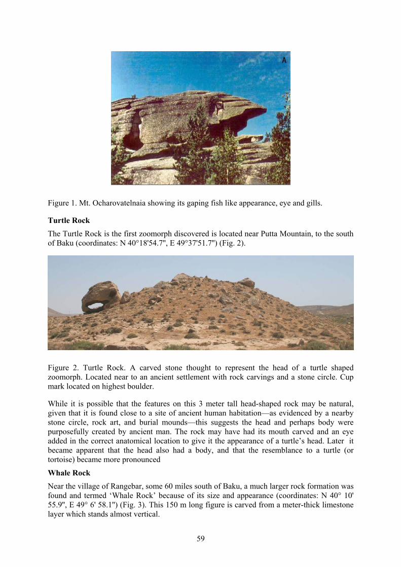
59
Figure 1. Mt. Ocharovatelnaia showing its gaping fish like appearance, eye and gills.
Turtle Rock The Turtle Rock is the first zoomorph discovered is located near Putta Mountain, to the south of Baku (coordinates: N 40°18'54.7'', E 49°37'51.7'') (Fig. 2).
Figure 2. Turtle Rock. A carved stone thought to represent the head of a turtle shaped zoomorph. Located near to an ancient settlement with rock carvings and a stone circle. Cup mark located on highest boulder.
While it is possible that the features on this 3 meter tall head-shaped rock may be natural, given that it is found close to a site of ancient human habitation—as evidenced by a nearby stone circle, rock art, and burial mounds—this suggests the head and perhaps body were purposefully created by ancient man. The rock may have had its mouth carved and an eye added in the correct anatomical location to give it the appearance of a turtle’s head. Later it became apparent that the head also had a body, and that the resemblance to a turtle (or tortoise) became more pronounced
Whale Rock Near the village of Rangebar, some 60 miles south of Baku, a much larger rock formation was found and termed ‘Whale Rock’ because of its size and appearance (coordinates: N 40° 10' 55.9'', E 49° 6' 58.1'') (Fig. 3). This 150 m long figure is carved from a meter-thick limestone layer which stands almost vertical.
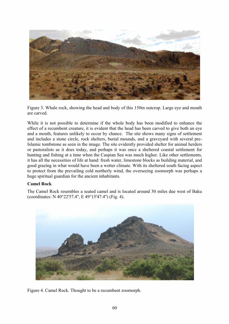
60
Figure 3. Whale rock, showing the head and body of this 150m outcrop. Large eye and mouth are carved.
While it is not possible to determine if the whole body has been modified to enhance the effect of a recumbent creature, it is evident that the head has been carved to give both an eye and a mouth, features unlikely to occur by chance. The site shows many signs of settlement and includes a stone circle, rock shelters, burial mounds, and a graveyard with several pre-Islamic tombstone as seen in the image. The site evidently provided shelter for animal herders or pastoralists as it does today, and perhaps it was once a sheltered coastal settlement for hunting and fishing at a time when the Caspian Sea was much higher. Like other settlements, it has all the necessities of life at hand: fresh water, limestone blocks as building material, and good grazing in what would have been a wetter climate. With its sheltered south facing aspect to protect from the prevailing cold northerly wind, the overseeing zoomorph was perhaps a huge spiritual guardian for the ancient inhabitants.
Camel Rock The Camel Rock resembles a seated camel and is located around 30 miles due west of Baku (coordinates: N 40°22'57.4'', E 49°15'47.4'') (Fig. 4).
Figure 4. Camel Rock. Thought to be a recumbent zoomorph.
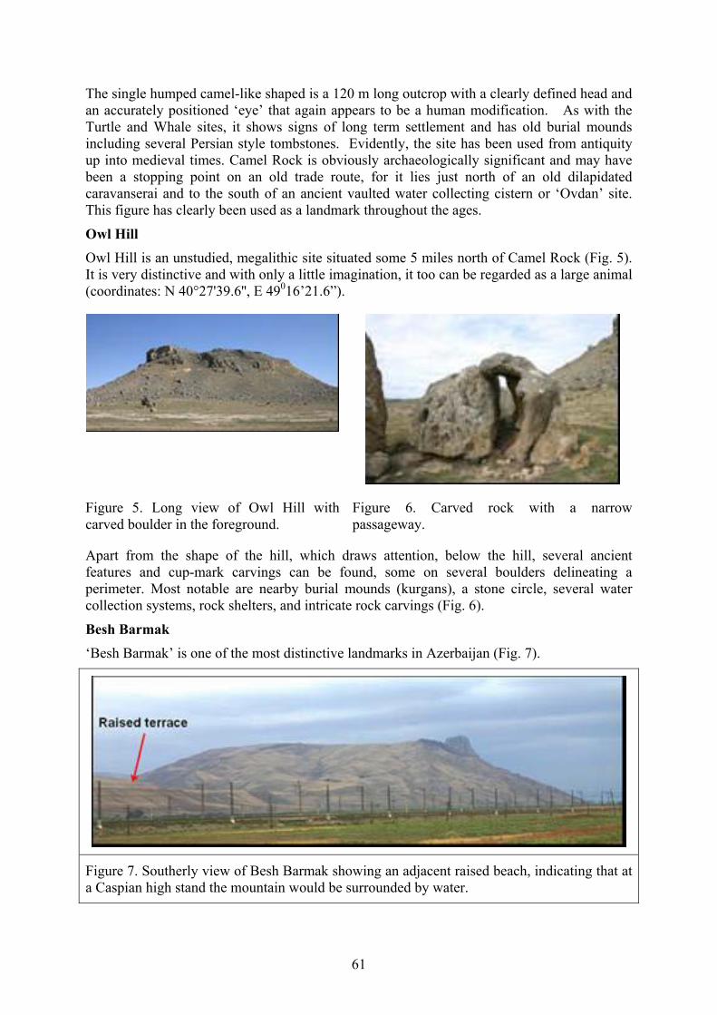
61
The single humped camel-like shaped is a 120 m long outcrop with a clearly defined head and an accurately positioned ‘eye’ that again appears to be a human modification. As with the Turtle and Whale sites, it shows signs of long term settlement and has old burial mounds including several Persian style tombstones. Evidently, the site has been used from antiquity up into medieval times. Camel Rock is obviously archaeologically significant and may have been a stopping point on an old trade route, for it lies just north of an old dilapidated caravanserai and to the south of an ancient vaulted water collecting cistern or ‘Ovdan’ site. This figure has clearly been used as a landmark throughout the ages.
Owl Hill Owl Hill is an unstudied, megalithic site situated some 5 miles north of Camel Rock (Fig. 5). It is very distinctive and with only a little imagination, it too can be regarded as a large animal (coordinates: N 40°27'39.6'', E 49016’21.6”).
Figure 5. Long view of Owl Hill with carved boulder in the foreground.
Figure 6. Carved rock with a narrow passageway.
Apart from the shape of the hill, which draws attention, below the hill, several ancient features and cup-mark carvings can be found, some on several boulders delineating a perimeter. Most notable are nearby burial mounds (kurgans), a stone circle, several water collection systems, rock shelters, and intricate rock carvings (Fig. 6).
Besh Barmak ‘Besh Barmak’ is one of the most distinctive landmarks in Azerbaijan (Fig. 7).
Figure 7. Southerly view of Besh Barmak showing an adjacent raised beach, indicating that at a Caspian high stand the mountain would be surrounded by water.

62
Today, its name means ‘Five Finger’ mountain, but in older times, it was simply Mount Barmak or Xisr Xindi.(meaning Holy Person). With several hundred people visiting it daily to climb up to its craggy top and offer prayers, it is an ancient site of pilgrimage steeped in legend and myth, with a large number of stone mounds that are thought to be ancient burial tombs. Most people see the mountain as a rocky crag with finger like digits, but from an anthropomorphic perspective, and a longer viewpoint, a gigantic animal-like figure becomes apparent (coordinates: 40° 56' 25.31" N, 49° 12' 26.21" E). With only a little imagination, the mountain can be seen to have an animal like head (the craggy peak) and a recumbent body. A nearby dominant raised terrace is also evident and indicates a previous Caspian Sea high stand level, thus indicating Besh Barmak was once surrounded on its seaward side by water.
Besh Barmak Tail or Serpent Considering that the mountain might be a zoomorph, it was examined further using Google Earth. Intriguingly, a long winding track, correctly positioned at the rear of the mountain, as if to represent a huge tail, was found (coordinates: 40°56'26.23" N, 49°12'30.68" E) (Fig. 8).
Figure 8. Serpentine like 1000 m long track at rear of Besh Barmak. The excavation seems to serve no obvious purpose and may be ceremonial. Suggestions for it are an anthropomorphic tail or a snake with either two heads or open jaws.
On inspection, it became obvious that the ‘tail’ was man made, seemingly going uphill for no apparent reason. It was an odd find with its one-thousand-meter-long zig-zag winding path up to two decorative lozenge shapes at the top. Its purpose and age need to be determined.
It is also possible that the track-like carving is not a ‘tail’ but may represent a snake or serpent. This is a possible conjecture, for serpents have played a major role in many ancient myths and legends. Perhaps to ancient people it had two symbolic meanings: both as a tail and a serpent. If the latter hypothesis is accepted, then this would make the ‘serpent’ carving the largest known in the world. It’s worth noting here that in America, prehistoric Indians created the Serpent Mound in Ohio, which at some 410 m long is considered the longest snake-like construction in the world (Wikipedia Serpent Mound). Another 130 m long man-made serpentine zoomorph may be found at Loch Nell, near Oban in Scotland. Serpent worship (i.e., ophiolatreia) was a significant ancient belief in ancient times.
Human Image Some four kilometres distant, a huge but unnoticed human-like image seems to be carved into the hillside close to the skyline and overlooks Besh Barmak (coordinates: 40° 54' 13.45" N, 49° 11' 58.48" E), nicknamed Enoch (Fig. 9).
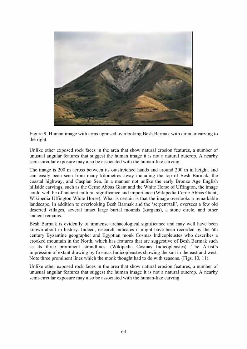
63
Figure 9. Human image with arms upraised overlooking Besh Barmak with circular carving to the right.
Unlike other exposed rock faces in the area that show natural erosion features, a number of unusual angular features that suggest the human image it is not a natural outcrop. A nearby semi-circular exposure may also be associated with the human-like carving.
The image is 200 m across between its outstretched hands and around 200 m in height. and can easily been seen from many kilometres away including the top of Besh Barmak, the coastal highway, and Caspian Sea. In a manner not unlike the early Bronze Age English hillside carvings, such as the Cerne Abbas Giant and the White Horse of Uffington, the image could well be of ancient cultural significance and importance (Wikipedia Cerne Abbas Giant; Wikipedia Uffington White Horse). What is certain is that the image overlooks a remarkable landscape. In addition to overlooking Besh Barmak and the ‘serpent/tail’, oversees a few old deserted villages, several intact large burial mounds (kurgans), a stone circle, and other ancient remains.
Besh Barmak is evidently of immense archaeological significance and may well have been known about in history. Indeed, research indicates it might have been recorded by the 6th century Byzantine geographer and Egyptian monk Cosmas Indicopleustes who describes a crooked mountain in the North, which has features that are suggestive of Besh Barmak such as its three prominent strandlines. (Wikipedia Cosmas Indicopleustes). The Artist’s impression of extant drawing by Cosmas Indicopleustes showing the sun in the east and west. Note three prominent lines which the monk thought had to do with seasons. (Figs. 10, 11).
Unlike other exposed rock faces in the area that show natural erosion features, a number of unusual angular features that suggest the human image it is not a natural outcrop. A nearby semi-circular exposure may also be associated with the human-like carving.

64
Figure 10. Three clear strandlines on flank of Besh Barmak.
Figure 11. Artist impression of extant drawing by Cosmas Indicopleustes. Animal like crooked mountain showing the sun in east and west. Note three prominent lines which, the monk thought were to do with seasons.
Fairy Castle (Peri Gala) Another equally mysterious example in Azerbaijan is the Fairy Castle, or locally Peri Gala (Gallagher, 2005) (coordinates: 41° 35' 23.21" N, 46° 45' 53.78" E) (Fig. 12).
Figure 12. Close up view of the Fairy Castle (Peri Gala). Central plinth in centre of archway and wall to left may have been deliberately destroyed by past conquerors.

65
Close up, it looks to be a most odd structure carved into a cliff face but from a distance, the castle can be seen to be a huge eye-like construction, much as a sculptor would create in a statue (Fig. 13).
Figure 13. Long view of the Fairy Castle seen as a huge head complete with a tall hat. The eye is the castle with, nose, and mouth carved in correct proportions.
The ‘eye’ is set into a rock face to give the illusion of a huge head facing westwards. Having been puzzled over for several years, the Fairy Castle is only now making sense through the lens of anthropomorphism. It is notable that the monument is located in an archaeologically-rich area with several ruined churches and buildings, some megaliths, and ancient graveyards. It is now suspected as being a temple or observatory of sorts to view the summer solstice sunset over the peak of the nearby Baxuvul Mountain. Curiously, radiocarbon dating shows it to be almost 1000 years old, thereby making it coeval with the reconstructed Maiden Tower in Baku, which has an opposite focus on the winter solstice sunrise. Both monuments may therefore be linked through a sun veneration culture.
Discussion and summary Links have been made between prehistoric peoples and natural rock outcrops that may have been thought of as anthropomorphic images. Examples described include Turtle Rock, Whale Rock, Camel Rock, and Owl Hill, as well as possibly Besh Barmak, with its two associated anthropomorphic images: the Besh Barmak Serpent and Enoch. If investigated and confirmed, anthropomorphism could become recognized as an important cultural tradition in Azerbaijan’s ancient past and elsewhere, one that continued into the Middle Ages. It is evident that zoomorphism is a subject that has been insufficiently studied in archaeology and anthropology. The examples highlighted above ought to be investigated, recognized as being culturally important, and protected. Indeed, by acknowledging the phenomenon, it is possible that this might begin to offer insight into some perplexing mysteries
An example of a probable anthropomorphic image is that of Noah’s Ark in Eastern Turkey at the Durupınar site (https://en.wikipedia.org/wiki/Durup%C4%B1nar_site) (Fig. 14).

66
Figure 14. Structure that is claimed to be Noah’s ark, near mount Ararat in Turkey. A natural rock outcrop that has been embellished to more closely resemble a large vessel..
This natural boat-shaped rock formation has confounded scientists for decades, as it is obviously natural but has carved features that give it the appearance of a boat, e.g., wooden beams. The site has long been known about and revered, possibly even recorded by Berosus, a third century BC Babylonian priest in his account of a great flood and Xisuthrus’s ark-like vessel (Berossus). The story of Xisuthrus and Noah appear to have common origins. Intriguingly, he reports that pilgrims visiting the ark site in antiquity would return with samples of bitumen in order to prepare amulets. With no local sources of bitumen, this is most odd. However, in the context of anthropomorphism, it makes sense to consider that the rock outcrop was identified in prehistory as a large boat and then physically modified, and decorated, to better resemble a huge vessel. This would account for the carving and addition of bitumen. It further makes sense when the ancient belief that rain came from an invisible ocean in the sky is considered. Indeed, the Egyptians believed that the Barque of Ra carried the sun daily across the heavens. It may then be postulated that in the light of an anthropomorphic tradition and against a background of ice age flooding, myth, and legend, one might hypothesize that the Durupınar site was established as a sacred location in commemoration of Noah and mankind’s salvation from the great flood.
Taking into consideration other strands of research that suggest connections to ancient Egypt, it should be noted that the Father of Archaeology, Sir William Matthew Flinders Petrie, held the controversial view that the earliest Egyptians had an ancestral homeland in the Caucasus (Petrie, 1926; Murray, 1941, 1949). In his paper ‘On the Origins of the Book of the Dead’ he notes that BAKHAU is often named; it was a great mountain upon which heaven rested. It was the "Mount Bakhau of the rising sun "… the name seems connected with beka, “the dawn”." Baku at the eastern end of the Caucasus range agrees with this position. Curiously this description is reflective of Cosmas description and suggests that Besh Barmak may well be Petrie’s ‘Mount of Bakhua of the rising sun.
His evidence was largely based on philology with some archaeological clues, but at the time, his views were discounted as not being credible. However, if archaeology begins to recognize anthropomorphism as an important tradition, then its reality may provide a tangible link to

67
ancient Egypt and an explanation for the world’s most famous anthropomorphic image, the mysterious Sphinx on the Giza plateau.
Some scientists consider the Sphinx (Fig. 15) to be much older than the pyramids, dating back some ten thousand years or so.
Figure 15. Classic view of the Sphinx which in Egypt was Hor em Akhet or called Harmakhis by the Greeks. Could this be modelled after Besh Barmak/Mt. Barmak in Azerbaijan?
If so, then considering evidence of massive ice age flooding across the Ponto-Caspian and likely migrations from the region as waterways disappeared and lifestyles were affected in the Early Neolithic, it seems possible that people, customs, and traditions travelled with them to the Nile Valley, thus supporting Flinders Petrie’s contention of a Caucasian ancestral homeland. In this regard, perhaps the most important cultural and anthropomorphic image, Besh Barmak, was commemorated in the carving of the Sphinx. Curiously, the Sphinx, whose ancient name was Hor-em-akhet to the Egyptians and which the ancient Greeks later called Harmakhis, bears a close philological resemblance to the word ‘Barmak’. For millennia, the Sphinx has remained enigmatic and mysterious. Perhaps then, with a focus on anthropomorphism, investigation might find solid archaeological evidence of cultural connections. Evidence of animism and sun worship in Azerbaijan and the Caucasus would seem to support ancestral links to predynastic Egypt. Perhaps Flinders Petrie may be proved correct after all, and it is hoped that his challenge to future archaeologists to investigate connections might be accepted.
In summary, there appear to be sufficient anthropomorphic examples associated with ancient settlement sites in Azerbaijan to warrant serious consideration and investigation. Others no doubt exist and need to be identified, recorded, and studied. Perhaps with open minded investigation into this animistic phenomenon and an acknowledgment of its reality and potential importance, it may be possible to roll back the pages of history to a distant and more formative time to better understand mankind’s cultural origins.
References Berosus (via Alexander Polyhistor) (50 BC). Flood History of Babylonia.
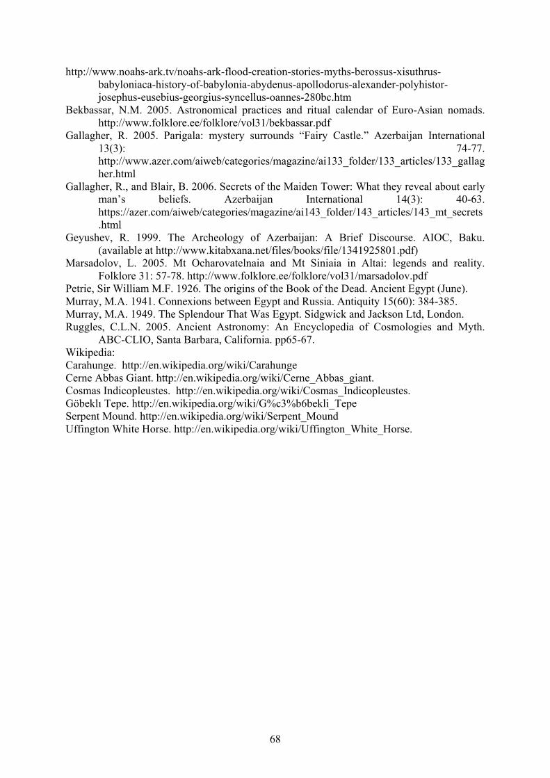
68
http://www.noahs-ark.tv/noahs-ark-flood-creation-stories-myths-berossus-xisuthrus-babyloniaca-history-of-babylonia-abydenus-apollodorus-alexander-polyhistor-josephus-eusebius-georgius-syncellus-oannes-280bc.htm
Bekbassar, N.M. 2005. Astronomical practices and ritual calendar of Euro-Asian nomads. http://www.folklore.ee/folklore/vol31/bekbassar.pdf
Gallagher, R. 2005. Parigala: mystery surrounds “Fairy Castle.” Azerbaijan International 13(3): 74-77. http://www.azer.com/aiweb/categories/magazine/ai133_folder/133_articles/133_gallagher.html
Gallagher, R., and Blair, B. 2006. Secrets of the Maiden Tower: What they reveal about early man’s beliefs. Azerbaijan International 14(3): 40-63. https://azer.com/aiweb/categories/magazine/ai143_folder/143_articles/143_mt_secrets.html
Geyushev, R. 1999. The Archeology of Azerbaijan: A Brief Discourse. AIOC, Baku. (available at http://www.kitabxana.net/files/books/file/1341925801.pdf)
Marsadolov, L. 2005. Mt Ocharovatelnaia and Mt Siniaia in Altai: legends and reality. Folklore 31: 57-78. http://www.folklore.ee/folklore/vol31/marsadolov.pdf
Petrie, Sir William M.F. 1926. The origins of the Book of the Dead. Ancient Egypt (June). Murray, M.A. 1941. Connexions between Egypt and Russia. Antiquity 15(60): 384-385. Murray, M.A. 1949. The Splendour That Was Egypt. Sidgwick and Jackson Ltd, London. Ruggles, C.L.N. 2005. Ancient Astronomy: An Encyclopedia of Cosmologies and Myth.
ABC-CLIO, Santa Barbara, California. pp65-67. Wikipedia: Carahunge. http://en.wikipedia.org/wiki/Carahunge Cerne Abbas Giant. http://en.wikipedia.org/wiki/Cerne_Abbas_giant. Cosmas Indicopleustes. http://en.wikipedia.org/wiki/Cosmas_Indicopleustes. Göbeklı Tepe. http://en.wikipedia.org/wiki/G%c3%b6bekli_Tepe Serpent Mound. http://en.wikipedia.org/wiki/Serpent_Mound Uffington White Horse. http://en.wikipedia.org/wiki/Uffington_White_Horse.

69
OBSERVATIONS OF CASPIAN STRANDLINES, THEIR USE AS HIGHSTAND INDICATORS WITH CONSIDERATION FOR THEIR
IMPLICATIONS WITH REGARD TO REGIONAL GEOMORPHOLOGY, PALEODRAINAGE, AND BIODIVERSITY
Gallagher, R.
Independent Researcher, c/o 170 Gardiner Drive, Aberdeen, AB12 5SA, UK [email protected]
Keywords: Late Pleistocene, paleodrainage, mud volcano, terrace, strandlines, rock art, isostasy, biodiversity, halocline, Lake Champlain Azerbaijan is a country rich in mud volcanoes. With over 400 known on land and at sea, both dormant and active, their soft strata provide a rich source of information on past Caspian Sea levels. Investigation of the landscape indicates terraces and strandlines from default previous highstands.
Acting as a proxy tidal gauge, these features can be used to formulate questions and help inquire about the paleodrainage regime during the Quaternary, and particularly the last Ice Age.
Investigation of terraces has shown that the consensus view of the Khvalynian highstand of ca. 50 m above global sea level (agsl) cannot be correct, for there are no terraces to be found at this level. Instead, a major terrace lies between 100 and 125 m agsl. Indeed, terrace tops at 26, 125, and 167 m agsl appear to show a direct correlation to respective spillways of the Manych corridor, Turgay (Central Asia) and Kes Ket (northeast Asia).
Borehole studies at Turgay revealed a major stream flowing from Glacial Lake Mansi to the Ponto- Caspian between 28.8 and 19.1 ka, respectively (Astakhov and Grosswald, 1978), thus confirming the presence of the West Siberian Glacial Lake Mansi. Radiocarbon dating of bulk mollusk samples also suggests elevated water levels across the Caspian and Black seas prior to the Last Glacial Maximum (Gallagher, 2013). See Table 1.
Table 1. Radiocarbon dating results of bulk mollusk samples from the Caspian and Black seas
COUNTRY
General Location (GPS coordinates available)
Elevation above global sea level (m)
Measured Age
13C/12C Conventional Age
Gobustan at 8 m 8 26110+/-180 BP
+2.5 ‰ 26560+/-190 BP
Gobustan at 18 to 30 m
18-30 28520+/-210 BP
+1.1 ‰ 28950+/-220 BP
Gobustan at 80 to 85 m
80-85 14310+/-70 BP
+1.6 ‰ 14750+/- 80 BP
AZERBAIJAN
Terrace top near Gobustan
100 32460+/- 480 BP
+2 ‰ 32910+/-510 BP

70
Gobustan 125 m 125 16770+/- 100 BP
+1.6 ‰ 17210+/-100 BP
Qobu terrace near rock shelter
140 40730+/- 530 BP
+1.1 ‰ 41160+/-530 BP
Thracian Cliffs 126 29010+/- 170 BP
+2.8 ‰ 29470+/-170 BP
BULGARIA Thracian Cliffs 77
39200+/- 490 BP
+2.7 ‰ 39650+/-490 BP
Source: BetaLab. Note that most dates are within the C14 half-life limitation.
It may be inferred from the Turgay borehole results that Glacial Lake Mansi was constrained by an onshore ice sheet with a height of at least 125 m agsl. Similarly, full discharge was not possible via the Bosporus from the Ponto-Caspian at this time, otherwise a highstand could not have been achieved.
The reason for the flooding appears to be that the major Russian rivers (Volga, Lena, Irtysh, Ob, and Yenesei) continued to flow, draining the Indian monsoon waters from the Himalayas and Tibetan highland. The combined average flowrates using today’s rates as an estimate would be ca. 59,000 m3/s. This is approximately a sevenfold increase over the Volga alone. The rivers could not discharge into the Arctic Ocean due to the northern onshore ice sheets. This situation would have persisted relative to climatic changes throughout the Pleistocene. Consequently, overspill from Asia would have been to the Ponto-Caspian, which must have acted as a huge endorheic basin and may also have discharged to the North Sea.
Upon deglaciation, meltwater may have swelled the Ponto-Caspian further, possibly to the level of the Kes Ket spillway. Allied to this, there seems to be evidence of laminated strata that may indicate varve-like layers in the Caspian landscape, which could have formed with spring meltwater (Fig. 1).
Figure 1. Laminated sediment layers at the entrance to the Qobu Valley, elevation 0 m asl.

71
With so much freshwater entering the Ponto-Caspian, it had to be a huge freshwater system, with salt winnowing away throughout the Pleistocene. This would have had significant implications for Eurasian aquatic biodiversity. It was also noted that the flooded continental interior resembles the map of Europe’s loess and suggests that loess (at least primary loess) was alluvial in origin, while secondary loess is aeolian, becoming windborne as water levels receded (Gallagher, 2013).
Yet, the Caspian is a salt water body, as are numerous lake systems across Eurasia. So where has the salt come from? The answer to this, however improbable, has to be from the ocean.
In considering this question, three curious strandlines in the Gilazi valley (inland from the western Caspian Sea coast in Azerbaijan) are etched into the soft landscape and have been a source of puzzlement for many years and might offer a clue (Fig. 2).
Figure 2. Gilazi Valley strandlines. Upper line is at ca. 230 m asl.
While there is a hint of a fourth and fifth strandline in Figure 2, these may have been created during an earlier glacial period. Over a longer period of time and through normal erosional processes, they have been almost completely erased. That three obvious strandlines still exist (though some sections have been eroded by streams) testifies to their relatively young age. With three shallow strandlines in the valley floor (note the telegraph poles for scale), this indicates that the floodwater could not have been present for any length of time. As a working theory, it is suspected that the strandlines were created by rough weather conditions in the Caspian Sea, with waves penetrating far inland. Perhaps the flood first cut into soft soil to create the top strandline. Drainage then ensued soon after, so lowering the Ponto-Caspian to the middle strandline. Then a second and then a third storm occurred to provide the erosional energy to create the lower strandlines as the Ponto-Caspian level regressed.

72
In support of this theory, a strandline/mini terrace is observed at the entrance to the Gilazi Valley. Others are also present elsewhere (Fig. 3).
Figure 3. Gilazi Valley entrance strandlines at ca. 110 m asl
The Gilazi strandlines have been described as being relatively recent, for they show little sign of erosion (V. Baker, pers. comm). The upper strandline sits at an elevation of 230 m agsl, determined using GPS which is well above any possibility of their creation due to deglaciation. However, they do exist, and they were created by a Caspian Sea highstand, albeit one that was temporary in nature. The only possible explanation for this was a massive flood, one that had to be worldwide in scale, at least in the Northern Hemisphere.
Eurasia has experienced much flooding, occasionally catastrophic, such as in glacial dam collapses. A full account is given by Komatsu et al. (2015). However, the Gilazi Valley strandlines at 222 m agsl testify to a flood many magnitudes greater than anything experienced before in the Pleistocene history of the Ponto- Caspian.
If it was to be accepted that a massive marine flood actually happened, this then raises questions that previously might not have been considered. For example, while the Caspian Sea has a large biomass, it is known to be relatively poor in species diversity (Aladin and Plotnikov, 1993; Zenkavitch, 1963). And oddly, there is also little life below about 100 m depth, all of which seems to suggest there had to be a relatively recent environmental crisis. In support of this, DNA studies show that the Caspian Mysis species, a relict Arctic and endemic crustacean species, has only recently diverged from its northern cousins (Vainola, 1995). Given that there are other new arrivals into the Caspian dating to the early Holocene, this implies a time frame when marine water could have poured into the continental interior, so introducing other species.
Mud volcano evidence might offer a clue here, for it is interesting to note that there is a very clear and defined visual unconformity on Azerbaijan’s second highest mud volcano, Boyuk Kagnesedagh, at around 115 m agsl (Fig. 4).

73
Figure 4. Seaward view of the Boyuk Kagnesedagh mud volcano showing water erosion and white discoloration, which is thought to be due to surface salt impregnation.
As a working theory, the water erosion on Boyuk Kagnesedagh seems to be wave cut. The lack of a terrace is problematic but may indicate the relative youth of the mud volcano; this needs to be investigated. Below 115 m agsl, there appears to be salt water impregnation of the surface layer, giving a characteristic white coloration layer which is more pronounced in the summer months. A taste test indicated it was salt, but this has to be confirmed chemically. Noting that it is very straight (and not fuzzy) might suggest it represents the upper level of a halocline with, e.g., salt water below and fresh water above.
If a halocline is an accurate interpretation of the situation, then it may have had dramatic consequences for deeper dwelling organisms, for it would effectively cut off circulation, potentially leading to anoxia in deeper water. In this regard, it has been suggested (Starobogatov, 1994) that the lack of deep water species in the Caspian Sea implies that there has been a period of anoxia in the recent past, but that no cause for this has been identified. Could it be that the Boyuk Kagnesedagh discontinuity/strandline is demonstrating a halocline, possibly the one that killed off deep water species? This is surely worth investigating.
The rock art at Gobustan further suggests the presence of Arctic species, including whales, dolphins, and what appears to be a Brunnich guillemot (Gallagher, 2011). During a recent visit to Gobustan to view the so-called 4 m dolphin petroglyph, it was located after some difficulty at an elevation of around 140 m agsl. This very odd and sheltered location on Kichikdash mountain only made sense in the context that it might be a lookout station. Whales would have been a bountiful prey species for the early mariners to hunt. A description of the larger dressed boulder depicting a possible breaching whale, and other related artifacts is described in Gallagher (2011).
Of course, the suggestion of whales in the Caspian Sea sounds most bizarre. However, there is a precedent for this in North America, where many whales and other Arctic species have been found as far as New York State’s Lake Champlain, with some problematic whale finds near the Great Lakes (Harington, 1988). These include white whale (Beluga), Atlantic walrus,

74
humpback and finback whales, harbor porpoise, and an assemblage of marine mollusks including Mya arenaria, Hiatella arctica, and Mytilus edulis. It also includes many seals, particularly those adapted to breeding on pack ice, such as harp and bearded, and those adapted to breeding on land-fast ice such as ringed, which also lived in the Champlain Sea.
The presence of these species is explained in the context of isostatic depression, as follows:
The weight of the Laurentide ice sheet as it melted back from the St. Lawrence Lowland depressed that region, causing Atlantic waters to flood in (with associated boreal flora and fauna). As the ice sheet melted back farther, the Lowland slowly rebounded, and the Champlain Sea waters drained back to the Atlantic Ocean. (Harington et al. 2006, 2014)
To account for the Caspian whales, it was suggested that the weight of the Fennoscandian ice sheet depressed the highland of the Valday Hills to allow Arctic water to penetrate into the Volga headwater region and Caspian Sea, with isostatic rebound eventually closing the corridor (Gallagher, 2011). However, for this to happen, it might not require a megaflood such as the Gilazi strandlines suggest: glacial depression could be enough. Still, like the problematic Great Lakes whale fossils, a worldwide ‘gentle’ flood might better explain their presence further inland.
Similarly, such a flood might explain the presence of Cerastoderma glaucum in the Caspian and Aral seas in the early Holocene: something that has always been problematic. Topography, distance, and eustatic levels all conspire to make natural migration virtually impossible. DNA studies show that this cockle has its ancestry in the Eastern Mediterranean and Black Sea region (Nikula and Vainola, 2003).
In considering a worldwide flood on the scale of the Gilazi strandlines (230 m agsl), the Cerastoderma problem begins to resolve itself. If both Caspian and Black Sea basins were deluged to this level and as the waters receded, perhaps at different rates (given that the Black Sea is effectively landlocked and the Caspian open to the Arctic lowlands), then water would migrate eastwards through the Manych corridor and presumably transport plankton.
Going back to the Gilazi strandlines and an inferred massive Eurasian deluge, with such an event, it should be possible to identify some consequences. If the Gilazi strandlines testify to a huge deluge at the exit to the Ponto-Caspian system, one might expect to see some effects following from the flood. An important observation in this regard may have been provided by Aksu et al. (2002) with their deep-water Aegean Sea sediment core (Fig. 5).
Figure 5. Sediment core indicators showing a Holocene outflow into the Aegean Sea ca. 10,000 to 6,500 years BP (after Aksu et al. 2002).

75
This core graphically shows a significant freshwater outflow commencing very suddenly at around 10000 BP with a strong outflow continuing to 6500 BP, and the Eastern Mediterranean salinity slowly recovering to ca. 39 psu by around 4000 BP. How might this be interpreted? The graph shows a sudden drop in salinity that persisted for around 3500 years followed by a lessening of freshwater for a further 2500 years. The rate of change seems to be important here and raises the question as to whether freshwater was displaced by the influx of oceanic water suddenly entering the Ponto-Caspian. Surely it might be expected that there would be a gradual (bell-shaped profile) in the Eastern Mediterranean which might be expected with the presumably slower ingress from the Aegean as sea level rose. Perhaps, the rate of change in salinity gives a clue to the reality of a worldwide flood. This might be worth further investigation.
Another major mystery, the origin of the Baer Knolls (BKs), might also begin to resolve itself if an inflow from the Arctic is considered. Giant ripples, sand waves, and other bedforms similar to the Baer Knolls differ only in size and composition. Megafloods such as in a glacial dam collapse include gravels and cobbles, while gentler flows with less energy produce ripples with finer sediments. They are all transverse bedforms created by the physical force of longitudinal water currents. A video model (https://www.youtube.com/watch?v=ojMCigbIU38) shows how longitudinal flow creates such ripples. The model indicates that a persistent inflow of water from the north flowing over the width of the BKs may have been involved in their creation, requiring only that the Caspian Sea was flooded to at least a few meters above mean sea level.
Dr. Badyukova effectively demonstrates that the BKs formed underwater and compares them to longitudinal bedforms in the Brahmaputra (Badyukova, 2016). However, visually the braided bedforms of the Brahmaputra appear very different from the BKs, but it is noted that they are similar to submarine sand waves created by the Brahmaputra in the Bengal Bay (Kuehl et al., 1997). Maintaining the view that the BKs were formed by east to west longitudinal currents is contrary to the physics involved and basically raises more questions than it provides answers. A simpler northern flow explanation, however improbable, seems to offer a simpler solution.
Overall, the geomorphology of mud volcanoes, strandlines, and terracing provide an opportunity to review the paleohydrology of Eurasia and various flood events, and possibly other related phenomena. Perhaps by considering the flood levels etched into the Azeri landscape and determining highstand dates through focused research, including landward borehole studies, then confirmation of flood timelines may be determined. Further knowledge of past Ponto-Caspian highstands might then begin to unravel some of the Caspian’s secrets.
However, the thorny problem of what might have caused the Gilazi strandlines and the inferred worldwide flood can only be speculated on and will be controversial.
Perhaps open-minded discussion on the theories, such as the reality of the diverted Russian rivers, an enlarged Ponto-Caspian, and the ingress of marine waters into the Eurasian continental interior might begin to reveal a different prehistory and provide support for a world-wide flood.
References Aksu, A.E., Hiscott, R.N., Mudie, P., Rochon, A., Kaminski, M.A., Abrajano, T.A., and
Yaşar, D. 2002. Persistent Holocene outflow from the Black Sea to the Eastern Mediterranean contradicts Noah's Flood Hypothesis. GSA Today 12(5): 4-10.
Aladin, N.V., and Plotnikov I.S. 1993. Large saline lakes of former USSR: a summary review. Hydrobiologia 267: 1-12,

76
Astakhov, V.I., and Grosswald, M.G. 1978. New data on the age of sediments in the Turgay Valley. Doklady Akademii Nauk SSSR 242: 891-894. (In Russian)
Badyukova, E.N. 2016. Genesis of the Baery knolls developed in the Northern Caspian Plain. Quaternary International 30: 1-11
Fedorov, P.V. 1978. Pleistotsen Ponto-Kaspiya. Nauka, Moscow. Gallagher, R. 2011. Discussions: The ice age rise and fall of the Ponto Caspian ancient
mariners and the Asiatic Mediterranean. Stratigraphy and Sedimentology of Oil-Gas Basin 2: 48-68.
Gallagher, R. 2013. Observations on late Pleistocene flooding of the Eurasian continental interior and possible alluvial origin of loess. In A. Gilbert and V. Yanko-Hombach, (Eds.), Proceedings, IGCP 610 “From the Caspian to Mediterranean: Environmental Change and Human Response during the Quaternary. Tbilisi, Georgia, Institute of Earth Sciences of the Georgia Ilia State University, pp. 59-62.
Harington, C.R. 1988. Marine mammals of the Champlain Sea, and the problem of whales in Michigan. In Gadd, N.R., ed., The Late Quaternary Development of the Champlain Sea Basin. Geological Association of Canada, Special Paper 35, pp. 225-240.
Harington, C.R., Cournoyer, M., Chartier, M., Lynn Fulton, T., and Shapiro, B. 2014. Brown bear (Ursus arctos) (9880 ± 35 BP) from late-glacial Champlain Sea deposits at Saint-Nicolas, Quebec, Canada, and the dispersal history of brown bears. Canadian Journal of Earth Sciences 51(5): 527-535.
Harington, C.R., Lebel, S., Paiement, M., and deVernal, A. 2006. Félix: a Late Pleistocene white whale from Champlain Sea deposits at Saint-Félix-de-Valois, Québec. Géographie physique et Quaternaire 60(2): 183-198.
Komatsu, G., Baker, V.R., Arzhannikov, S.G., Gallagher, R., Arzhannikova, A.V., Murana, A., and Oguchi, T. 2015. Catastrophic flooding, palaeolakes, and late Quaternary drainage reorganization in northern Eurasia. International Geology Review 58(14): 1693-1722.
Kuehl S.A., Levy, B.M., Moore, W.S., and Allison, M.A. 1997. Subaqueous delta of the Ganges-Brahmaputra river system. Marine Geology 144: 81-96.
Mamedov, A.V., 1997. The late Pleistocene-Holocene history of the Caspian Sea. Quaternary International 41-42: 161-166.
Nikula, R., and Vainola, R. 2003. Phylogeography of Cerastoderma glaucum (Bivalvia: Cardiidae) across Europe: a major break in the Eastern Mediterranean. Marine Biology 143: 339-350.
Starobogatov, Ya.I. 1994. ‘Systematics and Paleontology of Dreissena polymorpha’ In N, Aladin and I.Plotnikov, (Eds.), The Caspian Sea, Lake basin management initiative, 2004.
Vainola, R. 1995. Origin and Recent Endemic Divergence of a Caspian Mysis Species Flock with Affinities to the "Glacial Relict" Crustaceans in Boreal Lakes. Evolution 49(6): 1215-1223.
Zenkavitch, L. 1963. Biology of the Seas of the U.S.S.R. London: George Allen & Unwin Ltd.

77
TIMING OF MUD VOLCANIC ACTIVITY IN THE SOUTH CASPIAN AND ITS ENVIRONMENTAL IMPACT
Huseynov, D.A. 1, Aliyeva, E.H-M. 2, and Kangarli, T.N. 3 1-3 Institute of Geology and Geophysics, National Academy of Sciences of Azerbaijan, H.
Javid av., 119, Baku, Az 1143, Azerbaijan 1 [email protected]
2 [email protected] 3 [email protected]
Keywords: eruptions, emanating system, hydrocarbon fluid dynamic, gas hydrates, bottom sediment, anomalies of salinity, sea-level fluctuation, mass extinction, intoxication Based data on the data deriving from deep seismic and drilling explorations, mud volcanic activity in the South Caspian basin started in the Lower Miocene (Mamedov,1991; Mamedov et al., 1997; Knapp et al., 2000). It reached its greatest intensity at the Miocene-Pliocene boundary and was associated with a dramatic Caspian Sea level fall in the Lower Pliocene of between 600m and 1500m (Reynolds et al., 1998;), which led to the isolation of the PaleoCaspian from the Eastern ParaTethys. Catastrophic reduction in size of the PaleoCaspian was accompanied by an increasing scale of mud volcanic activity. This latter condition is documented by seismic data analysis that reveals quite clearly buried paleovolcanic cones and other types of mud volcanic structural-morphology elements in the Lower Pliocene (Productive Series) sedimentary complex. As result, the oversaturation and toxification of water by methane led to a mass extinction of mollusks, fishes, and other groups of sea inhabitants. In the Upper Pliocene and Quaternary, mud volcanism occurred under conditions of a semi-closed sea periodically connected with the Pontian and Mediterranean basins. Those stages of Caspian Sea history are characterized by the revival of the Caspian organic world.
Volumes of emanating fluxes (solid, liquid, and gaseous products) as well as the sizes of mud volcanic bodies show the scales of influence of mud volcanic oil-gas manifestations upon the environment and the processes occurring in the depths of the South Caspian during geological time and at present.
Calculations had shown that the general volume of mud volcanic breccia ejected from 220 onshore volcanoes over an area of about 5900 km2 is 100-110 mln km3. Solid products of eruptions form a mud volcano’s body, which reaches 300-400 m in height and 3-3.5 km in base diameter among the largest ones. Increased concentrations of Ni (to 2x10⁻²%), Cr (to 4.7x10⁻¹%), V (to 2x10⁻¹%), Cu (to 3x10⁻¹%), Ba (to 2x10⁻¹%), Sr (to 1x10⁻¹%), Rb, Cs, and Co (to 4x10⁻²%), and Mo (to 1x10⁻²%) have been determined within the solid ejecta of mud volcanoes. Mud volcanic breccias are highly (tens and hundreds of times) enriched in B (to 4x10⁻¹%), Hg (to 1.5x10⁻³%), and As (to 5x10⁻²%), which causes some anxiety due to their toxicity. Terrestrial areas covered by mud volcanic breccias are totally unsuitable for agricultural use.
Water emanating from volcanoes forms salt lakes that are strongly contaminated with heavy metals and that spread within the soil and groundwater over a vast territory.
Oils emanating from onshore mud volcanoes form oil lakes and widespread ground covers of oil-saturated rocks. At the same time, the substantial contamination of territories adjacent to volcanoes by oil is the cause of high radioactivity: 25-30mR/h with values for the radioactive background of 5-6 mR/h (Aliyev, et al., 2001) due to heightened concentrations in the oils of the radioactive elements U (2.2-10-6%) and Ra (1.9-10-13%). Average metal content in the

78
oils is: Cr (1.1-10-4%), Cu (2.2-10-4%), Pb (6.7-10-6%), Zn (9.3-10-5%), and Mo (5.1�10-6%).
Even when they are in a state of relative “quiet,” mud volcanoes represent actively functioning gas-emanating systems, causing a negative influence upon the state of the environment. Observations in the onshore areas of Azerbaijan show that a medium sized mud volcano emanates into the atmosphere 2200-4000 m3 of gas daily. About 250 mln m3 of gas is emanated per year by all onshore mud volcanoes during their calm periods. When erupting, a volcano emanates from 20 mln m3 to 500 mln m3 of gases. Every year, an average of two volcanoes are erupting in onshore localities of Azerbaijan, so the total volume of emitted gases can reach 1 mlrd m3 (1 bln m3).
Over 160 mud volcanoes are located on the sea bottom of the South Caspian. The influence of mud volcanoes upon the ecology and geochemistry of seawater and bottom sediments is extremely great. During their calm periods, they empty into the marine basin at least 60120 mln m3 of gases per year. Considerably more volume is emanated while a marine volcano is erupting. The consequences are: (1) disturbance of the carbonate-calcium balance, originating of reduction environment and abundant carbonate formation, (2) emphasized vertical replacement of sea water, (3) enrichment of bottom sediments by HC gases near the volcanoes, and (4) development of colonies of methane oxidizing bacteria.
Submarine discharge of water from mud volcanoes and ejection of various volcanic components are crucial in maintaining the saline balance of marine and bottom sediment water. The annual output of salts into the sea is 200,000 t: Na+(9x10⁴), Ca2+(9x10²), Mg2+(16x102), Cl-(1x10⁵), SO2-
4 (3x10³), HCO3-+CO3
2-(2x10⁴), NH4 (3), Si (35), I (140), Br (550), B (700), and F (25 tons). With the average salinity of marine volcanic water at 24 g/l, it makes up about 5% of the salt run-off of the Kura, the main river of the South Caspian. Vast anomalies of salinity and concentration in the above-mentioned components of marine water and mud solutions from bottom sediments are formed against the background of the South Caspian’s water with a general salinity of 10-12 g/l. The concentration of some microelements greatly exceeding the background are observed in bottom sediments (background figures are bracketed): Ba to 0.5% (0.06-0.08%), Sr to 0.3% (0.06-0.08%), Cr to >nx10-2% (6x10⁻³%), Hg to 87x10-5% (2x10⁻⁵%), Mo to >nx10-3% (2.5x10⁻⁴%), and Pb to >4x10⁻³% (1.2x10⁻³%). Here, high heat flows, saturation of bottom sediments and mud solutions with liquid and gaseous hydrocarbons, carbon dioxide, nitrogen, silicates, and sulphates are observed. The degree of bituminization of organic matter increases sharply, reaching 12-13% with a general syngenetic background of 3%, a supplied environment and favorable state for the activity of microorganisms, bottom fauna, and flora arises. Studies conducted in different seasons in a region near a group of underwater volcanoes (Shah-Gum) and a part of the sea where there are practically no volcanoes (Lenkaran-Astara) show the degree of influence of mud volcanic activity upon the state of bottom organisms. Results are given in Table 1, where it is noticeable that biomass and density of benthos is higher in regions of mud volcanism than where it is absent.
But when submarine volcanic eruptions occur, their influence on Caspian Sea ecology is very bad. This may be illustrated by the events of 2000-2001. This period had been characterized by maximum seismic and mud volcanic activity for the previous 15 years, with intensive hydrocarbon fluid dynamics in the Caspian Sea as a result of the underwater eruptions (Guliyev and Huseynov, 2004; Huseynov, 2011). It is very important to note that during the spring of 2001 on the Caspian Sea, the mass deaths of huge numbers of anchovy and macro-eyed sprats, which live at depths of 50-100 m and more, were observed in an open, deep part of the sea (Katunin et al., 2002). This large-scale phenomenon at the migratory period for
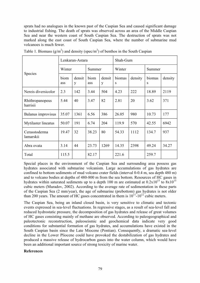
79
sprats had no analogues in the known past of the Caspian Sea and caused significant damage to industrial fishing. The death of sprats was observed across an area of the Middle Caspian Sea and near the western coast of South Caspian Sea. The destruction of sprats was not marked along the east coast of South Caspian Sea, where the number of submarine mud volcanoes is much fewer.
Table 1. Biomass (g/m2) and density (spec/m2) of benthos in the South Caspian
Lenkaran-Astara Shah-Gum
Winter Summer Winter Summer
Species biomass
density
biomass
density
biomass
density biomass
density
Nereis diversicolor 2.3 142 3.44 504 4.23 222 18.89 2119
Rhithropanopeus harrisii
5.44 40 3.47 82 2.81 20 3.62 371
Balanus improvisus 35.07 1361 6.56 386 26.05 980 10.73 177
Mytilaster lineatus 50.07 191 6.74 204 119.9 570 42.55 6942
Cerasstoderma lamarskii
19.47 32 38.23 80 54.33 1112 134.7 937
Abra ovata 3.14 44 23.73 1269 14.35 2398 49.24 34.27
Total 115.5 82.17 221.6 259.7
Special places in the environment of the Caspian Sea and surrounding area possess gas hydrates associated with submarine volcanism. Large accumulations of gas hydrates are confined to bottom sediments of mud volcano crater fields (interval 0-0.4 m, sea depth 480 m) and to volcano bodies at depths of 480-800 m from the sea bottom. Resources of HC gases in hydrates within saturated sediments up to a depth 100 m are estimated at 0.2x10¹⁵ to 8x10¹⁵
cubic meters (Muradov, 2002). According to the average rate of sedimentation in these parts of the Caspian Sea (2 mm/year), the age of submarine (prebottom) gas hydrates is not older than 200 years. The amount of HC gases concentrated in them is 1011-1012 cubic meters.
The Caspian Sea, being an inland closed basin, is very sensitive to climatic and tectonic events expressed in sea-level fluctuations. In regressive stages, as a result of sea-level fall and reduced hydrostatic pressure, the decomposition of gas hydrates and release of great volumes of HC gases consisting mainly of methane are observed. According to paleogeographical and paleotectonic reconstruction, paleoseismic and geochemical data indicate very good conditions for substantial formation of gas hydrates, and accumulations have existed in the South Caspian basin since the Late Miocene (Pontian). Consequently, a dramatic sea-level decline in the Lower Pliocene could have provoked the destabilization of gas hydrates and produced a massive release of hydrocarbon gases into the water column, which would have been an additional important source of strong toxicity of marine water.
References

80
Aliyev, Ch.S., Feyzullayev, A.A., and Zolotovitskaya, T.A. 2001. Peculiarities of radioactive fields of mud volcanoes of Azerbaijan. Geophysics News in Azerbaijan 3: 25-32.
Aliyeva, E.G.-M., 2005. Reservoirs of the Lower Pliocene Productive Series at the Western Flank of the South Caspian Basin. Lithology and Mineral Resources 40, No. 3: 267-278.
Katunin, D., Golubov, B., and Kashin, D. 2002. Hydrovolcanism and degassing of earth bowel as the possible reason of scale death of sprats on the Middle Caspian Sea during 2001 spring. Abstracts. 7th International Conference “Gas in Marine Sediments.” Baku, October 7-12.
Knapp, J.H., Diaconescu, C.C., and Conner, J.A. 2000. Deep seismic exploration of the South Caspian Basin: Lithosphere-scale imaging of the World's deepest basin. AAPG’s Inaugural Regional International Conference, Istanbul, Turkey.
Guliyev, I.S., and Huseynov, D.A. 2004. Dynamics of fluids in the South Caspian Basin. Doklady Earth Sciences 395A, No. 3: 338-342.
Huseynov, D.A. 2011. The modern fluid dynamics of Absheron peninsula Caspian water area as possible indicator of oil-and-gas content of transit zone and it reflection on satellite data. Oil Industry of Azerbaijan 8: 17-27. (In Russian)
Mamedov, P.Z. 1991. Seismostratigraphic studies of the geologic structure of the South Caspian megabasin in connection with the prospects of petroleum presence. Doctoral dissertation Geology Institute, Baku. (In Russian)
Mamedov, P.Z., Steling, C., and Kieckefor, R. 1997. Tectonic history of the Southern Caspian Sea. AAPG Bulletin 81/8: 110.
Muradov, Ch.S. 2002. Estimation of resources of gas in gas hydrate accumulations of the Southern Caspian Sea. Abstracts, 7th International Conference “Gas in Marine Sediments.” Baku, October 7-12.
Reynolds, A.D., Simmons, M.D., Bowman, M.B.J., Henton, J., Brayshaw, A.C., Ali-Zade, A.A., Guliyev, I.S., Suleymanova, S.F., Ataeva, E.Z, Mamedova, D.N., and Koshkarly, R.O. 1998. Implication of outcrop geology for reservoirs in the Neogene Productive Series, Apsheron peninsula, Azerbaijan. AAPG Bulletin 82(1): 25-49.
81
THE QUATERNARY OSTRACOD ASSEMBLAGES OF THE APSHERON ARCHIPELAGO
Javadova, A. 1, Zenina, M. 2, and Rzaeva, E. 3 1 Caspian Consulting Service Company, Burnaby, 44 Rengersausen str, Baunatal Germany
34225 [email protected]
2 Shirshov Institute of Oceanology, Russian Academy of Sciences, Moscow, 117997, Russia, [email protected]
3 Geology Institute of Science Academy, Baku, AZ1143, Azerbaijan, [email protected]
Keywords: ostracods, paleoenvironment, brackish water fauna, Caspian Sea, Quaternary Introduction The Apsheron archipelago is one of the largest oil-producing regions of Azerbaijan in the Caspian Sea. Oil fields have been under development in this area since the 19th century. Many scholars have published information on the regional ostracod fauna (Agalarova et al., 1961; Mandelstam et al., 1962; Maev et al., 1977; Mamedov et al., 1989; Javadova, 1989; etc.). Ostracods are excellent environmental indicators, and every geological time has its specific fauna (Boomer et al., 2005; Boomer, 2012; Gofman, 1966; etc.). They are numerous in the Caspian Sea and can live at various temperatures and salinities. Therefore, ostracods were used to date sediments while oil well drilling. As a result of wide-scale test drilling in the water area of the Apsheron archipelago, samples were collected from numerous wells, and ostracod fauna, stratigraphy, and lithofacies features of the Quaternary deposits could be studied in the region. The main study goal was paleo-reconstruction in the Apsheron archipelago area based on the Quaternary ostracod faunal complexes.
Methods The work is based on materials obtained by the first author while employed by the State Oil Company of Azerbaijan. It is officially permitted to use the materials for scientific publications. As oil companies drilled for production, complete coring was not always performed. Samples for ostracod study were collected from many wells in the water area of the Apsheron archipelago. In total, over 3000 samples from over 300 wells were analyzed. Specimens for ostracod faunal study were sieved through 0.063 mm sieve. Logs, seismic materials, lithological study, and analyzed faunal complexes were used to date the sediments. Maps with well locations were drafted in СоrelDraw at a scale of 1:200 000.
Results A total of about 130 ostracod species were found in the Quaternary deposits of the Apsheron archipelago. In the early Apsheronian, the following genera were widely represented among the ostracod fauna: Amnicythere, Euxinocythere, Loxoconcha, Paracyprideis, Candona, and others. In the mid-Apsheronian, ostracods are represented by species from the freshwater and brackish genera Amnicythere, Loxoconcha, Cyprideis, Ilyocypris, Paracyprideis, and others. In the late Apsheronian, considerable freshening of the Caspian water is recorded along with its shrinkage. Judging by the faunal composition, this freshening resulted from climatic cooling. Emerging gravels and conglomerates can be explained not only by regression, but by intensified tectonic and volcanic activity at the end of the Apsheronian. This is expressed by the presence of thick interbeds of volcanic ash in the upper Apsheronian. Many representatives of the genera Caspiocypris and Amnicythere became extinct in the late

82
Apsheronian. The Bakuvian unconformity overlaps the Apsheronian deposits in the Apsheron archipelago. In Bakuvian time, brackish species prevail among the ostracod fauna: Bakunella, Camptocypria, Paracyprideis, and Amnicythere. The lower Khazarian unconformity on the eroded Bakuvian surface and older deposits, along with faunal differences between the Bakuvian and lower Khazarian marine deposits clearly show the deep Caspian regression between Bakuvian and early Khazarian times. The deposits of this Caspian regression, named the Chelekenian, are not established within the Apsheron archipelago and adjacent area. Among the ostracods, species of the genus Candona were widely distributed, the species preferring relatively low salinity, along with brackish specimens of the genera Amnicythere and Euxinocythere. In the beginning of the upper Khazarian, Euxinocythere beata (Stepanaitys), Amnicythere periculosa (Stepanaitys), A. hildae (Stepanaitys), A. lunata (Stepanaitys), Scalaconcha edita (Schneider), and others were the first to emerge. At the end of the upper Khazarian, a Caspian regression occurs due to climatic cooling. The Lower Khvalynian unconformity within the Apsheron archipelago shows this. One may assume that the Apsheron archipelago used to be part of the Apsheron peninsula. Ostracod species composition considerably changed during that period, and the main Khvalynian faunal complexes formed. The Post-Khvalynian New-Caspian (modern times in Caspian history) is characterized by frequent small fluctuations in sea level and salinity. In places within the Apsheron archipelago, deposits of that time show limited distribution and are represented by shallow-water clays and sandy-muddy formations with mollusk shells of Cerastoderma glaucum (Bruguière), Mytilaster lineatus (Gmelin), Didacna crassa (Eichwald), D. baeri (Grimm), Monodacna caspia (Eichwald), and others. As for ostracods, the following are established: Amnicythere caspia (Livental), A. striatocostata (Schweyer), A. quinquetuberculata (Schweyer), along with numerous foraminifera Ammonia beccarii (Linnaeus). The compositions of ostracod assemblages from the New-Caspian and modern deposits are very close.
Conclusion This study resulted in the discovery of about 130 ostracod species; a stratigraphic section was prepared on the basis of the recovered ostracod fauna, and index species have been identified for each Quaternary horizon; a map of deposits in the Apsheron archipelago was drafted. The highest diversity of ostracod species is specific to the Apsheronian and Khazarian deposits. The comparative analysis of ostracod complexes shows the greatest inter-assemblage differences between those from the Apsheronian and Bakuvian supra-horizons, and between the Khazarian and Khvalynian assemblages. The facies and thickness analysis of the deposits in the Apsheron archipelago shows that all its basic structural components existed by the beginning of the Quaternary. The intensive growth of anticlinal highs occurred at that time, and in places, it was accompanied by erupting mud volcanoes. The facies thickness and faunal distribution analysis shows that in the Quaternary, the area of the Apsheron archipelago was quite a dynamic paleoenvironmental setting.
This work was partially supported by the Russian Foundation for Basic research (project № 18-34-00856 mol_a, M.A. Zenina).
References Agalarova, D.A., Kadyrova, Z.K., and Kulieva, S.A. 1961. Ostracods from the Pliocene and
Post-Pliocene Deposits. Azerneshr, Baku. Boomer, I. 2012. Ostracoda as Indicators of Climatic and Human-Influenced Changes in the
Late Quaternary of the Ponto-Caspian Region (Aral, Caspian and Black Seas). Ostracoda as Proxies for Quaternary Climate Change, Volume 12, 1st Edition, pp. 205-214.

83
Boomer, I., von Grafenstein, U., Guichard, F., and Bieda, S. 2005. Modern and Holocene sublittoral ostracod assemblages (Crustacea) from the Caspian Sea: a unique brackish, deep-water environment. Palaeogeography, Palaeoclimatology, Palaeoecology 225: 173-186.
Gofman, E.A. 1966. Ecology of Modern and New Caspian Ostracods from the Caspian Sea. Akademi Nauk, SSSR, Moscow.
Jafarova, А.Т. 1989. To the study of ostracod fauna from the Quaternary deposits in the water area of the Apsheron archipelago. Univ. Bull., Oil and Gas 7: 24-27.
Javadova, А.Т. 1996. Correlation of sections and biostratigraphy of the Quaternary deposits in the Apsheron and Baku archipelagos. Baku, Arch. AzINTI, p. 19.
Jafarova, А.Т., and Samedova, А.S. 1988. To the Quaternary stratigraphy in the water area of the Apsheron archipelago. NEA 10: 6-8.
Maev, Е.Т., Lebedev, L.I., and Artamonov, V.I. 1977. Some paleogeographic features of the Caspian Sea in the Upper Quaternary on the data of lithological and stratigraphic study of sediments. Paleogeography and Pleistocene Deposits of the SSR Southern Seas. Nauka, Moscow, pp. 78-84.
Mamedov, A.V., and Aleskerov, B.D. 1989. New data on Caspian Pleistocene stratigraphy, chronology and paleogeography. SA AzSSR, Geosciences series 3: 12-19.
Mandelstam, M.I., Markova, L., Rosyeva, T., and Stepanaitys, N. 1962. Ostracoda of the Pliocene and post-Pliocene deposits of Turkmenistan. Turkmenistan Geological Institute, Ashkhabad.

84
THE PROSPECTS OF CREATING UNESCO GEOPARKS AS A GEOECOLOGICAL TOOL TO PRESERVE THE GEOHERITAGE OF
AZERBAIJAN
Kangarli, T.N. 1, Huseynov, D.A. 2, Aliyeva, E.H. 3, Rashidov, T.M. 4, and Kangarli, I.T. 5
1-5 Institute of Geology and Geophysics, National Academy of Sciences of Azerbaijan, H. Javid av., 119, Baku, Az 1143, Azerbaijan
1 [email protected] 2 [email protected]
3 [email protected] 4 [email protected]
Keywords: rare geosites, sustainable use, culture-historical diversity, natural-geological diversity, region Introduction The decisions of some international conferences on geoparks show that at this modern stage of human evolution and given the state-to-state relations over the world, geoparks can serve as stewards of natural geoheritage in the natural state. Within them, all necessary conditions are available for their study and preservation for the benefit of humankind. At the same time, geological sites play a role in familiarizing people with aspects of the natural world through tourism and active leisure.
In that context, UNESCO should develop a list of key criteria for granting the status of geopark (International …, 2015). These criteria should: 1 - represent high achievements of human activity (e.g., unique worked-out deposits and ancient mines, constructive, architectural, technological, or landscape-related entities, and natural geologic phenomena); 2 - provide for information exchange, preservation of cultural traditions and evidence of past civilization; 3 - reflect the natural development of relief forms and natural geological processes typical of one or another period as well as the geological peculiarities of the Earth’s evolution and the beneficial results of natural land management; 4 - characterize the important modern environmental-biological processes occurring on the Earth as well as within varied habitats.
Along with that, we believe that the national park should meet the following key criteria: exclusivity, polygenicity or polyformity, developed infrastructure, and stability.
Methodology Azerbaijan possesses great potential for the creation of geoparks of local and international significance. The present potential was revealed by the implementation of the “National Strategy for Protection and Sustainable Use of Rare Geosites in the Azerbaijan Republic for 2009-2012.” Because of investigations performed under the aegis of the National Strategy, a cadaster of various geosites has been created. It includes such categories as paleontological-stratigraphic, tectonic, geomorphological, mineralogical-petrographic, hydrologic, hydrogeologic, and historic-mining-and-geological.
Results Azerbaijan is a region in the East Caucasus with rich flora (4100 species of plants) and fauna (over 12,000 animal species), a variety of climatic conditions, significant water resources, as

85
well as great tourist and recreational potential. The country’s natural phenomena include various exotic manifestations of geologic nature. Very often, these geological forms are expressed in the relief and combine with different types of landscapes – from semiarid to highland-nival. Thus, they represent rare geological localities (geosites) of local, regional, and even global significance. These geosites include mud volcanoes (some of the world’s largest), Naftalan oil with unique medical properties, sources of thermal and mineral waters, unique lithologic-stratigraphic sections, magmatic and tectonic forms of various genesis, geologic landscapes of volcanic and tectonic origin, relict mountain lakes, and other geologic manifestations falling within the category of geoheritage sites. Being part of the world’s geoheritage, these geosites must be preserved for the next generation of Azerbaijan and all of humankind as well. However, under present conditions, the increasing influence of anthropogenic factors upon the environment, geosites of the country are often under threat of destruction and require measures to be taken to ensure their geoconservation.
The geosites of different kinds (Kangarli, 2012; Kangarli and Babayev, 2012) are common in almost all the territory of the country. At the same time, many rare geosites, located in Garabagh, were not accessible to Azerbaijani scientists and therefore were excluded from the cadaster due to known reasons.
A preliminarily implemented analysis of the spatial distribution of geosites by categories, environmental conservation significance, and correspondence to established locations of culture-historical and recreational importance has revealed the great potential of Azerbaijan for the creation of national geoparks of international significance complying with the requirements of UNESCO and ProGEO. It includes:
Shahbuz-Ordubad region of the Nakhchivan area. The region is rich with its landscape and biodiversity; thermal and mineral sources of various balneological properties; complex topographic magmatic and structural forms; representative lithologic-stratigraphic sections of great chronological range; numerous ore manifestations of different genesis; mountain-historical, historical-cultural and archeological sites;
Girmaki geosite within Absheron. This geosite possesses an original erosional landscape; rare species of semi-desert vegetation, natural seeps of brea and bitums; exposed stratotype sections of oil-bearing horizons of the Productive Series; the Yanardagh hill with natural discharges of burning gas; ancient oil pits where primitive oil production was carried out even in the 18-19th centuries;
Khaltan depression, the greatest in the southeastern Caucasus. The depression offers a rich and diverse landscape; stratotype Jurassic and Cretaceous sections in the facies of continental slope and the foot of the southern edge of the Scythian Epi-Hercynian platform; complete topographic lithologic-stratigraphic Cretaceous section in the facies of the marginal sea of the Greater Caucasus; clearly expressed exotic forms of overthrust tectonics of the Austrian phase of tectogenesis; high-yield mineral sources of thermal waters in the southeastern Caucasus; historical-cultural and archaeological sites;
Basqal-Lahij region of the southeastern Caucasus. This region contains clear topographic manifestations of the overthrust tectonics of the Attic and Rodanian phases of tectogenesis; stratotype sections and structural forms of the northern island-arc margin of the South-Caucasian massif; the unique occurrence of Quaternary tectonics represented by the Garamaryam ridge; the distinctive annular-shaped Mudrisa syncline; the only exposed Early Pliocene intrusion into the Greater Caucasus (gabbro-syenites of Buynuz); Lahij settlement – the well-known historical-cultural site of the medieval period;

86
Gadabay-Dashkesan area of the Lesser Caucasus. This area offers a stratotype section and structural forms of the southern island-arc margin of the South-Caucasian massif; exotic mountain landscapes and rich biodiversity; topographic magmatic and structural forms; the giant fields of magnetite and alunite in the Caucasus; sources of thermal and mineral waters; mountain-historical, historical-cultural and archeological sites.
From the abovementioned territories, the most promising is the southeastern part of Nakhchivan Autonomous Republic. Here, it is proposed to create “Ilandagh” (Julfa) geopark, the culture-historical and natural potential of which is very close to the requirements of UNESCO and ProGEO.
Culture-historical heritage The Nakhchivan area is one of the cradles of world civilization (Naxçıvan…, 2002), as documented by numerous archaeological sites of the Paleolithic and Bronze Age, numerous petroglyphs in Gamigaya mountain, rock runic inscriptions in Ilandagh and Kharabagilan, ancient salt mines, remnants of the oldest urban development, cultures that produced colored wares of different shapes and other artifacts.
Over 280 archaeological sites and more than 400 landmarks have been discovered within the area of Nakhchivan. The history of Nakhchivan city dates back to the 4th-3rd millennia BC, and the city is currently one of the most ancient and largest settlements in the Near East.
Natural potential The territory of Nakhchivan AR is characterized by rich landscapes and biodiversity, as well as numerous phenomena of geological origin (Babayev, 2000; Kangarli, 2012; Kangarli and Babayev, 2012; Mammadov et al., 2012; Naxçıvan…, 2002).
The major species of flora (to 60%) and fauna (56%) encountered within the territory form part of the biodiversity of the region, including endemic, relict, and critically endangered. Generally, the Red Data Book of Azerbaijan includes 58 species of animals (35 vertebrates and 20 insects) and 39 species of plants spread over the area of Nakhchivan. The following nature conservation areas have been created here in order to preserve this biodiversity: Zangezur National Park, Arpachay State Nature Reserve, and Araz Nature Sanctuary.
The geological and geomorphological monuments that form the unique landscape of Nakhchivan include especially peculiar natural localities. Among the fascinating geological phenomena, one should mention the lithologic-stratigraphic sections (from Paleozoic to Pliocene). There are also topographic magmatic sites that clearly express their geological structure as well as observable folds and dislocation zones, numerous sources of mineral waters offering a wide range of balneotherapy, rare species of minerals of various origins, and mountain-historical sites. As many as 150 rare and unique geosites (Kangarli, 2012) have been discovered among the variety of geological and geomorphological forms. Among them are 22 lithologic-stratigraphic, 18 magmatic, 25 hydrologic and hydrogeological, 14 ore-petrographic, 68 geomorphological and 5 historic-mining-geological sites. Below there is a description of some of them.
Conclusions Considering the overall culture-historical and natural potential of the region, it seems reasonable to organize a geopark under the principle “three in one.” This means the inclusion of historic-architectural heritage (Ordubad Historical and Architectural Reserve) and biological diversity (Zangezur National Park) as one of the most interesting and ancient regions of the South Caucasus along with the geologic-geomorphological and archaeological sites into an integrated legal framework. The appropriate resolution has been accepted and
87
directed to the UNESCO Office for Geosciences and Geoparks. The idea has been approved and provision of the necessary assistance has been promised to grant international status to the geopark in the event of a positive outcome.
“Ilandag” geopark will allow the creation of a natural mechanism for protection of natural and human heritage with the involvement of local societies. In addition, it will promote the organization of cognitive-teaching activity as well as the development of geotourism – a new sphere of economic activity and sustainable development for local societies in Nakhchivan AR.
Reference Babayev, A.M. 2000. Mineralniye vodi gorno-skladchatih oblastey Azerbaijana [Mineral
Waters of Mountain-folded Areas of Azerbaijan]. “Çaşıoğlu”, Baku, pp.136-170. (in Russian)
International Program on Geosciences and Geoparks of UNESCO, 2015, Paris. Kangarli, T.N. 2012. “Azərbaycan Respublikasında nadir geoloji obyektlərin qorunması və
davamlı istifadəsinə dair” Tədbirlər Planı [Report of the Research on the “Plan of Actions on Protection and Sustainable Utilization of Rare Geological Objects in Azerbaijan Republic”]. Institute of Geology and Geophysics of the Azerbaijan National Academy of Sciences. (in Azerbaijani)
Kangarli, T.N., and Babayev, Sh.A. 2012. Geological heritage of Azerbaijan Republic. “Nafta-Press”, Baku.
Mammadov, G., Yusifov, E., Khalilov, M., and Karimov, V. 2012. Azerbaijan: ecotourism potential. “Şərq-Qərb”, Baku.
Naxçıvan Ensiklopediyası [Encyclopedia of Nakhchivan]. 2002. Publications of the Azerbaijan National Academy of Sciences, Baku. (in Azerbaijani)

88
ON THE QUESTION OF THE PLEISTOCENE-HOLOCENE BOUNDARY ON THE NORTHWESTERN SHELF OF THE BLACK SEA
BASED ON MICROPALEONTOLOGICAL DATA
Kondariuk, T. 1, and Mudryk, I. 2 1,2 Odessa I.I. Mechnikov National University, Paleontological Museum, 2 Dvoryanskaya Str.,
Odessa, Ukraine 65082
1 [email protected] 2 [email protected]
Keywords: foraminifera, ostracoda, pollen, dinoflagellate cysts, environmental changes Introduction The age of the Upper Pleistocene-Holocene boundary as well as the character of the transition from the Late Pleistocene (Neoeuxinian in the local terminology) lake into a more saline marine basin are highly debated. These issues are interesting for scientists in Quaternary geology. According to different data, the age of the transition ranges between 7.2 ky BP (Ryan et al., 1997), 8.4 ky BP (Major et al., 2002; Ryan et al., 2003), 7.8 ky BP (Lericolais et al., 2007), 10 ky BP (Inozemtsev et al., 1984; Kind, 1976; Balabanov et al., 1981; Aksu et al., 2002; Hiscott et al., 2002, 2007), 9.5 ky BP (Yanko and Troitskaya, 1987; Yanko-Hombach, 2007; Yanko-Hombach et al., 2014). The character of the transition from one basin to another varies from catastrophic (Ryan et al., 1997; Ryan, 2007) to gradual (Hiscott et al., 2002, 2007), and gradual but oscillating (Yanko and Troitskaya, 1987; Yanko-Hombach, 2007). The salinity of the Neoeuxinian lake varies between fresh (Ryan et al., 1997; Ryan, 2007), fresh but slightly brackish (Yanchilina et al., 2017), and brackish (Yanko-Hombach et al., 2014).
This article presents the results of studies conducted on samples from the northwestern shelf of the Black Sea. We chose this part of the shelf because it is the widest in the Black Sea and has a number of advantages for studying Quaternary geology compared to other geomorphological provinces. For our data, we used palynomorphs, foraminifera, and ostracoda.
The palynomorphs are extremely stable and do not collapse, being carried by the wind for long distances in huge numbers. That is why they are indispensable for paleogeographic reconstructions of vegetation and climate. Foraminifera are used as a reliable bioindicator of paleoenvironmental conditions and for stratigraphic studies because they are: benthic, taxonomically representative, widely distributed, hard-shelled, abundant, small-sized, and short-lived. Together, such evidence would provide a representative data-set that could be used successfully to reconstruct population statistics. The main goal of this paper is the reconstruction of the Pleistocene-Holocene boundary in the Black Sea on the basis of the complex use of palynological and foraminiferal analyzes as tools for reconstructing environmental conditions.
Study Area The study area includes the northwestern shelf of the Black Sea. It is the widest shelf in the basin and comprises about 30% of the Black Sea’s total area. The bottom relief is smooth due to sediment discharge and distribution by major lowland European rivers, such as the Danube, Dnieper, Dniester, and Southern Bug, that discharge together 56.8 million tons of sediments annually (Panin and Jipa, 2002). There are no known expressions of active tectonic movements that would strongly influence the position of ancient shorelines and the deposition

89
of sediments resulting in a shallow buildup of Quaternary sediments and a high variety of lithounits or facies (Dolukhanov et al., 2009); this enables us to trace the transformation from one basin to another.
Materials and methods Material for this study was obtained from the Ukrainian outer shelf using the Ukrainian Research Vessel “Vladimir Parshin” in September 2008 (Core 38). The length of gravity core 38 is 110 cm, and it comprises two lithological units: 0-53 cm: light grey mud with shells of marine Modiolus phaseolinus; and 55-110 cm: dark grey mud with shells of Caspian brackish Dreissena rostriformis. In all, 31 samples were studied: four in Unit 1, and 27 in Unit 2. Unit 2 was not present in Cores 45B, 342, and B2 as described in Yanko-Hombach et al. (2014) (Fig. 1).
Figure 1. Map of the Black Sea showing the study area, and the location of cores (modified after Yanko et al., 2014). Red points indicate the location of Cores B2, 342, and 45; the green point indicates the location of Core 38.
We also used materials from previous studies for comparison (Cores B2, 342, and 45) (Yanko-Hombach et al., 2014).
Table 1. Selected cores from NW shelf of the Black Sea
Core No Latitude N Longitude E Water depth, m Length, cm 38 44°66' 31°17' 192 1.1 B2 45°43' 09'' 30° 34' 28'' 30.8 72.5
45B 44°40' 16'' 31° 17' 30'' 107 75 342 46°37' 38'' 31° 24' 56'' +2 10.5
Palynomorphs were prepared for microscope study using the Odessa University method of sample treatment, which is based on the method used at Sapienza University of Rome. First, 10% HCl is used to remove carbonate from the sediment sample of 2 g dry weight after addition of 2 Lycopodium tablets and boiling for 10 minutes. After washing with distilled water until neutral pH, cold 40% HF is used to remove silicates by chemical digestion. Residues are mounted on microscope slides in glycerine gel.
Foraminiferal analysis was performed by methods described in Yanko and Troitskaya (1987). Foraminifera were picked by hand under the binocular microscope. The total assemblage was calculated and expressed as the number of tests (abundance) per 50 g dry sediment.

90
According to their ecological preferences, foraminifera (Yanko and Troitskaya, 1987) are divided into species groups based on salinity: oligohaline (1–5 psu), strictoeuryhaline (11–26 psu), polyhaline (18–26 psu), euryhaline (1–26 psu); and depth: shallow (0–30 m), relatively deep (31–70 m), and deep (71–220 m).
Results and discussion All obtained palynological data were divided into five groups: Trees, Shrubs, Herbs, Spores, and Aquatic plants. In Unit 1, 37 taxa were obtained, and 52 taxa were obtained in Unit 2. 17 taxa were present only in Unit 2. Pollen concentration is high (14,724−43,799 grain/g) and is dominated by Pinus, but totals increase after 4,551 yr BP (Unit 1) when Juglans, Pistacia, Vitis, and Cereal pollen records begin, probably reflecting land cultivation in the northern coastal plain. Increases of Filicales, Polypodiaceae, and Sphagnum spores mark the interval <7.9 ka BP, reflecting proximity to the Paleo-Dniester Delta (Mudryk and Mudie, 2017).
Dinoflagellate cyst concentrations (126–5,430 cysts/g) are lower than pollen, especially in the deltaic interval where microforaminiferal linings are absent; the flora indicate a salinity <8 psu (Fig. 2). Lingulodinium machaerophorum (Fig. 3) appears around 7 ka BP, marking increased salinity after an earlier rise of microforaminifera (Marret et al., 2015). Dinocyst diversity increases at 3,759 yr BP, when polykrikoids appear together with heterotrophic protoperidinioids, suggesting the start of eutrophication (Mousing et al., 2013).
Figure 2. Some NPP from Core 38 layer 2: 1 Pediastrum boryanum, 2 Spiniferites cruciformis – Core H42, 3 Lining of foraminifera Ammonia novoeuxinica (?)
Figure 3. NPP from Core 38 (layer 1). 1 Lining of foraminifera Ammonia compacta, 2 Echinidinium?, 3 Lingulodinium
The late Neoeuxinian assemblages of foraminifera (Core 38) are dominated by oligohaline Ammonia novoeuxinica, Mayerella brotzkajae, and Elphidium caspicum, all of Caspian genesis. Mollusks are represented by Dreissena polymorpha, Monodacna caspia, and ostracoda Leptocythere bacuana and Loxoconcha lepida (Yanko and Gramova, 1990) that tolerate salinity up to 13 psu in the Caspian Sea today (Nevesskaya, 1965; Shornikov, 1972). According to the studied cores, the reconstructed possible salinity of the Late Neoeuxinian lake ranged from ~6 to 13 psu. No Mediterranean species are present among the foraminifera, mollusks, and ostracoda (Kondariuk, 2017).

91
Mediterranean species appear upwards (Core 38, Unit 1) in the cores at about 9.5 ka BP where Ammonia novoeuxinica is slowly replaced by A. tepida (Fig. 3, 1-2) and then by Ammonia compacta (Fig. 3, 3-4) and A. ammoniformis (Fig. 4, 5-6). Other holeuryhaline (e.g., Haynesina anglica) and strictoeuryhaline (e.g., Cribroelphidium poeyanum) and even polyhaline (including Lagenida representatives) species appear increasingly towards the sea. The number of species and specimens at the Pleistocene-Holocene boundary increases but never sharply (Kondariuk, 2017).
Figure 4. Foraminifera from the northwestern shelf of the Black Sea: 1, 2 - Ammonia tepida, 3, 4 - Ammonia ammoniformis, 5, 6 - Ammonia compacta.
Also, we used the distribution data of ostracoda (Kondariuk T., in preparation). Ostracoda (3 species) from Unit 1 are dominated by marine species. Ostracoda (7 species) from Unit 2 are represented by brackish species only. Foraminifera from Unit 1 are represented by 5 polyhaline (18-26 psu) species.
Conclusions According to our data, the boundary between the latest Neopleistocene and Holocene lies between ~9 and 10 ky BP. This boundary is characterized by a smooth change. The Neoeuxinian lake could not be fresh because foraminifera are not adapted to freshwater. Foraminiferal species discovered in Neoeuxinian sediments live today in the Caspian Sea, and the salinity of this lake can be as high as 13 psu. Changes in foraminiferal assemblages at the Pleistocene-Holocene boundary depend on the facies. They are more pronounced in marine than in shallow facies, especially in the areas influenced by paleoriver discharge. Pollen data from Upper Pleistocene sediments show a cold climate with a high concentration of forest trees, aquatic plants, and grasses. However, the presence of Ephedra shows that the climate was not very dry at the time. Pollen data from Lower Holocene deposits show a gradual transition to a warmer climate with more steppe vegetation. Distribution of non-pollen palynomorphs from Cores 38 and 342 (Yanko-Hombach et al., 2014) indicate that brackish water was present in the latest Neoeuxinian Lake.
Acknowledgments This paper is a contribution to the EU FR6 HERMES Project; contract GOCE-CT-2005-511234. It also contributes to the IGCP 610 project “From the Caspian to Mediterranean: Environmental change and human response during the Quaternary.”
References Aksu, A.E., Hiscott, R.N., Kaminski, M.A., Mudie, P.J., Gillespie, H., Abrajano, T., and
Yaşar, D. 2002. Last glacial–Holocene paleoceanography of the Black Sea and Marmara Sea: stable isotopic, foraminiferal and coccolith evidence. Marine Geology 190:119–149.
Balabanov, I.P., Kvirkveliya, B.D., and Ostrovsky, A.B. 1981. Noveishaya istoriia formirovaniya inzhenerno-geologicheskikh uslovii i dolgosrochnyi prognoz razvitiia beregovoi zony poluostrova Pitsunda [Recent History of the Development of
92
Engineering-Geological Conditions and Long-Time Forecast for the Coastal Zone of the Pitsunda Peninsula]. Metsniereba, Tbilisi. (In Russian)
Dolukhanov, P., Kadurin, S., and Larchenkov, E. 2009. Dynamics of the coastal North Black Sea area in Late Pleistocene and Holocene and early human dispersal. Quaternary International 197(1-2): 27-34.
Hiscott, R.N., Aksu, A.E., Yaşar, D., Kaminski, M.A., Mudie, P.J., Kostylev, V.E., MacDonald, J.C., Işler, F.I., and Lord, A.R. 2002. Deltas south of the Bosphorus Strait record persistent Black Sea outflow to the Marmara Sea since ~10 ka. Marine Geology 190: 95-118.
Hiscott, R.N., Aksu, A.E., Mudie, P.J., Kaminski, M.A., Abrajano, T., Yaşar, D., and Rochon, A. 2007. The Marmara Sea gateway since ~16 ky BP: Non-catastrophic causes of paleoceanographic events in the Black Sea at 8.4 and 7.15 ky BP. In V. Yanko-Hombach, A.S. Gilbert, N. Panin, and P. Dolukhanov, (Eds.), The Black Sea Flood Question: Changes in Coastline, Climate and Human Settlement. Springer, Dordrecht, pp. 89-117.
Inozemtsev, Yu.I., Lutsiv, Ya.K., Sobotovich, E.V., Kovalyukh, N.N., and Petrenko, L.V. 1984. Geochronologiia i fatsialnie kompleksi golotsena Chernomorskoi oblasti [Holocene geochronology and facies complexes of the Pontic area]. In E.F. Shnyukov, ed., Izuchenie geologicheskoi istorii i protsessov sovremennogo osadkoobrazovaniia Chernogo i Baltiiskogo morei [Study of the Geological History and Processes of Recent Sedimentation in the Black and Baltic Seas], Part 1, pp. 103-113. Naukova Dumka, Kiev. (In Russian)
Kind, N.V. 1976. Paleoklimati i prirodnaia sreda golotsene [Holocene climates and environment]. In Istoria biogeotsenozov SSSR v golotsene [History of Biogenocenoses of the USSR in the Holocene], L.G. Dinesman (Ed.), pp. 5–14, Nauka, Moscow. (In Russian).
Kondariuk, T. 2017. Paleoenvironmental reconstructions at the Pleistocene-Holocene boundary in the Black Sea based upon on benthic foraminifera. In Gilbert, A. and Yanko-Hombach, V., (Eds.), Proceedings of UNESCO - IUGS – IGCP 610 and INQUA IFG POCAS Joint Plenary Conference and Field Trip, October 1-9, 2017, Palermo, Italy. University of Palermo, pp. 98-102.
Kondariuk T. Reconstruction of changes in sedimentation conditions on the basis of benthic foraminiferal analysis at the Pleistocene and Holocene boundary in the Black Sea. PhD Thesis, in prep.
Lericolais, G., Popescu, I., Guichard, F., Popescu, S.-M., and Manolakakis, L. 2007. Waterlevel fluctuations in the Black Sea since the Last Glacial Maximum. In V. Yanko-Hombach, A.S. Gilbert, N. Panin, and P. Dolukhanov, (Eds.), The Black Sea Flood Question: Changes in Coastline, Climate and Human Settlement. Springer, Dordrecht, pp. 437-452.
Major, C., Ryan, W.B.F., Lericolais, G., and Hajdas, I. 2002. Constraints on Black Sea outflow to the Sea of Marmara during the last glacial-interglacial transition. Marine Geology 90: 19-34.
Marret, F., Mudie, P., Mertens, K., and Shumilovskhikh, K. 2015. Atlas of modern dinoflagellate cyst distribution in the Black Sea corridor. GSA Annual Meeting in Baltimore, Maryland, USA (1-4 November 2015), Program and Abstracts. Paper No. 44-7.
Mousing, E.A., Andersen, T.B., and Ellegaard, M., 2013. Changes in the abundance and species composition of phytoplankton in the last 150 years in the Southern Black Sea. Estuaries and Coasts 36: 1206-1218.

93
Mudryk, I., and Mudie, P.J. 2017. Palynology and paleoecological interpretation of Core 38, Palaeo-Dneister valley, Northwestern Black Sea: initial results of pollen, dinocyst and NPP studies. PAGES – OSM 2017, Zaragoza, Spain, 9-13 May 2017, Abstract Book, p. 99.
Nevesskaya, L.A. 1965. Pozdnechetvertichnye dvustvorchatye molliuski Chernogo Moria; ikh sistematika i ekologiia [Late Quaternary Bivalve Molluscs of the Black Sea; Their Systematics and Ecology]. Trudy Paleontologicheskogo Instituta Akademii Nauk SSSR, vol. 105. Nauka, Moscow. (In Russian)
Panin, N., and Jipa, D. 2002, Danube River sediment input and its interaction with the north-western Black Sea. Estuarine, Coastal and Shelf Science 54: 551–562.
Ryan, W.B.F. 2007. Status of the Black Sea flood hypothesis. In V. Yanko-Hombach, A.S. Gilbert, N. Panin, and P.M. Dolukhanov, (Eds.), The Black Sea Flood Question: Changes in Coastline, Climate and Human Settlement. Springer, Dordrecht, pp. 63-88.
Ryan, W.B.F., Pitman, W.C., III, Major, C.O., Shimkus, K., Moskalenko, V., Jones, G.A., Dimitrov, P., Görür, N., Sakınç, M., and Yüce, H. 1997. An abrupt drowning of the Black Sea shelf. Marine Geology 138(1-2): 119-126.
Ryan, W.B.F., Major, C.O., Lericolais, G., and Goldstein, S.L. 2003. Catastrophic flooding of the Black Sea. Annual Review of Earth and Planetary Sciences 31: 525-554.
Shornikov, E.I. 1972. Voprosy ekologii azovo-chernomorskikh ostracod [Questions about the ecology of Azov-Black Sea Ostracoda]. Biologia Moria, pp. 53-88. (In Russian)
Yanchilina A. G., Ryan W. B.F., McManus J. F., Dimitrov P., Dimitrov D., Slavova K., and Filipova-Marinova M. 2017. Compilation of geophysical, geochronological, and geochemical evidence indicates a rapid Mediterranean-derived submergence of the Black Sea's shelf and subsequent substantial salinification in the early Holocene. Marine Geology 383, pp. 14–34.
Yanko, V.V., and Troitskaya, T.S. 1987. Pozdnechetvertichnye foraminifery Chernogo moria [Late Quaternary Foraminifera of the Black Sea]. Nauka, Moscow. (In Russian)
Yanko, V., and Gramova, L. 1990. Stratigrafiia chetvertichnykh otlozhenii kavkazskogo shel’fa i kontinental’nogo sklona Chernogo moria po mikrofaune–foraminiferam i ostrakodam [Stratigraphy of the Quaternary sediments of the Caucasian shelf and continental slope of the Black Sea based on microfauna–foraminifera and ostracoda]. Sovetskaia Geologiia 2:60–72. (In Russian).
Yanko-Hombach, V. 2007. Controversy over Noah’s Flood in the Black Sea: geological and foraminiferal evidence from the shelf. In V. Yanko-Hombach, A.S. Gilbert, N. Panin, and P. Dolukhanov, (Eds.), The Black Sea Flood Question: Changes in Coastline, Climate and Human Settlement. Springer, Dordrecht, pp. 149-203.
Yanko-Hombach, V., Mudie P.J., Kadurin, S., and Larchenkov, E. 2014. Holocene marine transgression in the Black Sea: New evidence from the northwestern Black Sea shelf. Quaternary International 345: 100-118.
.

94
TECTONICALLY MODIFIED COASTAL SHORELINE IN THE MARMARA REGION, NW TURKEY: EVIDENCE FROM BYZANTINE
ARCHAEOLOGICAL SITES
Koral, H. 1, Tur, H. 2, Aydıngün, Ş. 3, and İşbil, D. 4 1,4 Istanbul University, Department of Geological Engineering, Istanbul, Turkey 34320,
1 hkoral @istanbul.edu.tr 4 [email protected]
2 Istanbul University, Department of Geophysical Engineering, Istanbul, Turkey 34320 [email protected]
3 Kocaeli University, Department of Archaeology, Izmit, Turkey 41380 [email protected]
Keywords: Coastal modification, North Anatolian Fault Zone, Prince Islands, KüçükÇekmece Lagoon, Iznik Lake, Byzantine establishment Active tectonic structures are present along the coast of the Marmara Sea and surrounding areas, extensively modifying the Neogene-Quaternary sequence (e.g., Barka and Kadinsky-Cade,1988; Koral and Şen, 1995; Koral, 1998). The units were folded and faulted by neotectonic structures, some of which are linked to the seismically active North Anatolian Fault Zone (NAFZ). Proximity of a submerged or elevated ancient settlement to the nearby active tectonic feature is evidence for a tectonically induced coastal change in the Marmara region (Fig. 1).
Figure 1. Locations of investigation near Istanbul, Turkey, indicated by dashed boxes.
A small submerged rocky mass named ‘Yıldız Kayalıkları/Vordonisi’ forms one the Prince Islands, located about 1 km south of the Asian coast of the city of Istanbul in the Marmara Sea (Fig. 1). The Prince Islands comprise nine closely spaced islands with unique tectonic and geological features (e.g., İşbil, 2012; Tur, 2007). Historical records and underwater searches indicate that ‘Vordonisi’ supported a monastery during Byzantine time, circa 850 AD, which now lies submerged under several meters of water (Meriç, 2010).

95
“Bathonea” is named after an ancient settlement that existed on the KüçükÇekmece Lake, a lagoon situated inland on the northern coast of the Marmara Sea (Fig. 1). With cultural layers extending from the Middle Iron Ages to the 12th century, a part of this settlement characterized by a Quaternary age coquina horizon is elevated, but its mole now lies under the water level of the lake (Aydıngün and Bilgili, 2015).
Likewise, İznik (Nicaea) Lake, an inland lake located along the NAFZ, has elevated Quaternary terraces on the adjacent slope (e.g., Meric et al., 2018) (Fig. 1), while a Byzantine structure dated to about 400 AD is located tens of meters away from the northern shoreline and is submerged (Fig. 2).
Figure 2. Submerged archaeological site of St. Neophytos Basilica in İznik (Nicaea) Lake, situated along the central strand of the NAFZ. (Taken from www.arkeofili.com).
These sites are situated either near the active NAFZ or along its secondary branches. The northern Marmara region has been affected by many strong historical earthquakes, especially those of 740, 989, 1509, 1766, and 1894 AD, whose epicenters are considered to have been close by, in addition to events dating to 861, 869, 1011, 1032, 1063, 1296, 1332, 1346, 1419, 1542, and 1556 AD (Ambraseys and Finkel, 1987, 1991). Coastal changes observed along the fault line during the August 1999 Gölcük (Izmit) (Mw=7.46) and Kaynaşlı (Mw=7.2) events (e.g., Barka, 1999; Herece, 1999; Öztürk, et al., 2000; Koral, 2007) make it plausible to relate the submergence or elevation of the archaeological site to a tectonic shoreline and land modification along the seismically active NAFZ.
References Ambraseys, N.N., and Finkel, C.F. 1987. Seismicity of Turkey and neighbouring regions,
1899–1915. Annales Geophysicae 5B(6): 701-726. Ambraseys, N.N., and Finkel, C.F., 1991. Long-term seismicity of Istanbul and of the
Marrmara Sea region. Terra Nova 3(5): 527-539. Aydıngün, Ş.G., and Bilgili, A.E. 2015. İstanbul Tarih Öncesi Arkeolojik Yüzey
Araştırmaları ve KüçükÇekmece Göl Havzası (Bathonea) Kazılarının İstanbul'a Katkıları. [Pre-historic surface investigations in Istanbul and the contribution of KüçükÇekmece Lake Basin excavations to the history of Istanbul]. In Great History of

96
Istanbul from the Prehistoric Ages to the XXI Century, ed. by Karakuyu, M., pp. 374-389. (In Turkish)
Barka, A.A. 1999. The 17 August 1999 İzmit earthquake. Science 285(5435): 1858-1859. Barka, A.A., and Kadinsky-Cade, K. 1988. Strike-slip fault geometry in Turkey and its
influence on earthquake activity. Tectonics 7, 663-684. Herece, E. 1999. Kocaeli Depreminin Yüzey Kırıkları ve Gözlem Noktalarının Tanıtımı.
[Surface Rupture of the Kocaeli Earthquake and Description of the Observation Sites]. MTA Report no. 10230. (In Turkish)
İşbil, D. 2012. Prens Adalarının (İstanbul) Jeolojisi, ve Tektonik Özellikleri [Geology and Tectonic Features of the Prince Islands (İstanbul)]. İ. Univ., Faculty of Engineering. (B.Sc.Thesis, in Turkish)
Koral, H. 2007. Sea-level changes modified the Quaternary coastal lines in the Marmara region, NW Turkey: what about tectonic movements? In The Black Sea Flood Question: Changes in Coastline, Climate, and Human Settlement, V. Yanko-Hombach, A.S. Gilbert, N. Panin, and P.M. Dolukhanov, (Eds.), pp. 571-601. Springer, Dordrecht.
Koral, H. 1998. Progressive Mid-Tertiary Geometry of a Major Crustal in Southeastern Stranjha Massif. 12th International Petroleum Congress of Turkey, İstanbul, Türkiye, pp.15-30.
Koral, H., and Şen, S. 1995. Evidence of a transtensional regime in Tertiary sediments of Istanbul: examples from Çekmece regions. Proceedings of Istanbul-94, First Turkish International Symposium on Deformations (Istanbul, 5-9 September, 1994), Ankara, pp. 680-691.
Meriç E., Nazik, A., Yümün, Z.Ü., Büyükmeriç, Y., Avşar, N., Yıldız, A., Sagular, E., Koral, H., and Gökaşan, E. 2018. Fauna and flora of drilling and core data from the İznik Lake: The Marmara and the Black Sea connection. Quaternary International 486:156-184.
Meriç, E. 2010. Jeoloji ve arkeoloji: İstanbul ve yakın çevresinin 8000 yıllık geçmişinden kesitler [Geology and Archaeology: Examples from the 8000 Year Old Past of Istanbul and its Vicinity]. The Chamber of Architects, Bakırköy BKBT, Istanbul. (In Turkish)
Öztürk, H., Koral, H., and Geist, E.L. 2000. Intra-basinal water movements induced by faulting: the August 17, 1999, Gölcük (İzmit Bay) earthquake (Mw = 7.4). Marine Geology 170(3-4): 263-270.
Tur, H. 2007. An example of secondary fault activity along the North Anatolian Fault on the NE Marmara Sea Shelf, NW Turkey. Earth, Planets and Space 59: 541-552.
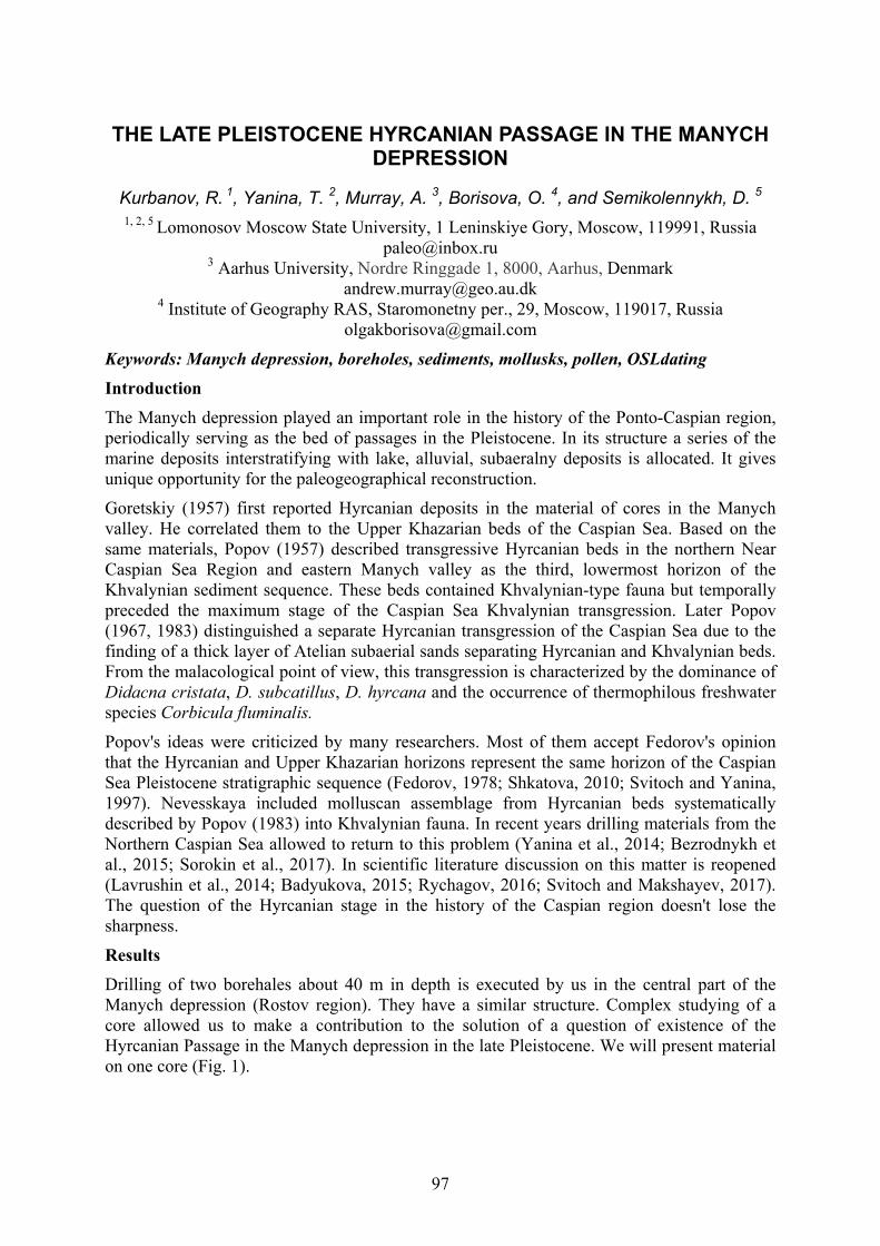
97
THE LATE PLEISTOCENE HYRCANIAN PASSAGE IN THE MANYCH DEPRESSION
Kurbanov, R. 1, Yanina, T. 2, Murray, A. 3, Borisova, O. 4, and Semikolennykh, D. 5 1, 2, 5 Lomonosov Moscow State University, 1 Leninskiye Gory, Moscow, 119991, Russia
[email protected] 3 Aarhus University, Nordre Ringgade 1, 8000, Aarhus, Denmark
[email protected] 4 Institute of Geography RAS, Staromonetny per., 29, Moscow, 119017, Russia
Keywords: Manych depression, boreholes, sediments, mollusks, pollen, OSLdating Introduction The Manych depression played an important role in the history of the Ponto-Caspian region, periodically serving as the bed of passages in the Pleistocene. In its structure a series of the marine deposits interstratifying with lake, alluvial, subaeralny deposits is allocated. It gives unique opportunity for the paleogeographical reconstruction.
Goretskiy (1957) first reported Hyrcanian deposits in the material of cores in the Manych valley. He correlated them to the Upper Khazarian beds of the Caspian Sea. Based on the same materials, Popov (1957) described transgressive Hyrcanian beds in the northern Near Caspian Sea Region and eastern Manych valley as the third, lowermost horizon of the Khvalynian sediment sequence. These beds contained Khvalynian-type fauna but temporally preceded the maximum stage of the Caspian Sea Khvalynian transgression. Later Popov (1967, 1983) distinguished a separate Hyrcanian transgression of the Caspian Sea due to the finding of a thick layer of Atelian subaerial sands separating Hyrcanian and Khvalynian beds. From the malacological point of view, this transgression is characterized by the dominance of Didacna cristata, D. subcatillus, D. hyrcana and the occurrence of thermophilous freshwater species Corbicula fluminalis.
Popov's ideas were criticized by many researchers. Most of them accept Fedorov's opinion that the Hyrcanian and Upper Khazarian horizons represent the same horizon of the Caspian Sea Pleistocene stratigraphic sequence (Fedorov, 1978; Shkatova, 2010; Svitoch and Yanina, 1997). Nevesskaya included molluscan assemblage from Hyrcanian beds systematically described by Popov (1983) into Khvalynian fauna. In recent years drilling materials from the Northern Caspian Sea allowed to return to this problem (Yanina et al., 2014; Bezrodnykh et al., 2015; Sorokin et al., 2017). In scientific literature discussion on this matter is reopened (Lavrushin et al., 2014; Badyukova, 2015; Rychagov, 2016; Svitoch and Makshayev, 2017). The question of the Hyrcanian stage in the history of the Caspian region doesn't lose the sharpness.
Results Drilling of two borehales about 40 m in depth is executed by us in the central part of the Manych depression (Rostov region). They have a similar structure. Complex studying of a core allowed us to make a contribution to the solution of a question of existence of the Hyrcanian Passage in the Manych depression in the late Pleistocene. We will present material on one core (Fig. 1).

98
Figure 1. Diagram of the structure of MN -1 core: 1 – sandy loam, 2 – aleurite/loam, 3 – clay and loam, 4 – loam, 5 – loess-like loam.
Stratigraphic units: p-hv – Post-Khvalynian horizon; hv – Khvalynian horizon; bur – Burtas horizon; gk – Hyrcanian horizon; gk-kr – transitional Hyrcanian-Karangatian horizon; kr – Karangatian horizon.
The borehole MN-1 (42.0 m in depth) is drilled in 5 km to the northwest from the settlement Manych (the Orlovsky area). The absolute height is 19.17 m.
In the core, in the range of 35.50–31.80 m the loams and clays with impurity of an alevrit including the shells of Karangatian mollusks lie. Over them the loam layer with increase in impurity of sand, with numerous shells of both the Caspian, and Black Sea mollusks is opened (31.80–9.20 m).
Above (29.20–4.70 m) loams-sandy loams with pro-layers of an alevrit and shells of the Caspian mollusks lie. They are blocked (24.70–15.60 m) by gray clays with concretions of carbonates, with large grains of plaster, with iron spots, with small fragments of fresh-water shells.
99
The four paleogeographical events in the history of the central part of the Manych depression are consistently reflected a structure of the described part of a core: (1) the ingressive gulf of Karangatian transgression of the Black Sea which is characterized quiet (to stagnant) sedimentation conditions; (2) the basin indicating mixture of the Black Sea and Caspian waters with the amplified activity of the water environment; (3) the basin with the Caspian waters which is quite well aerated due to activity of water weight; (4) a basin of lake type, strongly desalinated or fresh-water, answering to the Burtas (Gudilovo) lake (Goretski, 1953; Popov, 1955, 1983).
We executed granulometric, faunistic, sporous and pollen, geochronological (optic-luminescent dating) analyses (Fig. 2).
Figure 2. Structure of the studied interval of MN-1 core. Fraction size, mm: 1 – 0.0001–0.001; 2 – 0.001–0.005; 3 – 0.005–0.01; 4 – 0.01–0.05; 5 – 0.05–0.1; 6 – 0.1–0.2; 7– 0.25–0.5.
The faunistic analysis is the base for conclusion that Hyrcanian faunistic complex (Fig. 2) doesn't raise doubts in its identity to the Hyrcanian complex (fauna) which for the first time is systematically described by G.I. Popov (1983). The sporous and pollen analysis showed that pollen ranges of the Hyrcanian thickness belong to steppe type. The content of pollen of herbs and low shrubs makes 66%, pollen of the Chenopodioídeae (48%), ice-holes (30%) and cereals (21%) prevails. Pollen of ice-holes in this horizon belongs generally to Artemisia s.g. Seriphidium. Pollen of grass differs in a big variety here. Pollen of trees and bushes makes
100
less than a third (27%) of a range. About 37% of wood pollen belong to a pine (Pinus sylvestris). Besides, alder pollen (21%), birches, broad-leaved breeds (an oak, an elm, a linden, a filbert) is found.
By results of OSL-dating the core interval from depth of 27.0-27.1 m is characterized by age of 107±7 thousand years, for an interval of a core of 29.9-30.0 m dating of 119±7 thousand years is received (Kurbanov et al., 2018).
On the base of investigation of the core we made conclusion: The beginning of the period (interglacial epoch, MIS 5e) was characterized by deep penetration of an ingressive gulf of the Black Sea Karangatian transgression into the Manych depression. Its waters were rather saline (not less than 18–20‰), thus supporting a rich Black Sea complex of mollusks. The transitional stage to the glacial epoch (MIS 5d) led to a gradual retreat of the Karangatian gulf waters from the Manych depression to the Black Sea one. The stage is dated by OSL method as 119±7 thousand years and it ended with the development of the Hyrcanian passage of the Caspian Sea. The passage had brackish Caspian waters (8–7‰). Its faunistic profile was dominated by mollusks D. cristata, D. hyrcana, D. subcatillus, Monodacna caspia, Dreissena polymorpha. The bottom of the passage in the central part of the Manych depression had absolute elevations of –13 to –9 m. Sedimentation in the passage was smooth, obviously due to its considerable width in the central part of depression.
Landscapes of the central part of the Manych depression were in line with the interstadial climatic conditions (rather cool, with smaller seasonal contrasts and higher moistening than today). OSL dating received for the first time for the Hyrcanian deposits (middle part of the stratum) is 107±7 thousand years, thus relating the existence of the passage to MIS 5c-a epoch. The marine period of development of the central part of the depression was followed by a long-term lacustrine phase (the Burtass lake) in the second half of the Late Pleistocene.
Acknowledgements Field research and the initial stages of analytical work were financially supported by the Russian Scientific Foundation (project № 14-17-00705). At present they are financially supported by the Russian Scientific Foundation (project № 16-17-10103). Authors are sincerely grateful to V.R. Belyaev and E.V. Garankina, Senior Scientific Researchers of the Department of Geomorphology and Paleogeography of the MSU Faculty of Geography, for the help in the organization and carrying out field works, and also to the students who took part in them. Our gratitude to E.A. Konstantinov, Senior Scientific Researcher of the Institute of Geography of the Russian Academy of Sciences, and the student A. Rudinskaya for the organization and implementation of the granulometric analysis.
References Badyukova, E.N. 2015. Istoriya kolebanij urovnya Kaspiya v Pleistotsene (byla li velikaya
khvalynskaya transgressiya?) [History of fluctuations of the Caspian Sea level in the Pleistocene (whether there was a Great Khvalynian transgression?)]. Bulletin of the Commission on Studying the Quaternary Period. 74: 111–120 (in Russian).
Bezrodnykh, Yu.P., Deliya S.V., Romanyuk B.F., Sorokin V.M., and Yanina T.A. 2015. New data on the upper quaternary stratigraphy of the north Caspian sea. Dokl. Earth Sci. 462(1): 479–483.
Fedorov, P.V. 1978. Plejstocen Ponto-Kaspiya [Pleistocene of the Ponto-Caspian]. Moscow: Nauka, 1978. 165 p. (in Russian).
Goretskiy, G.I. 1953. O paleogeografii Priazoviya i Zapadnogo Primanych’ya v uzunlarsko-girkanskij i burtasskij veka [About paleogeography of the Azov Sea area and the
101
Western Manych areain the Uzunlarian-Hyrcanian and Burtass epochs]. Questions of Geography. 33: 190–221 (in Russian).
Goretskiy, G.I. 1957. O girkanskom etape v istorii Prikaspiya [About the Hyrcanian stage in the history of the Caspian Sea area]. Novosti neftyanoy tekhniki 6: 3–5 (in Russian).
Kurbanov, R.N., Yanina T.A., Murrey A., and Borisova O.K. 2018. Girkanskiy etap v pleistotsenovoy istorii Manychskoy depressii [Hyrcanian epoch in the Pleistocene history of the Manych depression]. Vestnik Moskovskogo Unviersiteta. Seriya 5. Geografiya 3; 77–88 (in Russian).
Lavrushin, Yu.A., Spiridonova, E.A., Tudrun, A., Shali, F., Antipov, M.P., Kuralenko, N.P., Kurina, E.E., and Tukholka, P. 2014. Kaspiy: gidrologicheskie sobytiya pozdnego kvartera [The Caspian Sea: hydrological events of the Late Quaternary]. Bulletin of the Commission on Studying the Quaternary Period 73: 19–51 (in Russian).
Popov, G.I. 1955. Istoriya Manychskogo proliva v svyazi so stratigrafiej chernomorskih i kaspijskih otlozhenij [History of the Manych Strait in relation with stratigraphy of the Black Sea and Caspian deposits]. Bulletin MOIP. Otd. Geologii 20(2): 31–49 (in Russian).
Popov, G.I. 1957. Sravnitel’naya stratigrafiya chetvertichnyh otlozheniy Manychskogo proliva, Kaspiya i Evksina [Comparative stratigraphy of the Quaternary deposits of the Manych Strait, Caspian Sea and Euxinian]. Trudy of the Commission on Studying the Quaternary Period 13: 65–73 (in Russian).
Popov, G.I. 1967. Girkanskaya transgressiya v Severnom Prikaspii [Hyrcanian transgression in the Northern Caspian Sea area]. Bulletin of the Commission on studying of the Quaternary Period 33: 77–86 (in Russian).
Popov, G.I. 1983. Plejstocen Chernomorsko-Kaspijskih prolivov [Pleistocene of the Black Sea and Caspian passages]. Moscow: Nauka, 216 p. (in Russian).
Rychagov, G.I. 2016. Girkansky etap v istorii Kaspijskogo morya [Hyrcanian stage in the history of the Caspian Sea]. Geomorphology 1: 3–17 (in Russian).
Shkatova, V.K. 2010. Paleogeography of the late Pleistocene Caspian basins: Geochronometry, paleomagnetism, paleotemperature, paleosalinity and oxygen isotopes. Quaternary International. 225: 221–229.
Sorokin, V.M., Yanina, T.A., Bezrodnykh, Yu.P., and Romanyuk, B.F. 2017. Identification and age of submarine Girkanian sediment beds (Upper Pleistocene) in the Caspian Sea. Quaternary International 465А: 152–157.
Svitoch, A.A., and Makshaev, R.R. 2017. Vzaimosvyazi paleogeograficheskih sobytij v Pont-Manych-Kaspijskoj sisteme v pozdnem pleistocene-golocene [Interrelations of the paleogeographical events in the Pont-Manych-Caspian system during the Late Pleistocene and Holocene]. Vestnik Moskovskogo Unviersiteta. Seriya 5. Geografiya 2; 24–32 (in Russian).
Svitoch, A.A., and Yanina, T.A. 1997. Chetvertichnye otlozheniya poberezhij Kaspijskogo morya [Quaternary deposits of the coasts of the Caspian Sea]. Moscow: Russian Academy of Agrarian Sciences, 264 p. (in Russian).
Yanina, T.A., Sorokin, V.M., Bezrodnykh, Yu.P., and Romanyuk, B.F. 2014. Girkanskiy etap v plejstocenovoy istorii Kaspijskogo morya [Hyrcanian stage in the Pleistocene history of the Caspian Sea]. Vestnik Moskovskogo Unviersiteta. Seriya 5. Geografiya 3: 3–9 (in Russian).

102
THE LOESS-SOIL SEQUENCES IN THE LOWER VOLGA AREA: STRATIGRAPHY, GEOCHRONOLOGY AND PALEOGEOGRAPHY
Kurbanov, R. 1, Yanina, T. 2, Murray, A. 3, Buylaert, J.-P. 4, Stevens, T. 5, Rogov, V.6, Streletskaya, I. 7, Belyaev, V. 8, Makeev, A. 9, Lebedeva, M. 10, Rusakov, A. 11,
Svistunov, M. 12, Yarovaya, S. 13, Taratunina N. 14, and Költringer, Ch. 15 1,2,6,7,8,9,12,13 Lomonosov Moscow State University, 1 Leninskiye Gory, Moscow, 119991,
Russia [email protected]
3,4 Aarhus University, DTU Risø Campus, DK-4000, Roskilde, Denmark [email protected]
5, 15 Department of Earth Science, Uppsala University, Villav, 16, 752 36, Uppsala, Sweden [email protected]
10 V.V. Dokuchaev Soil Science Institute, Pyzhevsky per., 7, Moscow, 119017, Russia [email protected]
1,14 Institute of Geography RAS, Staromonetny per., 29, Moscow, 119017, Russia [email protected]
11 St. Petersburg State University, Institute of Earth Sciences, Saint-Petersburg, Russia [email protected]
Keywords: Caspian region, Lower Volga area, Atelian deposits, regression, stratigraphic po-sition, chronology Paleogeographic development of the Caspian Sea in the Late Pleisocene is characterized by alterna-tion of transgressive and regressive stages. Unlike transgressive periods, the paleogeographical environment during regressive periods is less understood. The main reason is the lack of paleon-tological and paleobotanical remains (fauna and pollen) in continental deposits of various genesis.
The longest period of a Caspian Sea low level stand in the Late Pleistocene is the Atelian regres-sion. During this period a thick sequence of continental deposits was formed. This formation is widespread within the Northern Caspian Depression and represented by subaqueous and subaerial deposits, including alluvial and aeolian. In the southern part of Lower Volga most of this strata is eroded by more active abrasion during Caspian sea minor transgressions of Hyrcanian time and the first part of Khvalynian period. But in the north, in the series of sections around the Volgograd city, Atelian strata reach up to 10-12 m in thickness. In this area continental sedimentation was longer, the abrasion during the high-stand of Early Khvalynian transgression was relatively small (~1-3 m, depending on the geomorphological position) due to very rapid sea-level rise in a short time (Kur-banov et al., 2018). Four sections reveal the structure of Atelian formation: Srednyaya Akhtuba, Leninsk and Batayevka on the left side of the Volga valley and Raigorod on the right side.
The general stratigraphy of Atelian formation in these four outcrops differs. The existing strati-graphical framework is based on new series of luminescence dating results (Yanina et al., 2017). Srednyaya Akhtuba is characterized by three MIS-5 paleosols and thick horizon of MIS-4 loess. The uppermost soil (MIS-5a) is disturbed by distinct deep wedges, cracks and streaks with sedi-ment penetrating from the covering loess. These cryogenic features clearly illustrate cooling cli-mate conditions of the MIS-4 at Lower Volga and can be easily identified at most of the sections. The upper part of the sequence is represented by alternation of alluvial sand and weakly developed loess horizons with clear traces of pedogenesis in MIS-3, that are also influenced by cryoturbations.
103
Leninsk, located more to the South is characterized by two well-developed paleosols of MIS-5, again with clear frost wedges from the upper thick loess horizon and one level of pedogenesis at the top of MIS-3 stage (the upper part of the soil is eroded). The MIS-5a soil is disturbed by deep cracks filled by loess.
At Raigorod section the Atelian strata is based on thick horizon of alluvial sediments (floodplain facies). In these alluvial clays and silts we identified two levels of pedogenesis, represented by highly hydromorphic soils. This stage remains undated, the only idea about the age of the well-developped soil at the base of the section can be obtained from the published results of pollen anal-ysis – that indicates the Likhvin stage (MIS-9) of the Russian plain (Grichuk, 1954). On the top of this layer floodplain facies change to channel facies – clean well-sorted sands, on top of which weakly developed paleosol can be identified. This soil is disturbed by minor wedges – not very clear due to similarity of the lithology with the overlaying sands. The clean loess of MIS-4 stage with 2 layers of slightest evidence of pedogenesis passes to MIS-3 stage loess with pedocomplex containing two paleosols on the top of the sequence. This pedocomplex was partly eroded during Khvalynian transgression.
Most developed sequence of Atelian time can be found at the Batayevka location, 100 km to the SE from Leninsk. Batayevka section is located on the left side of the Lower Volga valley opposite to the reference section of Chernyy Yar on the right valley side. In this outcrop we were able to iden-tify three levels of pedogenesis of MIS-3 (in alluvial sands of the upper part of the section), well-developed pedocomplex of MIS-5, containing three combined paleosols, the top one with perma-frost features – cracks and wedges. Important difference of this section is that it contains another three older levels of pedogenesis – of unknown age (probably MIS-7 and MIS-9). The Atelian for-mation here developed on the alternating lagoon and lacustrine sands and silts.
Described stratigraphy and chronology of the loess-paleosol sequence of the Atelian formation al-lows us to better understand the main stages of environmental evolution of the Lower Volga region and the whole Northern Caspian lowland during the Late Quaternary.Shells of freshwater and con-tinental ecological groups of molluscs are found in these sediments, both with suppressed morphol-ogy. Mammal skeletal remains of the upper Paleolithic faunal complex are found, including a mammoth, a horse, a reindeer and other animals, giving evidence for the cold climate of the Atelian epoch. The same is indicated by the taiga spore and pollen spectra from the Atelian deposits (Grichuk, 1954; Moskvitin, 1962). The pollen assemblages of definitely periglacial character re-covered from the Atelian deposits from cores (Bolikhovskaya et al., 2017).
The Atelian paleosols of different degrees of development implies a multiple change of climatic conditions in the region with warming and increased humidity. By the end of the Atelian epoch, the climate became warmer. In the vegetation, the share of arboreal pollen increased; along with birch, pine and spruce, newly introduced elm, oak and linden appeared; in the herbaceous associations the importance of xerophytes decreased, while Gramineae and herbaceous vegetation were introduced. Steppe and forest-steppe environments became dominant.
Starting with the second early Valday cooling and lasting up to the Holocene, the center of the Rus-sian Plain was occupied by a variety of periglacial landscapes. At the beginning of the early Valday cooling maximum, the transgressive development of the Caspian was disrupted by the Atelian re-gression that reached the lowest level at the peak of cooling conditions, under a cold and dry cli-mate. Heterogeneity of climatic conditions, expressed as an alternation of stadials and interstadials, was reflected in the Atelian deposits by the

104
development of thick loess horizon during MIS-4 and paleosol horizons alternating with loess during MIS-5 and MIS-3 stages.
Acknowelegements The investigstion was supported by the Russian Scientific Foundation (project № 16-17-10103).
References Bolikhovskaya, N.S., Yanina, T.A., Sorokin, V.M. 2017. Environment of the Atelian epoch
(on the data of palynological analyses). Vestnik Moskovskogo Universiteta, Seriya 5, Geographiya 6: 96–101 (in Russian).
Grichuk, V.P. 1954. Materials to the paleobotany characteristic of the Quaternary and Pliocene deposits of the northern-western part of the Precaspian lowland. In: Materials on Geomor-phology and Paleogeography of the USSR, vol. 11. Nauka, Moscow, pp. 5-79 (in Russian).
Kurbanov, R.N., Yanina, T.A., Murrey,A.S., and Borisova, O.K. 2018. Hyrcanian epoch in the late Pleistocene history of the Manych depression. Vestnik Moskovskogo Universiteta, Seriya 5, Geographiya 3: 77–88 (in Russian).
Moskvitin, A.I. 1962. Pleistocene of the lower Volga region. In: Trudy of the Geological Institute of the Academy of Science, vol. 64. Nauka, Moscow, pp. 1-263 (in Russian).
Yanina T.A., Svitoch A.A., Kurbanov R.N., Murray A.S.,Tkach N.T., and Sychev N.V. 2017. Experience of dating of the Pleistocene deposits of the Lower Volga area using the optically stimulated luminescence. Vestnik Moskovskogo Universiteta, Seriya 5, Geographiya 1: 21–29 (in Russian).

105
OPTICALLY-STIMULATED LUMINESCENCE AGES OF THE EARLY KHVALYNIAN “CHOCOLATE CLAYS” OF THE LOWER VOLGA
Kurbanov, R. 1, Murray, A. 2, Yanina, T. 3, Thompson, W. 4, Svistunov, M. 5, and Yarovaya, S. 6
1,3 ,5,6 Lomonosov Moscow State University, 1 Leninskiye Gory, Moscow, 119991, Russia 3 [email protected]
2,4Aarhus University, DTU Risø Campus, DK-4000, Roskilde, Denmark [email protected]
Keywords: Caspian region, late Pleistocene, Khvalynian transgression, chocolate clays, OSL During the Late Quaternary dramatic changes in relative sea-level are known to have occurred in the Caspian Sea. However, all previous attempts at resolving the uncertainty associated with the timing of these transgressive/regressive events using standard dating methods have produced inconclusive or controversial results. However, the chronology of these palaeogeographic events remains very controversial. Existing Late Quaternary age estimates for various transgressive/regressive events have been obtained using electron paramagnetic resonance spectroscopy (Molodkov, 1992), thermoluminescence (Shahovets, 1987; Rychagov, 1997), uranium-thorium (Kuznetsov, 2008; Arslanov et al, 2015), and radiocarbon (Arslanov et al., 2013; Tudryn et al, 2013; Svitoch 2014); with the various methods often providing contradictory results. The main purpose of this research is develop a new chronology for the group of sections exposed by the Volga River ~50 km downstream of Volgograd (Fig. 1).
Figure 1. Lower Volga area. Investigated sections.

106
The timing of the Early Khvalynian has always been one of the most controversial issues of the Late Quaternary history of the Caspian Sea. There are currently two main views: (a) the transgression is old, perhaps between 70 and 30 ka. This view (Rychagov, 2016; Mamedov, 2010) emphasizes the time required for the development of the geomorphology (formation of marine terraces) and palaeogeography (sourcing and transporting the large volume of water required to produce a very considerable sea-level rise). To support these arguments, somewhat selective reference is usually made to TL ages of 24-32 ka (Shahovets, 1987), U-Th of 20-24 ka and older radiocarbon (28-31 ka) ages (Mamedov, 2010).
For the first time a reliable Late Pleistocene chronology has been derived using optically stimulated luminescence (OSL), and post-IR IRSL290 analysis of quartz and K-feldspar grains extracted from 20 sediment samples collected along the Lower Volga River. Analyses were conducted on multi-grain aliquots of the sand-sized fractions of loessic sediments, marine clays and the overlying modern soils from three exposed sections ~50km downstream of Volgagrad. The signals from all quartz samples were dominated by the fast component; there was no significant IR sensitivity, and no significant dependence of De on preheat temperature. The post-IR IRSL290 signals from the 5 samples examined also met all laboratory-based criteria for a reliable estimate of equivalent dose. Resetting of the luminescence signals was investigated based on the differential bleaching rates of quartz OSL and K-feldspar signals; we conclude that all signals were sufficiently reset prior to deposition.
Acknowledgement The investigations here reported are supported by the Russian Scientific Found Project No 16-17-10103.
References Arslanov, KhA., Yanina, T.A., Chepalyga, A.L., Svitoch, A.A., Makshaev, F.E., Maksimov,
S.B., Chernov, N.I., and Tertychniy, A.A. 2016. On the age of the Khvalynian deposits of the Caspian Sea coast according to 14C and 230Th/234U methods. Quat. Int. 409 (A0), 81-87.
Mamedov, A.V. 1997. The late Pleistocenee - Holocene history of the Caspian Sea. Quat. Int. 41/42, 161-166.
Molodkov, A.N. 1992. EPR-analyses of the skeleton of mollusks in the chronostratigraphic investigations of the Late Cenozoic. PhD dissert. Tartu. (in Russian).
Rychagov, G.I. 1997. Pleistocene History of the Caspian Sea. Moscow State University, Moscow, pp. 1-267 (in Russian).
Rychagov, G.I. 2014. Khvalynian epoch in the history of the Caspian Sea) Vestnik Moskovskogo Universiteta. Seriya 5, Geographiya 4:3-9 (in Russian).
Rychagov, G.I. 2016. Hyrcanian stage in the history of the Caspian Sea. Geomorphology 1: 3–17 (in Russian).
Shahovets, S.A. 1987. Chronology of the paleogeographical events of the late Pleistocene of the Lower Volga area (on the data of TL method). PhD Diss. Moscow, MSU (in Russian).
Svitoch, A.A. 2014. The Great Caspian Sea: Structure and History of Development. Moscow University Press, Moscow, pp. 1-268 (in Russian).
Tudryn, A., Chali_e, F., Lavrushin, YuA., Antipov, M.P., Spiridonova, E.A., Lavrushin, V.Yu., Tucholka, P., and Leroy, S.A.G. 2013. Late quaternary Caspian sea environment: late khazarian and early khvalynian transgressions from the lower reaches of the Volga River. Quat. Int. 292, 193-204.
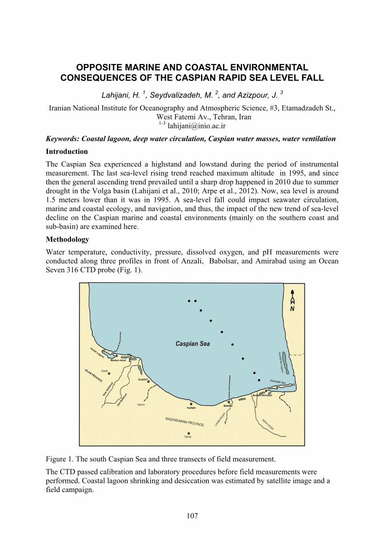
107
OPPOSITE MARINE AND COASTAL ENVIRONMENTAL CONSEQUENCES OF THE CASPIAN RAPID SEA LEVEL FALL
Lahijani, H. 1, Seydvalizadeh, M. 2, and Azizpour, J. 3
Iranian National Institute for Oceanography and Atmospheric Science, #3, Etamadzadeh St., West Fatemi Av., Tehran, Iran 1-3 [email protected]
Keywords: Coastal lagoon, deep water circulation, Caspian water masses, water ventilation Introduction
The Caspian Sea experienced a highstand and lowstand during the period of instrumental measurement. The last sea-level rising trend reached maximum altitude in 1995, and since then the general ascending trend prevailed until a sharp drop happened in 2010 due to summer drought in the Volga basin (Lahijani et al., 2010; Arpe et al., 2012). Now, sea level is around 1.5 meters lower than it was in 1995. A sea-level fall could impact seawater circulation, marine and coastal ecology, and navigation, and thus, the impact of the new trend of sea-level decline on the Caspian marine and coastal environments (mainly on the southern coast and sub-basin) are examined here.
Methodology
Water temperature, conductivity, pressure, dissolved oxygen, and pH measurements were conducted along three profiles in front of Anzali, Babolsar, and Amirabad using an Ocean Seven 316 CTD probe (Fig. 1).
Figure 1. The south Caspian Sea and three transects of field measurement.
The CTD passed calibration and laboratory procedures before field measurements were performed. Coastal lagoon shrinking and desiccation was estimated by satellite image and a field campaign.
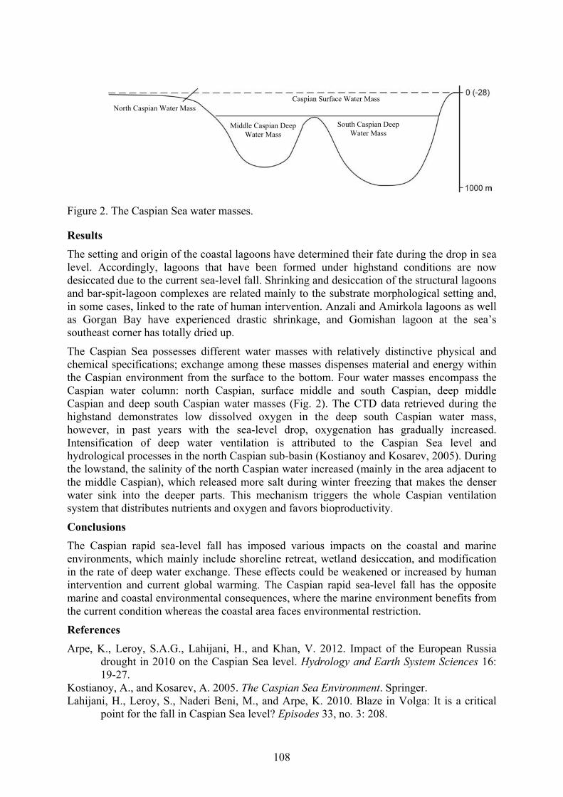
108
Figure 2. The Caspian Sea water masses.
Results
The setting and origin of the coastal lagoons have determined their fate during the drop in sea level. Accordingly, lagoons that have been formed under highstand conditions are now desiccated due to the current sea-level fall. Shrinking and desiccation of the structural lagoons and bar-spit-lagoon complexes are related mainly to the substrate morphological setting and, in some cases, linked to the rate of human intervention. Anzali and Amirkola lagoons as well as Gorgan Bay have experienced drastic shrinkage, and Gomishan lagoon at the sea’s southeast corner has totally dried up.
The Caspian Sea possesses different water masses with relatively distinctive physical and chemical specifications; exchange among these masses dispenses material and energy within the Caspian environment from the surface to the bottom. Four water masses encompass the Caspian water column: north Caspian, surface middle and south Caspian, deep middle Caspian and deep south Caspian water masses (Fig. 2). The CTD data retrieved during the highstand demonstrates low dissolved oxygen in the deep south Caspian water mass, however, in past years with the sea-level drop, oxygenation has gradually increased. Intensification of deep water ventilation is attributed to the Caspian Sea level and hydrological processes in the north Caspian sub-basin (Kostianoy and Kosarev, 2005). During the lowstand, the salinity of the north Caspian water increased (mainly in the area adjacent to the middle Caspian), which released more salt during winter freezing that makes the denser water sink into the deeper parts. This mechanism triggers the whole Caspian ventilation system that distributes nutrients and oxygen and favors bioproductivity.
Conclusions
The Caspian rapid sea-level fall has imposed various impacts on the coastal and marine environments, which mainly include shoreline retreat, wetland desiccation, and modification in the rate of deep water exchange. These effects could be weakened or increased by human intervention and current global warming. The Caspian rapid sea-level fall has the opposite marine and coastal environmental consequences, where the marine environment benefits from the current condition whereas the coastal area faces environmental restriction.
References Arpe, K., Leroy, S.A.G., Lahijani, H., and Khan, V. 2012. Impact of the European Russia
drought in 2010 on the Caspian Sea level. Hydrology and Earth System Sciences 16: 19-27.
Kostianoy, A., and Kosarev, A. 2005. The Caspian Sea Environment. Springer. Lahijani, H., Leroy, S., Naderi Beni, M., and Arpe, K. 2010. Blaze in Volga: It is a critical
point for the fall in Caspian Sea level? Episodes 33, no. 3: 208.
North Caspian Water Mass
South Caspian Deep Water Mass
Middle Caspian Deep Water Mass
Caspian Surface Water Mass

109
NEW DATA ABOUT GRAIN-SIZE AND GEOCHEMICAL CHARACTERIZATION OF BAER KNOLLS SEDIMENTS IN THE
VOLGA DELTA REGION
Lobacheva, D.M. 1, Makshaev, R.R. 2, Zastrozhnov, A.S. 3, Zastrozhnov, D.A, 4, Tkach, N.T 5
1, 2, 5 Lomonosov Moscow State University, Faculty of Geography, Moscow, 119991, Russia 1 [email protected] 2 [email protected] 3 [email protected]
3,4 A.P. Karpinsky Russian Geological Research Institute (VSEGEI), 74, Sredny Prospect, 199106, St. Petersburg, Russia
Keywords: grain-size, geochemistry, Baer knolls, Caspian Sea, Late Pleistocene Nothern Caspian territory is characterized by typical relief, which is like a huge ridges. They are called Baer knolls after K.M. Baer who described them first (Baer, 1856). Since then many works were dedicated to Baer knolls (e.g. Barbot de Marni, 1868, Mushketov, 1895, Pravoslavlev, 1929, Fedorovich, 1941, Zhukov, 1945, Doskach, 1949, Yakubov, 1952, Ivanova, 1952, Brytsyna, 1955, Belevich, 1979, Svitoch, Klyuvitkina, 2006, Badyukova, 2005, 2018), but there are still discussions about genesis, distribution, morphology, inner structure and genesis of Baer's knolls (BK). There are some main hypotheses of Baer knolls (BK) thickness: aeolian, erosion-accumulative and coastal. Generally, the geological structure of BK consists of three parts: upper (UBT) and lower knoll formations (LBT), often separated by angular unconformity, and chocolate clays (CC) as a basement. Previous studies on granulometric and grain morphoscopic analyses of BK sediments had shown how grain size and mineral assemblages can be used to identify potential sediment source (Ivanova, 1952).
The aim of this research is to analyze granulometric and geochemical composition of BK sediments in the Volga delta region. These data was used to determine the potential relationship between three types of BK layers. Sometimes there are only one BK layer.
So we carried out a granulometric analysis of samples taken from the Upper and Lower layers.
So during our investigation, sediment samples were taken from four Baer knolls (Yaksatovo, Mirniy, Natrovo and Troitsky knolls), which are located in the Volga delta. Fifty samples (7 CC, 17 LKF and 26 UKF) with fraction less than 1 mm were analyzed using the “Fritsch Analysette 22” laser diffraction grain-size analyzer. All samples were treated with 5% sodium pyrophosphate (Na4P4O7). As a result, an average grain size composition of studied BK sediments is represented by < 1 μm (13%), 1-5 μm (42,4%), 5-10 μm (13,7%), 10-50 μm (21,7%), 50-250 μm (8,7%) and 250-1000 μm (0,3%). Grain-size of CC consists mainly of 1-5 μm (45,1%) and 10-50 μm (24,5%) and is not represented by a coarse sand fraction. Grain size in LBT is quite similar to CC and demonstrates the increase of 50-250 μm fractions. In the UBT medium and coarse (250-1000 μm) sand fraction appears.
Major element and trace elements geochemistry analysis was carried out for 8 powder pellets using wavelength-dispersive X-ray fluorescence (WDXRF) Spectroscan-Maks-GV with 50 kV Pd tube. That about geochemical results: the major element of samples is SiO2 (in all layers it ranges between 60-70%). In UKF major elements are TiO2, Fe2O3, Al2O3, K2O, and
110
trace elements V, Cr, Co, Ni, Cu, Zn, Pb are depleted, while the concentration of Sr is increasing. In comparison to CC, LBT there are the similar concentration of Fe2O3 more than 6 %, it can be because of erosion of upper CC part.
The sediments forming BK have a variegated mineralogical composition. This fact indicates either different types of the incoming materials, or a periodic change in the hydrodynamics of the basin. Analyzing the content of Ca, a regularity was revealed: the amount of calcium decreases while moving from the delta plain upstream of the Volga. Such a high content of Ca in the sediments may be attributed either to the abundance of organogenic material in the form of detritus, debris and whole shells of marine and freshwater mollusks, or with the removing of limestone material from the Volga Uplands. We founded that layers are rich in organogenic material: detritus, debris and whole valves of marine and freshwater redeposited shells Didacna praetrigonoides, Dreissena rostriformis Des, Adacna plicata Eichw etc.
The character of stratification and gran-size indicates that, likely, BK were formed in subaquatic conditions, where a weak current occurred. Simultaneously with the accumulation of sandy material and interlayers of redeposited shells, there were a background deposition of clay particles. It should be noted that the questions of genesis, time of origin and distribution of Baer’s knolls are still open. Further detailed studies will help to solve this problem in a complex.
Acknowledgements
The investigations here reported are supported by the RSF Project No 16-17-10103.
References Badyukova, E.N. 2005. New data about the morphology and composition of BK.
Geomorfologiya 4, 25-38 (in Russian). Badyukova, E.N. 2018. Genesis of the Baery knolls developed in the Northern Caspian Plain.
Quaternary International 465, 11-21. Baer, K.M. 1856. Scientific Notes about the Caspian Sea and Adjacent Regions. Notes of the
Imperial Russian Geographical Society. St-Petersburg. XI, pp. 181-224 (in Russian). Barbot-de-Marni. 1868. Geological Description of the Kalmykya steppe and Respective
Territories. In: Kalmykyan steppe of the Astrakhanyan region, Kuma- Manych expeditions, pp. 1-76 (in Russian).
Belevich, E.F. 1979. About genesis of the Baery knolls. Geomorfologiya 2, 57-68 (in Russian).
Britzyna, M.P., 1955. About the Genesis of the Baery Knolls Relief. In the Memory of Academician L.S.Berg. Publishing house of Academy of science, pp. 320-330 (in Russian).
Doskach, A.G. 1949. Geomorphological observations in the region of the Baery knolls distribution. Proc. Inst. Geogr. 43 (2), 19-32 (in Russian).
Fedorovich, B.A. 1941. Genesis of the “Baery knolls” in the northern Caspian Plain. Proc. USSR Acad. Sci. Ser. Geogr. Geophys. 1, 95-116 (in Russian).
Ivanova, G.A. 1952. On the origin of Baer knolls. Proc. Inst. Geogr. 51 , 277-291 (in Russian).
Mushketov, I.V. 1895. Geological research in the Kalmykian steppe in 1885-1886. Proc. Geol. Comm. 14 (1) (in Russian).
Pravoslavlev, P.A. 1929. The north-west shore of the Caspian Sea. Proc. Central hydrometeobyuro 8, 1-54 (in Russian).
Svitoch, A.A. Klyuvitkina, T.C., 2006. Baery Knolls in the Regions Surrounded the Lower Volga. Moscow, p. 160 (in Russian).

111
Yakubov, T.F. 1952. Baery knolls genesis in the northern Caspian Plain. Proc. Inst. Geogr. 51. 253-276. (in Russian).
Zhukov, M.M. 1945. About Baer knolls. Priroda 2. (in Russian).

112
GRAIN-SIZE AND GEOCHEMICAL CHARACTERIZATION OF BAER KNOLLS SEDIMENTS IN THE VOLGA DELTA
Makshaev, R.R. 1, Lobacheva, D.M. 2, Zastrozhnov, A.S. 3, Zastrozhnov, D.A. 4, and Tkach, N.T. 5
1, 2, 5 Lomonosov Moscow State University, Faculty of Geography, Moscow, 119991, Russia 1 [email protected]
5 [email protected] 3,4 A.P. Karpinsky Russian Geological Research Institute (VSEGEI), 74, Sredny Prospect,
199106, St. Petersburg, Russia 3 [email protected]
Keywords: grain-size, geochemistry, Baer knolls, Caspian Sea, Late Pleistocene Introduction
The Late Khvalynian transgression was the last to occur in the Pleistocene history of the Caspian Sea. At that time, the shoreline reached 0 m asl over a length of 7500 km. In the Northern Caspian Plain, subparallel knolls were formed. They were called Baer knolls after K.M. Baer who first described them (Baer, 1856).
Since then, many works have been dedicated to the Baer knolls (e.g., Barbot de Marni, 1868; Mushketov, 1895; Pravoslavlev, 1929; Fedorovich, 1941; Zhukov, 1945; Doskach, 1949; Yakubov, 1952; Ivanova, 1952; Brytsyna, 1955; Belevich, 1979; Svitoch and Klyuvitkina, 2006; Badyukova, 2005, 2018), but the question of the Baer knolls’ genesis is still under debate. There are a few major hypotheses relating to the formation of the Baer knolls (BK): aeolian, erosion-accumulative, and coastal. Generally, the geological structure of the BK consists of three parts: upper knoll formations (UKF), lower knoll formations (LKF), and chocolate clays (CC). Previous studies on granulometric and grain morphoscopic analyses of BK sediments had shown how grain size and mineral assemblages can be used to identify potential sediment sources (Ivanova, 1952).
The aim of this research is to analyze the granulometric and geochemical composition of BK sediments in the Volga delta. These data are then used to determine the potential relationship between the three types of BK structures.
Materials and methods
Sediment samples were taken from four Baer knolls (Yaksatovo, Mirniy, Natrovo, and Troitsky knolls), which are located in the Volga delta. Fifty samples (7 CC, 17 LKF, and 26 UKF) with fractions less than 1 mm were analyzed using the “Fritsch Analysette 22” laser diffraction grain-size analyzer. All samples were treated with 5% sodium pyrophosphate (Na4P4O7).
Major and trace element geochemistry analyses were carried out for 8 powder pellets using a wavelength-dispersive X-ray fluorescence (WDXRF) Spectroscan-Maks-GV with 50 kV Pd tube.
Results
Grain-size
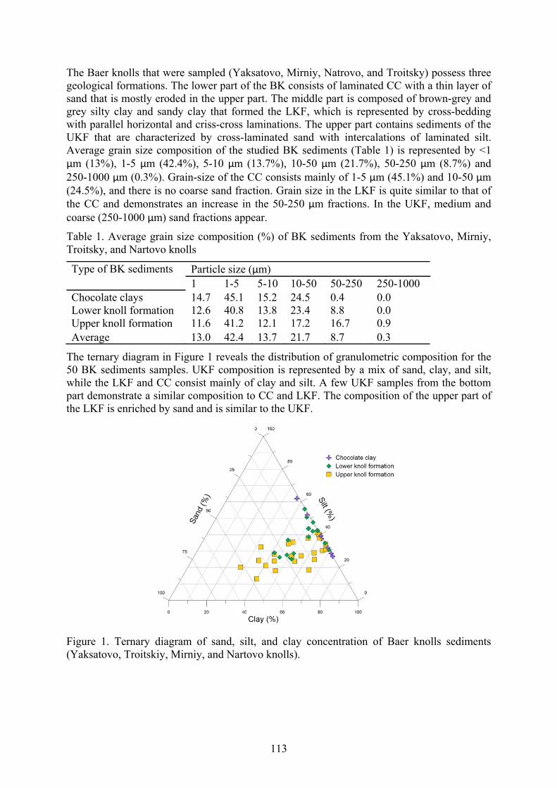
113
The Baer knolls that were sampled (Yaksatovo, Mirniy, Natrovo, and Troitsky) possess three geological formations. The lower part of the BK consists of laminated CC with a thin layer of sand that is mostly eroded in the upper part. The middle part is composed of brown-grey and grey silty clay and sandy clay that formed the LKF, which is represented by cross-bedding with parallel horizontal and criss-cross laminations. The upper part contains sediments of the UKF that are characterized by cross-laminated sand with intercalations of laminated silt. Average grain size composition of the studied BK sediments (Table 1) is represented by <1 μm (13%), 1-5 μm (42.4%), 5-10 μm (13.7%), 10-50 μm (21.7%), 50-250 μm (8.7%) and 250-1000 μm (0.3%). Grain-size of the CC consists mainly of 1-5 μm (45.1%) and 10-50 μm (24.5%), and there is no coarse sand fraction. Grain size in the LKF is quite similar to that of the CC and demonstrates an increase in the 50-250 μm fractions. In the UKF, medium and coarse (250-1000 μm) sand fractions appear.
Table 1. Average grain size composition (%) of BK sediments from the Yaksatovo, Mirniy, Troitsky, and Nartovo knolls
Particle size (μm) Type of BK sediments 1 1-5 5-10 10-50 50-250 250-1000
Chocolate clays 14.7 45.1 15.2 24.5 0.4 0.0 Lower knoll formation 12.6 40.8 13.8 23.4 8.8 0.0 Upper knoll formation 11.6 41.2 12.1 17.2 16.7 0.9 Average 13.0 42.4 13.7 21.7 8.7 0.3
The ternary diagram in Figure 1 reveals the distribution of granulometric composition for the 50 BK sediments samples. UKF composition is represented by a mix of sand, clay, and silt, while the LKF and CC consist mainly of clay and silt. A few UKF samples from the bottom part demonstrate a similar composition to CC and LKF. The composition of the upper part of the LKF is enriched by sand and is similar to the UKF.
Figure 1. Ternary diagram of sand, silt, and clay concentration of Baer knolls sediments (Yaksatovo, Troitskiy, Mirniy, and Nartovo knolls).

114
Geochemistry The bulk geochemical composition (wt %) of the Yaksatovo knoll sediments and CC are presented in Table 2. The major compound of the samples is SiO2. The concentration of SiO2 in CC, LKF, and UKF ranges between 60-70%. In the UKF, the major compounds TiO2, Fe2O3, Al2O3, K2O, and trace elements V, Cr, Co, Ni, Cu, Zn, Pb are depleted, while the concentration of Sr is increasing. A comparison of CC and LKF reveals a similar concentration of Fe2O3. The concentration of Fe2O3 in CC largely corresponds to the upper part of the CC horizons in most of the key sections of the Lower Volga region.
Table 2. The geochemical composition of Yaksatovo knoll sediments and CC
UKF-1
UKF-2
UKF-3
UKF-4
UKF-5
UKF-6
UKF-7
LKF-8
CC
TiO2 (wt %)
0.59 0.57 0.58 0.69 0.66 0.54 0.68 0.87 0.98
Fe2O3 4.06 3.68 3.79 4.88 3.80 3.44 4.39 6.27 6.77 CaO 6.02 3.94 5.08 5.92 4.04 3.89 6.82 5.55 5.19 Al2O3 12.10 11.80 12.13 12.76 12.04 11.00 13.06 15.25 17.9
6 SiO2 63.55 69.02 66.20 60.49 69.47 72.11 60.34 60.48 62.0
2 P2O5 0.13 0.12 0.12 0.14 0.13 0.15 0.14 0.15 0.15 K2O 2.20 2.16 2.23 2.22 2.14 2.11 2.24 2.38 2.80 MgO 2.22 1.89 2.13 2.24 1.88 1.55 2.29 2.45 2.40 MnO (ppm)
675 557 520 787 532 917 622 870 718
V 88 83 85 102 93 77 99 132 145 Cr 97 115 98 110 120 123 100 135 150 Co 32 28 27 28 28 38 23 42 46 Ni 69 67 64 70 66 74 65 92 89 Cu 59 59 57 64 60 70 61 86 92 Zn 74 65 62 73 66 65 71 108 122 Pb 22 22 26 26 27 27 30 50 50 Sr 296 298 297 311 291 313 401 409 260
Conclusions
Grain size composition and geochemical properties of several Baer knolls reveal some differences and relationships between the three main geological structures. The grain size compositions of the CC are very similar to those of the LKF, while UKF shows considerable scatter in granulometric fractions. Geochemical compounds of the CC and LKF are quite similar and consist of more than 6% Fe2O3. These concentrations of Fe2O3 could correspond to the erosion of the upper part of the CC horizons, which were redeposited and formed the LKF. The distribution of Fe2O3 in the profile of CC in the Baer knolls could potentially reveal the degree of clay horizon erosion.
Acknowledgments
This paper is a contribution to the IGCP-610 project: “From the Caspian to Mediterranean: Environmental Change and Human Response during the Quaternary.” This research was supported by the Russian Science Foundation (project № 16-17-10103).
References

115
Badyukova, E.N. 2005. New data about the morphology and composition of BK. Geomorfologiya 4: 25-38 (In Russian)
Badyukova, E.N. 2018. Genesis of the Baery knolls developed in the Northern Caspian Plain. Quaternary International 465: 11-21.
Baer, K.M. 1856. Scientific Notes about the Caspian Sea and Adjacent Regions. Notes of the Imperial Russian Geographical Society St-Petersburg XI: 181-224. (In Russian)
Barbot-de-Marni. 1868. Geological Description of the Kalmykya Steppe and Respective Territories. In Kalmykyan Steppe of the Astrakhanyan Region, Kuma-Manych Expeditions, pp. 1-76. (In Russian)
Belevich, E.F. 1979. About the genesis of the Baery knolls. Geomorfologiya 2: 57-68. (In Russian)
Britzyna, M.P. 1955. About the Genesis of the Baery Knolls Relief. In the Memory of Academician L.S. Berg. Publishing House of Academy of Science, pp. 320-330. (In Russian)
Doskach, A.G. 1949. Geomorphological observations in the region of the Baery knolls distribution. Proc. Inst. Geogr. 43(2): 19-32. (In Russian)
Fedorovich, B.A. 1941. Genesis of the “Baery knolls” in the northern Caspian Plain. Proc. USSR Acad. Sci. Ser. Geogr. Geophys. 1: 95-116. (In Russian)
Ivanova, G.A. 1952. On the origin of Baer knolls. Proc. Inst. Geogr. 51: 277-291. (In Russian)
Mushketov, I.V. 1895. Geological research in the Kalmykian steppe in 1885-1886. Proc. Geol. Comm. 14(1). (In Russian)
Pravoslavlev, P.A. 1929. The northwest shore of the Caspian Sea. Proc. Central Hydrometeobyuro 8: 1-54. (In Russian)
Svitoch, A.A., and Klyuvitkina, T.C. 2006. Baery Knolls in the Regions Surrounding the Lower Volga. Moscow. (In Russian)
Yakubov, T.F. 1952. Baery knolls genesis in the northern Caspian Plain. Proc. Inst. Geogr. 51: 253-276. (In Russian)
Zhukov, M.M. 1945. About Baer knolls. Priroda 2. (In Russian)

116
DINOFLAGELLATE MARKER SPECIES OF THE RELIC PARATETHYAN SEAS: PANNONIAN TO CASPIAN BASINS
Mudie, P.J. 1, Richards, K. 2, Rochon, A. 3, and Bakrač, K. 4
1 Natural Resources Canada, Geological Survey Atlantic, 1 Challenger Drive, Dartmouth, NS B2Y 4A, Canada
[email protected] 2 University of Amsterdam Institute for Biodiversity and Ecosystem Dynamics, Amsterdam;
The Netherlands [email protected]
3 Institut des sciences de la mer de Rimouski, Université du Québec à Rimouski, 418 723-1986, poste 1742, bureau O-110, Canada
[email protected] 4 Croatian Geological Survey, Sachsova 2, HR-10000, Zagreb
Keywords: morphology, cruciform dinocyst, Late Miocene-Pleistocene, Eastern Mediterranean Introduction During the Late Miocene, the Caspian Sea was part of the brackish-marine Paratethyan Sea extending from Asia to eastern Europe (Figure 1) during the ‘Pontian’ regional stage, before becoming a predominantly isolated lake basin from Pliocene to Holocene time. Distinctive organic-walled dinoflagellate cysts (dinocysts) with wing-like morphological features have often been used in attempts to characterise the salinity, timing and the direction of inter-basin connections and faunal migrations. In particular, one of these winged dinocysts, Galeacysta etrusca (Figure 2) is considered an excellent marker of basin connection with the Mediterranean during Messinian Lago Mare events and/or reconnection of the Mediterranean and Pontian seas (Popescu et al., 2009; Grothe et al., 2018). Unfortunately, the usefulness of this marker species is complicated by the idea that it is one member of an intergradational complex of five to seven dinocyst genera called the Galeacysta etrusca complex by Popescu et al. (2009). This complex comprises Galeacysta etrusca Corradini & Biffi 1988, Thalassiphora balcanica Balteș 1971, Romanodinium areolatum Balteș 1971, ‘Nematosphaeropsis bicorporis’ Suto-Szentai 1990, Spiniferites cruciformis Wall & Dale in Wall et al 1973, Seriliodinium explicatum Eaton 1996, and Pterocysta cruciformis Rochon in Rochon et al. 2002. The winged structure common to these genera when viewed by light microscope (LM) may suggest that all these species are morphological variants of the same taxon; however, systematic studies of new SEM images shows that consistent differences distinguish the taxa which belong to at least two different subfamilies. Recognising these differences is important for allowing us to determine the age ranges and distributions of individual species more accurately. Our paper highlights the distinctive characteristics of the seven winged species and outlines their paleogeographic distribution. We also introduce a new morphotype that apparently uniquely distinguishes the Bakunian (Mid-Pleistocene) interval in the Caspian Basin and may be part of an ontological series within an endemic cruciform dinocyst.

117
Figure 1. Location map showing outline of the Paratethys during the Late Miocene and positions of basins within the Central and Eastern Paratethys.
Methods Palynomorphs were extracted from piston cores (Black Sea), well cores (Caspian Sea) or outcrop samples (Croatia) using HCl and HF treatments after disaggregation with sodium pyrophosphate. Some Croatian samples were further processed using zinc chloride (S.G. 2.0) after acid treatment. Residues were then screened on a 10 or 20 µm sieve and microscope slides were made using glycerin-jelly or suspension in silicone oil. For scanning electron microscopy (SEM) of Croatian and Caspian specimens, some residues were sonicated for 4–5 secs to remove micropyrite particles. About 1 ml of residue was transferred to a sterile 50 mm Petri dish containing 70% ethanol + 30% Nanopure water, then hand-picked with a glass micropipette. Specimens were washed in 100% ethanol, air-dried on a Cambridge-type specimen holder, sputter-coated with gold-palladium, and examined with a JEOL 6460-LV SEM.
Results Literature search on occurrences shows that the oldest dinocyst of this “winged” series in the Paratethys is the large (>125 µm) camocavate cribroperidinoid Thalassiphora pelagica (Figures 2A,B) that has a wide distribution in the Atlantic Ocean and pre-Paratethyan European Seas from the Late Cretaceous to Late Miocene in central Europe. T. pelagica has a fibrous pericyst, with a wide ventral opening (Fig. 2A) and indistinct tabulation throughout; this species appears in the Pannonian Basin during the Sarmatian stage around 11 Ma.
The smaller camocavate cribroperidinioid species Thalassiphora balcanica appears next, during the early Late Pannonian s.l. in Hungary and Croatia. This species differs from T. pelagica in having a coarsely reticulate periphragm, sometimes with a few large openings (claustra, Figure 1C). It is common in the Croatian part of the Pannonian Basin but is not reported further east until its appearance in the Caspian Basin during the Plio-Pleistocene. The camocavate gonyaulacaean taxon Galeacysta etrusca appears in the Early Pannonian of Hungary and Croatia, then the Messinian in NE Italy. It is distinguished by a well-defined paracingulum on the dorsal surface, and claustrate dorso-laterally attached periphragm. It is reported to have migrated rapidly from the Pannonian basin into Dacian and Black Sea basins, reaching the Caspian Basin after the Pontian flooding at 6.1 Ma (Grothe et al., 2018). In the Caspian Basin, it has a first occurrence (FO) at ca. 5.8 Ma in the Adzhiveli section where the gonyalacoid Spiniferites cruciformis has an earlier FO during the Late Maeotian stage (Early to Mid Messinian correlative). S. cruciformis also occurs in the “Pontian” interval of the

118
Kirmaky trench on the Apsheron Peninsula (Richards, 2018) and it persists in the Caspian Basin to Recent time.
Figure 2. SEM images of “winged” dinocysts from Paratethyan basins. Scale in micrometers; numbers and red lines show key tabulation features. Left and middle columns are camocavate taxa; right has chorate taxa. 2A, 2B: Thalassiphora pelagica: ventral (2A) and dorsal (2B) views. 2C, 2F: Spiniferites cruciformis dorsal (2C) and ventral (2F) views, with typical complex processes in cingular and posterior sulcal areas. 2D: cribroperidinioid Thalassiphora balcanica, showing apical plates and relatively small ventral opening. 2E, 2H: Galeacysta etrusca details of apical plates in Messinian holotype from NE Italy with neutral torsion and dorsal “wing attachment” (2E), and apical tabulation of a Caspian Sea Bakunian specimen (2H). 2G: paratype of Pterocysta cruciformis from Black Sea. 2I: specimen from a gradational complex of a new cf. Pterocysta cruciform taxon from the Caspian Sea; note characteristic ventral attachment of claustrate periphragm but atypical open sulcal area.
S. cruciformis is a chorate species in the subfamily Gonyaulacoideae that displays neutral torsion and S-type ventral organisation (Figure 1D). It is the oldest member of a series of taxa with a cruciform central body and is distinguished by presence of ventral tabulation, including a definable cingulum and parasulcal septa (Figure 2F). It appears to have migrated to the Black Sea after the “Pontian” flood interval (Grothe et al., 2018). The Plio-Pleistocene Black Sea species Seriliodinium explicatum apparently differs only in expression of complete trabeculation and absence of flaring posterioventral sutural membranes. “Nematosphaeropsis

119
bicorporis” from the upper Pannonian s.l. in the Central Paratethys is also trabeculate but it is presently unclear if this little-known chorate gonyaulacoid taxon is a predecessor of Seriliodinium. The youngest cruciform taxon Pterocysta cruciformis has a FO and occurs commonly during the Bakunian stage in the Caspian Basin, within the range of c. 900 – 425 ka BP, and it is known for the Black Sea from c. 128 – 30 ka (MIS stages 5 – 3). Pterocysta cruciformis is a small camocavate cyst with a ventro-laterally attached periphragm that typically covers only the sulcal area, perhaps indicating its cribroperidinioid affiliation (Figure 1E). Samples from Bakunian-aged intervals of offshore Caspian Sea sediments contain a bewildering array of morphotypes ranging from typical Pterocysta cruciformis to specimens with an open sulcal area and a semi-enclosed ventrally open periphragm (Figure 2I). Work is in progress to determine if there is a gradation between the end-points of this morphological gradient, like that described for Thalassiphora pelagica by van Benedek and Gocht (1981) and interpreted as an ontological series.
References Benedek, P.N. v., and Gocht, H. 1981. Thalassiphora pelagica (Dinoflagellata, Tertiär):
electron mikroskopische untersuchung und gedanken zur paläobiology. Palaeontographica Abdt. B v. 18: 39-64.
Grothe, A., Sangiori, F., Brinhuis, H., Stoica, M., and Krijgsman, W. 2018. Migration of the dinoflagellate Galeacysta etrusca and its implications for the Messinian salinity crisis. Newsletters of Stratigraphy 51(1): 73-91.
Popescu, S-M., Dalesme, F., Escarguel, G., Head, MJ., Melinte-Dobrinescu, MC., Sütő-Szentai, M., Bakrač, K., Clauzon, G., and Suc, J-P. 2009. Galaecysta etrusca complex: dinoflagellate cyst marker of Paratethyan influxes to the Mediterranean Sea before and after the peak of the Messinian salinity crisis. Palynology 33(2): 105−134.
Richards, K. 2018. Studies in Caspian palynology: six million years of vegetation, climate and sea level change. PhD Dissertation, ISBN: 978-94-91407-55-0, Institute for Biodiversity and Ecosystem Dynamics, University of Amsterdam, Amsterdam, The Netherlands.

120
PALYNOLOGY OF CORE 38 AND ITS IMPLICATIONS FOR UNDERSTANDING CLIMATE AND SALINITY CHANGES OF THE
LATE PLEISTOCENE (NEOEUXINIAN) BLACK SEA LAKE
Mudryk, I. 1, and Mudie, P.J. 2 1 Odessa I.I. Mechnikov National University, Paleontological Museum, 2 Dvoryanskaya Str.,
Odessa, Ukraine 65082
2 Dalhousie University, Department of Graduate Studies, Halifax, Nova Scotia, B3J 4H2 [email protected]
Keywords: Pollen, dinoflagellate cysts, non-pollen palynomorphs, brackish, drainage Introduction Marine palynology is a primary tool for correlating land-sea climate interactions and interpreting paleohydrological and anthropogenic changes recorded in Holocene Black Sea sediments. Material was obtained as part of the EU FR6 HERMES project “Hotspot Ecosystems Research on the Margins of European Seas.” Core 38 was collected from the outer Paleo-Dniester Valley ca. 44.66° N, 17.31oE, at 192 m depth on the tectonically stable Ukrainian Shelf, beneath the Rim Current (Fig. 1). An age-depth curve was derived by correlation with uncalibrated 14C shell and wood AMS ages of regional cores, and one new shell age.
Figure 1. Map of Black Sea (A) showing study area, and (B) the location of stations sampled for palynology. 1 = mud volcanoes; 2 = gas seepages; 3,4 = sampled stations; 5 = 100 m isobaths (modified after Yanko et al., 2014). The red ellipse indicates the location of Core 38.
In addition to pollen and spores of terrestrial plants, the palynological data also include: (1) resting spores of organic-walled dinoflagellate cysts that are sensitive indicators of salinity (Mertens et al., 2012) and eutrophication (Giosan et al., 2012); (2) remains of aquatic algae, including freshwater species; (3) fungal spores that can indicate soil erosion, and (4) microforaminiferal linings derived from benthic foraminifera (Mudie et al., 2011).
Methods Material for this study was obtained from the Ukrainian outer shelf using the Ukrainian Research Vessel “Vladimir Parshin” in September 2008. Palynomorphs were prepared for

121
microscope study using the Odessa University method of sample treatment, which is based on the method used at Sapienza University of Rome. First, 10% HCl is used to remove carbonate from the sediment sample of 2 g dry weight after addition of 2 Lycopodium tablets and boiling for 10 minutes. After washing with distilled water until neutral pH, then cold 40% HF is used to remove silicates by chemical digestion. Residues are mounted on microscope slides in glycerine gel.
Results The length of gravity core 38 is 110 cm. The core has two lithological units: 0-53 cm: light grey mud with shells of marine Modiolus phaseolinus; and 55-110 cm: dark grey mud with shells of Caspian brackish Dreissena rostriformis. 31 samples were studied: four in Unit 1, and 27 in Unit 2. Unit 2 was not present in Cores 45B, 342, B2 described in Yanko-Hombach et al. (2014) (Fig. 2).
Figure 2. The layout of cores and their lithology (modified after Yanko et al., 2014). The black arrow indicates Core 38.
All obtained data were divided into five groups: Trees, Shrubs, Herbs, Spores, and Aquatics plants. 37 taxa were obtained in Unit 1, and 52 taxa were obtained in Unit 2. 17 taxa were present only in Unit 2. Pollen concentration is high (14,724−43,799 grain/g) and is dominated by Pinus, but totals increase after 4,551 yr BP (Unit 1) when Juglans, Pistacia, Vitis, and Cereal pollen records begin, probably reflecting land cultivation in the northern coastal plain. Increases of Filicales, Polypodiaceae, and Sphagnum spores mark the interval <7.9 ka BP, reflecting proximity to the Paleo-Dniester Delta (Mudryk et al., 2017).
122
Unit 2 with latest Pleistocene age indicates more forest trees and aquatics as in a delta; the high concentration of Pinus and Betula shows evidence of a cold climate. Elevated concentration of Ericaceae indicates drainage of the Paleo Dniester River. The larger amount of Grass (Poaceae) and Chenopods show a cold climate, apparent as well by more Artemisia, but low Ephedra indicates that the climate was not very dry.
Dinoflagellate cyst concentrations (126–5,430 cysts/g) are lower than pollen, especially in the deltaic interval where microforaminiferal linings are absent flora indicate a salinity <8 psu. Lingulodinium machaerophorum appears around 7 ka BP, marking increased salinity after an earlier rise of microforaminifera (Marret et al., 2015). Dinocyst diversity increases at 3,759 yr BP, when polykrikoids appear together with heterotrophic protoperidinioids, suggesting the start of eutrophication (Mousing et al., 2013). All non-pollen palynomorphs from Unit 1 characterize salinity at about 18 psu (Lingulodinium machaerophorum, linings of foraminifera Ammonia compacta, etc.). From Unit 2, a salinity about 8 psu is indicated by Pediastrum boryanum, Spiniferites cruciformis, and linings of the foraminifera Ammonia novoeuxinica. Distribution of non-pollen palynomorphs from Core 38 indicate brackish water in the latest Neoeuxinian lake.
Also, we used the distribution data of ostracoda and foraminifera (Kondariuk T., In progress). Ostracoda (3 species) from Unit 1 are dominated by marine species. Ostracoda (7 species) from Unit 2 are represented by brackish species only. Foraminifera from Unit 1 are represented by 5 polyhaline (18-26 psu) species. Foraminifera from Unit 2 are represented by only oligohaline (1-5 psu) species (Ammonia novoeuxinica). Data on foraminifera and ostracoda support the results obtained from NPP.
Conclusions Core 38 Unit 2 provides a new record of the final stage of the latest Neoeuxinian lake, 10.2 to 8 kiloyears before present. This stage was missing in other cores shown in the profile (Figure 2), except for Core 2411, recovered at a water depth of 435 m. Core 38 is near the reference Core 45, and extends downwards into the sedimentological, macro- and micro-paleontological and NPP records showing a lacustrine brackish environment like that of present Caspian Sea for the final stage of the Neoeuxinian Lake. It indicates that the boundary between the latest Neopleistocene and Holocene lies between ~9 and 10 kiloyears. This matches published and new data on ostracods and foraminifera, and it shows that Lingulodinium was already present before the marine reconnection of the Black Sea with the Marmara Sea.
Acknowledgments This paper is a contribution to the EU FR6 HERMES Project; contract GOCE-CT-2005-511234. It also contributes to the IGCP 610 project “From the Caspian to Mediterranean: Environmental change and human response during the Quaternary.”
References Giosan, L., Coolen, M.J.L., Kaplan, J.O., Constantinescu, S., Filip, F., Filipova-Marinova, M.,
Kettner, A.J., and Thom, N. 2012. Early anthropogenic transformation of the Danube-Black Sea System. Nature Science Report 2: 582; DOI:10.1038/srep00582.
Kondariuk, T. Reconstruction of changes in sedimentation conditions on the basis of benthic foraminifera`s analysis at the Pleistocene and Holocene boundary in the Black Sea. PhD Thesis, in progress.
Marret, F., Mudie, P., Mertens, K., and Shumilovskhikh, K. 2015. Atlas of modern dinoflag-ellate cyst distribution in the Black Sea corridor. GSA Annual Meeting in Baltimore, Maryland, USA (1-4 November 2015), Program and Abstracts. Paper No. 44-7.

123
Mertens, K.N., Bradley, L.R. Takano, Y., Mudie, P.J., Marret, F., Aksu, A.E., Hiscott, R.N., Verleye, T.J., Mousing, E.A., Smyrnova, L.L. Bagheri, S., Mansor, M., Pospelova, V., and Matsuoka, K. 2012. Quantitative estimation of Holocene surface salinity variation in the Black Sea using dinoflagellate cyst process length. Quaternary Science Reviews 39, 45–59.
Mousing, E.A., Andersen, T.B., and Ellegaard, M. 2013. Changes in the abundance and species composition of phytoplankton in the last 150 years in the Southern Black Sea. Estuaries and Coasts 36, 1206–1218.
Mudie, P.J., Leroy, S.A.G., Marret, F., Gerasimenko, N., Kholeif, S.E.A., Sapelko, T., and Filipova-Marinova, M. 2011. Nonpollen palynomorphs: indicators of salinity and environmental change in the Caspian-Black SeaeMediterranean corridor. In I. Buynevich, V. Yanko-Hombach, A.S. Gilbert, R. Martin, (Eds.), Geology and Geoarchaeology of the Black Sea Region: beyond the Flood Hypothesis. GSA Special Paper 473, 245−262.
Mudryk, I., and Mudie, P.J. 2017. Palynology and paleoecological interpretation of Core 38, Palaeo-Dneister valley, Northwestern Black Sea: initial results of pollen, dinocyst and NPP studies. PAGES – OSM 2017, Zaragoza, Spain, 9-13 May 2017, Abstract Book, p. 99.
Yanko-Hombach, V., Mudie P.J., Kadurin, S., and Larchenkov, E. 2014. Holocene marine transgression in the Black Sea: New evidence from the northwestern Black Sea shelf. Quaternary International 345: 100-118.

124
ON THE GENETIC SIGNIFICANCE OF FLUID INCLUSIONS IN MINERALS FROM THE EJECTS OF MUD VOLCANOES IN THE
AZOV-BLACK SEA REGION
Naumko, I.М.
Institute of Geology and Geochemistry of Combustible Minerals of the NАS of Ukraine, Department of Geochemistry of Deep-Seated Fluids, Lvіv, Ukraine 79060
Keywords: calcite, gypsum, fluids, mud volcanism Introduction The unique geological phenomenon of mud volcanism, which is typical for oil and gas regions, is a window into the deep earth on the Kerch and Taman peninsulas within the limits of the Azov-Black Sea region (Shnyukov et al.,1971). Therefore, data from the study of minerals that are products of mud volcanic activity and the fluid inclusions in them can be used for the purpose of establishing the nature of thermobaric and geochemical conditions as well as the composition of the fluid medium at the sources of nucleation of mud volcanoes; these data can also serve as predictors of the presence of oil and gas.
Methodology Fluid inclusions in the calcite and gypsum deriving from mud volcanic outbursts have been studied using methods applied to the exploration of mineral-forming fluids (Kalyuzhny, 1982): thermometric, cryometric, and mass-spectrometric chemical methods.
Results Calcite from mud volcanic ejecta in the Kerch-Taman province contains fluid inclusions of both gas-liquid (aqueous solutions) and liquid hydrocarbons with gas inclusions (Kalyuzhny et al., 1984). Most gas-liquid inclusions are depressurized at a temperature of 100–110С due to the presence of high density methane, the remainder being homogenized into a liquid phase at 110–130, 150 and 200–210С. The inclusions within liquid hydrocarbons are two-phase inclusions with a liquid phase (95–65% content) of pale yellow color (under a luminescent microscope, bright milky-blue), along with syngenetic gas inclusions with a content of methane of more than 90 vol. % and inclusions with a brown liquid phase of all three paheses. Gas inclusions contain high density methane with an admixture of other components. In the composition of volatile components, СН4 prevails (40.2–94.9%). The presence of hydrocarbons in fluids that function in the deep earth, relics of which are captured by inclusions in the calcite of mud volcanic breccia, as well as temperature values that reach 200–210С and as much as 255С have also been confirmed by Chebanenko et al. (1987). Inclusions of hydrocarbon-water fluids in calcite from mud volcanic outbursts on the Kerch Peninsula were compared with inclusions in calcite from rocks of Mountain Crimea (Kalyuzhny et al., 1984; Naumko et al., 2007). The temperatures of crystallization for both types of calcite are similar: 150–100С, less than 210С. The pressure in the mud-volcanic source exceeded 40 MPa (Kalyuzhny, 1982), and it reached 50 MPa in the process of veinlet mineralogenesis (Gigashvili et al. 1978). The composition of volatile inclusions is dominated by СН4 (Kerch Peninsula: 45.0–94.9, Taman Peninsula: 57.3–98.3, Mountain Crimea: 88.1–99.6 vol. %) (Naumko et al., 2007). There are sometimes heavy homologues of methane (to hexane) in Mountain Crimea (Gigashvili et al., 1978), and inclusions of liquid hydrocarbons are also detected. Characteristic for calcite from mud volcanic outbursts are inclusions of high

125
density methane, higher than in the calcite veinlets. Pressure in the gas-dynamic system of the mud volcano exceeded the hydrostatic pressure due to the influx of gases of deep-seated origin. Actually, the presence of isotopically heavy CO2 in mud-volcanic fluids (Gemp et al., 1970; Valyaev et al., 1985) reflects the impact of a deep-seated, high-thermobaric fluid (Naumko, 2006). High thermodynamic parameters of the deep component and its anomalously high strata pressures (Chebanenko et al., 1987) caused an increase in gas-dynamic phenomena and contributed to the breakthroughs onto the surface of ejected products that always accompany mud volcanism (mud volcanic breccia and sludge together with gas and water, and sometimes a film of oil). Thereafter, individual calcite crystals that formed from water-methane fluids in veinlets underwent deformation during the adiabatic process (Naumko et al., 2007), followed by the recapture of defective fracturing in a new fluid medium—the water-pelitic mass of the mud volcano—and the capture of inclusions of liquid hydrocarbons, methane, and water-pelitic mass, respectively. This, on the one hand, characterizes the fluid regime of post-sedimentogenic mineralogenesis in host rocks at depth, and on the other hand, the conditions and fluid medium of hydrocarbon migration through fractures, which are confined to mud volcanoes. Modern emissions of methane at the surface, along with water-pelitic mud volcanic mass and calcite aggregates, testify to their genetic connection with deep-seated paleo-hydrocarbon systems.
Inclusions of amorphous liquid bitumen (high-resinous oil) appear in early gypsum from mud volcanic peaks (Kulchetskaya and Shchiritsa, 1984), and only inclusions of aqueous solutions appear in late gypsum (Naumko et al., 2007). Unlike the calcite and early gypsum, which contain fluid inclusions of hydrocarbons and high-density methane (Kalyuzhny et al., 1984; Naumko et al., 2007), inclusions in late gypsum are enriched in nitrogen and have a high water saturation (Naumko et al., 2007). This mineral was formed at low temperatures and near surface conditions from the residual pore solutions in shrinkage cracks of clay rocks during the final stages of mud volcanism.
Conclusions The presence of hydrocarbons in fluid inclusions from mud volcanic outbursts on the Kerch and Taman peninsulas is an important feature of the migration processes that involve hydrocarbon compounds. The detection of gases (methane and its homologues), liquid (oil, oil-based liquids), and solid (anthraxolite) bitumen shows the migration of hydrocarbons within the hydrocarbon-water fluid as a form of light, methane-water-salt together with heavy phases enriched with oily bitumen and resins. At the same time, heavier components were selectively captured by inclusions in calcite and early gypsum. During late gypsum formation, solutions filtered by clay rocks were almost devoid of pelitic material and hydrocarbons characteristic of the period of mud-volcanic activation and its accompanying vertical movement as a fragment of the intensive migration of hydrocarbons into the rock complexes of Mountain Crimea and the Black Sea shelf during the Middle Miocene epoch.
References Chebanenko, I.I., Orlov, A.А., Lyakhu, M.V, Gnatenko, G.I., Zhuchenko, G.А., Klochko,
V.P., and Omelchenko, V.G. 1987. Stratum pressure in oil and gas geostructures of Crimean-Azov Province and Methods of Their Forecasting. Preprint, Academy of Sciences of Ukraine, Institute of Geological Sciences, pp. 87-32. Kiev: IGN, Academy of Sciences of the USSR. (In Russian)
Gemp, S.D., Dubrova, N.V., Nesmelova, Z.N., Beketov, V.M., and Khofdkova, I.A. 1970. Isotopic carbon composition of carbon-containing gases (СН4 and CO2) of mud volcanoes in the Kerch-Taman province. Geochemistry 2: 243-247. (In Russian)

126
Gigashvili, G.M, Stupka, O.S., and Plotnikov, A.M. 1978. Migration conditions and the evolution of hydrocarbon fluids (by liquid inclusions of hydrocarbons in the hydrothermal minerals of Mountain Crimea). In Carbon and its Compounds in Endogenous Processes of Mineral Formation (According to Data on Fluid Inclusions Research), pp. 121-127. Nauk. dumka, Kiev. (In Russian)
Kalyuzhny, V.A. 1982. Principles of Knowledge about Mineral-forming Fluids. Nauk. dumka, Kiev. (In Russian)
Kalyuzhny, V.A., Telepko, L.F., and Shchiritsa, A.С. 1984. Composition and PT-parameters of deep fluids according to the study of inclusions in calcite from the outbursts of mud volcanoes. Mineral. Review of Lviv University 38, 2: 32-37. (In Russian)
Kulchetskaya, A.A., and Shchiritsa, A.S. 1984. Genetic significance of inclusions in gypsum from mud volcanoes of the Kerch Peninsula. Mineral. Journ. 6, 1: 83-88. (In Russian)
Naumko, I.M. 2006. Fluid regime of mineral genesis of the rock-ore complexes of Ukraine (based on inclusions in minerals of typical parageneses): Thesis for a Doctor’s Degree in Geology. Lviv. (In Ukrainian)
Naumko, I., Kalyuzhnyi, V., Svoren’, Yo., Zinchuk, I., Bekesha, S., Red’ko, L., Sakhno, B., Druchok, L., Telepko, L., Belets’ka, Yu., Matviishyn, Z., Sava, N., Bonda, R., and Stepanyuk, V. 2007. Fluids of post-sedimentogenic processes within sedimentary and sedimentary-volcanogenic strata of the southwestern margin of the East European platform and adjoining geostructures (by inclusions in minerals). Geology and Geochemistry of Combustible Minerals 4: 63-94. (In Ukrainian)
Shnyukov, E.F., Naumenko, P.I., Lebedev, Yu.S., Usenko, V.P., Gordievich, V.A, Yuhanov, I.S., and Shchiritsa, A.С. 1971. Mud volcanoes and Ore Formation. Nauk. dumka, Kiev. (In Russian)
Valyaev, B.M., Grinchenko, Yu.I., Erokhin, V.E., Prokhorov, V.S., and Titkov, G.A. 1985. Isotope shape of gases of mud volcanoes. Lithology and Mineral Resources 1: 72-87. (In Russian)

127
QUATERNARY VOLCANOES OF SHAVNABADA AND TAVKVETILI (GEORGIA): HAZARDS FOR THE AZERBAIJAN-TURKEY OIL AND
GAS PIPELINES?
Okrostsvaridze, A. 1, Bluashvili, D. 2, Skhirtladze, I. 3, and Avkofashvili, I. 4 1,2,3 Faculty of Natural Sciences and Engineering of Ilia State University, 0162 Tbilisi,
Georgia 1 [email protected]
3 [email protected] 4 irakli.avkofashvili @iliauni.edu.ge
2 Faculty of Geology and Mining of the Georgian Technical University, 0179 Tbilisi, Georgia 4 [email protected]
Keywords: Baku-Tbilisi-Ceyhan oil pipeline, Baku-Tbilisi-Erzurum gas pipeline Introduction Georgia is situated in the central part of the Caucasian region and provides a natural pipeline corridor from Azerbaijan to the west and into Turkey. The Baku-Supsa (BS) and the Baku-Tbilisi-Ceyhan oil pipelines (BTC), as well as the Baku-Tbilisi-Erzurum South Caucasian natural gas pipeline (SCP) traverse this corridor, passing through Georgia. The BTC is one of the longest oil pipelines in the world, with a length of 1768 km, while the length of the SCP is 692 km, and the plan is to combine it with the Trans-Anatolian gas pipeline (TANAP) in the future. They run parallel to each other, and in Georgia, they run through the areas of Shavnabada and Tavkvetili: the youngest volcanoes of the Quaternary Abul-Samsari volcanic ridge. This reality introduces legitimate concerns about the geological stability of the area. In this work, new information about the Shavnabada and Tavkvetili volcanoes is analyzed, and volcanic and tectonic hazards that threaten the BTC and SCP are assessed.
Geological framework of the region The region represents part of a vast subaerial volcanic province, which started to emerge about 20 Ma as a result of the Arabia-Eurasia continental collision following the closure of the Neotethys. These volcanics overlie all rocks older than Middle Miocene, creating a stratigraphic unconformity. This formation covers Eastern Anatolia and the central segment of the Lesser Caucasus, and it occupies about 20,000 km2; in Georgia, Armenia, and Turkey, it is known, respectively, as the Samtskhe-Javakheti, Armenian, and Erzurum-Kars volcanic plateaus. Despite a long history of research, the genesis of the volcanic province is still a matter of discussion (Keskin, 2006; Okrostsvaridze et al., 2016; Nomade et al., 2016).
Three main stages of magmatic activity have contributed to the formation of the Samtskhe-Javakheti volcanic highland in Georgia: (1) Upper Miocene-Lower Pliocene, when huge, 700-1000 m thick dacite-andesitic volcanic tuffs and basaltic-andesitic lava flows were formed; (2) Upper Pliocene-Lower Pleistocene, when 120-270 m thick continental basalts were formed, and (3) Middle-Upper Pleistocene volcanic activity, when the Abul-Samsari volcanic ridge was formed (Okrostsvaridze et al., 2016). The last is the youngest and northernmost part of the Samtskhe-Javakheti volcanic plateau.
The Abul-Samsari volcanic ridge The Abul-Samsari volcanic ridge is 8-12 km in width, of andesitic-dacitic composition, and stretches in a N-S direction for 40 km; it contains more than 20 volcanic centers. According to the Sr and Nd isotopic parameters (143Nd/144Nd = +0.52504; 87Sr/88Sr = 0.0421), the magmatic
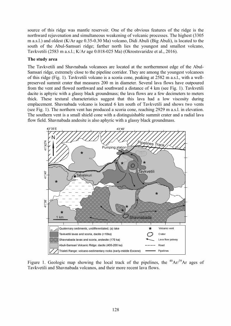
128
source of this ridge was mantle reservoir. One of the obvious features of the ridge is the northward rejuvenation and simultaneous weakening of volcanic processes. The highest (3305 m a.s.l.) and oldest (K/Ar age 0.35-0.30 Ma) volcano, Didi Abuli (Big Abuli), is located to the south of the Abul-Samsari ridge; farther north lies the youngest and smallest volcano, Tavkvetili (2583 m a.s.l.; K/Ar age 0.018-025 Ma) (Okrostsvaridze et al., 2016).
The study area The Tavkvetili and Shavnabada volcanoes are located at the northernmost edge of the Abul-Samsari ridge, extremely close to the pipeline corridor. They are among the youngest volcanoes of this ridge (Fig. 1). Tavkvetili volcano is a scoria cone, peaking at 2582 m a.s.l., with a well-preserved summit crater that measures 200 m in diameter. Several lava flows have outpoured from the vent and flowed northward and southward a distance of 4 km (see Fig. 1). Tavkvetili dacite is aphyric with a glassy black groundmass; the lava flows are a few decimeters to meters thick. These textural characteristics suggest that this lava had a low viscosity during emplacement. Shavnabada volcano is located 6 km south of Tavkvetili and shows two vents (see Fig. 1). The northern vent has produced a scoria cone, reaching 2929 m a.s.l. in elevation. The southern vent is a small shield cone with a distinguishable summit crater and a radial lava flow field. Shavnabada andesite is also aphyric with a glassy black groundmass.
Figure 1. Geologic map showing the local track of the pipelines, the 40Ar/39Ar ages of Tavkvetili and Shavnabada volcanos, and their more recent lava flows.

129
Our geomorphologic observations indicate the absence of periglacial activity on the Savnabada and Tavkvetili volcanoes. Well-preserved summit craters suggest that volcanic activity probably postdates the last glacial retreat (<10,000 BP). Nevertheless, the central and northern segments of the Abul-Samsari ridge carry obvious signs of ice age glacial activities (Akhalkacisvili, 2006). New K/Ar and 40Ar/39Ar radiometric data provide much younger dates (Nomade et al., 2016) than previous radiometric analysis using the same methodology (Lebedev et al., 2003). For example, according to new studies, the age of the Tavkvetili volcano is 13 ± 5 Ka (Lebedev et al. determined the age to be 30 Ka). If we rely on these data, then this volcano is younger than the last glacial period and was unaffected by ice age processes.
Conclusion Based on the results of our study, we think that in the event of reactivation of the Shavnabada and Tavkvetili volcanoes, the BTC and SCP will face serious challenges, since these pipelines run across the slopes of these volcanoes. It would appear that during the selection of pipeline routes, this geological hazard was not taken into account, which should be considered a serious mistake.
An especially hazardous area in this regard is the northern dacitic flow of Tavkvetili, which is crossed by the aforementioned pipelines. Besides the fact that this segment will be very problematic in case volcanic activity begins, the lava flow inclines to the north by 8-11° and consists of unconsolidated volcanic tuff, which causes gravitational instability. If we also consider the tectonic characteristics of the area, in particular the young faults with N-S strikes (Pasquarè et al., 2011), and the 1986 Faravani earthquake of magnitude 5.6, then we should suppose that the areas surrounding the Shavnabada and Tavkvetili volcanoes represent one of the most geologically hazardous segments for the BTC and SCP in Georgia.
Finally, our analysis indicates that the BTC and SCP pipelines were designed in such a way that the risk posed by the newly-identified geohazards in the vicinity of the Abul-Samsari ridge were reduced significantly. The regionally significant BTC and SCP may require greater protections, however, since the consequences of longterm shut-down in the event of a lava flow or large landslide engulfing the valve station would be very damaging to the economies of western Europe and Turkey.
References Akhalkacishvili, M. 2006. Age correlation of volcanic formation and glacial epochs of the
Javakheti Plateaus. Candidate dissertation, Tbilisi, 90 p. Keskin, M. 2006. Eastern Anatolia: A hotspot in a collision zone without a mantle plume. In
Plates, Plumes, and Planetary Processes, G.R. Foulger, and D.M. Jurdy Geological Society of America Special Paper 430, pp. 693-722.
Okrostsvaridze, A., Popkhadze, N., Bluashvili, D., Chang, Y.H., and Skhirtladze, I. 2016. Pliocene-Quaternary Samtskhe-Javakheti Volcanic Highland, Lesser Caucasus – as a result of mantle plumes activity? In A.S.Gilbert, and V. Yanko-Hombach, (Eds.), Proceedings of the Fourth Plenary Conference of IGCP 610 “From the Caspian to Mediterranean: Environmental Change and Human Response during the Quaternary” (October 2-9, 2016; Tbilisi, Georgia), pp. 127-131. Georgian National Academy of Sciences, Tbilisi.
Pasquarè, F., Tormay, D., Vezzoli, L., Okrostsvaridze A., and Tutberidze, B. 2011. Mitigating the consequences of extreme events on strategic facilites: Evaluation of volcanic and
130
seismic risk affecting the Caspian oil and gas pipelines in the Republic of Georgia. Journal of Environmental Management 92(7): 1774-1782.
Nomade, S., Scao, V.H., Guillou V.H., Messager, E., Mgeladze, A., Voinchet, P., Renne, P.R., Courtin-Nomade, A., Bardintzeff, J.M., Ferring, R., and Lordkipanidze, D. 2016. New 40Ar/39Ar, unspiked K/Ar and geochemical constraints on the Pleistocene magmatism of the Samtskhe-Javakheti highlands (Republic of Georgia). Quaternary International 395: 45-59.
Lebedev, V.A., Chernishev, I.V., Dudauri, O.Z., Arakelyants, A.A., Bairova, E.D., Gol’tsman, Yu.V., Chugaev, A.V., and Vashakidze, G.T. 2003. The Samsari volcanic center as an example of recent volcanism in the lesser Caucasus: K-Ar geochronological and Sr-Nd isotopic data. Doklady Earth Sci. 393A: 1323-1328.
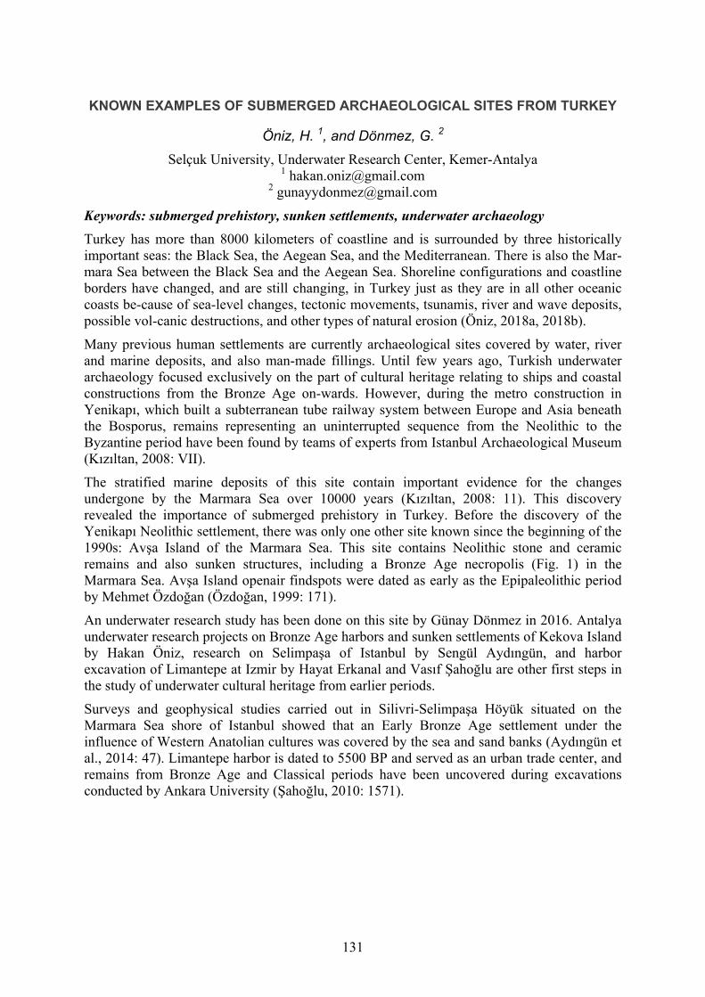
131
KNOWN EXAMPLES OF SUBMERGED ARCHAEOLOGICAL SITES FROM TURKEY
Öniz, H. 1, and Dönmez, G. 2
Selçuk University, Underwater Research Center, Kemer-Antalya 1 [email protected]
Keywords: submerged prehistory, sunken settlements, underwater archaeology Turkey has more than 8000 kilometers of coastline and is surrounded by three historically important seas: the Black Sea, the Aegean Sea, and the Mediterranean. There is also the Mar-mara Sea between the Black Sea and the Aegean Sea. Shoreline configurations and coastline borders have changed, and are still changing, in Turkey just as they are in all other oceanic coasts be-cause of sea-level changes, tectonic movements, tsunamis, river and wave deposits, possible vol-canic destructions, and other types of natural erosion (Öniz, 2018a, 2018b).
Many previous human settlements are currently archaeological sites covered by water, river and marine deposits, and also man-made fillings. Until few years ago, Turkish underwater archaeology focused exclusively on the part of cultural heritage relating to ships and coastal constructions from the Bronze Age on-wards. However, during the metro construction in Yenikapı, which built a subterranean tube railway system between Europe and Asia beneath the Bosporus, remains representing an uninterrupted sequence from the Neolithic to the Byzantine period have been found by teams of experts from Istanbul Archaeological Museum (Kızıltan, 2008: VII).
The stratified marine deposits of this site contain important evidence for the changes undergone by the Marmara Sea over 10000 years (Kızıltan, 2008: 11). This discovery revealed the importance of submerged prehistory in Turkey. Before the discovery of the Yenikapı Neolithic settlement, there was only one other site known since the beginning of the 1990s: Avşa Island of the Marmara Sea. This site contains Neolithic stone and ceramic remains and also sunken structures, including a Bronze Age necropolis (Fig. 1) in the Marmara Sea. Avşa Island openair findspots were dated as early as the Epipaleolithic period by Mehmet Özdoğan (Özdoğan, 1999: 171).
An underwater research study has been done on this site by Günay Dönmez in 2016. Antalya underwater research projects on Bronze Age harbors and sunken settlements of Kekova Island by Hakan Öniz, research on Selimpaşa of Istanbul by Sengül Aydıngün, and harbor excavation of Limantepe at Izmir by Hayat Erkanal and Vasıf Şahoğlu are other first steps in the study of underwater cultural heritage from earlier periods.
Surveys and geophysical studies carried out in Silivri-Selimpaşa Höyük situated on the Marmara Sea shore of Istanbul showed that an Early Bronze Age settlement under the influence of Western Anatolian cultures was covered by the sea and sand banks (Aydıngün et al., 2014: 47). Limantepe harbor is dated to 5500 BP and served as an urban trade center, and remains from Bronze Age and Classical periods have been uncovered during excavations conducted by Ankara University (Şahoğlu, 2010: 1571).
132
Figure 1. Bronze Age Cubic Tomb from Avsa Island’s sunken necropolis (Photo by Gunay Donmez).
References Aydıngün, Ş., Heyd, V., Güldoğan, E., and Öniz, H. 2014. Istanbul’un Batısında Kalan Son
Höyük: Selimpaşa. Armizzi, Engin Özgen’e Armağan, pp. 47-55. Asitan Kitap, Ankara. (In Turkish)
Kızıltan, Z. 2008. Foreword, Istanbul Archaeological Museums Proceedings of the 1st Symposium on Marmaray-Metro Salvage Excavation. Istanbul.
Öniz, H. 2018a. Turkey – Gateway between Asia and Europe. In Oceans of Archaeology, ed. by Anders Fischer and Lisbeth Pedersen, pp. 100-107. The National Museum of Denmark Moesgaard Museum – Jutland Archaeological Society, Hojbjerg.
Öniz, H., 2018b. An early bridge to Europe: Submerged and coastal prehistory in Anatolia. Frontiers, Migrations, Anchorages - Frontières, Migrations, Ancrages. Seminars and Theses from the Erasmus Mundus Master’s Course in Catania “TEMA - Territoires Européens Master” (2011-2017), ed. by Paolo Militello and Melania Nucifora, pp. 93-106.
Özdoğan, M. 1999. Northwestern Turkey: Neolithic cultures in between Balkans and Anatolia. Neolithic Anatolia, ed. by Mehmet Özdoğan, pp. 203-224.
Şahoğlu, V. 2010. Ankara University Research Center for Maritime Archaeology (ANKUSAM) and its role on Turkey’s Protection to Underwater Cultural Heritage. Procedings of World Universities Congress, II Canakkale, pp. 1571-1580..

133
PALEOGEOGRAPHIC RECONSTRUCTION OF KARKINITSKY BAY (THE NORTHWESTERN BLACK SEA SHELF)
Pedan, G. 1, and Dragomyretska, O. 2
1 Odessa I.I. Mechnikov National University, Department of Engineering Geology and Hydrogeology, Odessa, Ukraine
2 State Institution “Hydroacoustic Branch of Institute of Geophysics by S.I. Subbotin name of National Academy of Sciences of Ukraine,” Odessa, Ukraine
[email protected] Keywords: Late Pleistocene, Holocene, sea level, GIS-based modeling Introduction The Late Pleistocene-Holocene geological history of Karkinitskiy Bay is closely connected with the Black sea level regime. The Black Sea postglacial transgression had an oscillating character and was further complicated by a number of regressions. These factors influenced sedimentation in Karkinitskiy Bay. The purpose of this paper is to set a spatial-time model of formation for Karkinitskiy Bay in the Late Pleistocene-Holocene, i.e., for the last 30 ky BP.
Methodology Geological, geomorphologic, paleobiological methods, and GIS-based modeling were the basis for mapping the ancient coastlines. Descriptions of these methods have been given in several publications (Arslanov et al., 1982; Voskoboynikov et al., 1982; Fedorov, 1982). Numerous geological cross-sections of Karkinitskiy Bay formed the basis for making the maps. Geological cross-sections were established by the use of drilling materials provided by geological organizations, Odessa National University, and also E. Nevessky (Nevessky, 1967). Relicts of ancient wave accumulative forms (bars, shafts) and the areas of distribution of mud sediment were plotted out with the help of geomorphological methods. Lithologic-facies complexes and their hypsometric positions were fixed on the basis of lithologic and faunistic attributes. Their spatial correlation allowed us to define the position of the coastline in various transgressive-regressive phases of sea level. Eustatic curves of sea level (Voskoboynikov et al., 1982; Ivanov et al., 1982; Konikov, 2007; Konikov et al., 2007; Shmuratko, 2006) were used to reconstruct the sequence of uneven-age forms. Paleogeographic map-cuts for geomorphological stratoisochronous surfaces were constructed by using GIS-based modeling. Paleogeographic maps-cuts reflect the lithological-facies picture and position of the coastline during the Neoeuxinian, Bugazian, Kalamitian, and Dzhemetinian stages of development of Karkinitskiy Bay and in the present time.
Results Karkinitskiy Bay is the largest bay of the Black Sea, and it is situated in its northwestern part. The length of its axial dimension is over 100 km. There are three large spits here: Tendrovskaya, Dzharyilgachskaya, and Bakalskaya. Karkinitskiy Bay is characterized by neotectoniс activity and is an area of recent downwarping in Quaternary time. The Late Pleistocene-Holocene geological history of Karkinitskiy Bay is closely connected with the Black Sea level regime. The Black Sea postglacial transgression had an oscillating character and was complicated by a number of regressions. It finds its reflection in the depositional record of Karkinitskiy Bay.
134
Geological cuts have crossed a number of zones composed of coarse-grained deposits that carry traces of surf stream impact. As for the spatial dimension, these zones are powerful geological bodies with an elongated form. They are relicts of ancient accumulative bodies that partitioned Karkinitskiy Bay during times of lower sea-level stands. Silted deposits or lenses of lagoons are adjacent to these bodies on the coast-side. There are seven such relicts in Karkinitskiy Bay: Churyumskaya bank, Bakalskaya bank, the third one to the west of Bakalskaya spit (and a relict of the ancient Bakalskaya spit), the fourth and the fifth stretch to the west across the bay; the sixth and the seventh ones face the front of Dzharyilgachskaya and Tendrovskaya spits. There are zones with mud horizons between relicts of ancient accumulative forms. The same age layers include accumulative form facies and lagoonal mud facies. They were continuously displaced towards the coast, leaning on one or another and forming transgressive layer precipitation. This process occurred during relative sea-level rise. The most ancient accumulative forms are at greater depths than younger ones.
If the hypothesis of a non-uniform course of transgression is accepted, it is possible to present the following sequence of events. At the stage of maximum Neoeuxinian regression (20-18 ky), Karkinitskiy Bay represented a poorly expressed valley (in terms of relief) of the Kalanchak River and its watersheds. The Neoeuxinian sediments that correspond to the maximum of the Neoeuxinian transgression are situated in the external part of Karkinitskiy Bay at a depth of 25 m from the current sea level. Neoeuxinian deposits are absent above this level along the bottom of the basin, which allows us to establish the coast line of the Neoeuxinian basin. The coastline of the transgressive Neoeuxinian basin is fixed on the socle of the ancient Bakalskaya spit and the wall which is located to the south of Dzharylgach island (Konikov, Likhodedova, Pedan, 2007).
Holocene transgressive-regressive sea levels are also reflected by the position and the structure of accumulative forms such as Dzharyilgach Island, as well as Bakalskaya and Churyumskaya spits, and the Kalanchak islands. It is necessary to note that all the accumulative forms were generated on sea and lagoonal muds.
Bakalskaya spit is the most ancient accumulative form of Karkinitskiy Bay. It appeared through the filling of the top of the bay with deposits from the Dnieper terraces. The bank formation began between 5 and 6 ky BP when sea level approached minus 10-12 m for the first time during the postglacial age. Coastlines moving in the northeastern direction were characteristic of Kalamitian time. Two large accumulative forms of Dzharyilgach Island (Small and Deep spits) were generated by the end of Kalamitian time (Pedan et al., 2005). Kalanchak and Churyumskaya banks are sandy and sandy-coquina accumulative forms of the Kalamitian-Dzhemetinian age. Behind them, toward the coast side, there are areas where mud and mud-coquina deposits of Dzhemetinian age are distributed. Two uneven-age generations are allocated to the Kalanchak-Churyumskaya accumulative form. They are divided by a hollow and located at different depths. A more ancient form accumulated during the Phanagorian regression (more than 2.2 ky BP). A younger accumulative form was formed during the Nymphaean transgression (about 2 ky BP). In order to determine the absolute age by radiocarbon method, samples were selected on one of these islands at depths of 0.2 and 0.6 m. The analysis has yielded: 2120 ±45 and 2150±100 years. At the same time, two more generations of Dzharyilgach Island formed. The maximum level of the Nymphaean transgression exceeded the modern one by approximately 2 m, that has led to the flooding of low areas and to the formation of bays in the northern part of Karkinitskiy Bay. They are Kalanchakskiy, Karzhinskiy, Shirokiy bays.

135
The analysis of maps and charts of the last two centuries has allowed us to propose the relative stabilization of accumulative forms in Karkinitskiy Bay. At present, they are in the stage of maturity and aging.
Conclusions Thus, the paleogeographical history of development of Karkinitskiy Bay has been reconstructed. Paleogeographical map-cuts reflect the lithological-facies picture as well as the position of the coastline during the Neoeuxinian, Bugazian, Kalamitian, and Dzhemetinian stages of development of Karkinitsky Bay and nowadays. Transgressive-regressive fluctuations in the Black Sea level represent the main factor driving the evolution of Karkinitskiy Bay in the Late Pleistocene-Holocene.
References Arslanov, Kh.A., Balabanov, I.P., Gey, N.A., Izmailov, Ya.A., Ostrovsky, A.B., Skiba, S.I.,
and Skryabina N.G. 1982. Metody i rezul’taty kartirovaniya i geokhronologicheskoy privyazki drevnikh beregovykh liniy na sushe i shel’fe Chernomorskogo poberezhya Kavkaza i Kerchensko-Tamanskogo rayona [Methods and results of mapping and geochronological assessment of shoreline on the land and shelf of the Caucasian coast of the Black Sea and Kerch-Taman region]. In P.A. Kaplin, R.K. Klige, and A.L. Chepalyga, (Eds.), Kolebaniia urovnia morei i okeanov za 15,000 let [Sea and Oceanic Level Fluctuations for 15,000 Years], pp. 144-150. Nauka, Moscow. (In Russian)
Fedorov, P.V. 1982. Poslelednikovaya transgressiya Chernogo moria i problema izmeneniya urovnya okeana za poslednie 15,000 let [The post-glacial transgression of the Black Sea and the problem of ocean level change during the last 15,000 years]. In Kaplin, P.A., Klige, R.K., and Chepalyga, A.L., (Eds.), Kolebaniia urovnia morei i okeanov za 15,000 let [Sea and Oceanic Level Fluctuations for 15,000 Years], pp. 151-156. Nauka, Moscow. (In Russian)
Ivanov, G.I., and Shmuratko, V.I. 1982. Ob osobennostiakh kolebanii urovnia Chernogo moria v poslelednikovoe vremia [Characteristics of variation of the Black Sea level in post-glacial time]. Vodnye resursy 3: 139-146. (In Russian)
Konikov, E.G. 2007. Sea-level fluctuation and coastline migration in the northwestern Black Sea area over the last 18 ka based on high-resolution lithological-genetic analysis of sediment architecture. In V.Yanko-Hombach, A.S. Gilbert, N. Panin, and P/ Dolukhanov, (Eds.), The Black Sea Flood Question: Changes in Coastline, Climate and Human Settlement. Springer, Dordrecht, The Netherlands, pp. 404-435.
Konikov, E., Likhodedova, O., and Pedan, G. 2007. Paleographic reconstructions of sea-level change and coastline migration on the northwestern Black Sea shelf over the past 18 ky. Quaternary International 167-168: 49-60.
Nevessky, E.N. 1967. Processi osadkoobrazovaniia v pribrezhnoi zone moria [Sediment Formation Processes in the Coastal Zone]. Nauka, Moscow. (In Russian)
Pedan, G.S., and Konikov, E.G. 2005. Regularities of Holocene evolution and stages of modification of coastal accumulation forms on Dzharulgach Island. In V. Yanko-Hombach, I. Buynevich, A. Chivas, A.S. Gilbert, R.E. Martin, and P. Mudie, (Eds.), Extended Abstracts of the First Plenary Meeting and Field Trip of IGCP 521 Project “Black Sea-Mediterranean corridor during the last 30 ky: Sea-level change and human adaptation,” (October 8-15, 2005, Kadir Has University, Istanbul, Turkey), TÜBİTAK, Ankara, pp. 139-140.
Shmuratko, V.I. 2006. Global climate change and Black Sea level during the Holocene. In V. Yanko-Hombach, I. Buynevich, A. Chivas, A.S. Gilbert, R.E. Martin, and P. Mudie,
136
(Eds.), Extended Abstracts of the Second Plenary Meeting and Field Trip of IGCP 521 Project “Black Sea-Mediterranean corridor during the last 30 ky: Sea-level change and human adaptation,” (August 20-28, 2006, I.I. Mechnikov Odessa National University, Odessa, Ukraine), Astroprint, Odessa, pp. 157-159.
Voskoboynikov, V.M., Rotar’, M.F., and Konikov, E.G. 1982. Sviaz’ ritmichnosti stroeniia tolsch golotsenovikh otlozhenii Prichernomorskikh limanov s kolebatel’nim rezhimom urovnia Chernogo moria [Correlation of rhythmicity of Holocene sediments of near Black Sea limans with fluctuating regime of the Black Sea level]. In P.A. Kaplin, R.K. Klige, and A.L. Chepalyga, (Eds.), Izmenenia urovnia Chernogo moria [Changes of the Black Sea Level], pp. 264-274. MGU, Moscow. (In Russian)

137
USE OF COMPLEX GEOLOGICAL, GEOCHEMICAL, AND GEOPHYSICAL DATA FOR DETERMINATION OF UPPER MIOCENE
TRANSGRESSION IN WEST KUBAN DEPRESSION OF THE WESTERN CISCAUCASUS
Pinchuk, T.N. 1, and Fursina, A.B. 2 1 Russia, Kuban State University, Stavropolskaya, 149, Krasnodar, 350040
[email protected] 2 Russia, Higher Military Aviation School for Pilots, Dzerdginskogo, 135, Krasnodar,
Keywords: sedimentation, lithological, stratigraphic, paleontological, geochemical Upper Miocene sediments have been thoroughly studied on the northern and southern flanks of the West Kuban depression of the Western Ciscaucasus. For the purpose of this study, lithological, stratigraphic, paleontological, geochemical, and seismological data have been used, together with detailed surveys of geophysical and standard well logs.
As is known from lithological and oilfield geophysical data, the Upper Miocene section is mainly composed of pelitic particles. The presence of abnormally high pore pressure has resulted in sufficient stability of clay porosity over the entire Upper Miocene section, with no tendency towards natural compaction with depth. Therefore, variations in petrophysical and geophysical parameters primarily reflect differences in the content of sandy and carbonate material, corresponding to those differentially created by sedimentation cycles.
The study of paleontological evidence from boreholes of the West Kuban depression has been used to obtain stratigraphic dates and to establish faunistic correspondences that coincide with the structural and facies reorganization of the basin; these aspects also help to trace the extent of its territory. Our results have made it possible to distinguish two lower order transgressive-regressive subcycles within the general background of the overall high order regressive stage (from Sarmatian -Meotian-Pontian to the end of the Pliocene).
As is generally known, transgression of the Eastern Parathethys in the West Kuban depression began during the Middle Maikopian period, when the axis of the depression shifted from the southern to the northern flank. This shifting was ongoing up to the end of the Sarmatian period. The Upper Miocene (Meotian-Pontian stage) period corresponds to a transgressive-regressive subcycle, where a change of basin hydrogeology was accompanied by the accumulation of thick clays in the abyssal setting. This subcycle was distinguished on the basis of paleontological and geochemical data, and it is corroborated by lithological and geophysical evidence.
At the Sarmatian-Meotian boundary, on the Timashevskaya bench, incisions, paleochannels, and antedeltas of the paleo-Donets River were formed; these are traceable from the Svobodnenskaya area to the northern slope of the West Kuban depression. Here, sandy coquina deposits with inclusions of Eocene white marl cobbles were penetrated in borehole sections. Based on the geological profile and thickness variations, the data are interpreted as an incision into the upper Sarmatian deposits and its filling with Meotian sands. The incision’s amplitude was some tens of meters. Up the section, in the same boreholes, several pebble interlayers were traced that were also within the sand sequence at the Pontian–Meotian boundary. The sands were dated to the Pontian by ostracods. Genetically, the deposits are likely to represent an underwater antedelta with sea microfauna. The deepest incisions confined to the Sarmatian-Meotian boundary were traced by drilling and seismic data in the

138
Beisug area. The incision depth was 200–250 m, cutting into Sarmatian sediments and, in places, the whole Miocene up to the Maikopian sequence. Deep incisions were attested within Pontian deposits of the Timashevskaya bench. They are documented by boreholes and images in the seismic profile. According to the correlation with the nearest dated boreholes, the incision corresponds to the Middle Pontian, though a direct paleontological confirmation of the age is as yet unavailable. The amplitude of incision is 100–120 m in these boreholes. A sharp, short-term facies rearrangement, a stratigraphic hiatus, and the appearance of terrestrial gastropods at the base of the upper Pontian Portaferian beds were revealed in relatively deep-water sections of the Taman Peninsula.
The next rise in sealevel in the Meotian may be estimated at several tens of meters above recent sealevel, as the sediments were of limited distribution on the platform. It is likely that the early and late Meotian basins did not differ in their water level and extension, and no appreciable regression was revealed in the terminal Meotian. A pronounced regression in the terminal Sarmatian sealevel and a small-scale transgression in the initial Meotian have no analogs in the eustatic curve despite all their debatable dates. The boundary between the Meotian and Pontian in the depressions seems to be purely faunal and is identified by the first appearance of high endemic brackish-water benthic fauna. According to geochemical data, extension of a marine basin during the Miocene period created favorable conditions for the accumulation of organic matter. Deep clays, deposited during the transgression, are rich in organic matter and are oil-prone. According to geophysical data, these deposits are characterized by high natural gamma activity and high elastic wave run time intervals. As for the Meotian-Pontian formation, deposition occurred under relatively deep marine conditions. During the main stage of siltstone and clay sedimentation, aleurolite intercalations were also taking place. Build up of aleurolite is represented on log surveys by a gradual decline in acoustic transit-time and lower natural gamma activity. According to the lithological composition, the siltstones and clays are similar to those of the Meotian-Pontian, since deposition was taking place under similar conditions. As shown by the geochemical data, changes in sedimentation conditions associated with shallowing of the basin within the Early Miocene period resulted in a notable reduction in organic matter content of Meotian-Pontian deposits. A regional break in sedimentation between the Meotian-Pontian is distinctly visible on the southern flank of the West Kuban depression, however, it is not so distinct on the northern flank, which is evident from the presence of interbedded conglomerates and breccias in the basal sand-aleurolite layers.
The next transgressive and regression subcycle began in Meotian time. During the course of the transgression, alteration of basin borders and its hydrological regime was occurring. The coastline kept moving to the north, and subsea currents began playing a major role in modifying various parts of the basin. According to geochemical data, initiation of a new transgressive-regressive subcycle related to the expansion and deepening of the basin, is apparent from the increased amount of dissipated organic matter. Short duration basin floor depositional cycles, alteration of the hydrodynamic regime, and oxidizing conditions, all had an effect on the rate of organic matter preservation.
The beginning of a new transgressive-regressive subcycle is evident from the appearance of separate sandstone members characterized by low gamma-ray log values and a significant reduction in elastic wave time intervals. The content of sand-aleurolite material in the Upper Pontian sediments decreases abruptly, which resulted in a corresponding increase in gamma-ray and acoustic log values.
Integration of geological, geophysical, and geochemical data has shown that the main prospects for oil and gas in the Upper Miocene are associated with reservoirs of the Meotian-

139
Pontian. Accumulation of hydrocarbons took place by migration of oil and gas from deposits of a transgressive-regressive subcycle. In the western Kuban trough, 12 oil and gas deposits have been discovered in the pontian-meiotic sediments.
References Balukhovskii A.N., and Khain V.E. 1975, Neogenovyi period/Paleogeographia [Neogene
period. Paleogeography]. In Paleogenovyi, neogenovyi i chetvertichnyi periody, Vol. 4., ed. by Vinogradov A.P.,. Nedra, Moscow. (Russia) pp. 173-268
Popov, S.V., Rögl, F., Rozanov. A.Y., Fritz, Steininger, F.F., Shcherba, I.G., and Kovac, M. 2004. Lithological paleogeographic maps of the Paratethys. Courer Forschungsinstitut Senckenberg. Bd. 250. pp. 1-46. 10 maps.
Popov, S.V., Zastrozhnov, A.S., Pinchuk, T.N., Antipov, M.P., and Kurina, E.E. 2009. Eastern Paratethys transgressive cyclicity and main sea level downfalls from the Oligocene to Pliocene. Acta Natur. L’Ateneo Parmense v. 45, n. 1/4. Abstr. Book. 13 Congr. RCMNS Sept. 2-6. 2009. рр. 112-113.
Popov, S.V., Antipov, M.P., Zastrozhnov, A.S., Kurina, E.E., and Pinchuk, T.N. 2010. Sea-level fluctuations on the Northern Shelf of the Eastern Paratethys in the Oligocene-Neogene. Stratigraphy and Geological Correlation, 2010, Vol. 18, No. 2, pp. 200–224.

140
EASTERN PARATETHYS – MEDITERRANEAN CONNECTIONS DURING THE NEOGENE AND QUATERNARY
Popov, S.V. 1, Golovina, L.A. 2, and Goncharova, I.A. 3 1, 3 Paleontological Institute RAS, Profsoyuznaya ul. 123, Moscow, Russia 117997
1 [email protected] 3 [email protected]
2 Geological Institute RAS, Pyzhevskiy per. 7, Moscow, Russia 119017 [email protected]
Keywords: paleogeography, ecology, environments, straits, water circulation Introduction The paleogeographic evolution of the Paratethyan and Mediterranean realms has been reconstructed in ten maps ranging from the Late Eocene to the Pliocene (Lithological ..., 2004). The maps were based on facies analysis, clastic input, as well as biogeographic data of planktonic, benthic, and terrestrial biota. Paleogeographic reconstructions were palinspastically restored (after Dercourt et al., 1993; The Paleogeographic …, 1997, with modifications). Though the emerging mountain system of the Alpine foldbelt increasingly separated the Paratethys from the Mediterranean, Tethys-Paratethys connections remained extant and sufficiently effective for limited communication between both basins. They governed many features of the cyclic depositional history and biogeographic evolution of the Eastern Paratethys.
Later some new paleontological data were received from Taman sections (Paleontology …, 2016), the North Anatolian area (Goncharova et al., 2013), the Aegean region, and the Caspian seaside of Iran (Mazandaran Province) (Popov et al., 2015), which allow a more accurate assessment of paleogeographic interrelations between the Eastern Paratethys and the Eastern Mediterranean during the Neogene.
Paleogeography, environments and straits Early Miocene. As in the Oligocene, most of the successive Early Miocene deep-water environments in the Eastern Paratethys were characterized by clayey sedimentation (during the late Maikopian) under dysoxic to anoxic conditions, and associated with an estuarine circulation system. Ichthyofauna, shallow benthic warm-water mollusks, planktonic associations, as well as floristic data from the shallow southern part of Transcaucasia reflect the climatic optimum in the mid Early Miocene. The occurrence of warm-water Tethyan elements in the benthic and fish fauna of the Eastern Paratethys indicates a resumed direct communication with the Tethys through eastern Turkey and Iran (Popov et al., 2004), which in the Burdigalian were covered by an extensive sea basin (Erentöz, 1953; Lüttig and Steffens, 1975: Lithological …, 2004). Faunal data indicate that these connections emerged already at the beginning of the Early Miocene but became easier and wider in the Burdigalian (Sakaraulian), probably stimulated by the peak of the Styrian tectonic phase.
Upper Maikopian deposits of North Iran represented by shallow sandy-clayey facies and sandstones with mollusk shells: Fragum semirugosum (Sandb.), Laevicardium spondyloides (Hauer), Anadara sakaraulensis (Popov), Glossus cor (L.), Callista lilacinoides Schaffer, Calistotapes vetula (Bast.), Dosinia exoleta (L.), and Lyonsia macai Kharatishvili. This association is very similar to the Sakharaulian of the stratotypic area in Central Georgia (Popov et al., 2015). Calcareous nannofossils were found from the same deposits and within

141
the association indicating the part of the NN1-2 zone. Decisive for such dating is the co-occurrence of Triquetrorhabdulus challengeri and Sphenolithus conicus.
The Thracian-Aegean region received mainly continental deposition over a long interval from the late Oligocene to the early Miocene. Sedimentological evidence from the roughly terrigeneous sediments testify to intensive uplift environments in the South Balkanids.
Middle Miocene. The marine Tarkhanian fauna of the Eastern Paratethys was much more diverse in comparison with the previous Kozakhurian due to now immigrant genera and species common with the Carpathian Basin. Connection with the Eastern Mediterranean via the Anatolia during the Middle Miocene was problematic due to absence of any specific Mediterranean taxa in the Eastern Paratethys fauna and the absence of a marine facies in the inner parts of Central Anatolia (Lüttig and Steffens, 1975). Sections in the Sinop area (North Turkey) demonstrate a normal Eastern Paratethys sequence with Tarkhanian, Chokrakian, Karaganian, Konkian, and Sarmatian regiostages (Oszayar, 1977; Goncharova et al., 2013), but with some exotic elements. The benthic microfauna from the Tarkhanian part of the Akliman section is represented bу numerous Pararotalia spp. and species of genera Quinqueloculina, Cibicides, Cibicidoides, Anomalina, Reussella, Triloculina, and others common for the Eastern Paratethys. Among the planktonic forams, Globigerina praebulloides, G. diplostoma, G. cf. euapertura, Hastigerina praesiphonifera, Globoquadrina langhiana, and Globigerinoides sp. were identified (data from M. Bylinskaya in Goncharova et al., 2013). Relative diversity of this association and the presence of Globoquadrina langhiana—the early Langhian Mediterranean species—speak to the influence of a normal marine basin.
From the other side, Transcaucasian associations of the Konkian benthic fauna demonstrate a richer composition compared to the northern ones. Only here were found in the mid-Konkian the mollusk fauna Strombus bonellii, Zonaria cf. columbaria, and Conus species. Based on biogeographic data, A.L. Chepalyga (1995), L.B. Ilyina (2003), and I.A. Goncharova proposed the existence of the Eufrat or Araks strait from the Eastern Mediterranean to the southeastern part of the Transcaucasian Basin during the Middle Miocene.
Similar Eastern Paratethys sequences can be seen in the North Iran sections (without the Tarkhanian and polyhaline part of the Konkian regiostages). Lower Sarmatian sandstones include typical Sarmatian bivalves: Mactra eichwaldi Lask., Mactra andrussovi Kolesn., Plicatiformes plicata (Eichw.), Obsoletiformes lithopodolica (Dub.), but in addition to Tellina (Laciolina) cf. pretiosa Eichw. and Varicorbula gibba Olivi, which are known only from more polyhaline Konkian layers. The calcareous nannoplankton assemblage is relatively diverse and consists of Coccolithus pelagicus, Helicosphaera carteri, Sphenolithus sp., Reticulofenestra sp., Calcidiscus leptoporus, Discoaster deflandrei, and Coccolithus miopelagicus (Golovina data in Popov et al., 2015). This fauna and the presence of a nannofossil assemblage indicate a distinct local marine influx.
Middle Sarmatian sandstones and silts include typical Sarmatian bivalves: Mactra ex gr. vitaliana (Orb.), Plicatiformes plicata, Venerupis (Polititapes) vitaliana, and Gomphomarcia naviculata, but in addition more polyhaline species: Parvicardium ex gr. exiguum, Solen sp., Cultellus sp., and Varicorbula gibba, which are unknown from the Sarmatian of the Eastern Paratethys and other regions. In the same layers, nannoplankton species Reticulofenestra sp., Coccolithus pelagicus, Helicosphaera carteri, and Sphenolithus sp. were also found. Based on these new data, we propose the existence of a marine relationship between the Eastern Mediterranean and the Transcaucaspian part of the Middle Miocene Paratethys, not only during the Tarkhanian and Konkian (Lithological ..., 2004), but before the mid-Sarmatian (sensu Barbot-de-Marni).
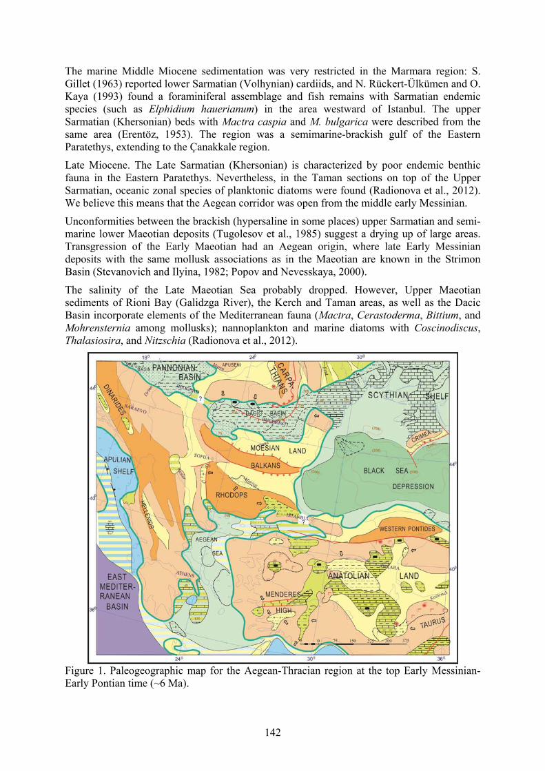
142
The marine Middle Miocene sedimentation was very restricted in the Marmara region: S. Gillet (1963) reported lower Sarmatian (Volhynian) cardiids, and N. Rückert-Ülkümen and O. Kaya (1993) found a foraminiferal assemblage and fish remains with Sarmatian endemic species (such as Elphidium hauerianum) in the area westward of Istanbul. The upper Sarmatian (Khersonian) beds with Mactra caspia and M. bulgarica were described from the same area (Erentöz, 1953). The region was a semimarine-brackish gulf of the Eastern Paratethys, extending to the Çanakkale region.
Late Miocene. The Late Sarmatian (Khersonian) is characterized by poor endemic benthic fauna in the Eastern Paratethys. Nevertheless, in the Taman sections on top of the Upper Sarmatian, oceanic zonal species of planktonic diatoms were found (Radionova et al., 2012). We believe this means that the Aegean corridor was open from the middle early Messinian.
Unconformities between the brackish (hypersaline in some places) upper Sarmatian and semi-marine lower Maeotian deposits (Tugolesov et al., 1985) suggest a drying up of large areas. Transgression of the Early Maeotian had an Aegean origin, where late Early Messinian deposits with the same mollusk associations as in the Maeotian are known in the Strimon Basin (Stevanovich and Ilyina, 1982; Popov and Nevesskaya, 2000).
The salinity of the Late Maeotian Sea probably dropped. However, Upper Maeotian sediments of Rioni Bay (Galidzga River), the Kerch and Taman areas, as well as the Dacic Basin incorporate elements of the Mediterranean fauna (Mactra, Cerastoderma, Bittium, and Mohrensternia among mollusks); nannoplankton and marine diatoms with Coscinodiscus, Thalasiosira, and Nitzschia (Radionova et al., 2012).
Figure 1. Paleogeographic map for the Aegean-Thracian region at the top Early Messinian-Early Pontian time (~6 Ma).
143
The Aegean basin became a marine gulf of the Mediterranean during the early Messinian (Dafni Formation of the Strimon Basin, northern Greece) and a semi-closed brackish basin (Fig. 1) at the end of the early Messinian (Choumnikon Fm., 6.30-6.04 Ma, according to Snel et al., 2006). Similar marine-brackish alternating facies are known in the Alçıtepe Formation, which outcrops in the northern Aegean, Gelibolu, and Çanakkale regions (Çağatay et al., 2006). The brackish mollusk fauna, ostracods, and dinocysts of the Choumnikon Formation include numerous genera and species in common with the Paratethys: endemic limnocardiids, Congeria and Melanopsis among the mollusks, Loxoconcha djaffarovi and Cyprideis pannonica in the ostracod associations, and Galeacysta etrusca among dinocysts. We believe that the origin of the Choumnikon brackish fauna is related to the oldest Pannonian Paratethys biota (Popov and Nevesskaya, 2000). At the beginning of the Pontian (~6.0 Ma), this fauna populated the Eastern Paratethys. Later, species of the Late Pontian fauna inhabited the whole Mediterranean at the “Lago-Mare” stage (5.42-5.33 Ma, according to CIESM, 2008).
Pliocene. The earliest Zanclean transgression reached the northern Aegean (oyster beds with nannoplankton at the top of the Choumnicon Fm.), Dacian, and Taman basins (Semenenko, 1987). Later, during the Pliocene, continental environments prevailed again in the Thracian-Aegean region (Çağatay et al. 2006).
The Kuyalnitsian inland sea had no direct connection with the ocean, but there was an ephemeral corridor connecting it with the Akchagylian basin of the Caspian region: layers with Aktschagylia subcaspia and Cerastoderma dombra are known from the Kuyalnitsan sequences of the Azov area.
Quaternary. At the early-middle Quaternary, a one-way connection was prevalent, and Chaudian Didacna of Black sea origin were established in the Çanakkale region (Andrussov, 1890); also, Caspian Didacna subpyramidata Pravosl. was described from the middle Pleistocene of Iznik Lake (Islamoğlu, 2009). Late Pleistocene connections took place in the same way as today and were described in detail based on mollusks (Nevesskaya, 1965) and foraminifers (Yanko, 1990), as well as microphytoplankton (Aksu et al., 1995; Mudie et al., 2002). The latest Pleistocene (Neoeuxinian) in the Marmara basin was affected by only the Euxine basin, while interrupting the connection with the Mediterranean.
Conclusions The Early Miocene (Aquitanian and Burdigalian) history of the Eastern Paratethys connections can be subdivided into three stages:
(1) The Aquitanian stage. Intensified biogeographic connections with the Central Paratethys and first prochoreses of fishes from the Indo-Pacific Basin, along with western contacts with the ocean; there were additional links, which were probably located in the south and connected the basin to the eastern Turkish and Iranian basins.
(2) The Early Burdigalian stage. Increased appearance of warm-water fauna, new prochoreses from the southern basins.
(3) The Late Burdigalian (Kotsakhurian) stage. Isolation of the Eastern Paratethys, a decrease in the salinity of its waters, and the impoverishment of its fauna.
During the Middle Miocene, restricted connection via Eastern Anatolia to Transcaucasia prevailed, which had enriched the local Georgian, Turkish, Iranian, and Transcaspian associations of the Tarkhanian, Konkian, and early-middle Sarmatian fauna.
At the Upper Miocene, from the top of the late Sarmatian, the Aegean corridor became the main Eastern Mediterranean-Eastern Paratethyan connecting marine strait, which was sufficiently effective to ensure the semi-marine character of the Early Maeotian waterbody,

144
inhabited by euryhaline marine fauna, poor nannoplankton, and some oceanic species of diatoms.
During the Pliocene, continental environments dominated in the Thracian-Aegean region.
At the Quaternary, one-way connection with outflow from the Euxine basin prevailed. Recent two-way exchange was formed only from top of the Pleistocene.
References Aksu, A.E., Yaşar, D., Mudie, P.J., and Gillespie, H. 1995. Late glacial-Holocene
paleoclimatic and paleooceanographic evolution of the Aegean Sea: micropaleontological and stable isotopic evidence. Marine micropaleontology 25(1): 1-28.
Andrussov, N. 1890. Die Schichten von Cap Tschauda. Annalen des Naturhistorischen Hofmuseums, Wien. 5(1): 66-76.
Çagatay, M.N., Görür, N., Flecker, R., Sakınç, M., Tünoğlu, C., Ellam, R., Krijgsman, W., Vincent, S., and Dikbas, A. 2006. Paratethyan-Mediterranean connection in the Sea of Marmara region (NW Turkey) during the Messinian. Sediment Geology 188-189: 171-187.
CIESM. 2008. The Messinian Salinity Crisis from Mega-deposits to Microbiology. A Consensus Report. CIESM Workshop Monographs. Monaco.
Chepalyga, A.L. 1995. East Paratethys-Tethys marine connections along Euphrat Passage during Neogene. Romanian Journal Stratigraphy 76. Suppl. 7: 149-150.
Dercourt, J., Ricou, L.-E., and Vrielynck, B., (Eds.). 1993. Atlas Tethys Palaeoenvironmental Maps, pp. 1-307, 14 maps. Gauthier-Villars, Paris.
Erentöz, C. 1953. Etude géologiques dans le région Catalea (Istambul). Ankara. Gillet, S. 1963. Histore de la Mer Noire. Annales Géologiques des Pays Helléniques 14: 339-
347. Goncharova, I.A., Bylinskaya, M.E., Rostovtseva, Yu.V., and Tchepalyga, A.L. 2013.
Characteristics of the Uppermost Lower - Lowermost Middle Miocene (Tarkhanian) in Akliman, Northern Sinop, Turkey. In Neogene to Quaternary Geological Evolution of Mediterranean, Paratethys and Black Sea. Book of abstracts of 14 RCMNS Congress. Sept. 8-12. 2013. Istanbul. p. 209.
Ilyina, L.B. 2003. Zoogeography of the Konkian (Middle Miocene) bivalves and gastropods. Paleontological Journal 2: 13-20.
Islamoğlu, Y. 2009. Middle Pleistocene bivalves of the Iznik lake basin (Eastern Marmara, NW Turkey) and a new paleobiogeographical approach. International Journal of Earth Sciences 98(8): 1981-1990.
Lithological-Paleogeographic maps of Paratethys. 2004. Courer Forschungsinstitut Senckenberg Frankfurt a. M. 250: 1-46. 10 maps.
Luttig, G., and Steffens, P. 1975. Paleogeographic Atlas from the Oligocene to the Pliocene. Hannover. 7 maps. 64 p.
Mudie, P.G., Rochon, A., Aksu, A.E., and Gillespie, H. 2002. Dinofagellate cysts, freshwater algae and fungal spores as salinity indicators in Late Quaternary cores from Marmara and Black seas. Marine Geology 190: 203-231.
Nevesskaya, L.A. 1965. Pozdnechetvertichnyye dvustvorchatyye mollyuski Chernogo morya, ikh sistematika i ekologiya [Late Quaternary Bivalve Mollusks of the Black Sea, their Taxonomy and Ecology]. Nauka, Moskva. (In Russian)
Ozsayar, J. 1977. Кaradeniz kiyi bölgesindeki neojen formasyonlari ve neojoen formasyonilari ve bunlarin mollusk faunasinin incelenmesi. Karadeniz Teknik Univ. Yayin. (79). Ver Bilimleri Fakйltesi Yayin. 80 (9). (In Turkish)
145
Paleontology and Stratigraphy of the Middle-Upper Miocene of the Taman Peninsula. Pt. 1. 2016. Paleontological Journal 50(10): 1-168.
Popov, S.V., Bugrova, E.M., Amitrov, O.V., Andreeva-Grigorovich, A.S., Akhmetiev, M.A., Zaporozhets, N.I., Nikolaeva, I.A., Sychevskaya, E.K., and Shcherba, I.G. 2004. Biogeography of the Northern Peri-Tethys from late Eocene to the early Miocene. Pt.3. Late Oligocene--Early Miocene marine basins. Paleontological. Journal 38 Suppl. Ser. (6): S653-S716.
Popov, S.V., Golovina, L.A., Jafarzadeh, M., and Goncharova, I.A. 2015. Eastern Paratethys Miocene deposits, mollusks and nannoplankton of the Northern Iran. In Neogene of the Paratethyan Region, 6th Workshop on Neogene of Central and SE Europe, Orfu, Hungary, 31 May-3 June, 2015, pp. 71-72.
Popov, S.V., and Nevesskaya, L.A. 2000. Brackish Later Miocene mollusks and history of the Aegean basin. Stratigraphy and Geological Correlation 8(2): 97-107.
Radionova, E.P., Golovina, L.A., Filippova, N.Yu., Trubikhin, V.M., Popov, S.V., Goncharova, I.A., Vernigorova, J.V., and Pinchuk, T.N. 2012. Middle-Upper Miocene stratigraphy of the Taman Peninsula, Eastern Paratethys. Central European Journal of Geosciences 4(1): 188-204.
Rückert-Ülkümen, N., and Kaya, O. 1993. Neue Beiträge zur Tertiär-Stratigraphie und Otolithenfauna der Umgebung von Istanbul (Küçükçekmece- und Büyükçekmece See), Türkei. Mitteilungen der Bayerischen Staatssammlung für Paläontologie und Historische Geologie 33: 51-89.
Semenenko, V.N. 1987. Stratigraficheskaja korrelatsija verkhnego miotsena i pliotsena Vostochnogo Paratetisa i Tetisa [Stratigraphic Correlation of the Eastern Paratethys Upper Miocene and Pliocene]. Naukova Dumka, Kiev. (In Russian)
Snel, E., Marunteanu, M., and Meulenkamp, J.E. 2006. Calcareous nannofossil biostratigraphy, magnetostratigraphy of the Upper Miocene and Lower Pliocene of the Northern Aegean, Greece. Palaeogeography, Palaeoclimatology, Palaeoecology 238: 125-150.
Stevanovich, P.M., and Ilyina, L.B. 1982. Maeotian stratigraphy of the eastern Serbia and adjacent regions based on mollusks. Bulletin Academia Serbe Science and Arts 82(23): 105-136.
The Paleogeographic Atlas of Northern Eurasia. 1997. Inst. Tectonics Lithospheric Plates. Moscow. 26 maps.
Tugolesov, D.A., Gorshkov, A.S., Meisner, L.B., Solov'ev, V.V., and Khakhalev, E.M. 1985. Tectonika mezo-kaynozoyskikh otlozheniy Chernomorskoy vpadiny [Tectonics of Mezo-Cenozoic Deposits of the Black Sea Depression]. Nedra, Moskva. (In Russian)
Yanko, V.V. 1990. Stratigraphy and paleogeography of the marine Pleistocene and Holocene deposits of the Southern Seas of the USSR. Marine Geology 190: 1-37.
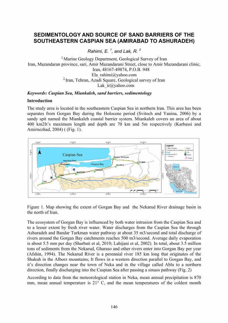
146
SEDIMENTOLOGY AND SOURCE OF SAND BARRIERS OF THE SOUTHEASTERN CASPIAN SEA (AMIRABAD TO ASHURADEH)
Rahimi, E. 1, and Lak, R. 2 1 Marine Geology Department, Geological Survey of Iran
Iran, Mazandaran province, sari, Amir Mazandarani Street, close to Amir Mazandarani clinic, Iran, 48167-49874, P.O.B. 948 [email protected]
2 Iran, Tehran, Azadi Square, Geological survey of Iran [email protected]
Keywords: Caspian Sea, Miankaleh, sand barriers, sedimentology Introduction
The study area is located in the southeastern Caspian Sea in northern Iran. This area has been separates from Gorgan Bay during the Holocene period (Svitoch and Yanina, 2006) by a sandy spit named the Miankaleh coastal barrier system. Miankaleh covers an area of about 400 km2It’s maximum length and depth are 70 km and 5m respectively (Karbassi and Amirnezhad, 2004) ( (Fig. 1).
Figure 1. Map showing the extent of Gorgan Bay and the Nekarud River drainage basin in the north of Iran.
The ecosystem of Gorgan Bay is influenced by both water intrusion from the Caspian Sea and to a lesser extent by fresh river water. Water discharges from the Caspian Sea the through Ashuradeh and Bandar Turkman water pathway at about 35 m3/second and total discharge of rivers around the Gorgan Bay catchments reaches 500 m3/second. Average daily evaporation is about 5.5 mm per day (Sharbati et al, 2010; Lahijani et al, 2002). In total, about 3.5 million tons of sediments from the Nekarud, Gharaso and other rivers enter into Gorgan Bay per year (Afshin, 1994). The Nekarud River is a perennial river 185 km long that originates of the Shakuh in the Alborz mountains; It flows in a western direction parallel to Gorgan Bay, and it’s direction changes near the town of Neka and in the village called Ablu to a northern direction, finally discharging into the Caspian Sea after passing a sinuos pathway (Fig. 2)
According to data from the meteorological station in Neka, mean annual precipitation is 870 mm, mean annual temperature is 21° C, and the mean temperatures of the coldest month

147
(February) and warmest month (August) are 9° C and 29° C, respectively. The most intensively heated regions during summer are the coastal cities.
Figure 2. Google Earth image of the study site (date:10 Auguest 2018).
Methodology A total of 3 cores were taken from of the study area of Caspian Sea coastal region in February 2017. Cores were taken from landward and seaward of Miankaleh, the maximum length of the cores was 673 cm and penetration usually stopped when unmixed sand layers were reached. After drilling, the core tubes were marked at the sediment surface and the tops sealed with plastic caps. In the laboratory, cores were cut open with a portable saw and the sediment split in half using a metal wire or knifes. Cores were logged, photographed and, from one core half, 5 cm long samples were taken for sedimentologic (texture, composition) and mineralogic (XRD) analysis. The other half of the core was sealed and kept for reference. Relative abundances of carbonate minerals were determined using the method of Milliman (1992, pp. 21-29).
Results On the way from Amirabad to Ashuradeh, one observes in abundance the spreading of sand barriers, behind which in some areas shallow swamps have formed, and in some places these swamps are accompanied by the growth of plants. In some areas sediments contain a large amount of organic matter, due to the growth of plants and the activity of birds (Fig. 3). Undoubtedly, with the continuation of this process, in the near future, the present situation of Ashuradeh will change, and perhaps more severely, on the northern coast of Miankaleh; there are many areas that have already been changed.
The study area in the southeastern part of the Caspian Sea is influenced by sedimentation caused by sea and wind. The sea is a major contributor to regional sediment supply, which

148
affects the geology and geomorphology of the region with its numerous fluctuations. Due to the gentle slopes of the beaches in this area, fluctuations (and in particular the lowering of sea levels and possibly the presence of prevailing winds) have rapidly changed this area with sand barriers. The composition of clastic sediments represents their source rocks and weathering conditions, but also the rate of sediment supply which is controlled by climatic and tectonic factors (Cox et al., 1995; Armstrong-Altrin and Verma, 2005; Singh, 2009; Bhuiyan et al., 2011, Silva et al, 2016). Gorgan metamorphic complexes including schist, phyllite, slate, Jurassic shale, sandstone, marl, as well as Cretaceous limestones have formed major rock units in the upstream catchment area that supplies sediments to Gorgan Bay. Geological and sedimentological evidences shows that the south Caspian Sea basin has a very high sedimentation rate up to 1000 m/Ma since the Middle Pliocene (Nadirovet al., 1997).
Figure 3. Picture of sand barriers information in Caspian Sea coast region from Amirabad.
Conclusion Sedimentological and micropaleontological investigations of three cores from the subsurface of sand barrier sediments show a vertical cyclic pattern of facies, including lagoonal, shoreline and both mixed together. Particularly, the lower part of the lagoon succession is characterized by windblown sand from Miankaleh’S sandy sediments. In contrast, the remaining part of the succession was formed in a variety of depositional environments, from lagoon to shoreline. This research shows windblown sand was related to migration of Miankaleh sand dunes.
References Afshin, E. 1994. Iran Rivers, Vol 2, Energy Ministry, Jamab, 251p. (In Persian). Armstrong-Altrin, J.S., and Verma, S.P. 2005. Critical evaluation of six tectonic setting
discrimination diagrams using geochemical data of Neogene sediments from known tectonic settings. Sedimentary Geology. 177, 115–129.
Bhuiyan, H. A. M., Rahman, J. J. M., Dampare, S. B., and Suzuki, S. 2011. Provenance, tectonics and source weathering of modern fluvial sediments of the Brahmaputra–Jamuna River, Bangladesh: Inference from geochemistry. Geochemical Exploration. 111. 113–137.
Cox, R., Lowe, D.R., and Cullers, R.L. 1995. The influence of sediment recycling and basement composition on evolution of mudrock chemistry in the southwestern United States. Geochim. Cosmochim. Acta 59 (14), 2919–2940.
Lahijani, H., Haeri, O., and Sharifi, A. 2002. Sedimentology and mineralogy of Gorgan Bay sediments. Research Report, Iranian National Center for Oceanography, 61pp.
149
Milliman, J. D. 1972. Atlantic Continental Shelf and Slop·e of the United States-Petrology of the sand fraction of sediments, northern New Jersey to southern Florida: U.S. Geol. Survey Prof. Paper 529-J, 40 p.
Nadirov,R.S., Bagirov , E .,Tagiyev, M ., and Lerche, I. 1997. Flexural plate subsidence, sedimentation rates, and structural development of the super-deep South Caspian Basin ,Marine and Petroleum Geology, 14, 4: 383- 400.
Sharbati, S., Hosseni, S., Taghizadeh, V ., Imanpour, M and Gorgin, S. 2010. Two dimentional modeling in Gorgan Bay Currents influence by sea level changes and wind pattern changes , Proceeding of First Conference of Caspian Sea Ecology, NRCES(2010). Sari, Iran.
Silva, G. V. M., Pinto, C. M., and Carvalho, A., 2016. Major, trace and REE geochemistry of recent sediments from lower Catumbela River (Angola), Journal of African Earth Sciences, 115: 203-217.
Singh, P., 2009. Major, trace and REE geochemistry of the Ganga River sediments: influence of provenance and sedimentary processes. Chem. Geol. 266: 251–264.
Svitoch, A.A. and Yanina, T.A., 2006, Holocene marine sediments on the Iranian coast of the Caspian Sea. Doklady Earth Sciences, 410: 1166−1169.

150
GEOMORPHOLOGICAL EVOLUTION OF PLAINS OF GORGAN DURING KHVALYNIAN TRANSGRESSION OF CASPIAN SEA
(GOLESTAN PROVINCE OF IRAN)
Semikolennykh, D. 1, Kurbanov, R. 2, Khoshravan, H. 3, and Belyayev, B. 4 1, 2, 4Lomonosov Moscow State University, 1 Leninskiye Gory, Moscow, 119991, Russia;
3Caspian Sea National Research and Study center, Sari, Mazandaran, Iran 1 [email protected]
2 [email protected] 3 [email protected]
Keywords: Late Pleistocene, climate change, geomorphological evolution, events, Khvalynian transgression, Caspian Sea, sea level change Introduction The Iranian Caspian coastal region is unique in our understanding of the history of the Caspian Sea in the Pleistocene and its correlation with the global and regional climate changes (Beni et al., 2014; Kakroodi, 2012; Kakroodi et. al., 2012 Chepalyga, 2006; Svitoch, 2016; Yanina, 2012) . The reason is representativeness of Quaternary sections, presence of both marine and subaerial sediments, paleontological richness of the materials that are available for study.
In our work, we tried to reconstruct the history of the development of the last and largest transgression of the Caspian Sea – Early Khvalynian, and to reveal the stages of its development in the territory of Northeast Iran.
Material and method
The object of research was the valley of the Gorgan River (Fig. 1), in the sides of which a series of sections with marine, alluvial and aeolian deposits are preserved.
Fig. 1. Gorgan Plains. goo.gl/wCDbnE, google.maps.

151
We have described more than 30 sections throughout the valley, within the bounds of the possible influence of the Khvalynian transgression (up to a height of +70 m abs). For the first time, deposits of mixed alluvial-marine genesis, reflecting the early Khvalynian transgression of the Caspian Sea, were found in the sections. Completed OSL-dating of sediments allowed to reconstruct the stages of development of the natural environment of the region after the LGM.
Results and discussion 14-15 thousand years ago the middle part of the valley of the Gorgan River was covered by the waters of the Caspian Sea. In sections of the middle part of the Valley (altitude of +30 m), this stage is represented by rhythmic clays and loams of mixed marine and alluvial genesis. The transition to purely alluvial floodplain deposits. The upper part of the section is represented by subaerial loess deposits, with thickness of 7-8 m. The subaerial phase of sedimentation began about 11 thousand years ago with a high rate of formation of loesslike deposits (Fig. 2).
Figure 2. Esir section (Gorgan river). Photo by D.V. Semikolennykh.
Acknowledgments
These investigations are supported by Russian Funding for Basic Research (17-55-560012).
References Beni, A.N., Lahijani, H., Pourkerman, M., Jokar, R., Hosseindoust, M., Marriner, N., Djamali,
M., Andrieu-Ponel, V., and Kamkar, A. 2014. Caspian Sea-level changes at the end of Little Ice Age and its impacts on the avulsion of the Gorgan River : a multidisciplinary case study from the southeastern flank of the Caspian Sea. Méditerranée 122: 145-155.
Kakroodi, A.A. 2012. Rapid Caspian Sea-level change and its impact on Iranian coasts. Master's theses. Geboren te Noshahr, Iran.

152
Kakroodi, A.A., Kroonenberg, S.B., Hoogendoorn, R.M., Mohammad-khani, H., Yamani, M., Ghassemi, M.R., and Lahijani, H.A.K. 2012. Rapid Holocene sea-level changes along the Iranian Caspian coast. Quaternary International 263: 93-103.
Chepalyga, A. 2006. Extraordinary rate of Khvalyn transgression: huge floodings, sea level oscillations, coastline migration, influence to civilization. The Fourth Intern. Conf. of UNESCO Programme 481 Dating Caspian Sea Level Change. Almaty.
Svitoch A.A., Yanina T.A. Marine Holocene of the Caspian coast of Iran. The Fourthh Intern. Conf. of UNESCO Programme 481 Dating Caspian Sea Level Change. Almaty, 2006. 109 p.
Yanina, T.A. 2012. Correlation of the Late Pleistocene paleogeographical events of the Caspian Sea and Russian Plain. Quaternary International 271: 120-129.
153
MEIOBENTHOS OF ABANDONED OIL WELLS IN THE NORTHERN CASPIAN SEA
Sergeeva N.G. 1, and Vodovsky N.B. 2
1 A.O. Kovalevsky Institute of Marine Biological Research of the RAS, 2 Nakhimov ave., Sevastopol 299011, Russia [email protected]
2 Caspian Branch of the Shirshov Institute of Oceanology of the RAS, Astrakhan, Russia [email protected]
Keywords: meiobenthos, abandoned oil wells, Caspian Sea Introduction The Caspian Sea is rich in natural (oil, gas) and biological resources. The main deposits of oil and gas are confined to the Carboniferous, Lower Permian, Permian-Triassic, Jurassic, and Cretaceous deposits (Diarov, 2001).
The last decade has seen much active research linked to the Caspian Sea deposits of oil and their exploitation. According to this research, exploration causes local disturbances in the sea bottom, simultaneously affecting biota and the rest of the environment. With the development of wells into the shallow shelf, negative effects on the bottom biotopes and associated fauna can be considerable.
It is supposed that the ecological threat due to leakage of oil and gas during the development of wells and extraction of oil resources is theoretically less than that from the leakage of abandoned wells and those that have been left after extraction is completed. Liquidated or conserved gas wells are ecologically dangerous (Smirnov, 2000), and therefore, industrial activities targeting the exploration and production of raw hydrocarbons on the shelf of the northern Caspian Sea are accompanied by various ecological studies aimed at assessing, controlling, and minimizing negative impact on the marine environment.
In order to carry out post-production control over inactive search and evaluation wells, the environment and biota in their vicinity have been monitored. Annual ecological and biological monitoring has been conducted by the oil company Lukoil-Nizhnevolzhskneft in cooperation with the Caspian Branch of the Institute of Oceanology, Shirshov RAS.
It is known that zoobenthos is a conservative natural community that reacts rapidly to emerging disturbances in its habitat. Therefore, macrozoobenthos is included in the monitoring studies conducted to assess the impact of inactive wells (Vodovsky, 2016). A high percent of endemic species and genera (41%), mostly among crustaceans and mollusks, is characteristic of the Caspian Sea benthic fauna; this testifies to the great age of this water reservoir fauna (Guseinova, 2014).
But it should be borne in mind that benthic communities are complex biological systems in which functioning organisms exist in ecological groupings of different sizes (macro-, meio-, and microbenthos). Meiobenthos include animals whose dimensions do not exceed 1-2 mm during their whole life cycle—including eumeiobenthos and immature individuals of macrobenthos, pseudomeiobenthos (Mare, 1942; Giere, 2009; Sergeeva and ürkmez, 2017).
Meiobenthos is an important component of benthic ecosystems, and it reacts sharply to changes in habitat. Responses of Caspian meiobenthos in such monitoring investigations was not previously estimated (Vodovsky, 2016).

154
Species of the European coastal euryhaline complex served as the initial material for formation of Caspian nematode fauna, as it is the dominant group of meiobenthos. Stabilization of the Caspian basin regime at the end of the Pliocene and its isolated status led to the establishment of an endemic Pontic-Caspian complex of nematodes (Tchesunov, 1981, 1983). Ecologic-biologic monitoring is also required for the preservation of specific Caspian benthic fauna that are being affected by high anthropogenic impacts.
The purpose of this work is to fill in missing data on meiobenthos associated with the postindustrial state of abandoned exploration wells. We provide a preliminary estimate of variability in taxonomic composition and species abundance distribution within studied wells in order to plan for further complex estimation of the effects of abandoned wells on the condition of bottom communities.
Methodology In August 2016, the Caspian Branch of the Institute of Oceanology of the RAS conducted an expedition to the licensed site “Severny,” OOO “Lukoil-Nizhnevolzhskneft” on board the RV “Nikifor Shurekov.” During the expedition, technological survey and ecological monitoring of the abandoned wells and adjacent parts of the bottom were carried out. In the margins of the licensed site, meiobenthos found near 15 abandoned exploration wells was studied. The stations at which bottom sediment samples were taken for meiobenthos analysis were situated near four well groups: “Rakushechnaya” (R, eight stations, 6 – 15 m depth), “Shirotnaya” (Sh, two stations, 12 – 13 m), “Sarmatskaya” (S, two stations, 13 – 15 m), and “Hvalynskaya (H, three stations, 25 – 29 m). The groups of wells differ in their abiotic conditions (Table 1). Close to each well, ground samples were taken by a diver with benthic samplers of ground taking area 0.01 m2. During biological monitoring, samples specifically for the study of meiobenthos were not taken. Therefore, we took a volume of bottom sediments (50 g) from these samples in order to study the macrobenthos and hydrochemistry, which then also served as material for meiobenthos analysis. That is why, in this work, we present only reconnaissance data on taxonomic richness and quantitative description of meiobenthos in general, and development of every taxon at the studied survey site in the northern Caspian.
Results
The groups of wells differ in their abiotic conditions (Table 1).
Table 1. Some abiotic environmental data at the licensed area “Severny” (6-8. 08.2016)
Well Group sample
Depth, m T S Ph O2
R. 1 8 29 3.9 9 5.4 R. 4 5 27,5 3.7 9 4 R. 5 8 28 3.2 9.1 4.6 R. 6 11 22 6.6 8.5 5 R. 7 11 22 3.5 9 6.7 R. 8 6 28.5 4.1 8.9 7.3 R. 9 7 28.2 3.8 8.95 5.2
R. 11 9 26.9 4.4 8.6 6.5 Sh. 1 12 26 4.2 8.6 6.7 Sh. 5 13 23.5 7.4 8.5 6 S. 1 15 14 10 8.7 6.3 S. 2 13 22 8.2 8.5 6.6 H. 1 27 12 10.2 9.1 7 H. 3 29 11 11.1 8.6 7.1 H. 4 25 12.5 10.5 8.6 7.5
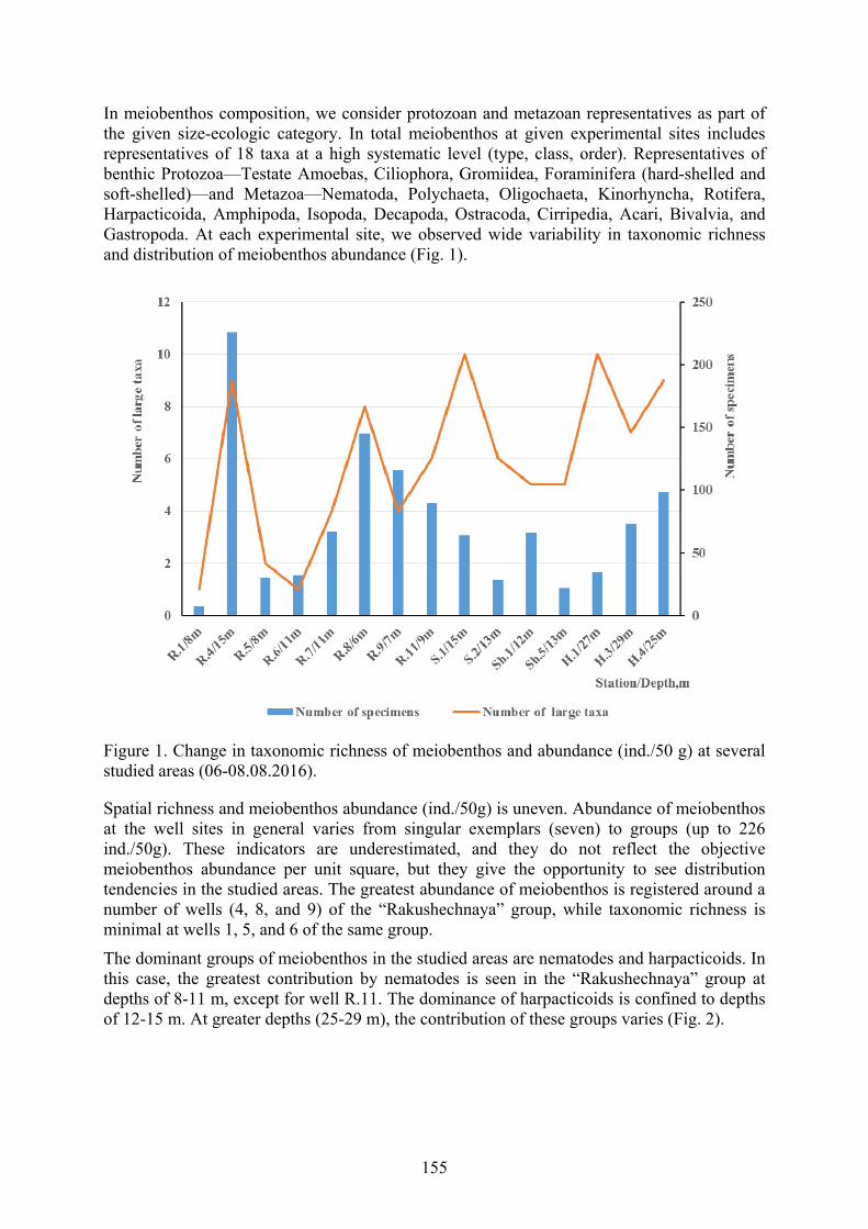
155
In meiobenthos composition, we consider protozoan and metazoan representatives as part of the given size-ecologic category. In total meiobenthos at given experimental sites includes representatives of 18 taxa at a high systematic level (type, class, order). Representatives of benthic Protozoa—Testate Amoebas, Ciliophora, Gromiidea, Foraminifera (hard-shelled and soft-shelled)—and Metazoa—Nematoda, Polychaeta, Oligochaeta, Kinorhyncha, Rotifera, Harpacticoida, Amphipoda, Isopoda, Decapoda, Ostracoda, Cirripedia, Acari, Bivalvia, and Gastropoda. At each experimental site, we observed wide variability in taxonomic richness and distribution of meiobenthos abundance (Fig. 1).
Figure 1. Change in taxonomic richness of meiobenthos and abundance (ind./50 g) at several studied areas (06-08.08.2016).
Spatial richness and meiobenthos abundance (ind./50g) is uneven. Abundance of meiobenthos at the well sites in general varies from singular exemplars (seven) to groups (up to 226 ind./50g). These indicators are underestimated, and they do not reflect the objective meiobenthos abundance per unit square, but they give the opportunity to see distribution tendencies in the studied areas. The greatest abundance of meiobenthos is registered around a number of wells (4, 8, and 9) of the “Rakushechnaya” group, while taxonomic richness is minimal at wells 1, 5, and 6 of the same group.
The dominant groups of meiobenthos in the studied areas are nematodes and harpacticoids. In this case, the greatest contribution by nematodes is seen in the “Rakushechnaya” group at depths of 8-11 m, except for well R.11. The dominance of harpacticoids is confined to depths of 12-15 m. At greater depths (25-29 m), the contribution of these groups varies (Fig. 2).

156
Figure 2. The share (%) of nematodes and harpacticoids in the total abundance of meiobenthos in the areas of abandoned wells at various depths.
Free-living nematodes are the most numerous and permanent group in the meiobenthos. At wells 1 and 6 of the “Rakushechnaya” group, the only free-living nematodes was registered. At the other well groups, meiobenthos was more variable and represented by 4-10 high taxa. Аt some of these stations, Ciliophora, Oligochaeta, Polychaeta, Bivalvia, and Acari accounted for a significant share of total meiobenthos abundance (11-21%).
The nematode fauna in the studied water area revealed about 30 species, the leading ones being Axonolaimus setosus Filipjev, 1918; Anoplostoma viviparum (Bastian, 1865) Bütschli, 1874; and Thalassomonhystera parva (Bastian, 1865). A. setosus is a common species for the Black Sea, but earlier, it was not recorded in the composition of nematode fauna of the Caspian Sea (Tchesunov 1981, 1983). Detailed systematic studies of detected morphotypes of many Caspian nematodes need to be continued.
The data we obtained are quite interesting, as for the first time, we found in the Caspian Sea Centropyxiella sp. (Testate Amoebas), several species of Gromiidea, and soft-shelled foraminifera. Free-living Ciliophora of the Caspian Sea have been very well studied (Amagaliev, 1983).
In our samplings, we registered unknown for science Suctoria on the body of Acari Halacarellus cf. hyrcanus (Viets, 1928) for the first time in this sea. Unknown epibiont ciliates were also registered on the bodies of the nematode A. setosus. Not less interesting are numerous colonies settlements of ciliates (Suctoria) on algae fragments in the bottom sediments.
Also for the first time, we observed fungi settlements in the bodies of dead A. setosus nematodes, which testifies to the role of marine fungi in consuming organic matter in the form of dead fauna. Together with this, aggregates of fungi were marked in the bottom sediments of a number of stations.
Conclusions
Preliminary data on changes to meiobenthos structure in the northern Caspian Sea in the vicinity of abandoned wells testify to the great taxonomic diversity, but further studies and
157
controls are needed. Special attention should be paid to studies of new groups of organisms, unknown earlier for Caspian Sea.
Acknowledgments The taxonomic analysis of meiobenthos was carried out within the framework of the theme No. 0828-2018-0002 of the State Program of the Institute of Marine Biological Research of the RAS “Regularities of formation and anthropogenic transformation of “Biodiversity and Bioresources of the Azov-Black Sea basin and other areas of the World Ocean.”
References Agamaliyev, F.G. 1983. Infusorii Kaspiyskogo morja (systematika, ecologia, zoogeografia)
[Infusoria of the Caspian Sea (Taxonomy, Ecology, Zoogeograhy]. L., Nauka. (In Russian)
Diarov, M.D. 2001. Doklad chlen-korr. NAN RK, doctor geologo-mineralogicheskikh nauk “Vliyanie deyatelnosti neftegazovogo komplexa na prirodnuyu sredu Severnogo Caspiya” [Report of Corres- ponding Member of NAS RK, Doctor of Geological and Mineralogical Sciences “The Impact of the Oil and Gas Industry on the Natural Environment of the North Caspian Sea]. http://www.caspinfo.ru/news/zips/Diarov.zip. (In Russian)
Giere, O. 2009. Meiobenthology: The Microscopic Motile Fauna of Aquatic Sediments. New York, Springer-Verlag.:527 pp.
Guseinova, S.A. 2014. Sostoyanie zoobentosa srednego Kaspiya. Osobennosti bentosnyh soob- shestv Kaspyiskogo morya [Zoobenthos of the Middle Caspian. Benthos Communities of the Caspian Sea]. Ecology of Animals of the South of Russia: Ecology, Development 1: 129-132. (In Russian)
Mare, M.F. 1942. A study of a marine benthic community with special reference to the marine meiobenthos: a review. Journal of the Marine Biological Association of the United Kingdom 25: 517-554.
Sergeeva, N.G., and Ürkmez, D. 2017. Current views on the diversity and distribution of deep-water meiobenthos at the Turkish shelf (Black Sea). Ecologica Montenegrina 14: 60-73.
Smirnov, V.I. 2000. Vnedrenie ecologicheski chistykh tehnologii razrabotki neftyanyh i gazovikh mestorohzdenii – velenie vremeni [Introduction of environmentally friendly technologies for development of oil and gas is the imperative time]. Jour. RAN “Geoecologya” 4: 331-333. (In Russian)
Tchesunov, A.V. 1981. Evolyutsia, systematika i ekologia svobodnozhivuschih nematod [Evolution, Systematics and Ecology of Free-living Nematodes]. L ., ZIN AN SSSR: 88-95. (In Russian)
Tchesunov, A.V. 1983. O geograficheskom rasprostranenii i putyah stanovleniya fauny svobod-nohzivushih nematod Kaspiyskogo morya [About Geographical Distribution and Ways of Fauna Formation of Free-living Nematodes of the Caspian Sea] In: Biological Resources of the Caspian Sea. M., MGU: 83-110. (In Russian)
Vodovsky, N.B. 2016. Bentofauna likvidirovannikh poiskovo-otcenochnyikh skvahzin v Kaspiyskom more [Zoobenthos of abandoned oil-wells in Caspian Sea]. Proceedings of the All- Russian Scientific-Practical Conference with International Participation dedicated to the 145th anniversary of the Sevastopol Biological Station (Sevastopol, 19–24 September, 2016), ed. A.V. Gaevskaya. Sevastopol: EKOSI-Gidrofizika, Vol. 2: 50-53. (In Russian)

158
ROLE OF MIGRATIONS IN CULTURAL EXPLORATION OF THE LOWER DANUBE REGION IN EARLY PREHISTORY
Smyntyna, O.V.
Odessa National I.I. Mechnikov University, Department of Archaeology and Ethnology of Ukraine, Dvoryanksaya str., 2, Ukraine, 65026
Keywords: paleoclimate change, paleolandscapes, Bilolissya, Grebeniky, Kukrek, Mesolithic Introduction The process of cultural exploration of the lower Danube River, particularly, its segment located within the territory of contemporary Ukraine, has become the subject of fundamental studies relatively recently, since the late 1970s, when the first archaeological sites were discovered in this region. Field research (excavations and observations) provided by archaeologists from Odessa I.I. Mechnikov University and Odessa Archaeological Museum (Vladimir Stanko, Leonid Subbotin, and others) have provided rich flint artifact and faunal assemblages dated to different phases of the Mesolithic period. These finds have allowed us to identify peculiarities of the flint knapping technology and flint industries, and opening at the same time broader possibilities for paleoenvironmental reconstructions (more details in Smyntyna, 2000).
A series of international projects implemented within the region in question under the leadership of Pavel Dolukhanov during late 1990s has provided new insight into human-nature interaction during the Stone Age. Examination of new and already available data in the course of interdisciplinary projects headed by Valentina Yanko-Hombach (IGCP 521 “Black Sea-Mediterranean Corridor during the last 30 ky: sea level change and human adaptation,” INQUA 501 “Caspian-Black Sea-Mediterranean Corridor during the last 30 ky: sea level change and human adaptive strategies,” IGCP 610 “From the Caspian to Mediterranean: Environmental Change and Human Response during the Quaternary”) has produced a fundamental platform of evidence for the establishment of a detailed history of colonization of the Lower Danube region at the Pleistocene-Holocene boundary.
Dryas III: the beginnings The first episode of penetration into the Ukrainian Lower Danube region is dated to the final stage of the Tardiglacial period, Dryas III, when a group moved here from the neighboring territory of Romanian Dobrudja. Based on peculiarities of the recovered flint industry, Vladimir Stanko has distinguished the Bilolissya industry and has connected it with the population from the Middle Danube region that followed aurochsen, their main prey species (Stanko, 1985: 31-45).
Formally, sites containing the Bilolissya industry are located outside the Lower Danube niche, on the steppe area between the Danube and Dniester rivers (contemporary Tatarbunar district of the Odessa region, villages of Bilolissya, Mykhailivka, and the small Kagilnik River). However, the presence of similar archaeological sites on the right bank of the Danube River indicates that this population could have crossed the Danube delta, which at that time looked like a set of temporary and semi-permanent streams.
The Bilolissya settlement system and the duration of occupation in the region imply that this migration was not a large-scale process: as of now, we have only 4 archaeological sites (one

159
base camp and 3 short-term sites with no cultural layer located at one day’s journey from the base camp). Most probably, this suggests the entry of an isolated community. However, this migration was no doubt successful, because the base camp of the migrants (Bilolissya) is known to be the most complicated and long-term archaeological site known in the whole Steppe Black Sea region for the Tardiglacial and Preboreal periods of the Holocene. As we have tried to demonstrate, such success in adapting to a territory was perhaps insured by continuing their traditional hunting of aurochs with the help of long-distance weapons (arrows equipped with geometric microliths: peculiar high trapezes and segments). At the same time, it should be stressed that such a successful adaptation did not cause any further migrations of this population, and the Bilolissya industry did not survive in the region beyond the beginning of the Preboreal period.
Boreal period of the Holocene: the starting point of continuous exploration The beginning of systematic occupation of the Ukrainian Lower Danube region is dated to the Boreal period, which is correlated with the Late Mesolithic in the history of flint industries of the northwestern Black Sea region. Presently, only 5 archaeological sites can be attributed to this phase of cultural expansion into the region, and a cultural layer is traceable only in 2 of them. However, their flint assemblages are numerous—e.g., the sites of Myrne in the Kilia district of Odessa region (over 20.6 thousand items) and Zaliznychne in the Bolgrad district of Odessa region (7.7 thousand items)—and represent all stages of flint knapping. Assemblages of all sites in the region demonstrate a characteristic typical of the Late Mesolithic of Steppe Ukraine—a tendency toward integration of specific features from two industries widespread in this region: Kukrek (based on retouched blade technologies) and Grebeniky (with predominant geometric microliths, particularly trapezes). This phenomenon has already been discussed by the author in greater detail on the basis of the flint assemblage of Zaliznyche (Smyntyna, 2007). Thus, determining the territory from which this population came to the Lower Danube region implies a search for the areas of primary origin of the Kukrek and Grebeniky industries.
This question remains reliably one of the most disputed in Ukrainian Mesolithic archaeology, and details of this discussion have recently been summarized by the author (Smyntyna, 2015). Today, it is possible to suggest that the Kukrek flint knapping tradition originated from further integration and gradual evolution of a series of Epi-Gravettian industries of the Steppe Black Sea region, which can be traced back to the Upper Paleolithic Anetivka tradition (Stanko, 1980). Its presence in the Ukrainian Lower Danube region in the Late Mesolithic should be explained as migrations of this population (realized individually or collectively) to the west from their original area. The Grebeniky tradition most probably should be interpreted as the late stage of the Tsarinka-Rogalik Early Mesolithic industry located in the central part of the Steppe region. Distribution of their sites in the Lower Danube area was the result of migration of this population looking for new foraging territories (Stanko, 1986).
The above suggests that the new phase of human occupation in the Ukrainian Lower Danube region was the result of a new wave of migrations, this time from the east, i.e., from the inner areas of the Northwestern Pontic Steppes. This process was designed as an enlargement of the traditional area of occupation; it was caused by the growth of population density in their home territory and the increasing necessity to find new foraging territory.
The newcomers managed to modify their traditional subsistence system in accordance with the possibilities provided by their new area, of which the resources remained practically intact (in contrast to the highly exhausted food sources in the inner parts of the Northwestern Pontic region during Glacial and Late Glacial times). Representatives of the Grebeniky and Kukrek traditions in the Lower Danube demonstrate a clear tendency to establish a much more stable
160
mode of life and longer period of site occupation. While most of the Late Mesolithic sites of the central part of the Black Sea steppe region are represented by surface finds, the proportion of settlements with a clear cultural layer in the Lower Danube region is considerably higher (about 40%). Archaeological sites of the Ukrainian Lower Danube region demonstrate also a higher intensity of occupational activities, which is displayed by relatively high artifact densities per square meter (11.4 items per sq.m for the excavated area of Myrne, and 201.6 items per sq.m for the excavated area of Zaliznychne). Based on the amount of consumed meat at Myrne and the number of its inhabitants (tentatively calculated by the number of hearths), this site was occupied for at least 9 months. The relatively long period of this site occupation is proved also by the presence of long-term hearths and baking pits, by the detection of places for food consumption and flint processing, as well as by displays of a peculiar attitude toward juvenile aurochsen, which has been interpreted as a primary phase of this animal’s domestication (Stanko, 1995).
Conclusion: paleolandscapes and the further history of occupation in the Ukrainian Lower Danube The diverse resource base of the Lower Danube region during the Boreal period (mesophilous meadow steppe landscape with deciduous forest plots rich with steppe and forest fauna like aurochs, wild boar, and red deer) was never intensively exploited, and this was one of the basic reasons why successful adaptation and a stable mode of life was established by Late Mesolithic migrants to the region. It was also the background leading to non-conflict interaction between representatives of both flint knapping traditions, which often simultaneously occupied the same site. It is worth mentioning, however, that this tendency is displayed by archaeological sites of central part of the Northwestern Pontic region as well (Kovlenko, Tsoy, 1999). The evidence appears to suggest that such a relationship between Grebeniky and Kukrek populations might have started at their very origin, and the Lower Danube was explored by migrants who were already well adapted to joint occupation and communal life.
This possibility forms the basis of later developments in the history of the Lower Danube region. In particular, the process of neolithization in the region and the transition to a productive economy within the Bug-Dniester culture demonstrates the interaction between the joint Grebeniky-Kukren population and newcomers from the west, who bring with them traditions of cattle breeding and land cultivation (Smyntyna, 2015).
References Kovalenko, S.I., Tsoy, V.B. 1999. K voprosu o razvitii pozdnemesoliticheskih industriy v
Karpato-Dunaiskom regione [To the question of development of Late Mesolithic industry in Carpathian-Danubian region]. Stratum Plus 1, pp. 257-262. (In Russian)
Smyntyna, O.V. 2000. Arheologichni rozviky pizniomezolitychnogo Podunavia [Archaeological investigations of Late Mesolithic of Lower Danube region]. Naukovyi visnyk Izmailskogo derzhavnogo pedagogichnogo institutu [Scientific Herald of Izmail State Pedagogical University], 9, pp. 34-37. (In Ukrainian)
Smyntyna, O. 2007. Late Mesolithic of the Ukrainian part of the Lower Danube region: New perspectives of human adaptation and interpretation of natural environments. Quaternary International, 167-168, pp. 114-120.
Smyntyna, O. 2015. Late Mesolithic site of Zaliznychne in the light of recent hypothesis of Neolithization of North-Western Pontic region. Romanian Review of Eurasian Studies. Vol. XI, no 1-2, pp. 7-28.
Stanko, V.N. 1980. Ranniy mesolit stepei Severnogo Prichernomoria [Early Mesolithic of Northern Black Sea region]. In: V.N. Stanko (ed.), Pervobytnaia arheologia: poiski i
161
nakhodki [Prehistoric Archaeology: Research and Findings]. “Naukova dumka”, Kiev, pp. 90-109. (In Russian)
Stanko, V.N. 1985. K probleme zapadnykh sviazey mesolita stepnogo Prichernomoria [To the problem of western connections of the Mesolithic of Steppe Black Sea region]. In: V.N. Stanko (ed.), Novye materialy po arheologiyi Severo-Zapadnogo Prichernomoria [New Materials on Archaeology of the North-Western Black Sea Region]. “Naukova dumka”, Kiev, pp. 31-45. (In Russian)
Stanko, V.N. 1986. K probleme slozhenia grebenikovskoy kultury [To the problem of the origin of Grebeniky culture]. In: V.N. Stanko (ed.), Issledovania po arheologiyi Severo-Zapadnogo Prichernomoria [Studies in the Archaeology of the North-Western Black Sea Region]. “Naukova dumka”, Kiev, pp. 13-25. (In Russian)
Stanko, V.N. 1995. Krizis okhotnichiego khoziaystva i vozniknovenie skotovodstva v azovo-prichernomorskih stepiakh [Crisis of the hunting economy and the origin of cattle breeding in the Azov-Black Sea steppes]. Drevnosti [Antiquities], 1, pp. 6-11. (In Russian)

162
PALEOANTHROPOLOGICAL STUDY OF THE POPULATION INHABITING THE TAMAN PENINSULA AT THE END OF THE
GOLDEN HORDE PERIOD
Vasilyev, S.V. 1, Borutskaya, S.B. 2, and Frizen, S.Yu. 3
1,3 Institute of Ethnology and Anthropology RAS, Moscow, Russia, 1 [email protected] 3 [email protected]
2 Lomonosov Moscow State University, Moscow, Russia, [email protected]
Keywords: Paleoanthropology, age cohort, mortality peak, life expectancy, final age cohort, paleodemographic index Introduction Anthropology is inseparably linked with other branches of science, including the social sciences. Many anthropologists, including Ya.Ya. Roginsky and M.G. Levin (1963), and V.P. Alekseev (1992), have noted this. Nowadays, knowledge and discoveries appear at the intersection of several disciplines. A comprehensive study gives more information about the material under investigation and permits accurate interpretations of the results. Paleodemography appears to be part of anthropology formed at the intersection of archaeology, ecology, medicine, anatomy, morphology, history, and demography. It is also located at the boundary between humanistic studies and social studies. At present, paleoanthropological study cannot be effective without a demographic profiling of the studied population. Quite often, paleodemography elicits very interesting mechanisms involving environmental factors that influence humans and population adaptation to them. Moreover, knowledge of the processes regulating demography in the past allows us to offer insights into the future (Angel, 1969).
Materials and methods The aim of the present work is a paleodemographic study of the necropolis of Psebeps 3 (dating back to the 14–15th centuries A.D.) with the use of statistical methods. This research makes a significant contribution to the accumulated knowledge about the demography of the human populations of the Taman Peninsula at that time.
During the study, we planned to calculate and analyze the demographic estimates listed in Table 1. The methodology for calculating paleodemographic indices is described in the work at Vlachi (Bogatenkov et al., 2003). Group-forming age intervals for all individuals in our study consisted of 5 years.
Table 1. List of paleodemographic indices
Symbol Description of the trait Formula a, c, m, f Adults, children, males, females Nr Number of individuals in sample – sample size (n) =∑(0,50+)Dx x, or (i-j) Age interval (class, cohort) of mortality tables (years) j=i+5 or j=i+10 X Mid-point of the age interval x (years) =[i+(i+5)]/2 or
=[i+(i+10)]/2 Dx Number of individuals in the age cohort х (n) Cx Percentage of sample in the age cohort х (%) Dx/Nr * 100 Lx The percentage of those aged from Xo age class to the =l(x-5)-C(x-5)
163
age of X %) Qx Probability of death of an individual in a cohort х =Cx/lx A The average age of death in a group (population), or life
expectancy (years) =[∑(0,50+)XDx]/Nr
AA Average age of adult death in the group (years) =[∑(15,50+)XDx]/Na PCD Child mortality in the group (%) =∑(0,15)Dx/Nr x 100 PBD Mortality rate in the first year of life (%) =∑(0,1)Dx/∑(0,15)Dx
x 100 PSR (m-f)
Percentage of men and women in the group (%) =N(m or f)/Na x 100, where Na=Nm+Nf
C50+ Percentage of individuals in the final age cohort (%) D(50+)/Nr x 100
Results and discussion Craniological characteristics of medieval Adyghe The Psebeps 3 burial ground (10 male and 5 female skulls) belongs to Adyghe (Circassians) and is dated to the 14-15th centuries. The Kabardinka burial ground (11 male and 4 female skulls) is also attributed to the Adyghe (Circassians) and is dated to the same period. The Cerkovnaya Shchel’ burial ground (3 male and 3 female skulls) dates to the 17-18th centuries and represents a funerary site of Adyghe tribes. All studied skulls exhibit a Caucasian cranial complex and great typological variety.
Based on within-group analysis and according to graphed indicators, skulls from Psebeps 3 and Kabardinka tend towards different parts of the graph. This configuration can probably be explained by the fact that these series differ from each other in spite of belonging to culturally related groups. Based on the between-group analysis graph of male skulls, there are two clusters: a Pyatigorskaya group including Natukhai, Kazazovo I, Moshchevaya balka, Gamovskoe ushchel'e, Psebeps 3, and Cerkovnaya Shchel’; аnd a Prichernomorskaya group including Shapsugi, Kazazovo II, and Kabardinka. The Circassian group is separate. Based on the between-group analysis graph for female skulls, there are the following clusters: Psebeps 3, Kazazovo II, Cerkovnaya Shchel’, and Natukhai are located on the left; the Pyatigorskaya group including Shapsugs, Kabardinka, the Prichernomorskaya group, and Moshchevaya balka are located in the center; and the Circassian group is located separately. The discrete position of the Circassian group is probably linked with the mongoloid admixture found among Adyghe withinin the territory of Circassia. The Prichernomorskaya group (Kazazovo II, Kabardinka, and the Shapsugs) can be explained by the fact that they all belong to the Adyghe. The third cluster shows that new data fit well to the chain of facts about the transformation of an anthropological variant of skulls from Moshchevaya balka and Kazazovo I to those of the Pyatigorskaya group. Interestingly, Psebeps 3 is somewhat close to this pool containing Natukhai, while Psebeps 3 skulls come from the territory of the native dwelling of Natukhai.
Paleodemographic characteristics of Psebeps 3 The total sample size that was suitable for this study incorporated 381 individuals. This size allows us to anticipate high reliability of the obtained paleodemographic characteristics of the population that inhabited the Taman Peninsula in the 14–15th centuries A.D. Based on these data, mortality tables were compiled (Tables 2,3,4). It is widely thought that the first adult age cohort is 15-20 years. Unfortunately, it was not possible to make a complete separation of skeletons within this cohort for males and females due to the state of preservation. Therefore, for all calculations in this study, the first adult age interval was that of 20-25 years, tabulated

164
separately for men and women. Data on individuals in the age cohort of 15-20 years were used for general paleodemographic analysis.
Table 2. Common table of Psebeps 3 group mortality
Age interval Dx (individuals) Cx (%) lx (%) qx (proportion)
0-1* 24 06.3 100.0 0.063 0-5 57 14.96 100.0 0.150 5-10 36 09.45 85.04 0.111 10-15 26 06.82 75.59 0.090 15-20 16 04.2 68.77 0.061 20-25 43 11.29 64.57 0.175 25-30 22 05.77 53.28 0.108 30-35 60 15.75 47.51 0.332 35-40 43 11.29 31.76 0.356 40-45 41 10.76 20.47 0.526 45-50 10 02.62 9.71 0.270 50+ 27 07.09 7.09 1.000 Sum 381 100.0 - -
*- this age interval is also included in the interval 0-5 years and is listed separately only for calculating PBD (the percentage of child mortality in the first year of life).
Analyzing Table 2, the following conclusions can be drawn. The most numerous are the child cohort of 0-5 years and the cohort of adults 30-35 years. Consequently, the major component of Psebebs 3 individuals died within the first five years and at the age of the greatest labor activity: 30-35 years. Immediately, we can conclude that the final age cohort (50+ years) is sufficiently numerous. It is interesting to note the very small percentage of individuals in the earliest adult cohort: 15-20 years. Most often, this age interval is quite numerous, since it corresponds to the time of the onset of reproductive activity of women.
Table 3. Mortality table for men and women of the Psebeps 3 group
Males Females Age interval Dx Cx Lx Qx Dx Cx Lx qx 20-25 17 10.429 100.00 0.104 26 31.325 100.00 0.313 25-30 13 07.976 89.571 0.089 9 10.843 68.675 0.158 30-35 45 27.607 81.595 0.338 15 18.072 57.832 0.312 35-40 31 19.018 53.988 0.352 12 14.458 39.760 0.364 40-45 28 17.178 34.970 0.491 13 15.663 25.302 0.619 45-50 9 05.522 17.792 0.310 1 01.205 09.639 0.125 50+ 20 12.270 12.270 1.000 7 08.434 08.434 1.000 Sum 163 100.00 - - 83 100.00 - -
Table 3 shows a difference in mortality peaks for men and women. For men, the peak of mortality falls into the interval of 30-35 years, as for the whole group. The peak of mortality for women in the group corresponds to the age cohort of 20-25 years. This is the age not only of active working life, but also the age of the greatest reproductive activity in women. In this population, this is probably the age of the onset of reproductive activity in women, judging by a few individuals in this group revealing an age of 15-20 years. Probably, a significant number of deliveries resulted in fatal outcomes. It is difficult to assume that the level of

165
medicine in the Middle Ages in Taman Peninsula was so high that first births in women proceeded without any complications, and similar problems concerned only older women.
It should also be noted that the final age cohort, over 50 years, is composed mostly of men. The number of men in this cohort is almost three times that of women.
Table 4 shows some demographic characteristics for the children of the group (up to 15 years).
Table 4. Paleodemographic indices of children in the Psebeps 3 group.
Age cohort Dx (ind.) Cx (%) 0-1* years 24 20.17% 0-5 years 57 47.9% 5-10 years 36 30.25% 10-15 years 26 21.85% Sum 119 ind. 100%
* this age interval is also included in the interval 0-5 years
We stated previously that one of the mortality peaks of the Psebebs 3 humans falls within the children's interval of 0-5 years. Table 4 confirms this result. A little less than half of the children from this interval died in their first year. Many factors can cause this. First, it can be the minimal level of medicine. The number of individuals in children's age cohorts decreases as they grow up, which is quite normal.
Table 5. Basic paleodemographic characteristics of the Psebeps 3 group
Index Value Nr – sample size 381 ind. Nra – adult sample size (15+) 262 ind. Nrc – child sample size (0-15 years) 119 ind. PCD – child mortality (%) 35.43% PBD – mortality during first year (%) 06.3% А – mean age of death (ле 25.7 years АА – mean age of adult death (лет) 35.5 years
PSR m-f – males-females (20+) 66.26% : 33.74%
С50+ – percent of individuals in final age cohorts (%) 07.09%
Table 5 summarizes some of the results. Average life expectancy (mean age of death in a group) of people from Psebebs 3 (Taman Peninsula, 14-15 centuries A.D.) was 25.7 years. This value is not high, primarily due to the fact that a significant number of individuals died at a very early age (up to five years). The percentage of child mortality in the group was 35.43%, slightly higher than the value about 30-33%, when demographic situation is considered normal.
Attention is drawn to the completely non-normal sexual proportion of the adult part of the group. There were twice as many men as women. It can be assumed that, for some reason in childhood, especially in early childhood, it was girls who were dying. Maybe they were undernourished and poorly looked after, and more attention was paid to the boys. Or there can be another reasons.
The final age cohort is sufficiently numerous.
Conclusions

166
Paleodemographic analysis leads us to the following conclusions:
1. The medieval human group from the necropolis of Psebeps 3 (Taman Peninsula) is numerous and representative, which permits us to obtain practically real paleodemographic characteristics for this territory.
2. The group does not have a normal proportion of sexes. The number of men is almost twice the number of women. Perhaps it was women who died more often in early childhood.
3. The average life expectancy in the group was 25.7 years.
4. Mortality peaks in the Psebeps 3 group corresponded to the intervals 0-5 years and 30-35 years. The mortality peak of adult men falls into the interval of 30-35 years, the mortality peak of adult women is in the range of 20-25 years.
5. Approximately 20% of the children died before the age of one year. Almost half of the children died before the age of five.
6. For this group, it is possible to note a very low number of individuals in the cohort of 15-20 years, and a substantial number in the final age cohort.
Acknowledgments This study was supported by the Russian Foundation for Basic Research, project no. 17-29-04329 ofi_m.
References Alekseev V.P. 1992. Volume of archaeological knowledge. Ecological aspects of
paleoanthropological and archaeological reconstructions, pp. 6-31. M. (in Russian) Angel J.L. 1969. The bases of paleodemography. American Journal of Physical Anthropology
30, pp. 427-438. Bogatenkov D.V. 2003. Paleodemography of Mistikhali. In Vlachi. Anthropo-ecological
Study (Based on the Materials of the Medieval Necropolis of Mistikhali), ed. by T.I. Alekseeva, D.V. Bogatenkov, and G.V. Lebedinskaya, pp. 19-49. M. (in Russian)
Roginsky Ya.Ya., and Levin M.G. 1963. Anthropology. Moscow (in Russian)

167
THE ROLE OF CLIMATIC STRESS IN THE LIFE OF THE ANCIENT CIVILIZATIONS OF THE FERTILE CRESCENT
Yakovleva, N.1, and Matygin, A.2 1 Center for Industrial Waste Management, 4, Svobody sq., Ckarkov, Ukraine, 61022
[email protected] 2 Black and Azov Seas Centre for Hydrometeorology, 89, Franzusky blvd, Odessa, Ukraine,
65009
Keywords: climate change, precipitation, drought, agriculture, Holocene
The entire path of the social development of mankind, beginning from the Neolithic period, is to a certain extent modulated by climatic changes. The change of climatic rhythms is often synchronized with the socio-historical cycles of the life of states, migration of peoples, and conquest campaigns. The analysis of the alternation of warm and cold (dry and wet) periods in different territories provides opportunities for understanding the causes of many historical events. Therefore, with its help, one can find the keys for forecasting the development of mankind. Consider the initial stages of the adaptation of ancient cultures to extreme climatic conditions by the example of the territory of the Fertile Crescent (FC).
Favorable climatic and natural conditions that existed in different parts of the Middle East and Asia Minor about 15-10 ka BP, contributed to the flourishing of the ancient Epipaleolithic Natufian Culture, located in the Levant in the western part of the FC. The FC is considered the birthplace of agriculture and cattle breeding, which appeared in the Neolithic. FC residents began to grow a variety of crops already 10-12 ka BP thanks to a relatively mild and humid climate. Climatic changes stipulated the process of primary colonization of FC by two main factors: droughts and the ability of society to fight them. To what extent climatic extremes, in this case droughts, have determined changes in the structure of social life of communities? Could they contribute to the economic and social development of cultures? To answer this question, a tool is needed that would link climate change and some parameter qualitatively characterizing the state of people's lives.
Analysis of the ratio of carbon isotopes 12C/13C (Δ13C ‰) in the remains of archaeological plants gives the method for assessing the direct relationship between the values of climatic parameters and the level of agricultural production in the past. This phenomenon allowed Riehl et al. (2014) to determine how often harvests of ancient barley from the FC were subjected to droughts and, accordingly, to assess the impact of droughts on the fate of the first civilizations of the world from the Neolithic to the Iron Age. Fig. 1A shows the chronological trends in the values of Δ13C fluctuating approximately between 15 ‰ and 18 ‰. Values below the reference line of 16 ‰ indicate a substantial lack of moisture, and values between 16 ‰ to 17 ‰ indicate a moderate moistening. Fig. 1 shows three major episodes in the climatic history of the Middle East when part or almost all of the civilizations of that time should have been subjected to severe droughts. These droughts often caused their disappearance or a sharp weakening.
A series of historical and climatic maps in Fig. 2 (Riehl et al., 2014) show for the territory of the FC the variability in the spatial structure of fertility as a result of the effects of droughts and other climatic phenomena for various historical periods of the Bronze Age, as well as for the present time.

168
A
B
Figure 1. (A) Accumulated Δ13C ‰ mean record from 1,037 barley grains from 33 archaeological sites (black line). Red line, reference line for drought stress at 16 ‰ and below; blue line, reference line for favorable conditions at 17 ‰ and above; red vertical bars, global climatic fluctuations at roughly 5200 cal yr BP (➀), 4200 cal yr BP (➁), and 3200 cal yr BP (➂) according to Riehl et al. (2014). (B) Mean annual precipitation rate during the Holocene Atlantic Optimum (about 6 ka BP) within the Caspian-Black Sea-Mediterranean Corridor as compared to the present values (Klimenko, 2001).
According to earlier local studies (Riehl et al., 2009), the average moisture values in the early and middle Holocene period (12000-6000 cal yr BP) for a given territory (Klimenko, 2001; Matygin and Erofeev, 2013) were significantly higher than today.
A
B
Figure 2 (A) Spline interpolation of mean Δ13C ‰ values from barley grains for different chronological segments. (B) Spline interpolation of minima Δ13C ‰ values from barley grains for different chronological segments. Red = strong drought stress; yellow = considerable to slight drought stress; green = moderate drought stress; blue = no drought stress (Riehl et al., 2014).
169
Fig. 2A shows that the amount of precipitation in the modern period and in the mid-Holocene was markedly different (current conditions are less by 50-150 mm of precipitation) and, accordingly, these periods differed in the conditions for plant growth. Cooling at 6.0-4.5 ka BP (Nicholson and Fiohn, 1980) caused a decrease in precipitation (Vannière et al., 2011), which produced the dry period of 5.5-5.2 ka BP (episode 1, Fig. 1); then came the humid phases of 5.2-4.3 ka BP and 3.8-3.3 ka BP, separated by an extra-arid phase of 4.3-3.9 ka BP (Nicholson et al., 1980). This period of drought (episode 2, Fig. 1) lasted about 300 years and, of course, could have caused the disintegration of a number of ancient civilizations of South West Asia. In particular, the highly developed civilization of the Akkadian Empire, which controlled the headwaters of the Tigris-Euphrates rivers to the Persian Gulf, sharply collapsed about 4170 ± 150 cal yr BP (Cullen et al., 2000). Fig. 2B (right) shows the distribution of minimum values for Δ13C in the Middle Bronze Age (MBA, 3900-3600 cal yr BP). Extremely low values for Δ13C minima indicate continuation of the arid climate phase. Acknowledgment of this fact is given in Geyer et al. (2007). There are texts from several places of the Ancient East that indicate a drought and famine at around 1250-1100 cal yr BP. In the Levant, during those crisis years, many urban centers disappeared, and the number of settlements decreased significantly (Langgut et al., 2013).
But still it must be noted that even during these events and with less pronounced droughts, the FC disintegrated into several regions (Fig. 2) each of which reacted in its own way to natural cataclysm. The most probable cause of this mosaic nature of people's resettlement in the FC during climatic extremes was its local features (coastal areas, proximity of large rivers and reservoirs), and, undoubtedly, artificial irrigation practiced by the population.
Thus, it can be concluded that only catastrophic events can lead to the complete disappearance of culture. There is no reason to expect unidirectional simultaneous cultural and socio-economic changes caused by environmental changes. Different levels of variability in the environment and human society create a very complex network of relationships. Climate stress does not lead to the complete destruction of culture. There remain places where, in some way, the culture survives and is again reborn with the restoration of more or less suitable conditions for existence. These mosaics in locations of archaeological remains of barley indicate that the adaptation of people to climate disasters even in such long-ago and relatively uncivilized times contributed to the survival of people, and in certain cases even led to a change of cultures or to more developed ones. Therefore, we cannot directly look for the concepts of modern economic policy in the historical past, but we can constructively take into consideration the variability of the weather and climate resources, studying a set of facts related to the dramatic relationship between mankind and nature.
References Cullen, H.M., deMenocal, P.B., Hemming, S., Hemming, G., Brown, F.H., Guilderson, T.,
and Sirocko, F. 2000. Climate change and the collapse of the Akkadian empire: Evidence from the deep sea. Geology 28(4): 379-382.
Geyer, B., al-Dbiyat, M., Awad, N., Barge, O., Besançon, J., Calvet, Y., and Jaubert, R. 2007. The arid margins of northern Syria: Occupation of the land and modes of exploitation in the Bronze Age. Urban and Natural Landscapes of an Ancient Syrian Capital: Settlement and Environment at Tell Mishrifeh/Qatna and in Central-Western Syria, ed. by Bonacossi, D.M., pp. 269-339. Forum, Udine, Italy.
Klimenko, V.V. 2001. Klimat srednevekovoi teploi epokhi v severnom polusharii [Climate of the Medieval Warm Period in the Northern Hemisphere]. MEI, Moscow. (In Russian)
Langgut, D., Finkelstein, I., and Litt, T. 2013. Climate and the Late Bronze collapse: New evidence from the Southern Levant. Tel Aviv 40: 149-175.

170
Matygin, A.S., and Erofeev, G.N. 2013. Climatic characteristics of the extremes in surface temperature within the Caspian-Black Sea-Mediterranean Corridor. In A. S. Gilbert and V. Yanko-Hombach, (Eds.), Extended Abstracts of the First Plenary Conference and Field Trip of IGCP-610 “From Caspian to Mediterranean^ Environmental Change and Human Response during the Quaternary". Tbilisi, Georgia 12-19 October 2013, 93-95.
Nicholson, S.E., and Fiohn, H. 1980. African environmental and climatic changes and the general atmospheric circulation in the Late Pleistocene and Holocene. Climatic Change 2(4): 313-348.
Riehl, S., Pustovoytov, K.E., Weippert, H., Klett, S., and Frank, H. 2014. Drought stress variability in ancient Near Eastern agricultural systems evidenced by δ13C in barley grain. PNAS 111(34) 12348-12353.
Riehl, S., Pustovoytov, K.E., Hotchkiss, S., and Bryson, R.A. 2009. Local Holocene environmental indicators in Upper Mesopotamia: Pedogenic carbonate record vs. archaeobotanical data and archaeoclimatological models. Quaternary International 209: 154-162.
Vannière, B., Power, M.J., Roberts, N., Tinner, W., Carrión, J., Magny, M., Bartlein, P., Colombaroli, D., Daniau, A.L., Finsinger, W., Gil-Romera, G., Kaltenrieder, P., Pini, R., Sadori, L., Turner. R., Valsecchi, V., and Vescovi, E. 2011. Circum-Mediterranean fire activity and climate changes during the mid-Holocene environmental transition (8500-2500 cal. BP). The Holocene 21(1): 53-73.

171
WHAT HAVE WE LEARNED FROM THE YENIKAPI-ISTANBUL EXCAVATIONS REGARDING ENVIRONMENTAL, CLIMATIC, AND
CULTURAL CHANGES IN THE HOLOCENE?
Yalçın, M.N.
Istanbul University, Department of Geological Engineering, TR-34850 Avcılar-Istanbul [email protected]
Keywords: Geoarchaeology, organic geochemistry, stable isotopes, Neolithic, 8.2 Event Introduction Multi-disciplinary studies, which were conducted within the frame of salvage excavations by the Archaeological Museum of Istanbul in the Theodosian Harbor of Constantinople, resulted in various new data and novel knowledge that bears importance for the cultural history of the region (Kızıltan, 2010; Özdoğan, 2013). Additionally, new data and results on global sea-level changes, Black Sea-Mediterranean connections, lateral changes of coast-line, Quaternary geology, environmental conditions, and natural hazards in the Istanbul region have been obtained, and major contributions were made to existing knowledge in these fields (Algan, et al., 2007, 2009, 2011; Perinçek, 2010a, 2010b; Bony, et al., 2011; Yalçın, et al., 2015).
In this study results of molecular organic geochemical and stable isotopic research conducted within an Early-Mid Holocene clay unit at Yenikapı will be presented. These data are used together with the results of previous studies to produce a new interpretation of the geology and environmental and climatic changes of the Istanbul area and their influences on cultural history.
In Yenikapı an area of 58000 m2 was uncovered to a depth of more than 12 meters until reaching a level of 10 m below the present sea-level. Previous geological and geo-archaeological studies unanimously differentiated five basic sedimentary packages. Namely, (1) a basement composed of a Miocene aged unit, (2) An Early-Mid Holocene dark-colored clay of limited areal extension, (3) A Mid-Late Holocene marine sequence consisting of mainly sands and bearing several different objects related to activities in the harbor, (4) a fluviatile coarse-grained sediment package containing both natural and anthropogenic material, and (5) an artificial fill and agricultural soil of the last centuries. Except the basement, all other units revealed numerous traces of both natural and anthropogenic events. 36 ship-wrecks, wooden posts of docks, seismites, a chaotic unit of controversial origin, dredging structures, blocks of different rocks, Neolithic and Byzantine burials, and foot-prints of Neolithic people are the most notable of them. In order to construct a geologic and anthropogenic history, construction of an age-model for the Holocene sequence including dating was necessary. For this purpose, in addition to the existing data, new 14C measurements and dating of the wooden docks by dendrochronology were conducted, and a new approach, based on the analysis of these dendrochronological ages and the deformations caused by the ramming of the posts into the sediments was applied. In this way, a high-resolution age model was constructed and the respective natural and anthropogenic events were dated precisely.
Environmental, Climatic, and Cultural History With the help of this age model, environmental, climatic, and cultural changes in the Istanbul region were determined; they are summarized here. The rise of the global sea-level, which commenced at 18000 years BP, breached the sill at the entrance of the Dardanelles at about 12

172
000 years BP (Çağatay et al., 2009). This resulted in a marine inversion in the former Marmara Lake. But, as the Yenikapı-Istanbul region is located farther to the north, it maintained its position for a long time far from the emerging coast-line. One of the streams, which started to carry more water due to changing climatic conditions from cold/dry to wet/warm at that time, was the small Lykos River. At about 11400 cal years BP, one of the major branches of the Lykos was abandoned, and a swamp/wetland was formed. Fine detritical material swept in by the Lykos River started to be deposited here under anoxic conditions. Organic matter in these sediments consists of almost only components of higher terrestrial plants. This composition points to the existence of a rich flora (trees and grass) in the watershed of the Lykos.
The bulk isotopic δ13Corg composition of the organic matter in the swamp deposits shows a fluctuating trend over the time-period 11400-7400 cal years BP. But, at certain periods remarkable and sudden shifts in isotopic composition are observed (Yalçın et al., 2014). Namely, at periods from 10559 to 10454, from 10080 to 9930, and from 8335 to 8255 cal years BP, the isotopic composition of organic matter gets lighter. These shifts may be caused by changes in climate toward dry/cold conditions. Another shift toward heavier values occurred during the period from 10454 to 10078 cal years BP, which probably indicates more wet/warm conditions. A reduction of the amounts of C27, C29, C31 and C33 n-alkanes, which represent epicuticular waxes of terrestrial higher plants, suggests unfavorable environmental/climatic conditions for vegetation in the Istanbul region during the period from 10250 to 9000 cal years BP. An increase of total organic carbon (TOC) in the sediments of the swamp, which commenced at 9000 cal years BP, indicates favorable conditions either for bio-production or for preservation of organic material in the swamp. Favorable climatic/environmental conditions enabled human occupation and led to the foundation of a Neolithic settlement in Yenikapı on the flood-plain of the Lykos at ca. 8500 years BP. However, this settlement couldn’t be uncovered in the excavation area. Considering that Lykos is placed east of the swamp area and this area flooded several times, one would expect the settlement farther to the west-northwest. However, as the wetland was used for different purposes, for example storage, burials, temporary housing, etc., and more than 100 foot-prints were preserved on its margins; the settlement cannot be too far from this side. A piece of wood from a wattle-and-daub construction found within the clay unit has been dated to cal 7903-7857 BP (5954-5908 BC) (Yalçın et al., 2015). This date is in accordance with archaeological dating.
Both the δ13C bulk and compound-specific isotopic investigation of organic matter in the sediments indicated that the so-called 8.2 Event also affected the Istanbul region. The compound-specific hydrogen isotope analysis (δD) also confirmed the 8.2 Event. The respective δD values showed that during the period from 8150 to 8051 cal years BP, enrichment of D took place, which is an obvious indication of dryness. This means, that the Neolithic people were not seriously influenced by the 8.2 Event, as the settlement continued in existence after this event. It was not possible to determine exactly, how long the Neolithic settlement continued before abandonment, however, it is clear that the environment and living conditions were rapidly changing due to the rising sea level. The oldest age detected at the base of the marine sequence using shells is 6740-6950 cal years BP (Algan, et al., 2009, 2011). This means that the living platform of Neolithic people, which is now lies six meters below the present sea-level, was inundated by the rising sea at about 6800 years BP. It is to be expected that they abandoned their village before this date. The youngest age obtained for the uppermost part of the swamp deposits is about 7400 BP (Yalçın et al., 2015). As this unit has also been eroded slightly, it can be assumed that the swamp existed longer. Consequently, the village was most probably abandoned or replaced at a time between 7300-6900 years BP.

173
The rising sea occupied the valley of the Lykos and transformed it into a gulf/estuary extending more than one km upstream. Consequently, a drowned coastal morphology was shaped and material transport by the rivers into the Marmara Sea was blocked for a certain time. This phenomenon (sediment starvation) is supported by the 3300 BP age of beds, that are only a few decimetres above the first beds of the marine transgression dated 6700-6900 BP (Algan et al., 2011).
Sediment input became sufficient for deposition only after ~ 3000 years. After that and until the end of the 4th century AD, a typical sandy beach sequence was deposited in the Yenikapı area. The former valley of the Lykos and the new gulf/estuary was chosen as the site of a new harbor of Constantinople around 390-410 AD. A breakwater was built, which caused remarkable changes in deposition. Cross-bedded sands in the lower part of the marine Holocene sequence still belong to the period before the harbor. The upper parts of these sands have been deformed by the wooden posts of docks, which are dated by dendrochronology. According to a novel approach applied at Yenikapı these sand intervals are dated to 528, 583, and 594 AD (Sezerer, 2013; Yalçın et al., 2013).
Later repairs and construction of new docks as well as various objects and ship wrecks uncovered by the excavations indicate that the harbor was used intensively. Clay and silt intercalating with sands point to the creation of a protected low-energy environment in the harbor. A chaotic unit of controversial origin, located in this clay matrix, is dated by different authors using different methods. The obtained 14C ages vary between 400 and 650 (Algan et al., 2009, 2011; Perinçek, 2010b). Archaeological objects in this unit are dated to the 5th, 6th and 7th centuries AD (Kızıltan, 2014). Sezerer (2013) and Yalçın et al. (2013) assigned an age of 593 AD to the top of the underlying unit and 640 AD to the base of the overlying unit using dendrochronology.
Accordingly, the respective rapid and high-energy event probably happened within the first quarter of the 7th century. Just after this event, deposition continued with clay and silts. But at about 640 AD, sand again became the dominant lithology. Deposition of coarser material in the harbor may be related to sediment input from the Lykos due to a wet period and/or due to increasing anthropogenic activities in the watershed. Most of the ship wrecks have been uncovered in the upper parts of the marine Holocene sequence. The fact, that a substantial number of ships sank together and were covered rapidly with a thick sand, suggests storm waves as the pre-curser of this event (Pulak, 2007; Perinçek, 2010a; Pulak et al., 2015; Kocabaş, 2015). Most of these ships are from the 10th and 11th centuries. Therefore, the harbor was still being used during the years 900-1000 AD, although it was partly filled with sediments. Accordingly, this big storm that occurred in the 11th century probably terminated further activities in the harbor. The marine sands are overlain by fluvial deposits of the Lykos. This indicates that the gulf was fully filled and the flood-plain of the Lykos had reached the shore-line. The area was used later during the Byzantine and Ottoman periods for different purposes, but mainly for agricultural gardens even until the mid-20th century.
References Algan, O., Yalçın, M.N., Yılmaz, Y., Perinçek, D., Özdoğan, M., Yılmaz, İ., Meriç, E., Sarı,
E., Kırcı, Elmas, E., Ongan, D., and Bulkan-Yeşiladalı, B. 2007. Geo-Archaeological significance of antique Theodosius Yenikapı Harbour: implications to Late Holocene environmental changes and last 10000 years cultural history of İstanbul. In Kızıltan, Z., ed., Istanbul: 8000 Years Brought to Daylight. Marmaray, Metro, Sultanahmet Excavations. Vehbi Koç Foundation, Istanbul, pp. 242- 245.
Algan, O., Yalçın, M.N., Özdoğan, M.,Yılmaz, İ., Sarı, E., Kırcı-Elmas, E., Ongan, D., Bulkan, Ö., Yılmaz, Y., and Karamut, İ. 2009. A short note on the geo-archaeological

174
significance of the ancient Theodosius harbour (Istanbul, Turkey). Quaternary Research 72: 457-461.
Algan, O., Yalçın, M.N., Özdoğan, M., Yılmaz, Y., Sarı, E., Kırcı-Elmas, E., Yılmaz, İ., Bulkan, Ö., Ongan, D., Gazioğlu, C., Nazik, A., Polat, M.İ., and Meriç, E. 2011. Holocene coastal change in the ancient harbour of Yenikapı-Istanbul and its impact on cultural history. Quaternary Research 76(1): 30-45.
Bony, G., Marriner, N., Morhange, C., Kaniewski, D. and Perinçek, D. 2011. A high-energy deposit in the Byzantine harbour of Yenikapı. Quaternary International 266: 117-1–30.
Çağatay, M.N., Eriş, K., Ryan, W.B.F., Sancar, Ü., Polonia, A., Akçer, S., Biltekin, D., Gasperini, L., Görür, N., Lericolais, G., and Bard, E. 2009. Late Pleistocene-Holocene evolution of the northern shelf of the Sea of Marmara. Marine Geology 265: 87-100.
Kızıltan, Z. 2010. Excavations at Yenikapı, Sirkeci and Üsküdar within Marmaray and Metro Projects. In Kocabaş, U. ed., Istanbul Archaeological Museums, Proceedings of the 1st Symposium on Marmaray-Metro Salvage Excavations, 5th-6th May 2008, pp.1-22.
Kızıltan, Z. 2014. Marmaray-Metro Projesi Kurtarma Kazıları: Yenikapı-Sirkeci ve Üsküdar İstasyonları Arkeoloji Çalışmaları ve İstanbul’un 8 Bin Yılı. In Ş. Baltaş, and Ş. Altun, (Eds.), Hayalden Gerçeğe Bir İstanbul Öyküsü-Marmaray, pp. 54-76. (In Turkish)
Kocabaş, U. 2015. The Yenikapı Byzantine-Era shipwrecks, Istanbul, Turkey: a preliminary report and inventory of the 27 wrecks studied by Istanbul University. Int. J. of Nautical Archaeology 44: 1, 5-38.
Özdoğan, M. 2013. Neolithic sites in the Marmara Region. Fikirtepe, Pendik, Yarımburgaz, Toptepe, Hoca Çeşme and Aşağı Pınar. In M.Özdoğan, N. Başgelen, and P. Kuniholm, (Eds.), The Neolithic in Turkey. New Excavations & New Research, Vol. 5: Northwestern Turkey and Istanbul, pp. 167-269. Archaeology and Art Publication, Istanbul.
Perinçek, D. 2010a. Geoarchaeology of the excavation site for the last 8000 years and traces of natural catastrophes in the geological profile. In Kocabaş, U., ed., Istanbul Archaeological Museums, Proceedings of the 1st Symposium on Marmaray-Metro Salvage Excavations, 5th-6th May 2008, pp. 191-219.
Perinçek, D. 2010b. Yenikapı kazı alanının son 8000 yıllık jeoarkeolojisi ve doğal afetlerin jeolojik izleri (Istanbul-Türkiye). Maden Tetkik ve Arama Dergisi 141: 73-96. (In Turkish).
Pulak, C. 2007. Yenikapı Byzantine shipwrecks. In Kızıltan, Z., ed., Istanbul: 8000 Years Brought to Daylight. Marmaray, Metro, Sultanahmet Excavations, pp. 202-215. Vehbi Koç Foundation, Istanbul.
Pulak, C., Ingram, R., Jones, M., and Matthews, S. 2015. Eight Byzantine shipwrecks from the Theodosian Harbour excavations at Yenikapı in Istanbul, Turkey: an introduction. Int. J. of Nautical Archaeology, 44(1), 39-73.
Sezerer, M. 2013. İstanbul-Yenikapı’daki Holosen Yaşlı Denizel İstifin Dendrokronoloji Yardımıyla Yaşlandırılması ve Çökelme Ortamı Analizi. Yüksek Lisans Tezi, İ.Ü. Fen Bilimleri Enstitüsü, Jeoloji Mühendisliği Anabilim Dalı. Unpublished MSc thesis. (In Turkish).
Yalçın, M. N., Sezerer, M., Pearson, C. L., Algan, O., and Kuniholm, P. 2013. Establishment of a high-resolution stratigraphy with the help of dendrochronology-an example from the marine Holocene sequence in the ancient Theodosian Harbour (Istanbul, Turkey). GSA Annual Meeting, Book of Abstracts and Program, Denver-Colorado, USA, 27-30 October 2013, p. 177.
Yalçın, M.N., Wilkes, H., and Plessen, B. 2014. Molecular and isotopic biogeochemistry of Holocene swamp deposits in Istanbul, Turkey-implications for environmental changes.
175
GeoFrankfurt 2014, Book of Abstracts. 21-24 September 2014, p. 244. Goethe Universitaet Frankfurt am Main.
Yalçın, M.N., Bulkan, Ö., Algan, O., and Konak, A. 2015. A Holocene aged swamp area in Yenikapı-Istanbul and its relation with the neighbouring Neolithic settlement. In P. Magdalino, and N. Ergin, (Eds.), Istanbul and Water. Ancient Near Eastern Studies, Supplement Serie V. 47, pp. 31-46.

176
THE CASPIAN SEA DURING THE ANTHROPOCENE
Yanina, T. 1, Khoshravan, H. 2, and Svitoch, A. 3 1, 3 Lomonosov Moscow State University, 1 Leninskiye Gory, Moscow, 119991, Russia
1,3 [email protected] 2 [email protected]
Keywords: Holocene, human activity, biodiversity, marine species in the Caspian Sea Anthropocene is an informal geochronological term that designates the period of intensive industrial and technological development by humanity. This name was applied in this sense for the first time by Crutzen (2002; Crutzen and Stoermer, 2000). In 2008, a working group on the Anthropocene was created within the Commission on Quarternary Stratigraphy (IUGS), and the Anthropocene was defined as the two last centuries of intensive industrial development when human activities became a powerful geological factor (Zalasiewicz et al., 2010). It has been suggested that the beginning of the Anthropocene coincides with the beginning of the 19th century, with an alternative global boundary being the start of nuclear tests in the 20th century. So far, the destiny of this term and its straton isn't clear, but as for criteria that identify the Anthropocene, obviously, the geochemical and biospheric consequences of human activity, including reduction in biodiversity and emergence of global invasive animal species and plants, can serve. In this work, we consider the influence of humans on the biodiversity of mollusks in the Caspian Sea.
The malacofaunistic analysis of the Neopleistocene and Holocene deposits of the Caspian region has shown that during the Neopleistocene, despite the transgressive and regressive rhythmics of the Caspian Sea encompassing considerable amplitude caused by climatic changes, the composition of molluscan genera remained invariable. There were evolutionary changes at the species and subspecies level of the Didacna genus, and each Caspian basin was populated by a unique composition of Didacna; this defined the stratigraphic and paleogeographical importance of the genus. Only in the Holocene Neocaspian basin is the broad movement of the marine species Cerastoderma glaucum noted. It is the characteristic feature of faunistic structure distinguishing this basin from all Neopleistocene basins of the Caspian Sea.
Emergence of the marine (Mediterranean) species Cerastoderma glaucum significantly affected the faunistic image of the basin. Malacofaunistic research of the Holocene deposits of the different regions of the Caspian Sea (the Northern Caspian, the coastal zones of Dagestan, Azerbaijan, and Iran) showed the first emergence of this species in sediments of the Neocaspian transgression, both its gradual distribution and increase in number. Convincing proof of how these mollusks penetrated from the Black Sea into the Caspian Sea is not as yet available. No geological, geomorphological, or paleontological evidence currently exists that the Manych Strait was functioning between the Pontic basin and the Caspian Sea during the post-Khvalynian epoch. We assume that Cerastoderma glaucum participated in the maximum development of the Neochernomorian transgression of Pontic basin, when a sea gulf occupied by these mollusks formed within the valley of the Western Manych, and in the Manych depression were a number of residual salty lakes. The first researchers in this area found shells of Cerastoderma in the lakes, which existed up to the moment they were flooded by waters of the reservoirs constructed in the last century. From the sea gulf through a chain of lakes, Cerastoderma got into the Neocaspian basin by means of ancient humans eating these mollusks as well as using them for ritual purposes (Fedorov, 1978; Yanina, 2012). Another

177
way this mollusk may have penetrated was by watercraft of ancient groups, about which there is mention in archaeological publications.
Thus, penetration of the marine species into the Caspian Sea was connected with an anthropogenic factor during the middle Holocene. Its influence on the Caspian fauna was essential and is explained by its euryhaline and eurybiont character. Essential changes occurred in the quantitative distribution of taxa, including a gradual increase in the number of individual Cerastoderma glaucum and reduction of the Caspian endemic Didacna. The modern faunistic composition of the Caspian Sea is characterized by the development of marine (Mediterranean) species Mytilaster lineatus and Abra ovata. The first species was brought to the Caspian Sea incidentally at the transfer of courts from the Azov-Black Sea basin at the beginning of the 20th century, and recorded for the first time in the Caspian Sea in 1928. Possessing requirements to a substratum, similar to Dreissena, the emergence of Mytilaster led to the extinction of Dreissena caspia and the restriction of Dr. polymorpha andrusovi to areas with lowered salinity, niches not available to competitors.
The euryhaline marine species Abra ovata was acclimatized to the Caspian Sea in 1947 for the purpose of improving the food supply for sturgeon fishes. Now in bottom biocenoses of the Caspian Sea, Abra ovata, Mytilaster lineatus, and Cerastoderma glaucum often dominate. All of them have a Mediterranean origin. Obviously, as a result of evolutionary development from a small number of sibling species, the Caspian autochthonus fauna began to possess universal qualities but weak species specialization. It provided stability and relative resistance for communities to changing environmental factors, but it made them noncompetitive to installed marine species. Invasive species and acclimatized species made much more essential changes to the biodiversity than was caused by natural factors.
In the Volga delta, species of Azov-Black Sea origin—Monodacna colorata, Hydrobia ventrosa, Dreissena bugensis—appeared thanks to anthropogenic factors during the last century. Monitoring of Dreissena bugensis (for the first time registered in the delta in 1994) shows that this species crowds out a polymorphic Dreissena (Abdurakhmanov et al., 2002). The latest invasive species is Mytilopsis leucophaeta, a mussel native to the Caribbean that in the past few years has invaded many ports (Heiler et al., 2010).
Natural ecosystems have undergone an anthropogenic transformation. In historical time, not only has a rapid change in biodiversity been observed, but also an irreversible change in water ecosystems. Now, the role of anthropogenic factors has become the most important in the distribution of molluscan species in the basin. The modern development of the Caspian Sea malacofauna has led to the seeming increase in molluscan biodiversity due to the emergence of new taxa. But, in fact, we currently observe a loss of biodiversity at the global level, which is turning unique ecosystems of the Caspian Sea into something similar to that of the Azov-Black Sea.
Acknowledgements
The investigations here reported are supported by the RSF Project No 16-17-10103 and RFBR Project 17-55-560012 (studying of the Iranian coast).
References Abdurakhmanov, G.M., Karpyuk, M.I., and Puzachenko, Yu.G. 2002. The Current State and
Factors Defining the Biological and Landscape Diversity of the Volga and Caspian Region of Russia. Moscow, Nauka. (In Russian)
Crutzen, P.J. 2002. Geology of mankind. Nature 415(6867): 23. Crutzen, P.J., and Stoermer, E.F. 2000. The “Anthropocene.” IGBP Newsletter 41: 17-18.
178
Fedorov, P.V. 1978. The Pleistocene of the Ponto-Caspian Region. Nauka Press, Moscow. (In Russian)
Heiler, K.C.M., Nahavandi, N., and Albrecht, C. 2010. A new invasion into an ancient lake—The invasion history of the dreissenid mussel Mytilopsis leucophaeata (Conrad, 1831) and its first record in the Caspian Sea. Malacologia 53: 185-192.
Yanina, T.A. 2012. Neopleistocene of the Ponto-Caspian Region: Biostratigraphy, Paleogeography, Correlation. Moscow State University, Moscow. (In Russian)
Zalasiewicz, J., Williams, M., Haywood, A., and Ellis, M. 2010. The Anthropocene: a new epoch of geological time. Phil. Trans. Roy. Soc. London 369: 835-841.

179
THE CASPIAN - BLACK SEA - MEDITERRANEAN CORRIDOR: WATER EXCHANGE AND MIGRATIONS OF FAUNA DURING THE
LASTCLIMATIC MACROCYCLE
Yanina, T. 1, Sorokin, V.2, and Svitoch, A.3 1-3 Lomonosov Moscow State University, 1 Leninskiye Gory, Moscow, 119991, Russia
1 [email protected] 2 [email protected]
Keywords: Late Pleistocene, climate change, environmental evolution, events, correlation Introduction
The beginning of the last climatic macrocycle (Late Pleistocene) was marked by the Eemian interglacial, and most specialists think it correlates with the MIS 5e substage. Its duration has been estimated at 15 thousand years (130-115 ka BP), and its thermal maximum is positioned at approximately 126 ka BP (Shackleton, 1969; Turney and Jones, 2010; Velichko, 2012). The interval of MIS 5d-5a to MIS 4 corresponds to the Early Valdai glaciation, MIS 3 is correlated with the Middle Valdai mega-interstadial, and MIS 2 is correlated with the Late Valdai in the Russian chronostratigraphy. In the West European and Central European schemes, the sequence of events is as follows: the early glacial interval—MIS 5d-5a; the early Pleniglacial—MIS 4; middle Pleniglacial—MIS 3; and the late Pleniglacial—MIS 2 (Velichko, 2012). We assess the interval MIS 5d-5a as a transitional interglacial-glacial period. Within the above-named periods, warmings and coolings have been recognized, each of them being a few millennia long (Dansgaard et al., 1989, 1993; Walker et al., 1999; etc.). The Late Glacial (14700-11700 cal. yr BP) displayed relatively short-term climatic fluctuations known as the Bølling and Allerød—14700-14000 and 13600-12900 cal. yr BP separated by the conspicuous cooling of the Younger Dryas 12900-11700 cal. yr BP. During this entire interval, temperatures were changing at a considerable rate.
The generally accepted sequence of paleogeographic events taking place in the Caspian basin in the Late Pleistocene includes the Late Khazarian and Khvalynian transgressive epochs (the latter is commonly subdivided into early Khvalynian and late Khvalynian transgressive stages), with the Atelian regression between them. The existence of a Hyrcanian transgressive basin was established by Popov (1983) and confirmed by us (Sorokin et al., 2018). The scheme of the Late Pleistocene events of the Pontian basin includes the Karangatian (Karangatian and Tarkhankutian stages), Surozhian, and Neoeuxinian transgressions, and intervening regressions. In the Mediterranean Late Pleistocene, Tyrrhenian and Flandrian stages have been identified (Brückner, 1986; Keraudren and Sorel, 1987; Cita and Castradori, 1994; etc.). Transgressive stages were divided by regressions of different depth and duration. Various aspects of the environmental evolution within this time interval have been fully considered in a great number of published works.
The comparative characteristics of terraces, the Pleistocene deposits, and the paleogeographical events of the Ponto-Caspian and Mediterranean, have been studied by many researchers starting with Andrusov (Fedorov, 1978; Zubakov, 1986; Svitoch et al., 1998; etc.). Practically all researchers draw direct analogies between the Tyrrhenian and Karangatian seas. Usually, they are correlated with the Late Khazarian transgression of the Caspian Sea. According to Fedorov (1978), the classical Tyrrhenian correlated with the Karangatian and Late Khazarian events; the maximum of the Early Khvalynian transgression,

180
when dumping of waters into the Black Sea was noted, correlated with the Post-Karangatian and Grimaldinian regression. Svitoch et al. (1998) offered such correlations: Tyrrhenian – Karangatian – Late Khazarian transgressions; Early Khvalynian – Surozhian; Verzilian – Chernomorian transgressions; Post-Tyrrhenian – Neoeuxinian – Post-Khvalynian regressions.
Results and discussion
It is logical to consider first of all a question of comparison of events in the Mediterranean and Pontic basins. The mode of the Mediterranean Sea in the Pleistocene was defined by fluctuations in the level of the Ocean as communication of this sea with Northern Atlantic through Gibraltar was not interrupted. The transgressive and regressive condition of the Pontic basin depended on the level of the Mediterranean Sea. As well as in the Pontic basin, the level of the Mediterranean Sea during epochs of transgressions exceeded its modern level only a little (to 5-7 m). During regressions, the level to which the sea surface fell exceeded by many times its rise during transgressions.
The Tyrrhenian stage is the “brightest” paleogeographical epoch in the Mediterranean Pleistocene and is characterized by a broad movement of tropical fauna of Senegalese type with the chief representative Strombus bubonius. It is established that penetration of tropical elements of malacofauna began in the Middle Pleistocene, and the time interval of its existence covered part of the Late Pleistocene also (Zazo et al., 1984; Paskoff and Sanlaville, 1980; Ozer et al., 1980; etc.). On various coasts of the Mediterranean, four marine terraces are known, deposits of which contain varying degrees of Tyrrhenian malacofauna. The Karangatian transgression was the largest in the Quaternary history of the Black Sea, with a maximum water level approximately 6-7 m higher than today. Warm saline Mediterranean (Tyrrhenian) waters entered the Black Sea basin through the Bosphorus Strait, and a one-way migration of euryhaline and stenohaline Mediterranean fauna took place.
The Karangatian transgression extended all the way into the Manych Depression, but marine mollusk species never entered the Caspian basin. The Karangatian transgression developed in two phases. During the early Tobechikian phase (Nevesskaya, 1965), a mollusk fauna similar to that of the modern Black Sea fauna was established. Sea levels did not exceed modern levels. With further development of the interglacial Mediterranean transgression, the penetration of marine waters into the Black Sea led to the second phase of the Karangatian transgression. Stenohaline species (Acanthocardia tuberculatum, etc.), which are absent in the Black Sea today, flourished in the Karangatian basin. The age of the transgression according to a series of thorium-uranium dates, show a range 140-70 ka (Arslanov et al., 1975; Balabanov and Izmailov, 1989). The Karangatian transgression was caused by the interglacial (Eemian) transgression of the World Ocean and an ingression of Mediterranean waters into the Black Sea basin. During the same time in the Caspian Sea, the Late Khazarian transgression developed. The level of the basin did not exceed -10 m, and its surface area was not much bigger than the modern Caspian Sea. The mollusk fauna contained crassoidal-type Didacna and was characterized by the occurrence of Didacna nalivkini and Didacna surachanica. Abundant trigonoidal and catilloidal Didacna dominated in the freshened areas of the northern Caspian, influenced by Volga River inflow. The Caspian Sea was an isolated lake-sea that lacked any connection with the Black Sea basin.
After the maximum transgression, during the transition interglacial-glacial epoch, the Karangatian Sea lowered (the Tarkhankutian stage) after a decrease in the level of the Mediterranean Sea during a time of regression in the World Ocean. The Tarkhankutian stage was the residual basin of the Karangatian Sea, the final stage of its existence. The Mediterranean connection had ceased to exist at the time. The mollusk faunas were dominated by Mediterranean taxa but lacked stenohaline species (Nevesskaya, 1965). In the Caspian

181
area, the transgressive brackish water Hyrcanian basin existed after the Late Khazarian transgression (Popov, 1983; Sorokin et al., 2018). The Hyrcanian basin was inhabited by “Khvalynian-like” fauna with Didacna subcatillus, D. cristata, etc. Hyrcanian waters entered the Tarkhankutian basin through the Manych passage, and Didacna species invaded the basin margins on the northeast area (Popov, 1983; Yanina, 2012). They lived together with euryhaline Mediterranean mollusks.
In the Mediterranean Sea, the Tyrrhenian transgression was replaced by a long, uneven decrease in sea level (MIS 4-2). In the deep-water deposits referred to the MIS 4 time period, an alternation of layers is noted that contain complexes of warm-water and cold-water foraminifera, corresponding to climatic warmings and cold snaps. For the MIS 3 horizon, alternation of pollen ranges of subtropical and subboreal (boreal) vegetation, and also pro-layers containing different warm-water planktonic foraminifera have been established. During this epoch of warming, a transgressive rise in level was noted, reaching no more than -40 m. In the Black Sea, there was a regressive Post-Karangatian basin, too. The marine environment was replaced by brackish-water conditions (Kuprin and Shcherbakov, 1988). According to Popov (1983), during the Post-Karangatian epoch, the Surozhian transgression occurred. Sea levels reached -25 m. There was no connection with the Mediterranean Sea at the time. The existence of this basin is estimated at 40-25 ka (Shcherbakov, 1982)., During the cold maximum of the interval MIS 4, when regional climate was cold and arid, the Atelian regression developed in the Caspian Sea. The slightly warmer conditions of MIS 3 resulted in increasing precipitation and river activity in the East European plain and simultaneous reduction of evaporation over the lake basins. The water balance became positive, resulting in transgressions in the Caspian basin (the first phase of the Khvalynian transgression) and in the Pontian basin (the Surozhian moderately warm-water basin). The overflow event from the Caspian (Khvalynian) also occurred (Popov, 1983).
In the MIS 2 horizon of deep-water deposits of the Mediterranean Sea, cold-water foraminifera prevail (Shimkus, 1981). Proof of a deep regression from 100 up to 300 m haz been published (Segre, 1969; Senatore, 1980; Koreneva and Saidova, 1969; etc.). In the Pontian, after the Surozhian epoch, a deep regression developed (the Neoeuxinian lake) during the MIS 2 glaciation. Lake levels dropped from -110 m (Ostrovsky et al., 1977; Balabanov and Izmailov, 1989) to -150 m (Ryan et al., 1997). The Neoeuxinian includes regressive and transgressive intervals. The former corresponds to a deep regression during the LGM with mostly fresh water mollusks like Dreissena, Viviparus, Valvata, etc. A connection with the Mediterranena Sea was absent. The age of the regression is estimated at 22-16 ka (Shcherbakov et al., 1977; Balabanov and Izmailov, 1989) or at 25-22 ka (Degens and Ross, 1972). In the Caspian basin, however, the general transgressive trend was interrupted during the LGM. The climatic conditions resulted in a negative water balance for the Khvalynian Sea, causing a sea-level drop. The Khvalynian transgression resumed during deglaciation after the LGM. The Early Khvalynian transgression, having reached the level of the Manych threshold, created an erosive valley and discharged into the Neoeuxinian basin. This was the last time the Manych served as a spillway between the Caspian and Black Sea basins.
Transgression of the Caspian type began in the Neoeuxinian basin. The transgressive stage was initiated ca. 16 ka. Around 12.5 ka, its level reached -45 m. The transgressive interval was dominated by Pontocaspian mollusk species such as Dreissena, Monodacna, Adacna, and Hypanis. Rare occurrences of Khvalynian species such as Didacna ebersini and Didacna moribunda in the Neoeuxinian deposits confirm the overflow of Caspian waters. This interval corresponds to a rise in water level to -20 m. At the same time, the presence of Neoeuxinian faunas in the Marmara basin and northern Aegean suggests Black Sea overflow (Taviani et al., 2014; Büyükmeriç, 2016). We conclude that the Neoeuxinian and Khvalynian basins

182
developed with the deep regression coinciding with the LGM and the Neoeuxinian and Khvalynian transgressions with the deglaciation phase.
Postglacial glacio-eustatic increase in the level of the Ocean in the Mediterranean Sea carries the name of the Flandrian transgression. Its beginning belongs to the early post-glacial period (about 17-15 ky ago) (Ulzega et al., 1986; Kaplin and Selivanov, 1999; etc.). It is almost universally accepted that sea level rose to -30 m at about 10-9 ka BP. The transgression which began with the release of a large volume of water into the North Atlantic led to the distribution of the modern Mediterranean mollusks, represented by the rather thermophilic Mediterranean Lusitanian and Canary species (Chlamys glabra, Mytilaster lineatus, Corbula mediterranea, Pitar rudis, etc.), moderately thermophilic (Mytilus galloprovincialis, Cardium paucicostatum, Donax venustus, etc.), and preferring cool conditions (Nucula nucleus, Ostrea edulis, Cerastoderma glaucum, Chione gallina, Solen vagina, etc.) species. Penetration of waters from the Flandrian transgression into the Black Sea basin caused the Chernomorian (Black Sea) transgression with euryhaline and moderately stenohaline Mediterranean mollusks.
Acknowledgments
These investigations are supported by the RFBR (Projects 18-05-00296, 18-05-00684). The work contributes to the IGCP 610 and INQUA POCAS Focus Group.
References Arslanov, Kh.A., Gerasimova, S.A., and Izmailov, Ya.A. 1975. About the age of the
Holocene and upper Pleistocene deposits of the Black Sea coasts of the Caucasus and Kerch-Taman region. Bulletin of the Commission on the Quaternary Investigations 44: 107-110. (In Russian)
Balabanov, I.P., and Izmailov, Ya.I. 1989. New generalization of data on the chronology of the Late Pleistocene and Holocene of the Azov-Black Sea basin. In Geochronology of the Quaternary Period. Nauka, Moscow, p. 42. (In Russian)
Brückner, H. 1986. Stratigraphy, evolution and age of quaternary marine terraces in Morocco and Spain. Z. Geomorph. N.F. 62: 83-101.
Büyükmeriç, Y. 2016. Postglacial floodings of the Marmara Sea: molluscs and sediments tell the story. Geo-Marine Letters 36: 307-321.
Cita, M.B., and Castradori, D. 1994. Workshop on marine sections from the Gulf of Taranto (Southern Italy) usable as potential stratotypes for the GSSP of the Lower, Middle and Upper Pleistocene. II Quaternario 7(2): 677-692.
Dansgaard, W., Johnsen, S.J., Clausen, H.B., Dahl-Jensen, D., Gundestrup, N.S., Hammer, C.U., Hvidberg, C.S., Steffensen, J.P., Sveibjornsdoyyir, A.E., Jouzel, J., and Bond, G. 1993. Evidence for general instability of past climate from a 250-kyr ice core record. Nature 364: 218-220.
Dansgaard, W., White, J.W.C., and Johnsen, S.J. 1989. The abrupt termination of the Younger Dryas climate event. Nature 339: 532-533.
Degens, E.T., and Ross, D.A. 1972. Chronology of the Black Sea over the last 25,000 years. Chemical Geology 10(1):1-16.
Fedorov, P.V. 1978. Pleistocene of the Ponto-Caspian Region. Nauka, Moscow. (In Russian) Kaplin, P., and Selivanov, A. 1999. Changes in the Levels of the Seas of Russia and the
Development of Coasts: last, real, future. Moscow, GEOS. (In Russian) Keraudren, B., and Sorel, D. 1987. The terraces of Corinth (Greece)—A detailed record of
eustatic sea-level variations during the Last 500 000 years. Marine Geology 77(1-2): 99-107.
183
Korneva, F., and Saidova, Kh. 1969. Stratigraphy of deposits of the east part of the Mediterranean Sea based on the benthic foraminifera. In The Main Problems of Micropaleontology and Organogenic Sedimentation in the Oceans and the Seas. Moscow, Nauka, pp. 188-192. (In Russian)
Kuprin, P., and Shcherbakov, F.A., (Eds.). 1988. History of the Geological Development of the Continental Zone of the Western Part of the Black Sea. Moscow State University, Moscow. (In Russian)
Nevesskaya, L.A. 1965. Late Quaternary Mollusks of the Black Sea, Their Systematization and Ecology. Academy of Science of the USSR, Moscow. (In Russian)
Ostrovsky, A.B., Izmailov, Ya.A., and Sheglov, A.P. 1977. New data on stratigraphy and geochronology of the marine Pleistocene terraces of the Black Sea coast of the Caucasus and Kerch-Taman peninsula. In Paleogeography and Deposits of the Pleistocene of the Southern Seas of the USSR. Nauka, Moscow, pp. 61-68. (In Russian)
Ozer A., Paskoff, R., Sanlaville, P., and Ulzega, A. 1980. Essai de corrélation du Pléistocène supérieur de la Sardaigne et de la Tunisie. C.R. Acad. Sci. Paris.Ser.D. 291: 801-804.
Paskoff R., and Sanlaville P. 1980. Le Tyrrhenien de la Tunisie: essai de stratigraphie. C.R. Acad. Sci. Paris. Ser. D. 290(5): 393-396.
Popov, G.I. 1983. Pleistocene Black Sea-Caspian Straits. Nauka, Moscow. (In Russian) Ryan, W.B.F., Pitman, W.C., and Major, C.O. 1997. An abrupt drowning of the Black Sea
shelf. Marine Geology 138: 119-126. Segre, A. 1969. Linee da riva sommersa e morfologea della piatta-forma continentale italiana
relative alla transgressione marina versiliana. Quaternaria 11: 141-154. Senatore, M.R., Mitabile, L., Pescatore, T., and Tramutoli, M. 1980. La plattaforma
continentale del settore nordorientale del Golfo di Taranto. Geol. Appl. e Idrogeol. 15:33-50.
Shackleton, N.J. 1969. The last interglacial in the marine and terrestrial records. Proc. R. Soc. Lond. 174: 135-154.
Shcherbakov, F.A., 1982. Fluctuations of the Black Sea and their correlation with transgressions and regressions of the ocean in the Pleistocene. In Changes in Sea Level. Moscow, Nauka, pp. 189-194. (In Russian)
Shcherbakov, F.A., Kuprin, P.N., and Zabelina, E.K. 1977. Paleogeography of the Azov-Black Sea area during the Late Pleistocene and Holocene. In Paleogeography and Deposits of the Pleistocene of the Southern Seas of the USSR. Nauka, Moscow, pp. 51-60. (In Russian)
Shimkus, K.M. 1981. Sedimentation in the Mediterranean Sea during Late Quarternary Time. Moscow, Nauka (In Russian).
Sorokin, V.M., Yanina, T.A., Bezrodnykh, Yu.P., and Romanyuk, B.F. 2018. Identification and age of submarine Girkanian sediment beds (upper Pleistocene) in the Caspian Sea. Quaternary International http://dx.doi.org/10.1016/j.quaint.2016.08.044.
Svitoch, A.A., Selivanov, A.O., and Yanina, T.A. 1998. Paleogeographic Events of the Ponto-Caspian and Mediterranean Pleistocene (Reconstruction Materials and Correlation). RASHN, Moscow. (In Russian)
Taviani, M, Angeletti, L, Çağatay, M.N., Gasperini, L., Polonia, A., and Wesselingh, F.P. 2014. Sedimentary and faunal signatures of the post-glacial marine drowning of the Pontocaspian Gemlik “lake” (Sea of Marmara). Quaternary International 345: 11-17.
Turney, C.S.M., and Jones, R.T. 2010. Does the Agulhas Current amplify global temperatures during superinterglacials? J. Quaternary Science 25: 839-843.
184
Ulzega, A., Leone, F., and Orru, P. 1986. Geomorphology of submerged Late Quaternary shorelines on the South Sardinian continental shelf. J. Coastal Research Spec. issue. 1: 73-82.
Velichko, A.A. 2012. Evolutionary Geography: Problems and Decisions. GEOS, Moscow. (In Russian)
Walker, M.J.C., Björck, S., Lowe, J., Cwynar, L., Johnsen, S., Knudsen, K., and Wohlfarth, B. 1999. Isotopic “events” in the GRIP ice core: a stratotype for the Late Pleistocene. Quaternary Science Reviews 18: 1143-1150.
Yanina, T.A. 2012. Neopleistocene of the Ponto-Caspian Region: Biostratigraphy, Paleogeography, Correlation. Moscow State University, Moscow. (In Russian)
Zazo, C., Goy, J.L., and Aguirre, E. 1984. Did Strombus survive the Last Interglacial in the Western Mediterranean Sea? Mediterranea. Ser. geol. 3: 131-137.
Zubakov, V.A. 1986. The Global Climate Events of the Pleistocene. Gidrometeoizdat, Leningrad. (In Russian).

185
THE PONTO-CASPIAN BIOSTRATIGRAPHY, SEA LEVEL, AND SALINITY RECONSTRUCTIONS USING BENTHIC FORAMINIFERA
AS THE MAIN TOOL
Yanko-Hombach, V. 1, 2 1, 4 Department of Physical and Marine Geology, 2 Shampansky Per., Odessa I.I. Mechnikov
National University, Odessa 65058, Ukraine [email protected]
2 Avalon Institute of Applied Science, 976 Elgin Ave, Winnipeg MB R3E 1B4, Canada [email protected]
Introduction
The potential of benthic foraminifera for biostratigraphic, sea-level, and salinity reconstructions is well known due to the sensitivity of these hard-shelled protozoans to environmental changes. In particular, their tremendous taxonomic diversity enables a wide range of biological reactions to varied environmental factors, including many species-specific responses to ecological conditions, which adds to their potential as index species for monitoring sea-level and salinity fluctuations. Their very short reproductive cycles—six months to one year—and rapid growth makes even their community structure particularly responsive to environmental change. Their tests are readily preserved in sediments and can record evidence of environmental variability through time. They are small and abundant compared to other larger, hard-shelled taxa (such as mollusks), making them particularly easy to recover in statistically significant numbers (Yanko et al., 1999).
The regional stratigraphic schemes of the Ponto-Caspian that have been developed on benthic foraminifera are based on the presence of common forms in synchronous stratigraphic units, and to a greater extent, on the general sequence of geological events and corresponding changes in the foraminiferal assemblages. This allows correlating of the stratigraphic scales of the Pontian, Caspian, Mediterranean, and Atlantic with each other as well as with the Alpine scale, MIS, and for the Holocene, with the Blitt-Sernander scheme (Yanko-Hombach, 2007; Yanko-Hombach et al., 2011, 2014).
The main goal of this paper is to provide an overview of Quaternary stratigraphy and paleoceanographic reconstructions of the Ponto-Caspian region based on the taxonomy, ecology, and spatial-temporal distribution of benthic foraminifera, supplemented by geological and chronometric dating records obtained from coastal outcrops and bottom sediments. Particular attention is given to the timing of the Mediterranean and Caspian intrusions into the Black Sea.
Material and methods The material for this research was collected from 112 coastal outcrops located in the Ponto-Caspian region as well as bottom sediments of the Black, Caspian, Marmara, Aegean, and Eastern Mediterranean basins. The obtained material was treated using methods described in Yanko and Troitskaya (1987), Yanko-Hombach (2007), and Yanko-Hombach et al. (2017), and gathered into an electronic data set. The latter includes SEM pictures, descriptions, and ecological characteristics of about 400 low taxa from the above-mentioned basins with detailed information on their stratigraphic position in geological sections. The foraminiferal data set is supplemented by data on lithology, mollusks, ostracods, palynology, and chronometric age, which forms a unique data bank on benthic foraminifera of the Mediterranean-Black Sea-Caspian Corridors.

186
Our ecostratigraphic technique is largely based on the alternation of foraminiferal assemblages and their ecological characteristics in geological sections supported by 14C and palynological data. An increase in the number of Mediterranean immigrants, especially stricteuryhaline and polyhaline species in sediment sequences, indicates an increase of Mediterranean influence and salinity and vice versa. The complete replacement of Mediterranean immigrants by oligohaline Caspian species shows a separation between the Black Sea and Mediterranean, followed by desalination of the Black Sea. This conclusion is based on a generally accepted observation, fully supported by our ecological study (Yanko, 1990), that foraminifera are not well adapted to fresh-water environments (Sen Gupta, 1999). The classification of Tchepalyga [also spelled Chepalyga] (1984) is used to describe the salinity of paleobasins: fresh <0.5‰, semi-fresh 0.5-5‰, brackish 5-12‰, semi-marine 12-30‰, and marine 30-40‰.
To determine the similarity of foraminiferal assemblages from different stratigraphic horizons, the method of Cabiosh (1979) was used. Similarity between foraminiferal assemblages is calculated using the coefficient of similarity (K) and enrichment (°). At K > 0.707, there is no similarity between compared assemblages; K = 0.707-0.507 indicates a weak similarity; K = 0.506-0.207 indicates average similarity; K < 0.206 indicates a strong similarity; and if K = 0, the compared assemblages are identical. If = 60°, the fauna is strongly enriched, = 30° indicates an impoverishment, and intermediate values indicate the replacement of species from one assemblage by another; if = 0, the compared assemblages are similar.
Results and discussion In this work, we follow the Russian subdivision of the Quaternary System, which divides the Quaternary into the Eopleistocene [1.8–0.78 Ma], the Neopleistocene [0.78–0.01 Ma], and the Holocene [0.01–0.0 Ma] (Zhamoida, 2004). The boundary between the Eopleistocene and Neopleistocene coincides with the Matuyama-Brunhes reversal, which is well traced in both the Pontic and Caspian regions at the bottom of the Lower Chaudinian and Turkyanian sediments, respectively. This boundary is characterized by an impoverished foraminiferal assemblage with the highest content of Eopleistocene relicts.
Within the Quaternary itself, boundaries between the main stratigraphic units have been traced based on major changes in composition and structure of the foraminiferal assemblages. In the Pontic region, it is the content of Caspian taxa and Eopleistocene relics. In the Caspian region, it is the presence of Eopleistocene relics. More detailed stratigraphy has been established based on the migration sequences of foraminiferal assemblages. In the Black Sea region, it is an increase in the number of stricteuryhaline and polyhaline forms that would correspond to transgressions. Their decrease up to total disappearance along with an increase in the number of oligohaline and holeuryhaline species would correspond to regressions. In the Caspian region, the reverse picture occurred.
In the Caspian region (from the bottom up), Apsheronian, Bakinian (lower and upper), Urunzhikian, Gyurgyanian (= lower Khazarian), Khvalynian (lower and upper), and Neocaspian (Holocene) horizons are distinguished. In the Black Sea region, Gurian, Chaudian, Karadenizian, Drevneeuxinian, Uzunlarian, Karangatian, Tarkhankutian, Neoeuxinian, and Chernomorian (Holocene) horizons are distinguished.
The Apsheronian foraminiferal assemblage reveals a significant similarity with the Gurian (K = 0.298) assemblage. In fact, the latter is a greatly impoverished analogue of the former, which suggests synchronicity of both horizons and migration of fauna from the Caspian
187
(which is hypsometrically higher) to the Pontic basin but not vice versa. Both assemblages are confined to deposits with reverse polarity and correspond partially to the Matuyama chron (MIS 38-22). The boundary between the Eopleistocene and Early Neopleistocene in the Caspian region is marked by the first appearance of the Neopleistocene species Mayerella brotzkajae, Cornuspira minuscula, and Miliammina fusca in geological sections and their occurrence together with numerous Eopleistocene relics (Aubygnina ex. gr. mariei and Haynesina ex.gr. germanica that do not survive the lower Neopleistocene). The boundary between the Eopleistocene and Early Neopleistocene in the Black Sea region is marked by the appearance of Psammosphaera sp., Porosononion martkobi tschaudicus, Aammonia novoeuxinica, and some others (8 species in total) that occur together with the Eopleistocene relics.
The Bakinian assemblage is subdivided into early and late Bakinian subassemblages corresponding to the subdivision of the Bakinian sedimentary sequences by lithological features into lower and upper. From one side, the Early Bakinian subassemblage and Apsheronian assemblage reveal a high similarity (K = 0.200), which suggests that the origin of the Neopleistocene foraminifera was from those of the Eopleistocene. From another side, the Early Bakinian subassemblage shows a significant similarity (K = 0.239) with the Early Chaudian assemblage. It is almost twice higher that for the Early Chaudian and Gurian assemblages (K = 0.438). This testifies in favor of the migration of Early Bakinian foraminifera into the Chaudian basin during the course of the Caspian Sea transgression. The latter corresponds to the regressive stage in the Pontic region that is expressed by low numbers, degeneration, and dwarfism of foraminiferal tests, and is associated with the Günz glaciation.
In the upper part of the Chaudian horizon, there is a specific Karadenizian foraminiferal assemblage, which reveals a low similarity (K = 0.416-0.701) with all Eopleistocene and Early Neopleistocene assemblages. The Karadenizian foraminiferal assemblage is characterized by the highest enrichment of fauna ( = 79º) due to the appearance of a significant number of mainly coldwater Mediterranean species that convert the brackish Chaudian assemblage into a brackish-marine Karadenizian one. The presence of Mediterranean species indicates a connection between the Mediterranean Sea and the Pontic basin at the end of the early Neopleistocene, in association with the late Sicilian transgression during Günz-Mindel time that was characterized by slight climate warming. This climatic event is also recorded in the deep-sea sediments of the Black Sea. In general, the Chaudian and Bakinian horizons seem to correspond to the nanoplankton zone of Pseudoemiliana lacunosa.
For Middle-Pleistocene foraminiferal assemblages, a reduction in Eopleistocene relics is typical. In the Black Sea region, five new species of foraminifera appear. Most of them do not extend beyond the limits of the Drevneeuxinian horizon. A comparison of the Drevneeuxinian and Gyurgynian assemblages shows that all species of the latter are included within the former, and some of them (e.g., P. martkobi tschaudicus) are also present in the Uzunlarian foraminiferal assemblage. The greatest similarity (K = 0) is characteristic only of the Gyurgyanian and early Drevneeuxininan assemblages, whereas between the early and late Drevneeuxinian assemblages, the similarity is low (K = 0.458). The decrease in similarity occurs due to the disappearance of M. fusca and the appearance of brackish Cornuspira minuscula, Trichochyalus aguajoi, as well as the Mediterranean species Parafissurina dzemetinica and Florilus cf. atlanticum. On average, there were two increases in Mediterranean Sea level during the Neopleistocene and, as a consequence, a double migration of Mediterranean fauna into the Pontic basin: (1) at the end of the Drevneeuxinian (Mindel-Riss climate warming); and (2) in middle Uzunlarian time (Inter-Riss climate stage). In both

188
cases, the warming was insignificant because in both cases the paleozoogeographic type of foraminiferal assemblages was boreal with high- and low-boreal elements (Aubygnina perlucida, Nonion matagordanus). The Drevneeuxinian horizon appears to be synchronous with the zone of Cephyrocapaa oceanica. The Uzunlarian horizon seems to be synchronous with the lower reaches of the Emiliania huxleyi zone. Both horizons can be compared with the Paleotyrrhenian of the Mediterranean: the Drevneeuxinian with MIS 11-8, the Uzunlarian with MIS 7.
The Upper Neopleistocene Karangatian foraminiferal assemblage is characterized by the presence of 78 low taxa predominantly of Mediterranean genesis. These are marine thermophilic species with large, massive tests enabling us to estimate the salinity of the basin as being above 30‰. Due to the presence of forms that do not live today even in the most saline part of the Black Sea near the Bosphorus, but which are widely distributed in the Mediterranean Sea as well as the southern and tropical parts of the Atlantic Ocean, the paleozoogeographic type of assemblage can be considered to be northern subtropical. According to the nature of the fauna, and taking into account the chronometric dating, Karangatian time corresponds to the Riss-Würm (Mikulino) interglacial. Assuming that the rhythm of the transgressive-regressive fluctuations in the level of the Black and Caspian seas is in antiphase, it seems logical to compare the transgressive Karangatian horizon with the regressive Khazarian horizon. The former is associated with the upper half zone of Emiliania huxleyi and MIS 5e. According to the availability of common foraminiferal species in the Black Sea and Mediterranean Upper Pleistocene sediments, a direct correlation is even possible. The early Karangatian can be correlated with the Duira, the middle one with the Eutyrrhenian (Redgish), and the upper one with the Neotyrrhenian (Shebba). The Karangatian transgression raised the Black Sea level to at least the present elevation. This transgression was not gradual but oscillating in nature, corresponding to the central European Eemian interglacial, and it is usually compared with the Alpine Riss-Würm interglacial.
The Tarkhankutian horizon (Surozhian) with an age of 40-27 ka BP corresponds to the middle Würm, and the Neoeuxinian corresponds to the late Würm and MIS 2. Tarkhankutian sediments show a sporadic distribution at the bottom of the Black Sea below isobath -30 m (Yanko-Hombach et al., 2014). The Tarkhankutian assemblage is dominated by brackish-water foraminiferal species enabling us to estimate the basin salinity at ca. 19‰. The Neoeuxinian horizon is subdivided into the early and late Neoeuxinian. The former is distributed below isobath ca. -100-120 m, the latter below isobath -39 m.
A direct correlation between the late Neopleistocene foraminiferal assemblages of the Caspian and Pontic regions is rather difficult. The Early Khvalynian and the late Neoeuxinian complexes (K = 0.296) are most similar, showing the migration of foraminifera from the Caspian Sea to the Pontic basin during the late Neoeuxine transgression. Detailed stratigraphy and reconstruction of the paleohydrological regime of the Neoeuxinian and Chernomorian horizons, taking into account new dating, is provided in Mudie et al. (2014) and Yanko-Hombach (2007, Yanko-Hombach et al. (2011, 2014). It is shown that the Holocene transgression had an oscillating character. Connection with the Mediterranean Sea was constant, but it weakened during regressive and intensified during transgressive stages. The Black Sea level reached its highest level during Dzhemetinian time. Any signs of catastrophic or prominent flooding of the Black Sea by Mediterranean water at the beginning of Holocene is absent.
Conclusions In the Quaternary stratigraphic sequence of the Ponto-Caspian, the composition of foraminiferal assemblages varies according to the migratory-climatic concept, namely, in the
189
Black Sea region, the highest quantitative and taxonomic diversity of foraminifera is characteristic of transgressive phases that correspond to interglacial climate warming and increases in salinity. During regressive phases that correspond to glacial climate coolings, the quantitative and taxonomic diversity of foraminifera decrease. In the Caspian Sea, the situation is vice versa.
Foraminifera show that Caspian-Black Sea and Mediterranean-Black Sea connections existed four and six times, respectively, since the Matuyama-Brunhes reversal (i.e., the last 780 kyr). Namely, the Early Chaudian, Early Drevneeuxinian, Early Uzunlarian, and Late Neoeuxinian basins were connected to the Caspian Sea. The Karadenizian, Late Drevneeuxinian, Middle-Late Uzunlarian, Early-Middle-Late Karangatian, Tarkhankutian, and Chernomorian basins were connected to the Mediterranean Sea. In all stages, these connections had an oscillating character.
Acknowledgments This work was executed with the financial support of the State Budget Theme #557 “Explore the interaction between nature and human society in the Northwest Black Sea region during the late Pleistocene and Holocene” and also financed by the Ministry of Education and Science of Ukraine. This study is a contribution to the IGCP 610 project “From the Caspian to Mediterranean: Environment change and human response during the Quaternary.”
References Cabiosh, L. 1979. Caracteres de le dissemblance entre peuplements en eco1ogie marine
bentique. Presentation d'une nouvelle mеtrique qualitative: la distance polaire. C. R. Acad. Sci. Paris 289D 7: 583-586.
Chepalyga, A.L. [Tchepalyga]. 1984. Inland sea basins. In A.A.Velichko, H.E.Wright, and C.W. Barnowsky, (Eds.), Late Quaternary Environments of the Soviet Union. Minneapolis, University of Minnesota Press, pp. 229-247.
Mudie, P.J., Yanko-Hombach, V., and Kadurin, S. 2014. The Black Sea dating game and Holocene marine transgression. Open Journal of Marine Science 4: 1-7. http://dx.doi.org/10.4236/ojms.2014.41001.
Sen Gupta, B.K. 1999. Foraminifera in marginal marine environments. In Sen Gupta, B.K., ed., Modern Foraminifera. Kluwer Academic Publishers, Dordrecht, pp. 141-160.
Yanko, V. 1990. Stratigraphy and palaeogeography of marine Pleistocene and Holocene deposits of the southern seas of the USSR. Mem. Soc. Geol. Ital. 44: 167-187.
Yanko, V., and Troitskaya, T. 1987. Late Quaternary Foraminifera of the Black Sea. Nauka, Moscow. (In Russian)
Yanko, V., Arnold, A., and Parker, W. 1999. The effect of marine pollution on benthic foraminifera. In Sen Gupta, B.K., ed., Modern Foraminifera. Kluwer Academic Publishers, Dordrecht, pp. 217-238.
Yanko-Hombach, V. 2007. Controversy over Noah’s Flood in the Black Sea: Geological and foraminiferal evidence from the shelf. In V. Yanko-Hombach, A.S. Gilbert, N.Panin, and P. Dolukhanov, (Eds.), The Black Sea Flood Question: Changes in Coastline, Climate and Human Settlement. Springer, Dordrecht, pp. 149-203.
Yanko-Hombach, V., Mudie, P., and Gilbert, A.S. 2011. Was the Black Sea catastrophically flooded during the post-glacial? Geological evidence and archaeological impacts. In J. Benjamin, C. Bonsall, C. Pickard, and A. Fischer, (Eds.), Submerged Prehistory. Oxbow Books, Oxford, pp. 245-262.
Yanko-Hombach, V., Mudie, P.J., Kadurin, S., and Larchenkov, E. 2014. Holocene marine transgression in the Black Sea: New evidence from the northwestern Black Sea shelf. Quaternary International 345: 100-118.

190
Yanko-Hombach, V. (also Yanko, V.), Kondariuk, T. (also Kondaryuk, T.), and Motnenko, I. 2017. Benthic foraminifera indicate environmental stress from river discharge to marine ecosystems: example from the Black Sea. Journal Foraminiferal Research 47(1): 70-92.
Zhamoida, A.I. 2004. Problems related to the international (standard) stratigraphic scale and its perfection. Stratigraphy and Geological Correlation 12(4): 321-330. (Translated from Stratigrafiia. Geologicheskaya Korrelyatsiya 12(4): 3-13. Nauka, Interperiodica).
191
SEROGLAZOVKA LOCALITY: KEY QUATERNARY SITE OF THE NORTH CASPIAN DEPRESSION, RUSSIA
Zastrozhnov, A. 1, Danukalova, G. 2, Golovachev, M. 3, Osipova, E. 4, Yakovlev, A. 5, Yakovleva, T. 6, Kurmanov, R. 7, and Zenina, M. 8
1 .P. Karpinsky Russian Geological Research Institute (VSEGEI), 74, Sredny prospect, 199106, St. Petersburg, Russia
[email protected] 2, 4, 5, 7 Institute of Geology UFRС RAS, 16/2, Karl Marx str., 450077, Ufa, Russia; Kazan
Federal University, 18, Kremlyovskaya str., 420008, Kazan, Russia 2 [email protected]
4 [email protected] 5 [email protected]
7 [email protected] 3 GBUK AO “Astrakhan Museum-Reserve,” 15 Sovetskaya Str., 414000, Astrakhan ,
Russia 3 [email protected]
6 Bashkir State Pedagogical University named after M. Akmulla, 3-a Oktober revolution str., 450008, Ufa, Russia
6 [email protected] 8 Shirshov Institute of Oceanology, Russian Academy of Sciences, 36 Nakhimovsky
Prospekt, 117997, Moscow, Russia [email protected]
Keywords: Lower Volga, Pleistocene, palynology, ostracods, mollusks, vertebrates Introduction The Seroglazovka locality is situated on the right bank of the Volga River between Seroglazovka and Promyslovyi villages (Astrakhan region, Russian Federation). In this presentation, individual riverine cliff sections of the Upper Neopleistocene at about 1.6 km distant from each other are described based on field campaigns in 2008-2018, with complementary data from Borehole 5 Seroglazovka to a depth of 500 m, including Lower Pleistocene deposits (Paleopleistocene). Despite the fact that the Seroglazovka site was described by Shkatova (1972), Smagin et al. (1977), Sedaikin (1988), and Yanina (2005), the new data obtained make it possible to characterize this stratigraphic interval in detail.
Material and methods Excavations and sampling for palynology and fauna followed standard methods. 109 palynological samples from Borehole 5 Seroglazovka, 250 malacological samples, 250 samples with ostracods, and 10 samples with vertebrates were examined. The authors use the general stratigraphic subdivisions of the Russian Stratigraphic Scale (Zhamoida et al., 2006).
Results
1. Stratigraphy Stratigraphic subdivision of the Quaternary deposits was based on data from facies lithology, biostratigraphy, and geochronology. Lower and Middle Neopleistocene sediments can be defined from the Borehole 5 Seroglazovka core, with the Upper Neopleistocene also represented in outcrops in the vicinity of Seroglazovka village. Review of the summary deposit description is as follows.
192
Paleopleistocene. Akchagyl Horizon (depth interval is 503-284.5 m). Dark grey silty micaceous clay (thickness is 41.68 m). Grey sand (10.91 m). Grey silty micaceous clay (17.31 m). Grey sand (44.3 m). Dark grey sandy clay (67.8 m). Grey sand (36.5 m).
Eopleistocene. Apsheron Horizon (depth interval is 284.5-139.1 m). An alternation of dark-grey clay and grey sand (38.5 m). Grey clay (7.4 m). An alternation of grey clayey sand and grey clay (18.1 m). Grey sand (16 m). An alternation of grey clay and grey sand (10 m). Dark-grey dense clay (27.9 m). Apsheron-Tyurkyan Horizon? An alternation of grey dense clay and grey sand (15.3 m). Grey dense clay (12 m).
Lower Neopleistocene. Tyurkyan Horizon (depth interval is 139.1-117.6 m). Bluish-grey dense clay (6.3 m). Greenish-grey clay (4.4 m). Tyurkyan-Baku Horizon? Grey clay (10.8 m). Baku Horizon (depth interval is 117.6-51.7 m). An alternation of grey clay and bluish-grey sand (4.2 m). Dark grey and grey clay (60.7 m).
Middle Neopleistocene. Khazar Horizon / Lower Subhorizon (depth interval is 51.7-13.2 m). An alternation of grey clayey sand and grey clay (49.7 m). Singil Beds. Grey clay with sand lenses in the upper part (3 m).
Upper Neopleistocene. Khazar Horizon / Upper Subhorizon. Greyish-brown clay laminated with silty and sandy layers (3 m). Yellowish-grey sand (1.2 m). Grey sandy loam (0.3 m). Brown clay with pedogenesis traces (0.6 m). Erosional surface. Grey sand in two paleo-river incisions (thickness is up to 6 m). Erosional surface. Khvalyn Horizon. Grey sand (1 m). Yellowish-grey sand (2 m).
Holocene. Brownish-grey sandy loam with traces of pedogenesis and carbonates (modern soil) (0.2 m).
2. Palynological investigations New information on pollen and spores was obtained from the deposits of Borehole 5 Seroglazovka. Several pollen complexes were established through palynological analysis. Arid stages were reconstructed in the complexes attributed to the Akchagyl, Apsheron, Khazar, and Khvalyn Horizons. These spectra are characterized by increasing grass pollen and decreasing arboreal pollen. Steppe and semi-desert landscapes dominated during the accumulation of these deposits. During humid periods (part of the Baku interval), the quantity of pollen from trees and spores increased. Marshes and wet areas existed during humid epochs. Palynological investigations are continuing, and data will be detailed.
3. Ostracods In total, 52 ostracod species were recorded in the Borehole 2 Seroglazovka core. The first ostracod complex is typical for the Akchagyl Horizon, but low abundance and diversity are noted for this locality. The second and third ostracod complexes are characteristic of the Apsheron Horizon. They have a similar species composition, but the lower complex is more diverse, and there are species of genera Caspiocypris Mandelstam and Limnocythere Brady, which prefer a lower salinity. The fourth complex was found in the Baku Horizon. The lower samples are characteristic of more diverse species composition and lack the species Bakunella dorsoarcuata (Zalanyi) and Camptocypria gracilis (Livental) that are typical of younger Baku deposits. The fifth complex is represented by brackish water species and is associated with the Lower Khazar Subhorizon. The sixth compleх was found in the Singil beds and is characterized by mainly freshwater species. The seventh complex includes brackish water species typical for deposits of the Upper Khazar Subhorizon.
4. Mollusks

193
Malacological complexes were determined in deposits of different origin. The most ancient complex was identified from the marine deposits of the Akchagyl Horizon. Mollusks are represented by Dreissena rostriformis, Pirgulidae, and Cardiidae fragments. The second malacocomplex was found in deposits of marine origin that are correlated with the Apsheron Horizon because of the key-species Parapsheronia cf. raricostata. The third malacocomplex with freshwater species was found in the lacustrine-limanian deposits of the Tyurkyan Horizon. The fourth malacocomplex with Didacna gen., poorly preserved shells of Cardiidae, and some brackish water gastropods was found in deposits of marine origin that are correlated with the Baku Horizon. The fifth malacocomplex with brackish water species was found in marine deposits correlated with the Lower Khazar Subhorizon. The sixth malacocomplex was found in the upper sandy part of the lacustrine-liman grey clay of the Singil beds and is characterized by mainly freshwater and brackish water mollusks. The seventh complex coincides with liman and lacustrine deposits of the Upper Khazar Subhorizon. Mollusks are represented by brackish water species. The eighth malacocomplex was found in the alluvial-marine deposits of the Upper Khazar Subhorizon. Mollusks are not numerous and are represented by brackish water species. The ninth complex occurs in alluvial deposits with cross bedding of the Upper Khazar and are represented by numerous brackish water and freshwater species. The Khvalyn marine deposits contain marine species of the tenth complex.
5. Vertebrates The Upper Khazar alluvial sands and paleosol of the Seroglazovka section contain the bone remains of Bison priscus and Equus caballus cf. ferus, which are typical representatives of open landscapes. Small mammals are represented by Spermophilus pygmaeus, Eolagurus luteus, which are inhabitants of the semi-desert landscapes, and by Arvicola terrestris, which prefer near water biotopes. Amphibians are represented by Anura indet., inhabiting near water, and reptiles are represented by Eremias arguta and Sauria indet., which are inhabitants of desert landscapes.
Conclusion
Preliminary results of our study permit the reconstruction of the paleoecological environment during the Quaternary in the surroundings of the Seroglazovka locality.
Akchagyl and Apsheron time were the periods of a long-stand marine environment. Marine mollusks with key species existed in this sea. Tyurkyan time was a period of regression of the Apsheronian Sea. Lithology and texture of the deposits are of continental origin and prove the existence of rivers and freshwater lakes inhabited by freshwater mollusks. It was a humid period. Baku time was a period of marine transgression. Marine mollusks existed in this sea. At the beginning, it was arid, and later, it became a humid period. Early Khazar is characterized by a marine environment. The Singilian period correlates to a regression of the Early Khazarian Sea, when brackish water limans (= lagoons) existed within the studied area. During Late Khazar time, a new transgression occurred with specific mollusk species. At the end of this period, the Late Khazarian Sea retreated, and we can see river deltaic deposits. Desert and semi-desert landscapes dominated. At the very beginning of the Khvalyn period, a new transgression started, and we see mollusk species that inhabited a shallow littoral. Within the studied area, we have widespread development of sand dunes that covered eroded Khvalynian and Khazarian sands during the Holocene. Modern sandy soil formed in the interfluves. The modern Volga valley formed during the Holocene.
Laboratory investigations on palynology, ostracoda, mollusks, and vertebrates are continuing and will permit the addition of more data to the paleocological reconstruction of the investigated territory.

194
References Sedaikin, V.M. 1988. Opornye razrezy chetvertichnykh otlozhenyi Severo-Zapadnogo
Pricaspiya [Key Sites of the Quaternary Deposits of the North-Western Fore-Caspian]. VINITY № 1594-B-88. (In Russian)
Shkatova, V.K. 1972. Otchet po teme N 139 “Izuchenie opornykh razrezov chetvertychnykh otlozhenyi SSSR s tcelyu razrabotky mestnykh stratigraphicheskyh skhem” [Report on the Theme №139 “Study of the Key-sites of the Quaternary Deposits of the USSR for Development of the Local Stratigraphical Schemes”]. VSEGEI Press, Leningrad (unpublished, in Russian)
Smagin, B.N., Troyanovskyi, S.V., Bushueva, V.P., Kuznetsova, V.I., and Shadrukhin, A.V. 1977. Otchet po kompleksnoi geologo-gidrologicheskoi i inzhenerno-geologicheskoi syemke masshtaba 1:200000 listov L-38-XI, XII [Report on Integrated Geological-hydrogeological and Engineering-geological Mapping, Scale 1:200,000, L-38-XI, XII]. Astrakhan complex-geological expedition NV TGU. Astrakhan Geological Survey Foundation (unpublished, in Russian)
Yanina, T.A. 2005. Didacny Ponto-Caspia [Didacna of the Ponto-Caspian Region]. Madgenta Press, Smolensk. 300 p. (In Russian)
Zhamoida, A.I., Girshgorn, L.C.H., Kovalevsky, O.P., Oleynikov, A.N., Prozorovskaya, E.L., Margulis, L.S., Khramov, A.N., and Shkatova, V.K. 2006. Stratigraphicheskyi Kodex Rossii [Stratigraphic Code of Russia]. Third edition. VSEGEI Press, St. Petersburg (Interdepartmental Stratigraphic Committee). 96 p. (In Russian)

195
THE BAER KNOLLS OF THE CASPIAN DEPRESSION AS LATE QUATERNARY AEOLIAN LANDFORMS: PROS AND CONS, OR ONLY
PROS?
Zastrozhnov, D.A. 1,2, Zastrozhnov, A.S. 3, Spiridonov, V.A. 4, and Kayukov, A.E. 5 1, 3, 5 A.P. Karpinsky Russian Geological Research Institute (VSEGEI), 74 Sredny
prospect, 199106, St. Petersburg, Russia 1 [email protected]
3 [email protected] 5 [email protected]
2 Volcanic Basin Petroleum Research AS (VBPR), Forskningsparken, Gaustadalléen 21, N-0349, Oslo, Norway
4 All-Russian Research Geological Oil Institute (VNIGNI), 36, Shosse Entuziastov, Moscow, 105118, Russia
Keywords: Northern Caspian Sea, Khvalynian, Digital Outcrop Models, longitudinal dunes Introduction The Baer Knolls (BK) are parallel, nearly W-E trending hills, which developed in the Caspian Depression in the Late Quaternary and cover significant dryland areas from the Lower Kuma, the Lower Volga, and further east to the Lower Emba River regions. They are typically 10-25 m in height, with a length reaching a few kilometers and a width of 100-500 m. The BK become more topographically prominent within the Volga Delta and the Lower Ural River areas. Their relief is highlighted there by swamps (“ilmen”) and salt marshes (“solonchak”) which developed in lows in between the hills after the Novocaspian transgression (9-5 ka) with a maximum level around -24 m below present-day global sea level, whereas the Caspian Sea presently lies at about -28 m. However, the overall spatial distribution of the BK is limited by the maximum level of the Late Khvalynian transgression (20-10 ka), which coincides (0 m) with present-day global sea level.
The body of a typical BK consists of alternations of sandy-clayey sediments with a specific reddish-brown color and sub-horizontal bedding to multidirectional cross-bedding. The sedimentary sequence usually includes two members: (1) the lower sequence forms the core of a knoll and rests on underlying Early Khvalynian sediments (mainly on so-called “chocolate” clays); and (2) the upper sequence which is usually draped upon the lower sequence and forms the flanks of the BK. The upper sequence is usually sandier and contains more cross-bedding series.
Various scenarios have been suggested for the origin of the BK since the mid-ninetieth century, when they were first described by Karl Ernst von Baer (1856). Since then, more than 80 papers have been published with different analyses of their distribution/orientation, structure, sedimentology, stratification, and genesis.
The main hypotheses addressing their genesis proposed in these studies can be divided in the following groups: (1) aeolian (Korzhinsky, 1886; Fedorovich, 1941; Ivanova, 1952); (2) marine (coastal and littoral; Svitoch and Klyuvitkina, 2006); (3) erosion-accumulative (delta formation; Sedaykin, 1977); and (4) polygenetic geological factors (fluvial-aeolian, marine-aeolian etc.; Britzyna, 1955; Menabde, 1989). Nonetheless, by now there is no widely accepted scenario for the development of the Baer Knolls. In this study, we make one more

196
attempt to understand the origin and development of the Baer Knolls by the use of modern remote sensing data and techniques, and our field observations.
Methodology In 2017-2018, we performed a multidisciplinary geological field study of about 20 BK in the Lower Volga Region. To illustrate and restore their internal structure we built up more than 20 three-dimensional photogrammetric models of river cliffs and quarries, which outcrop the BK. More than 2000 measurements of cross-bedding series have been made in the field, and interactively with the use of 3D outcrop models.
Automatic digitalization and filtering of SRTM (Shuttle Radar Topography Mission) digital elevation model helped us to identify about 15000 BK within the Caspian Depression, and, therefore to quantify their distribution pattern, orientation, and aspect ratio variations. Also, such an approach allowed the identification of paleovalleys within the Volga-Sarpa interfluve and study of their interrelationships with the BK.
We collected more than 50 samples for OSL-dating, geochemical analysis, and petrographic study. However, by the time of completing this abstract (August 2018), most of samples remain in the processing stage. Nonetheless, thanks to the tremendous job done by our precursors, we can refer to many published results of different analytical studies of the BK (e.g. Ivanova, 1952; Svitoch and Klyuvitkina, 2006) and put them into our model.
Results and Discussion The main results are summarized in the following points:
We found no evidence for typical subaqueous erosion at the base of the BK, such as channeling, downcutting, conglomerates, etc. Thin shell-dominated layers of different preservation at the base of the BK and higher in the BK succession cannot be the main regional indicators for a subaqueous environment, because shell deposits (also with well-preserved mollusk shells) are abundant in the modern dunes within the study area.
There are no observations to interpret the BK as accumulation forms that were developed in the subaqueous deltaic plain. The BK deposits do not contain large amounts of organic debris, which is typical for a deltaic environment.
NW-dipping cross-beds are dominant on the northern slope of the BK; whereas S-dipping cross-beds are typically distributed on the southern slope of the BK. W-dipping cross-bedding series, which are normally observed on both slopes of the BK, represent another significant trend. If the BK were the results of the Volga-Sarpa fluvial accumulation, cross-bedding series would normally have S-dipping trends on both slopes of the BK. At the same time, if they were formed due to wind-induced currents of the Caspian Sea, they would reveal dominant N-dipping series. Such a pattern of cross-bedding series orientation resembles the hypothetical internal structure of longitudinal dunes as was proposed by McKee (1979). Such an interpretation implies that the dominant W-E orientation of the BK, as being longitudinal dunes, is the result of long-term east wind forces in the Late Quaternary.
Our remote sensing data interpretation shows that the Baer Knolls orientation is often nearly perpendicular to the N-S paleo-trend of abandoned channels within the Sarpa River. Furthermore, we found evidence that the Baer Knolls locally occupy fluvial channel courses and oxbow-lakes of the western part of the paleo-Sarpa River floodplain. Thus, it is a clear fact that the BK were formed after that part of the Sarpa River floodplain was abandoned.
Conclusions
197
In this study, we are not trying to reinvent the wheel and offer a new hypothesis on the origin and development of the Baer Knolls. By the use of modern remote sensing data, photogrammetric methods, and new visualization technologies, we would like to review the existing ideas and select the most reasonable one that satisfies all the observations from micro- to macroscale. Our conclusion is that the dominant role of fluvial accumulative-erosional or marine accumulation processes in the formation of the Baer Knolls is unlikely. The regional distribution of the Baer Knolls, their shape and size, and interrelationships with the extent of the Late Khvalynian Caspian Sea and paleo-channels in the Volga-Sarpa interfluve and in the paleo-Sarpa River floodplain may indicate that they are results of windblown reworking of fluvial and/or marine deposits. Their internal and external structure shows similarities to longitudinal dunes, and that they are likely a result of long-term winds from the east and appropriate sediment transportation. We therefore attempt to reincarnate aeolian hypothesis on the development of the Baer Knolls, which was recently totally neglected and overlooked.
Acknowledgments We thank Radik Makshaev, Darya Lobacheva, Nikolay Tkach (Moscow State University), Guzel Danukalova (Institute of Geology UFRС RAS), and Elizaveta Shishmolina (VSEGEI) for their assistance during the field trips. We are deeply grateful to Prof. Alexander Svitoch (Moscow State University) who kindly provided many of his field materials. 3D outcrop models were made in Agisoft Photoscan software. We are thankful to the VOG Group in UNI Research, Bergen, Norway, and particularly to Simon Buckley, for providing a license for LIME: 3D Model Visualisation and Interpretation Software.
References Baer, K.M. 1856. Uchenyye zapiski o Kaspiyskom more i ego okrestnostyakh [Scientific
Notes about the Caspian Sea and Adjacent Regions]. Notes of the Imperial Russian Geographical Society, St-Petersburg 11: 181-224. (In Russian)
Britzyna, M.P. 1955. O proizkhozhdenii baerovskikh bugrov nizov’ev Volgi [About the Genesis of the Baery Knolls Relief]. In Memory of Academician L.S. Berg. Publishing House of the Academy of Science, pp. 320-330. (In Russian)
Fedorovich, B.A. 1941. Proizkhozhdeniye baerovskih bugrov Prikaspiya [Genesis of the “Baery knolls” in the northern Caspian Plain]. Proc. USSR Acad. Sci. Ser. Geogr. Geophys. 1: 95-116. (In Russian)
Ivanova, G.A. 1952. K voprosu o proizkhozhdenii baerovskikh bugrov [On the Origin of the Baer Knolls]. Materials of Institute of Geography, Academy of Science, USSR, pp. 277-391. (In Russian)
Korzhinsky, S.I. 1886. Zametki o tak nazyvayemykh Baerovskikh bugrakh Astrakhanskoy Gubernii [Notes on the so-called Baer Knolls of the Astrakhan’ Region]. Supplementary Materials to the Protocol of the Society of Natural Scientists in Kazan University, 70, 10 p. (In Russian)
McKee, E.D. (ed). 1979. A Study of Global Sand Seas. US Geol. Sur. Prof. Pap., 1052, 429 p. Menabde, I.V. 1989. Paleogeografiya pozdnego pleistotsena Nizhnego Povolzh’ya [Late
Pleistocene Paleography of the Lower Volga Region]. PhD Thesis, Moscow State University. (In Russian)
Sedaykin, V.M. 1977. K voprosu o proizkhozhdenii i vozraste baerovskikh bugrov Nizhnego Povolzh’ya [On the origin and age of the Baer Knolls of the Lower Volga Region]. Matters of Geomorphology of the Volga Region, Saratov 1 (4): 17-27. (In Russian)
198
Svitoch, A.A., and Klyuvitkina, T.C. 2006. Baerovskiye bugry Nizhnego Povolzh’ya [Baer Knolls from the Lower Volga Region]. Faculty of Geography, Moscow State University, 160 p. (In Russian)
199
OSTRACOD ASSEMBLAGES ON THE OUTER NORTHEASTERN BLACK SEA SHELF DURING THE LAST 300 YEARS
Zenina, M.A. 1, Murdmaa, I.O. 2, Koluchkina, G.A. 3, Aliev, R. 4, and Dorokhova E.V. 5 1,2,3,5 Shirshov Institute of Oceanology, Russian Academy of Sciences, Moscow, 117997,
Russia 1 [email protected]
2 [email protected] 3 [email protected]
5 [email protected] 4 Skobeltsyn Institute of Nuclear Physics, Lomonosov Moscow State University, Moscow
119992, Russia [email protected]
Keywords: Ostracods, salinity, temperature, paleoenvironmental changes, Holocene Introduction Over the past 300 years, climate changes occurred in the Black Sea region, from cooler conditions of the Little Ice Age to the recent warming. Besides, in the mid-20th century, the increasing anthropogenic pressing associated with transport infrastructure development, the construction of marine gas-oil facilities, the intensive recreation, and pollution discharge leads to faunal structure changes in the Black Sea ecosystem, and its effect is amplified up to the present (Vinogradov et al., 1992; Bologa et al., 1995). Ostracod assemblages are sensitive to temperature and salinity changes. They also respond to the anthropogenic pressing. So these natural and anthropogenic changes are reflected in the ostracod records of the studied core. Ostracod species composition of the Black Sea is fairly investigated (e.g., Caraion, 1967, Schornikov, 1969; 2012) although there are only a few data about species ecological preferences (temperature, salinity, sediment types). This paper aims to provide new data on the environmental changes on the outer north-eastern (Caucasian) Black Sea shelf over the last 300 years based on ostracod and mollusk records, lithology and age determination by radionuclides (210Pb, 137Cs and 241Am) measurements from mini-core Ash-2012-02. Besides, it considers modern distribution of benthic ostracod assemblages from coastal zone to 100 m.
Methodology Modern ostracod fauna was collected along the transect situated near Rybatskaya (Golubaya) Bay from the coastal zone to a depth of 100 m. In total, 15 meiobenthic samples were collected by drag.
For reconstruction of paleoenvironmental conditions on the outer northeastern Black Sea shelf, a 44 cm long mini-core Ash-2012-02 (44° 32.622'N 37° 57.120'E) was retrieved at the water depth of 60 m in 2012 using the Niemisto corer deployed from the Ashamba boat. The core Ash-2012-02 was sampled at one cm intervals and analyzed for Corg, CaCO3, radionuclides (210Pb, 137Cs and 241Am), ostracods and mollusks. Samples were sieved through a 0.63, 0.1 and 2mm mesh using distilled water. The dry fractions (>2 mm, 0.1-2 mm and 0.063-0.1 mm) were weighed to calculate the percent of each fraction in samples, and the total number of ostracods per gram of sediment. Grain-size analysis was carried out on the laser diffraction particle size analyzer SALD-2300 (Shimadzu, Japan).
Results

200
Modern ostracod distribution Modern ostracod fauna near Rybatskaya (Golubaya) Bay are represented by 25 species. The highest ostracod abundance is recorded at depths from 15 to 35 m in muddy sand with mollusk shells. On terrigenous mud at depths from 50 to 90 m, ostracod numbers are very low and living specimens were found only for three species.
Ostracod distribution in mini-core Ash-2012-02
Mini-core Ash-2012-02 recovered sediments of the last 300 years. Age dating of the sediment core was performed using three independent tracers. Mean sedimentation rate was determined by excess 210Pb using constant initial concentration model. This approach assumes constant sedimentation rate and constant specific activity of deposited sediment. Mean sedimentation rate was determined as 1.4 mm/year. Age-dating model was confirmed by two artificial tracers - 137Cs and 241Am.
The core section consists of rather uniform terrigenous slightly calcareous sandy silt with rather rare calcareous fossils including mollusk and ostracod valves, benthic foraminifers. A thin well sorted fine grained sand interbed occurs at 8 cm. Grain-size distribution is almost unimodal with a distinct mode ranging within limits 60 – 80 µm. Irregular low additional modes occur among finer silt fractions resulting in poor sorting and muddy appearance of the sediment serving as biotope for ostracods. CaCO3 content ranges within 25 – 30% throughout the major lower part of the core and shows a distinct increasing trend up to 50% in the upper 18 cm (from the end of XIX century). Unusually, CaCO3 is represented not by biogenic material, but mainly by fine-grained terrigenous carbonate apparently derived from erosion (or artificial powdering) of carbonate flysch deposits widespread in the nearby coastal provenance. TOC content varies within 0.6 – 1.3% in the major lower part of section and demonstrates an increasing trend (together with CaCO3) in the upper 18 cm. Terrestrial (including anthropogenic) TOC possibly dominates over the marine produced one.
The core is subdivided into five intervals (treated as microfascies) based on differences in lithology of sediments (biotope), abundance of ostracod valves and benthic foraminiferal tests, as well as relationship between ostracod species.
In total, 16 ostracod species were recorded in the samples taken from the mini-core Ash-2012-02. Most of them are muddy dwellers.
Microfascies 1 spans the interval from 44 to 31 cm (from 1700 to 1794 AD). The ostracod abundance varies from 6 to 16 valves per gram. Callistocythere diffusa (Müller, 1894) dominates in most cases (more than 40% per sample), but to the upper boundary of this microfascies its percentage decreases and reaches slightly lower values. Hiltermannicythere rubra (Müller, 1894) and Leptocythere multipunctata (Seguenza, 1884) are common species, abundance of the latter species increases to the upper boundary.
Microfascies 2 occurs between core depth of 31-24 cm ( from 1794 to 1844 AD) and it is characterized by relatively low abundance, less than 5 valves per gram. L. multipunctata (15-42%), Palmoconcha agilis (Ruggieri, 1967) (20.2 - 30%) and С. diffusa (10- 38 %) prevail here. In comparison with Microfascies 1, the role of L. multipunctata and P. agilis increases, whereas the number of C. diffusa decreases.
Microfascies 3, with abundance from 0.1 to 13 valves per gram, spans the core depth interval from 24 to 17 cm (from 1887 to 1844 AD). L. multipunctata comprises more than 30% in most cases and only to the upper boundary its percentage decreases. The role of Cytheridea neapolitana Kollman, 1958 increases and it is more than 20%.

201
Microfascies 4 (core depth 17 – 8 cm, from 1887 to 1951 AD) is characterized by strong fluctuation in the ostracods number from 2 to 25 valves per gram. C. diffusa dominates here, its percentage varies from 40 to 80%.
Microfascies 5 comprises core depth from 8 cm to the core top (from 1950 to present) and differs from others by a lowest ostracod abundance.
Conclusions Recent ostracod assemblages at the edge of the northeastern Black Sea shelf were formed 5-4 cal ka BP (Zenina et al., 2017). During the last 300 years, significant changes in the ostracod species composition were not recorded. However, dominant species changed repeatedly and significant fluctuations in ostracod abundance occurred. These changes were apparently related to climatic factors, mainly to temperature changes in the Black Sea region. Low numbers of ostracods are noted both in periods of the strong cooling (e.g. the Little Ice Age) and in periods with a relatively high temperature (e.g. recent warming). During the second half of the 20th century, a significant reduction in the ostracod abundance and diversity occurred on the silt habitats, likely associated with an increase in eutrophication.
This work was supported by the Russian Foundation for Basic research (project № 18-34-00856 mol_a, M.A. Zenina). The results of the study were partially obtained in the framework of the state assignment of FASO Russia (theme No. 0149-2018-0016).
References Bologa, A.S., Bodeanu, N., Petran, A., Tiganus, V., and Zaitsev, Yu.P. 1995. Major
modifications of the Black Sea benthic and planktonic biota in the last three decades. Bulletin de l'Institut oceanographique, Monaco, n special 15, pp. 85-110.
Caraion, F.E. 1967. Fauna Republicii Socialiste România. Vol. IV, Crustacea (Ostracoda). Fasc. 10, Fam. Cytheridae (Ostracode marine şi salmastricole). Editura Academiei Republicii Socialiste România, Bucharest.
Schornikov, E.I. 1969. Subclass Ostracoda, shelled Crustacea-Ostracoda. In: Vodyanitsky, V.A. (Ed.), Opredelitel’ fauny Chernogo i Azovskogo morey, tom 2, Rakoobraznye [Key to the fauna of the Black and Azov Seas, 2. Free living invertebrates -Crustacea]. Naukova Dumka, Kiev, pp. 163–260.
Schornikov, E.I. 2012. New species of ostracods to Black and the Azov seas fauna. Modern Micropaleontology: Proceedings of the XV All-Russian Micropaleontological Meeting, Moscow, pp. 257–260.
Vinogradov, M.E., Sapozhnikova, V.V., and Shushkina, E.A. 1992. Ekosistema Chernogo moria [Ecosystem of Black Sea]. Moscow, Nauka.

202
INDEX Alçiçek, H. 44 Makshaev 111 Alçiçek, M. 44 Marder 54 Aliev 198 Matygin 166 Aliyeva 77, 84 Mudie 115, 119 Avkofashvili 126 Mudryk 88, 119 Aydıngün 94 Murdmaa 198 Azizpour 107 Murray 97, 102, 105 Badyukova 27, 30 Naumko 123 Bakrač 115 Okrostsvaridze 126 Belyaev 102 Öniz 130 Belyayev 149 Osipova 190 Berdnikova 34 Pedan 132 Bluashvili 126 Pinchuk 136 Bolikhovskaya 37 Popov 139 Borisova 97 Rahimi 145 Borutskaya 161 Rashidov 84 Buylaert 102 Richards 115 Büyükmeriç 44 Rochon 115 Chepalyga 46 Rogov 102 Danukalova 190 Rusakov 102 Dönmez 130 Rzaeva 81 Dorokhova 198 Semikolennykh 97, 149 Dragomyretska 132 Sergeeva 152 Esin, N.I. 50 Seydvalizadeh 107 Esin, N.V. 50 Skhirtladze 126 Frizen 161 Smyntyna 157 Frumkin 54 Sorokin 178 Fursina 136 Spiridonov 194 Gallagher 58, 69 Stevens 102 Garova 34 Stoica 34 Golovachev 190 Streletskaya 102 Golovina 139 Svistunov 102, 105 Goncharova 139 Svitoch 30, 175, 178 Huseynov 77, 84 Taratunina 102 İşbil 94 Thompson 105 Javadova 81 Tkach 111 Kangarli, I.T. 84 Tur 94 Kangarli, T.N. 77, 84 Ullman 54 Kayukov 194 van de Velde 34 Khoshravan 149, 175 Vasilyev 161 Költringer 102 Vodovsky 152 Koluchkina 198 Wesselingh 34 Kondariuk 88 Yakovlev 190 Koral 94 Yakovleva, N. 166 Kurbanov 97, 102, 105,
149 Yakovleva, T. 190
Kurmanov 190 Yalçın 170 Lahijani 107 Yanina 34, 97, 102, 105,

203
175, 178 Lak 145 Yanko-Hombach 1, 184 Langford 54 Yarovaya 102, 105 Lebedeva 102 Zastrozhnov, A. 111, 190, 194 Lobacheva 109, 111 Zastrozhnov, D. 111, 194 Makeev, 102 Zenina 81, 190, 198

UNESCO - IUGS - IGCP 610“From the Caspian to Mediterranean: EnvironmentalChange and Human Response during the Quaternary”
(2013 - 2018)http://www.avalon-institute.org/IGCP610
INQUA IFG POCAS “Ponto-Caspian Stratigraphy and Geochronology”
(2017-2020)
October 14-21, 2018