Embed Size (px)
Citation preview
Product Requirement Document
Doc. No: SAF/HSAF/CDOP2/PRD/1.0
Issue: Version 1.0
Date: 11/12/2012
Page: 1/66
EUMETSAT Satellite Application Facility
on Support to Operational Hydrology
and Water Management
(H-SAF)
CDOP-2 Product Requirement Document
Reference Number: SAF/HSAF/CDOP2/PRD/1.0
Issue/Revision Index: Issue 1.0
Last Change: 11/12/2012

Product Requirement Document
Doc. No: SAF/HSAF/CDOP2/PRD/1.0
Issue: Version 1.0
Date: 11/12/2012
Page: 2/66
DOCUMENT SIGNATURE TABLE
Name Date Signature
Prepared by : H-SAF Project Team 11/12/2012
Approved by : H-SAF Project Manager
DOCUMENT CHANGE RECORD
Issue / Revision Date Description
0.1 23/11/2012 Preliminary version prepared for CDOP2
1.0 11/12/2012 Baseline version approved by Steering Group (CDOP2 SG2) on 11 December 2012

Product Requirement Document
Doc. No: SAF/HSAF/CDOP2/PRD/1.0
Issue: Version 1.0
Date: 11/12/2012
Page: 3/66
DISTRIBUTION LIST
Country Organization Name Contact
Austria TU-Wien Stefan Hasenauer [email protected]
Wolfgang Wagner [email protected]
ZAMG Alexander Jann [email protected]
Barbara Zeiner [email protected]
Belgium IRM Emmanuel Roulin [email protected]
Bulgary NIMH/BAS Gergana Kozinarova [email protected]
Finland FMI Jouni Pulliainen [email protected]
Ali Nadir Arslan [email protected]
Kari Luojus Kari.luojus.fmi.fi
Kati Anttila [email protected]
Matias Takala [email protected]
Niilo Siljamo [email protected]
Panu Lahtinen [email protected]
Terhikki Manninen [email protected]
France Météo France Jean-Christophe Calvet [email protected]
Germany BfG Peter Krahe [email protected]
Claudia Rachimow [email protected]
Hungary OMSZ Judit Kerenyi [email protected]
International ECMWF Lars Isaksen [email protected]
Patricia de Rosnay [email protected]
Clément Albergel [email protected]
International EUMETSAT Dominique Faucher [email protected]
Frédéric Gasiglia [email protected]
Jochen Grandell [email protected]
Lorenzo Sarlo [email protected]
Lothar Schueller [email protected]
Stefano Geraci [email protected]
Volker Gaertner [email protected]
Italy CNMCA Antonio Vocino [email protected]
Daniele Biron [email protected]
Davide Melfi [email protected]
Francesco Zauli [email protected]
Leonardo Facciorusso [email protected]
USAM Luigi De Leonibus [email protected]
Paolo Rosci [email protected]
CNR-ISAC Alberto Mugnai [email protected]
Giulia Panegrossi [email protected]

Product Requirement Document
Doc. No: SAF/HSAF/CDOP2/PRD/1.0
Issue: Version 1.0
Date: 11/12/2012
Page: 4/66
Stefano Dietrich [email protected]
Vincenzo Levizzani [email protected]
Elsa Cattani [email protected]
Sante Laviola [email protected]
DPC Paola Pagliara [email protected]
Angelo Rinollo [email protected]
Silvia Puca [email protected]
Telespazio Emiliano Agosta [email protected]
Flavio Gattari [email protected]
UniFerrara Federico Porcu' [email protected]
Marco Petracca [email protected]
Poland IMWM Michal Kasina [email protected]
Piotr Struzik [email protected]
Slovakia SHMÚ Ján Kaňák [email protected]
Sweden SMHI Stefan Nilsson [email protected]
Turkey ITU Ahmet Öztopal [email protected]
METU Zuhal Akyurek [email protected]
Serdar Surer [email protected]
Kenan Bolat [email protected]
TSMS Sezel Karayusufoglu [email protected]
Fatih Demýr [email protected]
AU Aynur Sensoy [email protected]
OMU Ibrahim Sonmez [email protected]
Product Requirement Document
Doc. No: SAF/HSAF/CDOP2/PRD/1.0
Issue: Version 1.0
Date: 11/12/2012
Page: 5/66
TABLE OF CONTENTS
1 INTRODUCTION .......................................................................................................... 7
1.1 Purpose of the document ...................................................................................... 7
1.2 Scope .................................................................................................................... 7
2 H-SAF PRODUCTS...................................................................................................... 8
2.1 Products list ........................................................................................................... 8
2.2 General requirements .......................................................................................... 10
3 PRODUCT REQUIREMENTS .................................................................................... 10
3.1 Precipitation products requirements .................................................................... 10
3.1.1 Precipitation Accuracy Values ...................................................................... 10
3.1.1 Precipitation Products Requirements ........................................................... 13
3.2 Soil Moisture products ......................................................................................... 39
3.2.1 Soil Moisture Accuracy Values ..................................................................... 39
3.2.2 Soil Moisture products requirements ............................................................ 41
3.3 Snow products .................................................................................................... 46
3.3.1 Snow Accuracy Values ................................................................................ 46
3.3.1 Snow products requirements........................................................................ 47
APPENDIX 1 GLOSSARY .............................................................................................. 57
APPENDIX 2 REFERENCES ......................................................................................... 62
2.1 Applicable documents ......................................................................................... 62
2.2 Reference documents ......................................................................................... 62
2.3 Scientific References ........................................................................................... 62
APPENDIX 3 TBC/TBD LIST .......................................................................................... 65
Product Requirement Document
Doc. No: SAF/HSAF/CDOP2/PRD/1.0
Issue: Version 1.0
Date: 11/12/2012
Page: 6/66
LIST OF TABLES
Table 1 H-SAF products list ........................................................................................................... 10
Table 2: RMSE% and standard deviation of interpolation algorithms for 3 different regular grids.
(VS 11_P01 Evaluation on accuracy of precipitation data” ) ................................................... 11
Table 3 RMSE% AND STANDARD DEVIATION OF INTERPOLATION ALGORITHMS FOR 3
DIFFERENT IRREGULARLY SAMPLED DATA GRID. (VS 11_P01 Evaluation on accuracy of
precipitation data” ) ................................................................................................................ 12
Table 4 SUMMARY TABLE. RMSE MEAN VALUES % OBTAINED BY DIFFERENT
INTERPOLATION METHODS AND STEPS FOR HOURLY IRREGULARLY SAMPLED DATA
GRID. (VS 11_P01 Evaluation on accuracy of precipitation data” ) ........................................ 12
Product Requirement Document
Doc. No: SAF/HSAF/CDOP2/PRD/1.0
Issue: Version 1.0
Date: 11/12/2012
Page: 7/66
1 Introduction
1.1 Purpose of the document
This document shows the Product Requirements of the Satellite Application Facility on
Support to Operational Hydrology and Water Management (H-SAF).
PRD document is released for the beginning of the CDOP-2 phase.
1.2 Scope
PRD includes the H-SAF products requirements in terms of:
- General information:
o Product acronym, name, identificator
o Targeted applications and users
o Characteristics and methods
o Input satellite data
o Validation method
- Requirements on:
o Generation frequency
o Dissemination: format, means and type of dissemination
o Accuracy: Threshold, Target and Optimal accuracy
o Coverage, resolution and timeliness: Spatial coverage, spatial resolution,
vertical resolution and timeliness.
o Format
References or comments are also included in each of the product requirement.
The PRD documents the committed target for development and operations within the
Second Continuous Development and Operations Phase (CDOP-2) based on the
cooperation agreement between the Leading Entity (USAM) and EUMETSAT. It is the
main reference document for all development related reviews and it provides the basis for
information given to users, what can be expected from the H-SAF after completion of
planned developments.
Product Requirement Document
Doc. No: SAF/HSAF/CDOP2/PRD/1.0
Issue: Version 1.0
Date: 11/12/2012
Page: 8/66
2 H-SAF Products
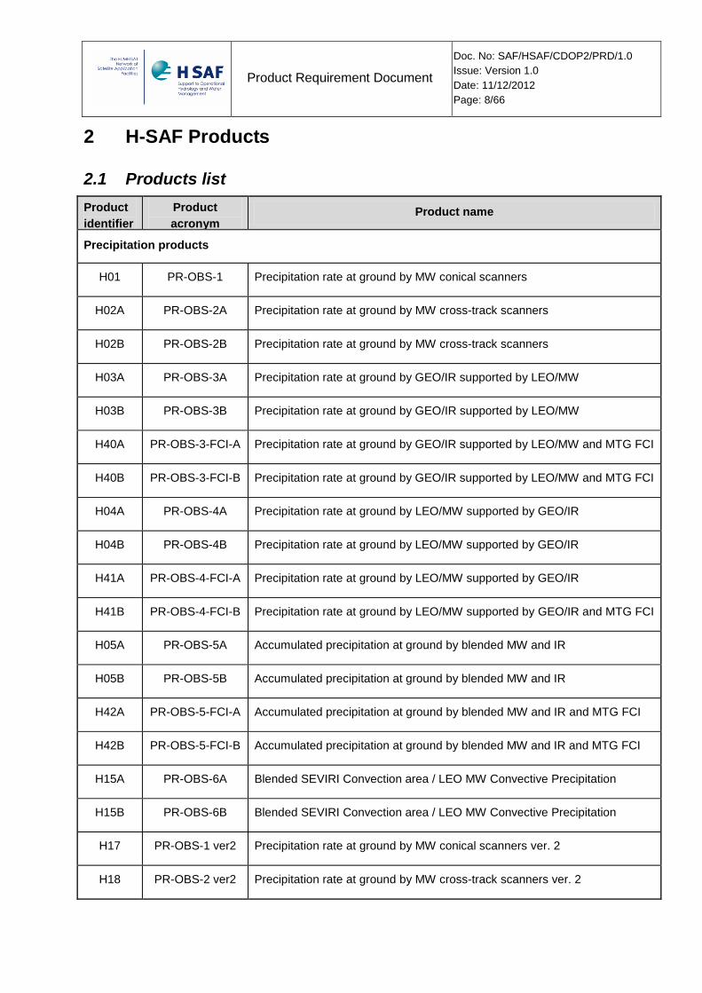
2.1 Products list
Product
identifier
Product
acronym Product name
Precipitation products
H01 PR-OBS-1 Precipitation rate at ground by MW conical scanners
H02A PR-OBS-2A Precipitation rate at ground by MW cross-track scanners
H02B PR-OBS-2B Precipitation rate at ground by MW cross-track scanners
H03A PR-OBS-3A Precipitation rate at ground by GEO/IR supported by LEO/MW
H03B PR-OBS-3B Precipitation rate at ground by GEO/IR supported by LEO/MW
H40A PR-OBS-3-FCI-A Precipitation rate at ground by GEO/IR supported by LEO/MW and MTG FCI
H40B PR-OBS-3-FCI-B Precipitation rate at ground by GEO/IR supported by LEO/MW and MTG FCI
H04A PR-OBS-4A Precipitation rate at ground by LEO/MW supported by GEO/IR
H04B PR-OBS-4B Precipitation rate at ground by LEO/MW supported by GEO/IR
H41A PR-OBS-4-FCI-A Precipitation rate at ground by LEO/MW supported by GEO/IR
H41B PR-OBS-4-FCI-B Precipitation rate at ground by LEO/MW supported by GEO/IR and MTG FCI
H05A PR-OBS-5A Accumulated precipitation at ground by blended MW and IR
H05B PR-OBS-5B Accumulated precipitation at ground by blended MW and IR
H42A PR-OBS-5-FCI-A Accumulated precipitation at ground by blended MW and IR and MTG FCI
H42B PR-OBS-5-FCI-B Accumulated precipitation at ground by blended MW and IR and MTG FCI
H15A PR-OBS-6A Blended SEVIRI Convection area / LEO MW Convective Precipitation
H15B PR-OBS-6B Blended SEVIRI Convection area / LEO MW Convective Precipitation
H17 PR-OBS-1 ver2 Precipitation rate at ground by MW conical scanners ver. 2
H18 PR-OBS-2 ver2 Precipitation rate at ground by MW cross-track scanners ver. 2
Product Requirement Document
Doc. No: SAF/HSAF/CDOP2/PRD/1.0
Issue: Version 1.0
Date: 11/12/2012
Page: 9/66
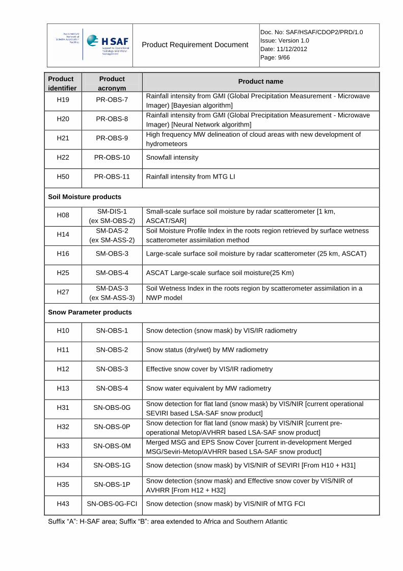
Product
identifier
Product
acronym Product name
H19 PR-OBS-7 Rainfall intensity from GMI (Global Precipitation Measurement - Microwave
Imager) [Bayesian algorithm]
H20 PR-OBS-8 Rainfall intensity from GMI (Global Precipitation Measurement - Microwave
Imager) [Neural Network algorithm]
H21 PR-OBS-9 High frequency MW delineation of cloud areas with new development of
hydrometeors
H22 PR-OBS-10 Snowfall intensity
H50 PR-OBS-11 Rainfall intensity from MTG LI
Soil Moisture products
H08 SM-DIS-1
(ex SM-OBS-2)
Small-scale surface soil moisture by radar scatterometer [1 km,
ASCAT/SAR]
H14 SM-DAS-2
(ex SM-ASS-2)
Soil Moisture Profile Index in the roots region retrieved by surface wetness
scatterometer assimilation method
H16 SM-OBS-3 Large-scale surface soil moisture by radar scatterometer (25 km, ASCAT)
H25 SM-OBS-4 ASCAT Large-scale surface soil moisture(25 Km)
H27 SM-DAS-3
(ex SM-ASS-3)
Soil Wetness Index in the roots region by scatterometer assimilation in a
NWP model
Snow Parameter products
H10 SN-OBS-1 Snow detection (snow mask) by VIS/IR radiometry
H11 SN-OBS-2 Snow status (dry/wet) by MW radiometry
H12 SN-OBS-3 Effective snow cover by VIS/IR radiometry
H13 SN-OBS-4 Snow water equivalent by MW radiometry
H31 SN-OBS-0G Snow detection for flat land (snow mask) by VIS/NIR [current operational
SEVIRI based LSA-SAF snow product]
H32 SN-OBS-0P Snow detection for flat land (snow mask) by VIS/NIR [current pre-
operational Metop/AVHRR based LSA-SAF snow product]
H33 SN-OBS-0M Merged MSG and EPS Snow Cover [current in-development Merged
MSG/Seviri-Metop/AVHRR based LSA-SAF snow product]
H34 SN-OBS-1G Snow detection (snow mask) by VIS/NIR of SEVIRI [From H10 + H31]
H35 SN-OBS-1P Snow detection (snow mask) and Effective snow cover by VIS/NIR of
AVHRR [From H12 + H32]
H43 SN-OBS-0G-FCI Snow detection (snow mask) by VIS/NIR of MTG FCI
Suffix “A”: H-SAF area; Suffix “B”: area extended to Africa and Southern Atlantic
Product Requirement Document
Doc. No: SAF/HSAF/CDOP2/PRD/1.0
Issue: Version 1.0
Date: 11/12/2012
Page: 10/66
Table 1 H-SAF products list
2.2 General requirements
UR.GE.01 - H-SAF shall generate and disseminate satellite-derived products according to
the detailed product requirements presented in section 3.
UR.GE.04 - The H-SAF products shall cover as a minimum all EUMETSAT member and
cooperating States and associated costal zones. The nominal H-SAF area coverage
stretches from latitude 25°N to 75°N, longitude 25°W to 45°E.
UR.GE.05 - The distributed H-SAF products shall be associated with characterisation of
their error structure so that users will be guided to appropriate utilisation. Guidance to
utilisation will also be supported by education and training activities on the nature of the
products and their applicability in hydrology and water management.
UR.GE.06 - All products generated in H-SAF shall be collected in near-real-time in the
central archive (real or virtual), and shall be made available to the user community through
the EUMETSAT Data Centre.
UR.GE.13 - In order to enable reconstruction of time series, or re-calibration and/or re-
processing by advanced algorithms, raw data shall be archived at the acquisition sites
(either physically or virtually) and made accessible to the H-SAF central archive.
UR.GE.14 - The system shall be designed to deal with emergency management such as
recovering missed real time production. The options range from the generation of products
at the closest possible time (though delayed), to highly-delayed recovery only for the
purpose of reconstructing time series, to acceptance of a definitive gap if the recovery is
impossible or not sufficiently cost-effective.
UR.GE.15 - The H-SAF shall install and maintain a H-SAF web site and maintain a help
desk. The web site will provide general public information on H-SAF, H-SAF products
description, rolling information on the H-SAF implementation status, the publication of
product images, and all related documentation.
UR.GE.DOC.1 - The H-SAF shall make available updated user documentation related to
its (pre-) operational products: ATBD, Product User Manual and Validation Reports.
3 Product Requirements
3.1 Precipitation products requirements
3.1.1 Precipitation Accuracy Values
Product requirements for accuracy are adopted on the basis of the principle that values be unified for each sub type of product family and by making use of the following criteria for the three values:
Product Requirement Document
Doc. No: SAF/HSAF/CDOP2/PRD/1.0
Issue: Version 1.0
Date: 11/12/2012
Page: 11/66
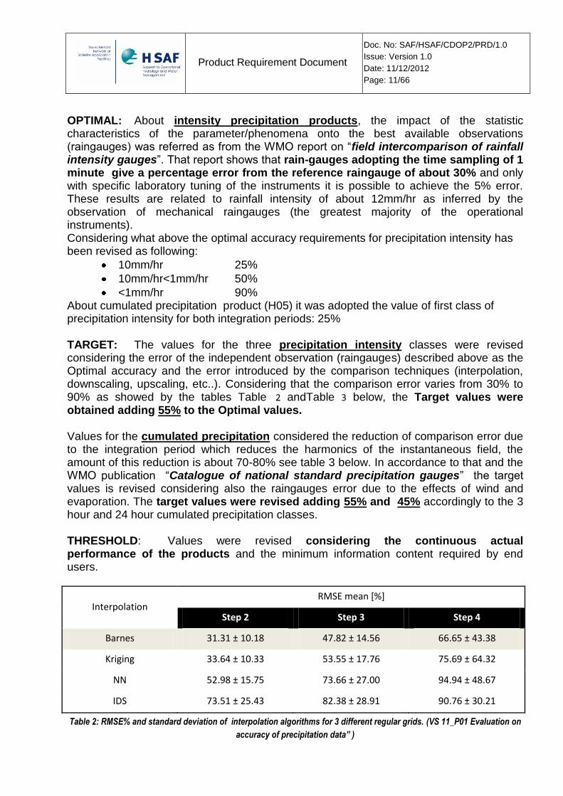
OPTIMAL: About intensity precipitation products, the impact of the statistic characteristics of the parameter/phenomena onto the best available observations (raingauges) was referred as from the WMO report on “field intercomparison of rainfall intensity gauges”. That report shows that rain-gauges adopting the time sampling of 1 minute give a percentage error from the reference raingauge of about 30% and only with specific laboratory tuning of the instruments it is possible to achieve the 5% error. These results are related to rainfall intensity of about 12mm/hr as inferred by the observation of mechanical raingauges (the greatest majority of the operational instruments). Considering what above the optimal accuracy requirements for precipitation intensity has been revised as following:
10mm/hr 25%
10mm/hr<1mm/hr 50%
<1mm/hr 90% About cumulated precipitation product (H05) it was adopted the value of first class of precipitation intensity for both integration periods: 25% TARGET: The values for the three precipitation intensity classes were revised considering the error of the independent observation (raingauges) described above as the Optimal accuracy and the error introduced by the comparison techniques (interpolation, downscaling, upscaling, etc..). Considering that the comparison error varies from 30% to 90% as showed by the tables Table 2 andTable 3 below, the Target values were obtained adding 55% to the Optimal values. Values for the cumulated precipitation considered the reduction of comparison error due to the integration period which reduces the harmonics of the instantaneous field, the amount of this reduction is about 70-80% see table 3 below. In accordance to that and the WMO publication “Catalogue of national standard precipitation gauges” the target values is revised considering also the raingauges error due to the effects of wind and evaporation. The target values were revised adding 55% and 45% accordingly to the 3 hour and 24 hour cumulated precipitation classes. THRESHOLD: Values were revised considering the continuous actual performance of the products and the minimum information content required by end users.
Interpolation RMSE mean [%]
Step 2 Step 3 Step 4
Barnes 31.31 ± 10.18 47.82 ± 14.56 66.65 ± 43.38
Kriging 33.64 ± 10.33 53.55 ± 17.76 75.69 ± 64.32
NN 52.98 ± 15.75 73.66 ± 27.00 94.94 ± 48.67
IDS 73.51 ± 25.43 82.38 ± 28.91 90.76 ± 30.21
Table 2: RMSE% and standard deviation of interpolation algorithms for 3 different regular grids. (VS 11_P01 Evaluation on
accuracy of precipitation data” )
Product Requirement Document
Doc. No: SAF/HSAF/CDOP2/PRD/1.0
Issue: Version 1.0
Date: 11/12/2012
Page: 12/66
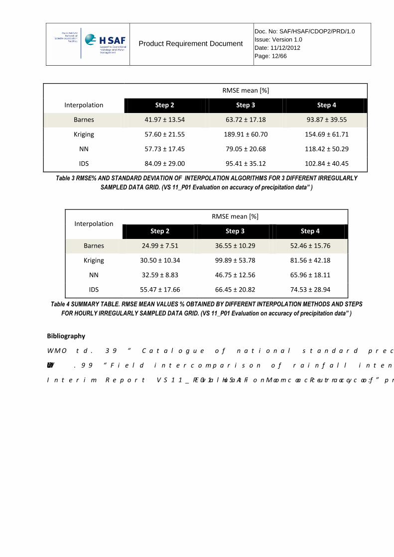
Interpolation
RMSE mean [%]
Step 2 Step 3 Step 4
Barnes 41.97 ± 13.54 63.72 ± 17.18 93.87 ± 39.55
Kriging 57.60 ± 21.55 189.91 ± 60.70 154.69 ± 61.71
NN 57.73 ± 17.45 79.05 ± 20.68 118.42 ± 50.29
IDS 84.09 ± 29.00 95.41 ± 35.12 102.84 ± 40.45
Table 3 RMSE% AND STANDARD DEVIATION OF INTERPOLATION ALGORITHMS FOR 3 DIFFERENT IRREGULARLY
SAMPLED DATA GRID. (VS 11_P01 Evaluation on accuracy of precipitation data” )
Interpolation RMSE mean [%]
Step 2 Step 3 Step 4
Barnes 24.99 ± 7.51 36.55 ± 10.29 52.46 ± 15.76
Kriging 30.50 ± 10.34 99.89 ± 53.78 81.56 ± 42.18
NN 32.59 ± 8.83 46.75 ± 12.56 65.96 ± 18.11
IDS 55.47 ± 17.66 66.45 ± 20.82 74.53 ± 28.94
Table 4 SUMMARY TABLE. RMSE MEAN VALUES % OBTAINED BY DIFFERENT INTERPOLATION METHODS AND STEPS
FOR HOURLY IRREGULARLY SAMPLED DATA GRID. (VS 11_P01 Evaluation on accuracy of precipitation data” )
Bibliography
WMO td. 39 “ Catalogue of national standard precipitation gauges”
WMO td .99 “Field intercomparison of rainfall intensity gauges”
Interim Report VS11_P01 HSAF Marco Petracca:” Evaluation on accuracy of precipitation data” in progress
Product Requirement Document
Doc. No: SAF/HSAF/CDOP2/PRD/1.0
Issue: Version 1.0
Date: 11/12/2012
Page: 13/66
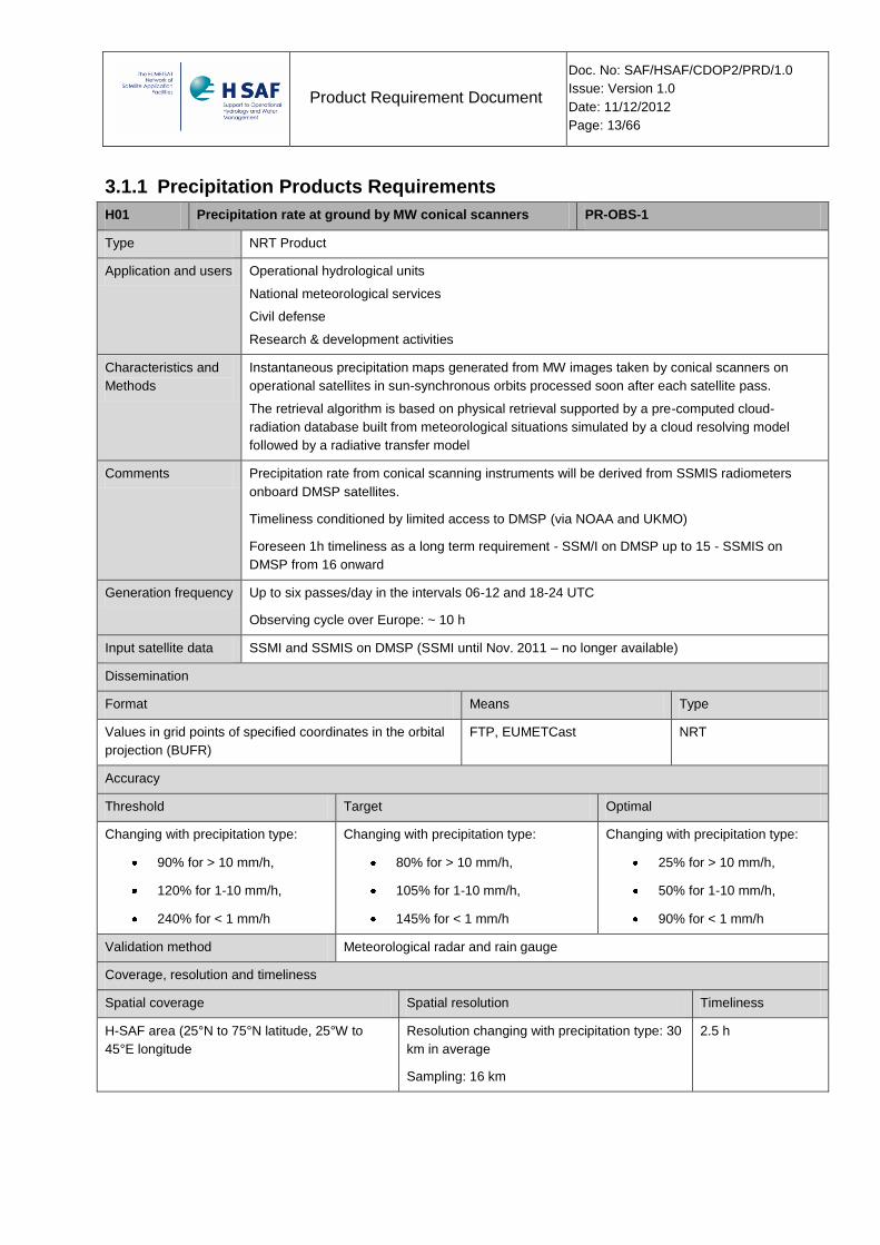
3.1.1 Precipitation Products Requirements
H01 Precipitation rate at ground by MW conical scanners PR-OBS-1
Type NRT Product
Application and users Operational hydrological units
National meteorological services
Civil defense
Research & development activities
Characteristics and
Methods
Instantaneous precipitation maps generated from MW images taken by conical scanners on
operational satellites in sun-synchronous orbits processed soon after each satellite pass.
The retrieval algorithm is based on physical retrieval supported by a pre-computed cloud-
radiation database built from meteorological situations simulated by a cloud resolving model
followed by a radiative transfer model
Comments Precipitation rate from conical scanning instruments will be derived from SSMIS radiometers
onboard DMSP satellites.
Timeliness conditioned by limited access to DMSP (via NOAA and UKMO)
Foreseen 1h timeliness as a long term requirement - SSM/I on DMSP up to 15 - SSMIS on
DMSP from 16 onward
Generation frequency Up to six passes/day in the intervals 06-12 and 18-24 UTC
Observing cycle over Europe: ~ 10 h
Input satellite data SSMI and SSMIS on DMSP (SSMI until Nov. 2011 – no longer available)
Dissemination
Format Means Type
Values in grid points of specified coordinates in the orbital
projection (BUFR)
FTP, EUMETCast NRT
Accuracy
Threshold Target Optimal
Changing with precipitation type:
90% for > 10 mm/h,
120% for 1-10 mm/h,
240% for < 1 mm/h
Changing with precipitation type:
80% for > 10 mm/h,
105% for 1-10 mm/h,
145% for < 1 mm/h
Changing with precipitation type:
25% for > 10 mm/h,
50% for 1-10 mm/h,
90% for < 1 mm/h
Validation method Meteorological radar and rain gauge
Coverage, resolution and timeliness
Spatial coverage Spatial resolution Timeliness
H-SAF area (25°N to 75°N latitude, 25°W to
45°E longitude
Resolution changing with precipitation type: 30
km in average
Sampling: 16 km
2.5 h
Product Requirement Document
Doc. No: SAF/HSAF/CDOP2/PRD/1.0
Issue: Version 1.0
Date: 11/12/2012
Page: 14/66
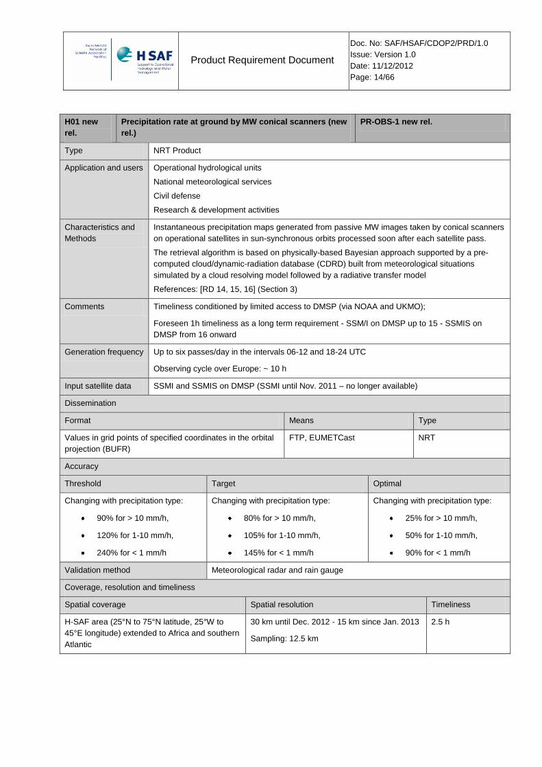
H01 new
rel.
Precipitation rate at ground by MW conical scanners (new
rel.)
PR-OBS-1 new rel.
Type NRT Product
Application and users Operational hydrological units
National meteorological services
Civil defense
Research & development activities
Characteristics and
Methods
Instantaneous precipitation maps generated from passive MW images taken by conical scanners
on operational satellites in sun-synchronous orbits processed soon after each satellite pass.
The retrieval algorithm is based on physically-based Bayesian approach supported by a pre-
computed cloud/dynamic-radiation database (CDRD) built from meteorological situations
simulated by a cloud resolving model followed by a radiative transfer model
References: [RD 14, 15, 16] (Section 3)
Comments Timeliness conditioned by limited access to DMSP (via NOAA and UKMO);
Foreseen 1h timeliness as a long term requirement - SSM/I on DMSP up to 15 - SSMIS on
DMSP from 16 onward
Generation frequency Up to six passes/day in the intervals 06-12 and 18-24 UTC
Observing cycle over Europe: ~ 10 h
Input satellite data SSMI and SSMIS on DMSP (SSMI until Nov. 2011 – no longer available)
Dissemination
Format Means Type
Values in grid points of specified coordinates in the orbital
projection (BUFR)
FTP, EUMETCast NRT
Accuracy
Threshold Target Optimal
Changing with precipitation type:
90% for > 10 mm/h,
120% for 1-10 mm/h,
240% for < 1 mm/h
Changing with precipitation type:
80% for > 10 mm/h,
105% for 1-10 mm/h,
145% for < 1 mm/h
Changing with precipitation type:
25% for > 10 mm/h,
50% for 1-10 mm/h,
90% for < 1 mm/h
Validation method Meteorological radar and rain gauge
Coverage, resolution and timeliness
Spatial coverage Spatial resolution Timeliness
H-SAF area (25°N to 75°N latitude, 25°W to
45°E longitude) extended to Africa and southern
Atlantic
30 km until Dec. 2012 - 15 km since Jan. 2013
Sampling: 12.5 km
2.5 h
Product Requirement Document
Doc. No: SAF/HSAF/CDOP2/PRD/1.0
Issue: Version 1.0
Date: 11/12/2012
Page: 15/66
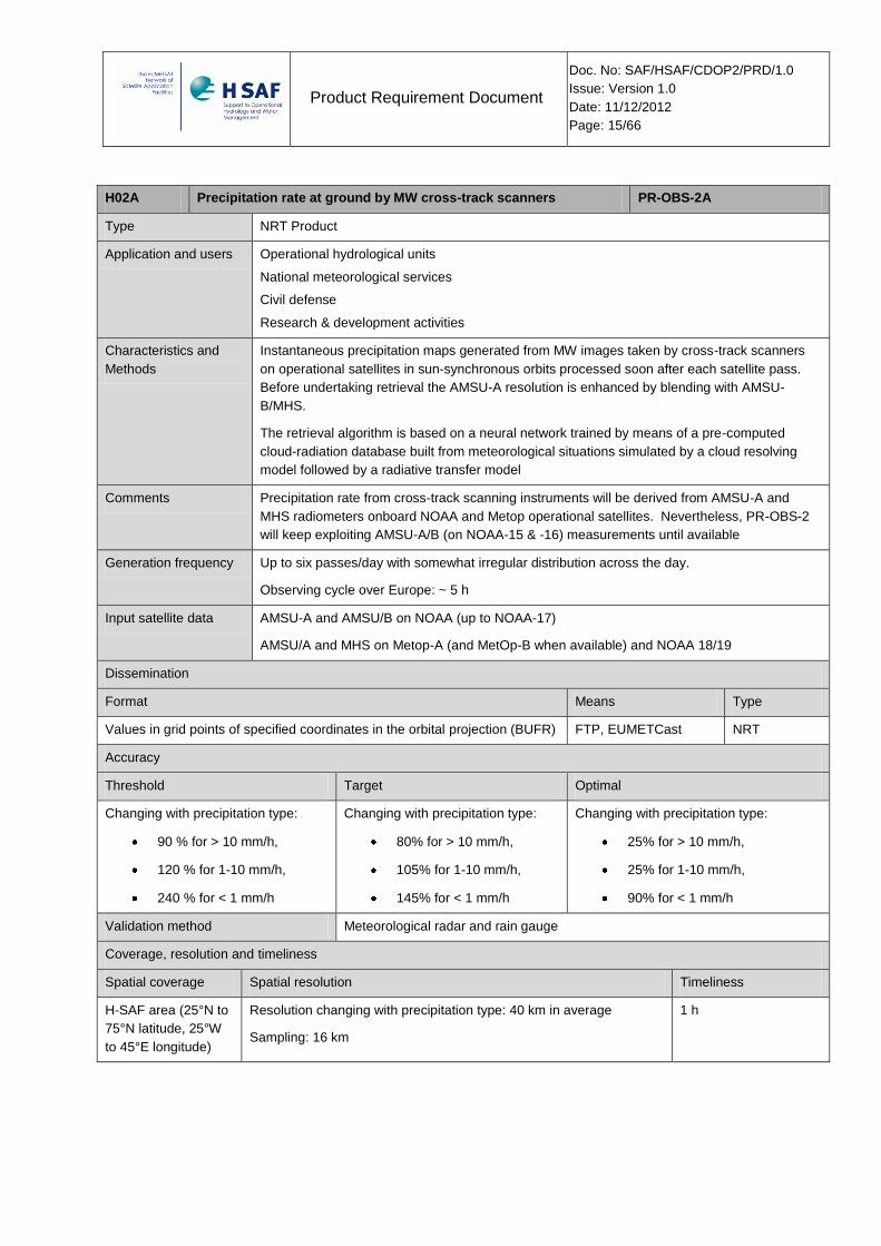
H02A Precipitation rate at ground by MW cross-track scanners PR-OBS-2A
Type NRT Product
Application and users Operational hydrological units
National meteorological services
Civil defense
Research & development activities
Characteristics and
Methods
Instantaneous precipitation maps generated from MW images taken by cross-track scanners
on operational satellites in sun-synchronous orbits processed soon after each satellite pass.
Before undertaking retrieval the AMSU-A resolution is enhanced by blending with AMSU-
B/MHS.
The retrieval algorithm is based on a neural network trained by means of a pre-computed
cloud-radiation database built from meteorological situations simulated by a cloud resolving
model followed by a radiative transfer model
Comments Precipitation rate from cross-track scanning instruments will be derived from AMSU-A and
MHS radiometers onboard NOAA and Metop operational satellites. Nevertheless, PR-OBS-2
will keep exploiting AMSU-A/B (on NOAA-15 & -16) measurements until available
Generation frequency Up to six passes/day with somewhat irregular distribution across the day.
Observing cycle over Europe: ~ 5 h
Input satellite data AMSU-A and AMSU/B on NOAA (up to NOAA-17)
AMSU/A and MHS on Metop-A (and MetOp-B when available) and NOAA 18/19
Dissemination
Format Means Type
Values in grid points of specified coordinates in the orbital projection (BUFR) FTP, EUMETCast NRT
Accuracy
Threshold Target Optimal
Changing with precipitation type:
90 % for > 10 mm/h,
120 % for 1-10 mm/h,
240 % for < 1 mm/h
Changing with precipitation type:
80% for > 10 mm/h,
105% for 1-10 mm/h,
145% for < 1 mm/h
Changing with precipitation type:
25% for > 10 mm/h,
25% for 1-10 mm/h,
90% for < 1 mm/h
Validation method Meteorological radar and rain gauge
Coverage, resolution and timeliness
Spatial coverage Spatial resolution Timeliness
H-SAF area (25°N to
75°N latitude, 25°W
to 45°E longitude)
Resolution changing with precipitation type: 40 km in average
Sampling: 16 km
1 h
Product Requirement Document
Doc. No: SAF/HSAF/CDOP2/PRD/1.0
Issue: Version 1.0
Date: 11/12/2012
Page: 16/66
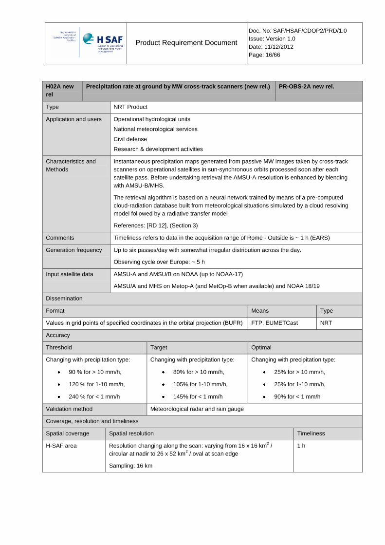
H02A new
rel
Precipitation rate at ground by MW cross-track scanners (new rel.) PR-OBS-2A new rel.
Type NRT Product
Application and users Operational hydrological units
National meteorological services
Civil defense
Research & development activities
Characteristics and
Methods
Instantaneous precipitation maps generated from passive MW images taken by cross-track
scanners on operational satellites in sun-synchronous orbits processed soon after each
satellite pass. Before undertaking retrieval the AMSU-A resolution is enhanced by blending
with AMSU-B/MHS.
The retrieval algorithm is based on a neural network trained by means of a pre-computed
cloud-radiation database built from meteorological situations simulated by a cloud resolving
model followed by a radiative transfer model
References: [RD 12], (Section 3)
Comments Timeliness refers to data in the acquisition range of Rome - Outside is ~ 1 h (EARS)
Generation frequency Up to six passes/day with somewhat irregular distribution across the day.
Observing cycle over Europe: ~ 5 h
Input satellite data AMSU-A and AMSU/B on NOAA (up to NOAA-17)
AMSU/A and MHS on Metop-A (and MetOp-B when available) and NOAA 18/19
Dissemination
Format Means Type
Values in grid points of specified coordinates in the orbital projection (BUFR) FTP, EUMETCast NRT
Accuracy
Threshold Target Optimal
Changing with precipitation type:
90 % for > 10 mm/h,
120 % for 1-10 mm/h,
240 % for < 1 mm/h
Changing with precipitation type:
80% for > 10 mm/h,
105% for 1-10 mm/h,
145% for < 1 mm/h
Changing with precipitation type:
25% for > 10 mm/h,
25% for 1-10 mm/h,
90% for < 1 mm/h
Validation method Meteorological radar and rain gauge
Coverage, resolution and timeliness
Spatial coverage Spatial resolution Timeliness
H-SAF area Resolution changing along the scan: varying from 16 x 16 km2 /
circular at nadir to 26 x 52 km2 / oval at scan edge
Sampling: 16 km
1 h
Product Requirement Document
Doc. No: SAF/HSAF/CDOP2/PRD/1.0
Issue: Version 1.0
Date: 11/12/2012
Page: 17/66
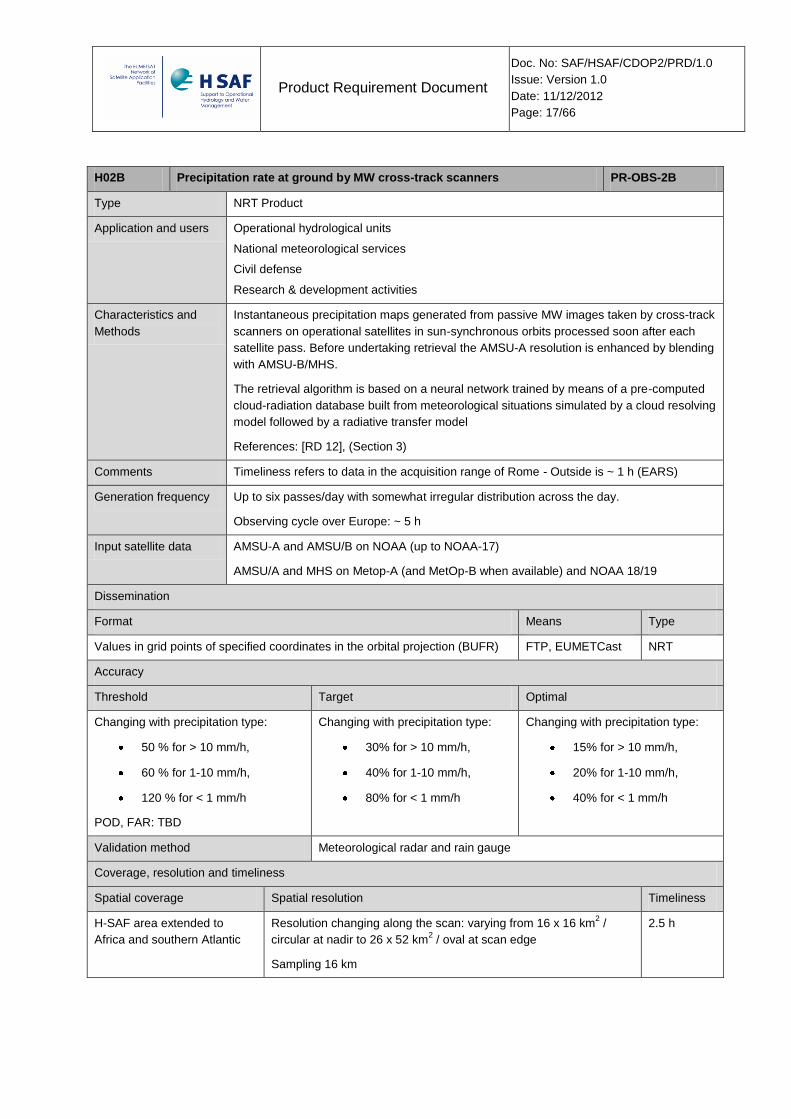
H02B Precipitation rate at ground by MW cross-track scanners PR-OBS-2B
Type NRT Product
Application and users Operational hydrological units
National meteorological services
Civil defense
Research & development activities
Characteristics and
Methods
Instantaneous precipitation maps generated from passive MW images taken by cross-track
scanners on operational satellites in sun-synchronous orbits processed soon after each
satellite pass. Before undertaking retrieval the AMSU-A resolution is enhanced by blending
with AMSU-B/MHS.
The retrieval algorithm is based on a neural network trained by means of a pre-computed
cloud-radiation database built from meteorological situations simulated by a cloud resolving
model followed by a radiative transfer model
References: [RD 12], (Section 3)
Comments Timeliness refers to data in the acquisition range of Rome - Outside is ~ 1 h (EARS)
Generation frequency Up to six passes/day with somewhat irregular distribution across the day.
Observing cycle over Europe: ~ 5 h
Input satellite data AMSU-A and AMSU/B on NOAA (up to NOAA-17)
AMSU/A and MHS on Metop-A (and MetOp-B when available) and NOAA 18/19
Dissemination
Format Means Type
Values in grid points of specified coordinates in the orbital projection (BUFR) FTP, EUMETCast NRT
Accuracy
Threshold Target Optimal
Changing with precipitation type:
50 % for > 10 mm/h,
60 % for 1-10 mm/h,
120 % for < 1 mm/h
POD, FAR: TBD
Changing with precipitation type:
30% for > 10 mm/h,
40% for 1-10 mm/h,
80% for < 1 mm/h
Changing with precipitation type:
15% for > 10 mm/h,
20% for 1-10 mm/h,
40% for < 1 mm/h
Validation method Meteorological radar and rain gauge
Coverage, resolution and timeliness
Spatial coverage Spatial resolution Timeliness
H-SAF area extended to
Africa and southern Atlantic
Resolution changing along the scan: varying from 16 x 16 km2 /
circular at nadir to 26 x 52 km2 / oval at scan edge
Sampling 16 km
2.5 h
Product Requirement Document
Doc. No: SAF/HSAF/CDOP2/PRD/1.0
Issue: Version 1.0
Date: 11/12/2012
Page: 18/66
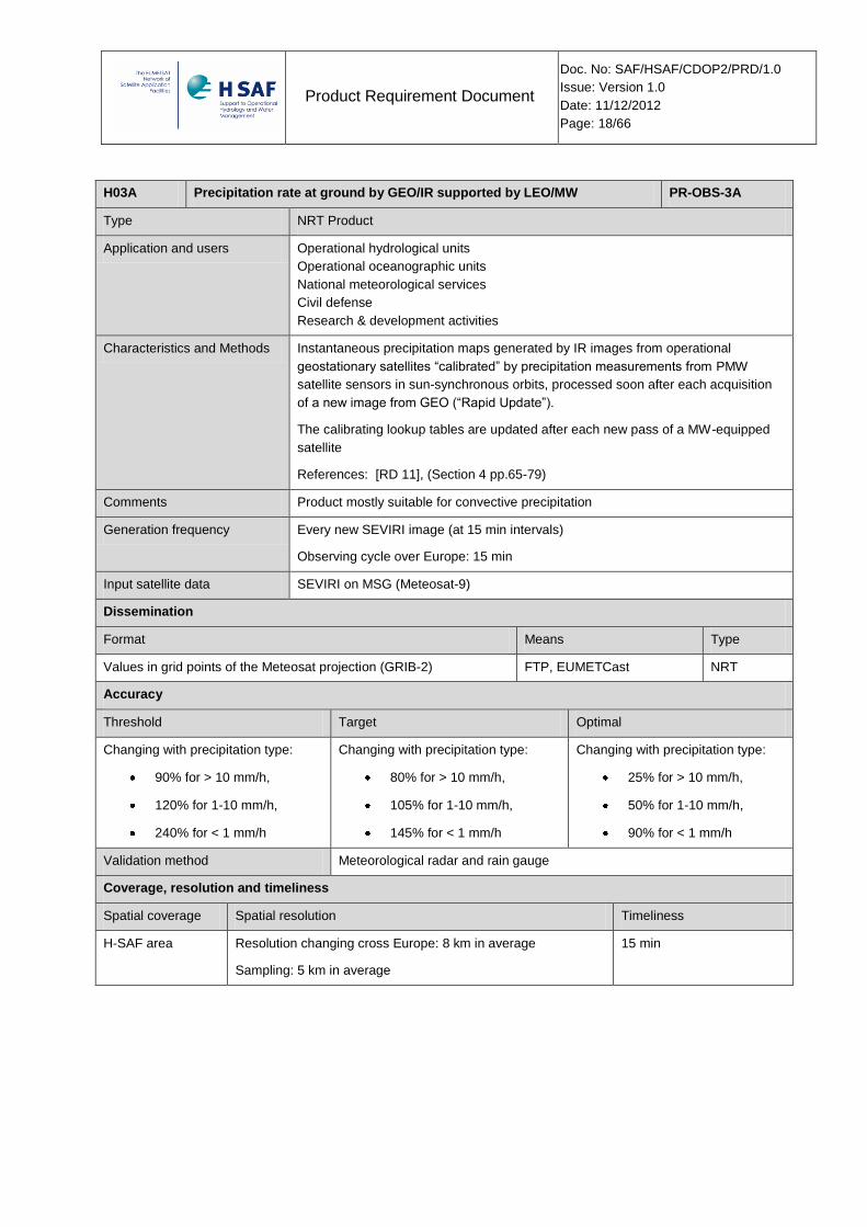
H03A Precipitation rate at ground by GEO/IR supported by LEO/MW PR-OBS-3A
Type NRT Product
Application and users Operational hydrological units
Operational oceanographic units
National meteorological services
Civil defense
Research & development activities
Characteristics and Methods Instantaneous precipitation maps generated by IR images from operational
geostationary satellites “calibrated” by precipitation measurements from PMW
satellite sensors in sun-synchronous orbits, processed soon after each acquisition
of a new image from GEO (“Rapid Update”).
The calibrating lookup tables are updated after each new pass of a MW-equipped
satellite
References: [RD 11], (Section 4 pp.65-79)
Comments Product mostly suitable for convective precipitation
Generation frequency Every new SEVIRI image (at 15 min intervals)
Observing cycle over Europe: 15 min
Input satellite data SEVIRI on MSG (Meteosat-9)
Dissemination
Format Means Type
Values in grid points of the Meteosat projection (GRIB-2) FTP, EUMETCast NRT
Accuracy
Threshold Target Optimal
Changing with precipitation type:
90% for > 10 mm/h,
120% for 1-10 mm/h,
240% for < 1 mm/h
Changing with precipitation type:
80% for > 10 mm/h,
105% for 1-10 mm/h,
145% for < 1 mm/h
Changing with precipitation type:
25% for > 10 mm/h,
50% for 1-10 mm/h,
90% for < 1 mm/h
Validation method Meteorological radar and rain gauge
Coverage, resolution and timeliness
Spatial coverage Spatial resolution Timeliness
H-SAF area Resolution changing cross Europe: 8 km in average
Sampling: 5 km in average
15 min
Product Requirement Document
Doc. No: SAF/HSAF/CDOP2/PRD/1.0
Issue: Version 1.0
Date: 11/12/2012
Page: 19/66
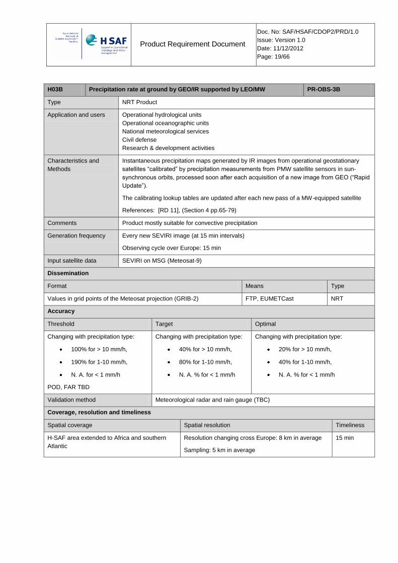
H03B Precipitation rate at ground by GEO/IR supported by LEO/MW PR-OBS-3B
Type NRT Product
Application and users Operational hydrological units
Operational oceanographic units
National meteorological services
Civil defense
Research & development activities
Characteristics and
Methods
Instantaneous precipitation maps generated by IR images from operational geostationary
satellites “calibrated” by precipitation measurements from PMW satellite sensors in sun-
synchronous orbits, processed soon after each acquisition of a new image from GEO (“Rapid
Update”).
The calibrating lookup tables are updated after each new pass of a MW-equipped satellite
References: [RD 11], (Section 4 pp.65-79)
Comments Product mostly suitable for convective precipitation
Generation frequency Every new SEVIRI image (at 15 min intervals)
Observing cycle over Europe: 15 min
Input satellite data SEVIRI on MSG (Meteosat-9)
Dissemination
Format Means Type
Values in grid points of the Meteosat projection (GRIB-2) FTP, EUMETCast NRT
Accuracy
Threshold Target Optimal
Changing with precipitation type:
100% for > 10 mm/h,
190% for 1-10 mm/h,
N. A. for < 1 mm/h
POD, FAR TBD
Changing with precipitation type:
40% for > 10 mm/h,
80% for 1-10 mm/h,
N. A. % for < 1 mm/h
Changing with precipitation type:
20% for > 10 mm/h,
40% for 1-10 mm/h,
N. A. % for < 1 mm/h
Validation method Meteorological radar and rain gauge (TBC)
Coverage, resolution and timeliness
Spatial coverage Spatial resolution Timeliness
H-SAF area extended to Africa and southern
Atlantic
Resolution changing cross Europe: 8 km in average
Sampling: 5 km in average
15 min
Product Requirement Document
Doc. No: SAF/HSAF/CDOP2/PRD/1.0
Issue: Version 1.0
Date: 11/12/2012
Page: 20/66
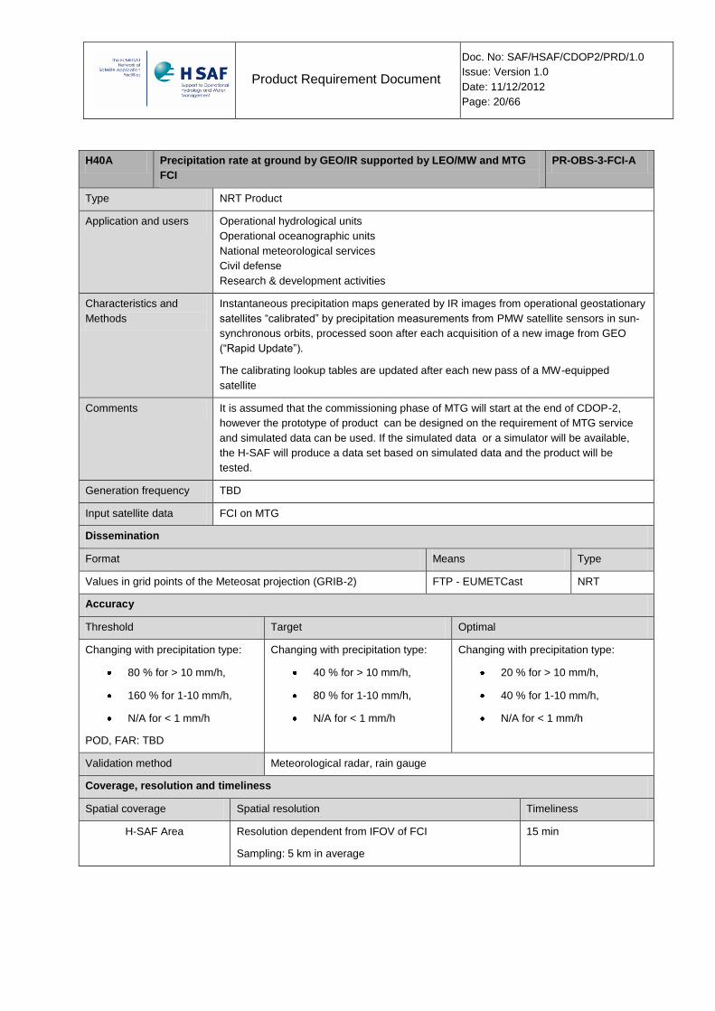
H40A Precipitation rate at ground by GEO/IR supported by LEO/MW and MTG
FCI
PR-OBS-3-FCI-A
Type NRT Product
Application and users Operational hydrological units
Operational oceanographic units
National meteorological services
Civil defense
Research & development activities
Characteristics and
Methods
Instantaneous precipitation maps generated by IR images from operational geostationary
satellites “calibrated” by precipitation measurements from PMW satellite sensors in sun-
synchronous orbits, processed soon after each acquisition of a new image from GEO
(“Rapid Update”).
The calibrating lookup tables are updated after each new pass of a MW-equipped
satellite
Comments It is assumed that the commissioning phase of MTG will start at the end of CDOP-2,
however the prototype of product can be designed on the requirement of MTG service
and simulated data can be used. If the simulated data or a simulator will be available,
the H-SAF will produce a data set based on simulated data and the product will be
tested.
Generation frequency TBD
Input satellite data FCI on MTG
Dissemination
Format Means Type
Values in grid points of the Meteosat projection (GRIB-2) FTP - EUMETCast NRT
Accuracy
Threshold Target Optimal
Changing with precipitation type:
80 % for > 10 mm/h,
160 % for 1-10 mm/h,
N/A for < 1 mm/h
POD, FAR: TBD
Changing with precipitation type:
40 % for > 10 mm/h,
80 % for 1-10 mm/h,
N/A for < 1 mm/h
Changing with precipitation type:
20 % for > 10 mm/h,
40 % for 1-10 mm/h,
N/A for < 1 mm/h
Validation method Meteorological radar, rain gauge
Coverage, resolution and timeliness
Spatial coverage Spatial resolution Timeliness
H-SAF Area Resolution dependent from IFOV of FCI
Sampling: 5 km in average
15 min
Product Requirement Document
Doc. No: SAF/HSAF/CDOP2/PRD/1.0
Issue: Version 1.0
Date: 11/12/2012
Page: 21/66
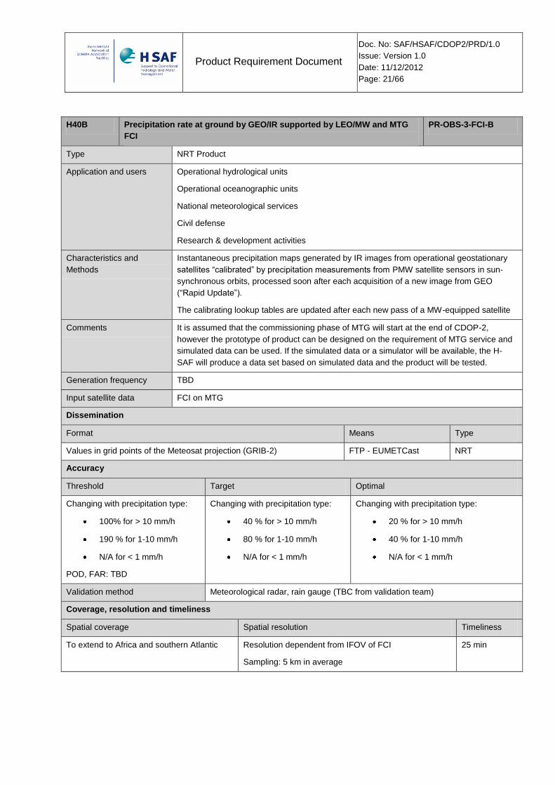
H40B Precipitation rate at ground by GEO/IR supported by LEO/MW and MTG
FCI
PR-OBS-3-FCI-B
Type NRT Product
Application and users Operational hydrological units
Operational oceanographic units
National meteorological services
Civil defense
Research & development activities
Characteristics and
Methods
Instantaneous precipitation maps generated by IR images from operational geostationary
satellites “calibrated” by precipitation measurements from PMW satellite sensors in sun-
synchronous orbits, processed soon after each acquisition of a new image from GEO
(“Rapid Update”).
The calibrating lookup tables are updated after each new pass of a MW-equipped satellite
Comments It is assumed that the commissioning phase of MTG will start at the end of CDOP-2,
however the prototype of product can be designed on the requirement of MTG service and
simulated data can be used. If the simulated data or a simulator will be available, the H-
SAF will produce a data set based on simulated data and the product will be tested.
Generation frequency TBD
Input satellite data FCI on MTG
Dissemination
Format Means Type
Values in grid points of the Meteosat projection (GRIB-2) FTP - EUMETCast NRT
Accuracy
Threshold Target Optimal
Changing with precipitation type:
100% for > 10 mm/h
190 % for 1-10 mm/h
N/A for < 1 mm/h
POD, FAR: TBD
Changing with precipitation type:
40 % for > 10 mm/h
80 % for 1-10 mm/h
N/A for < 1 mm/h
Changing with precipitation type:
20 % for > 10 mm/h
40 % for 1-10 mm/h
N/A for < 1 mm/h
Validation method Meteorological radar, rain gauge (TBC from validation team)
Coverage, resolution and timeliness
Spatial coverage Spatial resolution Timeliness
To extend to Africa and southern Atlantic Resolution dependent from IFOV of FCI
Sampling: 5 km in average
25 min

Product Requirement Document
Doc. No: SAF/HSAF/CDOP2/PRD/1.0
Issue: Version 1.0
Date: 11/12/2012
Page: 22/66
H04A Precipitation rate at ground by LEO/MW supported by GEO/IR PR-OBS-4A
Type NRT Product
Application and users Hydrology
Climate monitoring
Risk Management
Meteorology
Characteristics and
Methods
Instantaneous precipitation maps generated by PMW satellite sensors from operational
satellites in sun-synchronous orbits, time-interpolated by exploiting the dynamical
information observed on IR images from GEO.
The algorithm performs the interpolation soon after the acquisition of a new image from
LEO. This method (“Morphing”) is particularly suited for computing accumulated
precipitation of use in hydrology.
Comments Product primarily designed for climatology.
Applicability in an operational framework to be assessed.
Input data are merged into one product file
Generation frequency 12 times per day
Input satellite data SEVIRI on MSG;
H-SAF PR-OBS-01
H-SAF PR-OBS-02
Dissemination
Format Means Type
Equidistant cylindrical or Plate Carree (GRIB-2) FTP, EUMETCast NRT
Accuracy
Threshold Target Optimal
Changing with precipitation type:
90% for > 10 mm/h,
120% for 1-10 mm/h,
240% for < 1 mm/h
Changing with precipitation type:
80% for > 10 mm/h,
105% for 1-10 mm/h,
145% for < 1 mm/h
Changing with precipitation type:
25% for > 10 mm/h,
50% for 1-10 mm/h,
90% for < 1 mm/h
Validation method Meteorological radar and rain gauge (TBC from validation team)
Coverage, resolution and timeliness
Spatial coverage Spatial resolution Timeliness
H-SAF area (25°N to 75°N latitude, 25°W to 45°E
longitude) (degradation expected at very high
latitudes)
Resolution: 30 km in average
Sampling: 8 km in average
4 hours
Product Requirement Document
Doc. No: SAF/HSAF/CDOP2/PRD/1.0
Issue: Version 1.0
Date: 11/12/2012
Page: 23/66
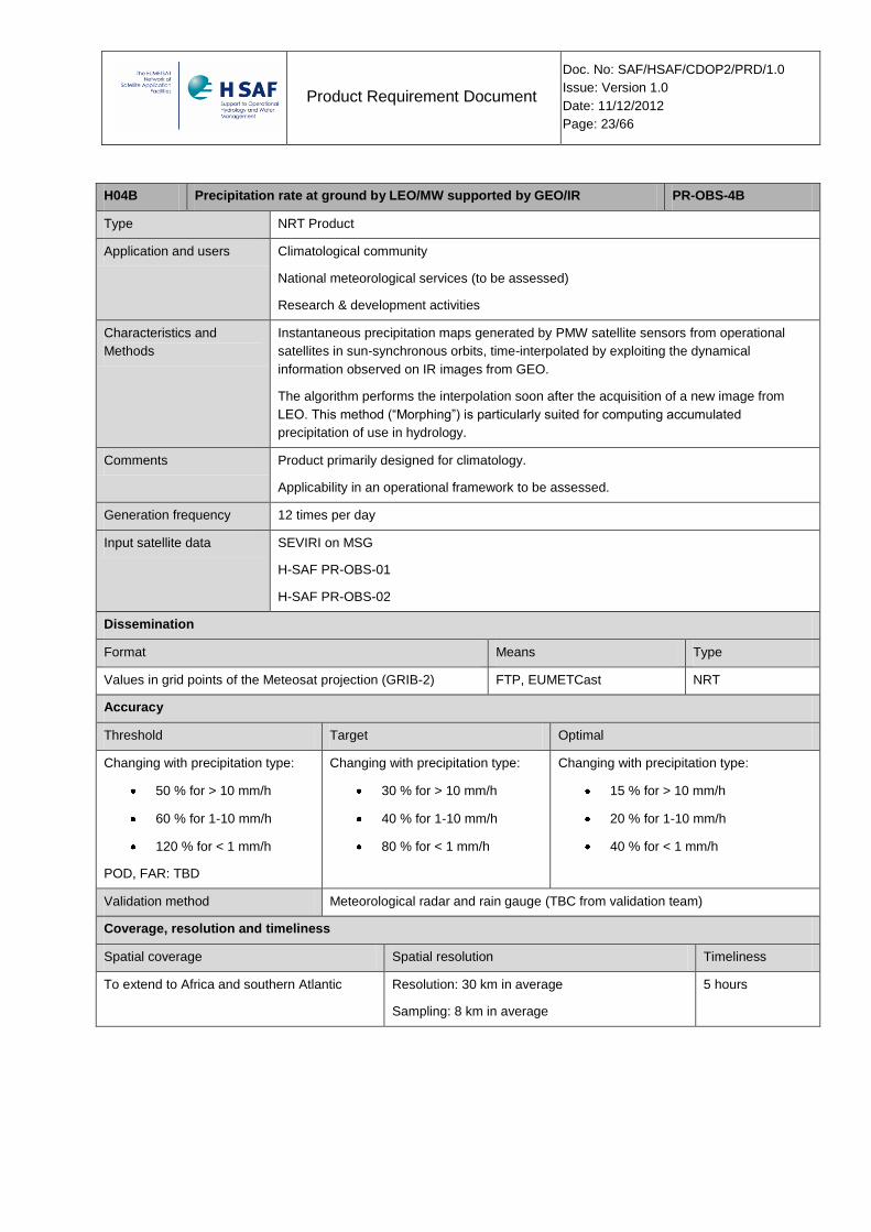
H04B Precipitation rate at ground by LEO/MW supported by GEO/IR PR-OBS-4B
Type NRT Product
Application and users Climatological community
National meteorological services (to be assessed)
Research & development activities
Characteristics and
Methods
Instantaneous precipitation maps generated by PMW satellite sensors from operational
satellites in sun-synchronous orbits, time-interpolated by exploiting the dynamical
information observed on IR images from GEO.
The algorithm performs the interpolation soon after the acquisition of a new image from
LEO. This method (“Morphing”) is particularly suited for computing accumulated
precipitation of use in hydrology.
Comments Product primarily designed for climatology.
Applicability in an operational framework to be assessed.
Generation frequency 12 times per day
Input satellite data SEVIRI on MSG
H-SAF PR-OBS-01
H-SAF PR-OBS-02
Dissemination
Format Means Type
Values in grid points of the Meteosat projection (GRIB-2) FTP, EUMETCast NRT
Accuracy
Threshold Target Optimal
Changing with precipitation type:
50 % for > 10 mm/h
60 % for 1-10 mm/h
120 % for < 1 mm/h
POD, FAR: TBD
Changing with precipitation type:
30 % for > 10 mm/h
40 % for 1-10 mm/h
80 % for < 1 mm/h
Changing with precipitation type:
15 % for > 10 mm/h
20 % for 1-10 mm/h
40 % for < 1 mm/h
Validation method Meteorological radar and rain gauge (TBC from validation team)
Coverage, resolution and timeliness
Spatial coverage Spatial resolution Timeliness
To extend to Africa and southern Atlantic Resolution: 30 km in average
Sampling: 8 km in average
5 hours
Product Requirement Document
Doc. No: SAF/HSAF/CDOP2/PRD/1.0
Issue: Version 1.0
Date: 11/12/2012
Page: 24/66
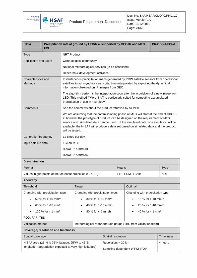
H41A Precipitation rate at ground by LEO/MW supported by GEO/IR and MTG
FCI
PR-OBS-4-FCI-A
Type NRT Product
Application and users Climatological community
National meteorological services (to be assessed)
Research & development activities
Characteristics and
Methods
Instantaneous precipitation maps generated by PMW satellite sensors from operational
satellites in sun-synchronous orbits, time-interpolated by exploiting the dynamical
information observed on IR images from GEO.
The algorithm performs the interpolation soon after the acquisition of a new image from
LEO. This method (“Morphing”) is particularly suited for computing accumulated
precipitation of use in hydrology.
Comments See the comments about the product retrieved by SEVIRI.
We are assuming that the commissioning phase of MTG will start at the end of CDOP-
2, however the prototype of product can be designed on the requirement of MTG
service and simulated data can be used. If the simulated data or a simulator will be
available, the H-SAF will produce a data set based on simulated data and the product
will be tested.
Generation frequency 12 times per day
Input satellite data FCI on MTG
H-SAF PR-OBS-01
H-SAF PR-OBS-02
Dissemination
Format Means Type
Values in grid points of the Meteosat projection (GRIB-2) FTP, EUMETCast NRT
Accuracy
Threshold Target Optimal
Changing with precipitation type:
50 % for > 10 mm/h
60 % for 1-10 mm/h
120 % for < 1 mm/h
POD, FAR: TBD
Changing with precipitation type:
30 % for > 10 mm/h
40 % for 1-10 mm/h
80 % for < 1 mm/h
Changing with precipitation type:
15 % for > 10 mm/h
20 % for 1-10 mm/h
40 % for < 1 mm/h
Validation method Meteorological radar and rain gauge (TBC from validation team)
Coverage, resolution and timeliness
Spatial coverage Spatial resolution Timeliness
H-SAF area (25°N to 75°N latitude, 25°W to 45°E
longitude) (degradation expected at very high latitudes)
Resolution: ~ 30 km
Sampling dependent of FCI IFOV
4 hours

Product Requirement Document
Doc. No: SAF/HSAF/CDOP2/PRD/1.0
Issue: Version 1.0
Date: 11/12/2012
Page: 25/66
H41B Precipitation rate at ground by LEO/MW supported by GEO/IR and MTG
FCI
PR-OBS-4-FCI-B
Type NRT Product
Application and users Climatological community
National meteorological services (to be assessed)
Research & development activities
Characteristics and
Methods
Instantaneous precipitation maps generated by PMW satellite sensors from operational
satellites in sun-synchronous orbits, time-interpolated by exploiting the dynamical information
observed on IR images from GEO.
The algorithm performs the interpolation soon after the acquisition of a new image from LEO.
This method (“Morphing”) is particularly suited for computing accumulated precipitation of use
in hydrology.
Comments See the comments about the product retrieved by SEVIRI.
We are assuming that the commissioning phase of MTG will start at the end of CDOP-2,
however the prototype of product can be designed on the requirement of MTG service and
simulated data can be used. If the simulated data or a simulator will be available, the H-SAF
will produce a data set based on simulated data and the product will be tested.
Generation frequency 12 times per day
Input satellite data FCI on MTG;
H-SAF PR-OBS-01
H-SAF PR-OBS-02
Dissemination
Format Means Type
Values in grid points of the Meteosat projection (GRIB-2) FTP, EUMETCast NRT
Accuracy
Threshold Target Optimal
Changing with precipitation type:
50 % for > 10 mm/h
60 % for 1-10 mm/h
120 % for < 1 mm/h
POD, FAR: TBD
Changing with precipitation type:
30 % for > 10 mm/h
40 % for 1-10 mm/h
80 % for < 1 mm/h
Changing with precipitation type:
25% for > 10 mm/h,
50% for 1-10 mm/h,
90% for < 1 mm/h
Validation method Meteorological radar and rain gauge (TBC from validation team)
Coverage, resolution and timeliness
Spatial coverage Spatial resolution Timeliness
To extend to Africa and southern Atlantic Resolution: ~ 30 km
Sampling dependent of FCI IFOV
5 hours
Product Requirement Document
Doc. No: SAF/HSAF/CDOP2/PRD/1.0
Issue: Version 1.0
Date: 11/12/2012
Page: 26/66
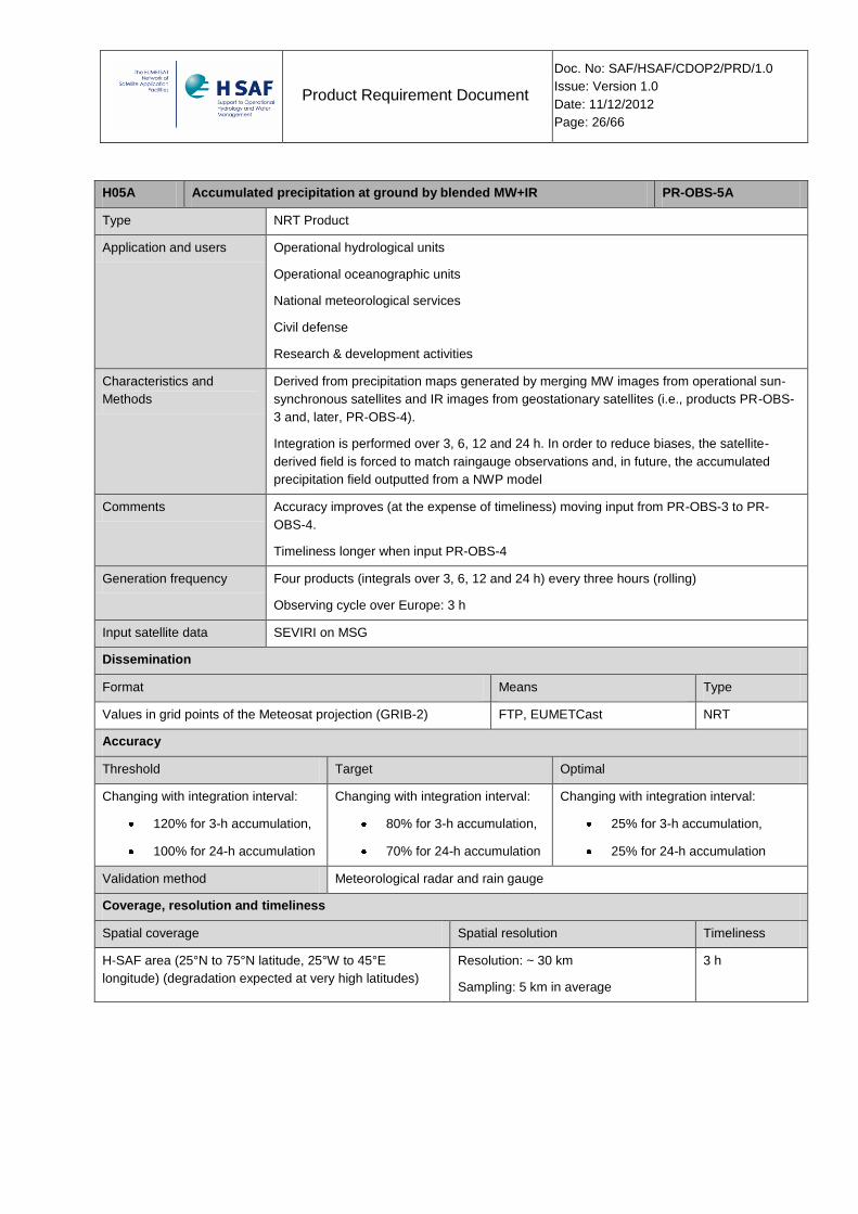
H05A Accumulated precipitation at ground by blended MW+IR PR-OBS-5A
Type NRT Product
Application and users Operational hydrological units
Operational oceanographic units
National meteorological services
Civil defense
Research & development activities
Characteristics and
Methods
Derived from precipitation maps generated by merging MW images from operational sun-
synchronous satellites and IR images from geostationary satellites (i.e., products PR-OBS-
3 and, later, PR-OBS-4).
Integration is performed over 3, 6, 12 and 24 h. In order to reduce biases, the satellite-
derived field is forced to match raingauge observations and, in future, the accumulated
precipitation field outputted from a NWP model
Comments Accuracy improves (at the expense of timeliness) moving input from PR-OBS-3 to PR-
OBS-4.
Timeliness longer when input PR-OBS-4
Generation frequency Four products (integrals over 3, 6, 12 and 24 h) every three hours (rolling)
Observing cycle over Europe: 3 h
Input satellite data SEVIRI on MSG
Dissemination
Format Means Type
Values in grid points of the Meteosat projection (GRIB-2) FTP, EUMETCast NRT
Accuracy
Threshold Target Optimal
Changing with integration interval:
120% for 3-h accumulation,
100% for 24-h accumulation
Changing with integration interval:
80% for 3-h accumulation,
70% for 24-h accumulation
Changing with integration interval:
25% for 3-h accumulation,
25% for 24-h accumulation
Validation method Meteorological radar and rain gauge
Coverage, resolution and timeliness
Spatial coverage Spatial resolution Timeliness
H-SAF area (25°N to 75°N latitude, 25°W to 45°E
longitude) (degradation expected at very high latitudes)
Resolution: ~ 30 km
Sampling: 5 km in average
3 h
Product Requirement Document
Doc. No: SAF/HSAF/CDOP2/PRD/1.0
Issue: Version 1.0
Date: 11/12/2012
Page: 27/66
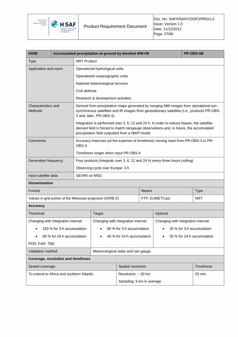
H05B Accumulated precipitation at ground by blended MW+IR PR-OBS-5B
Type NRT Product
Application and users Operational hydrological units
Operational oceanographic units
National meteorological services
Civil defense
Research & development activities
Characteristics and
Methods
Derived from precipitation maps generated by merging MW images from operational sun-
synchronous satellites and IR images from geostationary satellites (i.e., products PR-OBS-
3 and, later, PR-OBS-4).
Integration is performed over 3, 6, 12 and 24 h. In order to reduce biases, the satellite-
derived field is forced to match raingauge observations and, in future, the accumulated
precipitation field outputted from a NWP model
Comments Accuracy improves (at the expense of timeliness) moving input from PR-OBS-3 to PR-
OBS-4.
Timeliness longer when input PR-OBS-4
Generation frequency Four products (integrals over 3, 6, 12 and 24 h) every three hours (rolling)
Observing cycle over Europe: 3 h
Input satellite data SEVIRI on MSG
Dissemination
Format Means Type
Values in grid points of the Meteosat projection (GRIB-2) FTP, EUMETCast NRT
Accuracy
Threshold Target Optimal
Changing with integration interval:
150 % for 3-h accumulation
90 % for 24-h accumulation
POD, FAR: TBD
Changing with integration interval:
60 % for 3-h accumulation
40 % for 24-h accumulation
Changing with integration interval:
30 % for 3-h accumulation
20 % for 24-h accumulation
Validation method Meteorological radar and rain gauge
Coverage, resolution and timeliness
Spatial coverage Spatial resolution Timeliness
To extend to Africa and southern Atlantic Resolution: ~ 30 km
Sampling: 5 km in average
25 min
Product Requirement Document
Doc. No: SAF/HSAF/CDOP2/PRD/1.0
Issue: Version 1.0
Date: 11/12/2012
Page: 28/66
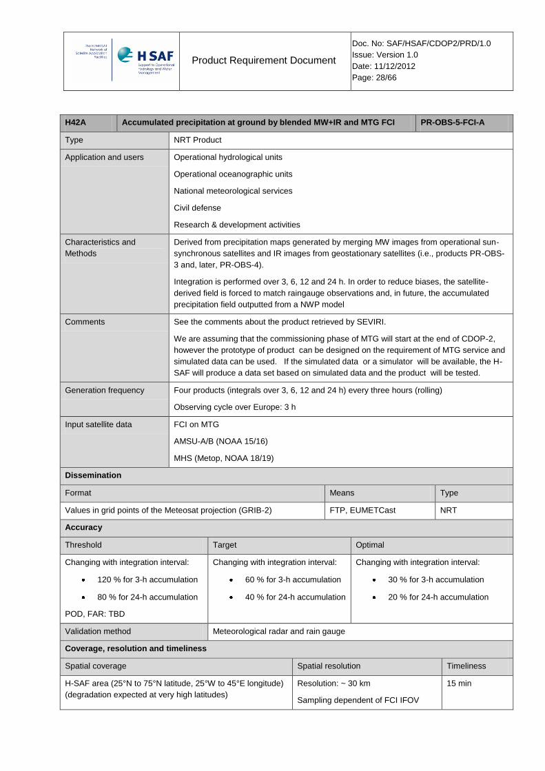
H42A Accumulated precipitation at ground by blended MW+IR and MTG FCI PR-OBS-5-FCI-A
Type NRT Product
Application and users Operational hydrological units
Operational oceanographic units
National meteorological services
Civil defense
Research & development activities
Characteristics and
Methods
Derived from precipitation maps generated by merging MW images from operational sun-
synchronous satellites and IR images from geostationary satellites (i.e., products PR-OBS-
3 and, later, PR-OBS-4).
Integration is performed over 3, 6, 12 and 24 h. In order to reduce biases, the satellite-
derived field is forced to match raingauge observations and, in future, the accumulated
precipitation field outputted from a NWP model
Comments See the comments about the product retrieved by SEVIRI.
We are assuming that the commissioning phase of MTG will start at the end of CDOP-2,
however the prototype of product can be designed on the requirement of MTG service and
simulated data can be used. If the simulated data or a simulator will be available, the H-
SAF will produce a data set based on simulated data and the product will be tested.
Generation frequency Four products (integrals over 3, 6, 12 and 24 h) every three hours (rolling)
Observing cycle over Europe: 3 h
Input satellite data FCI on MTG
AMSU-A/B (NOAA 15/16)
MHS (Metop, NOAA 18/19)
Dissemination
Format Means Type
Values in grid points of the Meteosat projection (GRIB-2) FTP, EUMETCast NRT
Accuracy
Threshold Target Optimal
Changing with integration interval:
120 % for 3-h accumulation
80 % for 24-h accumulation
POD, FAR: TBD
Changing with integration interval:
60 % for 3-h accumulation
40 % for 24-h accumulation
Changing with integration interval:
30 % for 3-h accumulation
20 % for 24-h accumulation
Validation method Meteorological radar and rain gauge
Coverage, resolution and timeliness
Spatial coverage Spatial resolution Timeliness
H-SAF area (25°N to 75°N latitude, 25°W to 45°E longitude)
(degradation expected at very high latitudes)
Resolution: ~ 30 km
Sampling dependent of FCI IFOV
15 min
Product Requirement Document
Doc. No: SAF/HSAF/CDOP2/PRD/1.0
Issue: Version 1.0
Date: 11/12/2012
Page: 29/66
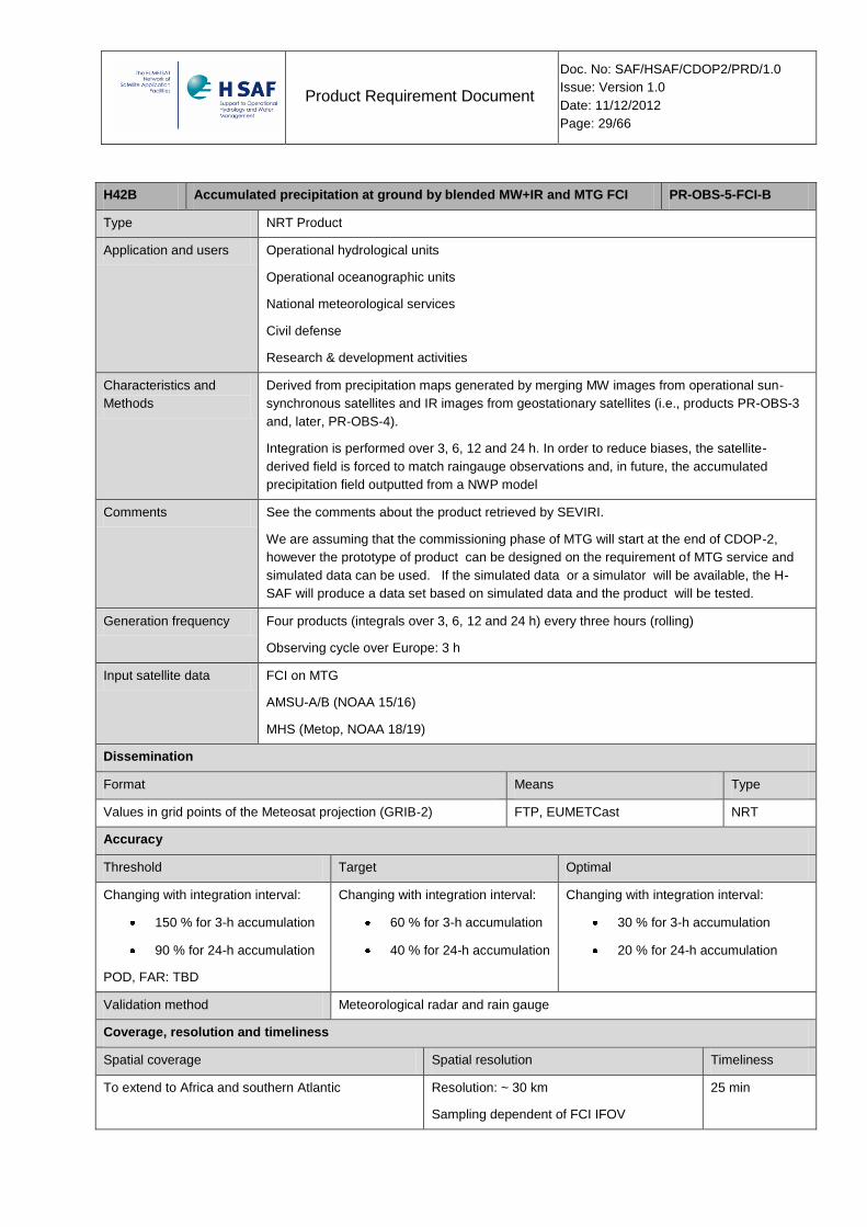
H42B Accumulated precipitation at ground by blended MW+IR and MTG FCI PR-OBS-5-FCI-B
Type NRT Product
Application and users Operational hydrological units
Operational oceanographic units
National meteorological services
Civil defense
Research & development activities
Characteristics and
Methods
Derived from precipitation maps generated by merging MW images from operational sun-
synchronous satellites and IR images from geostationary satellites (i.e., products PR-OBS-3
and, later, PR-OBS-4).
Integration is performed over 3, 6, 12 and 24 h. In order to reduce biases, the satellite-
derived field is forced to match raingauge observations and, in future, the accumulated
precipitation field outputted from a NWP model
Comments See the comments about the product retrieved by SEVIRI.
We are assuming that the commissioning phase of MTG will start at the end of CDOP-2,
however the prototype of product can be designed on the requirement of MTG service and
simulated data can be used. If the simulated data or a simulator will be available, the H-
SAF will produce a data set based on simulated data and the product will be tested.
Generation frequency Four products (integrals over 3, 6, 12 and 24 h) every three hours (rolling)
Observing cycle over Europe: 3 h
Input satellite data FCI on MTG
AMSU-A/B (NOAA 15/16)
MHS (Metop, NOAA 18/19)
Dissemination
Format Means Type
Values in grid points of the Meteosat projection (GRIB-2) FTP, EUMETCast NRT
Accuracy
Threshold Target Optimal
Changing with integration interval:
150 % for 3-h accumulation
90 % for 24-h accumulation
POD, FAR: TBD
Changing with integration interval:
60 % for 3-h accumulation
40 % for 24-h accumulation
Changing with integration interval:
30 % for 3-h accumulation
20 % for 24-h accumulation
Validation method Meteorological radar and rain gauge
Coverage, resolution and timeliness
Spatial coverage Spatial resolution Timeliness
To extend to Africa and southern Atlantic Resolution: ~ 30 km
Sampling dependent of FCI IFOV
25 min
Product Requirement Document
Doc. No: SAF/HSAF/CDOP2/PRD/1.0
Issue: Version 1.0
Date: 11/12/2012
Page: 30/66
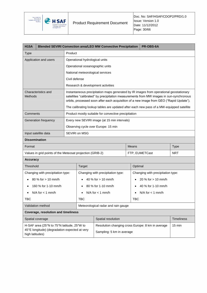
H15A Blended SEVIRI Convection area/LEO MW Convective Precipitation PR-OBS-6A
Type Product
Application and users Operational hydrological units
Operational oceanographic units
National meteorological services
Civil defense
Research & development activities
Characteristics and
Methods
Instantaneous precipitation maps generated by IR images from operational geostationary
satellites “calibrated” by precipitation measurements from MW images in sun-synchronous
orbits, processed soon after each acquisition of a new image from GEO (“Rapid Update”).
The calibrating lookup tables are updated after each new pass of a MW-equipped satellite
Comments Product mostly suitable for convective precipitation
Generation frequency Every new SEVIRI image (at 15 min intervals)
Observing cycle over Europe: 15 min
Input satellite data SEVIRI on MSG
Dissemination
Format Means Type
Values in grid points of the Meteosat projection (GRIB-2) FTP, EUMETCast NRT
Accuracy
Threshold Target Optimal
Changing with precipitation type:
80 % for > 10 mm/h
160 % for 1-10 mm/h
N/A for < 1 mm/h
TBC
Changing with precipitation type:
40 % for > 10 mm/h
80 % for 1-10 mm/h
N/A for < 1 mm/h
TBC
Changing with precipitation type:
20 % for > 10 mm/h
40 % for 1-10 mm/h
N/A for < 1 mm/h
TBC
Validation method Meteorological radar and rain gauge
Coverage, resolution and timeliness
Spatial coverage Spatial resolution Timeliness
H-SAF area (25°N to 75°N latitude, 25°W to
45°E longitude) (degradation expected at very
high latitudes)
Resolution changing cross Europe: 8 km in average
Sampling: 5 km in average
15 min
Product Requirement Document
Doc. No: SAF/HSAF/CDOP2/PRD/1.0
Issue: Version 1.0
Date: 11/12/2012
Page: 31/66
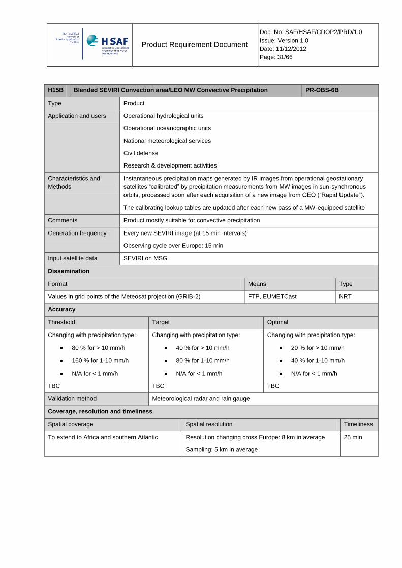
H15B Blended SEVIRI Convection area/LEO MW Convective Precipitation PR-OBS-6B
Type Product
Application and users Operational hydrological units
Operational oceanographic units
National meteorological services
Civil defense
Research & development activities
Characteristics and
Methods
Instantaneous precipitation maps generated by IR images from operational geostationary
satellites “calibrated” by precipitation measurements from MW images in sun-synchronous
orbits, processed soon after each acquisition of a new image from GEO (“Rapid Update”).
The calibrating lookup tables are updated after each new pass of a MW-equipped satellite
Comments Product mostly suitable for convective precipitation
Generation frequency Every new SEVIRI image (at 15 min intervals)
Observing cycle over Europe: 15 min
Input satellite data SEVIRI on MSG
Dissemination
Format Means Type
Values in grid points of the Meteosat projection (GRIB-2) FTP, EUMETCast NRT
Accuracy
Threshold Target Optimal
Changing with precipitation type:
80 % for > 10 mm/h
160 % for 1-10 mm/h
N/A for < 1 mm/h
TBC
Changing with precipitation type:
40 % for > 10 mm/h
80 % for 1-10 mm/h
N/A for < 1 mm/h
TBC
Changing with precipitation type:
20 % for > 10 mm/h
40 % for 1-10 mm/h
N/A for < 1 mm/h
TBC
Validation method Meteorological radar and rain gauge
Coverage, resolution and timeliness
Spatial coverage Spatial resolution Timeliness
To extend to Africa and southern Atlantic Resolution changing cross Europe: 8 km in average
Sampling: 5 km in average
25 min
Product Requirement Document
Doc. No: SAF/HSAF/CDOP2/PRD/1.0
Issue: Version 1.0
Date: 11/12/2012
Page: 32/66
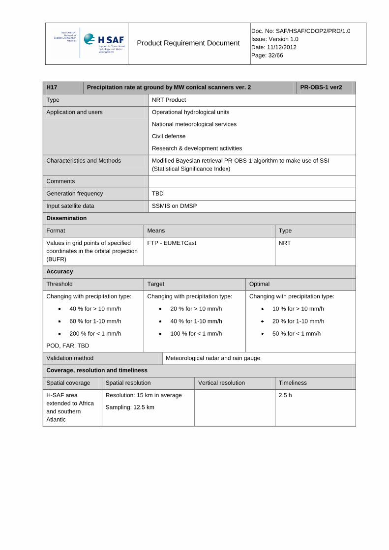
H17 Precipitation rate at ground by MW conical scanners ver. 2 PR-OBS-1 ver2
Type NRT Product
Application and users Operational hydrological units
National meteorological services
Civil defense
Research & development activities
Characteristics and Methods Modified Bayesian retrieval PR-OBS-1 algorithm to make use of SSI
(Statistical Significance Index)
Comments
Generation frequency TBD
Input satellite data SSMIS on DMSP
Dissemination
Format Means Type
Values in grid points of specified
coordinates in the orbital projection
(BUFR)
FTP - EUMETCast NRT
Accuracy
Threshold Target Optimal
Changing with precipitation type:
40 % for > 10 mm/h
60 % for 1-10 mm/h
200 % for < 1 mm/h
POD, FAR: TBD
Changing with precipitation type:
20 % for > 10 mm/h
40 % for 1-10 mm/h
100 % for < 1 mm/h
Changing with precipitation type:
10 % for > 10 mm/h
20 % for 1-10 mm/h
50 % for < 1 mm/h
Validation method Meteorological radar and rain gauge
Coverage, resolution and timeliness
Spatial coverage Spatial resolution Vertical resolution Timeliness
H-SAF area
extended to Africa
and southern
Atlantic
Resolution: 15 km in average
Sampling: 12.5 km
2.5 h

Product Requirement Document
Doc. No: SAF/HSAF/CDOP2/PRD/1.0
Issue: Version 1.0
Date: 11/12/2012
Page: 33/66
H18 Precipitation rate at ground by MW cross-track scanners ver. 3 PR-OBS-2 ver3
Type NRT Product
Application and users Operational hydrological units
National meteorological services
Civil defense
Research & development activities
Characteristics and Methods Re-train the CDRD-based ANN network with additional SSI input
Comments
Generation frequency TBD
Input satellite data AMSU-A and MHS on NOAA and EPS (MetOp) satellites
Dissemination
Format Means Type
Values in grid points of specified
coordinates in the orbital projection
(BUFR)
FTP - EUMETCast NRT
Accuracy
Threshold Target Optimal
Changing with precipitation type:
40 % for > 10 mm/h
60 % for 1-10 mm/h
200 % for < 1 mm/h
POD, FAR: TBD
Changing with precipitation type:
20 % for > 10 mm/h
40 % for 1-10 mm/h
100 % for < 1 mm/h
Changing with precipitation type:
10 % for > 10 mm/h
20 % for 1-10 mm/h
50 % for < 1 mm/h
Validation method Meteorological radar and rain gauge
Coverage, resolution and timeliness
Spatial coverage Spatial resolution Vertical resolution Timeliness
H-SAF area
extended to Africa
and southern
Atlantic
Resolution changing along the
scan: varying from 16 x 16 km2 /
circular at nadir to 26 x 52 km2 /
oval at scan edge
Sampling: 16 km
2.5 h

Product Requirement Document
Doc. No: SAF/HSAF/CDOP2/PRD/1.0
Issue: Version 1.0
Date: 11/12/2012
Page: 34/66
H19 Rainfall intensity from GMI (Global Precipitation Measurement -
Microwave Imager) [Bayesian algorithm]
PR-OBS-7
Type Offline Product
Application and users Operational hydrological units
Operational oceanographic units
National meteorological services
Civil defense
Research & development activities
Characteristics and Methods Bayesian algorithm
Comments
Generation frequency N. A.
Input satellite data GMI and DPR on GPM observatory
Dissemination
Format Means Type
Values in grid points of specified
coordinates in the orbital projection
(BUFR)
FTP Offline
Accuracy
Threshold Target Optimal
TBD TBD TBD
Validation method Meteorological radar and rain gauge
Coverage, resolution and timeliness
Spatial coverage Spatial resolution Vertical resolution Timeliness
Global for low and
middle latitudes up
to 62°
Resolution: 4.4 X 7.3 Km N. A.

Product Requirement Document
Doc. No: SAF/HSAF/CDOP2/PRD/1.0
Issue: Version 1.0
Date: 11/12/2012
Page: 35/66
H20 Rainfall intensity from GMI (Global Precipitation Measurement -
Microwave Imager) [Neural Network algorithm]
PR-OBS-8
Type Offline Product
Application and users Operational hydrological units
Operational oceanographic units
National meteorological services
Civil defense
Research & development activities
Characteristics and Methods Neural Network algorithm
Comments
Generation frequency N. A.
Input satellite data GMI and DPR on GPM observatory
Dissemination
Format Means Type
Values in grid points of specified
coordinates in the orbital projection
(BUFR)
FTP Offline
Accuracy
Threshold Target Optimal
TBD TBD TBD
Validation method Meteorological radar and rain gauge
Coverage, resolution and timeliness
Spatial coverage Spatial resolution Vertical resolution Timeliness
Global for low and
middle latitudes up
to 62°
Resolution: 4.4 X 7.3 Km N. A.
Product Requirement Document
Doc. No: SAF/HSAF/CDOP2/PRD/1.0
Issue: Version 1.0
Date: 11/12/2012
Page: 36/66
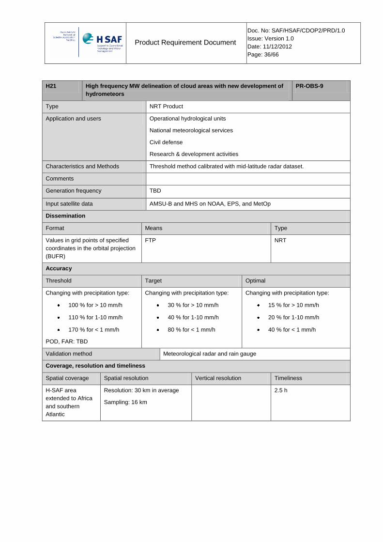
H21 High frequency MW delineation of cloud areas with new development of
hydrometeors
PR-OBS-9
Type NRT Product
Application and users Operational hydrological units
National meteorological services
Civil defense
Research & development activities
Characteristics and Methods Threshold method calibrated with mid-latitude radar dataset.
Comments
Generation frequency TBD
Input satellite data AMSU-B and MHS on NOAA, EPS, and MetOp
Dissemination
Format Means Type
Values in grid points of specified
coordinates in the orbital projection
(BUFR)
FTP NRT
Accuracy
Threshold Target Optimal
Changing with precipitation type:
100 % for > 10 mm/h
110 % for 1-10 mm/h
170 % for < 1 mm/h
POD, FAR: TBD
Changing with precipitation type:
30 % for > 10 mm/h
40 % for 1-10 mm/h
80 % for < 1 mm/h
Changing with precipitation type:
15 % for > 10 mm/h
20 % for 1-10 mm/h
40 % for < 1 mm/h
Validation method Meteorological radar and rain gauge
Coverage, resolution and timeliness
Spatial coverage Spatial resolution Vertical resolution Timeliness
H-SAF area
extended to Africa
and southern
Atlantic
Resolution: 30 km in average
Sampling: 16 km
2.5 h

Product Requirement Document
Doc. No: SAF/HSAF/CDOP2/PRD/1.0
Issue: Version 1.0
Date: 11/12/2012
Page: 37/66
H22 Snowfall intensity PR-OBS-10
Type NRT Product
Application and users Operational hydrological units
Operational oceanographic units
National meteorological services
Civil defense
Research & development activities
Characteristics and Methods Threshold method calibrated with mid- and high-latitude radar dataset.
Comments
Generation frequency TBD
Input satellite data AMSU-B and MHS on NOAA,EPS, and MetOp
Dissemination
Format Means Type
Values in grid points of specified
coordinates in the orbital projection
(BUFR)
FTP NRT
Accuracy
Threshold Target Optimal
POD (≥ 1 mm/h) 0.3
FAR (≥ 1 mm/h) 0.7
POD (≥ 1 mm/h) 0.6
FAR (≥ 1 mm/h) 0.4
POD (≥ 1 mm/h) 0.8
FAR (≥ 1 mm/h) 0.2
Validation method Meteorological radar and rain gauge
Coverage, resolution and timeliness
Spatial coverage Spatial resolution Vertical resolution Timeliness
H-SAF area
extended to Africa
and southern
Atlantic
Resolution: 30 km in average
Sampling: 16 km (at nadir)
2.5 h

Product Requirement Document
Doc. No: SAF/HSAF/CDOP2/PRD/1.0
Issue: Version 1.0
Date: 11/12/2012
Page: 38/66
H50 Rainfall intensity from MTG LI PR-OBS-11
Type NRT Product
Application and users Operational hydrological units
Operational oceanographic units
National meteorological services
Civil defense
Research & development activities
Characteristics and Methods nstantaneous precipitation maps generated by LI data maps from
operational geostationary satellites “calibrated” by precipitation
measurements. The preliminary activities will be done with simulated data
from data of LAMPINET (the Italian network lightning).
The methods is based on the Tapia concept and a initial calibration has to be
performed. During the development phase will be evaluated the impact of
First guess.
The output will show the field of convective rainfall linked to lightning .
Comments We are assuming that the commissioning phase of MTG will start at the end
of CDOP-2, however the prototype of product can be designed on the
requirement of MTG service and simulated data can be used. If the
simulated data or a simulator will be available the H-SAF will produce a
data set based on simulated LI data and the data set will tested with the
validation procedure. A report will be presented.
Generation frequency TBD
Input satellite data LI on MTG
Dissemination
Format Means Type
BUFR FTP NRT
Accuracy
Threshold Target Optimal
Changing with precipitation type:
40 % for > 10 mm/h
60 % for 1-10 mm/h
200 % for < 1 mm/h
Changing with precipitation type:
20 % for > 10 mm/h
40 % for 1-10 mm/h
100 % for < 1 mm/h
Changing with precipitation type:
10 % for > 10 mm/h
20 % for 1-10 mm/h
50 % for < 1 mm/h
Validation method Meteorological radar and rain gauge
Coverage, resolution and timeliness
Spatial coverage Spatial resolution Vertical resolution Timeliness
Europe >20Km 15 min.
Product Requirement Document
Doc. No: SAF/HSAF/CDOP2/PRD/1.0
Issue: Version 1.0
Date: 11/12/2012
Page: 39/66
3.2 Soil Moisture products
3.2.1 Soil Moisture Accuracy Values
During Development Phase and CDOP1, Accuracy Requirements for products H14 SM-
DAS-2 and H08 SM-OBS-2 have been given in volumetric unit (m3m-3) and the main
score to be evaluated was the Root Mean Square Difference, supportive scores being: the
Mean Error (or bias, ME), the Standard Deviation (SD) and the Correlation Coefficient
(CC).
The first definition of H-SAF soil moisture validation goals stems to a large extent from the
efforts to build the SMOS and SMAP satellites that both aim to retrieve the absolute
volumetric soil moisture content with an RMSD of 0.04 m3m-3. But considering the
evolution of the literature on this topic over the last few years one can clearly see a shift in
the way of how the validation of remotely sensed / modelled soil moisture data is being
regarded. RMSD by itself is not sufficient, other measures such as CC are also important,
and for some applications even more important than the RMSD (Entekhabi et al., 2010;
Brocca et al., 2011).
Several authors have demonstrated that local measurements could be used to validate
model output as well as remotely-sensed soil moisture (SM) at a different scale (e.g.
Albergel et al, 2009, 2010; Rüdiger et al., 2009; Brocca et al., 2010a; 2011). However,
spatial variability of SM is very high and can vary from centimetres to metres. Precipitation,
evapotranspiration, soil texture, topography, vegetation and land use could either enhance
or reduce the spatial variability of soil moisture depending on how it is distributed and
combined with other factors (Famiglietti et al., 2008; Brocca et al., 2010b, 2012).
Differences in soil properties could imply important variations in the mean and variance of
soil moisture, even over small distances. Each soil moisture data set is characterized by its
specific mean value, variability and dynamical range. Saleem and Salvucci (2002) and
Koster et al. (2009, 2011) suggested that the true information content of modelled soil
moisture does not necessarily rely on their absolute magnitudes but instead on their time
variation. The latter represents the time-integrated impacts of antecedent meteorological
forcing on the hydrological state of the soil system within the model.
The high spatial variability of in situ SM used for validation as well as SM data set specific
characteristics suggest that the Correlation Coefficient (CC) should be the main score to
be evaluated. On this basis the soil moisture products development and validation groups
propose to change the main score to evaluate the "Product Requirements" for H08 and
H14 products from the RMSD to the CC. The following values are proposed as accuracy
thresholds:
• Threshold accuracy: 0.50
• Target accuracy 0.65

Product Requirement Document
Doc. No: SAF/HSAF/CDOP2/PRD/1.0
Issue: Version 1.0
Date: 11/12/2012
Page: 40/66
• Optimal accuracy 0.80
It is noted that a sufficiently long period of time is needed to calculate the scores (periods
of at least 12 months are needed).
For references on the matter, see Appendix 2, references from [RD 18] to [RD 29].
Product Requirement Document
Doc. No: SAF/HSAF/CDOP2/PRD/1.0
Issue: Version 1.0
Date: 11/12/2012
Page: 41/66
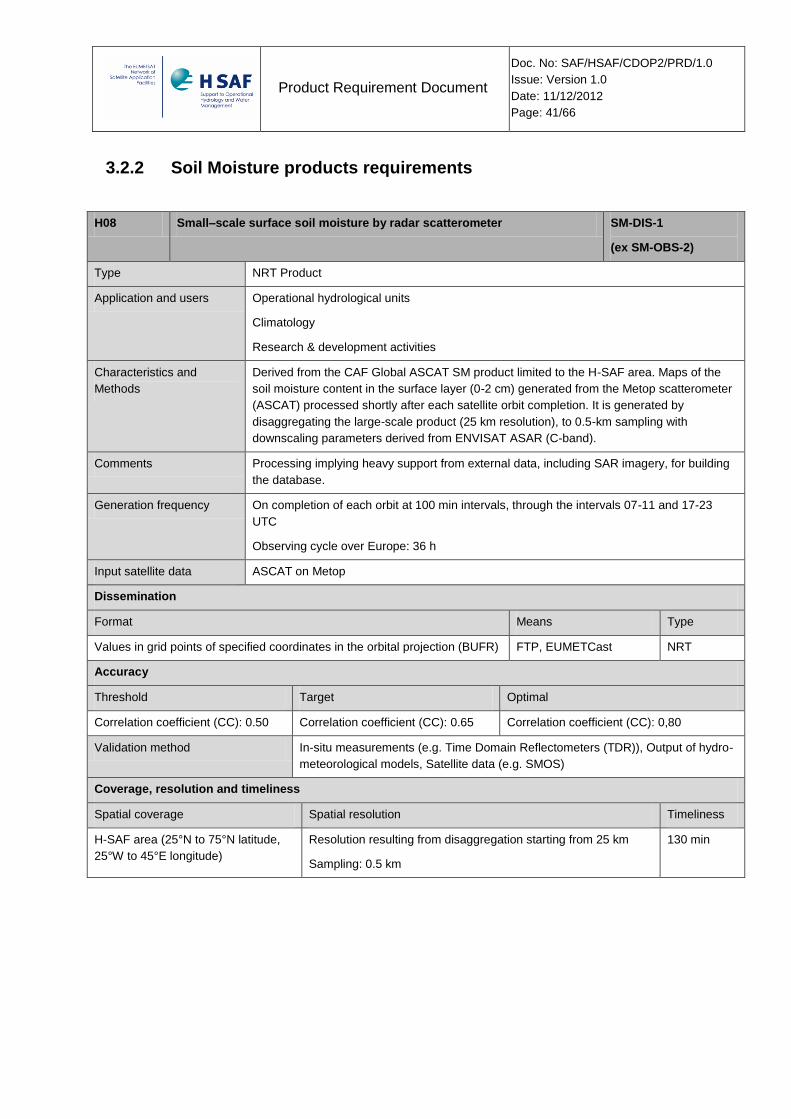
3.2.2 Soil Moisture products requirements
H08 Small–scale surface soil moisture by radar scatterometer SM-DIS-1
(ex SM-OBS-2)
Type NRT Product
Application and users Operational hydrological units
Climatology
Research & development activities
Characteristics and
Methods
Derived from the CAF Global ASCAT SM product limited to the H-SAF area. Maps of the
soil moisture content in the surface layer (0-2 cm) generated from the Metop scatterometer
(ASCAT) processed shortly after each satellite orbit completion. It is generated by
disaggregating the large-scale product (25 km resolution), to 0.5-km sampling with
downscaling parameters derived from ENVISAT ASAR (C-band).
Comments Processing implying heavy support from external data, including SAR imagery, for building
the database.
Generation frequency On completion of each orbit at 100 min intervals, through the intervals 07-11 and 17-23
UTC
Observing cycle over Europe: 36 h
Input satellite data ASCAT on Metop
Dissemination
Format Means Type
Values in grid points of specified coordinates in the orbital projection (BUFR) FTP, EUMETCast NRT
Accuracy
Threshold Target Optimal
Correlation coefficient (CC): 0.50 Correlation coefficient (CC): 0.65 Correlation coefficient (CC): 0,80
Validation method In-situ measurements (e.g. Time Domain Reflectometers (TDR)), Output of hydro-
meteorological models, Satellite data (e.g. SMOS)
Coverage, resolution and timeliness
Spatial coverage Spatial resolution Timeliness
H-SAF area (25°N to 75°N latitude,
25°W to 45°E longitude)
Resolution resulting from disaggregation starting from 25 km
Sampling: 0.5 km
130 min
Product Requirement Document
Doc. No: SAF/HSAF/CDOP2/PRD/1.0
Issue: Version 1.0
Date: 11/12/2012
Page: 42/66
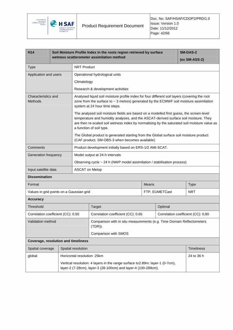
H14 Soil Moisture Profile Index in the roots region retrieved by surface
wetness scatterometer assimilation method
SM-DAS-2
(ex SM-ASS-2)
Type NRT Product
Application and users Operational hydrological units
Climatology
Research & development activities
Characteristics and
Methods
Analysed liquid soil moisture profile index for four different soil layers (covering the root
zone from the surface to ~ 3 metres) generated by the ECMWF soil moisture assimilation
system at 24 hour time steps.
The analysed soil moisture fields are based on a modelled first guess, the screen-level
temperature and humidity analyses, and the ASCAT-derived surface soil moisture. They
are then re-scaled soil wetness index by normalising by the saturated soil moisture value as
a function of soil type.
The Global product is generated starting from the Global surface soil moisture product
(CAF product, SM-OBS-3 when becomes available)
Comments Product development initially based on ERS-1/2 AMI-SCAT.
Generation frequency Model output at 24-h intervals
Observing cycle ~ 24 h (NWP model assimilation / stabilisation process)
Input satellite data ASCAT on Metop
Dissemination
Format Means Type
Values in grid points on a Gaussian grid FTP, EUMETCast NRT
Accuracy
Threshold Target Optimal
Correlation coefficient (CC): 0.50 Correlation coefficient (CC): 0.65 Correlation coefficient (CC): 0,80
Validation method Comparison with in situ measurements (e.g. Time Domain Reflectometers
(TDR)).
Comparison with SMOS
Coverage, resolution and timeliness
Spatial coverage Spatial resolution Timeliness
global Horizontal resolution: 25km
Vertical resolution: 4 layers in the range surface to2.89m: layer-1 (0-7cm),
layer-2 (7-28cm), layer-3 (28-100cm) and layer-4 (100-289cm).
24 to 36 h
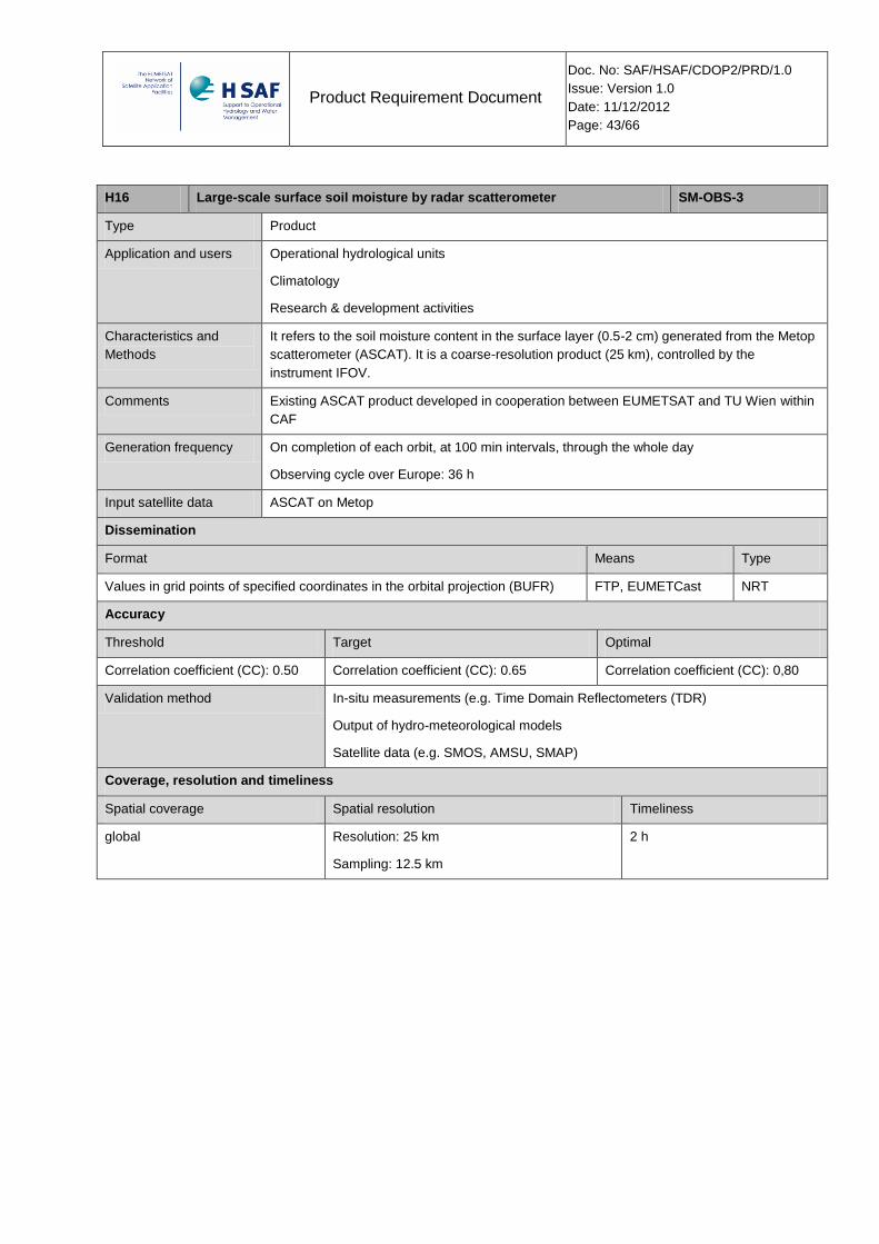
Product Requirement Document
Doc. No: SAF/HSAF/CDOP2/PRD/1.0
Issue: Version 1.0
Date: 11/12/2012
Page: 43/66
H16 Large-scale surface soil moisture by radar scatterometer SM-OBS-3
Type Product
Application and users Operational hydrological units
Climatology
Research & development activities
Characteristics and
Methods
It refers to the soil moisture content in the surface layer (0.5-2 cm) generated from the Metop
scatterometer (ASCAT). It is a coarse-resolution product (25 km), controlled by the
instrument IFOV.
Comments Existing ASCAT product developed in cooperation between EUMETSAT and TU Wien within
CAF
Generation frequency On completion of each orbit, at 100 min intervals, through the whole day
Observing cycle over Europe: 36 h
Input satellite data ASCAT on Metop
Dissemination
Format Means Type
Values in grid points of specified coordinates in the orbital projection (BUFR) FTP, EUMETCast NRT
Accuracy
Threshold Target Optimal
Correlation coefficient (CC): 0.50 Correlation coefficient (CC): 0.65 Correlation coefficient (CC): 0,80
Validation method In-situ measurements (e.g. Time Domain Reflectometers (TDR)
Output of hydro-meteorological models
Satellite data (e.g. SMOS, AMSU, SMAP)
Coverage, resolution and timeliness
Spatial coverage Spatial resolution Timeliness
global Resolution: 25 km
Sampling: 12.5 km
2 h
Product Requirement Document
Doc. No: SAF/HSAF/CDOP2/PRD/1.0
Issue: Version 1.0
Date: 11/12/2012
Page: 44/66
H25 ASCAT Large-scale surface soil moisture(25 Km) SM-OBS-4
Type Offline Product
Application and users Operational hydrological units
Climatology
Research & development activities
Characteristics and
Methods
Time series of ASCAT large-scale surface soil moisture
Comments Currently a TU WIen product
Generation frequency N. A.
Input satellite data ASCAT on Metop
Dissemination
Format Means Type
various scientific file formats FTP Offline
Accuracy
Threshold Target Optimal
Correlation coefficient (CC): 0.50 Correlation coefficient (CC): 0.65 Correlation coefficient (CC): 0,80
Validation method In-situ measurements (e.g. Time Domain Reflectometers (TDR))
Output of hydro-meteorological models
Satellite data (e.g. SMOS)
Coverage, resolution and timeliness
Spatial coverage Spatial resolution Timeliness
Global Resolution: 25 km
Sampling: 12.5 km
N. A.
Product Requirement Document
Doc. No: SAF/HSAF/CDOP2/PRD/1.0
Issue: Version 1.0
Date: 11/12/2012
Page: 45/66
H27 Soil Wetness Index in the roots region by scatterometer assimilation in a
NWP model
SM-DAS-3
(ex SM-ASS-3)
Type Offline Product
Application and users Operational hydrological units
Climatology
Research & development activities
Characteristics and
Methods
Re-analysed liquid soil moisture profile index for four different soil layers (covering the
root zone from the surface to ~ 3 metres) generated by the ECMWF land surface re-
analysis system at 24 hour time steps. H-27 provides a consistent time series of both
surface and root zone soil moisture with a daily global coverage which is highly relevant
for hydrological applications and water budget investigations.
The analysed soil moisture fields are based on a modelled first guess, the screen-level
temperature and humidity analyses, and the ASCAT-derived surface soil moisture. They
are then re-scaled to soil wetness index by normalising by the saturated soil moisture
value as a function of soil type.
The Global product is generated using the re-analysed Global surface soil moisture
product assimilated in the ECMWF land surface re-analysis suite. This product will be
developed in CDOP-2 based on CDOP developments. . Data assimilation is indeed the
only approach that enables to retrieve both surface and root zone soil moisture from
satellite surface swath data.
Comments Re-analysis of SM-ASS-2 using consistent production algorithm to provide long time
series of the root zone soil wetness profile index
Generation frequency N. A.
Input satellite data Satellites used in NWP
ASCAT on Metop
Dissemination
Format Means Type
Values in grid points on a Gaussian grid FTP Offline
Accuracy
Threshold Target Optimal
Correlation coefficient (CC): 0.50 Correlation coefficient (CC): 0.65 Correlation coefficient (CC): 0,80
Validation method Comparison with in situ measurements (e.g. Time Domain Reflectometers
(TDR)).
Comparison with SMOS
Coverage, resolution and timeliness
Spatial coverage Spatial resolution Timeliness
Global Horizontal resolution: ~16 km N. A.
Product Requirement Document
Doc. No: SAF/HSAF/CDOP2/PRD/1.0
Issue: Version 1.0
Date: 11/12/2012
Page: 46/66
3.3 Snow products
3.3.1 Snow Accuracy Values
Product requirements for accuracy were adopted taking in consideration the actual performances achievable as demonstrated by continuous validation and taking in consideration the baseline proposed requirement values have not been tested before. Especially in the mountainous areas, 5 km x 5 km spatial resolution of the product can not be represented by the distribution of the available ground data. During the validation analysis simple satellite-ground comparison is performed. When automatic snow observation stations (specially established at most proper sites for snow measurement in Turkey) which are used in the comparison at high altitudes (elevation >2000 m) 90% POD values are obtained. However between 750 m and 2000m due to morphology of snow changes rapidly and the distribution of the ground observations are synoptic, the results are decreasing due to the available limitations.
In Remote Sensing Community the question of the acceptable level of accuracy is often answered by reference to the seminal work of Anderson et al. (1976) who outline the criteria for an effective land use and land cover classification scheme for use in conjunction with remotely sensed data. Specifically, Anderson et al. (1976, p. 5), citing the earlier work of Anderson (1971), state that “the minimum level of interpretation accuracy in the identification of land use and land cover categories from remote sensor data should be at least 85 percent”. Therefore, although an 85% accuracy target is widely accepted by the remote sensing community as a benchmark, as several recent examples indicate (Foody 2002, Reese et al. 2002, Fuller et al. 2003, Tømmervik et al. 2003), its usefulness as a standard is unclear. Others have also questioned the validity of the 85% target (Laba et al. 2002, p. 453). The accuracy assessments of several recently completed regional-scale land cover mapping projects indicate that producer's and user's accuracies are stabilizing in the50-70% range, independent of level of taxonomic detail or methodological approaches (Edwards et al. 1998, Ma et al. 2001, Zhu et al. 2000). Additional improvements in accuracy are not likely, and that only through the use of sensors with high spectral, spatial, and temporal resolution will map accuracies approach 80%.
The appropriate accuracy assessment protocol often develops from consideration of the following question: Is the product sufficiently accurate for a specific application? The understanding is that not all applications require the same level of accuracy to be successfully accomplished, and therefore the same level of effort need not be expended to determine product accuracy for different possible applications. For hydrological applications 85% POD and 15% FAR would be ideal in using the snow cover maps for runoff generation.
Furthermore, different threshold requirements for flat/forested areas and mountainous areas should be identified. Revised threshold values are 0.8 POD for flat and forested areas and 0.6 POD for mountainous areas. For the target values, the proposed requirement is 0.85 POD for the flat and forested areas, and 0.7 for the mountainous area.
Regarding the FAR, the threshold is 0.2 for flat area and 0.3 for mountainous area, and for the target value: for 0.15 for flat area and 0.2 for mountainous area.
Product Requirement Document
Doc. No: SAF/HSAF/CDOP2/PRD/1.0
Issue: Version 1.0
Date: 11/12/2012
Page: 47/66
With this respect, following table summarizes product requirements for Snow products.
3.3.1 Snow products requirements
H10 Snow detection (snow mask) by VIS/IR radiometry SN-OBS-1
Type NRT Product
Application and users Operational hydrological units
National meteorological services
Civil defense
Research & development activities
Characteristics and
Methods
Binary map of snow / no-snow situation. VIS/IR images from GEO are used. The product may
be processed in different ways and have different quality depending on the surface being flat,
forested or mountainous. The algorithm is based on thresholding of several channels of
SEVIRI, the most important being those in short-wave, thus the product is generated in
daylight. In order to search for cloud-free pixels, multi-temporal analysis is performed over all
images available in 24 hours (in daylight)
Comments Different methods used for flat/forested and mountainous regions.
Timeliness is intended as delay after acquisition of the last image utilised in the multi-temporal
analysis
Generation frequency Output result every 24 h
Input satellite data SEVIRI on MSG
Dissemination
Format Means Type
Values in grid points of the Meteosat projection (HDF5) FTP, EUMETCast NRT
Accuracy
Threshold Target Optimal
Probability Of Detection (POD):
Flat / Forested areas: 80 %
Mountainous areas: 60%
False Alarm Rate (FAR):
Flat / Forested areas: 20 %
Mountainous areas: 30%
Probability Of Detection (POD):
Flat / Forested areas: 85 %
Mountainous areas: 70%
False Alarm Rate (FAR):
Flat / Forested areas: 15 %
Mountainous areas: 20%
Probability Of Detection (POD): 99 %
False Alarm Rate (FAR): 5 %
Validation method Snow observing stations
Coverage, resolution and timeliness
Spatial coverage Spatial resolution Timeliness
H-SAF area (25°N to 75°N latitude, 25°W to 45°E
longitude) (degradation expected at very high
latitudes)
SEVIRI pixel resolution and grid 30 min

Product Requirement Document
Doc. No: SAF/HSAF/CDOP2/PRD/1.0
Issue: Version 1.0
Date: 11/12/2012
Page: 48/66
H11 Snow status (dry/wet) by MW radiometry SN-OBS-2
Type NRT Product
Application and users Operational hydrological units
National meteorological services
Civil defense
Research & development activities
Characteristics and
Methods
This product indicates the status of the snow mantle, whether it is wet or dry and, in time
series, thawing or freezing.
Multi-channel MW observations are used (middle frequencies), and the algorithm is based
on thresholding.
In order to remove ambiguity between wet snow and bare soil, use is made of product SN-
OBS-1 for preventive snow recognition, and of exploitation of change detection
Comments AMRS-E failed on 4 Oct 2011 : input data replaced with SSMIS
Before failure: timeliness controlled by the delay in accessing AMSR-E data from NASA by
FTP, intended as delay after acquisition of the last image utilised in the multi-temporal
analysis.
Generation frequency After each orbit, but then merging with daily SN-OBS-1 maps; therefore: output result every
24 h
Input satellite data SSMIS on DMSP
Dissemination
Format Means Type
GRIB2 FTP, EUMETCast NRT
Accuracy
Threshold Target Optimal
Hit Rate (HR): 60 %
False Alarm Rate (FAR): 20 %
Hit Rate (HR): 80 %
False Alarm Rate (FAR): 10 %
Hit Rate (HR): 90 %
False Alarm Rate (FAR): 5 %
Validation method Snow observing stations
Coverage, resolution and timeliness
Spatial coverage Spatial resolution Timeliness
H-SAF area (25°N to 75°N latitude, 25°W to 45°E longitude) Resolution: ~ 20 km
Sampling: 0.25 degrees
6 h

Product Requirement Document
Doc. No: SAF/HSAF/CDOP2/PRD/1.0
Issue: Version 1.0
Date: 11/12/2012
Page: 49/66
H12 Effective snow cover by VIS/IR radiometry SN-OBS-3
Type NRT Product
Application and
users
Operational hydrological units
National meteorological services
Civil defense
Research & development activities
Characteristics and
Methods
The combined effect, within a product resolution element, of fractional snow cover and other
reflective contributors is used to estimate the fractional cover at resolution element level.
The product may be processed in different ways and have different quality depending on the
surface being flat, forested or mountainous.
The algorithm is based on multi-channel analysis of AVHRR, the most important being those in
short-wave, thus the product is generated in daylight.
The “deficit” of brightness in respect of the maximum one is correlated to the lack of snow in the
product resolution element. In the case of forests, the signal attenuation due to forest canopy
obstruction is taken in to account by application of transmissivity map assembled in advance using
MODIS and GlobCover land cover data.
In order to search for cloud-free pixels, multi-temporal analysis is performed over all images
available in 24 hours (in daylight)
Comments Different methods used for flat/forested and mountainous regions.
Timeliness is intended as delay after acquisition of the last image utilised in the multi-temporal
analysis
Generation
frequency
After each AVHRR pass, then multi-temporal analysis for cloud-free pixels
Output result every 24 h
Input satellite data AVHRR (NOAA, Metop)
Dissemination
Format Means Type
GRIB2 FTP, EUMETCast NRT
Accuracy
Threshold Target Optimal
45% (Overall accuracy) 65% (Overall Accuracy) 95% (Overall Accuracy)
Validation method Snow observing stations
Better spatial resolution satellite data (Landsat)
Snow courses
Coverage, resolution and timeliness
Spatial coverage Spatial resolution Timeliness
H-SAF area (25°N to 75°N
latitude, 25°W to 45°E longitude)
Resolution: 1 - 2 km,
Sampling:0.01 degrees
30 min
Timeliness is intended as delay after acquisition of the
last image utilised in the multi-temporal analysis

Product Requirement Document
Doc. No: SAF/HSAF/CDOP2/PRD/1.0
Issue: Version 1.0
Date: 11/12/2012
Page: 50/66
H13 Snow water equivalent by MW radiometry SN-OBS-4
Type NRT Product
Application and
users
Operational hydrological units
National meteorological services
Civil defense
Research & development activities
Characteristics and
Methods
Maps of snow water equivalent derived from MW measurements sensitive to snow thickness and
density.
The product may be processed in different ways and have different quality depending on the
surface being flat, forested or mountainous.
The algorithm is based on assimilating MW brightness temperatures of several channels at
frequencies with different penetration in snow, into a first-guess field built by the (sparse) network
of stations measuring snow depth for flat areas, for mountainous areas snow depth measured at
stations is not used directly in the algorithm
Comments AMRS-E failed on 4 Oct 2011 : input data replaced with SSMIS
Before failure: timeliness controlled by the delay in accessing AMSR-E data from NASA by FTP,
intended as delay after acquisition of the last image utilised in the multi-temporal analysis.
Different methods used for flat/forested and mountainous regions.
Generation
frequency
Assimilation of SSMI/S brightness temperatures in a background field
Output result every 24 h
Input satellite data SSMI/S
Dissemination
Format Means Type
GRIB2 FTP, EUMETCast NRT
Accuracy
Threshold Target Optimal
Flat / Forested areas: 40mm
Mountainous areas: 45mm
Flat / Forested areas: 20mm
Mountainous areas: 25mm
Flat / Forested areas: 10mm
Mountainous areas: 15mm
Validation method Snow observing stations
Coverage, resolution and timeliness
Spatial coverage Spatial resolution Timeliness
H-SAF area (25°N to 75°N latitude, 25°W to 45°E longitude) Resolution: ~ 20 km
Sampling: 0.25 degrees
6 h
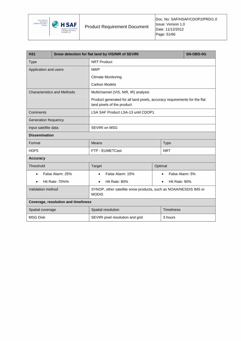
Product Requirement Document
Doc. No: SAF/HSAF/CDOP2/PRD/1.0
Issue: Version 1.0
Date: 11/12/2012
Page: 51/66
H31 Snow detection for flat land by VIS/NIR of SEVIRI SN-OBS-0G
Type NRT Product
Application and users NWP
Climate Monitoring
Carbon Models
Characteristics and Methods Multichannel (VIS, NIR, IR) analysis
Product generated for all land pixels, accuracy requirements for the flat
land pixels of the product
Comments LSA SAF Product LSA-13 until CDOP1
Generation frequency
Input satellite data SEVIRI on MSG
Dissemination
Format Means Type
HDF5 FTP - EUMETCast NRT
Accuracy
Threshold Target Optimal
False Alarm: 25%
Hit Rate: 70%%
False Alarm: 15%
Hit Rate: 80%
False Alarm: 5%
Hit Rate: 90%
Validation method SYNOP, other satellite snow products, such as NOAA/NESDIS IMS or
MODIS
Coverage, resolution and timeliness
Spatial coverage Spatial resolution Timeliness
MSG Disk SEVIRI pixel resolution and grid 3 hours
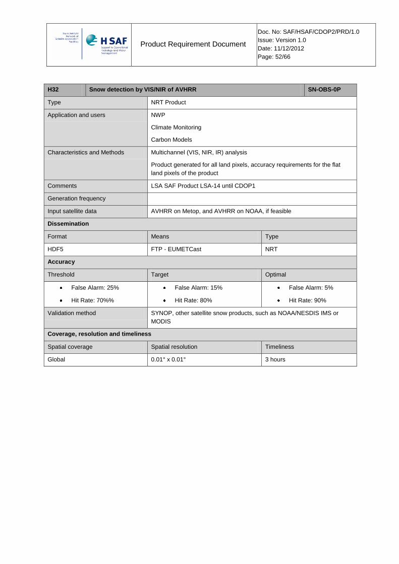
Product Requirement Document
Doc. No: SAF/HSAF/CDOP2/PRD/1.0
Issue: Version 1.0
Date: 11/12/2012
Page: 52/66
H32 Snow detection by VIS/NIR of AVHRR SN-OBS-0P
Type NRT Product
Application and users NWP
Climate Monitoring
Carbon Models
Characteristics and Methods Multichannel (VIS, NIR, IR) analysis
Product generated for all land pixels, accuracy requirements for the flat
land pixels of the product
Comments LSA SAF Product LSA-14 until CDOP1
Generation frequency
Input satellite data AVHRR on Metop, and AVHRR on NOAA, if feasible
Dissemination
Format Means Type
HDF5 FTP - EUMETCast NRT
Accuracy
Threshold Target Optimal
False Alarm: 25%
Hit Rate: 70%%
False Alarm: 15%
Hit Rate: 80%
False Alarm: 5%
Hit Rate: 90%
Validation method SYNOP, other satellite snow products, such as NOAA/NESDIS IMS or
MODIS
Coverage, resolution and timeliness
Spatial coverage Spatial resolution Timeliness
Global 0.01° x 0.01° 3 hours
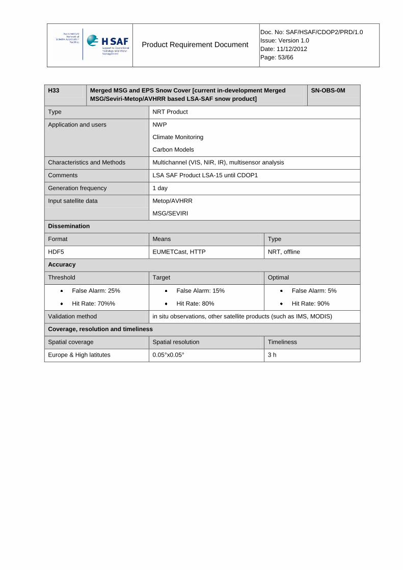
Product Requirement Document
Doc. No: SAF/HSAF/CDOP2/PRD/1.0
Issue: Version 1.0
Date: 11/12/2012
Page: 53/66
H33 Merged MSG and EPS Snow Cover [current in-development Merged
MSG/Seviri-Metop/AVHRR based LSA-SAF snow product]
SN-OBS-0M
Type NRT Product
Application and users NWP
Climate Monitoring
Carbon Models
Characteristics and Methods Multichannel (VIS, NIR, IR), multisensor analysis
Comments LSA SAF Product LSA-15 until CDOP1
Generation frequency 1 day
Input satellite data Metop/AVHRR
MSG/SEVIRI
Dissemination
Format Means Type
HDF5 EUMETCast, HTTP NRT, offline
Accuracy
Threshold Target Optimal
False Alarm: 25%
Hit Rate: 70%%
False Alarm: 15%
Hit Rate: 80%
False Alarm: 5%
Hit Rate: 90%
Validation method in situ observations, other satellite products (such as IMS, MODIS)
Coverage, resolution and timeliness
Spatial coverage Spatial resolution Timeliness
Europe & High latitutes 0.05°x0.05° 3 h

Product Requirement Document
Doc. No: SAF/HSAF/CDOP2/PRD/1.0
Issue: Version 1.0
Date: 11/12/2012
Page: 54/66
H34 Snow detection (snow mask) by VIS/NIR of SEVIRI SN-OBS-1G
Type NRT Product
Application and users Operational hydrological units
National meteorological services
Civil defense
Research & development activities
Characteristics and
Methods
Binary map of snow / no-snow situation. VIS/IR images from GEO are used. The product may
be processed in different ways and have different quality depending on the surface being flat,
forested or mountainous. The algorithm is based on thresholding of several channels of
SEVIRI, the most important being those in short-wave, thus the product is generated in
daylight. In order to search for cloud-free pixels, multi-temporal analysis is performed over all
images available in 24 hours (in daylight)
Comments Different methods used for flat/forested and mountainous regions.
Timeliness is intended as delay after acquisition of the last image utilised in the multi-temporal
analysis
Generation frequency Output result every 24 h
Input satellite data SEVIRI on MSG
Dissemination
Format Means Type
Values in grid points of the Meteosat projection (HDF5) FTP, EUMETCast NRT
Accuracy
Threshold Target Optimal
Probability Of Detection (POD):
Flat / Forested areas: 80 %
Mountainous areas: 60%
False Alarm Rate (FAR):
Flat / Forested areas: 20 %
Mountainous areas: 30%
Probability Of Detection (POD):
Flat / Forested areas: 85 %
Mountainous areas: 70%
False Alarm Rate (FAR):
Flat / Forested areas: 15 %
Mountainous areas: 20%
Probability Of Detection (POD): 99 %
False Alarm Rate (FAR): 5 %
Validation method Snow observing stations, other satellite snow products, such as NOAA/NESDIS
IMS or MODIS
Coverage, resolution and timeliness
Spatial coverage Spatial resolution Timeliness
MSG disk SEVIRI pixel resolution and grid 30 min

Product Requirement Document
Doc. No: SAF/HSAF/CDOP2/PRD/1.0
Issue: Version 1.0
Date: 11/12/2012
Page: 55/66
H35 Snow detection (snow mask) and Effective snow cover by VIS/NIR of
AVHRR
SN-OBS-1P
Type NRT Product
Application and users Operational hydrological units
National meteorological services
Civil defense
Research & development activities
Characteristics and
Methods
The combined effect, within a product resolution element, of fractional snow cover and other
reflective contributors is used to estimate the fractional cover at resolution element level.
The product may be processed in different ways and have different quality depending on the
surface being flat, forested or mountainous.
The algorithm is based on multi-channel analysis of AVHRR, the most important being those in
short-wave, thus the product is generated in daylight.
The “deficit” of brightness in respect of the maximum one is correlated to the lack of snow in the
product resolution element. In the case of forests, the expected maximum brightness (or the
“transmissivity”) is evaluated in advance by a high-resolution instrument (MODIS).
In order to search for cloud-free pixels, multi-temporal analysis is performed over all images
available in 24 hours (in daylight)
Comments Derived from H12 and H32
Different methods used for flat/forested and mountainous regions.
Timeliness is intended as delay after acquisition of the last image utilised in the multi-temporal
analysis
Generation frequency
Input satellite data AVHRR (NOAA, Metop)
Dissemination
Format Means Type
Values in grid points of the equal-latitude/longitude projection (HDF5) FTP, EUMETCast NRT
Accuracy
Threshold Target Optimal
45% (Overall accuracy) 65% (Overall Accuracy) 95% (Overall Accuracy)
Validation method Snow observing stations, other satellite snow products, such as NOAA/NESDIS
IMS or MODIS
Coverage, resolution and timeliness
Spatial coverage Spatial resolution Timeliness
Global Resolution: ~ 8 km
Sampling: ~ 5 km
30 min
Timeliness is intended as delay after acquisition of the last
image utilised in the multi-temporal analysis

Product Requirement Document
Doc. No: SAF/HSAF/CDOP2/PRD/1.0
Issue: Version 1.0
Date: 11/12/2012
Page: 56/66
H43 Snow detection (snow mask) by VIS/NIR of MTG FCI SN-OBS-0G-FCI
Type NRT Product
Application and users Operational hydrological units
National meteorological services
Civil defense
Research & development activities
Characteristics and Methods Multichannel (VIS, NIR, IR) analysis
Comments
Generation frequency TBD
Input satellite data FCI on MTG
Dissemination
Format Means Type
HDF5 FTP - EUMETCast NRT
Accuracy
Threshold Target Optimal
TBD TBD TBD
Validation method TBD
Coverage, resolution and timeliness
Spatial coverage Spatial resolution Timeliness
MTG Disk TBD TBD

Product Requirement Document
Doc. No: SAF/HSAF/CDOP2/PRD/1.0
Issue: Version 1.0
Date: 11/12/2012
Page: 57/66
Appendix 1 Glossary
AAPP AVHRR and ATOVS Processing Package
ADEOS Advanced Earth Observation Satellite (I and II)
ALOS Advanced Land Observing Satellite
AMIR Advanced Microwave Imaging Radiometer
AMSR Advanced Microwave Scanning Radiometer (on ADEOS-II)
AMSR-E Advanced Microwave Scanning Radiometer - E (on EOS-Aqua)
AMSU-A Advanced Microwave Sounding Unit - A (on NOAA satellites and EOS-Aqua)
AMSU-B Advanced Microwave Sounding Unit - B (on NOAA satellites up to NOAA-17)
API Application Program(ming) Interface
ASAR Advanced SAR (on ENVISAT)
ASCAT Advanced Scatterometer (on MetOp)
ASI Agenzia Spaziale Italiana
ATDD Algorithms Theoretical Definition Document
ATMS Advanced Technology Microwave Sounder (on NPP and NPOESS)
ATOVS Advanced TIROS Operational Vertical Sounder (on NOAA and MetOp)
AU Anatolian University
AVHRR Advanced Very High Resolution Radiometer (on NOAA and MetOp)
BAMPR Bayesian Algorithm for Microwave Precipitation Retrieval
BfG Bundesanstalt für Gewässerkunde
BRDF Bi-directional Reflectance Distribution Function
BVA Boundary Value Analysis
CASE Computer Aided System Engineering
CDA Command and Data Acquisition (EUMETSAT station at Svalbard)
CDD Component Design Document
CDR Critical Design Review
CESBIO Centre d'Etudes Spatiales de la BIOsphere (of CNRS)
CETP Centre d’études des Environnements Terrestres et Planétaires (of CNRS)
CI Configuration Item
CMIS Conical-scanning Microwave Imager/Sounder (on NPOESS)
CMP Configuration Management Plan
CNMCA Centro Nazionale di Meteorologia e Climatologia Aeronautica
CNR Consiglio Nazionale delle Ricerche
CNRM Centre Nationale de la Recherche Météorologique (of Météo-France)
CNRS Centre Nationale de la Recherche Scientifique
COTS Commercial-off-the-shelf
CPU Central Processing Unit
CR Component Requirement

Product Requirement Document
Doc. No: SAF/HSAF/CDOP2/PRD/1.0
Issue: Version 1.0
Date: 11/12/2012
Page: 58/66
CRD Component Requirement Document
CVERF Component Verification File
CVS Concurrent Versions System
DCOM Distributed Component Object Model
DEM Digital Elevation Model
DFD Data Flow Diagram
DMSP Defense Meteorological Satellite Program
DOF Data Output Format
DPC Dipartimento della Protezione Civile
DWD Deutscher Wetterdienst
E&T Education and Training
EARS EUMETSAT Advanced Retransmission Service (station)
ECMWF European Centre for Medium-range Weather Forecasts
ECSS European Cooperation on Space Standardization
EGPM European contribution to the GPM mission
EOS Earth Observing System
EPS EUMETSAT Polar System
ERS European Remote-sensing Satellite (1 and 2)
ESA European Space Agency
EUR End-User Requirements
FAR False Alarm Ratio
FMI Finnish Meteorological Institute
FOC Full Operational Chain
FTP File Transfer Protocol
GEO Geostationary Earth Orbit
GIS Geographical Information System
GMES Global Monitoring for Environment and Security
GOMAS Geostationary Observatory for Microwave Atmospheric Sounding
GOS Global Observing System
GPM Global Precipitation Measurement mission
GPROF Goddard Profiling algorithm
GTS Global Telecommunication System
HMS Hungarian Meteorological Service
HRU Hydrological Response Unit
H-SAF SAF on support to Operational Hydrology and Water Management
HSB Humidity Sounder for Brazil (on EOS-Aqua)
HTML Hyper Text Markup Language
HTTP Hyper Text Transfer Protocol
HUT/LST Helsinki University of Technology / Laboratory of Space Technology

Product Requirement Document
Doc. No: SAF/HSAF/CDOP2/PRD/1.0
Issue: Version 1.0
Date: 11/12/2012
Page: 59/66
HV Hydrovalidation (referred to Hydro Validation Subsystem items, e.g.: reports, components etc.)
HVR Hydrological Validation Review
HYDRO Preliminary results of Hydrological validation
HYDROS Hydrosphere State Mission
HW Hardware
ICD Interface Control Document
IFS Integrated Forecast System
INWM Institute of Meteorology and Water Management (of Poland)
IPF Institut für Photogrammetrie und Fernerkundung
ISAC Istituto di Scienze dell’Atmosfera e del Clima (of CNR)
ISO International Standards Organization
IT Information Technology
ITU Istanbul Technical University
JPS Joint Polar System (MetOp + NOAA/NPOESS)
KOM Kick-Off Meeting
LAI Leaf Area Index
LEO Low Earth Orbit
LIS Lightning Imaging Sensor (on TRMM)
LST Solar Local Time (of a sun-synchronous satellite)
MARS Meteorological Archive and Retrieval System
MetOp Meteorological Operational satellite
METU Middle East Technical University (of Turkey)
MHS Microwave Humidity Sounder (on NOAA N/N’ and MetOp)
MIMR Multi-frequency Imaging Microwave Radiometer
MODIS Moderate-resolution Imaging Spectro-radiometer (on EOS Terra and Aqua)
MSG Meteosat Second Generation
MTBF Mean Time Between Failure
MTG Meteosat Third Generation
MTTR Mean Time To Repair
MVIRI Meteosat Visible Infra-Red Imager (on Meteosat 1 to 7)
N/A Not Available
N.A. Not Applicable
NASA National Aeronautics and Space Administration
NATO North Atlantic Treaty Organisation
NIMH National Institute for Meteorology and Hydrology of Bulgaria
NMS National Meteorological Service
NOAA National Oceanic and Atmospheric Organisation (intended as a satellite series)
NPOESS National Polar-orbiting Operational Environmental Satellite System
NPP NPOESS Preparatory Programme

Product Requirement Document
Doc. No: SAF/HSAF/CDOP2/PRD/1.0
Issue: Version 1.0
Date: 11/12/2012
Page: 60/66
NRT Near-Real Time
NWP Numerical Weather Prediction
OFL Off-line
OM Offline Monitoring (referred to Offline Monitoring Subsystem items, e.g.: components)
OMG Object Management Group
OO Object Oriented
OP Proposal for H-SAF Operational phase
OPS Operational Product Segment
ORB Object Request Broker
ORR Operations Readiness Review
PAC Prototype Algorithm Code
PALSAR Phased Array L-band Synthetic Aperture Radar (on ALOS)
PAW Plant Available Water
PDR Preliminary Design Review
POD Probability of Detection
PP Project Plan
PR Precipitation (referred to Precipitation Subsystem items, e.g.: products, components etc.)
QoS Quality of Service
R&D Research and Development
REP Report
RMI Royal Meteorological Institute (of Belgium)
RMSE Root Mean Square Error
RR Requirements Review
RT Real Time
SAF Satellite Application Facility
SAG Science Advisory Group
SAR Synthetic Aperture Radar
SCA Snow Covered Area
SCAT Scatterometer (on ERS-1 and 2)
SD Snow depth
SDAS Surface Data Assimilation System
SDD System Design Document
SEVIRI Spinning Enhanced Visible Infra-Red Imager (on MSG)
SHW State Hydraulic Works of Turkey
SHFWG SAF Hydrology Framework Working Group
SHMI Slovakian Hydrological and Meteorological Institute
SIRR System Integration Readiness Review
SIVVP System Integration, Verification & Validation Plan
SLAs Service-Level Agreements

Product Requirement Document
Doc. No: SAF/HSAF/CDOP2/PRD/1.0
Issue: Version 1.0
Date: 11/12/2012
Page: 61/66
SM Soil Moisture (referred to Soil Moisture Subsystem items, e.g.: products, components etc.)
SMART Service Migration and Reuse Technique
SMMR Scanning Multichannel Microwave Radiometer (on SeaSat and Nimbus VII)
SMOS Soil Moisture and Ocean Salinity
SN Snow Parameters (referred to Snow Parameters Subsystem products)
SP Snow Parameters (referred to Snow Parameters Subsystem items, e.g.: components)
SR System Requirement
SRD System Requirements Document
SSM/I Special Sensor Microwave / Imager (on DMSP up to F-15)
SSMIS Special Sensor Microwave Imager/Sounder (on DMSP starting with F-16)
SSVD System/Software Version Document
STRR System Test Results Review
SVALF System Validation File
SVERF System Verification File
SVRR System Validation Results Review
SW Software
SWE Snow Water Equivalent
SYKE Finnish Environment Institute
TBC To be confirmed
TBD To be defined
TKK/LST Helsinki University of Technology / Laboratory of Space Technology
TLE Two-line-element (telemetry data format)
TMI TRMM Microwave Imager (on TRMM)
TRMM Tropical Rainfall Measuring Mission
TSMS Turkish State Meteorological Service
TU Wien Technische Universität Wien
U-MARF Unified Meteorological Archive and Retrieval Facility
UML Unified Modelling Language
UR User Requirement
URD User Requirements Document
VIIRS Visible/Infrared Imager Radiometer Suite (on NPP and NPOESS)
WMO World Meteorological Organization
WP Work Package
WPD Work Package Description
WS Workshop
XMI XML (eXtensible Markup Language ) Metadata Interchange
ZAMG Zentral Anstalt für Meteorologie und Geodynamik
Product Requirement Document
Doc. No: SAF/HSAF/CDOP2/PRD/1.0
Issue: Version 1.0
Date: 11/12/2012
Page: 62/66
Appendix 2 References
2.1 Applicable documents
[AD 1] Cooperation Agreement between EUMETSAT and the NMS of Italy on the Continuous
Development and Operations Phase of the Satellite Application Facility on Support to
Hydrology and Operational Water Management (Ref.: EUM/C/70/DOC/10)
[AD 2] H-SAF Project Plan (PP). Ref.:SAF/HSAF/PP/2.2
[AD 3] Definition of Product Status Categories for the SAF Network Ref:
EUM/PPS/TEN/07/0036
2.2 Reference documents
[RD 1] Soutter M, R. Caloz and A. Beney, 2001: “Potential Contribution of EUMETSAT Space
Systems in the Fields of Hydrology and Water Management”. Final report to
EUMETSAT dated 21 August 2001.
[RD 2] Conclusions from the Working Group on a Potential SAF on Support to Operational
Hydrology and Water Management - Annex 1 to EUM/C/53/03/DOC/48, 2002.
[RD 3] Summary Report of the SAF Hydrology Framework Working Group -
EUM/PPS/REP/04/0002.
[RD 4] Proposal for the development of a “Satellite Application Facility on Support to
Operational Hydrology and Water Management (H-SAF)”, submitted by the Italian
Meteorological Service on behalf of the H-SAF Consortium - Issue 2.1 dated 15 May
2005
[RD 5] Definition of Product Status Categories for the SAF Network. EUM/PPS/TEN/07/0036 -
Issue v1A dated 14 May 2007
2.3 Scientific References
[RD 6] Naeimi, V., Scipal, K., Bartalis, Z., Hasenauer, S., Wagner, W. (2009): An improved soil
moisture retrieval algorithm for ERS and METOP scatterometer observations. IEEE
Transactions on Geoscience and Remote Sensing, 47 (7), pp. 1999-2013
[RD 7] Wagner, W., G. Lemoine, H. Rott (1999): A Method for Estimating Soil Moisture from
ERS Scatterometer and Soil Data, Remote Sensing of Environment, Volume 70, Issue
2, pp. 191-207
[RD 8] Wagner, W., C. Pathe, M. Doubkova, D. Sabel, A. Bartsch, S. Hasenauer, G. Blöschl,
K. Scipal, J. Martínez-Fernández, A. Löw (2008): Temporal stability of soil moisture
and radar backscatter observed by the Advanced Synthetic Aperture Radar (ASAR),
Sensors, Volume 8, pp. 1174-1197
[RD 9] Mugnai, A., D. Casella, M. Formenton, P. Sanò, G.J. Tripoli, W.Y. Leung, E.A. Smith,
and A. Mehta, 2009: Generation of an European Cloud-Radiation Database to be used
Product Requirement Document
Doc. No: SAF/HSAF/CDOP2/PRD/1.0
Issue: Version 1.0
Date: 11/12/2012
Page: 63/66
for PR-OBS-1 (Precipitation Rate at Ground by MW Conical Scanners), H-SAF VS 310
Activity Report, 39 pp
[RD 10] Joyce, R.J., J.E. Janowiak, P.A. Arkin, and P. Xie, 2004: CMORPH: A method that
produces global precipitation estimates from passive microwave and infrared data at
high spatial and temporal resolution. J. Hydrometeor., 5, 487-503.
[RD 11] Turk, F.J., G. Rohaly, J. Hawkins, E.A. Smith, F.S. Marzano, A. Mugnai, and V.
Levizzani, 2000: Meteorological applications of precipitation estimation from combined
SSM/I, TRMM and geostationary satellite data. In: Microwave Radiometry and Remote
Sensing of the Earth's Surface and Atmosphere, P. Pampaloni and S. Paloscia Eds.,
VSP Int. Sci. Publisher, Utrecht (The Netherlands), 353-363.
[RD 12] Surussavadee, C., and D.H. Staelin, 2006: Comparison of AMSU millimeterwave
satellite observations, MM5/TBSCAT predicted radiances, and electromagnetic models
for hydrometeors. IEEE Trans. Geosci. Remote Sens., 44, 2667-2678.
[RD 13] H. Van de Vyver and E. Roulin: Scale-recursive estimation for merging precipitation
data from radar and microwave cross-track scanners’.
[RD 14] Sanò, P., Casella, D., Mugnai, A., Schiavon, G., Smith, E.A., and Tripoli, G.J.:
Transitioning from CRD to CDRD in Bayesian retrieval of rainfall from satellite passive
microwave measurements, Part 1: Algorithm description and testing, IEEE Trans.
Geosci. Remote Sens., in press, 2012.
[RD 15] Casella, D., Panegrossi, G., Sanò, P., Mugnai, A., Smith, E.A., Tripoli, G.J., Dietrich,
S., Formenton, M., Di Paola, F., Leung, H. W.-Y., and Mehta, A.V.: Transitioning from
CRD to CDRD in Bayesian retrieval of rainfall from satellite passive microwave
measurements, Part 2: Overcoming database profile selection ambiguity by
consideration of meteorological control on microphysics, IEEE Trans. Geosci. Remote
Sens., submitted, 2012.
[RD 16] Mugnai, A., Casella, D., Cattani, E., Dietrich, S., Laviola, S., Levizzani, V., Panegrossi,
G., Petracca, M., Sanò, P., Di Paola, F., Biron, D., De Leonibus, L., Melfi, D., Rosci, P.,
Vocino, A., Zauli, F., Puca, S., Rinollo, A., Milani, L., Porcù, F., and Gattari, F.:
Precipitation products from the Hydrology SAF, Nat. Hazards Earth Syst. Sci., Special
Issue on Plinius 13, submitted, 2012a.
[RD 17] Mugnai, A., Smith, E.A., Tripoli, G.J., Bizzarri, D., Casella, D., Dietrich, S., Di Paola, F.,
Panegrossi, G., and Sanò, P.: CDRD and PNPR satellite passive microwave
precipitation retrieval algorithms: EuroTRMM / EURAINSAT origins and H-SAF
operations, Nat. Hazards Earth Syst. Sci., Special Issue on Plinius 13, submitted,
2012b.
[RD 18] Albergel, C., C. Rüdiger, D. Carrer, J.-C. Calvet, N. Fritz, V. Naeimi, Z. Bartalis, and S.
Hasenauer, 2009: An evaluation of ASCAT surface soil moisture products with in situ
observations in Southwestern France, Hydrol. Earth Syst. Sci., 13, 115–124,
doi:10.5194/hess-13-115-2009.
Product Requirement Document
Doc. No: SAF/HSAF/CDOP2/PRD/1.0
Issue: Version 1.0
Date: 11/12/2012
Page: 64/66
[RD 19] Albergel, C., J.-C. Calvet, P. de Rosnay, G. Balsamo, W. Wagner, S. Hasenauer, V.
Naemi, E. Martin, E. Bazile F. Bouyssel, and Mahfouf, J.-F., 2010: Cross-evaluation of
modelled and remotely sensed surface soil moisture with in situ data in southwestern
France, Hydrol. Earth Syst. Sci., 14, 2177-2191, doi:10.5194/hess-14-2177-2010.
[RD 20] Brocca, L., F. Melone, T. Moramarco, W. Wagner and S. Hasenauer, 2010a: ASCAT
soil wetness index validation through in situ and modelled soil moisture data in central
Italy. Remote Sens. Environ., 114(11), 2745-2755, doi:10.1016/j.rse.2010.06.009.
[RD 21] Brocca, L., Melone, F., Moramarco, T., Morbidelli, R., 2010b: Spatial-temporal
variability of soil moisture and its estimation across scales. Water Resour. Res., 46,
W02516, doi:10.1029/2009WR008016.
[RD 22] Brocca, L., Hasenauer, S., Lacava, T., Melone, F., Moramarco, T., Wagner, W., Dorigo,
W., Matgen, P., Martínez-Fernández, J., Llorens, P., Latron, J., Martin, C., Bittelli, M.,
2011: Soil moisture estimation through ASCAT and AMSR-E sensors: an
intercomparison and validation study across Europe. Remote Sensing of Environment,
115, 3390-3408, doi:10.1016/j.rse.2011.08.003.
[RD 23] Brocca, L., Tullo, T., Melone, F., Moramarco, T., Morbidelli, R., 2012: Catchment scale
soil moisture spatial-temporal variability. Journal of Hydrology, 422-423, 71-83,
doi:10.1016/j.jhydrol.2011.12.039.
[RD 24] Entekhabi, D., Reichle, R.H., Koster, R.D. And Crow, W.T., 2010: Performance metrics
for soil moisture retrievals and application requirements. J. Hydrometeorol., 11 (3),
832-840.
[RD 25] Famiglietti, J.S., D. Ryu, A.A. Berg, M. Rodell and T.J. Jackson 2008: Field
observations of soil moisture variability across scales, Water Resour. Res., 44,
W01423, doi:10.1029/2006WR005804.
[RD 26] Koster R.D., Z. Guo, R. Yang, P.A. Dirmeyer, K. Mitchell and M.J. Puma 2009: On the
nature of soil moisture in Land Surface Model, Journal of Climate, 22, 4322-4334,
doi:10.1175/2009JCLI2832.1.
[RD 27] Koster, R.D, S. P. P. Mahanama, T. J. Yamada, G. Balsamo, A. A. Berg, M. Boisserie,
P. A. Dirmeyer, F. J. Doblas-Reyes, G. Drewitt, C. T. Gordon, Z. Guo, J.-H. Jeong, W.-
S. Lee, Z. Li, L. Luo, S. Malyshev, W. J. Merryfield, S. I. Seneviratne, T. Stanelle, B. J.
J. M. van den Hurk, F. Vitart and E. F. Wood., 2011: The Second Phase of the Global
Land–Atmosphere Coupling Experiment: Soil Moisture Contributions to Subseasonal
Forecast Skill. J. Hydrometeor. 12:5, 805-822
[RD 28] Rüdiger, C., J.-C. Calvet, C. Gruhier, T. Holmes, R. De Jeu, and W. Wagner, 2009: An
intercomparison of ERS-Scat and AMSR-E soil moisture observations with model
simulations over France, J. Hydrometeorol., 10(2), 431–447,
doi:10.1175/2008JHM997.1.
[RD 29] Saleem, J.A., and G.D. Salvucci, 2002: Comparison of soil wetness indices for inducing
functional similarity of hydrologic response across sites in Illinois. J. Hydrometeor., 3,
80–
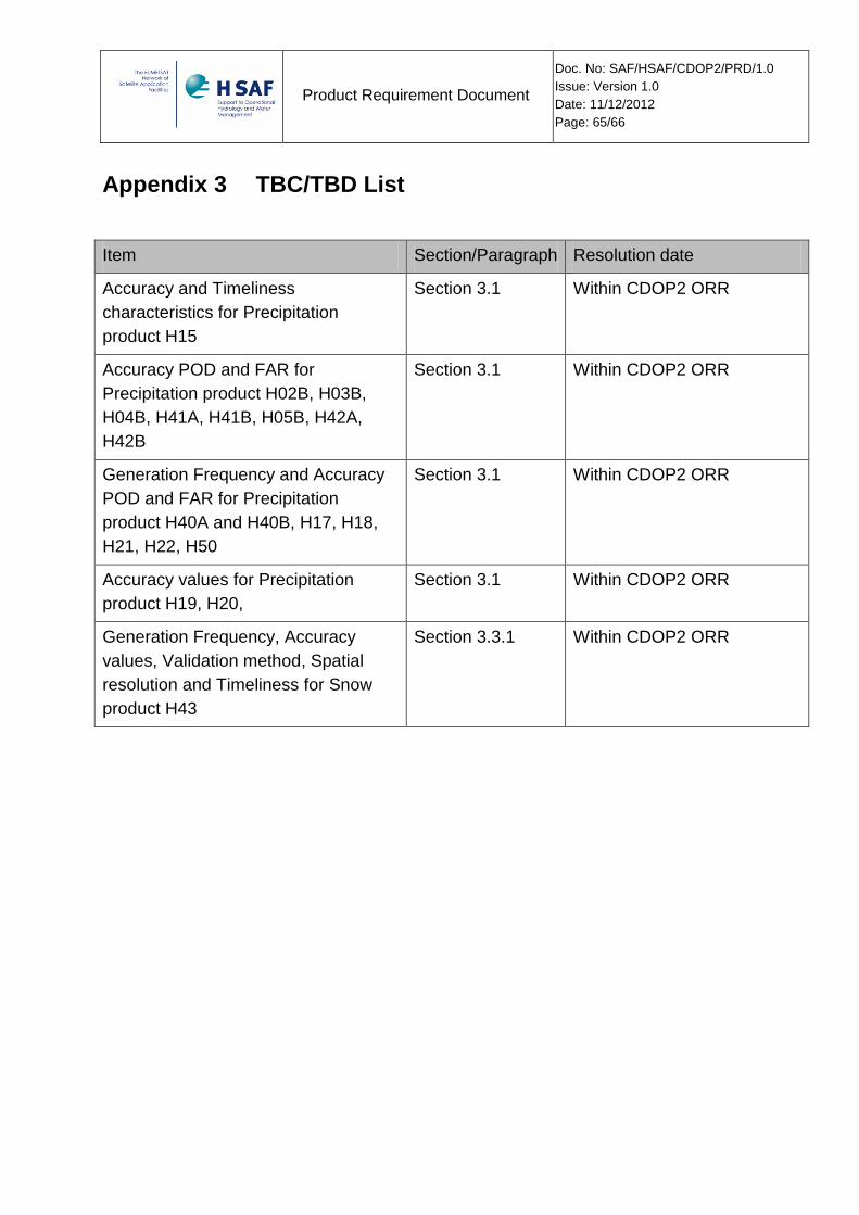
Product Requirement Document
Doc. No: SAF/HSAF/CDOP2/PRD/1.0
Issue: Version 1.0
Date: 11/12/2012
Page: 65/66
Appendix 3 TBC/TBD List
Item Section/Paragraph Resolution date
Accuracy and Timeliness
characteristics for Precipitation
product H15
Section 3.1 Within CDOP2 ORR
Accuracy POD and FAR for
Precipitation product H02B, H03B,
H04B, H41A, H41B, H05B, H42A,
H42B
Section 3.1 Within CDOP2 ORR
Generation Frequency and Accuracy
POD and FAR for Precipitation
product H40A and H40B, H17, H18,
H21, H22, H50
Section 3.1 Within CDOP2 ORR
Accuracy values for Precipitation
product H19, H20,
Section 3.1 Within CDOP2 ORR
Generation Frequency, Accuracy
values, Validation method, Spatial
resolution and Timeliness for Snow
product H43
Section 3.3.1 Within CDOP2 ORR

Product Requirement Document
Doc. No: SAF/HSAF/CDOP2/PRD/1.0
Issue: Version 1.0
Date: 11/12/2012
Page: 66/66
- END OF THE DOCUMENT -