Embed Size (px)
Citation preview
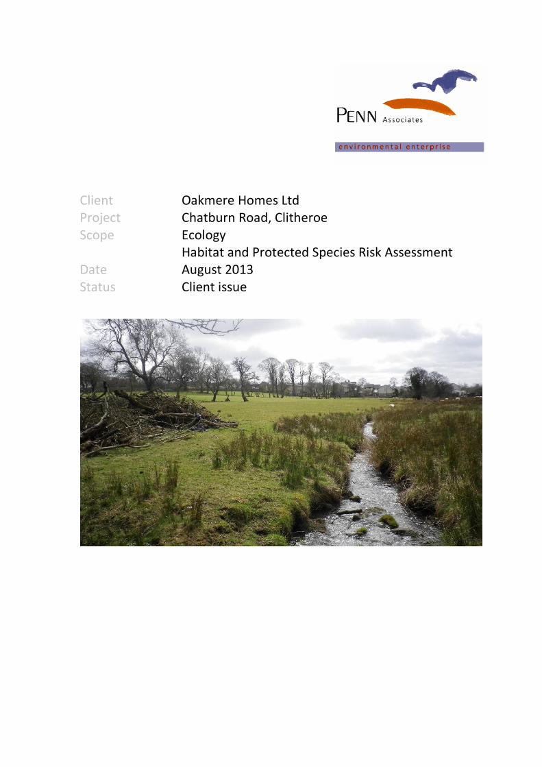
Client Oakmere Homes Ltd
Project Chatburn Road, Clitheroe
Scope Ecology
Habitat and Protected Species Risk Assessment
Date August 2013
Status Client issue
© Penn Associates Ecology Ltd 2 Client: Oakmere Homes Ltd
06-Aug-13 Site: Chatburn Road, Clitheroe
2358 Ecology Planning
Contents
0.0 Summary
1.0 Introduction and Site Context
2.0 General Survey Methodology and Designated Sites
3.0 Habitat Survey
4.0 Protected Species Risk Assessment and Surveys
5.0 Interpretation of Results
Plans
Plan 1: Habitat Plan
Appendices
Appendix 1: Summary of Wildlife Legislation and Relevant Planning Legislation
Report Control Penn Associates Ecology Ltd
Whiteshield House Dipton Mill Road Hexham NE46 1RT
T: 01434 602120 [email protected]
Client Oakmere Homes
Project Chatburn Road, Clitheroe
Document Title Ecology - Habitat and Protected Species Risk Assessment
Document Ref 2358 Chatburn Road~ Ecology Planning
Issue Checked By Date Remarks
1 R Penn 22-April-13 Client Issue
2 R Penn 5-Jul-13 Client Issue
3 R Penn 26-Jul-13 Client Issue
4 R Penn 06-Aug-13 Client Issue
© Penn Associates Ecology Ltd 3 Client: Oakmere Homes Ltd
06-Aug-13 Site: Chatburn Road, Clitheroe
2358 Ecology Planning
0.0 Summary
This report, which was commissioned by Oakmere Homes Ltd, details the results of a Phase 1
Habitat Survey and Protected Species Risk Assessment of land off Chatburn Road, Clitheroe,
Lancashire. The site is proposed for housing development.
0.1 Site Location and General Character
The site is located approximately 1.4km north east of the centre of Clitheroe and south of a
cement works and a railway line. Chatburn Road forms the southern boundary of the site. The
area is urban fringe with agricultural land east and south of the site as well as existing residential
land to the west. The central grid reference of the site is GR: SD751430.
0.2 General Survey Methodology and Designated Sites
A Phase 1 habitat survey was undertaken of the site with the aim of characterising its biodiversity
value. The survey aimed to record the presence/absence of key plant and animal species found in
and around the site, and the communities and habitats they make up.
0.3 Designated Wildlife Sites
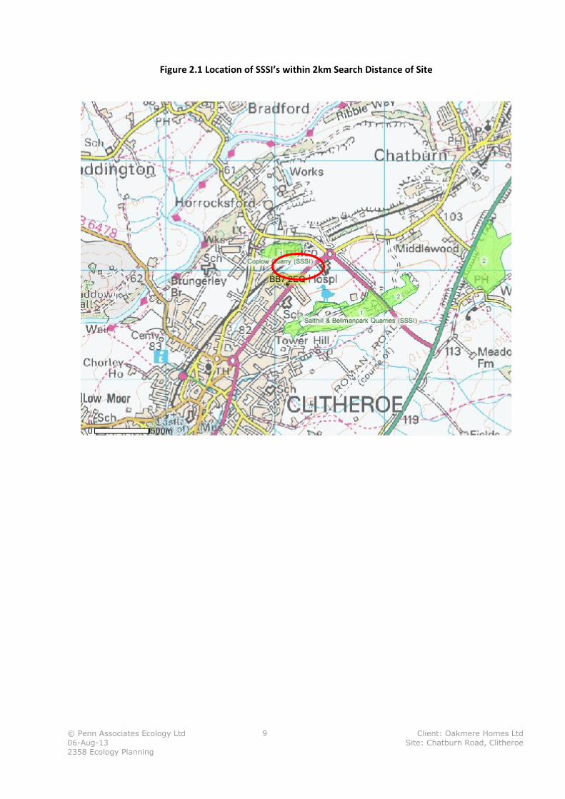
There are no statutory or non-statutory wildlife designations within the site. There are two
geological SSSI’s within a 2km search distance of the site – Coplow Quarry SSSI adjacent to the
northern site boundary and Salthill and Bellmanpark Quarries SSSI approximately 250m to the
south. No adverse impacts on these SSSI’s are predicted as a consequence of development of the
site. Salthill Quarry Local Nature Reserve is also located 250m south of the site. No direct impacts
on the site are predicted and no significant indirect impacts, such as disturbance are anticipated.
0.4 Habitat Survey
Habitats Present within Site:
� Grassland (semi-improved)
� Grassland (unimproved)
� Marshy grassland
� Hedgerows and Trees
� Stream
� Drystone wall
Habitats Adjacent to Site:
� Fen
� Grassland (semi-improved)
� Urban (housing, gardens, roads)
Nature Conservation Status of the Habitats Present
Of the habitats present within the site, the stream habitat is a UK BAP priority habitat (rivers and
streams) and whilst the hedgerow rows are species poor, the ground flora associated with them is
diverse and would suggest that they are long-established. The site survey identified lowland fen
vegetation adjacent to the eastern site boundary which is also a UK BAP priority habitat.
© Penn Associates Ecology Ltd 4 Client: Oakmere Homes Ltd
06-Aug-13 Site: Chatburn Road, Clitheroe
2358 Ecology Planning
Recommendation:
It is recommended that the stream and fen hedgerows habitats are protected from the direct and
indirect impacts of development, including use:
• of an appropriately sized and designed buffer zone around the habitats
• lighting design methods to avoid light spill into these habitats
• appropriate boundary treatment that aims to sustain the undeveloped character of these
habitats
• an appropriately designed surface water management regime which prevents adverse
changes in ground water and surface water quality and flows as a consequence of the
proposed development.
• Where loss of any of these priority habitats cannot be avoided through careful site design,
compensatory habitat creation works should be undertaken.
It is recommended that where feasible, hedgerows are retained within the proposed built
environment with appropriate buffer zones retained around them to enable them to continue to
function as wildlife corridors. Where hedgerows cannot be retained in situ compensatory habitat
should be created within the site.
0.5 Nature Conservation Status of the Species Present
Protected Species
No species that are specially protected under the Conservation of Habitats and Species
Regulations (Amendment) 2012 and/or the WCA (1981) have been recorded within the site.
Targeted surveys for otter and water vole were undertaken with no evidence of the presence of
these species found. The potential for breeding barn owl was assessed as low but with moderate
potential for foraging. However, two trees within the site were classified as having a high risk of
hosting roosting bats with other trees assessed as having a moderate potential.
Recommendations:
Bats and their roosting places are afforded legal protection; as such it is advised that the following
measures are taken with the aim of ensuring that any works undertaken to the trees on site are
legally compliant:
• If the proposed development requires the pruning or felling of a category 2a tree, dusk and
dawn surveys to establish the presence of bats in that particular tree would be required to
inform any requirements for mitigation. If the presence of a roost is confirmed, the tree
would be upgraded to a category 1 tree. Any trees with confirmed roosts will require an
EPS1 licence prior to arboriculture works. If the repeat survey did not confirm presence of a
roost, the tree would be downgraded to a category 2b tree.
• If the proposed development requires the pruning or felling of a category 2b tree, this work
must be carried out taking reasonable avoidance measures. The reasonable avoidance
1 A European Protected Species (EPS) licence, if required, would include a detailed Method Statement describing how
the works would be undertaken (in a manner that would avoid harming bats) and the measures that would be taken
to compensate for the loss of the original roosts. EPS licences can only normally be granted following full planning
permission and the EPS licence application process can take up to ten weeks.
© Penn Associates Ecology Ltd 5 Client: Oakmere Homes Ltd
06-Aug-13 Site: Chatburn Road, Clitheroe
2358 Ecology Planning
measures recommended for each category 2b tree are: the removal of any ivy before felling
and the Appointed Ecologist to supervise soft fell lowering of limbs.
• Trees classified as category 3 in this study can be pruned or felled with no repeat survey
work or mitigation, with regard to bats, considered necessary.
• In the event that bats, evidence of bats or additional potential roost features not identified
during these surveys are observed within a tree with a category 2b or 3 classification prior
to pruning or felling, all works should cease immediately and the Appointed Ecologist
contacted for advice on how to proceed.
Compensation measures (i.e. bat boxes, new woodland planting) for the loss of any potential tree-
roost features should be finalised in conjunction with the master-planning exercise.
Breeding Birds
There is a high risk of breeding birds being present within the site, in particular associated with
trees, hedgerows and shrubs, and the stream and marshy grassland habitat.
Recommendation:
Breeding birds and their nests are afforded legal protection from harm and disturbance under the
Wildlife and Countryside Act 1981 (as amended). Where feasible no vegetation clearance should be
undertaken during the bird breeding season (typically 1st
March – 31st
August). If shrub or tree
clearance during this time is required then pre-clearance checks should be undertaken by a suitably
qualified and experienced ecologist to confirm that no breeding birds or their nests will be affected
by the works.
BAP Priority Species
No UK BAP priority species were observed as present on the site during the site survey, however,
there is a high risk of toads being present and potentially priority bird species such as dunnock,
song thrush, yellowhammer and possibly wetland birds such as Northern lapwing associated with
the marshy grassland.
Invasive Weeds
Himalayan balsam, a plant listed on schedule 9 of Wildlife and Countryside Act 1981, was relatively
widespread within the site. Himalayan balsam is a non-native species which spreads rapidly into
semi-natural habitats at the expense of native plants and associated animals.
Recommendation:
Measures are taken to control the spread of Himalayan balsam outside of the site in accordance
with the requirements of Wildlife and Countryside 1981.
© Penn Associates Ecology Ltd 6 Client: Oakmere Homes Ltd
06-Aug-13 Site: Chatburn Road, Clitheroe
2358 Ecology Planning
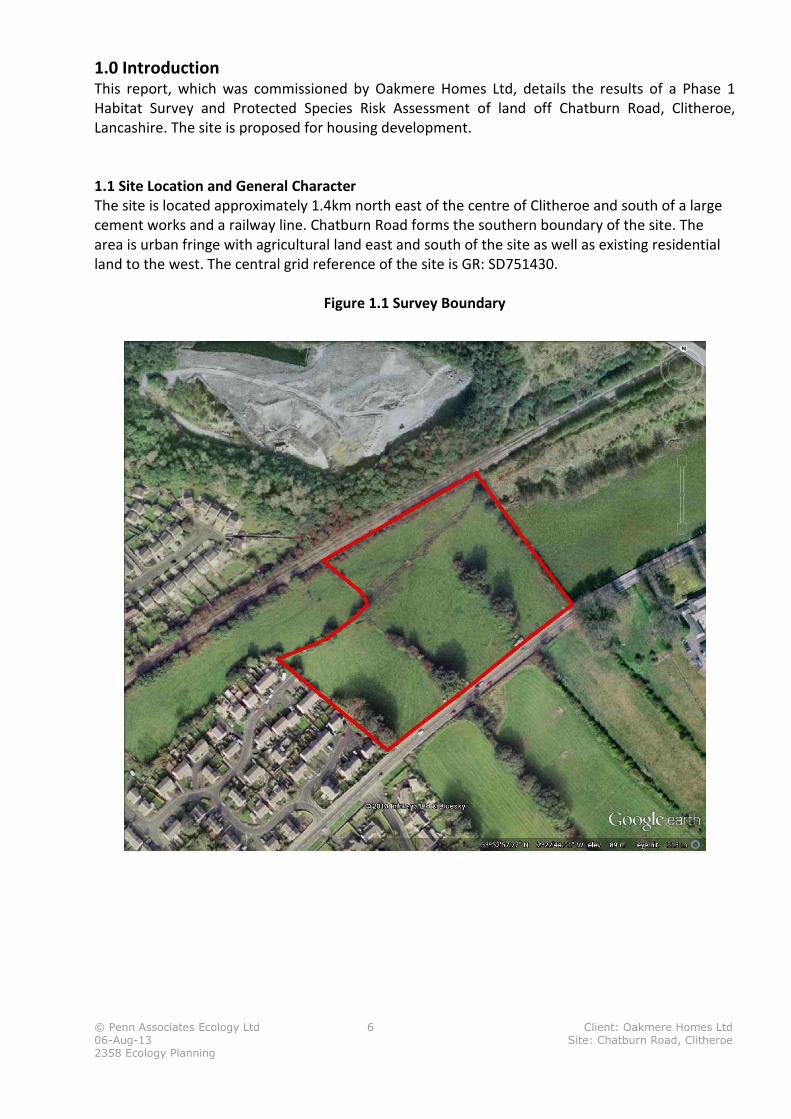
1.0 Introduction This report, which was commissioned by Oakmere Homes Ltd, details the results of a Phase 1
Habitat Survey and Protected Species Risk Assessment of land off Chatburn Road, Clitheroe,
Lancashire. The site is proposed for housing development.
1.1 Site Location and General Character
The site is located approximately 1.4km north east of the centre of Clitheroe and south of a large
cement works and a railway line. Chatburn Road forms the southern boundary of the site. The
area is urban fringe with agricultural land east and south of the site as well as existing residential
land to the west. The central grid reference of the site is GR: SD751430.
Figure 1.1 Survey Boundary
© Penn Associates Ecology Ltd 7 Client: Oakmere Homes Ltd
06-Aug-13 Site: Chatburn Road, Clitheroe
2358 Ecology Planning
2.0 General Survey Methodology and Designated Sites A Phase 1 habitat survey was undertaken of the site with the aim of characterising its biodiversity
value. The survey aimed to record the presence/absence of key plant and animal species found in
and around the site, and the communities and habitats they make up. Certain species and habitats
are afforded protection through planning policies and legislation at a local, regional and national
level. This report details:
� the presence of any designated sites of nature conservation value within a significant
distance of the site
� the habitats and species found on the site and their ecological value
� the presence or potential for protected species or habitats
� legislation relating to these species and habitats.
2.1 Habitat Survey Method
A site walk over was conducted on the 18th
April 2013 by Dr Rachel Penn (MCIEEM CEnv) during
which habitats found were identified and mapped according to the Joint Nature Conservation
Committee 1993 Phase 1 methodology.2 Additional notes were made on species composition and
structure where appropriate and are described in this report.
2.2 Protected Species Risk Assessment
During the site walk-over the potential for protected species and the need for further protected
species surveys was assessed based on habitat suitability, existing datasets and site observation.
2.3 Desk Study
A search for designated wildlife sites and protected species records was carried out using the
Natural England’s ‘Nature on the Map’ website3 and the NBN Gateway website
4 which were
accessed on the 15th
April 2013.
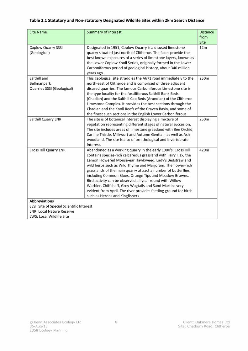
2.4 Designated Sites
Certain areas of land are afforded statutory protection under the Wildlife and Countryside Act
1981 (as amended) and/or the National Parks and Access to the Countryside Act 1949 (as
amended by Schedule 11 of the Natural Environment and Rural Communities Act 2006). Land may
also be given non-statutory designations, which may be afforded weight in the planning system
e.g. Local Wildlife Sites. The Nature on the Map website identified the statutory designated
wildlife sites listed in table 2.1 within a 2km search distance of the site boundaries and their
location is shown on plan 2.1.
2Joint Nature Conservation Committee Handbook for Phase 1 Habitat Survey A technique for environmental audit
2003 3 (http://www.natureonthemap.naturalengland.org.uk)
4 (http://www.nbn.org.uk/)
© Penn Associates Ecology Ltd 8 Client: Oakmere Homes Ltd
06-Aug-13 Site: Chatburn Road, Clitheroe
2358 Ecology Planning
Table 2.1 Statutory and Non-statutory Designated Wildlife Sites within 2km Search Distance
Site Name Summary of Interest Distance
from
Site
Coplow Quarry SSSI
(Geological)
Designated in 1951, Coplow Quarry is a disused limestone
quarry situated just north of Clitheroe. The faces provide the
best known exposures of a series of limestone layers, known as
the Lower Coplow Knoll Series, originally formed in the Lower
Carboniferous period of geological history, about 340 million
years ago.
12m
Salthill and
Bellmanpark
Quarries SSSI (Geological)
This geological site straddles the A671 road immediately to the
north-east of Clitheroe and is comprised of three adjacent
disused quarries. The famous Carboniferous Limestone site is
the type locality for the fossiliferous Salthill Bank Beds
(Chadian) and the Salthill Cap Beds (Arundian) of the Clitheroe
Limestone Complex. It provides the best sections through the
Chadian and the Knoll Reefs of the Craven Basin, and some of
the finest such sections in the English Lower Carboniferous
250m
Salthill Quarry LNR The site is of botanical interest displaying a mixture of
vegetation representing different stages of natural succesion.
The site includes areas of limestone grassland with Bee Orchid,
Carline Thistle, Milkwort and Autumn Gentian as well as Ash
woodland. The site is also of ornithological and invertebrate
interest.
250m
Cross Hill Quarry LNR Abandoned as a working quarry in the early 1900's, Cross Hill
contains species-rich calcareous grassland with Fairy Flax, the
Lemon Flowered Mouse-ear Hawkweed, Lady's Bedstraw and
wild herbs such as Wild Thyme and Marjoram. The flower-rich
grasslands of the main quarry attract a number of butterflies
including Common Blues, Orange Tips and Meadow Browns.
Bird activity can be observed all year round with Willow
Warbler, Chiffchaff, Grey Wagtails and Sand Martins very
evident from April. The river provides feeding ground for birds
such as Herons and Kingfishers.
420m
Abbreviations
SSSI: Site of Special Scientific Interest
LNR: Local Nature Reserve
LWS: Local Wildlife Site
© Penn Associates Ecology Ltd 9 Client: Oakmere Homes Ltd
06-Aug-13 Site: Chatburn Road, Clitheroe
2358 Ecology Planning
Figure 2.1 Location of SSSI’s within 2km Search Distance of Site
© Penn Associates Ecology Ltd 10 Client: Oakmere Homes Ltd
06-Aug-13 Site: Chatburn Road, Clitheroe
2358 Ecology Planning
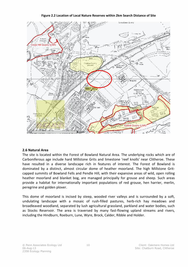
Figure 2.2 Location of Local Nature Reserves within 2km Search Distance of Site
2.6 Natural Area
The site is located within the Forest of Bowland Natural Area. The underlying rocks which are of
Carboniferous age include hard Millstone Grits and limestone 'reef knolls' near Clitheroe. These
have resulted in a diverse landscape rich in features of interest. The Forest of Bowland is
dominated by a distinct, almost circular dome of heather moorland. The high Millstone Grit-
capped summits of Bowland Fells and Pendle Hill, with their expansive areas of wild, open rolling
heather moorland and blanket bog, are managed principally for grouse and sheep. Such areas
provide a habitat for internationally important populations of red grouse, hen harrier, merlin,
peregrine and golden plover.
This dome of moorland is incised by steep, wooded river valleys and is surrounded by a soft,
undulating landscape with a mosaic of rush-filled pastures, herb-rich hay meadows and
broadleaved woodland, separated by lush agricultural grassland, parkland and water bodies, such
as Stocks Reservoir. The area is traversed by many fast-flowing upland streams and rivers,
including the Hindburn, Roeburn, Lune, Wyre, Brock, Calder, Ribble and Holder.
© Penn Associates Ecology Ltd 11 Client: Oakmere Homes Ltd
06-Aug-13 Site: Chatburn Road, Clitheroe
2358 Ecology Planning
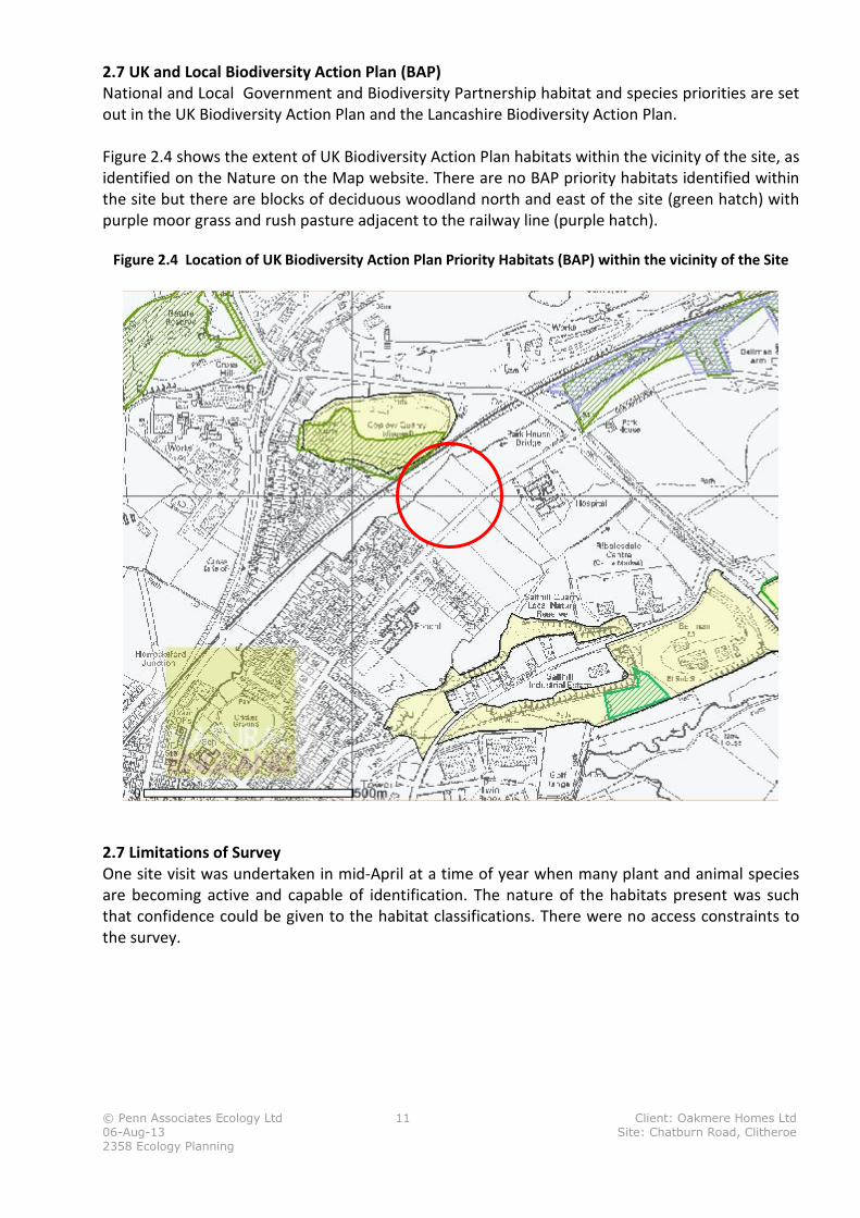
2.7 UK and Local Biodiversity Action Plan (BAP)
National and Local Government and Biodiversity Partnership habitat and species priorities are set
out in the UK Biodiversity Action Plan and the Lancashire Biodiversity Action Plan.
Figure 2.4 shows the extent of UK Biodiversity Action Plan habitats within the vicinity of the site, as
identified on the Nature on the Map website. There are no BAP priority habitats identified within
the site but there are blocks of deciduous woodland north and east of the site (green hatch) with
purple moor grass and rush pasture adjacent to the railway line (purple hatch).
Figure 2.4 Location of UK Biodiversity Action Plan Priority Habitats (BAP) within the vicinity of the Site
2.7 Limitations of Survey
One site visit was undertaken in mid-April at a time of year when many plant and animal species
are becoming active and capable of identification. The nature of the habitats present was such
that confidence could be given to the habitat classifications. There were no access constraints to
the survey.
© Penn Associates Ecology Ltd 12 Client: Oakmere Homes Ltd
06-Aug-13 Site: Chatburn Road, Clitheroe
2358 Ecology Planning
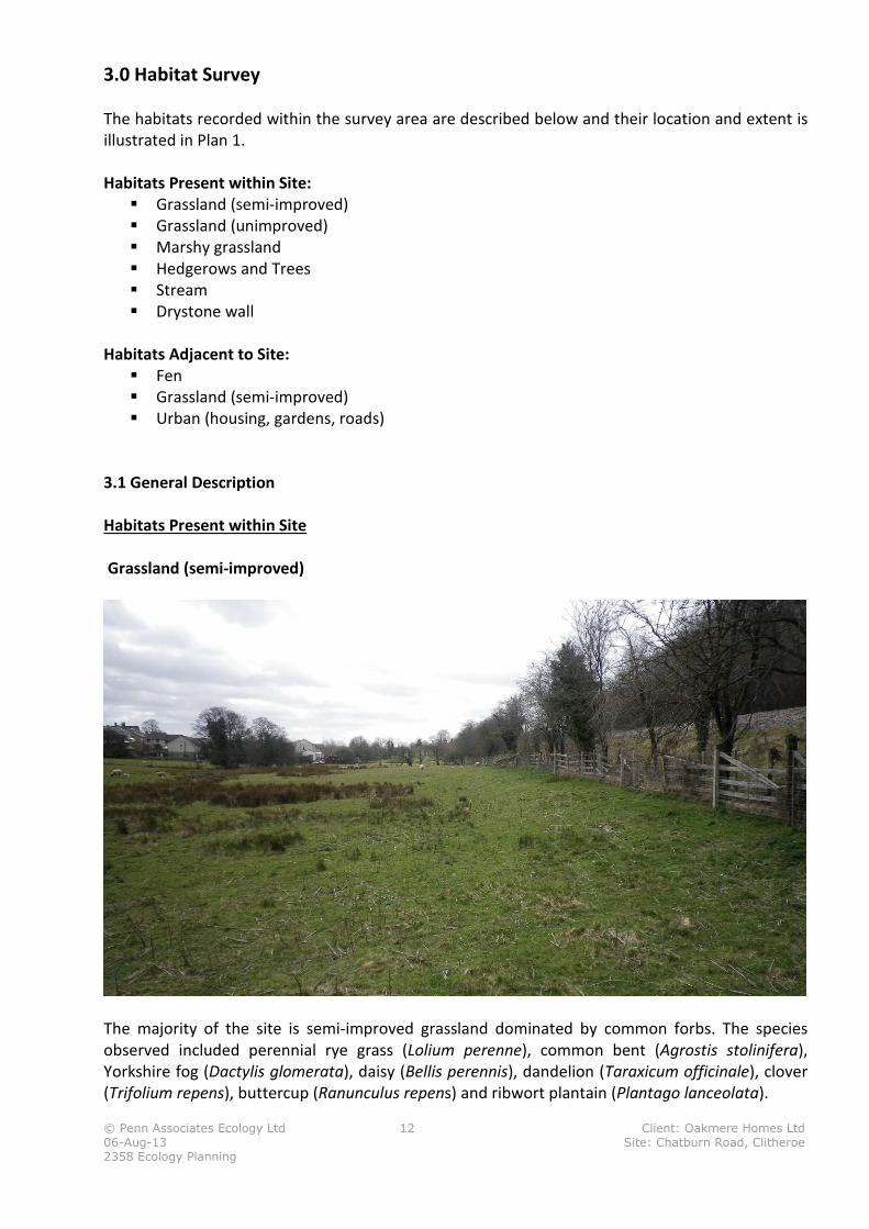
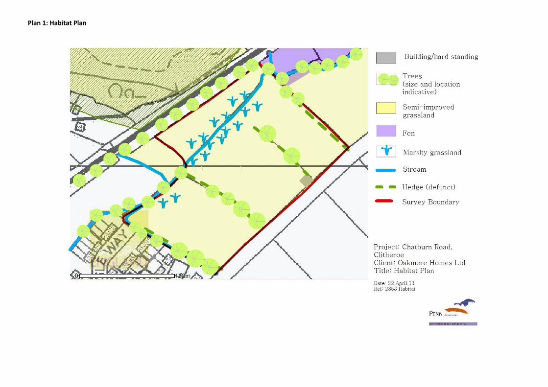
3.0 Habitat Survey
The habitats recorded within the survey area are described below and their location and extent is
illustrated in Plan 1.
Habitats Present within Site:
� Grassland (semi-improved)
� Grassland (unimproved)
� Marshy grassland
� Hedgerows and Trees
� Stream
� Drystone wall
Habitats Adjacent to Site:
� Fen
� Grassland (semi-improved)
� Urban (housing, gardens, roads)
3.1 General Description
Habitats Present within Site
Grassland (semi-improved)
The majority of the site is semi-improved grassland dominated by common forbs. The species
observed included perennial rye grass (Lolium perenne), common bent (Agrostis stolinifera),
Yorkshire fog (Dactylis glomerata), daisy (Bellis perennis), dandelion (Taraxicum officinale), clover
(Trifolium repens), buttercup (Ranunculus repens) and ribwort plantain (Plantago lanceolata).
© Penn Associates Ecology Ltd 13 Client: Oakmere Homes Ltd
06-Aug-13 Site: Chatburn Road, Clitheroe
2358 Ecology Planning
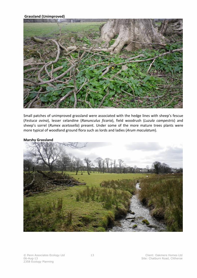
Grassland (Unimproved)
Small patches of unimproved grassland were associated with the hedge lines with sheep’s fescue
(Festuca ovina), lesser celandine (Ranunculus ficaria), field woodrush (Luzula campestris) and
sheep’s sorrel (Rumex acetosella) present. Under some of the more mature trees plants were
more typical of woodland ground flora such as lords and ladies (Arum maculatum).
Marshy Grassland
© Penn Associates Ecology Ltd 14 Client: Oakmere Homes Ltd
06-Aug-13 Site: Chatburn Road, Clitheroe
2358 Ecology Planning
A band of marshy grassland was present along the stream which flows in a south westerly
direction through the site. In addition to rush species (Juncus effusus and J inflexus) the grassland
included abundant meadowsweet (Filipendula ulmaria), willowherb (Epilobium sps), opposite-
leaved golden saxifrage (Chrysosplenium oppositifolium), reed sweet grass (Phalaris arundinacea)
and valerian (Valeriana sps).
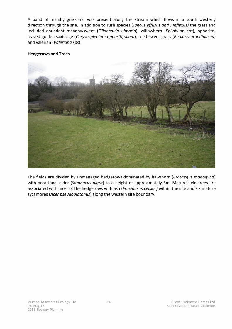
Hedgerows and Trees
The fields are divided by unmanaged hedgerows dominated by hawthorn (Crataegus monogyna)
with occasional elder (Sambucus nigra) to a height of approximately 5m. Mature field trees are
associated with most of the hedgerows with ash (Fraxinus excelsior) within the site and six mature
sycamores (Acer pseudoplatanus) along the western site boundary.
© Penn Associates Ecology Ltd 15 Client: Oakmere Homes Ltd
06-Aug-13 Site: Chatburn Road, Clitheroe
2358 Ecology Planning
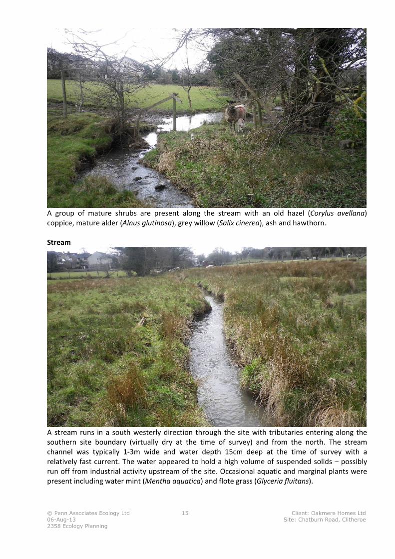
A group of mature shrubs are present along the stream with an old hazel (Corylus avellana)
coppice, mature alder (Alnus glutinosa), grey willow (Salix cinerea), ash and hawthorn.
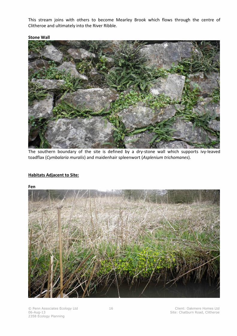
Stream
A stream runs in a south westerly direction through the site with tributaries entering along the
southern site boundary (virtually dry at the time of survey) and from the north. The stream
channel was typically 1-3m wide and water depth 15cm deep at the time of survey with a
relatively fast current. The water appeared to hold a high volume of suspended solids – possibly
run off from industrial activity upstream of the site. Occasional aquatic and marginal plants were
present including water mint (Mentha aquatica) and flote grass (Glyceria fluitans).
© Penn Associates Ecology Ltd 16 Client: Oakmere Homes Ltd
06-Aug-13 Site: Chatburn Road, Clitheroe
2358 Ecology Planning
This stream joins with others to become Mearley Brook which flows through the centre of
Clitheroe and ultimately into the River Ribble.
Stone Wall
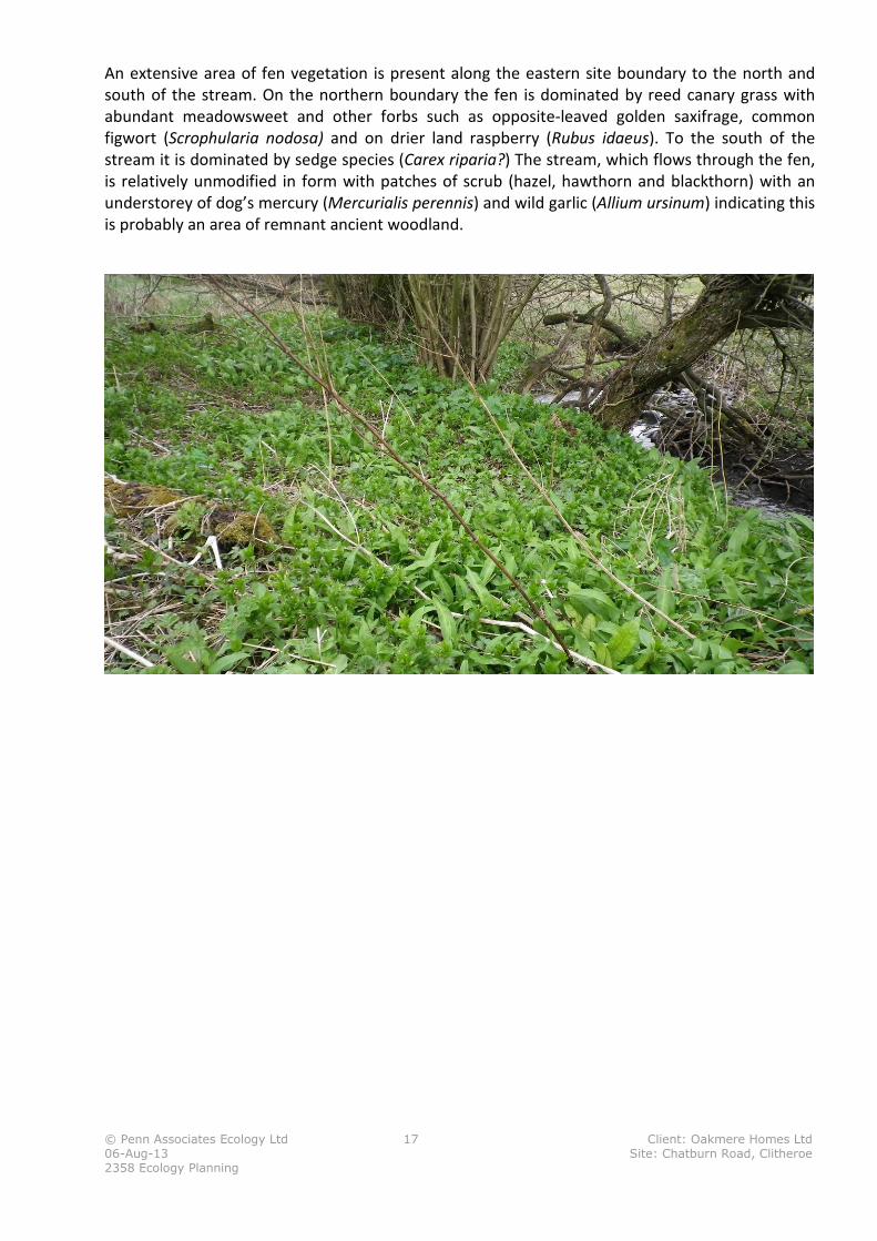
The southern boundary of the site is defined by a dry-stone wall which supports ivy-leaved
toadflax (Cymbalaria muralis) and maidenhair spleenwort (Asplenium trichomanes).
Habitats Adjacent to Site:
Fen
© Penn Associates Ecology Ltd 17 Client: Oakmere Homes Ltd
06-Aug-13 Site: Chatburn Road, Clitheroe
2358 Ecology Planning
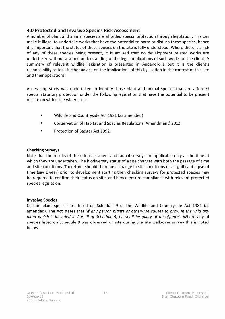
An extensive area of fen vegetation is present along the eastern site boundary to the north and
south of the stream. On the northern boundary the fen is dominated by reed canary grass with
abundant meadowsweet and other forbs such as opposite-leaved golden saxifrage, common
figwort (Scrophularia nodosa) and on drier land raspberry (Rubus idaeus). To the south of the
stream it is dominated by sedge species (Carex riparia?) The stream, which flows through the fen,
is relatively unmodified in form with patches of scrub (hazel, hawthorn and blackthorn) with an
understorey of dog’s mercury (Mercurialis perennis) and wild garlic (Allium ursinum) indicating this
is probably an area of remnant ancient woodland.
© Penn Associates Ecology Ltd 18 Client: Oakmere Homes Ltd
06-Aug-13 Site: Chatburn Road, Clitheroe
2358 Ecology Planning
4.0 Protected and Invasive Species Risk Assessment A number of plant and animal species are afforded special protection through legislation. This can
make it illegal to undertake works that have the potential to harm or disturb these species, hence
it is important that the status of these species on the site is fully understood. Where there is a risk
of any of these species being present, it is advised that no development related works are
undertaken without a sound understanding of the legal implications of such works on the client. A
summary of relevant wildlife legislation is presented in Appendix 1 but it is the client’s
responsibility to take further advice on the implications of this legislation in the context of this site
and their operations.
A desk-top study was undertaken to identify those plant and animal species that are afforded
special statutory protection under the following legislation that have the potential to be present
on site on within the wider area:
� Wildlife and Countryside Act 1981 (as amended)
� Conservation of Habitat and Species Regulations (Amendment) 2012
� Protection of Badger Act 1992.
Checking Surveys
Note that the results of the risk assessment and faunal surveys are applicable only at the time at
which they are undertaken. The biodiversity status of a site changes with both the passage of time
and site conditions. Therefore, should there be a change in site conditions or a significant lapse of
time (say 1 year) prior to development starting then checking surveys for protected species may
be required to confirm their status on site, and hence ensure compliance with relevant protected
species legislation.
Invasive Species
Certain plant species are listed on Schedule 9 of the Wildlife and Countryside Act 1981 (as
amended). The Act states that ‘if any person plants or otherwise causes to grow in the wild any
plant which is included in Part II of Schedule 9, he shall be guilty of an offence’. Where any of
species listed on Schedule 9 was observed on site during the site walk-over survey this is noted
below.
© Penn Associates Ecology Ltd 19 Client: Oakmere Homes Ltd
06-Aug-13 Site: Chatburn Road, Clitheroe
2358 Ecology Planning
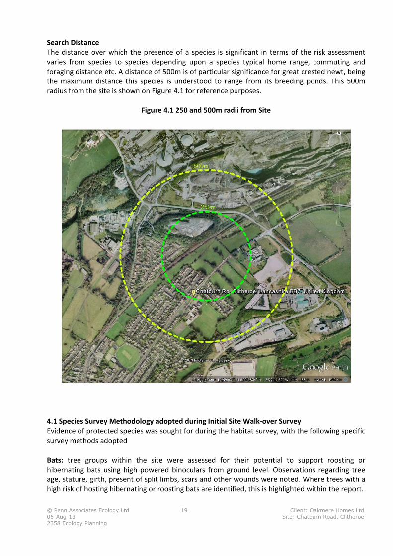
Search Distance
The distance over which the presence of a species is significant in terms of the risk assessment
varies from species to species depending upon a species typical home range, commuting and
foraging distance etc. A distance of 500m is of particular significance for great crested newt, being
the maximum distance this species is understood to range from its breeding ponds. This 500m
radius from the site is shown on Figure 4.1 for reference purposes.
Figure 4.1 250 and 500m radii from Site
4.1 Species Survey Methodology adopted during Initial Site Walk-over Survey
Evidence of protected species was sought for during the habitat survey, with the following specific
survey methods adopted
Bats: tree groups within the site were assessed for their potential to support roosting or
hibernating bats using high powered binoculars from ground level. Observations regarding tree
age, stature, girth, present of split limbs, scars and other wounds were noted. Where trees with a
high risk of hosting hibernating or roosting bats are identified, this is highlighted within the report.
© Penn Associates Ecology Ltd 20 Client: Oakmere Homes Ltd
06-Aug-13 Site: Chatburn Road, Clitheroe
2358 Ecology Planning
Badgers: evidence of badger activity within the site was sought through observation for badger
tracks, snuffle holes and latrines, as well as the more obvious badger setts.
Great Crested Newt: The presence of ponds potentially suitable for breeding great crested newt
either within the site or within 500m of the site where such land is accessible was recorded.
However, great crested newts occupy terrestrial habitats outside the breeding season, with scrub,
long grassland, stone and wood piles being favoured habitat. Where suitable terrestrial habitats
are located within the site this is noted.
Red Squirrel: Evidence of red squirrels within the site is sought by visual observation for the
species in woodland and scrub areas, evidence of dreys in the trees as well as feeding remains e.g.
nuts, pine cones.
Reptiles: Evidence of reptiles was sought by direct observation in suitable habitats e.g. long grass,
areas of bare soils and stones which can provide basking sites as well as by searching in suitable
refugia (only during the summer months to avoid disturbance during hibernation). However,
reptiles can be elusive and hence the risk assessment takes this factor into account.
Water Vole: Water vole typically are found within 5m of watercourses and ditches although they
can move up to 15m from a watercourse in search of a mate, hence the absence of any suitable
watercourse or ditch within the site is a good determinant of the risk of water vole being present.
Where a watercourse or ditch is present then evidence of water vole in the form of grazing lawns,
holes, foot prints and latrines as well as the sound of water vole entering the water is good
evidence of water vole activity.
Otter: Otter are only likely to be resident within a site where there is a reasonably large water
body that hosts fish. They may be present on a lake or river bank and move through suitable
adjacent habitat some distance form the water. The presence of otter spraints, often on rocks, as
well as otter foot prints as well as sightings are reliable indicators of otter activity.
Breeding Birds: The presence of breeding birds within a site is typically evidenced by breeding
activity (courtship and mating) as well as by the presence of nest which may be located within
trees, shrubs as well as on the ground in long grass, rushes etc.
4.2 Desk-top Study
Desktop data on the distribution of protected species was obtained from the NBN Gateway, which
is the largest, widely accessible, biological dataset for the UK. It contains data from a wide range of
historic and current data recording centres and atlas’s. Reference was also made to the North East
England Reptile Atlas (2008) and Amphibian Atlas 2008. Table 4.1 contains a summary of the
information obtained from these datasets and a risk assessment for protected species based on
the dataset records as well as the site survey and evaluation.
The absence of a record for a locality can be taken as confirmation that the species is not present;
rather it may reflect lack of survey effort. It should also be noted that many of the data records are
more than 10 years old. Hence whilst the results need to be interpreted in an informed manner,
the dataset does provide valuable information regarding the general distribution of species within
any given region.
© Penn Associates Ecology Ltd 21 Client: Oakmere Homes Ltd
06-Aug-13 Site: Chatburn Road, Clitheroe
2358 Ecology Planning
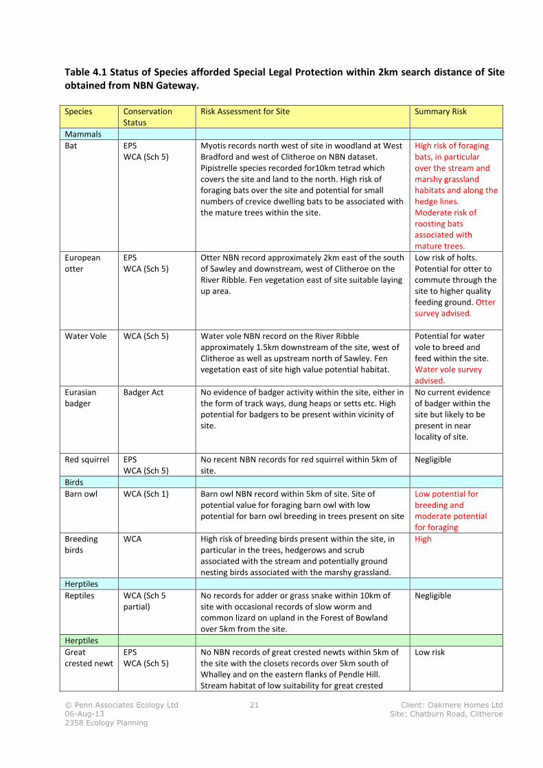
Table 4.1 Status of Species afforded Special Legal Protection within 2km search distance of Site
obtained from NBN Gateway.
Species Conservation
Status
Risk Assessment for Site Summary Risk
Mammals
Bat EPS
WCA (Sch 5)
Myotis records north west of site in woodland at West
Bradford and west of Clitheroe on NBN dataset.
Pipistrelle species recorded for10km tetrad which
covers the site and land to the north. High risk of
foraging bats over the site and potential for small
numbers of crevice dwelling bats to be associated with
the mature trees within the site.
High risk of foraging
bats, in particular
over the stream and
marshy grassland
habitats and along the
hedge lines.
Moderate risk of
roosting bats
associated with
mature trees.
European
otter
EPS
WCA (Sch 5)
Otter NBN record approximately 2km east of the south
of Sawley and downstream, west of Clitheroe on the
River Ribble. Fen vegetation east of site suitable laying
up area.
Low risk of holts.
Potential for otter to
commute through the
site to higher quality
feeding ground. Otter
survey advised.
Water Vole WCA (Sch 5) Water vole NBN record on the River Ribble
approximately 1.5km downstream of the site, west of
Clitheroe as well as upstream north of Sawley. Fen
vegetation east of site high value potential habitat.
Potential for water
vole to breed and
feed within the site.
Water vole survey
advised.
Eurasian
badger
Badger Act No evidence of badger activity within the site, either in
the form of track ways, dung heaps or setts etc. High
potential for badgers to be present within vicinity of
site.
No current evidence
of badger within the
site but likely to be
present in near
locality of site.
Red squirrel EPS
WCA (Sch 5)
No recent NBN records for red squirrel within 5km of
site.
Negligible
Birds
Barn owl WCA (Sch 1) Barn owl NBN record within 5km of site. Site of
potential value for foraging barn owl with low
potential for barn owl breeding in trees present on site
Low potential for
breeding and
moderate potential
for foraging
Breeding
birds
WCA High risk of breeding birds present within the site, in
particular in the trees, hedgerows and scrub
associated with the stream and potentially ground
nesting birds associated with the marshy grassland.
High
Herptiles
Reptiles WCA (Sch 5
partial)
No records for adder or grass snake within 10km of
site with occasional records of slow worm and
common lizard on upland in the Forest of Bowland
over 5km from the site.
Negligible
Herptiles
Great
crested newt
EPS
WCA (Sch 5)
No NBN records of great crested newts within 5km of
the site with the closets records over 5km south of
Whalley and on the eastern flanks of Pendle Hill.
Stream habitat of low suitability for great crested
Low risk
© Penn Associates Ecology Ltd 22 Client: Oakmere Homes Ltd
06-Aug-13 Site: Chatburn Road, Clitheroe
2358 Ecology Planning
newts with no standing water within the site
EPS: European Protected Species (i.e. Species afforded legal protection under the Conservation of Habitats and
Species Regulations 2010)
WCA (Sch 5): Species afforded protection under the Wildlife and Countryside Act 1981 (as amended). Relevant
schedule number follows.
NBN Gateway Data: Reference is made to the NBN gateway data to provide general information of the distribution of species
within the vicinity of the site. Where this indicates species are resident in the locality of the site, more detailed species surveys are
recommended and/or sourcing data from the Local Biological Records Centre. The contribution of the data provider is kindly
acknowledged as is the NBN Gateway (data.nbn.org.uk). Website accessed 15 April 2013.
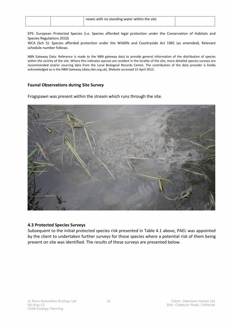
Faunal Observations during Site Survey
Frogspawn was present within the stream which runs through the site.
4.3 Protected Species Surveys
Subsequent to the initial protected species risk presented in Table 4.1 above, PAEL was appointed
by the client to undertaken further surveys for those species where a potential risk of them being
present on site was identified. The results of these surveys are presented below.

© Penn Associates Ecology Ltd 23 Client: Oakmere Homes Ltd
06-Aug-13 Site: Chatburn Road, Clitheroe
2358 Ecology Planning
4.3.1 Otter Lutra lutra
Otter surveys record field signs along rivers and streams to determine activity levels and patterns
of behaviour over a predetermined area of suitable habitat (‘The New Rivers and Wildlife
Handbook’ (RSPB, NRA and RSNC, 1995). This methodology complies with the survey requirements
as set out in the Design Manual for Roads and Bridges (DMRB).
Otter surveying records locations of otter activity i.e. footprints, spraints (otter droppings), feeding
remains, footprints, slides (where otters pass back and forth to the waters edge), lying-up areas
and holts to determine otter usage of particular stretches of a river and its tributaries. The otter
survey undertaken on the un-named stream which flows through the site consisted survey of both
banks (where accessible) within the site boundaries.
There are a number of different types of resting places used by otters. Below is a brief description
of the resting sites.
Holts
Otter holts are places/structures used by otters for shelter on a ‘permanent’ basis. Holts are
covered structures, usually a hole or burrow along the river bank amongst riparian vegetation and
the roost system of river side trees, or behind boulders set in to the bank. Usually a holt will also
have other associated otter field signs such as footprints or an accumulation of spraint. Holts may
also be connected to lying-up areas and have more than one entrance as with badger setts.
Lying-up areas/couches
Lying-up areas or couches are ‘temporary’ areas used by otters for resting, grooming or feeding
whilst on the move. Lying-up areas usually do not form a full covered structure, rather they are
partially hidden bankside shelves amongst riparian vegetation, or ‘nest-like’ structures amongst
reeds and grasses. As with holts, lyingup areas usually have other field signs to demonstrate use by
otters.
Natal Dens
Natal dens are holts which are used by otters to give birth and rear their young natal dens usually
have inconspicuous entrances and have little or no evidence of otter activity around the entrance.
Natal dens can be located some distance from the watercourse, sometimes being set back in
woodland amongst log piles, tree roots, rubble or even amongst reed beds. The banks of the
ditches and watercourses within the site and a 500m radius of the site were assessed for their
potential to support otter in line with methods given in Chanin (2003). Any field signs of otter
activity, including footprints, spraints, lying-up sites and holts were noted. All fieldwork is carried
out in accordance with current best practice guidelines with reference to Monitoring the Otter
(Life in UK Rivers 2003), the Design Manual for Roads and Bridges; Volume 10 Section 4 Part 2
(Highways Agency, 2001), and The New Rivers and Wildlife Handbook (RSPB, NRA and RSNC,1995).
Survey Results
Despite a comprehensive search throughout the site for signs of otter presence or activity, none
were found. Throughout the entire site the banks for the single un-named stream were readily
accessible and a comprehensive search was possible. The stream was only approx. 70-100cm wide
© Penn Associates Ecology Ltd 24 Client: Oakmere Homes Ltd
06-Aug-13 Site: Chatburn Road, Clitheroe
2358 Ecology Planning
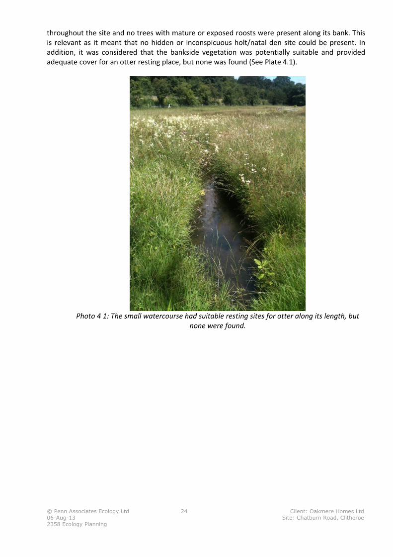
throughout the site and no trees with mature or exposed roosts were present along its bank. This
is relevant as it meant that no hidden or inconspicuous holt/natal den site could be present. In
addition, it was considered that the bankside vegetation was potentially suitable and provided
adequate cover for an otter resting place, but none was found (See Plate 4.1).
Photo 4 1: The small watercourse had suitable resting sites for otter along its length, but
none were found.
© Penn Associates Ecology Ltd 25 Client: Oakmere Homes Ltd
06-Aug-13 Site: Chatburn Road, Clitheroe
2358 Ecology Planning
4.3.2 Water vole: Field Survey
Survey Method
Both banks of the un-named stream which flows through the site was walked by the surveyor on
25/07/2013. The banks of the ditches and watercourses were assessed for their potential to
support water vole. The survey methods were implemented in accordance with those described in
the Water Vole Conservation Handbook, (Strachan and Moorhouse, 2006).
A detailed examination of the watercourses was carried out to search for evidence of water vole
such as;
• Feeding signs, including feeding stations;
• Latrines and individual droppings;
• Burrows, nests and feeding lawns (areas of shortly-grazed grassland at the entrance to a
burrow);
• Footprints and obvious runways in vegetation; and
• Distinctive ‘plop’ sound of water voles entering the water.
The survey was undertaken on 25/07/2013 which is during the optimal period (between April and
early-October) for identifying breeding territories (Strachan & Moorhouse 2006). In addition, the
survey was carried out during dry weather and the water levels were suitably low allowing good
visibility of the banks. Surveys were conducted from both banks to maximise views of the banks.
Any evidence of water vole was to be recorded on a map and accompanied by photographs.
Survey Results
Water levels were low in the single small stream which flows through the site. This meant that
conditions were ideal for searching and observing any low-level water vole burrows which might
have been present. Nonetheless, despite a thorough search, no signs of water vole activity were
observed. The characteristics of the channel were considered to be reasonable for water vole lots
of overhanging banking and some aquatic plants and grasses and with good dense cover with
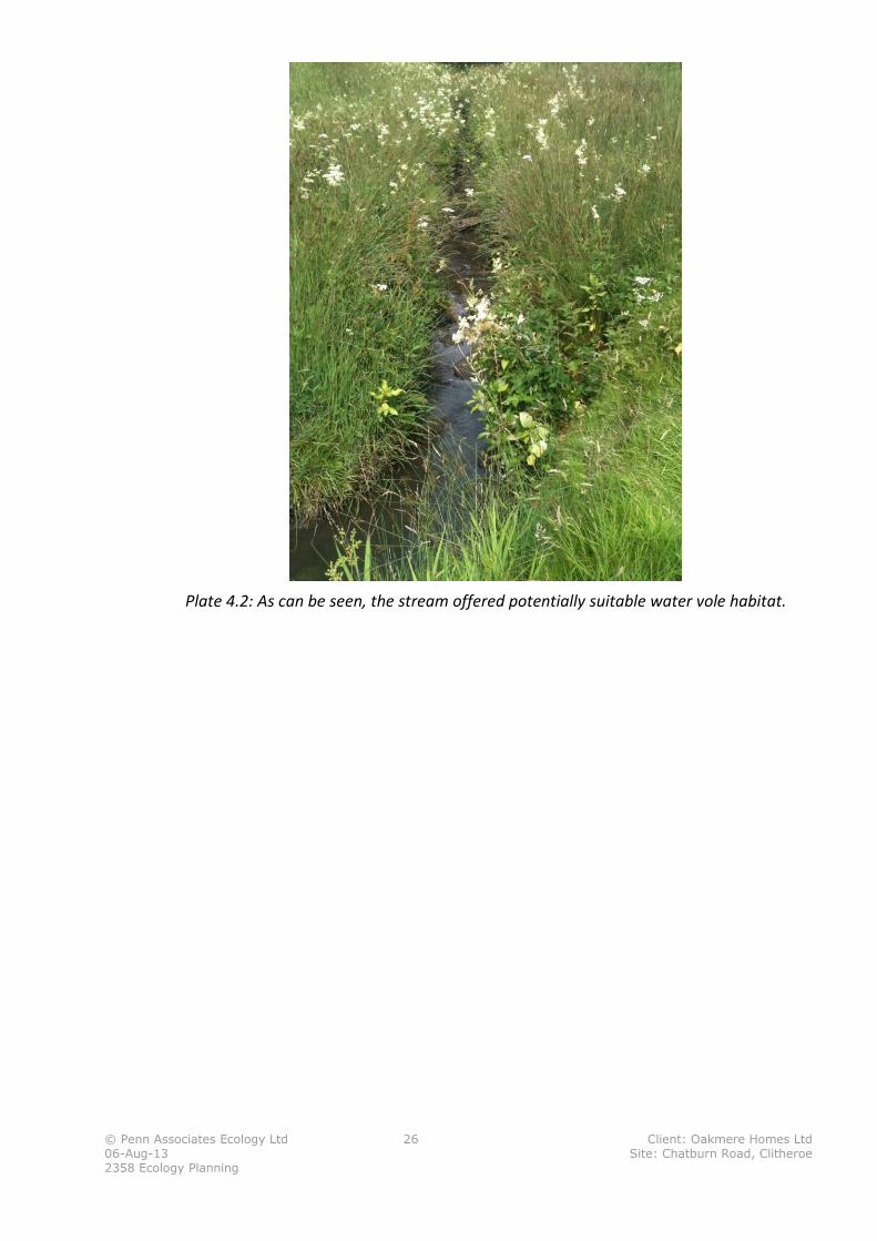
meadowsweet and rushes along its length (See Plate 5.2).
One possible sign of historical water vole activity was found in the northern section of the site
along the stream. This was a single burrow. However, the burrow was choked with vegetation and
no other signs of any water vole activity were present, so it was no concluded that no water voles
are present.
© Penn Associates Ecology Ltd 26 Client: Oakmere Homes Ltd
06-Aug-13 Site: Chatburn Road, Clitheroe
2358 Ecology Planning
Plate 4.2: As can be seen, the stream offered potentially suitable water vole habitat.
© Penn Associates Ecology Ltd 27 Client: Oakmere Homes Ltd
06-Aug-13 Site: Chatburn Road, Clitheroe
2358 Ecology Planning
4.3.3 Bats: Tree Inspection
Survey Method
A visual survey of all trees was carried out. Trees were categorised into high, medium or low
potential for bats. The following signs which can be indicators of bat presence were used for the
categorisation:
• Woodpecker holes with small cracks/crevices
• Cracks/crevices, ivy cover and flaking bark
• Loose or flaking bark deadwood in canopy or stem low/no ivy cover
• Medium to dense ivy cover
• Deadwood in canopy or stem
• Snagged branches
• Hollow stems or limbs
• Hole in buttresses/hollow core
• The following signs were searched for in all of the above places as these would indicate bat
presence:
• Staining around a hole, caused by natural oils in the bats’ fur.
• Stains beneath a hole, caused by bat urine.
• Scratch marks around a hole, caused by bat claws.
• Bat droppings beneath a hole.
• Insects (especially flies) around a hole.
Once surveyed, each tree was categorised, using Bat Conservation Trust guidelines, according to
its potential to support roosting bats into one of four categories: 1. Confirmed bat roost, 2a. High
potential to support bats, 2b. Low/moderate potential to support bats, and 3. Negligible potential
to support bats.
© Penn Associates Ecology Ltd 28 Client: Oakmere Homes Ltd
06-Aug-13 Site: Chatburn Road, Clitheroe
2358 Ecology Planning
Survey Results
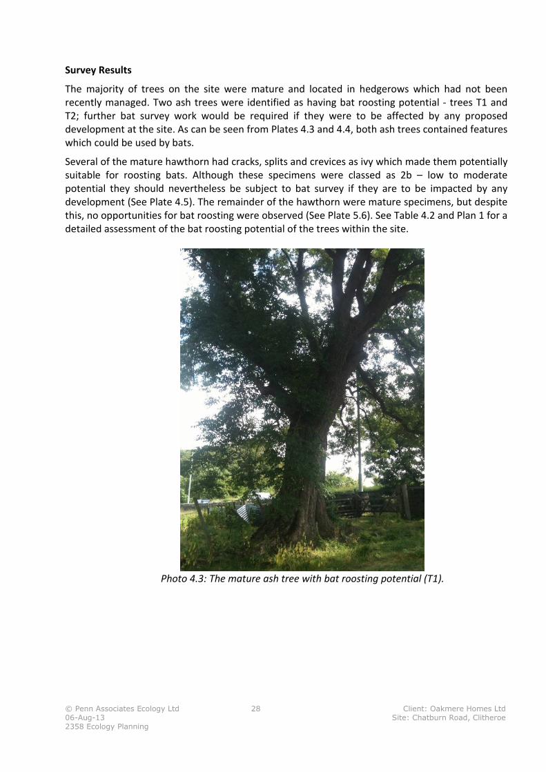
The majority of trees on the site were mature and located in hedgerows which had not been
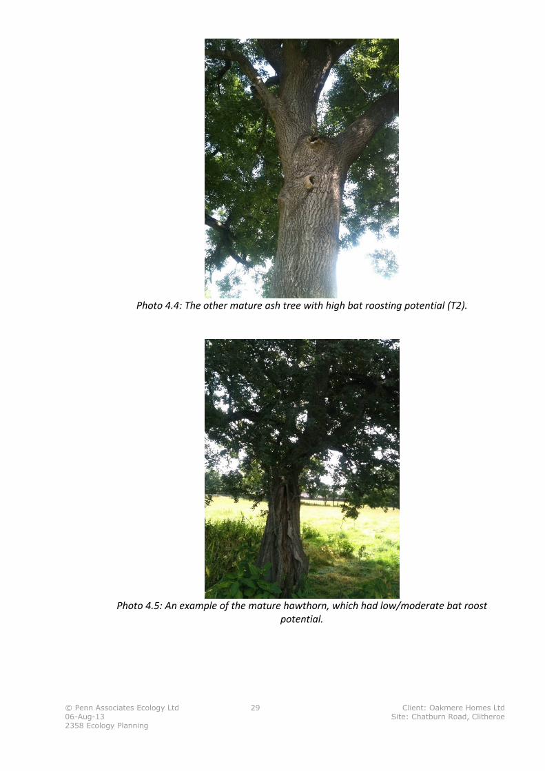
recently managed. Two ash trees were identified as having bat roosting potential - trees T1 and
T2; further bat survey work would be required if they were to be affected by any proposed
development at the site. As can be seen from Plates 4.3 and 4.4, both ash trees contained features
which could be used by bats.
Several of the mature hawthorn had cracks, splits and crevices as ivy which made them potentially
suitable for roosting bats. Although these specimens were classed as 2b – low to moderate
potential they should nevertheless be subject to bat survey if they are to be impacted by any
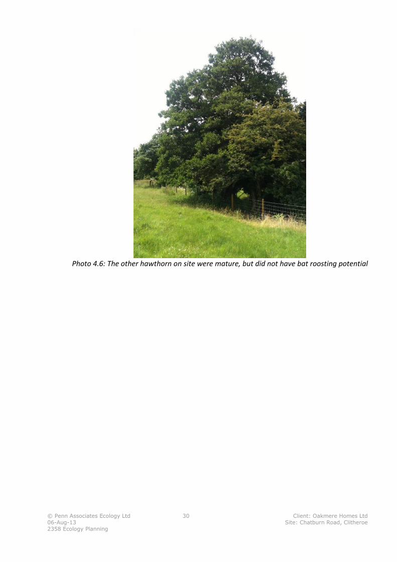
development (See Plate 4.5). The remainder of the hawthorn were mature specimens, but despite
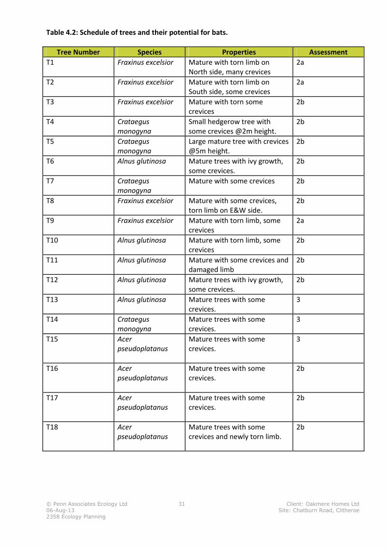
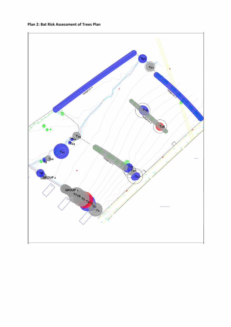
this, no opportunities for bat roosting were observed (See Plate 5.6). See Table 4.2 and Plan 1 for a
detailed assessment of the bat roosting potential of the trees within the site.
Photo 4.3: The mature ash tree with bat roosting potential (T1).
© Penn Associates Ecology Ltd 29 Client: Oakmere Homes Ltd
06-Aug-13 Site: Chatburn Road, Clitheroe
2358 Ecology Planning
Photo 4.4: The other mature ash tree with high bat roosting potential (T2).
Photo 4.5: An example of the mature hawthorn, which had low/moderate bat roost
potential.
© Penn Associates Ecology Ltd 30 Client: Oakmere Homes Ltd
06-Aug-13 Site: Chatburn Road, Clitheroe
2358 Ecology Planning
Photo 4.6: The other hawthorn on site were mature, but did not have bat roosting potential
© Penn Associates Ecology Ltd 31 Client: Oakmere Homes Ltd
06-Aug-13 Site: Chatburn Road, Clitheroe
2358 Ecology Planning
Table 4.2: Schedule of trees and their potential for bats.
Tree Number Species Properties Assessment
T1 Fraxinus excelsior Mature with torn limb on
North side, many crevices
2a
T2 Fraxinus excelsior Mature with torn limb on
South side, some crevices
2a
T3 Fraxinus excelsior Mature with torn some
crevices
2b
T4 Crataegus
monogyna
Small hedgerow tree with
some crevices @2m height.
2b
T5 Crataegus
monogyna
Large mature tree with crevices
@5m height.
2b
T6 Alnus glutinosa Mature trees with ivy growth,
some crevices.
2b
T7 Crataegus
monogyna
Mature with some crevices 2b
T8 Fraxinus excelsior Mature with some crevices,
torn limb on E&W side.
2b
T9 Fraxinus excelsior Mature with torn limb, some
crevices
2a
T10 Alnus glutinosa Mature with torn limb, some
crevices
2b
T11 Alnus glutinosa Mature with some crevices and
damaged limb
2b
T12 Alnus glutinosa Mature trees with ivy growth,
some crevices.
2b
T13 Alnus glutinosa Mature trees with some
crevices.
3
T14 Crataegus
monogyna
Mature trees with some
crevices.
3
T15 Acer
pseudoplatanus
Mature trees with some
crevices.
3
T16 Acer
pseudoplatanus
Mature trees with some
crevices.
2b
T17 Acer
pseudoplatanus
Mature trees with some
crevices.
2b
T18 Acer
pseudoplatanus
Mature trees with some
crevices and newly torn limb.
2b
© Penn Associates Ecology Ltd 32 Client: Oakmere Homes Ltd
06-Aug-13 Site: Chatburn Road, Clitheroe
2358 Ecology Planning
5.0 Interpretation of Results and Recommendations In this section, general guidance on the planning and legislative context for biodiversity is
provided, along with a site specific interpretation of the value of the proposed development site,
in the context of this guidance.
5.1 National and Regional Planning and Legislative Context
The UK Government’s national approach to planning policy is set out in the National Planning
Policy Framework (NPPF) (March 2012). The UK Governments Biodiversity 2020 Strategy,
published by DEFRA in 2011, sets a context within which the NPPF should be viewed. Specifically
Biodiversity 2020 aims to:
Para 8: Halt overall biodiversity loss, support healthy well functioning ecosystems and establish
coherent ecological networks, with more and better places for nature for the benefit of wildlife and
people.
This is consistent with the Governments Environment White Paper, The Natural Choice (June
2011) which aims to:
• shifts emphasis from piecemeal conservation action towards a more integrated landscape-
scale approach
• value the natural environment in decision making and thereby unlock growth in the green
economy and reconnect people with nature.
National Planning Policy Framework
The NPPF reflects the commitments set out above, stating that (Para 109)’ the planning system
should contribute to and enhance the natural and local environment by:
• Protecting and enhancing valued landscapes, geological conservation interest and soils;
• Recognising the wider benefits of ecosystem services;
• Minimising impacts on biodiversity and providing net gains in biodiversity where possible,
contributing to the Government’s commitment to halt the overall decline in biodiversity,
including by establishing coherent ecological networks that are more resilient to current
and future pressures’.
Natural Environment and Rural Communities Act 2006 (NERC)
Section 41(3) (a) and (b) of the NERC Act 2006 requires the Secretary of State to promote the
taking of steps by others to further the conservation of habitats and species identified as priorities
under Section 41 of the Act.
In addition to the above, Section 40(1) of the NERC Act 2006 introduced the ‘biodiversity duty’
which requires that;
© Penn Associates Ecology Ltd 33 Client: Oakmere Homes Ltd
06-Aug-13 Site: Chatburn Road, Clitheroe
2358 Ecology Planning
‘Every public authority [including Local Planning Authorities] must, in exercising its functions, have
regard, so far as is consistent with the proper exercise of those functions, to the purpose of
conserving biodiversity’.
Relevant Protected Species Legislation
European and UK legislation affords protection to many plants and animals, with some species
afforded a high level of protection from disturbance. A summary of relevant legislation is
contained in Appendix 1.
UK and Local Biodiversity Action Plan (BAP) Habitats and Species
Certain habitats and species are identified as priorities for protection and nature conservation
through their inclusion on the Biodiversity List, under the NERC Act 2006 (see above). The
Biodiversity List is largely consistent with those habitats and species identified as priorities under
the UK Biodiversity Action Plan (BAP) and Local BAP (the Tees Valley Local Action Plan).
5.2 Impact on Designated Sites
There are no statutory or non-statutory wildlife designations within the site. There are two
geological SSSI’s within a 2km search distance of the site – Coplow Quarry SSSI adjacent to the
northern site boundary and Salthill and Bellmanpark Quarries SSSI approximately 250m to the
south. No adverse impacts on these SSSI’s are predicted as a consequence of development of the
site. Salthill Quarry Local Nature Reserve is also located 250m south of the site. No direct impacts
on the site are predicted and no significant indirect impacts, such as disturbance are anticipated.
5.3 Nature Conservation Status of the Habitats Present
Of the habitats present within the site, the stream habitat is a UK BAP priority habitat (rivers and
streams) and whilst the hedgerows are species poor, the ground flora associated with them is
relatively diverse and would suggest that they are long-established. The site survey also identified
lowland fen vegetation adjacent to the eastern site boundary which is a UK BAP priority habitat.
Recommendation:
It is recommended that the stream and fen habitats are protected from the direct and indirect
impacts of development, including use:
• of an appropriately sized and designed buffer zone around the habitats
• lighting design methods to avoid light spill into these habitats
• appropriate boundary treatment that aims to sustain the undeveloped character of these
habitats
• an appropriately designed surface water management regime which prevents adverse
changes in ground water and surface water quality and flows as a consequence of the
proposed development
• Where loss of any of these priority habitats cannot be avoided through careful site design,
compensatory habitat creation works should be undertaken.
It is recommended that where feasible, hedgerows are retained within the proposed built
environment with appropriate buffer zones retained around them to enable them to continue to
function as wildlife corridors. Where hedgerows cannot be retained in situ compensatory habitat
should be created within the site.
© Penn Associates Ecology Ltd 34 Client: Oakmere Homes Ltd
06-Aug-13 Site: Chatburn Road, Clitheroe
2358 Ecology Planning
5.4 Nature Conservation Status of the Species Present
Protected Species
No species that are specially protected under the Conservation of Habitats and Species
Regulations (Amendment) 2012 and/or the WCA (1981) have been recorded within the site.
Targeted surveys for otter and water vole were undertaken with no evidence of the presence of
these species found. The potential for breeding barn owl was assessed as low but with moderate
potential for foraging. However, two trees within the site were classified as having a high risk of
hosting roosting bats with other trees assessed as having a moderate potential.
Recommendations:
Bats and their roosting places are afforded legal protection; as such it is advised that the following
measures are taken with the aim of ensuring that any works undertaken to the trees on site are
legally compliant:
• If the proposed development requires the pruning or felling of a category 2a tree, dusk and
dawn surveys to establish the presence of bats in that particular tree would be required to
inform any requirements for mitigation. If the presence of a roost is confirmed, the tree
would be upgraded to a category 1 tree. Any trees with confirmed roosts will require an
EPS5 licence prior to arboriculture works. If the repeat survey did not confirm presence of a
roost, the tree would be downgraded to a category 2b tree.
• If the proposed development requires the pruning or felling of a category 2b tree, this work
must be carried out taking reasonable avoidance measures. The reasonable avoidance
measures recommended for each category 2b tree are: the removal of any ivy before felling
and the Appointed Ecologist to supervise soft fell lowering of limbs.
• Trees classified as category 3 in this study can be pruned or felled with no repeat survey
work or mitigation, with regard to bats, considered necessary.
• In the event that bats, evidence of bats or additional potential roost features not identified
during these surveys are observed within a tree with a category 2b or 3 classification prior
to pruning or felling, all works should cease immediately and the Appointed Ecologist
contacted for advice on how to proceed.
Compensation measures (i.e. bat boxes, new woodland planting) for the loss of any potential tree-
roost features should be finalised in conjunction with the master-planning exercise.
5 A European Protected Species (EPS) licence, if required, would include a detailed Method Statement describing how
the works would be undertaken (in a manner that would avoid harming bats) and the measures that would be taken
to compensate for the loss of the original roosts. EPS licences can only normally be granted following full planning
permission and the EPS licence application process can take up to ten weeks.
© Penn Associates Ecology Ltd 35 Client: Oakmere Homes Ltd
06-Aug-13 Site: Chatburn Road, Clitheroe
2358 Ecology Planning
Breeding Birds
There is a high risk of breeding birds being present within the site, in particular associated with
trees, hedgerows and shrubs, and the stream and marshy grassland habitat.
Recommendation:
Breeding birds and their nests are afforded legal protection from harm and disturbance under the
Wildlife and Countryside Act 1981 (as amended). Where feasible no vegetation clearance should be
undertaken during the bird breeding season (typically 1st
March – 31st
August). If shrub or tree
clearance during this time is required then pre-clearance checks should be undertaken by a suitably
qualified and experienced ecologist to confirm that no breeding birds or their nests will be affected
by the works.
BAP Priority Species
No UK BAP priority species were observed as present on the site during the site survey, however,
there is a high risk of toads being present and potentially priority bird species such as dunnock,
song thrush, yellowhammer and possibly wetland birds such as Northern lapwing associated with
the marshy grassland.
Invasive Weeds
Himalayan balsam, a plant listed on schedule 9 of Wildlife and Countryside Act 1981, was relatively
widespread within the site. Himalayan balsam is a non-native species which spreads rapidly into
semi-natural habitats at the expense of native plants and associated animals.
Recommendation:
Measures are taken to control the spread of Himalayan balsam outside of the site in accordance
with the requirements of Wildlife and Countryside 1981.
Plan 1: Habitat Plan
Plan 2: Bat Risk Assessment of Trees Plan

Appendix 1: Summary of Wildlife Legislation and Relevant Planning Legislation
Many species of British wildlife are legally protected or are afforded protection from the potentially
harmful effects of some development through the planning system. The following section provides a brief
overview of the protection afforded to species commonly encountered during development.
Birds
All wild birds are protected against killing or injury under the WCA 1981 (as amended). This protection
extends to birds nests during the breeding season, which makes it an offence to:
� Kill, injure or take any wild bird (with certain exceptions for recognised game or pest species)
� Take, damage or destroy the nests of any wild bird while it is in use or being built
� Take or destroy the egg of any wild bird
Birds that are listed on Schedule 1 of the Act receive additional protection against intentional or reckless
disturbance during the breeding season. This makes it an offence to disturb these species at or near to their
nesting site.
European Protected Species
All bats, great crested newts and otter are European Protected Species (EPS). The European legislation is
implemented in England via The Conservation of Habitats and Species Regulations (amendment) 2012. A
full list of EPS is provided in Schedule 2 of the Regulations.
In summary this legislation makes it an offence to:
• Intentionally/deliberately kill, disturb, injure or capture the species
• Intentionally or recklessly damage, destroy or obstruct access to any breeding site or resting place.
• Possess or control any live or dead specimen or anything derived from a European Protected
Species.
If an activity is likely to result in any of the above offences, derogation from the legal protection can, under
certain restricted circumstances, be issued in the form of a European Protected Species licence.
EPS licences will only be issued if the following if the application complies with the following tests:
• The consented operation must be for “preserving public health or public safety or other imperative
reasons of overriding public interest including those of a social or economic nature and beneficial
consequences of primary importance for the environment”;
• There must be “no satisfactory alternative”; and
• The action authorised “will not be detrimental to the maintenance of the population of the species
concerned at a favourable conservation status in their natural range”
Protected Animals
Some British animals receive protection under the Wildlife and Countryside Act (WCA) 1981 (as amended)
with species listed on Schedule 5 afforded special protection. For most species on Schedule 5, the Act
makes it an offence to intentionally kill, injure, or take, possess, or trade in the species and prohibits
interference with places used for shelter or protection, or intentionally disturbing animals occupying such
places.
Reptiles
Common lizard, slow worm, grass snake and adder are protected only from unlawful killing under the
Wildlife and Countryside Act 1981 (as amended). The rarer reptiles, including smooth snake and sand lizard
are fully protected and any works affecting them can only be carried out if a Natural England licence has
been issued.
Badgers
Badgers are protected under the Protection of Badgers Act 1992. It is illegal to:
• Kill, injure, take, possess of cruelly ill-treat a badger or to attempt to do so;
• Interfere with badger sett by damaging or destroying it;
• Obstruct access to or any entrance of a badger sett;
• Disturb a badger when it is occupying a sett
A badger sett is “any structure or place that displays signs indicating current use by a badger. Natural
England, the Government’s statutory nature conservation body, classifies a sett as active if it has been
occupied within the last 12 months.
Operations that might cause disturbance of an active sett entrance can be carried out under licence from
Natural England.
Planning Legislation as it Relates to Protected Species
For activities requiring planning permission, the presence of protected species, such as those listed above,
is a material consideration which must be fully considered by the Local Authority when granting planning
permission. Local Authorities have been issued with ODPM Circular 06/2005 Biodiversity and Geological
Conservation – Statutory Obligations and their Impact within the Planning System, which provides further
guidance on the application of the law as it relates to planning and nature conservation in England.
UK and LBAP Species
Certain species are identified as priorities for protection and nature conservation through their inclusion on
the Biodiversity List, under the Natural Environment and Rural Communities Act 2006. Public authorities
have a duty to have regard to conserving biodiversity, under this Act, so far as is consistent with the proper
exercise of its functions.
Hedgerow Regulations (1997)
The Hedgerow Regulations gives local planning authorities (LPA) the right to designate ‘important
hedgerows’ provided they meet certain specified criteria. Removal of designated ‘important hedgerows’ is
prohibited under the Act. The status of hedgerows within the site under these regulations has not been
checked as part of this survey, but can be either done directly by the land owners with the LPA or by PAEL
on request.
The Town and Country Planning (Tree Preservation) (England) Regulations 2012
Local planning authorities can place Tree Preservation Orders on trees and tree groups of high landscape
and amenity value, which places restrictions upon tree works that an owner can legally undertake,
including tree felling. The status of trees within the site under these regulations has not been checked as
part of this survey, but can be either done directly by the land owners with the LPA or by PAEL on request.