Embed Size (px)
Citation preview

23 USC § 409 NDDOT Reserves All Objections
WE
TLA
ND
DE
LIN
EA
TIO
N R
EPO
RT
STRUCTURE REPAIR
Project No.
PCN
ABC-1-234(567)890 12345
Structure Repair RP 890
234
Prepared by
NORTH DAKOTA DEPARTMENT OF TRANSPORTATION BISMARCK, NORTH DAKOTA
http://www.dot.nd.gov/
DIRECTOR
Francis G. Ziegler, P.E.
PROJECT DEVELOPMENT DIRECTOR Ronald J. Henke, P.E.
Principal Author: John Doe
December 2009

Structure Repair RP 890 Page i Project No. ABC-1-234(567)890 PCN 12345 December 2009 Wetland Delineation Report
TABLE OF CONTENTS
I. Introduction ..................................................................................................................... 1 II. Methods .......................................................................................................................... 1 III. Results ............................................................................................................................ 1 IV. References ...................................................................................................................... 2 V. Delineator’s Credentials ................................................................................................... 2 Tables Table 1, Wetland Table ......................................................................................................... 3 Exhibits Exhibit 1, Project Location Map ............................................................................................. 4 Exhibit 2, Wetland Map ......................................................................................................... 5 Appendices Appendix A, Additional Information for Jurisdictional Requests Appendix B, Site Photos Appendix C, Wetland Determination Data Forms

Structure Repair RP 890 Page 1 Project No. ABC-1-234(567)890 PCN 12345 December 2009 Wetland Delineation Report
I. Introduction The North Dakota Department of Transportation (NDDOT), in cooperation with the Federal Highway Administration (FHWA), is planning roadway improvements within a project area along ND 234 near Reference Point (RP) 890. Please refer to Exhibit 1, Project Location Map. The project consists of structural repair and incidentals. The project is planned to be built during the 2011 construction season. Jane Doe and John Doe of the NDDOT conducted a field wetland delineation for the proposed project on December 25, 2009. Supplementary project area information can be found in Appendix A, Additional Information for Jurisdictional Requests.
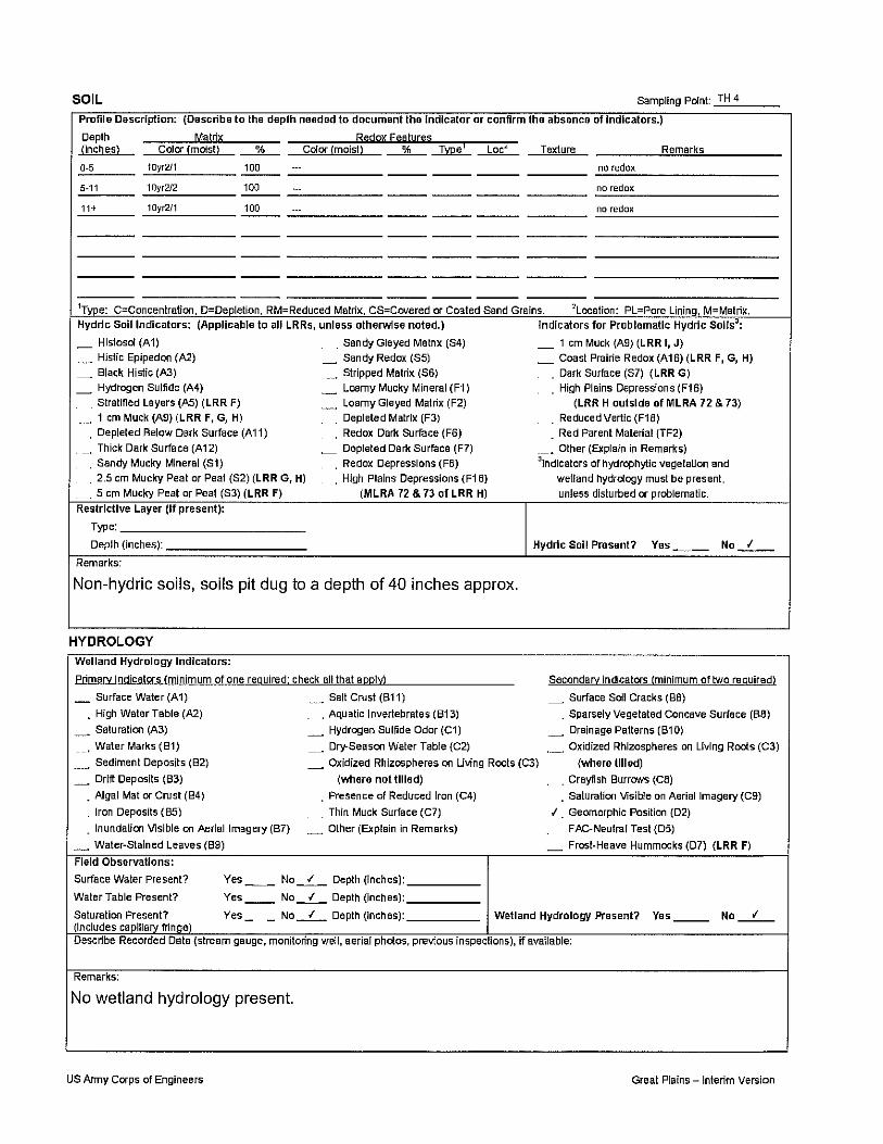
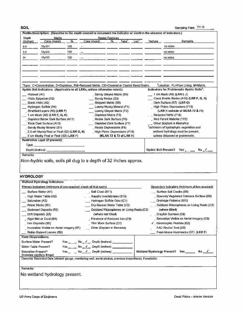
II. Methods The field wetland delineation was conducted in accordance with the 1987 Corps of Engineers Wetland Delineation Manual and the Interim Regional Supplement to the Corps of Engineers Wetland Delineation Manual: Great Plains Region. Wetland boundaries within the study area were determined by completing USACE Wetland Determination Data Forms for paired test hole points and observing vegetation and hydrology in the area. The project area was extended to 200 feet on either side of the roadway due to the potential addition of a bypass during project design. Wetland Maps were developed using NDDOT 2004 aerial photography in combination with the National Wetlands Inventory (NWI) layer. Pictures taken onsite are provided in Appendix B, Site Photos. Specific data for each sample point can be found on data sheets included in Appendix C, Data Sheets.
III. Results
Three wetlands were identified within the project area. Two of the delineated wetlands (1-E and 1-W) are part of a natural stream. The remaining wetland (2) is a natural basin. The USGS topographic layer indicates that the stream delineated within the project area is Otter Creek, which flows into Square Butte Creek, and later into the Missouri River. Please refer to Table 1, Wetland Table. Approximately 1.64 acres of wetlands were delineated. Some wetlands extended beyond the limits of the project area; however, wetlands were only delineated to the boundary of the project area. Please refer to Exhibit 2, Wetland Map. Pursuant to Section II-03.12 of the NDDOT Design Manual, a tree count was also completed during the field wetland delineation process because the project area is along a riparian corridor. Trees that met the following criteria were included in the tree count:
• Deciduous trees – if the diameter breast height (dbh) of the tree is 3 inches or more and the tree is 15 feet or more in height.
• Evergreen trees – if the tree is 5 feet or more in height.

Structure Repair RP 890 Page 2 Project No. ABC-1-234(567)890 PCN 12345 December 2009 Wetland Delineation Report
The tree count yielded 8 trees within the study area that met the above criteria. Tree impacts will be quantified during project design, and a mitigation plan for unavoidable tree impacts will be developed at that time.
IV. References Cowardin, L. M., V. Carter, F. C. Golet, E. T. LaRoe. 1979. Classification of wetlands
and deepwater habitats of the United States. U.S. Department of the Interior, Fish and Wildlife Service. Available online: http://www.fws.gov/wetlands/_documents/gNS DI/ClassificationWetlandsDeepwaterHabitatsUS.pdf
National Hydric Soils List by State [Electronic Database]. 2009. United States
Department of Agriculture: Natural Resources Conservation Service. Available online: http://soils.usda.gov/use/hydric/lists/state.html
North Dakota Department of Transportation. 2009. NDDOT Design Manual. Available
online: http://www.dot.nd.gov/manuals/design/designmanual/designmanual.htm Plants Database [Electronic Database]. 2009. United States Department of Agriculture:
Natural Resources Conservation Service. Available online: http://plants.usda.gov/ U.S. Army Corps of Engineers. 1987. US Army Corps of Engineers Wetlands
Delineation Manual. Available online: http://www.wetlands.com/regs/tlpge02e.htm
V. Delineator’s Credentials Education: University of North Dakota – BS Biology
Professional Membership: Society of Wetland Scientists
Wetland Professionals Association
Training: Society of Wetland Scientists – Introduction to Wetlands
Wetland Training Institute – Basic Wetland Delineation Field Practicum
Wetland Training Institute – Wetland Delineation with Emphasis on Soils
and Hydrology
NRCS – Field Indicators of Hydric Soil
NRCS – Regulatory IV - Wetland Delineation, US Army Corps of
Engineers

Structure Repair RP 890 Page 3 Project No. ABC-1-234(567)890 PCN 12345 December 2009 Wetland Delineation Report
Table 1, Wetland Table The field wetland delineation for PCN 12345, Project ID # ABC-1-234(567)890 (Structure Repair RP 890), was conducted on December 25, 2009 by Jane Doe and John Doe of the North Dakota Department of Transportation. The wetland delineations were conducted in accordance with the 1987 Corps of Engineers Wetland Delineation Manual and the Interim Regional Supplement to the Corps of Engineers Wetland Delineation Manual: Great Plains Region. Observations at each sample location were recorded on standard Corps of Engineers data sheets. Wetland boundaries and paired sample locations were recorded by GPS. The project is located within the Painted Woods / Square Butte Creek (10130101) Hydrologic Unit Code (HUC).
Wetland Number
Test Hole (in wetland) Location LONG / LAT
(Dec. Deg.) Cowardin
Classification Wetland
Type
Wetland Size
(acres)
Wetland Feature
Physical Characteristics
of Potential Tributary*
1-E 3 T140N, R81W, Section 18
-100.953145 / 46.940198 R4SBF Stream 1.34 Natural 4, 11,13,23,25
2 8 T140N, R81W, Section 18
-100.955542 / 46.940846 PEMC Basin 0.18 Natural N/A
1-W 10 T140N, R81W, Section 18
-100.954241 / 46.939917 R4SBF Stream 0.12 Natural 4, 11,13,23,25
TOTAL 1.64
* Physical Characteristics of Potential Tributary: Other Tributary Features: Substrate composition: 10) Bed and banks 20) Leaf litter disturbed or washed away 1) Silts 11) Ordinary High Water Mark 21) Scour 2) Sands 12) Clear, natural line impressed on the bank 22) Sediment deposition 3) Concrete 13) The presence of litter and debris 23) Multiple observed or predicted flow events 4) Cobbles 14) Changes in the character of soil 24) Water staining 5) Gravel 15) Destruction of terrestrial vegetation 25) Abrupt change in plant community 6) Muck 16) Shelving 7) Bedrock 17) The presence of wrack line 8) Vegetation (Type/% Cover) 18) Vegetation matted down, bent, or absent 9) Other. Explain: 19) Sediment sorting

M o r t o nM o r t o n
B u r l e i g hB u r l e i g h
O l i v e rO l i v e r
8
16
5
3
10
21
33
23
25
14
28
6 4 2 1
31
18
35
79
13
12
27
34
26
24
30
19
32
36
29
15
20
11
22
17
CITY OF Bismarck
CITY OF Mandan
5432
1 5432
1
9
8
7
6
5
4
3
2
8989
68
96
95
94
93
92
91
90
89
88
87
86 85 84 83
85
84
83
82
81
80
79
78
77
76
75 72
71
69
99
98
97
96
95
94
93
92
91
90
99
98
97
96
95
94
93
92
91
90
67
66
65
10
921921
926926
924923922
920
919
917
925924923922
920
919
917915914
913
912
911
910
909
101
100
101
100
163
162161160159
157156
155
154
153
152
151
150149148147146145144143
163
162161160159
157
156
155
154153
152
151
150149148147146145144143
902
901
902
2.9182.773
0.0000.000
0.000
1.072
0.0000.000
71.225
82.973
85.800
92.463
88.998
92.463
88.998
67.413
926.799926.867155.026155.026
924.140922.860922.724
926.799
901.523
901.523
Linear Wetlands
NDHUB.Counties_Poly
Delineated Wetlands
NDHUB.Wetlands
Freshwater Emergent Wetland
Freshwater Forested/Shrub Wetland
Freshwater Pond
Lake
Other
Riverine
Corporate Boundaries
PLSS Sections
0 0.8 1.6 2.4 3.20.4Miles
Orthophoto Source: NRCSDate of Photography: 2004
Data Source: NDGIS Hub & NDDOT
Exhibit 1Project Location Map
Drawn By:MAD
Project ID: PCN:Date:12/25/09
Sheet:1 of 1
Morton County,North Dakota
ABC-1-234(567)890 12345
ProjectABC-1-234(567)890
Missouri RiverSquare Butte Creek

M o r t o nM o r t o nT140NR 81W
18
19
17
20
PEM/ABF
PEMA
PFOA
PEMA
PEMC
PEMA
PEMA
PEMC
PEMC
PEMCPEMC
PEM/ABF
PEMC
PEMA
PEMA
PEMC
Test_Holes
Culvert
Reference Points
Linear Wetlands
NDHUB.Counties_Poly
Delineated Wetlands
NDHUB.Wetlands
Freshwater Emergent Wetland
Freshwater Forested/Shrub Wetland
Freshwater Pond
Lake
Other
Riverine
Corporate Boundaries
PLSS Sections
PLSS Townships
0 150 300 450 60075Feet
Orthophoto Source: NRCSDate of Photography: 2004
Data Source: NDGIS Hub & NDDOT
Exhibit 2Wetland Map
Drawn By:MAD
Project ID: PCN:Date:12/25/09
Sheet:1 of 1
Morton County,North Dakota
ABC-123(456)-789 12345
Wetland 1- ELat:46.940198Long:-100.953145
Wetland 1-WLat:46.939917Long:-100.954241
Wetland 2Lat:46.940846 Long:-100.955542
Test Hole 1Lat:46.939777Long:-100.952808
Test Hole 2Lat:46.939847Long:-100.952730
Test Hole 3Lat:46.940305 Long:-100.953310
Test Hole 4Lat:46.940373Long:-100.953414
Test Hole 5Lat:46.940808Long:-100.953759
Test Hole 6Lat:46.940796Long:-100.953875
Test Hole 8Lat:46.940967Long:-100.955688
Test Hole 7Lat:46.941022Long:-100.955730
Test Hole 9Lat:46.939968Long:-100.954525
Test Hole 10Lat:46.939857 Long:-100.954541
Begin ProjectABC-123(456)789
End ProjectABC-123(456)789

Appendix A Additional Information for Jurisdictional Requests

1 of 2 May 2009
ADDITIONAL INFORMATION FOR WETLAND JURISDICTIONAL REQUESTS ON NDDOT PROJECTS
A. Project Location and Background Information
1. PCN / Project Number: 12345 / ABC-1-234(567)890 a. City: Mandan b. County: Morton c. State: North Dakota
2. Short project description: Structure Repair RP 890 3. Name of nearest waterbody: Square Butte Creek 4. Name of nearest Traditional Navigable Water (TNW): Missouri River 5. Name of watershed or Hydrologic Unit Code (HUC): Painted Woods - Square Butte Creek /
10130101 6. Number of wetlands being considered in this cumulative analysis: 2 (see comments below) 7. Approximate acreage being considered in this cumulative analysis (Total Basin Size): 1.64 ac.
B. Review Performed for Site Evaluation (Check all that apply)
1. Office Determination Date: 2. Field Determination Date: 12/25/09
C. General Information
1. General area conditions: a. HUC watershed size (specify acres or square miles): 40.01 sq. miles b. Average annual rainfall (inches): 16.35
i. Source: High Plains Regional Climate Center c. Average annual snowfall (inches): 32.60
i. Source: High Plains Regional Climate Center
2. Biological characteristics (Field Determination only; list applicable wetland numbers): a. The wetland supports (use space below each to elaborate for applicable wetlands):
i.Riparian buffer characteristics (type, average width): ii.Habitat for:
___ Federally Listed species. Explain findings: ___ Fish/spawn areas. Explain findings: ___ Other environmentally-sensitive species. Explain findings: ___ Aquatic/wildlife diversity. Explain findings:
D. Data Sources (Check all that apply)
_X_ Maps, plans, plots, or plat submitted by or on behalf of the applicant/consultant _X_ Data Sheets prepared/submitted by or on behalf of the applicant/consultant ___ U.S. Geological Survey Hydrologic Atlas ___ USGS NHD data: _X_USGS 8 and 12 digit HUC maps: _X_ U.S. Geological Survey map(s) Cite scale & quad name: 24K - Harmon _X_ USDA Natural Resources Conservation Service Soil Survey

2 of 2 May 2009
Citation: SSURGO, ND GIS Data Hub _X_ National Wetlands Inventory map(s) Cite name/date: USFWS NWI Maps ND GIS Data Hub ___ State/Local wetland inventory map(s) Cite name/date: ___ 100-year Floodplain Elevation is: ______ (National Geodetic Vertical Datum of 1929) _X_ Aerial Photographs Cite name/date: NDDOT / 2004 ___ Applicable/supporting scientific literature: ___ Other information (please specify):
E. Additional Comments Wetlands 1-E, and 1-W are all part of the same continuous intermittent stream. The entire region is / are the headwaters of Square Butte Creek, which flows into the Missouri River.

Appendix B Site Photos

Photo 1: Wetlands 1-E & 1-S
Photo 2: Wetland 2

Appendix C
Wetland Determination Data Forms