Embed Size (px)
Citation preview

North Carolina Depar tment of Transportation PROJECT ENVIRONMENTAL CONSULTATION FORM
I . D. No. I -5506
- 1 -
I. GENERAL INFORMATION
a. Consultation Phase: Right of Way
b. Project Description: SR 1002 (Aviation Parkway), improve interchange and construct auxiliary lane along I-40 westbound from SR 1002 to SR 3015 (Airport Boulevard)
c. WBS Element Number: 43608.1.1 Federal Project: NHPP-040-7(154)284 d. Document Type: CE 08/30/2016
Date
II. CONCLUSIONS
The above environmental document has been reevaluated as required by 23 CFR 771. It was determined that the current proposed action is essentially the same as the original proposed action. Proposed changes, if any, are noted below in Section III. It has been determined that anticipated social, economic, and environmental impacts were accurately described in the above referenced document(s) unless noted otherwise herein. Therefore, the original Administration Action remains valid.
III. CHANGES IN PROPOSED ACTION AND ENVIRONMENTAL
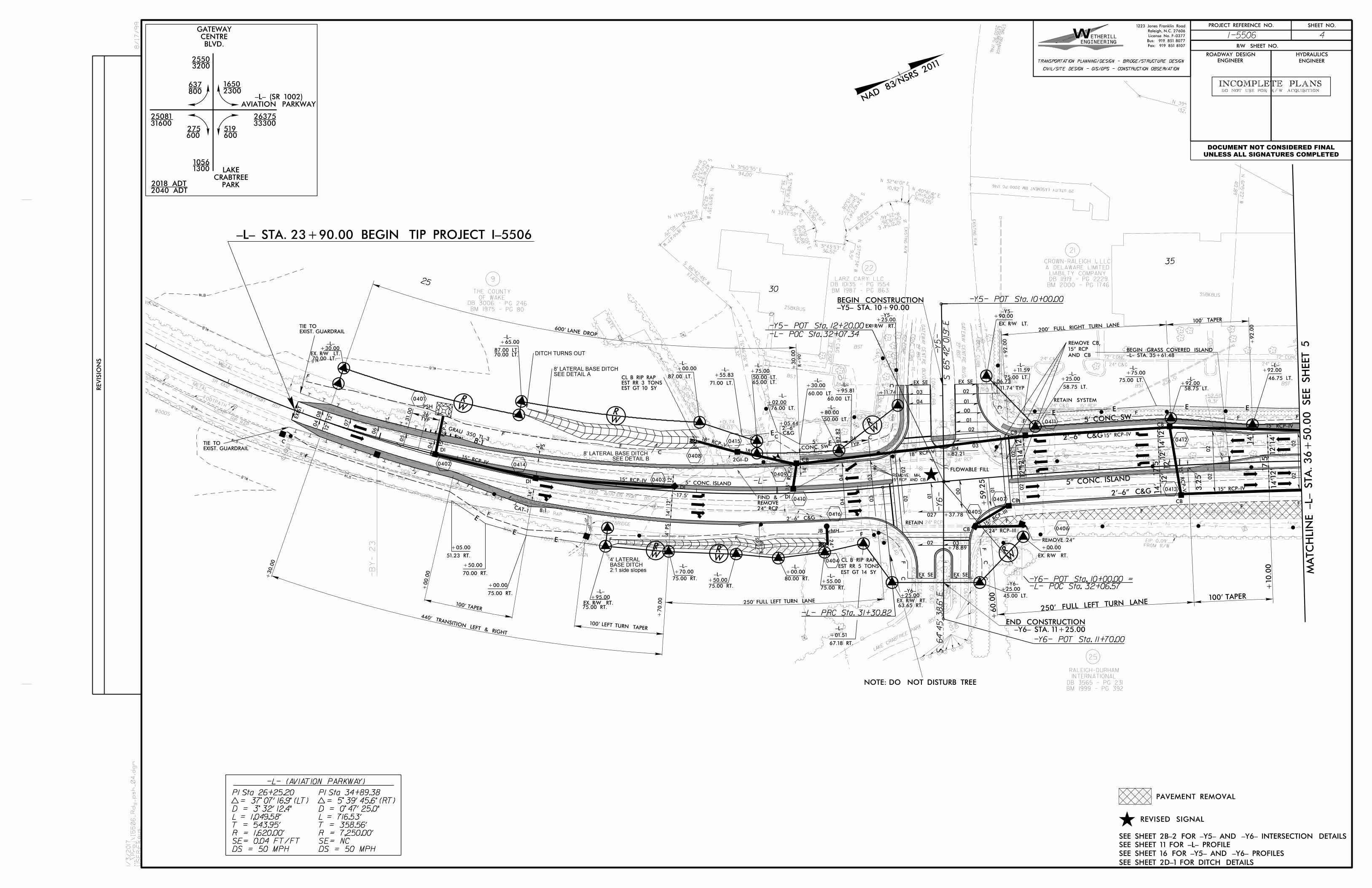
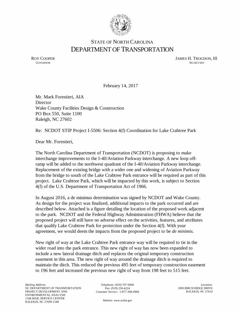
CONSEQUENCES 1. New right of way at the Lake Crabtree Park entrance way will be required to tie in
the wider road into the park entrance. This new right of way has now been expanded to include a new lateral drainage ditch and replaces the original temporary construction easement in this area (see attached Plan Sheet 4). The new right of way around the drainage ditch is required to maintain the ditch. This reduced the previous 495 feet of temporary construction easement to 196 feet and increased the previous new right of way from 198 feet to 515 feet.
2. There are also impacts to a primitive footpath, Lake Trail, which were not included in the August 2016 de minimus determination (see Plan Sheet 4). This trail exits the park and runs along the existing right of way of Aviation Parkway. The Lake Trail continues south within the right of way parallel to Aviation Parkway across the causeway, over Lake Crabtree and then re-enters the park. There is no formal encroachment agreement for the Lake Trail to be within the right of way of Aviation Parkway. A fill section is needed to construct the lane widening approaching the park entrance from the south. This fill section will
North Carolina Depar tment of Transportation PROJECT ENVIRONMENTAL CONSULTATION FORM
I . D. No. I -5506
- 2 -
cover approximately 23 feet of this trail on the park property and approximately 413 feet within the existing right of way.
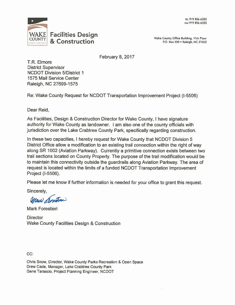
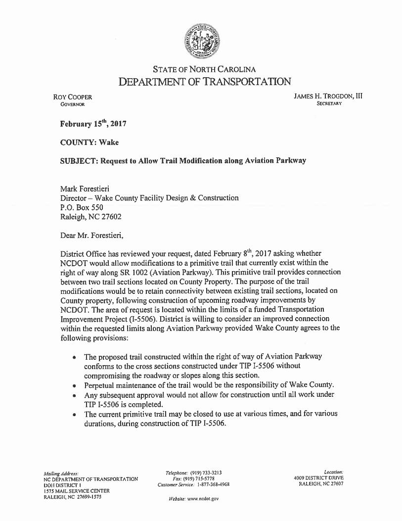
3. A formal letter from Wake County was sent to NCDOT, requesting a trail connection for the Lake Trail within the right of way along Aviation Parkway (see attached). This request was accepted by NCDOT in a letter of acceptance on February 15, 2017 (see attached). NCDOT’s letter of acceptance laid out several provisions: Wake County Parks and Recreation has agreed to close this trail for the duration of the construction period of the I-5506 project. Wake County Parks and Recreations has also agreed to relocate the trail where impacted by the new fill slope and NCDOT will allow a trail connection within the existing right of way along Aviation Parkway once the construction period has ended for the I-5506 project.
4. Wake County Park and Recreation’s acceptance to NCDOT’s provisions is documented by their signing of a new de minimus determination on February 21, 2017 and is attached for reference.
IV. LIST OF ENVIRONMENTAL COMMITMENTS
See attached.
V. COORDINATION
PDEA personnel have discussed current project proposals with others. Please note who was coordinated with and the date. This section is to be filled out by the project manager and does not require signatures. Design Engineer: Kanchana Noland 2/24/2017 Date FHWA Engineer: Eddie Dancausse, George Hoops 2/1/2017 Date NEU-PM: (Construction Consultations only) Date
RETAIN SYSTEM
SS
CB
30" C
&G
30" C
&G
30" C
&G
24" C
&G
24" C
&G
30" C&G
60" CONC 60" CONC
60" C
ON
C
72" CONC 72" CONC
24" C&G24" C&G
24" C&G
24" C&G
30" C&G
CO
NC
CU
RB
CO
NC
CU
RB
BST
BSTBST
BST
BST
72" C
ON
C
60" C
ON
C
BL
K
WA
LL
POS
TW
D
2SBKBUS
BL
K
WA
LL
HE
AD
PE
D
CO
NC
3SBKBUS
DI
CB
30" C
&G
30" C
&G
AVIATION PARKWAY 52’ BST
27’ B
ST
GA
TE
WA
Y C
EN
TR
E
BL
VD.
27’ B
ST
GA
TE
WA
Y C
EN
TR
E
BL
VD.
CO
NC
CU
RB
CO
NC
CU
RB
LIABILTY COMPANY
A DELAWARE LIMITED
CROWN-RALEIGH I, LLC
BM 2000 - PG 1746
DB 11919 - PG 2229LARZ CARY LLC
BM 1987 - PG 863
DB 10135 - PG 1554
EXIS
TIN
G
R/
W
N 47°19’49" E
N 69°50’15" E
89.97’
N 39°50’18" E132.72’
N 61°15
’22" W
412.8
9’
EXISTING R/W
EIP-
R/
W
0.3
1’
FROM R/W
EIP 0.09’
EXIS
TIN
G
R/
W
EXISTING R/W
N 76°4
6’2
6" W
111.32’
S 66°42’45" W
117.6
9’
N 18°14’47" W
40.25’
N 14°03’4
8" E
22.08’
N 58°13
’35" W
42.3
9’
N 31°50’55" E94.00’
S 57°4
8’16
" E36.2
7’
N 33°17’52" E
15.31’
N 76°2
3’5
1" E
21.9
0’
N 31°43’53" E36.52’
N 11°57’13" W
49.60’
N 57°2
7’3
4" W
9.5
1’
N 32°41’01" E10.92’
S 42°4
1’34" E
R=44.3
0’
CH=23.7
3’
S 81°3
0’0
5" E
R=11.5
4’
CH=8.6
8’
S 34°4
2’2
4" E
R=13.0
8’
CH=10.12’
N 10°21’54" E
R=25.46’ CH=19.26’
N 40°41’41" ER=19.05’
CH=5.09’
EIP
EIP
EIP
EIP
EIP
21
22
INTERNATIONAL
RALEIGH-DURHAM
25
BM 1999 - PG 392
DB 3565 - PG 231
20’ UTILITY EASEMENT BM 2000 PG 1746
BM
2000
PG 17
46
EA
SE
ME
NT
EXIS
TIN
G
DR
AIN
AG
E
BM
2000
PG 17
46
EA
SE
ME
NT
EXIS
TIN
G
DR
AIN
AG
E
LT
LT
LT LT
LT
LT
LT
TSP
LT
LT
LT
LT
LT LT
LT
LT
BM4
S
15" R
CP
15" R
CP
24" RCP
24" RCP
15" RCP
24" RCP
24" RCP
ONLYDIRECTION
15" RCP
15" RCP
OF WAKE
THE COUNTY
BM 1975 - PG 80
DB 3006 - PG 246
9
N 81°17
’32" W
78.4
0’
SIGN
SIGN
SIGN
WOODS
WOODS
WOODS
SIGN
SIGN
SIGN
SIGN
SIGN
LP
LP
LP
LP
LP
SIGN
WOODS
BST
15’ S
OIL R
OA
D
METAL
METAL
SR 1002 AVIATION PKWY BST
30" C&G
GA
TE
WOODS
HH
CHH
HH
HH H
H
HH
HH
HH
HH
HH
HH
HH
LAKE
CRABTREE PARK
BST
-B
Y-22
-B
Y- 23
9.31’
+52.50
48.03’
+01.74
SR 1002 AVIATION PKWY BST
*B
L36041
*B
L34061
*B
L34062
SIGN
SIGN
SIGN
FOOTBRIDGE
RIP RAP
RIP RAP
FOOTPATH
FOOTPATH
FOOTPATH
RIP RAP
12’
14’
12’
12’
14’
12’
12’
14’
17.5’
14’
+60.0
0
00.
01+
G&C "6-’2
G&C "6-’2
5’ CONC. SW
14’
12’
17.5’
12’
14’
3.2
5’
100’ TAPER
12’ 12
’
35
+59.2
5
-L- PRC Sta. 31+30.82
02
02
02
02
14’
12’
17.5’
ENAL NRUT TFEL LLUF ’052
-Y5- POT Sta. 10+00.00
PC Sta. 20+81.24
2530
+30.0
0
+70.0
0
100’ TAPER
100’ LEFT TURN TAPER
250’ FULL LEFT TURN LANE
08
07
06
05
04
04
TYP
36’
+31.00
02
02
03 01 0
0 01 02
04
+82.8
2
03
03
02
01
00
01
02
EX SEEX SE
+11.74
+06.73
11.74’ TYP
-L- POC Sta. 32+06.57-Y6- POT Sta. 10+00.00 =
027
02 03
+37.78
-Y6- POT Sta. 11+70.00
-Y6-
-Y5-
+78.89
+82.21
5" CONC. ISLAND
-L- POC Sta. 32+07.34
-Y5- POT Sta. 12+20.00 =
EX SE EX SE
04
04
GRAU 350 TL-3
CAT-1
8:1
-Y5- STA. 10+90.00BEGIN CONSTRUCTION
-L- STA. 23+90.00 BEGIN TIP PROJECT I-5506
-Y6- STA. 11+25.00END CONSTRUCTION
-L-
02
03
04
TYP36’
00.
00
+
THGIR & TFEL
NOITISNART
’044
600’ LANE DROPEXIST. GUARDRAILTIE TO
EXIST. GUARDRAILTIE TO
EXIS
T
12’
12’
14’
8:1
4’ PS
14’
12’
17.5’
12’
5" CONC. ISLAND
+77.6
5R=
90’
G&C "6-’2
14’
CONC. SW5’
+30.0
0
R=
90’
+92.0
0
ENAL NRUT THGIR LLUF ’002
-L- STA. 35+61.48BEGIN GRASS COVERED ISLAND
REPAT ’001
+92.0
0
+05.44
C&G2’-6"
PS4’
NOTE: DO NOT DISTURB TREE
-L-+30.00
+65.00-L-
+00.00-L- -L-
+75.00
-L-+80.00
+55.83-L-
-L-+30.00 -L-
+95.81
+25.00+90.00
-Y5--Y5-
+25.00+92.00
+92.00-L-
-L-
-L--L-
-L-+11.59
+75.00
-L-
+95.00
+05.00
+50.00
+00.00
-Y6-+25.00
+00.00
+25.00-Y6-
+02.00
-L-
70.00 LT.EX. R/W LT.
87.00 LT.70.00 LT.
87.00 LT.
71.00 LT.
50.00 LT.65.00 LT.
76.00 LT.
60.00 LT.60.00 LT.
50.00 LT.
EX. R/W RT.EX. R/W LT.
75.00 LT.
58.75 LT.
75.00 LT.
58.75 LT.
46.75 LT.
51.23 RT.
70.00 RT.
75.00 RT.
EX. R/W RT.75.00 RT. 63.65 RT.
45.00 LT.
EX. R/W RT.
-L-
-L-
-L-
-L-+70.00
+50.00
+00.00
+55.0075.00 RT.
75.00 RT.
80.00 RT.
75.00 RT.
EX. R/W RT.
+01.51
67.18 RT.
-L-
2040 ADTPARK
CRABTREELAKE
BLVD.CENTRE
GATEWAY
2637533300
16502300
519600
25503200
637800
10561300
275600
2508131600
AVIATION PARKWAY-L- (SR 1002)
2018 ADT
0401
0404
0403
0402
0405
0406
0407
0408
0409
0410
0411
0412
0413
PSH
JB w/MH
RETAIN
DI
DI
DI
CB
CB
CB
CB
CB
CB
18"
24"
15"
RCP-III
15" RC
P-V
EST GT 14 SY
EST RR 5 TONS
CL B RIP RAP
FLOWABLE FILL
AND CB
15" RCP
REMOVE CB,
15" RC
P-V
15" RCP-IV
2GI-D
SEE DETAIL A8’ LATERAL BASE DITCH
0414
DI
0416
0415
15" RCP-IV
15" RCP-IV
24" RCP-III
15" RCP AND CB
REMOVE MH,
24" RCP REMOVE FIND &
18" RCP-V
DITCH TURNS OUT
18" RCP-V
EST GT 10 SYEST RR 3 TONSCL B RIP RAP
SEE DETAIL B8’ LATERAL BASE DITCH
15" RCP-IV
15" RCP-IV
15" RC
P-V
REMOVE 24"
2:1 side slopesBASE DITCH4’ LATERAL
PI Sta 26+25.20
D
L = 1,049.58’
T = 543.95’
R = 1,620.00’
SE= 0.04 FT/FT
DS = 50 MPH
-L- (AVIATION PARKWAY)
PI Sta 34+89.38
D
L = 716.53’
T = 358.56’
R = 7,250.00’
SE= NC
DS = 50 MPH
MA
TC
HLIN
E -L- STA. 36+
50.0
0 SEE S
HEET 5
PAVEMENT REMOVAL
REVISED SIGNAL
SEE SHEET 11 FOR -L- PROFILE
ENGINEERING
ETHERILLW
CIVIL/SITE DESIGN - GIS/GPS - CONSTRUCTION OBSERVATION
TRANSPORTATION PLANNING/DESIGN - BRIDGE/STRUCTURE DESIGN
Fax: 919 851 8107
Bus: 919 851 8077
License No. F-0377
Raleigh, N.C. 27606
1223 Jones Franklin Road
RE
VISIO
NS
HYDRAULICSROADWAY DESIGN
ENGINEER ENGINEER
R/W SHEET NO.
SHEET NO.PROJECT REFERENCE NO.
4I-5506
1/3/2017
...\
Proj\I5506_
Rdy_psh_04.d
gn
US
ER:F
keys
8/17/99
INCOMPLETE PLANSDO NOT USE FOR R/W ACQUISITION
DOCUMENT NOT CONSIDERED FINAL
UNLESS ALL SIGNATURES COMPLETED
SEE SHEET 2B-2 FOR -Y5- AND -Y6- INTERSECTION DETAILS
SEE SHEET 16 FOR -Y5- AND -Y6- PROFILES
NAD 83/ N
SRS
2011
SEE SHEET 2D-1 FOR DITCH DETAILS
F
F
F
F
F
FF
FF
F
F
C
F
C
F C
F
C
CC
C
F
F
FCF
CC
C
C
F
C
F
F
F
STATE OF NORTH CAROLINA
DEPARTMENT OF TRANSPORTATION
ROY COOPER JAMES H. TROGDON, III GOVERNOR SECRETARY
Mailing Address: NC DEPARTMENT OF TRANSPORTATION PROJECT DEVELOPMENT AND ENVIRONMENTAL ANALYSIS 1548 MAIL SERVICE CENTER RALEIGH, NC 27699-1548
Telephone: (919) 707-6000 Fax: (919) 250-4224
Customer Service: 1-877-368-4968
Website: www.ncdot.gov
Location: 1000 BIRCH RIDGE DRIVE
RALEIGH, NC 27610
February 14, 2017 Mr. Mark Forestieri, AIA Director Wake County Facilities Design & Construction PO Box 550, Suite 1100 Raleigh, NC 27602 Re: NCDOT STIP Project I-5506: Section 4(f) Coordination for Lake Crabtree Park Dear Mr. Forestieri, The North Carolina Department of Transportation (NCDOT) is proposing to make interchange improvements to the I-40/Aviation Parkway interchange. A new loop off-ramp will be added to the northwest quadrant of the I-40/Aviation Parkway interchange. Replacement of the existing bridge with a wider one and widening of Aviation Parkway from the bridge to south of the Lake Crabtree Park entrance will be required as part of this project. Lake Crabtree Park, which will be impacted by this work, is subject to Section 4(f) of the U.S. Department of Transportation Act of 1966. In August 2016, a de minimus determination was signed by NCDOT and Wake County. As design for the project was finalized, additional impacts to the park occurred and are described below. Attached is a figure detailing the location of the proposed work adjacent to the park. NCDOT and the Federal Highway Administration (FHWA) believe that the proposed project will still have no adverse effect on the activities, features, and attributes that qualify Lake Crabtree Park for protection under the Section 4(f). With your agreement, we would deem the impacts from the proposed project to be de minimis. New right of way at the Lake Crabtree Park entrance way will be required to tie in the wider road into the park entrance. This new right of way has now been expanded to include a new lateral drainage ditch and replaces the original temporary construction easement in this area. The new right of way around the drainage ditch is required to maintain the ditch. This reduced the previous 495 feet of temporary construction easement to 196 feet and increased the previous new right of way from 198 feet to 515 feet.
There are also impacts to a primitive footpath, Lake Trail, which were not included in the August 2016 de minimus determination. This trail exits the park and runs along the existing right of way of Aviation Parkway. The Lake Trail continues south within the right of way parallel to Aviation Parkway across the causeway, over Lake Crabtree and then re-enters the park. There is no formal encroachment agreement for the Lake Trail to be within the right of way of Aviation Parkway. A fill section is needed to construct the lane widening approaching the park entrance from the south. This fill section will cover approximately 23 feet of this trail on the park property and approximately 413 feet within the existing right of way. A formal letter from Wake County requesting the trail connection within the right of way along Aviation Parkway was sent to NCDOT. NCDOT responded to this request with a letter of agreement in which, Wake County Parks and Recreation has agreed to close this trail for the duration of the construction period of the I-5506 project. Wake County Parks and Recreations has also agreed to relocate the trail where impacted by the new fill slope and NCDOT will allow a trail connection within the existing right of way along Aviation Parkway once the construction period has ended for the I-5506 project. Although NCDOT would reserve the right to close the trail for any future maintenance and/or construction at no compensation from NCDOT, NCDOT would be open to discussion on allowing relocation of the affected trail section/sections within the right of way, at County expense, if constructible and compliant with NCDOT design standards. These are the only impacts to the park anticipated by the proposed project. This widening will facilitate better access to Lake Crabtree Park, and the temporary easement will revert to the park when construction is completed. If you concur that the proposed impacts to Lake Crabtree Park, as described above and shown on the attached figures, will not adversely affect the park’s access and use, the NCDOT is requesting that you sign and date this letter in the spaces provided below, keep a copy for your files, and return a signed original to the address provided. We will keep a copy of the letter in the project files. As Facilities, Design & Construction Director for Wake County North Carolina, I am the party with signature authority as landowner representative and the official with jurisdiction over the Lake Crabtree Park in Wake County. I concur with the determination that the proposed NCDOT project I-5506 as described in this letter and shown on the accompanying attachments will not adversely affect the activities, features, and attributes that qualify Lake Crabtree Park for protection under Section 4(f) of the Department of Transportation Act as amended. I have been informed that, based on my concurrence, the FHWA intends to make a de minimis finding regarding impacts to the Lake Crabtree Park, thus satisfying the requirements of Section 4(f).


![Background document Consultation on the potential policy ...3356]-PEF... · Background document Consultation on the potential policy options to implement the Environmental Footprint](https://img.pdfslide.net/doc/110x75/5f0ac5267e708231d42d4148/background-document-consultation-on-the-potential-policy-3356-pef-background.jpg)