Embed Size (px)
Citation preview

Project Environmental Management Plan - Construction
#: 2787810
Wolseley to Mount Gambier Rail Line
Track Section: Wolseley to Kalangadoo
(KM 308.000 – KM 459.000)
UPGRADE of RAIL INFRASTRUCTURE
Project Environmental Management Plan
Construction June 2009

Project Environmental Management Plan - Construction
#: 2787810
i
Table of Contents
PART 1 INTRODUCTION 1
1.1 Environmental management framework 1 1.2 Company Environmental Management Plan 1 1.3 General duty of care 3
PART 2 ESTABLISHMENT OF THE ACTIVITY ZONE 4 2.1 Definition of the Activity Zone 4
2.1.1 Vegetation Clearance Envelope 4 2.1.2 Rail direction and Kilometre Post Markers 6 2.1.3 Access Track and Service areas 6
2.2 General requirements for control of vegetation 7 2.3 Vegetation outside the Activity Zone 7
PART 3: FLORA AND FAUNA PROTECTION 9 3.1 Native vegetation 9
3.1.1 Issues 9 3.1.2 Environment Protection Actions 16
3.2 Fauna 16 3.2.1 Issues 16 3.2.2 Environmental Protection Actions 18
3.3 Weeds, Pests and Diseases 18 3.3.1 Issues 18 3.4.2 Environmental Protection Actions 20
PART 4: OTHER ENVIRONMENTAL ISSUES 21 4.1 Drainage and soil erosion 21
4.1.1 Issues 21 4.1.2 Environment Protection Actions 21
4.2 Construction Noise and Vibration Control 22 4.2.1 Issues 22 4.2.2 Environment Protection Actions 22
4.3 Air Quality and Dust Suppression 22 4.3.1 Issues 23 4.3.2 Environment Protection Actions 23
4.4 Waste management and Recycling of Materials 23 4.4.1 Issues 23 4.4.2 Environment Protection Actions 23
4.5 Site contamination 24 4.5.1 Issues 24 4.5.2 Environment Protection Actions 24
4.6 Materials Storage and Handling 24 4.6.1 Issues 24 4.6.2 Environment Protection Actions 25
4.7 Protection of Sites of Cultural and Natural Heritage Significance 25 4.7.1 Issues 25
Project Environmental Management Plan - Construction
#: 2787810
ii
4.8.2 Environment Protection Actions 25 4.9 Environmental emergency 26
FIGURES Figure 2.1 “Clear Zone” for Standard Clearance Envelope and Access Track / Firebreak 4 Figure 3.1 Phytophthora Risk Zone along Penola Rail Line 19
TABLES
Table 3.1 Main remnant vegetation types within the rail corridor (Wolseley to Kalangadoo 11 Table 3.2 Track sections in which plants of conservation significance are known to occur 15 Table 3.3 Potential rare fauna habitat locations within the rail Easement 21
APPENDICES Appendix A Track Sections 27 Appendix B Railside Significant Sites recorded along Mt Gambier to Wolseley 28
Line (August 2007)

Project Environmental Management Plan - Construction
#: 2787810
1
PART 1 INTRODUCTION 1.1 Environmental management framework
The aims of the environmental management process for this Project are to:
Document the requirements for control of rail upgrade construction impacts and a system of monitoring, reporting and implementation of corrective action
Provide evidence of compliance with legislation, licences and conditions of approval
Provide the Minister for Transport as, the owner of the land, and the community, with the confidence that the rail upgrade, rail operations and Leased land are being managed in an environmentally acceptable manner
The above aims shall be achieved by proactive environmental management, implementation of the requirements of the Project Environmental Management Plan (PEMP), and the Environmental Management System that the Company is required to establish, implement and maintain in accordance with 21.1.2 of the Project Deed. The PEMP outlines the currently known environmental issues and constraints within the rail corridor and specifies requirements for protecting environmental values. It details actions and procedures to be carried out during the rail upgrade and Lease term, in order to mitigate adverse environmental impacts. 1.2 Company Environmental Management Plan The lessee shall establish, implement and maintain a Company Environmental Management Plan (CEMP) for the duration of the Lease. The CEMP shall:
document measures to ensure all activities are undertaken in compliance with legislation, licences and conditions of approval,
document procedures and measures to be undertaken to address the environmental issues on the leased land and the requirements of the Lease and PEMP,
detail the process for ensuring that the Lessee’s staff and subcontractors understand and meet all environmental requirements of the Project Environmental Management Plan, Project Deed and Lease,
document emergency and incident management procedures, reporting and rehabilitation.

Project Environmental Management Plan - Construction
#: 2787810
2
outline a process to review and update the actions and procedures in the Company Environmental Management Plan at regular intervals.
Prior to commencement of any works, the Lessee shall submit controlled copies of the CEMP. Provision of the CEMP, or any proposed amendments to the CEMP, shall constitute a Hold Point. The Minister / DTEI owes no duty to the Company to review any CEMP submitted by the Lessee for compliance with the PEMP, Project Documents or legislation. Potential issues associated with the rail upgrade are listed in the Table below.
Potential Impact Measures required to minimise impact
Transportation of materials Selection of means of transportation which requires minimal disturbance or clearance of vegetation.
Access to track Pre work site inspection,
Identify side of formation to be used for access,
Identify entrance and exit routes for transport and machinery (Access only available from Public Road crossings and some Occupational crossings)
Identify and mark Conservation Rated Species for protection in Activity Zone.
Identify & mark vegetation for clearance within Activity Zone.
Request landowners to permanently remove stock from rail corridor.
Permanent and temporary Service Sites
Select, mark and carry out pre-work inspection of Service Sites and locate outside areas of native vegetation
Stockpiles and waste management
Ensure that materials (sleepers new/ life-expired) remain within the Clear Zone or defined service sites at all times
Assess contaminant levels of waste materials and dispose of, or recycle in accordance with EPA requirements
Vegetation Clearance Site inspection with environmental consultant,
Marking of vegetation for removal,
Flag species or areas of conservation significance
Identify stockpile sites for mulch and timber
Fire management Identify areas for clearance (long grass),
Develop a fire management plan.

Project Environmental Management Plan - Construction
#: 2787810
3
Erosion Control Implement necessary erosion and silt trap controls when undertaking crossing renewal work.
Clean up Identify and remove waste materials,
Obtain waste material deliver logs (signed paperwork from Operators yard or licensed waste facility),
Post-work site inspection and sign-off.
Rehabilitation Pre-work site inspection,
Identify sites within the work area suitable for rehabilitation
Spread mulch from vegetation clearance to stabilise/ rehabilitate disturbed areas.
1.3 General duty of care The Company shall ensure that any detrimental effects on the environment resultant from any activity associated with the Lease and other Project Documents are kept to the minimum practicable for the duration of the Project. If any damage to the environment occurs as a result of non-compliance with the requirements of the Project Environmental Management Plan (PEMP) or the Company’s Environmental Management Plan (CEMP), the Company shall reinstate the damaged area to the condition existing prior to the commencement of work. This includes, but is not limited to, damage to vegetation and contamination of soil or water. The amount of damages shall be the cost of reinstating the damaged area to a condition comparable to that existing prior to the start of work.

Project Environmental Management Plan - Construction
#: 2787810
4
PART 2 ESTABLISHMENT OF THE ACTIVITY ZONE 2.1 Definition of the Activity Zone Prior to commencement of work on site, a joint inspection with DTEI’s representatives shall be conducted and the Company shall nominate the location of the Activity Zone and submit the location of service sites for approval by DTEI’s representative. The Activity Zone means the part of the rail corridor in which all activity associated with the upgrade, maintenance and operation of rail infrastructure is permitted to take place. The Activity Zone is a specified portion of the rail easement in which vegetation growth is regularly controlled, and comprises the following Areas:
1) The Clearance Envelope (Figure 2.1), along the rail line, which is to be kept free of physical obstructions and provide adequate sight distance for the safe passage of rolling stock
2) Clearance on one or both sides of the formation for a longitudinal vehicular access track and/or fire break (Figure 2.1)
3) Clearance at level crossings and occupational crossings to provide adequate sight distance
4) Clearance at specified locations for Service Sites for temporary stockpiling, storage, waste management, equipment lay-down and the movement, turning or parking of vehicles (Schedule 1:Service Sites),
The areas specified above shall consist of the minimum area practicable. The Company shall undertake all activities within the approved Activity Zone.
2.1.1 Vegetation Clearance Envelope
Since the cessation of regular maintenance within the rail corridor, vegetation has regrown over the previous rail maintenance zone and will need to be cleared for the upgrade and operation of the rail line.
Any clearance of native vegetation or work that may impact on native vegetation shall only be undertaken in compliance with a Standard Operating Procedure approved by the Native Vegetation Council under the Native Vegetation Act or a clearance approval and Decision Notification by the Native Vegetation Council. It is expected that the clearance envelope maintained for the rail corridor will be as shown in Figure 2.1 however, the actual clearance envelope shall be the area approved in the Standard Operating Procedure approved under the Native Vegetation Act.

Project Environmental Management Plan - Construction
#: 2787810
5
In Figure 2.1 below: The Rollingstock window, Zone A, allows for the safe passage of trains, for corridors limited to locomotives with single stack wagons this vertical distance is 6 metres from the top of the rail and for locomotives hauling double stack wagons 7.5 metres. All non frangible vegetation is to be removed from this envelope as well as from the sides of the formation. For the Access track, Zone B, the vertical clearance is 5 metres, extending to a maximum width of 5 metres from the base of the formation. This allows for all track maintenance activities to be carried out, and for recovery and emergency vehicle access. All non frangible vegetation is to be removed from this envelope and the frangible vegetation to be cut or slashed as required. The zone B Access track will be located on existing tracks in the corridor, where available. The Exemption Zone, denoted C, extends to a maximum of 3 metres horizontally from the edge of formation and is required where there is not a usable access track. This allows access for recovery and emergency vehicles.
Note: 1 Zone A – Rollingstock window B – Access track C – Exemption
2 Vertical height Single stack containers – 6 metres Double stack containers – 7.5 metres
Figure 2.1: Clearance Envelope
top of rail
A
B C
Max 5 metres Formation Max
3 metres
refe
r no
te 2
6 metres
5 m
etre
s
Min 2 metres

Project Environmental Management Plan - Construction
#: 2787810
6
Note the height and width of the formation varies as per the local topography, ie. flat country, gradients, cuttings, embankments etc.
2.1.2 Rail direction and Kilometre Post Markers The rail network in South Australia utilises a system of markers for maintenance. This system has a number of features which allows a user to automatically determine the direction in which the rail formation runs (DOWN / UP track), the side of the formation that the markers are found and the direction in which the rail markers run (UP / DOWN track).
These features are;
Track Name (e.g. Wolseley – Mount Gambier) indicates the start and end point of a particular section of track.
DOWN Track. A train travelling from Wolseley (start of the line) to Mt Gambier is proceeding DOWN track to the destination Mount Gambier. When travelling DOWN track the kilometre posts are always on the left hand side of the engine.
UP Track. A train travelling from Mount Gambier to Wolseley is proceeding UP track to the destination Wolseley (start of the line). When travelling UP track the kilometre posts are always on the right hand side of the engine.
Kilometre Markers are a series of posts inserted at .5 kilometre intervals on the DOWN side of the formation. The kilometre distance (i.e. KM386.000) indicates the distance travelled on the rail formation from the start in Adelaide.
LHS / RHS is non railway term used to indicate a side of the Track when starting from Wolseley and heading south to Mount Gambier (similar to the TSA terminology used for the side of roads when travelling from start to finish). In this document the terms DOWN / LHS relate to the same side of the formation and ditto for UP / RHS.
2.1.3 Access Track and Service areas
The selection of the side of formation on which the Access Track should be based on the side of formation which requires the least amount of clearance of native vegetation to enable the construction of an all weather vehicular track. Given the limited area available for linear access throughout the rail reserve the reinstatement or development of a single vehicular track (with one way traffic flow or with defined passing points) on one side of the formation should be considered. Normal corridor entry or exit for vehicles should, in general, be possible from existing public road and occupational crossings. Any temporary or permanent stockpile and equipment lay down sites shall be placed in existing cleared areas (e.g. station and siding sites, access track / firebreaks) which will not involve any removal of native vegetation.

Project Environmental Management Plan - Construction
#: 2787810
7
The area previously cleared and to be reinstated as the longitudinal access track could be used for stockpiling of bundles of sleepers prior to replacement of life expired sleepers on track. The boundaries or extent of all service sites shall be documented in a Schedule to the CEMP and clearly demarcated with physical markers on the ground until they are required to be decommissioned. Once surplus to use they shall be rehabilitated and revegetated.
Material shall not be stockpiled against trees, under the drip line of trees or on native grasses, shrubs or groundcover plants.
2.2 General requirements for control of vegetation
Vegetation may be cleared and cleared areas maintained within the Activity Zone standard to the extent authorized under a Standard Operating Procedure approved under the Native Vegetation Act. The clearance of native vegetation within the Activity Zone however should not exceed the amount that is necessary to meet legal safety standards and operational requirements. All works, activities or movements should be confined to the Activity Zone with the exception of the activities described in Section 2.3:
The clearance of vegetation should:
use minimal impact methods (i.e. avoiding or minimizing soil disturbance), and
retain low-growing, frangible species (i.e. maximum 0.3m height, 0.1m stem diameter at maturity) where possible, particularly if of conservation significance.
2.3 Vegetation outside the Activity Zone
All works, activities or movements should be confined to the Activity Zone with the exception of the following:
The control of pest plants under the Natural Resources Management Act 2004 and environmental weeds
The restoration or repair of degraded areas (e.g. eroding slopes, or areas subject to an incident or derailment) outside the Activity Zone
Works to protect or enhance the remnant native vegetation
Emergency works, such as derailment.

Project Environmental Management Plan - Construction
#: 2787810
8
The CEMP shall outline how any work undertaken outside of the current Activity Zone will be undertaken to ensure compliance with relevant legislation including the requirements of the Native Vegetation Act 1991, the Native Vegetation Council’s Naracoorte Crossing Loop Regulation Advice Notification 09WLB03427 and the Environment Protection and Biodiversity Conservation Act. Prior to any work being undertaken, an assessment of the potential impact and an investigation of alternatives that would avoid or minimise the impact and the process to meet legislative approvals shall be undertaken. Requirements for the protection and maintenance of vegetation outside the Activity Zone are given in Part 3.

Project Environmental Management Plan - Construction
#: 2787810
9
PART 3: FLORA AND FAUNA PROTECTION Significant stands of native vegetation which provide habitat for a wide range of fauna species occur within the rail easement. The flora and fauna in the rail corridor shall be protected by the Lessee.
The broad actions described below shall be addressed in the Company Environmental Management Plan and the Native Vegetation Standard Operating Procedure under the Native Vegetation Act, for the upgrade and maintenance of the rail line.
3.1 Native vegetation
3.1.1 Issues Significant stands of native vegetation occur within the rail easement. This vegetation is particularly important as the general landscape has been extensively cleared and the continued survival of individual species within the region is dependent on the protection of such remnants. Much of the remnant vegetation within the corridor has been cleared or heavily grazed, with the notable exception of Track Sub Sections 2, 3 and 4 (KM 315.930 – KM 342.640) where largely intact remnant vegetation occurs within a wide, unfenced easement, up to 25-30 metres wide on either side of the formation. This wide, vegetated part of the rail easement, when combined with the adjoining council road reserves and state conservation areas, represents a substantial habitat corridor for a wide range of native flora and fauna species. These sub sections have a narrow Access Track (3-4 metres wide) on both sides of the formation with entry and egress limited to public road and occupational crossings. The native vegetation varies along the corridor with regard to composition (vegetation type) and condition. A drive-by vegetation survey of the Wolseley-Mount Gambier rail line (183 km) was undertaken for DTEI in September 2002 to record and map the vegetation along the corridor at the plant community or association level. A detailed vegetation survey was undertaken in the rail corridor adjacent to the site of the proposed pulp mill by DTEI in June 2007 (Vegetation Survey 2007/040). Although the vegetation was recovering from recent stock grazing a high level of plant diversity was recorded (79 indigenous species) and it was also noted to have a high species diversity for the relevant plant association. In addition a vegetation survey was undertaken by DTEI in 2008 (Vegetation Survey 2008/075) for the proposed Naracoorte Crossing loop. Approval for clearance of native vegetation for the crossing loop was obtained under the Native Vegetation Act, Naracoorte Crossing Loop Regulation Advice Notification 09WLB03427.

Project Environmental Management Plan - Construction
#: 2787810
10
Based on the 2002 Drive-by Survey and subsequent ground-truthing, 14 examples of remnant native vegetation within the corridor between Wolseley and Mt Gambier have been identified to be of particular environmental significance. These locations have been recorded in the Railside Significant Sites Database (DTEI). One Railside Significant Site has been recorded adjacent to the site of proposed pulp mill just north of Krongart (Site No. 227, KM 442.680 – 444.790). To assist in the recognition of sites of significance within the corridor these fourteen sites have been marked with permanent markers (Railside Markers). Details of the significant feature at each site are stored in the Railside Significant Sites Database (refer Appendix B – Railside Significant Sites). An overview of the main vegetation types (plant associations) currently known to occur within the rail corridor between Wolseley (KM 307.475) and Kalangadoo (KM 459.000) is given in Table 3.1 below Seventeen plant species of conservation significance are currently known to occur within the rail corridor refer Table 3.2 below. Three tree species of conservation significance are currently known to occur within the rail corridor between Bangham and Binnum (Sub Section 5), and occur as scattered, regenerating trees:
Grey box Eucalyptus microcarpa (Vulnerable for SA and South East)
Black box Eucalyptus largiflorens (Vulnerable for SA and South East)
Buloke Allocasuarina leuhmannii (Uncommon for South East)
Scattered trees of Buloke are closely associated with intact Buloke Woodland which is listed under the Commonwealth Environment Protection and Biodiversity Conservation Act 1999 (EPBC Act) as an endangered ecological community. The following vegetation types (plant associations) of conservation significance have also been recorded within the rail reserve:
Red gum Woodland
Grey box Grassy Woodland
Buloke Woodland
Native tussock Grassland
The track sections in which these vegetation types occur and their condition are outlined in Table 3.2. The location of the track sections are listed in Appendix A.

Project Environmental Management Plan - Construction
#: 2787810
11
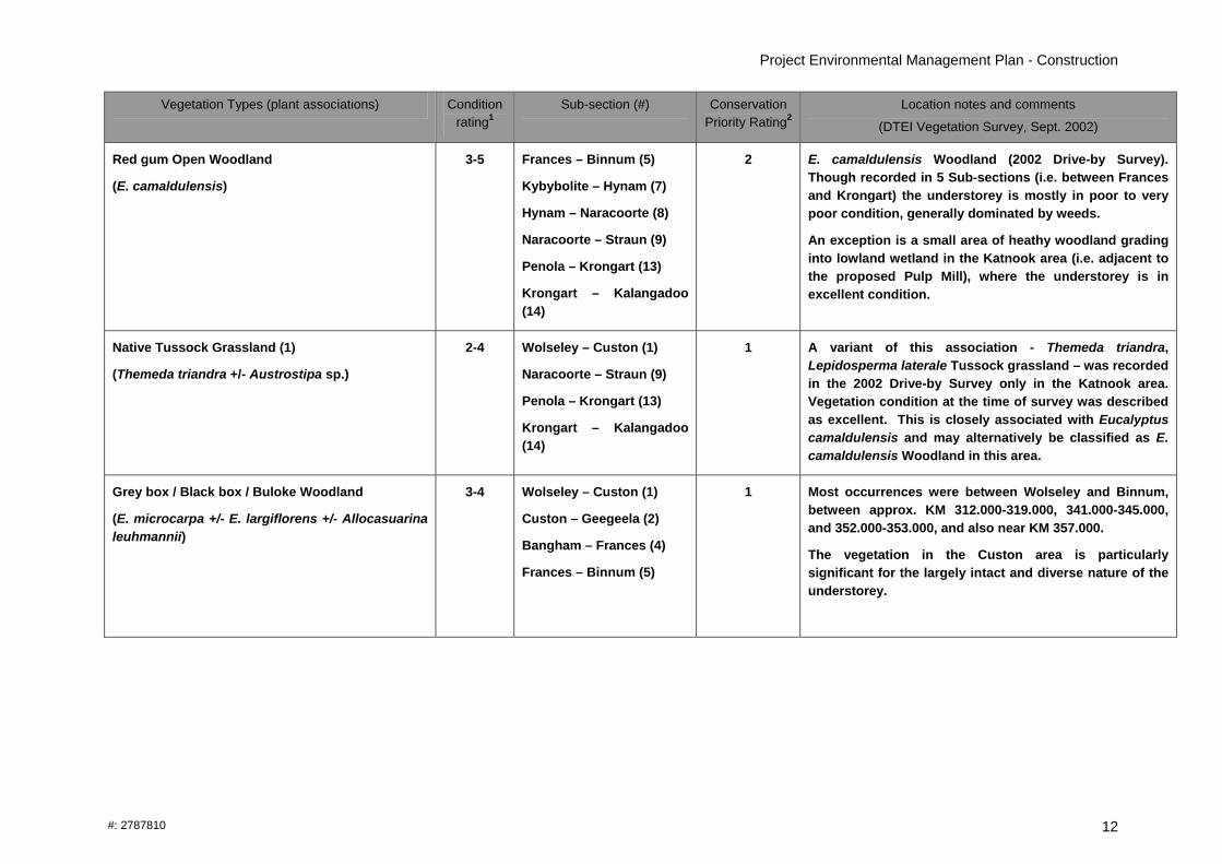
Table 3.1: Main remnant vegetation types within the rail corridor (Wolseley to Kalangadoo
Vegetation Types (plant associations) Condition rating1
Sub-section (#) Conservation Priority Rating2
Location notes and comments
(DTEI Vegetation Survey, Sept. 2002)
Sand stringybark +/- Blue gum Woodland
(Eucalyptus arenacea +/- E. leucoxylon ssp pruinosa)
2-4 Geegeela-Bangham (3)
Bangham – Frances (4)
3 Recorded in 2002 Drive-by Survey as Eucalyptus arenacea +/- E. leucoxylon. The most intact and diverse association recorded.
Blue gum +/- Sand stringybark Woodland
(E. leucoxylon ssp. pruinosa +/- E. arenacea)
2-4 Bangham – Frances (4) Refer above Recorded in 2002 Drive-by Survey as Eucalyptus arenacea +/- E. leucoxylon
Sand stringybark Woodland
(E. arenacea)
2-4 Geegeela-Bangham (3)
Bangham – Frances (4)
Refer above Not recorded as a distinct association in 2002 Drive-by Survey.
E. leucoxylon Low open forest Custon-Geegeela (2)
Geegeela-Bangham (3)
Bangham-Frances (4)
Hynam-Naracoorte (8)
2 Occurs principally in drainage depressions between Custon (KM315.900) and Frances (KM347.000), with understorey mostly in good condition.
A degraded example occurs KM378.000-381.000 (east of Naracoorte).
Red gum / Blue gum Open Woodland
(E. camaldulensis +/- E. leucoxylon ssp leucoxylon)
4-5 Frances – Binnum (5)
Hynam – Naracoorte (8)
? Not recorded as a distinct association in2002 Drive-by Survey.
Project Environmental Management Plan - Construction
#: 2787810
12
Vegetation Types (plant associations) Condition rating1
Sub-section (#) Conservation Priority Rating2
Location notes and comments
(DTEI Vegetation Survey, Sept. 2002)
Red gum Open Woodland
(E. camaldulensis)
3-5 Frances – Binnum (5)
Kybybolite – Hynam (7)
Hynam – Naracoorte (8)
Naracoorte – Straun (9)
Penola – Krongart (13)
Krongart – Kalangadoo (14)
2 E. camaldulensis Woodland (2002 Drive-by Survey). Though recorded in 5 Sub-sections (i.e. between Frances and Krongart) the understorey is mostly in poor to very poor condition, generally dominated by weeds.
An exception is a small area of heathy woodland grading into lowland wetland in the Katnook area (i.e. adjacent to the proposed Pulp Mill), where the understorey is in excellent condition.
Native Tussock Grassland (1)
(Themeda triandra +/- Austrostipa sp.)
2-4 Wolseley – Custon (1)
Naracoorte – Straun (9)
Penola – Krongart (13)
Krongart – Kalangadoo (14)
1 A variant of this association - Themeda triandra, Lepidosperma laterale Tussock grassland – was recorded in the 2002 Drive-by Survey only in the Katnook area. Vegetation condition at the time of survey was described as excellent. This is closely associated with Eucalyptus camaldulensis and may alternatively be classified as E. camaldulensis Woodland in this area.
Grey box / Black box / Buloke Woodland
(E. microcarpa +/- E. largiflorens +/- Allocasuarina leuhmannii)
3-4 Wolseley – Custon (1)
Custon – Geegeela (2)
Bangham – Frances (4)
Frances – Binnum (5)
1 Most occurrences were between Wolseley and Binnum, between approx. KM 312.000-319.000, 341.000-345.000, and 352.000-353.000, and also near KM 357.000.
The vegetation in the Custon area is particularly significant for the largely intact and diverse nature of the understorey.

Project Environmental Management Plan - Construction
#: 2787810
13
Vegetation Types (plant associations) Condition rating1
Sub-section (#) Conservation Priority Rating2
Location notes and comments
(DTEI Vegetation Survey, Sept. 2002)
Grey box / Black box Woodland
(E. microcarpa +/- E. largiflorens)
3-4 Wolseley – Custon (1)
Custon – Geegeela (2)
Bangham – Frances (4)
Frances – Binnum (5)
Refer above Not recorded as a distinct association in2002 Drive-by Survey.
(referable to E. microcarpa +/- E. largiflorens +/- Allocasuarina leuhmannii Woodland above)
Grey box Woodland
(E. microcarpa)
3-4 Wolseley – Custon (1)
Custon – Geegeela (2)
Bangham – Frances (4)
Frances – Binnum (5)
Refer above Not recorded as a distinct association in2002 Drive-by Survey (referable to E. microcarpa +/- E. largiflorens +/- Allocasuarina leuhmannii Woodland above)
Tall Sedge Sedgeland
(Lepidosperma laterale)
2-3 Penola – Krongart (13) 1 Not recorded as a distinct association in2002 Drive-by Survey (referable to Native Tussock Grassland (1) above)
Allocasuarina verticillata Low woodland Wolseley – Custon (1) 2 KM 310.000-312.000 (i.e. 3.5-5.5.km south of Wolseley).
Typha domingensis / Amphibromus sp. / Eleocharis acuta Herbland
Hynam-Naracoorte (8) 3 Localised occurrence at KM 389.000, southern outskirts of Naracoorte
Gahnia trifida Sedgeland Straun-Glenroy (10) 1 Localised occurrence at KM 405.000, south of Straun.

Project Environmental Management Plan - Construction
#: 2787810
14
1 Explanation of condition ratings in Table 3.1: #Condition
Rating Overview Condition Management Implications
1 Excellent Very little or no sign of alien vegetation in the understorey*; resembles probable pre-European condition.
2 Good High proportion of native species and native cover in the understorey*; reasonable representation of probable pre-European vegetation.
3 Moderate Substantial invasion of aliens but native understorey* persists; for example may be a low proportion of native species and a high native cover, or a high proportion of native species and low native cover.
4 Poor The understorey* consists predominately of alien species, although a small number of natives persist.
5 Very Poor The understorey* consists only of alien species.
*Or all Strata if the upper and lower strata are difficult to distinguish e.g. Grasslands etc. (‘Guide to Roadside Vegetation Survey Methodology for South Australia’, Stokes et al 1998). 2 Conservation priority rating system as per Stokes AL, Heard LMB, Carruthers S, and Reynolds T (1998) Guide to the roadside vegetation survey methodology for South Australia. September 1998. Planning SA and Dept. of Transport Urban Planning and the Arts, Adelaide, where 1 is very high conservation rating and 5 is no conservation significance. Actual ratings used here were taken from Table 5.1 in Drive-by Vegetation Survey: South East – Various Rail Lines. (2004) DTEI unpublished repo

Project Environmental Management Plan - Construction
#: 2787810
15
Table 3.2: Track sections in which plants of conservation significance are known to occur
Species Conservation Rating
Position in reserve Track Sub Section/s
Allocasuarina leuhmannii (1)
Eucalyptus largiflorens
Eucalyptus microcarpa (2)
Callitris gracilis
Pittosporum angustifolium
SE-Uncommon
SE-Vulnerable
SE-Vulnerable
SE-Rare
SE-Endangered
Across the width of the corridor primarily outside of the formation and Clear Zone areas.
(1) Conservation Priority Association -EPBC Act
(2) Conservation Priority Association –Native Vegetation Act, 1999
1-4, 5
1-4, 5
1-4, 5
1-4
1-4
Swainsona procumbrens
Calocephalus citreus,
Acacia acinacea
Acacia brachybotrya
Leucopogon woodsii
SA/SE-Vulnerable
SE-Vulnerable
SE-Uncommon
SE-Uncommon
SE-Uncommon
Understorey species occurring in a number of sections of the reserve and located across the width of the corridor including on the formation and within the Clear Zone
1-4
Gratiola peruviana
Juncus procerus
Ranunculus inundatus
Eleocharis sphacelata
Lepidosperma laterale
SA/SA-Rare,
SA/SE-Rare
SA/SE-Rare
SE-Rare
SE-Rare
Understorey species occurring across the width of the corridor including within the Clear Zone.
13
Calocephalus lacteus SA/SE-Endangered Understorey species possibly occurs on the formation and/or within the Clear Zone within a potential Railside Significant Site which will need to be assessed at a later date.
10

Project Environmental Management Plan - Construction
#: 2787810
16
3.1.2 Environment Protection Actions
To minimise impacts on native vegetation and maintain it in good condition, the following actions shall be adopted in regard to the protection of native vegetation within the rail corridor:
Clearance of vegetation within the Activity Zone shall be carried out in accordance with Section 2.2 (General requirements for control of vegetation)
Undertake the following actions to protect plant species and vegetation types of conservation significance.
o identify areas containing key plant populations, rare fauna habitat and weed species (including EPBC Act listed species) and vegetation types, based on drive-by survey information.
o describe each Lessee activity and undertake an evaluation of the potential threat to key plant populations, vegetation types and fauna habitat and describe measures to be implemented to avoid or minimise disturbance to these areas, including the management of non-target damage during weed control.
o include a process to monitor railside significant sites and potential rare fauna habitat locations (from Table 3.3) key sites that are sensitive to disturbance and a process for the reporting of damage or disturbance.
o detail a strategic annual weed control program to be implemented on a priority basis, with clear objectives, and appropriate management options and control techniques.
o Undertake induction of site staff and contractors on protection of remnant vegetation and threatened flora.
The Railside Significant Sites database should be consulted prior to undertaking any work to confirm the location of Significant Sites.
The CEMP shall identify key sites and measures required for their protection and on-going management. This should include an annual weed management program in the remnant native vegetation areas undertaken by a qualified biodiversity management contractor trained in bushcare methods.
The removal of low-growing species within the Activity Zone may not be necessary for safety purposes. Plants of these species should be retained wherever possible.
3.2 Fauna
3.2.1 Issues

Project Environmental Management Plan - Construction
#: 2787810
17
The known or potential areas of key fauna habitat in the rail corridor are outlined in Table 3.3.
The following significant fauna species of conservation significance have been recorded in the vicinity of the rail corridor and may be present in or utilise the corridor:
Red-tailed Black Cockatoo Calyptorhynchus banksii graptogyne
Listed as Endangered under the Commonwealth EPBC Act 1999. This species nests in large hollows in Red gums (Eucalyptus camaldulensis) and Blue gums (Eucalyptus leucoxylon) located within a 2 km range of feeding sites. The total estimated population is 700 – 1,000 birds. The species natural range is in the South East, extending from the Bangham – Frances area through to Mount Gambier and into adjoining areas of Victoria.
Southern Bell Frog Littoria raniformis
Listed as Threatened under the Commonwealth EPBC Act 1999. This species habitat requires large permanent water holes, farm dams and quarry waterholes with the appropriate native plant species which provide habitat and breeding opportunities (e.g. sedges, rushes, water weed etc). Threats to the species continual survival include chemical over use, the lowering of the water table, habitat destruction and isolation.
Striped Legless Lizard Delmar impar
Listed as Endangered under SA National Parks and Wildlife Act 1972. Found mainly in grasslands dominated by perennial, tussock grasses with significant amounts of surface rocks, which are used for shelter but has also been captured in modified grasslands with a significant content of exotic grasses. Threats to this species includes habitat degradation from land clearing, slashing or ploughing, heavy grazing and trampling by stock, invasion by weeds, changes to fire regimes that result in changes to vegetation structure and composition, predation by foxes and cats, tree planting, spray drift and vehicle traffic through known lizard sites.
Table 3.3: Potential rare fauna habitat locations within the rail easement
Species Rail Sub Section KM Comment
Red-tailed Black Cockatoo
Custon-Geegeela (2)
Geegeela-Bangham (3)
Bangham-Frances (4)
315.930-323.550
323.550-330.970
330.970-342.640
Eucalyptus arenacea Woodland and E. arenacea / E. leucoxylon ssp pruinosa Woodland could be used as a food resource.
Southern Bell Frog Frances – Krongart (5-14)
342.640-450.000 Throughout the rail corridor there are many areas of standing water which frogs could use for refuge during migration between permanent water bodies.

Project Environmental Management Plan - Construction
#: 2787810
18
Striped Legless Lizard
Naracoorte-Straun (9) 389.200-391.000 Section contains native tussock grasses and exposed rock which could form suitable habitat for the species
3.2.2 Environmental Protection Actions
To avoid or minimise impacts on native fauna and fauna habitat, in particular species of conservation significance, the following should be undertaken:
Implement the conditions of approval under the Environment Protection and Biodiversity Conservation Act, Decision notification???
Implement the conditions of approval under the Native Vegetation Council Naracoorte Crossing Loop Decision notification NVC2009/3030/674 Document 09WLB02437
Engage a suitably qualified person to undertake a fauna inspection prior to vegetation clearance and to relocate any fauna affected by the clearance
Undertake an induction program for site staff and contractors for protection of native fauna.
Use herbicides which minimise impact on aquatic fauna and frogs 3.3 Weeds, Pests and Diseases
3.3.1 Issues
Various surveys of the rail corridor have recorded a range of weeds within the rail corridor, including species proclaimed as pest plants under the NRM Act. Within a number of sections of the rail corridor environmental weeds are growing on the track formation and in certain areas present a high fire risk in relation to the operation of trains. Weeds also pose a threat to the ecological integrity of native vegetation, including populations of threatened plant species, either within the rail corridor or in certain adjacent areas. The rail corridor is located in a moderate risk area for Phytophthora which is a serious disease of native vegetation, refer Figure 3.1. It is also in proximity to vineyards potentially at risk of phylloxera. Management measures need to be taken to avoid the introduction or spread of these diseases.

Project Environmental Management Plan - Construction
#: 2787810
19
STRUAN
PENOLA
KEPPOCH
GLENCOE
FRANCES
TARPEENA
NANGWARRY
PADTHAWAY
MOUNT BURR
NARACOORTE
TANTANOOLAKALANGADOO
COONAWARRA
MOUNT GAMBIER
PORT MACDONNELL
BLACKFELLOWS CAVES
Figure 3.1 Phytophthora Risk Zone along Penola Rail Line, 2008
0 30 60 90 120 15015
Kilometers
Adelaide
Phytophthora Locations
Railway
Moderate/High Acidic Soil
Rural Towns
Maximum Rainfall (mm)
400 - 500
501 - 600
601 - 700
701 - 800
801 - 900
Produced by: Department for Transport Energy and Infrastructure Environmental Systems. www.dtei.sa.gov.au
Data Source: Department of Water Land and Biodiversity for soil and rainfall information. Department for Environment and Heritage for phytophthora infomation. Rail and township by Department for Transport, Energy and Infrastructure.
Projection: Lambert Conformal ConicCompiled: July 2008

Project Environmental Management Plan - Construction
#: 2787810
20
3.3.2 Environmental Protection Actions
To prevent the introduction and dispersal of pest plants into and within the rail corridor, and adjacent ecologically sensitive areas the following should be undertaken:
the CEMP shall incorporate weed management measures to control proclaimed and environmental weeds and reduce the risk of weed invasion and potential damage to vegetation.
The CEMP shall incorporate management measures to control introduction
or spread of plant disease such as phytophthora and phylloxera. Potential spread of these diseases should be considered in the location and design of the access track.
Weed propagules or weed infested material or soil shall not be imported
onto the Lease area.
All earth moving machinery shall be cleaned of soil and vegetation prior to entering and leaving the Lease area.
Any pests and weeds existing at the site prior to construction commencing
shall not be spread any further by construction activities.
Herbicides used shall have low toxicity to fauna and frogs.

Project Environmental Management Plan - Construction
#: 2787810
21
PART 4: OTHER ENVIRONMENTAL ISSUES 4.1 Drainage and soil erosion 4.1.1 Issues Soil erosion can cause the pollution of waterways, impacts on fauna and flora, and damage to rail infrastructure. Maintaining vegetative cover on all areas of the trackside greatly assists with erosion control. It is important therefore that vegetation is retained wherever possible when establishing new work sites or drainage works. The extent of low lying areas within portion of the rail corridor and a tendency for seasonal inundation to occur particularly in areas with grey cracking clay soils means these areas are difficult to access by vehicles in the winter months and the soils are vulnerable to damage. 4.1.2 Environment Protection Actions To protect water resources from silt and pollution the following should be undertaken:
comply with the Environment Protection Act 1993, the Environment Protection (Water Quality) Policy 2003 and the Natural Resources Management Act 2004
During the rail upgrade a Soil Erosion and Drainage Management Plan (SEDMP) shall be developed and implemented to manage the risk of potential damage to vegetation and water resources. The SEDMP shall be prepared in accordance with the Stormwater Pollution Prevention Code of Practice for Local, State and Federal Government. The plan shall address the following:
o Identification of sites or activities at risk of erosion
o The location of any sensitive ecological areas such as watercourses, wetlands and nature reserves in the vicinity of the rail corridor
o Statement regarding the impact of works on natural or existing
drainage patterns within and adjacent to the rail corridor
o Limits of site disturbance at each disturbance location (e.g. stockpile areas)
o Description of the methods adopted to control erosion and sediment, and type of site protection measures to be used;
o Brief description of how work sites will be stabilised and rehabilitated after works have been completed, including areas to be revegetated;
o Inspection and maintenance schedule of drainage structures and erosion-prone areas and procedures to ensure continuing effectiveness.

Project Environmental Management Plan - Construction
#: 2787810
22
4.2 Construction Noise and Vibration Control 4.2.1 Issues Excessive machinery noise and vibration may be a nuisance to residential properties adjacent to the rail corridor particularly in townships. Vibration may arise from the rail repair equipment, and noise nuisance from materials handling ,the movement of trucks, front-end loaders, rail repair equipment, and reversing alarms on mobile plant, particularly early in the morning or late at night 4.2.2 Environment Protection Actions To minimise nuisance caused by equipment/plant noise and vibration the following actions shall be undertaken:
Comply with the Environment Protection Act relating to noise from vehicles and machinery.
Within townships and near rural residences work shall be programmed to avoid operations outside normal construction hours of 7.00 a.m. to 7.00 p.m. Monday to Saturday inclusive and must not occur on Sundays and Public holidays.
If works outside these hours or night works are required the lessee shall prepare a Construction Noise and Vibration Management Plan which identifies the noise and vibration levels for the planned activities, the ambient noise levels, location of sensitive receivers and the management measures to reduce or manage the potential impacts. The lessee will seek endorsement of the Plan from the EPA for the proposed works.
The lessee shall prepare and maintain a community information plan to advise adjoining residences of proposed activities and timing of activities.
The lessee is responsible for responding to and resolving any complaints and repair of any damage arising from the lessee’s activities.
Construction vehicles and equipment shall have appropriate noise control measures fitted and be effectively maintained to minimise engine noise and comply with the appropriate regulations and by-laws relating to noise.
Stationary items of plant, normally operating continuously, such as generators and compressors, shall be fitted with noise attenuating enclosures.
When construction will involve the use of heavy equipment and significant noise generating activities, the rail operator shall, as much as practicable, prevent noise from being a nuisance to neighbouring residents.
The lessee shall discuss their Rail Licence with the EPA to determine any further noise requirements.
4.3 Air Quality and Dust Suppression

Project Environmental Management Plan - Construction
#: 2787810
23
4.3.1 Issues The emission of dust and other air pollutants can impact on the public, adjoining businesses, townships and nearby residences. 4.3.2 Environment Protection Actions
The lessee shall minimise air pollution from the construction works and suppress dust nuisance from disturbed sites within the Lease area including access tracks, haul roads and stockpile sites. The lessee shall implement the following measures:
(a) watering of the works areas or temporary paving of haul roads to suppress dust;
(b) avoiding or minimising dust-generating activities during dry and windy conditions
(c) stabilising stockpiles by covering or other appropriate means to prevent generation of dust;
(d) minimising the extent of exposed, stripped surface;
(e) the progressive revegetation of disturbed areas as work proceeds.
It is the Contractor's responsibility to achieve adequate dust control, particularly where the safety and convenience of people are affected. 4.4 Waste management and Recycling of Materials 4.4.1 Issues Previous operation of the rail line resulted in a range of waste materials left scattered throughout the rail easement such as life-expired sleepers, broken rail line, clips, plates and dog spikes. Upgrading the rail line will generate significant quantities of waste materials. 4.4.2 Environment Protection Actions
The lessee shall recycle waste materials where practicable or dispose of materials to a licensed waste depot in accordance with the Environment Protection Act.
The Lessee shall remove waste and recyclable material from the lease area unless recyclable material can be reused within the lease area and maintain the lease area in a clean and tidy condition
Where the Lessee proposes to use recycled material from an external source or to dispose of or sell waste materials from the rail corridor, the Lessee shall ensure that an assessment of potential contaminants (including testing where appropriate) and an environmental risk assessment is undertaken and documented in the CEMP.
The assessment shall be reviewed and an Audit Report obtained from an Environmental Auditor (Contaminated Land) who has been accredited by the EPA.

Project Environmental Management Plan - Construction
#: 2787810
24
The Lessee shall comply with any environmental management recommendations in the assessment and the Auditor’s Audit Report and the recommendations must be incorporated into the CEMP.
4.5 Site contamination 4.5.1 Issues Potential contamination on rail land (e.g. ballast and track areas) associated with activities such as weed control and refuelling, and the relocation or movement of contaminated soils off-site. 4.5.2 Environment Protection Actions Where any contaminated material is moved within the lease land or off site, the Lessee shall undertake all work in compliance with the Environment Protection Act 1993.
The lessee shall undertake investigation necessary (prior to any potential construction and during construction) to determine the scope and nature of contamination issues associated with its activities.
Where contaminants may be mobilised or contaminated soils are disturbed, relocated or moved off the site, the lessee shall ensure that an assessment of potential contaminants (including testing where appropriate) and an environmental risk assessment is undertaken and the lessee shall develop and undertake an appropriate Contamination Management Plan. The Contamination Management Plan shall cover the management of spoil, topsoil, soil, surface and groundwater.
The assessment shall be reviewed and a Site Audit Report obtained from an Environmental Auditor (Contaminated Land) who has been accredited by the EPA.
The Lessee shall comply with any environmental management recommendations in the assessment, the Auditor’s Site Audit Report and the recommendations must be incorporated into the CEMP.
A Safety Plan shall include procedures for safe working with contaminated materials. The Lessee shall maintain a register of the nature, type and location of contamination encountered on the leased land.
4.6 Materials Storage and Handling 4.6.1 Issues Materials such as such as fuels, oils, and chemicals can pollute or harm the environment (e.g. waterways or groundwater) through inappropriate use, leaks and spills. The stockpiling of aggregates, if not located and contained carefully, can damage vegetation and heritage sites, pollute watercourses or spread weeds.

Project Environmental Management Plan - Construction
#: 2787810
25
4.6.2 Environment Protection Actions Storage and handling of materials, including fuels, oils, chemicals and solid waste, and the stockpiling of solid aggregates shall be undertaken in a manner that does not contaminate soil, watercourses and groundwater, or damage native vegetation, either within the rail easement or on adjacent property.
Fuel, oil and other chemicals that are stored on the lease area should be stored within a bund, with an impervious floor, in an area not subject to flooding and in accordance with AS 1940.
In the event of a spill or leak, the lessee shall clean up the contaminated area and dispose of the affected material to the nearest licensed waste depot immediately.
The lessee shall provide on site and have access at all times to a spill kit for the purpose of cleaning up oil and fuel spillage and any other hazardous materials used or carried in the lease area. The lessee shall also ensure that personnel trained in the efficient deployment of the spill kit are readily available in the event of a spill.
Maintenance of vehicles and machinery should be carried out off site where practicable. If maintenance is to occur on site, the location and procedure shall be documented in the CEMP.
Avoid placement of aggregate stockpiles or solid waste on or near native vegetation (in particular Railside Significant Sites – refer Appendix B) or across drainage lines.
4.7 Protection of Sites of Cultural and Natural Heritage Significance 4.7.1 Issues An Aboriginal Heritage Survey of the rail corridor was undertaken in 2002 and did not identify any sites or items of significance. There are two entries in the State Heritage Register adjacent the rail line; the Tantanoola Railway Station and the former Penola Railway Station. A drive-by vegetation survey of the rail corridor was conducted in September 2002 and a validation assessment was carried out in 2007. To assist in the recognition of sites of significance within the corridor fourteen sites (vegetation or flora features only) have been marked with permanent markers (Railside Markers). Details of the significant feature at each site (refer Appendix B) are stored in the Railside Significant Sites Database. 4.8.2 Environment Protection Actions To avoid damage or disturbance to Sites of Cultural or Natural Heritage Significance the lessee shall:

Project Environmental Management Plan - Construction
#: 2787810
26
Ensure that any Railside Signficant Sites and environmentally sensitive areas identified within the Lease and Project Documents or identified during the course of the Project are identified in the CEMP.
Mark any sites of significance that have been identified in the PEMP or associated documents and ensure that these sites remain protected during the Project.
Exercise due care and protect all identified sites or sites that may be encountered during the Project
Stop work if, at any time, an Aboriginal site or a site containing items associated with Aboriginal occupation is uncovered. The Lessee shall provide notification immediately under the Aboriginal Heritage Act and to the Lessor, and work shall not recommence in the affected area until the Aboriginal Affairs and Reconciliation Division, Department of Premier and Cabinet has provided direction on site treatment.
4.9 Environmental emergency The Lessee shall develop and maintain an Emergency Response Plan that includes the following information as appropriate for environmental emergencies:
Emergency contacts (including EPA, CFS / MFS, Police and other relevant authorities)
Key personnel
Communications plan
Action to be taken
Information on hazards
Training plan and equipment
Rehabilitation plan
In the event of a spill or emergency incident, the Lessee shall:
Keep a record of the incident, the response, the corrective action and any rehabilitation undertaken.
Provide notification to DTEI within 2 days, of any incidents requiring notification under legislative requirements.

Project Environmental Management Plan - Construction
#: 2787810
27
APPENDIX A Track Sections
Track Section Track Sub-section Sub-section
No. KM Start/End
Wolseley - Frances Wolseley – Custon 1 308.000 – 315.930
Wolseley - Frances Custon-Geegeela 2 315.930 – 323.550
Wolseley - Frances Geegeela-Bangham 3 323.550 – 330.970
Wolseley - Frances Bangham-Frances 4 330.970 – 347.920
Frances - Naracoorte Frances-Binnum 5 347.920 – 356.790
Frances - Naracoorte Binnum-Kybybolite 6 356.790 – 365.810
Frances - Naracoorte Kybybolite-Hynam 7 365.810 – 375.380
Frances - Naracoorte Hynam-Naracoorte 8 375.380 – 386.850
Naracoorte-Penola Naracoorte-Straun 9 386.850 – 404.130
Naracoorte-Penola Straun-Glenroy 10 404.130 – 416.970
Naracoorte-Penola Glenroy-Coonawarra 11 416.970 – 425.070
Naracoorte-Penola Coonawarra-Penola 12 425.070 – 435.710
Penola - Kalangadoo Penola-Krongart 13 435.710 – 448.030
Penola - Kalangadoo Krongart-Kalangadoo 14 448.030 – 450.000

Project Environmental Management Plan - Construction
#: 2787810 28
APPENDIX B: Railside Significant Sites recorded along Mt Gambier to Wolseley Line (to August 2007) Source: Railside Significant Sites Database, DTEI, January 2008
Site No. Side of track
(travel south)
Feature Type Feature Description KM Start KM End
213 Left
(DOWN) Rare Flora 1. Swainsona procumbrens
Calocephalus citreus,
3. Allocasuarina leuhmannii,
4. Eucalyptus microcarpa
310.700 311.360
Rare Flora 1. Eucalyptus microcarpa,
2. Acacia acinacea,
3. Eucalyptus largiflorens
311.380 315.910
Vegetation/ Bushland
Themeda triandra / Austrostipa Tussock Grassland 311.380 313.500
214 Right
(UP)
Vegetation/ Bushland
Eucalyptus microcarpa / Euc largiflorens Open woodland 313.500 315.910
215 Left
(DOWN) Rare Flora 1. Swainsona procumbrens (KM311.380 - 312.380),
2. Calocephalus citreus (KM311.380 - 312.380),
3. Eucalyptus microcarpa (KM312.380 - 315.910),
4. Eucalyptus largiflorens (KM313.780 - 315.910),
5. Acacia acinacea (KM315.280 - 315.910),
6. Allocasuarina leuhmannii (KM315.280 - 315.910),
7. Pittosporum angustifolium (KM314.670 - 314.720)
311.380 315.910
216 Right
(UP) Rare Flora 1. Acacia acinacea (KM315.940 - 318.680),
2. Allocasuarina leuhmannii (KM315.940 - 318.680),
3. Eucalyptus microcarpa (KM315.940 - 319.360),
4. Eucalyptus largiflorens (KM315.940 - 318.680),
315.940 319.360

Project Environmental Management Plan - Construction
#: 2787810 29
Site No. Side of track
(travel south)
Feature Type Feature Description KM Start KM End
5. Pittosporum angustifolium,
6. Leucopogon woodsii (KM318.680-319.360)
Rare Flora Leucopogon woodsii 319.380 319.480
Rare Flora Acacia acinacea 323.080 323.520
218 Right
(UP)
Vegetation/ Bushland
Eucalyptus arenacea +/- Eucalyptus leucoxylon ssp stephaniae Woodland Over Sparse tall shrubs - Leptospermum sp., Banksia sp., Over Sparse - Mid dense Xanthorrhoea sp., Over Dense mosses, lichens, grasses and ground covers - Kunzea pomifera
319.400 323.520
Rare Flora Leucopogon woodsii 319.380 319.480
Rare Flora Acacia acinacea 323.080 323.520
219 Left
(DOWN)
Vegetation/ Bushland
Eucalyptus arenacea +/- Eucalyptus leucoxylon ssp stephaniae Woodland Over Sparse tall shrubs - Leptospermum sp., Banksia sp., Over Sparse - Mid dense Xanthorrhoea sp., Over Dense Mosses, Lichens, grasses and ground covers - Kunzea pomifera
319.380 323.520
Vegetation/ Bushland
1. Eucalyptus arenacea / Euc leucoxylon Open Woodland (KM323.560 - 327.900),
2. Eucalyptus arenacea Open Woodland (KM327.900 - 328.300),
3. Eucalyptus leucoxylon Woodland (KM328.300 - 328.700),
4. Eucalyptus arenacea Open Woodland (KM328.700 - 329.000),
5. Eucalyptus arenacea / Euc leucoxylon Open Woodland (KM329.000 - 330.960)
Understorey varies across the associations from open grassland understorey (E. leucoxylon) to closed heath understorey (E. arenacea).
323.56 330.96
Rare Flora Acacia acinacea 323.560 328.180
220 Right
(UP)
Rare Flora Acacia brachybotrya 330.480 330.96

Project Environmental Management Plan - Construction
#: 2787810 30
Site No. Side of track
(travel south)
Feature Type Feature Description KM Start KM End
Vegetation/ Bushland
1. Eucalyptus arenacea / Euc leucoxylon Open Woodland (KM323.560 - 327.900),
2. Eucalyptus arenacea Open Woodland (KM327.900 - 328.300),
3. Eucalyptus leucoxylon Woodland (KM328.300 - 328.700),
4. Eucalyptus arenacea Open Woodland (KM328.700 - 329.000),
5. Eucalyptus arenacea / Euc leucoxylon Open Woodland (KM329.000 - 330.960)
Understorey varies across the associations from open grassland understorey (E. leucoxylon) to closed heath understorey (E. arenacea).
Rare Flora Acacia acinacea 323.560 328.180
221 Left
(DOWN)
Rare Flora Acacia brachybotrya 330.480 330.960
Rare Flora Acacia brachybotrya (KM330.980 - 333.680) )KM335.080 - 335.480) 330.980 335.480 222 Right
(UP) Vegetation/ Bushland
1. Eucalyptus leucoxylon ssp pruinosa / Euc arenacea Open Woodland (KM333.980 - 333.200),
2. Eucalyptus arenacea Woodland (KM333.200 - 334.000),
3. Eucalyptus leucoxylon ssp pruinosa / Euc arenacea Woodland (KM334.000 - 335.500),
4. Eucalyptus arenacea Woodland (KM333.500 - 336.500),
5. Eucalyptus leucoxylon ssp pruinosa / Euc arenacea Open Woodland (KM36.500 - 337.360)
Understorey varies across the associations predominately consists of Sparse - Mid dense Tall shrubs Acacia sp., Leptospermum sp., over Sparse - Mid dense Medium/Low Shrubs Correa sp., Acacia sp., Astroloma sp., Lissanthe sp., over Dense Kunzea pomifera, over Sparse native grasses, over Dense mosses and lichens
333.980 337.360
Rare Flora Acacia acinacea (KM330.980 - 333.680) 330.980 333.680 223 Left
(DOWN) Rare Flora 1. Acacia brachybotrya (KM335.080 - 335.480),
2. Callitris gracilis (KM335.080 - 335.480),
3. Santalum murraynum (KM335.480 - 335.580)
335.080 335.580

Project Environmental Management Plan - Construction
#: 2787810 31
Site No. Side of track
(travel south)
Feature Type Feature Description KM Start KM End
Vegetation/ Bushland
1. Eucalyptus leucoxylon ssp pruinosa / Euc arenacea Open Woodland (KM333.980 - 333.200),
2. Eucalyptus arenacea Woodland (KM333.200 - 334.000),
3. Eucalyptus leucoxylon ssp pruinosa / Euc arenacea Woodland (KM334.000 - 335.500),
4. Eucalyptus arenacea Woodland (KM333.500 - 336.500),
5. Eucalyptus leucoxylon ssp pruinosa / Euc arenacea Open Woodland (KM336.500 - 337.360)
Understorey varies across the associations predominately consists of Sparse - Mid dense Tall shrubs Acacia sp., Leptospermum sp., over Sparse - Mid dense Medium/Low Shrubs Correa sp., Acacia sp., Astroloma sp., Lissanthe sp., over Dense Kunzea pomifera, over Sparse native grasses, over Dense mosses and lichens
333.980 337.360
Rare Flora 1. Eucalyptus microcarpa
2. Eucalyptus largiflorens,
3. Allocasuarina leuhmannii
341.800 342.612 224 Right
(UP)
Vegetation/ Bushland
1. Eucalyptus leucoxylon ssp pruinosa Woodland (KM337.380 - 337.500),
2. Eucalyptus arenacea Woodland (KM337.500 - 338.000),
3. Eucalyptus leucoxylon ssp pruinosa Woodland (KM338.000 - 338.500),
4. Eucalyptus arenacea Low Woodland (KM338.500 - 341.800),
5. Eucalyptus microcarpa / Euc largiflorens Open Woodland (KM341.800 - 342.612)
Understorey varies across the associations predominately consists of Sparse - Mid dense Tall shrubs Acacia sp., Leptospermum sp., over Sparse - Mid dense Medium/Low Shrubs Correa sp., Acacia sp., Astroloma sp., Lissanthe sp., over Dense Kunzea pomifera, over Sparse native grasses, over Dense mosses and lichens
337.380 342.612
225 Left
(DOWN)
Rare Flora 1. Eucalyptus microcarpa
2. Eucalyptus largiflorens,
3. Allocasuarina leuhmannii,
4. Callitris gracilis (KM340.000)
340.000 342.640

Project Environmental Management Plan - Construction
#: 2787810 32
Site No. Side of track
(travel south)
Feature Type Feature Description KM Start KM End
Vegetation/ Bushland
1. Eucalyptus leucoxylon ssp pruinosa Woodland (KM337.380 - 337.500),
2. Eucalyptus arenacea Woodland (KM337.500 - 338.000),
3. Eucalyptus leucoxylon ssp pruinosa Woodland (KM338.000 - 338.500),
4. Eucalyptus arenacea Low Woodland (KM338.500 - 341.800),
5. Eucalyptus microcarpa / Euc largiflorens Open Woodland (KM341.800 - 342.612)
Understorey varies across the associations predominately consists of Sparse - Mid dense Tall shrubs Acacia sp., Leptospermum sp., over Sparse - Mid dense Medium/Low Shrubs Correa sp., Acacia sp., Astroloma sp., Lissanthe sp., over Dense Kunzea pomifera, over Sparse native grasses, over Dense mosses and lichens
337.380 342.612
Rare Flora 1. Juncus procerus (KM443.600 - 444.790),
2. Gratiola peruviana (KM443.600 - 444.790),
3. Ranunculus inundatus (KM443.600 - 444.790),
4. Eleocharis sphacelata (KM442.680 - 443.600) - possible site?
443.600 444.790 226 Right
(UP)
Vegetation/ Bushland
Eucalyptus camaldulensis var. camaldulensis Open Woodland Over Dense sedge, exotic/native grasses, exotic/native herbs.
442.680 444.790
Left
(DOWN)
Vegetation/ Bushland
Eucalyptus camaldulensis var. camaldulensis Open Woodland Over Dense sedge, exotic/native grasses, exotic/native herbs.
442.680 444.790 227
Rare Flora 1. Juncus procerus (KM443.600 - 444.790),
2. Gratiola peruviana (KM443.600 - 444.790),
3. Ranunculus inundatus (KM443.600 - 444.790),
4. Eleocharis sphacelata (KM442.680 - 443.600)
442.680 444.790