Embed Size (px)
Citation preview
Schedule ‘B’ Environmental Assessment for Intersection of Derry Road and Argentia Road
Project File Report
Regional Municipality of Peel February 2015
Schedule ‘B’ Environmental Assessment for Intersection of Derry Road and Argentia Road Project File Report
February 2015 | i
EXECUTIVE SUMMARY
The Regional Municipality of Peel is undertaking a Schedule ‘B’ Class Environmental Assessment (EA) for the intersection of Derry Road and Argentia Road in the City of Mississauga. The purpose of this EA study is to:
Identify short and long term improvements for the horizon years of 2021 and 2031 at the intersection of Derry Road and Argentia Road
Complete Phases 1 through 4 of the Class EA Process Prepare 30% Detail Design for the Preferred Alternative, including recommending mitigation
measures for the Final Recommended Design Prepare a Class EA Schedule ‘B’ Project File Report
The intersection is located in north Mississauga, south of Highway 401 and north of the Milton GO Train rail corridor. Derry Road is a regional arterial road that runs continuously across Mississauga from Halton Region in the west to the City of Toronto in the east. Derry Road also passes through Pearson Airport. Argentia Road is a Major Collector that begins at Creditview Road in the east and terminates at 10th Line Road in the west at the entrance to the Lisgar GO Station parking lot. Based on the City of Mississauga Official Plan, the study area falls within the “Meadowvale Business Park Corporate Centre”. The land use designation for the four corners of the intersection of Derry Road and Argentia Road is “Business Employment.” The following problems and opportunities were identified within the transportation study:
Existing congestion during the AM and PM peak periods, which is expected to increase by the horizon years of 2021 and 2031 if no improvements are implemented
Opportunities to improve the intersection for pedestrians and cyclists Opportunities to improve the safety performance of the intersection
The problem and opportunity statement for the study was developed based on these findings:
Improvements are necessary to accommodate existing and long-term travel demands which are projected to exceed the current capacity of the intersection of Derry Road and Argentia Road. At the same time, improvements should minimize impacts to existing features at the intersection and improve safety performance. In particular the study will focus on addressing the following problems and opportunities:
Supporting the movement of people and goods through the intersection by facilitating more efficient vehicle movement (automobiles, transit vehicles, trucks)
Improving safety for all corridor users Protecting vulnerable road users Improving facilities for pedestrians and cyclists Improving access to transit service Supporting economic growth and planned development within the study area Preserving and enhancing existing natural and cultural features
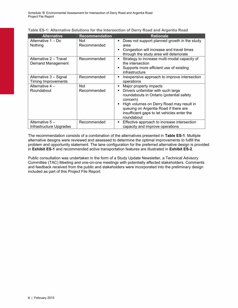
A set of alternative solutions were identified and evaluated against multiple criteria. Other than the “Do Nothing” option, the alternative solutions are not mutually exclusive and can be implemented in conjunction with other alternatives. The outcome of the evaluation is summarized in Table ES-1.
Schedule ‘B’ Environmental Assessment for Intersection of Derry Road and Argentia Road Project File Report
ii | February 2015
Table ES-1: Alternative Solutions for the Intersection of Derry Road and Argentia Road Alternative Recommendation Rationale
Alternative 1 – Do Nothing
Not Recommended
Does not support planned growth in the study area
Congestion will increase and travel times through the study area will deteriorate
Alternative 2 – Travel Demand Management
Recommended Strategy to increase multi-modal capacity of the intersection
Supports more efficient use of existing infrastructure
Alternative 3 – Signal Timing Improvements
Recommended Inexpensive approach to improve intersection operations
Alternative 4 – Roundabout
Not Recommended
Major property impacts Drivers unfamiliar with such large
roundabouts in Ontario (potential safety concern)
High volumes on Derry Road may result in queuing on Argentia Road if there are insufficient gaps to let vehicles enter the roundabout
Alternative 5 – Infrastructure Upgrades
Recommended Effective approach to increase intersection capacity and improve operations
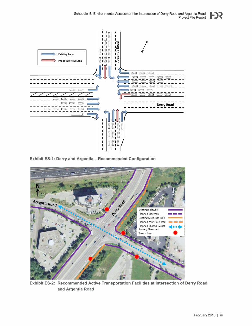
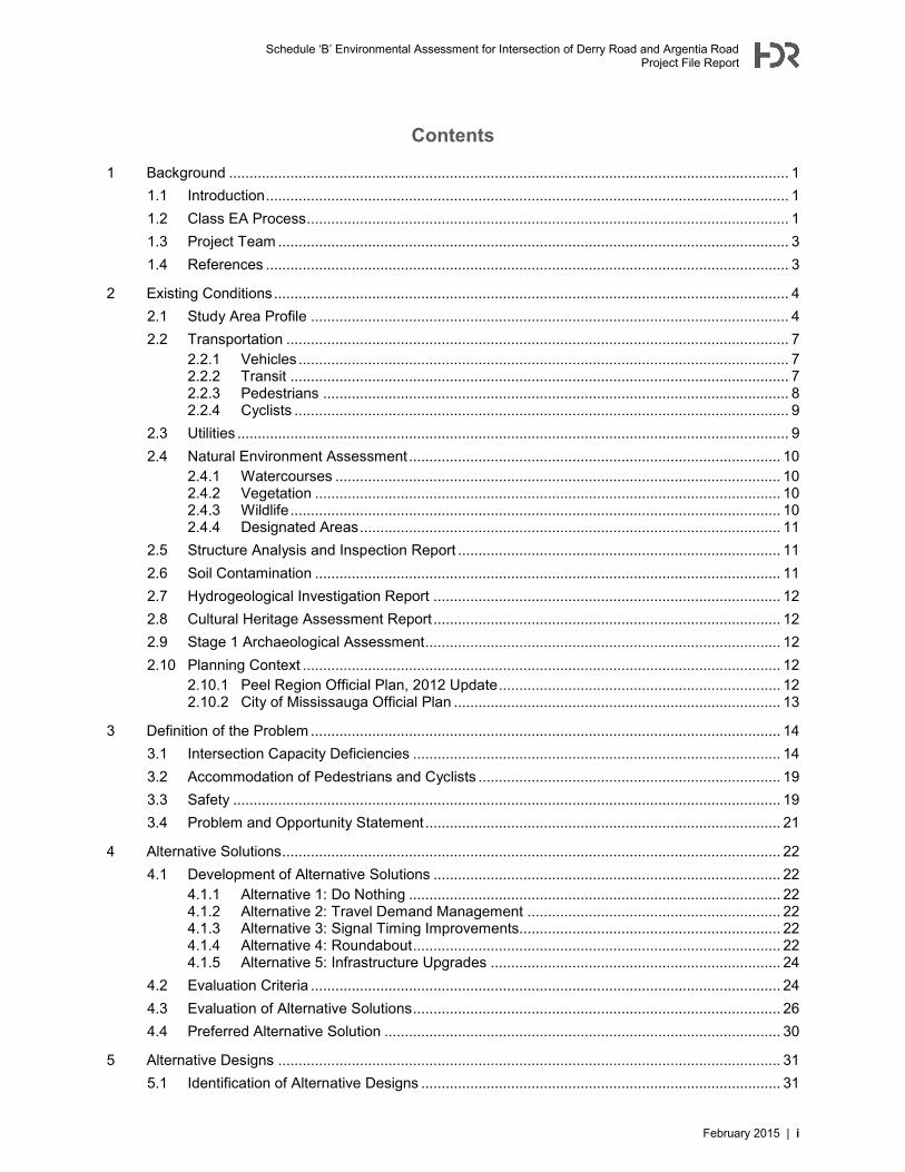
The recommendation consists of a combination of the alternatives presented in Table ES-1. Multiple alternative designs were reviewed and assessed to determine the optimal improvements to fulfill the problem and opportunity statement. The lane configuration for the preferred alternative design is provided in Exhibit ES-1 and recommended active transportation features are illustrated in Exhibit ES-2. Public consultation was undertaken in the form of a Study Update Newsletter, a Technical Advisory Committee (TAC) Meeting and one-on-one meetings with potentially affected stakeholders. Comments and feedback received from the public and stakeholders were incorporated into the preliminary design included as part of this Project File Report.
Schedule ‘B’ Environmental Assessment for Intersection of Derry Road and Argentia Road Project File Report
February 2015 | iii
Exhibit ES-1: Derry and Argentia – Recommended Configuration
Exhibit ES-2: Recommended Active Transportation Facilities at Intersection of Derry Road and Argentia Road

Schedule ‘B’ Environmental Assessment for Intersection of Derry Road and Argentia Road Project File Report
February 2015 | i
Contents
1 Background ......................................................................................................................................... 1 1.1 Introduction ................................................................................................................................ 1 1.2 Class EA Process ...................................................................................................................... 1 1.3 Project Team ............................................................................................................................. 3 1.4 References ................................................................................................................................ 3
2 Existing Conditions .............................................................................................................................. 4 2.1 Study Area Profile ..................................................................................................................... 4 2.2 Transportation ........................................................................................................................... 7
2.2.1 Vehicles ........................................................................................................................ 7 2.2.2 Transit .......................................................................................................................... 7 2.2.3 Pedestrians .................................................................................................................. 8 2.2.4 Cyclists ......................................................................................................................... 9
2.3 Utilities ....................................................................................................................................... 9 2.4 Natural Environment Assessment ........................................................................................... 10
2.4.1 Watercourses ............................................................................................................. 10 2.4.2 Vegetation .................................................................................................................. 10 2.4.3 Wildlife ........................................................................................................................ 10 2.4.4 Designated Areas ....................................................................................................... 11
2.5 Structure Analysis and Inspection Report ............................................................................... 11 2.6 Soil Contamination .................................................................................................................. 11 2.7 Hydrogeological Investigation Report ..................................................................................... 12 2.8 Cultural Heritage Assessment Report ..................................................................................... 12 2.9 Stage 1 Archaeological Assessment ....................................................................................... 12 2.10 Planning Context ..................................................................................................................... 12
2.10.1 Peel Region Official Plan, 2012 Update ..................................................................... 12 2.10.2 City of Mississauga Official Plan ................................................................................ 13
3 Definition of the Problem ................................................................................................................... 14 3.1 Intersection Capacity Deficiencies .......................................................................................... 14 3.2 Accommodation of Pedestrians and Cyclists .......................................................................... 19 3.3 Safety ...................................................................................................................................... 19 3.4 Problem and Opportunity Statement ....................................................................................... 21
4 Alternative Solutions .......................................................................................................................... 22 4.1 Development of Alternative Solutions ..................................................................................... 22
4.1.1 Alternative 1: Do Nothing ........................................................................................... 22 4.1.2 Alternative 2: Travel Demand Management .............................................................. 22 4.1.3 Alternative 3: Signal Timing Improvements................................................................ 22 4.1.4 Alternative 4: Roundabout .......................................................................................... 22 4.1.5 Alternative 5: Infrastructure Upgrades ....................................................................... 24
4.2 Evaluation Criteria ................................................................................................................... 24 4.3 Evaluation of Alternative Solutions .......................................................................................... 26 4.4 Preferred Alternative Solution ................................................................................................. 30
5 Alternative Designs ........................................................................................................................... 31 5.1 Identification of Alternative Designs ........................................................................................ 31
Schedule ‘B’ Environmental Assessment for Intersection of Derry Road and Argentia Road Project File Report
ii | February 2015
5.2 Evaluation of Alternative Designs ........................................................................................... 32 5.3 Preferred Alternative Design ................................................................................................... 36
6 Development of Preferred Design ..................................................................................................... 38 6.1 Design Criteria ......................................................................................................................... 38 6.2 Description of Design and Cross-Sections .............................................................................. 39 6.3 Preliminary Cost Estimate ....................................................................................................... 42
7 Impacts and Mitigation ...................................................................................................................... 44 7.1 Impacts to Property Owners .................................................................................................... 44 7.2 Utility Impacts .......................................................................................................................... 46 7.3 Environmental Impacts ............................................................................................................ 47
7.3.1 Natural Environment................................................................................................... 47 7.3.2 Tree Inventory ............................................................................................................ 48 7.3.3 Air and Noise .............................................................................................................. 48 7.3.4 Archaeology and Cultural Heritage ............................................................................ 48
7.5 Construction Impacts ............................................................................................................... 49 7.6 Mitigation ................................................................................................................................. 49
8 Consultation....................................................................................................................................... 53 8.1 Contact List ............................................................................................................................. 53 8.2 Notice of Study Commencement ............................................................................................ 54 8.3 Technical Advisory Committee (TAC) Meeting ....................................................................... 54 8.4 Study Update Newsletter......................................................................................................... 54 8.5 Stakeholder Meetings .............................................................................................................. 55 8.6 Notice of Completion ............................................................................................................... 55
Tables
Table 1-1: Project Team ................................................................................................................................ 3 Table 4-1: Evaluation of Alternative Solutions for Intersection of Derry Road and Argentia Road ............ 27 Table 4-2: Recommended Alternatives ....................................................................................................... 30 Table 5-1: Evaluation of Short-Listed Alternatives ...................................................................................... 33 Table 5-2: 2021 Traffic Operations – Alternative Solutions ........................................................................ 34 Table 5-3: 2031 Traffic Operations – Alternative Solutions ........................................................................ 35 Table 6-1: Design Criteria – Derry Road ..................................................................................................... 38 Table 6-2: Design Criteria – Argentia Road ................................................................................................ 39 Table 6-3: Proposed Storage Lengths ........................................................................................................ 42 Table 6-4: Approximate Cost Estimate for Improvements to Intersection of Derry Road and
Argentia Road ................................................................................................................................ 43 Table 7-1: Property Impacts Identified at the EA Stage .............................................................................. 45 Table 7-2: Feedback Received on Potential Utility Impacts ....................................................................... 46 Table 7-3: Impacts and Mitigation ............................................................................................................... 50 Table 8-1: Contact List for Derry/Argentia EA............................................................................................. 53 Table 8-2: Summary of Stakeholder Meetings............................................................................................ 55
Schedule ‘B’ Environmental Assessment for Intersection of Derry Road and Argentia Road Project File Report
February 2015 | iii
Figures Figure 4-1: Typical Plan View of Roundabout ............................................................................................. 23
Exhibits Exhibit 1-1: Municipal Class Environmental Assessment Planning and Design Process ............................ 2 Exhibit 2-1: Intersection of Derry Road and Argentia Road .......................................................................... 5 Exhibit 2-2: Population and Employment in Meadowvale ............................................................................. 6 Exhibit 2-3: Population and Employment in Streetsville ............................................................................... 6 Exhibit 2-4: Derry and Argentia – Existing Configuration .............................................................................. 7 Exhibit 2-5: Existing Sidewalk Network and Transit Stops ........................................................................... 9 Exhibit 2-6: Excerpt from Schedule G of Peel Region Official Plan ............................................................ 13 Exhibit 3-1: 2011 Traffic Volumes ............................................................................................................... 14 Exhibit 3-2: Study Area Operations – Existing AM Peak Period ................................................................. 15 Exhibit 3-3: Study Area Operations – Existing PM Peak Period ................................................................. 16 Exhibit 3-4: Study Area Operations – 2031 AM Peak Period ..................................................................... 17 Exhibit 3-5: Study Area Operations – 2031 PM Peak Period ..................................................................... 18 Exhibit 3-6: Collision Locations within Intersection of Derry Road and Argentia Road .............................. 20 Exhibit 5-1: Evaluation Rating Scale ........................................................................................................... 32 Exhibit 5-2: Derry and Argentia – Recommended Configuration ................................................................ 36 Exhibit 5-3: Recommended Active Transportation Facilities at Intersection of Derry Road ....................... 37 Exhibit 6-1: Section on Derry Road, West of Argentia Road ...................................................................... 41 Exhibit 6-2: Section on Argentia Road, North of Derry Road ...................................................................... 41
Appendices Appendix A: Preliminary Design
Appendix B: Transportation Report
Appendix C: Sub-surface Utility Engineering Services
Appendix D: Natural Heritage Report
Appendix E: Phase 1 Environmental Site Assessment
Appendix F: Hydrogeologic Study
Appendix G: Cultural Heritage Assessment Report
Appendix H: Stage 1 Archaeological Assessment
Appendix I: Geotechnical Report
Appendix J: Stormwater Management Report
Appendix K: Preliminary Cost Estimate
Appendix L: Property Impact Plans
Appendix M: Utility Impact Plan
Appendix N: Tree Inventory
Appendix O: Noise and Air Assessment
Appendix P: Consultation Record

Schedule ‘B’ Environmental Assessment for Intersection of Derry Road and Argentia Road Project File Report
February 2015 | 1
1 Background 1.1 Introduction The Regional Municipality of Peel is undertaking a Schedule ‘B’ Class Environmental Assessment (EA) for the intersection of Derry Road and Argentia Road in the City of Mississauga. The purpose of this EA study is to:
Identify short and long term improvements for the horizon years of 2021 and 2031 at the intersection of Derry Road and Argentia Road
Complete Phases 1 through 4 of the Class EA Process Prepare 30% Detail Design for the Preferred Alternative, including recommending mitigation
measures for the Final Recommended Design Prepare a Class EA Schedule ‘B’ Project File Report
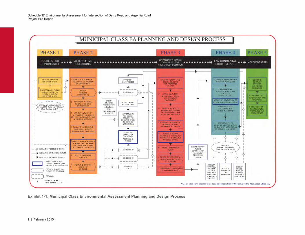
1.2 Class EA Process The Environmental Assessment Act of Ontario (EAA) provides for the protection, conservation, and management of the environment in Ontario. The EAA applies to municipalities and to activities including municipal road projects. Activities with common characteristics and common potential effects may be assessed as part of a “class”, and are therefore approved subject to compliance with the pre-approved Class EA process.
The Municipal Class EA is an approved Class EA process that applies to municipal infrastructure projects including roads, water, and wastewater. This process provides a comprehensive planning approach to consider several alternative solutions and evaluate their impact on a set of criteria (e.g. technical, environmental, social, cost) and determine any mitigating measures to arrive at a preferred alternative for addressing the problem (or opportunity). The process involves consultation of technical agencies and the general public at the various project stages.
This EA was undertaken and prepared in accordance with the guidelines of the Municipal Engineers Association Municipal Class Environmental Assessment (October 2000, as amended in 2007 and 2011). The EA was conducted in compliance with a Schedule “B” project. Schedule “B” projects generally involve minor modifications to existing facilities, such as increasing the depth of a municipal well, retiring a water pollution control plant, or constructing a minor expansion to a road. A Schedule ‘B’ project requires completion of Phases 1 & 2 of the Class EA process as illustrated in Exhibit 1-1. For this project, Phases 1 through 4 have been completed
After the PFR is finalized, it is filed and placed on public record for a minimum of 30 calendar days for review by the public and review agencies. At the time the report is filed, a Notice of Completion of the Project File Report will be advertised, to advise the public and other stakeholders where the Project File Report may be seen and reviewed, and how to submit public comments. The Notice will also advise the public and other stakeholders of their right to request a Part II Order, and how and when such a request must be submitted.
Under the Environmental Assessment Act, members of the public, interest groups, agencies, and other stakeholders may submit a written request to the Minister of the Environment to require the proponent (Peel Region) to comply with Part II of the Environmental Assessment Act (referred to as a Part II Order) before proceeding with the proposed undertaking. Part II of the Act addresses Individual Environmental Assessments.
The request for a Part II Order must also be copied to the proponent at the same time it is submitted to the Minister. Written requests for a Part II Order must be submitted to the Minister within the minimum 30 calendar day review period. The Minister or delegate then reviews the Environmental Assessment Report to ensure that the Class EA process has been followed. The proponent and the requestor have an opportunity to discuss and resolve the issues. Once the proponent has satisfied the requestor’s concerns a requestor should promptly withdraw a Part II Order request.
Schedule ‘B’ Environmental Assessment for Intersection of Derry Road and Argentia Road Project File Report
2 | February 2015
Exhibit 1-1: Municipal Class Environmental Assessment Planning and Design Process
Schedule ‘B’ Environmental Assessment for Intersection of Derry Road and Argentia Road Project File Report
February 2015 | 3
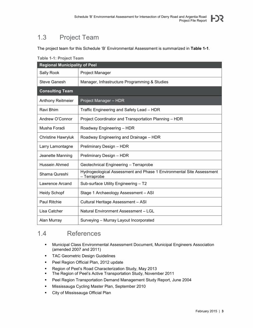
1.3 Project Team The project team for this Schedule ‘B’ Environmental Assessment is summarized in Table 1-1.
Table 1-1: Project Team Regional Municipality of Peel
Sally Rook Project Manager
Steve Ganesh Manager, Infrastructure Programming & Studies
Consulting Team
Anthony Reitmeier Project Manager – HDR
Ravi Bhim Traffic Engineering and Safety Lead – HDR
Andrew O’Connor Project Coordinator and Transportation Planning – HDR
Musha Foradi Roadway Engineering – HDR
Christine Hawryluk Roadway Engineering and Drainage – HDR
Larry Lamontagne Preliminary Design – HDR
Jeanette Manning Preliminary Design – HDR
Hussein Ahmed Geotechnical Engineering – Terraprobe
Shama Qureshi Hydrogeological Assessment and Phase 1 Environmental Site Assessment – Terraprobe
Lawrence Arcand Sub-surface Utility Engineering – T2
Heidy Schopf Stage 1 Archaeology Assessment – ASI
Paul Ritchie Cultural Heritage Assessment – ASI
Lisa Catcher Natural Environment Assessment – LGL
Alan Murray Surveying – Murray Layout Incorporated
1.4 References Municipal Class Environmental Assessment Document, Municipal Engineers Association
(amended 2007 and 2011) TAC Geometric Design Guidelines Peel Region Official Plan, 2012 update Region of Peel’s Road Characterization Study, May 2013 The Region of Peel’s Active Transportation Study, November 2011 Peel Region Transportation Demand Management Study Report, June 2004 Mississauga Cycling Master Plan, September 2010 City of Mississauga Official Plan
Schedule ‘B’ Environmental Assessment for Intersection of Derry Road and Argentia Road Project File Report
4 | February 2015
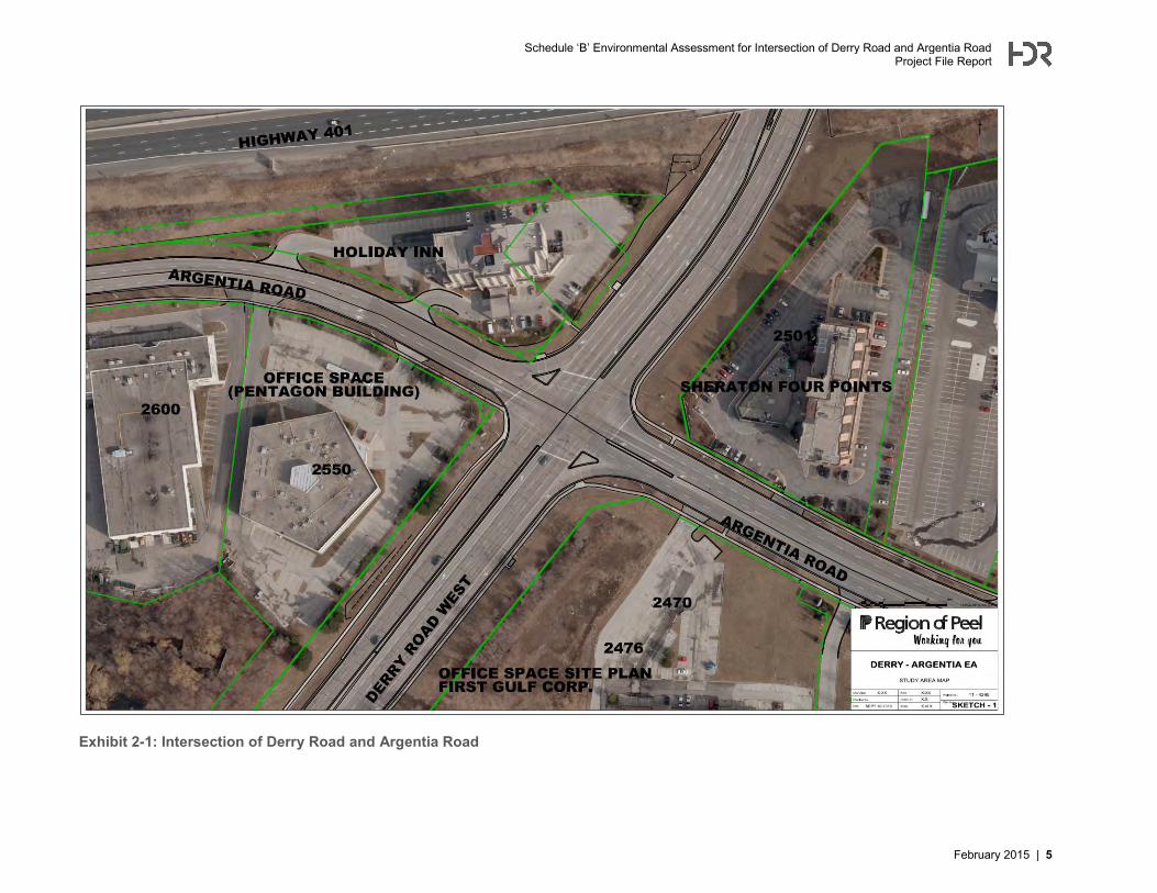
2 Existing Conditions 2.1 Study Area Profile The study intersection of Derry Road and Argentia Road and the surrounding study area is located in the southwest quadrant of the Region of Peel, in the City of Mississauga. The study intersection is illustrated in Exhibit 2-1. For the purposes of this study, Derry Road is considered to run east-west and Argentia Road is considered to run north-south. The intersection is located in north Mississauga, south of Highway 401 and north of the Milton GO Train rail corridor. Derry Road is a regional arterial road that runs continuously across Mississauga from Halton Region in the west to the City of Toronto in the east. Derry Road also passes through Pearson Airport. Argentia Road is a Major Collector that begins at Creditview Road in the east and terminates at 10th Line Road in the west at the entrance to the Lisgar GO Station parking lot. Based on the City of Mississauga Official Plan, the study area falls within the “Meadowvale Business Park Corporate Centre”. The land use designation for the four corners of the intersection of Derry Road and Argentia Road is “Business Employment.” The following properties are located within the vicinity of the intersection:
A Four Points Sheraton hotel and a Bank of Montreal (BMO) office building are on the southeast corner of the intersection.
First Gulf has initiated construction of a new office building in the southwest corner with an approximate Gross Floor Area (GFA) of 11,430 square metres. The development plan proposes shifting the existing driveway 30 metres south, so that it would be 80 metres to the south of the study intersection.
A Holiday Inn Express is located in the northeast corner of the intersection A low-rise office building named the “Pentagon Building” is located in the northwest corner of
the intersection The Meadowvale GO Train station and parking lot is located further to the southwest of the
intersection. There is an access to one of the parking lots for this station on Argentia Road, south of the study intersection. The rail tracks cross Derry Road on an overpass structure to the west of the intersection.
There are no direct easterly or westerly accesses to or from Derry Road, and therefore there are no specific businesses until Millcreek Drive or Syntex Drive. Approximately 300 metres west of the intersection is a rail bridge overpass, and approximately 160 metres east of the intersection is the Highway 401 overpass.
Schedule ‘B’ Environmental Assessment for Intersection of Derry Road and Argentia Road Project File Report
February 2015 | 5
Exhibit 2-1: Intersection of Derry Road and Argentia Road
Schedule ‘B’ Environmental Assessment for Intersection of Derry Road and Argentia Road Project File Report
6 | February 2015
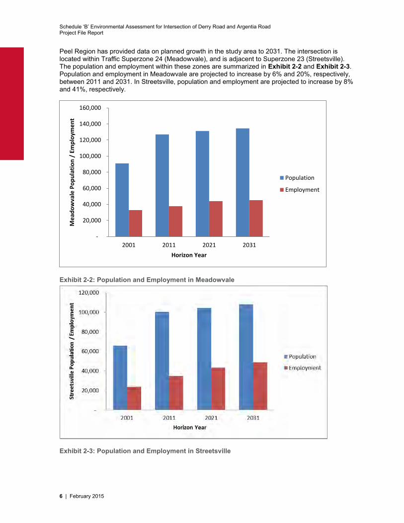
Peel Region has provided data on planned growth in the study area to 2031. The intersection is located within Traffic Superzone 24 (Meadowvale), and is adjacent to Superzone 23 (Streetsville). The population and employment within these zones are summarized in Exhibit 2-2 and Exhibit 2-3. Population and employment in Meadowvale are projected to increase by 6% and 20%, respectively, between 2011 and 2031. In Streetsville, population and employment are projected to increase by 8% and 41%, respectively.
Exhibit 2-2: Population and Employment in Meadowvale
Exhibit 2-3: Population and Employment in Streetsville
-
20,000
40,000
60,000
80,000
100,000
120,000
140,000
160,000
2001 2011 2021 2031
Me
ado
wva
le P
op
ula
tio
n /
Em
plo
yme
nt
Horizon Year
Population
Employment
Schedule ‘B’ Environmental Assessment for Intersection of Derry Road and Argentia Road Project File Report
February 2015 | 7
2.2 Transportation The existing intersection of Derry Road and Argentia Road is multi-modal, serving pedestrians, cyclists, transit users, automobiles and trucks. A full description of existing conditions, existing operations and projected future operations is provided in Appendix B.
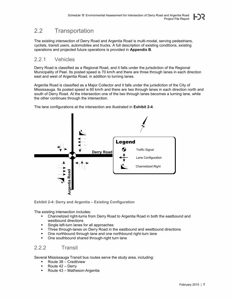
2.2.1 Vehicles Derry Road is classified as a Regional Road, and it falls under the jurisdiction of the Regional Municipality of Peel. Its posted speed is 70 km/h and there are three through lanes in each direction east and west of Argentia Road, in addition to turning lanes. Argentia Road is classified as a Major Collector and it falls under the jurisdiction of the City of Mississauga. Its posted speed is 60 km/h and there are two through lanes in each direction north and south of Derry Road. At the intersection one of the two through lanes becomes a turning lane, while the other continues through the intersection. The lane configurations at the intersection are illustrated in Exhibit 2-4.
Exhibit 2-4: Derry and Argentia – Existing Configuration The existing intersection includes:
Channelized right-turns from Derry Road to Argentia Road in both the eastbound and westbound directions
Single left-turn lanes for all approaches Three through-lanes on Derry Road in the eastbound and westbound directions One northbound through lane and one northbound right-turn lane One southbound shared through-right turn lane
2.2.2 Transit
Several Mississauga Transit bus routes serve the study area, including: Route 38 – Creditview Route 42 – Derry Route 43 – Matheson-Argentia
Schedule ‘B’ Environmental Assessment for Intersection of Derry Road and Argentia Road Project File Report
8 | February 2015
Route 57 – Courtneypark Route 108 – Meadowvale Business Express
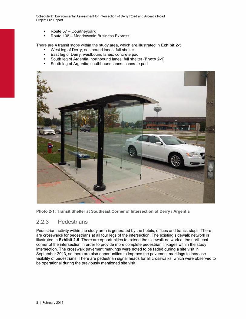
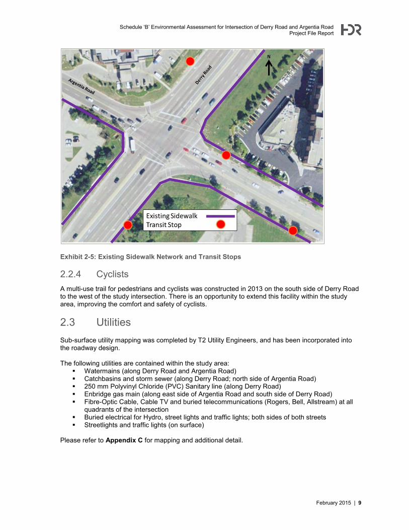
There are 4 transit stops within the study area, which are illustrated in Exhibit 2-5.
West leg of Derry, eastbound lanes: full shelter East leg of Derry, westbound lanes: concrete pad South leg of Argentia, northbound lanes: full shelter (Photo 2-1) South leg of Argentia, southbound lanes: concrete pad
Photo 2-1: Transit Shelter at Southeast Corner of Intersection of Derry / Argentia
2.2.3 Pedestrians Pedestrian activity within the study area is generated by the hotels, offices and transit stops. There are crosswalks for pedestrians at all four legs of the intersection. The existing sidewalk network is illustrated in Exhibit 2-5. There are opportunities to extend the sidewalk network at the northeast corner of the intersection in order to provide more complete pedestrian linkages within the study intersection. The crosswalk pavement markings were noted to be faded during a site visit in September 2013, so there are also opportunities to improve the pavement markings to increase visibility of pedestrians. There are pedestrian signal heads for all crosswalks, which were observed to be operational during the previously mentioned site visit.
Schedule ‘B’ Environmental Assessment for Intersection of Derry Road and Argentia Road Project File Report
February 2015 | 9
Exhibit 2-5: Existing Sidewalk Network and Transit Stops
2.2.4 Cyclists A multi-use trail for pedestrians and cyclists was constructed in 2013 on the south side of Derry Road to the west of the study intersection. There is an opportunity to extend this facility within the study area, improving the comfort and safety of cyclists.
2.3 Utilities Sub-surface utility mapping was completed by T2 Utility Engineers, and has been incorporated into the roadway design. The following utilities are contained within the study area:
Watermains (along Derry Road and Argentia Road) Catchbasins and storm sewer (along Derry Road; north side of Argentia Road) 250 mm Polyvinyl Chloride (PVC) Sanitary line (along Derry Road) Enbridge gas main (along east side of Argentia Road and south side of Derry Road) Fibre-Optic Cable, Cable TV and buried telecommunications (Rogers, Bell, Allstream) at all
quadrants of the intersection Buried electrical for Hydro, street lights and traffic lights; both sides of both streets Streetlights and traffic lights (on surface)
Please refer to Appendix C for mapping and additional detail.
Schedule ‘B’ Environmental Assessment for Intersection of Derry Road and Argentia Road Project File Report
10 | February 2015
2.4 Natural Environment Assessment A Natural Heritage Assessment has been completed by LGL for this study and the report is included as Appendix D. The study area occurs within the Mullet Creek subwatershed of the Credit River watershed. Mullet Creek and its associated regulated areas are managed under the jurisdiction of Credit Valley Conservation (CVC) and the Ontario Ministry of Natural Resources (MNR) Aurora District.
2.4.1 Watercourses There are two tributaries of Mullet Creek within the study area. Tributary 1 of Mullet Creek occurs just north of Highway 401 and flows across Derry Road in a general west to east direction. A headwall occurring approximately 10 metres east of Derry Road functions as a complete barrier to fish movement; Tributary 1 of Mullet Creek can be classified as indirect warmwater fish habitat. Tributary 2 of Mullet Creek flows across Derry Road in a general west to east direction to the south of the study intersection. Water enters a concrete inlet structure to the west of Derry Road, and flow is piped for approximately 700 metres before discharging into the main tributary of Mullet Creek. The pipe functions as a complete barrier to fish movement. The watercourse within the vicinity of the study area should be classified as indirect fish habitat as it provides flow and likely thermal relief to downstream fish communities. Based upon a review of the MNR Natural Heritage Information Centre – Biodiversity Explorer on-line database, CVC, MNR and Department of Fisheries Ontario (DFO) Species at Risk mapping and correspondence with CVC, no aquatic species at risk occur in Mullet Creek within the vicinity of the study area.
2.4.2 Vegetation The vegetation communities directly adjacent to the four corners of the intersection are classified as manicured grasses and planted shrubs and/or trees. Further to the west along Derry Road, there is a “Mineral Cultural Thicket” on the south side of Derry Road and a “Dry-Moist Old Field Meadow” and “Fresh-Moist Ash Lowland Deciduous Forest/Mineral Shallow Marsh” on the north side of Derry Road. The Mississauga Natural Areas Survey (2011) included the woodlot on the west side of Derry Road, and noted that it is a “mature forest with a closed canopy approximately 26 metres in height”. No plant species that are regulated under the Ontario Endangered Species Act or the Canadian Species at Risk Act were encountered during LGL’s botanical investigation (conducted September 16th, 2013) within the study area.
2.4.3 Wildlife Given the land uses within the study area (primarily commercial development and roadways), natural heritage features were generally contained within several areas while the remainder of the study area consisted of developed lands or scattered ornamental trees and manicured grassland. No significant wildlife movement or passage corridors were identified within the study area; the study area supports a low diversity of wildlife species, and wildlife species identified within the study area are generally considered urbanized or tolerant of anthropogenic features and disturbance.
Schedule ‘B’ Environmental Assessment for Intersection of Derry Road and Argentia Road Project File Report
February 2015 | 11
Within the study area the following is noted: Of the 14 wildlife species recorded within the study area (based on field observations and a
review of habitat types present), none are regulated under the Ontario Endangered Species Act, 2007 or the federal Species at Risk Act (SARA).
A single bird species documented within the study area, the Killdeer, is considered to be of ‘conservation concern’ by the Credit Valley Conservation Authority, although its population is secure across the province.
Four species of bird are protected under the Migratory Birds Convention Act (MBCA) Two species of mammal and one bird species identified within the study area are offered
protection under the Fish and Wildlife Conservation Act (FWCA).
2.4.4 Designated Areas A review of the Region of Peel Official Plan (2012) and the City of Mississauga Official Plan (2010) indicates that there are no Provincially Significant Wetlands (PSWs), Areas of Natural and Scientific Interest (ANSIs) or Environmentally Sensitive Areas (ESAs) located within 120 metres of the study area.
2.5 Structure Analysis and Inspection Report An Ontario Structure Inspection Manual (OSIM) inspection report was completed for CN’s rail bridge that crosses over Derry Road to the west of the study area intersection. The inspection report was completed on November 1, 2011, by EMS on behalf of the Region of Peel. It states the following:
Deck: “In total, an estimated 5% exhibits hairline shrinkage cracking although no rehabilitative action is required.”
Sidewalk: “In total, an estimated 5% exhibits severe surface deterioration and requires repair.”
North abutment: “In total, an estimated 6% exhibits hairline shrinkage cracking although no rehabilitative action is required.”
Railing: “In total, an estimated 5% exhibits severe collision damage although no rehabilitative action is required.”
Other bridge elements: “No significant defects were noted.” The EMS report concluded that:
“Overall the structure is in excellent condition with an aggregate condition index of 99.8. The major concerns at this site are the south sidewalk showing isolated severe deterioration and aluminum barrier showing collision damage.”
Inspections should be conducted every 2 years. No changes or modifications are proposed to either the CN rail bridge overpass or the Highway 401 overpass (to the east of the study intersection) as part of this Class Environmental Assessment study.
2.6 Soil Contamination A Phase One Environmental Site Assessment (ESA) has been undertaken by Terraprobe for this study and is included as Appendix E. The identified Potentially Contaminating Activities (PCAs) within the study area (referred to as “Property”) included the following:
1. Suspected fill material placed in utility trenches and underneath the pavement structures at the Property (study area) during construction of the roadways;
2. Use of road salts for de-icing purposes in winter
Schedule ‘B’ Environmental Assessment for Intersection of Derry Road and Argentia Road Project File Report
12 | February 2015
Due to use of the Property as public roadways, the PCAs at the Property do not represent a significant environmental concern. Therefore, there are no areas of potential environmental concern identified at the Property or lands immediately adjacent. A soil quality assessment was also undertaken as part of the geotechnical study making use of the data collected from the boreholes.
2.7 Hydrogeological Investigation Report A hydrogeological study has been undertaken by Terraprobe for this study and is included as Appendix F. The study was undertaken to assess geologic and hydrogeologic conditions at the site and to provide detailed information regarding the hydrogeologic impact of the proposed improvements on the local groundwater function. Some of the key study findings include:
Any potential impact to groundwater from construction of the proposed development will be limited in extent
There is no use of groundwater and no private water wells are located in the area; therefore, no well monitoring program or mitigation measures are required
Low permeability native soils encountered at the site will not tend to have free flowing ground water.
Permit to take water (PTTW) is not expected to be required
2.8 Cultural Heritage Assessment Report A Cultural Heritage Assessment Report has been undertaken by ASI for this study and the report has been included as Appendix G. The study area has a rural land use history dating back to the early nineteenth century. Two cultural heritage landscapes were identified within the study area:
The CN Rail corridor has been identified as a “Railscape” The Mullet Creek tributary (located to the northwest of the study intersection) has been
identified as a “Waterscape” Road improvement activities should be suitably planned to avoid impacts to identified cultural heritage resources.
2.9 Stage 1 Archaeological Assessment A Stage 1 Archaeological Assessment has been undertaken by Archaeological Services Inc. (ASI) for this study and is included as Appendix H. The study found that:
The majority of the Derry Road and Argentia Road study area does not retain archaeological potential due to deep and extensive land disturbance. These areas do not require further archaeological assessment
One small section of the study area at the southwest corner of the intersection possesses archaeological potential and requires a Stage 2 archaeological assessment prior to any land disturbance
The preliminary design will not result in the need for any additional archaeological assessment beyond the Stage 1 assessment that was completed, as there will be no disturbance to the land that possesses archaeological potential
2.10 Planning Context
2.10.1 Peel Region Official Plan, 2012 Update According to the Region of Peel’s Official Plan, the study area is part of the Region’s “Urban” system. It is also located within a “settlement area outside the Greenbelt” and a “Built-Up Area”. Derry Road is classified as a “Major Road” with a 45 metre Right-of-Way (ROW).
Schedule ‘B’ Environmental Assessment for Intersection of Derry Road and Argentia Road Project File Report
February 2015 | 13
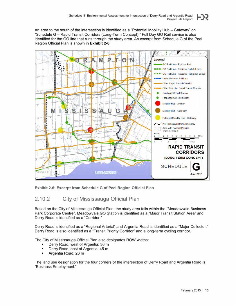
An area to the south of the intersection is identified as a “Potential Mobility Hub – Gateway” on “Schedule G – Rapid Transit Corridors (Long-Term Concept).” Full Day GO Rail service is also identified for the GO line that runs through the study area. An excerpt from Schedule G of the Peel Region Official Plan is shown in Exhibit 2-6.
Exhibit 2-6: Excerpt from Schedule G of Peel Region Official Plan 2.10.2 City of Mississauga Official Plan
Based on the City of Mississauga Official Plan, the study area falls within the “Meadowvale Business Park Corporate Centre”. Meadowvale GO Station is identified as a “Major Transit Station Area” and Derry Road is identified as a “Corridor.” Derry Road is identified as a “Regional Arterial” and Argentia Road is identified as a “Major Collector.” Derry Road is also identified as a “Transit Priority Corridor” and a long-term cycling corridor. The City of Mississauga Official Plan also designates ROW widths:
Derry Road, west of Argentia: 36 m Derry Road, east of Argentia: 45 m Argentia Road: 26 m
The land use designation for the four corners of the intersection of Derry Road and Argentia Road is “Business Employment.”
Schedule ‘B’ Environmental Assessment for Intersection of Derry Road and Argentia Road Project File Report
14 | February 2015
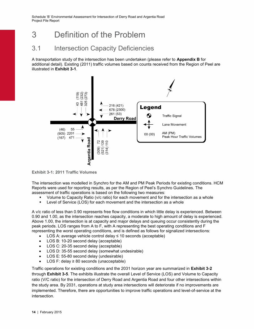
3 Definition of the Problem 3.1 Intersection Capacity Deficiencies A transportation study of the intersection has been undertaken (please refer to Appendix B for additional detail). Existing (2011) traffic volumes based on counts received from the Region of Peel are illustrated in Exhibit 3-1.
Exhibit 3-1: 2011 Traffic Volumes The intersection was modelled in Synchro for the AM and PM Peak Periods for existing conditions. HCM Reports were used for reporting results, as per the Region of Peel’s Synchro Guidelines. The assessment of traffic operations is based on the following two measures:
Volume to Capacity Ratio (v/c ratio) for each movement and for the intersection as a whole Level of Service (LOS) for each movement and the intersection as a whole
A v/c ratio of less than 0.90 represents free flow conditions in which little delay is experienced. Between 0.90 and 1.00, as the intersection reaches capacity, a moderate to high amount of delay is experienced. Above 1.00, the intersection is at capacity and major delays and queuing occur consistently during the peak periods. LOS ranges from A to F, with A representing the best operating conditions and F representing the worst operating conditions, and is defined as follows for signalized intersections:
LOS A: average vehicle control delay ≤ 10 seconds (acceptable) LOS B: 10-20 second delay (acceptable) LOS C: 20-35 second delay (acceptable) LOS D: 35-55 second delay (somewhat undesirable) LOS E: 55-80 second delay (undesirable) LOS F: delay ≥ 80 seconds (unacceptable)
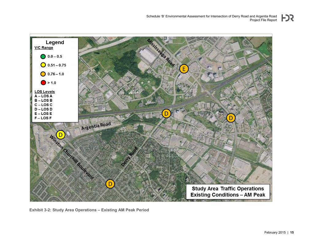
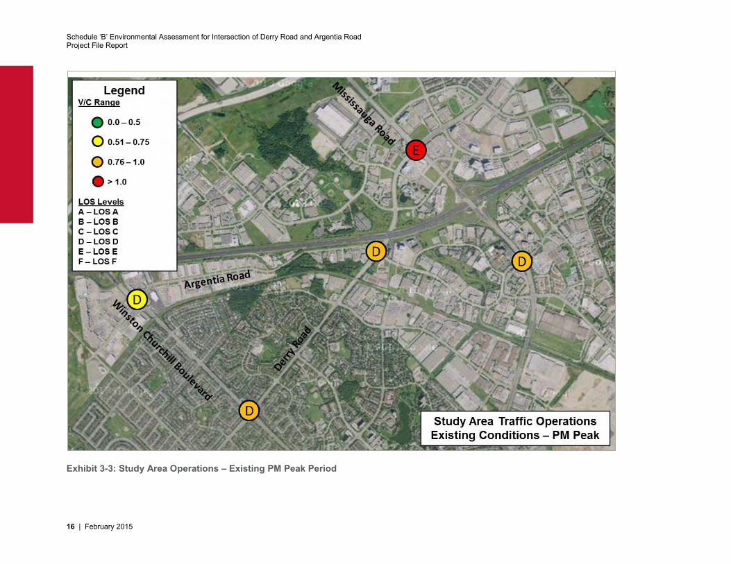
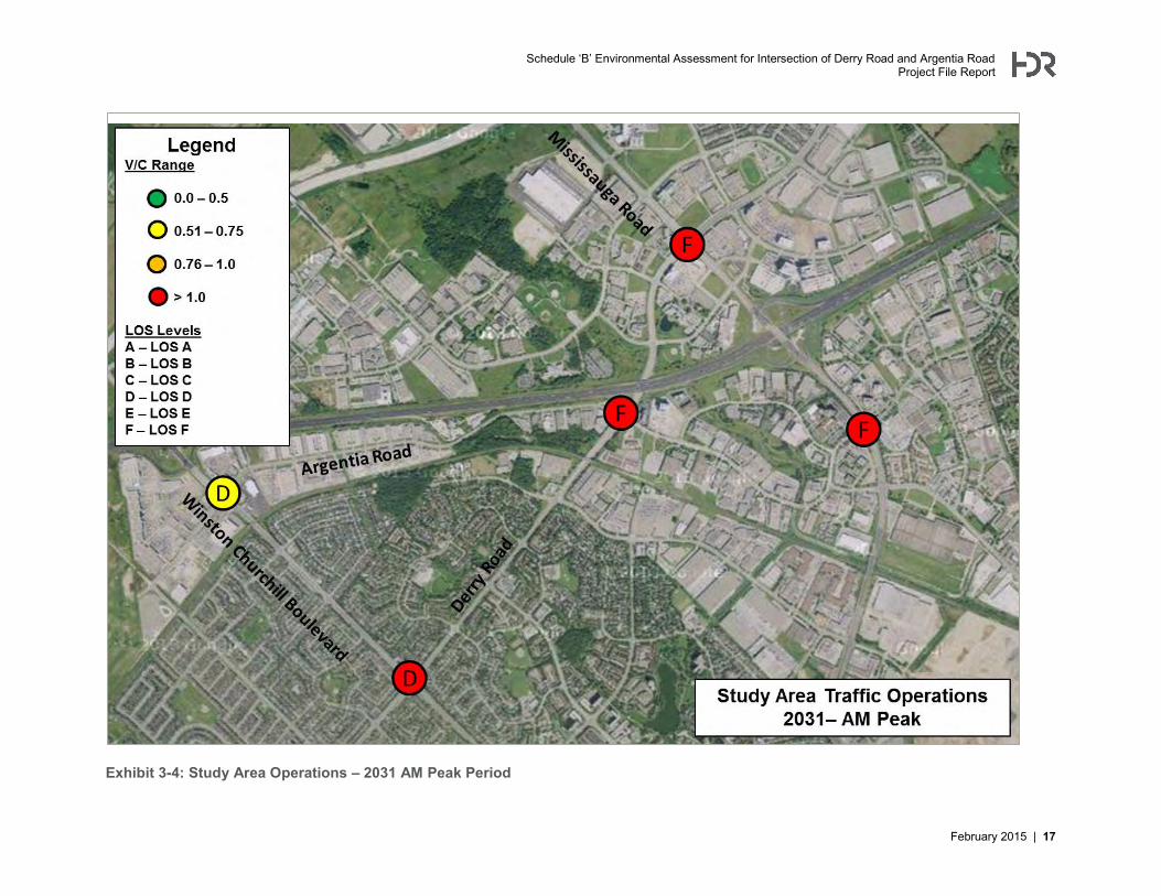
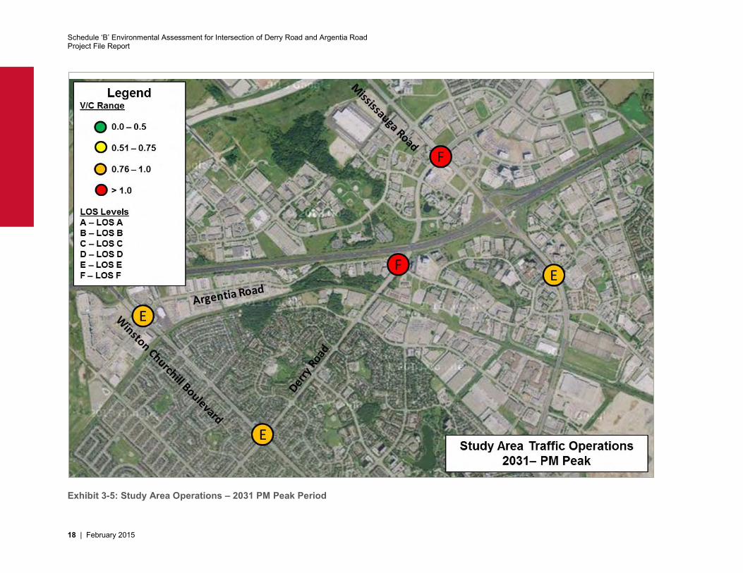
Traffic operations for existing conditions and the 2031 horizon year are summarized in Exhibit 3-2 through Exhibit 3-5. The exhibits illustrate the overall Level of Service (LOS) and Volume to Capacity ratio (V/C ratio) for the intersection of Derry Road and Argentia Road and four other intersections within the study area. By 2031, operations at study area intersections will deteriorate if no improvements are implemented. Therefore, there are opportunities to improve traffic operations and level-of-service at the intersection.
Schedule ‘B’ Environmental Assessment for Intersection of Derry Road and Argentia Road Project File Report
February 2015 | 15
Exhibit 3-2: Study Area Operations – Existing AM Peak Period
Schedule ‘B’ Environmental Assessment for Intersection of Derry Road and Argentia Road Project File Report
16 | February 2015
Exhibit 3-3: Study Area Operations – Existing PM Peak Period
Schedule ‘B’ Environmental Assessment for Intersection of Derry Road and Argentia Road Project File Report
February 2015 | 17
Exhibit 3-4: Study Area Operations – 2031 AM Peak Period
Schedule ‘B’ Environmental Assessment for Intersection of Derry Road and Argentia Road Project File Report
18 | February 2015
Exhibit 3-5: Study Area Operations – 2031 PM Peak Period
Schedule ‘B’ Environmental Assessment for Intersection of Derry Road and Argentia Road Project File Report
February 2015 | 19
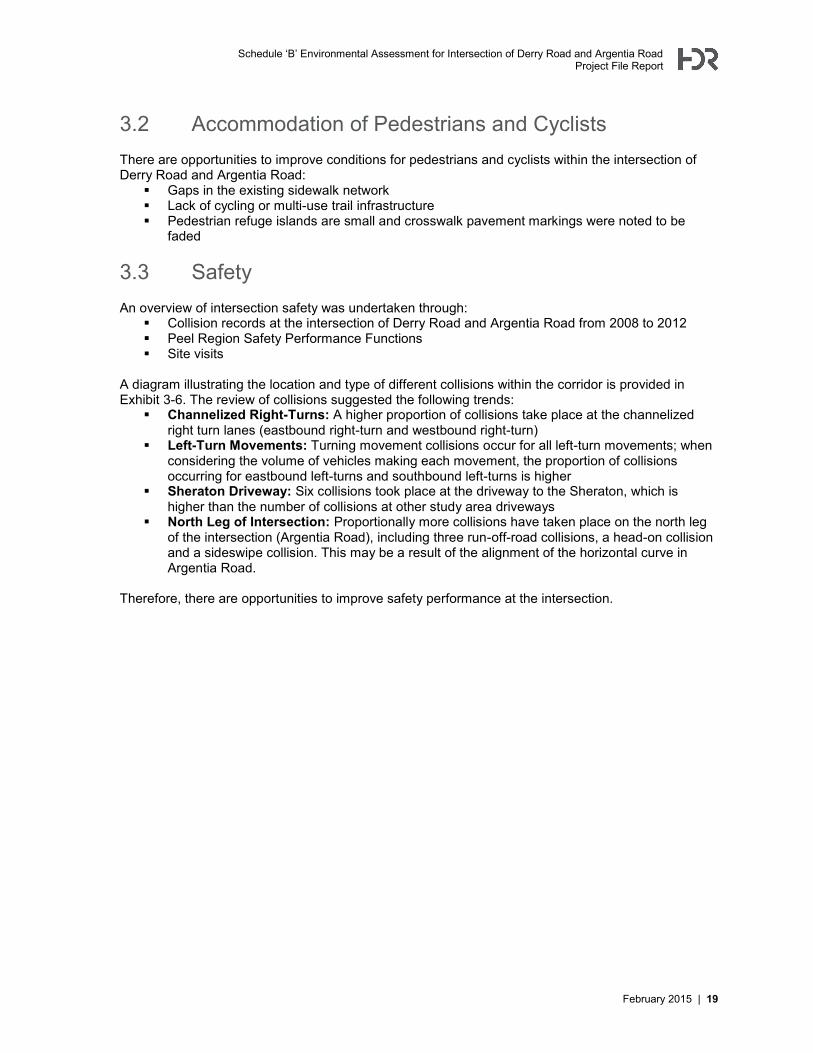
3.2 Accommodation of Pedestrians and Cyclists There are opportunities to improve conditions for pedestrians and cyclists within the intersection of Derry Road and Argentia Road:
Gaps in the existing sidewalk network Lack of cycling or multi-use trail infrastructure Pedestrian refuge islands are small and crosswalk pavement markings were noted to be
faded
3.3 Safety An overview of intersection safety was undertaken through:
Collision records at the intersection of Derry Road and Argentia Road from 2008 to 2012 Peel Region Safety Performance Functions Site visits
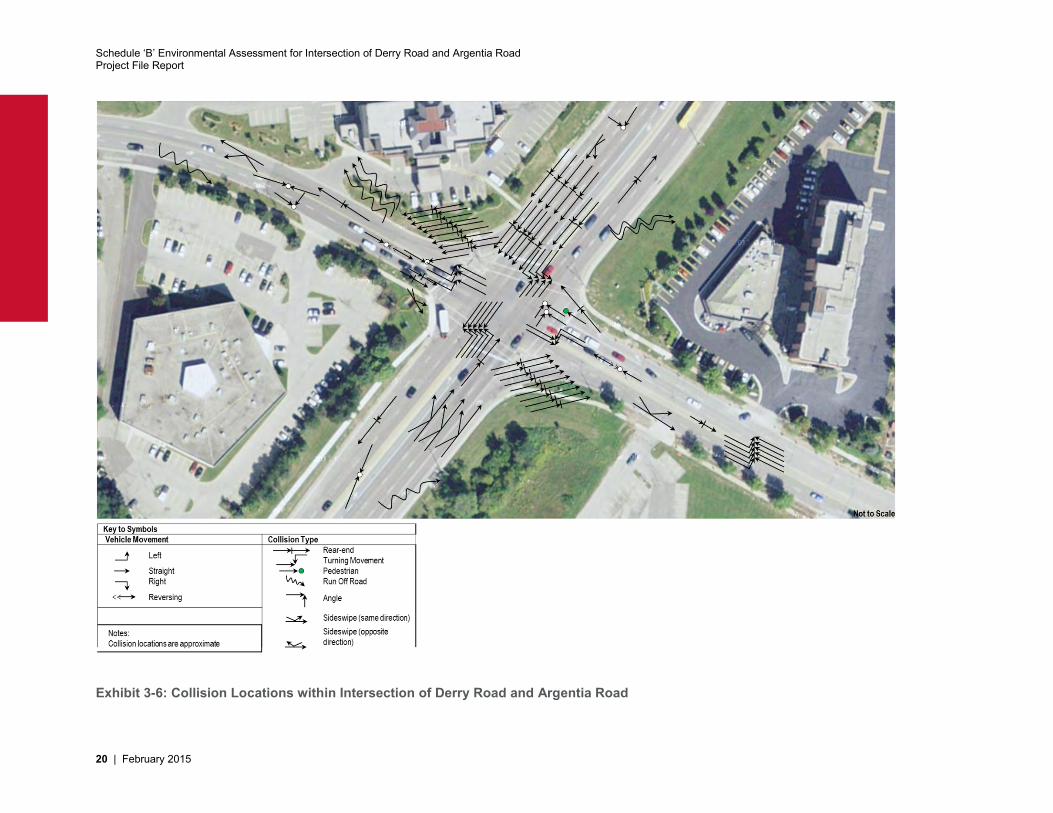
A diagram illustrating the location and type of different collisions within the corridor is provided in Exhibit 3-6. The review of collisions suggested the following trends:
Channelized Right-Turns: A higher proportion of collisions take place at the channelized right turn lanes (eastbound right-turn and westbound right-turn)
Left-Turn Movements: Turning movement collisions occur for all left-turn movements; when considering the volume of vehicles making each movement, the proportion of collisions occurring for eastbound left-turns and southbound left-turns is higher
Sheraton Driveway: Six collisions took place at the driveway to the Sheraton, which is higher than the number of collisions at other study area driveways
North Leg of Intersection: Proportionally more collisions have taken place on the north leg of the intersection (Argentia Road), including three run-off-road collisions, a head-on collision and a sideswipe collision. This may be a result of the alignment of the horizontal curve in Argentia Road.
Therefore, there are opportunities to improve safety performance at the intersection.
Schedule ‘B’ Environmental Assessment for Intersection of Derry Road and Argentia Road Project File Report
20 | February 2015
Exhibit 3-6: Collision Locations within Intersection of Derry Road and Argentia Road
Schedule ‘B’ Environmental Assessment for Intersection of Derry Road and Argentia Road Project File Report
February 2015 | 21
3.4 Problem and Opportunity Statement Based upon the findings of the transportation study, without any improvements congestion at the intersection will deteriorate. There are also opportunities to improve the environment for pedestrians and cyclists and improve safety performance. Improvements are necessary to accommodate existing and long-term travel demands which are projected to exceed the current capacity of the intersection of Derry Road and Argentia Road. At the same time, improvements should minimize impacts to existing features at the intersection and improve safety performance. In particular the study will focus on addressing the following problems and opportunities:
Supporting the movement of people and goods through the intersection by facilitating more efficient vehicle movement (automobiles, transit vehicles, trucks)
Improving safety for all corridor users Protecting vulnerable road users Improving facilities for pedestrians and cyclists Improving access to transit service Supporting economic growth and planned development within the study area Preserving and enhancing existing natural and cultural features
Schedule ‘B’ Environmental Assessment for Intersection of Derry Road and Argentia Road Project File Report
22 | February 2015
4 Alternative Solutions 4.1 Development of Alternative Solutions As documented in Section 0 and in the Problem and Opportunity Statement, the assessment of existing conditions determined that there is a need for improvements at the intersection of Derry Road and Argentia Road. Five alternative solutions have been generated to address the problem and opportunity statement and are described in the following sections. Other than the “Do Nothing” option, the alternative solutions are not mutually exclusive and can be implemented in conjunction with other alternatives.
4.1.1 Alternative 1: Do Nothing “Do Nothing” is the baseline approach, in which no improvements are made to the study area intersection.
4.1.2 Alternative 2: Travel Demand Management Travel Demand Management (TDM) is a set of policies to improve the management of travel demand. The purpose of TDM measures is to reduce vehicular demand for the roadway and use existing infrastructure more efficiently. TDM measures that could be implemented within the study area include:
Encouraging active transportation modes, such as walking and cycling, by improving the facilities and environment for pedestrians and cyclists (i.e. bike trails, improved pedestrian connections, multi-use trails, urban design improvements)
Encouraging transit use by improving transit service (i.e. increased frequency, bus lanes, Bus Rapid Transit, subsidized transit fares, park and ride lots at major transit stops)
Methods to increase vehicle occupancy, such as carpooling and a network of HOV lanes Employer support / subsidization of carpooling, transit use, or walking or cycling to work Parking cash-out: employers can offer employees the cash equivalent of the cost of providing
a parking space for them to encourage them to shift to a different mode Employer support for tele-commuting (i.e. working from home) to reduce the need for
physical travel Alternative Work Schedules / Flexible Work Hours to allow commuters to travel before or
after the peak periods Parking fees or congestion pricing / road tolls to shift demand away from the congested peak
periods Fuel taxes to discourage vehicle travel
These measures will reduce demand for single-occupant vehicle travel.
4.1.3 Alternative 3: Signal Timing Improvements Signal timings can be optimized at the intersection to minimize delays and increase the capacity of the intersection. Signal timing improvements require no physical infrastructure works (i.e. roadway widening).
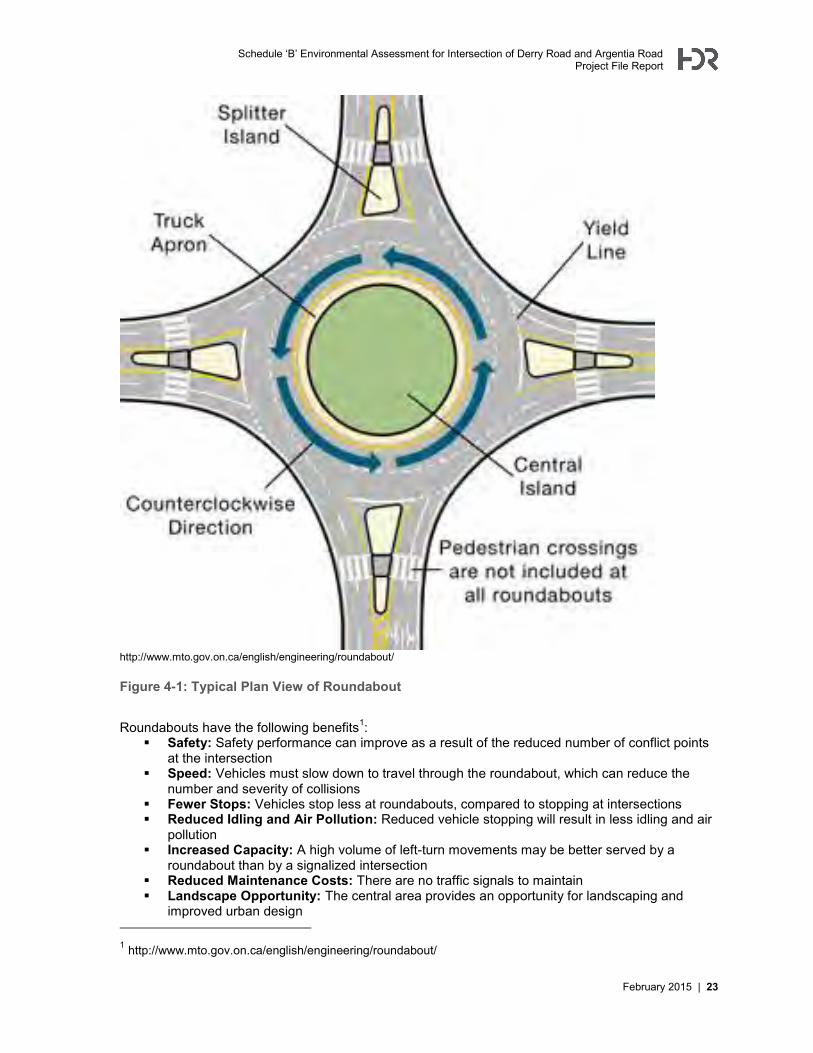
4.1.4 Alternative 4: Roundabout A roundabout is a circular intersection at which traffic flows around a centre island in a counter-clockwise direction (see illustration in Figure 4-1). Vehicles yield to oncoming traffic before entering the intersection and drive around the central island until arriving at the desired exit lane.
Schedule ‘B’ Environmental Assessment for Intersection of Derry Road and Argentia Road Project File Report
February 2015 | 23
http://www.mto.gov.on.ca/english/engineering/roundabout/
Figure 4-1: Typical Plan View of Roundabout
Roundabouts have the following benefits1:
Safety: Safety performance can improve as a result of the reduced number of conflict points at the intersection
Speed: Vehicles must slow down to travel through the roundabout, which can reduce the number and severity of collisions
Fewer Stops: Vehicles stop less at roundabouts, compared to stopping at intersections Reduced Idling and Air Pollution: Reduced vehicle stopping will result in less idling and air
pollution Increased Capacity: A high volume of left-turn movements may be better served by a
roundabout than by a signalized intersection Reduced Maintenance Costs: There are no traffic signals to maintain Landscape Opportunity: The central area provides an opportunity for landscaping and
improved urban design 1 http://www.mto.gov.on.ca/english/engineering/roundabout/
Schedule ‘B’ Environmental Assessment for Intersection of Derry Road and Argentia Road Project File Report
24 | February 2015
However, a roundabout is not the optimal solution for every intersection. Roundabouts are more suitable at intersections with2:
A high number of head-on, right angle and left turn across path collisions High collision severity due to excessive speed Heavy delay on minor street High left-turning volumes, especially with single lane approaches
Roundabouts are less suitable at intersections with3:
Insufficient Right-of-Way availability or utility constraints Insufficient vehicle gaps along the major street to allow vehicles from the minor street to enter
the roundabout; this can result in queuing along the minor street Co-ordinated signals within a co-ordinated signalized corridor; signalization may result in a
better level of service High pedestrian or cyclist volumes
Additionally, roundabouts with high vehicle volumes and multiple lanes of traffic are unfamiliar to drivers in Ontario
4.1.5 Alternative 5: Infrastructure Upgrades Infrastructure Upgrades refers to the widening or expansion of the intersection to increase its capacity for vehicle movement. Potential upgrades could include the following:
Installing dual left-turn lanes on the northbound, eastbound, southbound and/or westbound approach to the intersection
Widening Argentia Road to provide additional lanes on the northbound or southbound approach
Installing channelized Right-Turn lanes from Argentia Road to Derry Road Infrastructure upgrades result in additional capacity at the intersection, which reduces delays and queuing.
4.2 Evaluation Criteria The following evaluation criteria and associated performance measure were used to evaluate the five alternative solutions that have been developed for the corridor.
Evaluation Criteria Performance Measure
ENVIRONMENTAL SUSTAINABILITY
Protect Vegetation Impact to vegetation communities Impact to rare, threatened or endangered species
Protect Wildlife Impact to wildlife habitat Impact to rare, threatened or endangered species
Protect Aquatic Habitat Impact to aquatic habitat at culverts (i.e. length of extension) Impact to rare, threatened or endangered species
Protect Designated Natural Areas
Potential for encroachment to designated areas (Environmentally Sensitive Areas, Areas of Natural or Scientific Interest, Provincially Significant Wetlands)
2 “Roundabout Guidelines”, the City of Calgary, December 13, 2011, page 4,
http://www.calgary.ca/Transportation/TP/Documents/Safety/Roundabout-Guidelines.pdf?noredirect=1 3 “Roundabout Guidelines”, the City of Calgary, December 13, 2011, page 5,
http://www.calgary.ca/Transportation/TP/Documents/Safety/Roundabout-Guidelines.pdf?noredirect=1
Schedule ‘B’ Environmental Assessment for Intersection of Derry Road and Argentia Road Project File Report
February 2015 | 25
Evaluation Criteria Performance Measure
Protect Surface Water Change in quantity and quality stormwater runoff Protect Ground Water Minimize Impacts to Air Quality
Change in vehicle travel and/or congestion within the corridor
SOCIAL ENVIRONMENT
Minimize Impacts on Existing Residential Dwellings / Properties (including driveway impacts)
Potential for encroachment to residential properties
Minimize Impacts on Existing Institutional / Recreational Dwellings / Properties
Potential for encroachment to institutional / recreational properties
Minimize Traffic Noise Potential for increase in traffic noise Minimize Impacts to Archaeological, Cultural Heritage Features
Potential for disruption or disturbance to any archaeological or cultural heritage features
Improve Urban Design and Streetscaping
Opportunity to improve urban design and streetscaping
ECONOMIC ENVIRONMENT
Accommodate Planned Development and Growth
Support for planned and committed growth in the study corridor
Minimize Impacts on Business Properties
Potential for encroachment to businesses
Minimize Impacts to Access to Businesses
Driveway impacts Changes to access (i.e. full access converted to right-in/right-
out) Connectivity improvements to commercial areas
Minimize Impacts to Access to Key Employment Areas
Connectivity improvements to employment areas
TRANSPORTATION SERVICE
Minimize Traffic Congestion and Delays
Potential for improvement to intersection levels of service, travel times, and operational issues.
Improve Public Transit Service
Potential for improvement to the quality of service for transit users, considering delays caused by traffic congestion, impact on service reliability, transit travel speeds, travel times, pedestrian access to bus stops, and space for amenities / shelters at bus stops.
Create a Pedestrian-Friendly Environment
Potential for improvement to the environment for pedestrians considering availability of sidewalks, continuity of facilities, connectivity, sidewalk widths, overall pedestrian realm widths, crossing opportunities, safety, conflicts with other modes, attractiveness, and convenience
Create a Cyclist-Friendly Environment
Potential for improvement to the environment for cyclists considering availability of facilities (and whether they are separated from traffic), the design of existing cycling facilities, continuity of facilities, connectivity, safety, conflicts with driveways, attractiveness, and convenience
Schedule ‘B’ Environmental Assessment for Intersection of Derry Road and Argentia Road Project File Report
26 | February 2015
Evaluation Criteria Performance Measure
Improve Traffic Safety and Roadway Geometry
Potential for improvement to safety for all users – pedestrians, cyclists, transit, autos, trucks.
INFRASTRUCTURE DESIGN AND COST EFFECTIVENESS
Minimize Utility Relocation Potential for impact to utilities (number of hydro poles relocated, distance of gas main relocated, etc.)
Minimize Disruption due to Construction
Potential for construction impacts
Minimize Property Requirements
Need for property requirements
Minimize Capital Cost Cost assessment for each alternative Minimize Operating Costs Increased roadway works (i.e. more pavement and facilities)
are correlated to the Region’s operating costs
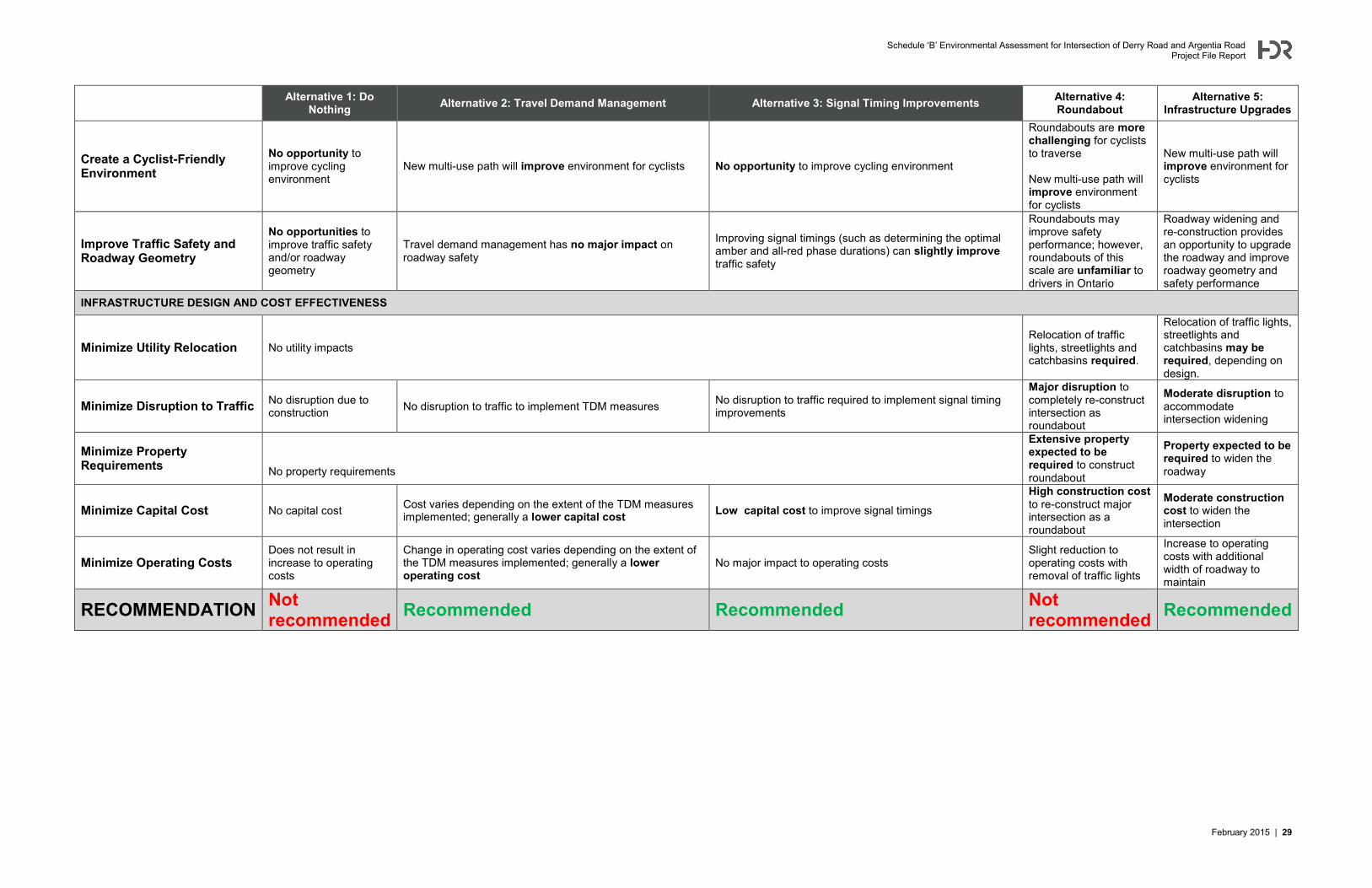
4.3 Evaluation of Alternative Solutions The evaluation of the five alternative solutions is shown in Table 4-1.
Schedule ‘B’ Environmental Assessment for Intersection of Derry Road and Argentia Road Project File Report
February 2015 | 27
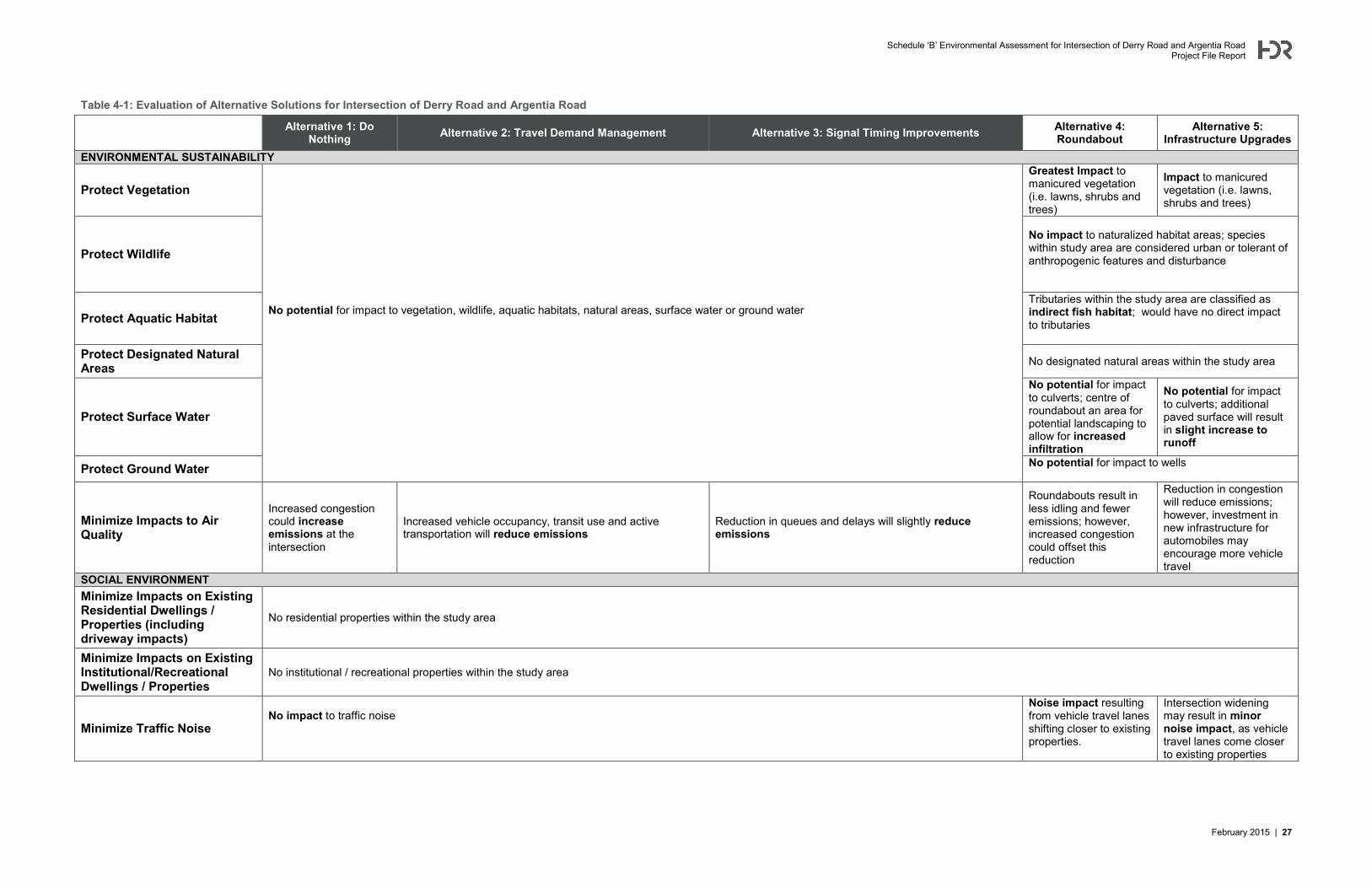
Table 4-1: Evaluation of Alternative Solutions for Intersection of Derry Road and Argentia Road
Alternative 1: Do Nothing Alternative 2: Travel Demand Management Alternative 3: Signal Timing Improvements Alternative 4:
Roundabout Alternative 5:
Infrastructure Upgrades ENVIRONMENTAL SUSTAINABILITY
Protect Vegetation
No potential for impact to vegetation, wildlife, aquatic habitats, natural areas, surface water or ground water
Greatest Impact to manicured vegetation (i.e. lawns, shrubs and trees)
Impact to manicured vegetation (i.e. lawns, shrubs and trees)
Protect Wildlife No impact to naturalized habitat areas; species within study area are considered urban or tolerant of anthropogenic features and disturbance
Protect Aquatic Habitat Tributaries within the study area are classified as indirect fish habitat; would have no direct impact to tributaries
Protect Designated Natural Areas No designated natural areas within the study area
Protect Surface Water
No potential for impact to culverts; centre of roundabout an area for potential landscaping to allow for increased infiltration
No potential for impact to culverts; additional paved surface will result in slight increase to runoff
Protect Ground Water No potential for impact to wells
Minimize Impacts to Air Quality
Increased congestion could increase emissions at the intersection
Increased vehicle occupancy, transit use and active transportation will reduce emissions
Reduction in queues and delays will slightly reduce emissions
Roundabouts result in less idling and fewer emissions; however, increased congestion could offset this reduction
Reduction in congestion will reduce emissions; however, investment in new infrastructure for automobiles may encourage more vehicle travel
SOCIAL ENVIRONMENT Minimize Impacts on Existing Residential Dwellings / Properties (including driveway impacts)
No residential properties within the study area
Minimize Impacts on Existing Institutional/Recreational Dwellings / Properties
No institutional / recreational properties within the study area
Minimize Traffic Noise No impact to traffic noise
Noise impact resulting from vehicle travel lanes shifting closer to existing properties.
Intersection widening may result in minor noise impact, as vehicle travel lanes come closer to existing properties
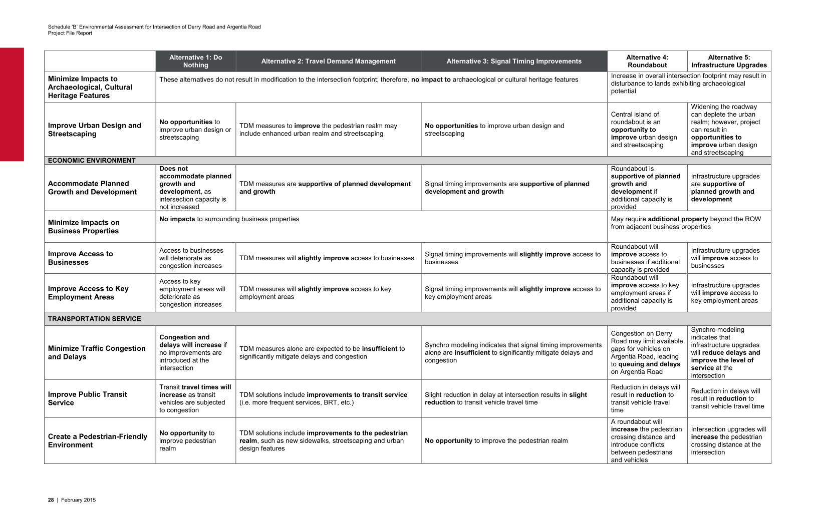
Schedule ‘B’ Environmental Assessment for Intersection of Derry Road and Argentia Road Project File Report
28 | February 2015
Alternative 1: Do Nothing Alternative 2: Travel Demand Management Alternative 3: Signal Timing Improvements Alternative 4:
Roundabout Alternative 5:
Infrastructure Upgrades
Minimize Impacts to Archaeological, Cultural Heritage Features
These alternatives do not result in modification to the intersection footprint; therefore, no impact to archaeological or cultural heritage features
Increase in overall intersection footprint may result in disturbance to lands exhibiting archaeological potential
Improve Urban Design and Streetscaping
No opportunities to improve urban design or streetscaping
TDM measures to improve the pedestrian realm may include enhanced urban realm and streetscaping
No opportunities to improve urban design and streetscaping
Central island of roundabout is an opportunity to improve urban design and streetscaping
Widening the roadway can deplete the urban realm; however, project can result in opportunities to improve urban design and streetscaping
ECONOMIC ENVIRONMENT
Accommodate Planned Growth and Development
Does not accommodate planned growth and development, as intersection capacity is not increased
TDM measures are supportive of planned development and growth
Signal timing improvements are supportive of planned development and growth
Roundabout is supportive of planned growth and development if additional capacity is provided
Infrastructure upgrades are supportive of planned growth and development
Minimize Impacts on Business Properties
No impacts to surrounding business properties
May require additional property beyond the ROW from adjacent business properties
Improve Access to Businesses
Access to businesses will deteriorate as congestion increases
TDM measures will slightly improve access to businesses Signal timing improvements will slightly improve access to businesses
Roundabout will improve access to businesses if additional capacity is provided
Infrastructure upgrades will improve access to businesses
Improve Access to Key Employment Areas
Access to key employment areas will deteriorate as congestion increases
TDM measures will slightly improve access to key employment areas
Signal timing improvements will slightly improve access to key employment areas
Roundabout will improve access to key employment areas if additional capacity is provided
Infrastructure upgrades will improve access to key employment areas
TRANSPORTATION SERVICE
Minimize Traffic Congestion and Delays
Congestion and delays will increase if no improvements are introduced at the intersection
TDM measures alone are expected to be insufficient to significantly mitigate delays and congestion
Synchro modeling indicates that signal timing improvements alone are insufficient to significantly mitigate delays and congestion
Congestion on Derry Road may limit available gaps for vehicles on Argentia Road, leading to queuing and delays on Argentia Road
Synchro modeling indicates that infrastructure upgrades will reduce delays and improve the level of service at the intersection
Improve Public Transit Service
Transit travel times will increase as transit vehicles are subjected to congestion
TDM solutions include improvements to transit service (i.e. more frequent services, BRT, etc.)
Slight reduction in delay at intersection results in slight reduction to transit vehicle travel time
Reduction in delays will result in reduction to transit vehicle travel time
Reduction in delays will result in reduction to transit vehicle travel time
Create a Pedestrian-Friendly Environment
No opportunity to improve pedestrian realm
TDM solutions include improvements to the pedestrian realm, such as new sidewalks, streetscaping and urban design features
No opportunity to improve the pedestrian realm
A roundabout will increase the pedestrian crossing distance and introduce conflicts between pedestrians and vehicles
Intersection upgrades will increase the pedestrian crossing distance at the intersection
Schedule ‘B’ Environmental Assessment for Intersection of Derry Road and Argentia Road Project File Report
February 2015 | 29
Alternative 1: Do Nothing Alternative 2: Travel Demand Management Alternative 3: Signal Timing Improvements Alternative 4:
Roundabout Alternative 5:
Infrastructure Upgrades
Create a Cyclist-Friendly Environment
No opportunity to improve cycling environment
New multi-use path will improve environment for cyclists No opportunity to improve cycling environment
Roundabouts are more challenging for cyclists to traverse New multi-use path will improve environment for cyclists
New multi-use path will improve environment for cyclists
Improve Traffic Safety and Roadway Geometry
No opportunities to improve traffic safety and/or roadway geometry
Travel demand management has no major impact on roadway safety
Improving signal timings (such as determining the optimal amber and all-red phase durations) can slightly improve traffic safety
Roundabouts may improve safety performance; however, roundabouts of this scale are unfamiliar to drivers in Ontario
Roadway widening and re-construction provides an opportunity to upgrade the roadway and improve roadway geometry and safety performance
INFRASTRUCTURE DESIGN AND COST EFFECTIVENESS
Minimize Utility Relocation No utility impacts Relocation of traffic lights, streetlights and catchbasins required.
Relocation of traffic lights, streetlights and catchbasins may be required, depending on design.
Minimize Disruption to Traffic No disruption due to construction No disruption to traffic to implement TDM measures No disruption to traffic required to implement signal timing
improvements
Major disruption to completely re-construct intersection as roundabout
Moderate disruption to accommodate intersection widening
Minimize Property Requirements
No property requirements
Extensive property expected to be required to construct roundabout
Property expected to be required to widen the roadway
Minimize Capital Cost No capital cost Cost varies depending on the extent of the TDM measures implemented; generally a lower capital cost Low capital cost to improve signal timings
High construction cost to re-construct major intersection as a roundabout
Moderate construction cost to widen the intersection
Minimize Operating Costs Does not result in increase to operating costs
Change in operating cost varies depending on the extent of the TDM measures implemented; generally a lower operating cost
No major impact to operating costs Slight reduction to operating costs with removal of traffic lights
Increase to operating costs with additional width of roadway to maintain
RECOMMENDATION Not recommended Recommended Recommended Not
recommended Recommended
Schedule ‘B’ Environmental Assessment for Intersection of Derry Road and Argentia Road Project File Report
30 | February 2015
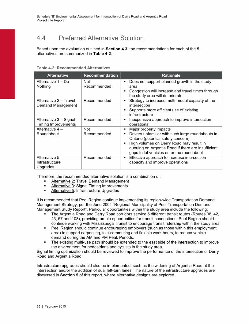
4.4 Preferred Alternative Solution Based upon the evaluation outlined in Section 4.3, the recommendations for each of the 5 alternatives are summarized in Table 4-2.
Table 4-2: Recommended Alternatives
Alternative Recommendation Rationale Alternative 1 – Do Nothing
Not Recommended
Does not support planned growth in the study area
Congestion will increase and travel times through the study area will deteriorate
Alternative 2 – Travel Demand Management
Recommended Strategy to increase multi-modal capacity of the intersection
Supports more efficient use of existing infrastructure
Alternative 3 – Signal Timing Improvements
Recommended Inexpensive approach to improve intersection operations
Alternative 4 – Roundabout
Not Recommended
Major property impacts Drivers unfamiliar with such large roundabouts in
Ontario (potential safety concern) High volumes on Derry Road may result in
queuing on Argentia Road if there are insufficient gaps to let vehicles enter the roundabout
Alternative 5 – Infrastructure Upgrades
Recommended Effective approach to increase intersection capacity and improve operations
Therefore, the recommended alternative solution is a combination of:
Alternative 2: Travel Demand Management Alternative 3: Signal Timing Improvements Alternative 5: Infrastructure Upgrades
It is recommended that Peel Region continue implementing its region-wide Transportation Demand Management Strategy, per the June 2004 “Regional Municipality of Peel Transportation Demand Management Study Report”. Particular opportunities within the study area include the following:
The Argentia Road and Derry Road corridors service 5 different transit routes (Routes 38, 42, 43, 57 and 108), providing ample opportunities for transit connections. Peel Region should continue working with Mississauga Transit to encourage transit ridership within the study area
Peel Region should continue encouraging employers (such as those within this employment area) to support carpooling, tele-commuting and flexible work hours, to reduce vehicle demand during the AM and PM Peak Periods.
The existing multi-use path should be extended to the east side of the intersection to improve the environment for pedestrians and cyclists in the study area.
Signal timing optimization should be reviewed to improve the performance of the intersection of Derry Road and Argentia Road. Infrastructure upgrades should also be implemented, such as the widening of Argentia Road at the intersection and/or the addition of dual left-turn lanes. The nature of the infrastructure upgrades are discussed in Section 5 of this report, where alternative designs are explored.
Schedule ‘B’ Environmental Assessment for Intersection of Derry Road and Argentia Road Project File Report
February 2015 | 31
5 Alternative Designs 5.1 Identification of Alternative Designs Several alternative designs were developed to address the needs and opportunities outlined in the Problem and Opportunity Statement (refer to Section 3.4). These designs are based on the preferred Alternative Solution 5 “Infrastructure Upgrades”, and will be implemented in conjunction with Alternative Solution 2 (Travel Demand Management) and Alternative Solution 3 (Signal Timing Improvements) The alternative designs were focused on the following lane movements with consideration for the available right-of-way on all approaches to the intersection: Westbound dual-left turn lane to address high demand for westbound left turn movements Northbound and southbound dual-left turn lanes to address high demand for northbound and
southbound movements Additional northbound and southbound through lanes to address high demand for
northbound and southbound through movements The alternatives were evaluated based on the expected 2021 and 2031 level of service (LOS) and v/c ratio for the study intersection. A review of multiple potential alternative designs was undertaken to assess which improvements had the greatest potential to improve operations at the intersection. Key findings are summarized below:
The intersection is expected to operate close to or at capacity in 2031 during both AM and PM peak.
Providing additional northbound and southbound capacity on Argentia Road improves overall intersection level of service and capacity.
A dual left turn lane is not warranted in the eastbound direction as a result of low volumes As a result of the high eastbound through movement volumes, it is challenging to serve the
westbound left-turn with a single protected phase Adding northbound and southbound dual left turn phases increase the “all-red” time in the
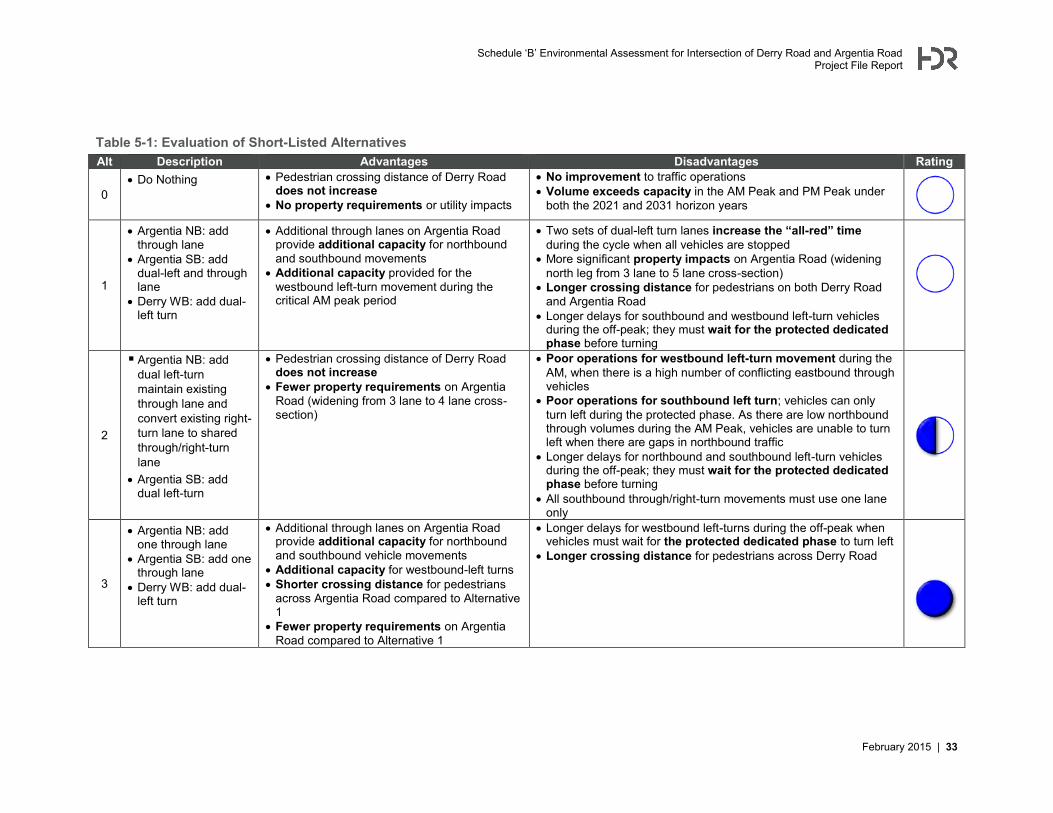
cycle and further reduces capacity. Based on the results of the screening analysis, three (3) alternatives were identified for further evaluation from the perspective of traffic operations, safety, available right-of-way and pedestrian accessibility. The three short-listed alternative designs and the “Do Nothing” alternative are described as follows:
Alternative 0 Do Nothing
Alternative 1 Argentia NB: add through lane Argentia SB: add dual-left and through lane Derry WB: add dual-left turn
Alternative 2 Argentia NB: add dual left-turn; maintain existing through lane and convert
existing right-turn lane to shared through/right-turn lane Argentia SB: add dual left-turn
Alternative 3 Argentia NB: add one through lane Argentia SB: add one through lane Derry WB: add dual-left turn
Schedule ‘B’ Environmental Assessment for Intersection of Derry Road and Argentia Road Project File Report
32 | February 2015
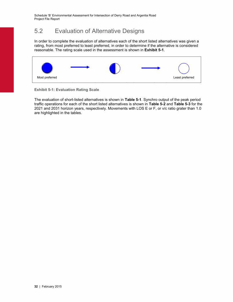
5.2 Evaluation of Alternative Designs In order to complete the evaluation of alternatives each of the short listed alternatives was given a rating, from most preferred to least preferred, in order to determine if the alternative is considered reasonable. The rating scale used in the assessment is shown in Exhibit 5-1.
Most preferred Least preferred
Exhibit 5-1: Evaluation Rating Scale The evaluation of short-listed alternatives is shown in Table 5-1. Synchro output of the peak period traffic operations for each of the short listed alternatives is shown in Table 5-2 and Table 5-3 for the 2021 and 2031 horizon years, respectively. Movements with LOS E or F, or v/c ratio grater than 1.0 are highlighted in the tables.
Schedule ‘B’ Environmental Assessment for Intersection of Derry Road and Argentia Road Project File Report
February 2015 | 33
Table 5-1: Evaluation of Short-Listed Alternatives Alt Description Advantages Disadvantages Rating
0 Do Nothing Pedestrian crossing distance of Derry Road
does not increase No property requirements or utility impacts
No improvement to traffic operations Volume exceeds capacity in the AM Peak and PM Peak under
both the 2021 and 2031 horizon years
1
Argentia NB: add through lane
Argentia SB: add dual-left and through lane
Derry WB: add dual-left turn
Additional through lanes on Argentia Road provide additional capacity for northbound and southbound movements
Additional capacity provided for the westbound left-turn movement during the critical AM peak period
Two sets of dual-left turn lanes increase the “all-red” time during the cycle when all vehicles are stopped
More significant property impacts on Argentia Road (widening north leg from 3 lane to 5 lane cross-section)
Longer crossing distance for pedestrians on both Derry Road and Argentia Road
Longer delays for southbound and westbound left-turn vehicles during the off-peak; they must wait for the protected dedicated phase before turning
2
Argentia NB: add dual left-turn maintain existing through lane and convert existing right-turn lane to shared through/right-turn lane
Argentia SB: add dual left-turn
Pedestrian crossing distance of Derry Road does not increase
Fewer property requirements on Argentia Road (widening from 3 lane to 4 lane cross-section)
Poor operations for westbound left-turn movement during the AM, when there is a high number of conflicting eastbound through vehicles
Poor operations for southbound left turn; vehicles can only turn left during the protected phase. As there are low northbound through volumes during the AM Peak, vehicles are unable to turn left when there are gaps in northbound traffic
Longer delays for northbound and southbound left-turn vehicles during the off-peak; they must wait for the protected dedicated phase before turning
All southbound through/right-turn movements must use one lane only
3
Argentia NB: add one through lane
Argentia SB: add one through lane
Derry WB: add dual-left turn
Additional through lanes on Argentia Road provide additional capacity for northbound and southbound vehicle movements
Additional capacity for westbound-left turns Shorter crossing distance for pedestrians
across Argentia Road compared to Alternative 1
Fewer property requirements on Argentia Road compared to Alternative 1
Longer delays for westbound left-turns during the off-peak when vehicles must wait for the protected dedicated phase to turn left
Longer crossing distance for pedestrians across Derry Road
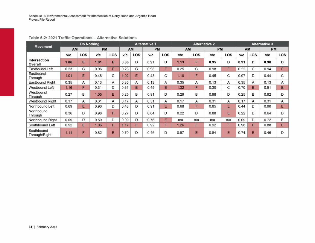
Schedule ‘B’ Environmental Assessment for Intersection of Derry Road and Argentia Road Project File Report
34 | February 2015
Table 5-2: 2021 Traffic Operations – Alternative Solutions
Movement Do Nothing Alternative 1 Alternative 2 Alternative 3
AM PM AM PM AM PM AM PM v/c LOS v/c LOS v/c LOS v/c LOS v/c LOS v/c LOS v/c LOS v/c LOS Intersection Overall 1.06 E 1.01 E 0.86 D 0.97 D 1.13 F 0.95 D 0.91 D 0.90 D
Eastbound Left 0.23 C 0.96 F 0.23 C 0.98 F 0.25 C 0.98 F 0.22 C 0.94 F Eastbound Through 1.01 E 0.48 C 1.02 E 0.43 C 1.10 F 0.45 C 0.97 D 0.44 C
Eastbound Right 0.35 A 0.13 A 0.35 A 0.13 A 0.35 A 0.13 A 0.35 A 0.13 A Westbound Left 1.16 F 0.31 C 0.61 E 0.45 E 1.32 F 0.30 C 0.70 E 0.51 E Westbound Through 0.27 B 1.05 E 0.25 B 0.91 D 0.29 B 0.98 D 0.25 B 0.92 D
Westbound Right 0.17 A 0.31 A 0.17 A 0.31 A 0.17 A 0.31 A 0.17 A 0.31 A Northbound Left 0.69 E 0.90 D 0.48 D 0.91 E 0.68 F 0.85 E 0.44 D 0.90 E Northbound Through 0.36 D 0.98 F 0.27 D 0.64 D 0.22 D 0.88 E 0.22 D 0.64 D
Northbound Right 0.09 D 0.59 D 0.09 D 0.76 E n/a n/a n/a n/a 0.09 D 0.72 E Southbound Left 0.92 E 1.06 F 1.17 F 0.92 F 1.26 F 0.92 F 0.98 F 0.88 E Southbound Through/Right 1.11 F 0.82 E 0.70 D 0.46 D 0.97 E 0.84 E 0.74 E 0.46 D
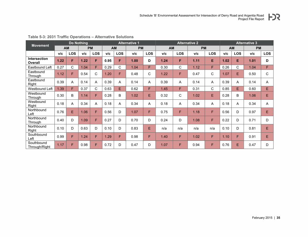
Schedule ‘B’ Environmental Assessment for Intersection of Derry Road and Argentia Road Project File Report
February 2015 | 35
Table 5-3: 2031 Traffic Operations – Alternative Solutions
Movement Do Nothing Alternative 1 Alternative 2 Alternative 3
AM PM AM PM AM PM AM PM v/c LOS v/c LOS v/c LOS v/c LOS v/c LOS v/c LOS v/c LOS v/c LOS Intersection Overall 1.22 F 1.22 F 0.95 F 1.00 D 1.24 F 1.11 E 1.02 E 1.01 D
Eastbound Left 0.27 C 1.04 F 0.29 C 1.04 F 0.30 C 1.12 F 0.26 C 1.04 F Eastbound Through 1.12 F 0.54 C 1.20 F 0.48 C 1.22 F 0.47 C 1.07 E 0.50 C
Eastbound Right 0.39 A 0.14 A 0.39 A 0.14 A 0.39 A 0.14 A 0.39 A 0.14 A
Westbound Left 1.39 F 0.37 C 0.63 E 0.62 F 1.45 F 0.31 C 0.85 E 0.60 E Westbound Through 0.30 B 1.14 F 0.28 B 1.02 E 0.32 C 1.02 E 0.28 B 1.06 E
Westbound Right 0.18 A 0.34 A 0.18 A 0.34 A 0.18 A 0.34 A 0.18 A 0.34 A
Northbound Left 0.76 E 1.06 F 0.56 D 1.07 F 0.75 F 1.18 F 0.56 D 0.97 E
Northbound Through 0.40 D 1.09 F 0.27 D 0.70 D 0.24 D 1.08 F 0.22 D 0.71 D
Northbound Right 0.10 D 0.63 D 0.10 D 0.83 E n/a n/a n/a n/a 0.10 D 0.81 E
Southbound Left 0.99 F 1.24 F 1.29 F 0.98 F 1.40 F 1.02 F 1.10 F 0.91 E
Southbound Through/Right 1.17 F 0.98 F 0.72 D 0.47 D 1.07 F 0.94 F 0.76 E 0.47 D
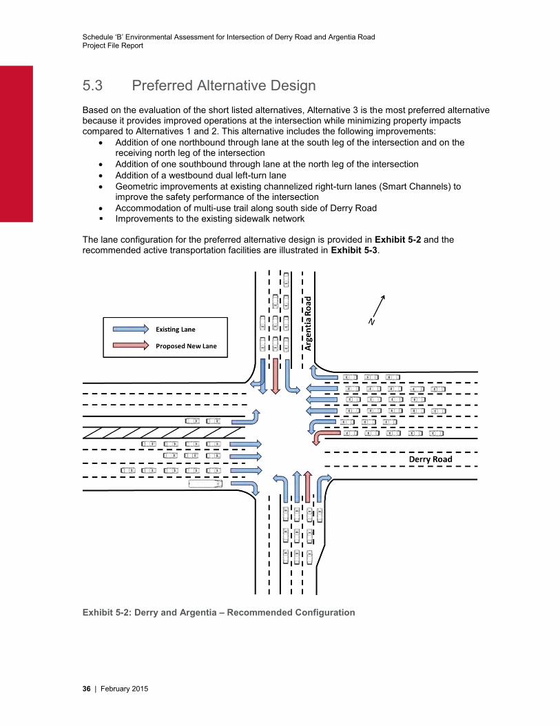
Schedule ‘B’ Environmental Assessment for Intersection of Derry Road and Argentia Road Project File Report
36 | February 2015
5.3 Preferred Alternative Design Based on the evaluation of the short listed alternatives, Alternative 3 is the most preferred alternative because it provides improved operations at the intersection while minimizing property impacts compared to Alternatives 1 and 2. This alternative includes the following improvements:
Addition of one northbound through lane at the south leg of the intersection and on the receiving north leg of the intersection
Addition of one southbound through lane at the north leg of the intersection Addition of a westbound dual left-turn lane Geometric improvements at existing channelized right-turn lanes (Smart Channels) to
improve the safety performance of the intersection Accommodation of multi-use trail along south side of Derry Road Improvements to the existing sidewalk network
The lane configuration for the preferred alternative design is provided in Exhibit 5-2 and the recommended active transportation facilities are illustrated in Exhibit 5-3.
Exhibit 5-2: Derry and Argentia – Recommended Configuration
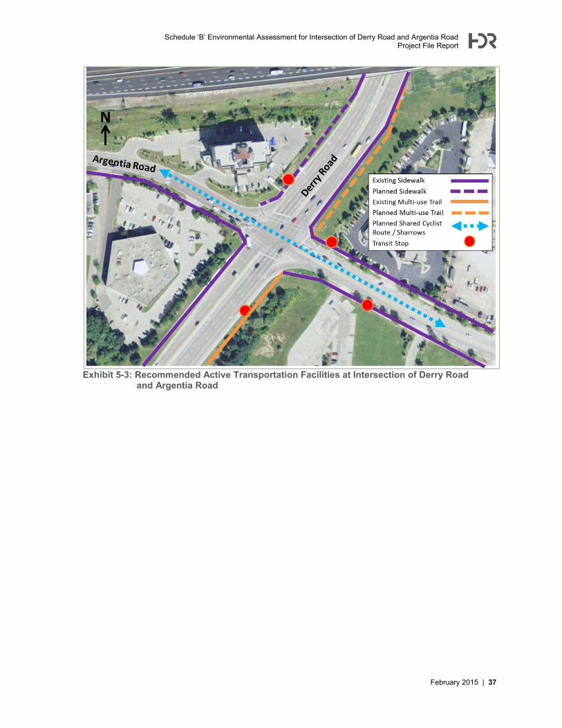
Schedule ‘B’ Environmental Assessment for Intersection of Derry Road and Argentia Road Project File Report
February 2015 | 37
Exhibit 5-3: Recommended Active Transportation Facilities at Intersection of Derry Road and Argentia Road
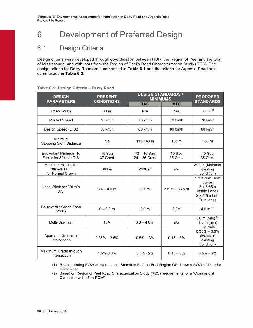
Schedule ‘B’ Environmental Assessment for Intersection of Derry Road and Argentia Road Project File Report
38 | February 2015
6 Development of Preferred Design 6.1 Design Criteria Design criteria were developed through co-ordination between HDR, the Region of Peel and the City of Mississauga, and with input from the Region of Peel’s Road Characterization Study (RCS). The design criteria for Derry Road are summarized in Table 6-1 and the criteria for Argentia Road are summarized in Table 6-2.
Table 6-1: Design Criteria – Derry Road
DESIGN PARAMETERS
PRESENT CONDITIONS
DESIGN STANDARDS / MINIMUMS PROPOSED
STANDARDS TAC MTO
ROW Width 60 m N/A N/A 60 m (1)
Posted Speed 70 km/h 70 km/h 70 km/h 70 km/h
Design Speed (D.S.) 80 km/h 80 km/h 80 km/h 80 km/h
Minimum Stopping Sight Distance n/a 115-140 m 135 m 130 m
Equivalent Minimum ‘K’ Factor for 80km/h D.S.
15 Sag 37 Crest
12 – 16 Sag 24 – 36 Crest
15 Sag 35 Crest
15 Sag 35 Crest
Minimum Radius for 80km/h D.S.
for Normal Crown 300 m 2130 m n/a
300 m (Maintain existing
condition)
Lane Width for 80km/h D.S. 3.4 – 4.0 m 3.7 m 3.5 m – 3.75 m
1 x 3.75m Curb Lanes
3 x 3.65m Inside Lanes 2 x 3.5m Left-
Turn lanes
Boulevard / Green Zone Width 0 – 3.0 m 3.0 m 3.0m 4.0 m (2)
Multi-Use Trail N/A 3.0 – 4.0 m n/a 3.0 m (min) (2)
1.8 m (min) sidewalk
Approach Grades at Intersection 0.35% – 3.6% 0.5% – 3% 0.15 – 3%
0.35% – 3.6% (Maintain existing
condition)
Maximum Grade through Intersection 1.5%-3.0% 0.5% - 2% 0.15 – 3% 0.5% – 2%
(1) Retain existing ROW at intersection; Schedule F of the Peel Region OP shows a ROW of 45 m for Derry Road
(2) Based on Region of Peel Road Characterization Study (RCS) requirements for a “Commercial Connector with 45 m ROW”
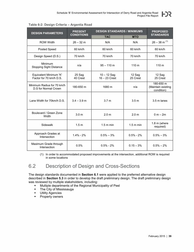
Schedule ‘B’ Environmental Assessment for Intersection of Derry Road and Argentia Road Project File Report
February 2015 | 39
Table 6-2: Design Criteria – Argentia Road
DESIGN PARAMETERS PRESENT CONDITIONS
DESIGN STANDARDS / MINIMUMS PROPOSED STANDARDS
TAC MTO
ROW Width 26 – 32 m N/A N/A 26 – 38 m (1)
Posted Speed 60 km/h 60 km/h 60 km/h 60 km/h
Design Speed (D.S.) 70 km/h 70 km/h 70 km/h 70 km/h
Minimum Stopping Sight Distance n/a 95 – 110 m 110 m 110 m
Equivalent Minimum 'K' Factor for 70 km/h D.S.
25 Sag 40 Crest
10 – 12 Sag 16 – 23 Crest
12 Sag 25 Crest
12 Sag 25 Crest
Minimum Radius for 70 km/h D.S for Normal Crown 180-650 m 1680 m n/a
180-650 m (Maintain existing
condition)
Lane Width for 70km/h D.S. 3.4 – 3.9 m 3.7 m
3.5 m
3.5 m lanes
Boulevard / Green Zone Width 3.0 m 2.0 m 2.0 m 0 m – 2m
Sidewalk 1.5 m 1.5 m min 1.5 m min 1.8 m (where required)
Approach Grades at Intersection 1.4% - 2% 0.5% – 3% 0.5% - 2% 0.5% – 3%
Maximum Grade through Intersection 0.5% 0.5% - 2% 0.15 – 3% 0.5% – 2%
(1) In order to accommodated proposed improvements at the intersection, additional ROW is required in some locations
6.2 Description of Design and Cross-Sections The design standards documented in Section 6.1 were applied to the preferred alternative design described in Section 5.3 in order to develop the draft preliminary design. The draft preliminary design was reviewed by multiple stakeholders, including:
Multiple departments of the Regional Municipality of Peel The City of Mississauga Utility Agencies Property owners
Schedule ‘B’ Environmental Assessment for Intersection of Derry Road and Argentia Road Project File Report
40 | February 2015
Stakeholders discussed multiple potential design refinements during this design review process. Specific design refinements suggested during the design review were incorporated into the design, as feasible, to improve level of service for all multi-modal corridor users, improve safety and minimize impacts. Some of the key refinements, which should be carried forward into the detail design phase, are documented below and reflect the design intent for the intersection of Derry Road and Argentia Road:
Dimensions (lane widths, taper lengths) Lane widths have been slightly reduced on Argentia Road in order to reduce property
impacts The length of the northbound right-turn lane on Argentia Road has been reduced
from the “ideal” length based on traffic modelling output. The length of this lane was reduced to achieve a balance between transportation level of service and impacts to the environment, the community and cost to Peel Region. Reducing the length of this lane resulted in a reduction of: property acquisition, impact to the Sheraton 4 Points Hotel, removal of trees and landscaping, and relocation of utilities.
Boulevard and buffer widths along Argentia Road have been optimized to achieve a balance between property impacts and space for utilities
The length of the dual westbound left-turn lanes are constrained by the Highway 401 overpass; design intent was to avoid any impact to Highway 401 overpass
Active Transportation The existing multi-use trail at the southwest quadrant of the intersection has been
extended across the intersection, to continue along the southeast quadrant of the intersection
The sidewalk has been extended along the north side of Derry Road, east of Argentia Road, to connect to the existing sidewalk below the Highway 401 overpass
A sidewalk has not been included on the east side of Argentia Road, north of Derry Road, because there are no properties to connect to along this side of the road
Safety, Accessibility and Pedestrian Environment Existing channelized right-turns have been converted to “Smart Channels” to reduce
vehicle speeds Pedestrian crossing distances have been minimized across the intersection Curb radii have been minimized to improve pedestrian crossings Island sizes have been increased to provide additional refuge for crossing
pedestrians Accessibility for Ontarians with Disabilities Act (AODA) requirements must be fulfilled.
This includes design features such as: Depressed curbs with tactile walking surface indicators 1.8 metre width sidewalks Accessible pedestrian signals
Goods Movement Curb radii, stop bars and median locations have been designed based on the output
of Autoturn testing, to ensure that the intersection can accommodate truck turning movements
Property Impacts A small retaining wall is proposed along Argentia Road at the northwest corner of the
intersection, in order to address the grade difference and reduce the extent of property impacts. Further refinement should be undertaken during the detail design phase to minimize impacts to the parking lot at this property
Driveway Accesses To improve safety and respond to the collision history observed at the Sheraton 4
Points driveway, the design includes the conversion of the existing driveway to a “right-in / right-out” driveway
A second driveway with “full moves” access is proposed at the southern edge of the Sheraton 4 Points property, along with some minor modifications to internal circulation within the site
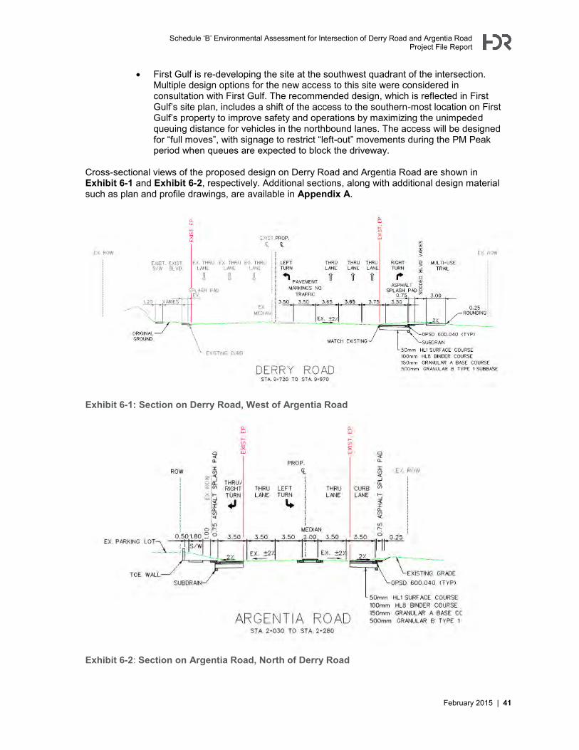
Schedule ‘B’ Environmental Assessment for Intersection of Derry Road and Argentia Road Project File Report
February 2015 | 41
First Gulf is re-developing the site at the southwest quadrant of the intersection. Multiple design options for the new access to this site were considered in consultation with First Gulf. The recommended design, which is reflected in First Gulf’s site plan, includes a shift of the access to the southern-most location on First Gulf’s property to improve safety and operations by maximizing the unimpeded queuing distance for vehicles in the northbound lanes. The access will be designed for “full moves”, with signage to restrict “left-out” movements during the PM Peak period when queues are expected to block the driveway.
Cross-sectional views of the proposed design on Derry Road and Argentia Road are shown in Exhibit 6-1 and Exhibit 6-2, respectively. Additional sections, along with additional design material such as plan and profile drawings, are available in Appendix A.
Exhibit 6-1: Section on Derry Road, West of Argentia Road
Exhibit 6-2: Section on Argentia Road, North of Derry Road
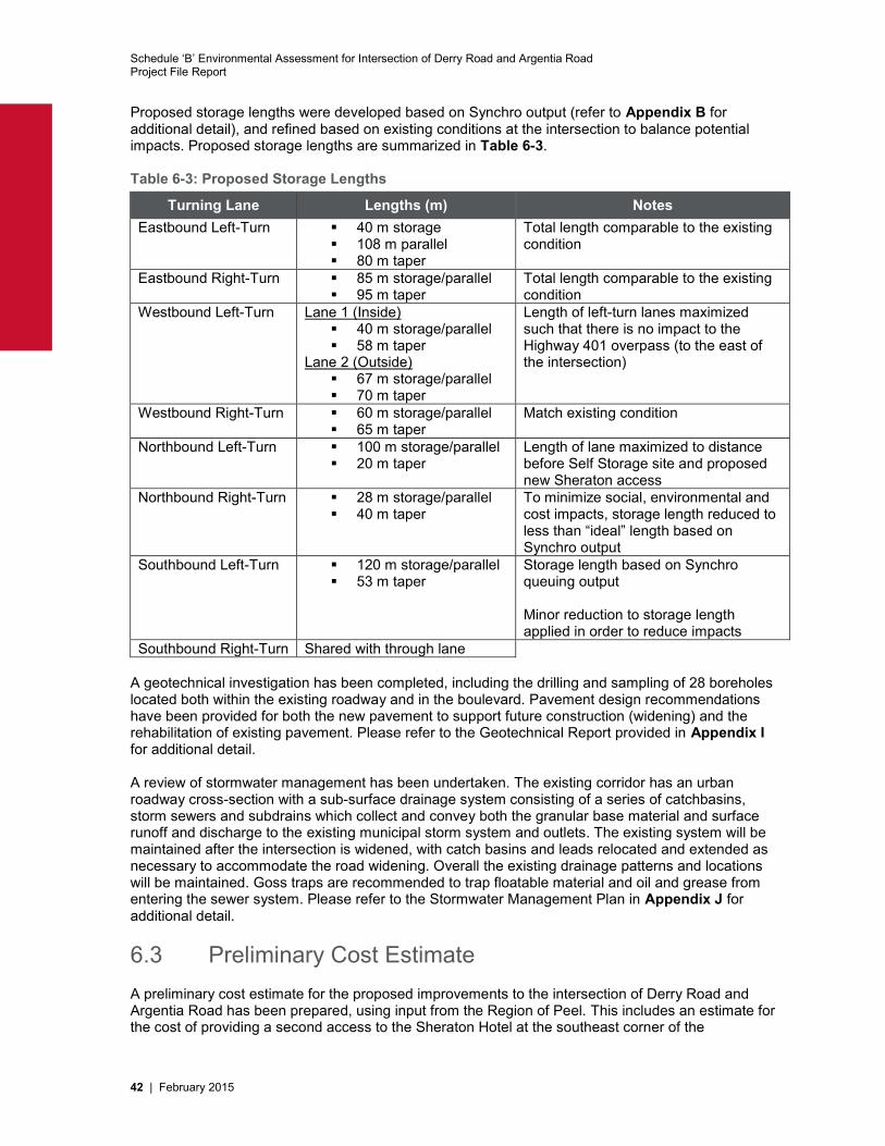
Schedule ‘B’ Environmental Assessment for Intersection of Derry Road and Argentia Road Project File Report
42 | February 2015
Proposed storage lengths were developed based on Synchro output (refer to Appendix B for additional detail), and refined based on existing conditions at the intersection to balance potential impacts. Proposed storage lengths are summarized in Table 6-3. Table 6-3: Proposed Storage Lengths
Turning Lane Lengths (m) Notes Eastbound Left-Turn 40 m storage
108 m parallel 80 m taper
Total length comparable to the existing condition
Eastbound Right-Turn 85 m storage/parallel 95 m taper
Total length comparable to the existing condition
Westbound Left-Turn Lane 1 (Inside) 40 m storage/parallel 58 m taper
Lane 2 (Outside) 67 m storage/parallel 70 m taper
Length of left-turn lanes maximized such that there is no impact to the Highway 401 overpass (to the east of the intersection)
Westbound Right-Turn 60 m storage/parallel 65 m taper
Match existing condition
Northbound Left-Turn 100 m storage/parallel 20 m taper
Length of lane maximized to distance before Self Storage site and proposed new Sheraton access
Northbound Right-Turn 28 m storage/parallel 40 m taper
To minimize social, environmental and cost impacts, storage length reduced to less than “ideal” length based on Synchro output
Southbound Left-Turn 120 m storage/parallel 53 m taper
Storage length based on Synchro queuing output Minor reduction to storage length applied in order to reduce impacts
Southbound Right-Turn Shared with through lane A geotechnical investigation has been completed, including the drilling and sampling of 28 boreholes located both within the existing roadway and in the boulevard. Pavement design recommendations have been provided for both the new pavement to support future construction (widening) and the rehabilitation of existing pavement. Please refer to the Geotechnical Report provided in Appendix I for additional detail. A review of stormwater management has been undertaken. The existing corridor has an urban roadway cross-section with a sub-surface drainage system consisting of a series of catchbasins, storm sewers and subdrains which collect and convey both the granular base material and surface runoff and discharge to the existing municipal storm system and outlets. The existing system will be maintained after the intersection is widened, with catch basins and leads relocated and extended as necessary to accommodate the road widening. Overall the existing drainage patterns and locations will be maintained. Goss traps are recommended to trap floatable material and oil and grease from entering the sewer system. Please refer to the Stormwater Management Plan in Appendix J for additional detail.
6.3 Preliminary Cost Estimate A preliminary cost estimate for the proposed improvements to the intersection of Derry Road and Argentia Road has been prepared, using input from the Region of Peel. This includes an estimate for the cost of providing a second access to the Sheraton Hotel at the southeast corner of the
Schedule ‘B’ Environmental Assessment for Intersection of Derry Road and Argentia Road Project File Report
February 2015 | 43
intersection. The key figures are summarized in Table 6-4; please refer to Appendix K for detailed information regarding the preliminary cost estimate. Table 6-4: Approximate Cost Estimate for Improvements to Intersection of Derry Road and Argentia Road Item Approximate Cost Estimate Intersection Works $2,065,000
Sheraton Second Access $ 55,000
Total $2,120,000
Schedule ‘B’ Environmental Assessment for Intersection of Derry Road and Argentia Road Project File Report
44 | February 2015
7 Impacts and Mitigation 7.1 Impacts to Property Owners Property acquisition is required to implement the recommended design for the intersection of Derry Road and Argentia Road. Design refinements were implemented during the EA stage in order to reduce property requirements, and additional design refinements should be investigated during the detail design stage to further mitigate potential impact to property owners in the study area. A summary of the property requirements identified at the EA Stage is provided in Table 7-1.
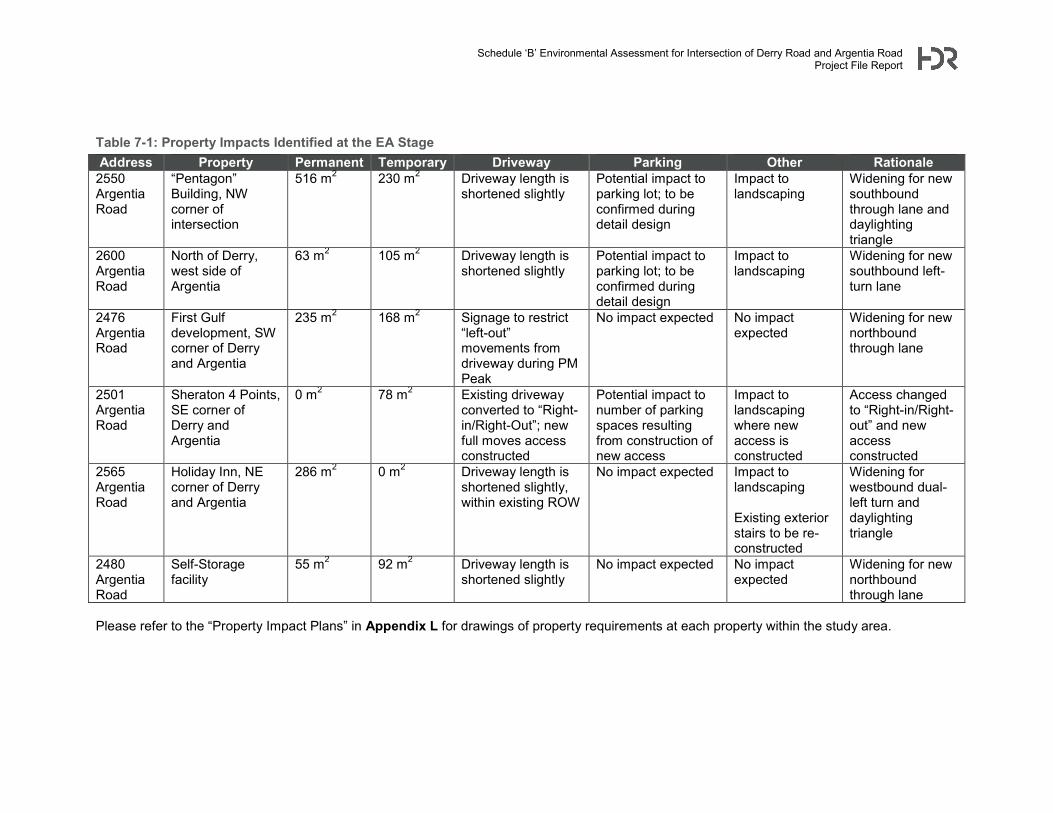
Schedule ‘B’ Environmental Assessment for Intersection of Derry Road and Argentia Road Project File Report
Table 7-1: Property Impacts Identified at the EA Stage Address Property Permanent Temporary Driveway Parking Other Rationale
2550 Argentia Road
“Pentagon” Building, NW corner of intersection
516 m2 230 m2 Driveway length is shortened slightly
Potential impact to parking lot; to be confirmed during detail design
Impact to landscaping
Widening for new southbound through lane and daylighting triangle
2600 Argentia Road
North of Derry, west side of Argentia
63 m2 105 m2 Driveway length is shortened slightly
Potential impact to parking lot; to be confirmed during detail design
Impact to landscaping
Widening for new southbound left-turn lane
2476 Argentia Road
First Gulf development, SW corner of Derry and Argentia
235 m2 168 m2 Signage to restrict “left-out” movements from driveway during PM Peak
No impact expected No impact expected
Widening for new northbound through lane
2501 Argentia Road
Sheraton 4 Points, SE corner of Derry and Argentia
0 m2 78 m2 Existing driveway converted to “Right-in/Right-Out”; new full moves access constructed
Potential impact to number of parking spaces resulting from construction of new access
Impact to landscaping where new access is constructed
Access changed to “Right-in/Right-out” and new access constructed
2565 Argentia Road
Holiday Inn, NE corner of Derry and Argentia
286 m2 0 m2 Driveway length is shortened slightly, within existing ROW
No impact expected Impact to landscaping Existing exterior stairs to be re-constructed
Widening for westbound dual-left turn and daylighting triangle
2480 Argentia Road
Self-Storage facility
55 m2 92 m2 Driveway length is shortened slightly
No impact expected No impact expected
Widening for new northbound through lane
Please refer to the “Property Impact Plans” in Appendix L for drawings of property requirements at each property within the study area.
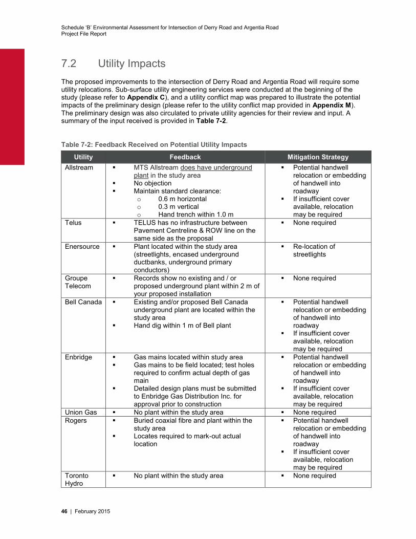
Schedule ‘B’ Environmental Assessment for Intersection of Derry Road and Argentia Road Project File Report
46 | February 2015
7.2 Utility Impacts The proposed improvements to the intersection of Derry Road and Argentia Road will require some utility relocations. Sub-surface utility engineering services were conducted at the beginning of the study (please refer to Appendix C), and a utility conflict map was prepared to illustrate the potential impacts of the preliminary design (please refer to the utility conflict map provided in Appendix M). The preliminary design was also circulated to private utility agencies for their review and input. A summary of the input received is provided in Table 7-2.
Table 7-2: Feedback Received on Potential Utility Impacts
Utility Feedback Mitigation Strategy Allstream MTS Allstream does have underground
plant in the study area No objection Maintain standard clearance:
o 0.6 m horizontal o 0.3 m vertical o Hand trench within 1.0 m
Potential handwell relocation or embedding of handwell into roadway
If insufficient cover available, relocation may be required
Telus TELUS has no infrastructure between Pavement Centreline & ROW line on the same side as the proposal
None required
Enersource Plant located within the study area (streetlights, encased underground ductbanks, underground primary conductors)
Re-location of streetlights
Groupe Telecom
Records show no existing and / or proposed underground plant within 2 m of your proposed installation
None required
Bell Canada Existing and/or proposed Bell Canada underground plant are located within the study area
Hand dig within 1 m of Bell plant
Potential handwell relocation or embedding of handwell into roadway
If insufficient cover available, relocation may be required
Enbridge Gas mains located within study area Gas mains to be field located; test holes
required to confirm actual depth of gas main
Detailed design plans must be submitted to Enbridge Gas Distribution Inc. for approval prior to construction
Potential handwell relocation or embedding of handwell into roadway
If insufficient cover available, relocation may be required
Union Gas No plant within the study area None required Rogers Buried coaxial fibre and plant within the
study area Locates required to mark-out actual
location
Potential handwell relocation or embedding of handwell into roadway
If insufficient cover available, relocation may be required
Toronto Hydro
No plant within the study area None required
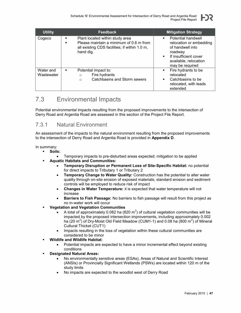
Schedule ‘B’ Environmental Assessment for Intersection of Derry Road and Argentia Road Project File Report
February 2015 | 47
Utility Feedback Mitigation Strategy Cogeco Plant located within study area
Please maintain a minimum of 0.6 m from all existing CDS facilities; if within 1.0 m, hand dig.
Potential handwell relocation or embedding of handwell into roadway
If insufficient cover available, relocation may be required
Water and Wastewater
Potential impact to: o Fire hydrants o Catchbasins and Storm sewers
Fire hydrants to be relocated
Catchbasins to be relocated, with leads extended
7.3 Environmental Impacts Potential environmental impacts resulting from the proposed improvements to the intersection of Derry Road and Argentia Road are assessed in this section of the Project File Report.
7.3.1 Natural Environment An assessment of the impacts to the natural environment resulting from the proposed improvements to the intersection of Derry Road and Argentia Road is provided in Appendix D. In summary:
Soils: Temporary impacts to pre-disturbed areas expected; mitigation to be applied
Aquatic Habitats and Communities: Temporary Disruption or Permanent Loss of Site-Specific Habitat: no potential
for direct impacts to Tributary 1 or Tributary 2 Temporary Change to Water Quality: Construction has the potential to alter water
quality through on-site erosion of exposed materials; standard erosion and sediment controls will be employed to reduce risk of impact
Changes in Water Temperature: it is expected that water temperature will not increase
Barriers to Fish Passage: No barriers to fish passage will result from this project as no in-water work will occur
Vegetation and Vegetation Communities A total of approximately 0.082 ha (820 m2) of cultural vegetation communities will be
impacted by the proposed intersection improvements, including approximately 0.002 ha (20 m2) of Dry-Moist Old Field Meadow (CUM1-1) and 0.08 ha (800 m2) of Mineral Cultural Thicket (CUT1)
Impacts resulting in the loss of vegetation within these cultural communities are considered to be minor
Wildlife and Wildlife Habitat: Potential impacts are expected to have a minor incremental effect beyond existing
conditions Designated Natural Areas:
No environmentally sensitive areas (ESAs), Areas of Natural and Scientific Interest (ANSIs) or Provincially Significant Wetlands (PSWs) are located within 120 m of the study limits
No impacts are expected to the woodlot west of Derry Road
Schedule ‘B’ Environmental Assessment for Intersection of Derry Road and Argentia Road Project File Report
48 | February 2015
7.3.2 Tree Inventory Approximately 51 trees will require removal in order to facilitate the implementation of intersection improvements. Please refer to Appendix N for a visual overview of trees that are anticipated to be removed and trees that will require protection during construction. As discussed in Section 7.6, mitigating measures will be implemented to address the removal of trees during construction.
7.3.3 Air and Noise The alternative solution is not expected to result in substantial air or noise impacts for the following reasons:
None of the alternative solutions will increase the throughput capacity of Derry Road or Argentia Road:
Derry Road: Derry Road will have three through lanes to the east and west of the intersection, as per existing conditions
Argentia Road: Argentia Road will have two through lanes to the north and south of the intersection, as per existing conditions
Background traffic growth within the study area is not assumed to be the result of the proposed study improvements.
One of the goals of the proposed design is to decrease congestion, queuing and delays at the intersection. Increasing intersection capacity will reduce queuing and therefore reduce vehicle idling and the associated air quality results.
The proposed improvement to the intersection of Derry Road and Argentia Road may result in a minor increase in noise to properties adjacent to the study area, as a result of the fact that some traffic lanes are now slightly closer to the properties. None of the properties in the vicinity of the intersection can be classified as sensitive receptors (i.e. schools, places of worship, daycares, residential properties, etc.)
The proposed improvements to the intersection of Derry Road and Argentia Road are expected to result in an improvement to air quality by reducing congestion and the emissions associated with vehicles idling in traffic. Please refer to Appendix O for additional detail.
7.3.4 Archaeology and Cultural Heritage The outcome of the cultural impact assessment is that no negative impacts are anticipated to the identified cultural heritage resources as a result of the proposed undertaking. Based on the results of the assessment, the following recommendations have been developed:
Construction activities should be suitably planned to avoid impacts to identified cultural heritage resources;
Should future work require an expansion of the intersection of Derry Road and Argentia Road study area beyond what has been proposed through this EA, a qualified heritage consultant should be contacted in order to confirm the impacts of the proposed work on potential cultural heritage resources.
Please refer to Appendix G for additional detail. The preliminary design will not result in the need for any additional archaeological assessment beyond the Stage 1 assessment that was completed (please refer to Appendix H).
Schedule ‘B’ Environmental Assessment for Intersection of Derry Road and Argentia Road Project File Report
February 2015 | 49
7.5 Construction Impacts Potential impacts that may occur during construction include:
Traffic congestion resulting from lane closures and intersection modifications to accommodate utility relocations and lane widening works
Noise impacts to surrounding properties Dust / air impacts arising from construction vehicles Temporary re-location of transit stops during construction Driveway closures (partial or full) to accommodate roadway widening
Efforts should be made to minimize construction impacts during detail design and the construction phase.
7.6 Mitigation In order to mitigate impacts resulting from the implementation of the proposed improvements at the intersection of Derry Road and Argentia Road, multiple strategies have been proposed. They are summarized in Table 7-3. All of these impacts and potential mitigation measures are to be confirmed during detail design. Temporary construction impacts should also be reviewed and confirmed during detail design. Permits and approvals may be required, and will be addressed during the detail design phase.

Schedule ‘B’ Environmental Assessment for Intersection of Derry Road and Argentia Road Project File Report
50 | February 2015
Table 7-3: Impacts and Mitigation
Potential Impact Recommended Mitigation Measure(s) Potential Residual Impact
Detail Design Stage Recommendations
Reduction of parking spaces at commercial properties as a result of roadway widening
Use of retaining walls to minimize impact; re-configuration of internal parking space layout to maximize number of spaces
Impact to business owners
Design effort on approaches and strategies to reduce impact to parking spaces at commercial properties
Noise and air impacts during construction
Provide advance notice of when construction work will occur; avoid construction during the night. Apply best management practices (such as application of non-chloride dust suppressants) to mitigate any air quality impacts caused by construction dust
Potential temporary impact to local businesses
Engage with local stakeholders (such as the Holiday Inn and Sheraton Four Points) to discuss construction requirements
Driveway impacts during construction
Develop construction staging plans that minimize closure of driveways and business accesses; consider whether alternate accesses are available; consider whether driveway can remain open (i.e. close half the driveway at a time)
Potential temporary impact to local businesses
Confirm requirement for temporary working easements around driveways during detail design.
Develop staging plans that minimize impacts to local businesses by minimizing closures or restrictions of driveways
Property acquisition requirements
To reduce property requirements for grading, consider modifying the grading slope (in accordance with geotechnical recommendations), or in some cases considering a retaining wall or other type of soil retention feature.
Low potential impact Consider design refinements to reduce property requirements (soil retaining structures, easements as opposed to acquisition, etc.)
Removal of planted trees and landscaping to accommodate roadway improvements
Re-planting of trees once construction is complete
Impact to business owners
Requirement to establish tree re-planting requirements and landscape improvements once construction is complete
Utility relocations Meet with utilities to confirm need for re-location
Low potential impact Confirmation of utility impacts and identification of utility re-location strategy Design focus on early consultation and co-ordination with utilities to assess need for any utility re-locations
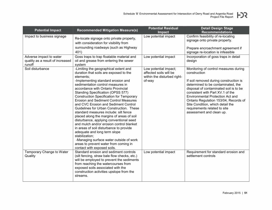
Schedule ‘B’ Environmental Assessment for Intersection of Derry Road and Argentia Road Project File Report
February 2015 | 51
Potential Impact Recommended Mitigation Measure(s) Potential Residual Impact
Detail Design Stage Recommendations
Impact to business signage Re-locate signage onto private property, with consideration for visibility from surrounding roadways (such as Highway 401)
Low potential impact Confirm feasibility of re-locating signage onto private property. Prepare encroachment agreement if signage re-location is infeasible
Adverse impact to water quality as a result of increased runoff
Goss traps to trap floatable material and oil and grease from entering the sewer system
Low potential impact Incorporation of goss traps in detail design
Soil disturbance -Limiting the geographical extent and duration that soils are exposed to the elements; -Implementing standard erosion and sedimentation control measures in accordance with Ontario Provincial Standing Specification (OPSS 577) Construction Specification for Temporary Erosion and Sediment Control Measures and CVC Erosion and Sediment Control Guidelines for Urban Construction. These standard measures include: silt fence placed along the margins of areas of soil disturbance, applying conventional seed and mulch and/or erosion control blanket in areas of soil disturbance to provide adequate and long term slope stabilization; -Managing surface water outside of work areas to prevent water from coming in contact with exposed soils.
Low potential impact; affected soils will be within the disturbed right-of-way
Monitoring of control measures during construction If soil removed during construction is determined to be contaminated, the disposal of contaminated soil is to be consistent with Part XV.1 of the Environmental Protection Act and Ontario Regulation 153/04, Records of Site Condition, which detail the requirements related to site assessment and clean up.
Temporary Change to Water Quality
Standard erosion and sediment controls (silt fencing, straw bale flow checks, etc.) will be employed to prevent the sediments from reaching the watercourses from exposed soils associated with the construction activities upslope from the streams.
Low potential impact Requirement for standard erosion and settlement controls
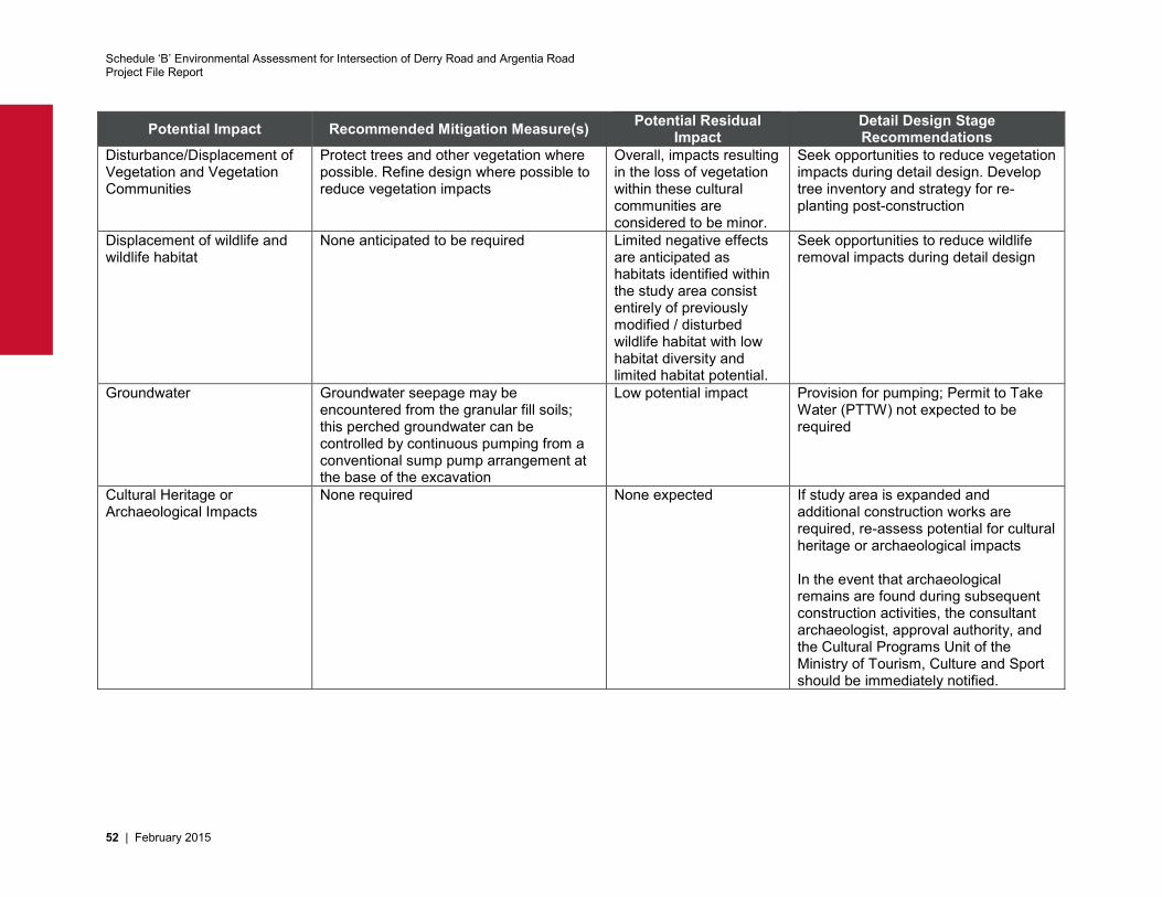
Schedule ‘B’ Environmental Assessment for Intersection of Derry Road and Argentia Road Project File Report
52 | February 2015
Potential Impact Recommended Mitigation Measure(s) Potential Residual Impact
Detail Design Stage Recommendations
Disturbance/Displacement of Vegetation and Vegetation Communities
Protect trees and other vegetation where possible. Refine design where possible to reduce vegetation impacts
Overall, impacts resulting in the loss of vegetation within these cultural communities are considered to be minor.
Seek opportunities to reduce vegetation impacts during detail design. Develop tree inventory and strategy for re-planting post-construction
Displacement of wildlife and wildlife habitat
None anticipated to be required Limited negative effects are anticipated as habitats identified within the study area consist entirely of previously modified / disturbed wildlife habitat with low habitat diversity and limited habitat potential.
Seek opportunities to reduce wildlife removal impacts during detail design
Groundwater Groundwater seepage may be encountered from the granular fill soils; this perched groundwater can be controlled by continuous pumping from a conventional sump pump arrangement at the base of the excavation
Low potential impact Provision for pumping; Permit to Take Water (PTTW) not expected to be required
Cultural Heritage or Archaeological Impacts
None required None expected If study area is expanded and additional construction works are required, re-assess potential for cultural heritage or archaeological impacts In the event that archaeological remains are found during subsequent construction activities, the consultant archaeologist, approval authority, and the Cultural Programs Unit of the Ministry of Tourism, Culture and Sport should be immediately notified.
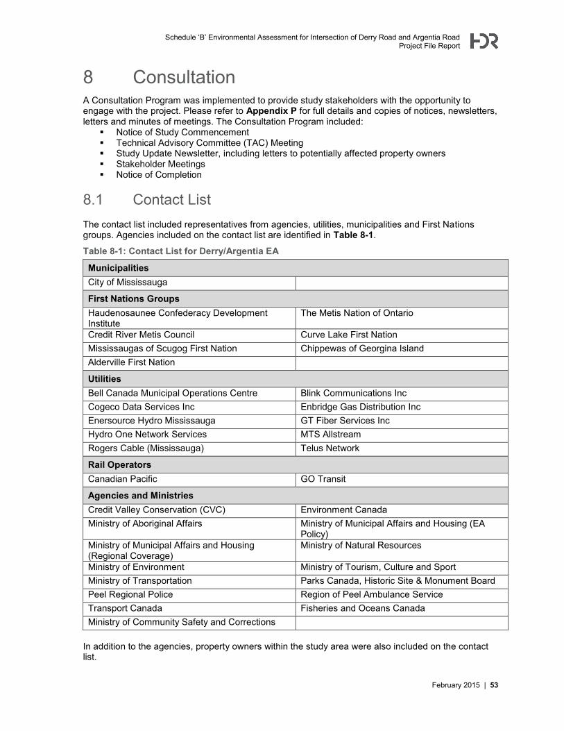
Schedule ‘B’ Environmental Assessment for Intersection of Derry Road and Argentia Road Project File Report
February 2015 | 53
8 Consultation A Consultation Program was implemented to provide study stakeholders with the opportunity to engage with the project. Please refer to Appendix P for full details and copies of notices, newsletters, letters and minutes of meetings. The Consultation Program included:
Notice of Study Commencement Technical Advisory Committee (TAC) Meeting Study Update Newsletter, including letters to potentially affected property owners Stakeholder Meetings Notice of Completion
8.1 Contact List The contact list included representatives from agencies, utilities, municipalities and First Nations groups. Agencies included on the contact list are identified in Table 8-1.
Table 8-1: Contact List for Derry/Argentia EA
Municipalities City of Mississauga
First Nations Groups Haudenosaunee Confederacy Development Institute
The Metis Nation of Ontario
Credit River Metis Council Curve Lake First Nation Mississaugas of Scugog First Nation Chippewas of Georgina Island Alderville First Nation
Utilities Bell Canada Municipal Operations Centre Blink Communications Inc Cogeco Data Services Inc Enbridge Gas Distribution Inc Enersource Hydro Mississauga GT Fiber Services Inc Hydro One Network Services MTS Allstream Rogers Cable (Mississauga) Telus Network
Rail Operators Canadian Pacific GO Transit
Agencies and Ministries Credit Valley Conservation (CVC) Environment Canada Ministry of Aboriginal Affairs Ministry of Municipal Affairs and Housing (EA
Policy) Ministry of Municipal Affairs and Housing (Regional Coverage)
Ministry of Natural Resources
Ministry of Environment Ministry of Tourism, Culture and Sport Ministry of Transportation Parks Canada, Historic Site & Monument Board Peel Regional Police Region of Peel Ambulance Service Transport Canada Fisheries and Oceans Canada Ministry of Community Safety and Corrections
In addition to the agencies, property owners within the study area were also included on the contact list.
Schedule ‘B’ Environmental Assessment for Intersection of Derry Road and Argentia Road Project File Report
54 | February 2015
8.2 Notice of Study Commencement The Notice of Study Commencement was circulated to study stakeholders and property owners on August 20, 2013. The purpose of the Notice of Study Commencement was to:
Inform study stakeholders about the study and provide them with the opportunity to provide initial input on the study
Provide an overview of the study goals Summarize the study process Summarize the proposed consultation plan Provide the Project Team’s contact information
Individually addressed letters and comment sheets were sent along with the notice to agency representatives and property owners. The notice was also published in the Mississauga News on August 28th, 2013 and September 4th, 2013.
8.3 Technical Advisory Committee (TAC) Meeting The Technical Advisory Committee (TAC) Meeting was held on April 25th, 2014. The agenda included:
Introductions Study background, scope and objectives Consultation program Presentation: needs assessment and recommended alternative Review of preliminary design and utilities Study schedule Discussion and next steps
Invitations were issued to internal departments within the Region of Peel, the City of Mississauga, Rogers, Allstream, Enersource, Enbridge, Cogeco and Bell. The meeting was attended by representatives from the Region of Peel, Peel Public Health, the City of Mississauga, Enbridge and Rogers. Attendees provided feedback which was incorporated into the design.
8.4 Study Update Newsletter The Study Update Newsletter was circulated to contacts on the mailing list on June 2nd, 2014, along with letters and comment sheets. The purpose of the update newsletter was to:
Share the Problem and Opportunity Statement and alternative solutions Present the proposed improvements to the intersection Inform study stakeholders that in lieu of a PIC, stakeholders were invited to contact the study
team to arrange meetings to discuss the project In addition to the content above, potentially affected property owners received drawings illustrating the potential property impacts. Potentially affected property owners were also invited to arrange meetings with the Project Team. The Study Update Notice was also published in the Mississauga News on Friday July 4th and Friday July 11th.
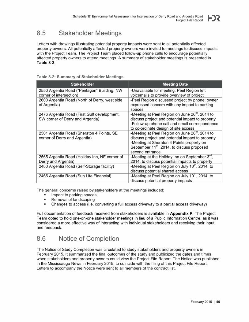
Schedule ‘B’ Environmental Assessment for Intersection of Derry Road and Argentia Road Project File Report
February 2015 | 55
8.5 Stakeholder Meetings Letters with drawings illustrating potential property impacts were sent to all potentially affected property owners. All potentially affected property owners were invited to meetings to discuss impacts with the Project Team. The Project Team placed follow-up phone calls to encourage potentially affected property owners to attend meetings. A summary of stakeholder meetings is presented in Table 8-2.
Table 8-2: Summary of Stakeholder Meetings
Stakeholder Meeting Date 2550 Argentia Road (“Pentagon” Building, NW corner of intersection)
-Unavailable for meeting; Peel Region left voicemails to provide overview of project
2600 Argentia Road (North of Derry, west side of Argentia)
-Peel Region discussed project by phone; owner expressed concern with any impact to parking spaces
2476 Argentia Road (First Gulf development, SW corner of Derry and Argentia)
-Meeting at Peel Region on June 26th, 2014 to discuss project and potential impact to property -Follow-up phone call and email correspondence to co-ordinate design of site access
2501 Argentia Road (Sheraton 4 Points, SE corner of Derry and Argentia)
-Meeting at Peel Region on June 26th, 2014 to discuss project and potential impact to property -Meeting at Sheraton 4 Points property on September 11th, 2014, to discuss proposed second entrance
2565 Argentia Road (Holiday Inn, NE corner of Derry and Argentia)
-Meeting at the Holiday Inn on September 3rd, 2014, to discuss potential impacts to property
2480 Argentia Road (Self-Storage facility) -Meeting at Peel Region on July 10th, 2014, to discuss potential shared access
2465 Argentia Road (Sun Life Financial) -Meeting at Peel Region on July 10th, 2014, to discuss potential property impacts
The general concerns raised by stakeholders at the meetings included:
Impact to parking spaces Removal of landscaping Changes to access (i.e. converting a full access driveway to a partial access driveway)
Full documentation of feedback received from stakeholders is available in Appendix P. The Project Team opted to hold one-on-one stakeholder meetings in lieu of a Public Information Centre, as it was considered a more effective way of interacting with individual stakeholders and receiving their input and feedback.
8.6 Notice of Completion The Notice of Study Completion was circulated to study stakeholders and property owners in February 2015. It summarized the final outcomes of the study and publicized the dates and times when stakeholders and property owners could view the Project File Report. The Notice was published in the Mississauga News in February 2015, to coincide with the filing of this Project File Report. Letters to accompany the Notice were sent to all members of the contract list.

Appendix A Preliminary Design

Appendix B Transportation Report

Appendix C Sub-Surface Utility Engineering Services
Appendix D Natural Heritage Report
Appendix E Phase 1 Environmental Site Assessment

Appendix F Hydrogeologic Study

Appendix G Cultural Heritage Assessment Report:
Built Heritage Resources and Cultural Heritage Landscapes

Appendix H Stage 1 Archaeological Assessment

Appendix I Geotechnical Report
Appendix J Stormwater Management Report
Appendix K Preliminary Cost Estimate

Appendix L Property Impact Plans

Appendix M Utility Impact Plan

Appendix N Tree Inventory
Appendix O Air and Noise Assessment
Appendix P Consultation Record