Embed Size (px)
Citation preview
1
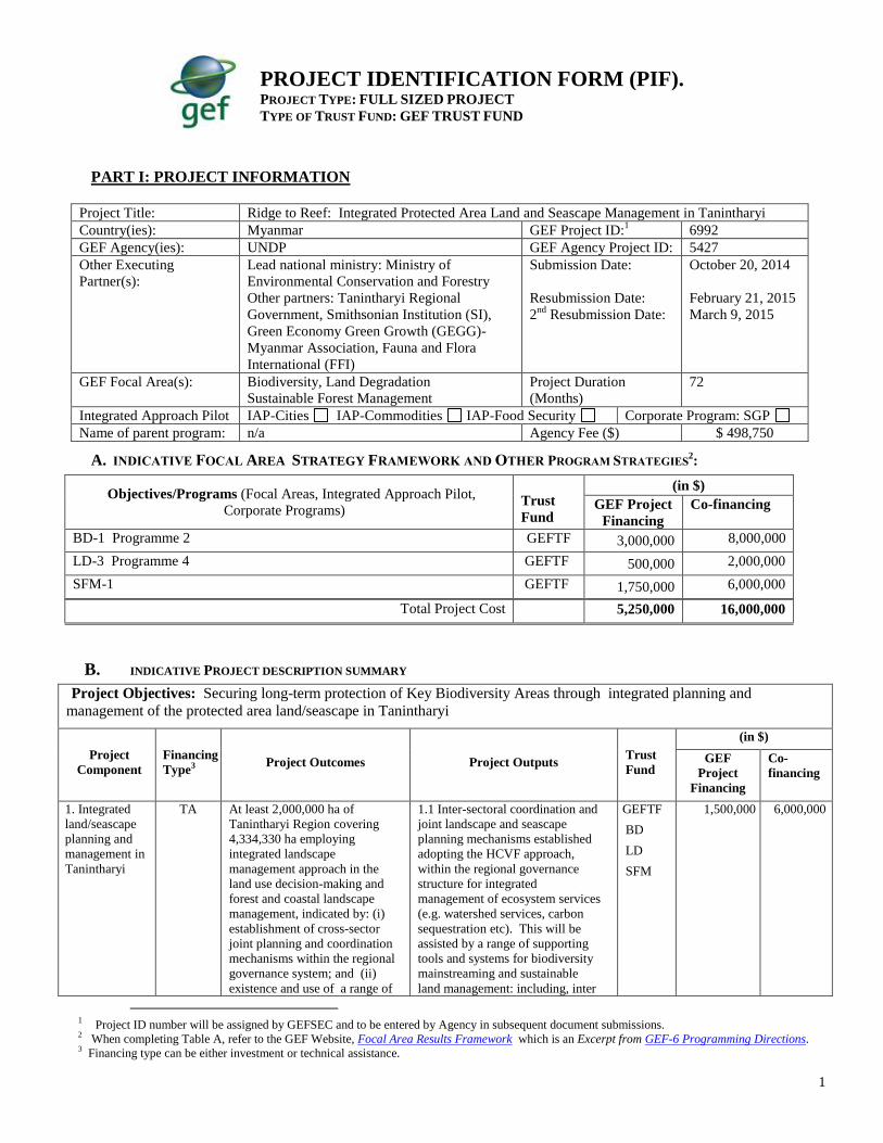
PART I: PROJECT INFORMATION
Project Title: Ridge to Reef: Integrated Protected Area Land and Seascape Management in Tanintharyi
Country(ies): Myanmar GEF Project ID:1 6992
GEF Agency(ies): UNDP GEF Agency Project ID: 5427
Other Executing
Partner(s):
Lead national ministry: Ministry of
Environmental Conservation and Forestry
Other partners: Tanintharyi Regional
Government, Smithsonian Institution (SI),
Green Economy Green Growth (GEGG)-
Myanmar Association, Fauna and Flora
International (FFI)
Submission Date:
Resubmission Date:
2nd
Resubmission Date:
October 20, 2014
February 21, 2015
March 9, 2015
GEF Focal Area(s): Biodiversity, Land Degradation
Sustainable Forest Management
Project Duration
(Months)
72
Integrated Approach Pilot IAP-Cities IAP-Commodities IAP-Food Security Corporate Program: SGP
Name of parent program: n/a Agency Fee ($) $ 498,750
A. INDICATIVE FOCAL AREA STRATEGY FRAMEWORK AND OTHER PROGRAM STRATEGIES2:
Objectives/Programs (Focal Areas, Integrated Approach Pilot,
Corporate Programs)
Trust
Fund
(in $)
GEF Project
Financing
Co-financing
BD-1 Programme 2 GEFTF 3,000,000 8,000,000
LD-3 Programme 4 GEFTF 500,000 2,000,000
SFM-1 GEFTF 1,750,000 6,000,000
Total Project Cost 5,250,000 16,000,000
B. INDICATIVE PROJECT DESCRIPTION SUMMARY
Project Objectives: Securing long-term protection of Key Biodiversity Areas through integrated planning and
management of the protected area land/seascape in Tanintharyi
Project
Component
Financing
Type3 Project Outcomes Project Outputs
Trust
Fund
(in $)
GEF
Project
Financing
Co-
financing
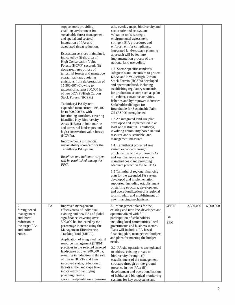
1. Integrated
land/seascape
planning and
management in
Tanintharyi
TA At least 2,000,000 ha of
Tanintharyi Region covering
4,334,330 ha employing
integrated landscape
management approach in the
land use decision-making and
forest and coastal landscape
management, indicated by: (i)
establishment of cross-sector
joint planning and coordination
mechanisms within the regional
governance system; and (ii)
existence and use of a range of
1.1 Inter-sectoral coordination and
joint landscape and seascape
planning mechanisms established
adopting the HCVF approach,
within the regional governance
structure for integrated
management of ecosystem services
(e.g. watershed services, carbon
sequestration etc). This will be
assisted by a range of supporting
tools and systems for biodiversity
mainstreaming and sustainable
land management: including, inter
GEFTF
BD
LD
SFM
1,500,000 6,000,000
1 Project ID number will be assigned by GEFSEC and to be entered by Agency in subsequent document submissions. 2 When completing Table A, refer to the GEF Website, Focal Area Results Framework which is an Excerpt from GEF-6 Programming Directions.
3 Financing type can be either investment or technical assistance.
PROJECT IDENTIFICATION FORM (PIF).
PROJECT TYPE: FULL SIZED PROJECT
TYPE OF TRUST FUND: GEF TRUST FUND
2
support tools providing
enabling environment for
sustainable forest management
and spatial and sectoral
integration of PAs and
associated threat reduction.
Ecosystem services maintained,
indicated by (i) the area of
High Conservation Value
Forests (HCVF) secured; (ii)
decreased rates of loss of
terrestrial forests and mangrove
coastal habitats, avoiding
emissions from deforestation of
15,560,667 tC owing to
gazettal of at least 300,000 ha
of new HCVFs/High Carbon
Stock Forests (HCSFs)
Tanintharyi PA System
expanded from current 195,402
ha to 500,000 ha, with
functioning corridors, covering
identified Key Biodiversity
Areas (KBAs) in both marine
and terrestrial landscapes and
high conservation value forests
(HCVFs).
Improvements in financial
sustainability scorecard for the
Tanintharyi PA system
Baselines and indicator targets
will be established during the
PPG.
alia, overlay maps, biodiversity and
sector oriented ecosystem
valuation tools, strategic
environmental assessment,
stringent EIA procedures and
enforcement for compliance.
Integrated land/seascape planning
approach will be fed into
implementation process of the
national land use policy.
1.2 Sector-specific standards,
safeguards and incentives to protect
KBAs and HVCFs/High Carbon
Stock Forests (HCSFs) developed
and operationalized, including
establishing regulatory standards
for production sectors such as palm
oil, rubber, extractive activities,
fisheries and hydropower industries
Stakeholder dialogue for
Roundtable for Sustainable Palm
Oil (RSPO) strengthened
1.3 An integrated land-use plan
developed and implemented in at
least one district in Tanintharyi,
involving community based natural
resource and sustainable land
management measures
1.4 Tanintharyi protected area
system expanded through
proclamation of the proposed PAs
and key mangrove areas on the
mainland coast and providing
adequate protection to the KBAs
1.5 Tanintharyi regional financing
plan for the expanded PA system
developed and implementation
supported, including establishment
of staffing structure, development
and operationalization of a regional
tourism plan, and establishment of
new financing mechanisms.
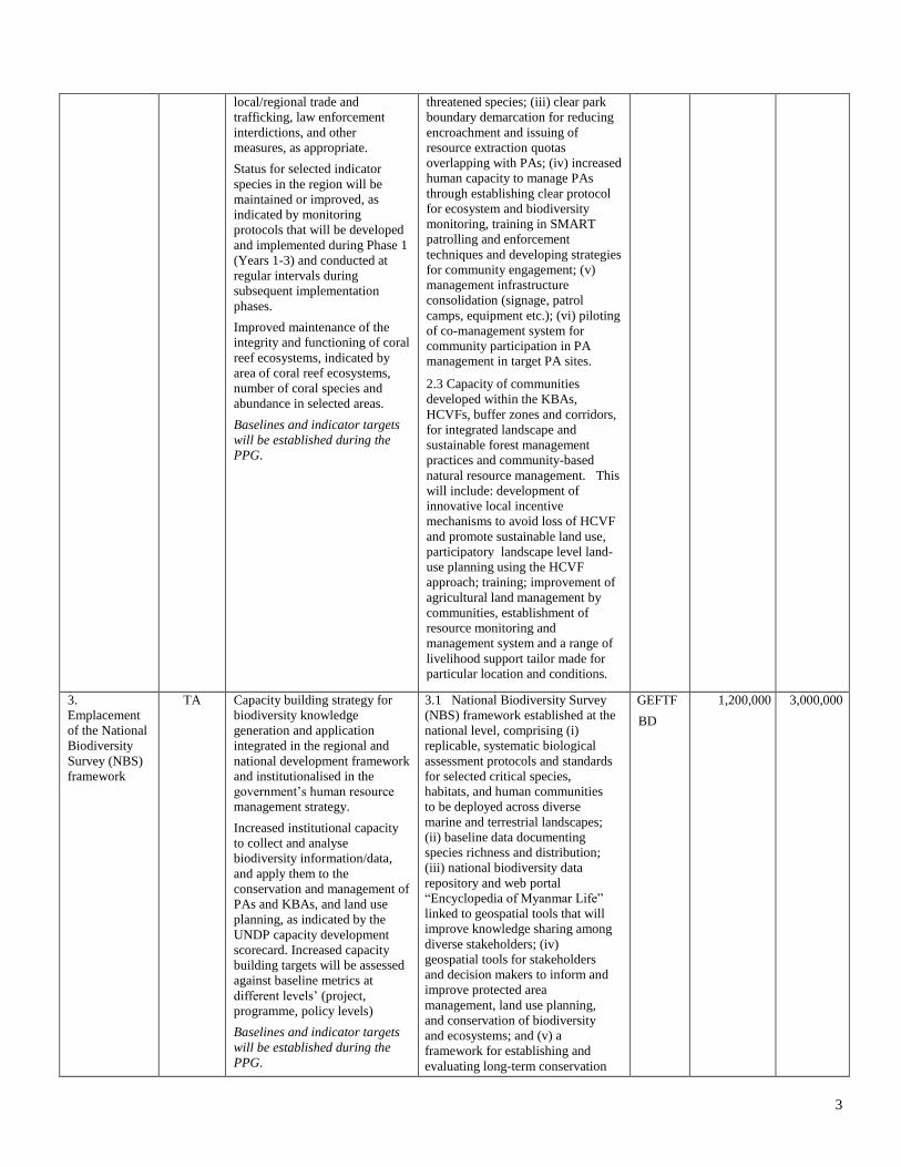
2.
Strengthened
management
and threat
reduction in
the target PAs
and buffer
zones.
TA Improved management
effectiveness of individual
existing and new PAs of global
significance, covering over
500,000 ha, indicated by the
percentage increase using the
Management Effectiveness
Tracking Tool (METT).
Application of integrated natural
resource management (INRM)
practices in the selected targeted
landscapes of over 200,000 ha,
resulting in reduction in the rate
of loss in HCVFs and their
improved status, reduction of
threats at the landscape level
indicated by quantifying
poaching threats,
agriculture/plantation expansion,
2.1 Management plans for the
existing and new PAs developed and
operationalized with full
participation of stakeholders
including local communities, local
governments and business sectors.
Plans will include a PA-based
financing plan, management budgets
and plans for meeting the budget
needs.
2.2 PA site operations strengthened
to address existing threats to
biodiversity through: (i)
establishment of the management
structure through on-the-ground
presence in new PAs; (ii)
development and operationalization
of habitat and biological monitoring
systems for key ecosystems and
GEFTF
BD
SFM
2,300,000 6,000,000
3
local/regional trade and
trafficking, law enforcement
interdictions, and other
measures, as appropriate.
Status for selected indicator
species in the region will be
maintained or improved, as
indicated by monitoring
protocols that will be developed
and implemented during Phase 1
(Years 1-3) and conducted at
regular intervals during
subsequent implementation
phases.
Improved maintenance of the
integrity and functioning of coral
reef ecosystems, indicated by
area of coral reef ecosystems,
number of coral species and
abundance in selected areas.
Baselines and indicator targets
will be established during the
PPG.
threatened species; (iii) clear park
boundary demarcation for reducing
encroachment and issuing of
resource extraction quotas
overlapping with PAs; (iv) increased
human capacity to manage PAs
through establishing clear protocol
for ecosystem and biodiversity
monitoring, training in SMART
patrolling and enforcement
techniques and developing strategies
for community engagement; (v)
management infrastructure
consolidation (signage, patrol
camps, equipment etc.); (vi) piloting
of co-management system for
community participation in PA management in target PA sites.
2.3 Capacity of communities
developed within the KBAs,
HCVFs, buffer zones and corridors,
for integrated landscape and
sustainable forest management
practices and community-based
natural resource management. This
will include: development of
innovative local incentive
mechanisms to avoid loss of HCVF
and promote sustainable land use,
participatory landscape level land-
use planning using the HCVF
approach; training; improvement of
agricultural land management by
communities, establishment of
resource monitoring and
management system and a range of
livelihood support tailor made for
particular location and conditions.
3.
Emplacement
of the National
Biodiversity
Survey (NBS)
framework
TA Capacity building strategy for
biodiversity knowledge
generation and application
integrated in the regional and
national development framework
and institutionalised in the
government’s human resource
management strategy.
Increased institutional capacity
to collect and analyse
biodiversity information/data,
and apply them to the
conservation and management of
PAs and KBAs, and land use
planning, as indicated by the
UNDP capacity development
scorecard. Increased capacity
building targets will be assessed
against baseline metrics at
different levels’ (project,
programme, policy levels)
Baselines and indicator targets
will be established during the
PPG.
3.1 National Biodiversity Survey
(NBS) framework established at the
national level, comprising (i)
replicable, systematic biological
assessment protocols and standards
for selected critical species,
habitats, and human communities
to be deployed across diverse
marine and terrestrial landscapes;
(ii) baseline data documenting
species richness and distribution;
(iii) national biodiversity data
repository and web portal
“Encyclopedia of Myanmar Life”
linked to geospatial tools that will
improve knowledge sharing among
diverse stakeholders; (iv)
geospatial tools for stakeholders
and decision makers to inform and
improve protected area
management, land use planning,
and conservation of biodiversity
and ecosystems; and (v) a
framework for establishing and
evaluating long-term conservation
GEFTF
BD
1,200,000 3,000,000
4
project outcomes.
3.2. National and regional
structure and capacity building
system developed for maintenance
and effective use of the NBS
system, including, establishment of
a multi-agency cooperation
mechanism for constant generation
and management of data and
information; establishment of core
staffing; and development and
institutionalised training
programme.
Subtotal 5,000,000 15,000,000
Project Management Cost (PMC)4 GEFTF 250,000 1,000,000
Total Project Cost 5,250,000 16,000,000
If Multi-Trust Fund project :PMC in this table should be the total and enter trust fund PMC breakdown here (n/a)
C. INDICATIVE SOURCES OF CO-FINANCING FOR THE PROJECT BY NAME AND BY TYPE, IF AVAILABLE
Please include confirmed co-financing letters for the project with this form.
Sources of Co-
financing Name of Co-financier
Type of Co-
financing Amount ($)
Recipient Government Ministry of Environmental Conservation and Forestry In-kind 3,000,000
Recipient Government Tanintharyi Regional Government In-kind 3,000,000
GEF Agency UNDP Grant 500,000
CSO Smithsonian Institution Grant 1,500,000
CSO Fauna and Flora International, Green Economy Green Growth
Myanmar Association Grant 6,000,000
Private Sector To be determined Grant 2,000,000
Total Co-financing 16,000,000
D. INDICATIVE TRUST FUND RESOURCES REQUESTED BY AGENCY(IES), COUNTRY(IES) AND THE
PROGRAMMING OF FUNDS a)
GEF
Agency
Trust
Fund
Country/
Regional/
Global
Focal Area Programming
of Funds
(in $)
GEF
Project
Financing
(a)
Agency
Fee
(b)b)
Total
(c)=a+b
UNDP GEFTF Myanmar Biodiversity n/a 3,000,000 285,000 3,285,000
UNDP GEFTF Myanmar Land Degradation n/a 500,000 47,500 547,500
UNDP GEFTF Myanmar Multi-Focal Areas SFM 1,750,000 166,250 1,916,250
Total GEF Resources 5,250,000 498,750 5,748,750
a) No need to fill this table if it is a single Agency, single Trust Fund, single focal area and single country project.
b) Refer to the Fee Policy for GEF Partner Agencies.
4 For GEF Project Financing up to $2 million, PMC could be up to10% of the subtotal; above $2 million, PMC could be up to 5% of the subtotal.
PMC should be charged proportionately to focal areas based on focal area project financing amount in Table D below.
5
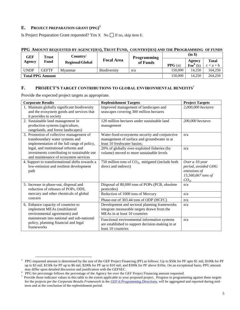
E. PROJECT PREPARATION GRANT (PPG)5
Is Project Preparation Grant requested? Yes X No If no, skip item E.
PPG AMOUNT REQUESTED BY AGENCY(IES), TRUST FUND, COUNTRY(IES) AND THE PROGRAMMING OF FUNDS
GEF
Agency
Trust
Fund
Country/
Regional/Global Focal Area
Programming
of Funds
(in $)
PPG (a)
Agency
Fee6 (b)
Total
c = a + b
UNDP GEFTF Myanmar Biodiversity n/a 150,000 14,250 164,250
Total PPG Amount 150,000 14,250 264,250
F. PROJECT’S TARGET CONTRIBUTIONS TO GLOBAL ENVIRONMENTAL BENEFITS7
Provide the expected project targets as appropriate.
Corporate Results Replenishment Targets Project Targets
1. Maintain globally significant biodiversity
and the ecosystem goods and services that
it provides to society
Improved management of landscapes and
seascapes covering 300 million hectares
2,000,000 hectares
2. Sustainable land management in
production systems (agriculture,
rangelands, and forest landscapes)
120 million hectares under sustainable land
management
200,000 hectares
3. Promotion of collective management of
transboundary water systems and
implementation of the full range of policy,
legal, and institutional reforms and
investments contributing to sustainable use
and maintenance of ecosystem services
Water-food-ecosystems security and conjunctive
management of surface and groundwater in at
least 10 freshwater basins;
n/a
20% of globally over-exploited fisheries (by
volume) moved to more sustainable levels
n/a
4. 4. Support to transformational shifts towards a
low-emission and resilient development
path
750 million tons of CO2e mitigated (include both
direct and indirect)
Over a 10-year
period, avoided GHG
emissions of
15,560,667 tons of
CO2e
5. Increase in phase-out, disposal and
reduction of releases of POPs, ODS,
mercury and other chemicals of global
concern
Disposal of 80,000 tons of POPs (PCB, obsolete
pesticides)
n/a
Reduction of 1000 tons of Mercury n/a
Phase-out of 303.44 tons of ODP (HCFC) n/a
6. Enhance capacity of countries to
implement MEAs (multilateral
environmental agreements) and
mainstream into national and sub-national
policy, planning financial and legal
frameworks
Development and sectoral planning frameworks
integrate measurable targets drawn from the
MEAs in at least 10 countries
n/a
Functional environmental information systems
are established to support decision-making in at
least 10 countries
n/a
5 PPG requested amount is determined by the size of the GEF Project Financing (PF) as follows: Up to $50k for PF upto $1 mil; $100k for PF
up to $3 mil; $150k for PF up to $6 mil; $200k for PF up to $10 mil; and $300k for PF above $10m. On an exceptional basis, PPG amount
may differ upon detailed discussion and justification with the GEFSEC. 6 PPG fee percentage follows the percentage of the Agency fee over the GEF Project Financing amount requested. 7 Provide those indicator values in this table to the extent applicable to your proposed project. Progress in programming against these targets
for the projects per the Corporate Results Framework in the GEF-6 Programming Directions, will be aggregated and reported during mid-
term and at the conclusion of the replenishment period.
6
PART II: PROJECT JUSTIFICATION
Project Overview
A.1. Project Description. Briefly describe: 1) the global environmental problems, root causes and barriers that need to be
addressed; 2) the baseline scenario or any associated baseline projects, 3) the proposed alternative scenario, with a brief description of expected outcomes and components of the project, 4) incremental/additional cost reasoning and expected
contributions from the baseline, the GEFTF, LDCF, SCCF, and co-financing; 5) global environmental benefits (GEFTF)
and/or adaptation benefits (LDCF/SCCF); and 6) innovativeness, sustainability and potential for scaling up.
Biodiversity Significance and Project Context: Myanmar is the jewel in the crown of Asia’s biodiversity. Intersecting
three biogeographic regions, it is recognized for its exceptionally high endemism and its importance as a global
biodiversity hotspot. Myanmar is the largest country in mainland South-East Asia, with a land area of 676,553 km² and a
coastline of 2,832 km. It is the most forested country in South-East Asia, enjoying nearly 50% forest cover, and it
possesses some of the most pristine marine ecosystems on Earth. The country includes all or part of fourteen Global Eco-
regions defined by WWF, with 9 Global 200 Eco-regions including, Kayah-Karen/Tenasserim Moist Forests and the
Andaman Sea. Due to wide variations in latitude, altitude and climate within the country, Myanmar supports a high
diversity of habitats, and is extremely rich in plant species. Furthermore, the country is located at the convergence of 4
major floristic regions: the Indian, Malaysian (Sundaic), Sino-Himalayan and Indochinese. Myanmar supports at least 251
mammal species, although a number of these species have not been confirmed to occur in recent years, with seven
mammal species thought to be endemic. The country supports at least 1,090 bird species, a greater diversity than any other
country in mainland South-East Asia. Myanmar's avifauna contains six endemic species and numerous endemic
subspecies, several of which may warrant full species status. Myanmar also supports at least 19 other restricted-range bird
species (species with a global breeding range of less than 50,000 km2). The fresh water fish fauna of Myanmar is one of
the least known in South-East Asia. The number of coral species in Myanmar is estimated by some experts to be as many
as 350 species although most of them are yet to be scientifically described.
Tanintharyi Region: The country’s southern-most Tanintharyi Region is a relatively undeveloped area with high
biodiversity and endemism that provides invaluable ecosystem services. Approximately 20% of Myanmar’s Key
Biodiversity Areas (KBAs) are located in Tanintharyi. The whole Tanintharyi region, as well as a small part of the Mon
and Kayin States, fall under the Sundaic Subregion Priority Corridor. The corridor includes the largest areas of lowland
wet evergreen forest remaining in the Indo-Myanmar (Indo-Burma) Hotspot. The Priority Corridor also includes a
significant portion of coastline, a large number of offshore islands and significant areas of key wetland habitats, including
mangrove and intertidal mudflats. It includes the Moscos Islands and the Myeik Archipelago which consists of over 800
islands in the Andaman Sea Marine Ecoregion. Although the Priority Corridor has received little recent biological study,
there are indications that it supports rich lowland evergreen forest communities and globally threatened wildlife, such as
Asian tapir (Tapirus indicus) and plain-pouched hornbill (both are Vulnerable). Coastal habitats support Mangrove
Terrapin (Critically Endangered) and are thought to be important for migratory water birds. Of greatest significance, the
Priority Corridor supports the bulk of the world population of Gurney’s pitta (Critically Endangered), a species endemic to
the Tanintharyi Region and a small part of peninsular Thailand (Anon. 2003, Eames et al. 2005). Moreover, the Priority
Corridor is thought to support a relatively large population (approximately 50 individuals) of tiger (Endangered). The
potential of the Sundaic Sub-region for the long-term conservation of landscape species, such as Asian elephant, tiger and
plain-pouched hornbill, is enhanced by the existence of significant areas of contiguous natural habitat in western and
peninsular Thailand, including significant portions which are already protected and managed.
Threats to Biodiversity: The outstanding biodiversity of the Tanintharyi region is under increasingly severe threats. The
lowland forests in the Tanintharyi Range Corridor that support significant populations of globally threatened species, such
as the endemic Gurney’s pitta, are under immediate threats from land conversion to oil palm and rubber plantations. There
are already around 50 plantation licences being issued in the region. The Dawei Development Corridor Project, with
associated infrastructure development such as a deep sea port and road links to Thailand, is likely to lead to significant
habitat degradation and conversion. These initiatives do not only threaten the habitat but endanger the functioning of the
Tanintharyi River watersheds, which discharge into the Andaman Sea. Any erosion in the watershed could lead to
sedimentation and pollution impacting marine ecosystems in the Myeik Archipelago. Unsustainable and/or illegal logging
and illegal wildlife trade also pose major threats. Forest products are over exploited particularly through resource
extraction quotas sold to local businesses that often overlap with PA boundaries and can be politically sensitive to enforce.
Fishing rights are also sold using similar auction methods and often promote commercial over-harvesting while at the
same time excluding the subsistence needs of local communities. Both terrestrial and marine pollution threats are on a
7
sharp increase from extractive industries (e.g. gas, oil, copper, gold, zinc etc.), aquaculture (e.g. shrimp farming) and
construction in coastal areas such as seaport development. Moreover, the decline of fishery resources is a major concern
for the government, as fishermen are reporting drastic reductions in their catches. This has led to a recent decision by the
government to halve the off-shore fishing season from 90 to 45 days. Illegal fishing by foreign vessels with modern
equipment is regularly reported. Furthermore, temperature rise and an increase in the frequency of extreme weather events
associated with climate change are expected to pose emerging threats to both terrestrial (e.g. wildfires, floods) and marine
biodiversity (e.g. adverse impacts on coral). Root causes of the threats include population increase, poverty,
undervaluation of natural resources, and environmental externalities not being integrated in the planning and operation of
economic sectors. Refugees returning from Thailand and internally displaced persons could cause additional pressure, if
they resort to unsustainable practices and their livelihoods remain precarious.8
Baseline Activities: In the country’s democratisation process, the government has been striving to achieve both a green
economy and green growth in the country – a growth pattern that learns from mistakes made by other countries in the
region when faced with similar conditions of rapid growth and transition, generally characterized by economic growth that
results in wealth disparity among populations at the expense of ecosystem degradation and biodiversity loss. Since 2011,
the Myanmar government with the support of Green Economy Green Growth (GEGG) Association of Myanmar, has been
engaged in high level discussions with eminent thinkers and practitioners from both public and private sectors around the
world, to explore ways and mechanisms to achieve a sustainable path for Myanmar’s development. The Green Economy
Green Growth Forum will continue to be held with an annual budget of approximately $ 100,000 with over $ 300,000 in-
kind contributions from international and national speakers, providing a major platform that influences the course of the
nation’s development.
In the specific field of biodiversity and ecosystem services management, in order to protect the country’s outstanding
biodiversity, the Myanmar government has designed a network of 43 PAs. Thirty-six of these have been officially gazetted
under the Protection of Wildlife and Protected Areas Law, while 7 remain proposed. The 36 PAs cover 5.6% of the total
land area of the country, and the addition of the 7 proposed protected areas would increase this to 6.7%.
In 2001, the government approved a 30-year Forest Master Plan mandating the increase of the Permanent Forest Estate
(constituted by reserved forests and public protected forests) to 30% and an increase of PAs to 10% of the total country
area. Furthermore, the Forest Master Plan encourages the registration of unclassified forests into community or private
forests. The Government of Myanmar invests approximately US$ 750,000 in PA management annually. Myanmar is a
partner of the Global Tiger Initiative and was represented at the Global Tiger Summit in St. Petersburg in September 2010
by the then Minister of Forestry. It submitted a National Tiger Recovery Plan (NTRP), as part of the Global Tiger
Recovery Plan in June 2010.
Myanmar is in the process of devolving power from the national government to regional and local governments. In 2013,
the Region or State Parliament Law was promulgated. It is envisaged that an increasing level of authority and
responsibility will be decentralized to the regional and state governments, including natural resource management. The
government is also in the process of developing the National Land Use Policy. Related to this, MOECAF has started an
initiative called One Map Myanmar Programme to harmonize the spatial planning data required for land use planning at
the national and regional levels. Tanintharyi has been selected as a pilot region under the programme.
In the Tanintharyi Range Corridor, there are 3 existing PAs covering 195,402 ha and 2 proposed areas covering 523,159
ha. In 2014, two new marine protected areas in the biodiversity-rich Myeik archipelago were proposed based on the
scientific surveys conducted with support from FFI and SI. However much of the important areas remain unprotected.
With US$ 3 million support from the International Tropical Timber Organisation (ITTO), MOECAF is working on the 4-
year “Capacity Building for Strengthening Transboundary Biodiversity Conservation of the Tanintharyi Range in
Myanmar” (2013-2016). The project provides targeted capacity building support for improving transboundary
biodiversity conservation between Myanmar and Thailand with particular focus on the work in the Tanintharyi Range. The
project aims to establish institutional mechanisms for the trans-boundary biodiversity conservation between the two
countries, and supports trans-boundary research and joint actions. It also supports targeted research and work to engage
community participation and livelihood support in the proposed Tanintharyi National Park area. With this project,
MOECAF in addition provides a MSc fellowship in biodiversity organization and a range of training courses are organised
8 UNHCR estimates a total of about 400,000 individuals were still internally displaced in the rural areas of 36 townships in South-East Myanmar in
Kayin, Kayah, South and East Shan and Mon States, and Bago and Tanintharyi Regions. (2008-2012, South East Myanmar: A Report on Village
Profiles 2008-2012)
8
at the national level, as well as some support for procurement of equipment necessary for research facilities at the national
level.
In the country’s effort for safeguarding biodiversity and ecosystem services, one of the most pressing issues that has been
identified is highly limited information availability and human resources and capacity for generating and applying the
information. In response to this, Project partner agencies have been working closely with the MOECAF in support of the
10-year Strategic framework for “Building the Foundation for Natural Resource Stewardship, for Sustainable, Inclusive
and Equitable Development” for 2015-2025. The 10-Year Strategy aims to accelerate capacity development for better
stewardship of natural resources, directly implementing the capacity development needs identified under the National
Biodiversity Strategy and Action Plan (NBSAP). The 10-year strategy aims to promote sustainable, inclusive and
equitable economic development, reduce poverty and conserve the rich natural heritage of the county for present and
future generations. The Framework, which was presented and approved in principle by the Minister of MOECAF in
November 2013, will focus its initial support for building of the necessary scientific foundation and trial application of
scientific knowledge for biodiversity stewardship in the coming decade in close collaboration with the Smithsonian
Institution, FFI, GEGG, UNDP and other partners. The necessary financial resources for implementation of the
programmatic framework are estimated to be $128,500,000, including plans for establishing a $100 million trust fund.
The proposed project is anchored on this programmatic framework.
A number of other governmental and civil society organisations have also provided capacity development support to the
country. Scientists from the Smithsonian Institution have been studying the biodiversity and ecology of Myanmar over the
last 20 years, and since 1993, Smithsonian has trained more than 300 MOECAF staff, completed 50 research projects, 150
science publications, aiding in the discovery of over 70 species new to science, and has located and identified hundreds of
critical species. Fauna and Flora International (FFI) supports a range of biodiversity conservation programmes in
Myanmar, including community forest programmes and collaborative PA management initiatives in Kachin, which led to
the discovery of the snub-nosed monkey. In addition, the Wildlife Conservation Society (WCS) supports strengthening the
country’s capacity for conducting biological surveys, monitoring populations of key wildlife species, supporting
establishment of protected area and management actions. WCS supported the Tanintharyi Forest Department in
development of the regional forestry plan, and has supported Tanintharyi Nature Reserve development and management
by developing the park management plan and introducing the SMART patrol system. WCS is also the CSO implementing
partner for the GEF-5 PA strengthening project which will start implementation in late 2014, with focus on the northern
tiger landscape. Furthermore, World Wildlife Fund (WWF) established its Myanmar Office in 2014 with a new Myanmar
country programme. The programme includes support for Tanintharyi region, in particular integration of green economy
principles and development of a capital strategy with focus on the Dawei Development Corridor in northern Tanintharyi.
IUCN is currently conducting an in-depth situation analysis of the Myeik Archipelago as part of the GEFFAO supported
Bay of Bengal Large Marine Ecosystem Project (BOBLME).
Through the 2013-2015 programme, UNDP support extends to three areas: (i) Effective local governance for sustainable,
inclusive community development; (ii) Climate change, environment and disaster risk reduction and (iii) Democratic
governance. UNDP supported initiatives include community-based reforestation and sustainable forest management,
watershed management, development of community-based resource- and land-use planning systems, sustainable
agricultural and livelihood development programmes and local conservation programmes. In addition, in November 2011,
Myanmar became a UN-REDD Programme partner country and has developed the Myanmar REDD+ Readiness
Roadmap. Based on the roadmap, with US$4,788,250 funding, UN-REDD programme is providing targeted support for 4
years from 2015 to engage stakeholders and develop capacity to implement effective a participatory governance
arrangement for REDD+. UNDP/UNEP joint programme Poverty and Environment Initiative (PEI) support the
government in improving the quality of foreign direct investment in natural resource sectors by managing the social and
environmental impacts. The current programme budget is US$700,000 for 2014-2017.
Although the baseline activities are significant, the threats to the globally significant biodiversity of Myanmar are on the
increase and biodiversity is in decline. The support to the countries in the field of biodiversity conservation and ecosystem
management has been small scale and rather fragmented, focused on addressing specific threats and issues. A more
comprehensive approach that combines work to improve response to systemic issues at the national, provincial levels, and
interventions on the ground level to apply systemic improvement is warranted in this newly opened country.
Long-term vision and barriers to achieving it: The long-term vision of the project is for Myanmar to achieve
sustainable, inclusive and equitable development through sustainable management of the country’s natural capital and
safeguarding its globally significant biodiversity and ecosystems. This will be achieved through emplacement of systemic
and institutional capacity to generate, maintain and apply essential information and knowledge about its magnificent and
9
valuable biodiversity and ecosystems. The country will integrate PA management and finance into broader state and
national level development and sector planning. It will employ integrated planning and management of the protected area
land/seascapes, with integrated ridge to reef planning and management as principles, expanding the PA system
andincreasing connectivity of protected areas to conserve valuable biodiversity as stipulated in the 10-Year Strategic
Framework and the NBSAP. Specifically, this project will rapidly establish a foundation of biodiversity knowledge for
the terrestrial and marine ecosystems of the Tanintharyi Region, which can be directly applied to manage and secure the
globally significant biodiversity of the Sundaic Subregion and Andaman Sea. However, there are a number of significant
barriers to achieving this goal.
Barriers Elaboration
1. Under-
representation of
important habitats in
the PA system and
insufficient systemic
capacity for
integrated protected
area land /
seascape planning
and management
The Sundaic Lowland Forest in the Tanintharyi Range Biodiversity Priority Corridor is not yet
represented in the national PA system. Some KBAs in the Tanintharyi Region have been proposed
as PAs (e.g. Proposed Lenya National Park and Extension comprised of the Lenya Reserved
Forest, Ngawun Reserved Forest/ Ngawun extension), but have yet to be gazetted. Similarly,
marine ecosystems are seriously under-represented in the PA network, accounting for only 0.31%
of the total territorial water. The Myeik Archipelago and associated coastal ecosystems along the
central Tanintharyi coast (Tanintharyi Marine Corridor) are highly threatened by unsustainable
fishing practices, but provide Myanmar’s best opportunities to protect marine biodiversity as well
as the whole range of marine ecosystems, including coral reefs, sea grass areas, mudflats, and
mangroves. Despite this, current development planning is done without consideration of KBA
locations, distribution of endangered species, or taking into account the current or potential value
of biodiversity and ecosystem services. There is no systemic capacity in terms of law and
regulations, an absence of development planning and operationalization processes, and no ability
to integrate biodiversity and ecosystem valuations into regional development planning.
Furthermore, the integrated approach to land and seascape planning as a connecting unit is non-
existent in the country despite the globally significant terrestrial and marine biodiversity it
harbours
2. Weak institutional
and individual
capacity for
management of PAs
and buffer zones
There are four existing PAs in the Tanintharyi Range; however, site and buffer zone management
is extremely weak and ad-hoc. Only 2 of the PAs, Lampi Island and Tanintharyi Nature Reserve,
have field staff presence on the site and limited park management infrastructure. These are the only
PAs that have a management plan. Staff skills are also insufficient, particularly when it comes to
law enforcement, habitat condition, species monitoring, park-neighbour relations, and
landscape/seascape management. Conservation planning and management is generally perfunctory.
There is no clear strategy for reducing threats coming in from outside PAs—be it encroachment or
illegal activities within the PAs. In addition, there is a clear disconnect between PAs and local-
level economic development and land use planning, resulting in increased pressure on biodiversity
within the PAs and buffers, and increased degradation of natural habitats in the conservation
priority corridors and around KBAs. Hundreds of thousands of refugee returnees, internally
displaced persons, and poverty also exacerbate the threats to the biodiversity of the Tanintharyi
Range, causing deforestation and increasing soil run-off and sedimentation. This in turn affects
coral reefs, as well as soil fertility and productivity.
3. Insufficient
capacity for
generating and
applying biodiversity
information and
knowledge
Although Myanmar already had a participatory process for identifying biodiversity priorities,
which is articulated in the National Biodiversity Strategy and Action Plan (NBSAP, 2011), the
NBSAP lacks critical baseline data on the extent, location, condition and threats for many
important species and ecosystems, including coral reef and species. There is an urgent need for a
strategy for acquiring and distributing data, and building the institutional, technical, human, and
infrastructure capacity needed to support on-going biodiversity monitoring and decision-making.
With the recent opening of the country and the democratisation process, the pressure on land,
forest and extractive resources has increased dramatically. With this particular background, it is
not surprising that the country’s knowledge base on biodiversity and natural resources and capacity
for stewardship are particularly weak, even compared with other neighbouring least-developed
countries. The baseline scenario in terms of human resource base in the country is alarming.
Human resource base in biodiversity related disciplines is highly limited. The capacity gap is
particularly acute in botany, herpetology, entomology and marine biology. For example, there are
only two qualified herpetologists, and the first marine diver in the entire country was only trained
and certified in 2013. Without urgent and substantial international support in this field, many
unique animal and plant species in the country will be lost without notice, resulting in a huge
10
biodiversity loss for the country and for the world. This is not just critical for implementing the
strategy, but also for strengthening the PA landscape/seascape management in the priority
biodiversity corridors and KBAs. A systematic assessment of the Tanintharyi ecosystems and their
biodiversity is urgently needed to better inform PA expansion and management, and to integrate
conservation strategies into development and sector planning
Proposed Alternative Scenario: The objective of the proposed project is to secure long-term protection of Key
Biodiversity Areas through integrated planning and management of the protected area land/seascape in Tanintharyi. The
project will systematically remove the above mentioned barriers through 3 integrated components.
Protected areas represent the frontline for conservation of natural resources and biodiversity, yet many have not been
systematically assessed. As mentioned above, it is also clear that many important ecosystems such as lowland forest,
mangrove and marine ecosystems are heavily under-represented in the Tanintharyi’s PA system. Timely, accurate, and
scientifically sound information on biodiversity and ecosystem services is needed to prevent the loss of Myanmar’s natural
capital.
Component 1: Integrated land/seascape planning and management in Tanintharyi
Component 1 will support the expansion of Tanintharyi’s PA system, covering identified KBAs in both marine and
terrestrial landscapes, and the gazetting of up to 3 proposed PAs and KBAs. This component will also support
development of systematic and institutional capacity to enable integrated land and seascape planning and management,
which will ensure that development and land use practices in Tanintharyi will support conservation objectives rather than
exerting undesirable pressures on high conservation value forests and KBAs. This will directly feed into the on-going
Land Use Plan finalization and the One Map Myanmar Initiative.
Expected outcomes for Component 1 are:
At least 2,000,000 ha of Tanintharyi Region covering 4,334,330 ha employing integrated landscape management
approach in the land use decision-making and forest and coastal landscape management, indicated by: (i) establishment
of cross-sector joint planning and coordination mechanisms within the regional governance system; and (ii) existence
and use of a range of support tools providing enabling environment for sustainable forest management and spatial and
sectoral integration of PAs and associated threat reduction.
Ecosystem services maintained, indicated by (i) the area of High Conservation Value Forests (HCVF) secured; (ii)
decreased rates of loss of terrestrial forests and mangrove coastal habitats, avoiding emissions from deforestation of
15,560,667 tC owing to gazettal of at least 300,000 ha of new HCVFs/High Carbon Stock Forests (HCSFs)
Tanintharyi PA System expanded from its current 195,402 ha to 500,000 ha, covering identified KBAs in both marine
and terrestrial landscapes and HCVFs, directly contributing to implementation of the National Biodiversity Strategy
and Action Plan in terms of PA coverage increase, Ramsar site development and community-based approach to
conservation.
Improved maintenance of the integrity and functioning of coral reef ecosystems, indicated by increased area of coral
reef ecosystem, number of coral species and abundance in selected areas.
The project will introduce landscape/seascape and HCV approach to forest area planning. It will support establishment of
a mechanism within the regional governance system for multi-sectoral and multi-stakeholder landscape planning involving
both public and private sectors to inform decision-making on integrated management of ecosystem services. It will also
provide support for capacity building of the Tanintharyi government to enable integration of value of ecosystem services
(including carbon sequestration) and biodiversity (e.g. HVC forests) in regional and local land use and development
planning. These actions will inform implementation of National Land Use Policy which is under development and will
mainstream KBA and HCVs in implementation of the policy. The project will be directly linked to the One Map
Myanmar initiative, and will in turn contribute to sustainable forest management at the national level. In addition to the
range of tools for biodiversity data and information generation and geospatial analysis that are supported under Component 3 (below), this component will support development of mechanisms and tools for mainstreaming. These
include: (i) maps (overlay of HVC forest, KBAs, carbon density, land use patterns, regional forest and deforestation
analysis); (ii) biodiversity and ecosystem valuations (including TSA - targeted scenario analysis as appropriate), as well as
socio-economic and cultural reference data for specific sites; (iii) strengthening of EIA procedures and enforcement for
11
compliance incorporating HCV approach; (iv) Strategic Environmental Assessment focusing on sector development
impacts on biodiversity incorporating HCV approach; and (v) development and operationalization of sector-specific
standards and safeguards to protect KBAs from biodiversity-threatening sector practices, including progress on
establishing regulatory standards for palm oil, extractive activities, fisheries and hydropower industries. FFI, through the
co-financing project Biodiversity Corridor Project in Tanintharyi Region, will support stakeholder dialogue for Roundtable
for Sustainable Palm Oil (RSPO) and support a self-assessment of 3 plantations and undertake HCVF assessment in one
pilot palm oil plantation that is committed to RSPO certification.
An integrated land-use plan will be developed and implementation supported in at least one district in Tanintharyi.
Implementation support will include support for local communities in target landscapes for capacity development for
community based natural resource management and practicing improved land management and agricultural practices
including natural forest regeneration, establishment of community woodlots on degraded lands, community forestry,
agroforestry, rubber gardens, integrated pest management and silvicultural management.
Towards gazetting new PAs, the project will provide targeted support to fill identified critical gaps in co-financed efforts
supported by FFI and SI to generate baseline data and conduct assessment of KBAs (both terrestrial and marine). This will
facilitate boundary determination and zoning, biological corridor design, and habitat management.
Furthermore, Tanintharyi’s expanded PA system financing plan will be developed and implementation will be supported.
The support could include (i) establishment/strengthening of management structure, with permanent staff, for new and
existing PAs; (ii) development and operationalization of a regional tourism plan; (iii) establishment of PES and offset
mechanisms (e.g. watershed services, carbon sequestration etc.) to realise payments by ecosystem service users and
biodiversity impacting private sector companies (e.g. hydropower, oil and gas, plantation). Replicable, systematic
biological assessment protocols and standards for selected critical species, habitats, and human communities will be
deployed across diverse marine and terrestrial landscapes.
Effective management of PAs cannot be accomplished solely through enforcement; it must reach beyond the boundaries
and involve community engagement and participation. Systematic biological assessments provide the objective data
necessary for informed decision-making and the establishment of sound public policy. The establishment of long-term
core monitoring sites can serve as the backbone for deploying resources across diverse landscapes, building capacity
among government and civil society organizations, communicating the value of functioning ecosystems for human society,
integrating conservation into development practice, and building sustainable livelihoods for Myanmar’s citizens.
Component 2: Strengthened management and threat reduction in the target PAs and buffer zones
This component will focus on strengthening PA management effectiveness on the ground, by increasing on-site
management capacity and by reducing threats to biodiversity and high conservation value forests in the target PA
land/seascapes.
Expected outcomes of Component 2 are:
Improved management effectiveness of individual existing and new PAs of global significance, covering over 500,000
ha indicated by the percentage increase using the Management Effectiveness Tracking Tool (METT).
Application of integrated natural resources management practices in target landscapes of over 200,000 ha, resulting in
reduction of threats at the landscape level indicated by quantifying change in poaching threats, agriculture/plantation
expansion, local/regional trade and trafficking, law enforcement interdictions.
Status for selected indicator species in the region will be maintained or improved, as indicated by monitoring protocols
that will be developed and implemented during Phase 1 (Years 1-3) and conducted at regular intervals during subsequent
implementation phases.
Improved maintenance of the integrity and functioning of coral reef ecosystems, number of coral species and
abundance in selected areas.
From the 4 gazetted PAs and 4 proposed/potential PAs, up to 3 target sites will be selected during the project preparation
phase, with particular focus on interventions, species conservation, and threat reduction targets.
EXISTING AND PROPOSED PAS IN TANINTHARYI
Protected Area Size (Ha)
Year of Gazettal Biodiversity and Ecosystem Features
1. Lampi Island
Marine National
20,484 1996 Rocky coast with sandy beaches, bays, and inlets. Evergreen forest is the major forest
type, with some mangrove and dune forests. Coral reefs surround the islands and
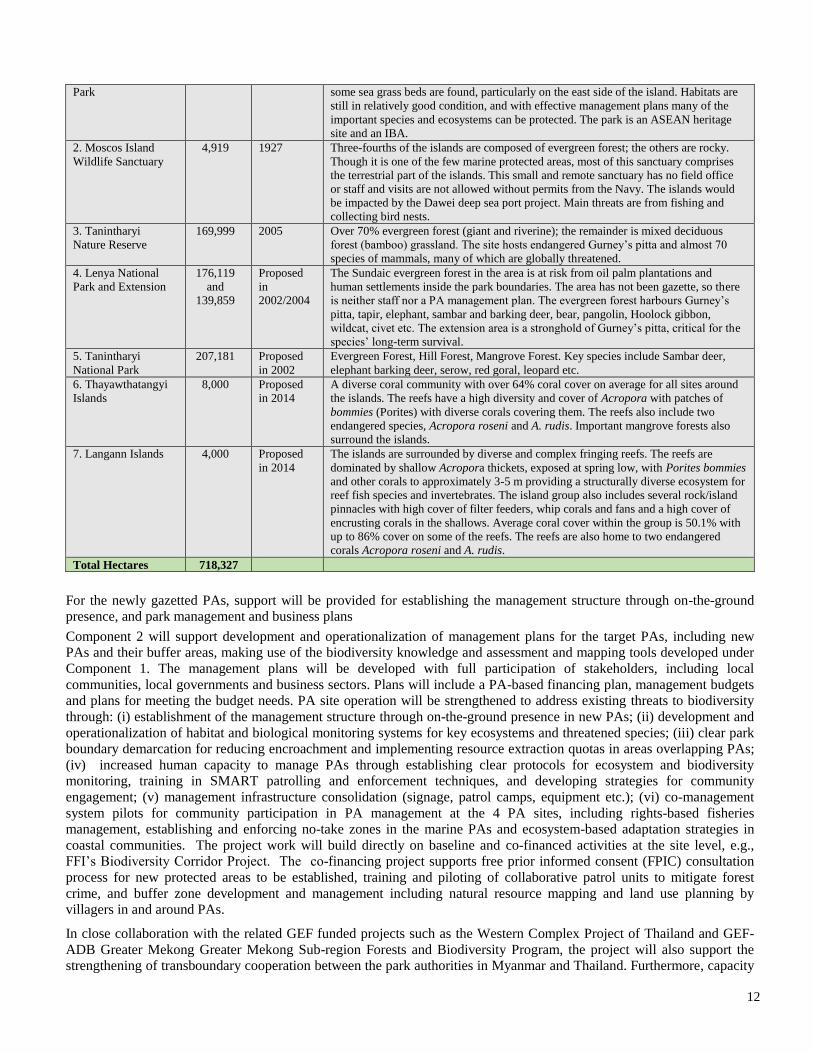
12
Park some sea grass beds are found, particularly on the east side of the island. Habitats are
still in relatively good condition, and with effective management plans many of the
important species and ecosystems can be protected. The park is an ASEAN heritage
site and an IBA.
2. Moscos Island
Wildlife Sanctuary
4,919 1927 Three-fourths of the islands are composed of evergreen forest; the others are rocky.
Though it is one of the few marine protected areas, most of this sanctuary comprises
the terrestrial part of the islands. This small and remote sanctuary has no field office
or staff and visits are not allowed without permits from the Navy. The islands would
be impacted by the Dawei deep sea port project. Main threats are from fishing and
collecting bird nests.
3. Tanintharyi
Nature Reserve
169,999 2005 Over 70% evergreen forest (giant and riverine); the remainder is mixed deciduous
forest (bamboo) grassland. The site hosts endangered Gurney’s pitta and almost 70
species of mammals, many of which are globally threatened.
4. Lenya National
Park and Extension
176,119
and
139,859
Proposed
in
2002/2004
The Sundaic evergreen forest in the area is at risk from oil palm plantations and
human settlements inside the park boundaries. The area has not been gazette, so there
is neither staff nor a PA management plan. The evergreen forest harbours Gurney’s
pitta, tapir, elephant, sambar and barking deer, bear, pangolin, Hoolock gibbon,
wildcat, civet etc. The extension area is a stronghold of Gurney’s pitta, critical for the
species’ long-term survival.
5. Tanintharyi
National Park
207,181 Proposed
in 2002
Evergreen Forest, Hill Forest, Mangrove Forest. Key species include Sambar deer,
elephant barking deer, serow, red goral, leopard etc.
6. Thayawthatangyi
Islands
8,000 Proposed
in 2014
A diverse coral community with over 64% coral cover on average for all sites around
the islands. The reefs have a high diversity and cover of Acropora with patches of
bommies (Porites) with diverse corals covering them. The reefs also include two
endangered species, Acropora roseni and A. rudis. Important mangrove forests also
surround the islands.
7. Langann Islands 4,000 Proposed
in 2014
The islands are surrounded by diverse and complex fringing reefs. The reefs are
dominated by shallow Acropora thickets, exposed at spring low, with Porites bommies
and other corals to approximately 3-5 m providing a structurally diverse ecosystem for
reef fish species and invertebrates. The island group also includes several rock/island
pinnacles with high cover of filter feeders, whip corals and fans and a high cover of
encrusting corals in the shallows. Average coral cover within the group is 50.1% with
up to 86% cover on some of the reefs. The reefs are also home to two endangered
corals Acropora roseni and A. rudis.
Total Hectares 718,327
For the newly gazetted PAs, support will be provided for establishing the management structure through on-the-ground
presence, and park management and business plans
Component 2 will support development and operationalization of management plans for the target PAs, including new
PAs and their buffer areas, making use of the biodiversity knowledge and assessment and mapping tools developed under
Component 1. The management plans will be developed with full participation of stakeholders, including local
communities, local governments and business sectors. Plans will include a PA-based financing plan, management budgets
and plans for meeting the budget needs. PA site operation will be strengthened to address existing threats to biodiversity
through: (i) establishment of the management structure through on-the-ground presence in new PAs; (ii) development and
operationalization of habitat and biological monitoring systems for key ecosystems and threatened species; (iii) clear park
boundary demarcation for reducing encroachment and implementing resource extraction quotas in areas overlapping PAs;
(iv) increased human capacity to manage PAs through establishing clear protocols for ecosystem and biodiversity
monitoring, training in SMART patrolling and enforcement techniques, and developing strategies for community
engagement; (v) management infrastructure consolidation (signage, patrol camps, equipment etc.); (vi) co-management
system pilots for community participation in PA management at the 4 PA sites, including rights-based fisheries
management, establishing and enforcing no-take zones in the marine PAs and ecosystem-based adaptation strategies in
coastal communities. The project work will build directly on baseline and co-financed activities at the site level, e.g.,
FFI’s Biodiversity Corridor Project. The co-financing project supports free prior informed consent (FPIC) consultation
process for new protected areas to be established, training and piloting of collaborative patrol units to mitigate forest
crime, and buffer zone development and management including natural resource mapping and land use planning by
villagers in and around PAs.
In close collaboration with the related GEF funded projects such as the Western Complex Project of Thailand and GEF-
ADB Greater Mekong Greater Mekong Sub-region Forests and Biodiversity Program, the project will also support the
strengthening of transboundary cooperation between the park authorities in Myanmar and Thailand. Furthermore, capacity
13
building of communities within the KBAs, buffer zones, and corridors, will be built to improve biodiversity resource
management. Based on the thorough on-the-ground investigation, including threat and social analysis, capacity
development measures that include livelihood support will be designed. The target communities could include ex-refugees,
ex-soldiers and internal displaced people in the region. Management oriented research projects (e.g. human-elephant
conflict, aquaculture, agriculture, poaching, and PA encroachment) will be designed, with co-financing, to address
conservation challenges specific to the PAs and will be implemented in partnership with PA staff and community
members. Project experience provides an opportunity for on-the-job training and mentoring.
Component 3: Emplacement of the National Biodiversity Survey (NBS) framework
This component focuses on removing the aforementioned third barrier and targets systemic and institutional capacity
development for generation and application of biodiversity knowledge at both national and local levels. The National
Biodiversity Survey (NBS) framework will be established at the national level as the umbrella for the systematic
biodiversity information management system. In building national and local capacity, a wide range of programmes and
tools developed by the Smithsonian Institution will be utilised, including establishing regional monitoring stations, Marine
GEO, Forest GEO, BMAP, Geospatial Initiative, Encyclopedia of Myanmar Life, and a range of training programs.
Expected outcomes are:
Capacity building strategy for biodiversity knowledge generation and application integrated in the regional and national
development framework and institutionalised in the government’s human resource management strategy.
Increased institutional capacity to collect and analyse biodiversity information/data, and apply them to the conservation
and management of PAs and KBAs, and land use planning, as indicated by the UNDP capacity development scorecard.
Biodiversity information and data will be consolidated through establishment of the NBS framework focusing initially on
the Tanintharyi Range Corridor, coastal wetlands (mangrove and mudflats) and Myeik Archipelago. The NBS will
comprise: (i) replicable, systematic biological assessment protocols and standards for selected critical species, habitats,
and human communities to be deployed across diverse marine and terrestrial landscapes; (ii) baseline data documenting
species richness and distribution (mapping current diversity at the species and genomic levels for key taxonomic groups);
(iii) national biodiversity data repository and web portal—Encyclopedia of Myanmar Life—linked to geospatial tools that
will improve knowledge sharing among diverse stakeholders; (iv) geospatial tools for stakeholders and decision makers to
inform and improve PA management, land use planning, and conservation of biodiversity and ecosystems; and (v) a
framework for establishing and evaluating long-term conservation project outcomes.
Working from detailed capacity needs assessments, the capacity of MOECAF, national and local research institutions and
NGOs will be strengthened for implementation of Convention of Biological Diversity (CBD) in particular in the areas of
biodiversity assessment, biodiversity planning and management for development and poverty alleviation, and utilization of
open standard methods and tools to design, implement and evaluate projects. Training programmes will be established and
institutionalised. These will be linked to human resource management and appropriate incentives for conservation
personnel in Myanmar for biodiversity assessment, management and ridge to reef PA landscape management and
management-oriented research, in collaboration with the Smithsonian Institution and other global training institute of
excellence. Training programmes for the NBS will focus on select MOECAF officials (e.g. GIS technicians, taxonomic
specialists, field rangers, etc.), co-management partners and academic institutes in Myanmar and other stakeholders. Core
Learning Programme modules will be developed and implemented. These could include: (i) smart green infrastructure
planning; (ii) management and leadership; (ii) habitat management; (iv) managing landscapes for wildlife; (v) community
engagement; (vi) resolving human-wildlife conflict; (vii) anti-poaching systems (SMART patrolling); (viii) tracking
management effectiveness through management information systems; and (ix) science-based habitat and wildlife
population monitoring. Modules will be adaptable for different PAs regionally, but also nationally, as appropriate. Up to
30 candidates will be identified for long-term hands-on training for conducting biodiversity assessments, and utilizing
open standard methods and tools to design, implement and evaluate conservation projects. Under this component, SI’s co-
financing project with funding from Helmsley Charitable Trust, will bolster the scientific and technical capacity needed to
support on-going scientific/technical monitoring of PA biodiversity and patterns of change over time.
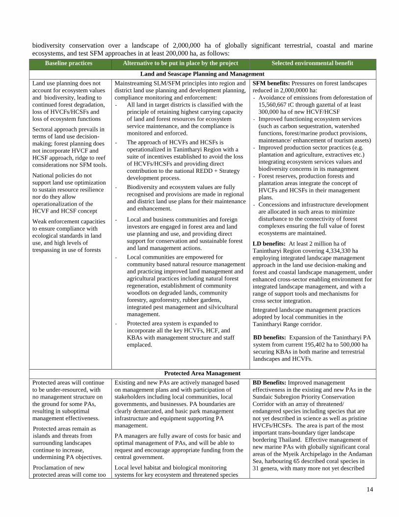
Summary comparison of baseline and alternative scenarios and global environmental benefits
The primary global benefits that will be delivered include adoption of sustainable land management (SLM) and sustainable
forest management (SFM) practices that will reduce land degradation and secure ecosystem services and mainstream
14
biodiversity conservation over a landscape of 2,000,000 ha of globally significant terrestrial, coastal and marine
ecosystems, and test SFM approaches in at least 200,000 ha, as follows:
Baseline practices Alternative to be put in place by the project Selected environmental benefit
Land and Seascape Planning and Management
Land use planning does not
account for ecosystem values
and biodiversity, leading to
continued forest degradation,
loss of HVCFs/HCSFs and
loss of ecosystem functions
Sectoral approach prevails in
terms of land use decision-
making; forest planning does
not incorporate HVCF and
HCSF approach, ridge to reef
considerations nor SFM tools.
National policies do not
support land use optimization
to sustain resource resilience
nor do they allow
operationalization of the
HCVF and HCSF concept
Weak enforcement capacities
to ensure compliance with
ecological standards in land
use, and high levels of
trespassing in use of forests
Mainstreaming SLM/SFM principles into region and
district land use planning and development planning,
compliance monitoring and enforcement:
- All land in target districts is classified with the
principle of retaining highest carrying capacity
of land and forest resources for ecosystem
service maintenance, and the compliance is
monitored and enforced.
- The approach of HCVFs and HCSFs is
operationalized in Tanintharyi Region with a
suite of incentives established to avoid the loss
of HCVFs/HCSFs and providing direct
contribution to the national REDD + Strategy
development process.
- Biodiversity and ecosystem values are fully
recognised and provisions are made in regional
and district land use plans for their maintenance
and enhancement.
- Local and business communities and foreign
investors are engaged in forest area and land
use planning and use, and providing direct
support for conservation and sustainable forest
and land management actions.
- Local communities are empowered for
community based natural resource management
and practicing improved land management and
agricultural practices including natural forest
regeneration, establishment of community
woodlots on degraded lands, community
forestry, agroforestry, rubber gardens,
integrated pest management and silvicultural
management.
- Protected area system is expanded to
incorporate all the key HCVFs, HCF, and
KBAs with management structure and staff
emplaced.
SFM benefits: Pressures on forest landscapes
reduced in 2,000,0000 ha:
- Avoidance of emissions from deforestation of
15,560,667 tC through gazettal of at least
300,000 ha of new HCVF/HCSF
- Improved functioning ecosystem services
(such as carbon sequestration, watershed
functions, forest/marine product provisions,
maintenance/ enhancement of tourism assets)
- Improved production sector practices (e.g.
plantation and agriculture, extractives etc.)
integrating ecosystem services values and
biodiversity concerns in its management
- Forest reserves, production forests and
plantation areas integrate the concept of
HVCFs and HCSFs in their management
plans.
- Concessions and infrastructure development
are allocated in such areas to minimize
disturbance to the connectivity of forest
complexes ensuring the full value of forest
ecosystems are maintained.
LD benefits: At least 2 million ha of
Tanintharyi Region covering 4,334,330 ha
employing integrated landscape management
approach in the land use decision-making and
forest and coastal landscape management, under
enhanced cross-sector enabling environment for
integrated landscape management, and with a
range of support tools and mechanisms for
cross sector integration.
Integrated landscape management practices
adopted by local communities in the
Tanintharyi Range corridor.
BD benefits: Expansion of the Tanintharyi PA
system from current 195,402 ha to 500,000 ha
securing KBAs in both marine and terrestrial
landscapes and HCVFs.
Protected Area Management
Protected areas will continue
to be under-resourced, with
no management structure on
the ground for some PAs,
resulting in suboptimal
management effectiveness.
Protected areas remain as
islands and threats from
surrounding landscapes
continue to increase,
undermining PA objectives.
Proclamation of new
protected areas will come too
Existing and new PAs are actively managed based
on management plans and with participation of
stakeholders including local communities, local
governments, and businesses. PA boundaries are
clearly demarcated, and basic park management
infrastructure and equipment supporting PA
management.
PA managers are fully aware of costs for basic and
optimal management of PAs, and will be able to
request and encourage appropriate funding from the
central government.
Local level habitat and biological monitoring
systems for key ecosystem and threatened species
BD Benefits: Improved management
effectiveness in the existing and new PAs in the
Sundaic Subregion Priority Conservation
Corridor with an array of threatened/
endangered species including species that are
not yet described in science as well as pristine
HVCFs/HCSFs. The area is part of the most
important trans-boundary tiger landscape
bordering Thailand. Effective management of
new marine PAs with globally significant coral
areas of the Myeik Archipelago in the Andaman
Sea, harbouring 65 described coral species in
31 genera, with many more not yet described
15
late after heavy degradation
of the habitats and there are
insufficient resouces and
capacity for properly
managing the areas even after
proclaimation.
are in place, with established protocol for
monitoring based on the SMART patrolling and
enforcement techniques.
Incentives for communities to reduce unsustainable
forest use created through application of various
incentive and support systems, including co-
management, training, alternative livelihood support
schemes such as conservation job creation and high
value non-wood forest product development and
marketing.
species.
Increase or stable numbers of tiger, takin, musk
deer, blue sheep and other selected species
Reduction of threats to biodiversity from
incompatible land use practices in PA
landscapes/seascapes.
SFM Benefits: Emplacement of system for
identification, management and monitoring of
HCVFs, with participation of local
communities for management and monitoring.
Capacity for Application of Biodiversity Knowledge
Gravely low capacity for
ecological surveys in relation
to the country’s size,
abundance of biodiversity and
intense development pressure
will lead to massive loss of
biodiversity resources,
compromising sustainable
development.
Scientific knowledge on
biodiversity and ecosystems
will be confined to an
extremely small number of
individuals and some foreign
scientists, with no systematic
application at policy level and
on the ground.
Accelerated establishment of foundation for
biodiversity stewardship:
- National Biodiversity Survey (NBS) framework is
established at national and local levels, providing
duplicable systematic biological assessment
protocols and standards.
- National biodiversity data repository is established,
resulting in improved knowledge sharing.
- Geospatial tools for stakeholders and decision
makers is available to inform and improve land use
planning.
- Capacity development system for maintenance and
effective use of the NBS system is in place.
BD Benefit: Effective management of the
above mentioned globally significant
biodiversity and habitats in the Tanintharyi
region. Accelerated emplacement of the
framework and capacity which is also applied
to increase effective management of the target
PAs, landscapes/seascapes.
Innovativeness, sustainability and potential for scaling up: The project establishes, for the first time, integrated land
and seascape planning and management in Myanmar, in the area that harbours one of the last biodiversity strongholds in
Asia and where new development pressures are some of the greatest in the region. Support for the integrated approach is
combined with emphasis on capacity development actions and focused on the generation and application of biodiversity
knowledge – the most essential and fundamental capacity needs – with institutional and technical backing of the
Smithsonian Institution.
Project has sustainability and future scale-up actions built in its design. The project, although primarily regional in nature,
incorporates a number of aspects that contribute directly to national level work, increasing sustainability and scalability.
Under the aforementioned 10-year strategy’s programmatic framework (2015-2025), aiming to build the necessary
scientific foundation, the project will support emplacement of systemic and institutional capacity at the national and local
levels with trial application of scientific knowledge for biodiversity stewardship in the country. For example, through
Component 3, the project will establish the National Biodiversity Survey system at the national level, and include its by-
products, e.g. a data repository and web portal integrated with geospatial tools. This work will start primarily at the national
level, addressing the critical gap of NBSAP implementation and essential foundation for improved biodiversity stewardship
and PA management, with initial data population and application work under the NBS focused on Tanintharyi.. This aspect
of the work will also have regional and local level components in terms of capacity building and demonstration of applying
the framework and tools in decision-making for land use planning and management at the regional and local levels. This is
particularly timely as the government is expected to finalise the National Land Use Policy soon.
The project contributes directly to PA system-wide work, again providing good upscaling potential. Under Component 1,
the project will establish integration of key biodiversity areas and HCVFs/HCVFs in the regional PA system and land use
planning and management, which is highly replicable in other regions. It will also introduce ridge to reef approach, which
will be critical in coastal regions such as Taninathryi and Rakhine. By applying this approach at sub-national levels, the
project will help inform development and implementation of national land use policies, which in turn contribute to
sustainable forest management framework at the national level. This directly implements part of the national vision for
16
establishing the 8 priority corridors, and demonstrates tools and approaches for corridor implementation in the country. The
project also takes a systematic approach to tackling threats to key biodiversity areas and improving management
effectiveness of PAs and landscapes, focusing on the Tanintharyi PA system, with a significant portion of Components 1
and 2 providing systemic level interventions. The 10-year programmatic framework includes a component for scaling up
regional experiences to at least three more regions, and the NBS framework will enable these future replications and scale
up activities.
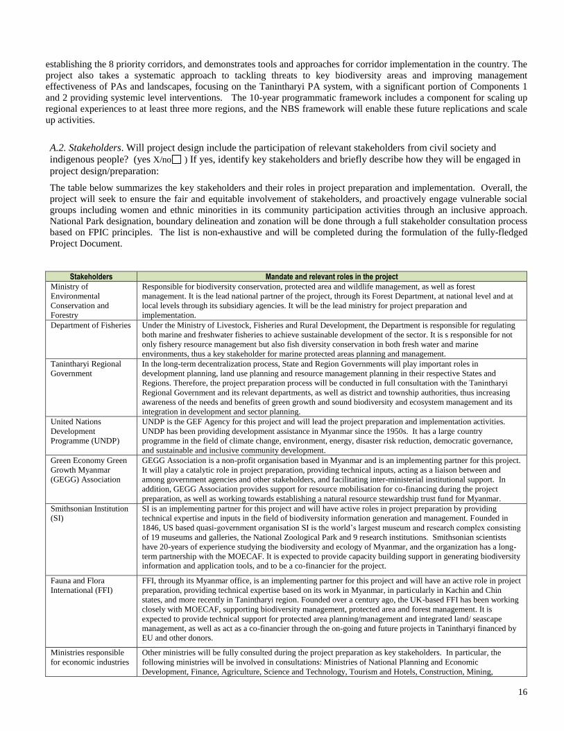
A.2. Stakeholders. Will project design include the participation of relevant stakeholders from civil society and
indigenous people? (yes X/no ) If yes, identify key stakeholders and briefly describe how they will be engaged in
project design/preparation:
The table below summarizes the key stakeholders and their roles in project preparation and implementation. Overall, the
project will seek to ensure the fair and equitable involvement of stakeholders, and proactively engage vulnerable social
groups including women and ethnic minorities in its community participation activities through an inclusive approach.
National Park designation, boundary delineation and zonation will be done through a full stakeholder consultation process
based on FPIC principles. The list is non-exhaustive and will be completed during the formulation of the fully-fledged
Project Document.
Stakeholders Mandate and relevant roles in the project
Ministry of
Environmental
Conservation and
Forestry
Responsible for biodiversity conservation, protected area and wildlife management, as well as forest
management. It is the lead national partner of the project, through its Forest Department, at national level and at
local levels through its subsidiary agencies. It will be the lead ministry for project preparation and
implementation.
Department of Fisheries Under the Ministry of Livestock, Fisheries and Rural Development, the Department is responsible for regulating
both marine and freshwater fisheries to achieve sustainable development of the sector. It is s responsible for not
only fishery resource management but also fish diversity conservation in both fresh water and marine
environments, thus a key stakeholder for marine protected areas planning and management.
Tanintharyi Regional
Government
In the long-term decentralization process, State and Region Governments will play important roles in
development planning, land use planning and resource management planning in their respective States and
Regions. Therefore, the project preparation process will be conducted in full consultation with the Tanintharyi
Regional Government and its relevant departments, as well as district and township authorities, thus increasing
awareness of the needs and benefits of green growth and sound biodiversity and ecosystem management and its
integration in development and sector planning.
United Nations
Development
Programme (UNDP)
UNDP is the GEF Agency for this project and will lead the project preparation and implementation activities.
UNDP has been providing development assistance in Myanmar since the 1950s. It has a large country
programme in the field of climate change, environment, energy, disaster risk reduction, democratic governance,
and sustainable and inclusive community development.
Green Economy Green
Growth Myanmar
(GEGG) Association
GEGG Association is a non-profit organisation based in Myanmar and is an implementing partner for this project.
It will play a catalytic role in project preparation, providing technical inputs, acting as a liaison between and
among government agencies and other stakeholders, and facilitating inter-ministerial institutional support. In
addition, GEGG Association provides support for resource mobilisation for co-financing during the project
preparation, as well as working towards establishing a natural resource stewardship trust fund for Myanmar.
Smithsonian Institution
(SI)
SI is an implementing partner for this project and will have active roles in project preparation by providing
technical expertise and inputs in the field of biodiversity information generation and management. Founded in
1846, US based quasi-government organisation SI is the world’s largest museum and research complex consisting
of 19 museums and galleries, the National Zoological Park and 9 research institutions. Smithsonian scientists
have 20-years of experience studying the biodiversity and ecology of Myanmar, and the organization has a long-
term partnership with the MOECAF. It is expected to provide capacity building support in generating biodiversity information and application tools, and to be a co-financier for the project.
Fauna and Flora
International (FFI)
FFI, through its Myanmar office, is an implementing partner for this project and will have an active role in project
preparation, providing technical expertise based on its work in Myanmar, in particularly in Kachin and Chin
states, and more recently in Tanintharyi region. Founded over a century ago, the UK-based FFI has been working
closely with MOECAF, supporting biodiversity management, protected area and forest management. It is
expected to provide technical support for protected area planning/management and integrated land/ seascape
management, as well as act as a co-financier through the on-going and future projects in Tanintharyi financed by EU and other donors.
Ministries responsible
for economic industries
Other ministries will be fully consulted during the project preparation as key stakeholders. In particular, the
following ministries will be involved in consultations: Ministries of National Planning and Economic
Development, Finance, Agriculture, Science and Technology, Tourism and Hotels, Construction, Mining,
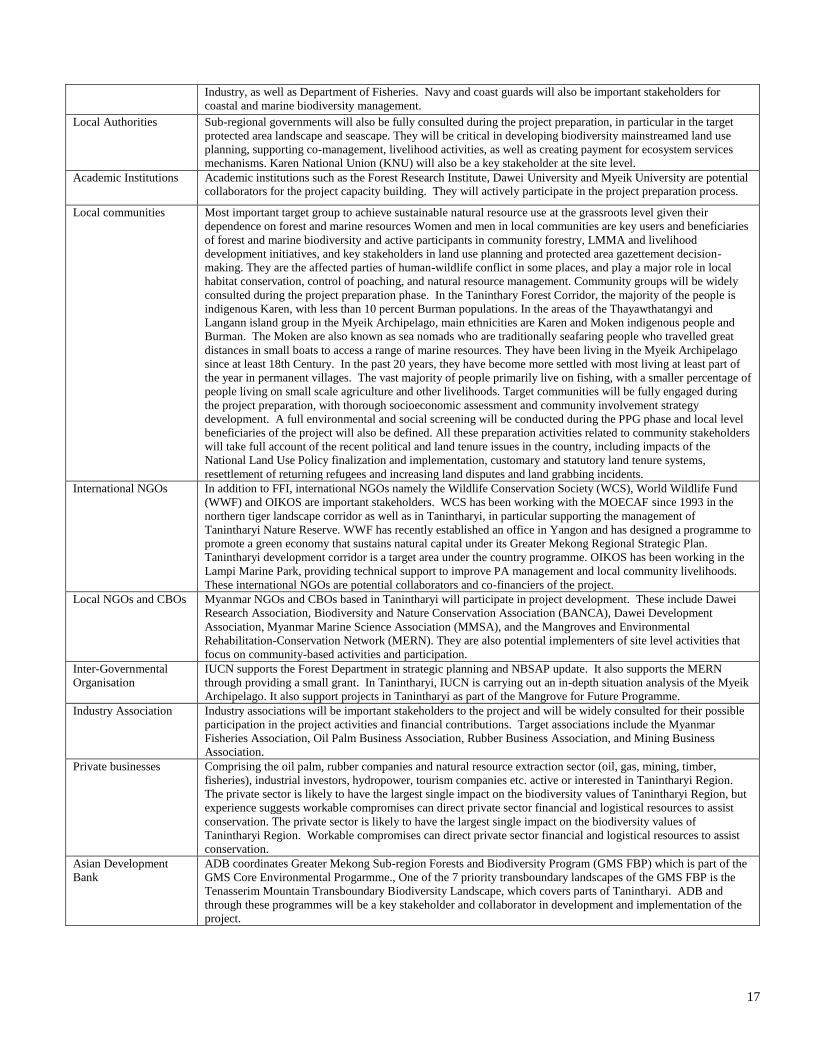
17
Industry, as well as Department of Fisheries. Navy and coast guards will also be important stakeholders for
coastal and marine biodiversity management.
Local Authorities
Sub-regional governments will also be fully consulted during the project preparation, in particular in the target
protected area landscape and seascape. They will be critical in developing biodiversity mainstreamed land use
planning, supporting co-management, livelihood activities, as well as creating payment for ecosystem services
mechanisms. Karen National Union (KNU) will also be a key stakeholder at the site level.
Academic Institutions Academic institutions such as the Forest Research Institute, Dawei University and Myeik University are potential collaborators for the project capacity building. They will actively participate in the project preparation process.
Local communities Most important target group to achieve sustainable natural resource use at the grassroots level given their
dependence on forest and marine resources Women and men in local communities are key users and beneficiaries
of forest and marine biodiversity and active participants in community forestry, LMMA and livelihood
development initiatives, and key stakeholders in land use planning and protected area gazettement decision-
making. They are the affected parties of human-wildlife conflict in some places, and play a major role in local
habitat conservation, control of poaching, and natural resource management. Community groups will be widely
consulted during the project preparation phase. In the Taninthary Forest Corridor, the majority of the people is
indigenous Karen, with less than 10 percent Burman populations. In the areas of the Thayawthatangyi and
Langann island group in the Myeik Archipelago, main ethnicities are Karen and Moken indigenous people and
Burman. The Moken are also known as sea nomads who are traditionally seafaring people who travelled great
distances in small boats to access a range of marine resources. They have been living in the Myeik Archipelago
since at least 18th Century. In the past 20 years, they have become more settled with most living at least part of
the year in permanent villages. The vast majority of people primarily live on fishing, with a smaller percentage of
people living on small scale agriculture and other livelihoods. Target communities will be fully engaged during
the project preparation, with thorough socioeconomic assessment and community involvement strategy
development. A full environmental and social screening will be conducted during the PPG phase and local level
beneficiaries of the project will also be defined. All these preparation activities related to community stakeholders
will take full account of the recent political and land tenure issues in the country, including impacts of the
National Land Use Policy finalization and implementation, customary and statutory land tenure systems,
resettlement of returning refugees and increasing land disputes and land grabbing incidents.
International NGOs In addition to FFI, international NGOs namely the Wildlife Conservation Society (WCS), World Wildlife Fund
(WWF) and OIKOS are important stakeholders. WCS has been working with the MOECAF since 1993 in the
northern tiger landscape corridor as well as in Tanintharyi, in particular supporting the management of
Tanintharyi Nature Reserve. WWF has recently established an office in Yangon and has designed a programme to
promote a green economy that sustains natural capital under its Greater Mekong Regional Strategic Plan.
Tanintharyi development corridor is a target area under the country programme. OIKOS has been working in the
Lampi Marine Park, providing technical support to improve PA management and local community livelihoods.
These international NGOs are potential collaborators and co-financiers of the project.
Local NGOs and CBOs Myanmar NGOs and CBOs based in Tanintharyi will participate in project development. These include Dawei
Research Association, Biodiversity and Nature Conservation Association (BANCA), Dawei Development
Association, Myanmar Marine Science Association (MMSA), and the Mangroves and Environmental
Rehabilitation-Conservation Network (MERN). They are also potential implementers of site level activities that
focus on community-based activities and participation.
Inter-Governmental
Organisation
IUCN supports the Forest Department in strategic planning and NBSAP update. It also supports the MERN
through providing a small grant. In Tanintharyi, IUCN is carrying out an in-depth situation analysis of the Myeik
Archipelago. It also support projects in Tanintharyi as part of the Mangrove for Future Programme.
Industry Association Industry associations will be important stakeholders to the project and will be widely consulted for their possible
participation in the project activities and financial contributions. Target associations include the Myanmar
Fisheries Association, Oil Palm Business Association, Rubber Business Association, and Mining Business
Association.
Private businesses Comprising the oil palm, rubber companies and natural resource extraction sector (oil, gas, mining, timber,
fisheries), industrial investors, hydropower, tourism companies etc. active or interested in Tanintharyi Region.
The private sector is likely to have the largest single impact on the biodiversity values of Tanintharyi Region, but
experience suggests workable compromises can direct private sector financial and logistical resources to assist
conservation. The private sector is likely to have the largest single impact on the biodiversity values of
Tanintharyi Region. Workable compromises can direct private sector financial and logistical resources to assist
conservation.
Asian Development
Bank
ADB coordinates Greater Mekong Sub-region Forests and Biodiversity Program (GMS FBP) which is part of the
GMS Core Environmental Progarmme., One of the 7 priority transboundary landscapes of the GMS FBP is the
Tenasserim Mountain Transboundary Biodiversity Landscape, which covers parts of Tanintharyi. ADB and
through these programmes will be a key stakeholder and collaborator in development and implementation of the
project.
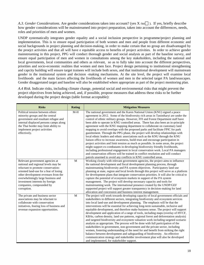
18
A.3. Gender Considerations. Are gender considerations taken into account? (yes X /no ). If yes, briefly describe
how gender considerations will be mainstreamed into project preparation, taken into account the differences, needs,
roles and priorities of men and women.
UNDP systematically integrates gender equality and a social inclusion perspective in programme/project planning and
implementation. This is to ensure equal participation of both women and men and people from different economic and
social backgrounds in project planning and decision-making, in order to make certain that no group are disadvantaged by
the proejct activities and that all will have e equitable access to benefits of project activities. In order to achieve gender
mainstreaming in this project, PPG will conduct thorough gender and social analysis as part of the baseline survey, and
ensure equal participation of men and women in consultations among the key stakeholders, including the national and
local governments, local communities and others as relevant, so as to fully take into account the different perspectives,
priorities and socio-economic realities that women and men face. Project design pertaining to institutional strengthening
and capcity building will ensure target trainees will include both sexes, and that institutional development will mainstream
gender in the institutonal system and decision -making mechanisms. At the site level, the project will examine local
livelihoods and the main factors affecting the livelihoods of women and men in the selected target PA land/seascapes.
Gender disaggretated target and baseline will also be established where appropriate as part of the project monitoring plan.
A.4 Risk. Indicate risks, including climate change, potential social and environmental risks that might prevent the
project objectives from being achieved, and, if possible, propose measures that address these risks to be further
developed during the project design (table format acceptable):
Risks Rating Mitigation Measures
Political tension between ethnic
minority groups and the central
government and resultant refugee and
internal displaced persons camps along
the Thai border may limit ability to
implement project activities
effectively.
M-H The national government and the Karen National Union (KNU) signed a peace
agreement in 2012. Some of the biodiversity rich areas in Tanintharyi are under the
control of ethnic military groups. However, FFI and Forest Department staff have
been able to operate in KNU controlled areas. There has also been an in-principle
agreement with the KNU mapping department to collaborate on customary land
mapping to avoid overlaps with the proposed parks and facilitate FPIC for park
gazettement. Through the PPG phase, the project will develop relationships with
local ethnic leaders and ethnic associations such as the KNU through the KNU
liaison office to increase awareness, build trust and encourage participation in
project activities and limit tension as much as possible. In some areas, the project
might support ex-combatants in developing biodiversity friendly livelihoods,
including professional engagement in local conservation work. Local PA managers
and conservation officers will be trained in conflict resolution and will conduct
patrols unarmed to avoid any conflicts in KNU controlled areas.
Relevant government agencies at
national and regional levels may be
reluctant to promote conservation-
oriented land-use for a fear of losing
other development revenues from the
overwhelmingly large business and
investment interests by foreign
companies, compounded by
corruption.
M Working closely with relevant government agencies, the project aims to influence
the national development and fiscal development planning process, through
mainstreaming biodiversity and PA system objectives. Participatory land use
planning at state, region and local levels through this project will serve as a platform
for development plans that integrate conservation priorities. It will also be critical to
capture the potential of ecosystem markets in support of the PA system
management. The project will develop necessary capacity and tools for
mainstreaming work. The international presence created by the UNDP/GEF
supported project will support greater transparency in decision-making for land
allocation and concession and business interest management.
The private and business sector
associations may be reluctant to
collaborate with conservation
initiatives, fearing loss of business and
revenue expansion opportunities.
M The project will work towards developing capacity of local government officials and
stakeholders in different sectors, integrating biodiversity and ecosystem services
into local land-use and development planning. The emphasis will be that the
interventions will be essential for achieving long-term sustainable, inclusive and
equitable development, and therefore make business sense. The project will support
development and application of a range of tools, including maps (overlay of HVCF,
KBAs, carbon density, land use patterns, regional forest and deforestation analysis)
and targeted biodiversity and ecosystem valuation work including targeted scenario
analysis as appropriate. The process will be done with full participation of the
stakeholders in government, non-government and the private sector, including
women, fostering understanding of the need for and benefit from striking the right
balance between development and safeguarding of biodiversity. An effective
communication strategy and stakeholder involvement plan will also be developed
and implemented, for stakeholder support.
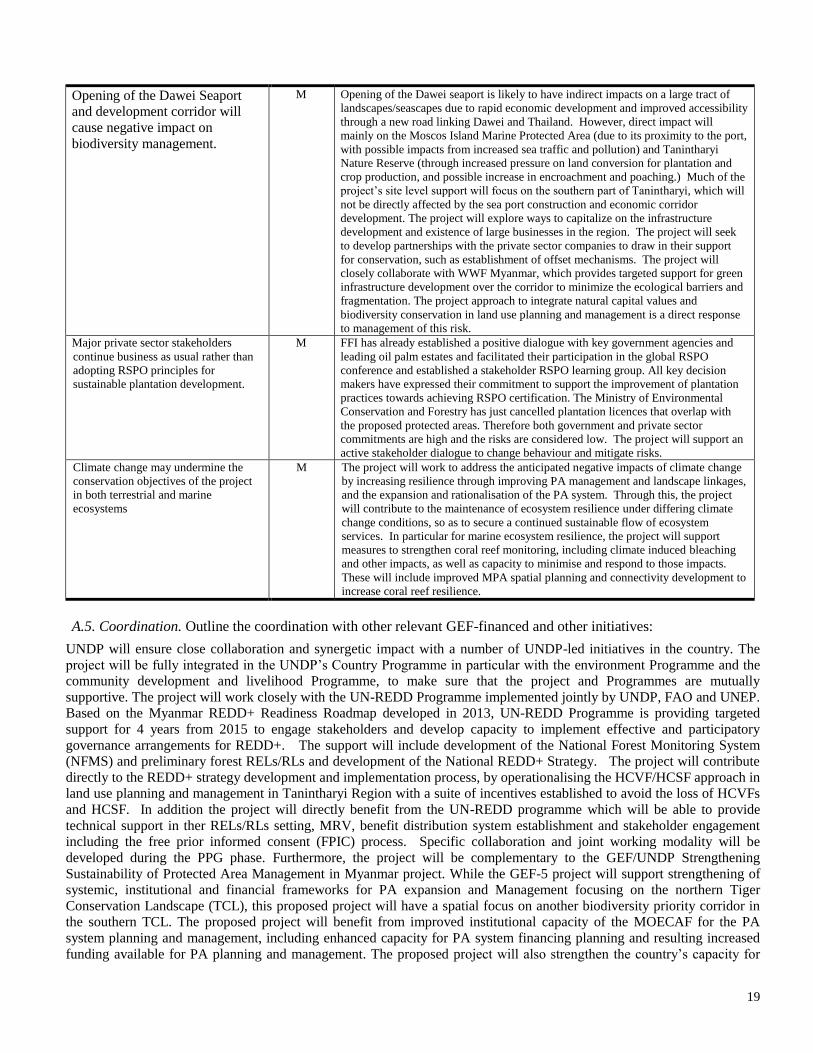
19
Opening of the Dawei Seaport
and development corridor will
cause negative impact on
biodiversity management.
M Opening of the Dawei seaport is likely to have indirect impacts on a large tract of
landscapes/seascapes due to rapid economic development and improved accessibility
through a new road linking Dawei and Thailand. However, direct impact will
mainly on the Moscos Island Marine Protected Area (due to its proximity to the port,
with possible impacts from increased sea traffic and pollution) and Tanintharyi
Nature Reserve (through increased pressure on land conversion for plantation and
crop production, and possible increase in encroachment and poaching.) Much of the
project’s site level support will focus on the southern part of Tanintharyi, which will
not be directly affected by the sea port construction and economic corridor
development. The project will explore ways to capitalize on the infrastructure
development and existence of large businesses in the region. The project will seek
to develop partnerships with the private sector companies to draw in their support
for conservation, such as establishment of offset mechanisms. The project will
closely collaborate with WWF Myanmar, which provides targeted support for green
infrastructure development over the corridor to minimize the ecological barriers and
fragmentation. The project approach to integrate natural capital values and
biodiversity conservation in land use planning and management is a direct response
to management of this risk.
Major private sector stakeholders
continue business as usual rather than
adopting RSPO principles for
sustainable plantation development.
M FFI has already established a positive dialogue with key government agencies and
leading oil palm estates and facilitated their participation in the global RSPO
conference and established a stakeholder RSPO learning group. All key decision
makers have expressed their commitment to support the improvement of plantation
practices towards achieving RSPO certification. The Ministry of Environmental
Conservation and Forestry has just cancelled plantation licences that overlap with
the proposed protected areas. Therefore both government and private sector
commitments are high and the risks are considered low. The project will support an
active stakeholder dialogue to change behaviour and mitigate risks.
Climate change may undermine the
conservation objectives of the project
in both terrestrial and marine
ecosystems
M The project will work to address the anticipated negative impacts of climate change
by increasing resilience through improving PA management and landscape linkages,
and the expansion and rationalisation of the PA system. Through this, the project
will contribute to the maintenance of ecosystem resilience under differing climate
change conditions, so as to secure a continued sustainable flow of ecosystem
services. In particular for marine ecosystem resilience, the project will support
measures to strengthen coral reef monitoring, including climate induced bleaching
and other impacts, as well as capacity to minimise and respond to those impacts.
These will include improved MPA spatial planning and connectivity development to
increase coral reef resilience.
A.5. Coordination. Outline the coordination with other relevant GEF-financed and other initiatives:
UNDP will ensure close collaboration and synergetic impact with a number of UNDP-led initiatives in the country. The
project will be fully integrated in the UNDP’s Country Programme in particular with the environment Programme and the
community development and livelihood Programme, to make sure that the project and Programmes are mutually
supportive. The project will work closely with the UN-REDD Programme implemented jointly by UNDP, FAO and UNEP.
Based on the Myanmar REDD+ Readiness Roadmap developed in 2013, UN-REDD Programme is providing targeted
support for 4 years from 2015 to engage stakeholders and develop capacity to implement effective and participatory
governance arrangements for REDD+. The support will include development of the National Forest Monitoring System
(NFMS) and preliminary forest RELs/RLs and development of the National REDD+ Strategy. The project will contribute
directly to the REDD+ strategy development and implementation process, by operationalising the HCVF/HCSF approach in
land use planning and management in Tanintharyi Region with a suite of incentives established to avoid the loss of HCVFs
and HCSF. In addition the project will directly benefit from the UN-REDD programme which will be able to provide
technical support in ther RELs/RLs setting, MRV, benefit distribution system establishment and stakeholder engagement
including the free prior informed consent (FPIC) process. Specific collaboration and joint working modality will be
developed during the PPG phase. Furthermore, the project will be complementary to the GEF/UNDP Strengthening
Sustainability of Protected Area Management in Myanmar project. While the GEF-5 project will support strengthening of
systemic, institutional and financial frameworks for PA expansion and Management focusing on the northern Tiger
Conservation Landscape (TCL), this proposed project will have a spatial focus on another biodiversity priority corridor in the southern TCL. The proposed project will benefit from improved institutional capacity of the MOECAF for the PA
system planning and management, including enhanced capacity for PA system financing planning and resulting increased
funding available for PA planning and management. The proposed project will also strengthen the country’s capacity for
20
integrated Ridge to Reef planning and management, as well as fast tracking the capacity development for managing and
applying biodiversity information. Some of the two project implementation periods will coincide, and this will enable the
two projects to cross fertilise to generate larger and coordinated impacts. The MOECAF has a steering committee that will
oversee both projects to ensure joint planning and collaboration between the two projects. Furthermore, the Project will
coordinate with the Global Tiger Initiative, through directly contributing to the National Tiger Action Plan. The project will
promote the objectives and recommendations of the NTRP and will work in Myanmar’s southern Tiger Conservation
Landscape. Furthermore, coordination with the Thailand’s Western Forest Complex Project will be assured for the
transboundary collaboration components of the project under component 2. This will be based on the framework for regular
consultation to support trans-boundary conservation between Myanmar and Thailand which has already been established
with support from ITTO. The project will further collaborate with the GEF-ADB Greater Mekong Sub-region Forests and
Biodiversity Program (GMS FBP), given that much of the terrestrial area that is supported by this project fall under
Tenasserim Mountain Transboundary Biodiversity Landscape, which is one of the 7 priority transboundary landscapes of
GMS FBP will provide conducive regional framework for transboundary collaboration, while the proposed project will be
able to provide on the ground support at the site level for transboundary collaboration particularly in law enforcement and
species monitoring. GMS FBP and broader GMS Core Environmental Programme support includes tourism development
with particular focus on Thanintharyi Nature Reserve for pilot, which is expected to directly contribute to output 2.3 by
providing workable examples of community participation in the tourism sector activities, including community based
tourism establishment. WWF Greater Mekong supports tiger restoration and recovery work in the Tenasserium
Lansdascape. WWF implements an innovative conservation approach which is complementary to the propsoed project. It
combines community engagement and behaviorial change with strong law enforcement and robust scientific monitoring of
tiger and tiger prey communities. This approach will be essential in order to ensure an intact tiger landscape with protected
and connected habitats and safeguarded ecosystem values for local communities and the Thai and Myanmar nations. The
project will ensure regular contact with GMS FBP and GMS related sub-projects, and contribution to GMS work through
joint planning of relevant activities and sharing of outputs. The Project will further coordinate with other on-going and
emerging support in Tanintharyi by a range of partners including FFI, WCS, IUCN and WWF, through operationalization
of a joint output and impact monitoring programmatic framework which has already been drafted. Further work to finalise
the programmatic results framework will be carried out during the PPG.
DESCRIPTION OF THE CONSISTENCY OF THE PROJECT WITH:
B.1 Is the project consistent with the National strategies and plans or reports and assessements under relevant conventions?
(yes X /no ). If yes, which ones and how: NAPAs, ASGM NAPs, MIAs, NBSAPs, NCs, TNAs, NCSAs, NIPs, PRSPs,
NPFE, BURs, etc.:
The project will directly support the 2012 Myanmar National Biodiversity Strategy and Action Plan (MNBSAP). More
specifically, it directly supports implementation of three Strategic Directions in the MNBSAP.
Direction 1: Strengthen conservation of Priority Sites including four priorities for intervention: Intervention 1.1
Review and support the expansion of the national protected area system to address gaps in coverage of globally
threatened species and Key Biodiversity Areas; Intervention 1.2 Strengthen protected area management at Priority
Sites; Intervention 1.3 Pilot alternative approaches to formal protected area management at Priority Sites; and
Intervention 1.4 Support strengthening of the legal framework for protected area management and species
conservation.
Direction 2: Mainstream biodiversity into other policy sectors including three priorities for intervention:
Intervention 2.1 Integrate biodiversity into decision-making processes for land-use and development interventions
in the Priority Corridors, Intervention 2.4 Forge partnerships between biodiversity conservation and rural
development initiatives, maximize synergies and mitigate risks; and Intervention 2.5. Cooperate with other
concerned departments to raise awareness of the trade-off between biodiversity conservation and sustainable
development;
Direction 3: Implement focused conservation actions for priority species, in particular Priority Intervention 3.2.
Take range-wide conservation actions for certain widely dispersed priority species, and 3.3 Conduct status
surveys of priority species and 3.4 conduct biodiversity surveys for freshwater taxa and apply results to
conservation planning.
Direction 4: Support local NGOs and academic institutions to engage in biodiversity conservation including
Intervention 4.3 Support the development of conservation curricula at local academic institutions.
21
The project target landscape is recognised under MNBSAP as a top priority corridor containing 12 identified KBAs. In
addition, the high priority conservation corridor identified for the project overlaps with one of the country’s Tiger
Conservation Landscapes (TCL). Project activities will also address all components of the Myanmar National Tiger
Recovery Plan as submitted to the Global Tiger Initiative in June 2010. These activities include:
Landscapes with appropriate extensions and corridors legally protected;
Improved management especially concerning law enforcement in source landscapes;
Monitoring on-going tiger population source landscapes; and
Improved national and trans-boundary cooperation
In addition, the project will contribute to achievement of the Aichi Targets, in particular under the strategic goal B: Reduce
the direct pressures on biodiversity and promote sustainable use, Target 5: the rate of loss of all natural habitats, including
forests, is at least halved and where feasible brought close to zero, and degradation and fragmentation is significantly
reduced; Target 8: reduction of pollution to levels that are not detrimental to ecosystem functions and biodiversity; Target
11: increasing the coverage and connectivity of the PA system in important regions with high biodiversity importance and
significant ecosystem services and by increasing management effectiveness of the PA system in a way that is integrated into
the wider landscapes; Target 12: preventing extinction of known threatened species; Target 14: restoring and safeguarding
essential ecosystem services for securing health, livelihoods and well-being of people; Target 15: enhancing ecosystem
resilience and contribution of biodiversity to carbon stocks through conservation and restoration.
Furthermore, the country’s National Action Programme (NAP) for UNCCD (2005) identifies deforestation as one of the
primary causes of land degradation in Myanmar. Thus it includes a number of actions related to sustainable forest
management and integrated land use planning. The project in particular contributes directly to Action Programme for Key
Issue 6.2 calling for undertaking of an ecological survey, socioeconomic survey and consumption survey in order to have
ecological and socioeconomic data relating to land degradation processes, and the establishment of an information
management system. The project also contributes to implementation of Action Programme for Key Issue 6.3 Institutional
Framework which includes institutional capacity development planning and development of training curricula for forestry
including specialised fields of forest economy, ecological, social, and wildlife and biological management to enhance
capacity. Furthermore, the project provides direct support for the NAP programme: Integration of Environment and
Development into decision making under NAP, aims to integrate environment and development in the national
development and planning process, and to strengthen institutional and legal structures, and participation in international
programmes
22
Part III: approval/endorsement by gef operational focal point(s) and GEF agency(ies)
A. Record of Endorsement9 of GEF Operational Focal Point (S) on Behalf of the Government(s): (Please
attach the Operational Focal Point endorsement letter(s) with this template. For SGP, use this SGP OFP
endorsement letter).
NAME POSITION MINISTRY DATE (MM/dd/yyyy)
Mr. Hla Maung Thein
Deputy Director General,
Environmental
Conservation
Department
Ministry of
Environmental
Conservation and
Forestry
10/17 /2014
B. GEF Agency(ies) Certification
This request has been prepared in accordance with GEF policies10
and procedures and meets the GEF
criteria for project identification and preparation under GEF-6.
Agency
Coordinator,
Agency name
Signature
Date (MM/dd/yyyy)
Project Contact
Person Telephone Email
Adriana Dinu
GEF Executive
Coordinator
UNDP
10/20/2014
Midori Paxton
Regional Technical
Advisor – EBD
UNDP
+66 98 824
7330
midori.paxton@
undp.org
9 For regional and/or global projects in which participating countries are identified, OFP endorsement letters from these countries are required
even though there may not be a STAR allocation associated with the project. 10 GEF policies encompass all managed trust funds, namely: GEFTF, LDCF, and SCCF
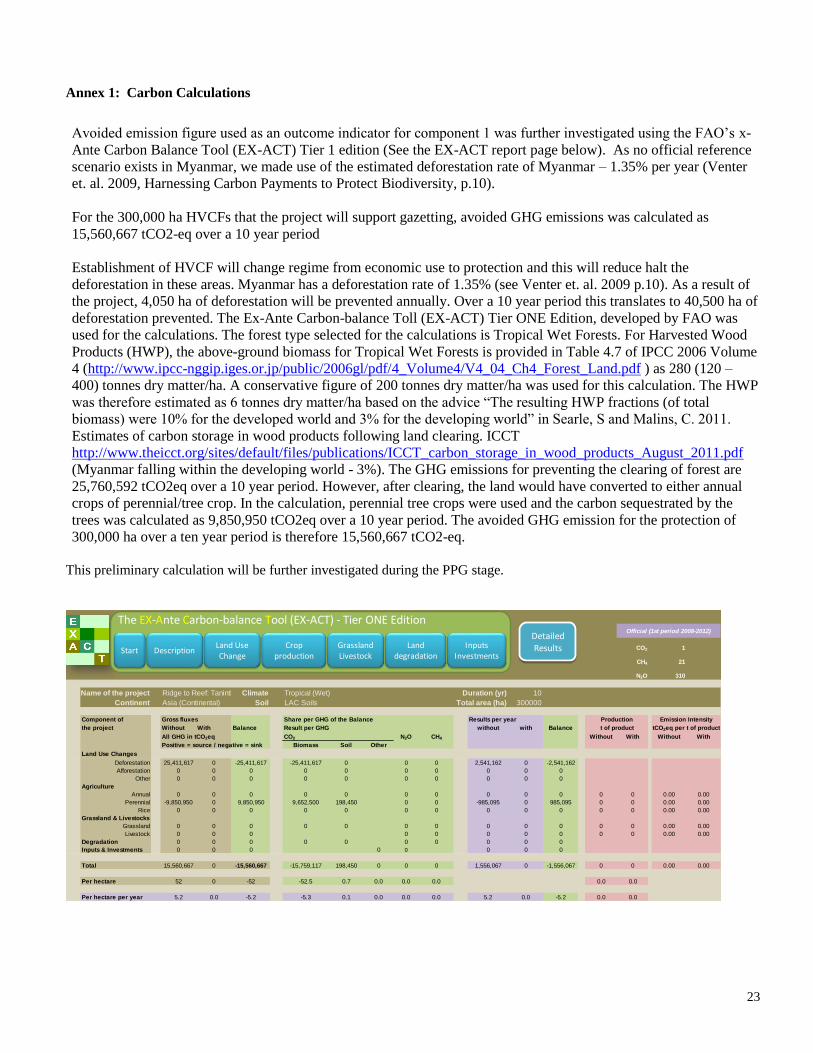
23
Annex 1: Carbon Calculations
Avoided emission figure used as an outcome indicator for component 1 was further investigated using the FAO’s x-
Ante Carbon Balance Tool (EX-ACT) Tier 1 edition (See the EX-ACT report page below). As no official reference
scenario exists in Myanmar, we made use of the estimated deforestation rate of Myanmar – 1.35% per year (Venter
et. al. 2009, Harnessing Carbon Payments to Protect Biodiversity, p.10).
For the 300,000 ha HVCFs that the project will support gazetting, avoided GHG emissions was calculated as
15,560,667 tCO2-eq over a 10 year period
Establishment of HVCF will change regime from economic use to protection and this will reduce halt the
deforestation in these areas. Myanmar has a deforestation rate of 1.35% (see Venter et. al. 2009 p.10). As a result of
the project, 4,050 ha of deforestation will be prevented annually. Over a 10 year period this translates to 40,500 ha of
deforestation prevented. The Ex-Ante Carbon-balance Toll (EX-ACT) Tier ONE Edition, developed by FAO was
used for the calculations. The forest type selected for the calculations is Tropical Wet Forests. For Harvested Wood
Products (HWP), the above-ground biomass for Tropical Wet Forests is provided in Table 4.7 of IPCC 2006 Volume
4 (http://www.ipcc-nggip.iges.or.jp/public/2006gl/pdf/4_Volume4/V4_04_Ch4_Forest_Land.pdf ) as 280 (120 –
400) tonnes dry matter/ha. A conservative figure of 200 tonnes dry matter/ha was used for this calculation. The HWP
was therefore estimated as 6 tonnes dry matter/ha based on the advice “The resulting HWP fractions (of total
biomass) were 10% for the developed world and 3% for the developing world” in Searle, S and Malins, C. 2011.
Estimates of carbon storage in wood products following land clearing. ICCT
http://www.theicct.org/sites/default/files/publications/ICCT_carbon_storage_in_wood_products_August_2011.pdf
(Myanmar falling within the developing world - 3%). The GHG emissions for preventing the clearing of forest are
25,760,592 tCO2eq over a 10 year period. However, after clearing, the land would have converted to either annual
crops of perennial/tree crop. In the calculation, perennial tree crops were used and the carbon sequestrated by the
trees was calculated as 9,850,950 tCO2eq over a 10 year period. The avoided GHG emission for the protection of
300,000 ha over a ten year period is therefore 15,560,667 tCO2-eq.
This preliminary calculation will be further investigated during the PPG stage.
CO2 1
CH4 21
N2O 310
Name of the project Ridge to Reef: TaninthanyieClimate Tropical (Wet) Duration (yr) 10
Continent Asia (Continental) Soil LAC Soils Total area (ha) 300000
Component of Gross fluxes Share per GHG of the Balance Results per year
the project Without With Balance Result per GHG without with Balance
All GHG in tCO2eq CO2 N2O CH4 Without With Without With
Positive = source / negative = sink Biomass Soil Other
Land Use Changes CO2-Biomass CO2-Soil CO2-OtherN2O CH4
Deforestation 25,411,617 0 -25,411,617 -25,411,617 0 0 0 2,541,162 0 -2,541,162
Afforestation 0 0 0 0 0 0 0 0 0 0
Other 0 0 0 0 0 0 0 0 0 0
Agriculture
Annual 0 0 0 0 0 0 0 0 0 0 0 0 0.00 0.00
Perennial -9,850,950 0 9,850,950 9,652,500 198,450 0 0 -985,095 0 985,095 0 0 0.00 0.00
Rice 0 0 0 0 0 0 0 0 0 0 0 0 0.00 0.00
Grassland & Livestocks
Grassland 0 0 0 0 0 0 0 0 0 0 0 0 0.00 0.00
Livestock 0 0 0 0 0 0 0 0 0 0 0.00 0.00
Degradation 0 0 0 0 0 0 0 0 0 0
Inputs & Investments 0 0 0 0 0 0 0 0
Total 15,560,667 0 -15,560,667 -15,759,117 198,450 0 0 0 1,556,067 0 -1,556,067 0 0 0.00 0.00
Per hectare 52 0 -52 -52.5 0.7 0.0 0.0 0.0 0.0 0.0
Per hectare per year 5.2 0.0 -5.2 -5.3 0.1 0.0 0.0 0.0 5.2 0.0 -5.2 0.0 0.0
Production
t of product
Emission Intensity
tCO2eq per t of product
Official (1st period 2008-2012)
The EX-Ante Carbon-balance Tool (EX-ACT) - Tier ONE Edition
Grassland Livestock
Start DescriptionLand Use Change
Crop production
Inputs Investments
DetailedResultsLand
degradation

24
Annex 2: Map of PAs System in Tanintharyi