Embed Size (px)
Citation preview
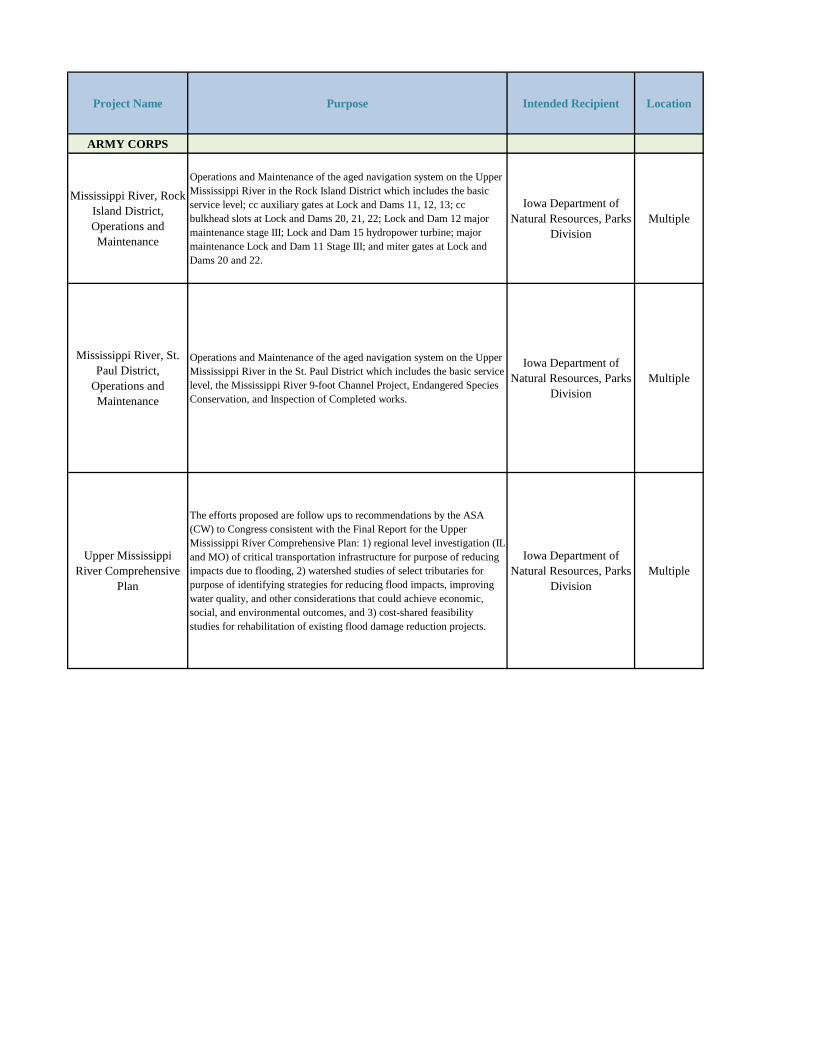
Project Name Purpose Intended Recipient Location
ARMY CORPS
Mississippi River, Rock Island District, Operations and Maintenance
Operations and Maintenance of the aged navigation system on the Upper Mississippi River in the Rock Island District which includes the basic service level; cc auxiliary gates at Lock and Dams 11, 12, 13; cc bulkhead slots at Lock and Dams 20, 21, 22; Lock and Dam 12 major maintenance stage III; Lock and Dam 15 hydropower turbine; major maintenance Lock and Dam 11 Stage III; and miter gates at Lock and Dams 20 and 22.
Iowa Department of Natural Resources, Parks
DivisionMultiple
Mississippi River, St. Paul District,
Operations and Maintenance
Operations and Maintenance of the aged navigation system on the Upper Mississippi River in the St. Paul District which includes the basic service level, the Mississippi River 9-foot Channel Project, Endangered Species Conservation, and Inspection of Completed works.
Iowa Department of Natural Resources, Parks
DivisionMultiple
Upper Mississippi River Comprehensive
Plan
The efforts proposed are follow ups to recommendations by the ASA (CW) to Congress consistent with the Final Report for the Upper Mississippi River Comprehensive Plan: 1) regional level investigation (IL and MO) of critical transportation infrastructure for purpose of reducing impacts due to flooding, 2) watershed studies of select tributaries for purpose of identifying strategies for reducing flood impacts, improving water quality, and other considerations that could achieve economic, social, and environmental outcomes, and 3) cost-shared feasibility studies for rehabilitation of existing flood damage reduction projects.
Iowa Department of Natural Resources, Parks
DivisionMultiple
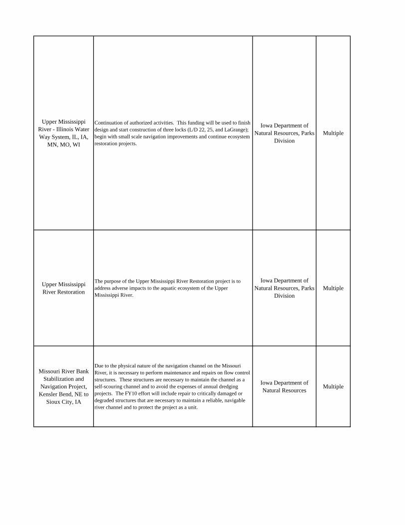
Upper Mississippi River - Illinois Water Way System, IL, IA,
MN, MO, WI
Continuation of authorized activities. This funding will be used to finish design and start construction of three locks (L/D 22, 25, and LaGrange); begin with small scale navigation improvements and continue ecosystem restoration projects.
Iowa Department of Natural Resources, Parks
DivisionMultiple
Upper Mississippi River Restoration
The purpose of the Upper Mississippi River Restoration project is to address adverse impacts to the aquatic ecosystem of the Upper Mississippi River.
Iowa Department of Natural Resources, Parks
DivisionMultiple
Missouri River Bank Stabilization and
Navigation Project, Kensler Bend, NE to
Sioux City, IA
Due to the physical nature of the navigation channel on the Missouri River, it is necessary to perform maintenance and repairs on flow control structures. These structures are necessary to maintain the channel as a self-scouring channel and to avoid the expenses of annual dredging projects. The FY10 effort will include repair to critically damaged or degraded structures that are necessary to maintain a reliable, navigable river channel and to protect the project as a unit.
Iowa Department of Natural Resources
Multiple
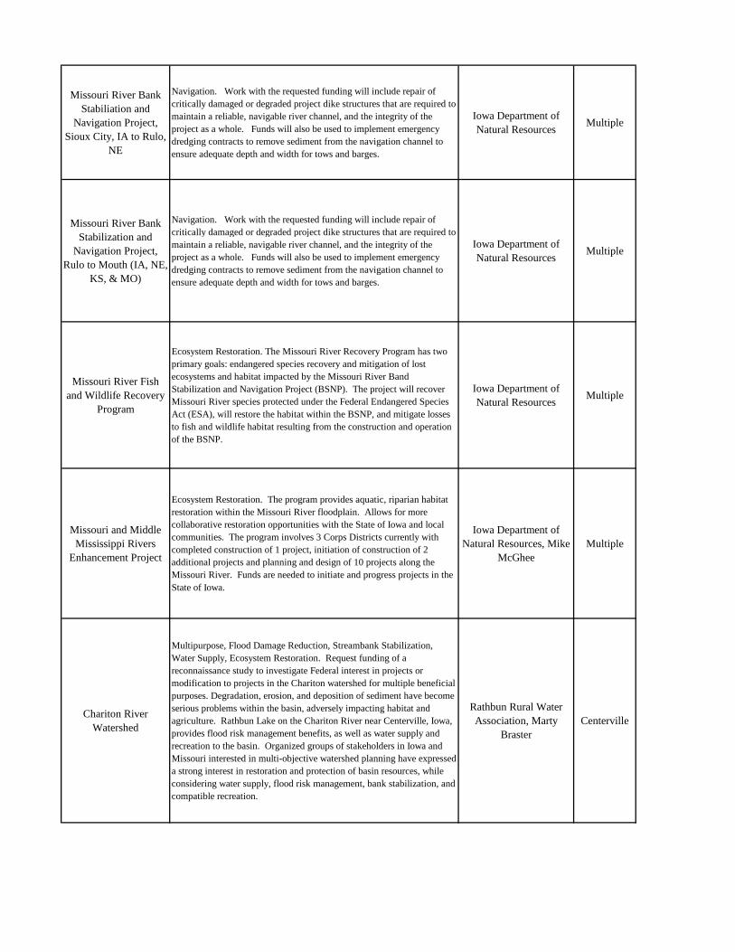
Missouri River Bank Stabiliation and
Navigation Project, Sioux City, IA to Rulo,
NE
Navigation. Work with the requested funding will include repair of critically damaged or degraded project dike structures that are required to maintain a reliable, navigable river channel, and the integrity of the project as a whole. Funds will also be used to implement emergency dredging contracts to remove sediment from the navigation channel to ensure adequate depth and width for tows and barges.
Iowa Department of Natural Resources
Multiple
Missouri River Bank Stabilization and
Navigation Project, Rulo to Mouth (IA, NE,
KS, & MO)
Navigation. Work with the requested funding will include repair of critically damaged or degraded project dike structures that are required to maintain a reliable, navigable river channel, and the integrity of the project as a whole. Funds will also be used to implement emergency dredging contracts to remove sediment from the navigation channel to ensure adequate depth and width for tows and barges.
Iowa Department of Natural Resources
Multiple
Missouri River Fish and Wildlife Recovery
Program
Ecosystem Restoration. The Missouri River Recovery Program has two primary goals: endangered species recovery and mitigation of lost ecosystems and habitat impacted by the Missouri River Band Stabilization and Navigation Project (BSNP). The project will recover Missouri River species protected under the Federal Endangered Species Act (ESA), will restore the habitat within the BSNP, and mitigate losses to fish and wildlife habitat resulting from the construction and operation of the BSNP.
Iowa Department of Natural Resources
Multiple
Missouri and Middle Mississippi Rivers
Enhancement Project
Ecosystem Restoration. The program provides aquatic, riparian habitat restoration within the Missouri River floodplain. Allows for more collaborative restoration opportunities with the State of Iowa and local communities. The program involves 3 Corps Districts currently with completed construction of 1 project, initiation of construction of 2 additional projects and planning and design of 10 projects along the Missouri River. Funds are needed to initiate and progress projects in the State of Iowa.
Iowa Department of Natural Resources, Mike
McGheeMultiple
Chariton River Watershed
Multipurpose, Flood Damage Reduction, Streambank Stabilization, Water Supply, Ecosystem Restoration. Request funding of a reconnaissance study to investigate Federal interest in projects or modification to projects in the Chariton watershed for multiple beneficial purposes. Degradation, erosion, and deposition of sediment have become serious problems within the basin, adversely impacting habitat and agriculture. Rathbun Lake on the Chariton River near Centerville, Iowa, provides flood risk management benefits, as well as water supply and recreation to the basin. Organized groups of stakeholders in Iowa and Missouri interested in multi-objective watershed planning have expressed a strong interest in restoration and protection of basin resources, while considering water supply, flood risk management, bank stabilization, and compatible recreation.
Rathbun Rural Water Association, Marty
BrasterCenterville
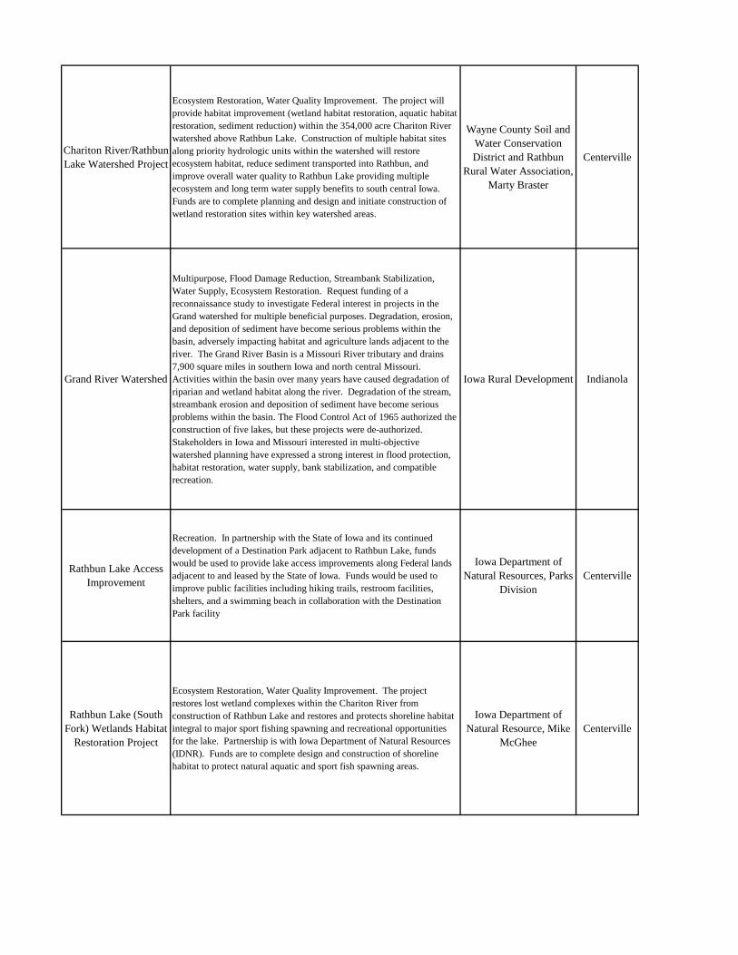
Chariton River/Rathbun Lake Watershed Project
Ecosystem Restoration, Water Quality Improvement. The project will provide habitat improvement (wetland habitat restoration, aquatic habitat restoration, sediment reduction) within the 354,000 acre Chariton River watershed above Rathbun Lake. Construction of multiple habitat sites along priority hydrologic units within the watershed will restore ecosystem habitat, reduce sediment transported into Rathbun, and improve overall water quality to Rathbun Lake providing multiple ecosystem and long term water supply benefits to south central Iowa. Funds are to complete planning and design and initiate construction of wetland restoration sites within key watershed areas.
Wayne County Soil and Water Conservation District and Rathbun
Rural Water Association, Marty Braster
Centerville
Grand River Watershed
Multipurpose, Flood Damage Reduction, Streambank Stabilization, Water Supply, Ecosystem Restoration. Request funding of a reconnaissance study to investigate Federal interest in projects in the Grand watershed for multiple beneficial purposes. Degradation, erosion, and deposition of sediment have become serious problems within the basin, adversely impacting habitat and agriculture lands adjacent to the river. The Grand River Basin is a Missouri River tributary and drains 7,900 square miles in southern Iowa and north central Missouri. Activities within the basin over many years have caused degradation of riparian and wetland habitat along the river. Degradation of the stream, streambank erosion and deposition of sediment have become serious problems within the basin. The Flood Control Act of 1965 authorized the construction of five lakes, but these projects were de-authorized. Stakeholders in Iowa and Missouri interested in multi-objective watershed planning have expressed a strong interest in flood protection, habitat restoration, water supply, bank stabilization, and compatible recreation.
Iowa Rural Development Indianola
Rathbun Lake Access Improvement
Recreation. In partnership with the State of Iowa and its continued development of a Destination Park adjacent to Rathbun Lake, funds would be used to provide lake access improvements along Federal lands adjacent to and leased by the State of Iowa. Funds would be used to improve public facilities including hiking trails, restroom facilities, shelters, and a swimming beach in collaboration with the Destination Park facility
Iowa Department of Natural Resources, Parks
DivisionCenterville
Rathbun Lake (South Fork) Wetlands Habitat
Restoration Project
Ecosystem Restoration, Water Quality Improvement. The project restores lost wetland complexes within the Chariton River from construction of Rathbun Lake and restores and protects shoreline habitat integral to major sport fishing spawning and recreational opportunities for the lake. Partnership is with Iowa Department of Natural Resources (IDNR). Funds are to complete design and construction of shoreline habitat to protect natural aquatic and sport fish spawning areas.
Iowa Department of Natural Resource, Mike
McGheeCenterville
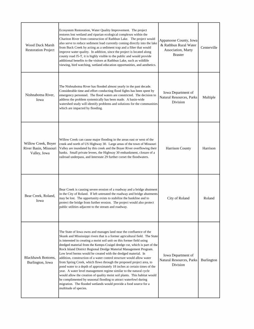
Wood Duck Marsh Restoration Project
Ecosystem Restoration, Water Quality Improvement. The project restores lost wetland and riparian ecological complexes within the Chariton River from construction of Rathbun Lake. The project would also serve to reduce sediment load currently coming directly into the lake from Buck Creek by acting as a sediment trap and a filter that would improve water quality. In addition, since the project is located along county road J5-T, it is highly visible to the public and would provide additional benefits to the visitors at Rathbun Lake, such as wildlife viewing, bird watching, wetland education opportunities, and aesthetics.
Appanoose County, Iowa & Rathbun Rural Water
Association, Marty Braster
Centerville
Nishnabotna River, Iowa
The Nishnabotna River has flooded almost yearly in the past decade. Considerable time and effort conducting flood fights has been spent by emergency personnel. The flood waters are constricted. The decision to address the problem systemically has been made. A basin-wide watershed study will identify problems and solutions for the communities which are impacted by flooding.
Iowa Department of Natural Resources, Parks
DivisionMultiple
Willow Creek, Boyer River Basin, Missouri
Valley, Iowa
Willow Creek can cause major flooding in the areas east or west of the creek and north of US Highway 30. Large areas of the town of Missouri Valley are inundated by this creek and the Boyer River overflowing their banks. Small private levees, the Highway 30 embankment, closure of a railroad underpass, and Interstate 29 further corset the floodwaters.
Harrison County Harrison
Bear Creek, Roland, Iowa
Bear Creek is causing severe erosion of a roadway and a bridge abutment in the City of Roland. If left untreated the roadway and bridge abutments may be lost. The opportunity exists to stabilize the bankline and to protect the bridge from further erosion. The project would also protect public utilities adjacent to the stream and roadway.
City of Roland Roland
Blackhawk Bottoms, Burlington, Iowa
The State of Iowa owns and manages land near the confluence of the Skunk and Mississippi rivers that is a former agricultural field. The State is interested in creating a moist soil unit on this former field using dredged material from the Kemps-Craigel dredge cut, which is part of the Rock Island District Regional Dredge Material Management Program. Low level berms would be created with the dredged material. In addition, construction of a water control structure would allow water from Spring Creek, which flows through the proposed project area, to pond water to a depth of approximately 18 inches at certain times of the year. A water level management regime similar to the natural cycle would allow the creation of quality moist soil plants. This habitat would be complimented by seasonal flooding to attract waterfowl during migration. The flooded wetlands would provide a food source for a multitude of species.
Iowa Department of Natural Resources, Parks
DivisionBurlington
Cedar River, Cedar Rapids, Iowa
This project started as a Section 205 Flood Damage Project, but at the completion of the Initial Assessment it was realized the implementation of the likely flood damage reduction plan would exceed the Section 205 project cap of $7,000,000 Federal Dollars. As a result the project was converted to a General Investigation (GI). During its evaluation of the proposed scope of services, the City of Cedar Rapids determined that other segments of its flood production system failed to meet current FEMA standards. This entire area was severely impacted by the floods of 2008. In response to the extensive flooding the City experienced in June 2008 Time Check Feasibility Study the study area has been expanded to include both sides of the Cedar River within the Cedar Rapids City Limits.
City of Cedar RapidsCedar Rapids
Cedar River Bridge, Cedar County
The Cedar River is causing severe erosion of bridge abutments and roadway (F44) near the Village of Rochester, Iowa. If left untreated the bridge abutments and roadway may be lost resulting in loss of a critical transportation route. The opportunity exists to stabilize the bank line and to protect the abutments and roadway from further erosion. The project would also protect public utilities adjacent to the stream and roadway.
Cedar CountyCedar
County
Clear Creek and Iowa River, Johnson County,
Iowa
This project will restore and enhance wetland, riparian, and stream habitat along and adjacent to the Iowa River and Clear Creek. It will also restore a section of Clear Creek, which has been channelized.
Johnson CountyJohnson County
Coralville Lake and Dam Operations and
Maintenance
Coralville Lake is a multiple purpose project providing primary benefits in flood control and low-flow augmentation and secondary benefits in recreation, fish and wildlife management, forest management, and water quality improvement. Conservation pool is 4,900 acres; and the flood control pool is 24,800 acres with 475,000 acre-feet of storage. The dam is located on the Iowa River just upstream of Iowa City, Iowa. Cumulative damages prevented since the project’s inception in 1958 equals $139,295,000. The project includes 24,591 acres of fee title lands and there are 11 recreation area sites.
Coralville LakeJohnson County
Des Moines and Raccoon Rivers, Des
Moines, Iowa
The City of Des Moines, located in Polk County, Iowa, has several flood-prone streams that traverse the city, including the Des Moines River, Raccoon River, Walnut Creek, and Leetown Creek. The areas adjacent to these streams frequently sustain substantial flood damages. During the Great Flood of 1993, Polk County suffered more than $152,000,000 in flood damages, mostly in the Des Moines metropolitan area. In addition, Des Moines was without water service for more than a week causing the closure of most of the businesses and industry in the city. More than 3,000 properties were inundated. The Birdland Levee was breached in the June 2008 flooding. The City of Des Moines is seeking ways to reduce the potential damage from future floods. The recommended and locally preferred flood damage reduction plan reconstructs 2.6 miles of levee at Birdland Park and Central Place. It also improves the reliability of closure structures in the downtown area and constructs a recreational trail on top of the Birdland Park Levee.
City of Des Moines Des Moines
Des Moines Recreational River and
Greenbelt
Continue development of high priority Greenbelt projects:-Continue construction of Des Moines Riverwalk (including levee and floodwall completion)-Start construction of Fort Dodge bridges and trails-Continue incremental construction of Red Rock Trail 4B-Continue preconstruction engineering and design for Cordova Center
Iowa Department of Natural Resources
Multiple
Des Moines River, Keosauqua, Iowa
The west bank of the Des Moines River is causing severe erosion of Front Street in the Village of Keosauqua. If left untreated the roadway may be lost. The opportunity exists to stabilize the bankline and to protect the roadway from further erosion.
Keosauqua Keosauqua
Duck Creek, Davenport, Iowa
The 42-acre project site, owned by the City of Davenport, is bordered on the east by Fairmount Avenue, on the north by the Iowa Interstate Railroad embankment, on the south by Duck Creek, and on the west by an unnamed tributary.
The proposed project includes three components: wetland, prairie, and stream restoration. The proposed wetland restoration project would expand and improve existing wetland areas within the Duck Creek floodplain and provide improved conditions for submergent and emergent vegetation re-establishment and diversity. Additional benefits would be improvements to water quality through increased nutrient and sediment removal, and improved wildlife habitat. The prairie component would include restoration of native prairie plants to the site. The site would provide a prairie buffer habitat not currently common to the Duck Creek corridor. The stream restoration component includes pool and riffle complexes created by weir placement in Duck Creek, which would slow water flows, provide bankline erosion control, and improve fish habitat. Additional benefits are reduced turbidity and increased oxygenation of the water. The sponsor has indicated an interest in ancillary recreational features such as a bike path spur around the proposed wetland complex and a bridge connecting the spur to the bike path on the south side of Duck Creek, which extends Duck Creek from western Davenport to eastern Bettendorf (about 11 miles in length).
Davenport Davenport
Floodplain Management Services,
Iowa
Funding requested would be used for the following projects:-$37,000 to complete development of flood flow models and risk analyses for floodplains downstream of three flood control reservoirs in Iowa (Red Rock, Saylorville, and Coralville) in Iowa-$50,000 to complete post-2008 flood event updating of the regulated frequency curve and pool elevation frequency estimates for the Des Moines River Basin, Iowa.-$120,000 to complete evaluation of flooding scenarios and emergency planning assistance for urban levee system.
Iowa Department of Natural Resources, Parks
DivisionMultiple
Humboldt, Iowa
The dams at Humboldt and Rutland preclude upstream riverine habitat use by fish and other aquatic resources. This fragmentation and restricted fish movement created by the dams has had an adverse affect to the ecological health of the river system. The two dams block fish from accessing potentially suitable spawning, feeding, resting, and shelter habitats. Further, local tributaries are experiencing bed and bank instability resulting in larger than expected sediment loads. These transported and deposited sediments are negatively impacting aquatic organisms and water quality.
The investigation is evaluating the restoration of degraded aquatic, riparian, and wetland habitats along the West Fork of the Des Moines River and tributaries at Humboldt, Iowa, including fish passage. It will also assess associated recreational issues and evaluate potential for flood risk management measures at the City of Humboldt water supply plant which provides potable water to approximately 4,500 residents and businesses. Large flood events have the potential to inundate the plant and disrupt water supply. Emergency water supply would need to be provided Requested funds would continue feasibility phase and complete Draft Feasibility Report.
City of Humboldt Humboldt
Indian Creek, Cedar Rapids, Iowa
The combined watersheds of Indian Creek and Dry Run Creek have a total drainage area of 77.6 square miles. On June 4, 2001, these watersheds experienced a significant rainfall event. The 24-hour rainfall totals ranged from 4.5 inches to 6.5 inches. Antecedent rainfall brought area streams to near capacity and saturated the soils, thereby magnifying the runoff event and causing an amplified flash flood regime. The June flood caused wide spread damage to both public and private property.
City of Cedar RapidsCedar Rapids
North Raccoon River, Perry, Iowa
Two sewage lagoons, located along the North Raccoon River in Perry, Iowa are being threatened by erosion during high flow periods. The stability of the lagoons and the potential for contamination of the North Raccoon River increases the need for emergency streambank protection at this location. The opportunity exists to stabilize the bankline and to protect the lagoons from further erosion.
City of Perry Perry
North Skunk River, Poweshiek County,
Iowa
A bridge listed on the National Historic Register is threatened by erosion on the North Skunk River. Further erosion will cause failure of the bridge. The North Skunk River is causing severe erosion of a bridge abutment in Poweshiek County. If left untreated the bridge abutment may be lost. The opportunity exists to stabilize the bankline and to protect the bridge from further erosion.
Poweshiek CountyPoweshiek
County
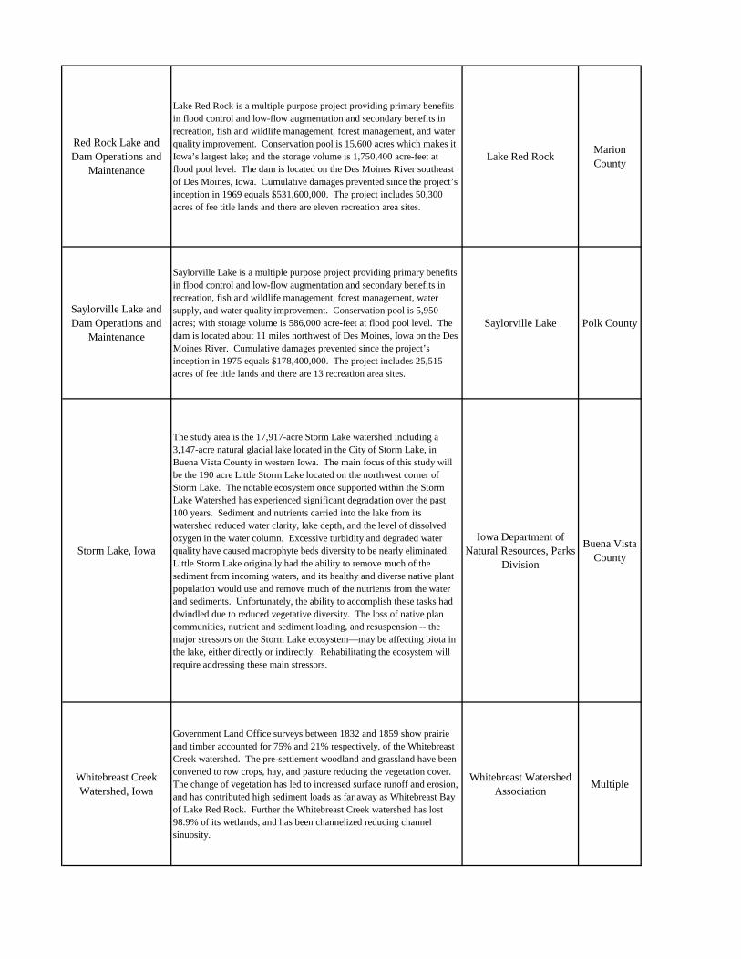
Red Rock Lake and Dam Operations and
Maintenance
Lake Red Rock is a multiple purpose project providing primary benefits in flood control and low-flow augmentation and secondary benefits in recreation, fish and wildlife management, forest management, and water quality improvement. Conservation pool is 15,600 acres which makes it Iowa’s largest lake; and the storage volume is 1,750,400 acre-feet at flood pool level. The dam is located on the Des Moines River southeast of Des Moines, Iowa. Cumulative damages prevented since the project’s inception in 1969 equals $531,600,000. The project includes 50,300 acres of fee title lands and there are eleven recreation area sites.
Lake Red RockMarion County
Saylorville Lake and Dam Operations and
Maintenance
Saylorville Lake is a multiple purpose project providing primary benefits in flood control and low-flow augmentation and secondary benefits in recreation, fish and wildlife management, forest management, water supply, and water quality improvement. Conservation pool is 5,950 acres; with storage volume is 586,000 acre-feet at flood pool level. The dam is located about 11 miles northwest of Des Moines, Iowa on the Des Moines River. Cumulative damages prevented since the project’s inception in 1975 equals $178,400,000. The project includes 25,515 acres of fee title lands and there are 13 recreation area sites.
Saylorville Lake Polk County
Storm Lake, Iowa
The study area is the 17,917-acre Storm Lake watershed including a 3,147-acre natural glacial lake located in the City of Storm Lake, in Buena Vista County in western Iowa. The main focus of this study will be the 190 acre Little Storm Lake located on the northwest corner of Storm Lake. The notable ecosystem once supported within the Storm Lake Watershed has experienced significant degradation over the past 100 years. Sediment and nutrients carried into the lake from its watershed reduced water clarity, lake depth, and the level of dissolved oxygen in the water column. Excessive turbidity and degraded water quality have caused macrophyte beds diversity to be nearly eliminated. Little Storm Lake originally had the ability to remove much of the sediment from incoming waters, and its healthy and diverse native plant population would use and remove much of the nutrients from the water and sediments. Unfortunately, the ability to accomplish these tasks had dwindled due to reduced vegetative diversity. The loss of native plan communities, nutrient and sediment loading, and resuspension -- the major stressors on the Storm Lake ecosystem—may be affecting biota in the lake, either directly or indirectly. Rehabilitating the ecosystem will require addressing these main stressors.
Iowa Department of Natural Resources, Parks
Division
Buena Vista County
Whitebreast Creek Watershed, Iowa
Government Land Office surveys between 1832 and 1859 show prairie and timber accounted for 75% and 21% respectively, of the Whitebreast Creek watershed. The pre-settlement woodland and grassland have been converted to row crops, hay, and pasture reducing the vegetation cover. The change of vegetation has led to increased surface runoff and erosion, and has contributed high sediment loads as far away as Whitebreast Bay of Lake Red Rock. Further the Whitebreast Creek watershed has lost 98.9% of its wetlands, and has been channelized reducing channel sinuosity.
Whitebreast Watershed Association
Multiple
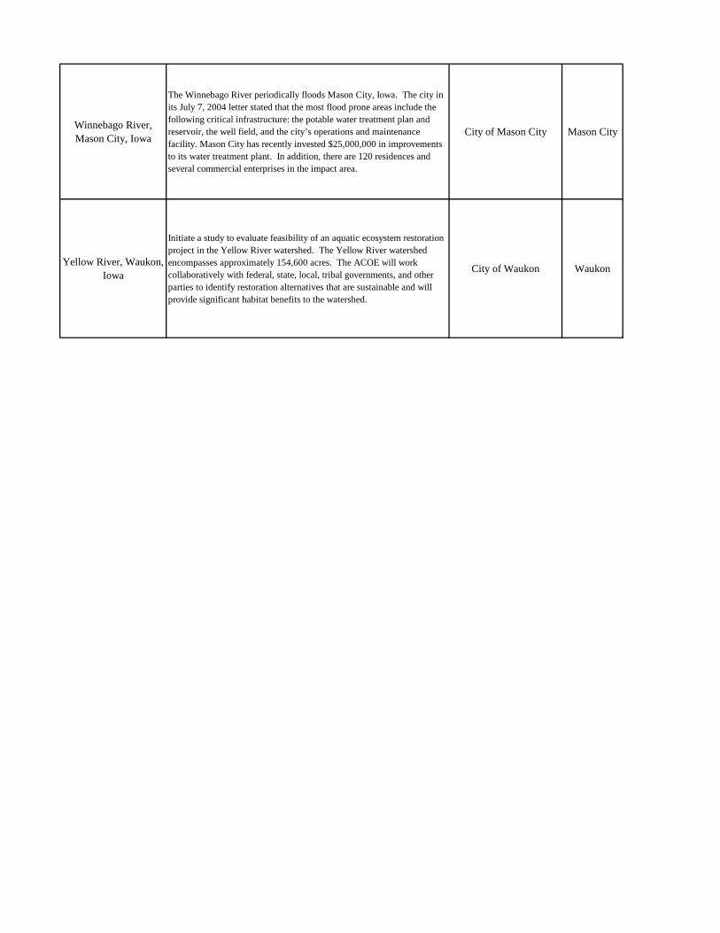
Winnebago River, Mason City, Iowa
The Winnebago River periodically floods Mason City, Iowa. The city in its July 7, 2004 letter stated that the most flood prone areas include the following critical infrastructure: the potable water treatment plan and reservoir, the well field, and the city’s operations and maintenance facility. Mason City has recently invested $25,000,000 in improvements to its water treatment plant. In addition, there are 120 residences and several commercial enterprises in the impact area.
City of Mason City Mason City
Yellow River, Waukon, Iowa
Initiate a study to evaluate feasibility of an aquatic ecosystem restoration project in the Yellow River watershed. The Yellow River watershed encompasses approximately 154,600 acres. The ACOE will work collaboratively with federal, state, local, tribal governments, and other parties to identify restoration alternatives that are sustainable and will provide significant habitat benefits to the watershed.
City of Waukon Waukon
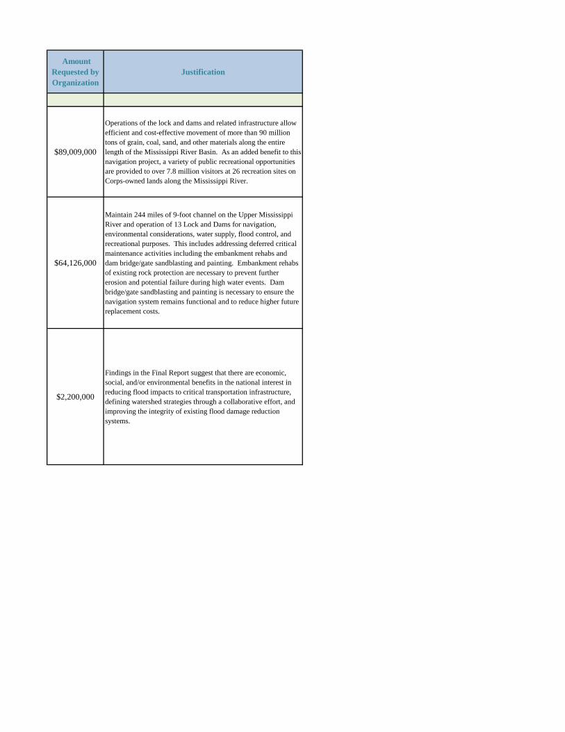
Amount Requested by Organization
Justification
$89,009,000
Operations of the lock and dams and related infrastructure allow efficient and cost-effective movement of more than 90 million tons of grain, coal, sand, and other materials along the entire length of the Mississippi River Basin. As an added benefit to this navigation project, a variety of public recreational opportunities are provided to over 7.8 million visitors at 26 recreation sites on Corps-owned lands along the Mississippi River.
$64,126,000
Maintain 244 miles of 9-foot channel on the Upper Mississippi River and operation of 13 Lock and Dams for navigation, environmental considerations, water supply, flood control, and recreational purposes. This includes addressing deferred critical maintenance activities including the embankment rehabs and dam bridge/gate sandblasting and painting. Embankment rehabs of existing rock protection are necessary to prevent further erosion and potential failure during high water events. Dam bridge/gate sandblasting and painting is necessary to ensure the navigation system remains functional and to reduce higher future replacement costs.
$2,200,000
Findings in the Final Report suggest that there are economic, social, and/or environmental benefits in the national interest in reducing flood impacts to critical transportation infrastructure, defining watershed strategies through a collaborative effort, and improving the integrity of existing flood damage reduction systems.
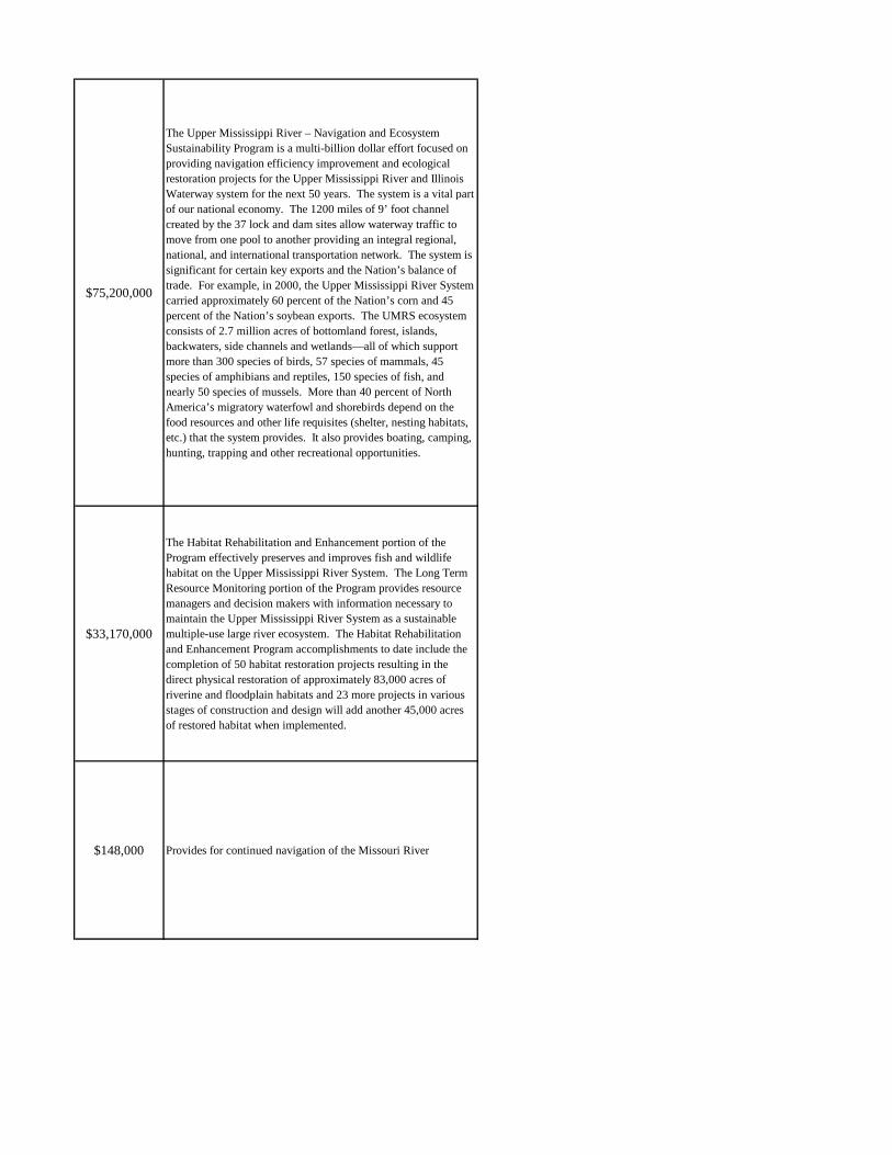
$75,200,000
The Upper Mississippi River – Navigation and Ecosystem Sustainability Program is a multi-billion dollar effort focused on providing navigation efficiency improvement and ecological restoration projects for the Upper Mississippi River and Illinois Waterway system for the next 50 years. The system is a vital part of our national economy. The 1200 miles of 9’ foot channel created by the 37 lock and dam sites allow waterway traffic to move from one pool to another providing an integral regional, national, and international transportation network. The system is significant for certain key exports and the Nation’s balance of trade. For example, in 2000, the Upper Mississippi River System carried approximately 60 percent of the Nation’s corn and 45 percent of the Nation’s soybean exports. The UMRS ecosystem consists of 2.7 million acres of bottomland forest, islands, backwaters, side channels and wetlands—all of which support more than 300 species of birds, 57 species of mammals, 45 species of amphibians and reptiles, 150 species of fish, and nearly 50 species of mussels. More than 40 percent of North America’s migratory waterfowl and shorebirds depend on the food resources and other life requisites (shelter, nesting habitats, etc.) that the system provides. It also provides boating, camping, hunting, trapping and other recreational opportunities.
$33,170,000
The Habitat Rehabilitation and Enhancement portion of the Program effectively preserves and improves fish and wildlife habitat on the Upper Mississippi River System. The Long Term Resource Monitoring portion of the Program provides resource managers and decision makers with information necessary to maintain the Upper Mississippi River System as a sustainable multiple-use large river ecosystem. The Habitat Rehabilitation and Enhancement Program accomplishments to date include the completion of 50 habitat restoration projects resulting in the direct physical restoration of approximately 83,000 acres of riverine and floodplain habitats and 23 more projects in various stages of construction and design will add another 45,000 acres of restored habitat when implemented.
$148,000 Provides for continued navigation of the Missouri River
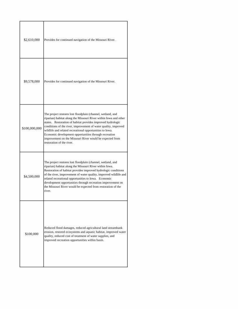
$2,610,000 Provides for continued navigation of the Missouri River.
$9,578,000 Provides for continued navigation of the Missouri River.
$100,000,000
The project restores lost floodplain (channel, wetland, and riparian) habitat along the Missouri River within Iowa and other states. Restoration of habitat provides improved hydrologic conditions of the river, improvement of water quality, improved wildlife and related recreational opportunities to Iowa. Economic development opportunities through recreation improvement on the Missouri River would be expected from restoration of the river.
$4,500,000
The project restores lost floodplain (channel, wetland, and riparian) habitat along the Missouri River within Iowa. Restoration of habitat provides improved hydrologic conditions of the river, improvement of water quality, improved wildlife and related recreational opportunities to Iowa. Economic development opportunities through recreation improvement on the Missouri River would be expected from restoration of the river.
$100,000
Reduced flood damages, reduced agricultural land streambank erosion, restored ecosystems and aquatic habitat, improved water quality, reduced cost of treatment of water supplies, and improved recreation opportunities within basin.
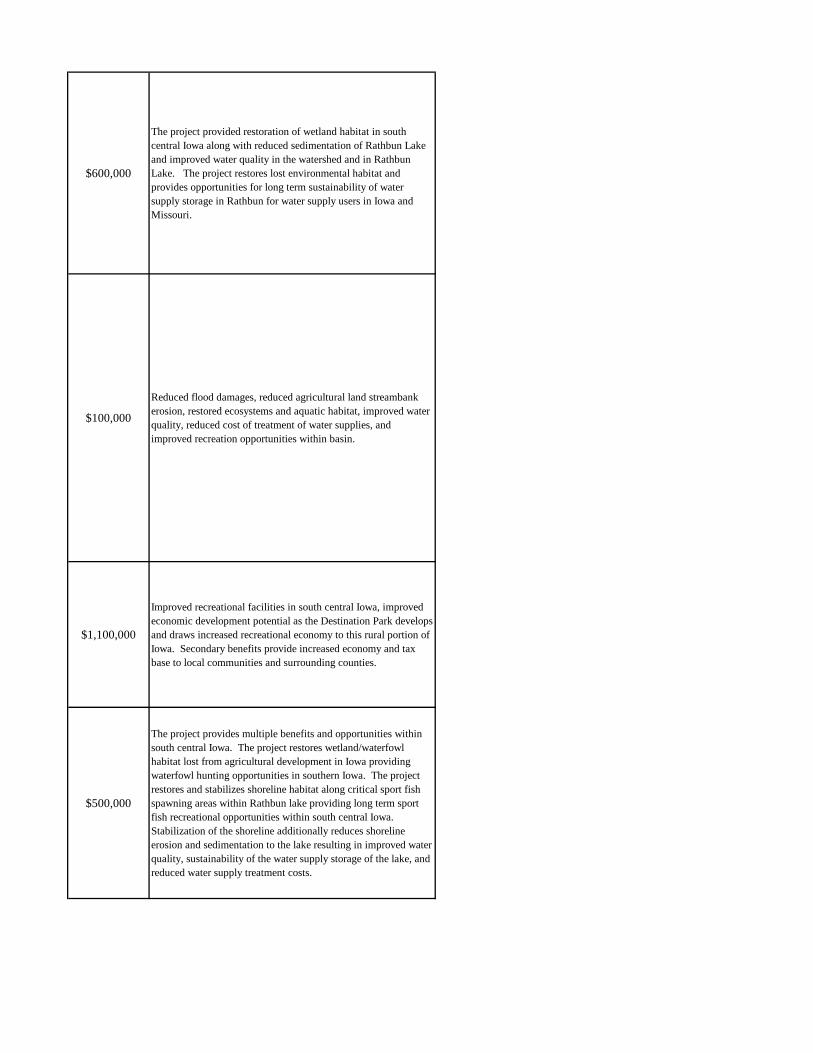
$600,000
The project provided restoration of wetland habitat in south central Iowa along with reduced sedimentation of Rathbun Lake and improved water quality in the watershed and in Rathbun Lake. The project restores lost environmental habitat and provides opportunities for long term sustainability of water supply storage in Rathbun for water supply users in Iowa and Missouri.
$100,000
Reduced flood damages, reduced agricultural land streambank erosion, restored ecosystems and aquatic habitat, improved water quality, reduced cost of treatment of water supplies, and improved recreation opportunities within basin.
$1,100,000
Improved recreational facilities in south central Iowa, improved economic development potential as the Destination Park develops and draws increased recreational economy to this rural portion of Iowa. Secondary benefits provide increased economy and tax base to local communities and surrounding counties.
$500,000
The project provides multiple benefits and opportunities within south central Iowa. The project restores wetland/waterfowl habitat lost from agricultural development in Iowa providing waterfowl hunting opportunities in southern Iowa. The project restores and stabilizes shoreline habitat along critical sport fish spawning areas within Rathbun lake providing long term sport fish recreational opportunities within south central Iowa. Stabilization of the shoreline additionally reduces shoreline erosion and sedimentation to the lake resulting in improved water quality, sustainability of the water supply storage of the lake, and reduced water supply treatment costs.
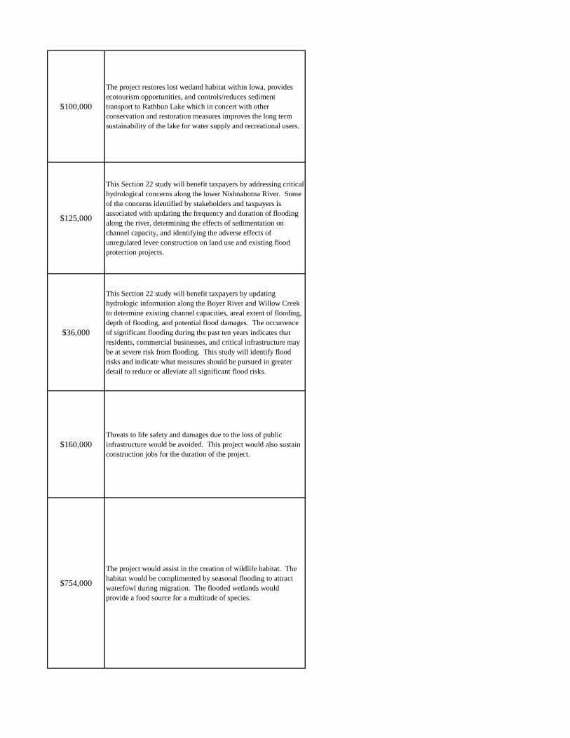
$100,000
The project restores lost wetland habitat within Iowa, provides ecotourism opportunities, and controls/reduces sediment transport to Rathbun Lake which in concert with other conservation and restoration measures improves the long term sustainability of the lake for water supply and recreational users.
$125,000
This Section 22 study will benefit taxpayers by addressing critical hydrological concerns along the lower Nishnabotna River. Some of the concerns identified by stakeholders and taxpayers is associated with updating the frequency and duration of flooding along the river, determining the effects of sedimentation on channel capacity, and identifying the adverse effects of unregulated levee construction on land use and existing flood protection projects.
$36,000
This Section 22 study will benefit taxpayers by updating hydrologic information along the Boyer River and Willow Creek to determine existing channel capacities, areal extent of flooding, depth of flooding, and potential flood damages. The occurrence of significant flooding during the past ten years indicates that residents, commercial businesses, and critical infrastructure may be at severe risk from flooding. This study will identify flood risks and indicate what measures should be pursued in greater detail to reduce or alleviate all significant flood risks.
$160,000 Threats to life safety and damages due to the loss of public infrastructure would be avoided. This project would also sustain construction jobs for the duration of the project.
$754,000
The project would assist in the creation of wildlife habitat. The habitat would be complimented by seasonal flooding to attract waterfowl during migration. The flooded wetlands would provide a food source for a multitude of species.
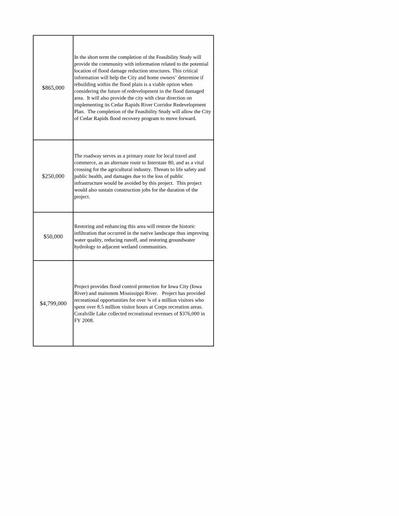
$865,000
In the short term the completion of the Feasibility Study will provide the community with information related to the potential location of flood damage reduction structures. This critical information will help the City and home owners’ determine if rebuilding within the flood plain is a viable option when considering the future of redevelopment in the flood damaged area. It will also provide the city with clear direction on implementing its Cedar Rapids River Corridor Redevelopment Plan. The completion of the Feasibility Study will allow the City of Cedar Rapids flood recovery program to move forward.
$250,000
The roadway serves as a primary route for local travel and commerce, as an alternate route to Interstate 80, and as a vital crossing for the agricultural industry. Threats to life safety and public health, and damages due to the loss of public infrastructure would be avoided by this project. This project would also sustain construction jobs for the duration of the project.
$50,000
Restoring and enhancing this area will restore the historic infiltration that occurred in the native landscape thus improving water quality, reducing runoff, and restoring groundwater hydrology to adjacent wetland communities.
$4,799,000
Project provides flood control protection for Iowa City (Iowa River) and mainstem Mississippi River. Project has provided recreational opportunities for over ¾ of a million visitors who spent over 8.5 million visitor hours at Corps recreation areas. Coralville Lake collected recreational revenues of $376,000 in FY 2008.
$2,700,000
Risks to lives and property would be reduced, and the levee would be certifiable to at least the regulatory 100-year level of protection such that flood insurance rates for flood-prone zones could be avoided. The project will also sustain jobs in the architect-engineer / design field and will sustain construction jobs for the duration of the project.
$14,000,000
In the City of Des Moines, environmental and recreational benefits will be incorporated into a higher and more reliable level of flood protection, thus increasing life safety and decreasing damages to property and structures. Other projects provide primarily environmental and recreational benefits by completing trail networks, providing plantings and enhancing habitat. The project will also sustain jobs in the architect-engineer / design field and will sustain construction jobs for the duration of the project.
$60,000 Threats to life safety and damages due to the loss of public infrastructure would be avoided. This project would also sustain construction jobs for the duration of the project.
$216,000 Improvements to water quality, restoration of native prairie plants to the site, reduced turbidity and increased oxygenation of the water, and improved recreation.
$207,000
The projects would result in an increase in flood forecast accuracy and reservoir flood control operations, and improved emergency flood response to help prevent property damage and reduce the risk to life from damaging floods.
$150,000
Improved fish passage, while improving the ecological integrity and function of the upper Des Moines River, will also provide an ancillary benefit to recreational use of the River. In the absence of flood risk management measures, large flood events have the potential to inundate the water plant and disrupt water supply. Emergency water supply would need to be provided for up to two weeks at tax payers expense.
$424,000
Threats to life safety and public health, and damages due to the loss of public infrastructure would be avoided. This project would also sustain construction jobs for the duration of the project.
$241,000
Threats to life safety and public health, and damages due to the loss of public infrastructure would be avoided. This project would also sustain construction jobs for the duration of the project.
$286,000
The project will help preserve a Nationally Historic bridge from further damage, and possible collapse, during high water events. This project would also sustain construction jobs for the duration of the project.
$6,567,000
Project provides flood control protection for Ottumwa, Iowa and areas downstream of the dam on the Des Moines River and mainstem Mississippi River. Project has provided recreational opportunities for over one million visitors who spent over 8.5 million visitor hours at Corps recreation areas. Lake Red Rock collected recreational revenues of $285,000 in FY 2008.
$7,032,000
Project provides flood control protection for Des Moines, Iowa and areas on the Des Moines River downstream of the dam and mainstem Mississippi River. The project provides recreational opportunities for over one million visitors who spent over 5.4 million visitor hours at Corps recreation areas in FY 2008. Saylorville Lake collected recreational revenues of $508,000 in FY 2008.
$2,172,000 Re-enhancement of a degrading ecosystem in Little Storm Lake. The project will also result in improved water quality and eventual restoration of macrophyte beds.
$50,000
Restoring wetlands to the watershed will improve aquatic habitat. Selected planting and hydrology enhancements will create high quality aquatic habitat. The project was planned for the benefit of native species of mammals, amphibians, fish, birds, and migratory birds consistent with agency management goals.
$300,000
Threats to life safety and public health, and damages due to the loss of public infrastructure would be avoided. This project would also sustain construction jobs for the duration of the project.
$100,000 If federal interest is identified in the study, the project will provide aquatic benefits along the Yellow River in Iowa.


![Army Corps Neg[1]](https://img.pdfslide.net/doc/110x75/577cde9a1a28ab9e78af7164/army-corps-neg1.jpg)