Embed Size (px)
Citation preview
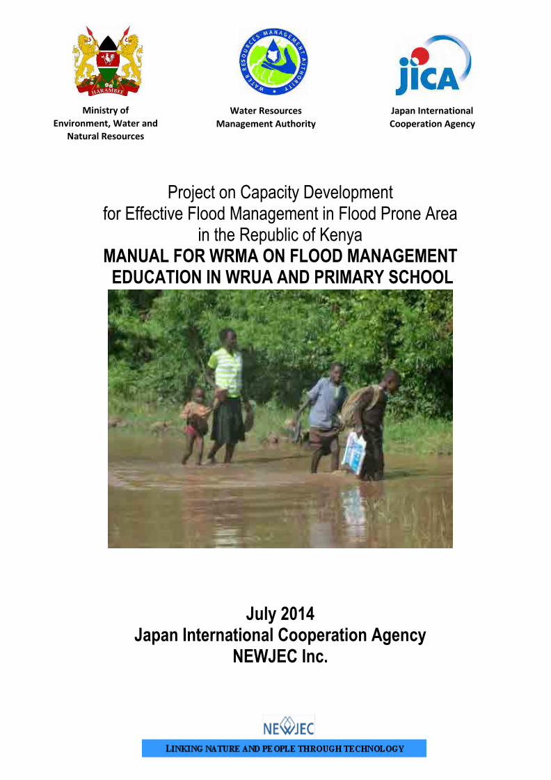
Project on Capacity Development for Effective Flood Management in Flood Prone Area
in the Republic of Kenya MANUAL FOR WRMA ON FLOOD MANAGEMENT EDUCATION IN WRUA AND PRIMARY SCHOOL
July 2014
Japan International Cooperation Agency NEWJEC Inc.
Ministry of Environment, Water and
Natural Resources
Water Resources Management Authority
Japan International Cooperation Agency

Preface
The Government of Kenya established the Water Resources Management
Authority (WRMA), through the sector reform brought by Water Act 2002.
WRMA is the lead agency in the management of water resources in the country
through six (6) regional offices and twenty six (26) sub – regional offices of the
respective water resources catchment areas.
Since its operationalization in 2005, WRMA has made significant progress in
making water resources recognized as being fundamental for socio-economic
and environmental sustainability. In this regard, integrated floods management is viewed as necessary
component in water resources management.
Based on the request from GOK, JICA carried out the “Study on the Integrated Flood Management
(IFM) for Nyando River Basin (2006 – 2009)” as the Technical Cooperation Scheme and “Programme
for Community based Flood Disaster Management to Adapt to Climate Change in the Nyando River
Basin (2009-2011)”. This was a Grant Aid Programme with the aim of establishing a flood
management system in the southern part or Lake Victoria Basin through IFM, where WRMA was the
implementing agency. Through the above projects, community based flood management activities
have been implemented through integrating non- structural and structural measures such as
community based flood hazard mapping and construction of flood counter measure structures in
prioritized flood prone areas.
Based on the achievement of Nyando project, the Project on Capacity Development for Effective
Flood Management was formulated to expand IFM in other flood prone areas in Kenya. Three pilot
river basins were selected namely: Isiolo, Gucha-Migori and Lumi to promote community based flood
management activities. The main purpose of the project was to build institutional framework of flood
management in the context of integrated water resource management for effective and sustainable
implementation of community based activities. Through the project WRMA has developed strategies
and guidelines in managing floods which have since been incorporated in the revised Catchment
Management Strategies (CMS) and WRUA Development Cycle (WDC) manual. In order to develop
capacity of WRMA officers in the field of community-based integrated flood management, a training
system has been developed where the Project conducted IFM Training for WRMA officers who in
turn trained the WRUAs. The Training Materials for community based flood management have been
developed. These include supplemental manuals, lessons learnt and case studies.
Eng. John P. Olum, HSC
Chief Executive Officer, WRMA
i
ACKNOWLEDGEMENT
This booklet acknowledges all who have worked hard to enhance effective flood management in Kenya. It
is imperative therefore to acknowledge the great efforts that have been undertaken in the Nyando River
Basin through the noble assistance from Japan Government and the people wherein Japan Grant Aid
Nyando Project was successfully implemented. During the Nyando Project the Teachers Handbook on
Flood Management and Flood Management Textbook for Primary Pupils were developed and therefore this
booklet has borrowed excerpts, pictures, figures and even text from those to grand books.
This booklet acknowledges the efforts undertaken by Asian Disaster Reduction Centre, we have learnt
much from your efforts.
This booklet also acknowledges that some pages are direct copy of materials that have been produced
before like Chapter 8 is copied word to word from the Trainers’ Training Manual onFlood Disaster
Management for the Project for Building of Communities’ Capacity in Flood Disaster Management (Package
2). Chapter 3, Chapter 4, Chapter 6 and Chapter 7 has borrowed heavily from School Flood Safety
Program: Flood Risk Preparation and Reduction “Teachers Information Booklet 2nd Edition- October 2009”.
While Chapter 5 has borrowed heavily from Flood Disaster Management Textbook for Primary Pupils forThe
Project For Building Of Communities’ Capacity In Flood Disaster Management (Package 3) Under Nyando
Project.
This booklet also acknowledges and appreciates the office of the Nyatike District Education Office that
opened its door wide open and thereby allowing interaction of stakeholders with teachers within Nyatike
Sub-county. This booklet therefore acknowledges the teachers and the school community at large from
Sere Primary School, Agungo Primary School, Nyora Primary School and Kabuto Primary School that
participated actively in the teachers Training on Effective Flood Management in Primary Schools Workshop
and thus contributing immensely to the development of this booklet.
This booklet also acknowledges and appreciates the technical assistance and contribution of JICA Project
Team, WRMA, LOGUMI WRUA and KRCS towards the development of this booklet.
ii
PREAMBLE Floods have been with us since Noah’s time as recorded by the bible in Genesis Chapter 7 and 8. It is imperative therefore to understand floods, to know when they will occur, what to do when they occur and how to recover our daily livelihood after the floods. It is premised on this fact that an excerpt from the Flood Management Textbook for Primary Pupils a book developed under Japan Grant Aid Nyando Project on Flood Management is herein shared with us.
THE NARRATIVE: KODH UHURU Once upon time in the land of Kano Plains in the days of our grandfathers, there was a great year that people of Kano Plains had never ever witnessed before. The short rainy season of that particular great year was great one and the people of Kano Plains had cultivated their farms and they were waiting for a great abundant harvest. The children were happy and there was a lot of dancing by the little girls wearing sisal skirts commonly known as ‘Owalo’ and the boys with their slings were hunting for birds mainly ‘aluru’. Then one day when the boys had gone hunting, they came back with a great catch of their prized game which included new species of birds that have never been seen before by the younger generation. The new species of birds captured were known as Okok and Wiwi. When the old men saw the two birds instead of being happy they became sad and said “Waah! The birds that come with floods are here with us we must prepare otherwise we will lose our harvest.” No one took the old men seriously and therefore nothing was done! The dancing continued and continued in vigour in the Kano Plains. The children were happy and everybody was talking and their conversation centred on how the harvest was going to be great. However the old men were gloomy and sad because they could not do anything on their own because of their age. The old men were indeed very old, as they had seen a lot of things in their lifetime. The old men met and decided that they will ask their grandchildren to take the livestock to their relatives who lived in areas that were raised and were not easy to be affected by floods. When they told the young boys about their plan, the boys were very happy because taking the livestock to the raised lands of Muhoroni and Awasi was an adventure. Therefore the boys obeyed their grandfathers and took the livestock to Awasi which was a day’s journey. On their way back home the boys heard the frogs crocking like they had never ever heard before in their young lives. They were amazed by the crocking noises of the frogs and they started imitating the crocking noise of the frogs “croockocroocko”. Meanwhile the girls in their sisal skirts danced all the way to the river and they too were surprised by the booming noise of the river water as it flowed towards the lake. It was at this exact time that the boys also passed crocking like frogs and the cacophony of the noises of the flowing water and the imitation of crocks by the boys sounded like music to the girls and they danced even the more. Thereafter as the girls were drawing water from the river, one girl told her friends “I think the water in the river is rising!” her friends dismissed her and told her “you have been dancing too much and now the water is dancing in your eyes that is why you think the water in the river is rising.”
iii
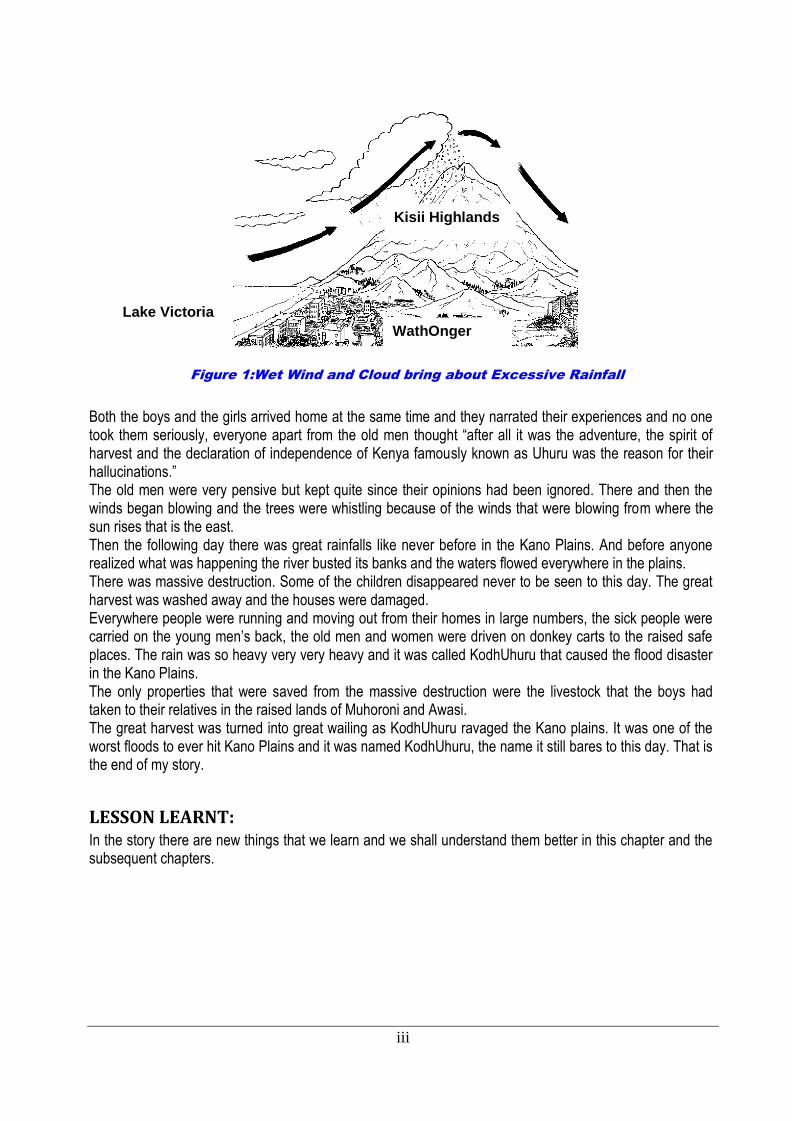
Figure 1:Wet Wind and Cloud bring about Excessive Rainfall
Both the boys and the girls arrived home at the same time and they narrated their experiences and no one took them seriously, everyone apart from the old men thought “after all it was the adventure, the spirit of harvest and the declaration of independence of Kenya famously known as Uhuru was the reason for their hallucinations.” The old men were very pensive but kept quite since their opinions had been ignored. There and then the winds began blowing and the trees were whistling because of the winds that were blowing from where the sun rises that is the east. Then the following day there was great rainfalls like never before in the Kano Plains. And before anyone realized what was happening the river busted its banks and the waters flowed everywhere in the plains. There was massive destruction. Some of the children disappeared never to be seen to this day. The great harvest was washed away and the houses were damaged. Everywhere people were running and moving out from their homes in large numbers, the sick people were carried on the young men’s back, the old men and women were driven on donkey carts to the raised safe places. The rain was so heavy very very heavy and it was called KodhUhuru that caused the flood disaster in the Kano Plains. The only properties that were saved from the massive destruction were the livestock that the boys had taken to their relatives in the raised lands of Muhoroni and Awasi. The great harvest was turned into great wailing as KodhUhuru ravaged the Kano plains. It was one of the worst floods to ever hit Kano Plains and it was named KodhUhuru, the name it still bares to this day. That is the end of my story.
LESSON LEARNT: In the story there are new things that we learn and we shall understand them better in this chapter and the subsequent chapters.
WathOnger
Lake Victoria
Kisii Highlands
iv
TABLEOFCONTENT
INTRODUCTION: OVERVIEW OF THE PROJECT ...................................................................... - 1 -
Chapter1: BACKGROUND OF FLOODS IN THE ARIVER BASIN ........................................... - 4 -
1.1 Definition of floods ................................................................................................ - 4 -
1.2 Terms and vocabulary used in flood management ................................................ - 4 -
1.3 Organizations and Agencies involved in flood management ................................. - 5 -
1.4 Types of floods ..................................................................................................... - 6 -
1.5 Causes of floods .................................................................................................. - 7 -
1.6 Effects of floods .................................................................................................... - 8 -
1.7 History of floods disaster in Nyatike .................................................................... - 12 -
Chapter2: Flood Hazard in the ARiver Basin ........................................................................... - 13 -
2.1 Background of LOGUMI Sub-catchment: Downstream of Gucha Migori River Basin ....
........................................................................................................................... - 13 -
2.2 Floods in Lower Gucha Migori Sub-catchment.................................................... - 13 -
2.3 Floods impact on schools in Lower Gucha Migori Sub-catchment ...................... - 14 -
Chapter 3: Flood Safety Measures at Household Level ....................................................... - 16 -
3.1 Floods Management Components ...................................................................... - 16 -
3.2 Floods Management at Household Level ............................................................ - 16 -
3.3 Pre-flood phase (before floods) – preparedness ................................................. - 16 -
3.4Flooding Phase (during Floods): - response ............................................................... - 18 -
3.5 Post Flood Phase (After Floods): - Recovery ...................................................... - 18 -
Chapter 4: Flood Safety Measures in School ........................................................................... - 19 -
4.1 School flood safety measures ............................................................................. - 19 -
4.2 Safety on the way to school ................................................................................ - 21 -
Chapter 5 - Flood Early Warning System ................................................................................. - 23 -
5.1 What is an early warning system? ...................................................................... - 23 -
5.2 - Whatarefloodwarning andforecasting?................................................................ - 24 -
Chapter 6: Common Diseases during flood season ................................................................. - 25 -
6.1. CAUSES AND TREATMENT FORDIARRHOEA ................................................ - 25 -
6.2. ACUTE DIARRHOEA FOR CHILDREN .............................................................. - 26 -
6.3. FEVER ............................................................................................................... - 28 -
v
CHAPTER 7: SCHOOL FLOOD SAFETY PROGRAM ............................................................ - 30 -
7.1 Assessment ofFloodRiskinschools ..................................................................... - 30 -
7.2Developing School FloodManagementPlan ................................................................ - 33 -
7.3 TeacherorientationonFloodHazards .................................................................... - 36 -
7.4 Student orientationonFloodHazard ..................................................................... - 36 -
7.5 Designing public awareness activities in schools ................................................ - 36 -
Chapter 8: First Aid ............................................................................................................... - 38 -
8.1 Basic First Aid .................................................................................................... - 38 -
8.2. Objectives of first aid .......................................................................................... - 38 -
8.3 Role of First Aides .............................................................................................. - 38 -
8.4 Resuscitation...................................................................................................... - 38 -
8.5 Airway Disorders (Chocking and Drowning) ........................................................ - 39 -
8.6 Bites and Stings ................................................................................................. - 39 -
8.7 Transportation of Victims .................................................................................... - 40 -
8.8 Bleeding and Wounds ........................................................................................ - 41 -
8.9 Foreign Bodies in Eyes, Ears and Nose ............................................................. - 41 -
8.10 Emergency Child Birth ........................................................................................ - 41 -
8.11 Fainting and Shock ............................................................................................. - 42 -
REFERENCE ..................................................................................................................................... 43
- 1 -
INTRODUCTION: OVERVIEW OF THE PROJECT
1. BACKGROUND OF THE PROJECT The Republic of Kenya (hereinafter referred to as “Kenya”) experiences regular nationwide flooding during
rainy season. These floods leads to approximately five thousand (5,000) people to be affected and
causes financial damage of approximately JPY one hundred and sixty million (160,000,000) every year.
In 2003, the southern parts of Lake Victoria Basin including Nyando River Basin were affected by serious
flooding which affected approximately twenty two thousand (22,000) people. In 2007, Garissa town which
is located at the middle Tana River Basin was hit by severer flood and approximately JPY six hundred and
eighty million (680,000,000)financial damage. According to the analysis reported in the fourth assessment
report published by the Inter-governmental Panel on Climate Change (IPCC), it is anticipated that Climate
Change will ultimately lead to generation of more occurrence of flood incidences.
The Government of Kenya (hereinafter referred to as “GOK”) in the sector reforms under the Water Act
2002 established Water Resources Management Authority (WRMA), which is under the Ministry of Water
and Irrigation (MWI). WRMA acts as implementation organization in charge of overall water resource
management of each catchment. WRMA set up is as follows: the headquarter, the six (6) regional
Catchments and the thirty two (32) sub-regional Sub-catchments.
In 2004, WRMA formulated “Integrated Flood Management Policy” focusing on Lake Victoria Basin, which
is one of the areas that suffers from severe flood damages. It was intended to promote Integrated Flood
Management (IFM) to raise awareness of community and strengthen institutional capacity to allow flood
mitigation, prediction and warning. Based on the request from GOK, JICA carried out the “Study on the
Integrated Flood Management for Nyando River Basin (2006 – 2009)” as the Technical Cooperation
Scheme and “Programme for Community based Flood Disaster Management to Adapt to Climate Change
in the Nynado River Basin (2009-2011)” as the Grant Aid Programme with the aim of establishing a flood
management system in the southern part or Lake Victoria Basin through IFM. Through the above projects,
community based flood management activities have been implemented and deployed combining
structural and non-structural measures such as workshops for mapping flood damaged areas and
protection measures for building structures in prioritized communities. Some positive outcomes have
since been realized.
GOK in essence aims to expand these activities, which were implemented in the area of Nyando River
Basin only to other parts of the nation with a purpose to promote community based water resource
management activities including flood management. GOK has been currently working on the
institutionalization of Water Resource User Associations (WRUAs). WRUAs are managed by community
members who are major beneficiary of water resources. A framework therefore has already been
established which enables the WRUAs to receive funds from the Water Service Trust Fund (WSTF)
sourced from technical support, official aid, and donor’s funds. This framework is known as WRUA
Development Cycle (WDC).
GOK plans to utilize WDC framework to deploy nationwide community led activities based on IFM which
integrates outcomes from previous JICA’s projects. However it is considered that GOK requires
assistance in providing appropriate technical advice to relevant entities in IFM including WRUAs. This is
- 2 -
because the previous flood management activities carried out under JICA were not in line with WDC as
well as other frameworks.
Therefore, this Project is expected to strengthen WRMA institutional ability through the capacity
development on basic flood management to promote community based flood management activities
within the WDC framework. This Project known as “The Project for Capacity Development for Effective
Flood Management in Flood Prone Areas (hereinafter referred to as the “Project”) targets to pilot these
activities in three river basins: Gucha Migori; Lumi; and EwasoNg’iro North.
This manual focuses how WRMA staff conducts flood management education to WRUA and school with
utilization of the existing teachers manual in the Lower Gucha-Migori Sub-catchment.
2. BACKGROUND OF THE A RIVER BASIN In this section, topographic aspects, WRMA office and WRUAs, and floods aspects are explained. The Gucha Migori river basin is a vast expansive river basin that consist of two river system i.e. River
Gucha system and R. Migori System. These two rivers merge at a confluence in Sango area in Central
Kadem Location in Nyatike sub-county to become the wide R. Gucha Migori. The river thereafter flows
and pours its water in Lake Victoria. R. Gucha has its source in Nyamira County in the Kisii highlands,
while R. Migori has its source in Narok County specifically in EmuriaDikiri district.
The Gucha Migori river basin falls under the jurisdiction of WRMA-LVSC Southern Shoreline Sub
Regional Office (SRO) as pertaining to the general water resource management inclusive of flood
management. WRMA-LVSC Southern Shoreline in effort to effectively manage this river basin has
collaborated with the community to establish Water Resources Users Association (WRUAs).
There are nine (9) WRUAs in Gucha Migori namely, Lower Gucha Migori (LOGUMI) WRUA, Ongoche
WRUA (Nyatike district), Nyangweta WRUA (Kenyenya district), Middile Gucha WRUA (Gucha district),
Nyarwaba WRUA (Nyamarambe district), Chirichiro WRUA (Masaba district), Nyamache WRUA
(Nyamache district), Kenyamware WRUA (Nyamira district) Upper Migori WRUA (EmuriaDikiri district),
are established within the Gucha Migori river basin. In the flood plain of R. Gucha Migori there is the
LOGUMI WRUA that is located within the Lower Gucha Migori Sub-catchment and implements grass-
roots water management in collaboration with WRMA.
The principal flood damages are destruction of houses, enforcement of long-term evacuation, heavy
losses of crops in the farmlands, contamination of water resources by polluted water diffusion, growing
worse sanitary conditions and impassable roads and longer period of flood water inundation of the
villages within the flood prone areas etc.
3. PURPOSE OF WRMAS’ MANUAL BOOKLET ON FLOOD MANAGEMENT EDUCATION This booklet provides the WRMA staff with basic knowledge on flood, flood hazard, means of protection
and what to do before, during and after floods in WRUA/schools and methods to identify, prepare for and
treat diseases caused by flood water. The oriented WRMA staff can use this booklet as a source of
knowledge to disseminate to WRUA member and school children regarding flood safety measures.
- 3 -
XG Cllt'XG \'dJW IGiii Kll P!wJ1\iliam !M-rn 1..'}'16.\6
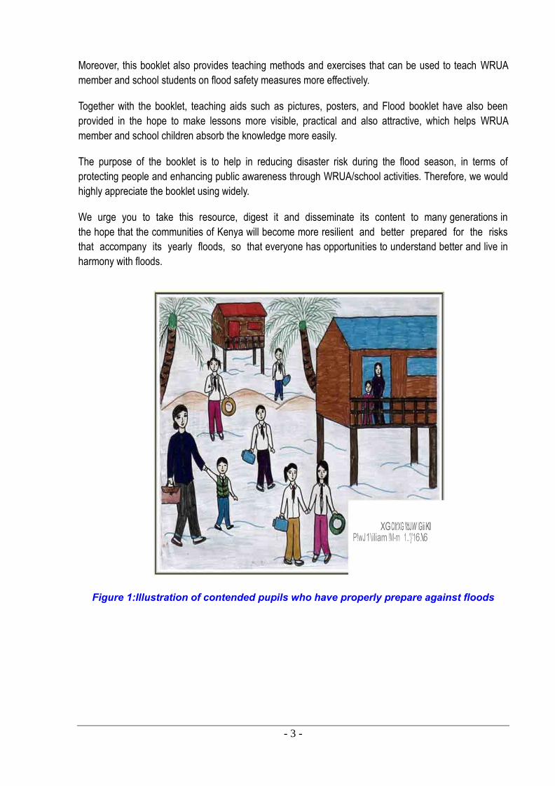
Moreover, this booklet also provides teaching methods and exercises that can be used to teach WRUA
member and school students on flood safety measures more effectively.
Together with the booklet, teaching aids such as pictures, posters, and Flood booklet have also been
provided in the hope to make lessons more visible, practical and also attractive, which helps WRUA
member and school children absorb the knowledge more easily.
The purpose of the booklet is to help in reducing disaster risk during the flood season, in terms of
protecting people and enhancing public awareness through WRUA/school activities. Therefore, we would
highly appreciate the booklet using widely.
We urge you to take this resource, digest it and disseminate its content to many generations in
the hope that the communities of Kenya will become more resilient and better prepared for the risks
that accompany its yearly floods, so that everyone has opportunities to understand better and live in
harmony with floods.
Figure 1:Illustration of contended pupils who have properly prepare against floods
- 4 -
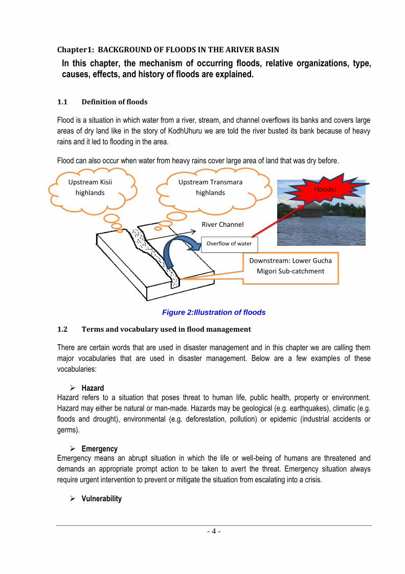
Chapter1: BACKGROUND OF FLOODS IN THE ARIVER BASIN
In this chapter, the mechanism of occurring floods, relative organizations, type, causes, effects, and history of floods are explained.
1.1 Definition of floods
Flood is a situation in which water from a river, stream, and channel overflows its banks and covers large areas of dry land like in the story of KodhUhuru we are told the river busted its bank because of heavy rains and it led to flooding in the area.
Flood can also occur when water from heavy rains cover large area of land that was dry before.
Figure 2:Illustration of floods
1.2 Terms and vocabulary used in flood management
There are certain words that are used in disaster management and in this chapter we are calling them major vocabularies that are used in disaster management. Below are a few examples of these vocabularies:
Hazard Hazard refers to a situation that poses threat to human life, public health, property or environment. Hazard may either be natural or man-made. Hazards may be geological (e.g. earthquakes), climatic (e.g. floods and drought), environmental (e.g. deforestation, pollution) or epidemic (industrial accidents or germs).
Emergency Emergency means an abrupt situation in which the life or well-being of humans are threatened and demands an appropriate prompt action to be taken to avert the threat. Emergency situation always require urgent intervention to prevent or mitigate the situation from escalating into a crisis.
Vulnerability
River Channel
Downstream: Lower Gucha Migori Sub-catchment
Upstream Kisii highlands
Upstream Transmara highlands
Overflow of water
Floods!
- 5 -
Vulnerability is the lack of ability for a person or a community or a structure to protect himself or herself or
itself from damage, injury or harm inflicted by a hazard. There are two types of vulnerability:
a) Structural or physical vulnerability: is the extent to which a structure is likely to be damaged or
disrupted when a hazard occurs. For instance a dyke that is porous and not properly compacted
can easily be destroyed by floods.
b) Human vulnerability: is the relative lack of capacity of a person or community to anticipate, cope
with, resist and recover from the impact of a hazard. For example in Africa if an earthquake
disaster occurs, most homes do not have bunkers and therefore there are no places to hid or run
to and therefore the impact of the earthquake disaster will be severe.
Risk Risk refers to the possibility of a specific hazard to occur and its probable consequences for people,
property and environment. Risk can also mean there are chances that a disaster will occur. There are
places where people go in case a risk occurs. There are vocabularies that are used in disaster
management in case of such occurrence for example
a) Evacuation
This is the process in which affected people move from their homes because of a disaster whether
impending or occurring at the time of disaster and they seek for a safe place to temporally settle.
b) Evacuees
These are people who are moving out of their homes in search of a safe place because of the impending
or occurring disasters.
c) Evacuation Places
This can be a public facility such as a school or a church that is used for emergencies. In Gucha Migori
river basin there are schools that have been identified as evacuation centers in other words during floods
people use them temporarily as their homes while they wait for water to subside in their homes for
example Nyora Primary and Kaburo Primary. When these schools are used as shelter by affected families
then the schools are referred to as evacuation places.
d) Evacuation Routes
These are roads, foot-paths that are normally followed by people as they run away from their homes and
go to places of safety mainly evacuation places.
1.3 Organizations and Agencies involved in flood management
There are various organizations and agencies involved in flood management in Gucha Migori River Basin
and these organizations are known as stakeholders. Therefore the stakeholders in flood management in
Gucha Migori are: Water Resources Management Authority-Lake Victoria South Catchment (WRMA-
LVSC) Southern Shoreline Gucha Migori Office, Water Resources Users Association (WRUA) and
specifically Lower Gucha Migori (LOGUMI) WRUA, Kenya Red Cross Society (KRCS), World Vision,
District Disaster Management Committee (DDMC) specifically Nyatike DDMC, Community-based Flood
- 6 -
River Gucha Migori bursts its banks and its water floods and inundated the homes in Nyora village
Management Organizations (CFMOs) among other stakeholders.Involvement of the stakeholders is
important in order to enhance integrated flood management.
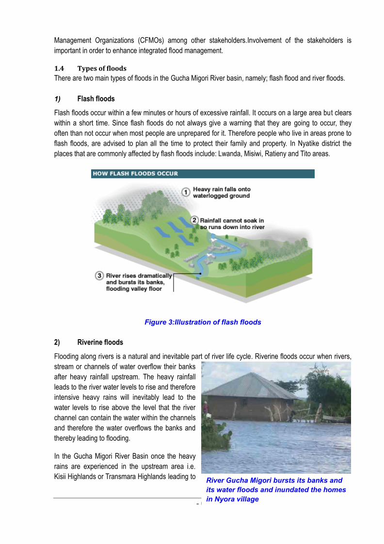
1.4 Types of floods
There are two main types of floods in the Gucha Migori River basin, namely; flash flood and river floods.
1) Flash floods
Flash floods occur within a few minutes or hours of excessive rainfall. It occurs on a large area but clears
within a short time. Since flash floods do not always give a warning that they are going to occur, they
often than not occur when most people are unprepared for it. Therefore people who live in areas prone to
flash floods, are advised to plan all the time to protect their family and property. In Nyatike district the
places that are commonly affected by flash floods include: Lwanda, Misiwi, Ratieny and Tito areas.
Figure 3:Illustration of flash floods
2) Riverine floods
Flooding along rivers is a natural and inevitable part of river life cycle. Riverine floods occur when rivers,
stream or channels of water overflow their banks
after heavy rainfall upstream. The heavy rainfall
leads to the river water levels to rise and therefore
intensive heavy rains will inevitably lead to the
water levels to rise above the level that the river
channel can contain the water within the channels
and therefore the water overflows the banks and
thereby leading to flooding.
In the Gucha Migori River Basin once the heavy
rains are experienced in the upstream area i.e.
Kisii Highlands or Transmara Highlands leading to
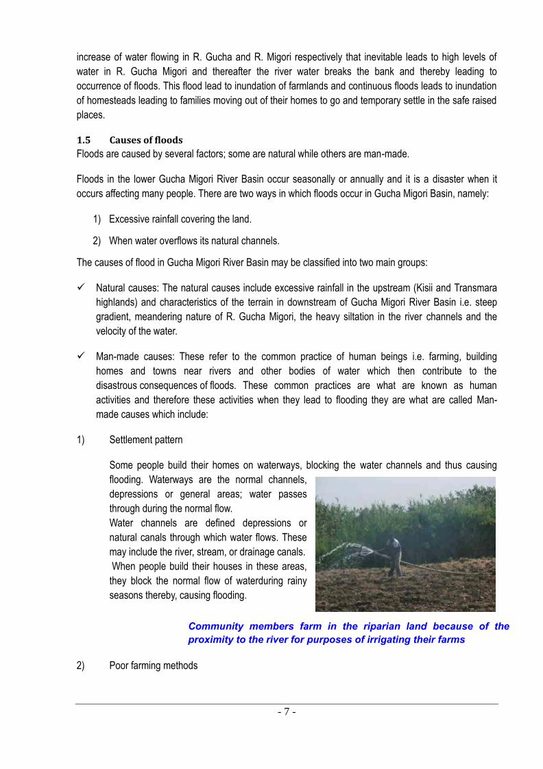
- 7 -
Community members farm in the riparian land because of the proximity to the river for purposes of irrigating their farms
increase of water flowing in R. Gucha and R. Migori respectively that inevitable leads to high levels of
water in R. Gucha Migori and thereafter the river water breaks the bank and thereby leading to
occurrence of floods. This flood lead to inundation of farmlands and continuous floods leads to inundation
of homesteads leading to families moving out of their homes to go and temporary settle in the safe raised
places.
1.5 Causes of floods
Floods are caused by several factors; some are natural while others are man-made.
Floods in the lower Gucha Migori River Basin occur seasonally or annually and it is a disaster when it
occurs affecting many people. There are two ways in which floods occur in Gucha Migori Basin, namely:
1) Excessive rainfall covering the land.
2) When water overflows its natural channels.
The causes of flood in Gucha Migori River Basin may be classified into two main groups:
Natural causes: The natural causes include excessive rainfall in the upstream (Kisii and Transmara
highlands) and characteristics of the terrain in downstream of Gucha Migori River Basin i.e. steep
gradient, meandering nature of R. Gucha Migori, the heavy siltation in the river channels and the
velocity of the water.
Man-made causes: These refer to the common practice of human beings i.e. farming, building
homes and towns near rivers and other bodies of water which then contribute to the
disastrous consequences of floods. These common practices are what are known as human
activities and therefore these activities when they lead to flooding they are what are called Man-
made causes which include:
1) Settlement pattern
Some people build their homes on waterways, blocking the water channels and thus causing
flooding. Waterways are the normal channels,
depressions or general areas; water passes
through during the normal flow.
Water channels are defined depressions or
natural canals through which water flows. These
may include the river, stream, or drainage canals.
When people build their houses in these areas,
they block the normal flow of waterduring rainy
seasons thereby, causing flooding.
2) Poor farming methods
- 8 -
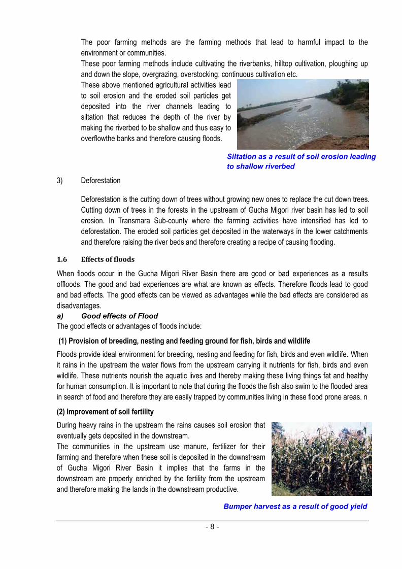
Siltation as a result of soil erosion leading to shallow riverbed
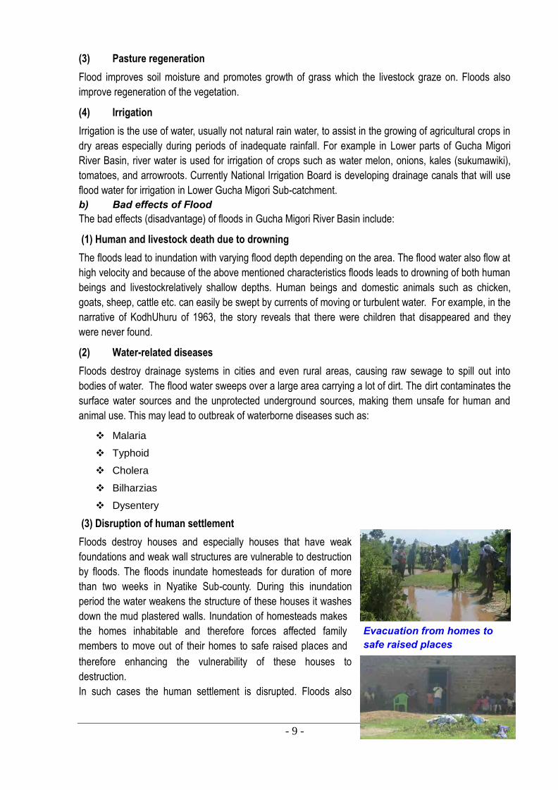
Bumper harvest as a result of good yield
The poor farming methods are the farming methods that lead to harmful impact to the
environment or communities.
These poor farming methods include cultivating the riverbanks, hilltop cultivation, ploughing up
and down the slope, overgrazing, overstocking, continuous cultivation etc.
These above mentioned agricultural activities lead
to soil erosion and the eroded soil particles get
deposited into the river channels leading to
siltation that reduces the depth of the river by
making the riverbed to be shallow and thus easy to
overflowthe banks and therefore causing floods.
3) Deforestation
Deforestation is the cutting down of trees without growing new ones to replace the cut down trees.
Cutting down of trees in the forests in the upstream of Gucha Migori river basin has led to soil
erosion. In Transmara Sub-county where the farming activities have intensified has led to
deforestation. The eroded soil particles get deposited in the waterways in the lower catchments
and therefore raising the river beds and therefore creating a recipe of causing flooding.
1.6 Effects of floods
When floods occur in the Gucha Migori River Basin there are good or bad experiences as a results
offloods. The good and bad experiences are what are known as effects. Therefore floods lead to good
and bad effects. The good effects can be viewed as advantages while the bad effects are considered as
disadvantages.
a) Good effects of Flood The good effects or advantages of floods include:
(1) Provision of breeding, nesting and feeding ground for fish, birds and wildlife
Floods provide ideal environment for breeding, nesting and feeding for fish, birds and even wildlife. When
it rains in the upstream the water flows from the upstream carrying it nutrients for fish, birds and even
wildlife. These nutrients nourish the aquatic lives and thereby making these living things fat and healthy
for human consumption. It is important to note that during the floods the fish also swim to the flooded area
in search of food and therefore they are easily trapped by communities living in these flood prone areas. n
(2) Improvement of soil fertility
During heavy rains in the upstream the rains causes soil erosion that
eventually gets deposited in the downstream.
The communities in the upstream use manure, fertilizer for their
farming and therefore when these soil is deposited in the downstream
of Gucha Migori River Basin it implies that the farms in the
downstream are properly enriched by the fertility from the upstream
and therefore making the lands in the downstream productive.
- 9 -
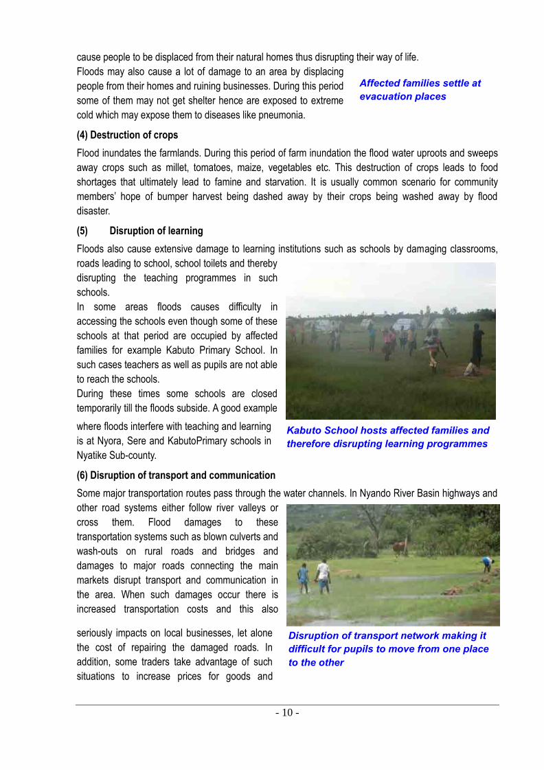
Evacuation from homes to safe raised places
(3) Pasture regeneration
Flood improves soil moisture and promotes growth of grass which the livestock graze on. Floods also
improve regeneration of the vegetation.
(4) Irrigation
Irrigation is the use of water, usually not natural rain water, to assist in the growing of agricultural crops in
dry areas especially during periods of inadequate rainfall. For example in Lower parts of Gucha Migori
River Basin, river water is used for irrigation of crops such as water melon, onions, kales (sukumawiki),
tomatoes, and arrowroots. Currently National Irrigation Board is developing drainage canals that will use
flood water for irrigation in Lower Gucha Migori Sub-catchment.
b) Bad effects of Flood The bad effects (disadvantage) of floods in Gucha Migori River Basin include:
(1) Human and livestock death due to drowning
The floods lead to inundation with varying flood depth depending on the area. The flood water also flow at
high velocity and because of the above mentioned characteristics floods leads to drowning of both human
beings and livestockrelatively shallow depths. Human beings and domestic animals such as chicken,
goats, sheep, cattle etc. can easily be swept by currents of moving or turbulent water. For example, in the
narrative of KodhUhuru of 1963, the story reveals that there were children that disappeared and they
were never found.
(2) Water-related diseases
Floods destroy drainage systems in cities and even rural areas, causing raw sewage to spill out into
bodies of water. The flood water sweeps over a large area carrying a lot of dirt. The dirt contaminates the
surface water sources and the unprotected underground sources, making them unsafe for human and
animal use. This may lead to outbreak of waterborne diseases such as:
Malaria
Typhoid
Cholera
Bilharzias
Dysentery
(3) Disruption of human settlement
Floods destroy houses and especially houses that have weak
foundations and weak wall structures are vulnerable to destruction
by floods. The floods inundate homesteads for duration of more
than two weeks in Nyatike Sub-county. During this inundation
period the water weakens the structure of these houses it washes
down the mud plastered walls. Inundation of homesteads makes
the homes inhabitable and therefore forces affected family
members to move out of their homes to safe raised places and
therefore enhancing the vulnerability of these houses to
destruction.
In such cases the human settlement is disrupted. Floods also
- 10 -
Affected families settle at evacuation places
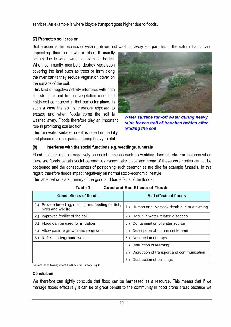
Kabuto School hosts affected families and therefore disrupting learning programmes
Disruption of transport network making it difficult for pupils to move from one place to the other
cause people to be displaced from their natural homes thus disrupting their way of life.
Floods may also cause a lot of damage to an area by displacing
people from their homes and ruining businesses. During this period
some of them may not get shelter hence are exposed to extreme
cold which may expose them to diseases like pneumonia.
(4) Destruction of crops
Flood inundates the farmlands. During this period of farm inundation the flood water uproots and sweeps
away crops such as millet, tomatoes, maize, vegetables etc. This destruction of crops leads to food
shortages that ultimately lead to famine and starvation. It is usually common scenario for community
members’ hope of bumper harvest being dashed away by their crops being washed away by flood
disaster.
(5) Disruption of learning
Floods also cause extensive damage to learning institutions such as schools by damaging classrooms,
roads leading to school, school toilets and thereby
disrupting the teaching programmes in such
schools.
In some areas floods causes difficulty in
accessing the schools even though some of these
schools at that period are occupied by affected
families for example Kabuto Primary School. In
such cases teachers as well as pupils are not able
to reach the schools.
During these times some schools are closed
temporarily till the floods subside. A good example
where floods interfere with teaching and learning
is at Nyora, Sere and KabutoPrimary schools in
Nyatike Sub-county.
(6) Disruption of transport and communication
Some major transportation routes pass through the water channels. In Nyando River Basin highways and
other road systems either follow river valleys or
cross them. Flood damages to these
transportation systems such as blown culverts and
wash-outs on rural roads and bridges and
damages to major roads connecting the main
markets disrupt transport and communication in
the area. When such damages occur there is
increased transportation costs and this also
seriously impacts on local businesses, let alone
the cost of repairing the damaged roads. In
addition, some traders take advantage of such
situations to increase prices for goods and
- 11 -
Water surface run-off water during heavy rains leaves trail of trenches behind after eroding the soil
services. An example is where bicycle transport goes higher due to floods.
(7) Promotes soil erosion
Soil erosion is the process of wearing down and washing away soil particles in the natural habitat and
depositing them somewhere else. It usually
occurs due to wind, water, or even landslides.
When community members destroy vegetation
covering the land such as trees or farm along
the river banks they reduce vegetation cover on
the surface of the soil.
This kind of negative activity interferes with both
soil structure and tree or vegetation roots that
holds soil compacted in that particular place. In
such a case the soil is therefore exposed to
erosion and when floods come the soil is
washed away. Floods therefore play an important
role in promoting soil erosion.
The rain water surface run-off is noted in the hilly
and places of steep gradient during heavy rainfall.
(8) Interferes with the social functions e.g. weddings, funerals
Flood disaster impacts negatively on social functions such as wedding, funerals etc. For instance when
there are floods certain social ceremonies cannot take place and some of these ceremonies cannot be
postponed and the consequences of postponing such ceremonies are dire for example funerals. In this
regard therefore floods impact negatively on normal socio-economic lifestyle.
The table below is a summary of the good and bad effects of the floods:
Table 1 Good and Bad Effects of Floods
Good effects of floods Bad effects of floods
1.) Provide breeding, nesting and feeding for fish, birds and wildlife
1.) Human and livestock death due to drowning
2.) Improves fertility of the soil 2.) Result in water-related diseases
3.) Flood can be used for irrigation 3.) Contamination of water source
4.) Allow pasture growth and re-growth 4.) Description of human settlement
5.) Refills underground water 5.) Destruction of crops
6.) Disruption of learning
7.) Disruption of transport and communication
8.) Destruction of buildings
Source: Flood Management Textbook for Primary Pupils
Conclusion
We therefore can rightly conclude that flood can be harnessed as a resource. This means that if we
manage floods effectively it can be of great benefit to the community in flood prone areas because we
- 12 -
cannot control the floods by stopping them because in most cases they are natural occurrence but we can
manage the floods.
1.7 History of floods disaster in Nyatike
Floods in Lower Gucha Migori Sub-catchment are not a new phenomenal but have been on increase in
intensity and impact over time. Based on oral tradition from the senior citizens in the area the history of
heavy flood in Lower Gucha Migori is as follows: 1947, 1957, 1961, 1963, 1985, 1997-1998, 2006, 2011,
2012 and 2013. Currently Floods in Lower Gucha Migori SC occur annually with a current frequency of
twice a year i.e. during the long rains (March to June) and during the short rains (October to December).
Flood history in Lower Gucha Migori Sub-catchment is therefore summarized as follows:
(i) There was major floods in 1947, 1957, 1961 after the heavy rainfall;
(ii) In 1963, there were floods after heavy downpour of 1962-1963. The elderly members of the
community point out that the 1962-63 rains led to heavy flooding that led to relocation some of
their farms as Lake Victoria in hostile takeover took over the farmlands. They clarified that in
some cases where it had been said the lake was receding was ironically the Lake leaving the
land it had taken over;
(iii) In 1985 there was heavy floods that led to displacement and eventual relocation of Kabuto
Primary School;
(iv) In 1990-92 heavy floods were again noted;
(v) The other major flooding occurrence was in 1997 as a result of El-Nino rains.
(vi) The other major incidence of flooding was in the year 2006 whereby R. Kuja changed its course
from flowing through Aneko to the current flowing place of Kabuto-Nyora.
(vii) The impact of 2006 flood included four schools relocating and moving into one school for various
education programmes in those schools to continue at the one school that hosted them. This
flood also led to massive and heavy evacuation of the affected community members and also the
crops in the farmlands were swept away;
(viii) In 2011 the area experienced heavy flooding in September-December short rains;
(ix) The year 2012 the area experienced floods disaster leading to massive destruction of crops and
some homes were damaged. The floods were experienced in April-June long rains;
(x) Flash floods were experienced in Lwanda Township in late December 2012 after heavy rains in
the area leading to evacuation of eight families for three hours, some houses were damaged and
also some toilets collapsed;
(xi) Heavy floods affected LOGUMI SC in the month of April and May 2013. Flash floods affected
Lwanda Township in April while the river floods affected at least twelve villages leading to heavy
evacuation in April and May; and
(xii) The heavy floods in April and May 2013 caused houses in some parts of Kabuto and Nyora to
sink in by fifty centimeters (50CM) as a result of long inundation period and the porous nature of
the soil in the area in the month of June 2013.
Activity for WRUA member and students
1) Discuss with your family members some of the human activities that they
do that enhances probability of flood occurrence.
2) With your friends, discuss how your family or village has benefited from
the flood in the last five years.
3) Write a one page composition entitled During the last floods in Nyatike.
- 13 -
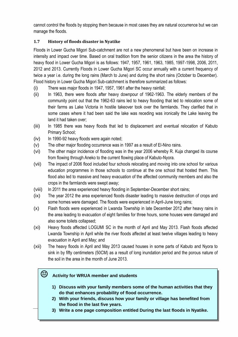
Figure 4Satellite Map of LOGUMI Sub-Catchment
Source: LOGUMI WRUA SCMP
Chapter2: Flood Hazard in the ARiver Basin
In this chapter, back ground of sub-catchment, mechanism of floods, countermeasures against floods, and impacts of floods are explained.
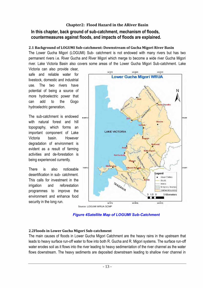
2.1 Background of LOGUMI Sub-catchment: Downstream of Gucha Migori River Basin
The Lower Gucha Migori (LOGUMI) Sub- catchment is not endowed with many rivers but has two
permanent rivers i.e. River Gucha and River Migori which merge to become a wide river Gucha Migori
river. Lake Victoria Basin also covers some areas of the Lower Gucha Migori Sub-catchment. Lake
Victoria can also provide clear,
safe and reliable water for
livestock, domestic and industrial
use. The two rivers have
potential of being a source of
more hydroelectric power that
can add to the Gogo
hydroelectric generation.
The sub-catchment is endowed
with natural forest and hill
topography, which forms an
important component of Lake
Victoria basin. However
degradation of environment is
evident as a result of farming
activities and de-forestation is
being experienced currently.
There is also noticeable
desertification in sub- catchment.
This calls for investment in the
irrigation and reforestation
programmes to improve the
environment and enhance food
security in the long run.
2.2Floods in Lower Gucha Migori Sub-catchment
The main causes of floods in Lower Gucha Migori Catchment are the heavy rains in the upstream that
leads to heavy surface run-off water to flow into both R. Gucha and R. Migori systems. The surface run-off
water erodes soil as it flows into the river leading to heavy sedimentation of the river channel as the water
flows downstream. The heavy sediments are deposited downstream leading to shallow river channel in
- 14 -
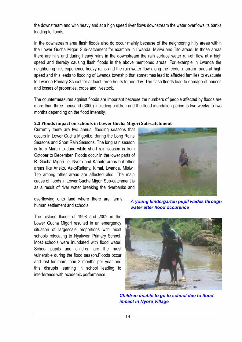
A young kindergarten pupil wades through water after flood occurence
Children unable to go to school due to flood impact in Nyora Village
the downstream and with heavy and at a high speed river flows downstream the water overflows its banks
leading to floods.
In the downstream area flash floods also do occur mainly because of the neighboring hilly areas within
the Lower Gucha Migori Sub-catchment for example in Lwanda, Misiwi and Tito areas. In those areas
there are hills and during heavy rains in the downstream the rain surface water run-off flow at a high
speed and thereby causing flash floods in the above mentioned areas. For example in Lwanda the
neighboring hills experience heavy rains and the rain water flow along the feeder murram roads at high
speed and this leads to flooding of Lwanda township that sometimes lead to affected families to evacuate
to Lwanda Primary School for at least three hours to one day. The flash floods lead to damage of houses
and losses of properties, crops and livestock.
The countermeasures against floods are important because the numbers of people affected by floods are
more than three thousand (3000) including children and the flood inundation period is two weeks to two
months depending on the flood intensity.
2.3 Floods impact on schools in Lower Gucha Migori Sub-catchment
Currently there are two annual flooding seasons that
occurs in Lower Gucha Migorii.e. during the Long Rains
Seasons and Short Rain Seasons. The long rain season
is from March to June while short rain season is from
October to December. Floods occur in the lower parts of
R. Gucha Migori i.e. Nyora and Kabuto areas but other
areas like Aneko, AekoRatieny, Kimai, Lwanda, Misiwi,
Tito among other areas are affected also. The main
cause of floods in Lower Gucha Migori Sub-catchment is
as a result of river water breaking the riverbanks and
overflowing onto land where there are farms,
human settlement and schools.
The historic floods of 1998 and 2002 in the
Lower Gucha Migori resulted in an emergency
situation of largescale proportions with most
schools relocating to Nyakweri Primary School.
Most schools were inundated with flood water.
School pupils and children are the most
vulnerable during the flood season.Floods occur
and last for more than 3 months per year and
this disrupts learning in school leading to
interference with academic performance.
- 15 -
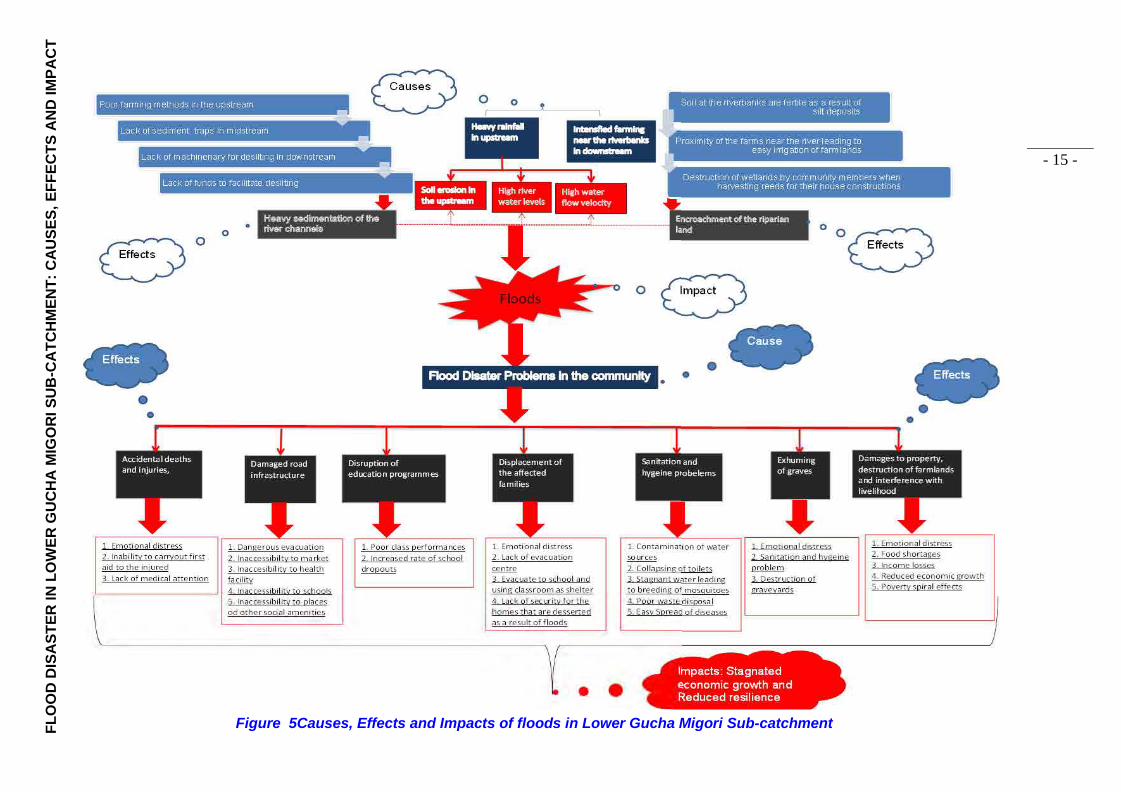
FL
OO
D D
ISA
ST
ER
IN
LO
WE
R G
UC
HA
MIG
OR
I SU
B-C
AT
CH
ME
NT
: C
AU
SE
S,
EF
FE
CT
S A
ND
IMP
AC
T
Figure 5Causes, Effects and Impacts of floods in Lower Gucha Migori Sub-catchment
- 16 -
Chapter3: Flood Safety Measures at Household Level
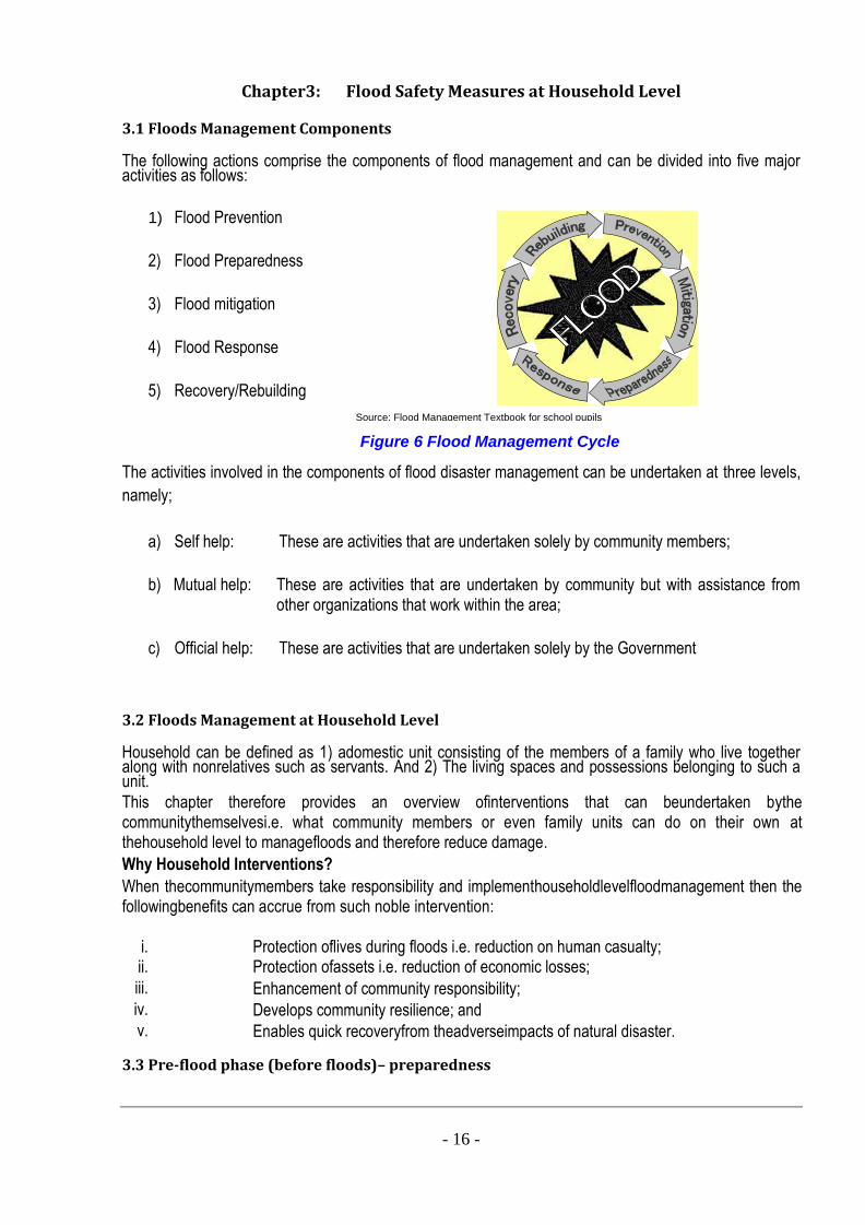
3.1 Floods Management Components The following actions comprise the components of flood management and can be divided into five major activities as follows:
1) Flood Prevention
2) Flood Preparedness
3) Flood mitigation
4) Flood Response
5) Recovery/Rebuilding
The activities involved in the components of flood disaster management can be undertaken at three levels, namely;
a) Self help: These are activities that are undertaken solely by community members;
b) Mutual help: These are activities that are undertaken by community but with assistance from other organizations that work within the area;
c) Official help: These are activities that are undertaken solely by the Government
3.2 Floods Management at Household Level Household can be defined as 1) adomestic unit consisting of the members of a family who live together along with nonrelatives such as servants. And 2) The living spaces and possessions belonging to such a unit. This chapter therefore provides an overview ofinterventions that can beundertaken bythe communitythemselvesi.e. what community members or even family units can do on their own at thehousehold level to managefloods and therefore reduce damage. Why Household Interventions? When thecommunitymembers take responsibility and implementhouseholdlevelfloodmanagement then the followingbenefits can accrue from such noble intervention:
i. Protection oflives during floods i.e. reduction on human casualty; ii. Protection ofassets i.e. reduction of economic losses; iii. Enhancement of community responsibility; iv. Develops community resilience; and v. Enables quick recoveryfrom theadverseimpacts of natural disaster.
3.3 Pre-flood phase (before floods)– preparedness
Figure 6 Flood Management Cycle
Source: Flood Management Textbook for school pupils
- 17 -
a) Flood earlywarning informandcommunicationsystems
Before floods especially riverine floods occur there are always flood early warnings issued either by nature or by relevant stakeholders. Nature warns us by appearance of certain bird species, croaking of frogs etc. Relevant stakeholders issue alerts through radio, chief’s baraza etc.
The following activities are important to be observed at household level: Regularly listentoradio/orwatchTVother sources of information to keepyourselfabreast of facts on
weather and flood watch alerts andensure that yourfamily also are informedofdaily weathercondition and relevant warnings.
Do not question the warning information but rather follow such warnings religiously.
Do not be selfish with the received information but rather shareinformation withyour neighbors. Have and keepcontactinformationofyourrelatives, village elder and sub-location chief. Andknow the nearesthealth-care centre, evacuation placesand rescuepost available.
b) Building capacity and raising awareness Learn previous flood experience and preparedness undertaken during those floods. Understand that dynamism is key to any success and therefore update regularly the experience of
flood preparedness. Develop a flood plan Have a plan for emergency situation. Swimming can be what saves someone’s life therefore regularly build and improve your capacity of
swimming. Share with your family members of the planned flood preparedness activities.
c) Asset andlife protection Know the usual flood depth of the area and ensure that the levels of houses are raised above
expected flood level. Ensure safety tools such as canoes and anything that can assist in floating such as life-jackets are
available or easily accessible. Build separate and highly raised up places for poultry to protect them from floods. Build embankments around the homestead and skirting around the house to keep flood water out
of your compound and your house. Assign roles and tasks for family members. Closely tie furniture to prevent them from being swept away by flood water and also hang utensils
on the ceiling to prevent them from being swept away during floods. Move livestock to high raised areas. Keep your books in water-resistant bags and keep them in above raised places.
d) Foodand health safety Store firewood i.e. collect and tie firewood and store them at places above the flood depth. Store food, water, medicine for man and animals and keep them at places above flood depth and
ensure that the stored materials are easily accessible during floods. Store water treatment tabs like aqua tabs and water guard. Plant vegetable in pots and raise them by tying the pots up above the flood depth.
e) Community activities Join community based groups like WRUA and CFMO and other volunteer groups and support
community activities where possible. Be quick to assist your neighbor by knowing and understanding their vulnerability especially for old
persons, disable person, children and expectant mothers. f) Evacuation Participate actively during community based evacuation drills. Understand the evacuation plan and follow the direction therein and support others during
evacuation. Understand and know the evacuation routes.
- 18 -
Ensure bringing safety objects such as life vest, Actively evacuate before the transport networks are disrupted.
3.4 Flooding Phase (during Floods): - response
Flooding phase is characterized by response to floods. The affected families respond to floods by evacuating while the stakeholders respond to floods by offering assistance to the affected families. DuringFlooding phase major activities are monitoringand taking action for emergency situations. The following activities should be undertaken: Strictly prohibit luxurious swimming or boat rowing i.e. do not allow children to go swimming or
boating in swollen rivers, canals, lakes Ensure that children do not play around thebanks of rivers, canals, water pans etc. Watch out for snakes and other poisonous animals in flood water. When going out to the field ensure that at least you go out with another person. When pupils leave school for home or vice-versa ensure that the pupils walk in group and never
alone. Monitor rains and flood levels at all times. Regularly pay attention to special members in family such as young children, old persons, disable
persons or pregnant women. Regularly check the safety of animals, drinking water, food, medicine etc. Regularly check the safety of fences, house. Get transportation means and safety equipment ready. Properly treat water and food before use to prevent epidemic. Always update family members on situations of flood for taking proper actions on time. Rearrange all things to adapt the change of flood level. Make decision and evacuate on time if necessary. In emergency case, call the nearest health station or rescue post.
The following activities should be undertaken when living at evacuation places: Ensure all family members are safe and present at evacuation place. Ensure you that you name is registered at the evacuation place Consciously abide by the safety measures, rules and regulation set at the evacuation place. Do not go back home until you confirm that it is safe to go back.
3.5 Post Flood Phase (After Floods): - Recovery
Everything that has a beginning must have an end. Floods come and eventually they go away. After the floods the activities are geared towards recovery and rehabilitation. The following activities should be undertaken: Support neighbors who need help Join relief activities or provide relief to community. Restore back the evacuation place to the orderly state as you found it when you moved at the
evacuation place. Set up rehabilitation planand ensure safety of all family members. Identify priority activities. Assign works to family members. Prepare/mobilize resources and support. Ensure that your house is safe and there are no poisonous animals residing there as a result of
your absence. Ensure and maintain good sanitation and hygiene. Carryout damage assessment Prepare a check-list with a priority order, such as rehabilitating the toilet, cleaning house, etc. Restore as planned from the list. Look for external support where necessary.
- 19 -
Chapter 4: Flood Safety Measures in School
This chapterfocuses on helping the teachers and pupils to not onlyget acquainted on flood safetymeasures
in school but on what they can do to ensure their safety and safety of those affected by floods. Measures
are the activities a person, institution etc. can undertake to mitigate the problem.
4.1 School flood safety measures
There is always something that someone can do to solve a problem no matter how little or how big the
solution(s) may be. Therefore it is imperative to have that kind of mind-set as a school community that there
is something that the school community can do during flood problem. There are measures that can
beundertaken during floods at theschool level to ensurethe safetyof itspupils, teachers, staffs,infrastructure
and equipment.Themain roles that the schools can playin managing floods can be described as follows:
As core of publicawareness raising– through parent, student and teacher networks
As evacuationplaces, if theschools arelocated on higher ground.
As a support systemtothe young, when flood victims are of school age.
There are specificpreparednessmeasuresthatcan be undertaken by theschoolcanto at least ensure safety its occupants (pupils, teachersandstaffs) or even to facilitaterecoveryfrom flood disaster. These activities are as listed below:
Beforeflood activities
Understand the flood history of the area. Familiarize yourself with the geographical features of the area where the school is. Always have mobile contact local flood disaster management unit. Develop a school disaster management plan and share it with the students and parents. The plan
should clearly define actions to take in case of hazards (not just flood). Teach and train pupils on basic first aid and water rescue (or other life saving techniques,
depending on the frequent hazard in the area). Sensitize school pupils on safety measures at household level as part of the school lessons. Help students to brainstorm on family safe plans. Invite subject experts to school and hold
seminars on health care during the flood season. Provide health related information, especially on water borne diseases caused by flood water, to
pupils, teachers, school staff and parents. Invite subject experts to school and hold seminars. Paste an emergency contact list on a noticeboard including contact details of local emergency
management agencies. It should be shared with the students and their parents. Organize evacuation drills and exercises for pupils. Develop an inventory for the schools properties. Identify safe areaswithin the community and address safe evacuation routes for evacuation. This is
particularly important in case of quick as well as slow onset disasters. Update flood information and effective emergency response measures so that pupils and
teachers know and actively prepare for. Keeping abreast of facts at all times by school staffs and pupils by continuously listen to radio for
flood information and contacting relevant stakeholders like WRMA, Kenya Red Cross Society and WRUA.
Teachers and pupils should open up drainages and ensure that all the drainages will allow easy flow of water.
- 20 -
During flood activities
Uponreceiving theflood warning,
At the issuance of the first warning, arrange equipment and books in safe places. Remove and tie tightly all the heavy objects that could be moved by flood water and cause damages.
When the warning is issued do not push the pupils to still go to school but allow them to be away from school but encourage them to study even when they are not at school.
Have a full register of all the pupils in the school at the time of warning and ensure that they are protected from danger.
Make announcement of the school closure to the community and giving reasons to why the school shall remain closed and inform the parents to take good care of their children such that none of the pupilsabscondsschool after the floods.
Have a plan to protect school’s properties during the flood season. Switch off all power supply mains to prevent electrocution and associated fire hazards. Assign staffs to be on shift and ready to response to flood.
If theschool is used as asafeshelter,
Keep first aids kit ready. Reserve drinking water. Make sure the school floor is higher than the anticipated flood level. Identify how many people can stay at the school and inform the local authority to ensure that
school resources are not overstretched. Raise the level of toilets in the school area. Keep a portable radio powered by battery. Keep flash lights (at least 2) powered by battery. Know the routes to a safer area in case the flood is more severe than expected. Have means of transportation such as boats, small boats, etc. to be ready for evacuation if
necessary.
After the flood
Clean up the classrooms thoroughly to make sure all objects in touch with contaminated flood water are now clean and tidy. Seek help from students and the communities
Assess and record all damages, identify needed supports, and report to the education authority for immediate repair.
Announce the school’s reopening dates to the community and inform the parents to ensure that all their children go back to school.
Organize activities where pupils can help in community rehabilitation efforts. Beside the Government’s supports, the school should mobilize more supports from private
organizations as well as mass organizations to help the school recovers quickly. Reach out to the affected families especially pupils and offer counselling services to help them
overcome the trauma. Seek for pupils whose name were in the register before floods but are no longer attending classes.
Supporting the flood affectedstaffs and thestudents
Keep records and analyze the number of students and staffs who are affected by flood. Provide support to affected staff and students. Have a school-wise support plan. Provide students opportunities to express their feelings. This can help them overcome the trauma
of loss and grief.
- 21 -
Relief activities from political and social organizations. Provide activities to reduce trauma, such as writing essays, art projects and etc.Younger kids who
have difficulties in expressing their emotions can apply this way to release stress. Contact parents or relatives of affected pupils and staff. By working together, healing process can
be quicker. Train teachers and staff on psycho-social care and support for disaster victims. To be able to
recognize children’s reaction to traumatic situations can help formulate an appropriate support system.
Have experience sharing section in the class where students can freely share their own personal experience and receive peer support.
Head teacher andotherseniorstaffs
Be ready to give command and instructions on response activities after flood. Establish the linkage among local authority, other affected schools in the province/district
and the local disaster management agencies to do damage inventory and have support activities accordingly.
Provide extra support to students and staff with deceased in the family and hold memorial services as appropriate.
Provide direct interventions.
4.2 Safety on the way to school
4.2.1 - Flood risks and ways toschool
Themain means of transportation duringflood seasonareboats and canoes. Inruralandborderareas,manypupilshavetogotoschoolbysmallboatsthrough longrivers and large fields, without lifevestsorfloatingthings. Withoutequippingenoughskillsto respondto emergencysituation duringflood season, children becomethe most vulnerablegroup in community.
4.2.2 - Safety measures on the way to school
Safetyontheway toschoolisthetop importantobjective ofeducation management duringflood season. Whatshouldwedotoensurechildren’ssafety on the way to schoolduring flood season? Organizetaking childrentoschool and backhome by safemeansoftransport such asnotover loaded,
equipped enoughwithlifevests, and means of communication when necessary (Mobile phone, loud-speaker).
Continuously follow up warning information anddo notgosailingwhile ithas signal of storm, whirlwind
Select the route not much affected by flood. Keep away from strong flow. Be careful when crossing bridge, canal junction - strong current.
Do not go on the uninhabited route. Should go on crowed route, with a lot of trees to have support when necessary
Do not go through exposed fields. Assign tasks before starting see off and pick up children. If children can go to school by themselves, parents and teachers should help children to assess
the level of safety and have necessary safety requirements for them.
Children should be active themselves! Learn to swim and become good swimmers. Equip themselves with life-vest or floating things when going out. Obey the safety waterway regulations. Learn how to save drowning people. Be ready to help others when necessary.

- 22 -
In emergency situation, it’s easier and more active with tidy clothes and suitable books
- 23 -
Flotsam and foam
FF
Chapter 5 - Flood Early Warning System
5.1 Whatis an early warning system?
In the Bible the Book of Genesis Chapter 7 the world experiences floods leading to heavy losses until in
Chapter 8 God says He will never again use flood water to punish the inhabitants of the earth. Key lesson
is the power that is in water and when it is comes as floods it causes huge destruction. It is therefore,
important that the people living in flood prone areas should ideally have a clear understanding of the signs
that nature issues as flood warnings before floodsoccur.
There are several warnings that are observed by communities living in the flood prone areas immediately
before floods. An early warningsystemistoalertpopulationunderthreatofapotentialdisaster(in this case a
damaging flood) in the near future, and serve as starting points for individuals and groups
tomakedecisions and taketimelyprotectiveactions.
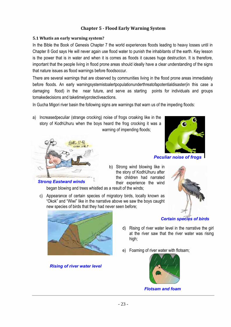
In Gucha Migori river basin the following signs are warnings that warn us of the impeding floods:
a) Increasedpeculiar (strange crocking) noise of frogs croaking like in the
story of KodhUhuru when the boys heard the frog crocking it was a
warning of impending floods;
b) Strong wind blowing like in the story of KodhUhuru after the children had narrated their experience the wind
began blowing and trees whistled as a result of the winds;
c) Appearance of certain species of migratory birds, locally known as “Okok” and “Wiwi” like in the narrative above we saw the boys caught new species of birds that they had never seen before;
d) Rising of river water level in the narrative the girl at the river saw that the river water was rising high;
e) Foaming of river water with flotsam;
Certain species of birds
Peculiar noise of frogs
Strong Eastward winds
Rising of river water level
- 24 -
Overflowing water
FF
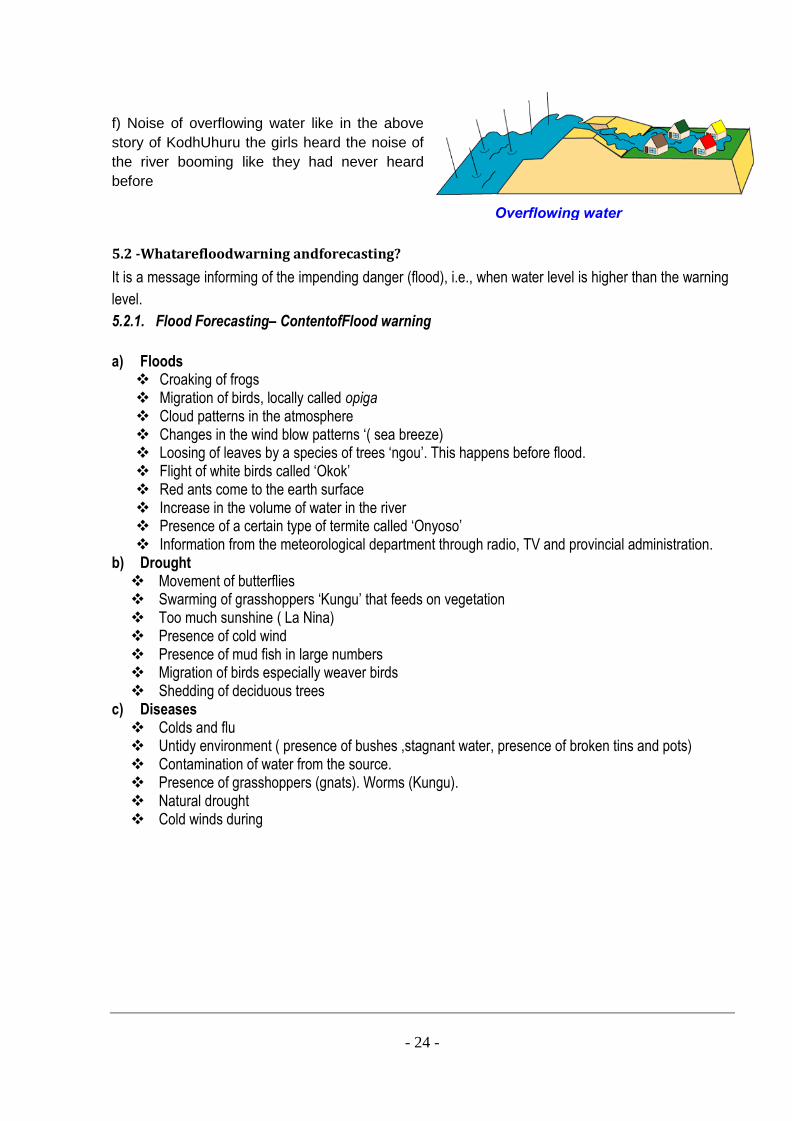
f) Noise of overflowing water like in the above
story of KodhUhuru the girls heard the noise of
the river booming like they had never heard
before
5.2 -Whatarefloodwarning andforecasting?
It is a message informing of the impending danger (flood), i.e., when water level is higher than the warning
level.
5.2.1. Flood Forecasting– ContentofFlood warning a) Floods Croaking of frogs Migration of birds, locally called opiga Cloud patterns in the atmosphere Changes in the wind blow patterns ‘( sea breeze) Loosing of leaves by a species of trees ‘ngou’. This happens before flood. Flight of white birds called ‘Okok’ Red ants come to the earth surface Increase in the volume of water in the river Presence of a certain type of termite called ‘Onyoso’ Information from the meteorological department through radio, TV and provincial administration.
b) Drought Movement of butterflies Swarming of grasshoppers ‘Kungu’ that feeds on vegetation Too much sunshine ( La Nina) Presence of cold wind Presence of mud fish in large numbers Migration of birds especially weaver birds Shedding of deciduous trees
c) Diseases Colds and flu Untidy environment ( presence of bushes ,stagnant water, presence of broken tins and pots) Contamination of water from the source. Presence of grasshoppers (gnats). Worms (Kungu). Natural drought Cold winds during
- 25 -
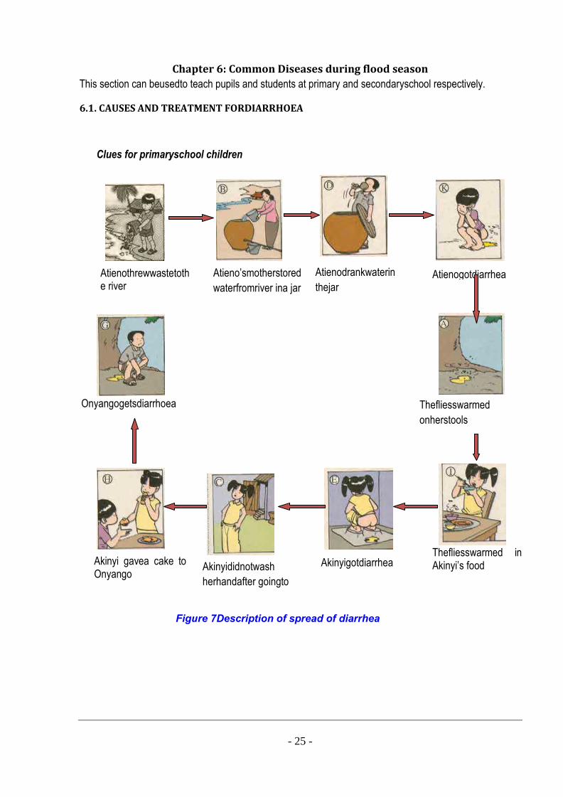
Chapter 6: Common Diseases during flood season
This section can beusedto teach pupils and students at primary and secondaryschool respectively.
6.1. CAUSES AND TREATMENT FORDIARRHOEA
Clues for primaryschool children
Figure 7Description of spread of diarrhea
FF
Onyangogetsdiarrhoea
Akinyi gavea cake to Onyango
Akinyididnotwash
herhandafter goingto
stool
Atienogotdiarrhea
Thefliesswarmed in Akinyi’s food
onAkinyi’sfood
Thefliesswarmed
onherstools
Atienothrewwastetothe river
Atieno’smotherstored
waterfromriver ina jar
Atienodrankwaterin
thejar
Akinyigotdiarrhea
- 26 -
Howto prevent diarrhea: Table 2 How to prevent Diarrhea
Cut the followingmessages and put ina suitable positionintheabovestory
Keys
Wash hands beforeeatingandafter visiting toilets
Between pictureNo 8 and 9
Put garbagein the dustbin Between pictureNo 1 and 2
Usehygienic toilet Between pictureNo 4 and 5
Keep food off flies Between pictureNo 6 and 7
Drink boiled water Between pictureNo 2 and 3
6.2. ACUTE DIARRHOEA FOR CHILDREN
1. Howcanyouknow a child gotdiarrhea?
Answer:
Visit toilet morethan 10 times perday.
Wateryfeces.
Feces havesour smell.
Blood in feces or mucus in feces.
Continuouslyvomit or afew times perday.It often happens after meal.
Maybethe child got fever.
Refuseto eat.
2. What is the harm of diarrhea?
Answer:
Maydie.
May get malnutrition.
Easytoget other diseases.
3. What is the cause of diarrhea?
Answer:
Eat or drink food contaminated bacteria causingdiarrhea.
4. Howto prevent diarrhea?
Answer:
Eat and drink safely.
During the first 4 months of the baby life, always feed them with breast milk.
5. What are safe eating and safe drinking?
Answer:
Food and drink must bewashed and cooked properly.
Food and drink must be fresh and clean.
Keep food off flies.
Wash hands properly before touching food.
6. What do you do whenyour child gets diarrhea?
Answer:
Give children plenty of water especially ORS liquid, and let them drink gradually.
Feed children as usual (Breast milk, fruits and food)
7. Howcanyou have ORS liquid?
Answer:
Buyit at drugstore.
- 27 -
All needed thing to make salt rice soup Six bowls of water
A handful of rice A pinch of salt
Dissolve 1 sachet of ORS with 1 litter of boiled water. Must dissolve the whole
sachet at one time.
8. If you can’t get sachet ofORS you can makeit byyourselfwith thefollowing
formula:
Answer:
1 tea spoon of salt.
1 litter ofboiled water
Put everything in one bottle and then shake
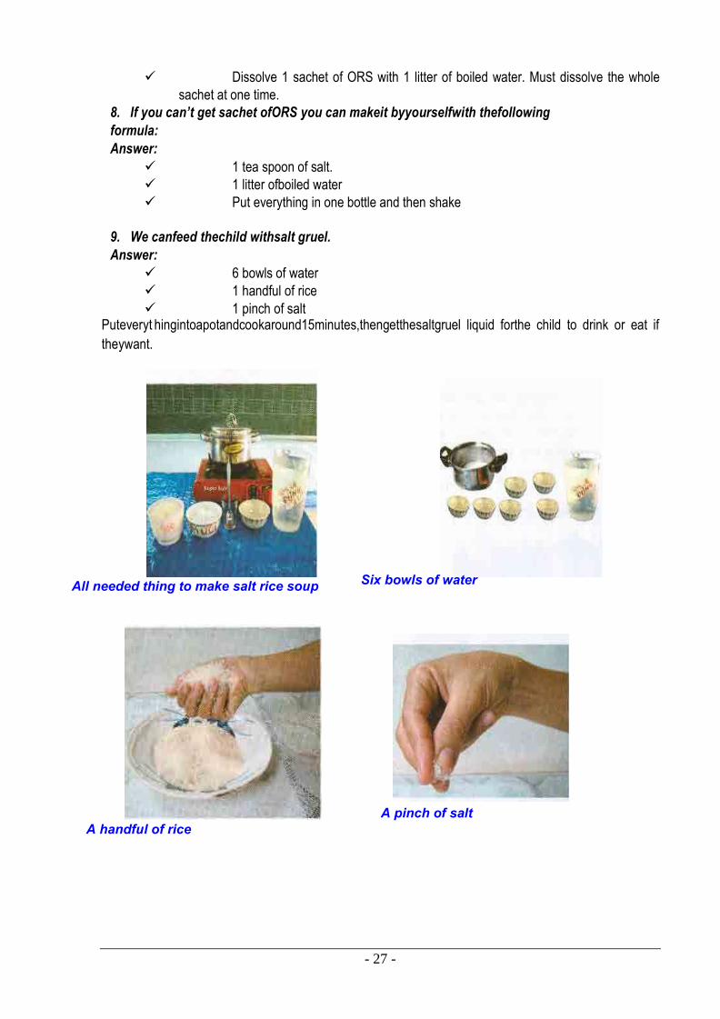
9. We canfeed thechild withsalt gruel.
Answer:
6 bowls of water
1 handful of rice
1 pinch of salt Puteveryt hingintoapotandcookaround15minutes,thengetthesaltgruel liquid forthe child to drink or eat if
theywant.
6 bowls ofwater
- 28 -
10. After dissolving ORS, we can use it during the day after 24 hours. If there is some left over,we should throwitaway.
11. What should we do whena child vomits?
Answer:
10 minutes after vomiting, the child should be given ORSliquid.
12. If the child still got diarrhea and vomits, what should we do?
Answer:
Takethe child to hospitals.
6.3. FEVER
1. What is fever?
When the temperatureofthe bodyis over 370C isso-called fever. Whenachild gets fever,weshould followup his/hertemperature regularly.
2. Is fever a disease? No. It is the resistance ofthe body to disease causing substances and agents.
3. The cause:
Virus, bacteria (Flu, cold…)
Strange protein (i.e. when having vaccine)
Other causes such as when a baby has milk teeth, loss of water when suffering
diarrhea, and so on.
4. Levels:
Minor level: from 37.5 – 38 0C
Average level: from 38 – 39 0C
High level: from 39 – 40 0C
Very high level: over 40 0C
You have to use thermometer to take the temperature of the body. For baby and children it is good to take temperature at anus if taking temperature at armpit, add 0.50C to the shown number from thermometer.
5. What should we do when a child gets fever?
Take their clothes off.
Let them lie down at cool and quiet places with fresh air but not windiness.
Give them plenty of water, fruit juice, and should feed them easy-digested food
such as gruel and soup. When they’ve got fever they don’t want to eat. Therefore we
should feed them many times per day.
When the temperature is over 380C, we should clean the child’s body to reduce
fever. (See the next section)
We can give the child medicine to reduce fever such as Paracetamol.
N/B: Don’t givemedicinewhich contains Aspirin. Itis good to followtheadvices of the doctor if youcanvisit one.
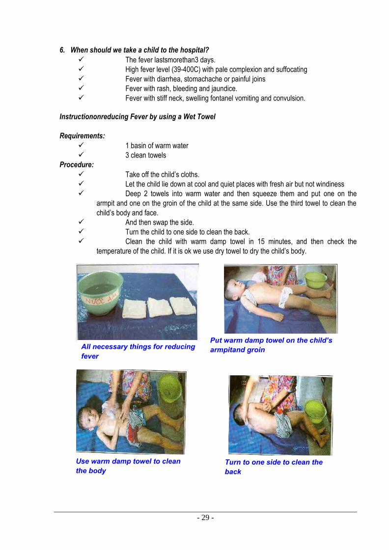
- 29 -
6. When should we take a child to the hospital?
The fever lastsmorethan3 days.
High fever level (39-400C) with pale complexion and suffocating
Fever with diarrhea, stomachache or painful joins
Fever with rash, bleeding and jaundice.
Fever with stiff neck, swelling fontanel vomiting and convulsion.
Instructiononreducing Fever by using a Wet Towel
Requirements:
1 basin of warm water
3 clean towels
Procedure:
Take off the child’s cloths.
Let the child lie down at cool and quiet places with fresh air but not windiness
Deep 2 towels into warm water and then squeeze them and put one on the
armpit and one on the groin of the child at the same side. Use the third towel to clean the
child’s body and face.
And then swap the side.
Turn the child to one side to clean the back.
Clean the child with warm damp towel in 15 minutes, and then check the
temperature of the child. If it is ok we use dry towel to dry the child’s body.
All necessary things for reducing fever
Put warm damp towel on the child’s armpitand groin
Use warm damp towel to clean the body
Turn to one side to clean the back
- 30 -
CHAPTER 7: SCHOOL FLOOD SAFETY PROGRAM
This chapter aims at introducing the steps to be followed when conducting School Flood Safety Program
and how to organize festival such as School Flood Safety Day. For purposes of our study we can state that
there are five(5) steps to be followed and they include:
Assessment of Flood Risk in schools
Developing School Flood Management Plan
Teacher orientation on Flood Hazards
Students orientation on Flood Hazards
Designing public awareness activities in school.
7.1-Assessment ofFloodRiskinschools
7.1.1.Whyflood risk should be assessed in schools
To review status of capacity and vulnerabilities of your schools
To identify what are the risks can be happened to your schools during flood
season.
To forecast strength of flood and capacity of your schools to scope with flood
To identify vulnerability in both your schools‟ facilities and students
To have a proper school flood management plan to strengthen capacity of your
schools and better emergency response approaches. 7.1.2. Sampleof school flood risks assessment form
Schoolimpactassessmentform
School name:………………………………………………………………………………
County:……………………….. Sub-county:… ……….……….
1. General information:
1.1. Teachers information
Table 3 Sample of Teachers Information Form
Total
Male
Female
No. ofpersons trained
on flood hazards
No. ofpersons who
need support
Male
Female Cannot
swim
others
- 31 -
1.2. Pupilsinformation Table 4 Sample of Pupils Information Form
1.3. Status of school facilities:
Q.1. a) Hasyour school ever been flooded duringflood season in last 3 consecutive years?..................................
b) Ifyes, how high was thewaterlevel?....................................
Q.2. How manypupils inyour school drown duringlast flood season?........
Q.3. How far is your school from themain road?.........................................
Q.4. a) Is your school near a river?..................................................
b) If yes how far is it from the river………………………………
c) How dangerous is the river?.................................................. d) Are there anysafetysignals installed?.....................................................
Q.5. a) Do pupils go to school during the flood season?...............................
Total
Male
Female
No. ofpupils trained
on flood hazards
No. ofpupilswho
need support
Male
Female Cannot
swim
others
STD 1
STD 2
STD 3
STD 4
STD 5
STD 6
STD 7
STD 8

- 32 -
b) If yes how do they manage to reach the school……………………
- 33 -
Please tick where appropriate with reference to the state of your school.
Table 5 Sample of Form for the status of the School 1. Thewalls of theschool aremadeof concrete wood soil thatch
2. The roof of the school is tiles tole Corrugatediron cottage
3. The floor ofthe school is tiles cement soil
4. Theschool is new old strong weak Nearlycollapsed
Q.6. How efficient is the communication system in your school?
(i) Good
(ii)Not good
Q.7. (a) Does your school have lifesaving equipment like life-vests, school map for emergencies, any means of transport?
(i) Yes
(ii) No
(b) If yes specify……………………………………............................
2. Floodrisks andvulnerabilities assessment:
2.1. General informationon impacts of flood in previousyear 2.2. Forecastingstrengthof flood in theyear
2.3.Items maybe affected byflood
Table 6 Sample of Form for Vulnerability Assessment No Items Unit Quantity Remark
2.4.Identifywho arevulnerable?Why
Table 7 Sample of Form for Vulnerable persons No Name Whatarerisks? Why? Remark
3. Recommendation:
Table 8 Sample of Form for Recommendations No Items Activities Expectation Responsibilities Cooperation ….
Structural
measures
Non-
structural
measures
………
7.2-Developing School FloodManagementPlan
7.2.1. School Flood Management Plan:

- 34 -
This is a list of activities that teachers and students agree to follow before, during and after flood. A schoolflood risk reduction planidentifies activities to reduceflood related risks inaschool.It has been shown that those affected byfloodarethe ones best ableto deal with adisaster, thereforetheschool contingency plan builds on this copingstrategyensuringthat theteachers and studentsarebetter prepared fordisasters.Itmustbe ensured that different school children andteachersarerepresented andwillhaveavoicein the contingencyplanningprocess.This will contributeto theschool owningand sustainingtheplan. 7.2.2. Steps to make a School Flood Management Plan
Step 1:Identification ofobjectives of the plan
To make the school secure against flood.
To plan and implement flood reduction activities in the school.
To effectively prepare and respond to flood.
To train and build awareness among students, teachers, parents and School
Management Committees about flood.
To coordinate with local government offices and other emergency services.
Step 2: Formation of School Flood Management Task Force Group 1: School FloodManagementBoard
School Management Board (Principal, Vice principal, General Secretary, etc.)
Group of former teachers Group of active students Group 2:Local agency partners
Red Cross
World Vision
Youth
WRUAs
Blue Cross
Women union
Health N/B: Assign responsibilities of each group, group members in accordance to each period of
flood. For example: before flood, groupA is responsibleto organizetraining forteachersand
students while group Bis designingpublicawareness activities, etc. Step 3:Assessmenton school flood risk impacts
Resource inventory
Assessment on hazards, vulnerable and capacity at school level
Identifying risk, possible problems.
Solutions. Step 4:Preparation ofSchool Flood ManagementAction Plan
Before flood: including preparedness activities (structural and non-structural
measures) such as upgrading school yards, building school fences, facilities, safety
equipments, training for teachers and students on flood hazards, public awareness
activities, swimming lesson for school children, etc.
During flood: including response activities. Activities for emergency situation
should be highlighted. Increasing close cooperation with other local agencies partners as
mentioned in the list above to cope with emergency more effectively.
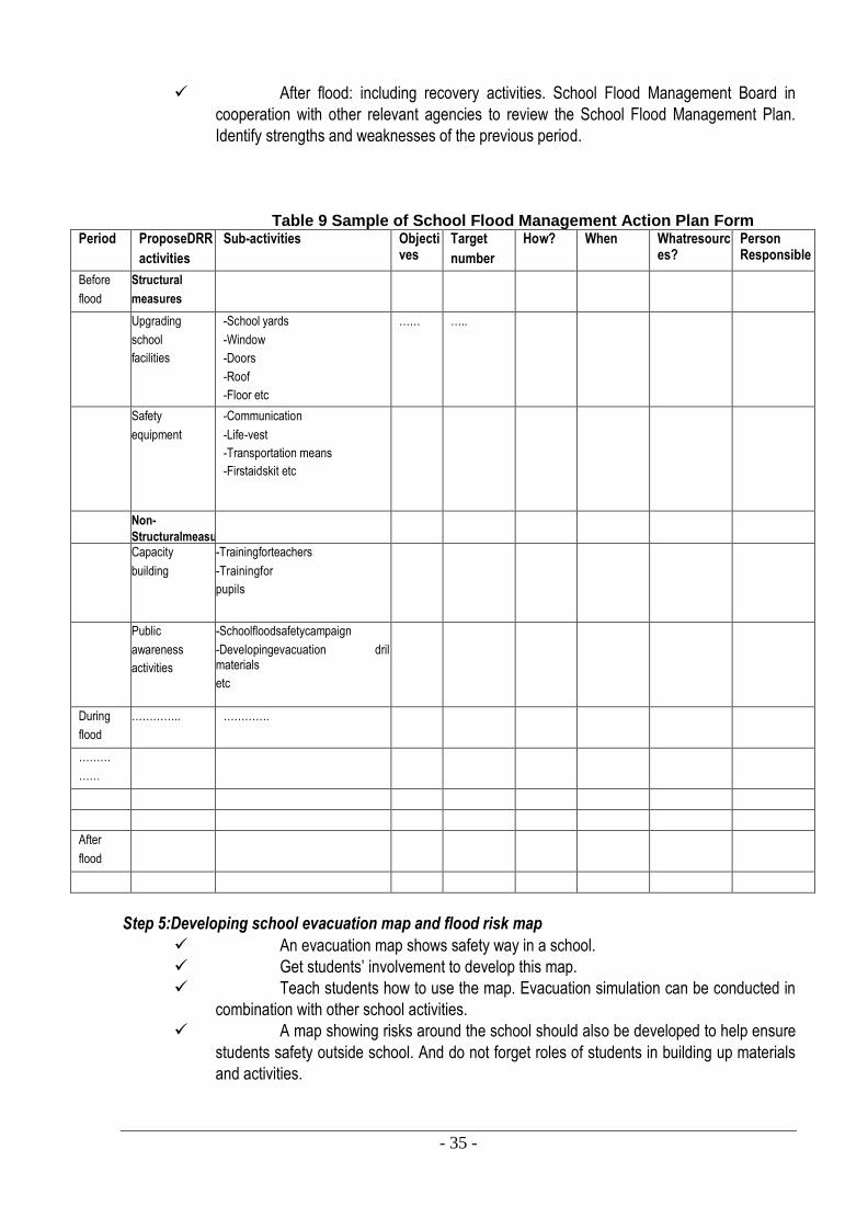
- 35 -
After flood: including recovery activities. School Flood Management Board in
cooperation with other relevant agencies to review the School Flood Management Plan.
Identify strengths and weaknesses of the previous period.
Table 9 Sample of School Flood Management Action Plan Form
Period ProposeDRR
activities
Sub-activities Objectives
Target
number
How? When Whatresources?
Person Responsible
Before
flood
Structural
measures
Upgrading
school
facilities
-School yards
-Window
-Doors
-Roof
-Floor etc
…… …..
Safety
equipment
-Communication
-Life-vest
-Transportation means
-Firstaidskit etc
Non-
Structuralmeasu
res
Capacity
building
-Trainingforteachers
-Trainingfor
pupils
Public
awareness
activities
-Schoolfloodsafetycampaign
-Developingevacuation drill materials
etc
During
flood
………….. ………….
………
……
After
flood
Step 5:Developing school evacuation map and flood risk map
An evacuation map shows safety way in a school.
Get students’ involvement to develop this map.
Teach students how to use the map. Evacuation simulation can be conducted in
combination with other school activities.
A map showing risks around the school should also be developed to help ensure
students safety outside school. And do not forget roles of students in building up materials
and activities.
- 36 -
7.3-TeacherorientationonFloodHazards
Educational institution isamajorpublic infrastructurewhich cancreatelong lastingimpacts on
futuregeneration. The overwhelmingimpacts ofdisasters on children, particularlythose attending schools in
times of disasteris the evidence that immediatelysolutions need to be sought to ensurethat childrenget
access to un-interrupted educationand theirsafety improved at homeor at schools.
Teachers areconsideredas the pillars of societywith high moral regards. Theextent oftheirinfluencegoes beyond theschool boundaryand orientingthem in flood risk reduction has far-reachingimpacts. Hence, buildingcapacityon flood hazards forschool teacherscan help reduce vulnerabilities atschools.
That leads to moreeffective education and safer forschool children. This approach can be
consideredenhancinglongterm development.
In the seminar, teachers areintroduced:
General understanding on flood hazards and other disaster.
Knowledge, experience on flood management at school and household.
Health care and early warning system.
Discussion on possible activities can be undertaken at schools to education
students and enhance public awareness on flood risk reduction.
Evaluation of flood impacts and developing flood management plan at school
level.
7.4-Student orientationonFloodHazard
Children arethe most vulnerablegroup in community. Therefore, equippingthem with general
understandingonflood hazards and how to copewith emergencysituation can help to reducehuman loss.
Theyare effectivecommunication agents in the communities, willingand enthusiastic in
sharingknowledgeand information without anyreservation.
It is expected thatafter beingoriented,school teachers will comeback theirschools, together with school
management board built up school flood managementplan and provide orientation for other colleagues
andstudents in theirschools.
Orientation for students can bethroughextra-curricular and out-door activities, into class activities.
7.5 - Designing public awareness activities in schools
Children’s participation should not been seen as an isolated event but a process where children are
constantly supported, encouraged and engaged by adults.
To have larger impacts to community’s awareness on flood risk reduction, public awareness activities
organized by schools should be planned and conducted in cooperation with relevant agencies at local
levels.
The objectives of the public awareness activity in schools are not only for their school teachers, staffs,
students but also for wider community living in the areas. Event experiences can be shared with other
neighboring districts, provinces, etc. for better approaches and effects.
Following is a sample activity which schools can conduct at their schools:
- 37 -
School Flood Safety Campaign Day:
The objectives of Festival on School flood safety Day are to help students and community to:
Get to know the geographical features of their school.
Get to know the flood features in the region
Enhance the communication network.
Develop orientation for flood preparedness plan.
Update information on flood and measures to cope with flood. Enhance
knowledge, experience and skills on emergency management during flood season.
Enhance the swimming capacity for children.
Review information on flood safety measures.
Know how to prevent common diseases in flood season.
Identify safe places and routes for evacuation. Recommended activities:
Exhibition of safety objects.
Quiz
Game,
Role-play,
Drawing and painting, painting analysis
Film show,
Experience exchange with local people.
Developing school map
Identifying flood prone areas to draw map of the channels surrounding and
danger warning board.

- 38 -
Chapter 8: First Aid
8.1 Basic First Aid
Basic first aid was taught importance of basic first aid knowledge was discussed. How to conduct basic
first aid for cuts, fainting, shock, miscarriages, bites, resuscitation and so on were highlighted to the
villagers.
First Aid - this is a help given in the case of accident or sudden illness before the casualty is handed over
to the doctor or medically trained person
8.2. Objectives of first aid
To save life
To prevent further injury
To promote recovery
To send for medical aid or transport the casualty to medical care
8.3 Role of First Aides
History-to give story of the accident or illness
Sympathy – any sensation described by the casualty e.g. pain thirsty, faintness
etc.
Signs – any unusual features such as swelling or change in the normal body
function
8.4 Resuscitation
This is the basic life support done to rescue breathing
a) Airway
Signs of airway blockage:
Abnormal breathing e.g. snoring
The casualty my become agitated
Paradoxical chest movements
Increasing effort in breathing
b) Rescue breathing
Safety : ensure that the area is safe for you, the casualty and bystanders
Response : gently tap the casualty on the shoulders and give simple commands e.g. open your eyes.
Airway : check inside the mouth for any obvious obstruction and clear if possible.
Breathing : look, listen and feel for seconds. If there is no breathing start rescue breathing as follows:
With the casualty lying flat, put the head backward (head tilt) and support the jaw
using the “pistol grip”
Breathe into the casualty’s mouth and watch for the chest to rise.
- 39 -
If the pulse is absent, start cardio pulmonary resuscitation (CPR) i.e. two
effective mouth breaths and thirty chest compression (30:2)
8.5 Airway Disorders (Chocking and Drowning)
a) Chocking is caused by inadequate chewing of food or through attempting to eat while talking. This can be controlled by properly chewing of food and avoiding talking while eating.
In children chocking is caused by swallowing small objects such as marble, peanuts or small buttons, hence they should be protected from them.
First Aid procedure for Adult and Children is as follows
i) Backblows
Lean them forward with their head and shoulders down and hit them firmly
between the shoulder blade three times (incase of adults use your arms while incase of
children use three middle fingers.)
ii) Upright abdominal thrust
stand behind the casualty with one between the ribs
Place the other hand over fist
Make inward and upward movements
Sign and Symptoms of airways disorder are:
i) Weak cry ii) Infective cough i.e. one that fails to dislodge the object iii) Difficulty in breathing iv) Skin turns blue (sign of inadequate oxygen in the body)
b) Drowning is caused by obstruction of throat airways by water. There are two experiences of drowning as indicate below:
i) This is death caused by obstruction of airway by water ii) Near drowning death after 24hrs while out of water
The First Aid procedure steps are as follows:
Life jackets of inflated tubes can be used to save somebody from drowning
No compression should be done to the casualty;
The victim should be laid down in drowning recovery position.
8.6 Bites and Stings
a) Snake bites
Most snakes bite on the ankle or lower leg, therefore thick socks and strong
shoes should be worn when walking through long grass or scrubs
- 40 -
First Aid procedure is as follows:
Immediately apply firm pressure over the bite site
Keep the casualty calm and at complete rest
Apply a firm roller bandage over the whole limb i.e. from the fingers /toes to the
shoulder/waist
Refer the casualty to the hospital
b) Dog Bites
First Aid procedure is as follows:
Clean wound with tap water
Cover the wound with clean cloth
Rest the bitten part (immobilize)
Find out on immunization e.g. last tetanus injection given
Refer to medical aid
c) Bee Sting
First Aid procedure is as follows:
If breathing or circulation fail, start resuscitation at once and seek urgent medical
assistance.
Apply ice packs to the bite site and seek urgent medical advice
After a bee sting, the barb may be felt in the skin. If should be removed promptly
by brushing or scraping sideway; never pull the sting out as more venom will be injected.
8.7 Transportation of Victims
These are used when the first Aides is alone
a) Drag
Fold the casualty’s arms across the chest then grasp their clothing and pull the
causality.
b) Human crutch
Stand next to the casualty and place their arm around your shoulders for support.
Then place your arm around their back and hold their belt or clothing.
c) Hand seats
Hand seats are used when the casualty can help you by placing their arms
around your shoulder. This can be used by two First Aides.
d) Stretchers
Should be carried by four to six First Aid attendants.
e) Blanket
It is used when the casualty cannot walk or help themselves;
The blanket is rolled lengthwise for half its width;
Lay the blanket next to the casualty;
The blanket is rolled at the same time both sides and
Gently roll the same time following the commands with one person supporting
the head.
- 41 -
8.8 Bleeding and Wounds
a) External bleeding: this is where the blood is seen oozing out and an open cut is left on the body.
First Aid procedure is as follows:
Wash the wound if bleeding isn’t excessive;
Stop the bleeding by applying firm pressure on the wound with the casualty at
rest and then
Refer the injured person to the hospital
b) Internal bleeding: this is where there is bleeding as a result of internal organ injuries that cause a major bone for example pelvis to break
Signs and symptoms:
i) Complain of pain, tenderness and swelling in the affected area and may show signs and symptoms of shock
ii) Blood may be seen if it is coughed up or vomited or if it escapes through the ear, nose or body openings
First Aid procedure is as follows:
Help the casualty to lie down in the most comfortable position
Raise the legs if injuries permit
Apply direct and indirect pressure
Loosen any tight clothing at neck and waist and cover the casualty lightly to
maintain body temperature
8.9 Foreign Bodies in Eyes, Ears and Nose
First Aid procedure of the following organs is as follows:
a) Ears
Pour clean vegetable oil (salad)
Let the casualty rest with the affected ear facing down
Refer to medical personnel
b) Eyes
Pour clean water and let it flow out with the object
Be careful and don’t allow it flow to the ears or other eye.
c) Nose
Let the casualty block the other nose and blow
If no change refer to the hospital
N/B neveruse objects like needles, match box sticks and the likes to remove foreign bodies, this may cause further injury.
8.10 Emergency Child Birth
a) This is an unplanned /sudden way of giving birth. Miscarriage can also be referred to as an emergency childbirth.
b) Emergency childbirth / miscarriage can lead to death through excessive bleeding if not taken well care of.
- 42 -
Fainting- this may be caused by bad news or nervous excitement or injury and
illness. The casualty looks shocked, feels faint and dizzy and may collapse Put the casualty
in a comfortable position
Make a pad and apply pressure on the bleeding place (padding)
Refer the casualty to the hospital immediately.
8.11 Fainting and Shock
a) Fainting- this may be caused by bad news or nervous excitement or injury and illness. The casualty looks shocked, feels faint and dizzy and may collapse
First Aid procedure is as follows:
Lay the casualty down and raise the legs
Loosen any tight clothing at the neck and waist
Food and drinks should not be given
Seek medical attention
b) Shock- this is caused by reduced flow of blood through the body. Serve vomiting serious bleeding can cause shock.
Signs and Symptoms
i) Feeling faint or looking pale; ii) Cold and clammy skin; iii) Weak and rapid pulse; iv) Feels sick and may vomit; v) May be thirsty from loss of body fluids and vi) Unconsciousness
First Aid procedure is as follows:
Loosen any tight clothing at the neck and waist
Keep the area quiet and allow the casualty plenty of fresh air
Cover the casualty lightly to maintain body temperature but do not overheat.
Protect the underneath surface of the body from heat or cold.
Comfort and reassure the casualty while checking all injuries that have been
found and manage.
43
REFERENCE Askew, A., (1991) “Learning to live with floods”, in Nature and Resources, Vol. 27 No. 1, p.4-8
Cuny, F.C., (1999). “Living with floods”; Alternatives for Riverine floods.
DMC (1986). Natural Hazards; Causes and Effects.
University of Wisconsin Board of RegentsIFRC (2000).Disaster Preparedness Training Module.
Khan, H.R., (2000). “Flood and Flood Preparedness; Disaster management Course,
Asian Disaster Preparedness Centre, Asian Institute of Technology, Bangkok, Thailand.
Smith, K. (1996). Environmental Hazards; Assessing risk and Reducing disaster, Routledge, London UK
UNDP (1992).Environmental Disaster Management: Preventive and Mitigative measures.
UNDRO (1984).Disaster Prevention and Mitigation; A compendium of current knowledge, Vol.11,
“Preparedness aspects”, United Nations, New York.
U.S. Department of Health and Human Services, Substance Abuse and Mental Health Services
Administration.(2000). Training manual for mental health and human services workers in major disasters,
second edition.Washington, DC.
Training course curriculum on Planning and Implementation of Flood Preparedness Program at
Provincial and District Levels – Project on Capacity Building for Planning and Implementation of Flood
Preparedness Program at Provincial and District levels in the Lower Nyatike Basin (Phase 2) Feb 05 –
Apr 06
School Disaster Management Plan, Children’s Participation in Disaster Risk Reduction(CPDRR) Project
– Plan Bangladesh Oct 07 – Dec 08
Booklet of Health Care for Primary School Children - Save The Children Australian –New Zealand
School Flood Safety Program: Flood Risk Preparation and Reduction “Teachers Information Booklet 2nd
Edition- October 2009”
Flood Disaster Management Textbook for Primary Pupils forThe Project For Building Of Communities’
Capacity In Flood Disaster Management (Package 3) Under Nyando Project
Trainers’ Training Manual onFlood Disaster Management for the Project for Building of Communities’
44
Capacity in Flood Disaster Management (Package 2)
Kenya Red Cross Society (2009) First Aid Training Manual New Edition
World Bank- Emergency Safe water System Handbook
- 45 -
GLOSSARY
Abbreviations, concepts and terminologies
ALERT –Automated Local Evaluation in real time.
CARE- Co-operative for American Relief Everywhere
C.B.O- Community Based Organizations.
CFMO- Community Flood Management Organizations
FAO- Food and Agricultural Organization
JICA- Japan International Co-operation Agency
Japan ODA- Japan Overseas Development Assistance
KRCS- Kenya Red Cross Society
LOGUMI-Lower Gucha Migori
N.G.O- Non Governmental Organizations
UNDP- United Nations Development Programme
UNICEF- United Nation Child Education Fund
WRMA- Water Resources Management Authority
WRUA- Water Resources Users Association
WV-World Vision
Dumping -Carelessly throwing away of unused products (waste) in a place
Earthquake- Great trembling/tremor of the earth
Gradient - the way the land lies especially when it is steep
Landslides- Great mud slide that normally occurs along hillsides
Topography-the way the land lies.
KodhUhuru-The heavy rains that came during independence(1962-1963)
Wailing – Continual weeping
Pensive- Being In great thoughts about something
Lake Victoria (Nam Lolwe)-A mass of water named after Queen Victoria
Predict- To be able to foresee what will happen
1. GENERAL INFORMATION OF THE PROJECT
1.1 The Implementation Agency
Recipient : Government of the Republic of Kenya represented by Water Resources Management Authority (WRMA), Ministry of Water and Irrigation (MWI).
1.2 The Employer
Implementing Agent : Japan International Cooperation Agency (JICA)
1.3 The Consultants
Name : NEWJEC Inc.
1.4 Project
Name : The Project on Capacity Development for effective Flood Management in Flood Prone Areas
1.5 Non-Structural Measures Component
Implementer : Kenya Red Cross Society
Linking nature and people through technology
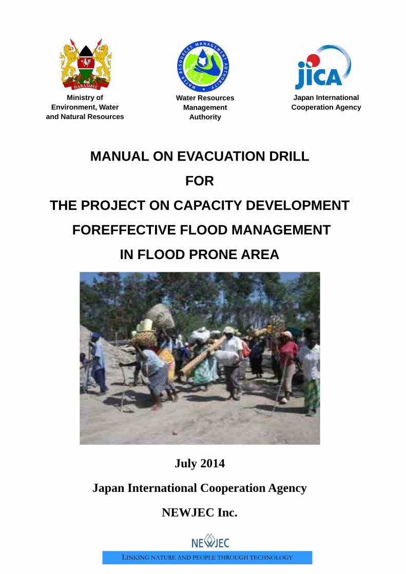
LINKING NATURE AND PEOPLE THROUGH TECHNOLOGY
MANUAL ON EVACUATION DRILL
FOR
THE PROJECT ON CAPACITY DEVELOPMENT
FOREFFECTIVE FLOOD MANAGEMENT
IN FLOOD PRONE AREA
July 2014
Japan International Cooperation Agency
NEWJEC Inc.
Ministry of Environment, Water
and Natural Resources
Water Resources Management
Authority
Japan International Cooperation Agency

Preface
The Government of Kenya established the Water Resources Management
Authority (WRMA), through the sector reform brought by Water Act 2002.
WRMA is the lead agency in the management of water resources in the country
through six (6) regional offices and twenty six (26) sub – regional offices of the
respective water resources catchment areas.
Since its operationalization in 2005, WRMA has made significant progress in
making water resources recognized as being fundamental for socio-economic
and environmental sustainability. In this regard, integrated floods management is viewed as necessary
component in water resources management.
Based on the request from GOK, JICA carried out the “Study on the Integrated Flood Management
(IFM) for Nyando River Basin (2006 – 2009)” as the Technical Cooperation Scheme and “Programme
for Community based Flood Disaster Management to Adapt to Climate Change in the Nyando River
Basin (2009-2011)”. This was a Grant Aid Programme with the aim of establishing a flood
management system in the southern part or Lake Victoria Basin through IFM, where WRMA was the
implementing agency. Through the above projects, community based flood management activities
have been implemented through integrating non- structural and structural measures such as
community based flood hazard mapping and construction of flood counter measure structures in
prioritized flood prone areas.
Based on the achievement of Nyando project, the Project on Capacity Development for Effective
Flood Management was formulated to expand IFM in other flood prone areas in Kenya. Three pilot
river basins were selected namely: Isiolo, Gucha-Migori and Lumi to promote community based flood
management activities. The main purpose of the project was to build institutional framework of flood
management in the context of integrated water resource management for effective and sustainable
implementation of community based activities. Through the project WRMA has developed strategies
and guidelines in managing floods which have since been incorporated in the revised Catchment
Management Strategies (CMS) and WRUA Development Cycle (WDC) manual. In order to develop
capacity of WRMA officers in the field of community-based integrated flood management, a training
system has been developed where the Project conducted IFM Training for WRMA officers who in
turn trained the WRUAs. The Training Materials for community based flood management have been
developed. These include supplemental manuals, lessons learnt and case studies.
Eng. John P. Olum, HSC
Chief Executive Officer, WRMA
i
ACKNOWLEDGEMENT: Community based Flood Management was implemented in the Nyando River Basin and various manuals were developed as outputs including the evacuation drill guidebook. This guidebook therefore takes cognisance of the previous work done and acknowledges that this guidebook has borrowed heavily from the previous evacuation drill guidebook under the Nyando Project.
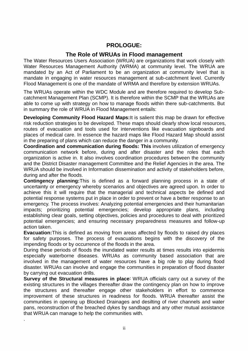
ii
PROLOGUE:
The Role of WRUAs in Flood management The Water Resources Users Association (WRUA) are organizations that work closely with Water Resources Management Authority (WRMA) at community level. The WRUA are mandated by an Act of Parliament to be an organization at community level that is mandate in engaging in water resources management at sub-catchment level. Currently Flood Management is one of the mandate of WRMA and therefore by extension WRUAs.
The WRUAs operate within the WDC Module and are therefore required to develop Sub-catchment Management Plan (SCMP). It is therefore within the SCMP that the WRUAs are able to come up with strategy on how to manage floods within there sub-catchments. But in summary the role of WRUA in Flood Management entails:
Developing Community Flood Hazard Maps:It is salient this map be drawn for effective risk reduction strategies to be developed. These maps should clearly show local resources, routes of evacuation and tools used for interventions like evacuation signboards and places of medical care. In essence the hazard maps like Flood Hazard Map should assist in the preparing of plans which can reduce the danger in a community. Coordination and communication during floods: This involves utilization of emergency communication network before, during and after disaster and the roles that each organization is active in. It also involves coordination procedures between the community and the District Disaster management Committee and the Relief Agencies in the area. The WRUA should be involved in Information dissemination and activity of stakeholders before, during and after the floods. Contingency planning:This is defined as a forward planning process in a state of uncertainty or emergency whereby scenarios and objectives are agreed upon. In order to achieve this it will require that the managerial and technical aspects be defined and potential response systems put in place in order to prevent or have a better response to an emergency. The process involves: Analyzing potential emergencies and their humanitarian impacts; prioritizing potential emergencies; develop appropriate plans, including establishing clear goals, setting objectives, policies and procedures to deal with prioritized potential emergencies; and ensuring necessary preparedness measures and follow-up action taken. Evacuation:This is defined as moving from areas affected by floods to raised dry places for safety purposes. The process of evacuations begins with the discovery of the impending floods or by occurrence of the floods in the area. During these periods of floods the inundated water results at times results into epidermis especially waterborne diseases. WRUAs as community based association that are involved in the management of water resources have a big role to play during flood disaster. WRUAs can involve and engage the communities in preparation of flood disaster by carrying out evacuation drills. Survey of the Structural measures in place: WRUA officials carry out a survey of the existing structures in the villages thereafter draw the contingency plan on how to improve the structures and thereafter engage other stakeholders in effort to commence improvement of these structures in readiness for floods. WRUA thereafter assist the communities in opening up Blocked Drainages and desilting of river channels and water pans, reconstruction of the breached dykes by sandbags and any other mutual assistance that WRUA can manage to help the communities with. .
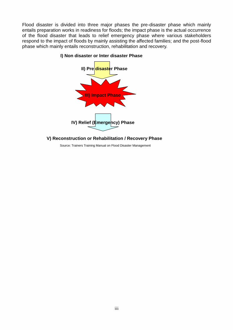
iii
Flood disaster is divided into three major phases the pre-disaster phase which mainly entails preparation works in readiness for floods; the impact phase is the actual occurrence of the flood disaster that leads to relief emergency phase where various stakeholders respond to the impact of floods by mainly assisting the affected families; and the post-flood phase which mainly entails reconstruction, rehabilitation and recovery.
I) Non disaster or Inter disaster Phase
III) Impact Phase
II) Pre disaster Phase
IV) Relief (Emergency) Phase
V) Reconstruction or Rehabilitation / Recovery Phase
Source: Trainers Training Manual on Flood Disaster Management
iv
EVACUATION DRILL GUIDE-BOOK
FOR THE FLOOD PRONE AREA IN KENYA
Table of Contents
Page
CHAPTER 1 PREPARATORY STAGE ..................................................................................... 1
1.1 Preparatory Meeting .............................................................................................................. 1 1.2 Confirmation of Executing Board and Organisation ........................................................... 1 1.3 Implementation Programme on how to evacuate in case of flood disaster ........................ 2
CHAPTER 2 EXECUTION OF AN EVACUATION DRILL ....................................................... 6 2.1 Step 1: Commencement of Drill ............................................................................................. 6 2.2 Step 2: Causing alert by various tools................................................................................... 6 2.3 Step 3: Evacuation of community members to evacuation centre. ..................................... 6 2.4 Step 4: Dissemination of information for External Assistance ........................................... 7 2.5 Step 5: Settling of Evacuees at the Evacuation Centre ....................................................... 7 2.6 Step 6: First Aid demonstration ............................................................................................ 8 2.7 Step 7: Evaluation and Assessment of Flood Damage. ........................................................ 8 2.8 Step 8: Wrap up Meeting ........................................................................................................ 9
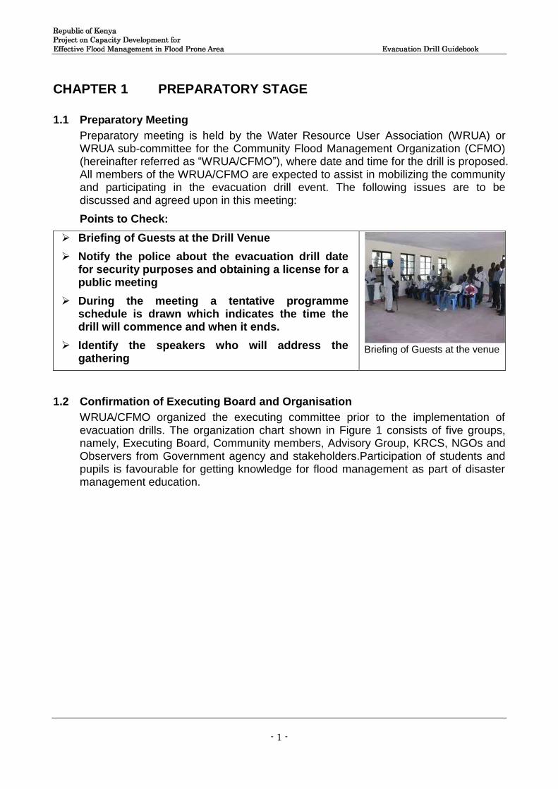
Republic of Kenya Project on Capacity Development for Effective Flood Management in Flood Prone Area Evacuation Drill Guidebook
- 1 -
CHAPTER 1 PREPARATORY STAGE
1.1 Preparatory Meeting
Preparatory meeting is held by the Water Resource User Association (WRUA) or WRUA sub-committee for the Community Flood Management Organization (CFMO) (hereinafter referred as “WRUA/CFMO”), where date and time for the drill is proposed. All members of the WRUA/CFMO are expected to assist in mobilizing the community and participating in the evacuation drill event. The following issues are to be discussed and agreed upon in this meeting:
Points to Check:
Briefing of Guests at the Drill Venue
Notify the police about the evacuation drill date for security purposes and obtaining a license for a public meeting
During the meeting a tentative programme schedule is drawn which indicates the time the drill will commence and when it ends.
Identify the speakers who will address the gathering
Briefing of Guests at the venue
1.2 Confirmation of Executing Board and Organisation
WRUA/CFMO organized the executing committee prior to the implementation of evacuation drills. The organization chart shown in Figure 1 consists of five groups, namely, Executing Board, Community members, Advisory Group, KRCS, NGOs and Observers from Government agency and stakeholders.Participation of students and pupils is favourable for getting knowledge for flood management as part of disaster management education.
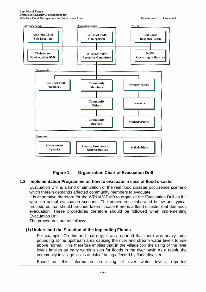
Republic of Kenya Project on Capacity Development for Effective Flood Management in Flood Prone Area Evacuation Drill Guidebook
- 2 -
Figure 1: Organization Chart of Evacuation Drill
1.3 Implementation Programme on how to evacuate in case of flood disaster
Evacuation Drill is a kind of simulation of the real flood disaster occurrence scenario which therein demands affected community members to evacuate. It is imperative therefore for the WRUA/CFMO to organize the Evacuation Drill as if it were an actual evacuation scenario. The procedures elaborated below are typical procedures that should be undertaken in case there is a flood disaster that demands evacuation. These procedures therefore should be followed when implementing Evacuation Drill. The procedures are as follows:
(1) Understand the Situation of the Impending Floods
For example: On this and that day, it was reported that there was heavy rains pounding at the upstream area causing the river and stream water levels to rise above normal. This therefore implies that in the village xxx the rising of the river levels implies an early warning sign for floods in the river basin.As a result, the community in village xxx is at risk of being affected by flood disaster.
Based on this information on rising of river water levels, reported
Advisory Group Executing Board NGOs
Community
Observers
WRUA/CFMO Chairperson
WRUA/CFMO Executive Committee
WRUA/CFMO members
Community Members Primary School
Teachers
Students/Pupils
Assistant Chief Sub-Location
Chairperson Sub-Location DMC
Red Cross Response Team
NGOs Operating in the area
Community Elders
Community Disabled
Government Agencies Stakeholders County Government
Representatives
Republic of Kenya Project on Capacity Development for Effective Flood Management in Flood Prone Area Evacuation Drill Guidebook
- 3 -
byWRUA/CFMO officials that patrol to monitor the river, the WRUA/CFMO chairman thereafter announces immediate evacuation of those community membersin village xxx to safer grounds.
(2) Roles to all the Key WRUA/CFMO Members
It is important that roles of each actor be assigned before the evacuation drill is carried out. Table 1 shown typical role of the each member’s role.
Table 1 Assignment of Roles
Items for Checking Activity Assigned Personnel
Items of Confirmation
Confirmation of river water level. This is a daily routine exercise but for the Evacuation Drill it is explained in the WRAP UP MEETING
WRUA/CFMO member carries out patrol to confirm river water level, and report the high possibility of flood from the river to WRUA/CFMO chairman by mobile.
WRUA/CFMO member
Existing method of patrol (confirmer, check point, method of confirmation of river water level) and timing for report.
Request aid. This the second step after confirmation of inevitable evacuation the WRUA/CFMO chair request for aid. During the drill this part is explained during the WRAP UP MEETING
WRUA/CFMO chairman reports increasing river water level above river bank/dike and a possible evacuation situation to DMC (Sub-Location) by mobile, and requests for aid from the DMC.
WRUA/CFMO chairman
Announcement of evacuation. The WRUA/CFMO Chairman informs the village elder who sounds the alarm for community members to evacuate. This event is dramatized in the Evacuation Drill as it is done in the actual evacuation scenario.
WRUA/CFMO chairman instructs the executive committee members to evacuate community members to the nearest evacuation centre.
WRUA/CFMO chairman
WRUA/CFMO members move from homestead to homestead warning community members to evacuate.
WRUA/CFMO members
Announce method (siren, drum, shouting)
Set up an evacuation centre. WRUA/ CFMO officials take the lead in organizing the evacuation centre to ensure orderly occupation and also register the evacuees to ascertain the numbers, the injured and assess the damage caused on human and property when registering. WRUA/CFMO official responsible is the Secretary. This is how it should be done both in actual scenario and Evacuation Drill
WRUA/CFMO members set up reception for evacuees at the evacuation centre
WRUA/CFMO members
Basic necessities should be made available like water, food and firewood
Reporting a number of evacuees. The number of evacuees should be noted down then communicated to other stakeholders like KRCS, Provincial Administration by the WRUA/CFMO Chairperson via mobile phone. This is depicted in the Evacuation Drill and it is undertaken in the actual evacuation scenario.
Reception counts a number of evacuees and reports total number with a proper breakdown, i.e. the sick, the injured, children, and pregnant women to WRUA/CFMO chairman.
WRUA/CFMO member
Vulnerable persons, the injured and the sick.
WRUA/CFMO chairman report a number of evacueesand evacuation place condition to Assistant Chief.
WRUA/CFMO chairman
Emergency treatment This scenario is dramatized by the WRUA/CFMO members and an elaborate first aid technique transfer is explained by a person with first aid skills during the evacuation drill. In actual scenario WRUA/CFMO members should be able to administer basic first aid to the injured
Assess the injuries and thereafter provide basic treatment (first aid). Below are guidelines on injuries and first aid administration: 1) Resuscitation A-Airway B-Breathing -Look -Listen -Feel C.P.R-Cardiopulmonary Resuscitation 2) Airway Disorders
KRCS/ trained first-aid attendant
It is important that WRUA/CFMO members acquire basic First- Aid administration to assist the injured especially on the major injuries that evacuees suffer as a result of evacuation
Republic of Kenya Project on Capacity Development for Effective Flood Management in Flood Prone Area Evacuation Drill Guidebook
- 4 -
Chocking Drowning (near drowning) 3) Foreign bodies in the eye, ear
and nose -Eyes-pour cool clean running water
-Ears-pour vegetable oil -Nose-blow one side 4) Bleeding and wounds -Clean the wounds and stop
bleeding 5) Bites and Stings Bites-dogs, snakes, cats Stings, bees, wasps, ants etc.
6) Transportation-Moving casualty from one place to another
-Fireman’s crawl -Stretchers -Hand lifts 7) Fainting and Shock -Recovery position
In-case of an evacuation drill a Wrap-up meeting must be organized.
Wrap-up meeting which reviews the evacuation process and problems encountered are highlighted and discussed.
WRUA/CFMO Executive Committee facilitates
Scheduled speakers address the participants.
Point to note: It is important to note that the drill is a simulation of the real flooding scenario and whatsoever that is needed to ensure safe evacuation should be carried out during Evacuation Drill. Also areas that need to be improved should be highlighted during Evacuation Drill and incorporated into the evacuation programme guide to improve on safe evacuation.
(3) Procurement of refreshment
The WRUA/CFMO should develop a budget for implementing Evacuation Drill. The budget should be simple void of unnecessary expenses. The main expense during the drill should be refreshment and hiring of public address system. Refreshment should be simple for example sodas or drinking water for at least three hundred (300) participants.
(4) Sharing of information to relevant stakeholders
It is important that information on the proposed Evacuation Drill (including the budget) be shared with the relevant stakeholders. WRUA/CFMO should take the initiative of sharing the information with WRMA Sub-regional Office; and thereafter share the information with the Deputy County Commissioner of the Sub-county and KRCS; and also share the information with the relevant offices in the County Government setup.
1.4 Typical Evacuation Drill Timetable
WRUA/CFMO should establish a timetable for evacuation drill. This timetable should be shared with other stakeholders and community members that will participate in the Evacuation Drill.
Table 2 shows an example of time table for evacuation drill.
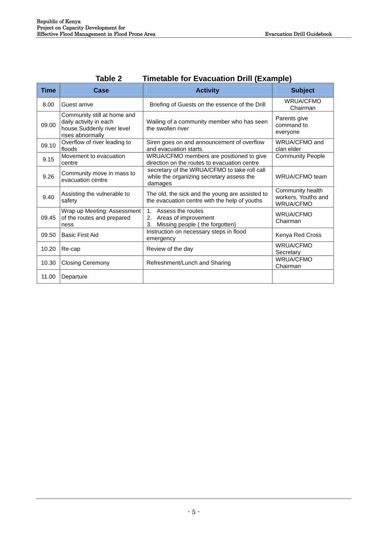
Republic of Kenya Project on Capacity Development for Effective Flood Management in Flood Prone Area Evacuation Drill Guidebook
- 5 -
Table 2 Timetable for Evacuation Drill (Example)
Time Case Activity Subject
8.00 Guest arrive Briefing of Guests on the essence of the Drill WRUA/CFMO
Chairman
09.00
Community still at home and daily activity in each house.Suddenly river level rises abnormally
Wailing of a community member who has seen the swollen river
Parents give command to everyone
09.10 Overflow of river leading to floods
Siren goes on and announcement of overflow and evacuation starts.
WRUA/CFMO and clan elder
9.15 Movement to evacuation centre
WRUA/CFMO members are positioned to give direction on the routes to evacuation centre
Community People
9.26 Community move in mass to evacuation centre
secretary of the WRUA/CFMO to take roll call while the organizing secretary assess the damages
WRUA/CFMO team
9.40 Assisting the vulnerable to safety
The old, the sick and the young are assisted to the evacuation centre with the help of youths
Community health workers, Youths and WRUA/CFMO
09.45 Wrap up Meeting: Assessment of the routes and prepared ness
1. Assess the routes 2. Areas of improvement 3. Missing people ( the forgotten)
WRUA/CFMO Chairman
09.50 Basic First Aid Instruction on necessary steps in flood emergency
Kenya Red Cross
10.20 Re-cap Review of the day WRUA/CFMO Secretary
10.30 Closing Ceremony Refreshment/Lunch and Sharing WRUA/CFMO Chairman
11.00 Departure
Republic of Kenya Project on Capacity Development for Effective Flood Management in Flood Prone Area Evacuation Drill Guidebook
- 6 -
CHAPTER 2 EXECUTION OF AN EVACUATION DRILL
2.1 Step 1: Commencement of Drill
The evacuation drill commences with a village community member discussing with fellow community member on issues of floods and exclaims “…did you hear the announcement by WRUA/CFMO Chairman that the river water level is raising and we need to start evacuating!” Then the other community member wails loud“Floods! Floods! Evacuate from your homes, do not waste time evacuate immediately!” Thereafter WRUA/CFMO membermainly the Chairperson thereafter briefs the participants from the community members, invited guests and other stakeholders of the evacuation drill event based on the timetable and the processes involved in the evacuation. The member doing the briefing must emphasize the need for time management. Thereafter he or she declares the evacuation drill commencement..
Points to Check
2.2 Step 2: Causing alert by various tools
WRUA/CFMO chairperson immediately after briefing the participants delegates to the CFMO chairperson or clan elder or CFMO organizing secretary to alert people to evacuate. The drill therefore starts when the CFMO chairperson or clan elder or an appointed person sounds alarm and alerts the villagers to evacuate immediately because of the impending floods that are about to occur any moment from that time. He or she instructs community members to evacuate to a particular evacuation centre that is already prepared for them.
Points to Check The alert is made loud enough for all to hear The youths are on stand-by to assist the
vulnerable The alert is to warn people on the flood
situation and need to evacuate to a particular centre
Announcement of Evacuation
to the community to move as alert
2.3 Step 3: Evacuation of community members to evacuation centre.
The community members should evacuate immediately to the evacuation centre on hearing the alarm sound.
The case scenario is that the waters are yet to burst the banks but the signs are
WRUA/CFMO Chairperson distributes roles among the executive and committee members to assist the evacuees
Youths direct evacuees to the evacuation centre Chairperson impression that he or she is in contact with the local
provincial administration (assistant chief) and if possible the assistant chief should be part of the members in the meeting
Chairperson’s impression is that he or she was in constant communication with the sub-location disaster management committee chairperson
Republic of Kenya Project on Capacity Development for Effective Flood Management in Flood Prone Area Evacuation Drill Guidebook
- 7 -
visible that the river water will soon burst the banks and cause flooding in the village. Thereforethe community members evacuation should be very organized and orderlywithout bring about element of confusion but with the sense of urgency must be visible and eminent.
Points to Check
2.4 Step 4: Dissemination of information for External Assistance
As the community members are evacuating the Assistant Chief and the WRUA Chairperson should be coordinating and making calls for help from the Sub-county national administration office and other government agencies like Ministry of Health. The chairperson or assistant chief also calls like the KRCS and NGOs operating in the area for assistance. Points to Check Mobile phone communication between the
chairperson and assistant chief concerning requesting for relief assistance to the evacuees (in cases where the assistant chief is not available during the drill)
Assistant chief makes a phone call to the district provincial administration. The name of the department must be mentioned and a proper description of the flood situation is made.
Assistant chief or chairperson calls KRCS. The approximate number of the affected persons and households, what is lacking at the evacuation centre in terms of basic needs, number of the injured or sick persons should be mentioned.
Vulnerable evacuees wait for medical assistance that has been communicated by WRUA/CFMO Chair and local Chief to the response agencies.
2.5 Step 5: Settling of Evacuees at the Evacuation Centre
The affected community members move into the evacuation centre and thereafter are referred to as evacuees. The evacuees are registered by the WRUA/CFMO as they enter into the evacuation centre. The WRUA/CFMO chairperson takes the leading role in ensuring peaceful settlement of evacuees. Village elders play an important role in helping them to settle down at the evacuation centre. WRUA/CFMO members ask questions to assess the status of properties left behind or missing and whether the water had breached any river banks yet. Points to Check
Participation of village elders in assisting the community during evacuation The importance of mobile phone as a way of enhancing communication
during disaster particularly floods Assistance to the vulnerable persons like the disabled, pregnant women,
children, sick people Registration and of evacuees and their number noted down and given to the
chairperson of WRUA/CFMO and assistant chief
Republic of Kenya Project on Capacity Development for Effective Flood Management in Flood Prone Area Evacuation Drill Guidebook
- 8 -
Evacuees are registered as they settle at the evacuation centre for initial registration
Chairperson plays a pivotal role in the settling of evacuees
Village elders assist in the settling of evacuees Injuries and damage assessment done mainly
by WRUA/CFMO executive committee members Ensuring the safety of the vulnerable especially
children, the aged, disables and pregnant women
Initial registration of Evacuees as they settle at the evacuation centre.
2.6 Step 6: First Aid demonstration
Based on the hazards and injuries that are likely to occur during evacuation,WRUA/CFMO members must demonstrate on their own the first aid treatment on emergency cases. Thereafter a demonstration on the same emergency cases is carried out by a qualified first aider or KRCS official.
Points to Check The first-aid demonstration is carried out by a competent
first-aid trained attendant. First-aid attendant must state that first-aid is not in itself
a complete medical treatment but a step whereby the risky medical condition is minimized as the injured person is taken to hospital for medical treatment
Demonstration should deal mainly with injuries that are prevalent during the flooding period e.g. drowning, cuts, bleeding, fainting, shock and snake bites among other like related injuries
First Aid provision at Evacuation time
Figure2: Illustrations Showing the First Aid during Evacuation
2.7 Step 7: Evaluation and Assessment of Flood Damage.
WRUA/CFMO executive committee carryout an evaluation and assessment of the flood damage by administering a questionnaire survey to the evacuees in efforts of establishing the damage level of their homesteads, the challenges encountered when evacuating, assistance to the vulnerable and properties salvaged.
Points to Check
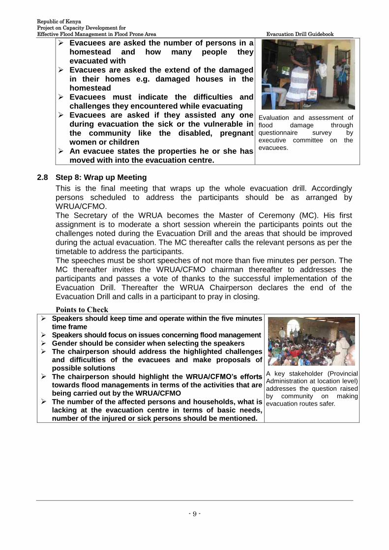
Republic of Kenya Project on Capacity Development for Effective Flood Management in Flood Prone Area Evacuation Drill Guidebook
- 9 -
Evacuees are asked the number of persons in a homestead and how many people they evacuated with
Evacuees are asked the extend of the damaged in their homes e.g. damaged houses in the homestead
Evacuees must indicate the difficulties and challenges they encountered while evacuating
Evacuees are asked if they assisted any one during evacuation the sick or the vulnerable in the community like the disabled, pregnant women or children
An evacuee states the properties he or she has moved with into the evacuation centre.
Evaluation and assessment of flood damage through questionnaire survey by executive committee on the evacuees.
2.8 Step 8: Wrap up Meeting
This is the final meeting that wraps up the whole evacuation drill. Accordingly persons scheduled to address the participants should be as arranged by WRUA/CFMO. The Secretary of the WRUA becomes the Master of Ceremony (MC). His first assignment is to moderate a short session wherein the participants points out the challenges noted during the Evacuation Drill and the areas that should be improved during the actual evacuation. The MC thereafter calls the relevant persons as per the timetable to address the participants. The speeches must be short speeches of not more than five minutes per person. The MC thereafter invites the WRUA/CFMO chairman thereafter to addresses the participants and passes a vote of thanks to the successful implementation of the Evacuation Drill. Thereafter the WRUA Chairperson declares the end of the Evacuation Drill and calls in a participant to pray in closing.
Points to Check Speakers should keep time and operate within the five minutes
time frame Speakers should focus on issues concerning flood management Gender should be consider when selecting the speakers The chairperson should address the highlighted challenges
and difficulties of the evacuees and make proposals of possible solutions
The chairperson should highlight the WRUA/CFMO’s efforts towards flood managements in terms of the activities that are being carried out by the WRUA/CFMO
The number of the affected persons and households, what is lacking at the evacuation centre in terms of basic needs, number of the injured or sick persons should be mentioned.
A key stakeholder (Provincial Administration at location level) addresses the question raised by community on making evacuation routes safer.
LINKING NATURE AND PEOPLE THROUGH TECHNOLOGY
Manual for Developing Community Flood Hazard Map for the Project on Capacity Development
for Effective Flood Management
in Flood Prone Area
July 2014
Japan International Cooperation Agency
NEWJEC Inc.
Ministry of Environment, Water and
Natural Resources
Water Resources Management
Authority
Japan International Cooperation Agency

Preface
The Government of Kenya established the Water Resources Management
Authority (WRMA), through the sector reform brought by Water Act 2002.
WRMA is the lead agency in the management of water resources in the country
through six (6) regional offices and twenty six (26) sub – regional offices of the
respective water resources catchment areas.
Since its operationalization in 2005, WRMA has made significant progress in
making water resources recognized as being fundamental for socio-economic
and environmental sustainability. In this regard, integrated floods management is viewed as necessary
component in water resources management.
Based on the request from GOK, JICA carried out the “Study on the Integrated Flood Management
(IFM) for Nyando River Basin (2006 – 2009)” as the Technical Cooperation Scheme and “Programme
for Community based Flood Disaster Management to Adapt to Climate Change in the Nyando River
Basin (2009-2011)”. This was a Grant Aid Programme with the aim of establishing a flood
management system in the southern part or Lake Victoria Basin through IFM, where WRMA was the
implementing agency. Through the above projects, community based flood management activities
have been implemented through integrating non- structural and structural measures such as
community based flood hazard mapping and construction of flood counter measure structures in
prioritized flood prone areas.
Based on the achievement of Nyando project, the Project on Capacity Development for Effective
Flood Management was formulated to expand IFM in other flood prone areas in Kenya. Three pilot
river basins were selected namely: Isiolo, Gucha-Migori and Lumi to promote community based flood
management activities. The main purpose of the project was to build institutional framework of flood
management in the context of integrated water resource management for effective and sustainable
implementation of community based activities. Through the project WRMA has developed strategies
and guidelines in managing floods which have since been incorporated in the revised Catchment
Management Strategies (CMS) and WRUA Development Cycle (WDC) manual. In order to develop
capacity of WRMA officers in the field of community-based integrated flood management, a training
system has been developed where the Project conducted IFM Training for WRMA officers who in
turn trained the WRUAs. The Training Materials for community based flood management have been
developed. These include supplemental manuals, lessons learnt and case studies.
Eng. John P. Olum, HSC
Chief Executive Officer, WRMA
i
TABLE OF CONTENTS
Page
1. Background ........................................................................................................... 1
2. Introduction ........................................................................................................... 2
3. Developing Community-driven Flood Hazard Map .................................................... 4
4. Preparatory Works for Community-driven Flood Hazard Mapping .............................. 6
5. ADRC Approach in developing Community-driven Flood Hazard Map ....................... 6
6. What therefore constitute a Community-driven Flood Hazard Map? ............................ 7
7. Methodologies of developing Community-driven Flood Hazard Map ........................... 7
8. Importance of Local Knowledge in Community-driven Flood Hazard Map................... 8
9. Implementation of Community-driven Flood Hazard Map .......................................... 8
10. Merits of Community Flood hazard mapping ........................................................ 10
11. Advantages of Community Flood hazard mapping ................................................ 10
12. Point to note on community flood hazard map ...................................................... 11
13. Examples of Community-driven Flood Hazard Map .............................................. 12
14. How to use community flood hazard mapping to update topographical map ............ 13
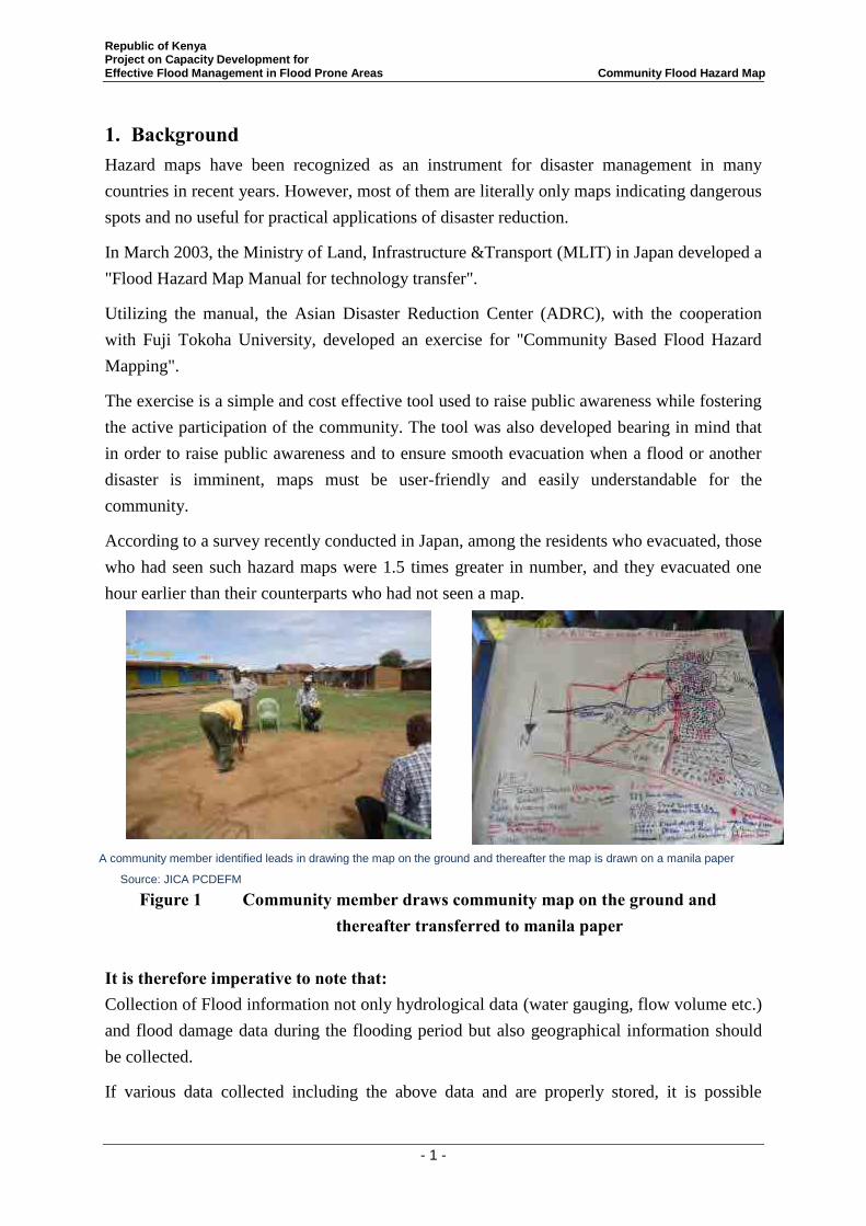
Republic of Kenya Project on Capacity Development for Effective Flood Management in Flood Prone Areas Community Flood Hazard Map
- 1 -
1. Background Hazard maps have been recognized as an instrument for disaster management in many
countries in recent years. However, most of them are literally only maps indicating dangerous
spots and no useful for practical applications of disaster reduction.
In March 2003, the Ministry of Land, Infrastructure &Transport (MLIT) in Japan developed a
"Flood Hazard Map Manual for technology transfer".
Utilizing the manual, the Asian Disaster Reduction Center (ADRC), with the cooperation
with Fuji Tokoha University, developed an exercise for "Community Based Flood Hazard
Mapping".
The exercise is a simple and cost effective tool used to raise public awareness while fostering
the active participation of the community. The tool was also developed bearing in mind that
in order to raise public awareness and to ensure smooth evacuation when a flood or another
disaster is imminent, maps must be user-friendly and easily understandable for the
community.
According to a survey recently conducted in Japan, among the residents who evacuated, those
who had seen such hazard maps were 1.5 times greater in number, and they evacuated one
hour earlier than their counterparts who had not seen a map.
Figure 1 Community member draws community map on the ground and thereafter transferred to manila paper
It is therefore imperative to note that: Collection of Flood information not only hydrological data (water gauging, flow volume etc.)
and flood damage data during the flooding period but also geographical information should
be collected.
If various data collected including the above data and are properly stored, it is possible
A community member identified leads in drawing the map on the ground and thereafter the map is drawn on a manila paper
Source: JICA PCDEFM
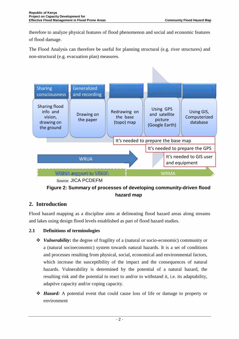
Republic of Kenya Project on Capacity Development for Effective Flood Management in Flood Prone Areas Community Flood Hazard Map
- 2 -
therefore to analyze physical features of flood phenomenon and social and economic features
of flood damage.
The Flood Analysis can therefore be useful for planning structural (e.g. river structures) and
non-structural (e.g. evacuation plan) measures.
Sharing flood info and
vision, drawing on the ground
Drawing on the paper
Redrawing on the base
(topo) map
Using GPS and satellite
picture (Google Earth)
Using GIS, Computerized
database
WRUA
WRMA
It’s needed to prepare the base map
It’s needed to prepare the GPS
It’s needed to GIS userand equipment
Sharing consciousness
Generalized and recording
2. Introduction Flood hazard mapping as a discipline aims at delineating flood hazard areas along streams
and lakes using design flood levels established as part of flood hazard studies.
2.1 Definitions of terminologies
Vulnerability: the degree of fragility of a (natural or socio-economic) community or
a (natural socioeconomic) system towards natural hazards. It is a set of conditions
and processes resulting from physical, social, economical and environmental factors,
which increase the susceptibility of the impact and the consequences of natural
hazards. Vulnerability is determined by the potential of a natural hazard, the
resulting risk and the potential to react to and/or to withstand it, i.e. its adaptability,
adaptive capacity and/or coping capacity.
Hazard: A potential event that could cause loss of life or damage to property or
environment
Source: JICA PCDEFM
Figure 2: Summary of processes of developing community-driven flood
hazard map
Republic of Kenya Project on Capacity Development for Effective Flood Management in Flood Prone Areas Community Flood Hazard Map
- 3 -
Risks: The scientific approach defines the risk as the probability and extent of damage
due to a particular flood. Conventionally the risk is expressed by the notation:
Risk = Hazard X Vulnerability.
Flood related risk refers to the probability of harmful consequences, or expected
losses resulting from interactions between natural hazards and vulnerable conditions.
Disaster: The serious disruption of the functioning of society causing widespread
human, material or environmental losses which exceed the ability of the affected
communities to cope using their resources. Disasters occur when negative effects of
the hazards are not well managed.
Flood: a temporary covering of land by water on the land normally not covered by
water. This shall include floods from rivers, mountain torrents, and floods from the
sea in coastal areas.
Flood risk: the combination of the probability of a flood event and of the potential
adverse consequences to human health, the environment and economic activity
associated with a flood event.
A floodplain or flood plain is an area of land adjacent to a stream or river that
stretches from the banks of its channel to the base of the enclosing valley walls and
experiences flooding during periods of high discharge.
Floodplain map is a map that indicates the geographical areas, which could be
covered by a flood according to one or several probabilities: floods with a very low
probability or extreme events scenarios; floods with a medium probability floods
with a high probability.
Flood hazard map is a map that details a flood plain and indicates the type of flood,
the flood extent; water depths or water level, flow velocity or the relevant water
flow direction. In the community flood hazard mapping process, the community
members along with the executing agencies and the concerned governmental
officials, demarcate flood hazardous areas, evacuation centres and evacuation routes.
Floodway is a portion of the flood hazard area where water flows are deepest, fastest
and most destructive. The floodway typically includes the main channel of a stream
and a portion of the adjacent overbank area. New development should be
discouraged in the floodway.
Flood Fringe are areas inundated by the flood, but which do not experience a strong
current and the water in the flood fringe is generally shallower and flows more
slowly than in the floodway.
Republic of Kenya Project on Capacity Development for Effective Flood Management in Flood Prone Areas Community Flood Hazard Map
- 4 -
Flood risk map is the map that indicates potential adverse consequences associated
with floods under several probabilities, expressed in terms of: the indicative number
of inhabitants potentially affected; type of economic activity of the area potentially
affected; installation which might cause accidental pollution in case of flooding.
Flood Damage is the amount of destruction or damage, either in health, financial,
environmental functional and/or other terms as a consequence of an occurrence of a
flood hazard.
3. Developing Community-driven Flood Hazard Map
Community-driven Flood Hazard Map is therefore a flood hazard map that is developed by
community members and it features flood characteristics of the area. It entails the flood
direction flow, the depth of flood in particular areas, the flood inundation duration, the
evacuation routes, the evacuation places, rescue centres, health facilities, water points and
the homesteads in the area.
Objectives of flood hazard maps:
i) Understand the characteristics of flood in the community; ii) Understand the weaknesses to floods in the community; iii) Increase awareness of personal flood mitigation measures; and iv) Assist the establishment and strengthening of community organizations for
flood disaster mitigation.
N/B: It is desirable that community flood hazard maps should be shown on the community
board for dissemination of proper evacuation routes and places dangerous to the community.
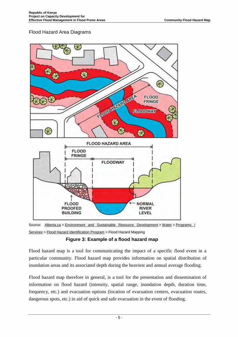
Republic of Kenya Project on Capacity Development for Effective Flood Management in Flood Prone Areas Community Flood Hazard Map
- 5 -
Flood Hazard Area Diagrams
1. Developing Community-driven Flood Hazard Map
Flood hazard map is a tool for communicating the impact of a specific flood event in a
particular community. Flood hazard map provides information on spatial distribution of
inundation areas and its associated depth during the heaviest and annual average flooding.
Flood hazard map therefore in general, is a tool for the presentation and dissemination of
information on flood hazard (intensity, spatial range, inundation depth, duration time,
frequency, etc.) and evacuation options (location of evacuation centers, evacuation routes,
dangerous spots, etc.) in aid of quick and safe evacuation in the event of flooding.
Source: Alberta.ca > Environment and Sustainable Resource Development > Water > Programs /
Services > Flood Hazard Identification Program > Flood Hazard Mapping
Figure 3: Example of a flood hazard map
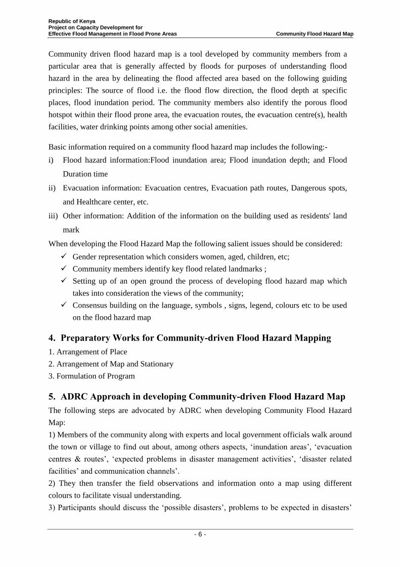
Republic of Kenya Project on Capacity Development for Effective Flood Management in Flood Prone Areas Community Flood Hazard Map
- 6 -
Community driven flood hazard map is a tool developed by community members from a
particular area that is generally affected by floods for purposes of understanding flood
hazard in the area by delineating the flood affected area based on the following guiding
principles: The source of flood i.e. the flood flow direction, the flood depth at specific
places, flood inundation period. The community members also identify the porous flood
hotspot within their flood prone area, the evacuation routes, the evacuation centre(s), health
facilities, water drinking points among other social amenities.
Basic information required on a community flood hazard map includes the following:-
i) Flood hazard information:Flood inundation area; Flood inundation depth; and Flood
Duration time
ii) Evacuation information: Evacuation centres, Evacuation path routes, Dangerous spots,
and Healthcare center, etc.
iii) Other information: Addition of the information on the building used as residents' land
mark
When developing the Flood Hazard Map the following salient issues should be considered:
Gender representation which considers women, aged, children, etc;
Community members identify key flood related landmarks ;
Setting up of an open ground the process of developing flood hazard map which
takes into consideration the views of the community;
Consensus building on the language, symbols , signs, legend, colours etc to be used
on the flood hazard map
4. Preparatory Works for Community-driven Flood Hazard Mapping 1. Arrangement of Place
2. Arrangement of Map and Stationary
3. Formulation of Program
5. ADRC Approach in developing Community-driven Flood Hazard Map The following steps are advocated by ADRC when developing Community Flood Hazard
Map:
1) Members of the community along with experts and local government officials walk around
the town or village to find out about, among others aspects, ‘inundation areas’, ‘evacuation
centres & routes’, ‘expected problems in disaster management activities’, ‘disaster related
facilities’ and communication channels’.
2) They then transfer the field observations and information onto a map using different
colours to facilitate visual understanding.
3) Participants should discuss the ‘possible disasters’, problems to be expected in disasters’
Republic of Kenya Project on Capacity Development for Effective Flood Management in Flood Prone Areas Community Flood Hazard Map
- 7 -
and ‘possible countermeasures’.
6. What therefore constitute a Community-driven Flood Hazard Map? Flood hazard map, in general, is a tool for the presentation and dissemination of information
on flood hazard (intensity, spatial range, inundation depth, duration time, frequency, etc.) and
evacuation options (location of evacuation centers, evacuation routes, dangerous spots, etc.)
in aid of quick and safe evacuation in the event of flooding.
The following items are considered important and they should constitute the community
driven flood hazard map i.e.:
a) Basic Information
Flood Hazard Information
- Flood inundation area
- Flood inundation depth
- Flood Duration time
Evacuation Information
- Evacuation centers,
- Evacuation path routes
- Dangerous spots,
- Healthcare center, etc
b) Other information
- Addition of the information on the building used as residents' land mark
- Setting to the scale range which can have a common view
- Consider of gender and the aged, young, etc.
7. Methodologies of developing Community-driven Flood Hazard Map To develop the Flood Hazard Map the following should be considered:
1. Gender representation which considers women, aged, children, etc;
2. Community members identify key flood related landmarks ;
3. Setting up of an open ground the process of developing flood hazard map which takes
into consideration the views of the community;
4. Consensus building on the language, symbols , signs, legend, colours etc to be used
on the flood hazard map;
Republic of Kenya Project on Capacity Development for Effective Flood Management in Flood Prone Areas Community Flood Hazard Map
- 8 -
5. For village based flood hazard map it is advisable for a transect walk to carried out to
verify the various points and locations indicated on the draft community flood hazard
map;
6. Explanation of the purpose and objective of flood hazard map to the community;
7. Identify one member of the community to lead in drawing the community flood
hazard map; and last but not least
8. Transfer the sketch from the ground to the manilla paper as the first draft and after
discussion the draft is adopted as it is or they review as per community consensus.
8. Importance of Local Knowledge in Community-driven Flood Hazard Map
It is important to utilize local knowledge when developing the community flood hazard map.
Why use local knowledge?
Community members that live in that geographical location know their area better
than the outsiders. They know their surrounding environment and the areas that are
prone to disasters;
Local knowledge also allow the planners to rapidly survey needs and opportunities for
mitigation needs; and
Local knowledge also contributes different viewpoints and concerns that helps in
mapping out hazardous conditions.
9. Implementation of Community-driven Flood Hazard Map
(1) Introduction to community flood hazard mapping
(2) Explanation of the Steps in drawing Hazard Map;
(3) Identification of the person who will lead in drawing the community flood hazard map;
(4) Implementation of Step 1: Analysis of the current condition
(a) Draw the boundary of the area;
(b) Identification of the major link roads within the area;
(c) Drawing of current natural conditions in the communities (residential area, agricultural
land, grass land, forest, river, hilly area etc.);
(d) Drawing of community transport and communication infrastructure (road and culverts ,
footpaths, drainage, bridges, dykes, fields etc,); and
(e) Drawing of other community infrastructures (office, school, hospital, church,
evacuation facility, kiosk, storage etc.)
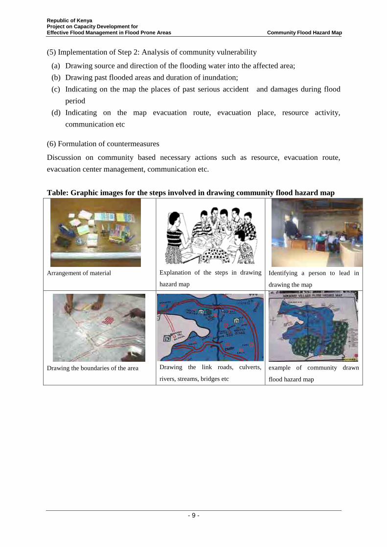
Republic of Kenya Project on Capacity Development for Effective Flood Management in Flood Prone Areas Community Flood Hazard Map
- 9 -
(5) Implementation of Step 2: Analysis of community vulnerability
(a) Drawing source and direction of the flooding water into the affected area;
(b) Drawing past flooded areas and duration of inundation;
(c) Indicating on the map the places of past serious accident and damages during flood
period
(d) Indicating on the map evacuation route, evacuation place, resource activity,
communication etc
(6) Formulation of countermeasures
Discussion on community based necessary actions such as resource, evacuation route,
evacuation center management, communication etc.
Table: Graphic images for the steps involved in drawing community flood hazard map
Arrangement of material Explanation of the steps in drawing
hazard map
Identifying a person to lead in
drawing the map
Drawing the boundaries of the area Drawing the link roads, culverts,
rivers, streams, bridges etc
example of community drawn
flood hazard map
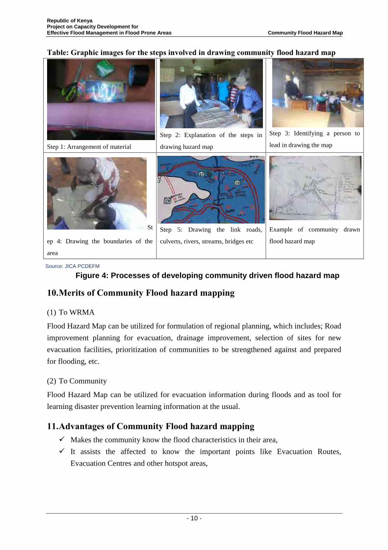
Republic of Kenya Project on Capacity Development for Effective Flood Management in Flood Prone Areas Community Flood Hazard Map
- 10 -
Table: Graphic images for the steps involved in drawing community flood hazard map
Step 1: Arrangement of material
Step 2: Explanation of the steps in
drawing hazard map
Step 3: Identifying a person to
lead in drawing the map
St
ep 4: Drawing the boundaries of the
area
Step 5: Drawing the link roads,
culverts, rivers, streams, bridges etc
Example of community drawn
flood hazard map
10. Merits of Community Flood hazard mapping
(1) To WRMA
Flood Hazard Map can be utilized for formulation of regional planning, which includes; Road
improvement planning for evacuation, drainage improvement, selection of sites for new
evacuation facilities, prioritization of communities to be strengthened against and prepared
for flooding, etc.
(2) To Community
Flood Hazard Map can be utilized for evacuation information during floods and as tool for
learning disaster prevention learning information at the usual.
11. Advantages of Community Flood hazard mapping Makes the community know the flood characteristics in their area,
It assists the affected to know the important points like Evacuation Routes,
Evacuation Centres and other hotspot areas,
Figure 4: Processes of developing community driven flood hazard map
Source: JICA PCDEFM
Republic of Kenya Project on Capacity Development for Effective Flood Management in Flood Prone Areas Community Flood Hazard Map
- 11 -
Assists the WRUA to interpret the real flood features on the ground and opens up
discussion among the community members thereby enhancing flood awareness and
sensitization within the community,
Assists the Government, KRCS, JICA and other donors to access the affected
communities with ease and
It also facilitates the transfer of historical flood incidences both past and current to the
younger generation.
12. Point to note on community flood hazard map In the case of a flood,hazard maps need to include not only inundation areas and
depth but also information such as evacuation centres & routes, disaster
management centres, dangerous spots, communication channels and systems,
evacuation criteria, tips for evacuation including emergency kits and other items
needed in evacuation, and mechanisms and symptoms of hazards.
The community must be provided with relevant information regarding hazard maps
and how to utilize them. Most importantly, how effectively hazard maps are used
depends on the level of community awareness. The members of the community must
be taught how to understand potential disasters in their area from the map to take
appropriate countermeasures.
It is imperative to note that the success of community flood hazard map does not
only lie in just developing the map but continuous review and updating such map.
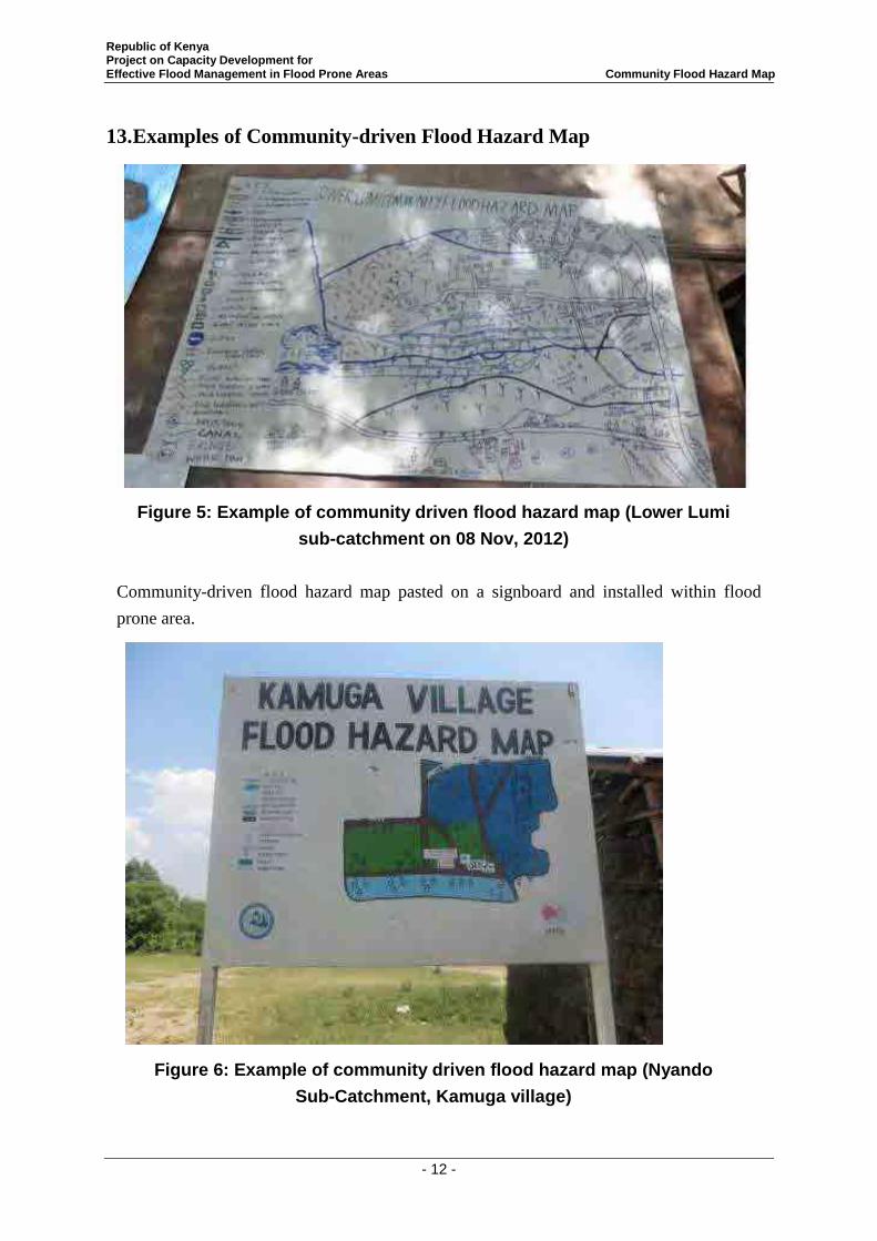
Republic of Kenya Project on Capacity Development for Effective Flood Management in Flood Prone Areas Community Flood Hazard Map
- 12 -
13. Examples of Community-driven Flood Hazard Map
Figure 5: Example of community driven flood hazard map (Lower Lumi
sub-catchment on 08 Nov, 2012)
Community-driven flood hazard map pasted on a signboard and installed within flood
prone area.
Figure 6: Example of community driven flood hazard map (Nyando
Sub-Catchment, Kamuga village)
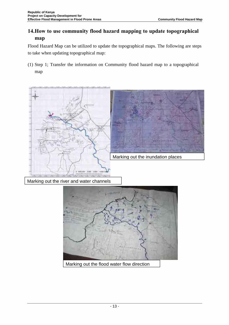
Republic of Kenya Project on Capacity Development for Effective Flood Management in Flood Prone Areas Community Flood Hazard Map
- 13 -
14. How to use community flood hazard mapping to update topographical map
Flood Hazard Map can be utilized to update the topographical maps. The following are steps
to take when updating topographical map:
(1) Step 1; Transfer the information on Community flood hazard map to a topographical
map
Marking out the river and water channels
Marking out the inundation places
Marking out the flood water flow direction
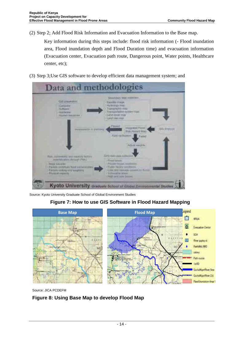
Republic of Kenya Project on Capacity Development for Effective Flood Management in Flood Prone Areas Community Flood Hazard Map
- 14 -
(2) Step 2; Add Flood Risk Information and Evacuation Information to the Base map.
Key information during this steps include: flood risk information (- Flood inundation
area, Flood inundation depth and Flood Duration time) and evacuation information
(Evacuation center, Evacuation path route, Dangerous point, Water points, Healthcare
center, etc);
(3) Step 3;Use GIS software to develop efficient data management system; and
Source: Kyoto University Graduate School of Global Environment Studies
Figure 7: How to use GIS Software in Flood Hazard Mapping
Base Map Flood Map
Source: JICA PCDEFM
Figure 8: Using Base Map to develop Flood Map
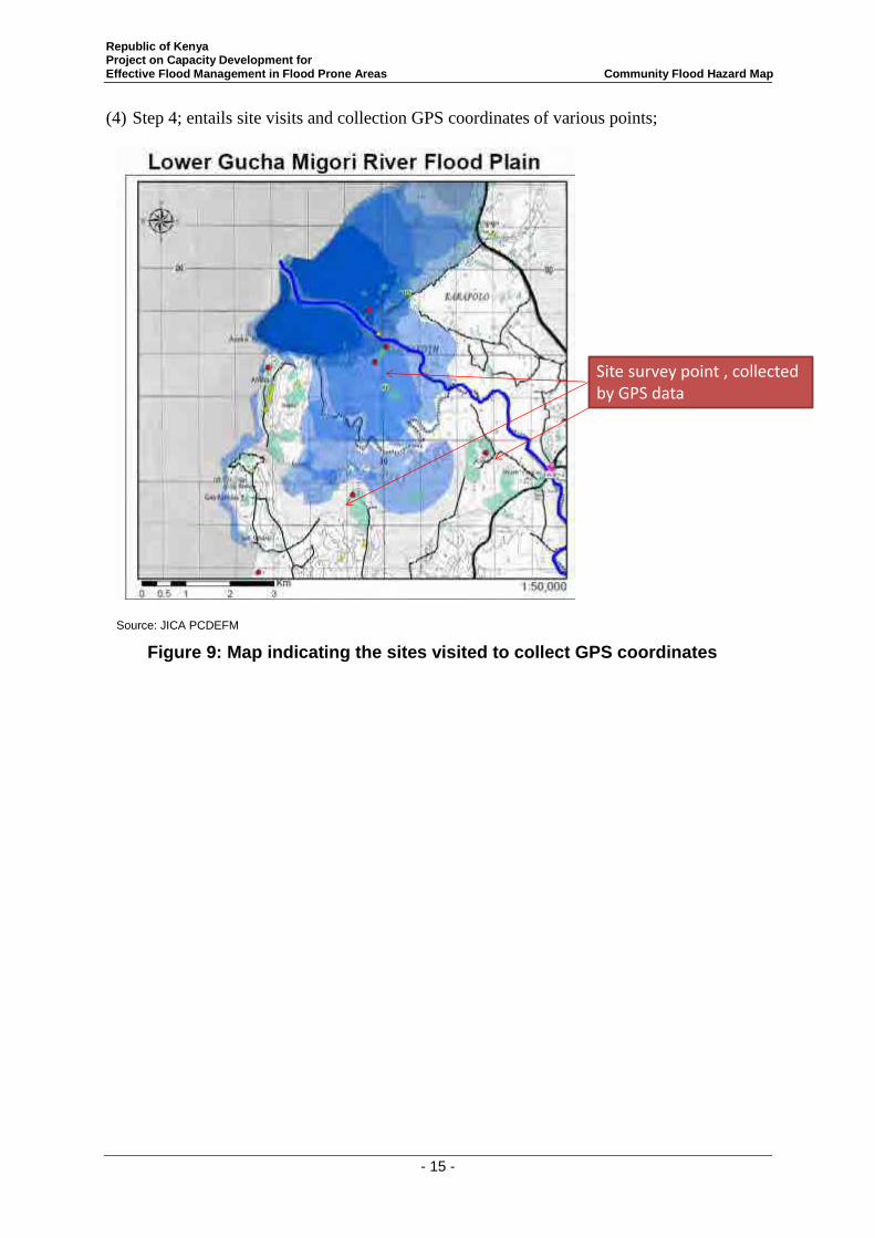
Republic of Kenya Project on Capacity Development for Effective Flood Management in Flood Prone Areas Community Flood Hazard Map
- 15 -
(4) Step 4; entails site visits and collection GPS coordinates of various points;
Site survey point , collected by GPS data
Source: JICA PCDEFM
Figure 9: Map indicating the sites visited to collect GPS coordinates
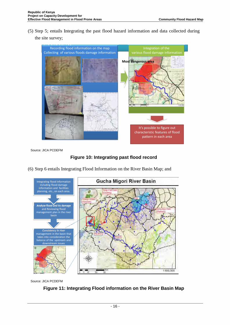
Republic of Kenya Project on Capacity Development for Effective Flood Management in Flood Prone Areas Community Flood Hazard Map
- 16 -
(5) Step 5; entails Integrating the past flood hazard information and data collected during
the site survey; Integrating the past flood hazard information and data collected during the site survey the site survey
Recording flood information on the map Collecting of various floods damage information
It’s possible to figure out characteristic features of flood
pattern in each area
Integration of the various flood damage information
Most dangerous area
Source: JICA PCDEFM
Figure 10: Integrating past flood record
(6) Step 6 entails Integrating Flood Information on the River Basin Map; and Integrating Flood Information on the River Basin Map
Consistency in river management in the basin that
takes into consideration the balance of the upstream and
downstream issues
Consistency in river
Analyze flood and its damage and Reviewing flood
management plan in the river basin
Analyze flood and its damage
Integrating flood information including flood damage
information and facilities planning, etc., on each area.
Source: JICA PCDEFM
Figure 11: Integrating Flood information on the River Basin Map
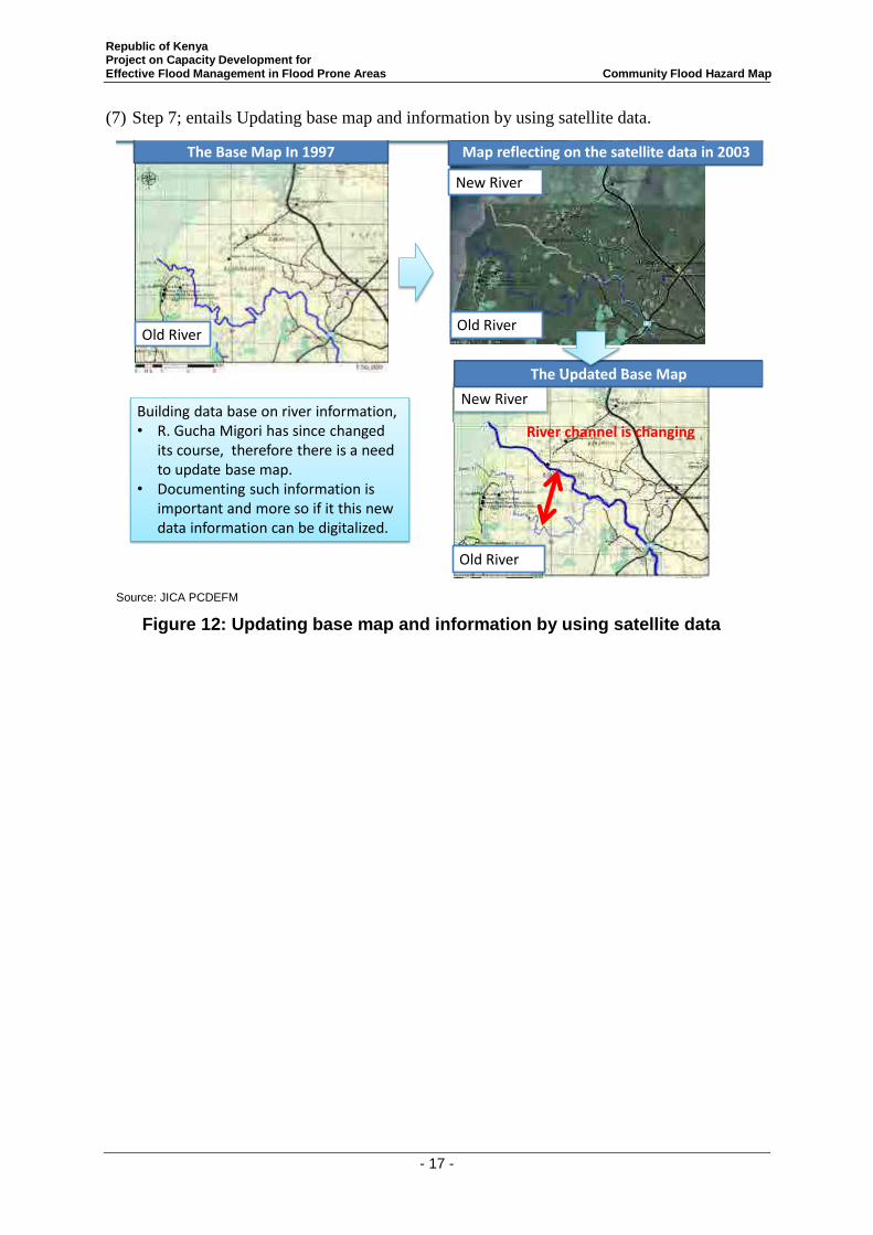
Republic of Kenya Project on Capacity Development for Effective Flood Management in Flood Prone Areas Community Flood Hazard Map
- 17 -
(7) Step 7; entails Updating base map and information by using satellite data. Step6: Updating base map and information by using satellite data
Building data base on river information,• R. Gucha Migori has since changed
its course, therefore there is a need to update base map.
• Documenting such information is important and more so if it this new data information can be digitalized.
Old River
New River
New River
Old RiverOld River
The Base Map In 1997
The Updated Base Map
Map reflecting on the satellite data in 2003
The Updated Base Map
River channel is changing
Source: JICA PCDEFM
Figure 12: Updating base map and information by using satellite data
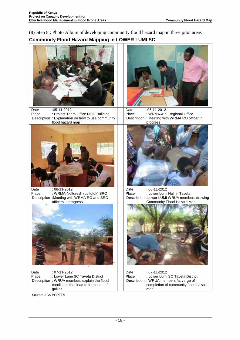
Republic of Kenya Project on Capacity Development for Effective Flood Management in Flood Prone Areas Community Flood Hazard Map
- 18 -
(8) Step 8 ; Photo Album of developing community flood hazard map in three pilot areas
Community Flood Hazard Mapping in LOWER LUMI SC
Date :05-11-2012 Place : Project Team Office NHIF Building Description : Explanation on how to use community
flood hazard map
Date :05-11-2012 Place : WRMA-Athi Regional Office Description : Meeting with WRMA RO officer in
progress
Date : 06-11-2012 Place : WRMA-Nolturesh (Loitotok) SRO Description :Meeting with WRMA RO and SRO
officers in progress
Date : 06-11-2012 Place : Lower Lumi Hall in Taveta Description :Lower LUMI WRUA members drawing
Community Flood Hazard Map
```
Date : 07-11-2012 Place : Lower Lumi SC Taveta District Description : WRUA members explain the flood
conditions that lead to formation of gullies
Date : 07-11-2012 Place : Lower Lumi SC Taveta District Description : WRUA members fat verge of
completion of community flood hazard map
Source: JICA PCDEFM
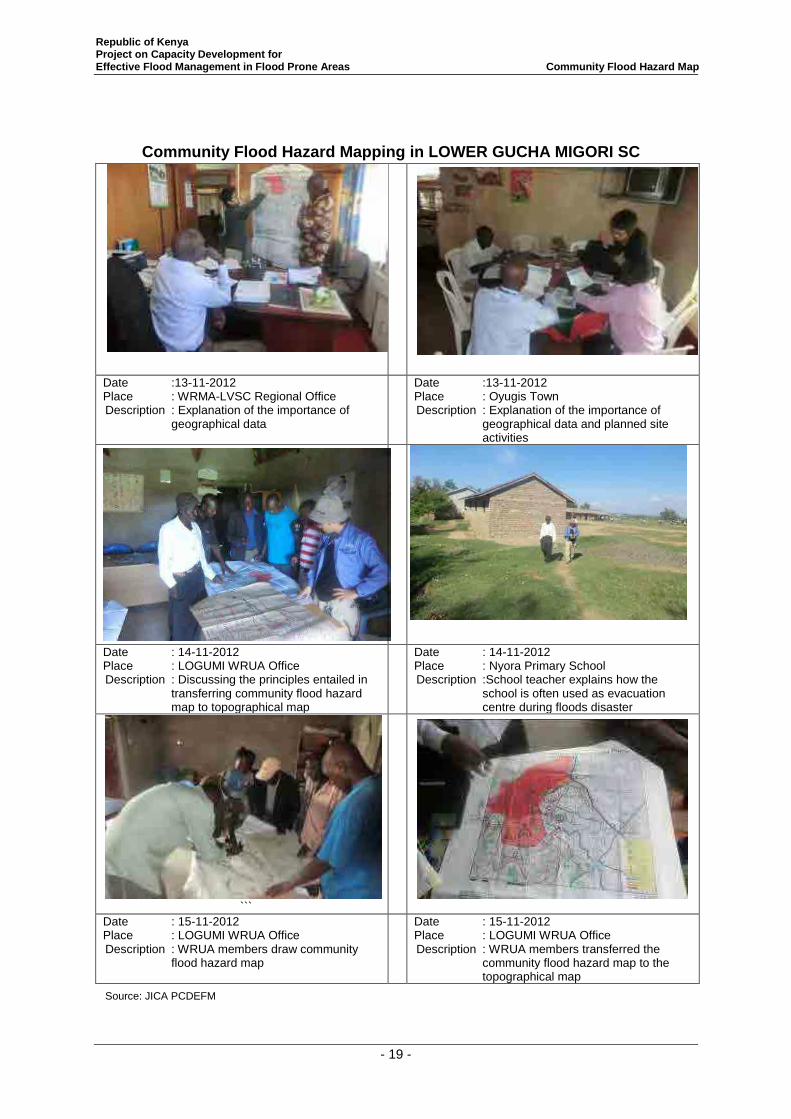
Republic of Kenya Project on Capacity Development for Effective Flood Management in Flood Prone Areas Community Flood Hazard Map
- 19 -
Community Flood Hazard Mapping in LOWER GUCHA MIGORI SC
Date :13-11-2012 Place : WRMA-LVSC Regional Office Description : Explanation of the importance of
geographical data
Date :13-11-2012 Place : Oyugis Town Description : Explanation of the importance of
geographical data and planned site activities
Date : 14-11-2012 Place : LOGUMI WRUA Office Description : Discussing the principles entailed in
transferring community flood hazard map to topographical map
Date : 14-11-2012 Place : Nyora Primary School Description :School teacher explains how the
school is often used as evacuation centre during floods disaster
```
Date : 15-11-2012 Place : LOGUMI WRUA Office Description : WRUA members draw community
flood hazard map
Date : 15-11-2012 Place : LOGUMI WRUA Office Description : WRUA members transferred the
community flood hazard map to the topographical map
Source: JICA PCDEFM
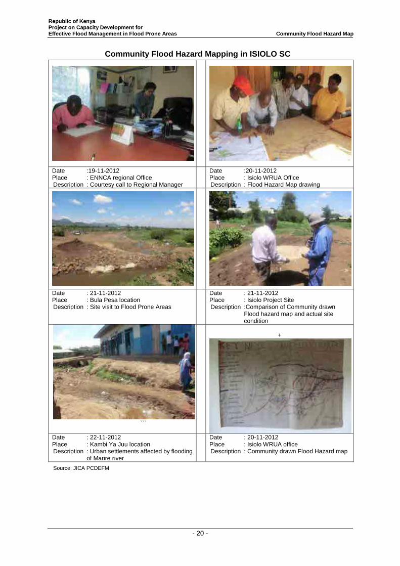
Republic of Kenya Project on Capacity Development for Effective Flood Management in Flood Prone Areas Community Flood Hazard Map
- 20 -
Community Flood Hazard Mapping in ISIOLO SC
Date :19-11-2012 Place : ENNCA regional Office Description : Courtesy call to Regional Manager
Date :20-11-2012 Place : Isiolo WRUA Office Description : Flood Hazard Map drawing
Date : 21-11-2012 Place : Bula Pesa location Description : Site visit to Flood Prone Areas
Date : 21-11-2012 Place : Isiolo Project Site Description :Comparison of Community drawn
Flood hazard map and actual site condition
```
+
Date : 22-11-2012 Place : Kambi Ya Juu location Description : Urban settlements affected by flooding
of Marire river
Date : 20-11-2012 Place : Isiolo WRUA office Description : Community drawn Flood Hazard map
Source: JICA PCDEFM
Project on Capacity Development
for Effective Flood Management in Flood Prone Area
in the Republic of Kenya
Lessons Learnt from
Pilot Activities
July 2014
Japan International Cooperation Agency
NEWJEC Inc.
Japan International Cooperation Agency
Water Resources Management Authority
Ministry of Environment, Water and Natural
Resources
Preface
The Government of Kenya established the Water Resources Management
Authority (WRMA), through the sector reform brought by Water Act 2002.
WRMA is the lead agency in the management of water resources in the country
through six (6) regional offices and twenty six (26) sub – regional offices of the
respective water resources catchment areas.
Since its operationalization in 2005, WRMA has made significant progress in
making water resources recognized as being fundamental for socio-economic
and environmental sustainability. In this regard, integrated floods management is viewed as necessary
component in water resources management.
Based on the request from GOK, JICA carried out the “Study on the Integrated Flood Management
(IFM) for Nyando River Basin (2006 – 2009)” as the Technical Cooperation Scheme and “Programme
for Community based Flood Disaster Management to Adapt to Climate Change in the Nyando River
Basin (2009-2011)”. This was a Grant Aid Programme with the aim of establishing a flood
management system in the southern part or Lake Victoria Basin through IFM, where WRMA was the
implementing agency. Through the above projects, community based flood management activities
have been implemented through integrating non- structural and structural measures such as
community based flood hazard mapping and construction of flood counter measure structures in
prioritized flood prone areas.
Based on the achievement of Nyando project, the Project on Capacity Development for Effective
Flood Management was formulated to expand IFM in other flood prone areas in Kenya. Three pilot
river basins were selected namely: Isiolo, Gucha-Migori and Lumi to promote community based flood
management activities. The main purpose of the project was to build institutional framework of flood
management in the context of integrated water resource management for effective and sustainable
implementation of community based activities. Through the project WRMA has developed strategies
and guidelines in managing floods which have since been incorporated in the revised Catchment
Management Strategies (CMS) and WRUA Development Cycle (WDC) manual. In order to develop
capacity of WRMA officers in the field of community-based integrated flood management, a training
system has been developed where the Project conducted IFM Training for WRMA officers who in
turn trained the WRUAs. The Training Materials for community based flood management have been
developed. These include supplemental manuals, lessons learnt and case studies.
Eng. John P. Olum, HSC
Chief Executive Officer, WRMA
i
Table of Contents
Chapter 1 Background of the project .................................................................................................... 1
Chapter 2 Case Studies in Lower Gucha Migori Sub-catchment .......................................................... 3
Chapter 3 Lessons Learnt in Lower Gucha Migori Sub-catchment .................................................... 28
Chapter 4 Case Studies in Isiolo Sub-catchment ................................................................................ 39
Chapter 5 Lessons Learnt in Isiolo Sub-catchment............................................................................. 44
Chapter 6 Case Studies in Lower Lumi Sub-catchment ..................................................................... 48
Chapter 7 Lessons Learnt in Lower Lumi Sub-catchment .................................................................. 53
Republic of Kenya Project on Capacity Development for Effective Flood Management in Flood Prone Areas Case Study and Lesson Learnt in three Pilot Project Areas
1
Chapter 1 Background of the project
1. The Project Overview
The Republic of Kenya (hereinafter referred to as “Kenya”), experiences regular nationwide
flooding during rainy season. These floods leads to approximately five thousand (5,000) people to be
affected and causes financial damage of approximately JPY one hundred and sixty million
(160,000,000) every year.
In 2003, the southern parts of Lake Victoria Basin including Nyando River Basin were affected by
serious flooding which affected approximately twenty two thousand (22,000) people. In 2007,
Garissa town which is located at the middle Tana River Basin was hit by severe flood and
approximately JPY six hundred and eighty million (680,000,000)financial damage. According to the
analysis reported in the fourth assessment report published by the Inter-governmental Panel on
Climate Change (IPCC), it is anticipated that Climate Change will ultimately lead to generation of
more occurrence of flood incidences.
The Government of Kenya (hereinafter referred to as “GOK”) in the sector reforms under the Water
Act 2002 established Water Resources Management Authority (WRMA), which is under the
Ministry of Water and Irrigation (MWI). WRMA acts as implementation organization in charge of
overall water resource management of each catchment. WRMA set up is as follows: the headquarter,
the six (6) regional Catchments and the thirty two (32) sub-regional Sub-catchments.
In 2004, WRMA formulated “Integrated Flood Management Policy” focusing on Lake Victoria
Basin, which is one of the areas that suffer from severe flood damages. It was intended to promote
Integrated Flood Management (IFM) to raise awareness of community and strengthen institutional
capacity to allow flood mitigation, prediction and warning. Based on the request from GOK, JICA
carried out the “Study on the Integrated Flood Management for Nyando River Basin (2006 – 2009)”
as the Technical Cooperation Scheme and “Programme for Community based Flood Disaster
Management to Adapt to Climate Change in the Nynado River Basin (2009-2011)” as the Grant Aid
Programme with the aim of establishing a flood management system in the southern part of Lake
Victoria Basin through IFM. Through the above projects, community based flood management
activities have been implemented and deployed combining structural and non-structural measures
such as workshops for mapping flood damaged areas and protection measures for building structures
in prioritized communities. Some positive outcomes have since been realized.
GOK in essence aims to expand these activities, which were implemented in the area of Nyando
River Basin only to other parts of the nation with a purpose to promote community based water
resource management activities including flood management. GOK has been currently working on
the institutionalization of Water Resource User Associations (WRUAs). WRUAs are managed by
community members who are major beneficiary of water resources. A framework therefore has
already been established which enables the WRUAs to receive funds from the Water Service Trust
Fund (WSTF) sourced from technical support, official aid, and donor’s funds. This framework is
Republic of Kenya Project on Capacity Development for Effective Flood Management in Flood Prone Areas Case Study and Lesson Learnt in three Pilot Project Areas
2
known as WRUA Development Cycle (WDC).
GOK plans to utilize WDC framework to deploy nationwide community led activities based on IFM
which integrates outcomes from previous JICA’s projects. However it is considered that GOK
requires assistance in providing appropriate technical advice to relevant entities in IFM including
WRUAs. This is because the previous flood management activities carried out under JICA were not
in line with WDC as well as other frameworks.
Therefore, this Project is expected to strengthen WRMA institutional ability through the capacity
development on basic flood management to promote community based flood management activities
within the WDC framework. This Project known as “The Project for Capacity Development for
Effective Flood Management in Flood Prone Areas (hereinafter referred to as the “Project”) targets
to pilot these activities in three river basins: Gucha Migori; Lumi; and EwasoNg’iro North. For the
purposes of this reportGucha Migori River Basin will be the focus and particularly the Lower
Gucha-Migori Sub-catchment.
2. Executive Summary
The following report contains a case study that analyses how the non-structural measures were
successfully implemented in Gucha Migori River Basin specifically Lower Gucha Migori
(LOGUMI) Sub-catchment ((SC).
The purpose of the case study is to extract lesson learnt from the implementation of the
non-structural measures in LOGUMI SC. Case study is the actual implementation of non-structural
measures flood management activities.
Through our analysis of the respective non-structural measures flood management activities
implemented in LOGUMI SC, we found that,although the activities varied in their implementation
but the goals of such activities was to enhance effective flood management in LOGUMI SC. In each
of theactivities involved revealed strong community participation and initiatives. We found
thatcommunity participation and engagementand the ability for cooperation, coordination and
sharing of knowledge on flood management was key for sustainable and effective flood management
in LOGUMI SC.
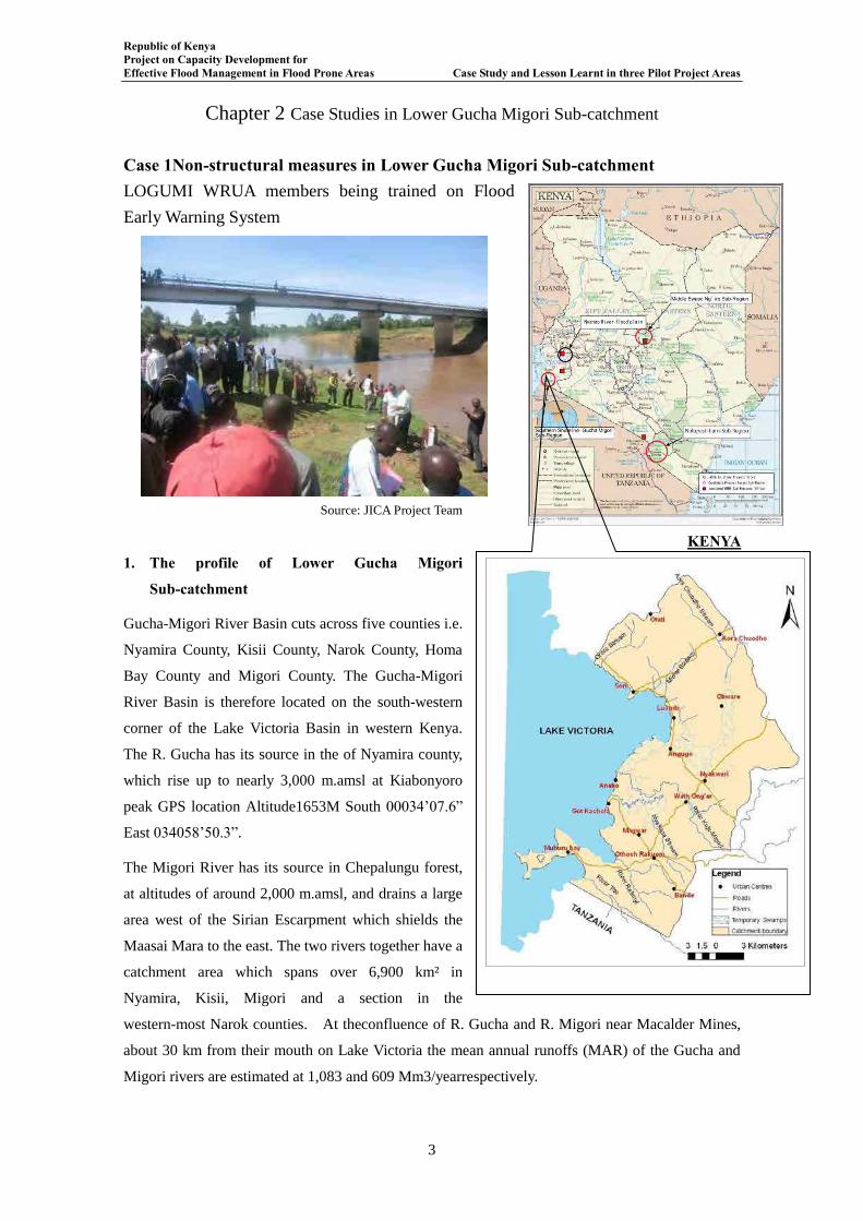
Republic of Kenya Project on Capacity Development for Effective Flood Management in Flood Prone Areas Case Study and Lesson Learnt in three Pilot Project Areas
3
Chapter 2 Case Studies in Lower Gucha Migori Sub-catchment
Case 1Non-structural measures in Lower Gucha Migori Sub-catchment LOGUMI WRUA members being trained on Flood
Early Warning System
Source: JICA Project Team
1. The profile of Lower Gucha Migori
Sub-catchment
Gucha-Migori River Basin cuts across five counties i.e.
Nyamira County, Kisii County, Narok County, Homa
Bay County and Migori County. The Gucha-Migori
River Basin is therefore located on the south-western
corner of the Lake Victoria Basin in western Kenya.
The R. Gucha has its source in the of Nyamira county,
which rise up to nearly 3,000 m.amsl at Kiabonyoro
peak GPS location Altitude1653M South 00034’07.6”
East 034058’50.3”.
The Migori River has its source in Chepalungu forest,
at altitudes of around 2,000 m.amsl, and drains a large
area west of the Sirian Escarpment which shields the
Maasai Mara to the east. The two rivers together have a
catchment area which spans over 6,900 km² in
Nyamira, Kisii, Migori and a section in the
western-most Narok counties. At theconfluence of R. Gucha and R. Migori near Macalder Mines,
about 30 km from their mouth on Lake Victoria the mean annual runoffs (MAR) of the Gucha and
Migori rivers are estimated at 1,083 and 609 Mm3/yearrespectively.
KENYA
Republic of Kenya Project on Capacity Development for Effective Flood Management in Flood Prone Areas Case Study and Lesson Learnt in three Pilot Project Areas
4
Flood damage is enormous in Gucha Migori River Basin. In the upstream Kenyenya Sub-counties
the area encounters flash floods that mainly damages the farmlands and disrupts traffic. In the
mid-stream the area of Oyani encounters flash floods and riverine floods that destroys farmlands and
disrupts transport networks. In the downstream area suffers from both flash floods in the area
surrounded by hills like Lwanda, Tito and Misiwi areas, while places in the flood plains like Nyora,
Kabuto, Kimai, Sere, Aeko and Aneko suffers from riverine floods with inundation period of three
weeks to two months.
2. Objective of the project
・ To build the capacity of LOGUMI WRUA members to effectively manage floods within
LOGUMI SC
3. Summary of result
It was predetermined by the Project that only Non-structural Measures against floods will be
implemented in LOGUMI SC. The major assumptions in flood management in LOGUMI SC were
that flood management entailed heavy high cost structural measures and that the community role in
flood management was being passive.
As a result of LOGUMI WRUA interaction with the Project great strides have been made.
Community-driven Flood Management Action Plan was developed and thereafter incorporated in the
revised LOGUMI SCMP, Community-driven Flood Hazard Map for four areas have been drawn,
Community-driven Flood Hydrograph for purposes of flood early warning had been developed,
Community-based Flood Early Warning System has been established, flood education programme
undertaken in four schools and evacuation drill implemented. The LOGUMI WRUA Chairperson
stated that during the entry of JICA Project Team in LOGUMI SC wherein the expectations of the
community were leaned towards heavy structural measures but when the scope of the Project in
LOGUMI was explained she pointed was heartbroken. But after undergoing through the various
training, workshops and interactions with other stakeholders, she now understands why the training
were important! She added that now LOGUMI community members were in control of their own
destiny! Using a Luo proverb she said it is better to train a person on how to fish than just giving that
person fish to eat! She added that LOGUMI WRUA were now able to know importance of any flood
structure that when they will be constructed in the area O&M will be per excellence!! She also stated
that LOGUMI WRUA had written proposal soliciting for funds to construct an evacuation centre at
Nyora village to Japan Embassy.
4. Good points
- The Community-driven Flood Management Action Plan was developed through community
participation entailing brainstorming, consensus building and adoption of the plan.
- LOGUMI WRUA revised the LOGUMI SCMP wherein the flood management activities were
incorporated.
- Excursion visit to the Nyando River Basin exposed LOGUMI WRUA to community based flood
management wherein the WRUA members were exposed to buildings with raised foundations
Republic of Kenya Project on Capacity Development for Effective Flood Management in Flood Prone Areas Case Study and Lesson Learnt in three Pilot Project Areas
5
above the flood depth. The WRUA members were also exposedto the Community-based Flood
Management Organizations (CFMOs).
- After the excursion visit LOGUMI WRUA were able to influence change of design for toilets
earmarked for construction in schools located within flood prone areas. The design was changed
and all the toilets constructed are raised above the flood depth.
- The LOGUMI WRUA established the Flood Management Sub-committee that was tasked with
pre-flood, flood response and post floods planning for corresponding activities.
- The LOGUMI WRUA also carried out a sensitization programme wherein they sensitized the
communities in flood prone areas on the importance of self-help in flood management that led to
establishment of eleven CFMOs in LOGUMI SC.
- LOGUMI WRUA participated actively in the Integrated Flood Management Committee (IFMC)
meetings leading to cooperation with the WRUAs from the upstream.
5. Implementation of capacity building activities
The implementation of non-structural measures entailed workshops, excursion site visits, community
sensitization meetings and training.
Table 1 Summary of Workshops
Date of Meeting
Attendants Venue Main Agenda
Organization No. of Attendants
Feb. 15 to 28,
2012
JICA Project Team
WRMA-LVSC
LOGUMI WRUA
1
2
30
LOGUMI WRUA
Office
Development of Community-driven
Flood Management Action Plan
Mar. 22 to 29,
2012
JICA Project Team
WRMA-LVSC
LOGUMI WRUA
1
2
30
LOGUMI WRUA
Office
Review of LOGUMI SCMP with aim
of incorporating Community-driven
Flood Management Action Plan into the
SCMP
May 02, 2012 JICA Project Team
WRMA-LVSC
LOGUMI WRUA
1
2
50
LOGUMI WRUA
Office
Development of Community-driven
Flood Hazard Map
June18, 2012 JICA Project Team
WRMA-LVSC
LOGUMI WRUA
1
2
50
LOGUMI WRUA
Office
Review of Community-driven flood
hazard map
Oct. 03 to 04,
2012
JICA Project Team
WRMA-LVSC
LOGUMI WRUA
2
2
50
LOGUMI WRUA
Office
Transferring of community-driven flood
hazard map to topographical map
Oct. 15 to 23,
2012
LOGUMI WRUA 50 LOGUMI WRUA
Office
Development of Community-driven
Flood Hydrograph by LOGUMI
WRUA
Nov. 15 to 23,
2012
JICA Project Team
WRMA-LVSC
LOGUMI WRUA
2
2
50
LOGUMI WRUA
Office
Development of Community-driven
Flood Hazard Map for other flood
prone areas in LOGUMI SC (Source: JICA PCDEFM)
Table 2 Summary of Excursion Exchange Site Visits
Date of Meeting
Attendants Venue Main Agenda
Organization No. of Attendants
Mar. 24 to 28,
2013
JICA Project Team
WRMA
LOGUMI WRUA
GIZ
5
6
5
1
Nyando River
Basin and
LOGUMI SC
Exposure of WRUA members to the
Nyando Project and understanding the
flood management activities in
LOGUMI SC
Republic of Kenya Project on Capacity Development for Effective Flood Management in Flood Prone Areas Case Study and Lesson Learnt in three Pilot Project Areas
6
Lower Lumi WRUA
Isiolo WRUA
3
3
Feb. 18 to 21,
2014
KRCS
WRMA-Isiolo
LOGUMI WRUA
Isiolo WRUA
Lower Lumi WRUA
1
2
10
5
10
Isiolo SC Training on community-based flood
early warning system (CBFEWS) and
observation installed CBFEWS
June 24-25,
2014
JICA Project Team
WRMA
LOGUMI WRUA
Isiolo WRUA
Lower Lumi WRUA
Migori County
Meru County
Taveta County
JICA Kenya
5
20
5
5
15
-
1
1
2
Lumi River Basin,
Taveta
Observation of community-based flood
management activities in Lower Lumi
SC and discussion of the future
activities of the WRUAs in flood prone
areas
(Source: JICA PCDEFM)
Table 3 Summary of Community Sensitization Meetings
Date of Meeting
Attendants Venue Main Agenda
Organization No. of Attendants
Feb. 15 to 17,
2012
JICA Project Team
WRMA-LVSC
LOGUMI WRUA
1
2
30
LOGUMI WRUA
Office
Community Sensitization on
importance of community-based flood
management
Sept. 6 to8,
2012
JICA Project Team
WRMA-LVSC
LOGUMI WRUA
2
2
30
LOGUMI WRUA
Office and
stakeholders’
offices
Sensitization of LOGUMI WRUA on
the need for Integrated Flood
Management Committee (IFMC)
Sept. 24, 2013 JICA Project Team
WRMA-LVSC
LOGUMI WRUA
Tulu CFMO
Got Kachola CFMO
1
2
5
30
30
Tulu and Got
Kachola
Community sensitization on
establishment of Community-based
Flood Management Organizations at
village level
Sept. 24, 2013 KRCS
WRMA-LVSC
LOGUMI WRUA
Community Members
5
1
50
150
Nyora Primary
School
Community sensitization on KRCS
activities for the Project on Flood
Management activities
May 23, 2014 JICA Project Team
WRMA-
LOGUMI WRUA
CFMOs
Community members
5
8
30
60
250
Nyora Primary
School
Community sensitization on effective
evacuation during flood disaster
through the implementation of
evacuation drill
(Source: JICA PCDEFM)
Table 4 Summary of the Flood Management Training
Date of Meeting
Attendants Venue Main Agenda
Organization No. of Attendants
Dec. 3 to6,
2013
KRCS
JICA Project Team
WRMA-LVSC
LOGUMI WRUA
5
1
3
30
LOGUMI WRUA
Office
Training on Community-driven Disaster
Management
Dec. 9 to11,
2013
KRCS
JICA Project Team
WRMA-LVSC
LOGUMI WRUA
5
1
3
30
LOGUMI WRUA
Office
Training on Community-based Floods
Early Warning System
Jan13 to 16,
2014
JICA Project Team
WRMA-LVSC
LOGUMI WRUA
Teachers
1
2
15
8
LOGUMI WRUA
Office
Training of teachers on infusion
strategies and flood management
programmes in school
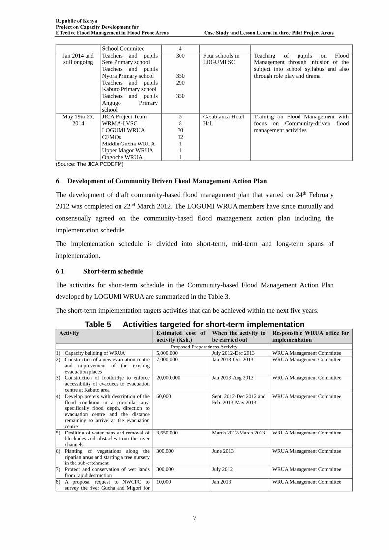
Republic of Kenya Project on Capacity Development for Effective Flood Management in Flood Prone Areas Case Study and Lesson Learnt in three Pilot Project Areas
7
School Commitee 4
Jan 2014 and
still ongoing
Teachers and pupils
Sere Primary school
Teachers and pupils
Nyora Primary school
Teachers and pupils
Kabuto Primary school
Teachers and pupils
Angugo Primary
school
300
350
290
350
Four schools in
LOGUMI SC
Teaching of pupils on Flood
Management through infusion of the
subject into school syllabus and also
through role play and drama
May 19to 25,
2014
JICA Project Team
WRMA-LVSC
LOGUMI WRUA
CFMOs
Middle Gucha WRUA
Upper Magor WRUA
Ongoche WRUA
5
8
30
12
1
1
1
Casablanca Hotel
Hall
Training on Flood Management with
focus on Community-driven flood
management activities
(Source: The JICA PCDEFM)
6. Development of Community Driven Flood Management Action Plan
The development of draft community-based flood management plan that started on 24th February
2012 was completed on 22nd March 2012. The LOGUMI WRUA members have since mutually and
consensually agreed on the community-based flood management action plan including the
implementation schedule.
The implementation schedule is divided into short-term, mid-term and long-term spans of
implementation.
6.1 Short-term schedule
The activities for short-term schedule in the Community-based Flood Management Action Plan
developed by LOGUMI WRUA are summarized in the Table 3.
The short-term implementation targets activities that can be achieved within the next five years.
Table 5 Activities targeted for short-term implementation Activity Estimated cost of
activity (Ksh.) When the activity to be carried out
Responsible WRUA office for implementation
Proposed Preparedness Activity
1) Capacity building of WRUA 5,000,000 July 2012-Dec 2013 WRUA Management Committee
2) Construction of a new evacuation centre and improvement of the existing
evacuation places
7,000,000 Jan 2013-Oct. 2013 WRUA Management Committee
3) Construction of footbridge to enforce accessibility of evacuees to evacuation
centre at Kabuto area
20,000,000 Jan 2013-Aug 2013 WRUA Management Committee
4) Develop posters with description of the
flood condition in a particular area specifically flood depth, direction to
evacuation centre and the distance
remaining to arrive at the evacuation centre
60,000 Sept. 2012-Dec 2012 and
Feb. 2013-May 2013
WRUA Management Committee
5) Desilting of water pans and removal of
blockades and obstacles from the river channels
3,650,000 March 2012-March 2013 WRUA Management Committee
6) Planting of vegetations along the
riparian areas and starting a tree nursery in the sub-catchment
300,000 June 2013 WRUA Management Committee
7) Protect and conservation of wet lands
from rapid destruction
300,000 July 2012 WRUA Management Committee
8) A proposal request to NWCPC to
survey the river Gucha and Migori for
10,000 Jan 2013 WRUA Management Committee
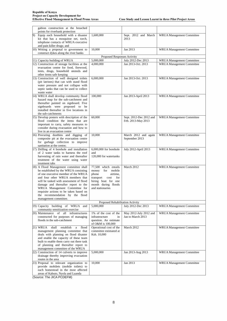
Republic of Kenya Project on Capacity Development for Effective Flood Management in Flood Prone Areas Case Study and Lesson Learnt in three Pilot Project Areas
8
gabion construction at the breached
points for riverbank protection
9) Equip each household with a disaster
kit that has a mosquitoe net, torch, telephone contacts of WRUA executive
and pain killer drugs; and
1,600,000 Sept. 2012 and March
2013
WRUA Management Committee
10) Writing a proposal to government to construct dykes along the river banks
10,000 Jan 2013 WRUA Management Committee
Proposed Responses Activity
11) Capacity building of WRUA 5,000,000 July 2012-Dec 2013 WRUA Management Committee
12) Construction of storage facilities at the
evacuation centre for food, firewood, tents, drugs, household utensils and
other items safe keeping
4,000,000 Jan 2013-Oct. 2013 WRUA Management Committee
13) Construction of well designed toilets (pit latrines) that can with stand flood
water pressure and not collapse with
septic tanks that can be used to collect waste water
6,000,000 Jan 2013-Oct. 2013 WRUA Management Committee
14) WRUA shall develop community flood
hazard map for the sub-catchment and
thereafter painted on signboard. Five signboards were proposed to be
installed thereafter in five locations in
the sub-catchments
100,000 Jan 2013-April 2013 WRUA Management Committee
15) Develop posters with description of the
flood condition the items that are
important to carry, safety measures to consider during evacuation and how to
live in an evacuation centre
60,000 Sept. 2012-Dec 2012 and
Feb. 2013-May 2013
WRUA Management Committee
16) Procuring dustbins and digging of composite pit at the evacuation centre
for garbage collection to improve
sanitation at the centre;
10,000 March 2012 and again September 2013
WRUA Management Committee
17) Drilling of 4 borehole and installation of 2 water tanks to harness the roof
harvesting of rain water and thereafter
treatment of the water using water treatment tabs
6,000,000 for borehole and
120,000 for watertanks
July 2012-April 2013 WRUA Management Committee
18) A Flood Management committee shall
be established by the WRUA consisting of one executive member of the WRUA
and four other WRUA members that
will be tasked with assessment of flood damage and thereafter report to the
WRUA Management Committee for
requisite actions to be taken based on the recommendation by the flood
management committee.
77,500 which entails
money for mobile phone airtime,
transport cost for
hiring boat for one month during floods
and stationaries
March 2012 WRUA Management Committee
Proposed Rehabilitation Activity
19) Capacity building of WRUA and community sensitization exercise
5,000,000 July 2012-Dec 2013 WRUA Management Committee
20) Maintenance of all infrastructures
constructed for purposes of managing
floods in the sub-catchment
1% of the cost of the
infrastructure in
question. An estimate
of O&M is 100,000
May 2012-July 2012 and
Jan to March 2013
WRUA Management Committee
21) WRUA shall establish a flood
management planning committee that deals with planning on flood disaster
and enable the capacity of these team
built to enable them carry out there task of planning and thereafter report to
management committee of the WRUA
Operational cost of the
committee estimated at Ksh. 10,000
March 2012 WRUA Management Committee
22) Construction of 14 culverts to improve drainage thereby improving evacuation
routes in the area
5,000,000 Jan 2013-Aug 2013 WRUA Management Committee
23) Proposal to relevant organization to
provide mobilets (mobile toilets) to each homestead in the most affected
areas of Kabuto, Nyola and Luanda
10,000 Jan 2013 WRUA Management Committee
(Source: The JICA PCDEFM)
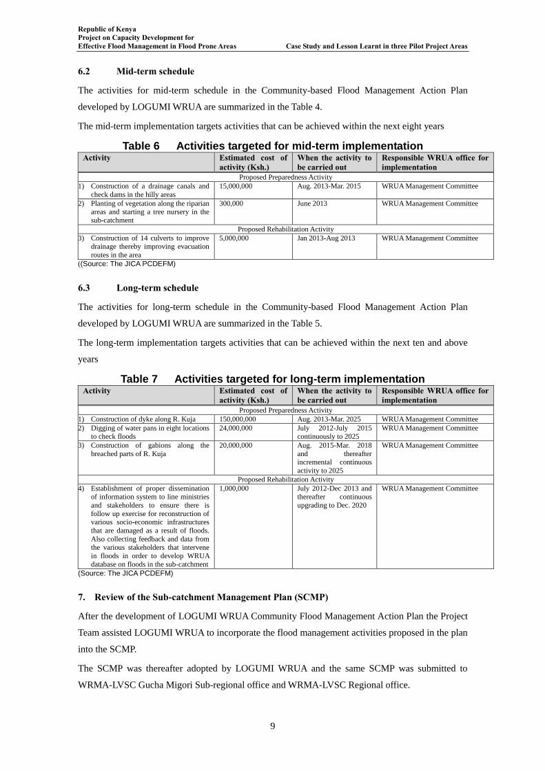
Republic of Kenya Project on Capacity Development for Effective Flood Management in Flood Prone Areas Case Study and Lesson Learnt in three Pilot Project Areas
9
6.2 Mid-term schedule
The activities for mid-term schedule in the Community-based Flood Management Action Plan
developed by LOGUMI WRUA are summarized in the Table 4.
The mid-term implementation targets activities that can be achieved within the next eight years
Table 6 Activities targeted for mid-term implementation Activity Estimated cost of
activity (Ksh.) When the activity to be carried out
Responsible WRUA office for implementation
Proposed Preparedness Activity
1) Construction of a drainage canals and
check dams in the hilly areas
15,000,000 Aug. 2013-Mar. 2015 WRUA Management Committee
2) Planting of vegetation along the riparian areas and starting a tree nursery in the
sub-catchment
300,000 June 2013 WRUA Management Committee
Proposed Rehabilitation Activity
3) Construction of 14 culverts to improve drainage thereby improving evacuation
routes in the area
5,000,000 Jan 2013-Aug 2013 WRUA Management Committee
((Source: The JICA PCDEFM)
6.3 Long-term schedule
The activities for long-term schedule in the Community-based Flood Management Action Plan
developed by LOGUMI WRUA are summarized in the Table 5.
The long-term implementation targets activities that can be achieved within the next ten and above
years
Table 7 Activities targeted for long-term implementation Activity Estimated cost of
activity (Ksh.) When the activity to be carried out
Responsible WRUA office for implementation
Proposed Preparedness Activity
1) Construction of dyke along R. Kuja 150,000,000 Aug. 2013-Mar. 2025 WRUA Management Committee
2) Digging of water pans in eight locations to check floods
24,000,000 July 2012-July 2015 continuously to 2025
WRUA Management Committee
3) Construction of gabions along the
breached parts of R. Kuja
20,000,000 Aug. 2015-Mar. 2018
and thereafter incremental continuous
activity to 2025
WRUA Management Committee
Proposed Rehabilitation Activity
4) Establishment of proper dissemination of information system to line ministries
and stakeholders to ensure there is
follow up exercise for reconstruction of various socio-economic infrastructures
that are damaged as a result of floods.
Also collecting feedback and data from the various stakeholders that intervene
in floods in order to develop WRUA
database on floods in the sub-catchment
1,000,000 July 2012-Dec 2013 and thereafter continuous
upgrading to Dec. 2020
WRUA Management Committee
(Source: The JICA PCDEFM)
7. Review of the Sub-catchment Management Plan (SCMP)
After the development of LOGUMI WRUA Community Flood Management Action Plan the Project
Team assisted LOGUMI WRUA to incorporate the flood management activities proposed in the plan
into the SCMP.
The SCMP was thereafter adopted by LOGUMI WRUA and the same SCMP was submitted to
WRMA-LVSC Gucha Migori Sub-regional office and WRMA-LVSC Regional office.
Republic of Kenya Project on Capacity Development for Effective Flood Management in Flood Prone Areas Case Study and Lesson Learnt in three Pilot Project Areas
10
8. Development of Flood Hazard Maps
The Lower Gucha Migori WRUA members identified the villages in LOGUMI SC that are worst hit
areas by floods as Kabuto, Nyora, Luanda, Misiwi, Tito and Ayieko areas. A discussion with the
WRUA revealed that the Kabuto and Nyora were at one time considered as one and same village and
it they were separated into two only after the area was divided by R. Gucha Migori. LOGUMI
WRUA requested that the two areas be considered as one village.
It was therefore agreed that a flood hazard map be developed for Kabuto-Nyora area, then
Luanda-Misiwi area and thereafter Aeko-Aneko area. These maps having been developed by
LOGUMI WRUA were pasted on the inside wall of LOGUMI WRUA office.
9. Developing Topographical-Map based on Community Flood Hazard Map
The Project Team noted that the current topographical map were not current because the maps did
not show the change of the river course. Therefore the Project Team with LOGUMI WRUA using
the Community Flood Hazard Map updated the topographical map to show the current conditions.
10. Nyando Excursion Visit and WRUA Exchange Visit to LOGUMI SC
The excursion visit and exchange programme to LOGUMI SC involved various parties that included
the JICA Project Team (Chief Advisor to the Project; the Project Team Leader; and three Project
Supervisors from Gucha Migori, Lumi and Isiolo river basins); WRMA FMU Headquarters;
WRMA-LVSC Regional Office, WRMA LVSC Kisii and Kisumu Sub-regional Offices; WRUAs
from LOGUMI, Lower Lumi and Isiolo; and GIZ.
10. 1 Nyando Excursion Visit
The excursion visit to Nyando was held from 24th March to 26th March 2013. The following sites
were visited:
(i) Rae Kanyaika Primary School in Mowlem village whereby raised evacuation centre, raised
borehole and raised toilets were observed. A meeting with school management committee and
Mowlem CFMO was also held;
(ii) Rae Kanyaika Village was also visited and small culverts were observed;
(iii) Ofunyu Primary School in Kamuga village whereby raised evacuation centre, raised borehole
and raised toilets were observed. A meeting with school management committee and Kamuga
CFMO was also held;
(iv) Kokwaro Village in which a raised road and evacuation centre constructed under the pilot
projects that were packaged in the Master Plan Study (2006-2008);
(v) Kamagaga Village was also visited and footbridge, community flood hazard map signboard,
raised evacuation centre and raised toilets were observed; and
(vi) Achuodho Primary School in Achuodho village whereby raised evacuation centre, raised
borehole and raised toilets were observed. A meeting with Achuodho CFMO, Nyando WRUA
and WinamNyamasaria WUA was also held.
10.2 The Excursion Visit to Nyando River Basin observations by LOGUMI WRUA

Republic of Kenya Project on Capacity Development for Effective Flood Management in Flood Prone Areas Case Study and Lesson Learnt in three Pilot Project Areas
11
Day 1: 25thMarch, 2013
The WRUA members were taken for a field visit at various sites within Nyando area. The aim was to
observe various projects that were supported by JICA as a flood management projects. The
participants in the excursion visit were able to observe the following facilities like raised boreholes,
raised toilets, raised evacuation centres, small culverts and pedestrian bridges were visited. The
participants were also able to interact with the communities wherein these structures were
constructed and these community members were able to explain the various training they received
on flood management and how they are using those skills in flood management in the area. The
participants also observed the education programme on flood management in one of the schools in
Nyando River Basin. In the evening the JICA Project Team was able to show the participants a video
recording of an evacuation drill activity in the Nyando River Basin.
LOGUMI WRUA members were able to note the following on the day one of visitation:
The raised structures were slightly above 1.2M which the community members pointed out
was above the flood depth in the area;
The education programme on flood management was an important activity in enhancing
flood management. The participants noted that primary pupils were able to understand
natural early warnings of floods like appreance of some bird species as an indicator that it
was going to flood;
The evacuation drill that prepares the community for effective and safe evacuation was an
important activity that if properly understood reduces human casuality;
The lessons learnt from day one visitation are as follows:
The raised structures were good model that should be replicated in all flood prone areas.
LOGUMI WRUA members were initially reluctant in identifying Nyora Primary School as
an evacuation place because during the worse flood situation in the area the flood water
flows into the classroom where the evacuees seek shelter. But with the raised structure like
evacuation centre and toilets in a place like Nyora Primary School will play an important
role because the affected families can move to the school without fear that in case the flood
situation worsens leading to water flowing to the school, they will be forced to move to
another evacuation place.
The education programme on flood management was an effective tool in sensitization on
flood management and also on informing the young generation on the flood problem within
their area and thereby socializing these pupils in effective ways of flood management. Such
education programme should be conducted also in LOGUMI SC.
Republic of Kenya Project on Capacity Development for Effective Flood Management in Flood Prone Areas Case Study and Lesson Learnt in three Pilot Project Areas
12
The efficacy of evacuation drill especially when the evacuation drills are conducted at least
once in a year. LOGUMI WRUA in their Flood Management Plan had proposed such
activity that should be implemented at least once per year.
Day 2: 26thMarch, 2013
Day 2 visit commenced at 9:00 am. All the participants met at Imperial Hotel and thereafter left for
the field trip. The following were observed during day 2 site visit:
Two raised evacuation centre whereby one was constructed at chief’s camp and the other at
school compound; raised toilets were also observed one constructed at the chief camp which
was a two compartment toilet and the other a ten compartment toilet constructed in the
school compound; footbridge that enhanced accessibility to a Kigoche primary school;
culverts that also enhanced accessibility to Achuodho School were observed and the raised
borehole constructed at the school compound;
The participants also interacted with the community members in the two villages and in one
of the village the community members were still asking the JICA Project Team to assist
them with constructing a nursery school yet the village had an evacuation centre that could
be used as a nursery. In the other evacuation centre at Achuodho School was poorly
maintained with most windows broken and not repaired.
The lessons learnt from day two visitation are as follows:
1) The footbridge that enhances accessibility to an evacuation place or other social amenities
was an important structure. The footbridge observed in Nyando enabled the pupils to access
the school even during floods and also evacuees can easily access such facility during floods.
In LOGUMI SC accessibility to Kabuto dispensary is a major problem during floods but
with such facility like footbridge then community members can easily access the healthcare
at the Kabuto Health Centre.
2) The culverts both big and small are important structures in improving evacuation routes for
example at Achuodho School the participants observed culverts constructed at the entry
point of the school and thus enhancing accessibility. In LOGUMI area some of the hotspot
areas on the evacuation route to evacuation centre can be improved with construction of
culverts in those areas.
3) The CFMOs in Nyando River Basin played an important role during implementation of the
Nyando Project but the CFMOs have remained stagnant after the Project. The CFMO
dependency on external help was noted and this does not augur well with flood management
within their areas because the CFMOs are not taking steps towards effective flood
management but rather are making excuses on why they have not made any steps after the
Republic of Kenya Project on Capacity Development for Effective Flood Management in Flood Prone Areas Case Study and Lesson Learnt in three Pilot Project Areas
13
project towards effective flood management. The CFMO have not even made steps to join
WRUA within their jurisdiction but they are still begging for structures that they can easily
have on their own like fencing evacuation centre or even the request for nursery school
when there is an evacuation centre within their village is preposterous.
4) The deconstruction of LOGUMI WRUA members’ assumption that LOGUMI SC was the
only worst hit area with floods. The excursion visit to Nyando River Basin was an eye
opener to the participants that floods do not only affect LOGUMI SC but other areas too and
that there is what community members on their own can do to manage these floods. In the
Nyando villages are organized in the CFMOs that are able to issue evacuation notice during
floods, community members are involved in O&M of the structures constructed within their
village, and community members can cooperate with schools that act as evacuation places
for effective evacuation and management of the evacuation centres within the schools.
10.3 The Exchange Visit to LOGUMI SC observations
The visiting WRUA members visited LOGUMI WRUA for two days. The purposes of the visit were
to:
Community based flood observation and early warning system
Community based flood hazard mapping
Observation on flood affected areas
Explanation and demonstration of flood water discharge observation by using ADCP
Day 3: 27thMarch, 2013
The day’s activity began by Mr. Boit of WRMA teaching the participants on how to develop
community based flood hazard maps. The second session entailed the LOGUMI WRUA explaining
to the participants how they developed including the steps that LOGUMI WRUA took in the
community-based flood early warning system. Third activity was accompanying the Project Team to
various sites within the LOGUMI SC and explaining the flood situation to the participants. That last
activity of the day was a joint lunch amongst all the participants that were involved in the Exchange
visit to LOGUMI SC.
Lesson learnt
That one step that a community takes can change the whole perception and the direction the
community goes towards. The community based flood early warning system was a step
LOGUMI WRUA members made in effort to manage floods within the SC but has become
a point of reference even among the LOGUMI WRUA members.
That what one knows is not the end of knowledge. The discussions amongst the participants
revealed that the community based early warning can be improved and even made more
effective through data and information sharing with WRMA.
Republic of Kenya Project on Capacity Development for Effective Flood Management in Flood Prone Areas Case Study and Lesson Learnt in three Pilot Project Areas
14
The borehole at former Kabuto primary school can be repaired by LOGUMI WRUA
without external help but by just the use of the borehole manual and innovation using
locally available materials.
Day 4: 28thMarch, 2013
The day’s activity began by Mr. Ngessa of WRMA teaching the participants on how to observe and
monitor high flows using ADCP machine. The second session entailed a discussion on the morning
teaching on the use of ADCP. Third activity was discussion by participants on good practices
observed during the Nyando Excursion Visit and Exchange Visit to LOGUMI. That last activity of
the day was a joint lunch amongst all the participants that were involved in the Exchange visit to
LOGUMI SC.
Lesson learnt
That observing water levels was good but it was much better to understand the amount of
water discharged during high flows.
That Flood Management does not only entail responding to floods but preparation works in
anticipation of floods and post floods activities.
The importance of team work, sharing of information with other stakeholders.
Conclusions The five days that entailed Nyando Excursion Visit and WRUA Exchange Visit to LOGUMI were an
eye opener to the LOGUMI WRUA both on effective flood management and the power of unity
within the organization. In summary the following are key lessons that LOGUMI WRUA learnt from
the two above mentioned visits:
Practical learning through observation was an appropraiate avenue for learning good flood
management practices as was the case with Nyando Excursion Visit;
The importance of structural measures in flood management cannot be overemphasized.
Though it is important to have these structures to enhance flood management in an area but
it is prudent that the capacity of the communities in flood prone area be developed through
training for example of Operation and Maintenance of these structures among other training
on flood management;
The community members in these flood prone areas have a lot of knowledge on the floods
that affects them and all they need is a platform to share this information. It is in sharing
information that the strengths, weaknesses and opportunities within the community can be
drawn out, tap into and harnessed to ensure effective flood management;
The importance of developing building codes for flood prone areas whereby houses, schools
and other public building including toilets should have their foundation raised above the
flood depth in that area; and
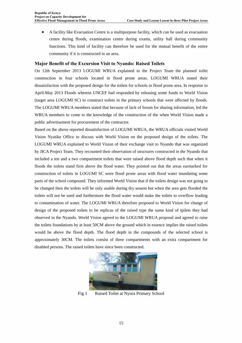
Republic of Kenya Project on Capacity Development for Effective Flood Management in Flood Prone Areas Case Study and Lesson Learnt in three Pilot Project Areas
15
A facility like Evacuation Centre is a multipurpose facility, which can be used as evacuation
centre during floods, examination centre during exams, utility hall during community
functions. This kind of facility can therefore be used for the mutual benefit of the entire
community if it is constructed in an area.
Major Benefit of the Excursion Visit to Nyando: Raised Toilets On 12th September 2013 LOGUMI WRUA explained to the Project Team the planned toilet
construction in four schools located in flood prone areas. LOGUMI WRUA stated their
dissatisfaction with the proposed design for the toilets for schools in flood prone area. In response to
April-May 2013 Floods wherein UNCEF had responded by releasing some funds to World Vision
(target area LOGUMI SC) to construct toilets in the primary schools that were affected by floods.
The LOGUMI WRUA members stated that because of lack of forum for sharing information, led the
WRUA members to come to the knowledge of the construction of the when World Vision made a
public advertisement for procurement of the contractor.
Based on the above reported dissatisfaction of LOGUMI WRUA, the WRUA officials visited World
Vision Nyatike Office to discuss with World Vision on the proposed design of the toilets. The
LOGUMI WRUA explained to World Vision of their exchange visit to Nyando that was organized
by JICA Project Team. They recounted their observation of structures constructed in the Nyando that
included a ten and a two compartment toilets that were raised above flood depth such that when it
floods the toilets stand firm above the flood water. They pointed out that the areas earmarked for
construction of toilets in LOGUMI SC were flood prone areas with flood water inundating some
parts of the school compound. They informed World Vision that if the toilets design was not going to
be changed then the toilets will be only usable during dry season but when the area gets flooded the
toilets will not be used and furthermore the flood water would make the toilets to overflow leading
to contamination of water. The LOGUMI WRUA therefore proposed to World Vision for change of
design of the proposed toilets to be replicas of the raised type the same kind of tpilets they had
observed in the Nyando. World Vision agreed to the LOGUMI WRUA proposal and agreed to raise
the toilets foundations by at least 50CM above the ground which in essence implies the raised toilets
would be above the flood depth. The flood depth in the compounds of the selected school is
approximately 30CM. The toilets consist of three compartments with an extra compartment for
disabled persons. The raised toilets have since been constructed.
Fig 1 Raised Toilet at Nyora Primary School
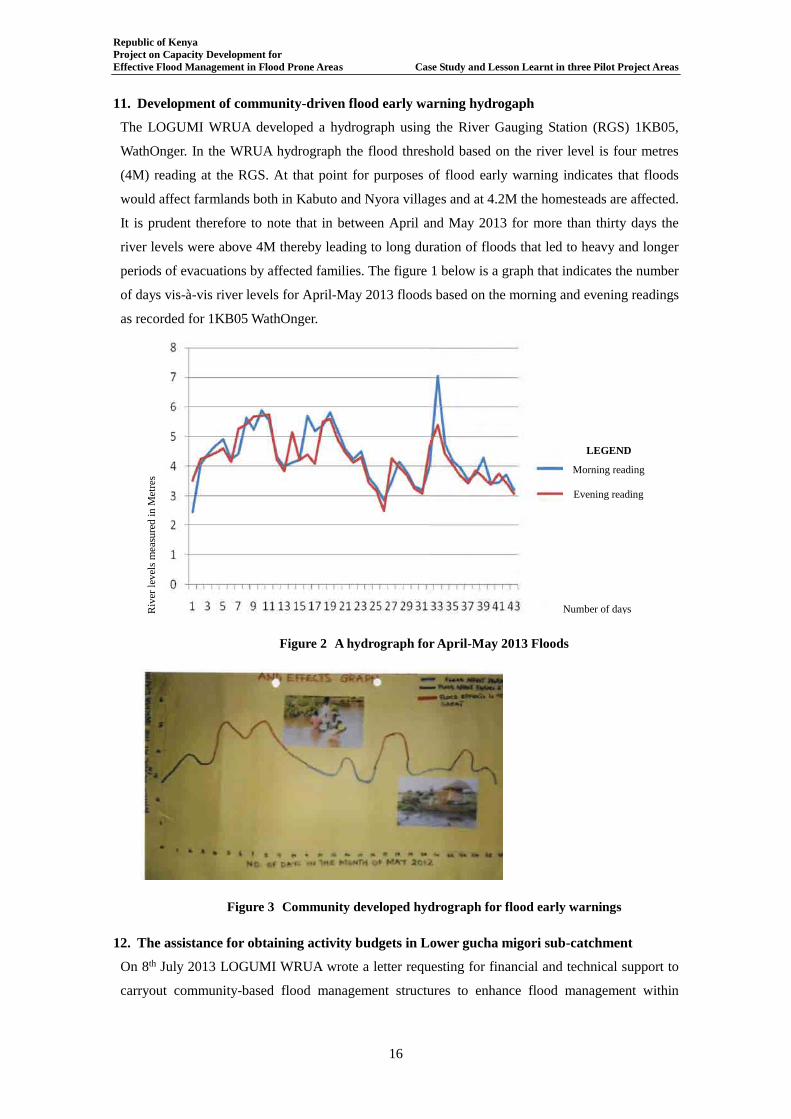
Republic of Kenya Project on Capacity Development for Effective Flood Management in Flood Prone Areas Case Study and Lesson Learnt in three Pilot Project Areas
16
11. Development of community-driven flood early warning hydrogaph
The LOGUMI WRUA developed a hydrograph using the River Gauging Station (RGS) 1KB05,
WathOnger. In the WRUA hydrograph the flood threshold based on the river level is four metres
(4M) reading at the RGS. At that point for purposes of flood early warning indicates that floods
would affect farmlands both in Kabuto and Nyora villages and at 4.2M the homesteads are affected.
It is prudent therefore to note that in between April and May 2013 for more than thirty days the
river levels were above 4M thereby leading to long duration of floods that led to heavy and longer
periods of evacuations by affected families. The figure 1 below is a graph that indicates the number
of days vis-à-vis river levels for April-May 2013 floods based on the morning and evening readings
as recorded for 1KB05 WathOnger.
Figure 2 A hydrograph for April-May 2013 Floods
Figure 3 Community developed hydrograph for flood early warnings
12. The assistance for obtaining activity budgets in Lower gucha migori sub-catchment
On 8th July 2013 LOGUMI WRUA wrote a letter requesting for financial and technical support to
carryout community-based flood management structures to enhance flood management within
Morning reading
Evening reading
Number of days Riv
er le
vels
mea
sure
d in
Met
res
LEGEND
Number of days
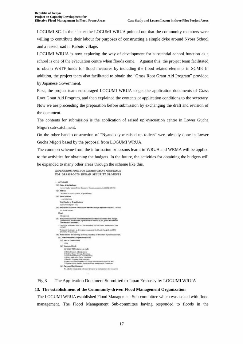
Republic of Kenya Project on Capacity Development for Effective Flood Management in Flood Prone Areas Case Study and Lesson Learnt in three Pilot Project Areas
17
LOGUMI SC. In their letter the LOGUMI WRUA pointed out that the community members were
willing to contribute their labour for purposes of constructing a simple dyke around Nyora School
and a raised road in Kabuto village.
LOGUMI WRUA is now exploring the way of development for substantial school function as a
school is one of the evacuation centre when floods come. Against this, the project team facilitated
to obtain WSTF funds for flood measures by including the flood related elements in SCMP. In
addition, the project team also facilitated to obtain the “Grass Root Grant Aid Program” provided
by Japanese Government.
First, the project team encouraged LOGUMI WRUA to get the application documents of Grass
Root Grant Aid Program, and then explained the contents or application conditions to the secretary.
Now we are proceeding the preparation before submission by exchanging the draft and revision of
the document.
The contents for submission is the application of raised up evacuation centre in Lower Gucha
Migori sub-catchment.
On the other hand, construction of “Nyando type raised up toilets” were already done in Lower
Gucha Migori based by the proposal from LOGUMI WRUA.
The common scheme from the information or lessons learnt in WRUA and WRMA will be applied
to the activities for obtaining the budgets. In the future, the activities for obtaining the budgets will
be expanded to many other areas through the scheme like this.
13. The establishment of the Community-driven Flood Management Organization
The LOGUMI WRUA established Flood Management Sub-committee which was tasked with flood
management. The Flood Management Sub-committee having responded to floods in the
Fig 3 The Application Document Submitted to Japan Embassy by LOGUMI WRUA
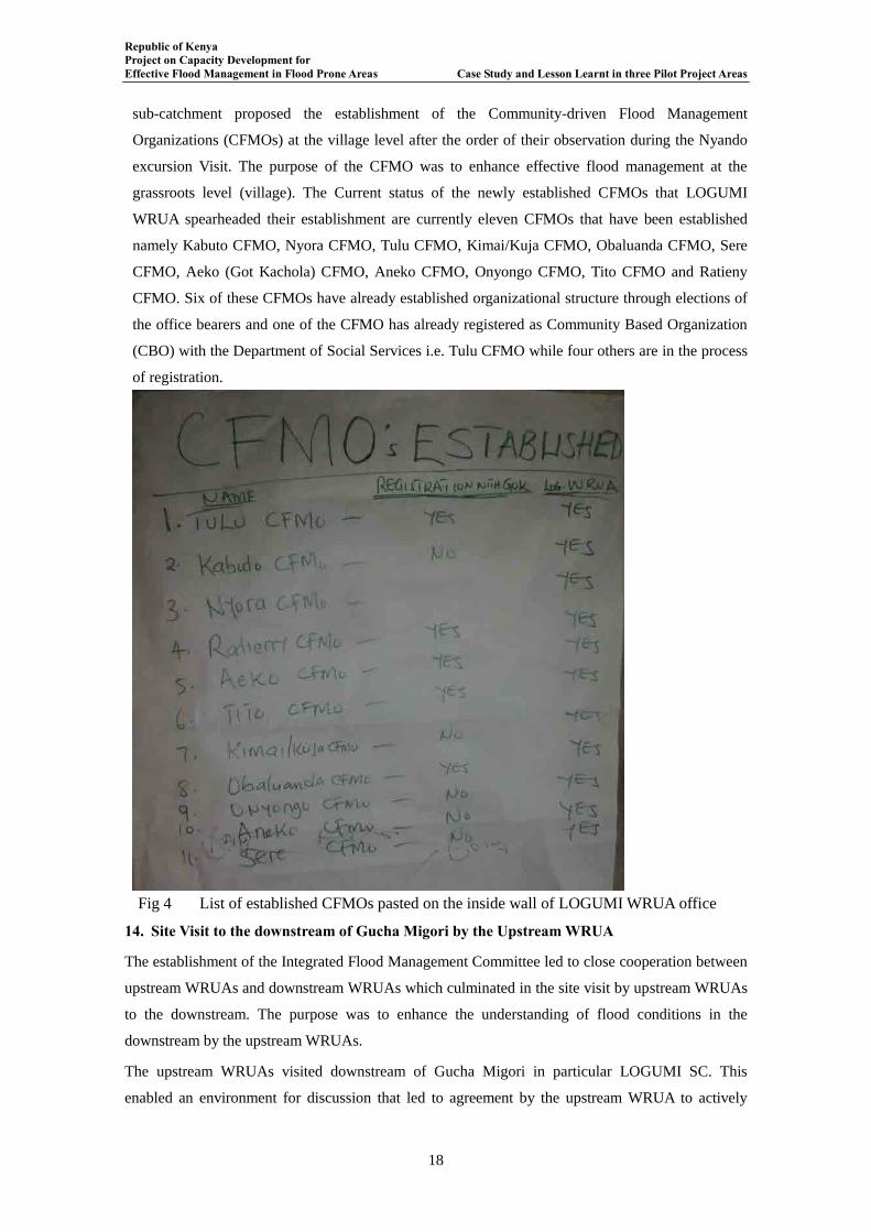
Republic of Kenya Project on Capacity Development for Effective Flood Management in Flood Prone Areas Case Study and Lesson Learnt in three Pilot Project Areas
18
sub-catchment proposed the establishment of the Community-driven Flood Management
Organizations (CFMOs) at the village level after the order of their observation during the Nyando
excursion Visit. The purpose of the CFMO was to enhance effective flood management at the
grassroots level (village). The Current status of the newly established CFMOs that LOGUMI
WRUA spearheaded their establishment are currently eleven CFMOs that have been established
namely Kabuto CFMO, Nyora CFMO, Tulu CFMO, Kimai/Kuja CFMO, Obaluanda CFMO, Sere
CFMO, Aeko (Got Kachola) CFMO, Aneko CFMO, Onyongo CFMO, Tito CFMO and Ratieny
CFMO. Six of these CFMOs have already established organizational structure through elections of
the office bearers and one of the CFMO has already registered as Community Based Organization
(CBO) with the Department of Social Services i.e. Tulu CFMO while four others are in the process
of registration.
14. Site Visit to the downstream of Gucha Migori by the Upstream WRUA
The establishment of the Integrated Flood Management Committee led to close cooperation between
upstream WRUAs and downstream WRUAs which culminated in the site visit by upstream WRUAs
to the downstream. The purpose was to enhance the understanding of flood conditions in the
downstream by the upstream WRUAs.
The upstream WRUAs visited downstream of Gucha Migori in particular LOGUMI SC. This
enabled an environment for discussion that led to agreement by the upstream WRUA to actively
Fig 4 List of established CFMOs pasted on the inside wall of LOGUMI WRUA office
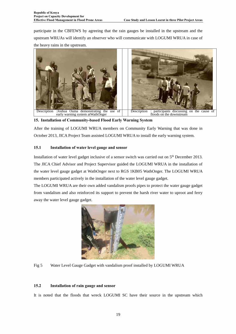
Republic of Kenya Project on Capacity Development for Effective Flood Management in Flood Prone Areas Case Study and Lesson Learnt in three Pilot Project Areas
19
participate in the CBFEWS by agreeing that the rain gauges be installed in the upstream and the
upstream WRUAs will identify an observer who will communicate with LOGUMI WRUA in case of
the heavy rains in the upstream.
Description :Joshua Ouma demonstrating the use of
early warning system atWathOnger Description : participants discussing on the cause of
floods on the downstream
15. Installation of Community-based Flood Early Warning System
After the training of LOGUMI WRUA members on Community Early Warning that was done in
October 2013, JICA Project Team assisted LOGUMI WRUA to install the early warning system.
15.1 Installation of water level gauge and sensor
Installation of water level gadget inclusive of a sensor switch was carried out on 5th December 2013.
The JICA Chief Advisor and Project Supervisor guided the LOGUMI WRUA in the installation of
the water level gauge gadget at WathOnger next to RGS 1KB05 WathOnger. The LOGUMI WRUA
members participated actively in the installation of the water level gauge gadget.
The LOGUMI WRUA are their own added vandalism proofs pipes to protect the water gauge gadget
from vandalism and also reinforced its support to prevent the harsh river water to uproot and ferry
away the water level gauge gadget.
Fig 5 Water Level Gauge Gadget with vandalism proof installed by LOGUMI WRUA
15.2 Installation of rain gauge and sensor
It is noted that the floods that wreck LOGUMI SC have their source in the upstream which
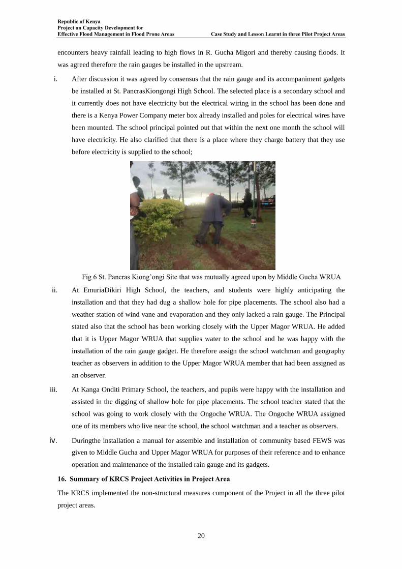
Republic of Kenya Project on Capacity Development for Effective Flood Management in Flood Prone Areas Case Study and Lesson Learnt in three Pilot Project Areas
20
encounters heavy rainfall leading to high flows in R. Gucha Migori and thereby causing floods. It
was agreed therefore the rain gauges be installed in the upstream.
i. After discussion it was agreed by consensus that the rain gauge and its accompaniment gadgets
be installed at St. PancrasKiongongi High School. The selected place is a secondary school and
it currently does not have electricity but the electrical wiring in the school has been done and
there is a Kenya Power Company meter box already installed and poles for electrical wires have
been mounted. The school principal pointed out that within the next one month the school will
have electricity. He also clarified that there is a place where they charge battery that they use
before electricity is supplied to the school;
ii. At EmuriaDikiri High School, the teachers, and students were highly anticipating the
installation and that they had dug a shallow hole for pipe placements. The school also had a
weather station of wind vane and evaporation and they only lacked a rain gauge. The Principal
stated also that the school has been working closely with the Upper Magor WRUA. He added
that it is Upper Magor WRUA that supplies water to the school and he was happy with the
installation of the rain gauge gadget. He therefore assign the school watchman and geography
teacher as observers in addition to the Upper Magor WRUA member that had been assigned as
an observer.
iii. At Kanga Onditi Primary School, the teachers, and pupils were happy with the installation and
assisted in the digging of shallow hole for pipe placements. The school teacher stated that the
school was going to work closely with the Ongoche WRUA. The Ongoche WRUA assigned
one of its members who live near the school, the school watchman and a teacher as observers.
iv. Duringthe installation a manual for assemble and installation of community based FEWS was
given to Middle Gucha and Upper Magor WRUA for purposes of their reference and to enhance
operation and maintenance of the installed rain gauge and its gadgets.
16. Summary of KRCS Project Activities in Project Area
The KRCS implemented the non-structural measures component of the Project in all the three pilot
project areas.
Fig 6 St. Pancras Kiong’ongi Site that was mutually agreed upon by Middle Gucha WRUA

Republic of Kenya Project on Capacity Development for Effective Flood Management in Flood Prone Areas Case Study and Lesson Learnt in three Pilot Project Areas
21
In Lower Gucha Migori the KRCS have been engaging the LOGUMI WRUA, KRCS Volunteers and
community members in the implementation of the activities.
The summary of the KRCS activities in the Project Area is as per the Table 2 below:
Table 8Summary of the KRCS Activities in Gucha Migori River Basin
Date Activities & Venue Participants Remarks 26th Sept. 2013 KRCS Non-structural
measures Kick-off meeting
held at Nyora Primary
School
KRCS, WRMA, LOGUMI
WRUA, DEO, DC and
Community members
The meeting was well attended and
KRCS explained to the community
the objectives of the activities, when,
where and how these activities would
be implemented.
19th Nov. 2013 Stakeholders Meeting held
at KRCS Migori Branch
Boardroom
KRCS, JICA Project Team,
LOGUMI WRUA, Migori
County Government,
Head teachers of schools in
flood prone areas, youth and
women representatives
The meeting was well attended and
KRCS explained to the stakeholders
the activities they intended to
undertake in the LOGUMI SC.
3rd -6th Dec.
2013 LOGUMI WRUA Training
on Community based
Disaster Management
KRCS, LOGUMI WRUA,
JICA Project Team
Average attendance of 30-40 WRUA
members. The training materials were
relevant to the subjects.
9th -11th Dec.
2013 LOGUMI WRUA Training
on Community based Early
Warning
KRCS, LOGUMI WRUA,
WRMA-LVSC Kisii Office,
JICA Project Team
WRMA counterpart staff participated
in the training as one of the trainer.
KRCS also carried out Focal Group
Discussion (FGD) to understand the
traditional early warning system.
18th Dec. 2013 Presentation of KRCS
activities in LOGUMI SC
during Gucha Migori IFMC
Stakeholders within Gucha
Migori
KRCS Project Officer made a
presentation on the current progress
of activities being implemented by
KRCS in LOGUMI SC.
13th -15th Jan.
2014 Teachers’ Training on Flood
Disaster Management
Teachers from Sere, Nyora,
Angugo and Kabuto
primary School
About 95% in attendance and
materials developed under the Japan
Grant Aid Project were used.
16th Jan. 2014
and is still
continuing
Teachers teaching pupils on
Flood Disaster Management
in Schools
Pupils in classes 4 to 7 in
Sere, Nyora, Angugo and
Kabuto primary School
The Teacher Booklet on Flood
Management was being developed
27th Feb 2014 KRCS Project Officer made
a presentation on Education
Programme on Flood
Management
IFMC members PowerPoint presentation was
developed on the relevant subject
(Source: The JICA PCDEFM)
17. Milestones in Flood Management Gucha Migori River Basin
Republic of Kenya Project on Capacity Development for Effective Flood Management in Flood Prone Areas Case Study and Lesson Learnt in three Pilot Project Areas
22
a) The list for the prospective IFM Committee members for Gucha Migori River Basin has
been developed;
b) Community based flood management Action Plan has since been developed: In the months
of February and March 2012 the Project Team and the WRUA were involved in developing
the community based flood management action plan. During this period the flood disaster
cycle was core area that the plan revolved round about it. Flood disaster preparedness,
response and reconstruction were discussed with various activities being proposed
thereafter.
c) The Community-based Flood Management Action Plan has since been incorporated in the
SCMP. The reviewed SCMP has been officially submitted to the WRMA SRO and also
recently a softcopy of both the Community-based Flood Management Action Plan and
reviewed SCMP for LOGUMI WRUA was given to the Assistant Technical Manager in
charge of Community Development WRMA-LVSC Regional Office.
d) Newsletter Production: There is a monthly Newsletter the Integrated Flood Management
Newsletter that is produced each month and it carries the briefs of the progress of the
Project in the Southern Shoreline Gucha Migori. Eight issues hitherto now have been as at
October 2012.
In each of the issues at least fifteen copies of the Newsletter are distributed to the LOGUMI
WRUA. The LOGUMI WRUA further redistributes this Newsletter to other stakeholders
and also uses the Newsletter for sensitization of its members on issues of flood
management.
e) The LOGUMI WRUA wrote a column in the Newsletter 4thand 5thedition wherein in 4th
edition the WRUA introduced the LOGUMI WRUA and the process of its establishment. In
the 5th edition the LOGUMI WRUA expounded upon their vision and mission.
f) Development and review of Flood Hazard Maps: The flood hazard map for Kabuto-Nyora
area; for Tito-Ratienyi area; and for Luanda-Misiwi area.
g) LOGUMI WRUA proactive participation in Flood Management in the Lower Gucha Migori
Sub-catchment.
h) The LOGUMI WRUA chairman and the District Commissioner Nyatike District attended
the Workshop on effective flood management organized under the Project.
i) Discussion with respective stakeholders’ targeted to as prospective IFM Committee
members has done and was fruitful with many stakeholders showing willingness to be part
of the IFM Committee members.
j) The Menu for Community-based Flood Management activities was developed and has been
circulated to various stakeholders. The menu also puts up case for building resilience a key
in ensuring effective flood management is achieved.
Republic of Kenya Project on Capacity Development for Effective Flood Management in Flood Prone Areas Case Study and Lesson Learnt in three Pilot Project Areas
23
k) The second Workshop on Integrated Flood Management was held on 12th February 2013.
During the workshop the Supervisor Gucha Migori made a presentation, Mr. Boit former
counterpart staff to the Project in Gucha Migori made a presentation and LOGUMI WRUA
Secretary Mr. Joshua Ouma also made a presentation.
l) Seven LOGUMI WRUA members visited Nyando River Basin during the excursion visit to
Nyando River Basin and had a firsthand experience of the Nyando Project and also had
positive interaction with Community members in Nyando including Community-based
Flood Management Organizations (CFMOs) and WRUAs located in Nyando.
m) LOGUMI WRUA hosted a team consisting of Project Team, WRMA, GIZ and WRUAs
from Isiolo and Lower Lumi for two days. During the two days LOGUMI WRUA explained
to the visitors the nature, the operations, the success of LOGUMI WRUA within the Lower
Gucha Migori SC.
n) LOGUMI WRUA was actively involved in the response to floods in April 2013. It worked
closely with World Vision Nyatike and KRCS Migori. The LOGUMI WRUA also stationed
two of its members at the Nyora Evacuation Place.
o) LOGUMI WRUA installed a ten thousands litres (10000 lts) water tanks at New Jerusalem
Children Home to harvest rain water from the vast roof catchment of the church in order to
reduce the water surface run-off in the area during the rainy seasons.
p) LOGUMI WRUA has sensitized community members to establish Community-driven Flood
Management Organizations (CFMOs) that has led to eleven CFMO hitherto to be
established.
q) LOGUMI WRUA members were involved in the open lecture held in Nairobi for
community based early warning system by using community develop rain gauges and river
gauge gadgets.
r) LOGUMI WRUA members were trained in Community-based Disaster Management and
Community-based Early Warning by KRCS.
s) LOGUMI WRUA assisted by JICA Project Team installed Community-based Flood Early
Warning System.
t) LOGUMI WRUA working closely with WRMA and KRCS mobilized teachers within
LOGUMI SC who were thereafter trained by Kenya Red Cross Society on teaching of
pupils on the subject of Disaster Management and in particular Flood Disaster Management.
u) Pupils in four Schools in LOGUMI SC currently are being taught Flood Management
Concepts that are being infused into school syllabus.
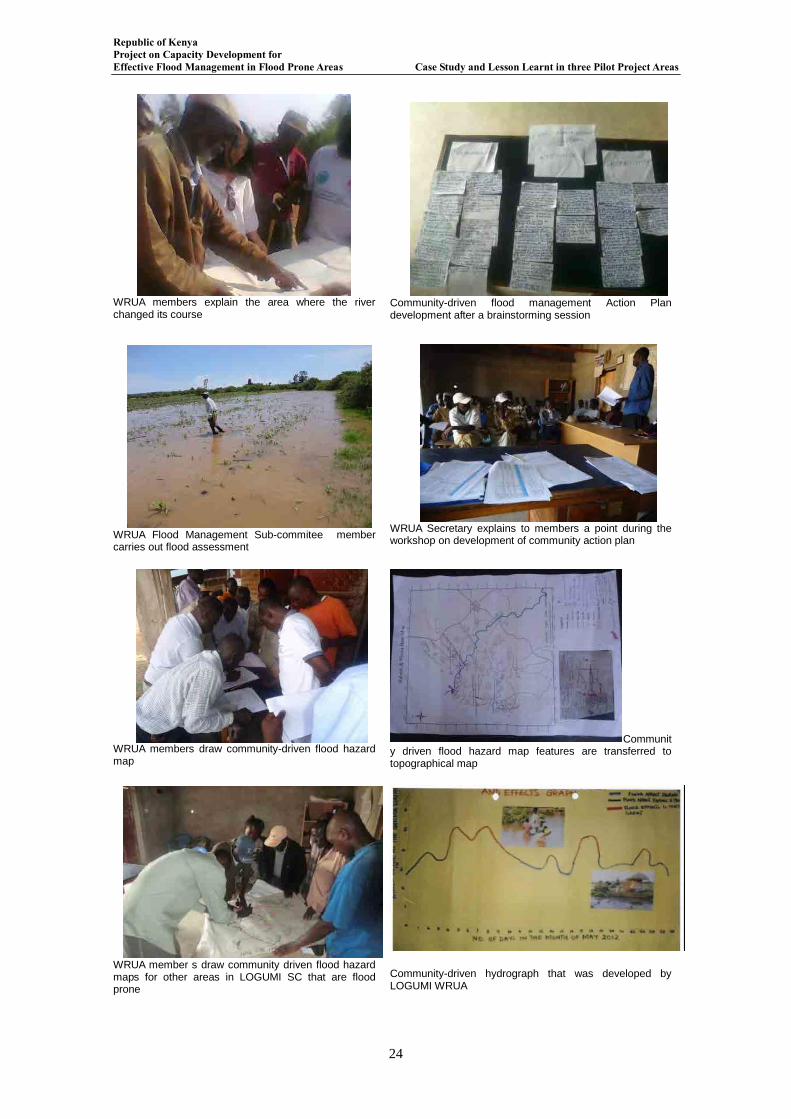
Republic of Kenya Project on Capacity Development for Effective Flood Management in Flood Prone Areas Case Study and Lesson Learnt in three Pilot Project Areas
24
WRUA members explain the area where the river changed its course
Community-driven flood management Action Plan development after a brainstorming session
WRUA Flood Management Sub-commitee member carries out flood assessment
WRUA Secretary explains to members a point during the workshop on development of community action plan
WRUA members draw community-driven flood hazard map
Community driven flood hazard map features are transferred to topographical map
WRUA member s draw community driven flood hazard maps for other areas in LOGUMI SC that are flood prone
Community-driven hydrograph that was developed by LOGUMI WRUA
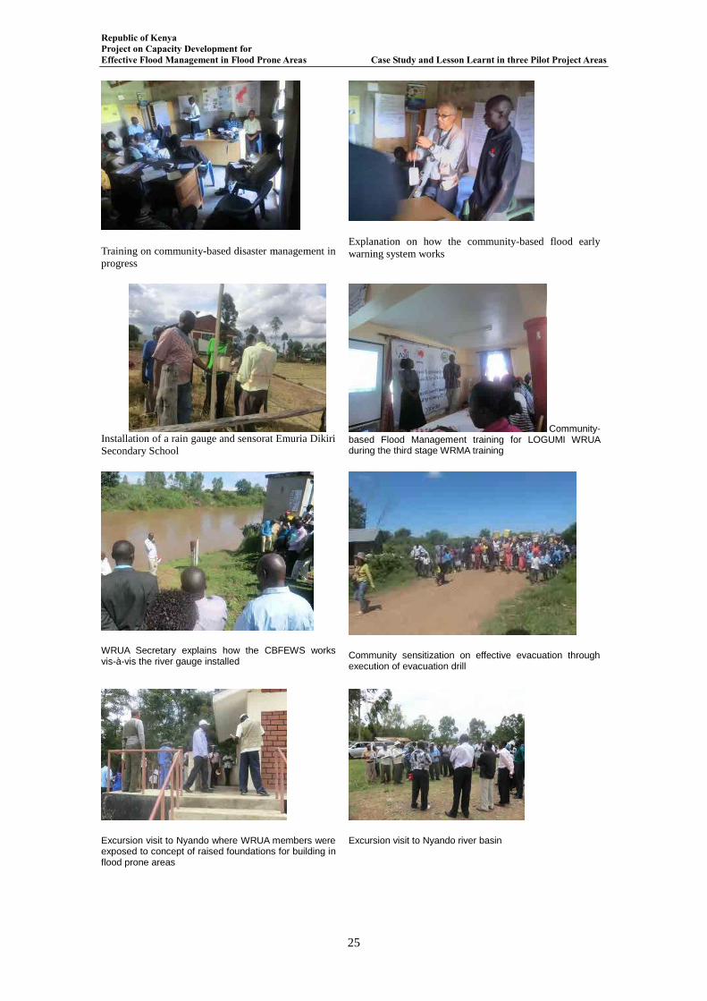
Republic of Kenya Project on Capacity Development for Effective Flood Management in Flood Prone Areas Case Study and Lesson Learnt in three Pilot Project Areas
25
Training on community-based disaster management in
progress
Explanation on how the community-based flood early
warning system works
Installation of a rain gauge and sensorat Emuria Dikiri
Secondary School
Community-based Flood Management training for LOGUMI WRUA during the third stage WRMA training
WRUA Secretary explains how the CBFEWS works vis-à-vis the river gauge installed
Community sensitization on effective evacuation through execution of evacuation drill
Excursion visit to Nyando where WRUA members were exposed to concept of raised foundations for building in flood prone areas
Excursion visit to Nyando river basin
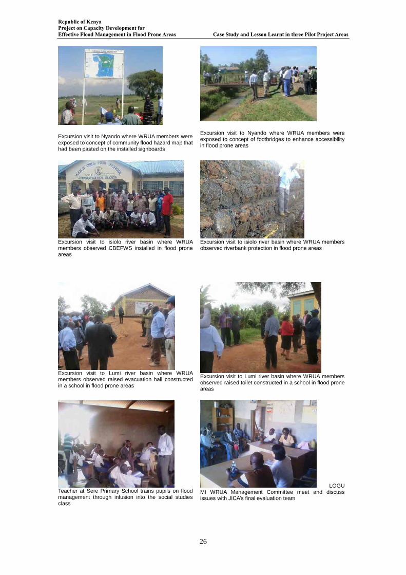
Republic of Kenya Project on Capacity Development for Effective Flood Management in Flood Prone Areas Case Study and Lesson Learnt in three Pilot Project Areas
26
Excursion visit to Nyando where WRUA members were exposed to concept of community flood hazard map that had been pasted on the installed signboards
Excursion visit to Nyando where WRUA members were exposed to concept of footbridges to enhance accessibility in flood prone areas
Excursion visit to isiolo river basin where WRUA members observed CBEFWS installed in flood prone areas
Excursion visit to isiolo river basin where WRUA members observed riverbank protection in flood prone areas
Excursion visit to Lumi river basin where WRUA members observed raised evacuation hall constructed in a school in flood prone areas
Excursion visit to Lumi river basin where WRUA members observed raised toilet constructed in a school in flood prone areas
Teacher at Sere Primary School trains pupils on flood management through infusion into the social studies class
LOGUMI WRUA Management Committee meet and discuss issues with JICA’s final evaluation team
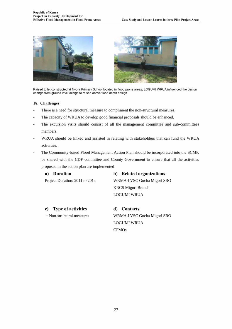
Republic of Kenya Project on Capacity Development for Effective Flood Management in Flood Prone Areas Case Study and Lesson Learnt in three Pilot Project Areas
27
Raised toilet constructed at Nyora Primary School located in flood prone areas, LOGUMI WRUA influenced the design change from ground level design to raised above flood depth design
18. Challenges
- There is a need for structural measure to compliment the non-structural measures.
- The capacity of WRUA to develop good financial proposals should be enhanced.
- The excursion visits should consist of all the management committee and sub-committees
members.
- WRUA should be linked and assisted in relating with stakeholders that can fund the WRUA
activities.
- The Community-based Flood Management Action Plan should be incorporated into the SCMP,
be shared with the CDF committee and County Government to ensure that all the activities
proposed in the action plan are implemented
a) Duration Project Duration: 2011 to 2014
b) Related organizations WRMA-LVSC Gucha Migori SRO
KRCS Migori Branch
LOGUMI WRUA
c) Type of activities ・Non-structural measures
d) Contacts WRMA-LVSC Gucha Migori SRO
LOGUMI WRUA
CFMOs
Republic of Kenya Project on Capacity Development for Effective Flood Management in Flood Prone Areas Case Study and Lesson Learnt in three Pilot Project Areas
28
Chapter 3 Lessons Learnt in Lower Gucha Migori Sub-catchment
Case 1Non-structural measures in Lower Gucha Migori Sub-catchment
1. INTRODUCTION
The Project on Capacity Development for effective flood management in flood prone areas
implemented a capacity building programmes on effective flood management for WRMA and
WRUA. The training for WRMA was divided into three stages: Stage 1 was the training of WRMA
staffs by JICA PCDEFM Team; Stage 2 was the training of WRMA staffs by the flood management
trained WRMA staffs; and stage 3 were the training of WRUA members by the flood management
trained WRMA staffs. The stage 3 was implemented in Gucha Migori river basin when WRMA staff
trained LOGUMI WRUA on community based effective flood management. It was during that
training that the sentiments of the LOGUMI WRUA Chairlady are herein quoted:
“She said that during the entry of JICA Project Team in LOGUMI wherein the expectations of the
community were heavy structural measures but when the scope of the Project in LOGUMI was
explained she pointed was heartbroken. But after undergoing through the various training,
workshops and interactions with other stakeholders, she now understands why the trainings were
important! She added that now LOGUMI community members were in control of their own destiny!
Using a Luo proverb she said it is better to train a person on how to fish than just giving that person
fish to eat! She added that LOGUMI WRUA were now able to know importance of any flood
structure that when they will be constructed in the area O&M will be per excellence!! She also stated
that LOGUMI WRUA had written proposal soliciting for funds to construct an evacuation centre at
Nyora village to Japan Embassy.”
2. LESSONS LEARNT
2.1 Community Participation and involvement in Flood Disaster Management
The concept of the Community Managed Disaster Risk Reduction (CMDRR) was the focal
point in the implementation of the Project. The Project Team entry point to the community was
through LOGUMI WRUA which is a community based grassroots organization. Through this
concept the community members through the LOGUMI WRUA and assistance from the Project
Team were able to develop the following:
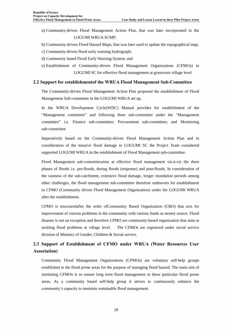
Republic of Kenya Project on Capacity Development for Effective Flood Management in Flood Prone Areas Case Study and Lesson Learnt in three Pilot Project Areas
29
a) Community-driven Flood Management Action Plan, that was later incorporated in the
LOGUMI WRUA SCMP;
b) Community-driven Flood Hazard Maps, that was later used to update the topographical map;
c) Community-driven flood early warning hydrograph;
d) Community based Flood Early Warning System; and
e) Establishment of Community-driven Flood Management Organizations (CFMOs) in
LOGUMI SC for effective flood management at grassroots village level.
2.2 Support for establishmentof the WRUA Flood Management Sub-Committee
The Community-driven Flood Management Action Plan proposed the establishment of Flood
Management Sub-committee in the LOGUMI WRUA set up.
In the WRUA Development Cycle(WDC) Manual provides for establishment of the
“Management committee” and following three sub-committee under the “Management
committee” i.e. Finance sub-committee; Procurement sub-committee; and Monitoring
sub-committee
Imperatively based on the Community-driven Flood Management Action Plan and in
consideration of the massive flood damage in LOGUMI SC the Project Team considered
supported LOGUMI WRUA in the establishment of Flood Management sub-committee.
Flood Management sub-committeeaims at effective flood management vis-à-vis the three
phases of floods i.e. pre-floods, during floods (response) and post-floods. In consideration of
the vastness of the sub-catchment, extensive flood damage, longer inundation periods among
other challenges, the flood management sub-committee therefore endeavors for establishment
in CFMO (Community driven Flood Management Organization) under the LOGUMI WRUA
after the establishment.
CFMO is structuredafter the order ofCommunity Based Organization (CBO) that acts for
improvement of various problems in the community with various funds as money source. Flood
disaster is not an exception and therefore CFMO are community-based organization that aims at
tackling flood problems at village level. The CFMOs are registered under social service
division of Ministry of Gender, Children & Social service.
2.3 Support of Establishment of CFMO under WRUA (Water Resources User Association)
Community Flood Management Organizations (CFMOs) are voluntary self-help groups
established in the flood prone areas for the purpose of managing flood hazard. The main aim of
instituting CFMOs is to ensure long term flood management in these particular flood prone
areas. As a community based self-help group it strives to continuously enhance the
community’s capacity to maintain sustainable flood management.
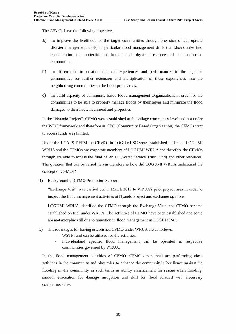
Republic of Kenya Project on Capacity Development for Effective Flood Management in Flood Prone Areas Case Study and Lesson Learnt in three Pilot Project Areas
30
The CFMOs have the following objectives:
a) To improve the livelihood of the target communities through provision of appropriate
disaster management tools, in particular flood management drills that should take into
consideration the protection of human and physical resources of the concerned
communities
b) To disseminate information of their experiences and performances to the adjacent
communities for further extension and multiplication of these experiences into the
neighbouring communities in the flood prone areas.
c) To build capacity of community-based Flood management Organizations in order for the
communities to be able to properly manage floods by themselves and minimize the flood
damages to their lives, livelihood and properties
In the “Nyando Project”, CFMO were established at the village community level and not under
the WDC framework and therefore as CBO (Community Based Organization) the CFMOs vent
to access funds was limited.
Under the JICA PCDEFM the CFMOs in LOGUMI SC were established under the LOGUMI
WRUA and the CFMOs are corporate members of LOGUMI WRUA and therefore the CFMOs
through are able to access the fund of WSTF (Water Service Trust Fund) and other resources.
The question that can be raised herein therefore is how did LOGUMI WRUA understand the
concept of CFMOs?
1) Background of CFMO Promotion Support
“Exchange Visit” was carried out in March 2013 to WRUA’s pilot project area in order to
inspect the flood management activities at Nyando Project and exchange opinions.
LOGUMI WRUA identified the CFMO through the Exchange Visit, and CFMO became
established on trial under WRUA. The activities of CFMO have been established and some
are metamorphic still due to transition in flood management in LOGUMI SC.
2) Theadvantages for having established CFMO under WRUA are as follows:
- WSTF fund can be utilized for the activities.
- Individualand specific flood management can be operated at respective
communities governed by WRUA.
In the flood management activities of CFMO, CFMO’s personnel are performing close
activities in the community and play roles to enhance the community’s Resilience against the
flooding in the community in such terms as ability enhancement for rescue when flooding,
smooth evacuation for damage mitigation and skill for flood forecast with necessary
countermeasures.
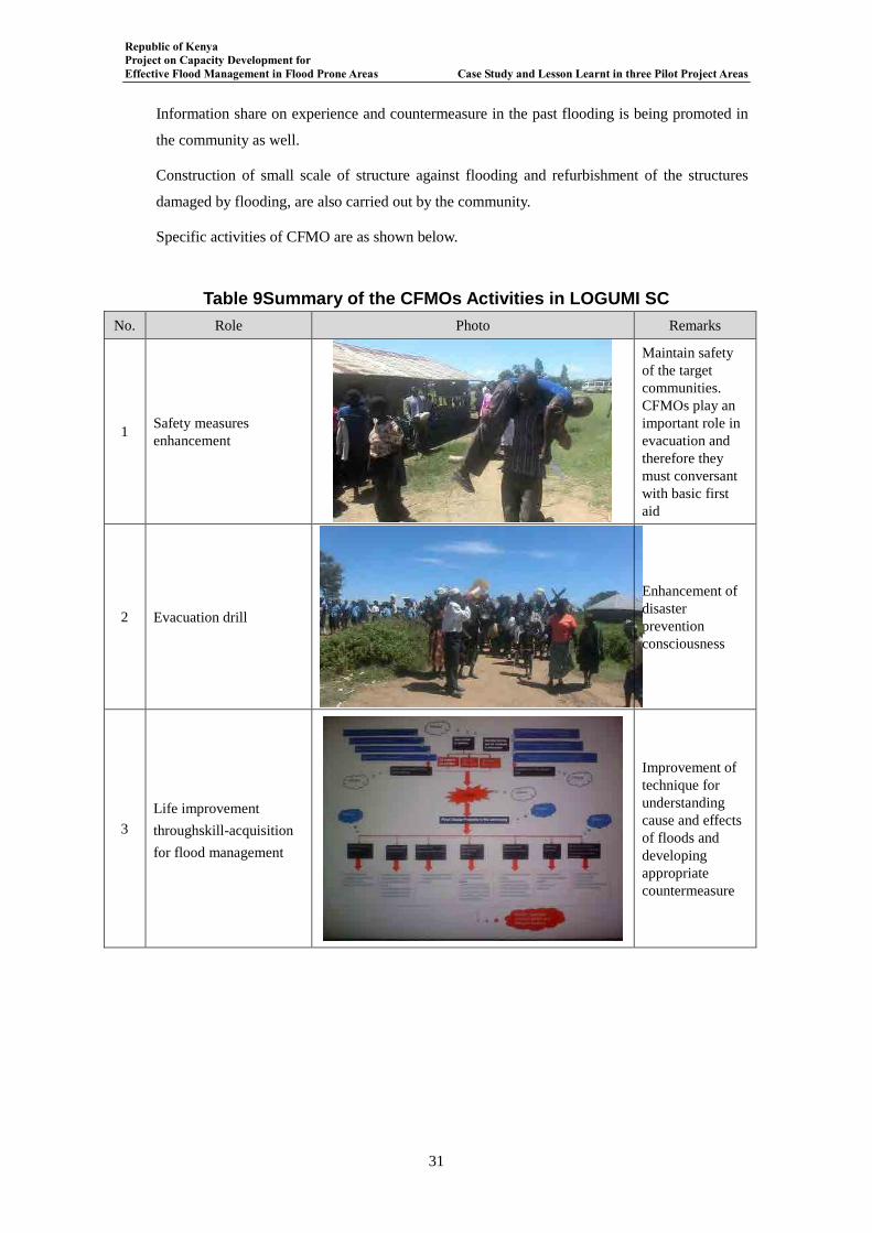
Republic of Kenya Project on Capacity Development for Effective Flood Management in Flood Prone Areas Case Study and Lesson Learnt in three Pilot Project Areas
31
Information share on experience and countermeasure in the past flooding is being promoted in
the community as well.
Construction of small scale of structure against flooding and refurbishment of the structures
damaged by flooding, are also carried out by the community.
Specific activities of CFMO are as shown below.
Table 9Summary of the CFMOs Activities in LOGUMI SC
No. Role Photo Remarks
1 Safety measures
enhancement
Maintain safety
of the target
communities.
CFMOs play an
important role in
evacuation and
therefore they
must conversant
with basic first
aid
2 Evacuation drill
Enhancement of
disaster
prevention
consciousness
3
Life improvement
throughskill-acquisition
for flood management
Improvement of
technique for
understanding
cause and effects
of floods and
developing
appropriate
countermeasure
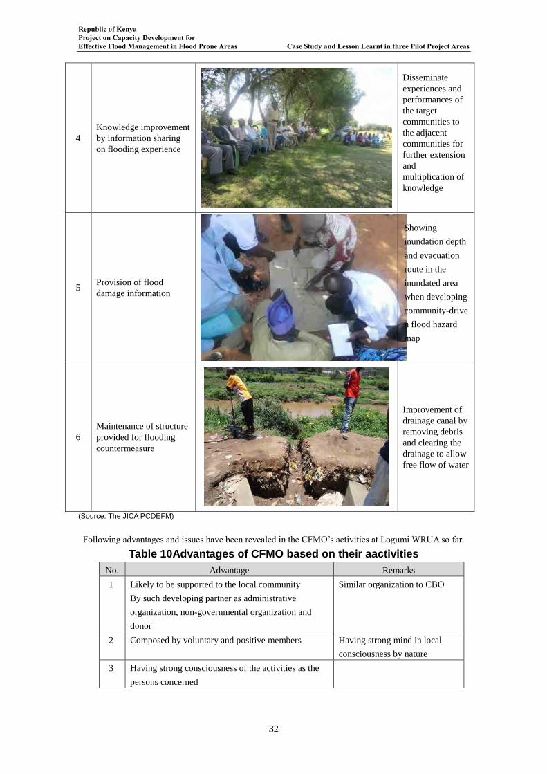
Republic of Kenya Project on Capacity Development for Effective Flood Management in Flood Prone Areas Case Study and Lesson Learnt in three Pilot Project Areas
32
4
Knowledge improvement
by information sharing
on flooding experience
Disseminate
experiences and
performances of
the target
communities to
the adjacent
communities for
further extension
and
multiplication of
knowledge
5 Provision of flood
damage information
Showing
inundation depth
and evacuation
route in the
inundated area
when developing
community-drive
n flood hazard
map
6
Maintenance of structure
provided for flooding
countermeasure
Improvement of
drainage canal by
removing debris
and clearing the
drainage to allow
free flow of water
(Source: The JICA PCDEFM)
Following advantages and issues have been revealed in the CFMO’s activities at Logumi WRUA so far.
Table 10Advantages of CFMO based on their aactivities
No. Advantage Remarks
1 Likely to be supported to the local community
By such developing partner as administrative
organization, non-governmental organization and
donor
Similar organization to CBO
2 Composed by voluntary and positive members Having strong mind in local
consciousness by nature
3 Having strong consciousness of the activities as the
persons concerned
Republic of Kenya Project on Capacity Development for Effective Flood Management in Flood Prone Areas Case Study and Lesson Learnt in three Pilot Project Areas
33
4 Possible to become contact between donor and
community member
Having dual viewpoint as
inhabitant and as developer
5 Likely to mobilize the persons easily due to old
acquaintance with community members
6 Familiar with local topography and geography and
having protective mind toward the inhabitants with
knowledge of dangerous spots when flooding
7 Appropriate for communication and information
exchange with neighboring villages
Habitual local interchange and
similar language (Source: The JICA PCDEFM)
Table 11Disadvantages of CFMO based on their aactivities
No. Issue Remarks
1 Much dependence on the chairman’s leadership for
operation, thus, likely to be declined in case of
chairman’s shift
2 Possibly to become private organization by the
persons who established CFMO
Making such warehouse for
flood management personal
belonging
3 No supervisory organization Required for high moral and
self-purification of the
personnel
4 Unrestricted performance due to no definite
obligations to WRUA
Limited control of WRUA
(Source: The JICA PCDEFM)
As reviewed above, CFMO has smooth understanding with the community members within the
village setup and is likely to proceed with positive and detailed performance in consideration of
high consciousness and independence of its activities.
But due to lack institutionalized framework that makes the CFMO independent from the office
bearers that manage CFMO, there are possibilities of the CFMObecoming a private
organization in terms of operational function and authority.
3) Development of CFMO to Other WRUA
Since CFMO is operating for flood management in the smaller community unit thanWRUA, it
is easy to target priority issue and assign the personal resource for carryingout the accident
prevention activities in the community.
From the above viewpoint, the Project Team supported to establish CFMO in the Lower LUMI
WRUA aiming at CFMO’s level development as follows.
Orientation to and Opinion Exchange with Lower LUMI WRUA and School Persons:
The Project Team explained CFMO substance and circumstances at Logumi WRUA to
Lower LUMI WRUA as well as advantageous matters and issues, and exchanged opinions
on the establishment possibility of CFMO.
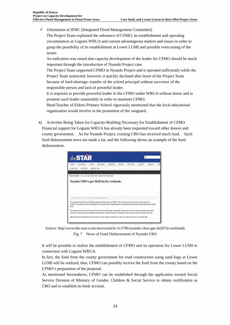
Republic of Kenya Project on Capacity Development for Effective Flood Management in Flood Prone Areas Case Study and Lesson Learnt in three Pilot Project Areas
34
Orientation at IFMC (Integrated Flood Management Committee)
The Project Team explained the substance of CFMO, its establishment and operating
circumstances at Logumi WRUA and current advantageous matters and issues in order to
grasp the possibility of its establishment at Lower LUMI and possible overcoming of the
issues.
An indication was raised that capacity development of the leader for CFMO should be much
important through the introduction of Nyando Project case.
The Project Team supported CFMO in Nyando Project and it operated sufficiently while the
Project Team instructed, however, it quickly declined after leave of the Project Team
because of fund-shortage, transfer of the school principal without successor of the
responsible person and lack of powerful leader.
It is requisite to provide powerful leader in the CFMO under WRUA without donor and to
promote such leader sustainably in order to maintain CFMO.
Head Teacher of Eldoro Primary School vigorously mentioned that the local educational
organization would involve in the promotion of the vanguard.
4) Activities Being Taken for Capacity-Building Necessary for Establishment of CFMO
Financial support for Logumi WRUA has already been requested toward other donors and
county government. As for Nyando Project, existing CBO has received much fund. Such
fund disbursement news are made a lot, and the following shows an example of the fund
disbursement.
Source: http//www.the-star.co.ke/news/article-113706/nyando-cbos-get-sh267m-wetlamds
Fig. 7 News of Fund Disbursement of Nyando CBO
It will be possible to realize the establishment of CFMO and its operation for Lower LUMI in
connection with Logumi WRUA.
In fact, the fund from the county government for road construction using sand bags at Lower
LUMI will be realized, thus, CFMO can possibly receive the fund from the county based on the
CFMO’s preparation of the proposal.
As mentioned hereinabove, CFMO can be established through the application toward Social
Service Division of Ministry of Gender, Children & Social Service to obtain certification as
CBO and to establish its bank account.
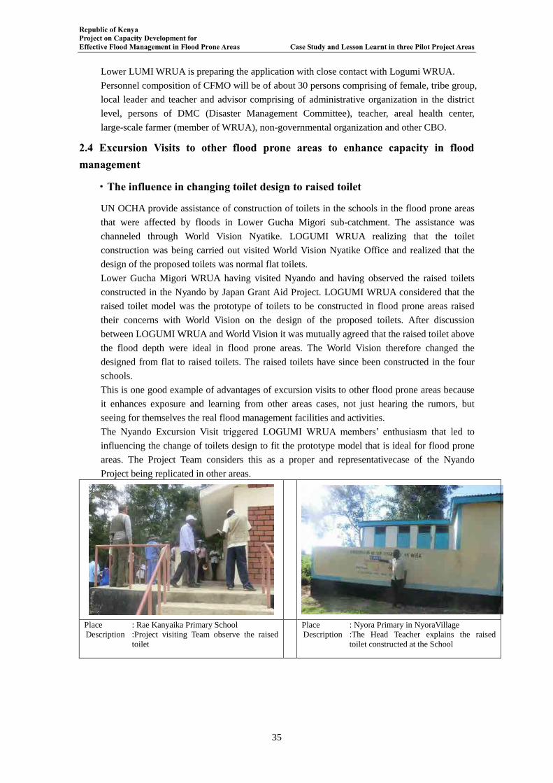
Republic of Kenya Project on Capacity Development for Effective Flood Management in Flood Prone Areas Case Study and Lesson Learnt in three Pilot Project Areas
35
Lower LUMI WRUA is preparing the application with close contact with Logumi WRUA.
Personnel composition of CFMO will be of about 30 persons comprising of female, tribe group,
local leader and teacher and advisor comprising of administrative organization in the district
level, persons of DMC (Disaster Management Committee), teacher, areal health center,
large-scale farmer (member of WRUA), non-governmental organization and other CBO.
2.4 Excursion Visits to other flood prone areas to enhance capacity in flood management
・The influence in changing toilet design to raised toilet
UN OCHA provide assistance of construction of toilets in the schools in the flood prone areas
that were affected by floods in Lower Gucha Migori sub-catchment. The assistance was
channeled through World Vision Nyatike. LOGUMI WRUA realizing that the toilet
construction was being carried out visited World Vision Nyatike Office and realized that the
design of the proposed toilets was normal flat toilets.
Lower Gucha Migori WRUA having visited Nyando and having observed the raised toilets
constructed in the Nyando by Japan Grant Aid Project. LOGUMI WRUA considered that the
raised toilet model was the prototype of toilets to be constructed in flood prone areas raised
their concerns with World Vision on the design of the proposed toilets. After discussion
between LOGUMI WRUA and World Vision it was mutually agreed that the raised toilet above
the flood depth were ideal in flood prone areas. The World Vision therefore changed the
designed from flat to raised toilets. The raised toilets have since been constructed in the four
schools.
This is one good example of advantages of excursion visits to other flood prone areas because
it enhances exposure and learning from other areas cases, not just hearing the rumors, but
seeing for themselves the real flood management facilities and activities.
The Nyando Excursion Visit triggered LOGUMI WRUA members’ enthusiasm that led to
influencing the change of toilets design to fit the prototype model that is ideal for flood prone
areas. The Project Team considers this as a proper and representativecase of the Nyando
Project being replicated in other areas.
Place : Rae Kanyaika Primary School
Description :Project visiting Team observe the raised
toilet
Place : Nyora Primary in NyoraVillage
Description :The Head Teacher explains the raised
toilet constructed at the School
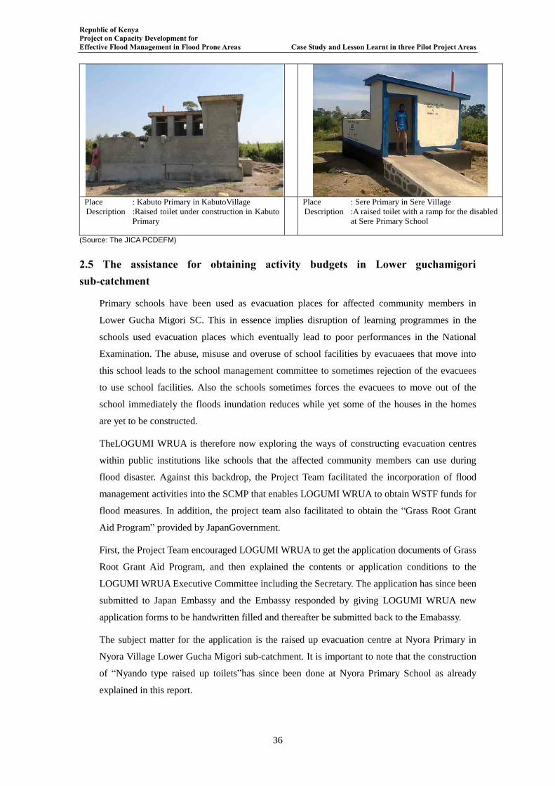
Republic of Kenya Project on Capacity Development for Effective Flood Management in Flood Prone Areas Case Study and Lesson Learnt in three Pilot Project Areas
36
Place : Kabuto Primary in KabutoVillage
Description :Raised toilet under construction in Kabuto
Primary
Place : Sere Primary in Sere Village
Description :A raised toilet with a ramp for the disabled
at Sere Primary School
(Source: The JICA PCDEFM)
2.5 The assistance for obtaining activity budgets in Lower guchamigori sub-catchment
Primary schools have been used as evacuation places for affected community members in
Lower Gucha Migori SC. This in essence implies disruption of learning programmes in the
schools used evacuation places which eventually lead to poor performances in the National
Examination. The abuse, misuse and overuse of school facilities by evacuaees that move into
this school leads to the school management committee to sometimes rejection of the evacuees
to use school facilities. Also the schools sometimes forces the evacuees to move out of the
school immediately the floods inundation reduces while yet some of the houses in the homes
are yet to be constructed.
TheLOGUMI WRUA is therefore now exploring the ways of constructing evacuation centres
within public institutions like schools that the affected community members can use during
flood disaster. Against this backdrop, the Project Team facilitated the incorporation of flood
management activities into the SCMP that enables LOGUMI WRUA to obtain WSTF funds for
flood measures. In addition, the project team also facilitated to obtain the “Grass Root Grant
Aid Program” provided by JapanGovernment.
First, the Project Team encouraged LOGUMI WRUA to get the application documents of Grass
Root Grant Aid Program, and then explained the contents or application conditions to the
LOGUMI WRUA Executive Committee including the Secretary. The application has since been
submitted to Japan Embassy and the Embassy responded by giving LOGUMI WRUA new
application forms to be handwritten filled and thereafter be submitted back to the Emabassy.
The subject matter for the application is the raised up evacuation centre at Nyora Primary in
Nyora Village Lower Gucha Migori sub-catchment. It is important to note that the construction
of “Nyando type raised up toilets”has since been done at Nyora Primary School as already
explained in this report.
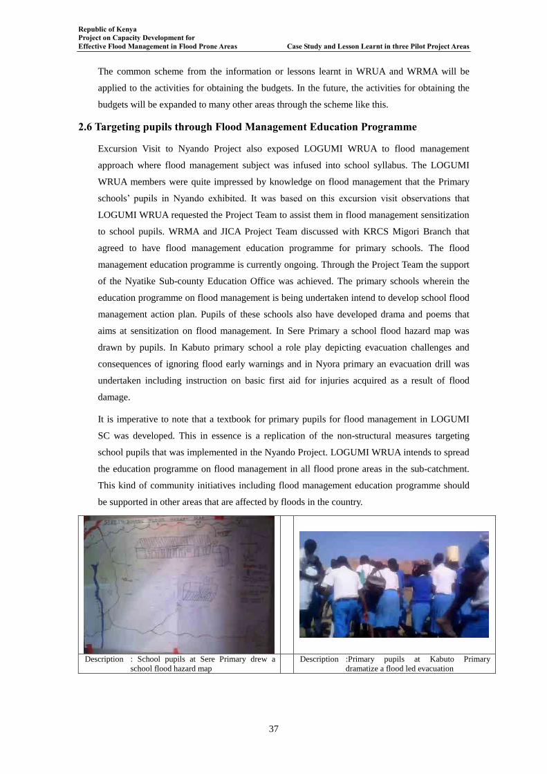
Republic of Kenya Project on Capacity Development for Effective Flood Management in Flood Prone Areas Case Study and Lesson Learnt in three Pilot Project Areas
37
The common scheme from the information or lessons learnt in WRUA and WRMA will be
applied to the activities for obtaining the budgets. In the future, the activities for obtaining the
budgets will be expanded to many other areas through the scheme like this.
2.6 Targeting pupils through Flood Management Education Programme
Excursion Visit to Nyando Project also exposed LOGUMI WRUA to flood management
approach where flood management subject was infused into school syllabus. The LOGUMI
WRUA members were quite impressed by knowledge on flood management that the Primary
schools’ pupils in Nyando exhibited. It was based on this excursion visit observations that
LOGUMI WRUA requested the Project Team to assist them in flood management sensitization
to school pupils. WRMA and JICA Project Team discussed with KRCS Migori Branch that
agreed to have flood management education programme for primary schools. The flood
management education programme is currently ongoing. Through the Project Team the support
of the Nyatike Sub-county Education Office was achieved. The primary schools wherein the
education programme on flood management is being undertaken intend to develop school flood
management action plan. Pupils of these schools also have developed drama and poems that
aims at sensitization on flood management. In Sere Primary a school flood hazard map was
drawn by pupils. In Kabuto primary school a role play depicting evacuation challenges and
consequences of ignoring flood early warnings and in Nyora primary an evacuation drill was
undertaken including instruction on basic first aid for injuries acquired as a result of flood
damage.
It is imperative to note that a textbook for primary pupils for flood management in LOGUMI
SC was developed. This in essence is a replication of the non-structural measures targeting
school pupils that was implemented in the Nyando Project. LOGUMI WRUA intends to spread
the education programme on flood management in all flood prone areas in the sub-catchment.
This kind of community initiatives including flood management education programme should
be supported in other areas that are affected by floods in the country.
Description : School pupils at Sere Primary drew a
school flood hazard map Description :Primary pupils at Kabuto Primary
dramatize a flood led evacuation
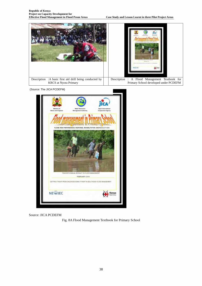
Republic of Kenya Project on Capacity Development for Effective Flood Management in Flood Prone Areas Case Study and Lesson Learnt in three Pilot Project Areas
38
Description :A basic first aid drill being conducted by
KRCS at Nyora Primary Description : A Flood Management Textbook for
Primary School developed under PCDEFM
Source: JICA PCDEFM
Fig. 8A Flood Management Textbook for Primary School
(Source: The JICA PCDEFM)
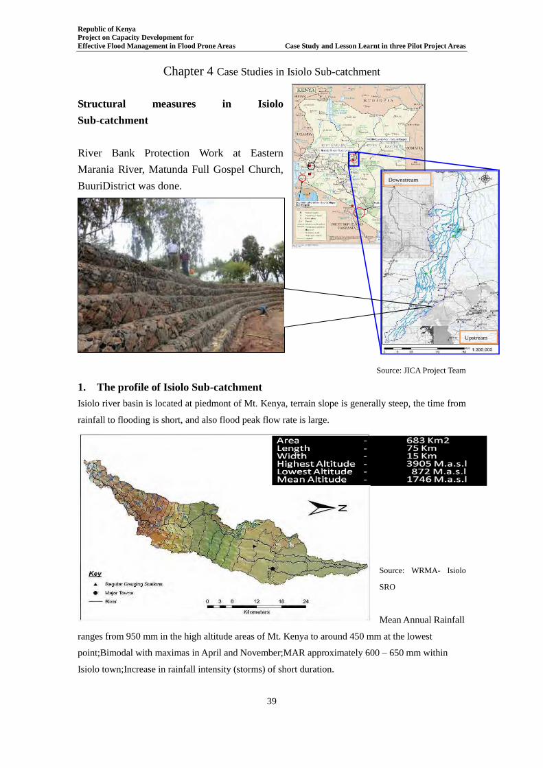
Republic of Kenya Project on Capacity Development for Effective Flood Management in Flood Prone Areas Case Study and Lesson Learnt in three Pilot Project Areas
39
Chapter 4 Case Studies in Isiolo Sub-catchment
Structural measures in Isiolo Sub-catchment
River Bank Protection Work at Eastern
Marania River, Matunda Full Gospel Church,
BuuriDistrict was done.
Source: JICA Project Team
1. The profile of Isiolo Sub-catchment Isiolo river basin is located at piedmont of Mt. Kenya, terrain slope is generally steep, the time from
rainfall to flooding is short, and also flood peak flow rate is large.
Source: WRMA- Isiolo
SRO
Mean Annual Rainfall
ranges from 950 mm in the high altitude areas of Mt. Kenya to around 450 mm at the lowest
point;Bimodal with maximas in April and November;MAR approximately 600 – 650 mm within
Isiolo town;Increase in rainfall intensity (storms) of short duration.
Downstream
Upstream
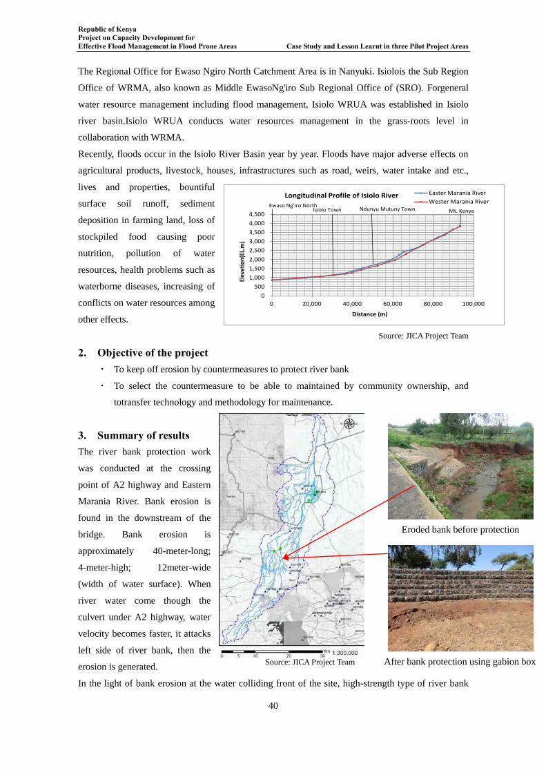
Republic of Kenya Project on Capacity Development for Effective Flood Management in Flood Prone Areas Case Study and Lesson Learnt in three Pilot Project Areas
40
The Regional Office for Ewaso Ngiro North Catchment Area is in Nanyuki. Isiolois the Sub Region
Office of WRMA, also known as Middle EwasoNg'iro Sub Regional Office of (SRO). Forgeneral
water resource management including flood management, Isiolo WRUA was established in Isiolo
river basin.Isiolo WRUA conducts water resources management in the grass-roots level in
collaboration with WRMA.
Recently, floods occur in the Isiolo River Basin year by year. Floods have major adverse effects on
agricultural products, livestock, houses, infrastructures such as road, weirs, water intake and etc.,
lives and properties, bountiful
surface soil runoff, sediment
deposition in farming land, loss of
stockpiled food causing poor
nutrition, pollution of water
resources, health problems such as
waterborne diseases, increasing of
conflicts on water resources among
other effects.
Source: JICA Project Team
2. Objective of the project ・ To keep off erosion by countermeasures to protect river bank
・ To select the countermeasure to be able to maintained by community ownership, and
totransfer technology and methodology for maintenance.
3. Summary of results The river bank protection work
was conducted at the crossing
point of A2 highway and Eastern
Marania River. Bank erosion is
found in the downstream of the
bridge. Bank erosion is
approximately 40-meter-long;
4-meter-high; 12meter-wide
(width of water surface). When
river water come though the
culvert under A2 highway, water
velocity becomes faster, it attacks
left side of river bank, then the
erosion is generated.
In the light of bank erosion at the water colliding front of the site, high-strength type of river bank
0
500
1,000
1,500
2,000
2,500
3,000
3,500
4,000
4,500
0 20,000 40,000 60,000 80,000 100,000
Elev
atio
n(E
L.m
)
Distance (m)
Easter Marania River
Wester Marania RiverLongitudinal Profile of Isiolo River
Isiolo Town Ndunyu Mutuny Town Mt. KenyaEwaso Ng’iro North
Eroded bank before protection
Source: JICA Project Team After bank protection using gabion box
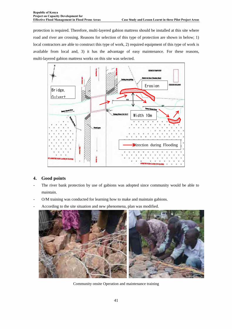
Republic of Kenya Project on Capacity Development for Effective Flood Management in Flood Prone Areas Case Study and Lesson Learnt in three Pilot Project Areas
41
protection is required. Therefore, multi-layered gabion mattress should be installed at this site where
road and river are crossing. Reasons for selection of this type of protection are shown in below; 1)
local contractors are able to construct this type of work, 2) required equipment of this type of work is
available from local and, 3) it has the advantage of easy maintenance. For these reasons,
multi-layered gabion mattress works on this site was selected.
4. Good points - The river bank protection by use of gabions was adopted since community would be able to
maintain.
- O/M training was conducted for learning how to make and maintain gabions.
- According to the site situation and new phenomena, plan was modified.
Community onsite Operation and maintenance training
Erosion
40m Bridge,
Culvert
Width 10m
Direction during Flooding
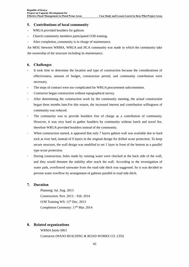
Republic of Kenya Project on Capacity Development for Effective Flood Management in Flood Prone Areas Case Study and Lesson Learnt in three Pilot Project Areas
42
5. Contributions of local community - WRUA provided boulders for gabions
- Church community members participated O/M training.
- After completion, community is in charge of maintenance.
An MOU between WRMA, WRUA and JICA community was made in which the community take
the ownership of the structure including its maintenance.
6. Challenges - It took time to determine the location and type of construction because the considerations of
effectiveness, amount of budget, construction period, and community contribution were
necessary.
- The steps of contract were too complicated for WRUA procurement subcommittee.
- Contractor began construction without topographical survey.
- After determining the construction work by the community meeting, the actual construction
began three months later.For this reason, the increased interest and contribution willingness of
community was reduced.
- The community was to provide boulders free of charge as a contribution of community.
However, it was very hard to gather boulders by community without lunch and travel fee,
therefore WRUA provided boulders instead of the community.
- When construction started, it appeared that only 7 layers gabion wall was available due to hard
rock at river bed, instead of 9 layers in the original design for drilled scour protection. To keep
secure structure, the wall design was modified to set 1 layer in front of the bottom as a parallel
type scour protection.
- During construction, holes made by running water were checked at the back side of the wall,
and they would threaten the stability after reach the wall. According to the investigation of
water path, overflowed rainwater from the road side ditch was suggested. So it was decided to
prevent water overflow by arrangement of gabions parallel to road side ditch.
7. Duration Planning: Jul. Aug. 2013
Construction: Nov. 2013 – Feb. 2014
O/M Training WS: 11th Dec. 2013
Completion Ceremony: 17th Mar. 2014
8. Related organizations WRMA Isiolo SRO
Contractor (WASO BUILDING & ROAD WORKS CO. LTD)

Republic of Kenya Project on Capacity Development for Effective Flood Management in Flood Prone Areas Case Study and Lesson Learnt in three Pilot Project Areas
43
Isiolo WRUA
9. Budget ・5mil KES
10. Contacts WRMA Isiolo SRO
Isiolo WRUA
Republic of Kenya Project on Capacity Development for Effective Flood Management in Flood Prone Areas Case Study and Lesson Learnt in three Pilot Project Areas
44
Chapter 5 Lessons Learnt in Isiolo Sub-catchment
River Bank Protection Work at Eastern Marania River, Matunda Full gospel church, Buuri District
1. INTRODUCTION
The Project on Capacity Development for effective flood management in flood prone areas carried
out Pilot Project in Isiolo River Basin. The Project had component for both structural and
non-structural measures to counter floods. Various structural countermeasures to floods were
proposed and after thorough evaluation using certain parameters, river bank protection emerged as
the most appropriate short term counter measure to floods in Isiolo river basin.
In the course of implementation of river bank protection using gabion mattress, various challenges
were experienced. The challenges were experienced right from the pre – construction stages to
construction completion stage. Out of this, various lessons were learnt and recommendations
proposed.
2. LESSONS LEARNT
2.1 Pre- construction Stage
The pre- construction stages involved planning and survey, design and procurement. Most important
in this case was the procurement process. Since the Project was simulating the WDC manual, the
WRUA procurement committee was involved in this stage. Below were the lesson learnt in the
procurement stage:
- The WRUA procurement committee was not aware of their roles, and most committee
members were less educated, too old to understand the meaning of procurement and its
process.
- The WRUA procurement committee has no data base for eligible contractors or suppliers to
be engaged in similar project.
- During short listing of contractors, the WRUA procurement committee could not clearly
evaluate the documents submitted by the interested contractors, they relied on views and
recommendations made by the WRMA and the JICA Project Team.
Recommendations
- There should be continuous capacity building for the WRUA Procurement committee on the
meaning of procurement and the processes involved.
Republic of Kenya Project on Capacity Development for Effective Flood Management in Flood Prone Areas Case Study and Lesson Learnt in three Pilot Project Areas
45
- For continuity in operation of the WRUA, the committee membership should consider
gender and youth.
- The WRUA Procurement committee should liaise with WRMA to develop data base of
eligible contractors and supplies for their future projects.
- The Project Team and WRMA should develop a manual on meaning of procurement and the
processes involved.
- The Procurement manual should include basic criteria for evaluation of interested bidders
and procedure of negotiations with the successful bidder.
2.2 Construction Stage
The construction stage for river bank protection works involved the, community participation,
supervision works, monitoring by the WRUA monitoring committee and on site operation and
maintenance training. The major challenge was in the community participation and monitoring of the
construction process of the river bank protection by the WRUA monitoring committee; this formed
the basis of the following lessons;
- The community participation was below the threshold set by the WDC manual ( 15% of the
total cost of the project should be community contribution), this was attributed to lack of
experience in handling donor funded project and separation of scope of services of
contractor and community contribution.
- The WRUA monitoring committee had no prior information on the scope of the construction
works; this was attributed to by lack of WRUA management committee meeting to share
information on the progress of the river bank protection works.
- The site was located far away from the residential of the WRUA monitoring committee; this
brought logistical challenge to carry out regular monitoring of the construction process.
Recommendations
- There should be a continuous capacity building to the community on the processes involved
in implementation of donor funded projects, scope of contractor services and community
contribution to the project.
- There should frequent WRUA management committee meeting to share information on the
progress of the activities of the Project, challenges and way forward.
- There selection of each WRUA subcommittee should represent each zone of the WRUA
coverage, this will ensure that when a project is implemented in WRUA coverage, that
particular site has a member in the subcommittee.
Republic of Kenya Project on Capacity Development for Effective Flood Management in Flood Prone Areas Case Study and Lesson Learnt in three Pilot Project Areas
46
- There should be ad hoc committee to manage a specific project at a specific time, this will
ensure smooth implementation process by both the community and the project
implementers.
- A prototype checklist for monitoring construction works/ or any activity implemented by
WRUA or any other donor should be developed to guide the WRUA monitoring committee
in executing their duties.
2.3 Completion of Construction Stage
During completion of construction stage, the Monitoring and Evaluation committee were engaged in
the completion inspection and made recommendations on the outstanding works that should be
completed by the contractor. The output of the completion inspection was a report done by the
secretary of the WRUA monitoring committee, a copy was shared by the Contractor and WRMA
Sub region office (Isiolo).
A checklist was made for the monitoring committee to be used in the inspection after the expiry of
the defects liability notification period. At this stage there was no major challenge experienced.
2.4 Maintenance stage
The JICA Project Team and WRMA are in the final stage of preparation of operation and
maintenance manual to be used by WRMA monitoring and evaluation committee. Since there was an
onsite operation and maintenance training, the manual will guide as reference of what was
practically done at site. In the draft manual is the contact person in case of any major repair that is
beyond the capacity of the WRUA.

Republic of Kenya Project on Capacity Development for Effective Flood Management in Flood Prone Areas Case Study and Lesson Learnt in three Pilot Project Areas
47
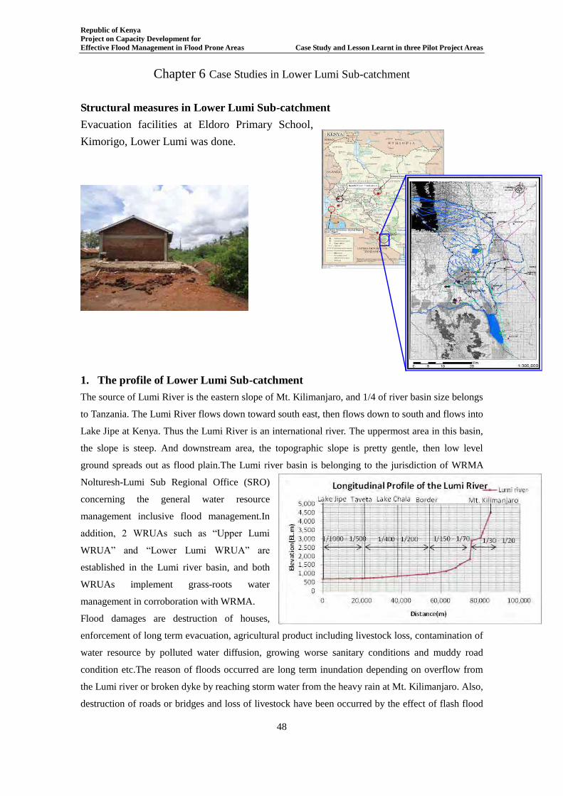
Republic of Kenya Project on Capacity Development for Effective Flood Management in Flood Prone Areas Case Study and Lesson Learnt in three Pilot Project Areas
48
Chapter 6 Case Studies in Lower Lumi Sub-catchment
Structural measures in Lower Lumi Sub-catchment
Evacuation facilities at Eldoro Primary School,
Kimorigo, Lower Lumi was done.
1. The profile of Lower Lumi Sub-catchment The source of Lumi River is the eastern slope of Mt. Kilimanjaro, and 1/4 of river basin size belongs
to Tanzania. The Lumi River flows down toward south east, then flows down to south and flows into
Lake Jipe at Kenya. Thus the Lumi River is an international river. The uppermost area in this basin,
the slope is steep. And downstream area, the topographic slope is pretty gentle, then low level
ground spreads out as flood plain.The Lumi river basin is belonging to the jurisdiction of WRMA
Nolturesh-Lumi Sub Regional Office (SRO)
concerning the general water resource
management inclusive flood management.In
addition, 2 WRUAs such as “Upper Lumi
WRUA” and “Lower Lumi WRUA” are
established in the Lumi river basin, and both
WRUAs implement grass-roots water
management in corroboration with WRMA.
Flood damages are destruction of houses,
enforcement of long term evacuation, agricultural product including livestock loss, contamination of
water resource by polluted water diffusion, growing worse sanitary conditions and muddy road
condition etc.The reason of floods occurred are long term inundation depending on overflow from
the Lumi river or broken dyke by reaching storm water from the heavy rain at Mt. Kilimanjaro. Also,
destruction of roads or bridges and loss of livestock have been occurred by the effect of flash flood
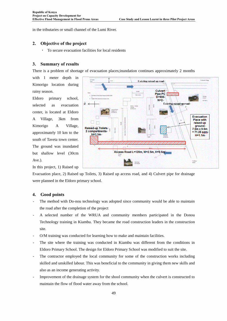
Republic of Kenya Project on Capacity Development for Effective Flood Management in Flood Prone Areas Case Study and Lesson Learnt in three Pilot Project Areas
49
in the tributaries or small channel of the Lumi River.
2. Objective of the project ・ To secure evacuation facilities for local residents
3. Summary of results There is a problem of shortage of evacuation places;inundation continues approximately 2 months
with 1 meter depth in
Kimorigo location during
rainy season.
Eldoro primary school,
selected as evacuation
center, is located at Eldoro
A Village, 3km from
Kimorigo A Village,
approximately 10 km to the
south of Taveta town center.
The ground was inundated
but shallow level (30cm
Ave.).
In this project, 1) Raised up
Evacuation place, 2) Raised up Toilets, 3) Raised up access road, and 4) Culvert pipe for drainage
were planned in the Eldoro primary school.
4. Good points - The method with Do-nou technology was adopted since community would be able to maintain
the road after the completion of the project
- A selected number of the WRUA and community members participated in the Donou
Technology training in Kiambu. They became the road construction leaders in the construction
site.
- O/M training was conducted for learning how to make and maintain facilities.
- The site where the training was conducted in Kiambu was different from the conditions in
Eldoro Primary School. The design for Eldoro Primary School was modified to suit the site.
- The contractor employed the local community for some of the construction works including
skilled and unskilled labour. This was beneficial to the community in giving them new skills and
also as an income generating activity.
- Improvement of the drainage system for the shool community when the culvert is constructed to
maintain the flow of flood water away from the school.
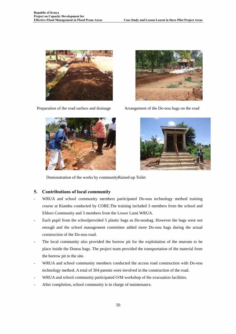
Republic of Kenya Project on Capacity Development for Effective Flood Management in Flood Prone Areas Case Study and Lesson Learnt in three Pilot Project Areas
50
Preparation of the road surface and drainage Arrangement of the Do-nou bags on the road
Demonstration of the works by communityRaised-up Toilet
5. Contributions of local community - WRUA and school community members participated Do-nou technology method training
course at Kiambu conducted by CORE.The training included 3 members from the school and
Eldoro Community and 3 members from the Lower Lumi WRUA.
- Each pupil from the schoolprovided 5 plastic bags as Do-noubag. However the bags were not
enough and the school management committee added more Do-nou bags during the actual
construction of the Do-nou road.
- The local community also provided the borrow pit for the exploitation of the murram to be
place inside the Donou bags. The project team provided the transportation of the material from
the borrow pit to the site.
- WRUA and school community members conducted the access road construction with Do-nou
technology method. A total of 304 parents were involved in the construction of the road.
- WRUA and school community participated O/M workshop of the evacuation facilities.
- After completion, school community is in charge of maintenance.
Republic of Kenya Project on Capacity Development for Effective Flood Management in Flood Prone Areas Case Study and Lesson Learnt in three Pilot Project Areas
51
6. Challenges - It was taken the time to determine the location and type of construction because the
considerations of effectiveness, amount of budget, construction period, and community
contribution were necessary.
- The steps of contract were too complicated for WRUA procurement subcommittee.
- The contractor delayed to submit the bank guarantee for getting advanced payment; therefore
the contractor had to begin the part of non-materialworks. This was the first time the contractor
had been involved in the kind of project requiring the advance payment bank guarantee and his
bank was also no very familiar with the process.
- WRUA monitoring subcommittee due to the distances from their residences to the project site.
In WSTF funded project some money is set aside for the monitoring committee. The project
team provided the money for the transportation from February and two members were now
involved in the monitoring. However the Secretary of the WRUA was involved in the
monitoring right from the commencement of the construction.
- The construction commenced just before the beginning of the short rainy season. As a result
there was suspension of works from November to December during the rains as the site was
flooded and no works could be carried out.
- During the construction of the toilet there were a lot of problems with the ground water because
the water table is very high. This interfered with the time schedule during the excavation of the
pit. The problem also persisted during the pit walling. There had to be dewatering daily for
about 2 hours before the commencement of the works.
7. Duration Planning: Jul. Aug. 2013
Construction: Nov. 2013 – Mar. 2014
Do-nou technology method training at Kiambu: 15-16 Jan. 2014
O/M Training WS: Mar. 2014
Completion Ceremony: 11th Mar. 2014
8. Related organizations WRMA Loitokitok SRO
Contractor (FRANJI ELECTRICALS AND GENERAL SUPPLIES LIMITED)
Lower Lumi WRUA
CORE
9. Budget ・5mil KES

Republic of Kenya Project on Capacity Development for Effective Flood Management in Flood Prone Areas Case Study and Lesson Learnt in three Pilot Project Areas
52
10. Contacts WRMA Loitokitok SRO
Lower Lumi WRUA
CORE Kenya
School Management Committee of Eldoro Primary School
Republic of Kenya Project on Capacity Development for Effective Flood Management in Flood Prone Areas Case Study and Lesson Learnt in three Pilot Project Areas
53
Chapter 7 Lessons Learnt in Lower Lumi Sub-catchment
Evacuation facilities at Eldoro Primary School, Kimorigo, Lower Lumi
1. INTRODUCTION
The Project on Capacity Development for effective flood management in flood prone areas carried
out Pilot Project in Lumi River basin. The Project had component for both structural and
non-structural measures for life protection against floods. Various structural countermeasures to
floods were proposed and after thorough evaluation using certain parameters, evacuation facilities
emerged as the most appropriate short term counter measure to floods in Lower Lumi.
In the course of implementation of evacuation facilities, various challenges were experienced. The
challenges were experienced right from the pre – construction stages to construction completion
stage. Out of this, various lessons were learnt and recommendations proposed.
2. LESSONS LEARNT
2.1 Pre- construction Stage
A) Bidding Process The bidding process involved the Project Team, WRMA and the WRUA Members.
- Only 6 contractors from 22 contractors of long list were submitted EOI
in case of the construction of evacuation facilities in Lower Lumi.
- The pre-qualification for the contractors was carried out and only 5
contractors selected for the next tendering stage. And no communication
was provided for the contractors not selected.
Recommendations
- It should be considered to hold an explanatory meeting to long listed
contractors to get attention to the contract.
- It is better to send notification to the unsuccessful contractors for keeping
connections with them.
B) Procurement The procurement process was carried tog with WRMA and the WRUA procurement
sub-committee.
During the evaluation for short listing certain observations were made from the WRUA
Procurement sub-committee. The observations made were:
- The WRUA Procurement sub-committee did not clearly understand the
key documents to be verified during the evaluation process.
- It was the first time for the Procurement sub-committee to carry out this
Republic of Kenya Project on Capacity Development for Effective Flood Management in Flood Prone Areas Case Study and Lesson Learnt in three Pilot Project Areas
54
kind of evaluation and they should utilize it during other WSTF projects.
It was a good kind of capacity development for the committee.
Recommendations
- For proper transfer of knowledge to the entire community youths should
be included in the procurement sub-committee and other sub-committees
within the WRUA set up.
- The WDC manual is not very clear on certain matters regarding the
procurement; such matters like evaluation criteria for Specific projects
should be included in the WDC manual.
Out of the 5 contractors who were sent bid documents and those who were responsive
only 3 contractors were considered for the next stage of bidding.
- According to the previous guideline of JICA, at least 3 companies were
needed for keeping numbers for bidding because of possibility not to
attend bidding. And it is revised to 5 companies in the new guideline of
JICA.
- In the PCDEFM pilot project, 5 contractors were short listed to the next
stage of bidding. All the short listed Contractors collected the Bid
Documents. 3contractors submitted the Bid Documents before the
deadline of submission. However, 2 Contractors were disqualified for
late submission of Bid Documents hence their Documents were neither
received nor opened.
C) Financial Issues According to the contract, the contractor was supposed to provide an advance payment
guarantee before the advance payment could be paid.
- The contractor had difficulties in procuring the advance payment from
his bank. It led to a very long delay before the guarantee was provided
and the delay in procurement of some materials.
Payment Mode:
- The payment was to be done in three batches, advance payment, final
payment and payment for the retention. The work was scheduled to be
completed within 90 days, however due to poor weather the construction
period was extended. This led to the contractor to have problems of cash
flow.
Recommendations
- To confirm the possibility of getting the guarantee by bank for advanced
Republic of Kenya Project on Capacity Development for Effective Flood Management in Flood Prone Areas Case Study and Lesson Learnt in three Pilot Project Areas
55
payment is essential.
- An interim payment should be considered.
2.2 Construction Stage
A) Siting
At the first stage of the planning of the siting of the various structures within the
school,it wasvery brief planning.Thus the surveying and the actual siting by the
contractor,they needed some discussions;
- The school through the headmaster requested for some
modificationssuch as the place of toilet had been sited very close to the
kitchen. This was not acceptable under the rules of the public health
department.
Recommendations
- It is better to discuss the planning with detailed design drawing.
- The toilet should be at least 20 meters away from the kitchen area.
B) Construction
The contractors procured both the skilled workers and unskilled workers from the
community which benefitted the local community both economically and by giving
some of them new skills.
The local community was very cooperative during the implementation of the project.
The WDC manual expects the local community to contribute at least 15% of the project
in cash or through labour. The local community agreed to contribute their labour and
do-nou bags for the construction of the community road. This showed it is easy to
mobilise the community in the schools because they feel they have a sense of belonging
to the project.
Recommendations
- It is the essential to hold the explanatory meeting with stakeholders
including local residents to get understanding of contribution for the
project.
- The activity manual will help understanding of their necessary
contributions.
3. Maintenance Stage
The operation and maintenance of the structural measures have to be carried out for the
Republic of Kenya Project on Capacity Development for Effective Flood Management in Flood Prone Areas Case Study and Lesson Learnt in three Pilot Project Areas
56
sustainability of the structures.
The project is based at a primary school but it is under the management of the WRUA
and the school. Therefore a memorandum of understanding (MOU) between the school
management committee, Lower Lumi WRUA and WRMA were signed for the
sustainable management and operation.
Recommendations - Before the handing over of the project the training for O&M should be
carried out.
- There need to be a MOU between the school, the WRUA and WRMA on
the modalities for the management and the operation of the structures