Embed Size (px)
Citation preview

epor t
d ' c t i v i t y
2003
THEME 3B
INSTITUT NATIONAL DE RECHERCHE EN INFORMATIQUE ET EN AUTOMATIQUE
Project-Team Ariana
Inverse Problems in Earth Observation andCartography
Sophia Antipolis


Table of contents
1. Team 12. Overall Objectives 23. Scientific Foundations 2
3.1. Probabilistic approaches 23.1.1. Markov random fields 23.1.2. Wavelets 33.1.3. Stochastic geometry 3
3.2. Variational approaches 33.2.1. Regularization and functional analysis 33.2.2. Contours and regions 33.2.3. Wavelets 3
3.3. Parameter estimation 34. Application Domains 4
4.1. Denoising and deconvolution 44.2. Segmentation and classification 44.3. Extraction of structures 54.4. 3D modeling 54.5. Information mining and database retrieval 5
5. Software 56. New Results 6
6.1. Probabilistic Models 66.1.1. Comparison of the Ising and Chien models 66.1.2. A diffusion process for image denoising 66.1.3. Urban area analysis using Markov random fields and data fusion 76.1.4. Line network extraction in remote sensing images using Markov object processes 76.1.5. Automatic segmentation of Digital Elevation Models using point processes 96.1.6. Wavelet-based superresolution 96.1.7. Texture-adaptive mother wavelet selection for texture classification 10
6.2. Variational Models 116.2.1. Γ-convergence for image restoration 116.2.2. Wavelet-based level set evolution for the classification of textured images 116.2.3. Modeling highly oscillatory signals, with application to image processing 116.2.4. Decomposing an image, with an application to textured and SAR images 116.2.5. Image decomposition: a three component model 126.2.6. Image disocclusion 136.2.7. Higher order active contours and their application to line network detection 136.2.8. Interferogram filtering 146.2.9. Edge detection and phase unwrapping 14
6.3. EU Project MOUMIR 156.3.1. Texture analysis using probabilistic models of the unimodal and multimodal statistics of
adaptive wavelet packet coefficients 156.3.2. Evaluation methodology and practice for a database of aerial images equipped with ground
truth 166.3.3. Shape from texture via conformal embeddings 16
6.4. EU Project IMAVIS 176.4.1. Track detection and classification 176.4.2. Tree-structured MRFs for noisy image segmentation 18

2 Activity Report INRIA 2003
6.5. COLORS Project Arbres: automatic tree crown detection using marked point processes186.6. ARC DeMeTri: blind deconvolution of confocal microscopy 19
7. Contracts and Grants with Industry 207.1.1. BRGM Orléans 207.1.2. DGA/CTA Arcueil 20
8. Other Grants and Activities 208.1. Regional 20
8.1.1. INRIA COLORS project Arbres 208.2. National 20
8.2.1. CNRS MATH/STIC grant ‘Visual Annotation’ 208.2.2. CNRS MATH/STIC grant ‘Image classification by variational methods and PDEs’ 20
8.3. European 208.3.1. EU project MOUMIR 208.3.2. EU project IMAVIS 208.3.3. PAI Procope ‘Non-local information extraction within a Bayesian data mining framework
for remote sensing images’ 218.4. International 21
8.4.1. INRIA ARC DeMiTri 218.4.2. Lyapunov Institute grant 98-02 218.4.3. NATO/Russia Collaborative Linkage Grant 980107 ‘Prior shape information for image
segmentation in environmental and disaster detection and monitoring’ 218.4.4. CONACYT grant 21
9. Dissemination 219.1. Conferences, Seminars, Meetings 219.2. Refereeing 239.3. Organization 239.4. Teaching 249.5. PhDs 24
9.5.1. In progress 249.5.2. Defended in 2003 25
10. Bibliography 25

1. TeamHead of Project-Team
Josiane Zerubia [Research Director (DR1) INRIA]
Project AssistantCorinne Zuzia [Administrative Assistant (AJT) INRIA (half-time in the project)]
INRIA PersonnelXavier Descombes [Research Scientist (CR1)]Ian Jermyn [Research Scientist (CR1)]
CNRS PersonnelLaure Blanc-Féraud [Research Scientist (CR1) until September, then Research Director (DR2)]
Postdoctoral FellowsRoberto Cossu [Dr. Cossu is funded by EU project MOUMIR. He arrived in April]Nicolas Dey [Dr. Dey is funded by the INRIA ARC DeMiTri. He arrived in February]Charith Abhayaratne [Dr. Abhayaratne is funded by an ERCIM postdoctoral fellowship. He arrived in March]
Doctoral StudentsJean-François Aujol [Mr. Aujol is funded by an AMN-ENS Cachan grant]Karen Brady [Ms Brady is funded by EU project MOUMIR]Caroline Lacombe [Ms Lacombe is funded by a teaching assistantship at ESSI, UNSA]Caroline Lacoste [Ms Lacoste is funded by a BRGM/INRIA grant]Mathias Ortner [Mr. Ortner is funded by a DGA/CNRS grant]Guillaume Perrin [Mr. Perrin has been funded by a Centrale Paris MENSR grant since November]Marie Rochery [Ms Rochery is funded by an UNSA MENESR grant]Emmanuel Villéger [Mr. Villéger is funded by an AMN-ENS Cachan grant]Oscar Viveros-Cancino [Mr. Viveros-Cancino was funded by a SFERE/CONACYT grant until June]
Graduate InternsGuillaume Perrin [Mr. Perrin was funded by INRIA COLORS project Arbres from May to October]Julien Bect [Mr. Bect was funded by a I3S (CNRS/UNSA) grant from May to August]
Visiting ScientistsRobert Acar [Associate Professor, University of Puerto Rico. September–October, funded by NASA]Paul Fieguth [Associate Professor, Waterloo University, Canada. February–April, funded by Waterloo Univer-sity]Rami Haggiag [PhD student, Ben-Gurion University, Israel. Three weeks in November, funded by EU projectMOUMIR]Zvi Kam [Professor, Weizmann Institute, Israel. One week in June, funded by the INRIA ARC DeMeTri]Mark Kliger [PhD student, Ben-Gurion University, Israel. mid-February–mid-March, funded by EU projectMOUMIR]Ercan Kuruoglu [Research Associate, CNR Pisa, Italy. One week in May, funded by ERCIM]Riccardo March [Senior Researcher, Istituto per le Applicazioni del Calcolo "Mauro Picone" of CNR Rome,Italy. One week in June, funded by CNR]Robert Nowak [Associate Professor, University of Wisconsin, USA. One week in July, funded by NSF]Eugene Pechersky [Senior Scientist, IITP of the Russian Academy of Science, Russia. Three weeks in March,funded by the Lyapunov Institute, and four weeks in December 2003/January 2004, funded by CNRS]Giuseppe Scarpa [PhD student, University Federico II of Naples, Italy. January–March and Octo-ber–December, funded by EU project IMAVIS]Alex Teterukovskiy [PhD student, Swedish University of Agricultural Sciences, Sweden. February–April,funded by EU project IMAVIS]Rebecca Willett [PhD student, University of Wisconsin, USA. June–August, funded by NSF]
2 Activity Report INRIA 2003
Elena Zhizhina [Senior Scientist, IITP of the Russian Academy of Science, Russia. Two weeks in March,funded by the Lyapunov Institute]
External CollaboratorsGilles Aubert [Professor at the Dieudonné Laboratory of the University of Nice-Sophia Antipolis]Gérard Giraudon [Research Director (DR1) INRIA, Director of Development and Industrial Relations]Marc Sigelle [Ingénieur en chef du corps des Télécom, and Associate Professor in the Signal and ImageProcessing department, ENST, Paris]
2. Overall ObjectivesAriana is a joint project of INRIA, CNRS, and the University of Nice-Sophia Antipolis, via the ComputerScience, Signals and Systems Laboratory (I3S) in Sophia Antipolis (UMR 6070). The project web site can befound athttp://www.inria.fr/ariana.The Ariana project is engaged in two distinct but strongly synergistic endeavors, one applicative and onemethodological. The project aims to provide image processing tools to aid in the solution of problems arising ina wide range of concrete applications in Earth observation and cartography, for example cartographic updating,land management, and agriculture, while at the same time advancing the state of the art in the image processingmethods used to construct those tools.
The problems treated by the project run the gamut of image processing, applied to satellite and aerialimages. Examples include image restoration and denoising, multicamera reconstruction and superresolution,the extraction of various complex structures in the scene, and retrieval from remote sensing image databases.One thing all the problems have in common is that they are ill-posed inverse problems. Even in those rare casesfor which the existence and uniqueness of the solution is guaranteed, the solution is unstable to the perturbingeffects of observation noise. It is therefore necessary to introduce prior knowledge concerning the solution,both in order to limit the set of possible solutions and to stabilize the solution against perturbations.
Methodologically speaking, the project uses two broad classes of techniques to attack these problems:probabilistic models combined with stochastic algorithms, and variational models combined with deterministicalgorithms. In addition to applying these techniques to specific cases, the project advances these techniquesmore generally, through innovative modeling and theoretical analysis, and a comparative study of the twoclasses. An important recent theme, for example, is the incorporation of geometric information into bothclasses of techniques, in the probabilistic case via the use of stochastic geometry, and in the variational casevia the use of higher-order active contours.
The project also concerns itself with a number of important, related problems, in particular the developmentof the parameter estimation procedures necessary to render the above methods automatic or semi-automatic,and the study of the optimization algorithms used to solve the problems (for example, reversible jump Markovchain Monte Carlo (RJMCMC)).
3. Scientific Foundations3.1. Probabilistic approaches
Following a Bayesian methodology as far as possible, probabilistic models are used within the Ariana project,as elsewhere, for two purposes: to describe the class of images to be expected from any given scene, and todescribe prior knowledge about the scene in the absence of the current data. The models used fall into thefollowing three classes.
3.1.1. Markov random fieldsMarkov random fields were introduced to image processing in the Eighties, and were quickly applied to thefull range of inverse problems in computer vision. They owe their popularity to their flexible and intuitivenature, which makes them an ideal modeling tool, and to the existence of standard and easy-to-implement

Project-Team Ariana 3
algorithms for their solution. In the Ariana project, attention is focused on their use in image modeling, inparticular of textures; on the development of improved prior models for segmentation; and on the lighteningof the heavy computational load traditionally associated with these techniques, in particular via the study ofvarieties of hierarchical random field.
3.1.2. WaveletsThe development of wavelets as an alternative to the pixel and Fourier bases has had a big impact on imageprocessing due to their spatial and frequency localization, and the sparse nature of many types of image datawhen expressed in these bases. In particular, wavelet bases have opened up many possibilities for probabilisticmodeling due to the existence of not one but two natural correlation structures, intra- and inter-scale, leadingto adaptive wavelet packet models and tree models respectively. In Ariana, attention is focused on the use oftree models for denoising and deconvolution; adaptive wavelet packet models for texture description; and onthe use of complex wavelets for their improved translation invariance and directional selectivity.
3.1.3. Stochastic geometryOne of the grand challenges of computer vision and image processing is the expression and use of priorgeometric information. For satellite and aerial imagery, this problem has become increasingly important as theincreasing resolution of the data results in the necessity to model geometric structures hitherto invisible. Oneof the most promising approaches to the inclusion of this type of information is stochastic geometry, which isa new and important line of research in the Ariana project. Instead of defining probabilities for different typesof image, probabilities are defined for configurations of an indeterminate number of interacting, parameterizedobjects located in the image. Such probability distribution are called ‘marked point processes’. For instance,two examples that have been developed in Ariana use interacting cuboids of varying length, width, heightand orientation for modeling buildings; and interacting line segments of varying length and orientation formodeling road and other networks.
3.2. Variational approaches3.2.1. Regularization and functional analysis
The use of variational models for the regularization of inverse problems in image processing is long-established. Attention in Ariana is focused on the theoretical study of these models and their associatedalgorithms, and in particular on theΓ-convergence of sequences of functionals and on projection algorithms.Recent research concerns the definition and computation of a function space containing oscillatory patterns,a sort of dual space to the BV space that captures the geometry of the image. Variational methods are alsoapplied to a variety of problems, including phase unwrapping and image decomposition.
3.2.2. Contours and regionsIn addition to the regularization of inverse problems, variational methods are much used in the modeling ofboundaries in images using contours. In Ariana, attention is focused on the use of such models for imagesegmentation, in particular texture segmentation; on the theoretical study of the models and their associatedalgorithms, in particular level set methods; and on the incorporation of prior geometric information concerningthe regions sought using higher-order active contour energies.
3.2.3. WaveletsWavelets are important to variational approaches in two ways. They enter theoretically, through the study ofBesov spaces, and they enter practically, in models of texture for segmentation, and in the denoising of theoscillatory parts of images.
3.3. Parameter estimationOne of the most important problems studied in the Ariana project is how to estimate the parameters that appearin the models. For probabilistic models, the problem is easily framed, but is not necessarily easy to solve,

4 Activity Report INRIA 2003
particularly in the case when it is necessary to extract simultaneously from the data both the informationof interest and the parameters. For variational models, there are few methods available, and the problem isconsequently more difficult.
4. Application Domains4.1. Denoising and deconvolution
These are perhaps the most basic of the applications with which Ariana is concerned, and two of the moststudied problems in image processing. Yet progress can still be made in these problems by improving the priorimage models used, for example, by using hidden Markov trees of complex wavelets or by decomposing theimage into several components. Ariana is also interested in blind deconvolution.
Figure 1. Left: denoising; middle: a degraded (blurred and noisy) image; right: its restoration.
4.2. Segmentation and classificationMany applications call for the image domain to be split into pieces, each piece corresponding to some entity inthe scene, for example, forest or urban area, and in many cases for these pieces to be assigned the appropriatelabel. These problems too are long-studied, but there is much progress to be made, in particular in the use ofprior geometric information.
50 100 150 200 250 300 350 400 450 500
50
100
150
200
250
300
350
400
450
500
50 100 150 200 250 300 350 400 450 500
50
100
150
200
250
300
350
400
450
500
Figure 2. Left: a satellite image; right: its classification.

Project-Team Ariana 5
50 100 150 200 250 300 350 400 450 500
50
100
150
200
250
300
350
400
Figure 3. Left: road network extraction; right: tree extraction.
4.3. Extraction of structuresAs the resolution of remote sensing imagery increases, so the full complexity of the scene comes to the fore.What was once a texture is now revealed to be an arrangement of individual houses for example, or a numberof separate trees. Many new applications are created by the availability of this data, but efficient harvesting ofthe information requires new techniques.
4.4. 3D modelingEarth observation and cartography is not solely concerned with 2D images. One important problem is theconstruction of 3D digital elevation models (DEMs) from high-resolution stereo images produced by satellitesor aerial surveys. Synthetic aperture radar (SAR) imagery also carries elevation information, and allows theproduction of more accurate DEMs thanks to interferometry techniques, for example.
Figure 4. Left: DEM; right: interferometry.
4.5. Information mining and database retrievalEvery day, vast quantities of data are accumulated in remote sensing data repositories, and intelligent accessto this data is becoming increasingly problematic. Recently, the problem of retrieval from large unstructuredremote sensing image databases has begun to be studied within the project.
5. SoftwareThis year the Ariana project did not depose any software at the APP, or apply for any patents. Nevertheless, agreat deal of software is under development, including software for the extraction of road and water networks,

6 Activity Report INRIA 2003
Figure 5. Image registration for the evaluation of retrieval systems. Left: mosaicked aerial image data; right:registered ground truth classification.
trees, and buildings, from optical, SAR, and DEM images, as well as several pieces of software for thesegmentation of images based on texture. Software for the deconvolution of confocal microscopy imagesis also being developed.
6. New Results6.1. Probabilistic Models6.1.1. Comparison of the Ising and Chien models
Participants: Xavier Descombes, Eugene Pechersky.
Key words: Gibbs fields, Ising model, Chien model.
This work is supported by Lyapunov Institute grant 98-02.The goal of this work is to understand and compare the behavior of two Gibbs models, both of which haveapplications in image processing. One is the well-known Ising model, while the other is a relatively new modelconstructed to be particularly well suited to segmentation problems.
The application of the models in image processing demonstrated the considerable advantages of the Chienmodel over the Ising model, and this led to the present comparative study. When a model is studied with imageprocessing in mind, it is the low-temperature behavior that is of most importance. In this study, simulations ofconfigurations for both models at the critical temperatures were undertaken. The differences in the shapesof the configurations obtained were rather unexpected. Typical Ising model configurations at the criticaltemperature are very similar to noisy configurations. In contrast, the typical configurations of the Chien modelhave a mosaic shape composed of small patches. Graphs of the number of connected components againstconnected component sizes are dramatically different for the two models. The Ising configurations have manyconnected components composed mostly of groups of 1–5 pixels, while for the Chien model, connected groupsof approximately 40 pixels constitute a significant proportion of all connected components. Seemingly thisdistinction is one reason for the above-mentioned success of the Chien model in applications. The relationsremain unclear however, and will be the subject of further investigation. Further details can be found in[10].
6.1.2. A diffusion process for image denoisingParticipants: Xavier Descombes, Elena Zhizhina.
Key words: image denoising, stochastic diffusion, discretization scheme.
This work is supported by Lyapunov Institute grant 98-02.We address the problem of image denoising using a Stochastic Differential Equation approach[43]. Weconsider an interaction diffusion process which is reversible with respect to a Gibbs distribution defined by a

Project-Team Ariana 7
given Hamiltonian. The Hamiltonian has an interaction term, ensuring smoothness of the solution, and a dataterm. The process is called the Langevin dynamics and it can be found as the solution of a stochastic differentialequation, which is a stochastic version of a partial differential equation. To derive algorithms for computersimulations, we consider two discrete time approximations of the stochastic differential equation, namely theEuler and the Explicit Strong Taylor approximations. We apply a special procedure to the approximationprocess (simulated annealing or expectation scheme) to find a denoised image. We compare the convergenceproperties of the Langevin dynamics algorithms and the Metropolis-Hastings algorithm. Results are shownon synthetic and real data. We observe that the proposed approach provides better results when using a smallnumber of iterations. An example is shown in figure6. Further details can be found in[43].
Figure 6. Image denoising using the Euler approximation. Noisy image (left), result (right).
6.1.3. Urban area analysis using Markov random fields and data fusionParticipants: Oscar Viveros-Cancino, Xavier Descombes, Josiane Zerubia.
Key words: urban area classification, texture analysis, data fusion, segmentation, Markov random field.
This work was supported by a SFERE/CONACYT PhD grant (Mexico).This work is concerned with the analysis and extraction of urban areas in remote sensing images. Asradiometric information alone is insufficient for the detection of such areas, we carry out a study of textureanalysis techniques for urban scenes. Of the techniques currently available, we choose to describe texture usingthe conditional variance parameter of a Gaussian Markov model. This parameter, estimated at each point inthe image, allows us to extract our initial urban mask. Having noted the complementary nature of radar andoptical sensors, we combine the textural information of SPOT and ERS sensors to refine our mask. Finally, wepropose and compare different supervised fission-fusion algorithms which allow us to perform an intra-urbanclassification. From the SPOT and ERS images, we compute different texture and radiometric parameters.A classification is carried out using each of these parameters in turn. The importance of each parameter foreach class is given by the corresponding confusion matrix which is computed using training zones. A fusionoperator is defined using the different confusion matrices. The site of our study is Mexico City. Further detailsof this work can be found in[4].
6.1.4. Line network extraction in remote sensing images using Markov object processesParticipants: Caroline Lacoste, Xavier Descombes, Josiane Zerubia.
Key words: line network extraction, marked point process, RJMCMC, simulated annealing.
This work is being done in collaboration with Nicolas Baghdadi, French Geological Survey (BRGM).

8 Activity Report INRIA 2003
In this work, we aim to extract line networks, such as roads and waterways, from satellite and aerial images,to assist in the updating of cartography. The line networks in the image are modeled using Markov objectprocesses. These recently developed models provide the same type of stochastic properties as Markovfields, while allowing the incorporation of strong geometric constraints. The models describe interacting,parameterized geometric objects, such as line segments, the interactions allowing the incorporation ofconstraints on the network topology, such as continuity or small curvature.
The prior model in this work, called “Quality Candy”, is constructed so that the topology of the line networkconsidered is accounted for as fully as possible, through potentials defined with respect to the quality of eachinteraction. We have shown that this model is particularly suited to the extraction of road networks fromsatellite or aerial images[31]: the use of quality coefficients for the relation of connection leads to a continuousline network with small curvature. Adaptations of this model also provide promising results in the case of moresinuous networks such as waterways[30].
Radiometric properties of the networks are incorporated using a data term based on statistical tests. Thisdata term can be used for various types of data, including aerial images, and optical and radar satellite images.Two techniques have been proposed in[14] in order to compute this term, the one more accurate, the othermore efficient (based on an off-line computation of the data potential).
Optimization of the model is performed using simulated annealing with an RJMCMC algorithm based on acomposed proposition kernel designed to accelerate convergence.
In [14][30], we proposed quantitative performance criteria based on a comparison between the extractedline network and a reference line network after a matching between the two networks. Using these criteria,different algorithms and models can be compared.
Figure 7. Results of line network extraction from a satellite image (SPOT XS2) of size682× 674 pixels. On the leftis the data image, in the center the reference line network, manually extracted by an expert (BRGM), and on the
right is the extracted line network.
Figure7 shows the waterway network extracted from a satellite image. There are trees near the rivers in thenetwork, named riverine forest, and these make the extraction problem more difficult. Results given in[14]confirm the relevance of the off-line computation of the data potential for the computation time.
Project-Team Ariana 9
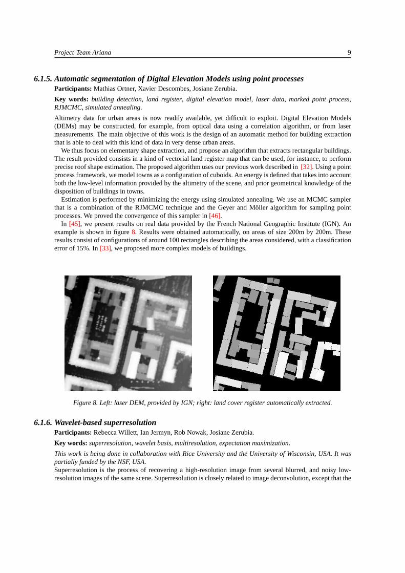
6.1.5. Automatic segmentation of Digital Elevation Models using point processesParticipants: Mathias Ortner, Xavier Descombes, Josiane Zerubia.
Key words: building detection, land register, digital elevation model, laser data, marked point process,RJMCMC, simulated annealing.
Altimetry data for urban areas is now readily available, yet difficult to exploit. Digital Elevation Models(DEMs) may be constructed, for example, from optical data using a correlation algorithm, or from lasermeasurements. The main objective of this work is the design of an automatic method for building extractionthat is able to deal with this kind of data in very dense urban areas.
We thus focus on elementary shape extraction, and propose an algorithm that extracts rectangular buildings.The result provided consists in a kind of vectorial land register map that can be used, for instance, to performprecise roof shape estimation. The proposed algorithm uses our previous work described in[32]. Using a pointprocess framework, we model towns as a configuration of cuboids. An energy is defined that takes into accountboth the low-level information provided by the altimetry of the scene, and prior geometrical knowledge of thedisposition of buildings in towns.
Estimation is performed by minimizing the energy using simulated annealing. We use an MCMC samplerthat is a combination of the RJMCMC technique and the Geyer and Möller algorithm for sampling pointprocesses. We proved the convergence of this sampler in[46].
In [45], we present results on real data provided by the French National Geographic Institute (IGN). Anexample is shown in figure8. Results were obtained automatically, on areas of size 200m by 200m. Theseresults consist of configurations of around 100 rectangles describing the areas considered, with a classificationerror of 15%. In[33], we proposed more complex models of buildings.
Figure 8. Left: laser DEM, provided by IGN; right: land cover register automatically extracted.
6.1.6. Wavelet-based superresolutionParticipants: Rebecca Willett, Ian Jermyn, Rob Nowak, Josiane Zerubia.
Key words: superresolution, wavelet basis, multiresolution, expectation maximization.
This work is being done in collaboration with Rice University and the University of Wisconsin, USA. It waspartially funded by the NSF, USA.Superresolution is the process of recovering a high-resolution image from several blurred, and noisy low-resolution images of the same scene. Superresolution is closely related to image deconvolution, except that the

10 Activity Report INRIA 2003
low-resolution images are not registered and their relative translations and rotations must be estimated as partof the process. The novelty of the approach to the superresolution problem taken in this work[37] is the useof wavelets and related multiresolution methods within an expectation-maximization reconstruction process.First, the low-resolution images are registered to each other. Then an initial reconstruction is performedusing least squares. The low-resolution images are then re-registered to this reconstruction, thereby increasingregistration accuracy. In the expectation-maximization algorithm that follows, the expectation step consistsof a multi-image deconvolution, while the maximization step consists of a wavelet-based denoising process.Simulations demonstrate the effectiveness of the proposed method, an example being shown in figure9. Onthe left is one of 16 low resolution images generated by randomly rotating, translating and downsampling (bya factor of 16) a given high-resolution image. On the right is the superresolved high-resolution image.
50 100 150 200 250 300 350
50
100
150
200
250
300
350
50 100 150 200 250 300 350
50
100
150
200
250
300
350
Figure 9. Left: one of 16 low resolution images generated by randomly rotating, translating and downsampling (bya factor of 16) a given high-resolution image; right: the superresolved high-resolution image.
6.1.7. Texture-adaptive mother wavelet selection for texture classificationParticipants: Charith Abhayaratne, Ian Jermyn, Josiane Zerubia.
Key words: texture classification, adaptive mother wavelet, lifting, biorthogonal wavelet.
This work is supported by an ERCIM postdoctoral fellowship.Texture is a widely used image attribute in remote sensing image segmentation because it is a distinguishingfeature of many land cover types. A probabilistic model for texture based on adaptive wavelet packets hasbeen developed in the Ariana project and applied to texture classification[23][24][41]. During this work, itwas observed that classification performance varied with the choice of mother wavelet used in the process.The work described here is concerned with the texture-adaptive selection of a mother wavelet for textureclassification using the above model.
As a first step, the mother wavelet is adapted within a standard wavelet basis, with the extension to adaptivewavelet packets to come later. We work with biorthogonal wavelets rather than the more commonly usedorthogonal wavelets, due to their linear phase property and easy parameterization, which is based on the liftingframework for wavelet transforms. This required modifying the existing framework to fit the biorthogonal casein which both the primal and dual wavelets appear in the probability model. Work is currently proceeding onthe gradient descent optimization procedure that will be used to find the MAP estimate for the mother wavelet.
Project-Team Ariana 11
6.2. Variational Models6.2.1.Γ-convergence for image restoration
Participants: Laure Blanc-Féraud, Gilles Aubert, Riccardo March.
Key words: restoration, gamma convergence, BV space.
In previous work, a new sequence of functionals was proposed for image restoration. This sequence offunctionals showed good results when applied to noisy image restoration and deconvolution. The purposeof this work is to prove mathematically the convergence of this sequence to a limit functional. This limitfunctional is linked to the Mumford-Shah functional for image segmentation.
6.2.2. Wavelet-based level set evolution for the classification of textured imagesParticipants: Jean-François Aujol, Gilles Aubert, Laure Blanc-Féraud.
Key words: texture, classification, variational approach, level set, active region, active contour, multiphase,wavelet, PDE, BV space, minimal surface.
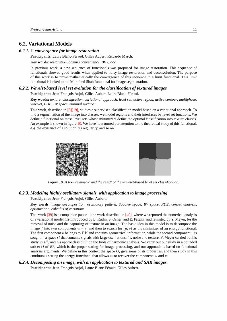
This work, described in[5][19], studies a supervised classification model based on a variational approach. Tofind a segmentation of the image into classes, we model regions and their interfaces by level set functions. Wedefine a functional on these level sets whose minimizers define the optimal classification into texture classes.An example is shown in figure10. We have now turned our attention to the theoretical study of this functional,e.g.the existence of a solution, its regularity, and so on.
Figure 10. A texture mosaic and the result of the wavelet-based level set classification.
6.2.3. Modeling highly oscillatory signals, with application to image processingParticipants: Jean-François Aujol, Gilles Aubert.
Key words: image decomposition, oscillatory pattern, Sobolev space, BV space, PDE, convex analysis,optimization, calculus of variations.
This work[39] is a companion paper to the work described in[40], where we reported the numerical analysisof a variational model first introduced by L. Rudin, S. Osher, and E. Fatemi, and revisited by Y. Meyer, for theremoval of noise and the capturing of texture in an image. The basic idea in this model is to decompose theimagef into two componentsu + v, and then to search for(u, v) as the minimizer of an energy functional.The first componentu belongs toBV and contains geometrical information, while the second componentv issought in a spaceG that contains signals with large oscillations,i.e.noise and texture. Y. Meyer carried out hisstudy inR2, and his approach is built on the tools of harmonic analysis. We carry out our study in a boundedsubsetΩ of R2, which is the proper setting for image processing, and our approach is based on functionalanalysis arguments. We define in this context the spaceG, give some of its properties, and then study in thiscontinuous setting the energy functional that allows us to recover the componentsu andv.
6.2.4. Decomposing an image, with an application to textured and SAR imagesParticipants: Jean-François Aujol, Laure Blanc-Féraud, Gilles Aubert.

12 Activity Report INRIA 2003
Key words: restoration, SAR image, texture, speckle, total variation minimization, BV space.
This work was done in collaboration with Antonin Chambolle, CEREMADE, University Paris Dauphine andÉcole Polytechnique.We construct an algorithm to split an image into a sumu + v of a bounded variation component and acomponent containing the textures and noise (see[21][20][40]). This decomposition is inspired by recentwork of Y. Meyer. We find this decomposition as the minimum of a convex functional that depends on thetwo variablesu and v, by minimizing alternately in each variable. Each minimization step is based on aprojection algorithm for minimizing the total variation. We carry out a mathematical study of our method andpresent some numerical results (e.g.figure11). In particular, we show how theu component can be used innon-textured SAR image restoration.
Figure 11.f (left) = u (middle)+ v (right).
6.2.5. Image decomposition: a three component modelParticipant: Jean-François Aujol.
Key words: texture, restoration, total variation minimization, BV space, Sobolev space, wavelet shrinkage,convex analysis.
This work was done in collaboration with Antonin Chambolle, CEREMADE, University Paris Dauphine andÉcole Polytechnique.We first study the choice of a norm to capture oscillatory patterns in images. Then, based on this study, weconstruct an algorithm to split an image into a sumu+v +w of a bounded variation component, a componentcontaining the texture, and a third component containing noise. We find this decomposition by minimizing aconvex functional which depends on the three variablesu, v andw. An example is shown in figure12.
Figure 12.f (left) = u (second to left)+ v (second to right)+ w (right)
Project-Team Ariana 13
6.2.6. Image disocclusionParticipants: Emmanuel Villéger, Laure Blanc-Féraud, Gilles Aubert.
Key words: interferometry, inpainting, diffusion, transport, PDE.
Interferometry phase images frequently have holes where there is no data. Some methods already exist tofill in the holes in these images. One method is to minimize a functional with respect to two functions, onedescribing the image grey level and the other the orientation of the level lines. The orientation of the level linesis thus represented as a separate function. These two quantities are linked by constraints on the minimization.Another method is to solve a partial differential equation (PDE). The solution is the grey level of the image.In this case, the PDE contains a term depending on the curvature of the level lines. Thus the PDE is of at leastthird order.
The novelty of the method being developed in this work is that it uses only second-order PDEs. Theorientation of the level lines is represented as the argument of a probabilistic function. This function is aprobabilistic gradient of the image depending on the norm of the image gradient. The method consists ofsolving two coupled second-order PDEs. One equation is for the orientation of the probabilistic gradient,while the second couples the orientation to the grey level of the image.
6.2.7. Higher order active contours and their application to line network detectionParticipants: Marie Rochery, Ian Jermyn, Josiane Zerubia.
Key words: line network extraction, shape description, quadratic functional, higher-order active contour,level set.
In this work, we concern ourselves with active contour models of regions in an image. A topic of great recentinterest in this area is the incorporation of prior geometric information into the models. The techniques thathave been used to this end thus far all deal with Gaussian fluctuations around particular template shapes.For the application considered here, which is the extraction of road and other networks from remote sensingimagery, this type of model will not do: road networks cannot be described as perturbations of some ‘mean’shape. Rather what is needed is a description of a ‘family’ of shapes that share complex geometric properties,without making reference to any particular shape.
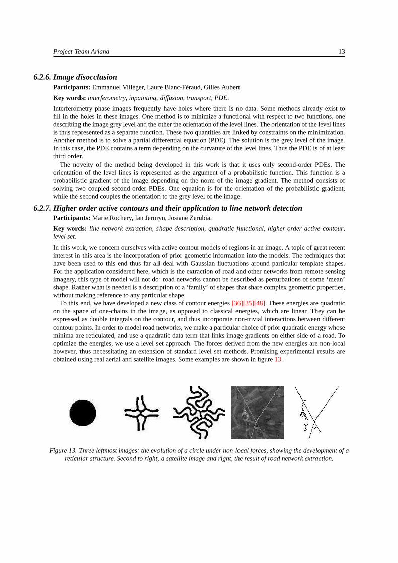
To this end, we have developed a new class of contour energies[36][35][48]. These energies are quadraticon the space of one-chains in the image, as opposed to classical energies, which are linear. They can beexpressed as double integrals on the contour, and thus incorporate non-trivial interactions between differentcontour points. In order to model road networks, we make a particular choice of prior quadratic energy whoseminima are reticulated, and use a quadratic data term that links image gradients on either side of a road. Tooptimize the energies, we use a level set approach. The forces derived from the new energies are non-localhowever, thus necessitating an extension of standard level set methods. Promising experimental results areobtained using real aerial and satellite images. Some examples are shown in figure13.
Figure 13. Three leftmost images: the evolution of a circle under non-local forces, showing the development of areticular structure. Second to right, a satellite image and right, the result of road network extraction.

14 Activity Report INRIA 2003
6.2.8. Interferogram filteringParticipants: Caroline Lacombe, Gilles Aubert, Laure Blanc-Féraud.
Key words: interferometric filtering, adaptive filter, phase noise statistic, anisotropic diffusion, structuretensor, diffusion tensor.
Interferometric radar techniques have been widely used to produce high-resolution ground digital elevationmodels. In space-borne SAR (Synthetic Aperture Radar) interferometry, two images of the same scene areacquired using two different geometries. The phase difference between the registered images (the so-calledinterferogram) is related to a desired physical quantity of interest such as the surface topography. The phasedifference can be registered only modulo2π and interferometric techniques consist mainly of recovering theabsolute phase (the unwrapped phase) from the registered one (the wrapped phase).
The interferogram has fringes representing the phase within the range of−π to π. Any phase values greaterthanπ are wrapped back around to−π. Due to phase discontinuities the reconstruction of the geometry isambiguous. But another difficulty comes from the high level of speckle noise, which introduces errors into thereconstruction. Several filters have been applied to this type of image, but they are not adapted to local noiselevel variations. To preserve phase discontinuities, most of them unwrap the phase in a small filtering windowbefore smoothing, and then wrap it again.
We propose[28][29] an anisotropic diffusion equation designed to restore interferometric images. It has twomain purposes. The first is to preserve the structures and discontinuities formed by the fringes. The secondis to incorporate noise modeling specific to this type of images. We show that our model formalizes previousrelated work in interferometry filtering. A result is shown in figure14.
Figure 14. Left: interferogram data from part of Utah; right: the filtered result after 30 iterations.
6.2.9. Edge detection and phase unwrappingParticipants: Caroline Lacombe, Gilles Aubert, Laure Blanc-Féraud.
Key words: edge detector, phase unwrapping, interferometric image, level set, active contour, structuretensor.
The aim of this work is to find the phase jumps (curves of discontinuities) from a filtered interferogram usinga level set approach. Phase interferometric images present typical structures because of fringes. In order totake into account local variations in gradient direction, we propose a new edge-descriptor that uses localinformation about the principal direction of fringes[3]. Figure15 shows a numerical result on a part of thefiltered interferogram of Utah.
We suppose that the interferogram does not contain terrain discontinuities. In order to add the missingintegral cycles to obtain the absolute phase, we propose an automatic method to distinguish each fringe fromthe image of phase jumps[3]. The algorithm has been tested on both synthetic and real interferograms forwhich the fringes are all either parallel or concentric. An automatic method is given for interferograms thatcombine both types of structure.

Project-Team Ariana 15
Figure 15. Left: Initialization. Right: edge detection after 1500 iterations.
6.3. EU Project MOUMIR6.3.1. Texture analysis using probabilistic models of the unimodal and multimodal statistics of
adaptive wavelet packet coefficientsParticipants: Roberto Cossu, Karen Brady, Ian Jermyn, Josiane Zerubia.
Key words: texture, multimodal distribution, adaptive basis, wavelet packet, Bayesian.
This work is being done as part of EU project MOUMIR (http://www.moumir.org).In [41], it was noted that although the subband histograms for standard wavelet coefficients take on ageneralized Gaussian form, this is no longer true for wavelet packet bases adapted to a given texture, andin particular it is not true for the adaptive Gaussian models developed in[41]. Instead, three types of subbandstatistics are observed: Gaussian, generalized Gaussian, and interestingly, in some subbands, bi- and tri-modal histograms. These multimodal subbands are closely linked to the structure of the texture, capturingthe presence of significant periodicities.
Motivated by these observations, in this work we extend the approach to texture analysis proposedin [23][24] to model these subbands. We relax the Gaussian assumption to include generalized Gaussians, anduse constrained Gaussian mixtures for the multimodal subbands. We use a Bayesian methodology throughout,finding MAP estimates for the adaptive wavelet packet basis, for subband model selection, and for subbandmodel parameters. Results confirm the effectiveness of the proposed approach, and highlight the importanceof multimodal subbands. For example, figure16 shows the distribution of wavelet packet coefficients fromseveral subbands in two textures. In two of the subbands, one texture has multimodal statistics while the otherdoes not. In the other two subbands, both textures have unimodal statistics. The discriminatory power of themultimodal subbands is clearly visible.
Figure 16. The two leftmost images show wavelet packet coefficient distributions from subbands multimodal for oneof two textures. The two textures are shown in different colors. The two rightmost images show distributions from
subbands unimodal for both textures. Note the discriminative power of the former.

16 Activity Report INRIA 2003
6.3.2. Evaluation methodology and practice for a database of aerial images equipped withground truthParticipants: Roberto Cossu, Ian Jermyn, Josiane Zerubia.
Key words: remote sensing image, database retrieval, multimodal image registration, image mosaicking,evaluation methodology.
This work is being done as part of EU project MOUMIR (http://www.moumir.org).In collaboration with the University of Cambridge, UK, project Ariana previously conducted a methodologicalanalysis of evaluation procedures for image database retrieval, focusing on two datasets that illustrate the rangeof image database applications. Work on the first dataset, scanned images of fine art from the Bridgeman ArtLibrary, UK, has finished, and is reported in[44]. The other dataset consists of aerial images of the Ile-de-France Region furnished by IGN. In this case, the analysis led to a search for ground truth for the dataset,which was acquired from the Institute for Urban Planning and Development of the Ile-de-France Region(IAURIF), and which consists of land-use classification maps for the Ile-de-France Region compiled fromexisting cartography and field studies.
In order to proceed with evaluation using this dataset, the land-use maps first had to be registered withthe aerial data. The difficulty lay in the fact that there were several data images overlapping each land-usemap, meaning that the required registration was multimodal: the land-use maps were to be registered with theaerial images, and these images were to be registered with each other. The registration process was carriedout by a manual procedure, illustrated in figure17. This first required the selection, by visual inspection, ofcorresponding points in the ground truth image and the data image. A first degree polynomial transform andnearest neighbor resampling were then used for the warping of the images. In the cases where the geographicalarea covered by a given land-use map was covered by more (partially overlapping) data images, additionalprocessing steps were required. First of all, such images might have been acquired under different atmosphericconditions. These differences were corrected using a simple histogram matching procedure applied to theoverlapping areas. After registration of the data images with land-use maps, they were mosaicked. At theend of the process, composite data images and corresponding land-use maps were obtained for 45 communesin the Ile-de-France Region. A CD-ROM with the results, i.e., the registered data set, was distributed to theMOUMIR partners.
Figure 17. Scheme of the adopted multimodal registration approach
6.3.3. Shape from texture via conformal embeddingsParticipants: Rami Haggiag, Ian Jermyn.

Project-Team Ariana 17
Key words: shape from texture, surface, conformal, embedding, diffeomorphism, constraint.
This work was done as part of EU project MOUMIR, in collaboration with Professor Joseph Francos ofBen-Gurion University, Israel.The goal in the shape from texture problem is to recover a surface from its image, which is supposed to be‘textured’. The regularities in the texture are distorted both by the curvature of the surface and by the imagingprocess, and therefore contain information about the shape of the surface.
One of the key difficulties in the formulation of the problem is how to model a texture on a curved surface.Since the surfaces in which we are interested are equivalence classes of embeddings of (a domain in)R2 inR3, we can choose a particular representative of this class, and then push forward the texture, or a probabilisticmodel of the texture, fromR2 to the surface. In the 1D case, the obvious choice of representative is an isometry,which always exists. In the 2D case under discussion, an isometry does not always exist. However, a conformalembedding does. Conformal embeddings result in a local, isotropic change of scale, and thus preserve angles.They have been used in the computer graphics community for precisely the purpose of moving textures fromflat surfaces to curved ones, and thus suit our purposes.
At present we are analyzing the case in which the original ‘flat’ texture is available, or in other wordsin which the probabilistic model of the texture is a delta function. This is not unrealistic for image databaseretrieval applications, in which an exemplar may be used as the query image. In this case, a 2D diffeomorphismtaking the flat texture to the distorted image can be estimated. We have developed a method to complete this2D diffeomorphism to a conformal embedding when such exists, thus estimating the surface. Problems arise,however, if the estimated 2D diffeomorphism is not projectively conformal. This can happen for a numberof reasons, errors and noise in the imaging and estimation processes being the most obvious. In addition, theconformal model of textures on surfaces may be only approximately correct in any given scenario. We arecurrently developing ways to impose the constraint of projective conformality as part of the estimation of the2D diffeomorphism, in particular in the case that the 2D diffeomorphism is approximated by a polynomial.Subsequent work will use a less restrictive probabilistic model of the texture.
6.4. EU Project IMAVIS6.4.1. Track detection and classification
Participants: Alexey Teterukovskiy, Josiane Zerubia.
Key words: track detection, classification, Gibbs sampler, prior distribution, Potts model, Chien model,maximum spacings estimation.
This work is being done as part of EU project IMAVIS, in collaboration with Professor Bo Ranneby and JunYu of the Swedish University of Agricultural Sciences, Sweden.This research was conducted within the following two connected areas: Bayesian image classification andthe estimation of parameters. Within the Bayesian framework, two problems were tackled: the detectionof tracks in remote sensing imagery and the classification of multispectral data. For detection of tracks,information about the shape of the tracks was used to construct the prior distribution. The maximization ofthe posterior distribution was performed using the Gibbs sampler. The effectiveness of the algorithm proposedwas compared to that of the algorithm described in[31]. The quality of the image classification can cruciallydepend on the adequacy of the prior distribution. This fact was reinforced by a simulation study, whichdemonstrated how the total misclassification rates varied with different priors, such as the well-known Pottsmodel and the Chien model. Work was also done on the estimation of parameters by a maximum spacings(MSP) method, which is an alternative to maximum likelihood (ML) estimation. Contrary to ML, which isknown to fail in many situations (notably, with mixtures of Gaussian distributions), the MSP estimate in suchcases is consistent. Moreover, it retains the useful properties of the ML estimator, such as asymptotic normalityand efficiency. Introduced in 1984 for univariate variables, the MSP estimator is only now being used in higherdimensions, making it an interesting alternative to ML estimation for purposes of image analysis.

18 Activity Report INRIA 2003
6.4.2. Tree-structured MRFs for noisy image segmentationParticipants: Giuseppe Scarpa, Josiane Zerubia.
Key words: segmentation, classification, hierarchical representation, Markov model, Bayesian estimation.
This work is being done as part of EU project IMAVIS, in collaboration with Professor Gianni Poggi of theUniversity Federico II of Naples, Italy.The goal of this work is the segmentation of multispectral satellite images using Markov random field modelsas prior probability distributions. In particular, this research focuses on a recent statistical model, an MRFlying on a binary tree structure (TS-MRF). This model has interesting properties both in computational termsand from a modeling point of view.
Computational complexity is reduced thanks to the constrained structure of the TS-MRF, which lies ona binary tree. In the model, the image as a whole is associated with a tree of regions/segments, while eachelementary region is associated with a leaf, which is progressively singled out top-down by means of asequence of binary decisions. Thus a K-class segmentation problem reduces to a sequence of K-1 binarysegmentations. Each binary split involves estimating a much smaller number of parameters than a K-ary split,with the result that even the whole sequence of binary steps is much simpler than a single K-ary split. The treestructure also allows the definition of local fields that are well adapted to the local characteristics of the data,thus improving the fidelity of the model. In addition, the proposed method addresses the cluster validationproblem in unsupervised segmentation via the definition of a stopping condition for each new node during treegrowth.
The performance of the model, in terms of misclassification rate, was assessed on a SPOT image of LannionBay in France for which ground truth exists. The assessment showed the improved performance of the methodwith respect to other MRF-based algorithms, in particular another hierarchical MRF, as well as with respectto non-contextual techniques such as minimum distance, maximum likelihood, and discriminant analysis. Anexample result is shown in figure18. Further details can be found in[49].
Figure 18. Left: a satellite image; right: the segmentation result.
6.5. COLORS Project Arbres: automatic tree crown detection using markedpoint processesParticipants: Guillaume Perrin, Xavier Descombes, Josiane Zerubia.
Key words: tree crown detection, marked point process, RJMCMC, simulated annealing.
This work was done as part of INRIA COLORS project Arbres , in collaboration with Michel Deshayes,Agricultural and Environmental Engineering Research Center (CEMAGREF), and Jean-Guy Boureau, FrenchNational Forest Inventory (IFN).

Project-Team Ariana 19
The availability of digital aerial photographs of high spatial resolution opens up new prospects for theautomatic generation of knowledge in the domain of forestry. Parameters such as tree crown diameters,stem density, species classification, and the distribution of non-forested gaps are currently assessed by humaninterpretation. Algorithms for the automatic extraction of these parameters would greatly aid forestry managersin their work, which is increasingly demanding due to stricter legislation and environmental concerns.
Several tree crown detection techniques already exist, but they all address a specific part of the globalproblem. Some are suited to dense stands, some handle the detection of trees near the Nadir point, and so on.We propose a new approach to the problem that will enable us to tackle images of forest stands with differentspecies (poplars, conifers, oaks,...), different ground slopes (plains, mountains,...) and different illuminations.
To achieve this goal, we use marked point processes, whose marked points (or objects) represent the trees.The density of this process contains both prior knowledge about the trees we are detecting, and a data termwhich fits our objects to the image. We estimate the distribution of trees by simulating our point processwith an RJMCMC algorithm and simulated annealing. The first results were obtained on stands of poplars, anexample being shown in figure19. Further details can be found in[47]. We are currently broadening our study.
IFN provides us with data, and evaluates our results, in collaboration with CEMAGREF.
Figure 19. Left: a data image of forest stands (IFN) containing oaks and poplars; right: automatic detection ofpoplars.
6.6. ARC DeMeTri: blind deconvolution of confocal microscopyParticipants: Nicolas Dey, Laure Blanc-Féraud, Josiane Zerubia.
Key words: fluorescence microscopy, confocal laser scanning microscopy, 3D deconvolution, PSF, imageformation.
This work is being done within the framework of the ARC DeMiTri (http://www-sop.inria.fr/ariana/personnel/Nicolas.Dey/DeMiTri/arc.php),in collaboration with Jean-Christophe Olivo-Marin and Christophe Zimmer, Pasteur Institute, and Zvi Kam,Weizmann Institute of Science, Israel.The overall goal of this work is to develop a new family of algorithms for the blind deconvolution of three-dimensional microscopic biological images. These algorithms will be based on methods which have previouslybeen developed by the Ariana project. The methods were originally used for satellite image processing and sothey currently permit estimation of instrument parameters, such as the PSF and noise variance, for an opticalsensor.
The first part of the work consisted in understanding the process of image formation in confocal microscopy,in which the specimen is stained with a fluorescent dye, which is then excited by a laser. The blur due to
20 Activity Report INRIA 2003
imprecise focusing is largely removed due to the use of two pinholes. However, the light intensity is very low,with the noise statistics following a Poisson distribution. Even if the laser focusing is accurate and the aperturevery small, some blur remains.
We have developed a Richardson-Lucy type algorithm that performs a 3D deconvolution of an image stack.This well-known algorithm is developed in 3D and is regularized with a function that preserves textures andfine structures.
Results have been obtained using simulated data with noise and blur added based on physical models andparameters. We use a physical model of the 3D PSF, provided by the Weizmann Institute, to perform this. Theiterations of the algorithm remove the noise and give a precise estimate of the original object.
7. Contracts and Grants with Industry7.1.1. BRGM Orléans
Updating of line networks in cartography using data fusion and Markov object processes. Contract #102E03800041624.01.2. Participants: C. Lacoste, X. Descombes, J. Zerubia.
7.1.2. DGA/CTA ArcueilAnalysis of urban areas using Markov object processes and digital elevation models. Grant under DGA/CNRSagreement. Participants: M. Ortner, X. Descombes, Josiane Zerubia.
8. Other Grants and Activities8.1. Regional8.1.1. INRIA COLORS project Arbres
In collaboration with CEMAGREF, Montpellier (M. Deshayes), and IFN, Montpellier (J. G. Boureau).Principal investigator: X. Descombes. Participants: G. Perrin, J. Zerubia.
8.2. National8.2.1. CNRS MATH/STIC grant ‘Visual Annotation’
In collaboration with ENS Cachan (L. Younes, D. Geman) and Paris XIII (A. Trouvé). Begun at the end of2001. Participants: I. Jermyn, J. Zerubia.
8.2.2. CNRS MATH/STIC grant ‘Image classification by variational methods and PDEs’In collaboration with the Jean-Alexandre Dieudonné Laboratory of UNSA (G. Aubert). Begun in mid-2002.Participants: J-F. Aujol, E. Villeger, L. Blanc-Féraud.
8.3. European8.3.1. EU project MOUMIR
The Ariana project is a participant in European Union Research Training Network MOUMIR (Models forUnified Multimedia Information Retrieval), contract HPRN-CT-1999-00108/RTN-1999-0177, in collaborationwith Trinity College Dublin, University of Cambridge, INESC Porto, University of Thessaloniki, Ben-GurionUniversity, Radio-Televisaõ Portuguesa, Bridgeman Art Library. INRIA principal investigator: J. Zerubia.INRIA participants: K. Brady, R. Cossu, I. Jermyn. Web site:http://www.moumir.org
8.3.2. EU project IMAVISThe Ariana project is a participant in European Union project IMAVIS (Theory and Practice of Image Proces-sing and Computer Vision), contract IHP-MCHT-99-1, in collaboration with the Odyssée and Epidaure pro-jects. Principal investigator: J. Zerubia. Web site:http://www-sop.inria.fr/robotvis/projects/Imavis/imavis.html

Project-Team Ariana 21
8.3.3. PAI Procope ‘Non-local information extraction within a Bayesian data miningframework for remote sensing images’In collaboration with the German Space Agency, DLR (M. Datcu). Principal investigator: I. Jermyn. Partici-pants: C. Lacoste, M. Ortner, J. Zerubia.
8.4. International8.4.1. INRIA ARC DeMiTri
In collaboration with the Pasteur Institute (J. C. Olivo-Marin) and the Weizmann Institute (Z. Kam).Principal investigator: J. Zerubia. Participants: N. Dey, L. Blanc-Féraud. Web site:http://www-sop.inria.fr/ariana/personnel/Nicolas.Dey/DeMiTri/arc.php
8.4.2. Lyapunov Institute grant 98-02In collaboration with the IITP of the Russian Academy of Science (E. Pechersky, E. Zhizhina). Principalinvestigator: J. Zerubia. Participants: X. Descombes.
8.4.3. NATO/Russia Collaborative Linkage Grant 980107 ‘Prior shape information for imagesegmentation in environmental and disaster detection and monitoring’In collaboration with North Carolina State University (H. Krim) and the IITP of the Russian Academy ofScience (R. Minlos, E. Pechersky, E. Zhizhina). Principal investigator: J. Zerubia. Participants: M. Rochery, I.Jermyn, X. Descombes.
8.4.4. CONACYT grantIn collaboration with the Autonomous National University of Mexico (M. Moctezuma). Principal investigator:X. Descombes. Participants: O. Viveros-Cancino, J. Zerubia.
9. Dissemination9.1. Conferences, Seminars, Meetings
• The members of the Ariana project participated actively in GDR-PRC ISIS and GDR-MSPCV.
• The members of the Ariana project participated in and presented their work at the first Ariana/DLR(German Space Agency) Collaborative Day in July in Sophia Antipolis, and at the second Collabo-rative Day in November in Oberpfaffenhofen, Germany, as part of the PAI Procope project.
• The members of the Ariana project participated actively in the INRIA Fête de la Science. Inparticular, M. Rochery and G. Perrin made presentations at the Special Needs School ‘Les CadransSolaires’, Vence, in October, while J. Zerubia M. Ortner, and N. Dey made presentations as part ofthe INRIA Open Doors weekend in October.
• As in previous years, the Ariana project participated in the TIPE for the preparatory classes for theGrandes Écoles.
• The Ariana project organized numerous seminars in image processing during 2003. Twenty-tworesearchers were invited from the following countries: Belgium, Canada, France, Ireland, Israel,Italy, Mexico, Puerto Rico, Sri Lanka, Sweden, Switzerland, the United Kingdom, and the UnitedStates. For more information, see theAriana project web site.
• The Ariana project participated actively in the visits to INRIA Sophia Antipolis of students from theGrandes Écoles (ENS Ulm, ENS Cachan, ENS Lyon, École Polytechnique, Sup’Aéro...)
• J.F. Aujol participated in the workshop CANUM, and he gave a talk as part of the Ariana-Odysséejoint seminar ‘The uses of texture in image processing, and associated mathematical problems’, atINRIA Sophia Antipolis in March.

22 Activity Report INRIA 2003
• K. Brady participated in the MOUMIR meeting at INESC in Porto, Portugal, in June, where shepresented a poster of her work.
• C. Lacoste gave a talk as part of the Ariana/Mistral joint seminar ‘Stochastic state space explorationstrategies applied to image processing and network modeling’, at INRIA Sophia Antipolis, inMay. She attended the symposium ‘Etats de la recherche: aspects probabilistes en vision’, at ENSCachan, Paris, in June, and the symposium ‘Modélisation aléatoire et industries aérospatiales’, at theLaboratoire de Statistique et Probabilités, Toulouse, in October.
• M. Ortner gave a talk as part of the Ariana/Mistral joint seminar ‘Stochastic state space explorationstrategies applied to image processing and network modeling’, at INRIA Sophia Antipolis, in May,and gave a seminar at DGA/CTA Arcueil, Paris, in May.
• G. Perrin visited IFN and CEMAGREF, both in Montpellier, in July, and IFN in Nogent surVermisson in December.
• M. Rochery visited Prof. V. Caselles of Pompeu Fabra University, Spain, for one week in July,supported by GDR-ISIS, and gave a seminar to the VISSTA group of the Electrical and ComputerEngineering Department at North Carolina State University, USA, as part of a three week visit to Dr.H. Krim in August.
• E. Villeger participated in the conference AMAM in February, and visited CMLA at ENS Cachan,Paris, for three days in April.
• R. Cossu participated in the meeting of EU project MOUMIR at INESC in Porto, Portugal, in June,and there presented a poster.
• N. Dey visited the Pasteur Institute, Paris, several times throughout the year, spending a total ofseven weeks there. During one of these visits, he gave a seminar. He participated in the ScientificVolume Imaging (SVI) User Group Meeting, at the SVI headquarters, Hilversum, the Netherlands.
• I. Jermyn participated in a meeting of the CNRS AS Fouille d’Image at ENST, Paris, in Januaryand attended the IGN Research Days at IGN, Paris, in February. He visited Trinity College, Dublin,as part of EU project MOUMIR, in March and participated in the MOUMIR meeting at INESC inPorto, Portugal, in June. He visited ENS Cachan, Paris, as part of the MATH/STIC project ‘VisualAnnotation’, in September.
• X. Descombes participated in the ORFEO meeting at CNES, in May and visited the IITP of theRussian Academy of Science in September in the context of a project supported by the LyapunovInstitute (grant 98-02). He gave two invited talks in the Computational and Information Infrastructuresession of the Astronomical Datagrid Workshop held at the Nice Observatory (OCA) in Octoberas part of a collaboration with the OCA, and gave a talk at the Lyapunov workshop for the 10th
anniversary of the Lyapunov Institute, Moscow, also in October. He gave a talk in the workshop‘Pixels et Cités’, Marne la Vallée, organized by SFPT, IGN, IRD, and INRIA, in November, andanother at the workshop on Hyperspectral Images organized by Alcatel Space, Cannes, in December.
• L. Blanc-Féraud participated in the CNRS AS Fouille d’Image, and attended several meetings inParis. She gave an invited talk in the conference VIA Vision, Image and Agriculture, Dijon, and gaveanother in the Computational and Information Infrastructure session of the Astronomical DatagridWorkshop held at the Nice Observatory (OCA) in October as part of a collaboration with the OCA.
• J. Zerubia gave invited talks at the University of Paris VI, in January, and ETH Zurich and InfoterraFriedrichhaffen, Germany, in February. In May, she participated in the ORFEO meeting at CNES,Paris, and visited Alcatel Space and Silogic, both in Toulouse. She visited the University of PompeuFabra, Barcelona, Spain, in September, and Alcatel Space, Cannes, in November.

Project-Team Ariana 23
9.2. Refereeing
• J.F. Aujol was a referee for IEEE TIP.
• C. Lacombe was a referee for IEEE TSP.
• C. Abhayaratne was a referee for IEEE TIP and IEEE Signal Processing Letters.
• R.Cossu was a referee for IEEE TIP, IEEE TGRS, International Journal on Information Fusion,Photogrammetric Engineering and Remote Sensing, and for the conference MultiTemp.
• I. Jermyn was a referee for IEEE TIP, IEEE TPAMI, JMLR, and Traitment du Signal, and for theconferences ICASSP, ICIP,and UIST.
• X. Descombes was a referee for IEEE TIP, TMI, IEEE PAMI, and Traitement du Signal, and for theconferences ICIP, ORASIS, and ICASSP.
• L. Blanc-Féraud was a referee IEEE Signal Processing Letters, IEEE TIP, and the conferencesACIVS, ICIP, and GRETSI.
• J. Zerubia was a referee for IJCV, IEEE TIP and IEEE TPAMI, and for the conferences ICASSP,ICIP, EMMCVPR, ORASIS, Pixels et Cités, GRETSI, TAIMA, and the SPIE Conference on SignalProcessing for Remote Sensing.
9.3. Organization
• C. Abhayaratne was chair of the ‘Wavelets and Multirate Filtering’ session at the InternationalSymposium on Image and Signal Processing and Analysis (ISPA).
• R.Cossu served on the organizing committee of the Second International Workshop on the Analysisof Multitemporal Remote Sensing Images (MultiTemp 2003), Ispra, Italy, in July.
• I. Jermyn is a member of the Comité de Suivi Doctoral and the Library Working Group at INRIA. Heorganized the DLR/Ariana Workshop in July as part of the Procope collaboration with the Germanspace Agency, DLR. He was chair of the ‘Indexing’ session at GRETSI, and was a member of onePhD committee during 2003.
• X. Descombes was a member of one PhD committee in 2003, and was co-chair of the ‘Classificationand segmentation II’ session at IGARSS.
• L. Blanc-Féraud is a member of the Scientific Committee of CNRS RTP 25 ‘Imagerie, vision etanalyse de scènes’. She was in charge of Communications at the I3S Laboratory (CNRS/UNSA)until August, and Adjoint Director of the I3S Laboratory from September. She is a member of theCOLORS Committee at INRIA. She was a member of a PhD pre-defence committee at LCPC inStrasbourg, and was a reviewer for two PhD theses, and a committee member for a third. She attendedthe General Assembly of the GDR, Dourdan, in March, and organized the GDR-PRC ISIS ‘TextureDay’ meeting in Paris, in June. She organized a meeting of the AS Fouille d’Image and GDR-PRCISIS on ‘Applications en Fouille d’Image’ at ENST in July. She was chair of the ‘Restoration andreconstruction: multicomponent analysis’ session at GRETSI.
• J. Zerubia was made an IEEE Fellow in January, and she is member at large of the Board ofGovernors of the IEEE Signal Processing Society. She is Area Editor of the IEEE Transactionson Image Processing, co-Guest Editor of a special section on ‘Energy minimization methods incomputer vision and pattern recognition’ in the IEEE Transactions on Pattern Analysis and MachineIntelligence November issue, and she is a member of the Editorial Board of the Bulletin of theSFPT. She was general co-chair of EMMCVPR in Lisbon, in July, general chair of the "Pixels etCités" workshop in Marne la Vallée, in November, and president of a session at ICIP in Barcelona, inSeptember. She was a Program Committee member for ICASSP, ICIP, EMMCVPR, ORASIS, Pixels
24 Activity Report INRIA 2003
& Cités, GRETSI, TAIMA, and the SPIE Conf. on Signal and Image Processing for Remote Sensing.She organized a one-day workshop between the Pasteur Institute, the Weizmann Institute, and theAriana project in Sophia Antipolis in July, funded by the ARC DeMiTri. She represented INRIAat the Direction Technique du Ministère de la Recherche for high resolution imagery and remotesensing. She was a member of three PhD defence committees at UNSA and ENST, a committeemember for one HdR at Sup-Aéro, and a reviewer for another at the University of Rennes. She wasa nominator for the Kyoto Prize in Information Science given by the Inamori Foundation in Japan,and she was a member of the evaluation boards for the Swiss National Science Foundation and theIsrael Science Foundation.
9.4. Teaching
• J.F. Aujol was teaching assistant for ‘Mathematics applied to Digital Images’ (64h) at the IUT of theUniversity of Nice Sophia-Antipolis.
• C. Lacoste was lab instructor for ‘Image’ (21 hours) at ESINSA.• C. Lacombe was a teaching assistant for ‘Financial Mathematics’ (8h), and in charge of a course
in ‘Mathematical Harmonization’ (10h), both for the DESS in ‘Informatique et MathématiquesAppliquées à la Finance et à l’Assurance’ at ESSI. She was also teaching assistant for ‘PartialDifferential Equations’ (26h) and ‘Numerical Mathematics’ (52h) at ESSI.
• M. Rochery was lab instructor for ‘Signal Processing’ (30 hours), ‘Numerical Signal Processing’(30 hours), and ‘Practical Electronics’ (37 hours) at ESINSA.
• E. Villeger was teaching assistant for ‘Mathematical Theory of Computer Science’ (42h), and labinstructor for a course on Maple (21h), both at the IUT of the University of Nice Sophia-Antipolis.
• N. Dey was lab instructor of ‘Unix Systems’ (39h) at the University of Nice-Sophia Antipolis.• I. Jermyn taught ‘Image Analysis’ (6h) at ESINSA, and ‘Filtering and Segmentation of Space
Imagery’ (2.5h) at Sup’Aéro.• X. Descombes taught ‘Image Analysis’ (15h) at ESINSA, ‘Remote Sensing’ for the DEA in
Astrophysics (9h) at the University of Nice-Sophia Antipolis, and ‘Filtering and Segmentation ofSpace Imagery’ (17h) at Sup’Aéro.
• J. Zerubia was director of the module ‘Markov Random Fields in Image Processing’ in the DEA SICat the University of Nice-Sophia Antipolis (15h taught), and director of the module ‘Remote Sensing’in the DEA in Astrophysics and Sciences of the Universe at the University of Nice-Sophia Antipolis(15h, of which 6h teaching), for which she also taught ‘Classification’ (3h). She was director of thecourse ‘Filtering and Segmentation’ (40h, of which 20h teaching) at Sup’Aéro, where she also taught‘Variational Methods for Image Processing’ (2.5).
9.5. PhDs9.5.1. In progress
1. Jean-François Aujol, ‘Classification d’image couleur texturée par approche variationnelle’, Univer-sity of Nice-Sophia Antipolis, defence expected in 2004.
2. Caroline Lacoste, ‘Mise à jour cartographique des réseaux linéiques en fusion de données parprocessus Markov objet’, University of Nice-Sophia Antipolis, defence expected in 2004.
3. Mathias Ortner, ‘Analyse urbaine à partir de modèles numériques d’élévation par processus Markovobjet’, University of Nice-Sophia Antipolis, defence expected in 2004.
4. G. Perrin, ‘Étude du couvert forestier à partir d’un processus objet’, Centrale Paris, defence expectedin 2006.
5. Marie Rochery, ‘Contours actifs d’ordre supérieur et leur application à la détection de linéiques surdes images de télédétection’, University of Nice-Sophia Antipolis, defence expected in 2005.
6. Emmanuel Villéger, ‘Evolution de sous-variétés deRn à l’aide de la fonction vecteur distance’,University of Nice-Sophia Antipolis, defence expected in 2004.

Project-Team Ariana 25
9.5.2. Defended in 2003
1. Oscar Viveros-Cancino. ‘Analyse des zones urbaines par fusion de données en télédétection’,University of Nice-Sophia Antipolis. Defended June 10.
2. Karen Brady. ‘A probabilistic framework for adaptive texture description’, University of Nice-SophiaAntipolis. Defended December 17.
3. Caroline Lacombe. ‘Modèles variationnels et équations aux dérivées partielles pour le déroulementde phase en interférometrie radar de type RSO’, University of Nice-Sophia Antipolis. DefendedDecember 16.
10. BibliographyBooks and Monographs
[1] Energy Minimization Methods in Computer Vision and Pattern Recognition (Proc. 4th Int’l Workshop EMMCV-PR, Lisbon, Portugal, July 2003).A. RANGARAJAN, M. FIGUEIREDO, J. ZERUBIA, editors, series LNCS,number 2683, Springer, 2003.
Doctoral dissertations and “Habilitation” theses
[2] K. B RADY. A Probabilistic Framework for Adaptive Texture Description.Ph. D. Thesis, University of Nice-Sophia Antipolis, 2003.
[3] C. LACOMBE. Modèles Variationnels et Équations Aux Dérivées Partielles Pour Le Déroulement de Phase EnInterférométrie Radar de Type RSO.Ph. D. Thesis, University of Nice-Sophia Antipolis, 2003.
[4] O. V IVEROS-CANCINO. Analyse Des Zones Urbaines Par Fusion de Données En Télédétection.Ph. D. Thesis,, University of Nice-Sophia Antipolis, 2003.
Articles in referred journals and book chapters
[5] J. F. AUJOL, G. AUBERT, L. BLANC-FÉRAUD. Wavelet-based level set evolution for classification of texturedimages.in « IEEE Trans. Image Processing », number 12, volume 12, 2003.
[6] L. B RUZZONE, R. COSSU. Advanced classification techniques: partially supervised approaches.C.H. CHEN,editor, in « Frontiers of Remote Sensing Information Processing », World Scientific Pub Co., 2003, pages285–314.
[7] L. B RUZZONE, R. COSSU. An adaptive approach to reducing registration noise effects in unsupervisedchange detection.in « IEEE Trans. Geoscience and Remote Sensing », number 11, volume 41, 2003, pages2455–2465.
[8] A. CROUZIL, X. DESCOMBES, J. DUROU. A Multiresolution Approach for Shape from Shading CouplingDeterministic and Stochastic Optimization.in « IEEE Trans. PAMI », number 11, volume 25, November,2003, pages 1416–1421, Special section on ‘Energy minimization methods in computer vision and patternrecognition’.

26 Activity Report INRIA 2003
[9] X. D ESCOMBES, F. KRUGGEL, G. WOLLNY, H. GERTZ. An object based approach for detecting small brainlesions: application to Virchow-Robin spaces.in « IEEE Trans. Medical Imaging », 2003.
[10] X. DESCOMBES, E. PECHERSKY. Droplet Shapes for a Class of Models inZ2 at Zero Temperature.in « J.Stat. Phys. », number 1-2, volume 111, 2003, pages 129–169.
[11] A. JALOBEANU , L. BLANC-FÉRAUD, J. ZERUBIA. Satellite image debbluring using complex waveletpackets.in « Int’l J. Comp. Vis. », number 3, volume 51, 2003, pages 205–217.
[12] E. E. KURUOGLU, J. ZERUBIA. Modelling SAR Images with a Generalization of the Rayleigh Distribution.in « IEEE Trans. Image Processing », number 12, volume 12, 2003.
[13] E. E. KURUOGLU, J. ZERUBIA. Skewedα-stable distributions for modelling textures.in « Patt. Recog. Lett. »,volume 24, 2003, pages 339–348.
[14] C. LACOSTE, X. DESCOMBES, J. ZERUBIA, N. BAGHDADI . Extraction automatique des réseaux linéiquesà partir d’images satellitaires et aériennes par processus Markov objet.in « Bulletin du Société Française dePhotogrammétrie et de Télédétection », volume 170, 2003, pages 13–22.
[15] G. RELLIER, X. DESCOMBES, F. FALZON , J. ZERUBIA. Classification de Textures Hyperspectrales Fondéesur un Modèle Markovien et Une Technique de Poursuite de Projection.in « Traitement du Signal », number1, volume 20, 2003, pages 25–42.
Publications in Conferences and Workshops
[16] G. C. K. ABHAYARATNE . Discrete Wavelet transforms that have an adaptive low pass filter.in « Proc. Int’lSymposium on Signal Processing and its Applications », Paris, France, July, 2003.
[17] G. C. K. ABHAYARATNE , H. J. A. M. HEIJMANS. A novel morphological subband decomposition schemefor 2D+t wavelet video coding.in « Proc. International Symposium on Image and Signal Processing andAnalysis », Rome, Italy, September, 2003.
[18] G. C. K. ABHAYARATNE , G. PIELLA , B. PESQUET-POPESCU, H. J. A. M. HEIJMANS. Adaptive integer tointeger wavelet transforms using update lifting.in « Proc. SPIE Wavelets X », volume 5207, San Diego, USA,August, 2003.
[19] J. AUJOL, G. AUBERT, L. BLANC-FÉRAUD. Wavelet-Based Level Set Evolution for Classification of TexturedImages.in « Proc. IEEE ICIP », Barcelona, Spain, September, 2003.
[20] J. AUJOL, G. AUBERT, L. BLANC-FÉRAUD, A. CHAMBOLLE . Décomposition D’images: Application AuxImages RSO.in « Proc. GRETSI », Paris, France, September, 2003.
[21] J. AUJOL, G. AUBERT, L. BLANC-FÉRAUD, A. CHAMBOLLE . Decomposing an Image: Application to SARImages.in « Proc. Scale-Space », series Lecture Notes in Computer Science, volume 2695, June, 2003.

Project-Team Ariana 27
[22] L. BLANC-FÉRAUD. Classification d’images par approche variationnelle.in « Workshop on Vision, Image,and Agriculture », Dijon, January, 2003, Invited talk..
[23] K. BRADY, I. H. JERMYN, J. ZERUBIA. Adaptive Probabilistic Models of Wavelet Packets for the Analysisand Segmentation of Textured Remote Sensing Images.in « Proc. BMVC », Norwich, U. K., September, 2003.
[24] K. BRADY, I. H. JERMYN, J. ZERUBIA. Texture Analysis: An Adaptive Probabilistic Approach.in « Proc.IEEE ICIP », Barcelona, Spain, September, 2003.
[25] F. CERDAT, X. DESCOMBES, J. ZERUBIA. Urban scene rendering using object description.in « Proc. IEEEIGARSS », Toulouse, France, July, 2003.
[26] S. DROT, H. LEMEN, X. DESCOMBES, J. ZERUBIA. Remotely sensed image segmentation using an objectpoint process.in « Proc. IEEE IGARSS », Toulouse, France, July, 2003.
[27] A. JALOBEANU , L. BLANC-FÉRAUD, J. ZERUBIA. Natural image modeling using complex wavelets.in« Proc. SPIE Wavelets X », volume 5207, San Diego, August, 2003.
[28] C. LACOMBE, G. AUBERT, L. BLANC-FÉRAUD, P. KORNPROBST. Filtering interferometric phase imagesby anisotropic diffusion.in « Proc. IEEE ICIP », Barcelona, September, 2003.
[29] C. LACOMBE, G. AUBERT, L. BLANC-FÉRAUD, P. KORNPROBST. Filtrage adaptatif des interférogrammespar diffusion anisotrope.in « ORASIS, Actes des journées des jeunes chercheurs en vision par ordinateur »,Gerardmer, May, 2003.
[30] C. LACOSTE, X. DESCOMBES, J. ZERUBIA, N. BAGHDADI . Extraction de réseaux linéiques à partird’images satellitaires par processus Markov objet.in « Proc. GRETSI », Paris, France, September, 2003.
[31] C. LACOSTE, X. DESCOMBES, J. ZERUBIA. Road Network Extraction in Remote Sensing by a Markov ObjectProcess.in « Proc. IEEE ICIP », Barcelona, Spain, September, 2003.
[32] M. ORTNER, X. DESCOMBES, J. ZERUBIA. Building Extraction from Digital Elevation Model..in « Proc.IEEE ICASSP », Honk Kong, April, 2003.
[33] M. ORTNER, X. DESCOMBES, J. ZERUBIA. Un Nouveau Modèle Pour L’extraction de Caricatures deBâtiments sur Des Modèles Numériques D’Élèvation.in « Proc. TAIMA », Hammamet, Tunisia, October,2003.
[34] H. PERMUTER, J. FRANCOS, I. H. JERMYN. Gaussian Mixture Models of Texture and Colour for ImageDatabase Retrieval.in « Proc. IEEE ICASSP », Hong Kong, April, 2003.
[35] M. ROCHERY, I. H. JERMYN, J. ZERUBIA. Higher Order Active Contours and their Application to theDetection of Line Networks in Satellite Imagery.in « Proc. IEEE Workshop VLSM », at ICCV, Nice, France,October, 2003.

28 Activity Report INRIA 2003
[36] M. ROCHERY, I. H. JERMYN, J. ZERUBIA. Étude D’une Nouvelle Classe de Contours Actifs Pour la Détectionde Routes Dans Des Images de Télédétection.in « Proc. GRETSI », Paris, France, September, 2003.
[37] R. WILLETT, I. H. JERMYN, R. NOWAK , J. ZERUBIA. Wavelet-Based Superresolution in Astronomy.in« Proc. Astronomical Data Analysis Software and Systems », Strasbourg, France, October, 2003.
Internal Reports
[38] R. ACAR, B. W. SEALES. Flattening of 3D Data.Research Report, number 5048, INRIA, December, 2003,http://www.inria.fr/rrrt/rr-5048.html.
[39] G. AUBERT, J. AUJOL. Modeling very oscillating signals: application to image processing.Research Report,number 4878, INRIA, July, 2003,http://www.inria.fr/rrrt/rr-4878.html.
[40] J. AUJOL, G. AUBERT, L. BLANC-FÉRAUD, A. CHAMBOLLE . Decomposing an image: Application to textu-red images and SAR images.Research Report, number 4704, INRIA, January, 2003,http://www.inria.fr/rrrt/rr-4704.html.
[41] K. BRADY, I. H. JERMYN, J. ZERUBIA. A Probabilistic Framework for Adaptive Texture Description.Research Report, number 4920, INRIA, September, 2003,http://www.inria.fr/rrrt/rr-4920.html.
[42] A. CROUZIL, X. DESCOMBES, J.-D. DUROU. A Multiresolution Approach for Shape from Shading Cou-pling Deterministic and Stochastic Optimization.Research Report, number 5006, INRIA, December, 2003,http://www.inria.fr/rrrt/rr-5006.html.
[43] X. DESCOMBES, E. ZHIZHINA . Image Denoising using Stochastic Differential Equations.Research Report,number 4814, INRIA, May, 2003,http://www.inria.fr/rrrt/rr-4814.html.
[44] I. H. JERMYN, C. SHAFFREY, N. KINGSBURY. The Methodology and Practice of the Evaluation ofImage Retrieval Systems and Segmentation Methods.Research Report, number 4761, INRIA, March, 2003,http://www.inria.fr/rrrt/rr-4761.html.
[45] M. ORTNER, X. DESCOMBES, J. ZERUBIA. Automatic 3D land register extraction from altimetric datain dense urban areas.Research Report, number 4919, INRIA, September, 2003,http://www.inria.fr/rrrt/rr-4919.html.
[46] M. ORTNER, X. DESCOMBES, J. ZERUBIA. Improved RJMCMC point process sampler for object detectionby simulated annealing.Research Report, number 4900, INRIA, August, 2003,http://www.inria.fr/rrrt/rr-4900.html.
[47] G. PERRIN, X. DESCOMBES, J. ZERUBIA. Extraction de Houppiers Par Processus Objet.Research Report,number 5037, INRIA, December, 2003,http://www.inria.fr/rrrt/rr-5037.html.
[48] M. ROCHERY, I. H. JERMYN, J. ZERUBIA. Contours actifs d’ordre supérieur appliqués à la détectionde linéiques dans des images de télédétection.Research Report, number 5063, INRIA, December, 2003,http://www.inria.fr/rrrt/rr-5063.html.

Project-Team Ariana 29
[49] G. SCARPA, G. POGGI, J. ZERUBIA. A Binary Tree-Structured MRF Model for Multispectral Satellite ImageSegmentation.Research Report, number 5062, INRIA, December, 2003,http://www.inria.fr/rrrt/rr-5062.html.