Embed Size (px)
Citation preview

ESPACIOYDESARROLLO. N11 9. 1997
PROJECT URBAN INFRASTRUCTURE IN BRAZILIAN AMAZONIA
*
Rolf Sternberg*
Ph. D. Department of Earth and Environmental Studies, Montclair State University, Upper Montclair, New Jersey, USA 07043-1624.


ABSTRAer
Brazilian Amazonia has drawn diverse resource extracting and managing projects into its sphere, notably since WWII. Large resource extracting and managing operations necessitated the planning and building of urban infrastructure to serve specific projects in proximity to select local resources. First to enter the regions was the Ford Motor Company at Boa V (Tapajos River) in 1928. Relocation to Belterra a few years later introduced improved housing stock, which has proven its viability by its current inhabitants dedication to its preservation and recent political decision to form a "municipio" independent of Santarem. Serrado Navio and Vila Amazonas were created to serve a large manganese mine in Amapa. Here, the key decision maker created optimal building stock, which carne to serve for the next three decades as model for comparable projects in the region. The formation of these urban places has not been copied or imitated in the open arena. Furthermore, as the products from the region increasingly enter the global economy, for how much longer can the firms provide suitable urban service infrastructure to its cost part of its products in the world Market? lndications point to active thinking of how to provide shelter for technical staff and professionals. A first idea is a platform rotation, which would constitute a radical change. Another possible venue would be federal and/or state govemment (s) active participation in such project place formation (s) to insure long-term urban system viability, even after the original function for a specific resource operation ended.
This is a study first presented before the AAG - Middle States Division Meeting, 18-19 October, 1996, Philadelphia, PA.
A note of special thanks to the many Brazilian friends who were generous as hosts and informants about their respective urban places. This is an opportune moment to acknowledge, with gratitude, the University's wisdom to grant time for research and writing via its farsighted FSIP. My thanks include the efficient manuscript preparation by Ms. K. Godleski and Ms. B. Varcadipone.
201

l. INTRODUCTION
A. Background
Brazilian Amazonia has become the scene of numerous changes since the relocation of the capital from Rio de Janeiro to Brasilia in 1961. This is also the year when the first road was built to establish a land connection with Belém on the Pará River. The first group to involve itself in resource extraction were the lumber interests, e~pecially those from the state ofEspirito Santo. With the military seizing the government in 1964, geopolitical considerations provided the foundations for diversification of projects in the region. The concept of "interiorization" (interiorizacáo) was the military's approach to ascertain the integrity of the regions's boundaries with its neighbors. Projects meant people and interests would occupy hitherto virtually empty quarters. Projects and urban places served as means to bring the region into the national economy and make it part of the effective national territory. The government under President Medici (1969-1974) initiated the process, in part, with the construction of the Transamazon Highway starting in 1971.
Projects and urban places in Brazilian Amazonia are generally lacking in comparability with the formation of company urban places in industrializing 19th century Europe or North America. These are company towns. "A company town is a community inhabited chiefly by the employees of a single company ora group of companies which also owns a substantial part of the real estate and houses" (Crawford, Building, 1995, 1). Consider the case of Pullman, a town created avowedly to benefit the workers employed in Pullman's factory. This can be considered pragmatically self-serving, as the manufacturer favored to minimize travel time for his employees. A certain paternalism was inherent in the system (Buder, "Pullman", Urban, 1970, 248, 257). Robert Owen's Lanark, over 60 years earlier, aimed, to improve the lot of his employees' living conditions as well (Owen, Report, 1970, 38, 41, 47). In Brazilian Amazonia, nothing was in place except the physical resources. Comparability can be considered fragile under the circumstances. Perhaps the more comparable characteristic to consider are the paternalistic attributes, as the Brazilian's also provided significantly improved urban shelter for those who carne to work in these projects. Economy and environment, in comparative perspective, provide next to no quarter for illuminating comparisons.
B. Purpose of Study
The purpose of this study is to explore the mechanisms that created these communities and how these became viable systems. These urban places were
202

introduced into the region rather than evolved out of the local socioeconomic system. There are modular characteristics that these urban places share, and it is the modular aspect that will be presented in sorne detail. It has to be noted that there exists heterogeneity in terms of resources used and projects vary in scale, kind, and Iife cycle. Attention will be directed to planning policies and how these dovetailed at the different levels during the different implementation stages.
This type of urbanization is essential for the effective operation of resource management in the region. Urban planning, as used here, is corporate in purpose and is applied to create an urban environment that includes adequate amenities for the managerial staff to coexist with the limited cultural resources available in the region. These conditions tend to enhance actual infrastructure costs, as well as contribute to higher overhead costs to cover special services and family travel allowances (vacation leave). In the last severa! years, a different settlement model surfaced in the talking stage currently, namely the "petroleum platform" concept instead of comprehensively planned urban communities. It is essential to look at the project urban system which are susceptible to a morphogenesis whose configuration remains to be delineated.
ll. PROJECf URBAN PLACE FORMATION IN BRAZILIAN AMAZONIA ANO THELOCATIONALCONTEXT
Many concepts come to the fore in describing and analyzing the process of project urban place formation and especially location. Popular in asuage is "frontier" as concept, but it generally is directed to farm projects (Wood, 1983, 260-3) and hardly fits the activities discussed and evaluated here. Furthermore, the evidence to date in Brazilian Amazonia, puts its usuage in question (see, especially, Watters, 1971 and Cleary, 1993). As concept "growth pole" could possibly explain sorne of the location choices made. The concept evolved in the context of industrial,systems and not in association with resource extraction (Isard, 1975, 380-3; Smith, 1971, 452-8). Katzman explored the concept in the Brazilian setting and used it as a diffusion system for modernization and enhancement of farm income among agriculturists (1977, 34-6). It is reasonable to suggest that those involved in planning projects in the study region were conversant with development theories and models (this observation is based on direct contacts with professionals in the mining, silviculture, and hydroelectric sectors in Brazil). Resource location dicta tes its own parameters of economic viability. Practica! considerations create systems of resource management that produce desired results regardless of the elegance of their conformity to locational models or developmental theories. Project urban places had to fit into the scheme of things above everything else (Platt, 1942, 457-463; Russell, 1942, 131-8). Urban project formation ranks as an ancillary function to projects in the study region as an
203

Figure l. Location map for reference points in study region
............... Agrlc1llan -• -..,
• ~-- » - ....... .. • ,_......,..
Figure 2. Project locations and identification by major activity/activities
204

unproductive investment. This can be considered an anomaly in the market system which measures capital retums and excludes the human response system.
In urban site selection, access to the desired resource and its location are decisive. Resource distribution, in general, is random, which makes it an indifferent element to urban place siting. Existing urban places in the region evolved in response to realizable opportunities and fitting into contemporary locational strategies and providing needed optimal accessibility. In the case of Brazilian Amazonia, the seeming random distribution of project urban places stands accentuated as a consequence of the vastness of the study region (Maps 1 and 2). The two largest urban poles in the study region owe their origin to location on two major rivers -namely Belém- Guajará and Guamá Rivers, and Manaus on the Rio Negro. A review of the locations of the urban places considered in this study points to an absence of direct relationships to existing major urban centers in the region. Locationally, this adds to the burden of these places, as each needs to install minimal urban infrastructure to provide basic amenities and services for people who relocated from urban milieus into a sparsely populated region. Furthermore, these project urban places provided closely measured dwelling spaces, exclusively for those associated with the projects. Until dos Cabanos, these places were closed to those not employed by the controlling firm.
Two aspects merit additional attention: one, the locational relationship of the project urban place to the particular resource to be recovered and marketed and, two, the' relationship of project urban places to other urban places in the region, including those that formed in response to the newly emerged economic opportunities. Rather than individualize each project, these are summarized in Table l.
Mining, hydroelectric power, and silviculture projects were sited, optimizing locational opportunities. Mining takes place where the minerals are sited, hydropower locates the dam where output conditions are optimal and silviculture seeks the more productive land. That leaves industry, which has options the other three functions can rarely match. ALBRAS location resembles Alfred Weber's industrial location model, in which labor, energy, and resources can be assembled, insuring world market competitiveness. Camargo Correia Metais chose Novo Breu Branco because of resource availability plus much needed energy and proximity to a functioning urban center-Tucuruí. Primary functions in Brazilian Amazonia listed will, in most likelihood, have to consider sorne urban system as part of their respective resource extraction activities. The existing urban places in the region have proven too distant to serve as borne for the employees of project firms.
205
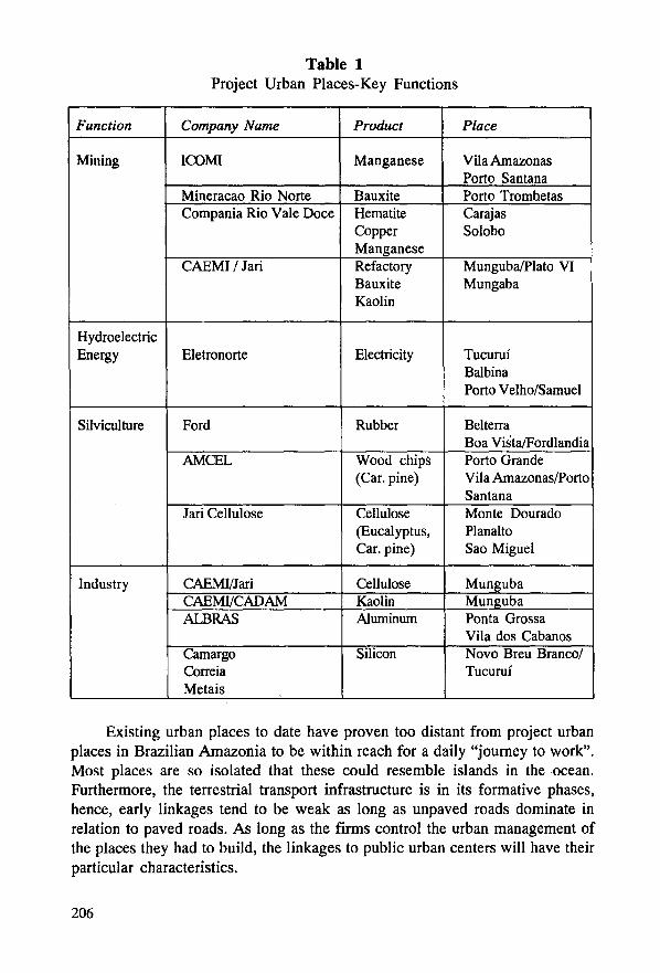
Table 1 Project Urban Places-Key Functions
Function Company Name Product Place
Mining ICOMI Manganese Vila Amazonas Porto Santana
Mineracao Rio Norte Bauxite Porto Trombetas Compania Rio Vale Doce Hematite Carajas
Copper So lobo Manganese
CAEMI 1 Jari Refactory Munguba/Plato VI Bauxite Mungaba Kaolin
H ydroelectric Energy Eletronorte Electricity Tucuruí
Balbina Porto Velho/Samuel
Silviculture Ford Rubber Belterra Boa Vista/Fordlandia
AMCEL Wood chips Porto Grande (Car. pine) Vila Amazonas/Porto
Santana Jari Cellulose Cellulose Monte Dourado
(Eucalyptus, Plan alto Car. pine) Sao Miguel
Industry CAEMI/Jari Cellulose Munguba CAEMI!CADAM Kaolin Munguba ALBRAS Aluminum Ponta Grossa
Vila dos Cabanos Camargo Silicon Novo Breu Branco/ Correia Tucuruí Metais
Existing urban places to date have proven too distant from project urban places in Brazilian Amazonia to be within reach for a daily "joumey to work". Most places are so isolated that these could resemble islands in the ocean. Furthermore, the terrestrial transport infrastructure is in its formative phases, hence, early linkages tend to be weak as long as unpaved roads domínate in relation to paved roads. As long as the firms control the urban management of the places they had to build, the linkages to public urban centers will have their particular characteristics.
206

s
·ro~ANDIA AHO IKL.Tt"IIA.
-.e101 IIL.ANTATIONS ON TIC TAN.JOS
""""•UAZIL.
~-~ • w
• ( 1 ••
ESTA TE VILLAG[ . . . . ~-""·-y·-r-.r'J J'T""T"
AT
IELTERRA BRAZII .. . . . . . .
• • • • • :~ , ~-, ·¡ : : • : : : : : : =1 1 '! \ ' 1 \ .... , J. 1 _ .. L _/ , .. . . • • • • ,¡ \
1941
e ' ~ e • • ' e o • •
• p :¡. e r
:: : : : :, /\·r 1\ , 1\ .. : : . -:--1 • • • • • • • • •. •. . ! 1 \ 1 ... ¡ • • • • •
-~- 1 • • ' e c • • e • • •· / ' • \' e • ' • •
-·---
¡
••••••••••·: \, • · es~• ..L_ 1 r e .... .,.,.,_~,1.'..._ \..' ...__ \._.,_,.__- t
..... ~ 1 • • • • • • ' 1 o •• 't•..... 1 • ---·
-- .... /~ -~''• ...... \ 1 ¡ '1 =• ~ 1 .. :: '•. ~·· ............ ¡.,,· ... ¡ •••• ,. ~--- ~.·\.....-.:;-;-~- ·~~...;. .---r\.:.. , ··-:.
., •••••••• 1 1 - \ ••••• ,, ..... • • e • • • • ,.... .. • ·-- ...__. • •· • • ·• • - '"'-=- • .::;: r:- . . . . • 1 \ 1 ¡-.. • : : ••
~ ;;;;.--o...-_ ·~ .-. • • ' \ , c ••••• lt ,.. .. ·~ ..... . .. _. • • 1 \ / ........ ·- •
) _,_ : : ~ ~ ~ ~ ~~:· : ~ . . .. . . . . . :· ¡ ~ : : :-~-1
j
Map3
. . . . . ....... .... . . . . . . . . . . .. .. ,.• = e t t .- . . .
Slightly over 500 km from the Amazon's estuary, Belterra is about 50 km from the confluence of the Tapa jos with the Amazon, with Fordlandia about another 60 km farther upstream. Plantation lots surrounded Belterra in 1942. In 1995 the rubber trees formed part of the vegetation ensemble (Russell, 1942, pp. 126, 138)
Resource utilization and project urban places in the future may experience more planning at the nationallevel. Moreover, as more urban places evolve in the region, the previous needs may undergo significant changes so that future project urban placesmay be added or incorporated into existing urban poles, thus, obviating the previously unavoidable needs for costly social infrastructure provisions.
m. TIIE FORMED ANO ICOMI PROJECfS
Antecedent experiences in project urban places recorded in Europe and the U.S. are of interest for possible parallels. Given the conditions in industrializing Europe and the U.S., the formation ofworker residential quarters was a response to changing housing needs. Robert Owen is noted for the improved housing he provided for his textile workers (Owen, Report, 1970, 97-8). Benevolo outlines, in sorne detail, the various utopian models dating from 1820-1870, in which Fourier's Phalange was given prominence (The Origins, 1967, 56-8). These also reached the U.S., where 41 experimental communities were initiated, revealing Fourier's influence (Benevolo, 1967, 63). These hada utopian orientation. Towns linked to production, especially factories, date back to the first decades of the 1800s. "The company town was the utopía of a capitalism striving to build an economic system founded no longer on land but on the machine, it was an ideal that made explicit, the incipient transformation of the economic basis of the American nation anda model that interpreted the myth, typical of early capitalism, of a perfect society in the service of industry" (Dal Co, "Transforming", The American, 1983, 191). The motive for developing this city, then, was the "factory". Circumstances differ significan ti y for the Brazilian Amazonia urban places. These are, in effect, the first to serve in the economic structure of the national economy when, in fact, much of Brazilian Amazonia was outside of the national economy until about 1961, when the highway linking Brasilia with Belém opened. While comparisons tend to be weak and flawed, awareness of the diverse vectors involved in the urban change process is considered intellectually necessary.
A. Belterra
In examining the Ford and ICOMI developments, the stark contrast with the European-North American changes are quite pronounced. The Brazilian condition was one of initiating change, the European-American constituted a response to increased production specialization, including changes in the socio-hierarchical order, notably, in the rural to urban transition. Ford initiated an enterprise that was, in every aspect, new, considering that Ford was unfamiliar with the physical world where the enterprise was implanted. There is no indication that a pilot
208

project for research preceded Fordlandia. There was no labor pool that carne with sorne estableshed or plantation labor practices. Here, one may interject the Southeast Asian experience and ultimate success as reference point only. Ford had to introduce town planning, agro-forestry, and a local transportation system. Ford found no infrastructure to use or antecedent system to build upon.
The Ford enterprise relocated to Belterra after the microcyclus (South American leafblight) infested the Fordlandia rubber plantation. At Belterra, Ford built a new town with essential infrastructure, much of which is in place and continues in use, even though Ford surrendered its property to Brazil in 1945 (Map 3). Belterra affords numerous aspects to consider in project and urban center formation. While in Fordlandia (Boa Vista), the houses were essentially American in style, the housing in Belterra reflected a more adaptive Amazonian modeled structure. For the plantation workers, upgraded local house types of local forest products were built. Administrators were quartered in individual houses of superior quality with tiled roofs instead of thatch as used in worker houses. Three main streets were paved and electricity transmission lines paralleled the streets. Even hydrants were installed once the water supply system had been brought on line.
Today (as of 1995 visit), much of Belterra housing continues to be in excellent condition and the residents make a concerted effort to preserve its original character. The residents guard the properties with great care and resist intrusion of different building types or styles (lengthy interview with resident Jose Moreira Pantoja, 12 August, 1995). The houses are airy, well-suited for the tropical regional and, by many, considered an important local patrimony. In many ways, it could serve as model on how to house people in Brazilian Amazonia, as it has turned into a Brazilian institution. In 1995, the community leaders were engaged in convincing the Pará State legislature to create a municipio (county) of Belterra, separating it from the municipio of Santarém. Ford as local factor has become irrelevant, yet it retains its influence though Ford as presence is history (see Amorin, 1995). Many of the residents (1995) served as functionaries in the ministry of agriculture, which owns the houses. Mr. Pantoja estimates that about 500 Ford houses remain. The Santarem authorities closed the Belterra Ford Hospital, which provoked the reaction culminating in the drive for county status. At the time, the Belterra population was about 8,000 people. Since Belterra is about 48 km from Santarém, and only a few kilometers off the partly paved highway linking Santarém with Cuiabá, service consolidation in the name of economy appeared attractive to the Santarém elected officials. The hospital is structurally in good condition, hence, its reopening would be costly in terms of infrastructure rehabilitation.
209

The Belterra experience is instructive in terms of what happens to an urban place when its raison d'etre disappears and it adapts to the changed needs for its continued existence. Agriculture may serve for an economic transition to provide economic viability for the longer term. Rice and fruit plantations could provide the raw materials for a local food processing industry. Proximity to Santarém means opportunity access toa market of 277,482 (1 July, 1993, IBGE, Annuario, 1994, 2-16). Just like Venice, Italy lost its commercial preeminence and replaced it with tourism toda y, so Belterra has options to crea te an economic base that reflects the level of initiative of its citizens and their perception of the local resource base and its potential uses. The Belterra experience informs about human hopes and economic cycles in how these influence and shape human settlement patterns.
B. S erra do N avío: The Mining Community
Serra do Navío is one of three urban centers that were created to provide necessary support infrastructure for the functioning of a manganese mining enterprise (1957-2003). The other places became the riverine Vila Amazonas, part pelletizing operation and raíl hub, and Porto Platón, halfway _point for the railroad, later to become a small urban center for support of silviculture experiments and developments (pine plantations and oil palm culture). Serrado Navío was placed in proximity to the mine with a rather complete socioeconomic infrastructure to service a complex population hierarchy, from executive level to untrained workers. For all the firm provided shelter and general services brought together in a planned urban nucleus.
The significant difference between Belterra and S erra do N a vio is that the Belterra experience was built upon an unproven biotic resource -rubber- which was without the antecedent research to plan for a long-term future. Serrado Navío owes its origin to a proven ore rese~e -manganese- with a defined life span of 46 years. As manganese is one of the more important industrial minerals in worldwide demand, a predictable income over the life of the operation made for the creation of a quality urban place. Its major owner, Augusto Trajano de azevedo Antunes (A. Antunes in short), instructed Oswaldo Arthur Bratke, architect-planner, that he wanted the urban place to be of excellent quality which could serve as model in the nation for future projects of this type (Ribeiro, Villa, 1993, 22). In this, Antunes' model succeeded admirably, as will be· detailed. Another important difference between the two project urban communities are their respective parentage -one foreign, the other domestic. While Ford carne with a Fordian frame of reference, pragmatic and structured, the houses first built in Fordlandia were wanting in characteristics for the humid tropics, a condition
210

N ...... ......
i 1 '/ .... ..; C..... ' r·· ' . . ~-, 1 ,, ~ ,, •• ·-- ----. . . . §si.- ' ú\l~üll\lfil}l))}f~r~::_-:---< .. Jl ~)?"-.. ·~ . . i'frn:l~ :,¡:-~·.": .:.- .. , .;;¡¡q'?.l •.<; .-:· ..
·.-.... ;• ~-n•·l' ll - -· ' 1 '' • ' • ·, ~-" • • <" ~c.,- -, :, . nu•· • ~ -~ .. ~ ,. . - -.. ol' ~ \ . -- '· "'F' .·· -. ../ . -o . - ~ . -...~- ....... .. .'i}: ~ l¡ .,., : '• .~ o!' ... ;( ' .. ' .. . "". \ ,1 • ·" i .. ~ "'· ., .-' ,· ~- . rl\ 1 .... ' " -~ a,-¿ r '\,. - ·. '!,;; • ¡ --... _~u·
lo\ ; ''l)'· \ ·.:;:,., . . . . '•
., . '• . '. ' "' PLANTAre~~···· -··, ,.,.... ·~ '. 1.·\. ~~--~ ' '· . __ ..... ,..-- ' --~- '· ·'·""., ~t _______ ::·;.-~;;e;:.::~'~\ • -,.'\. ·¡ .. ,......... \\ -....-....... -· ..... '·· -. . . . ": - )1 ......_.._·
&. \F"
Map 4 ICOMI built two urban communities independent in location to other urban places. In both urban centers ICOMI recognized social differences among its workers by separating administrators from workers (Operarios). (Farah, 1993, 20)

corrected, in good part, in Belterra. ICOMI (Industria e Comercio de Minerios, S.A.) on the other hand, was Brazilian and too k its time to plan the urban center and turned part of the planning task over to an M.D. -Dr. Hermelino Herbster Gusmao. Dr. Gusmao was environmentally aware and socially sensitive to in.,. teract effectively with architect Bratke. The houses were positioned on prominences to avoid house floodings, maximize exposure to air circulation, and preserve native tress close to the dwellings.
Serrado Navio was a bipolar community. To the north was the workers' housing, the service buildings -supermarket, administration, social facilities, such as pool, tennis courts, social club, and visitor's quarters- were centrally sited (Map 4). The southern segment was set aside for the managerial staff. House sizes and styles varied with position in the employment hierarchy. Workers generally received a 70 to 80 m2 (630' to 720'2) dwelling unit, high level managers lived in 180 to 200 m2 (1620' to 1800'2) houses. This pattern has been observed with minor variations for the projects studied. These are spatially comfortable living quarters, which have an ample porch and a shaded carport. Sanitary facilities are good, air conditioning tends to be found in the very large residences. It should be stated that the rents collected were and are symbolic, costly to the firm, and barely noted among the employees.
C. Villa Amazonas: Service Community and One Time Brumasa Seat, Now Home to AMCEL
This urban community is about 20-22 km to the southwest of Macapá and houses the staff involved in the shipping side of the operation. As the mining activity was, predictably, a declining activity, the company experimented widely in the agricultura! and silviculture sectors. The latter resulted in pine plantations exceeding 80,000 ha. (Champion Paper, a U.S. firm, purchased it in October 1996). This later development brings a certain employment stability to the firm and to the urban places installed for the manganese mining operation.
Vila Amazonas, as the riverside-sited community is called, is arranged very similarly to Serrado Navio. Guest houses and administrative staff dwellings are within 200 to 300 meters from the northern channel of the Amazon. Hospital and service facilities separate worker residences from administrative quarters1
• Vila Amazonas is a strategic point, as its port, Porto Santana, is the terminus for the railroad from the mine and the loading site for the ore to reach its varied markets.
l. Social and demographic analysis are weighty considerations, but here would unduly widen the scope of the study beyond its stated objective. These deserve full attention in another study.
212

More recently, this location has beco me the processing center for pine wood chips, whence these enter the export market via ocean-going bulk carriers. As ore shipping contracts, that of wood chips expands.
Porto Platón is a satellite community, designed to support the sil vi culture -Caribbean pine plantation and the oil palm (dende) plantation. These facilities are simple and many of the residents are from the state capital, Macapá, about a two hour car ride. The intent is to reduce the commute for staff and workers. Even though Porto Platón is linked to Porto Santana by railroad, the harvested pine trunks are trucked to the riverside wood chip processing plant in Porto Santana. The satellite community serves to house the field workers who plant and harvest the trees and oil kemels from the dende (oil palm). This affords an overview of how firms adopt to the spatial order they create and illustrates how economic considerations influence urban form and satellite town formation to secure a viable space-time system.
N. JARI: ANTICIPATING 1HE FUTURE
Jari is named after the river that divides it. Jari is a private property of about 1,632,121 has. lt's bulk is in the state of Pará and nearly 458,000 ha. in Amapá State, or an area the size of the state of Connecticut. This project was initiated in its major outlines by an American -D. Ludwig, shipping magnate- multibillionaire, iQ. foreign soil without adapting minimal sensitivities to the culture of the host country. Ludwig anticipated a world cellulose and food shortage in the mid-1960s, which encouraged him to search for a place from which he could contribute to solving this problem and also serve his interests. His perspicacity and commitment are convincing. The purchase of this tract of land (1967) opened possibilities to move in this direction. This required a pool of human talent that did not exist in this region of northem Brazil. Aside from the absence of the human resource base, the physical infrastructure had to be created, especially roads, energy sources, and urban facilities. Attention here is upon the last, though other facets will be considered in context.
A. Monte Dourado: The Magnet
Monte Dourado was built on a prominence on the westem side of the Jari River (Par á S tate). Its physical advantages are emphatically reinforced when the Laranjal do Jari, the initial favela community across the river from Monte Dourado rooted in the varzea on the Amapá si de of the J ari River, is more dosel y examined. The Laranjal is built on stilts to reduce the impact of seasonal flooding, and dwelling compaction was practiced to minimize construction of elevated walk-
213

ways. Totally unplanned, without capital resources, this became a complementary labor source for the Jari project over the years. Only now is the Laranjal tuming to plan and relocate to terrain well above the flood plain of the Jari (away from the varzea). In June 1995, Laranjal had 45,000 inhabitants, 33,000 in urban areas (data are from City Hall, Laranjal, 3 June, 1995). Monte Dourado's planned urban growth was then paralleled by the spontaneous growth of Laranjal, creating an unavoidable contrast.
Monte Dourado was planned and its first phase built by a Sr. Dourado. The real influence rested with William Turpin, who managed a construction firm in the U.S. (field notes, 22 August, 1995). Robert Gilbert, a Jari employee, visited Serrado Navio for ideas to be used in Monte Dourado, but there exists no visible evidence in the Monte Dourado urban pattem that Serrado Navio served as model or inspired any adaptations. Ludwig had the houses built American-style, boxlike, one floor, and attached two floors row house apartment buildings. These houses are conspicuously lacking in characteristics that include airiness to insure adequate interior air circulation. According to local informants (field notes, 21 August, 1995), the houses are uncomfortably hot. Actual house sizes vary with status of occupant (s) and location. The upper hierarchy staff occupy buildings that have a floor area of 180m2 or larger, and many of these are located on é\ prominence overlooking the Jari River. Besides being spacious, these are high-ceilinged. Workers' houses tend to be small, box-like, measuring 80 m2, built of prefabricated materials, dating tp 1971. A gridiron street pattern marks the urban layout, including sorne curving streets. The city has a central plaza without serving as a functional urban center. Jari-CAEMI (Companhia Auxiliar de Empresas de Mineracáo) missed an opportunity when the main administrative complex was located at the city's edge rather than its core. S pace for vehicle parking may have influenced this decision, but makes this, at least, a bipolar urban center rather than a single urban center.
Houses of key administrators provide spacious interiors and are placed on generously-sized lots in contrast to the far more closely spaced worker houses. The need for large houses for the managerial staff is rooted in the background of these important decision-makers: most come from larger to very large cities that have attractive and diverse amenities. Monte Dourado is new and remote and removed from a major urban pole. The nearest is Belém, and that is a 40-minute flight or 36-hour boat trip. To retain the direction-giving staff, the firm considers god housing for these employees than an essential part for its local viability. These conditions come under tension as the firm beco mes increasingly involved in world commerce and its products have to compete in the world market. Hence, the firm is exploring ways to reduce its cost in urban management and instead of token rents, is interested in collecting rents that are at least economically rational.
214

B. Satellite Communities and Silviculture Growth
Ludwig based his cellulose project upon an introduced tree. The tree -gmelina arborea, native to Southeast Asia and introduced to the Jari region from Africa, was intended to serve as basic raw material reserve for the project. A rapidly growing tree which can be processed within five years, providing a good yield as its growth measures 14 m3/year in poor soils and 42 m3/year in fertile soils. In the 1,632,000 has. of Jari, only 40,000 has. are considered fertile (Lins, Jari, 1994, 167). Jari management, at the time, planned for a 10-year growth cycle. The area destined for silviculture, at the time (1971-4), was set at 200,000 has. In 1995, 125,000 has. provided the raw material to produce 330,000 to 350,000 tons of cellulose annually. These sparse data provide a general idea about manpower needs, area to be tree-planted, and housing infrastructure requirements for the local labor force (Cameiro, Jari, 1988, 38-9). This presented the firm with a locational problem of strategic-economic complexity. The sheer costs of logistics and concomitant daily commuting would have doomed the project in terms of competitive costs in the world market. Without satellite urban centers, the firm would have to operate four daily multiple joumey-to-work trips. The two extra trips are the midday break. If all project-related personnel were concentrated in Monte Dourado, that place would be larger by about 6,500 to 7,000 persons, which would make Monte Dourado a far more complex urban center. Planalto is 10 km from Monte Dourado, Munguba is 15 km distant, and Sáo Miguel is 34 km from Monte Dourado. Instead of multiple daily commutes between Monte Dourado and the distant work sites, the firm opted to place the bulk of the labor force in proximity to the primary work sites. Thus, emerged the satellite urban places. Silvivila Planalto was the first, 1973-4, followed by Munguba, 1974-5 (Map 5), and Sáo Miguel, 1975-6 (Jari, Planalto, Munguba, and Sáo Miguel, 1992).
These three satellite communities share house types and sizes that are very similar, though Planalto, the oldest in 1995, was on the verge of extensive repairs and changes. The recently arrived town administrator wants all houses to be cleared of any additions that were made to the structures prior to their planned repairs and improvements. These satellite communities show different planning pattems. Planalto is compact in arrangement, while Mungaba's layout is bipolar, as is Sáo Miguel's. Mungaba houses especially workers engaged in kaolin mining and processing and the workhorse for the cellulose plant. Jari illustrates the interaction of transportation costs and town planning for large projects2• The difference between Planalto and the other two urban centers is notable for their
2. Even if not noted here, it illustrates the total managerial control of the operation, and the absence of political balance in the decision-making process.
215

N
0\
~';o. ·~\ .. '\"~~o
~' \~\ \~, '-:.: ....... ,.
'·;. / ··~· t,
'~-:.-:-:_,¡
o~r 1 At :Hih't.Hl'IHl'S
'.
. '
/ '·:~ -.~: .f-·. /('-, .... . , .,
...... .... ,,
'~·
/;-./5~-,/
u .··"
·---·-··
--~L' R ....... ~•t,.to --.- ....... .,__ Ul ~· ..
,.\/ ·"~' ....
xJ-
Map S Munguba serves as urban center for forest workers, factory staffs and administrators. The upper right houses the higher ranking employees. Munguba is closest to the Kaolin processing plant and cellulose factory. Both of these are at the Jari River's shore. (Jari, 1992)

respective planning, and this within, at most, a year to one and a half years in time difference. In case of expansion of the area in silviculture, the firm will be more hesitant now than when Ludwig was with town-building in the 1970s. By this time, the firm has accumulated a large body of economic data, affording it to evaluate the long-term cost factors. Jari is competitive with its more sizable competition because it reigns in distance expenditures according to Pimentel, one of the key analysts for CAEMI. Distance from forest to mill averages 45 km for J ari, greatest distan ce is 82 km. Its nearest competitor in shortest distan ce has to count on 61 km to mili on average, while the largest firm's, Aracruz, mean distance is 177 km from its milis and on Thünen ( der Isolierte Staat, 1826) stands fully confirmed (Companhia Floresta} Monte Dourado, Jar4 1995, 33). This example illustrates the role of the influence of space in organizing a marketdependent industry.
While the spontaneous urban community of Laranjal do Jari has been discussed in the context of Monte Dourado, numerous initiatives have been organized to provide its residents greater environmental stability. This means that the current urban center will shift to terrain beyond the current flood plain. To this end, SUDAM (Superintendencia do Desenvolvimento do Amazonia) has sponsored a plan for the future of Laranjal (SUDAM, Plano Director, 92). Laranjal was chosen by SUDAM for intervention to change the course of its urban development. The professionals writing the analysis for the plan are rather con cerned about the new urban centers in Amazonia following a formula in which worker town"s were built, places for the bureaucrats, technicians, and the directorate were implanted, creating Company Towns (ibid., 3). The original urban center generally became the magnet for a spontaneous place to emerge in proximity to it. This turned into a "reservation for unskilled workers who provided minor services for those in the established urban place (s). These places grew without the necessary town infrastructure. Moreover, the population increases were so large and swift, that these places became rapidly peripheries" (ibid., 7)3• Hence, the shift from the flood plain site to the "terra firme" will take far longer than government planners anticipate. Laranjal will relocate, except it will most likely occur when a major flood forces an evacuation.
In Brazil, in general, and in Brazilian Amazonia in particular, there are very few urban places that are without favelas, built urban places without infrastructure and peopled by squatters. The logic for these emerging urbanites and their site selection tend to be compelling, namely, potential job opportunities. Their choice
3. The authors of the plan consider large projects detrimental to the region. Project management creates the urban centers and provides the needed services, as these centers are run by the firm, not elected officials. While these concems are understandable, they neglect to outline how they would manage an introduced project.
217
of location reflects a sound sense of spatial relationships in proximity to an active work site. A similar site choice can be cited for the U.S. migrants who carne to New York City from the south. Their choice locations were in proximity to the major subway lines and particular stops, such as the Broadway line (# 1) in Manhattan, or the Lexington, White Plains Road system in the Bronx and Brooklyn (# 4, # 6) to cite examples (see, also, Kantrowitz,Negro), to keep the journeyto-work costs to minimal levels. A good Brazilian example is the town of Parauapebas, which emerged as a satellite for Carajas; Tucuruí, the old town became a satellite to the one that was built to house the dam builders. These unstructured urban places, in a way, turn into labor pools for projects. Laranjal do Jari, built into the flood plain of the Jari River, was sited across the river from Monte Dourado, which takes, at this point, about 3 minutes to cross by motorized boat. While Jari had ready access to daily wage workers, the case of Parauapebas is more controlled, as the mining town of Carajas is about 35 km from Parauapebas, creating a more restrained relationship in access. Instead of boat, bus service provides the necessary daily commute. Company projects are managed by the firms and the urban places form part of the operation. There are no elected officials, the officials are company-appointed. These urban places are managed in a functional context.
V. MINING AND INDUSTRIAL URBAN CENTERS
In Brazilian Amazonia, the more significant projects tend to be comprised of four key groups:
l. Major mineral extraction (bauxite and hematite), gold is excluded as it is in the hands of garimperos, or individual placer miners;
2. Industrial centers, which evolve in relation to local resource extraction. There are three so far: Jari, Barcarena, and Tucuruí;
3. Silviculture and oil palms spawn their particular kind of urban system; and
4. Urban places to serve dam builders. These tend to be temporary and only a segment remains for those to operate and maintain the power plant.
From the short identification of the sectors that foster the formation of urban systems emerges an overview of the genesis of these places that arise in a predestined process.
A. Mineral Discoveries and Urban Place Planning
Discoveries of major industrial mineral deposits in Brazilian Amazonia brought
218

about the formation of urban places to house core employees. Between discovery and mineral production, a certain time lag affords project developers opportunity to plan for an urban place in the project area. Urban site selection is guided by accessibility to transport facilities and their formation. Aside from preparing for the mining operation to enter production, town and transportation systems have to be put in place. From mineral discovery to assembly of plans, feasibility study, capital assembly, development of mine, markets and staff tend to be drawn out. This can take from 5 to 30 years. At Carajas, from discovery to first hematite shipment, 18 years elapsed (1967-1985). Porto Trombetas was about eight years in organization, and Serrado Navio, from discovery to first manganese shipment, took 14 (1943-1957) years (see Jones, "Mining", 1986, 164-6). There is time for urban place planning, but it gains in attention only once a production schedule exists with set target date. Actual town-siting is significantly influenced by the transportation system to be used. All three mines required freight raíl line construction linked to deep water facilities. This played a deciding part in locating Porto Trombetas town, close to the Trombetas River. At Carajas, the first urban center was placed at Serra Norte, dating to 1982. This urban place was located on part of the ore deposit, which made for a most difficult sewage condition. It is said this was done to insure its relocation to a suitable site at an early time (Farah and Farah, Vilas, 1993, 30). This is the only instance known, so far, where the original town had to be demolished in a mining complex and a different one had to be planned and built (Map 6).
The mihing firms are the planners and builders of the towns. Costs and management are the mining firms' responsibilities. There are no state or federal officials on the site in any official or managerial capacity. These firms are in complete control of town administration. There are no elected officials nor any law enforcement agents to be found, instead, there are guards as part of the firms' employees, and town administration is in the care of an upper-level administrator. These can be described as apolitical urban places as long as the firms plan to control the urban administration. As Serra do Navío approaches the exhaustion of manganese ore, CAEMI4 has initiated the transition from a closed community to an open urban place with an elected mayor and state financia! support. Changes can be anticipated.
Mining towns resemble those created for industry and hydroelectric projects. Size and house types vary with employee rank in the system. Executive and key professionals are provided houses that commonly average about 180 m2 of floor space; employees at lower levels occupy dwellings that average 70 m2• More
4. CAEMI hod offered the town to the University of Sáo Paulo to organize a tropical reasearch institution, but the University decided against this opportunity
219

N N o
. ~- .. r""\ u
i
~ ~-
~--
l
tt .. r~ ._'- ~t
.)
..... , ~·-- ""'"'- -~· ·¡·~~~~
/~ JI 'r·t
~::~·: ;··· ·~f.~··.i:··.:•.":¡r ;.:~0:.=: i:~~~~-... · . i ... ~ •. l.(: .............. ~··· ............ ·~·-····! :\ ........ ·
--- ~&~J.~~:~~l~:~~~i:I;:1::~¡ : ~l·W·:•:.;,,.,.¡,.J~;.,. · ·:·;~; •• · ... ~J ... ~_. ,_.~,~~·J ~1:! ~ ....... ~, . ,_. ••••·
-z=~ .... ;,.,¡.,•,r~':'i-;4-:.!,!í~:}T-·• ... :•¡~: .. 1 ·.- .. , ... ~.' .. v•:~.~ ~~~l"~ ~~~~ •: .. 1: 1 ~ ._""'"..;.• (: • io~tlts~vj¡)P.ilt"·-~·L,"ftll·U .. ,::,/ .... l .... .a.'t1r,:)-,1'ff~~":'F-IiC.I"~ ... ·~1 • -~ ,. ! .. ,¡ .. -••••• .,.,,,:.; •• \., .... ~~- ,,,~-'·-'~ 1 ·:: .,. •••• 't. ... ~ .. ,
!' jo'
:.~:..: . . ....... , ...... ····~· · ..................... ~i.t' "~rr ~- ~ . • , .•• _::::... ~ ~l. ~:-.i:i::~~.}~::;:::-'-'~~::.:~~D~;~~4~-~~;:~~:: .. ~ -·~ :1······ r::======-::·-::::·=====:::t
_i.
l 1!
·:·· ';j' f;~~ ~~
'· ¡! .. l
·:·' 1
,, -a¡-:""' .. 1 ~ Núcleo urbano de ,.. s.: _ .. _. :-1 Carajas
Map6. Carajas is a city of nearly 2,000 housing units that range from estate villa to modest house size. Lot sizes for the higher ranking staff are visible on this greatly reduced map. The designer of this urban unit placed urban, commercial functions in the periphery and a lowed only the school system to occupy a centrallocation (CVRD, 1991, single map)

recent constructions for lower level staff may drop to 60 m2 per household. As the houses decrease in size, their aesthetic appearance also diminishes. The larger houses tend to have large living quarters and comfortably kitchens and porches. The differences among these dwellings is notable in every aspect. In Carajas, the street pattern suggests homogeneity among the houses, but they differ significantly. in size. Many of the houses have carpets, reflecting the period of their construction and occupants' needs. The town planners also included bicycle paths, pointing to town size and expected mobility preferences. Carajas has been planned with a long-term perspective, as the mine has a projected productive life of 400+ years.
B. Industrial Town Planning
Industrial projects of any magnitude are few in Brazilian Amazonia. The Barcarena industrial complex has been built into the lower Pará delta, southwest of Belém. This is an aluminum facility with an annual production capacity of 320,000 tons of ingots. The energy is provided by Tucuruí dam to the south via two 500 kv lines. Ponta Grossa is the actual site for the plant and the port where bauxite and ingots cross paths. Vila dos Cabanos is the urban community planned for the resident staff and workers (Mps 7a and 7b). The land set aside for this community far exceeds the actual built area. The original plan was for 3,000 dwelling units, or another 1,417 can be readily sited. The planning of this community goes back to 1979, but its construction was coordinated to coincide with the factory, which set the pace. Anticipated population size is 12,000. In August 1995, 1,115 employees lived in dos Cabanos. House construction dates to 1984 but extended into 1988, when 1,583 houses were completed, with 50 houses built in the city of Barcarena. While the site was first visited in 1979, the visit in 1995 showed an urban complex adapting to changing conditions and needs. The Brazilian government was a partner in this project from the outset and, for this purpose, created CODEBAR5 as its oversight organ. One thousand five hundred eighty-three (1,583) houses were built to serve the needs of ALBRAS (a joint venture firm -Japan-Brazil). Dos Cabanos is open to non-Albras staff, which allows for variation in residents as well as make for changes in urban forms and functions. Urban place morphology, as envisioned by large firms, should not be expected to be continued unless the large firms persist to manage these centers at their expense. The hydroelectric sector may insist upon a small cluster of its housing stock to retain its original morphology for its permanent staff that manages the day-to-day functioning of such facility.
5. CODEBAR continues to function as a real estate firm. CODEBAR's performance proved substandard in the perspective of ALBRAS
221

The reasons for building industrial urban places in Brazilian Amazonia are resource and location propinquity. In the case of the Ponta Grossa aluminum plant, the riverine location on the Pará River, in proximity to a major labor market -Belém, and access to low cost energy in adequate volume from Tucuruí, satisfy significant constraints. Ease of delivery of the major ingredient in aluminum production, bauxite, from the Porto Trombetas deposits, facilitate the regular flow of raw material of the plant. In the meantime, the alumina plant in the complex entered production so that the bulk of the raw material used in the aluminum production process is locally transformed. This, in turn, augments the number of the locally employed who can locate their residences in Vila dos Cabano. While the locational concerns can be considered well met, the social cost factors, on the other hand, may well be under pressure, considering that this is a joint venture operation -Brazilian-Japanese, 51% Compania Vale Rio Doce, and Nippon Trading Co. with a 49% interest (field notes, 18 August, 1995, Ponta Grossa). Most of the aluminum produced in Ponta Grossa is destined for the Japanese market, the Japanese partnership in socioeconomic perspective will be world-market sensitive and unenthusiastic about socioeconomic needs of its Brazilian partners in Ponta Grossa. Needs for urban place construction are one condition, urban place management and financing of social services are different variables that marketdependent systems seek to reduce to the barest mínimum that can be secured.
At a more modest level, Camargo Correa Metais has been able to establish a modern silicon plant very el ose to Tucuruí dam in proximity to energy, urban shelter, and its raw material source. The firm has begun planting eucalyptus in the immediate area of its factory for needed charcoal production. Moreover, the silicon factory is sited on the edge of Breu Branco, a small urban place built for relocated riverside residents from the Tucuruí reservoir area. Technicians and executives reside in the city built by Eletronorte for its construction staff, while lesser employees are housed in Breu Branco. This is an opportune sequent occupance, as one function ends -dam construction- the next one -silicon production- comes on line and its staff contributes to the urban continuity and viability of urban places.
In 1995, the site for a copper smelting facility based on the Solobo deposit -1.2 x 10⁹ tons (Carajas)- was under intense discussion. This would be the fourth large resource processing plant in Brazilian Amazonia after Barcarena (Ponta Grossa), Tucuruí (Breu Branco), and the cellulose plant and coaling processing facilities in Jari. The contending urban centers for the copper smelter are Marabá on the Tocantins River and Parauapebas, only 35 km from Carajas and about 60 km from the Solobo mine. Locationallogic would si te the facility within Carajas in proximity to the ore body to reduce transport costs for the tailings, but political considerations may prevail with their particular politicallogic. This, in turn, will
222

impact upon the resulting urban system of either Marabá or Parauapebas. It is unreafistic to underestimate the role ofpolitical influence once it enters the state's or country's political life. As the changes become more numerous in the study region, and as the stakes gain in magnitude, previous experiences serve as models to provide a base for more democratic participation, read decision-making. Compensating, taxation could persuade contending parties to reexamine respective positions and permit optimal resource management and urban plan formation. This would also enhance domestic economic planning policies.
VI. HYDROELECTRIC PROJECTS ANO URBAN PLACES
PLANTA ESQUE.MÁ TICA !lAS 'liLAS DA E,LECTRONOATE EM TACURU[
Map 8. Tucurui had over 6,000 dwelling units, which accounts for a more general map, obscuring varieties of house sizes and respective locations. The urban core is built on high lying terrain. The permanent housing stock is of good quality (Farah, 1993, 56)
Hydroelectric projects in Brazil Amazonia require urban support systems. Few dam sites are in proximity to urban places. Power firms, thus, need to include urban place construction into project analysis, planning, and budgets. A further complication to urban place formation for hydroelectric projects in that the largest number of residences built are effectively occupied by the dam workers for a comparatively short time. Furthermore, dam construction is governed by two construction phases, namely, the civil infrastructure 1) the barrier -reinforced concrete structure and the needed earth dam wing segments, and 2) the mechanical infrastructure dominated by turbine- rotor and spillway control gates instal-
223

lation paralleled by transformer and transmission systems placement and connecting. That allows for sorne flexibility in housing, as the civil infrastructure moves toward completion, this specialized work crew is gradually reduced in number, affording the mechanical installers to occupy the residences, thus, vacated. A form of sequent occupance results. At the same time, the planned urban places from the outset include a cluster of majar houses for the chief project managers during the construction phase, followed by the resident manager and the operating crew once the power plant enters service (Map 8). During the construction phase, different specialists served specific construction phases as the dam moved toward completion. With the last turbine installed, the remaining staff declined into the hundreds for the day-to-day operations at Tucuruí. May 1981 was possibly a peak month, with over 30,000 employees in place, this number declined to abut 10,700 by May 1985, illustrating the rhythm of work with its peak and approaching strength (see Table 2).
Table 2 Tucuruí Population and Housing Data1
% of Total
Employees Population Month/Year
29,884 54 May1981 17,890 42 May 1983 18,478 39 May 1984 10,699 35 May 1985
Eletronorte (1981), (1983), (1984), (1985). R.T.U.C. Administracáo.
Total People 17 Years
Population and Younger
55,499 18,731 42,739 19,839 46,872 21,758 30,214 14,025
Housing
o/o. Units
33.75 5,391 46.4 6,221 46.4 6,215 46.4 6,152
1 Usina Hidrelétrica Tucuruí, Resumo Estalística- Mayo 1981, Tucuruí, Eletronorte, ps. 1, 2, 3.
A. Project Sea/e and Urban Place or Enclave Size
Urban place formation for hydroelectric projects is uneven in magnitude and unpredictable when it will be realized. With much of the housing temporary in intent, such urban places manifest distinct priorities as are commonly associated with mining and industrial centers. While the spillway in Tucuruí is completed, the powerhouse awaits a doubling in magnitude. There remains a need for available housing stock once the second phase powerhouse will be built, projected to start in 1997/98 and be complete by 2002 or 2003. The number of workers needed for this segment will be significantly smaller than when the dam was initially constructed. For this segment, it is anticipated that 5,000 employees will be an adequate number to complete the dam.lt Eletronorte had to build Volta
224

Grande in the very near future on the Xingu River, then it might remove a large portion of the currently vacant wooden housing stock in Tucuruí. This suggests planning flexibility on the part of the Brazilian power sector.
Samuel dam on the Jamari River is the only dam, so far, where the power firm, Eletronorte, could locate its permanent housing for building managers and subsequent resident managers and operating staff within the city limits of an established urban place. Porto Velho is about 50 km west of the dam and is linked by paved highway, requiring approximately 45 minutes oftravel time. During dam construction, a housing compound for single workers was provided at the project site. The dam is rather small, 216 MW, requiring, proportionately, a modestlabor force, translating into modest housing needs. Tucuruí is located near an established town, but the town was small and lacked growth prospects. Here, proximity
. served to establish a first foothold close to the dam si te (vila pionéira), but instead of building onto this place, the power firm created its own urban place with its own administration, social services, education, health, and security. Politics was excised.
The city that Eletronorte built in Tucuruí in the meantime, has attracted fishing operations and marketing. A large sawmill has established itself at the southern margin of the town near the lake edge. At the same time, the major contractor, Camargo Correia, who built the dam, has opened a silicon plant nearby and many of these workers and staff reside in the city built by Eletronorte, renting 240 houses from Eletronorte. Another 450 houses were rented to non-Eletronorte tenants in 1995. Once the second phase of the dam is completed and other industries could seek to locate in the town of Eletronorte, which would insure an effective continuity of the place while Eletronorte could recapture sorne of the original government investments. The introduction of large hydroelectric projects creates options for change previously unknown in Brazilian Amazonia. As these changes materialize, the dominance of the other Brazilians, the nonAmazonian Brazilians initiative reveals itself and contributes to political friction. Change does not come without bumps.
B. Antecedent Urban Place Experience: Future Possibilities
Volta Grande is a project on the Xingu River below Altamira, to the east and slightly north. This project has been in study since the mid-1970s, or for over 20 years. The construction time to complete this 11,000 MW dam is projected for about 15 years. In this time of privatization and possibly alternate sources of energy, this dam may not be built at all. In the meantime, Brazil, in all likelihood, will have to cope with severe electricity shortages, and to cover these will encumber the economy. This m ay cause further energy developments on the
225
Tocantins River, requiring sudden urban project planning. Hasty decisions can be costly for the domestic economy. But planners had to give the project considerable thought and what to do for the housing needs of a projected labor force of 35,000 or so employees. Here, analysis diverged between placing the workers community into Altamira or locating it at the project site. The distance from Altamira to project site is about 55 km. Merely consider the logistics of transporting sorne 11,000 to 12,000 workers per shift, 3 shifts a day, or 66,000 to 72,000 passengers per day. The bus park for such an enterprise and its acquisition costs cause one to pause. Next, the highway that needs to be built, at least four lanes for buses and trucks.
By 1995, the thinking about a "vila operaria" (workers' city) had undergone change among the planners and decision makers of Eletronorte. Altamira, as site for the "workers' city" was discarded in favor of a location in proximity to the project and in the county of Senador José Perferio. Taxes and royalties are payable in the county of operation, hence, Altamira loses because of geography and county boundaries6• For Eletronorte, this is rational for urban and regional planning if Altamira is considered a regional pole, the long-term consequences are complicated. It is the duplication of service infrastructure that will be created in the new urban place that draws attention. Eletronorte in Altamira would be subject to local and state politics. In the new urban place, Eletronorte would retain control of all aspects of urban management. People who consider this part of hydroelectric projects, now include lots for non-project or third party people to own property in the company town. As of August 1995, the housing question remained influx (lnterview, Brasilia, 8NIII/95).
lf the urban agglomeration is built near the constructions site, time and transport economies would be massive. What would be the prospects for this urban place to be a viable economic center once the project is completed? This is a social investment that is about 12% of the project's total costs, projected at current prices, 8 to 9 billions, or for $ 8 x 10⁹ it would be $ 960,000,000 and at $ 9 x 10⁹ it is $ 1,080,000,000. At tucuruí, the urban place took 18% of the project costs. lf the new urban place were to be sited adjacent to Altamira, very different possibilities emerge ( one should allow for the possibility that Altamira could equally relocate near the dam location). Altamira is located on the Transamazon highway and has become a major regional commercial pole since its opening, even though the town's foundation dates to 1868, legalized in 1874. If Eletronorte were to build into Altamira, serious thought should go into rigorous
6. The royalties are the result of the 1988 Brazilian Constitution, which stipulates that a resource- yielding county shall share in the productive benefits derived from its resources.
226

urban planning for well beyond dam completion. Eletronorte should think of office buildings of 6 to 10 floors for its technical and administrative staffs. Investments in improvements in local health and educational facilities would be leading considerations. Por the administrators and future power plant operators, quality apartment buildings with six floors should be placed in proximity to the administration cluster. Altamira, as place, would gain focus and become an urban place with an identity. Should the Brazilians ever decide to build the other dam above Altamira, a 6,500 MW project, they would have the urban infrastructure to carry out that complex. These sparse comments illustrate the quandary the planners have to negotiate and the frailty of the future where politics has the last word. This also awakens a certain sensitivity to the meaning of "permanence". What works can be considered permanent and what criteria help to identify the permanent?
C. Tucuruí As Seen in 1995
By 1995, the administrators of the Tucuruí urban system had garnered enough insights to approach the subject with a more balanced perspective. lf the project were to be built in 1995 or subsequently, the firm would charge its residents a 5% tax on wages for the housing provided, instead of the symbolic fee traditionally collected. At the time when the town was built, Eletronorte lacked general support from the local community. The old Tucuruí did not want a rival town in its sphere of influence. Then there existed no provision for royalty payments to be part of the project presence in the county for the county treasury. This condition has changed since 1989, and the project infuses a significant cashflow into the county's administrative expenditures, reducing its dependence upon local taxes and state budgetary support.
According to the informant (Brasilia, 8/8/95), the wooden housing in Tucuruí has been taken down. It has to be noted that these temporary structures were sited on the land of the future canal that will make the Tocantins River navigable above Tucuruí. Tucuruí dam includes a lock to insure navigability of the Tocantins River. In 1995 there remained 2,500 houses in Eletronorte's Tucuruí and ofthese, 1,400 were occupied. Camargo Correa, the key contractor for the dam, occupied 240 of these. Another 100 houses served employers of Camargo Correa Metais, the silicon factory in nearby Breu Branco. There remained 1,100 houses vacant in 1995 in anticipation of the resumption of the powerhouse construction before the end of this century. Should there be a dwelling shortage, instead of building, Eletronorte will turn to renting and gladly pay the rent instead of building additional housing stock. (At the time of my 1993 visit, people camped at the entrance to the project, claiming rights to reside in the vacant project houses).
227

Choice of pro test location was predicated u pon visibility and publicity. And the press obliged, as did TV and others. Cumulatively, these experiences will result in more restrictive urban project planning and reduced financia! resource allocations for infrastructure and social amenities. One of the first places where to assess changed project town planning practices will be in Cachoeira Porteira (Porteira River), a project on the books for more than twenty years. On the left hand side of the Amazon River, the site is essentially unpopulated until now, hence, housing has to be provided for the project builders. Symbolic rents appear destined to be something to commiserate about, but a thing of the past. The open market may even become part of the housing system and with it competitive rents. A profound change in the urban geography of projects is indicated.
The housing question for future project sites continues under review. By 1995, Eletronorte had advanced its thinking about projects and housing to the level where it would oblige the con tractor to build their housing. Even if the con tractor is paid, Eletronorte no longer has to carry the financia! burden over the long-term. Moreover, the administrative functions became part of the changed arrangements and Eletronorte need not divert technical staff to administer and manage urban places. Eletronorte's thinking is focusing on its technical mission and leaving the socio-urban domain with the project contractors (Brasilía, 8/8/95).
In a parallel perspective one can consider the Eletronorte hospital in Tucuruí. Eletronorte built a 220 bed hospital for the project and town population. With the project three-fourths completed, the hospital has become a financia! drain on Eletronorte's budget. Eletronorte offered the state the hospital, possibly the best in Pará S tate, but the state refused the offer. This helps to fathom the complexities of the development process and the order of priorities as perceived in the political milieu. Another question that projects itself is the comparative levels of attention to the common welfare and human health. The State's -Pará's- response to Eletronorte points to very different levels of priorities for the public vs. workers' health needs. Hospitals and their comparative qualities afford instructive insights.
Vll. PROSPECTS FOR OTHER PROJECTS ANO URBAN CENTERS
As the world's economies become more global in scope, prospective projects have to muster enough economic staying power as their products enter the world markets. This brings with it, economic constraints that spill over into the social fabric, which is in its early phases of formation in Brazilian Amazonia. Project developers and investors will seek to keep investment costs to the bare mínimum which, in turn, will include minimal allotments for urban town formation. A socially sensitive frame of reference as demonstrated by A. Atunes will be an unlikely and, at best, a unique case at this in the future. There have been no major
228

project developments in Brazilian Amazonia within the past 15 years. Changes will be small to modest to escape major social overhead expenditures.
Within the past fifteen years, no substantial projects, including workers' urban centers have come into existence in Brazilian Amazonia. Privatization has sidelined the government as project originator. Military presidents (1964-1985) had their agenda for projects in the region then. The likes of Ford and Ludwig, with their particular visions and ambitions, tend to be exotic blips in the region's history. Brazilian capitalists of A. Atunes aspiration and perspicacity remain to appear on the scene. Another indicator that few large projects will be implanted is the sale of AMCEL (AMAPA Floresta! e Celulose) to Champion, the U.S. paper firm (Jarilino, September 1996). Instead of model projects, most changes in Brazilian Amazonia lack the needed capital resources to enhance the region's physical productivity and further the local people's economic viability.
The increased reluctance to build project urban places in Brazilian Amazonia within the past fifteen years means that well-managed changes for a time will be displaced by activities with an uncertain future. Environmental degradation will gain as the population increases in numbers and struggles to exist. lf large firms enter Brazilian Amazonia in the future, these will seek to implant petroleum platform communities to escape large-scale social infrastructure systems. Transportation, notably airports, will become management's mean to avoid construction ofworking P.eople's towns and make the firms more viable in the global resource markets. Workers remain on site for ten days, then rotate out for the next group to take over. It is both impractical and unwise to think that past practices will repeat themselves. The evolving spatial order in Brazilian Amazonia will be time and economy conditioned. People considerations face an uncertain future in such context.
To sorne extent, this change can be observed in Ponta Grossa, Vila dos Cabanos. A large number of the staff who works for ALBRAS, communtes daily by boat to the aluminum factory. There are at least six buses that await the boat's arrival at dockside in Barcarena from Belém. In the afternoon, at 17 hours, the reverse trip starts, and by about 18:30, the people are back in Belém. Nearly 300 people make the boat trip every workday. These employees, thus, free ALBRAS to provide housing for them. And the Japanese partners (ioint venture) are eager to reduce the expenditures in Las Cabanos further by inducing more people into the daily commute (interview in Los Cabanos, 18NIII/95). Thus, ALBRAS is pressured by its Japanese partners who have no interest in subsidizing Brazilian social practices of symbolic rents (virtually no rent fee ). ALBRAS pursues a policy to get out of town administration complete! y. Its idea is to turn functions over to those who reside in Los Cabanos. One example of the current expenditure
229
is the education budget. Run by a group of Rio de Janeiro educators, the educational system needs $ 150,000 per month, or $ 1,800,000/year. Japanese unwillingness to share in the social costs of the project points to the future function and reduced prospects for large projects to root effectively in the region.
VID. REFLECTIONS ON THE VAGARIES OF PREDICTION
Urbanization in Brazilian Amazonia has multiple morphologies and is too often without a metamorphosis that is genuinely urban. A place may have the urban veneer but be without the essence of urban culture. Project urban places also register notable deficits in urban characteristics, as the sponsors have neither the capital resources nor the plans for such attributes. The culture of cities emerges generally out of the culture of the resident citizens. This, however, requires time. Mumford notes that " ... planted tissues need not even be in the form of living people; the collective organs of culture, signs, symbols, forms, the abstract and etherealized essences may likewise exercise a decisive effect ... " (1938, 295). Patience and expectations have to afford the project urban place time to implant the cultural life that is consonant with their citizens' cultural aspirations. Culture infuses urban places with character and viability and provides a place with its indispensable identity. ·
Urban attributes and character may suffer notable difficulties in Brazilian Amazonia as the mode of urban place formation under the auspices of large projects may be increasingly curtailed in scope and functions. Past practices allowed and included a place for cultural recreation besides clubs and sport fields and swimming pools. It is unwise to anticípate that the future will afford greater attention to culture, when the more immediate living facilities may be turned over to the project contractors for construction and management, who, in turn, tend to be minimalists. During the last two visits into the region, 1993 and 1995, these topics were explored with numerous contacts. At MRN (Mineracáo Rio Norte) the contact talked at length for the need of tighter management and reductions, especially in social costs. The petroleum platform approach was presented in detail and considered for replacing what is in place then. This approach constitutes a radical change from what is in place then (1995). The informant stated that projects would no longer build towns, instead use the petroleum platform and rotate the staff about every 10 days (Rio de Janeiro, 31NII/95). A number of the large firms, which administer project towns, have reviewed the conditions and costs and the outlook is for substantive changes. To place a single person to work, costs the mining firms $R 360/month and $R 740/month if it is a married couple (Rio de J aneiro, 31NII/95). A house for MRN costs $R 30,000 in Vila Trombetas. The large firms in the region have accumulated insights that makes then reconsider past urban place projects and future needs. World market prices and their
230

fluctuations curb earlier expansive optimism.
Mining and hydroelectric project managers are viewing existing project urban places in the past tense. For the moment, no new projects are in their initial phase. However, once these are initiated, a much better overview will be possible to compare past practice with the new approaches. The initial phase of project urban places can be considered models worthy of continuation in scope and intent. The permanence of these places is variable and reflects resource association and uses. If the level of investments is considered, how can locational optimization be achieved to preserve the urban infrastructure for more universal functions. Privatization will not simplify the process, nor be concerned about regional development. That is why the placement of the project town for Volta Grande would be suitable long-term planning. If one accepts the ephemeral attributes of much of human effort, one fathoms the transitory character of these places. How can one explain the misinvestment of large capital resources in a socially fragile system, when so many social needs remain unattended?
BffillOORAPHY
AMORIN, Antonia Terezinha dos Santos 1995 A Dominacao Norte Americano no Tapajós: A Companhia Ford
Industrial do Brasil. Santarém, Tiagao.
BENEVOLO, Leonardo 1967 The Origins of Modern Town Planning. London: Routledge of
Keagan Paul.
BORELLO, José Antonio 1992 "The Question of ldentity and the Generation of Knowledge in Latin
American regional Planning Theory". Coraggio, Boisier, Rofman and DeMattos, International Journal of Urban and Regional Research, XVI, 4, 602-622.
BUDER, Stanley 1967/1970 "Pullman: Town Planning and Social Control in the Gilded Age", in
Urban America in Historical Perspective. New York: Weybright and Talley, 247-257.
CAMPANHÍA FLORESTAL MONTE DOURADO 1995 Jari: Celulose S.A. Monte Dourado: C.F.M.D.
231

CARNEIRO, Glauco 1988 Jari: Urna Responsibilidade Brasileira. Sáo Paulo: Lisa.
CLEARY,David 1993 "Mter the Frontier: Problems with Political Economy in the Modern
Brazilian Amazon". Journal of Latin American Studies, XXV, 2, 331-349.
COMP ANHIA FLORESTAL MONTE DOURADO 1992 l. Munguba; 2. Silvivila do Planalto; 3. Sáo Miguel. Monte
Dourado: Depto. de Engenharia.
CRA WFORD, Margaret 1995 Building the Working Man's Paradise: The American Company
Towns. New York: Verso.
DAL CO, Francesco 1983 "From Parks to the region: Progressive Ideology and the Reform of
the American City", in The American City from the Civil War to the New Deal. Edited by G. Ciucci, F. Dal Co, M. Manieri-Elia, and M. Tafuri. Translated by B.L. La Penta. Cambridge: M.I.T.P., 143-291.
DEAN, Warren 1987 Brazil and the Struggle for Rubber. New Yor: Cambridge U.P.
DINIZ, Clelio Campolina 1994 "Polygonized Development in Brasil: Neither Decentralization nor
Continued Polarization" Internationallournal ofUrban andRegional Research, XVIII, 2, 293-314.
EIEIRONOR1E 1981, 1983, 1984, 1985 U. H. Tucuruí: Resumo Estadistica. Tucuruí: R.T.U.C.
These are all for the month of M ay.
FARAH, Flavio and Martha FERREIRA SANTOS FARAH 1993 Vilas de Mineracáo e de Barragens no Brasil: Retrato de Urna
Epoca. Sáo Paulo, S.A.M.A./I.P.T.
FORD
1941 The Ford Rubber Plantation. Dearborn: Ford.
GUSMAO, Hermelino Herbster 1961 Hospital-Centro de Saude em urna Comunidade Industrial. Sáo Paulo:
ICOMI.
232

IBGE 1994 Anuarío Estadistica do Brasil - 1994. Rio de Janeiro: IBGE.
ISARD, Walter 1975 Introduction to Regional Science. Englewood Cliffs, NJ: Prentice
Hall.
JARI, Celulose 1996 "A Venda da AMCEL e a Jari" Informe Jarilino, V, 17, l.
JONES, Patricio 1986 "Mining Development and the Origin of Capital". CEPAL Review, XXX,
163-172.
KANTROWITZ, Nathan 1969 Negro and Puerto Rican Populations of New York City in the
Twentieth Century. New York: AGS.
KATZMAN, Martín T. 1977 Cities and the Frontiers in Brazil. Cambridge, MA: Harvard Uni
versity Press.
LINS, Cristovao 1994 Jari: 70 años de Historia. Río de Janeiro: Dataforma.
MUMFORD, Lewis 1938 The Culture of Cities. New York: Harcourt, Brace.
PLATT, Robert S. 1942 Latin America: Countrysides and Unite Regions. New York:
McGraw Hill.
RIBEIRO, Benjamin Adivon 1993 Villa Serra do Navio: Comunidade na Selva Amazonica. Sáo Paulo:
Pini. RUSSELL, Joseph A. (1942) 1942 "Fordlandia and Belterra, Rubber Plantations on the tapajos River,
Brazil". Economic Geography, XVIII, 2, 125-145.
SEP!IDESP
1977 Diagnóstico do Municipio de Altamira. Serie Relatorías de Pesquisa 08. Belém: IDESP.
233

SMITH, David M. 1971 Industrial Location: An Economic Geographical Analysis. New York,
NY: Wiley.
STORPER, Michael 1990 "Industrialization and the Regional Question in the Third World: Les
sons of Post-Imperialism; Prospects of Post-Fordism". International Journal of Urban and Regional Research, XIV, 3, 423-444.
SUDAM 1992 Plano Diretor de Desenvolvimento Urbano de Laranjal do Jari.
Belém: SUDAM.
TOURINHO, Helena Lucia Zagury 1991 Repercussoes Socio-Economicas do Complexo Industrial ALBRAS!
ALUNORTE em su Area de Influencia /mediata. Belém: IDESP.
VANCE JR., James E. 1977 This Scene of Man. New York: Harper and Row.
WATTERS, R.F. 1971 Shifting Cultivation in Latín America. Rome: F.A.O.
WOOD, Charles H. 1983 "Peasant and Capitalist Production in the Brazilian Amazon: A Con
ceptual Framework for the Study of Frontier Expansion". In Emelio F. Moran (Ed.), The Dilemma of Amazonian Development. Boulder, CO: Westview, 259-277.
234