Embed Size (px)
Citation preview

Section 106 Assessment of Effects for Historic Properties Supplement 1: Additional Documentation and Assessment of Additional Effects on the St. Paul, Minneapolis & Manitoba Railroad / Great Northern Railway Historic District
November 2017

Prepared by:
The Minnesota Department of Transportation Cultural Resources Unit 395 John Ireland Boulevard Saint Paul, Minnesota 55155-1899
On behalf of:
The United States Department of Transportation Federal Transit Administration Region V 200 West Adams Street, Suite 320 Chicago, Illinois 60606
Phone: 651-296-3000 Toll-Free: 1-800-657-3774 TTY, Voice or ASCII: 1-800-627-3529
To request this document in an alternative format:
Please call 651-366-4718 or 1-800-657-3774 (Greater Minnesota). You may also send an email to [email protected].

Section 106 Assessment of Effects for Historic Properties Supplement 1: Additional Documentation and Assessment of Additional Effects on the St. Paul, Minneapolis & Manitoba Railroad / Great Northern Railway Historic District i
Summary
The Southwest Light Rail Transit (LRT) (METRO Green Line Extension) Project (Project) is an approximately 14.5-mile-long extension of the METRO Green Line (Central Corridor LRT). The line includes 16 new stations (including Town Center which is deferred for construction at a later date) and will operate from downtown Minneapolis through the communities of St. Louis Park, Hopkins, Minnetonka, and Eden Prairie, passing in close proximity to Edina. The project also includes an operations and maintenance facility in Hopkins, approximately 2,500 additional park-and-ride spaces, accommodations for passenger drop off, bicycle and pedestrian access, and new or restructured local bus routes connecting stations to nearby destinations.
The Project sponsor, the Metropolitan Council (Council), may receive funding from the Federal Transit Administration (FTA) and has received a permit from the United States Army Corps of Engineers (USACE) to construct the Project. Therefore, the Project is a federal undertaking and must comply with Section 306108 (hereinafter referred to as Section 106) of the National Historic Preservation Act of 1966, as amended (54 United States Code § 300101 et seq.) and its implementing regulations, 36 Code of Federal Regulations (CFR) Part 800 et. seq. In accordance with 36 CRF Part 800.2(a)(2), the USACE has recognized FTA as the lead federal agency responsible for fulfilling their collective responsibilities for the Project under Section 106.
Pursuant to 36 CFR Part 800 et. seq., FTA, with assistance from the Minnesota Department of Transportation (MnDOT) Cultural Resources Unit (CRU), consulted with the Minnesota Historic Preservation Office (MnHPO) and other interested parties to define an Area of Potential Effect (APE), conduct surveys to identify and evaluate historic properties within the APE for National Register of Historic Places (NRHP) eligibility, assess effects of the Project on historic properties, and resolve adverse effects. On November 10, 2015, FTA issued its final determination of effect for the undertaking, which was based on the Project’s 60% Plans. Based on the 60% Plans, FTA found that the Project would have an adverse effect on historic properties. Therefore, the measures FTA and the Council agreed to implement as part of the Project to avoid, minimize, and mitigate adverse effects on historic properties are documented in the Memorandum of Agreement between the Federal Transit Administration and the Minnesota Historic Preservation Office Regarding the Southwest Light Rail Transit (METRO Green Line Extension) Project, Hennepin County, Minnesota (MOA), which was executed on June 21, 2016.
On August 16, 2017, the Council authorized negotiation and execution of agreements (Agreements) with the Burlington Northern Santa Fe Railway (BNSF) related to portions of an approximately 1.7-mile-long segment of BNSF’s Wayzata Subdivision in Minneapolis between downtown Minneapolis and just west of Cedar Lake Junction for the Project (FTA will review the Agreements before they are executed). The Wayzata Subdivision is a contributing segment of the St. Paul, Minneapolis & Manitoba Railroad (StPM&M) / Great Northern Railway (GN) Main Line Railroad Corridor Historic District (HE-MPC-16387;
Section 106 Assessment of Effects for Historic Properties Supplement 1: Additional Documentation and Assessment of Additional Effects on the St. Paul, Minneapolis & Manitoba Railroad / Great Northern Railway Historic District ii
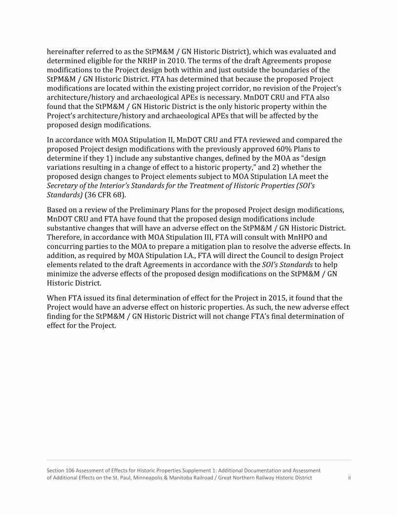
hereinafter referred to as the StPM&M / GN Historic District), which was evaluated and determined eligible for the NRHP in 2010. The terms of the draft Agreements propose modifications to the Project design both within and just outside the boundaries of the StPM&M / GN Historic District. FTA has determined that because the proposed Project modifications are located within the existing project corridor, no revision of the Project’s architecture/history and archaeological APEs is necessary. MnDOT CRU and FTA also found that the StPM&M / GN Historic District is the only historic property within the Project’s architecture/history and archaeological APEs that will be affected by the proposed design modifications.
In accordance with MOA Stipulation II, MnDOT CRU and FTA reviewed and compared the proposed Project design modifications with the previously approved 60% Plans to determine if they 1) include any substantive changes, defined by the MOA as “design variations resulting in a change of effect to a historic property,” and 2) whether the proposed design changes to Project elements subject to MOA Stipulation I.A meet the Secretary of the Interior’s Standards for the Treatment of Historic Properties (SOI’s Standards) (36 CFR 68).
Based on a review of the Preliminary Plans for the proposed Project design modifications, MnDOT CRU and FTA have found that the proposed design modifications include substantive changes that will have an adverse effect on the StPM&M / GN Historic District. Therefore, in accordance with MOA Stipulation III, FTA will consult with MnHPO and concurring parties to the MOA to prepare a mitigation plan to resolve the adverse effects. In addition, as required by MOA Stipulation I.A., FTA will direct the Council to design Project elements related to the draft Agreements in accordance with the SOI’s Standards to help minimize the adverse effects of the proposed design modifications on the StPM&M / GN Historic District.
When FTA issued its final determination of effect for the Project in 2015, it found that the Project would have an adverse effect on historic properties. As such, the new adverse effect finding for the StPM&M / GN Historic District will not change FTA’s final determination of effect for the Project.
Section 106 Assessment of Effects for Historic Properties Supplement 1: Additional Documentation and Assessment of Additional Effects on the St. Paul, Minneapolis & Manitoba Railroad / Great Northern Railway Historic District iii
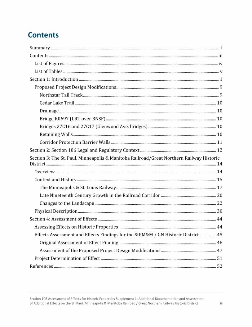
Contents
Summary ................................................................................................................................................................... i
Contents ................................................................................................................................................................... iii
List of Figures .................................................................................................................................................... iv
List of Tables ...................................................................................................................................................... v
Section 1: Introduction ....................................................................................................................................... 1
Proposed Project Design Modifications ................................................................................................... 9
Northstar Tail Track ................................................................................................................................... 9
Cedar Lake Trail ........................................................................................................................................ 10
Drainage ....................................................................................................................................................... 10
Bridge R0697 (LRT over BNSF) .......................................................................................................... 10
Bridges 27C16 and 27C17 (Glenwood Ave. bridges). ................................................................ 10
Retaining Walls.......................................................................................................................................... 10
Corridor Protection Barrier Walls ..................................................................................................... 11
Section 2: Section 106 Legal and Regulatory Context ......................................................................... 12
Section 3: The St. Paul, Minneapolis & Manitoba Railroad/Great Northern Railway Historic District .................................................................................................................................................................... 14
Overview ........................................................................................................................................................... 14
Context and History ...................................................................................................................................... 15
The Minneapolis & St. Louis Railway ................................................................................................ 17
Late Nineteenth Century Growth in the Railroad Corridor ..................................................... 20
Changes to the Landscape ..................................................................................................................... 22
Physical Description ..................................................................................................................................... 30
Section 4: Assessment of Effects .................................................................................................................. 44
Assessing Effects on Historic Properties .............................................................................................. 44
Effects Assessment and Effects Findings for the StPM&M / GN Historic District ................ 45
Original Assessment of Effect Finding .............................................................................................. 46
Assessment of the Proposed Project Design Modifications ..................................................... 47
Project Determination of Effect ............................................................................................................... 51
References ............................................................................................................................................................ 52

Section 106 Assessment of Effects for Historic Properties Supplement 1: Additional Documentation and Assessment of Additional Effects on the St. Paul, Minneapolis & Manitoba Railroad / Great Northern Railway Historic District iv
List of Figures Figure 1. 7th Street North to Linden Yards ................................................................................................. 3
Figure 2. Linden Yards to Cedar Lake Yard ................................................................................................. 5
Figure 3. Detail Map: Glenwood Avenue Bridges ..................................................................................... 7
Figure 4. The east side of Cedar Lake, ca. 1900 ...................................................................................... 17
Figure 5. Undated map showing the ca. 1865 route of the St. Paul & Pacific and Minnetonka Cut-Off .................................................................................................................................................................... 18
Figure 6. View of Minnetonka Cut-Off along north shore of Cedar Lake, 1914 ......................... 18
Figure 7. Minneapolis & St. Louis train yards with the Kenwood Water Tower in the distance .................................................................................................................................................................. 19
Figure 8. 1892 map of Minneapolis ............................................................................................................ 21
Figure 9. 1879 Bird's eye view of Minneapolis. ...................................................................................... 22
Figure 10. 1891 Bird's eye view of Minneapolis .................................................................................... 24
Figure 11. View of Lyndale Avenue bridge over Great Northern and M&StL tracks ............... 25
Figure 12. View of Great Northern elevator, ca. 1905 ......................................................................... 27
Figure 13. View of Great Northern Elevator, October 28, 1965 ....................................................... 27
Figure 14. 1949 aerial view of Highway 12 ............................................................................................. 28
Figure 15. View of Cedar Lake railroad yards, 1957 ............................................................................ 29
Figure 16. 1927 Bird's eye view of Minneapolis from Kenwood Water Tower ........................ 30
Figure 17. Looking north along Cedar Lake Trail to Target Field, August 2017 ....................... 33
Figure 18. Looking north from Cedar Lake Trail across former railyard to BNSF tracks, August 2017 ......................................................................................................................................................... 33
Figure 19. Looking northwest across BNSF and Northstar tracks to boundary with Mary’s Place, August 2017 ............................................................................................................................................ 34
Figure 20. The original curve cut through the bluffs at 12th Street and Glenwood Avenue, August 2017 ......................................................................................................................................................... 35
Figure 21. Looking east towards downtown through the tunnel-like effect under Lyndale and I-94, August 2017 ...................................................................................................................................... 36
Figure 22. Looking southwest from Cedar Lake Trail at vegetation near I-394, August 2017 ................................................................................................................................................................................... 36
Figure 23. Modern concrete block wall (left) and deteriorated historic formed concrete retaining wall with secondary wall above (right) on the east/southeast side of the corridor north of 12th Street, August 2017 ............................................................................................................... 38
Figure 24. End of 12th Street Bridge abutment and beginning of historic stone masonry retaining wall extending to Glenwood on east/southeast side of corridor, August 2017 ..... 39

Section 106 Assessment of Effects for Historic Properties Supplement 1: Additional Documentation and Assessment of Additional Effects on the St. Paul, Minneapolis & Manitoba Railroad / Great Northern Railway Historic District v
Figure 25. Historic stone masonry retaining wall east of Glenwood on east/southeast side of corridor, August 2017 ................................................................................................................................. 40
Figure 26. Bluff west of 12th Street on west/northwest side of corridor, August 2017........ 40
Figure 27. Bluff on west/northwest side of corridor between 12th Street and Glenwood, which has never been developed with timber wall remnants on the right, August 2017 ..... 41
Figure 28. Cedar Lake Trail looking northeast towards Target Field from under the 12th Street Bridge, August 2017 ............................................................................................................................ 41
Figure 29. Looking west from Glenwood showing trail and location of LRT embankment and bridge next to tracks, August 2017 .................................................................................................... 42
Figure 30. 1950 aerial view showing Wayzata Boulevard ................................................................. 43
List of Tables Table 1. Location of Features Along the Documented Segment of the StPM&M /GN Historic District .................................................................................................................................................................... 32
Table 2. Reference Key – Assessment of Effects .................................................................................... 45

Section 106 Assessment of Effects for Historic Properties Supplement 1: Additional Documentation and Assessment of Additional Effects on the St. Paul, Minneapolis & Manitoba Railroad / Great Northern Railway Historic District vi
This page intentionally left blank.

Section 106 Assessment of Effects for Historic Properties Supplement 1: Additional Documentation and Assessment of Additional Effects on the St. Paul, Minneapolis & Manitoba Railroad / Great Northern Railway Historic District 1
Section 1: Introduction
The Metropolitan Council (Council) is proposing to construct the Southwest Light Rail Transit (LRT) (METRO Green Line Extension) Project (Project), an approximately 14.5-mile-long double-track LRT line located in dedicated right-of-way, with 16 stations, of which one is deferred, and one operations and maintenance facility, beginning at the connection with the METRO Green Line and METRO Blue Line LRT lines at the existing Interchange (Target Field) Station, in Minneapolis, and extending along a southwesterly alignment to connect the cities of Minneapolis, St. Louis Park, Hopkins, Minnetonka and Eden Prairie, Minnesota.
The Council may receive funding from the Federal Transit Administration (FTA) and has received a permit from the United States Army Corps of Engineers (USACE) to construct the Project. Therefore, the Project is a federal undertaking and must comply with Section 306108 of the National Historic Preservation Act of 1966, as amended (54 United States Code [U.S.C.] § 306108) (hereinafter referred to as Section 106) and its implementing regulations, 36 Code of Federal Regulations 800 et. seq.; Section 101(b)(4) of the National Environmental Policy Act of 1969, as amended, (42 U.S.C. 4331); and other applicable federal mandates.
Pursuant to 36 CFR Part 800 et. seq., FTA, with assistance from the Minnesota Department of Transportation (MnDOT) Cultural Resources Unit (CRU), consulted with the Minnesota Historic Preservation Office (MnHPO) and other interested parties to define an Area of Potential Effect (APE), conduct surveys to identify and evaluate historic properties within the APE for National Register of Historic Places (NRHP) eligibility, assess effects of the Project on historic properties, and resolve adverse effects. On November 10, 2015, FTA issued its final determination of effect for the undertaking, which was based on the Project’s 60% Plans. Based on the 60% Plans, FTA found that the Project would have an adverse effect on historic properties. Therefore, the measures FTA and the Council agreed to implement as part of the Project to avoid, minimize, and mitigate adverse effects on historic properties are documented in the Memorandum of Agreement between the Federal Transit Administration and the Minnesota Historic Preservation Office Regarding the Southwest Light Rail Transit (METRO Green Line Extension) Project, Hennepin County, Minnesota (MOA), which was executed on June 21, 2016.
On August 16, 2017, the Council authorized negotiation and execution of agreements (Agreements) with the Burlington Northern Santa Fe Railway (BNSF) related to portions of an approximately 1.7-mile-long segment of BNSF’s Wayzata Subdivision in Minneapolis between downtown Minneapolis and just west of Cedar Lake Junction for the Project (Figures 1, 2 and 3). FTA will review the Agreements before they are executed.
The BNSF Wayzata Subdivision is a contributing segment of the St. Paul, Minneapolis & Manitoba Railroad (StPM&M) / Great Northern Railway (GN) Main Line Railroad Corridor Historic District (HE-MPC-16387; hereinafter referred to as the StPM&M / GN Historic District), which was evaluated and determined eligible for the NRHP in 2010 (Schmidt and

Section 106 Assessment of Effects for Historic Properties Supplement 1: Additional Documentation and Assessment of Additional Effects on the St. Paul, Minneapolis & Manitoba Railroad / Great Northern Railway Historic District 2
Vermeer 2010). The terms of the draft Agreements propose several modifications to the Project design both within and just outside the boundaries of the StPM&M / GN Historic District.
MOA Stipulation II requires MnDOT CRU and FTA to review and compare any modifications made to the Project plans prior to the start of construction with the previously approved 60% Plans to determine if they:
1) Include any substantive changes, defined by the MOA as “design variations resulting
in a change of effect to a historic property;” and
2) Whether the proposed design changes to Project elements subject to MOA
Stipulation I.A meet the Secretary of the Interior’s Standards for the Treatment of
Historic Properties (SOI’s Standards) (36 CFR 68).
Based on a review of the Preliminary Plans for the proposed Project design modifications, MnDOT CRU and FTA determined that the StPM&M / GN Historic District is the only historic property within Project’s architecture/history and archaeological APEs that will be affected by the proposed design modifications.1
When FTA issued its final determination of effect for the Project in 2015, it considered the following effects on the StPM&M / GN Historic District:
Alignment shift of the BNSF mainline; Introduction of LRT infrastructure to the railroad corridor;2 and Property acquisition.
FTA’s November 10, 2015 findings for the StPM&M /GN Historic District, which is included in its entirety in Section 4 of this report, contains a more complete description and analysis of these effects. At the time, FTA found that with the implementation of measures included in the MOA, the Project would have no adverse effect on the StPM&M / GN Historic District. Measures included in the MOA required all project elements within and in the vicinity of the StPM&M /GN Historic District to be designed in accordance with the SOI’s Standards.
1 While the Project’s architecture/history APE extends out a ¼ mile around the center point of stations to account for station infrastructure and other potential station-related effects to historic properties, the architecture/history APE limit for the alignment includes areas 300' on either side of the centerline of the proposed light rail alignment. Since all proposed Project design modifications are within and related to the Project alignment, not stations, the alignment APE limit was used to identify architecture/history properties that could potentially be affected by the proposed design modifications. Although the Osseo Branch of the StPM&M /GN Historic District is within the alignment APE for the Project modifications, on January 20, 2016 FTA determined that the construction of another of its undertakings, the METRO Blue Line Extension, would result in the destruction of the Osseo Branch. Therefore, effects of the modifications on it were not assessed. 2 The 60% Plans upon which FTA based its November 2015 findings include approximately 0.22 miles of corridor protection barrier (CPB) wall between LRT and the BNSF main line comprised of Retaining Wall E405, which begins between 12th Street North and Glenwood Avenue and extends to Interstate 94 (I-94), and Retaining Wall E404, which extends from E405, under I-94, to a point approximately 294' west of the Lyndale Avenue bridges. Both were a minimum of 6' in height above the ground on the freight rail side of the wall.

Retaining Wall E405
Retaining Wall E406
Retaining Wall E411
Retaining Wall E412
Retaining Wall E408
Retaining Wall E404
Retaining Wall E420
Corridor Protection Barrier - New
Glenwood Ave. West Bridge (27C17)
Glenwood Ave. East Bridge (27C16)
Bridge RO697
Luce Line Trail Ped. Bridge
12th St. N (Royalston Ave.) Bridge
Historic heavy timber retaining wall remnants
HIGHWAY 55
Historic formed concrete retaining wall
Historic stone masonry retaining wall
Lyndale Junction
Target Field Station
Royalston Avenue/Farmers Market Station
Bassett Creek Valley Station
StP
M&
M/G
N L
inden Y
ard
StPM&M/GN M
ainl ine
Osseo Branch of the StPM&M/GN HistoricDistric
t
StP
M&
M/G
N M
ainl in
e
Northstar Tail Track
DU
PO
NT
AV
E N
BR
YA
NT
AV
E N
11TH
ST N
6TH AVE N
10T
H S
T N
LY
ND
ALE
AV
E N
BO
RD
ER
AV
E N
4TH AVE NVAN WHITEMEMORIAL
BLVD
LINDEN AVE
LY
ND
ALE
AV
E N
5TH S
T N
9T
H S
T N
INT
ER
STA
TE
94
12T
H S
T N
HAWTHORNE AVE
5TH AVE N
16T
H S
T N
CURRIE AVE
3RD AVE N
HU
MB
OL
DT
AV
E N
DUNWOODY AVE
15T
H S
T N
17TH ST N
15T
H S
T N
3RD AVE N
IRV
ING
AV
E N
HENNEPIN AVE
ALD
RIC
H A
VE
S13TH
ST N
6TH AVE N
MA
PLE
ST
2ND AVE N
5TH AVE N
LY
ND
ALE
PL N
GLENWOOD AVE
HIGHWAY 55
RO
YA
LS
TO
N A
VE
N
394 HOV LN
FR
EM
ON
T A
VE
N
GIR
AR
D A
VE
N
7TH ST N
CURRIEAVEC
OL
FA
X A
VE
N
CHESTNUT AVE
HOLDENST N
6TH AVE N
LY
ND
ALE
AV
E N
394 HO
V LN
O DUNW
OODY AVEPARADE STADIUM DR
LINDEN A
VE
VA
N W
HIT
EM
EM
. B
LV
D
EB I394 T
Figure 1. Overview Map:7th Street North to Linden Yards
0 500 1,000Feet
LegendLRT Stations
LRT Alignment
Bridge Work
Corridor Protection Barrier: 10Design
Corridor Protection Barrier: N
Retaining Walls: Historic
Retaining Walls: New
Northstar Tail Track
BNSF Mainline
Osseo Branch
Cedar Lake Trail (realigned)
Architecture/History APE
0%
ew
Archaeological APE

Section 106 Assessment of Effects for Historic Properties Supplement 1: Additional Documentation and Assessment of Additional Effects on the St. Paul, Minneapolis & Manitoba Railroad / Great Northern Railway Historic District 4
This page intentionally left blank.

Luce Line Trail Ped. Bridge
Lyndale Junction
Cedar Lake Junction
Bassett Creek Valley Station
Bryn Mawr Station
StP
M&
M/G
N L
inden Y
ardOsseo Branch of the StPM&M/GN Historic
District
StP
M&
M/G
N M
ainl in
e
StPM&M/GN
Cedar Lake Yard
M&
StL
Main
line
M&StL
Cedar
Lake Yard
and Shops
MO
RG
AN
AV
E S
SU
MM
IT P
L
CHESTNUTAVE W
NEW
TO
N A
VE S
PE
NN
AV
E S
KENWOOD PKWY
MOUNT CURVE AVE
WAYZATA BLVD
FR
EM
ON
T A
VE
S
TH
OM
AS
AV
E S
INTERSTATE 394
CURRIE AVE
RU
SS
EL
L A
VE
S
HAWTHORNE AVE W
WAYZATA BLVD
DOUGLAS AVE
CHESTNUT AVE W
H
SUMMIT AVE
LAUREL AVE
DUNWOO
EM
ER
SO
N A
VE
S
SUMMIT PL
GIR
AR
DA
VE
S
DU
PO
NT
AV
E S
LO
GA
N A
VE
S
KN
OX
AV
E S
OL
IVE
R A
VE
S
JA
ME
S A
VE
S
CO
LFA
X A
VE
SIRV
ING
AV
E S
BR
YA
NT
HU
MB
OL
DT
AV
E S
NO
RT
HR
UP
LN
MOUNT VIEW AVE
PE
NN
AV
E S
MADEIRA AVEKENWOOD PKWY
QU
EE
N A
VE
S
CEDAR LAKE RD S
WAV
ER
LY P
L
394 H
OL
IVE
R A
VE
S
INTERSTATE 394
PE
NN
AV
E S
LAUREL AVE
SH
ER
IDA
N A
VE
S
QU
EE
N A
VE
S
UP
TO
N A
VE
S
CED
AR
LAKE R
D N
CO
L
CEDAR VIEW DR
394 HOV LN
394 HO
V LN
EB I394 TO D
UNWOODY AVE
PARADE STADIUM DR
MO
RG
AN
AV
E S
LINDEN A
VE
DOUGLAS AVE
VA
N W
HIT
EM
EM
. B
LV
D
Corridor Protection Barrier - New
UM
BO
LD
T A
VE
N
DY AVE
AV
E S
OV LN
FA
X A
VE
N
Figure 2. Overview Map:Linden Yards to Cedar Lake Yard
0 500 1,000Feet
LegendLRT Stations
LRT Alignment
Bridge Work
Corridor Protection Barrier: 100%Design
Corridor Protection Barrier: New
Retaining Walls: Historic
Retaining Walls: New
Northstar Tail Track
BNSF Mainline
Osseo Branch
Cedar Lake Trail (realigned)
Architecture/History APE
Archaeological APE

Section 106 Assessment of Effects for Historic Properties Supplement 1: Additional Documentation and Assessment of Additional Effects on the St. Paul, Minneapolis & Manitoba Railroad / Great Northern Railway Historic District 6
This page intentionally left blank.

Retaining Wall E405
Retaining Wall E406
Retaining Wall E411
Retaining Wall E412
Retaining Wall E408
Retaining Wall E404
Retaining Wall E420
Glenwood Ave. West Bridge (27C17)
Glenwood Ave. East Bridge (27C16)
Bridge RO697
12th St. N (Royalston Ave.) Bridge
Historic heavy timber retaining wall remnants
Historic formed concrete retaining wall
Historic stone masonry retaining wall
Royalston Avenue/Farmers Market Station
StPM&M/GN M
ainl ine
Northstar Tail Track
11TH
ST N
10T
H S
T N
BO
RD
ER
AV
E N
INT
ER
STA
TE
94
12T
H S
T N
15T
H S
T N
3RD AVE N
GLENWOOD AVE
RO
YA
LS
TO
N A
VE
N
CURRIE AVE
CHESTNUT AVE
HOLDEN ST N
LY
ND
ALE
AV
E N
Corridor Protection Barrier - New
Figure 3. Detail Map: Glenwood Avenue Bridges
0 200 400Feet
LegendLRT Stations
LRT Alignment
Bridge Work
Corridor Protection Barrier: 1Design
Corridor Protection Barrier:
Retaining Walls: Historic
Retaining Walls: New
Northstar Tail Track
BNSF Mainline
Cedar Lake Trail (realigned)
Architecture/History APE
Archaeological APE
00%
New

Section 106 Assessment of Effects for Historic Properties Supplement 1: Additional Documentation and Assessment of Additional Effects on the St. Paul, Minneapolis & Manitoba Railroad / Great Northern Railway Historic District 8
This page intentionally left blank.

Section 106 Assessment of Effects for Historic Properties Supplement 1: Additional Documentation and Assessment of Additional Effects on the St. Paul, Minneapolis & Manitoba Railroad / Great Northern Railway Historic District 9
Upon an initial review of the Preliminary Plans for the proposed Project design modifications (see next section for a description of the design changes), MnDOT CRU and FTA determined that the proposed Project modifications are located within the existing project corridor and, therefore, the Project’s existing architecture/history and archaeological APEs are sufficient to account for any potential effects to historic properties, and that no revision of the architecture/history and archaeological APE is necessary. MnDOT CRU and FTA also determined that the proposed Project modifications would only affect one previously identified historic property in the Project’s architecture/history and archaeological APEs: the StPM&M / GN Historic District. Therefore, this report assesses the effects of the proposed design modifications on the StPM&M / GN Historic District, including how the proposed design modifications do or do not comply with the SOI’s Standards. The report also includes additional historical context and physical description on the segment of the StPM&M / GN Historic District affected by the proposed design modifications. Specifically, the report looks at the approximately two-mile-long segment of the historic district in Minneapolis from approximately 7th Street North continuing southwest to just past the Project’s Bryn Mawr Station (previously known as the Penn Station)3, west of Cedar Lake Junction. The additional historic context and description were used as a framework to assess the effects of the proposed design modifications on the StPM&M / GN Historic District.
Proposed Project Design Modifications Per the terms of the MOA, FTA completed its review of the Project’s 100% Plans for civil construction on February 27, 2017, and determined that they met the terms of the MOA. The terms of the draft Agreements propose modifications to the Project design. The following is a list of proposed modifications from the previously approved 100% Plans:
Northstar Tail Track Realign and extend the Northstar Commuter Rail tail track to maintain sufficient
space within the BNSF right-of-way to allow for possible reinstallation of a second
main line track:
o Realign existing tail track from its connection with the BNSF main line just
south of the 10th Street North Bridge to current end of track at the 12th
Street North (Royalston Avenue) Bridge.
o Extend tail track west approximately 1,830’ from the current end of the tail
track.
Realign fencing and add an additional proposed fence between the BNSF main line
track and the Northstar tail trail.
3 After FTA issued its final determination of effect for the Project in November 2015, the Penn Station was renamed Bryn Mawr Station and the Van White Station was renamed Bassett Creek Valley Station.

Section 106 Assessment of Effects for Historic Properties Supplement 1: Additional Documentation and Assessment of Additional Effects on the St. Paul, Minneapolis & Manitoba Railroad / Great Northern Railway Historic District 10
Cedar Lake Trail Realign the existing Cedar Lake Trail to accommodate construction of the Northstar
tail track extension:
o Realign the trail from just east of the 12th Street North (Royalston Avenue)
Bridge to a point under the Interstate 94 (I-94) bridges.
Drainage Modify the design of drainage basins and inlets to accommodate the Corridor
Protection Barrier (CPB) Wall, Northstar tail track extension, and the re-
alignment of the Cedar Lake Trail.
Bridge R0697 (LRT over BNSF) Modify the pier design (Piers 1–9) to heavy construction.
Adjust the pier spacing of Piers 4 and 5 to mitigate conflict with an existing
CenturyLink underground line.
Modify the bridge snow barrier section to improve crashworthiness.
Bridges 27C16 and 27C17 (Glenwood Ave. bridges). Add an infill section of pier protection on the Bridge 27C16 (Glenwood West)
pier.
Modify a Bridge 27C17 (Glenwood East) pier to a solid wall pier design for crash
protection adjacent to tail track.
Revise (increase) the fence height on Bridge 27C17 (Glenwood East) over the
Northstar tail track to match height over the BNSF tracks.
Retaining Walls Increase the limits of disturbance to build trail and new walls.
Retaining Wall E412
o Shift the location of the wall several feet to the west to place the wall and
its footings outside of BNSF right-of-way (except at bridge tie-ins).
o Modify the design for the wall to allow it to be shifted, including adjusting
the height of the wall, previously approved 4' x 8' pattern finish surface
will not change.
Retaining Walls E406 and E408
o Add new Retaining Walls E406 and E408 along realigned trail:
New walls to replace historic walls described under “Historic
Retaining Walls.”
Finish surface to match 4' x 8' grid pattern previously approved for
Retaining Walls E411 and E412.
Historic Retaining Walls
o Remove a deteriorated historic formed concrete retaining wall that is a
contributing feature of the StPM&M / GN Historic District and a non-

Section 106 Assessment of Effects for Historic Properties Supplement 1: Additional Documentation and Assessment of Additional Effects on the St. Paul, Minneapolis & Manitoba Railroad / Great Northern Railway Historic District 11
historic concrete block retaining wall, both on the east/southeast side of
the railroad corridor, between the 12th Street pedestrian way and the
12th Street Bridge to accommodate construction of the realigned Cedar
Lake Trail.
o Remove a historic stone masonry retaining wall that is a contributing
feature of the StPM&M / GN Historic District on east/southeast side of the
railroad corridor, between the 12th Street Bridge and Glenwood Avenue
Bridge to accommodate construction of the realigned Cedar Lake Trail.
o Remove remnants of a historic heavy timber retaining wall that is a
contributing feature of the StPM&M / GN Historic District on
west/northwest side of the railroad corridor between the 12th Street
Bridge and Glenwood Avenue Bridge to allow for the construction of the
realigned Retaining Wall E412.
Corridor Protection Barrier Walls Permanent CPB Wall and drainage easement added (no physical construction).
Modify the height of CPB Walls E404 and E405 up to Bridge R0697 (LRT over
BNSF):
o Increase the minimum height from 6' above the railhead to 7.5' above the
railhead (approximately 10' above grade) on the freight rail side of the
walls.
Add an approximately 5,582' long (1.06 miles) of new CPB Wall along the
west/northwest side of the LRT tracks from Retaining Wall E404 at the I-94
bridges to the Bryn Mawr Station: 4
o Wall will extend approximately 7.5' above the railhead (approximately
10' above grade) on the freight rail side, visible height on LRT side will
vary;
o New CPB Walls will increase the total length of the barrier (walls and pier
protection) between the freight and LRT from approximately 1,523' (0.29
miles) to approximately 7,105' (1.35 miles; includes pier protection for I-
394 and Luce Line Trail bridges) in length.
Modify track slabs at Linden Yard utility crossings to accommodate the CPB
Wall.
Figures 1, 2 and 3 show the locations of the modifications described above. Table 2 in Section 4 of this report includes a list of plans depicting the Project modifications described above. The plans referenced are on file at the Southwest LRT Project Office.
4 The 5.582' of new CPB Wall includes 15.5' of pier protection under the Luce Line Trail Bridge, but not
the 387' of pier protection under the I-394 bridges.
Section 106 Assessment of Effects for Historic Properties Supplement 1: Additional Documentation and Assessment of Additional Effects on the St. Paul, Minneapolis & Manitoba Railroad / Great Northern Railway Historic District 12
Section 2: Section 106 Legal and Regulatory Context
Prior to implementing an undertaking, Section 106 of the NHPA requires Federal agencies to consider the effects of the undertaking on historic properties that are included in, or are eligible for inclusion in, the NRHP. Undertakings include projects a federal agency carries out, approves or licenses, or funds. Federal agencies must also give the Advisory Council on Historic Preservation (ACHP) a reasonable opportunity to comment on the project prior to the agency making a decision.
As described in 36 CFR § 800 et. seq., which implements Section 106, the Section 106 process includes the following steps:
1. Initiation of the Section 106 process:
Establish the undertaking;
Notify the State Historic Preservation Officer (SHPO) and any Tribal Historic
Preservation Officers (THPOs);
Plan to involve the public; and
Identify other consulting parties.
2. Identification of historic properties:
Determine the Area of Potential Effect (APE); and
Complete a survey of the APE to identify historic properties that are listed in or
eligible for inclusion in the NRHP.
3. Assessment of adverse effects:
Apply criteria of adverse effect.
4. Resolution of adverse effects:
Continue consultation to consider measures to avoid, minimize, or mitigate
adverse effects;
Reach agreement with the SHPO, any THPOs, and the ACHP (if it chooses to
participate in the consultation); and
Prepare a Section 106 agreement to document measures that will be
implemented by the Federal agency to avoid, minimize, and/or mitigate adverse
effects.
The 2015 report Section 106 Assessment of Effects for Historic Properties: Southwest LRT Project, Technical Report describes the APE for the Project, summarizes the surveys conducted by FTA of the APE to identify historic properties that may be affected by the Project, and describes properties identified that are listed in or are eligible for inclusion in the NRHP. The report documents consultation efforts completed under Section 106 to consider effects to historic properties and includes findings of effect for each listed and eligible historic property, as well as FTA’s final determination of effect for the Project under Section 106 (FTA et al. 2015).

Section 106 Assessment of Effects for Historic Properties Supplement 1: Additional Documentation and Assessment of Additional Effects on the St. Paul, Minneapolis & Manitoba Railroad / Great Northern Railway Historic District 13
FTA’s final determination of effect was that the Project would have an adverse effect on historic properties. Therefore, FTA consulted with MnHPO and other consulting parties for the Project to resolve the adverse effects. The Project MOA, executed in June 2016, documents the measures that FTA and the Council agreed to implement as part of the undertaking to avoid, minimize and/or mitigate adverse effects on historic properties.

Section 106 Assessment of Effects for Historic Properties Supplement 1: Additional Documentation and Assessment of Additional Effects on the St. Paul, Minneapolis & Manitoba Railroad / Great Northern Railway Historic District 14
Section 3: The St. Paul, Minneapolis & Manitoba Railroad/Great Northern Railway Historic District
Overview The StPM&M / GN Historic District is an approximately 205-mile-long linear historic district. Although the StPM&M / GN main line extends from Minneapolis to the Pacific Ocean, the determined eligible historic district in Minnesota extends from Minneapolis Junction in northeast Minneapolis, across the Mississippi River through the Minneapolis Warehouse Historic District, west through Minneapolis and its several suburbs, and westward across Minnesota to Breckenridge, Minnesota, located on the state’s border with North Dakota. The StPM&M / GN Historic District in Minnesota is eligible for the NRHP under National Register Criterion A in the area of Transportation within the historic context presented in the NRHP Multiple Property Documentation Form (MPDF): Railroads in Minnesota, 1862–1956. The StPM&M / GN main line was an important component in the GN network and Minnesota’s railroad network that “helped to solidify Minneapolis and St. Paul as the commercial, financial, and manufacturing center of an area extending from eastern Wisconsin to central Montana” (Schmidt and Vermeer 2010).
Under the registration requirements for Railroad Corridor Historic Districts in the MPDF: Railroads in Minnesota, 1862–1956, the corridor meets Registration Requirement 2:
A railroad corridor historic district provided transportation between a significant class of resource . . . and an important transfer point or terminal market for commodities, products, or services (Schmidt et al. 2007).
The corridor also meets Registration Requirement 3:
A railroad corridor historic district was an influential component of the state’s railroad network, or it made important early connections within the network or with other modes of transportation (Schmidt et al. 2007).
The period of significance for the StPM&M / GN Historic District is 1880–1956, reflecting the acquisition and re-alignment by the StPM&M to the end of the historical significance of the railroad in Minnesota, as defined in the historic context Railroads in Minnesota 1862–1956 (Schmidt and Vermeer 2010).
The previous Phase II evaluation of the historic district also confirmed that the StPM&M / GN railroad corridor retained sufficient historic integrity to convey its historic significance. The corridor retains integrity of location as it follows the original alignment. The design, materials, and workmanship reflect the early twentieth century construction, which is consistent with the period of significance. The setting is compatible, and the corridor retains integrity of feeling and association (Schmidt and Vermeer 2010).
Although the StPM&M / GN railroad corridor has defined beginning and end points, the width of the corridor is not as easily defined. The Phase II evaluation completed in 2010

Section 106 Assessment of Effects for Historic Properties Supplement 1: Additional Documentation and Assessment of Additional Effects on the St. Paul, Minneapolis & Manitoba Railroad / Great Northern Railway Historic District 15
only identified general boundaries for the historic district, which were generally described as including the railroad corridor right-of-way limits (Schmidt and Vermeer 2010). Usually, railroad corridors encompass the right-of-way owned by the railroad. These can vary greatly in width—from narrow areas with one set of tracks to corridors hundreds of feet wide in railyards or areas with layover tracks. In the approximately two-mile-long segment considered in this report, the historic StPM&M / GN right-of-way was adjacent to and shared the physical space in the railroad corridor with the Minneapolis & St. Louis Railway (M&StL), which purchased the southern part of the overall railroad corridor between downtown Minneapolis and Cedar Lake Junction from the StPM&M. The land area of the railroad corridor that was jointly used by the StPM&M / GN and the M&StL will be utilized for proposed Project improvements. Thus, for this report, the entire railroad corridor encompassing both the StPM&M / GN and M&StL right-of-ways will be discussed.
Context and History The railroad corridor occupied by the StPM&M / GN railroad was among the first railroad corridors built in the State of Minnesota and has been continuously occupied by railroads since the 1860s.
In 1857, the Territorial legislature chartered four railroad companies in various sections of the state. One company, the Minnesota & Pacific Railroad (M&P), was authorized to build a main line from Stillwater northwest via St. Paul and St. Anthony to the Bois des Sioux River (near present-day Breckenridge, Minnesota/Wahpeton, North Dakota). The M&P was also authorized to build a branch line from St. Anthony through Anoka and Crow Wing to St. Vincent on the Red River near the Canadian border (Prosser 1966/2007). The M&P broke ground in St. Paul on October 1, 1857, and halted work until spring. Although its charter called for a main line running west of St. Anthony, that route required an expensive bridge across the Mississippi River. Additionally, the area west of Minneapolis was still sparsely populated and would not provide any traffic. Thus, the M&P concentrated on the branch line to St. Cloud first and graded to Clear Lake, east of St. Cloud, by 1859 before running out of money. The Panic of 1857 caused a depletion of capital investments, particularly in frontier areas such as Minnesota, and the beginning of the Civil War in 1861 further delayed any progress in railroad activities (Luecke 1997).
On March 10, 1862, the M&P was reorganized as the St. Paul & Pacific Railroad (StP&P). The company began laying track from downtown St. Paul to Minneapolis, reaching St. Anthony across the Mississippi River from Minneapolis in June, culminating in a special excursion train run from St. Paul to St. Anthony on June 29, 1862, that celebrated the connection between the two settlements. Regular passenger service with three trains daily soon followed on the ten-mile route, ending at a depot in St. Anthony. The last segment of this line, which was located along Main Street, would be replaced by 1866 with a new connection from Minneapolis Junction (Luecke 1997).
To finance construction of the main line running west of Minneapolis, the StP&P created a distinct corporation known as the First Division, with funding from the firm of Electus B. Litchfield & Company of Brooklyn, New York (Peterson 2003). The StP&P needed to have

Section 106 Assessment of Effects for Historic Properties Supplement 1: Additional Documentation and Assessment of Additional Effects on the St. Paul, Minneapolis & Manitoba Railroad / Great Northern Railway Historic District 16
track laid and trains running by 1867 to keep the railroad franchise and claim the land grants that would ultimately fund construction. Sporadic grading on the main line began in Minneapolis, with only seven miles of main line graded by September 1864 and no track laid (Luecke 1997). The following year, work began on the 15 miles between Minneapolis and Wayzata, which included grading, trestle construction, and preparing the grade for rails (10,000 Lakes et al. 2014).
Like other early western railroads, the StP&P was built with hand tools and primitive grading equipment and built in a hurry to meet land grant deadlines. As a result, its alignment followed a circuitous route with sharp curves. Additionally, a more direct route may have required building bridges and trestles or cutting down hills and filling low areas; it was easier and faster for the company to avoid both the labor and costs of such work (Schmidt and Vermeer 2010).
As the StP&P built south and southwest from the Mississippi in downtown Minneapolis, its engineers followed a flat plain roughly parallel to Hennepin Avenue before turning southwest just south of what would become the Oak Lake neighborhood. The railroad then continued west on flat lands toward Cedar Lake. In 1865, Cedar Lake was larger, with lake levels close to 8' higher than today. Camden Hill was a bluff close to the north side of the lake. As a result, the StP&P took the path of least resistance, building south along the east side of the lake, constructing a trestle across the eastern bay then curving north again. From there to Wayzata, engineers avoided marshes where possible and followed the knolls along the edges of wetlands (Figure 3) (10,000 Lakes et al. 2014).
While the StP&P graded and built toward Wayzata, operations still required a bridge at the Mississippi. A new bridge, built with a wooden truss system that spanned two channels of the river and crossed Nicollet Island to reach Minneapolis, opened on May 2, 1867 (10,000 Lakes et al. 2014). As described in the St. Paul Pioneer of May 2, 1867, the bridge consisted of two spans of 150' from St. Anthony to Nicollet Island, the segment across Nicollet Island on a track depressed about 12' below grade and “handsomely walled on both sides” and then 623' across the main channel of the river. A depot was constructed on Washington and North 4th Avenue on the Minneapolis side, allowing Minneapolis citizens to board the train there instead of crossing over to St. Anthony (Luecke 1997).
Once trains could cross the Mississippi, the StP&P finished laying rails on the previously completed grade to Wayzata by September 1867. It continued to build west, reaching the city of Litchfield by November 1868, and Willmar by November 1869. Willmar represented the half-way point between St. Paul and Breckenridge, so a division point was established there. By 1869, the work crews included nearly 1,000 men who were able to grade roughly a half mile a day (Luecke 1997). The line reached Breckenridge in 1870, completing the original main line of the first land grant railroad in Minnesota. The StP&P would continue to struggle financially, and by 1879, it fell into bankruptcy and was purchased by James J. Hill and his associates, who reorganized it into the StPM&M (10,000 Lakes et al. 2014).

Section 106 Assessment of Effects for Historic Properties Supplement 1: Additional Documentation and Assessment of Additional Effects on the St. Paul, Minneapolis & Manitoba Railroad / Great Northern Railway Historic District 17
Figure 4. The east side of Cedar Lake, ca. 1900, looking northwest
(Minneapolis Collection, Hennepin County Library, reprinted from 10,000 Lakes et al. 2014)
With better funding, Hill’s StPM&M soon acted to improve operating efficiencies and in 1879–1882, constructed a new alignment west of downtown Minneapolis called the Minnetonka Cut-Off. At Cedar Lake Junction, the new route continued west/southwest, grading away Camden Hill on the north side of Cedar Lake. This more direct line eliminated the loop south around Cedar Lake, straightened curves and reduced grades to increase operating efficiencies. Material from Camden Hill was used to fill in wetlands in the low land west of Cedar Lake Junction (Figures 4 and 5). The old StP&P line south along Cedar Lake was eventually abandoned and sold off to surrounding land owners (10,000 Lakes et al. 2014; Schmidt and Vermeer 2010). Hill’s double track line to Wayzata was completed in June 1882 (Luecke 1997).
The Minneapolis & St. Louis Railway While the StP&P was evolving, Minneapolis businessmen banded together to create a locally owned railroad to have direct connections to grain and lumber producers and markets in the region and to gain better control of transportation and shipping rates. Incorporated as the Minnesota Western Railroad in 1853, the railroad was renamed as the Minneapolis & St. Louis Railway in 1870, with construction finally beginning on the line in 1871. The M&StL remained locally owned, a factor that ensured that it was always

Section 106 Assessment of Effects for Historic Properties Supplement 1: Additional Documentation and Assessment of Additional Effects on the St. Paul, Minneapolis & Manitoba Railroad / Great Northern Railway Historic District 18
challenged for competition and capital by larger railroads also operating in the region (Prosser 1966/2007; Schmidt 2010; Donovan 1950).
Figure 5. Undated map showing the ca. 1865 route of the St. Paul & Pacific and Minnetonka Cut-Off. The later
route is indicated with a dashed line (reprinted from 10,000 Lakes et al. 2014)
Figure 6. View of Minnetonka Cut-Off along north shore of Cedar Lake, 1914
(Minneapolis Collection, Hennepin County Library, reprinted from 10,000 Lakes et al. 2014)

Section 106 Assessment of Effects for Historic Properties Supplement 1: Additional Documentation and Assessment of Additional Effects on the St. Paul, Minneapolis & Manitoba Railroad / Great Northern Railway Historic District 19
In 1871, the M&StL began construction on its first line, which extended southwest from Minneapolis to Merriam (southwest of Shakopee). Between downtown Minneapolis and Cedar Lake, the M&StL purchased right-of-way just east of the original StP&P main line to construct its parallel line. Near Cedar Lake, the original StP&P line had looped around and west from the lake, but the M&StL continued southwest to Merriam Junction. An early roundhouse had been constructed just south of Glenwood Avenue opposite the StP&P roundhouse by 1885 (Sanborn Map and Publishing Company, 1885). The M&StL established its mechanical headquarters below the Kenwood bluffs (below where the Kenwood Water Tower stands today) on the northeastern side of Cedar Lake, where they would remain for another 113 years (Figure 6) (10,000 Lakes et al. 2014).
In the 1870s, the M&StL extended lines to Albert Lea and to White Bear Lake to connect with the Lake Superior & Mississippi Railroad, thus providing key rail connections for shipping. Holding a dominant position in the Minneapolis milling district, the M&StL also established elevators along its lines. It hauled over half the flour produced in Minneapolis
Figure 7. Minneapolis & St. Louis train yards with the
Kenwood Water Tower in the distance on the far right
(Norton & Peel photograph, Minnesota Historical Society)
Section 106 Assessment of Effects for Historic Properties Supplement 1: Additional Documentation and Assessment of Additional Effects on the St. Paul, Minneapolis & Manitoba Railroad / Great Northern Railway Historic District 20
in the 1870s and continued to expand its lines into Iowa, western Minnesota and Dakota Territory. The M&StL would operate throughout the late nineteenth and first half of the twentieth century but would continuously have insufficient capital to compete with the larger and more powerful railroads in Minnesota and in the region. It went into receivership in 1888 but was reorganized by 1894 as the Minneapolis & St. Louis Railway Company. The company went into receivership again in 1923, which lasted almost 20 years. The line was eventually acquired by the Chicago & North Western Railway (C&NW) in 1960, which was itself acquired by the Union Pacific Railroad in 1996 (10,000 Lakes et al. 2014; Schmidt and Vermeer 2010).
Late Nineteenth Century Growth in the Railroad Corridor While the StPM&M was building the Minnetonka Cut-Off at Cedar Lake Junction, the Minneapolis & Northwestern began grading for the West Side line that branched off the StPM&M line at the Linden Yards (west of Lyndale, near Colfax Avenue). Begun in 1881, the line traveled through the Bassett Creek Valley northwest through the village of Osseo and along the south side of the Mississippi River to Clearwater, just east of St. Cloud, by 1882 (Luecke 1997). This line was later absorbed into StPM&M.
The StPM&M also let a contract in 1881 for a new bridge to access Minneapolis. Although completed in 1883, the Stone Arch bridge was opened for business on September 1, 1884, the same day a new Union Depot opened for business on the east side of Hennepin Avenue at the river (Luecke 1997). In 1884, the Union Depot replaced the old StP&P depot at 4th Avenue North and Washington.
By 1885, both the StPM&M and M&StL operated in a developing railroad corridor between downtown Minneapolis and the burgeoning warehousing district, running parallel to the river from the Stone Arch bridge vicinity, through the milling district, and turning southwest in the area west of Hennepin Avenue and generally along the alignment of 4th Avenue North. StPM&M freight depots were located on the west side of the railroad corridor, between Washington and 4th Street North. The M&StL passenger station stood next to its main line at 3rd Street North, while its freight depots were on the east side of the railroad corridor between 3rd North Street and to 5th Street North (Sanborn Map and Publishing Company 1885).
Maps of the era indicate that all rail lines appeared to be at grade, with as many as 14–16 lines extending through the area. The StPM&M occupied the west/northwest portion of the corridor, while the M&StL occupied the east/southeast portion.
The lines such as the StPM&M and M&StL that turned southwest at 4th Avenue North reached their greatest width in the area from 2nd Street North to 7th Street North. The corridor expanded to accommodate up to 20 tracks including the main lines, sidings and spurs in this section, and then constricted down to 6–8 tracks to turn southwest through bluffs at 12th Street North and Glenwood Avenue, before the topography flattened and bluffs receded to low, flat land (Figure 7) (C.M. Foote & Co. 1892).

Section 106 Assessment of Effects for Historic Properties Supplement 1: Additional Documentation and Assessment of Additional Effects on the St. Paul, Minneapolis & Manitoba Railroad / Great Northern Railway Historic District 21
Figure 8. 1892 map of Minneapolis showing location of rail lines (north is to the left)
(C. M. Foote & Co. 1892)
This narrowed turn near 12th Street North was identified as early as 1879 on a bird’s eye view of Minneapolis, which showed both the StP&P and M&StL lines cutting through a hill, with a bridge at 12th Street connecting the main section of the city with the residential area (later Oak Lake) to the northwest (Figure 8). It is not clear whether this cut was a natural break in the topography, or whether the StP&P railroad first identified this point to move west, but it was present by 1879. The StP&P constructed a roundhouse just west of the cut, adjacent to Western Avenue (now Glenwood Avenue) (A. Ruger 1879). By 1885, the M&StL had also completed its first roundhouse south of Glenwood on the east/southeast side of the corridor (Sanborn Map and Publishing Company 1885).

Section 106 Assessment of Effects for Historic Properties Supplement 1: Additional Documentation and Assessment of Additional Effects on the St. Paul, Minneapolis & Manitoba Railroad / Great Northern Railway Historic District 22
Changes to the Landscape
The Warehouse District
Other than the cut through the hill at the 12th Street Bridge, the railroads in this corridor were originally built at grade, rather than depressed below grade with bridges overhead. During the 1880s, Minneapolis boomed, its population growing from 46,887 in 1880 to 164,738 in 1890. Development had pushed into North Minneapolis, the area northwest of the railroad corridor. The railroad tracks of the M&StL and the StPM&M / GN blocked easy access to the northwest from downtown. The City demanded that the tracks be depressed to create “underways” and that vehicular bridges be built over the yards. It also required that all expenses of crossings, underpasses, and bridges be paid by the railroad companies (Hofsommer 2005a). Litigation soon followed and resulted in a March 1888 decision by the
Figure 9. 1879 Bird's eye view of Minneapolis showing the railroad cutting through the hills (detail)
(A. Ruger 1879).

Section 106 Assessment of Effects for Historic Properties Supplement 1: Additional Documentation and Assessment of Additional Effects on the St. Paul, Minneapolis & Manitoba Railroad / Great Northern Railway Historic District 23
State Supreme Court, affirming a lower court decision that forced the railroads to lower tracks and build bridges over them at certain important streets, specifically Washington Avenue and 5th Street (Minneapolis Tribune, March 6, 1888).
It took until 1890 for the litigation to be resolved, when a compromise was finally developed in which the M&StL and StPM&M / GN split costs of demolition, excavation, bridgework and new trackage. The M&StL also constructed new passenger and freight facilities and retained its historic alignment on the south/east side of the StPM&M / GN, despite the desire of the StPM&M to move the other line out of the corridor (Hofsommer, 2005a).
Records of the StPM&M / GN showed that the Washington Avenue Bridge was completed in 1891 with plans in place for bridges at 1st, 2nd, 3rd, 4th, and 5th Streets North and at Western Avenue (Great Northern Railway, 1891 AFE#202-E). An 1891 bird’s eye view of the city (Figure 9) shows through-truss bridges over the railroad corridor at 1st, 2nd, Washington, 3rd and 5th (the extent of the view in that direction) (A. M. Smith 1891). The following sections describe the changes to the landscape of the historic railroad corridor, concentrating on the period of significance from 1880–1956. The segments are described first by the side of the corridor: east/southeast side then the west/northwest side.
7th Street North to 12th Street North
The segment of the historic railroad corridor from 7th Street North to 12th North Street appears on an 1879 bird’s eye view of Minneapolis (see Figure 6), which shows where the corridor began to cut into the bluff and the location where the topography rose gradually. On both sides of the railroad corridor, the land rose from the railroad grade near 7th Street. The only bridge in this vicinity in 1879 was at 12th Street, as the rails pushed through the bluffs to the flat land beyond (A. Ruger 1879).
In addition to the bridge at 12th Street North, a viaduct over the rail yard at 7th Street North was completed by 1903; it had not been constructed with the other bridges to the north in 1891 as part of the City’s lawsuit against the railroad companies. A truss railroad bridge that served the Short Line Electric Railway (commonly known as the Luce Line, incorporated 1908) was constructed over the corridor along Holden Street by 1914 (Benneche 1914).
The east/southeast side of the tracks through this area generally had a “hard edge” of buildings next to the bridges. The Wyman, Partridge & Company wholesale dry goods warehouse was constructed against the 7th Street viaduct and included a warehouse extending along several spurs on the east/southeast of the railroad corridor. South from the warehouse to Holden Street were tracks operated by the Electric Short Line Railway. The topography gradually rose to the bridge at 12th Street (also called Royalston on early maps). The land immediately adjacent to the bridge rose some 20–25' above the rails and was reinforced with retaining walls. It was the site of a potato warehouse and later a gas station in the twentieth century but not connected to rail (Sanborn Map and Publishing Company 1912/1930, and 1912/1951).

Section 106 Assessment of Effects for Historic Properties Supplement 1: Additional Documentation and Assessment of Additional Effects on the St. Paul, Minneapolis & Manitoba Railroad / Great Northern Railway Historic District 24
The west/northwest side of the corridor was generally at grade with the rails from 7th Street North until rising to the abutments for the 12th Street Bridge. From the turn of the century until the 1940s, a series of lines extended from the corridor to the northwest, serving the St. Paul & Western Coal Co. Yard. The coal yard filled the land southwest of 7th Street and extended to the back yards of residences fronting on Royalston. Those tracks were removed by the 1950s and replaced by industrial buildings, but this area remained generally at grade with the tracks (Sanborn Map and Publishing Company 1912/1951).
12th Street North to Lyndale Avenue
The topography along this section of the historic railroad corridor transitioned from the highest edges and narrowest portion of the corridor at 12th Street North, southwest past Western Avenue (Glenwood), and then gradually sloping down and widening out to a flat plane prior to Lyndale Avenue. Moving southwest from 12th Street, there was a bridge with stone abutments at Western Avenue (Glenwood) as early as 1885 (Sanborn Map and Publishing Company 1885). Although not present in 1885, a steel viaduct at Lyndale Avenue crossed the corridor by 1892 (Figure 10). This section remained in that configuration until the I-94 bridges were built adjacent to Lyndale by 1980 (C.M. Foote and Co. 1892; NETROnline historic aerial photograph 1957, 1972, 1979).
Figure 10. 1891 Bird's eye view of Minneapolis. The through-truss bridges are visible at right (A. M. Smith 1891)

Section 106 Assessment of Effects for Historic Properties Supplement 1: Additional Documentation and Assessment of Additional Effects on the St. Paul, Minneapolis & Manitoba Railroad / Great Northern Railway Historic District 25
The east/southeast side of the corridor remained raised approximately 20–25' above the railroad corridor, generally supported by retaining walls. The 1885 map indicates stone retaining walls from either side of 12th Street North, extending southwest through the Western Avenue bridge, then transitioning to an 8' board fence that reflected the topography that sloped down to the M&StL roundhouse. Coal yards at the rail grade filled adjacent land to Lyndale Avenue, with a retaining wall at the edge of the Chestnut Street right-of-way marking the south edge of the railroad corridor in the nineteenth century. By 1937, the M&StL roundhouse had been removed, and industrial buildings appeared along the corridor, with little demarcation between the buildings and the railroad corridor. In the post-World War II era, adjacent industrial buildings no longer required rail access in this location. The buildings faced Chestnut Street (south of the railroad corridor), with parking lots in the back along the railroad corridor. Southwest from the Western Avenue (Glenwood) bridge abutments to Lyndale, the corridor edge does not appear to have a strong demarcation or grade change by the mid-twentieth century. A power line was constructed along the east/southeast side of the railroad corridor by 1938 (Minnesota Historic Aerial Photos Online, 1938; NETROnline historic aerial photograph 1957).
The west/northwest side of the corridor from 12th Street North to Lyndale Avenue retained more of its earthen embankments over time than the east/southeast side. On the north end of the 12th Street Bridge, the properties were at least 20–25' above the railroad corridor at the intersection of Holden, 12th, and Highland (later Royalston Avenue) in the Oak Lake residential area. Some remnants of this residential area remained until the 1950s when the entire Oak Lake neighborhood had been redeveloped to industrial and
Figure 11. View of Lyndale Avenue bridge over Great Northern and
M&StL tracks from south of Glenwood Avenue
(Minnesota Historical Society)

Section 106 Assessment of Effects for Historic Properties Supplement 1: Additional Documentation and Assessment of Additional Effects on the St. Paul, Minneapolis & Manitoba Railroad / Great Northern Railway Historic District 26
commercial uses. At track level, a stone retaining wall ran under Western Avenue (Glenwood) on the west/northwest side, although its extent is not clear from the maps. As the railroad corridor passed Western Avenue (Glenwood), the topography sloped down to track level where a StP&P roundhouse was located prior to its removal in 1897 (Great Northern Railway, 1897 AFE #499-E and #583-E). The site west of the roundhouse contained various furniture companies and lumber yards from the 1880s into the mid-twentieth century. Later, an iron works and a coal yard moved onto the western portion of the property, with a rail line serving the coal yards. These industrial properties were close to grade level of the railroad corridor, since they required various rail tracks over time to receive materials and ship their products. Although the rail line was removed, the buildings here did not change drastically from the 1930s to 1957 (Sanborn Map and Publishing Company 1912/1930, and 1912/1951; NETROnline historic aerial photograph 1957).
Lyndale Avenue to Cedar Lake Junction
The topography of this segment of the historic railroad corridor is flat for most of the distance from Lyndale to Cedar Lake Junction. As noted in the history, the original rail alignment followed low-lying, flat land west until it reached the vicinity of Cedar Lake Junction, where Camden Hill was cut down when the StPM&M built the Minnetonka Cut-Off in 1879–82. While the topography did not experience many changes after this early construction period, this section would ultimately see the greatest reduction of railroad uses and circulation changes. Those changes, however, would not happen until the 1980s, after the period of significance.
From the 1880s until the 1920s, this section would have few bridges or roadways that intersected with it. By 1892, the only bridge crossing west of Lyndale was at Laurel Avenue, which carried a Twin City Rapid Transit streetcar line west over the lowlands and tracks toward Glenwood Park. By 1912, an additional crossing was added at Superior Avenue (now Wayzata Boulevard), running west from Loring Park. These provided the only grade-separated circulation over the railroad corridor until the 1970s. By 1972, work had begun on expanding Superior Avenue; Laurel Avenue was being disconnected and its bridge would eventually be removed (NETROnline historic aerial photograph 1957, 1972).
Moving west from Lyndale Avenue, on the east/southeast side of the railroad corridor, was the StPM&M / GN’s Linden Yard. The sidings on the yard extended approximately one mile to where I-394 now crosses over the railroad corridor. Within the right-of-way, tracks angled across platted lots and blocks, meaning that several east-west streets platted on the grid dead-ended into the railroad corridor. Several spur tracks also ran down the corridor, providing connections to coal piles and a few businesses, including the Anheuser Busch Brewing Association facility near the foot of Hawthorne Avenue. These blocks on the east/southeast side of the railroad corridor still had some residential uses. However, the space between the StPM&M and M&StL rail lines had two elevators (Figures 11 and 12), filling all the land and with tracks from each line running through the elevators. Elevator #1, with a capacity of 800,000 bushels, was farthest east, roughly between the alignment of Aldrich and Bryant Avenues. Elevator #2, with a capacity of 1,200,000 bushels, was adjacent on the southwest, between the alignment of Bryant and Colfax Avenues. The

Section 106 Assessment of Effects for Historic Properties Supplement 1: Additional Documentation and Assessment of Additional Effects on the St. Paul, Minneapolis & Manitoba Railroad / Great Northern Railway Historic District 27
elevators were identified first as the Minneapolis Elevator Company, later owned by Great Northern, and by the 1950s, they were owned by Archer Daniels Midland (Sanborn Map and Publishing Company 1885, 1912/1951; Great Northern Railway Railroad Valuation Map 1940).
Figure 12. View of Great Northern elevator, ca. 1905 (Minnesota Historical Society)
Figure 13. View of Great Northern Elevator from corner of Linden and Lyndale Avenues North,
looking west, October 28, 1965. Minneapolis Gas Company building is at right.
(Norton & Peel photograph, Minnesota Historical Society)

Section 106 Assessment of Effects for Historic Properties Supplement 1: Additional Documentation and Assessment of Additional Effects on the St. Paul, Minneapolis & Manitoba Railroad / Great Northern Railway Historic District 28
Mixed commercial and residential uses persisted adjacent to the railroad corridor until the turn of the century, but by 1912, the Minneapolis Gas Light Company’s 172 million cubic-foot storage tank was located just west of Lyndale Avenue. This use appeared to be the beginning of continuous use of this location for utility companies. The railroad corridor continued southwest until it intersected with Laurel Avenue and The Parade park area, just west of Dupont Avenue. By 1912, the approach for the Laurel Avenue viaduct over the tracks began east of Dupont and north of the Dunwoody Industrial Institute grounds. Continuing southwest, the topography began to rise to the Kenwood bluffs that defined the southeast edge of the railroad corridor. Superior Avenue (now Wayzata Boulevard) ran along the base of the bluff, first at grade, and by the 1930s, it had been elevated to bridge the railyards (Figure 13) (Sanborn Map and Publishing Company 1885, 1912/1951; Minnesota Historic Aerial Photos Online, 1938).
Figure 14. 1949 aerial view of Highway 12 (Wayzata Boulevard) showing Cedar Lake railroad
yard at right, looking east (Minneapolis Star Tribune photograph, Minnesota Historical Society)
Soon after the M&StL was established, the railroad built a shop complex on the flat land at the base of the Kenwood bluff and south of Superior Avenue/Wayzata Boulevard, which served as the mechanical headquarters of the M&StL. The M&StL Cedar Lake Yards, as they were known (not to be confused with the StPM&M / GN Cedar Lake Yard that was located west of Cedar Lake Junction on the Minnetonka Cut-Off), were located below the bluff where Kenwood Parkway ran, near the site of the Kenwood Water Tower. The railroad apparently scraped back the bluffs to carve out space for a six-stall roundhouse in the nineteenth century (Egan 1903; Hofsommer 2009). The M&StL continued to expand its yard operations in this area on the northeastern side of Cedar Lake and remained for the next century (Figure 14), until the M&StL was sold to the C&NW in 1960. The yards were

Section 106 Assessment of Effects for Historic Properties Supplement 1: Additional Documentation and Assessment of Additional Effects on the St. Paul, Minneapolis & Manitoba Railroad / Great Northern Railway Historic District 29
gradually decommissioned, abandoned, and demolished in the 1970s and 1980s (10,000 Lakes et al. 2014).
Figure 15. View of Cedar Lake railroad yards, 1957
(Norton & Peel photograph, Minnesota Historical Society)
In the 1880s, on the west/northwest side of the tracks west of Lyndale Avenue was the location of the North Star Lumber Company and its storage yards, as well as other construction material yards. The land on the west/northwest side appeared to be flat and generally at grade with the rail yards. This site adjacent to Lyndale Avenue would later house industrial uses. A Northern States Power substation was located at the foot of Aldrich, extending west to Colfax Avenue; the substation would be located on the site for the next century. Approximately three blocks to the west at Lyndale Junction, the Osseo Branch extended through the Bassett Creek Valley to the northwest. The StPM&M main line continued southwest along low-lying, flat ground for approximately one mile to Cedar Lake Junction, crossing under the Laurel Avenue Bridge, and the Superior Avenue (Wayzata Boulevard) bridge. The topography rose gradually toward the Superior Avenue Bridge, which connected to the Camden Hills. The StPM&M had cut into the Camden Hills in 1879–82 for the Minnetonka Cut-Off and continued to operate on that line. The Camden Hills bordered the StPM&M line on the north as it made its way to Minnetonka (Sanborn Map and Publishing Company 1885, 1912/1951; Minnesota Historic Aerial Photos Online, 1938; 10,000 Lakes et al. 2014).

Section 106 Assessment of Effects for Historic Properties Supplement 1: Additional Documentation and Assessment of Additional Effects on the St. Paul, Minneapolis & Manitoba Railroad / Great Northern Railway Historic District 30
The StPM&M gradually expanded its yards (known as Linden Yards) in the flat lands along this segment, adding over 20 tracks in the area between Lyndale Junction and the Superior Avenue Bridge. The tracks constricted under the Superior Avenue Bridge, and then expanded again, with multiple StPM&M lines to the southwest toward Cedar Lake Junction (Figure 15) (Minnesota Historic Aerial Photos Online, 1938; Great Northern Railway Railroad Valuation Map 1930, Rev. 1956; NETROnline historic aerial photograph 1957, 1972).
Figure 16. 1927 Bird's eye view of Minneapolis from Kenwood Water Tower showing
the railyards and Great Northern Elevator to the left
(Minnesota Historical Society)
Physical Description The StPM&M / GN Historic District is an approximately 205-mile-long linear historic district. Although the StPM&M / GM main line extends from Minneapolis to the Pacific Ocean, the determined eligible historic district in Minnesota extends from Minneapolis Junction in northeast Minneapolis, across the Mississippi River through the Minneapolis Warehouse Historic District, west through Minneapolis and its several suburbs, and westward across Minnesota to Breckenridge on the state border with North Dakota. The portion of the historic district documented in the following sections is an approximately two-mile-long segment in Minneapolis beginning roughly at 7th Street North and extending to west of Cedar Lake Junction, which is the segment of the historic district subject to the proposed Project design modifications(see Figures 1, 2 and 3). This width of this segment of the historic district varies considerably from approximately 100' to hundreds of feet at the railroad yards within the Warehouse District, Linden Yard west of Lyndale Avenue, and Cedar Lake Yard located between Cedar Lake Junction and Cedar Lake. This segment of the

Section 106 Assessment of Effects for Historic Properties Supplement 1: Additional Documentation and Assessment of Additional Effects on the St. Paul, Minneapolis & Manitoba Railroad / Great Northern Railway Historic District 31
historic district includes a variety of features, both natural and man-made, and functions that collectively constitute a historic landscape. From between approximately 12th Street North and just past Glenwood Avenue, the historic district also includes the M&StL right-of-way, to include a historic cut in which the StPM&M / GN and M&StL rights-of-way were co-located and which also includes an associated grade separation.
The StPM&M / GN Historic District in its entirety has both urban and rural components from the density of the Minneapolis Warehouse District, through modern suburbs, historic small and mid-sized towns, and rural areas along its route to Breckenridge. The two-mile corridor examined in this study, although located in the heart of the city, is more illustrative of a rural historic landscape than an urban landscape. Rural historic landscapes are typically based on historic occupation or land use, which may include both transportation systems and industrial uses. The pattern of railroad building in the nineteenth century, with its emphasis on speedy and expedient construction, can best be described using the landscape characteristics identified for rural historic landscapes by the National Park Service (NPS) (McClelland et al, 1989/1999). According to the NPS, the features and functions of a rural historic landscape can include:
Land uses and activities
Patterns of spatial organization
Response to the natural environment
Cultural traditions
Circulation networks
Boundary demarcations
Vegetation related to land use
Buildings, structures, and objects
Clusters
Archaeological sites
Small-scale elements
The StPM&M / GN Railway Historic District does not contain all of these features and functions. They vary by area, as the tracks move from the dense and spatially constricted corridor near Target Field at 7th Street North out to the flat, less developed, and most expansive area at Bryn Mawr Meadows.
Although the StPM&M / GN Historic District has defined beginning and end points, the width of the corridor is not as easily defined. The Phase II evaluation completed in 2010 only described general boundaries as including the railroad corridor right-of-way limits (Schmidt and Vermeer 2010). Railroad corridors typically encompass the right-of-way owned by the railroad, which can vary from narrow areas with one set of tracks to corridors hundreds of feet wide in railyards or areas with layover tracks. In the approximately two-mile-long segment documented in this report, the historic StPM&M / GN right-of-way included several yards and junctions, and was adjacent to and shared the physical space in the railroad corridor with the M&StL, which purchased the southern area

Section 106 Assessment of Effects for Historic Properties Supplement 1: Additional Documentation and Assessment of Additional Effects on the St. Paul, Minneapolis & Manitoba Railroad / Great Northern Railway Historic District 32
of the overall railroad corridor in the nineteenth century (Table 1). The area devoted to rail uses of both railroad lines matches the historic corridors including yard areas. Through the entirety of this segment from 7th Street North to Cedar Lake Junction, the setting included both railroad corridors, making the overall railroad corridor a larger facility than just the StPM&M / GN railroad corridor.
Table 1. Location of Features Along the Documented Segment of the StPM&M /GN Historic District
GN Mile Post
BNSF Mile Post (BNSF 2016)
Abbreviation Key
11.595 7th Street North Bridge
11.603 10th Street North Bridge
11.786 12th Street North (Royalston Avenue) Bridge
11.862 Western Avenue (Glenwood Avenue) Bridge
12.082 I-94 / Lyndale Avenue bridges
— Linden Yards
12.238 Lyndale Jct. switch (actual Jct. with Osseo Branch)
12.17 12.4 Lyndale Jct.
12.5 Van White Boulevard Bridge
13.0 13.0 Cedar Lake Jct.
13.075 Wayzata Boulevard (I-394) bridges
13.217 Cedar Lake Jct. switch (actual Jct. with M&StL, now TC&W)
— Cedar Lake Yard
14.7 Cedar Lake
The primary features in the StPM&M / GN and M&StL corridor from 7th Street North to Cedar Lake Junction include the main line of the StPM&M / GN (now BNSF) (contributing) that is consistently farthest west/northwest in the corridor, the adjacent tail track for the Northstar commuter rail (non-contributing – post dates the period of significance), and the Cedar Lake Trail (non-contributing), which was constructed on the alignment of the M&StL on the east/southeast portion of the corridor. West of I-94, the space between the BNSF line and the trail gradually grow farther apart, leaving a widening, flat area in the center where StPM&M / GN and M&StL rail yards (StPM&M / GN yards are contributing) were historically located. The StPM&M / GN main line track and trail gradually come together again as the former rail yard narrows to pass under I-394 to Cedar Lake Junction (Figures 16 and 17). Scattered along the entirety of the railroad corridor segment documented in this report there are numerous small-scale, non-countable features such as signs, automatic block signals, signal bungalows, switches with switch stands or switch housings, and other small pieces of railroad related infrastructure.

Section 106 Assessment of Effects for Historic Properties Supplement 1: Additional Documentation and Assessment of Additional Effects on the St. Paul, Minneapolis & Manitoba Railroad / Great Northern Railway Historic District 33
Figure 17. Looking north along Cedar Lake Trail to Target Field, August 2017
Figure 18. Looking north from Cedar Lake Trail across former railyard to BNSF tracks, August 2017
Throughout the corridor, the StPM&M / GN main line and the Northstar tail track are on a slightly raised roadbed of crushed granite ballast, with a track structure consisting of wood ties, and steel rails. The Northstar tail track currently ends prior to 12th Street North. The Cedar Lake Trail is paved with bituminous and is built up approximately 5' above the

Section 106 Assessment of Effects for Historic Properties Supplement 1: Additional Documentation and Assessment of Additional Effects on the St. Paul, Minneapolis & Manitoba Railroad / Great Northern Railway Historic District 34
existing rail bed in the area from 7th Street North to the south, but lowers down to parallel the rail grade past the 12th Street Bridge (Figure 18).
Figure 19. Looking northwest across BNSF and Northstar tracks to boundary with
Mary’s Place, August 2017
The edges of the corridor are varied in topography and land uses. The railroad corridor that contained the StPM&M / GN and M&StL was several hundred feet wide in the densely developed Minneapolis Warehouse District north of 7th Street, and began to constrict down to a narrow corridor at 7th Street North. The section in the Warehouse District north of 7th Street is depressed from surrounding grades approximately 20–25', the result of a railroad grade separation project in the 1890s (contributing).
From 7th Street North to 12th Street North, the railroad corridor is relatively narrow, approximately 100' wide with adjacent land at-grade. At 12th Street, the corridor narrows to cut through the bluff area, with retaining walls and earthen embankments approximately 20–25' high. The steep topography forms the boundaries for this segment of the corridor, which continues through Glenwood Avenue. West of Glenwood, the topography gradually slopes down to grade on either side of the railroad corridor to I-94. Once the corridor emerges on the west from the tunnel-like effect created by the I-94 and Lyndale Avenue Bridges, the edges of the corridor are less defined by topographic change. On the east/southeast side is a gentle slope with vegetation, which flattens out along the Cedar Lake Trail and extends under I-394. Southwest past I-394, the former M&StL railyard extended to the Kenwood bluffs, forming a southeastern edge to the railroad corridor. The BNSF main line marks the west/northwest edge of the corridor west of I-94, and adjacent

Section 106 Assessment of Effects for Historic Properties Supplement 1: Additional Documentation and Assessment of Additional Effects on the St. Paul, Minneapolis & Manitoba Railroad / Great Northern Railway Historic District 35
land is also flat toward Bryn Mawr Meadows Park west of the Bassett Creek Valley Station (Figures 19, 20, and 21).
Figure 20. The original curve cut through the bluffs at
12th Street and Glenwood Avenue, August 2017
In the late 19th and early 20th centuries, many businesses and industries that received and shipped large amounts of materials and goods set up near the tracks to take advantage of the transportation services offered by the StPM&M / GN and M&StL. Many of these businesses were served by sidings and spurs that extended off the railroad corridor onto these properties. However, by the mid-twentieth century, many of the business that once relied on rail service left the area, changed to trucks for their primary mode of transportation, or were replaced by land uses not needing rail service. As a result, the numerous sidings and spurs that once extended out from the railroad corridor to adjacent properties were removed.

Section 106 Assessment of Effects for Historic Properties Supplement 1: Additional Documentation and Assessment of Additional Effects on the St. Paul, Minneapolis & Manitoba Railroad / Great Northern Railway Historic District 36
Figure 21. Looking east towards downtown through the tunnel-like effect under
Lyndale and I-94, August 2017
Figure 22. Looking southwest from Cedar Lake Trail at vegetation near I-394, August 2017
A pattern of grade separations for railroads, vehicles, and pedestrians has been typical in the railroad corridor. Bridges that currently cross the corridor include 7th Street North (historic crossing, bridge non-contributing – post dates the period of significance), 10th

Section 106 Assessment of Effects for Historic Properties Supplement 1: Additional Documentation and Assessment of Additional Effects on the St. Paul, Minneapolis & Manitoba Railroad / Great Northern Railway Historic District 37
Street North (non-contributing – crossing post dates the period of significance), 12th Street North (Royalston Avenue) (crossing historic, bridge non-contributing – post dates the period of significance), Glenwood Avenue (crossing historic, bridge non-contributing – post dates the period of significance), I-94 (non-contributing – crossing post dates the period of significance), Lyndale Avenue (crossing historic, bridge non-contributing – post dates the period of significance), and Wayzata Boulevard (I-394) (crossing historic, bridges non-contributing – post date the period of significance). Since 1970, bridges have been removed at Holden Avenue and Laurel Avenue. Currently, there is a trail connection from the Cedar Lake Trail to 12th Street North on the east/southeast side (non-contributing); it follows the general street alignment of the original plat for that location. Since the 1970s, in the era when the Laurel Avenue Bridge was removed, a pedestrian bridge over the corridor to Bryn Mawr Meadows has been present west of Van White Boulevard.
The corridor is also defined by elements that contribute to the setting and feeling of the corridor. The cut through the bluff from 12th Street North to Glenwood Avenue required retaining walls from the beginning, and some remain from the period of historic significance (see Figures 1 and 3). The east/southeast side has a series of varied retaining walls that reflect different periods of construction and redevelopment. Immediately west of the 12th Street pedestrian way along the railroad corridor, a modern concrete block retaining wall (non-contributing) has been added up to the 12th Street Bridge abutments. The retaining wall on the west side of the abutments is a historic formed concrete wall (contributing) that is deteriorated with much of the surface worn away. There is a secondary concrete retaining wall on the top of the bluff in this area, set back a few feet from the lower wall. The concrete wall extends west to meet the historic stone masonry wall (contributing) that likely dates to the 1880s or possibly earlier; it extends to the Glenwood bridge abutment. West of the Glenwood Avenue Bridge there is a modern concrete block wall (non-contributing) (Figures 22, 23, and 24).
On the west/northwest side of the railroad corridor, the land between 12th Street North and Glenwood Avenue has remained undeveloped since the 1860s. It is a grass-covered earth embankment (contributing) with a bluff above. Both are further vegetated with volunteer trees and shrubs. There are remnants of a heavy timber wall (contributing) on the lower portion (approximately 6–8' high) (Figures 25 and 26).
This segment also retains vegetation related to the rail trench, because of the remaining grassy bluffs on the west/northwest side, and on and along the retaining walls on the east/southeast side. Vegetation on both sides of the railroad corridor includes volunteer trees, shrubs growing on the earthen embankments of the trench on and on top of the hillsides, and grasses and wild flowers in the shallow drainage ditches lining the tracks.
Throughout the entire railroad corridor, chain link fences (non-contributing) provide boundaries to the corridor, as well as within the corridor between the Trail and the railroad tracks. Within the area from 7th Street North to I-94, the chain link fencing provides views from the Trail to the BNSF and Northstar lines. West of I-94, the chain link fences are covered with vegetation that prevents any views; that is also the area where the

Section 106 Assessment of Effects for Historic Properties Supplement 1: Additional Documentation and Assessment of Additional Effects on the St. Paul, Minneapolis & Manitoba Railroad / Great Northern Railway Historic District 38
Trail split s away from the BNSF mainline and passes through the former railyard (Figures 27 and 28).
Figure 23. Modern concrete block wall (left) and deteriorated historic formed concrete retaining wall with
secondary wall above (right) on the east/southeast side of the corridor north of 12th Street, August 2017
Historically, the views of the entire railroad corridor were limited in the area from 7th Street North to I-94 because the corridor passed through the trench. West of I-94, the corridor was more visible from a distance, and views varied from the built-up area near Lyndale to the wide open railyards to the west. Near Lyndale, the railroad corridor was dominated by the Great Northern (later ADM) Elevator (non-extant), a massive structure that filled the open area between tracks. Adjacent land uses also crowded the edges of the tracks near the elevator. Moving west, there were up to two dozen tracks, often filled with rail cars or waiting trains. For residents living on the bluff, or traveling over the area on Superior Avenue/Wayzata Boulevard or Laurel Avenue, the overall view at the southwestern end of the railroad corridor remained industrial due to the large numbers of rail cars, as well as the M&StL shops at the base of the Kenwood bluff. This view persisted to the 1980s when the rail facilities were gradually removed (Figure 29).
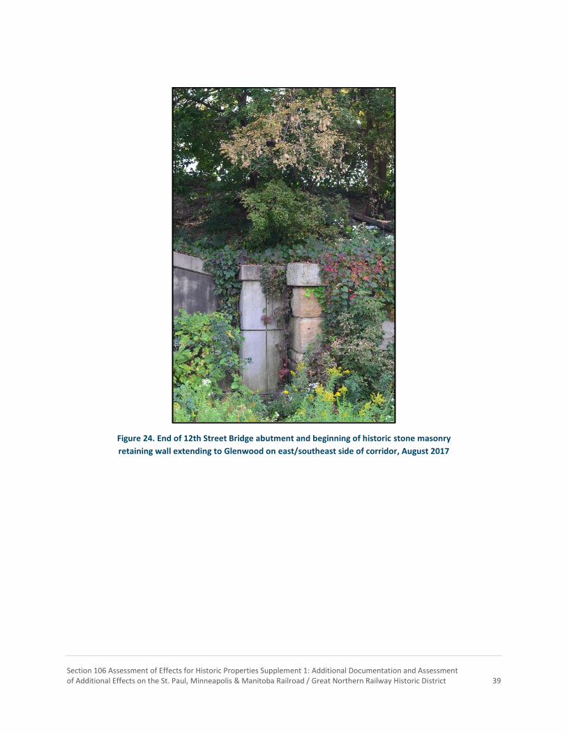
Section 106 Assessment of Effects for Historic Properties Supplement 1: Additional Documentation and Assessment of Additional Effects on the St. Paul, Minneapolis & Manitoba Railroad / Great Northern Railway Historic District 39
Figure 24. End of 12th Street Bridge abutment and beginning of historic stone masonry
retaining wall extending to Glenwood on east/southeast side of corridor, August 2017

Section 106 Assessment of Effects for Historic Properties Supplement 1: Additional Documentation and Assessment of Additional Effects on the St. Paul, Minneapolis & Manitoba Railroad / Great Northern Railway Historic District 40
Figure 25. Historic stone masonry retaining wall east of Glenwood on east/southeast side
of corridor, August 2017
Figure 26. Bluff west of 12th Street on west/northwest side of corridor, August 2017

Section 106 Assessment of Effects for Historic Properties Supplement 1: Additional Documentation and Assessment of Additional Effects on the St. Paul, Minneapolis & Manitoba Railroad / Great Northern Railway Historic District 41
Figure 27. Bluff on west/northwest side of corridor between 12th Street
and Glenwood, which has never been developed, with timber wall remnants on the right, August 2017
Figure 28. Cedar Lake Trail looking northeast towards Target Field from
under the 12th Street Bridge, August 2017

Section 106 Assessment of Effects for Historic Properties Supplement 1: Additional Documentation and Assessment of Additional Effects on the St. Paul, Minneapolis & Manitoba Railroad / Great Northern Railway Historic District 42
Figure 29. Looking west from Glenwood showing trail and location of LRT embankment
and bridge next to tracks, August 2017

Section 106 Assessment of Effects for Historic Properties Supplement 1: Additional Documentation and Assessment of Additional Effects on the St. Paul, Minneapolis & Manitoba Railroad / Great Northern Railway Historic District 43
Figure 30. 1950 aerial view showing Wayzata Boulevard (left), Great Northern corridor (center and right), and
Cedar Lake (far right). The railroad corridor can be seen extending to downtown Minneapolis (center rear)
(Norton & Peel photograph, Minnesota Historical Society)

Section 106 Assessment of Effects for Historic Properties Supplement 1: Additional Documentation and Assessment of Additional Effects on the St. Paul, Minneapolis & Manitoba Railroad / Great Northern Railway Historic District 44
Section 4: Assessment of Effects
Assessing Effects on Historic Properties The criteria that must be used to assess effects of Federal undertakings on historic properties that are listed in or are eligible for listing in the NRHP is set forth in 36 CFR § 800.5(a)(1):
An adverse effect is found when an undertaking may alter, directly or indirectly, any of the characteristics of a historic property that qualify the property for inclusion in the National Register in a manner that would diminish the integrity of the property’s location, design, setting, materials, workmanship, feeling, or association. Consideration shall be given to all qualifying characteristics of a historic property, including those that may have been identified subsequent to the original evaluation of the property’s eligibility for the National Register. Adverse effects may include reasonably foreseeable effects caused by the undertaking that may occur later in time, be farther removed in distance or be cumulative.
An adverse effect can occur if any aspect of a historic property’s integrity is diminished. Examples of adverse effects are identified in 36 CFR § 800.5(a)(2) and include, but are not limited to:
Physical destruction of or damage to all or part of the property;
Alteration of a property that is not consistent with the Secretary of the Interior’s (SOI’s) Standards for the Treatment of Historic Properties (36 CFR § 68) and applicable guidelines;
Removal of the property from its historic location;
Change of the character of the property’s use or of physical features within the property’s setting that contribute to its historic significance;
Introduction of visual, atmospheric, or audible elements that diminish the integrity of the property’s significant historic features;
Neglect of a property that causes its deterioration; and
Transfer, lease, or sale of property out of Federal ownership or control without adequate and legally enforceable restrictions or conditions to ensure long-term preservation of the property’s historic significance.
It is important to note that just because an undertaking may have an effect on a historic property it does not necessarily constitute an adverse effect. For example, project elements may be visible from a historic property without the effect rising to the level of an adverse effect. In this example, factors to consider when assessing whether the visual effect is adverse would include proximity of project components to the historic property, the nature of the element being introduced to the setting, the significance of the views to and from the

Section 106 Assessment of Effects for Historic Properties Supplement 1: Additional Documentation and Assessment of Additional Effects on the St. Paul, Minneapolis & Manitoba Railroad / Great Northern Railway Historic District 45
historic property, and the overall importance of integrity of setting to the historic property’s ability to convey its significance and maintain its eligibility for the NRHP. Direct effects, however, are often more likely to result in an adverse effect due to the actual physical changes they often cause to a historic property, although one notable exception is rehabilitation projects completed in accordance with the SOI’s Standards.
Effects Assessment and Effects Findings for the StPM&M / GN Historic District The only historic property within the Project’s architecture/history and archaeological APEs that will be affected by the proposed Project design modifications is the StPM&M / GN Historic District. Therefore, in accordance with MOA Stipulations II and III, MnDOT CRU reviewed the Preliminary Plans for the proposed design modifications and applied the criteria of adverse effect in accordance with 36 CFR 800.5(a). Reference materials utilized in assessing effects of the proposed Project design modifications on the StPM&M / GN Historic District, but not included in the body of this report, are summarized in Table 2.
Table 2. Reference Key – Assessment of Effects
Title Abbreviation Key
Materials Previously Reviewed under the MOA
Southwest Light Rail Transit Civil Construction: February 8, 2017 (100% Plans)
Volume 1: Existing Conditions and Removals Civil Vol. 1
Volume: 2B: Civil Civil Vol. 2B
Volume: 3B: Trackwork Civil Vol. 3B
Volume: 4G: Bridges Civil Vol. 4G
Volume: 6: Retaining Walls Civil Vol. 6
Volume: 8B: Drainage Civil Vol. 8B
Volume 13A: Cross Sections Civil Vol. 13A
Proposed Project Modifications Materials
Southwest Light Rail Transit: Typical Cross Sections Comparison: 100% Plans and BNSF Project Modifications – StPM&M / GN Historic District
PPM TCSC
Southwest Light Rail: Existing Trail Design and Proposed Trail Design with Realigned Northstar Tail Track, 08/07/2017
PPM E&P Trail+Tail Track
Southwest Light Rail: BNSF Wayzata Subdivision Structural Scope for Work Exhibit (Excludes Corridor Protection Barrier to Bryn Mawr), 8/21/2017
PPM SSW
Southwest Light Rail Transit: BNSF Project Modifications – Retaining Walls, 10/16/2017
PPM RTW

Section 106 Assessment of Effects for Historic Properties Supplement 1: Additional Documentation and Assessment of Additional Effects on the St. Paul, Minneapolis & Manitoba Railroad / Great Northern Railway Historic District 46
Original Assessment of Effect Finding When FTA issued its final determination of effect for the Project on November 10, 2015, which was based on the Project’s 60% Plans, it made the following finding regarding the StPM&M / GN Historic District (the effects considered are summarized in the first paragraph of the finding):
Effects from the Project on the StPM&M / GN Historic District include alterations to the corridor, a minor alignment shift of a short segment of the line, introduction of LRT infrastructure into the corridor, property acquisition, and potential development/redevelopment catalyzed by the Project adjacent to the line around the Van White Station. The Project will permanently acquire and incorporate, either through fee title purchase or easement, approximately 1.53 acres of property from the historic StPM&M / GN Historic District. However, this land will remain in a rail-related use and not otherwise be infringed on by incompatible development. Approximately 5.42 acres will be temporarily occupied for construction access.
North of Lyndale Avenue, the depressed grade separation in which the railroad line is located that extends northeasterly along the corridor through the Minneapolis Warehouse Historic District will be widened approximately 20–25' into the earthen embankment on either side to accommodate LRT. Along one section of the railroad line, beginning near I-94 to approximately Royalston Avenue (a total length of 2,543'), the existing BNSF main line track will be shifted from 0–11' northward within the historic right-of-way. BNSF freight rail operations will also continue. LRT tracks, the overhead power system, a TPSS, and signal bungalows will also be constructed in the corridor. Several bridges will be constructed near stations and across the StPM&M / GN Historic District to provide pedestrian access across the corridor.
At the east end of the Penn Avenue Station, a pedestrian bridge will extend northwest over the Historic District to connect with a passenger drop-off area at South Wayzata Boulevard. At the west end of the Van White Station, an existing pedestrian bridge will be removed and replaced by a new pedestrian bridge that will extend northwest over the Historic District to connect with the Luce Line Regional Trail. Within the depressed grade separation, between the Interstate 394 and North 12th Street bridges over the trench, a new, approximately 900'-long light rail bridge will be constructed to cross Glenwood Avenue at-grade and then carry the light rail tracks over the existing railroad tracks between Glenwood Avenue and North 12th Street. As part of this, the existing vehicular bridge that carries Glenwood Avenue over the trench will be replaced with two new vehicular bridges that will tie into the light rail bridge. The light rail bridge and its western approach will be located within the StPM&M / GN Historic District, in the widened portion of the grade-separation trench.

Section 106 Assessment of Effects for Historic Properties Supplement 1: Additional Documentation and Assessment of Additional Effects on the St. Paul, Minneapolis & Manitoba Railroad / Great Northern Railway Historic District 47
The proposed widening of the corridor, rail alignment shift, and introduction of LRT-related infrastructure are generally compatible with the character of the historic district and will change only a relatively short segment within the linear railroad resource, which extends to the western border of Minnesota. The continuity of the linear resource will be maintained and the alignment shift will remain within the historic corridor. The slight alignment shift of the railroad, the introduction of LRT infrastructure, and property acquisition will slightly alter the feeling of this short segment of the overall district, but will not diminish its overall historic integrity, or its ability to convey its significance.
Portions of the historic district are located within a quarter mile of the Penn, Van White, and Royalston stations. A station area planning study indicated that there is strong potential for the Project to catalyze development/redevelopment around these stations. Development catalyzed by the Project would change the setting of historic district as it passes through the areas of redevelopment. However, these areas are already developed and redevelopment will not diminish the ability of the historic district to convey its historic significance.
To minimize effects on the StPM&M / GN Historic District, which will also minimize visual effects on the Osseo Branch of the StPM&M / GN Historic District (see Section 7.1.15), the Project will design Project elements within and adjacent to the StPM&M / GN Historic District in accordance with the SOI’s Standards. The project will also continue to consult with MnSHPO and other consulting parties on the design of the alterations to Kenilworth Lagoon and Cedar Lake Parkway to confirm compliance with the SOI’s Standards. Therefore, with implementation of these measures, which will be documented in the Section 106 MOA, a finding of No Adverse Effect has been made for the StPM&M / GN Historic District (FTA et al. 2015).
Assessment of the Proposed Project Design Modifications The effects of the proposed Project design modifications on the StPM&M / GN Historic District include both direct and indirect effects to an approximately two-mile-long segment of the approximately 205-mile historic district. The segment subject to the proposed design modifications extends from approximately BNSF Mile Post (MP) 11.6, just south of the 10th Street Bridge, to approximately MP 13.3, just west of Cedar Lake Junction (visual effects extend beyond these limits). The proposed design modifications within and in the vicinity of the StPM&M / GN Historic District include design changes to previously approved Project elements, additional alterations and additions to the historic district within a historic cut that extends from just north of 12th Street North to Lyndale Avenue, and the introduction of an additional CPB Wall from just east of I-94 to the Project’s Bryn Mawr Station. The new CPB Wall will increase the total length of continuous CPB (walls and pier protection) in the corridor from approximately 1,136' (0.22 miles, not including the pier protection under the I-394 and Luce Line Trail bridges) to approximately 7,105' (1.35

Section 106 Assessment of Effects for Historic Properties Supplement 1: Additional Documentation and Assessment of Additional Effects on the St. Paul, Minneapolis & Manitoba Railroad / Great Northern Railway Historic District 48
miles; includes pier protection for I-394 and Luce Line Trail bridges) in length. The height of the CPB Walls will also increase from a minimum of 6' above the railhead to 7.5' above the railhead (approximately 10' above grade) on the freight rail side of the walls (visible height on the LRT side will vary). These design changes are subject to MOA Stipulation I.A, which requires all Project elements within and in the vicinity of the StPM&M / GN Historic District be designed in accordance with the SOI’s Standards in order to minimize effects and avoid adverse effects on the historic district. Each design modification is evaluated below for adherence to the SOI’s Standards. If an element does not meet the SOI’s Standards, an assessment of effects is presented based on the criteria for an adverse effect described in 36 CFR 800.5(a) (Civil Vols. 3B and 6; PPM TCSC; PPM RTW).
The addition of the Northstar tail track to the historic district on the present alignment of the Cedar Lake Trail generally meets the SOI’s Standards. Throughout the period of significance there were multiple sidings and spurs within the historic district and its immediate setting between 7th Street North and Lyndale Avenue. Therefore, extending the tail track will introduce a new element to the district that is in keeping with its historic character. The new track will be in the same general location as track that existed during the period of significance, but will be constructed with heavy rail and concrete ties, which will differentiate it from track that would have existed during the period of significance. Thus, it meets the SOI’s Standards, which require new work be differentiated from the old, but compatible with the historic materials, features, size, scale and proportion, and massing to protect the integrity of the property and its environment (C.M. Foote & Co. 1892; GN 1930; GN 1940; Civil Vols. 3B and 13A; PPM TCSC; PPM E&P Trail+Tail Track; PPM SSW).
The drainage modifications include below ground drainage and ditches along the tracks and trail. Both were included in the Project’s 60% Plans upon which FTA issued its final determination of effect for the Project on November 10, 2015. The design modifications to the below ground drainage will not be visible, so it will not alter the visual character of the historic district and its setting. Drainage ditches are a common and necessary feature found along the entirety of the historic district, providing necessary drainage to drain water away from the railroad tracks in the district. The proposed design modifications to the Project’s ditch designs are generally consistent with the designs included in the Project’s 60% Plans in terms of profile and section, so they are not a substantive change. The designs are also compatible with the design of ditches found throughout the historic district. Therefore, they meet the SOI’s Standards that require new construction to be “compatible with the historic materials, features, size, scale and proportion, and massing to protect the integrity of the property and its environment.” During much of the period of significance, two StPM&M / GN main line tracks were located in the historic district. The drainage modifications will also allow space for the potential reconstruction of a second BNSF main line track in the historic district in the future, which meets the SOI’s Standards that allow for the replacement of missing historic features (Civil Vols. 8B and 13A; PPM TCSC).
Extension of the Northstar tail track necessitates the relocation of the existing Cedar Lake Trail to the south/southeast from approximately 12th Street North to Lyndale Avenue. The relocation of the trail will increase the limits of disturbance into the embankments lining
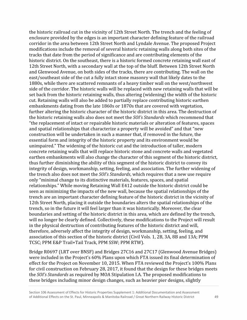
Section 106 Assessment of Effects for Historic Properties Supplement 1: Additional Documentation and Assessment of Additional Effects on the St. Paul, Minneapolis & Manitoba Railroad / Great Northern Railway Historic District 49
the historic railroad cut in the vicinity of 12th Street North. The trench and the feeling of enclosure provided by the edges is an important character defining feature of the railroad corridor in the area between 12th Street North and Lyndale Avenue. The proposed Project modifications include the removal of several historic retaining walls along both sites of the tracks that date from the period of significance and are contributing elements of the historic district. On the southeast, there is a historic formed concrete retaining wall east of 12th Street North, with a secondary wall at the top of the bluff. Between 12th Street North and Glenwood Avenue, on both sides of the tracks, there are contributing. The wall on the east/southeast side of the cut a fully intact stone masonry wall that likely dates to the 1880s, while there are scattered remnants of a heavy timber wall on the west/northwest side of the corridor. The historic walls will be replaced with new retaining walls that will be set back from the historic retaining walls, thus altering (widening) the width of the historic cut. Retaining walls will also be added to partially replace contributing historic earthen embankments dating from the late 1860s or 1870s that are covered with vegetation, further altering the historic character of the historic district in this area. The destruction of the historic retaining walls also does not meet the SOI’s Standards which recommend that “the replacement of intact or repairable historic materials or alteration of features, spaces and spatial relationships that characterize a property will be avoided” and that “new construction will be undertaken in such a manner that, if removed in the future, the essential form and integrity of the historic property and its environment would be unimpaired.” The widening of the historic cut and the introduction of taller, modern concrete retaining walls that will replace historic stone and concrete walls and vegetated earthen embankments will also change the character of this segment of the historic district, thus further diminishing the ability of this segment of the historic district to convey its integrity of design, workmanship, setting, feeling, and association. The further widening of the trench also does not meet the SOI’s Standards, which requires that a new use require only “minimal change to its distinctive materials, features, spaces, and spatial relationships.” While moving Retaining Wall E412 outside the historic district could be seen as minimizing the impacts of the new wall, because the spatial relationships of the trench are an important character defining feature of the historic district in the vicinity of 12th Street North, placing it outside the boundaries alters the spatial relationships of the trench, so in the future it will feel larger than it was historically. Moreover, the clear boundaries and setting of the historic district in this area, which are defined by the trench, will no longer be clearly defined. Collectively, these modifications to the Project will result in the physical destruction of contributing features of the historic district and will, therefore, adversely affect the integrity of design, workmanship, setting, feeling, and association of this section of the historic district (Civil Vols. 1, 2B, 3A, 8B and 13A; PPM TCSC; PPM E&P Trail+Tail Track, PPM SSW; PPM RTW).
Bridge R0697 (LRT over BNSF) and Bridges 27C16 and 27C17 (Glenwood Avenue Bridges) were included in the Project’s 60% Plans upon which FTA issued its final determination of effect for the Project on November 10, 2015. When FTA reviewed the Project’s 100% Plans for civil construction on February 28, 2017, it found that the design for these bridges meets the SOI’s Standards as required by MOA Stipulation I.A. The proposed modifications to these bridges including minor design changes, such as heavier pier designs, slightly

Section 106 Assessment of Effects for Historic Properties Supplement 1: Additional Documentation and Assessment of Additional Effects on the St. Paul, Minneapolis & Manitoba Railroad / Great Northern Railway Historic District 50
adjusted pier spacing of two piers, modification to a barrier section on the deck and increasing a railing height to match other railings, and adding a section of pier protection. The design changes to these bridges are minor, meet the SOI’s Standards, and are not a substantive change that would result in a change of effect to the StPM&M / GN Historic District. However, as noted above the required related work also necessitates the removal of historic retaining walls that contribute to the historic district, which will adversely affect the historic integrity of design, materials, workmanship, setting, feeling, and association of the StPM&M / GN Historic District in this area (Civil Vol. 4G; PPM SSW).
The last major element of the proposed design modifications is the introduction of approximately 5,582' of new CPB Wall (includes pier protection under the Luce Line Trail Bridge [15.5'], but not the 387' of pier protection under the I-394 Bridges) along the Project alignment from a point approximately 294' west of the I-94 bridge, where it will connect with Retaining Wall E404, westward to the Project’s Bryn Mawr Station near Cedar Lake Junction. The majority of the CPB Wall will be constructed within the boundaries of the StPM&M / GN Historic District, between the LRT tracks and the BNSF main line track. At a minimum the top of the CPB Wall will be 7.5' above the top of rail on the BNSF main line track, or 10.8' above grade. Due to differences in the elevations of the freight rail and LRT alignments, on the LRT side, at a minimum the top of the CPB Wall will be 5.5' above the LRT railhead, or approximately 8.7' above grade (PPM TCSC).
Along the entirety of the segment of the StPM&M / GN Historic District and its setting where the CPB Wall is proposed to be constructed, the historic district and portions of its setting are characterized by open areas with very flat topography where multiple tracks and other rail-related shops and industries were located. This condition existed throughout the period of significance. The open spaces include most of the StPM&M / GN right-of-way as well as the M&StL right-of-way that was co-located within the same railroad corridor and is an important character defining feature of historic district’s setting between 3rd Street North and Cedar Lake Junction in Minneapolis. The introduction of the CPB Wall to the historic district will change physical and spatial relationships of the BNSF main line with other physical features of the overall railroad corridor, both within the historic district and its setting. It will also create a visual element that diminishes the integrity of the property's significant historic features. More specifically, the introduction of the CPB will create a physical as well as a visual barrier between the main line track and historic yards that are also contributing elements to the historic district, thereby diminishing the ability of the segment of the historic district in which the CPB Wall is located from being able to convey its magnitude and function, as well as the association of the main line tracks with their associated yards and the M&StL main line and yards that are also important features of the historic district’s setting. Thus, the introduction of the CPB Wall to the historic district will both directly and indirectly alter characteristics of a historic property that qualify it for inclusion in the National Register in a manner that would diminish the integrity of the property's design, setting, feeling, and association. Therefore, the construction of the CPB Wall will result in an additional adverse effect to the StPM&M / GN Historic District (Civil Vols. 3A, 6, and 13A; PPM TCSC; PPM E&P Trail+Tail Track).

Section 106 Assessment of Effects for Historic Properties Supplement 1: Additional Documentation and Assessment of Additional Effects on the St. Paul, Minneapolis & Manitoba Railroad / Great Northern Railway Historic District 51
Project Determination of Effect Based on the results of the assessment of effect analysis conducted by MnDOT CRU under delegation from FTA, which is documented above, FTA has found that the Project will now have an Adverse Effect on the StPM&M / GN Historic District. Therefore, in accordance with MOA Stipulation III, FTA will consult with MnHPO and concurring parties to the MOA to prepare a mitigation plan to resolve the adverse effects. In addition, as required by MOA Stipulation I.A., FTA will direct the Council to design proposed changes to Project elements in accordance with the SOI’s Standards to help minimize the adverse effects of the Project modifications on the StPM&M / GN Historic District.
When FTA issued its final determination of effect for the Project in 2015, it found that the Project would have an adverse effect on historic properties. As such, the new adverse effect finding for the StPM&M / GN Historic District will not change FTA’s final determination of effect for the Project.

Section 106 Assessment of Effects for Historic Properties Supplement 1: Additional Documentation and Assessment of Additional Effects on the St. Paul, Minneapolis & Manitoba Railroad / Great Northern Railway Historic District 52
References
10,000 Lakes, Archaeological Research Services (ARS), Archaeo-Physics, and Merjent 2014 Phase II Archaeological Survey for the Southwest Light Rail Transit Project.
Prepared for the Metropolitan Council, Southwest LRT Project Office. On file at the State Historic Preservation Office, St. Paul.
Benneche, H. W.
1914 Atlas of Minneapolis, Hennepin County, Minnesota. Minneapolis Real Estate Board, Minneapolis, Minnesota.
Burlington Northern Santa Fe Railway
2016 BNSF Railway Track Chart, Wayzata Subdivision, Mpls. Jct., MN to CP 98, MN, MP 9.5 to MP 98.0. Electronic document, http://www.rclservicesgroup.com/wp-content/uploads/TrackCharts/Twin_Cities/Wayzata.pdf, accessed October 2, 2017.
C. M. Foote & Co.
1892 City of Minneapolis Map. Electronic document, http://geo.lib.umn.edu/plat_books/minneapolis1892/minn1892index.htm, accessed August 18, 2017.
Donovan, Frank P.
1950 Mileposts on the Prairie: The Story of the Minneapolis & St Louis Railway. Simmons-Boardman Publishing Corporation, New York, New York.
Egan, James G., compiler
1903 Atlas of the City of Minneapolis. Electronic document, http://www.geo.lib.umn.edu/collections/digitizedplatbooks/minn1903index.htm, accessed August 18, 2017.
Great Northern Railway
1891 AFE #202-E, Bridge. Great Northern Railway Historical Society. Electronic document, http://www.gn-npjointarchive.org/_layouts/15/start.aspx#/Lists/AFE_List/AllItems.aspx, accessed August 18, 2017.
1897 AFE #499-E, Turntable. Great Northern Railway Historical Society. Electronic
document, http://www.gn-npjointarchive.org/_layouts/15/start.aspx#/Lists/AFE_List/AllItems.aspx, accessed August 18, 2017.
1897 AFE #583-E, Yard Track. Great Northern Railway Historical Society. Electronic
document, http://www.gn-npjointarchive.org/_layouts/15/start.aspx#/Lists/AFE_List/AllItems.aspx, accessed August 18, 2017.
Section 106 Assessment of Effects for Historic Properties Supplement 1: Additional Documentation and Assessment of Additional Effects on the St. Paul, Minneapolis & Manitoba Railroad / Great Northern Railway Historic District 53
1940 Railroad Valuation Map, Minneapolis No. 11. Second Street N. to Lyndale Ave. Revised March 1962, p. U-95. Electronic document, (EDOCS) Minnesota Department of Transportation files.
1930 Railroad Valuation Map, Minneapolis No. 12. Lyndale Ave. to Superior Ave.
Revised June 1956, p. U-96. Electronic document, (EDOCS) Minnesota Department of Transportation files.
Hofsommer, Don L.
2005a Minneapolis and the Age of Railways. University of Minnesota Press, Minneapolis, Minnesota.
2005b The Tootin’ Louie: A History of the Minneapolis & St. Louis Railway. University of
Minnesota Press, Minneapolis, Minnesota. 2009 The Minneapolis & St. Louis Railway: A Photographic History. University of
Minnesota Press, Minneapolis, Minnesota. Luecke, John C.
1997 The Great Northern in Minnesota: The Foundations of an Empire. Grenadier Publications, St. Paul, Minnesota.
McClelland, Linda Flint, and J. Timothy Keller, Genevieve P. Keller and Robert Z. Melnick
1989, Rev. 1999 National Register Bulletin: Guidelines for Evaluating and Documenting Rural Historic Landscapes. Government Printing Office, Washington D.C.
Minneapolis & St. Louis Railway
1917 Right-of-Way and Track Map, Rev. April 1925, Station 79+20 to Station 105+64 (1st N. to 5th St. N.), pg. 4. Electronic document, (EDOCS) Minnesota Department of Transportation files.
1917 Right-of-Way and Track Map, Rev. April 1925, Station 105+64 to Station 132+04
(5th St. N. to Western Ave.), pg. 5. Electronic document, (EDOCS) Minnesota Department of Transportation files.
1917 Right-of-Way and Track Map, Rev. April 1925, Station132+04 to Station 158+44
(Western Ave. to Dupont Ave.), pg. 6. Electronic document, (EDOCS) Minnesota Department of Transportation files.
Minnesota Historic Aerial Photos Online [MNAPO]
1938 Historic Aerial Photograph, Minneapolis, Minnesota. Electronic document, https://www.lib.umn.edu/apps/mhapo, accessed September 5, 2017.
Minneapolis Tribune [Minneapolis, Minnesota]
1888 “The Crossings Decision.” 6 March. Minneapolis, Minnesota.

Section 106 Assessment of Effects for Historic Properties Supplement 1: Additional Documentation and Assessment of Additional Effects on the St. Paul, Minneapolis & Manitoba Railroad / Great Northern Railway Historic District 54
NETROnline (Historic Aerials) 1957 Historic Aerial Photograph, Minneapolis, Minnesota. Electronic document,
https://historicaerials.com/viewer, accessed August 21, 2017.
1972 Historic Aerial Photograph, Minneapolis, Minnesota. Electronic document, https://historicaerials.com/viewer, accessed August 21, 2017.
1979 Historic Aerial Photograph, Minneapolis, Minnesota. Electronic document,
https://historicaerials.com/viewer, accessed August 21, 2017.
1991 Historic Aerial Photograph, Minneapolis, Minnesota. Electronic document, https://historicaerials.com/viewer, accessed August 21, 2017.
Peterson, Garneth
2003 URS/BRW Report #03-01: Historic Context: The St. Paul and Pacific Railroad Main Line. Prepared for Minnesota Department of Transportation and the Federal Highway Administration. On file at the State Historic Preservation Office, St. Paul, Minnesota.
Prosser, Richard S. 2007 Rails to the North Star: A Minnesota Railroad Atlas. University of Minnesota Press,
Minneapolis, Minnesota. Originally published 1966, Dillon Press, Minneapolis, Minnesota.
Ruger, A.
1879 Panoramic View of the City of Minneapolis. Electronic document, https://www.loc.gov/resource/g4144m.pm003950/, accessed September 28, 2017.
Sanborn Map Company
1930 Insurance Maps of Minneapolis, Minnesota: Volume 2. New York: Sanborn Map Company, 1912, updated to 1930.
1951 Insurance Maps of Minneapolis, Minnesota: Volume 2. New York: Sanborn Map
Company, 1912, updated to 1951. Sanborn Map and Publishing Company
1885 Minneapolis Minnesota, Volume 2. Sanborn Map and Publishing Company, New York.
1889 Minneapolis Minnesota, Volume 3. Sanborn Map and Publishing Company, New
York.
Schmidt, Andrew J., Daniel R. Pratt, Andrea C. Vermeer, and Betsy H. Bradley 2007 National Register of Historic Places Multiple Property Documentation Form:
Railroads in Minnesota, 1862–1956. On file at the State Historic Preservation Office, St. Paul, Minnesota.

Section 106 Assessment of Effects for Historic Properties Supplement 1: Additional Documentation and Assessment of Additional Effects on the St. Paul, Minneapolis & Manitoba Railroad / Great Northern Railway Historic District 55
Schmidt, Andrew J., and Andrea C. Vermeer 2010 Phase I/Phase II Architecture History Investigation for the Proposed Southwest
Transitway Project, Hennepin County, Minnesota, Volume Three: Minneapolis and Saint Louis Railroad Survey Zone, Chicago Milwaukee and St. Paul Railroad Survey Zone, Minneapolis Northfield and Southern Railroad Survey Zone, Great Northern Railroad Survey Zone. Prepared by Summit Envirosolutions, Inc., St. Paul., Minnesota. Submitted to the Metropolitan Council, Southwest LRT Project Office. On file at the State Historic Preservation Office, St. Paul, Minnesota.
Smith, A. M.
1891 Bird’s Eye View of Minneapolis. Electronic document, http://hdl.loc.gov/loc.gmd/g4144m.pm003970, accessed September 28, 2017.