Embed Size (px)
Citation preview

i ii
PROPERTY OF Iff GEOLOGICAL SUWENATIONAL AERONAUTICS AND SPACE ADMINISTRATION
EARTH RESOURCES SURVEY PROGRAM
TECHNICAL LETTER NASA-68
J. R. Jones S. Geological Survey Washington, D. C.
April, 1967
Prepared by the Geological Survey for theNational Aeronautics and Space Administration (NASA)under NASA Contract No. R-09-020-013
MANNED SPACECRAFT CENTERHOUSTON, TEXAS
https://ntrs.nasa.gov/search.jsp?R=19700029613 2020-03-11T21:41:16+00:00Z

. UNITED STATES Technical Letter DEPARTMENT OF THE INTERIOR NASA-68
GEOLOGICAL SURVEY ^Y 1967 WASHINGTON, D.C. 20242
Dr. Peter C. Badgley Program Chief, Earth Resources Survey Code SAR - NASA Headquarters Washington, D. C. 20546
Dear Peteri
TECHNICAL LETTER NASA-68
HYDROLOGIC EVALUATION OF GEMINI PHOTOGRAPHS
OF FRINGES OF THE SAHARA, AFRICA*
by
J, R» Jones**
April 1967
Sincerely yours,
William A. Fischer Research Coordinator Earth Orbiter Program
*Work performed under NASA Contract No* R-09-020-013**U.S. Geological Survey, Washington, D. C.
RETURN TO!NMD RESEARCH REFERENCE'COLLECTION
USGS NATIONAL CENTER. MS-521

UNITED STATESDEPARTMENT OF THE INTERIOR
GEOLOGICAL SURVEY
TECHNICAL LETTER NASA-68
HYDROLOGIC EVALUATION OF GEMINI PHOTOGRAPHS
OF FRINGES OF THE SAHARA, AFRICA*
by
J. R. Jones
April 1967
These data are preliminary and should not be quoted without permission
*Work performed under NASA Contract No. R-09-020-013 **U.S. Geological Survey, Washington, D. C.
Prepared by the Geological Survey for the National Aeronautics and
Space Administration (NASA)

-CONTENTS
:e
ILLUSTRATIONS
Figure 1. Location Map
2. a, Photo 51-4; b, annotated overlay
3. a, Photo 52-17; b, annotated overlay
4. a, Photo 472-1; b, annotated overlay
5. a, Photo 9B-50;b, annotated overlay
6. a, Photo 54-63; b, geologic overlay;
c, geographic overlay
Abstract 1
Introduction 1
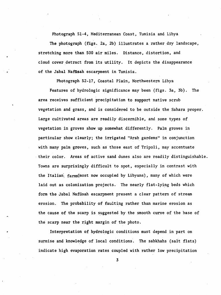
Photograph 51-4, Mediterranean Coast, Tunisia and Libya 3
Photograph 52-17, Coastal Plain, Northwestern Libya 3
Photograph 472-1, Nile Delta and Great Rift 4
Photograph 9B-50, Lake Chad, Chad, Niger, and Nigeria 4
Photograph 54-63, Atlantic Coast, Ifni, and Morocco 6

Technical Letter NASA-68
HYDROLOGIC EVALUATION OF GEMINI PHOTOGRAPHS OF FRINGES OF THE SAHARA, AFRICA
by J. R. Jones!/
Abstract
Five Gemini color photographs, including one from Gemini IV, three from Gemini V, and one from Gemini IX, are evaluated for their content of information of hydrologic significance. Geographic, geomorphic, and geologic features are annotated on overlays. Outstanding features clearly displayed in the photos include the paleohydrologic (transitional) nature of the eastern shore of Lake Chad; topographic and color manifestations of geology near the Atlantic Coast of Morocco, and the hydrologic control on location of towns in that region (37 towns were located in one photograph); the sharp contrast between the water-rich Nile Delta and adjacent desert; the disappearance of the Jabal Nafusah escarp ment in Libya; and the intricate drainage patterns of the flat- lying beds which form the Jabal Nafusah.
Introduction
Color photographs taken by Gemini astronauts are of hydrologic
interest because they provide views of imprecedented synoptic
content and quality. Geographic, geomorphic, and geologic features
revealed in the photographs, as well as obvious water bodies such
as lakes and streams, are important for hydrologic interpretation.
Five selected Gemini photographs of the fringes of the Sahara
in North Africa are evaluated in this report for their hydrologic
significance (figure 1). The author is!personallyfamiliar with
the areas shown in the five photographs. This evaluation is part
of a program wherein scientists evaluate empirically the data
from various airborne and spaceborne remote sensors.
I/ Geologist, Water Resources Division, U.S. Geological Survey

Visible-light photographic cameras have been and are expected to
continue to be the sensors most useful to hydrologists.
Each photograph has been reproduced with an accompanying
overlay indicating the features detected. Photograph 54-63
(fig. 6a) has two separate overlays, one for geology and one for
geography.
The photographs were all taken with a hand-held, modified
Hasselblad camera, Model 500, equipped with an 80mm Zeiss Planar
f.28 lens. The film used was General Aniline Anscochrome for
photo 54-63, and Kodak Ektachrome for the other photos. Other
pertinent information about the photographs is tabulated below:
Photo No.
51-4
52-17
472-1
9B-50
54-63
Gemini Mission
V
V
IV
IX
V
Orbit
14
87
12
44
74
Date
8/22/65
8/27/65
6/4/65
6/6/66
8/26/65
Time
1106
0658
0910
1123
1025
Astronauts
Cooper, Conrad
Cooper, Conrad
McDivitt, White
Stafford, Cernan
Cooper, Conrad
The altitudes from which the photographs were taken are
within the range, 86-215 nautical miles. The perigee (lowest point
in the orbit) and apogee (highest point) for Gemini missions IV, V,
and IX were, respectively, 100-175, 100-215, and 86-144 nautical
miles.
Photograph 51-4, Mediterranean Coast, Tunisia and Libya
The photograph (figs. 2a, 2b) illustrates a rather dry landscape,
stretching more than 500 air miles. Distance, distortion, and
cloud cover detract from its utility. It depicts the disappearance
of the Jabal NafQsah escarpment in Tunisia.
Photograph 52-17, Coastal Plain, Northwestern Libya
Features of hydrologic significance may been (figs. 3a, 3b). The
area receives sufficient precipitation to support native scrub
vegetation and grass, and is considered to be outside the Sahara proper.
Large cultivated areas are readily discernible, and some types of
vegetation in groves show up somewhat differently. Palm groves in
particular show clearly; the irrigated "Arab gardens" in conjunction
with many palm groves, such as those east of Tripoli, may accentuate
their color. Areas of active sand dunes also are readily distinguishable
Towns are surprisingly difficult to spot, especially in contrast with
the Italian. farms(most now occupied by Libyans), many of which were
laid out as colonization projects. The nearly flat-lying beds which
form the Jabal Nafusah escarpment present a clear pattern of stream
erosion. The probability of faulting rather than marine erosion as
the cause of the scarp is suggested by the smooth curve of the base of
the scarp near the right margin of the photo.
Interpretation of hydrologic conditions must depend in part on
surmise and knowledge of local conditions. The sabkhahs (salt flats)
indicate high evaporation rates coupled with rather low precipitation
3

(except right at Tripoli less than 16 inches per year). Only in the
right half of the photo, from Wadi al Majanin eastward, do floods of
the normally dry streams cross the plain (Gefara) to the sea. Most
runoff from the bare, steep hills percolates to ground-water reservoirs
or evaporates. The farm areas, especially the "Arab gardens" near the
coast, indicate that ground water is available for irrigation. The
"Arab gardens" are traditionally watered by animal power, therefore lifts
must be low. Most of the olive groves in the Gefara were irrigated for
at least their first two seasons and the citrus must be irrigated with
water of rather good chemical quality.
Photograph 472-1, Nile Delta and Great Rift
This photo (figs. 4a, 4b) clearly illustrates the importance of
water in this area supplied by the Nile -- which makes the delta
a bast garden that contrasts sharply with the adjacent desert. Evapora
tion has concentrated salts in the "sabkhahs 1,1 the Dead Sea, and
formerly, Great Bitter Lake. The depression Wadi al Natrun at the right
margin of the picture supports vegetation watered, probably in part
irrigated, by shallow ground water.
Photograph 9B-50, Lake Chad, Chad, Niger, and Nigeria
Paleohydrologic features may be seen (figs. 5a, 5b). The photograph
shows clearly the remarkable transitional nature of the eastern shore
of Lake Chad; it is almost impossible to determine a shoreline. Be
cause of the low gradient of the bottom of the shallow lake and of the
land adjacent on the east and north, a small change in lake level causes
4

a relatively large movement of the shoreline. Because the land surface
consists of sand dunes of differing heights and configuration, there
is a gradual zonal change from land, to land with ponds, to land with
bays, to bays with peninsulas and islands, to islands, to open lake.
Linear features in the northwestern part of the photo probably
represent shorelines formed at maximum or near-maximum stages of the
lake, presumably in the Pleistocene Epoch. Although the western shore
of the lake changes position but slightly when lake stage is in the
modern range, the northern and eastern shores at various stages are
subparallel to each other. Thus the shape of the lake remains relatively
constant, based on the west shore, but the area varies greatly.
Additional evidence of formerly higher water levels is provided by the
former lagoon south of the Komadugu Yobe.
The westward limit of the area of submerged dunes shows the
diminished extent of the lake during one or more past dry periods. The
outlines of the dunes have persisted despite wave action.
The general orientation of dunes is approximately northwest-southeast
A lineation nearly at right angles to this is apparent in the submerged
dune area, especially in the northern part of the lake, and inland to
the east of the lake. The dark patches which mark the lineations may be
either patches of vegetation or open water, indicating the proximity
of the water table to land surface. In recent years, the lake has been
exceptionally high.
The white areas northwest of the lake are probably active sand
dunes. The white color of the dunes may indicate that diatomite,
5

reported to occur in the general area, constitutes an appreciable
part of the dune sediments.
Photograph 54-63, Atlantic Coast, Ifni, and Morocco
Topographic and color manifestations of geologic units are
strikingly displayed in this photo (figs. 6a, 6b). Although there
is marked similarity between the ASGA-UNESCO Geological Map of Africa,
Sheet 1, and relief shown on the photo, it was not possible to relate
all mapped units to the photo. Three ages of Precambrian rocks are
distinguished on the geologic map and at places on the photo, but
descriptions of lithology are so generalized in literature and geologic
maps that at most places no attempt was made to differentiate on the
photo between the three Precambrian units.
Even the most conspicuous water courses in this region of low
precipitation are usually dry most of each year. A number of towns
are discernible (fig 6a) because they are in areas of irrigated culti
vation. On the overlay (fig. 6c) towns are identified by numbers
keyed to the list below. Most towns are sited on Quaternary deposits,
the only rocks which at most places yield water sufficiently freely for
use in irrigation.

1. Assaka
2. Agadir
3. Tracim
h. Iksabi
5. Puaroun
6. Sidi Athmane
7. Goulimine
8. Asrir
9. ATt Boukha
10. Taourirt Doubiane
11. Fask
12. Tiflit
13. A?t-Moussa-ou-Daoud
lU. Abeino
15. Sidi Messaoud
16. Ouaoutelt
IT. Tagant
18. Bou Izakarene
19. Tagmout
20. Targhjicht
21. Aiiamer
22. Sidi Ifni
23. El Argoub
24. Name not shown on map
25. Alt Moussa
26. Name not shown on map
27. El Kseib
28. El Aouina
29. N'Salah Bammou
30. Idehr
31. Ouijiane
32. Tiznit
33« Name not shown on map
3^. Name not shown on map
35. Attebane
36. Timslil
37- Ahl Mader
A T i. AN TIC
Figure 1. -- Location map,

Appro*.
GV1.FOF
TUNISIA
Buha^rat
atfiibanPisida
(8u Kammash)
C onti neirita.! Quo.-ternary uncon&olidated sedimentsJa.z~ira.-t Ja.rba.h
(Island of Jerbah)
LIBYA
Window
Cock pi t
NASA Gemini photo 51-4 Annotation by U.S. Geological Survey, September 1966
MEDITERRANEAN COAST, TUNISIA AND LIBYA

NASA-Gemini photo 52-17
COASTAL PLAIN, NORTHWESTERN LIBYA

M.\ /
l*'dd/~ 5/V' Ab<J a,/ 'Af? -A/.XT-- . ^
J / ^rs ?
Oatr a.1 Ji-fo.ra.H~ _ . A K\
oce ne Rocks
Cretaceous
\ *<\ o *\ 0-*^ °*r\? <i'%%
3^nes
Vnnv ;
& ^f f>"lo 0-
x A re a. of
^x ar bor i cultureN.
(&»sr Ki-.r; ,
V««//- Turgh^i ^^\'-J V/ ^(O " T > !
V \ Ital '" ri 'fx)rntsv \ 0̂ -<\\ <?V<i<ti a/ W<tsld '^i, ;^i^T'"^
Dune stab
pinC5 and
RCL s To. j u.
Coastal
As Saba. bi I
-farms- ol i ve^
t a b i 11 z Q. t/o n. I y p t u '
nJu Bin 6 ha s h i rnuq^ in aIdri > Airport!r l
-f should Dunes
Coa,*>ta.l dunes
S« b ratah
Excavactions at Roma So. brat ah
By us. <?e*u.oqric/it_

NASA-Gemini photo 472-1
NILE DELTA AND GREAT RIFT

Annotation by U.S. Geological Survey, September 1966

NASA-Gemini photo 9B-50
LAKE CHAD, CHAD, NIGER, AND NIGERIA

AHNOT4TION By (/ S. QfViOG/CAL

NASA-Gemini photo 54-63
ATLANTIC COAST, IFNI AND MOROCCO

Designation of rock agesQ, QuaternaryC, CarboniferousCO, Cambro-OrdovicianC, CambrianpC, Precambrian
(p a, b, c; subdivisions of Precambrian in order of increasing age)
AbbreviationsCgl, conglomerategr, graniteIs, limestone
"Schiste" is a French termincluding schist, slateand shale.
By u.s.GEOLOGICAL

Numbers designate inhabited places identified on photo. See text for names
.<C3f '',HI» X* V
Lot. 29*2 3'N Long. IO°IO
4
By v.f.Qeot.o^tCAL smtvey
MSC S5S747