Embed Size (px)
Citation preview
Proposal, CCNPP Phase I, Calvert County, Maryland
1
Proposal for Phase I Cultural Resources Investigation
Calvert Cliffs Nuclear Power Plant
Calvert County, Maryland
August 23, 2006
Introduction and Project Description GAI Consultants, Inc. (GAI) is pleased to submit this proposal to Tetra Tech NUS, Inc. to conduct a Phase I cultural resources investigation at the Calvert Cliffs Nuclear Power Plant (CCNPP). The proposed project area consists of a 300-acre parcel situated immediately south of the existing Calvert Cliffs Nuclear Power Plant, in southeastern Calvert County, Maryland, along the shore of the Chesapeake Bay. The goal of GAI’s Phase I survey is to identify historic or prehistoric archaeological resources within the project area and to preliminarily assess their eligibility for listing in the National Register of Historic Places (NRHP). An architectural survey of the property will include the inventory and NRHP evaluation of two circa 1930s structures in the project area.
The Area of Potential Effect (APE) for GAI’s Phase I cultural resources investigations will consist of the 300-acre (121.4 hectare) project footprint. Project mapping and information on the extent of proposed construction activities are not available for proposal preparation. For purposes of this proposal, GAI assumes that the project area represents a rectangular, 300-acre parcel that parallels the shore of the Chesapeake Bay and is bounded to the north by the existing CCNPP and a large artificial pond. Based on a preliminary review of mapping in the general project vicinity, the proposed project area consists largely of wooded, dissected uplands. “Made” or artificial land is mapped within open areas in the eastern portion of this parcel. Additional disturbances within the project APE result from construction of the existing CCNPP, roadway construction, and channelization of drainages.
GAI’s Phase I cultural resource survey will include background research, field investigations, laboratory analysis and technical report preparation. The proposed work will be conducted in accordance with Section 106 of the National Historic Preservation Act of 1966, as amended, guidelines developed by the Advisory Council on Historic Preservation, the amended Procedures for the Protection of Historic and Cultural Properties as set forth in 36 CFR 800, the Secretary of Interior’s Standards and Guidelines for Archaeology and Historic Preservation and the Standards and Guidelines for Archeological Investigations in Maryland (Shaffer and Cole 1994). These proposed project tasks are described below.
Scope of Work Project Management/Section 106 Coordination At various points in the proposed project, GAI will assist Tetra Tech NUS, Inc. and CCNNP in consulting and coordinating with the Maryland Historical Trust and, if applicable, the Calvert County Planning & Zoning Department. This is expected to include phone calls and preparation of memos involving discussions of project methods and results, drafting letters, and attendance at up to one (1) meeting in Crownsville (MHT) or at the project area. As necessary, GAI can assist with the preparation of other Section 106 documentation including Memorandum of Agreements (MOA). Literature and Background Research Prior to Phase I field investigations, GAI will examine archaeological site files, historic structure files, National Register listings, historic maps and cultural resource reports at the Maryland Historical Trust (MHT) in Crownsville, the Calvert County Historical Society in Prince Frederick, and possibly at the Southern Maryland Studies Center at the College of Southern Maryland in LaPlata. The purpose of this

Proposal, CCNPP Phase I, Calvert County, Maryland
2
task is to 1) identify previously recorded cultural resources in the vicinity of the study area, 2) assess the project area’s potential for unrecorded cultural resources, and 3) provide an historic context for evaluating any identified cultural resources. It should be noted that owing to GAI’s extensive recent work experience in Calvert County and surrounding areas, we have already developed a general historic context for the project vicinity.
Field Investigations GAI will conduct Phase I survey to identify cultural resources within the Area of Potential Effect for the proposed project. Fieldwork will be subdivided into three tasks: geomorphological/ archaeological reconnaissance, followed by archaeological survey and architectural survey. Through our survey experience on similar projects, we have found this approach to be highly cost-effective. In this approach, our in-house professional soil scientist and the project's archaeological field director will conduct a reconnaissance of the project to target locations for subsequent archaeological survey and exclude remaining project areas from further consideration.
Geomorphological and Archaeological Reconnaissance. Specific goals of the geomorphological and archaeological reconnaissance are to:
Screen project areas for surface disturbance and landform age;
Refine preliminary estimates of archaeological sensitivity derived from background research; and
Evaluate potential of deep impact areas for buried prehistoric archaeological sites.
During the Geomorphological Reconnaissance, GAI's soil scientist will screen the project area for surface disturbances, since these locations will be unlikely to contain intact archaeological remains and can be excluded from site survey. GAI's soil scientist will record relative landform ages within the study area, because the youngest landforms (e.g., historic floodplains) may be too recent to contain archaeological sites and can often be excluded from archaeological survey. This reconnaissance will also result in the identification of possible alluvial terrace settings within the project area that may have potential for older prehistoric sites buried by flood sediments. No deeply buried sites are expected based on GAI’s preliminary project review.
In conjunction with the project's staff soil scientist, GAI's project field director and/or crew chief will conduct an Archaeological Reconnaissance to ground-truth preliminary assessments of archaeological potential based on background research. In particular, the field director will assess how local ground conditions and topographic setting may affect archaeological potential across the project APE. Based on this field review, GAI will target locations of high and moderate archaeological potential in the APE for subsequent archaeological survey.
Archaeological Survey. Following geomorphological and archaeological reconnaissance, GAI will conduct an archaeological survey to identify historic or prehistoric sites in the project APE. If appropriate, pedestrian survey of areas with excellent ground surface visibility, such as plowed fields, will be conducted at this time.
Phase I survey will primarily consist of shovel test pit (STP) excavation in areas with poor ground surface visibility. In general, shovel test pits will be excavated at 15-meter intervals within transects spaced 15-meters apart. STPs will measure approximately 50x50 cm in diameter and will extend into subsoil. Excavated soils will be screened through 0.25-inch (6-mm) wire mesh for systematic artifact recovery. Prehistoric and historic artifacts recovered during survey will be bagged and labeled with appropriate provenience information. When artifacts are recovered during survey, GAI archaeologists will excavate additional radial STPs at reduced intervals to evaluate initial findspots and delineate site dimensions on a preliminary basis within the project APE. GAI archaeologists will record results of individual STPs on standardized field forms, including depths of soil horizons, soil texture and Munsell color, and artifact recovery. STP locations will be recorded on project maps. Following excavation and recording, individual STPs will be backfilled. Identified cultural resources will be plotted on project
Proposal, CCNPP Phase I, Calvert County, Maryland
3
maps, documented with photographs, and their location will be recorded using mapping-grade GPS equipment.
Based on general project location information provided by the client, and on a review of the Cove Point 7.5 Minute U.S.G.S. topographic quadrangle and the Calvert County Soil Survey in the general project vicinity, GAI assumes that approximately 190 acres of the project APE will be excluded from shovel testing due to slopes in excess of 10 percent. It is expected that an additional 30 acres will be excluded from testing due to prior disturbances. The remaining approximately 80 acres consist of relatively level to moderately sloping, wooded uplands that will be subject to subsurface shovel testing.
For purposes of this proposal GAI estimates the excavation of up to 1280 15-meter interval STPs and 80 radial STPs, for a project total of up to 1360 shovel tests. Due to the upland setting of the moderate to high potential portions of the project area, GAI assumes that cultural resources will be near-surface in nature and that STPs will extend no more than 50 cm in depth. GAI assumes that Phase I survey will result in the identification of one archaeological site, requiring completion of a Maryland Archeological Site Survey Form, within the project area.
Architectural Survey Based on information provided by Tetra Tech NUS, Inc., it is anticipated that two circa 1930s structures will be inventoried and evaluated for their eligibility for listing in the National Register of Historic Places. These resources will be identified and mapped in the field using a mapping-grade GPS unit. This work will be conducted in compliance with the Standards and Guidelines for Architectural and Historical Investigations in Maryland (Maryland Historical Trust 2000) and General Guidelines for Compliance-Generated Determinations of Eligibility (Maryland Historical Trust 2002).
Prior to initiating the survey of the two buildings, GAI will review existing materials relevant to the project area in the MHT Library and Archives in Crownsville and pertinent historical information related to the proposed project area in Calvert County’s Historical Society Collection in Prince Frederick. From these repositories, GAI will review earlier survey documentation pertaining to Camp Conoy and the project area. The collected research will be used to illustrate the development and history of the project area as well as to enhance the existing context for evaluation of surveyed resources. The information collected by GAI will be included in the technical report to be submitted to Tetra Tech NUS, Inc. GAI will conduct architectural fieldwork within the project area to document two cabins associated with the former Boy Scouts of America Facility at Camp Conoy including the completion of Maryland Historical Trust Determination of Eligibility forms. This will provide the MHT with the information necessary to concur on the NRHP eligibility of these resources. Photographs for each building will be processed, labeled, and catalogued as specified in MHT survey guidelines. The surveyed resources will be located on USGS 7.5’ Quadrangle maps and plotted on plan view sketch maps showing the relationship of the resource(s) to secondary resources, roadways, and other important benchmark features. Additionally, visual impacts assessments will be conducted and noted during the fieldwork phase to identify the potential for adverse effects on properties if they are determined to be eligible for NRHP listing in consultation with the Maryland Historical Trust. Laboratory Analysis Subsequent to Phase I survey, GAI will conduct laboratory analysis of recovered artifacts to characterize age, type, and function of recovered archaeological remains. Historic and/or prehistoric artifacts recovered during the Phase I survey will be transported to GAI’s archaeological laboratory in Homestead, Pennsylvania, and will be processed according to the Standards and Guidelines for Archeological Investigations in Maryland (Shaffer and Cole 1994), Technical Update No. 1 - Collections and Conservation Standards (MHT 1999), and the Maryland Archaeological Conservation Laboratory (MAAC Lab). These materials will be washed, sorted, and labeled with the site number, if appropriate. Prehistoric artifacts will be segregated into material types and functional classes (e.g., lithic tools, debitage, prehistoric pottery) and subjected to typological and technological analyses including the identification of temporal and cultural affiliation, if possible. Historic artifacts will be separated into various material groups, including ceramics, glass, metal, faunal, etc. These artifacts will be cataloged
Proposal, CCNPP Phase I, Calvert County, Maryland
4
according to established typologies using the class-type-variety method. If possible, historic proveniences will be assigned date ranges, based on the presence of diagnostic artifacts (e.g., bottle technological attributes, ceramic types). The final artifact repository for these materials will be determined in consultation with CCNPP, Tetra Tech NUS, Inc., and the MHT. For the purpose of this proposal, GAI assumes the identification of one archaeological site and the recovery of no more than 200 artifacts.
Technical Report GAI will prepare a Phase I Technical Report on the cultural resources survey, including results of background research, environmental and historic context, archaeological and architectural fieldwork, and laboratory analysis. The report will contain recommendations regarding the need for additional work, if necessary, the NRHP eligibility of two standing structures, and the potential National Register eligibility of any archaeological resources identified in the project area. Report appendices will include completed Maryland Archaeological Site Forms for identified site(s) (GAI assumes completion of one site form), MHT Determination of Eligibility Forms (two resources), and a catalog of recovered artifacts. Any collections reviewed from sites located in the vicinity of the project area will be discussed as well. The Phase I survey, artifact analysis, and report preparation will be conducted in accordance with the Standards and Guidelines for Archaeological Investigations in Maryland (Shaffer and Cole 1994), the Standards and Guidelines for Architectural and Historical Investigations in Maryland (Maryland Historical Trust 2000) and General Guidelines for Compliance-Generated Determinations of Eligibility (Maryland Historical Trust 2002).
Based on information provided by Tetra Tech NUS, Inc. GAI assumes the completion of the following project deliverables:
Monthly progress reports and updated schedule
Written records of meetings, discussions, etc.
Preliminary Draft Report (MS Word and PDF)
Five (5) GBC-bound hardcopies and one camera-ready copy of Draft Report, PDF and MS Word files, including two (2) copies to be forwarded by client to agencies within one (1) week of receipt of comments on preliminary Draft Report
Five (5) GBC-bound hardcopies and one camera-ready copy of Draft Report, PDF and MS Word files of Final Report
All project records (photographic negatives, maps, notes, etc.) submitted to the Client or MHT as requested by Client upon submittal of Final Report.
Cost Proposal and Schedule GAI can conduct Phase I cultural resources survey, as delineated above, for a cost of $XXXXXX. GAI will submit the Preliminary Draft Report within seventy (70) calendar days of the fully signed contract. Based on the assumptions stated in the proposal, it is anticipated that fieldwork will extend for a period of approximately thirty-five (35) calendar days followed by twenty-eight (28) calendar days of laboratory work and report preparation.
GAI assumes that Tetra Tech NUS, Inc. will gain access to all properties requiring cultural resources survey in advance of fieldwork.

Management Summary
Phase Ia Cultural Resources Investigation
Calvert Cliffs Nuclear Power Plant
Calvert County, Maryland
October 20, 2006
GAI Consultants, Inc. (GAI) is pleased to submit this Phase Ia Management Summary and Phase Ib Revised Scope of Work and Cost Estimate for conducting Cultural Resources Investigations at the Calvert Cliffs Nuclear Power Plant (CCNPP). GAI is conducting this work for Tetra Tech NUS, Inc. (Tetra Tech) on behalf of Constellation Energy (Constellation). The Phase Ia study included background research and a geomorphological and archaeological reconnaissance of the project area. Phase Ia fieldwork was conducted between October 9 and 12, 2006.
Introduction and Project Description The proposed project area consists of a 600-acre parcel situated west and south of the existing Calvert Cliffs Nuclear Power Plant, in southeastern Calvert County, Maryland (Figure 1). It is bounded to the east by the Chesapeake Bay and to the west by Maryland Route 2/4. The project area is located in a dissected upland setting encompassing woodlands, fallow agricultural fields, wetlands, and areas of disturbance associated with the existing CCNPP and Camp Conoy (a twentieth-century former YMCA camp). The goal of GAI’s Phase Ia study was to identify previously recorded cultural resources within the project area, evaluate the project area’s archaeological potential, and target portions of the project area that will be subject to Phase Ib shovel testing.
On August 23, 2006, GAI submitted a Proposal and Cost Estimate for Phase I Cultural Resources Investigation of the project area. (Project mapping and information on the extent of proposed construction activities were not available during proposal preparation.) As defined by Tetra Tech, this proposal assumed a 300-acre study area located south of the existing CCNPP. Project mapping provided to GAI by Tetra Tech on October 6, 2006, just prior to the Phase Ia field reconnaissance, defined an expanded project area of 540 acres. GAI submitted a Revised Phase Ia Cost Estimate (dated October 6, 2006) to account for this project expansion. Further modifications in the project boundaries, provided to GAI by Constellation on October 17, 2006, after the completion of Phase Ia field studies, resulted in the current project area of 600 acres. Due to the changes in project limits, Phase Ia field work investigated the 540-acre project area while background research (conducted earlier) was based on the initial 300-acre parcel. The Phase Ib Revised Scope of Work and Cost Estimate provided below are based on expansion of the project to the final 600-acre parcel.
The Area of Potential Effect (APE) for GAI’s Phase Ia field reconnaissance consisted of the approximately 540-acre (218.5-hectare) project footprint. Because the additional 60 acres included within the most recent project boundaries were not accessible at the time of the Phase Ia field study, the archaeological potential of these areas is estimated based on project mapping and conditions in adjacent portions of the project APE.
The Phase Ia study followed methods described in GAI’s August 2006 Phase I Proposal. Phase Ia investigations were conducted in accordance with Section 106 of the National Historic Preservation Act of 1966, as amended, guidelines developed by the Advisory Council on Historic Preservation, the amended Procedures for the Protection of Historic and Cultural Properties as set forth in 36 CFR 800, the Secretary of Interior’s Standards and Guidelines for Archaeology and Historic Preservation and the Standards and Guidelines for Archeological Investigations in Maryland (Shaffer and Cole 1994).

Revised Scope of Work, Calvert Cliffs Nuclear Power Plant, Calvert County, Pennsylvania
Background Research Prior to the Phase Ia field reconnaissance GAI examined archaeological site files, historic structure files, National Register listings, historic maps and cultural resource reports at the Maryland Historical Trust (MHT) in Crownsville, and the Calvert County Historical Society and Calvert County Department of Planning and Zoning in Prince Frederick. As noted above, the spatial extent of background research was defined based on the location of the initial 300-acre project area described in GAI’s Phase I proposal.
This research indicated that no archaeological sites, architectural resources or National Register properties have been previously recorded within the project APE. (Note that one National Register eligible property--the Baltimore and Drum Point Railroad--previously documented in discontinuous localities over ten miles to the north and two miles south of the current project area was subsequently identified within the study area during the Phase Ia field reconnaissance. This resource is discussed below.)
Within a 3.2 kilometer (2-mile) radius of the 300-acre parcel background research identified 28 previously recorded archaeological sites and no National Register properties. The previously recorded archaeological sites consist of 4 prehistoric sites, 11 historic sites, 5 sites with both prehistoric and historic components and 8 shell midden/scatter sites with unknown cultural components. Prehistoric sites range in age from Middle Archaic through Late Woodland and have been recorded on floodplain, low terrace, upland flat, ridgetop and knoll settings. Historic sites, representing seventeenth through twentieth century occupations in the area, have also been identified in a variety of settings including floodplains, low terraces, upland flats and ridgetops/hilltops.
Within a 305-meter (1000-foot) radius of the 300-acre project area, four architectural resources have been recorded. These include the Calvert Cliffs Nuclear Power Plant (constructed in the 1970s), the eighteenth-century Preston Cliffs House, and two nineteenth-century tobacco barns (Tobacco Barns A and B) associated with Preston Cliffs.
Based on the results of background research, relatively undisturbed, level to gently sloping portions of the project area are considered to have a high potential for both prehistoric and historic archaeological sites. Prehistoric archaeological sites are expected to occur on ridgetops and broad upland flats as well as low terraces within the project APE. Historic archaeological sites will likely be found in similar upland and low terrace settings in proximity to historic roadways and standing structures.
Geomorphological Reconnaissance GAI’s Senior Staff Soil Scientist, Dr. David Cremeens, conducted a Geomorphological Reconnaissance of the 540-acre project area between October 9 and 12, 2006. The purpose of this study was to 1) identify landforms with the potential for archaeological sites, 2) identify areas of surface disturbance, and 3) estimate relative landform ages within the study area. The evaluation was conducted by a walkover, with periodic shovel and hand auger observations of soils, and by study of topographic maps.
Project Setting The project area is located in Calvert County, Maryland, in an area characterized by unconsolidated Coastal Plain sediments of Cretaceous, Tertiary, and Quaternary age. It is situated in a portion of southern Maryland centered on the Patuxent River that is dominated by soils formed in sandy deposits of Tertiary age (circa > 1.8 ma). The dominant soils series in this area are Westphalia, Marr and Sassafras. The project vicinity also includes soils formed in silty and sandy aeolian (wind deposited) sediments of late Pleistocene age (circa 10-16 ka).
Results Most of the project area is drained by Johns Creek and its tributaries. Johns Creek drains into St. Leonard Creek, a tributary of the Patuxent River. A small portion of the project area, in the southeast near Camp Conoy, is drained by small unnamed streams flowing directly into the Chesapeake Bay. The drainage pattern is dendritic, indicating flat-lying sediments. The dissection is relatively deep with
2

Revised Scope of Work, Calvert Cliffs Nuclear Power Plant, Calvert County, Pennsylvania
relief as much as 18 meters (60 feet) between ridgetops and the Johns Creek valley floor. The ridgetops are narrow to moderately wide (30 to 120 meters/100 to 400 feet) and the slopes above the valley floors of Johns Creek and its tributaries are relatively steep. The southeastern portion of the project area contains narrow ridges [20 to 50 meters (66 to 164 feet) wide] and small conical hills. Most of the ridgetops and valleys are forested, although some broader ridgetops are in forages.
Major disturbances within the study area are either associated with construction of the existing power plant (including Lake Davies) or with Camp Conoy. These disturbances take the form of excavated soils or fill areas. Plowing and logging activities have also resulted in more limited disturbance.
Landforms with potential for archaeological sites are mostly the relatively level ridgetops. Many of these were probably cultivated in the past. Soils varied from silty loess (wind blown) to sandy Coastal Plain sediments. Most soils observed have a modern A horizon superimposed over an upper B horizon. This is a possible indication of extensive erosion in the past, followed by recent stability with the regrowth of forest vegetation. The ridgetop soils are still considered to be late Pleistocene in age, regardless of the erosion. The main portion of the B horizon appears to be an argillic Bt horizon, an indication of long term landscape stability in forested conditions.
One small area along Johns Creek valley, in the south-central portion of the parcel, contains a low terrace with soils indicating an age estimated at 200-600 years (Late Holocene to historic). This estimate is based on the A-Bw-Bg horizon sequence observed in auger probes. Bw horizons are weakly formed or immature subsoil horizons that require a minimum of 200 years to form. These low terraces lie upstream (south) of the extensive wetland that covers the majority of the Johns Creek valley floor within the project area.
Most of the tributaries to Johns Creek are filled with recent sediments resulting from erosion of agricultural field on the ridgetops. These tributary valley landforms, many of which are also wetlands, have no potential for intact cultural resources.
GAI’s geomorphological reconnaissance identified no settings within the project area with a potential for deeply buried sites.
Archaeological Reconnaissance Goals and Methods In conjunction with the project’s Senior Staff Soil Scientist, GAI’s Project Principal Investigator, Barbara Munford, Field Director, Terry Newell, and Crew Chief, Greg Sutton, conducted an Archaeological Reconnaissance of the 540-acre project area between October 9 and 12, 2006. This team was escorted by Mark Hunter (Constellation) and/or Yvonne Abernathy (Constellation) and was accompanied for portions of the survey by Kathy Roxlau (Tetra Tech) and Kirsti Uunila (Calvert County Department of Planning and Zoning).
The purpose of the archaeological reconnaissance was to confirm preliminary assessments of archaeological potential based on background research. This work was performed by a surface walkover of the project area, excavation of occasional judgmental shovel tests, and a review of project mapping. Mark Hunter also provided information on land use history and disturbances within the project area. Disturbed areas and locations of high and moderate archaeological potential within the APE were identified and plotted on project maps. Cultural resources observed during the surface walkover were plotted on project maps and their locations were recorded with a hand-held Garmin GPS unit. Architectural resources located within the project APE were photographed for preliminary review and subsequent evaluation by GAI’s architectural historian.
Results Proposed Phase Ib Shovel Test Areas
Based on the results of GAI’s Phase Ia study approximately 190 acres (32 percent) of the 600-acre project area are considered to have a moderate to high archaeological potential and will require subsurface Phase Ib shovel testing. Phase Ib test areas are plotted on Figure 1. Areas with moderate
3
Revised Scope of Work, Calvert Cliffs Nuclear Power Plant, Calvert County, Pennsylvania
to high archaeological potential are characterized by level to relatively gentle slopes and relatively undisturbed, moderately to well-drained soils. The remainder of the project area consists of slopes in excess of 10 percent, wetlands, recent deposits or areas of disturbance associated primarily with construction of the CCNPP or Camp Conoy.
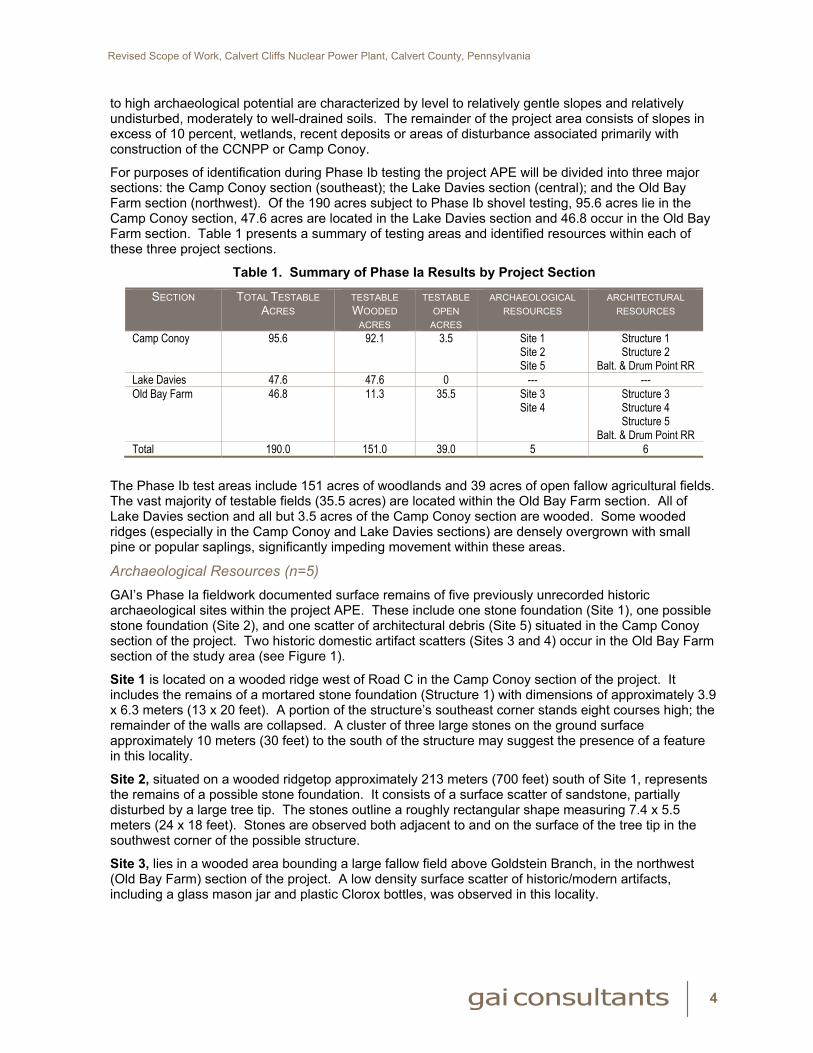
For purposes of identification during Phase Ib testing the project APE will be divided into three major sections: the Camp Conoy section (southeast); the Lake Davies section (central); and the Old Bay Farm section (northwest). Of the 190 acres subject to Phase Ib shovel testing, 95.6 acres lie in the Camp Conoy section, 47.6 acres are located in the Lake Davies section and 46.8 occur in the Old Bay Farm section. Table 1 presents a summary of testing areas and identified resources within each of these three project sections.
Table 1. Summary of Phase Ia Results by Project Section
SECTION TOTAL TESTABLE ACRES
TESTABLE WOODED
ACRES
TESTABLE OPEN
ACRES
ARCHAEOLOGICAL RESOURCES
ARCHITECTURAL RESOURCES
Camp Conoy 95.6 92.1 3.5 Site 1 Site 2 Site 5
Structure 1 Structure 2
Balt. & Drum Point RR Lake Davies 47.6 47.6 0 --- --- Old Bay Farm 46.8 11.3 35.5 Site 3
Site 4
Structure 3 Structure 4 Structure 5
Balt. & Drum Point RR Total 190.0 151.0 39.0 5 6
The Phase Ib test areas include 151 acres of woodlands and 39 acres of open fallow agricultural fields. The vast majority of testable fields (35.5 acres) are located within the Old Bay Farm section. All of Lake Davies section and all but 3.5 acres of the Camp Conoy section are wooded. Some wooded ridges (especially in the Camp Conoy and Lake Davies sections) are densely overgrown with small pine or popular saplings, significantly impeding movement within these areas.
Archaeological Resources (n=5) GAI’s Phase Ia fieldwork documented surface remains of five previously unrecorded historic archaeological sites within the project APE. These include one stone foundation (Site 1), one possible stone foundation (Site 2), and one scatter of architectural debris (Site 5) situated in the Camp Conoy section of the project. Two historic domestic artifact scatters (Sites 3 and 4) occur in the Old Bay Farm section of the study area (see Figure 1).
Site 1 is located on a wooded ridge west of Road C in the Camp Conoy section of the project. It includes the remains of a mortared stone foundation (Structure 1) with dimensions of approximately 3.9 x 6.3 meters (13 x 20 feet). A portion of the structure’s southeast corner stands eight courses high; the remainder of the walls are collapsed. A cluster of three large stones on the ground surface approximately 10 meters (30 feet) to the south of the structure may suggest the presence of a feature in this locality.
Site 2, situated on a wooded ridgetop approximately 213 meters (700 feet) south of Site 1, represents the remains of a possible stone foundation. It consists of a surface scatter of sandstone, partially disturbed by a large tree tip. The stones outline a roughly rectangular shape measuring 7.4 x 5.5 meters (24 x 18 feet). Stones are observed both adjacent to and on the surface of the tree tip in the southwest corner of the possible structure.
Site 3, lies in a wooded area bounding a large fallow field above Goldstein Branch, in the northwest (Old Bay Farm) section of the project. A low density surface scatter of historic/modern artifacts, including a glass mason jar and plastic Clorox bottles, was observed in this locality.
4

Revised Scope of Work, Calvert Cliffs Nuclear Power Plant, Calvert County, Pennsylvania
Site 4, also located in the Old Bay Farm section of the project area, is situated at the end of a wooded ridgetop above a tributary of Goldstein Branch. It lies approximately 30 meters (100 feet) south of a frame tobacco barn (Structure 5, see below) located in a clearing at the edge of a fallow field. Yucca plants line the edge of this ridge and a very large English ivy vine has nearly encased the trunk of one tree. A dense scatter of historic/modern artifacts (i.e. glass bottles and jars, a teapot, cans) covers the side slopes. A partially paved roadway skirts the low western side slope of the ridge. Based on the site’s setting, and the presence of plantings and domestic artifacts, this site may represent the remains of an historic residence.
Site 5 lies near the center of Camp Conoy, a former YMCA camp established in 1931 and located in the southeast portion of the project APE. Camp Conoy served as a YMCA camp until the property was purchased for the CCNPP in the late 1960s. It continued to be used for recreational purposes by employees of the plant through 2005. The portion of Camp Conoy located within the current project APE encompasses three standing structures [a cabin and a shed that are both greater than 50 years of age (see Structures 1 and 2 below) and a modern picnic pavilion] as well as a lighted baseball field, a volleyball court, a fenced tennis court, a children’s playground, a stone entrance wall, a modern guard shack, paved roadways, and gravel parking lots. Additional facilities located outside (east) of the current project limits consist of a fenced swimming pool with associated bath house and a one-story cabin (the Eagle’s Den) located at the edge of the cliff overlooking the Chesapeake Bay. A brochure prepared for the 1963 dedication of the Camp Conoy swimming pool (and provided to GAI by Kirsti Uunila, Calvert County DPZ) contains photographs of three structures (a large frame dining hall, a one-story Conoy Lodge, and an unidentified large frame building) and reference to several more structures (e.g. cabins, health center building), none of which are currently standing at the site.
Site 5 is located on a hilltop south of the existing cabin and east of the baseball field. It consists of a scatter of architectural debris including a metal pipe and a cluster of brick eroding out of the edge of the hillcrest. Based on the Phase Ia walkover the integrity of these artifacts is unclear. It is possible that this locality may represent the remains of a former structure associated with the YMCA camp. Additional associated archaeological remains may be located within the area of Camp Conoy.
Architectural Resources (n=6) GAI identified six architectural resources within the project area that, based on a preliminary review, appear to be greater than 50 years of age and will, accordingly, require documentation during subsequent architectural survey. These resources include five previously unrecorded structures and one previously recorded National Register-eligible property (the Baltimore and Drum Point Railroad), that has not been documented in the project area. The five structures consist of one cabin and one shed associated with Camp Conoy (the former YMCA camp) and three tobacco barns in the northwestern (Old Bay Farm) section of the project area. Remains of the Baltimore and Drum Point Railroad were observed both in the Camp Conoy and the Old Bay Farm sections of the project.
The Baltimore and Drum Point Railroad (CT-1295/18Cv172) consists of the discontinuous remains of a railroad bed constructed between 1868 and 1890. This uncompleted railroad was designed to connect the deep-water Drum Point harbor to Baltimore. By 1889 the railroad included 25 miles of a graded bed and trestles over both St. Leonard’s and Hunting creeks. Work was halted in 1890 due to lack of local governmental support and the railroad was never completed. This property was initially recorded in 1990 during a Phase I archaeological survey along Maryland Route 2/4 in the vicinity of Prince Frederick, approximately 6.2 kilometers (10 miles) north of the current project area (Gibb and Mark 1990). Another portion of the railroad bed was documented in the town of Bertha, over 3.4 kilometers (2.1 miles) to the south. The full extent of the railroad bed has not been recorded. In 1996, the MHT determined that the Baltimore and Drum Point Railroad is eligible for listing on National Register eligible, under Criteria A and C.
This railroad bed is visible both on the ground and on 1:400 scale mapping as a linear feature extending through much of the undisturbed portion of the study area (see Figure 1). In the wooded southeastern section of the project APE discontinuous sections of the railroad bed parallel Road C (at the west edge of Camp Conoy) for a distance of approximately 1.1 kilometers (0.7 miles). In the
5

Revised Scope of Work, Calvert Cliffs Nuclear Power Plant, Calvert County, Pennsylvania
6
northwest (Old Bay Farm) section of the APE, smaller discontinuous sections of the railroad bed, extending for a total of 0.7 kilometers (0.5 miles), are observed in woodlands flanking Road B.
Structures 1 and 2 are both located within Camp Conoy (see description above). Structure 1 is a one-story, five-bay, circa 1930s log cabin situated on a rise northeast of the baseball field. Structure 2 is a one-story wood shed located between the baseball field and a modern picnic pavilion.
The three frame tobacco barns (Structures 3, 4 and 5) all lie in fields south of Road B in the northwest corner of the project. Structures 3 and 4 flank the south side of Road B4. Structure 5 stands in a clearing at the south edge of a field in the area of archaeological Site 4 (possibly representing the remains of an historic residence).
Summary of Phase Ia Results Based on the results of GAI’s Phase Ia study, the 600-acre project area contains 190 acres of moderate to high archaeological potential that will require systematic shovel testing during Phase Ib field investigations. The remaining 410 acres of the project APE consist of settings with slopes in excess of 10 percent, disturbed areas, wetlands, or recent deposits; in accordance with state guidelines, these portions of the project area will be excluded from Phase Ib shovel testing. GAI’s geomorphological reconnaissance indicates that the project area has no potential for deeply buried archaeological sites.
The Phase Ia archaeological reconnaissance identified five previously unrecorded historic archaeological sites in the project APE that will require investigation during the Phase Ib survey.
Phase Ia fieldwork also identified six architectural resources—five previously unrecorded structures as well as the National Register-eligible Baltimore and Drum Point Railroad, not previously documented in this locality. These resources will require evaluation and documentation during the subsequent Architectural Survey.
References Gibb, James G. and Mark 1990 Phase I Archaeological Survey, Widening of Maryland Route 2/4 and the Collector-
Distributor System for Maryland Route 2/4, in the Vicinity of Prince Frederick, Calvert County, Maryland. Prepared by Greiner, Inc.
Shaffer, G. D. and E. Cole 1994 Standards and Guidelines for Archaeological Investigations in Maryland. Maryland
Historical Trust. Department of Housing and Community Development, Crownsville, MD.
Revised Scope of Work
Phase Ib Cultural Resources Investigation
Calvert Cliffs Nuclear Power Plant
Calvert County, Maryland
October 20, 2006 Project Management/Section 106 Coordination/Training GAI will assist Tetra Tech NUM, Inc. and CCNPP in consulting and coordinating with the Maryland Historical Trust and, if applicable, the Calvert County Department of Planning and Zoning during the course of the expanded project. This is expected to include phone calls and preparation of memos involving discussions of project methods and results, drafting letters, and attendance at up to one (1) meeting in Crownsville (MHT) or at the project area. As necessary, GAI can assist with the preparation of other Section 106 documentation including Memorandum of Agreements (MOA). This task also includes on-site training at CCNPP for two GAI archaeologists prior to the start of Phase Ib fieldwork.
Background Research GAI will conduct additional background research to identify previously recorded cultural resources within a 2-mile radius of the expanded project APE as well as to gather information on the National Register-eligible Baltimore and Drum Point Railroad, observed within the project area during Phase Ia field investigations. GAI will examine archaeological site files, historic structure files, National Register listings, historic maps and cultural resource reports at the Maryland Historical Trust (MHT) in Crownsville. GAI may also examine resources at the Calvert County Historical Society and Calvert County Department of Planning and Zoning in Prince Frederick and the Calvert Marine Museum in Solomans Island.
Architectural Survey Based on the results of Phase Ia investigations it is anticipated that a total of six architectural resources greater than 50 years of age are located within the project area. These include five previously unrecorded structures as well as the National Register-eligible Baltimore and Drum Point Railroad, not previously documented in this locality (see Figure 1). The five structures consist of two circa 1930s structures associated with Camp Conoy (included in GAI’s original Phase I proposal) and three additional nineteenth-century tobacco barns in the northwest (Old Bay Farm) section of the project area. These five structures will be inventoried and evaluated for their eligibility for listing in the National Register of Historic Places. For the National Register-eligible Baltimore and Drum Point Railroad GAI will 1) determine whether the railroad berm located within the project area contributes to the National Register-eligibility of this resource, 2) assess the National Register boundaries of this property within the project area, and 3) preliminarily evaluate effects to this resource. Architectural resources will be mapped in the field using a mapping-grade GPS unit. This work will be conducted in compliance with the Standards and Guidelines for Architectural and Historical Investigations in Maryland (Maryland Historical Trust 2000) and General Guidelines for Compliance-Generated Determinations of Eligibility (Maryland Historical Trust 2002).
Prior to initiating the architectural survey, GAI will review existing materials relevant to the project area in the MHT Library and Archives in Crownsville and pertinent historical information related to the proposed project area in Calvert County’s Historical Society Collection in Prince Frederick. From these repositories, GAI will review earlier survey documentation pertaining to Camp Conoy, the Baltimore and Drum Point Railroad, and the general project area. The collected research will be used to illustrate the development and history of the project area as well as to enhance the existing context for evaluation of

Revised Scope of Work, Calvert Cliffs Nuclear Power Plant, Calvert County, Pennsylvania
surveyed resources. The information collected by GAI will be included in the technical report to be submitted to Tetra Tech NUS, Inc.
GAI will conduct architectural fieldwork to document the six architectural resources identified in the project area. This work will include the completion of Maryland Historical Trust Determination of Eligibility forms for the five previously unrecorded structures and assessment of the National Register-eligible Baltimore and Drum Point Railroad (as described above). This will provide the MHT with the information necessary to concur on the NRHP eligibility of these resources within the project area. Photographs for each building will be processed, labeled, and catalogued as specified in MHT survey guidelines. The surveyed resources will be located on USGS 7.5’ Quadrangle maps and plotted on plan view sketch maps showing the relationship of the resource(s) to secondary resources, roadways, and other important benchmark features. Additionally, initial evaluation of potential visual impacts will be noted during fieldwork to identify the potential for adverse effects on National Register-eligible or potentially National Register-eligible properties, in consultation with the Maryland Historical Trust.
Phase Ib Archaeological Survey Prior to the start of Phase Ib fieldwork, GAI’s Project Crew Chief (and possibly an Archaeological Technician) will participate in a two to three day on-site training session at CCNPP so that they can be badged to permit unescorted access within the Owner Controlled Area of the property. This will facilitate the crew’s movement within the project APE during the Phase Ib field investigation.
GAI will conduct a Phase Ib archaeological survey to identify historic or prehistoric sites in the project APE. Based on the results of GAI’s Phase Ia reconnaissance, conducted between October 9 and 12, 2006, the 600-acre project area consists largely of wooded dissected uplands and areas of disturbance resulting from prior construction, as well as smaller areas of agricultural fields and wetlands (see Figure 1). Ground visibility throughout the project area is poor and plowing and disking of the agricultural fields is not feasible.
Due to poor ground surface visibility, Phase I survey will consist primarily of shovel test pit (STP) excavation in areas of moderate to high archaeological potential. Disturbed areas and settings with slopes in excess of 10 percent will be examined by surface walkover but will not be subject to shovel testing. In general, systematic shovel test pits will be excavated at 15-meter intervals within transects spaced 15-meters apart. Judgmental STPs may be excavated in select areas to confirm the presence of disturbed soils or recent deposits. In areas of standing structures and/or foundations, close-interval shovel testing at 3 to 6-meter (10 to 20-foot) intervals will be conducted. When artifacts are recovered during survey, GAI archaeologists will excavate additional radial STPs at reduced intervals to evaluate initial findspots and delineate preliminary site dimensions within the project APE.
STPs will measure approximately 50x50 cm in diameter and will extend at least 10 cm into the subsoil and 10 cm below the deepest artifact recovery. Excavated soils will be screened through 0.25-inch (6-mm) wire mesh for systematic artifact recovery. Prehistoric and historic artifacts recovered during survey will be bagged and labeled with appropriate provenience information. GAI archaeologists will record results of individual STPs on standardized field forms, including depths of soil horizons, soil texture and Munsell color, and artifact recovery. STP locations will be recorded on project maps. Following excavation and recording, individual STPs will be backfilled. Identified cultural resources will be plotted on project maps, documented with photographs, and their location will be recorded using mapping-grade GPS equipment.
Based on the results of Phase Ia investigations, project information provided by the client, and a review of topographic maps and soils data, GAI assumes that approximately 190 acres, consisting of relatively level to gently sloping uplands with moderately to well-drained soils, are considered to have a moderate to high archaeological potential and will be subject to subsurface shovel testing (see Figure 1). (Note that GAI’s original Phase I proposal assumed 80 testable acres of a 300-acre project area, requiring excavation of a total of 1360 STPs.) The remaining approximately 410 acres of the 600-acre project APE will be excluded from shovel testing due to prior disturbances, slopes in excess of 10 percent, wetlands or recent deposits.
2

Revised Scope of Work, Calvert Cliffs Nuclear Power Plant, Calvert County, Pennsylvania
GAI’s revised Phase Ib scope of work is based on the following assumptions:
approximately 190 acres of moderate to high archaeological potential requiring systematic Phase Ib shovel testing (16 STPs per acre)
excavation of up to 3040 15-meter interval STPs, 30 judgmental STPs, and 200 radial STPs
identification of up to eight archaeological sites, requiring completion of Maryland Archeological Site Survey Forms (these sites include five located during Phase Ia fieldwork and up to three additional sites)
excavation of up to 30 close interval STPs at each of the eight archaeological sites, for 180 STPs.
excavation of up to 30 close interval STPs at each of the five architectural resources, for another 150 STPs
excavation of a total of up to 3600 STPs during Phase Ib fieldwork
Due to the upland setting of the moderate to high potential portions of the project area, cultural resources will be near-surface in nature and STPs will extend no more than 50 cm in depth
Field logistics associated with the expanse of the 600-acre project area, with potential access and security issues involved in movement within the property, with brush clearing in areas of dense woodlands, and with seasonal (i.e. winter) weather conditions will result in average daily excavation rate of 12 STPs per person per day
Laboratory Analysis Subsequent to Phase Ib survey, GAI will conduct laboratory analysis of recovered artifacts to characterize age, type, and function of recovered archaeological remains. Historic and/or prehistoric artifacts recovered during the Phase I survey will be transported to GAI’s archaeological laboratory in Homestead, Pennsylvania, and will be processed according to the Standards and Guidelines for Archaeological Investigations in Maryland (Shaffer and Cole 1994), Technical Update No. 1 - Collections and Conservation Standards (MHT 1999), and the Maryland Archaeological Conservation Laboratory (MAAC Lab). These materials will be washed, sorted, and labeled with the site number, if appropriate. Prehistoric artifacts will be segregated into material types and functional classes (e.g., lithic tools, debitage, prehistoric pottery) and subjected to typological and technological analyses including the identification of temporal and cultural affiliation, if possible. Historic artifacts will be separated into various material groups, including ceramics, glass, metal, faunal, etc. These artifacts will be cataloged according to established typologies using the class-type-variety method. If possible, historic proveniences will be assigned date ranges, based on the presence of diagnostic artifacts (e.g., bottle technological attributes, ceramic types). The final artifact repository for these materials will be determined in consultation with CCNPP, Tetra Tech NUS, Inc., and the MHT.
For the purpose of this proposal, GAI assumes the identification of eight archaeological sites (including five sites noted during Phase Ia fieldwork and three additional sites) and the recovery of no more than 1600 artifacts. (Note that GAI’s original proposal assumed one site and 200 artifacts).
Technical Report GAI will prepare a Phase I Technical Report on the cultural resources survey, including results of background research, environmental and historic context, Phase Ia geomorphological and archaeological reconnaissance, Phase Ib archaeological and architectural fieldwork, and laboratory analysis. The report will contain recommendations regarding the need for additional work, if necessary, the recommended NRHP eligibility of six architectural resources, and the potential National Register eligibility of any archaeological resources identified in the project area (GAI assumes up to eight sites). Report appendices will include completed Maryland Archaeological Site Forms for identified site(s) (GAI assumes completion of eight site forms), MHT Determination of Eligibility Forms (six resources), and a catalog of recovered artifacts. Any collections reviewed from sites located in the vicinity of the project area will be discussed as well. The Phase I survey, artifact analysis, and report
3

Revised Scope of Work, Calvert Cliffs Nuclear Power Plant, Calvert County, Pennsylvania
4
preparation will be conducted in accordance with the Standards and Guidelines for Archaeological Investigations in Maryland (Shaffer and Cole 1994), the Standards and Guidelines for Architectural and Historical Investigations in Maryland (Maryland Historical Trust 2000) and General Guidelines for Compliance-Generated Determinations of Eligibility (Maryland Historical Trust 2002).
Based on information provided by Tetra Tech NUS, Inc. GAI assumes the completion of the following project deliverables:
Monthly progress reports and updated schedule
Written records of meetings, discussions, etc.
Preliminary Draft Report (MS Word and PDF)
Five (5) GBC-bound hardcopies and one camera-ready copy of Draft Report, PDF and MS Word files, including two (2) copies to be forwarded by client to agencies within one (1) week of receipt of comments on preliminary Draft Report
Five (5) GBC-bound hardcopies and one camera-ready copy of Final Report, PDF and MS Word files of Final Report
All project records (photographic negatives, maps, notes, etc.) submitted to the Client or MHT as requested by Client upon submittal of Final Report
Revised Phase Ib Cost Proposal and Schedule GAI can conduct Phase I cultural resources survey, as delineated above, for a cost of $XXXXXXXX. GAI will submit the Preliminary Draft Report within seventy (70) calendar days from the completion of fieldwork. Based on the assumptions stated in the proposal, it is anticipated that fieldwork will extend for a period of approximately twelve (12) calendar weeks followed by up to nine (9) calendar weeks of laboratory work and report preparation. If this schedule does not conform to project expectations GAI will gladly consult with Tetra Tech regarding schedule revisions.
GAI assumes that Tetra Tech NUS, Inc. will gain access to all properties requiring cultural resources survey in advance of fieldwork.
References Maryland Historical Trust
1999 Technical Update No. 1 – Collections and Conservation Standards. Maryland Historical Trust. Department of Housing and Community Development, Crownsville, MD.
2000 Standards and Guidelines for Architectural and Historical Investigations in Maryland.
Maryland Historical Trust. Department of Housing and Community Development, Crownsville, MD.
2002 General Guidelines for Compliance-Generated Determinations of Eligibility. Maryland Historical Trust. Department of Housing and Community Development, Crownsville, MD.
National Park Service
1992a National Register Bulletin 15 – How to Apply the National Register Criteria for Evaluation. Department of the Interior, National Park Service, Washington, D.C.
1992b National Register Bulletin 21 – Defining Boundaries for National Register Properties.
Department of the Interior, National Park Service, Washington, D.C. Shaffer, G. D. and E. Cole
1994 Standards and Guidelines for Archaeological Investigations in Maryland. Maryland Historical Trust. Department of Housing and Community Development, Crownsville, MD.
February 19, 2008
GAI Project No. C080212.00
Mr. Michael E. Lukey, P.E. MACTEC Federal Programs, Inc. 560 Herndon Parkway, Suite 200 Herndon, VA 20170-5240 Re: Revised Scope of Work
Phase II National Register Evaluations of Archaeological Sites 1, 7, 8 and 9 (18Cv474, 18Cv480, 18Cv481 and 18Cv482) and Assessment of Effects for Historic Resources
Calvert Cliffs Nuclear Power Plant Calvert County, Maryland
Dear Mr. Lukey: GAI Consultants, Inc. (GAI) is pleased to submit this revised scope of work to MACTEC Federal Programs, Inc. (MACTEC) to conduct Phase II National Register Evaluations of archaeological Sites 1, 7, 8 and 9 (18Cv474, 18Cv480, 18Cv481 and 18Cv482) and an Assessment of Effects for historic resources at the Calvert Cliffs Nuclear Power Plant (CCNPP), on behalf of UniStar Nuclear Development, LLC (UniStar). These cultural resources lie within the Area of Potential Effect (APE) of the 600-acre proposed project area situated immediately south of the existing CCNPP facility, in southeastern Calvert County, Maryland, along the shore of the Chesapeake Bay. GAI identified these resources during Phase Ib survey of the proposed project area in 2006-2007 (Munford and Hyland 2007). The goal of GAI’s Phase II archaeological study is to evaluate the eligibility of Sites 1, 7, 8 and 9 for listing in the National Register of Historic Places (NRHP). The Assessment of Effects will evaluate the proposed project’s effects on four NRHP-eligible historic resources: Parran’s Park (CT-58), Preston’s Cliffs (CT-59), the Baltimore and Drum Point Railroad (CT-1295), and Camp Conoy (CT-1312).
GAI’s Phase II investigations will include site-specific archival research, fieldwork, laboratory analysis, and technical report preparation. This work will be conducted in accordance with Section 106 of the National Historic Preservation Act of 1966, as amended, guidelines developed by the Advisory Council on Historic Preservation, the amended Procedures for the Protection of Historic and Cultural Properties as set forth in 36 CFR 800, the Secretary of Interior’s Standards and Guidelines for Archaeology and Historic Preservation and the Standards and Guidelines for Archeological Investigations in Maryland (Shaffer and Cole 1994). These proposed project tasks are described below.
Workplan Task 1: Project Management/Section 106 Coordination/Meetings At various points in the proposed project, GAI will assist MACTEC and CCNNP in consulting and coordinating with the Maryland Historical Trust and, if applicable, the Calvert County Planning & Zoning Department. This is expected to include phone calls and preparation of memos involving discussions of project methods and results, drafting letters, and attendance at up to one (1) meeting in Crownsville, Maryland.
Task 2: Archival Research Prior to Phase II field investigations, GAI will conduct site specific archival research for each of the four archaeological sites. This work will include a chain-of-title and census research for each of the properties and a detailed review of pertinent historic maps available at the Maryland Historical Trust (MHT) in Crownsville, the Maryland Hall of Records, the Calvert County Courthouse, the Calvert County Historical Society in Prince Frederick, and on-line sources.
Scope of Work: CCNPP Phase II National Register Evaluations and Assessment of Effects Mr. Michael E. Lukey, P.E. February 19, 2008
2
Additional sources such as tax records and appropriate published and unpublished histories will also be consulted. The collected research will be used to illustrate the development and history of the project area as well as to enhance the existing context for evaluation of the sites’ eligibility for listing in the NRHP.
Task 3: Archaeological Fieldwork Prior to the start of Phase II field investigations at each site, GAI surveyors will establish a grid over the site using a total station. Subsequent excavations will be designated by coordinates within this grid. Where possible, Phase Ib shovel tests will be relocated and plotted according to the Phase II grid system. In general, the sites will be cleared by hand to expose surface features and/or structural remains. Mechanical clearing may be required in portions of Site 7 (18Cv480) currently capped by gravel. GAI will coordinate plans for mechanical clearing activities with MACTEC and UniStar.
Phase II fieldwork will include close-interval shovel testing and test unit excavations. Shovel testing is designed to refine site boundaries within the project APE and to delineate within-site artifact concentrations. Shovel test pits will be excavated at 15 to 25-foot (5 to 7.5-meter) intervals within transects spaced 15 to 25-feet (5 to 7.5-meters) apart. STPs will measure approximately 1.5 x 1.5 feet (50x50 cm) in diameter and will be hand-excavated by natural strata into the subsoil.
Based on the results of shovel testing, GAI will excavate test units in areas of higher artifact density, unusual stratigraphy or potential cultural features. Test unit excavations will serve to define site stratigraphy, sample artifact concentrations and/or activity areas, determine the potential for subsurface features, and assess the integrity of archaeological remains. At each site, test units will consist of a combination of 5 x 5 foot (1.5 x 1.5-meter) and 2.5 x 5-foot (0.75 x 1.5-meter) units. Test units will be hand-excavated in 0.3-foot (10-cm) levels according to natural stratigraphy and will extend into subsoil. At the completion of each test unit, measured profiles will be drawn and photographs taken of at least one wall of each unit.
For both STPs and test units, excavated soils will be screened through 0.25-inch (6-mm) hardware cloth for systematic artifact recovery. Recovered artifacts will be bagged and labeled with appropriate provenience information. GAI archaeologists will record results of individual STPs and test units on standardized field forms, including depths of soil horizons, soil texture and Munsell color, and artifact recovery. Testing locations will be plotted on project maps and documented with photographs. Following excavation and recording, STPs and test units will be backfilled.
Potential cultural features identified during testing will be troweled clean, cross-sectioned and documented in plan view and profile with measured drawings and photographs. As appropriate, a portion of the feature fill will be collected as a flotation sample and the remaining feature fill will be screened through 0.25-inch (6-mm) hardware cloth. Artifacts and samples collected from the feature fill will be bagged and labeled with appropriate provenience information. The feature will be recorded on a standardized GAI Feature Form and plotted on project maps.
For purposes of this proposal GAI estimates the excavation of a total of up to 880 STPs and 36 test units. Due to the upland setting of the site localities, GAI assumes that cultural resources will be near-surface in nature and that test excavations will extend no more than 1.5 feet (50 cm) in depth.
The field effort at each of the four sites is anticipated to consist of the following:
• Site 1 (18Cv474)—100 STPs, 8 units (4 5x5-foot and 4 2.5x5-foot units), 5 features, clearing, mapping;
• Site 7 (18Cv480)—620 STPs, 12 units (6 5x5-foot and 6 2.5x5-foot units), 5 features, mechanical clearing, mapping;
• Site 8 (18Cv481)—80 STPs, 8 units (4 5x5-foot and 4 2.5 x5-foot units), 5 features, limited clearing, mapping;
• Site 9 (18Cv482)—80 STPs, 8 units (4 5x5-foot and 4 2.5 x5-foot units), 5 features, clearing, mapping.
Scope of Work: CCNPP Phase II National Register Evaluations and Assessment of Effects Mr. Michael E. Lukey, P.E. February 19, 2008
3
In addition to Phase II investigations, GAI will conduct Phase IA archaeological reconnaissance, as necessary, of new project areas (to be determined by MACTEC and UniStar) to evaluate their archaeological potential and assess the need for supplemental Phase IB survey in these localities. Based on information provided by Yvonne Abernethy (Constellation Generation) (February 11, 2008 teleconference), it is expected that these areas will be limited in extent and will consist primarily of upland settings adjacent to the Chesapeake Bay. GAI assumes that Phase IA fieldwork will require no more than 8 hours. Phase IB fieldwork, if necessary, is outside the scope of the current workplan.
Task 4: Laboratory Analysis Subsequent to Phase II fieldwork, GAI will conduct laboratory analysis of recovered artifacts to characterize age, type, and function of recovered archaeological remains. Artifacts recovered during Phase II testing will be transported to GAI’s archaeological laboratory in Homestead, Pennsylvania, and will be processed according to the Standards and Guidelines for Archeological Investigations in Maryland (Shaffer and Cole 1994), Technical Update No. 1 - Collections and Conservation Standards (MHT 1999), and the Maryland Archaeological Conservation Laboratory (MAAC Lab). These materials will be washed, sorted, and labeled with the site number, if appropriate. Historic artifacts will be separated into various material groups, including ceramics, glass, metal, faunal, etc. These artifacts will be cataloged according to established typologies using the class-type-variety method. If possible, historic proveniences will be assigned date ranges, based on the presence of diagnostic artifacts (e.g., bottle technological attributes, ceramic types). Soil flotation samples collected from feature fill will be processed to recover small specimens such as seeds, nuts or small bones. Select samples will be analyzed to identify archaeobotanical materials. The final artifact repository for these materials will be determined in consultation with MACTEC, UniStar and the MHT.
For the purpose of this proposal, GAI assumes the recovery of a total of up to 4,100 artifacts and the processing of up to 50 flotation samples. These totals are based on the following assumptions for each site:
• Site 1 (18Cv474)—900 artifacts, 10 flotation samples
• Site 7 (18Cv480)—1,800 artifacts, 20 flotation samples
• Site 8 (18Cv481)—700 artifacts, 10 flotation samples
• Site 9 (18Cv482)—700 artifacts, 10 flotation samples
Task 5: Combined Phase I/II Technical Report Preparation GAI will prepare a combined Phase I/II Technical Report on the previous Phase I survey of the project area and the Phase II National Register Evaluations of Sites 1, 7, 8 and 9 (18Cv474, 18Cv480, 18Cv481 and 18Cv482). The report will include methods and results of background research, historic context, archaeological fieldwork, and laboratory analysis. It will also present recommendations regarding the NRHP eligibility of these sites and, if necessary, the need for additional work. Report appendices will include updated Maryland Archaeological Site Forms and catalogs of recovered artifacts. The Phase II field investigation, artifact analysis, and Phase I/II report preparation will be conducted in accordance with the Standards and Guidelines for Archaeological Investigations in Maryland (Shaffer and Cole 1994), the Standards and Guidelines for Architectural and Historical Investigations in Maryland (Maryland Historical Trust 2000) and General Guidelines for Compliance-Generated Determinations of Eligibility (Maryland Historical Trust 2002).
GAI assumes the completion of the following project deliverables:
Five (5) hardcopies and electronic copy of Draft Report for client review;
Five (5) hardcopies of Final Report, as well as disc with PDF and MS Word files, within two (2) weeks of receipt of comments on Draft Report;
Project records (photographic negatives, maps, notes, etc.) submitted to the Client or MHT as requested by Client upon submittal of Final Report.
Scope of Work: CCNPP Phase II National Register Evaluations and Assessment of Effects Mr. Michael E. Lukey, P.E. February 19, 2008
4
Task 6: Assessment of Effects—Historic Resources Based on the results of GAI’s Phase IB survey and evaluation (Munford and Hyland 2007), as well as comments provided by the MHT (June 7, 2007 project review letter), four historic resources within the project APE have been determined eligible for listing in the NRHP: Parran’s Park (CT-58), Preston’s Cliffs (CT-59), the Baltimore and Drum Point Railroad (CT-1295), and Camp Conoy (CT-1312). As part of the Phase II work effort, GAI will conduct a formal assessment of the project’s effects to these historic resources under 36CFR800.5.
The assessment of effects study will include archival research, fieldwork and report preparation. Archival research will include detailed site-specific historical research to firmly establish the historic context for assessing project effects to each specific historic resource, according to methods outlined in Standards and Guidelines for Architectural and Historical Investigations in Maryland (MHT 2000). Fieldwork will involve visits to each of the four NRHP-eligible historic resources to assess the project’s effects, based on the contextual and site-specific background information. GAI will consider proposed construction activities in relation to each historic resource. GAI will conduct a visual impact assessment by photographing the location of proposed nuclear power plant buildings and transmission lines from each of the four aforementioned historic resources. The nature and extent of possible adverse effects to each resource will be carefully considered by applying the Criteria of Adverse Effect (36 CFR 800.5(a)(1)) to determine if any direct or indirect effects to the historic resource will result from the proposed project (National Park Service 1992a and 1992b).
As per consultation with Jonathan Sager (MHT) (January 28, 2008 email), GAI will prepare an Assessment of Effects report that will be submitted under separate cover (not incorporated in the Combined Phase I/II Technical Report). The report will include results of archival research, fieldwork, and the application of the Criteria of Adverse Effect, as well as recommendations for avoidance, mitigation or further consultation.
Cost Proposal and Schedule GAI can conduct Phase II National Register Evaluations of Sites 1, 7, 8 and 9 (18Cv474, 18Cv480, 18Cv481 and 18Cv482) and an Assessment of Effects study for historic resources, as delineated above, for a cost of $XXXXXXX. This cost includes the preparation of a combined Phase I/II Technical Report. Based on the assumptions stated in the workplan, it is anticipated that fieldwork will extend for a period of approximately ten (10) calendar weeks. Laboratory work and report preparation will take approximately sixteen (16) calendar weeks and will, in part, run concurrently with fieldwork. GAI will submit a Preliminary Draft Phase I/II Technical Report within twelve (12) calendar weeks following the end of fieldwork. The Assessment of Effects report will be submitted under separate cover. Costs for Supplemental Phase IB survey (i.e. fieldwork, analysis and reporting) are not included in the current cost proposal. If requested, GAI will prepare a separate cost for this work.
Should MACTEC opt for completing a Phase II National Register Evaluation of only one site (Site 1/18Cv474), the cost is estimated at $164,417.00. This cost includes the integration of Phase I results into a combined Phase I/II Technical Report.
Costs are based on the workplan described above as well as the following assumptions:
• One mobilization/demobilization for all fieldwork;
• Phase IA archaeological reconnaissance of limited amount of new project areas (to be determined by MACTEC and UniStar);
• Field crew consisting of Senior Archaeologist (field director) and 8 technicians;
• 8-hour work day;
• 10-day work sessions with lodging provided for crew over 4-day break, when necessary;
• Fieldwork includes clearing, mapping, excavation (STPs, test units and features), travel and site training (8 hours—paperwork, badging, on-site safety orientation);
Scope of Work: CCNPP Phase II National Register Evaluations and Assessment of Effects Mr. Michael E. Lukey, P.E. February 19, 2008
5
• Excavation of up to 880 STPs and 36 test units;
• STP and test unit excavations will extend to a maximum depth of 1.5 feet (50 cm);
• Features are assumed to have maximum dimensions of 2.5 feet (0.75 meters) and a maximum depth of 1.5 feet (0.5 meters); if deep features (e.g. well, privy) are encountered, GAI will sample only the upper few feet of feature fill;
• Mechanical removal of soil in portions of one site (Site 7/18Cv480);
• Costs for writing and implementation of Erosion and Sedimentation (E&S) Control plan (stabilization, reseeding, inspection, etc.) associated with mechanical soil removal are not included in this cost;
• Curation rates of $350 per box (as per MHT requirements);
• No extreme weather conditions or winter fieldwork (e.g., frozen ground);
• No more than two (2) days of down time due to inclement weather;
• Submittal of a Combined Phase I/II Technical Report (no management summary or interim report) including one round of report revisions;
• Submittal of a separate Assessment of Effects report.
If you have any questions, please do not hesitate to contact me at (412) 476-2000 x1200 ([email protected]) or Barbara Munford at (412) 476-2000 x1203 ([email protected]). We look forward to working with you and continuing to provide CCNPP with cultural resources services for this project.
Sincerely, GAI Consultants, Inc.
Ben Resnick, M.A., RPA Group Manager, Cultural Resources /bam
References Maryland Historical Trust
1999 Technical Update No. 1 – Collections and Conservation Standards. Maryland Historical Trust. Department of Housing and Community Development, Crownsville, MD.
2000 Standards and Guidelines for Architectural and Historical Investigations in Maryland.
Maryland Historical Trust. Department of Housing and Community Development, Crownsville, MD.
2002 General Guidelines for Compliance-Generated Determinations of Eligibility.
Maryland Historical Trust. Department of Housing and Community Development, Crownsville, MD.

Scope of Work: CCNPP Phase II National Register Evaluations and Assessment of Effects Mr. Michael E. Lukey, P.E. February 19, 2008
6
Munford, Barbara A. and Matthew G. Hyland 2007 Draft Interim Report Phase Ib Cultural Resources Investigation, Calvert Cliffs Nuclear
Power Plant, Calvert County, Maryland. Prepared by GAI Consultants, Inc. for UniStar Nuclear Development, LLC.
National Park Service
1992a National Register Bulletin 15 – How to Apply the National Register Criteria for Evaluation. Department of the Interior, National Park Service, Washington, D.C.
1992b National Register Bulletin 21 – Defining Boundaries for National Register Properties.
Department of the Interior, National Park Service, Washington, D.C. Shaffer, G. D. and E. Cole
1994 Standards and Guidelines for Archaeological Investigations in Maryland. Maryland Historical Trust. Department of Housing and Community Development, Crownsville, MD.