Embed Size (px)
Citation preview

Proposal of an Internet-Based EGNOS Receiver Architecture and
Demonstration of the SISNeT Concept Emilio González , Project Manager, [email protected]
Manuel Toledo, Head of division, [email protected] GMV, S.A
Isaac Newton, 11 - E-28760 Tres Cantos, Madrid, Spain Tel. +34 918072100 Fax. +34 918072199
Co- Authors: Alfredo Catalina, Carlos Barredo / GMV Sistemas S.A
Félix Torán, Javier Ventura / ESA Antonio Salonico / TELESPAZIO SpA
BIOGRAPHY
Emilio González is a Telecommunication Engineer from the Polytechnic University of
Madrid (Spain). His work in GMV has been devoted to the design and development of
EGNOS user segment applications. He is project manager of the ShPIDER receiver project.
Manuel Toledo holds a MS in Aeronautical Engineering, from the Polytechnic University of
Madrid in 1989 and a MS in Physics, from the Universidad Nacional de Educación a
Distancia, UNED, of Spain in 1996. Since 1992 he is working in GMV in studies and
development of applications based on satellite navigation systems. Currently he is in GMV
the Head of the GNSS Support Systems and Applications Division.
Alfredo Catalina is an Industrial Engineer in Electronics and Control Systems, University of
Valladolid (Spain). Head of the Navigation Engineering and Applications division in GMV
Sistemas, his main areas of activity are GNSS applications involving microelectronics,
software development, GIS applications and communications.
Carlos Barredo is an Electronics Engineer and Physics graduate from the University of
Valladolid. Teacher of Engineering applications of satellite navigation systems at the
Telecommunication school in Valladolid. Since 1999, hardware engineer at GMV Sistemas
where he has participated in the development of different hardware and software embedded
systems.
Felix Torán-Martí obtained his M. Sc. in Electrical Engineering from the University of
Valencia (Spain), where he is currently pursuing his PhD Degree. In Sept. 2000 he joined
ESA under the Spanish Young Graduate Programme. Since 2002, he is working at ESA as
System and Analysis Engineer for the EGNOS Project, with major contributions on
simulation software development and on the ESA SISNeT Project. Mr. Torán has co-authored
over 80 technical publications. He is member of ION and IEEE.
Dr. Javier Ventura-Traveset holds a M. Sc. in Telecommunication Eng. from the Polytechnic
Univ. of Catalonia (Spain, 1988); a M. Sc. in Engineering by Princeton University (Princeton,
NJ) in 1992; and a PhD in Electrical Eng. by the Polytechnic of Turin (Italy, 1996). Since
March 1989, he is working at the European Space Agency (ESA) on mobile, fix, earth
observation and satellite navigation programs; he is currently Principal System Engineer of
the EGNOS Project. Dr. Ventura-Traveset holds 4 patents and co-authored over 150 technical
papers. He is Member of ION and Senior Member of the IEEE.
Antonio Salonico is a system engineer at Telespazio SpA (Italy). Coming from a satellite
communication and TT&C background he is now the program manager of the EGNOS
TRAN project. He holds a M.S. in electronic engineering from University of Rome Tor
Vergata.
INTRODUCTION
EGNOS will broadcast their wide area / integrity messages through GEO satellites. Satellite
broadcasting through GEO means is proved to be an efficient strategy for aeronautical
applications and other modes of transport. For some applications, though, GEO broadcasting
may provide some limitations. For instance, building obstacles in cities or rural canyons may
difficult the GEO reception. Since the EGNOS message will still be very useful for those
applications, a complementary transmission link may be considered to take the utmost
advantage of the EGNOS potential. For this reason, ESA launched specific contract activities
(through the Advanced System Telecommunication Equipment program, ASTE) to assess and
demonstrate architectures where the ESTB signal is broadcast through non-GEO means (e.g.
FM RDS or GSM/GPRS broadcasting). In this context, ESA awarded Telespazio with the
EGNOS TRAN project, which focused on the terrestrial and aviation applications.
ESA also launched an internal project to provide access to the EGNOS Test Bed messages
through the Internet. The product of this project is a new technology, called SISNeT (Signal
in Space through the Internet). For in-depth information on the ESA SISNeT technology, the
reading of [SISNeT references] is recommended.
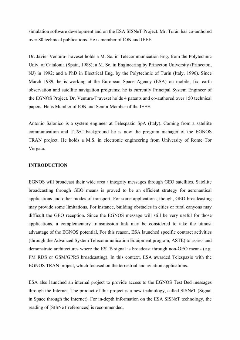
The overall architecture of the SISNeT system is depicted in Figure 1. The Base Station (BS)
gets the EGNOS messages from an EGNOS receiver, and transmits them to the Data Server
via a specific TCP/IP-based protocol, called SIS2DS. The Data Server (DS) transmits the
EGNOS messages to users over the Internet, in real time, using a specific protocol called
DS2DC.
Figure 1: Overall architecture of the SISNeT system.
User Software can take advantage of the EGNOS information provided by SISNeT, in
addition to other extra services (e.g. provision of GPS ephemeris parameters or access to
already broadcast SBAS messages). This results in better performances, and it is especially
useful in urban environments, where the availability of the EGNOS signal is not guaranteed,
due to the presence of obstacles (e.g. trees, buildings, etc.) A user equipped with a GPS
receiver and a wireless modem (e.g. GPRS) can access the SISNeT services, thus being able
to benefit from the EGNOS augmentation signals, irrespectively of the GEO visibility
conditions.
On the other hand, the Scientific and Engineering community may find major advantages in
using SISNeT: the EGNOS signal can be obtained and processed without having to invest in
an EGNOS receiver. Just a connection to the Internet is needed. These same benefits are also
applicable to educational environments. Indeed, the ESA SISNeT technology is presently
being employed at several European universities and training centers, allowing entire groups
of students experimenting with the ESTB signal, without acquiring any SBAS receiver.
ESA and European Industry have developed a variety of applications that demonstrate the
interest of using this new technology. For example, a SISNeT handheld receiver based on a
mobile phone [Handheld references], or SISNeT applied to urban buses [Bus references].
As a specific contract inside the EGNOS TRAN activities, Grupo GMV launched the
development of a SISNeT Receiver. This system was called ShPIDER (SISNeT high-
Performance Internet-Dependent EGNOS Receiver). In addition, the existing Internet
infrastructure was secured, and indications on how to improve the system, aiming at a
professional deployment, were provided.
SHPIDER PHYSICAL ARCHITECTURE
As a prototype, ShPIDER physical architecture is based on a complete CPU board, of type
ETX.
The GPS receiver inside the system is a Falcom JP3 receiver, a single-board 12 parallel-
channel receiver using the highly integrated SiRFStar II chipset. The GPS receiver
continuously tracks all satellites in view, thus providing accurate satellite measurements and
navigation data. This receiver has outstanding accuracy, power consumption and sensitivity
figures.
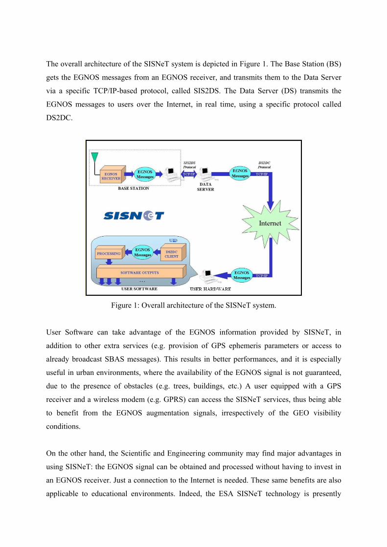
Figure 2: ShPIDER receiver appearance.
An MC35 GPRS modem from SIEMENS has been used. This dual-band modem is certified
in accordance with GSM phase 2/2+. It is very suitable for its integration in the platform, as
its weight, power consumption and size are quite low.
The hard disk is an IBM-MICRODRIVE, which provides high-capacity, high-performance
removable storage (1 GB) in a one-inch hard disk drive. It uses the industry standard CF+**
Type II format and is compatible (with an adapter) with the PCMCIA Type II technology.
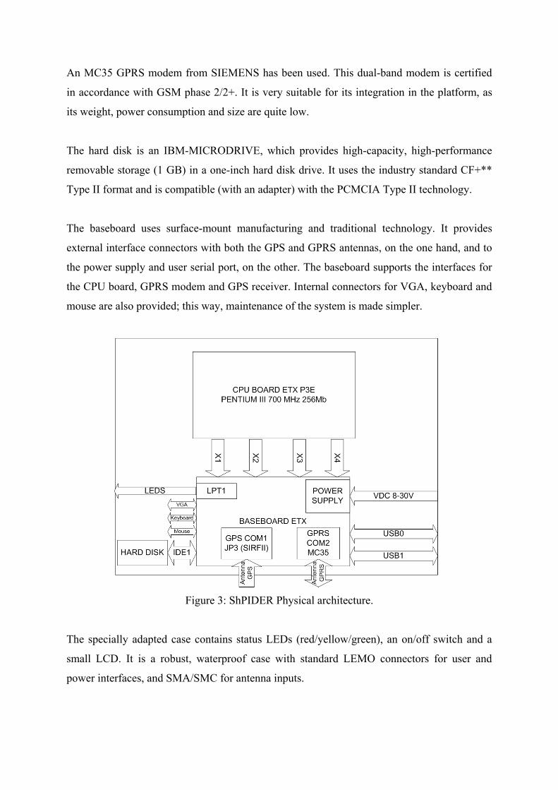
The baseboard uses surface-mount manufacturing and traditional technology. It provides
external interface connectors with both the GPS and GPRS antennas, on the one hand, and to
the power supply and user serial port, on the other. The baseboard supports the interfaces for
the CPU board, GPRS modem and GPS receiver. Internal connectors for VGA, keyboard and
mouse are also provided; this way, maintenance of the system is made simpler.
Figure 3: ShPIDER Physical architecture.
The specially adapted case contains status LEDs (red/yellow/green), an on/off switch and a
small LCD. It is a robust, waterproof case with standard LEMO connectors for user and
power interfaces, and SMA/SMC for antenna inputs.

SHPIDER INTERFACES
Figure 4 shows the external interfaces of the ShPIDER receiver, which are described below:
• The SISNeT Data Server (DS) provides EGNOS corrections to the Receiver through the
Internet (via GPRS).
• The GPS receiver inside ShPIDER is locked to GPS satellites, and uses their pseudo-range
measurements to provide navigation solutions.
• In addition, ShPIDER may send the computed outputs via TCP/IP over GPRS to a monitor
station (MS). This function is commanded from the operator computer and uses directly
the ShPIDER GPRS modem.
Internet
GPS GEO
BS & DS
Operator
GPRS
Monitor station
Serial
Figure 4: ShPIDER external interfaces.
Internet
ShPIDER SW
GPS
user commands
user logs
start / stop status rx measurements
rx nav. commands
other rx logs other rx log queries
SISNeT messages SISNeT msg. queries
ShPIDER Rx
MS commands user logs
GPRS modem
MS
DS
Figure 5: Internal interfaces
SHPIDER SOFTWARE ARCHITECTURE
Figure 5 shows the internal interfaces, from the point of view of the ShPIDER software.
ShPIDER is operated quite similar to a standard GNSS receiver. Once switched on, the
receiver enters a transient stage, in which the last recorded configuration is applied, and then a
stationary phase. Power, SISNeT monitoring and navigation status is visually output through
flashing LEDs and through the LCD indicator. In normal operation, the GPS receiver is
providing pseudo-range measurements and, if the SISNeT link is established, the corrections
are being applied.
The operator can configure the receiver by introducing commands through a serial port, and,
conversely, a number of dedicated output “logs” are returned, showing the navigation results,
current configuration or overall receiver status. Besides, NMEA messages can also be output.
Several kinds of commands have been designed, for SISNeT navigation, GPRS link
management, EGNOS navigation configuration and log scheduling. A degree of flexibility is
gained by enabling the traffic of commands and logs in both serial port and GPRS channels.
Internally, the event-driven software architecture allows reacting to the arrival of
measurement messages from the GPS receiver, SISNeT messages from the DS via a “GPRS
communication module”, or commands from the user or monitoring station. The logging of
measurement messages is pre-configured in the GPS receiver, and a “serial module” requests
the ephemeris data at the beginning of the process, upon command of the “navigation engine”.
The navigation engine performs the navigation with the SISNeT messages, together with a
RAIM algorithm and an error estimation function.
Finally, a “manager module” performs the synchronization control. This control is not
straightforward, as it must have into account the status of each data source: on the one hand,
the possible loss of the GPRS links and, on the other, the possible lack of messages from any
input port. Furthermore, to prevent from crashes of the GPRS modem or the application itself,
a standalone software watchdog has been developed. A small protocol is established between
the application and the watchdog; if the former fails to report, the watchdog restarts the
application; if it reports a confirmed loss of TCP/IP socket connection, the watchdog
initializes the Internet connection.
MECHANISMS TO INCREASE AVAILABILITY
As EGNOS messages go through a channel for which they were not designed, we face several
drawbacks:
• Delays of messages are always bigger than the nominal. Even with an upgraded server,
directly connected to the uplink facility (hence avoiding two GEO-ground leaps), the
delay distribution of the messages over time is unpredictable (it depends on the Internet
traffic and packet routing). In the worst case, some messages may arrive after their
timeout intervals, specially for the fast corrections. Even if this is not the case, the
corrections may suffer a significant degradation, according to the formulas laid down on
the SBAS standards [1].
• It is possible that some messages are lost. The fact is that the effect of losing a message is
different according to its type. For example, to miss a message type 1 (EGNOS mask) is
worse than to miss the GEO ephemeris message (message type 9).
The logical impact of the effects described above is the degradation of the navigation solution.
In a defective scenario, fast corrections could not be used. The effects would be even more
evident in the calculus of the integrity protection levels. They could be so pessimistic that
they could lie above the alert limits specified for the current operation.
Fully aware of these limitations, SISNeT is not intended to be a replacement for EGNOS, and
it has not be designed to provide integrity, the target parameters for a trade-off study are
accuracy and availability. In this context, several actions were proposed to increase
availability, without disregarding accuracy performances. Namely:
• Fast EGNOS acquisition: One of the SISNeT services is the possibility to recover past
EGNOS messages. ShPIDER takes advantage of this for getting a faster EGNOS
acquisition. In a regular receiver, it is common not to have full EGNOS solution until
about 100 seconds or more (depending on the current broadcast), because ionospheric
corrections for the particular receiver location have not been retrieved. ShPIDER, after a
receiver stop, or when the SISNeT server has granted access, requests a representative set
of corrections; thus, it is more likely to have all the information needed to compute an
EGNOS solution. This way, EGNOS acquisition is achieved in 10 to 20 seconds.
• Don’t use fast corrections in the solution, beyond a given margin. Fast corrections can
degrade so much that they may worsen the overall performance in case of late arrival.
Slow corrections would always be used. (This feature has not been implemented).
• Use satellites not monitored by EGNOS. The effect of using satellites which are not
monitored in EGNOS mask, but whose measurements are used in the GPS fix can
enhance the accuracy of the results. This effect can be significant in the outskirts of the
ECAC region, where fewer ESTB-monitored satellites are tracked.
• Reduce degradation factors for the fast corrections. If we assume that all delays are always
bigger than in the real EGNOS, degradation slopes should be reduced.
• Lengthen timeouts. Specially for fast corrections, if timeout intervals are enlarged a bit,
the risk of discarding the corrections is diminished and hence the accuracy improves. This
action should be applied together with the previous one in order not incur in bigger sigma
degradations.
• Use ionospheric corrections whenever possible. A stringent aspect of the EGNOS system
is the way ionospheric corrections are applied. If three or four ionospheric grid points
(IGP) surrounding the ionospheric pierce point (IPP) of a given line-of-sight are
monitored, the estimated slant delay and model variance due to ionosphere can be
computed. We studied the effect of blending in this calculus the values provided by
EGNOS, in the monitored IGPs, with the values extrapolated from surrounding EGNOS
IGPs, for the non-monitored points. Assuming a smooth ionosphere electron distribution,
the committed error with respect to a nominal situation is compensated by far by the
degree of availability gained.
These actions are performed only in a SISNeT-compatible “phase of flight”. Integrity is not
assessed; only an error estimation is made. We have to note that the experiments above have
been made through simulation. In practice, the mean delay is very small and those effects are
almost unnoticeable.
ERROR ESTIMATION
To have a best idea of our system positioning error, a simple estimation of the position error is
calculated, allowing some peculiarities. This estimation is not intended to be rigorous, but
reveals as an added value to the navigation, as further developed applications can adjust the
service to the estimated navigation error.
Pseudo-range residual variance calculation
After applying clock, orbit, ionosphere and troposphere corrections for a given satellite, error
variance can be assumed to be the sum of all terms:
σ2pseudorange = σ2
flt + σ2uire + σ2
air + σ2tropo
− σ2tropo: troposphere correction variance. It can be always used, since it comes from a
model.
− σ2air: airborne receiver correction variance. It does not depend on EGNOS messages. It
will always be possible to calculate it.
− σ2uire: model variance for the slant range ionospheric error. It is needed to have EGNOS
ionospheric corrections in order to calculate it. If these corrections are available, MOPS
[1] model will be used. If some corrections are not available, the mentioned mixed model
will be used.
− σ2flt: this is the model variance for the fast and long term residual error (satellite clock and
orbit).
There are several cases depending on the availability corrections. In next point it will be
described how this variance is calculated.
Variance of Fast and Long Term Correction Residuals
(σudre* + εfc + εrrc + εltc + εer ) 2 if RSSUDRE = 0
σ2flt = or not available
σ2udre* + ε2
fc + ε2rrc + ε2
ltc + ε2er if RSSUDRE = 1.
where:
σudre* : Broadcast UDRE standard deviation, already augmented by δUDRE.
εfc : degradation parameter for fast correction data.
εrrc : degradation parameter for range rate correction data.
εltc : degradation parameter for long term correction or GEO navigation message data.
εer : degradation parameter for en route through non-precise approach applications.
Fast and slow corrections may not be available due to a lost message or a delay in arrival over
message timeout. Depending on the available corrections in a specific epoch, this variance
will be calculated in a different way. For simplicity in the explanation hereafter, it will be
assumed RSSUDRE = 0:
Fast + Slow + degradations: use MOPS – Appendix A model [1].
σflt = σudre* + εfc + εrrc + εltc + εer.
{
Slow + degradations + (timed out fast): fast corrections still have not been applied to
navigation solution, therefore the residual error will not only include the broadcast UDRE
residual, but also the fast correction residual.
σflt ≈ σudre* + σfast + εltc + εer
σudre* and σfast must be estimated using previous UDREs and fast corrections (see below).
Other cases: use User Range Accuracy (URA) from navigation message. No correction
has been applied to the measured pseudo-range. Hence standard deviation for orbit and
satellite clock errors is in the order of the GPS URA for GPS satellites and the GEO URA
(message 9) for EGNOS satellites.
σflt = URA
UDRE variance estimation
Some conclusions have been reached studying real ESTB data: broadcast UDRE residuals
change very slowly in time, and its change is very small; usually from a UDREI to the next or
previous.
As this estimation is not intended to provide integrity, but only to estimate the positioning
error, the solution chosen is to use the last UDRE variance received even though it has timed
out.
σudre (t) = σudre (t-delay)
Taking into account the slow variation of broadcast UDRE, to use such simple estimation
seems a good compromise.
Fast correction variance estimation
Studying fast corrections variations, we can assume a division into low frequency variations
of several meters, and high frequency variations of decimeters. Although we have delays in
all messages arrivals, long-term variations will not be our concern. We can follow them easily
because its characteristic time varies much slower than the delays. Short-term variations are
difficult to model. There is no clear tendency. They change in two ways: steps and random
noise.
The solution taken is a very simple one based on random noise: estimated next fast correction
will be the mean of N last fast corrections available. Choosing a big N, we have a better long
term mean. It improves the variance of the random noise, but makes the variance of the steps
worse. Choosing a small one, we improve the steps variance, and worsen the noise variance.
An N of 10 fast corrections has been chosen as a good compromise, selected after
experimental tests.
Error estimation
Once the residual pseudo-range error estimations are computed, standard deviations for a
model distribution of the navigation error is computed according the formulae described in
MOPS, Appendix J [1]. A constant is applied to scale the standard deviations to the 95%
percentile, assuming a Rayleigh distribution in the horizontal plane and Gaussian in the
vertical dimension.
TESTS AT VALLADOLID
Currently, GMV Sistemas is performing several tests demonstrating the performance of
ShPIDER in an operational environment.
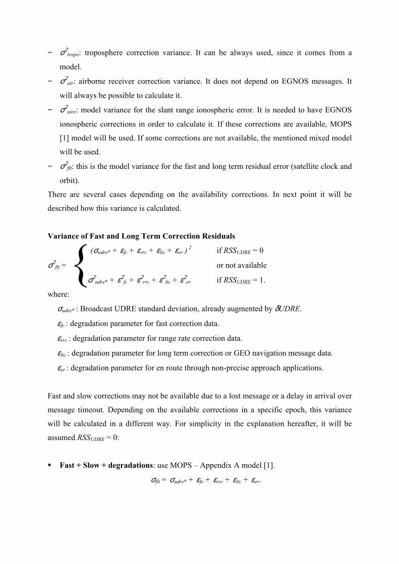
The preliminary results showed very promising performances (Figure 6). ShPIDER Least
Squares solution was compared to the hanheld SISNeT receiver referenced above [Handheld
references], which applies the corrections from the already computed outputs of the GPS
receiver inside. Carrier-phase smoothing was still not implemented in those experiments; the
overall performances would have been better in that case.
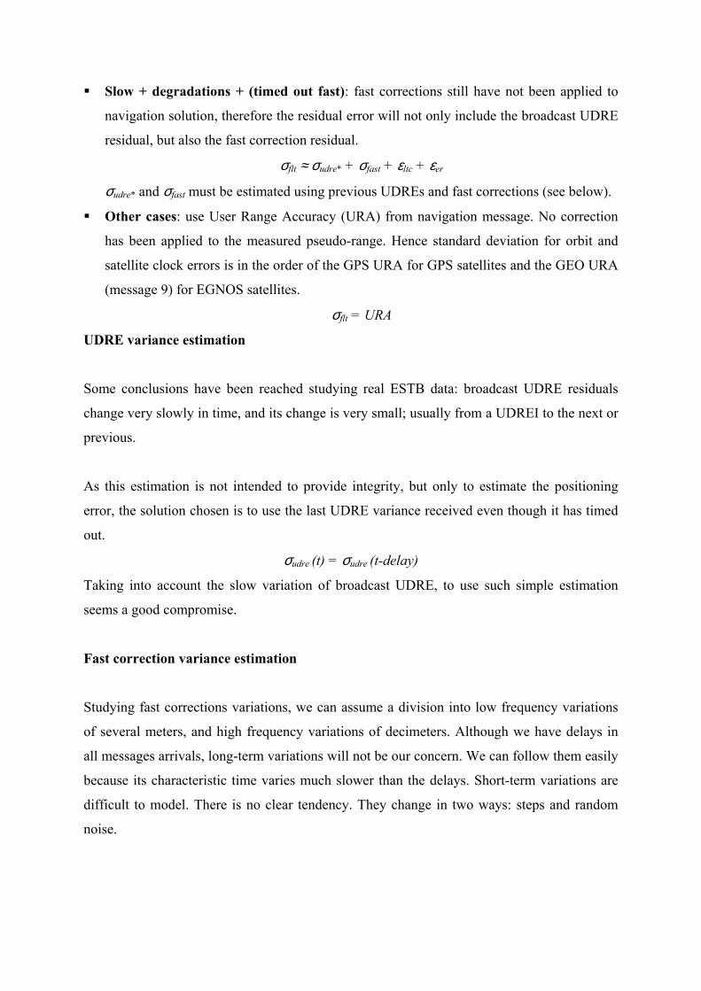
Figure 7 shows the performance of ShPIDER with and without SISNeT corrections. It is
evident the better performance of the receiver when the corrections are applied. The operation
mode is also shown, showing the ability of computing full-EGNOS navigation, EGNOS
navigation with the mixed ionospheric scheme, and ranging-only solution.
Figure 6: First results without carrier-phase smoothing of pseudoranges.
N-S Errors (GPS vs GPS+SISNeT)
-20
-10
0
10
20
30
0 100 200 300 400 500 600
time (s)
erro
r (m
)
GPSSISNeT
E-W errors (GPS vs GPS+SISNeT)
-10
-5
0
5
10
0 100 200 300 400 500 600
time (s)
erro
r (m
)
GPSSISNeT
Alt errors (GPS vs GPS+SISNeT)
-40-30-20-10
0102030
0 100 200 300 400 500 600
time (s)
erro
rs (m
)
GPSSISNeTmode
ionono ionoranging
Figure 7: Dynamic test with ShPIDER. North, East and Up errors comparing GPS and
GPS+SISNeT.
Another set of experiments were carried out using a rover equipped with ShPIDER as test
receiver and a NovAtel OEM4 receiver for the reference, with RTK algorithms. Expected
accuracy of the reference is 2 cm. Figure 8 shows some results from one of the tests.
Horizontal error is maintained below 2 meters except when the receiver lost SISNET
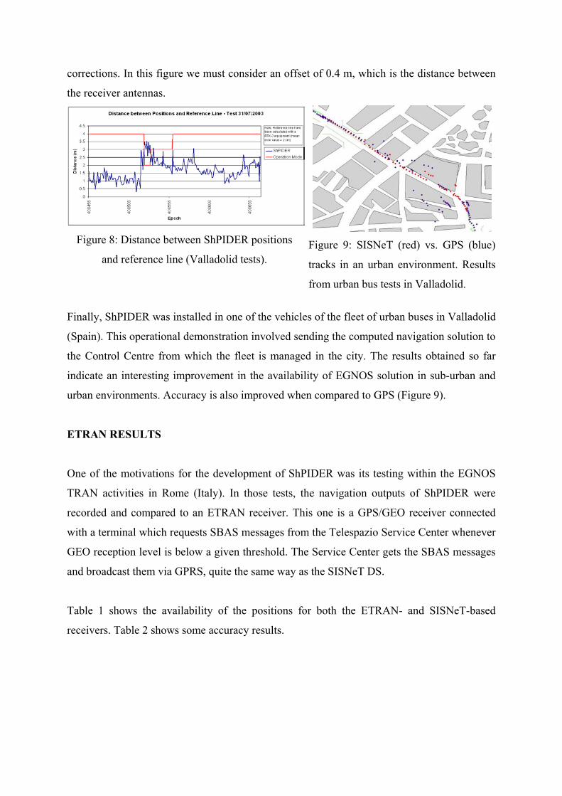
corrections. In this figure we must consider an offset of 0.4 m, which is the distance between
the receiver antennas.
Figure 8: Distance between ShPIDER positions
and reference line (Valladolid tests).
Figure 9: SISNeT (red) vs. GPS (blue)
tracks in an urban environment. Results
from urban bus tests in Valladolid.
Finally, ShPIDER was installed in one of the vehicles of the fleet of urban buses in Valladolid
(Spain). This operational demonstration involved sending the computed navigation solution to
the Control Centre from which the fleet is managed in the city. The results obtained so far
indicate an interesting improvement in the availability of EGNOS solution in sub-urban and
urban environments. Accuracy is also improved when compared to GPS (Figure 9).
ETRAN RESULTS
One of the motivations for the development of ShPIDER was its testing within the EGNOS
TRAN activities in Rome (Italy). In those tests, the navigation outputs of ShPIDER were
recorded and compared to an ETRAN receiver. This one is a GPS/GEO receiver connected
with a terminal which requests SBAS messages from the Telespazio Service Center whenever
GEO reception level is below a given threshold. The Service Center gets the SBAS messages
and broadcast them via GPRS, quite the same way as the SISNeT DS.
Table 1 shows the availability of the positions for both the ETRAN- and SISNeT-based
receivers. Table 2 shows some accuracy results.
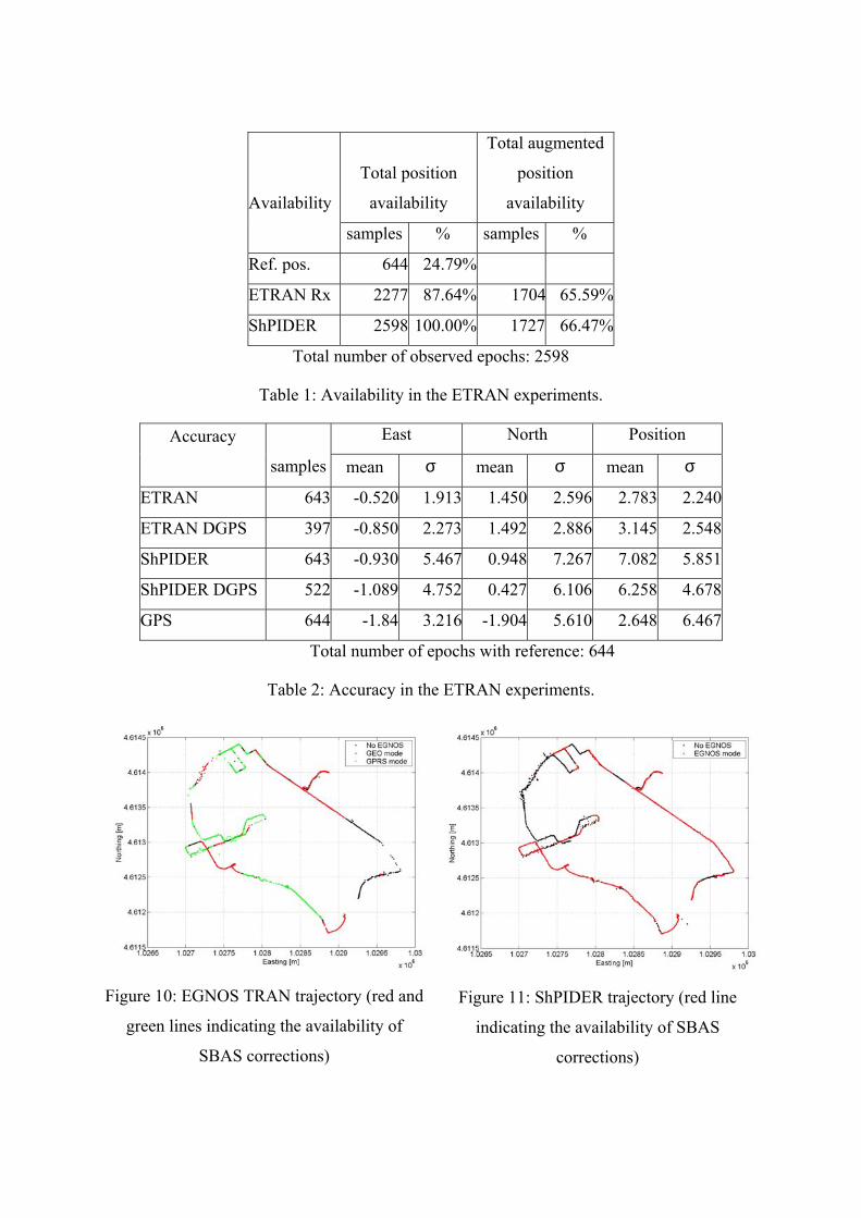
Total position
availability
Total augmented
position
availability Availability
samples % samples %
Ref. pos. 644 24.79%
ETRAN Rx 2277 87.64% 1704 65.59%
ShPIDER 2598 100.00% 1727 66.47%
Total number of observed epochs: 2598
Table 1: Availability in the ETRAN experiments.
East North Position Accuracy
samples mean σ mean σ mean σ
ETRAN 643 -0.520 1.913 1.450 2.596 2.783 2.240
ETRAN DGPS 397 -0.850 2.273 1.492 2.886 3.145 2.548
ShPIDER 643 -0.930 5.467 0.948 7.267 7.082 5.851
ShPIDER DGPS 522 -1.089 4.752 0.427 6.106 6.258 4.678
GPS 644 -1.84 3.216 -1.904 5.610 2.648 6.467
Total number of epochs with reference: 644
Table 2: Accuracy in the ETRAN experiments.
Figure 10: EGNOS TRAN trajectory (red and
green lines indicating the availability of
SBAS corrections)
Figure 11: ShPIDER trajectory (red line
indicating the availability of SBAS
corrections)
The reference trajectory was obtained with measurements from the ETRAN receiver and a
surveyed fixed receiver, using a kinematic software application from Astech. Possible causes
of the low availability of the reference are that L1-only measurements were used, and also
that inurban environment the phase ambiguity algorithms do not always work. It is also worth
noting that the ShPIDER antenna was 50cm away from the ETRAN antenna on the car roof.
ETRAN receiver and ShPIDER positions have been obtained from GGA logs. GPS positions
have been obtained from post-processed ETRAN measurements.
In general the EGNOS TRAN solution shows a better accuracy while the ShPIDER a better
position availability due to the availability-enhancing mechanisms described above. The
experiments were conducted with no smoothing in ShPIDER measurements; besides, the
latency of the corrections for ShPIDER was higher due to the longer distance to the Data
Server. This could explain the lower accuracy of the receiver.
Another result was that, due to the highly masked urban environment of this trial, the wide
area corrected position of both the ETRAN user terminal and ShPIDER do not show a
significant improvement with respect to the GPS solution due to the low number of corrected
satellites.
POCKET-SHPIDER
Currently, a PDA version of ShPIDER is being developed in GMV Sistemas. Pocket-
ShPIDER, as it is called, integrates the ShPIDER navigation engine, plus an own
geographical information system.
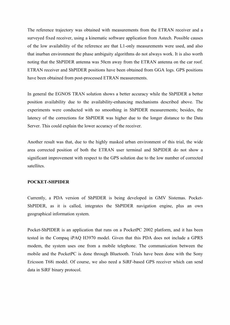
Pocket-ShPIDER is an application that runs on a PocketPC 2002 platform, and it has been
tested in the Compaq iPAQ H3970 model. Given that this PDA does not include a GPRS
modem, the system uses one from a mobile telephone. The communication between the
mobile and the PocketPC is done through Bluetooth. Trials have been done with the Sony
Ericsson T68i model. Of course, we also need a SiRF-based GPS receiver which can send
data in SiRF binary protocol.
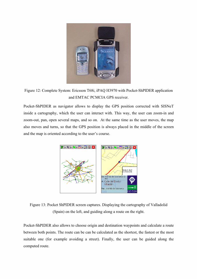
Figure 12: Complete System: Ericsson T68i, iPAQ H3970 with Pocket-ShPIDER application
and EMTAC PCMCIA GPS receiver.
Pocket-ShPIDER as navigator allows to display the GPS position corrected with SISNeT
inside a cartography, which the user can interact with. This way, the user can zoom-in and
zoom-out, pan, open several maps, and so on. At the same time as the user moves, the map
also moves and turns, so that the GPS position is always placed in the middle of the screen
and the map is oriented according to the user’s course.
Figure 13: Pocket ShPIDER screen captures. Displaying the cartography of Valladolid
(Spain) on the left, and guiding along a route on the right.
Pocket-ShPIDER also allows to choose origin and destination waypoints and calculate a route
between both points. The route can be can be calculated as the shortest, the fastest or the most
suitable one (for example avoiding a street). Finally, the user can be guided along the
computed route.
Pocket-ShPIDER is now in the qualification phase. Its evolution will go in parallel with the
ShPIDER prototype, but will also focus on location-based services taking advantage on its
graphical interface and mapping capabilities.
SISNET TO HELP THE BLIND
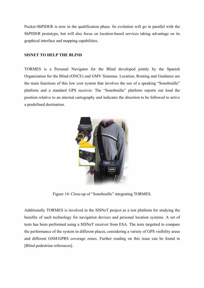
TORMES is a Personal Navigator for the Blind developed jointly by the Spanish
Organization for the Blind (ONCE) and GMV Sistemas. Location, Routing and Guidance are
the main functions of this low cost system that involves the use of a speaking “Sonobraille”
platform and a standard GPS receiver. The “Sonobraille” platform reports out loud the
position relative to an internal cartography and indicates the direction to be followed to arrive
a predefined destination.
Figure 14: Close-up of “Sonobraille” integrating TORMES.
Additionally TORMES is involved in the SISNeT project as a test platform for studying the
benefits of such technology for navigation devices and personal location systems. A set of
tests has been performed using a SISNeT receiver from ESA. The tests targetted to compare
the performance of the system in different places, considering a variety of GPS visibility areas
and different GSM/GPRS coverage zones. Further reading on this issue can be found in
[Blind pedestrian references].
FUTURE WORK
Short term tasks in mind are to finish the processing of the operational tests and to compare
the receiver with GPS, EGNOS and existing SISNeT receivers. The aim is to stress the
advantages of SISNeT, and to indicate possible improvements.
In the long run, some ideas are clear:
• To study a better way to apply the EGNOS corrections, for instance, providing only the
ionospheric corrections which a user needs based in his position.
• To exploit the ability of providing location-based services. For example, tourism
information based on SISNeT, advertisement, remote control...
CONCLUSION
The authors believe that the SISNeT technology, as a solid synergy between SBAS systems
and the Internet, will open the door to a large amount of innovative applications for Satellite
Navigation. It is already showing its capabilities by means of prototypes such as ShPIDER or
Pocket-ShPIDER, and will surely become a mature technology in the field of location-based
services.
ACKNOWLEDGMENTS
The authors wish to thank AUVASA, ONCE, Valenti and COOP for their kind support to the
tests.
REFERENCES
[1] RTCA Minimum Operational Performance Standards for GPS/WAAS System Airborne
Equipment. Do229B, October 6, 1999.
[SISNeT references]
[2] European Space Agency, “SISNeT Specialist Website,” http://www.esa.int/sisnet
[3] F. Torán, J. Ventura-Traveset and R. Chen. " The ESA SISNeT Technology: Access to
the EGNOS Services through Wireless Networks and the Internet," Proc. of ION GPS
2002, Portland (Oregon), Sept. 2002.
[4] F. Toran, J. Ventura-Traveset and JC de Mateo. “Satellite Navigation and the Internet:
Introducing the SISNET Technology,” Dr. Dobb’s Journal, March 2002, pp.17-26.
Featured article in March 2002. Available through http://www.ddj.com/articles
[5] F. Torán and J. Ventura-Traveset. "SISNeT User Interface Document," Issue 2, Rev. 1,
June 2002. Available at http://www.esa.int/sisnet
[Handheld references]
[6] F. Toran, J. Ventura-Traveset and R. Chen, “Handheld Internet-Based EGNOS Receiver:
The First Product of the ESA SISNET Technology,” GNSS 2003, Graz (Austria), 22 – 25
April 2003.
[7] R. Chen, F. Toran and J. Ventura-Traveset, “Access to the EGNOS Signal-In-Space Over
Mobile IP,” GPS Solutions (2003), Vol. 7, No. 1.
[Blind pedestrian references]
[8] A. Catalina, J. March, R. Davila, J. Paniagua, C. Busnadiego, J. Ventura-Traveset, F.
Toran, J.L. Fernandez-Coya, J.L. Lorente, “Blind Pedestrian Navigator: Operating
Features, Performances and EGNOS / SISNET Benefits,” GNSS 2003, Graz (Austria), 22
– 25 April 2003.
[9] “Space technology to help the blind,” ESA Press Release, 30 December 2003, available
at http://www.esa.int/export/esaSA/SEM4HZ1A6BD_navigation_0.html
[Bus references]
[10] “Toulouse bus test-drives European satellite navigation,” ESA Press Release, 14
February 2003, http://www.esa.int/export/esaSA/SEM4HZ1A6BD_navigation_0.html