Embed Size (px)
Citation preview
THE FERRYBANK-BELVIEW DRAFT LOCAL AREA PLAN Proposed Amendments (Material Alterations) to the Ferrybank-Belview Draft Local Area Plan In accordance with Section 12 of the Planning and Development Act, 2000, notice is hereby given that Kilkenny County Council has made proposed amendments to the Ferrybank-Belview Draft Development Plan. These amendments have arisen following the Elected Members review of the Second Managers Report on Submissions received under Section 12(4) of the Planning and Development Act, 2002. The proposed material alterations to the text are outlined in chronological order (below) and may be read in conjunction with a copy of the Ferrybank-Belview Draft Local Area Plan. Proposed alterations to land use zoning designations and/or development objectives are shown in the accompanying map Deletions in Strikethrough Proposed insertions in Italics Page 13: (DBF 2) Amend text on Table 2 to read as follows: “PLUTS Population Growth Projections” Page 30: (DBF22) Section 2.1.6; Include the insertion of a new policy to read as follows: TP8 Encourage the provision of improved rail access to and from the Port Page 31: (DBF19) Section 2.1.6; It is proposed to include a development objective as follows T16 Promote a new access road to the lands at Drumdowney running parallel to the existing railway line that will link into the main port access road. Page 32: (Matters Arising) Section 2.2.2 First paragraph second sentence to be corrected as follows: “This study will inform the members of Kilkenny County Council as to whether or not the Ferrybank Abbeylands Shopping Centre should be designated as a town or district centre. “This study will inform Kilkenny County Council as to the status of the Ferrybank Shopping Centre in the retail hierarchy going forward”. Page 33: (Matters Arising) Section 2.2.5; Reword the following policy as follows From REP3 Continually review the population targets for the area and should a need arise; the quantum of retail space permitted will be increased/decreased accordingly. These needs must be in accordance with the County Retail Strategy and met in a way that is ‘efficient, equitable and sustainable’.

To REP3 Continuously review the population for the area to ensure that the retail strategy is providing for the needs of the area in a way that is efficient, equitable and sustainable”. Page 34: (Matters Arising) Section 2.2.6, It is proposed to add the following objectives RE5 Require for the C2 zone at Newrath, that a masterplan is prepared prior to the development of the area. This masterplan shall be required to address the future access and circulation arrangements within the site, the provision of services and outline the sequence of development according to the number of phases of which there shall be at least three. 70% of development in any initial phase should be under construction prior to the commencement of a subsequent phase. RE6 Ensure that all retail development in the C2 zone at Christendom fronts onto the existing Clover Road and/or the proposed T5 route within its zone so as to create a new urban street. Lands zoned C2 lying between the river and the Clover Road shall be considered for more comprehensive large scale retail development subject to the outcome of the joint retail strategy. Page 35: (DFB50) Section 2.3.2, It is proposed to amend the text in the heading to read as follows: ‘Protection of Protected Structures in the Plan area’ Page 38: (DFB50) Section 2.3.2.3; It is proposed to relocate this section to Appendix 5 Page 38: (DFB50) Section 2.3.3; It is proposed to relocate this section to Appendix 6 Page 39: (DFB50) Section 2.3.4; It is proposed to amend the text of policy BHP2 as follows From BHP2: Refer all planning applications that would impinge upon any historic structure to the Architectural Heritage Advisory Unit of the DoEHLG, and where considered necessary on the advice of the DoEHLG, prevent development that would inappropriately and irreplaceably damage any such structure or monument. To BHP2: Refer certain planning applications that may impinge upon a protected structure to the Architectural Heritage Advisory Unit of the DoEHLG and where considered necessary based on advice prevent development that would be inappropriate or cause damage to a protected structure or monument

Page 39: (DFB50) Section 2.3.4; It is proposed to amend the text of the policy BHP3 to read as follows: From BHP3: Ensure that any development, modifications, alterations or extensions affecting the special interest of a Protected Structure, or structure located within the curtilage, setting or adjoining a Protected Structure, are sited and designed appropriately and are not detrimental to the character of the structure, its setting or character. To BHP3: Generally ensure that works affecting the character of a protected structure are not detrimental to the character of the structure, its setting or character. Page 39: (DFB50) Section 2.3.4; Policy BHP7, it is proposed to delete the last line and replace as follows: BHP7: Encourage the retention and protection of ruins, follies and walled gardens that occur within the plan area. Further deterioration of these structures should be avoided through raising awareness of the contribution they make to the character of the area. The re-use of these structures as private, semi-private or public areas of open space will be encouraged. New buildings in the vicinity of these structures will generally be discouraged, unless they are considered to be sensitive in scale and character. ‘New development in the vicinity of these structures will be encouraged only where it is sensitive in both scale and character’ Page 39: (DFB50) Section 2.3.5; It is proposed to reword the following objective BH2 as follows: From BH2 Given the proximity of Belview House to Belview Port, flexibility in the future re-use of this structure and its curtilage is encouraged through the introduction of land use zoning: C3 – Commercial Zoning, which could allow for a local commercial services centre and/or small scale offices at this location To BH2 The introduction of Land Use Zoning C3, Commercial Zoning, at Belview House is intended to encourage the development of a local commercial services centre and/or small scale offices at this location. Development in this regard which respects and enhances the character of structure and other structures within its curtilage will be encouraged and, in turn, it is intended that Belview House will establish a local sense of identity and character given its proximity to Belview Port.

Page 39: (DFB50) Section 2.3.5; It is proposed to amend the objective BH3 as follows: From BH3 Require that where sites of protected structures are redeveloped, full records of extant remains are created by a qualified Conservation Architect, and deposited with the National Archive and the Irish Architectural Archive. (No Map Reference). BH3 Require that where sites of protected structures such as the Glass House have received planning permission for redevelopment, full records of extant remains are produced by a suitably qualified person and deposited with the Irish Architectural Archive Page 39: (DFB50) Section 2.3.4, It is proposed to include the following policy BPH9: Consult with the (Heritage Section) DOEHLG and other interested parties to ensure the protection, promotion and enhancement of significant historic gardens and designed landscapes in the area and to support public awareness, enjoyment of and access to these sites Page 41: (DFB50) Section 2.4.4; It is proposed to include the following objective A3 Secure the preservation in-situ of, or preservation by record of any sites and features of historical and archaeological interest (No Map Reference) Page 41: (DFB50) Section 2.4.4; It is proposed to include the following objective A4 Secure the preservation in-situ of, or preservation by record of any subsurface archaeological features that may be discovered during the course of infrastructural/development works in the operational area of the Local Area Plan (No Map Reference) Page 41: (DFB50) Section 2.4.4; It is proposed to include the following objective A5 Where a proposed development (excluding individual residential home units) includes a monument or site included in the Record Monument and Places within the landholding the developer shall commission an archaeological assessment to establish the extent of archaeological material associated with the monument or site. This assessment shall also define the buffer area or area contiguous with the monument which well preserve the setting and visual amenity of the site. (No Map Reference) Page 41: (DFB50) Section 2.6.5; Fourth paragraph, it is proposed to delete the last line and replace with the following text ‘European Communities (Natural Habitats) (Amendment) Regulations, 2005’ Page 43: (DFB50) Section 2.5.3; It is proposed to add the following text subsequent to the second paragraph: ‘The LAP once adopted may require a material variation to ensure compliance with the next housing strategy (Part V).’

Page 44: (addendum to manager’s report) Section 2.5.3 Zoning of Lands for Residential Development: Following the second paragraph it is proposed to add: ‘Development of lands earmarked as phase 2 will not be considered until 70% of the residentially zoned land within the development boundary has been built out’. Page 46: (Matter Arising, DBF46) Reword Objective R3 (C1) as follows From R3 C1 Urban Village (10% maximum amount of residential development allowed) To C1 Urban Village (60% maximum amount of residential development allowed and prohibit residential use to the street front on the ground floor) Page 46: (DFB41) Section 2.5.7, It is proposed to add the following objective R4 Facilitate Residential Medium Density at Christendom subject to the protection of trees in accordance with the Tree Preservation Order Page 47: (DFB55) First line, it is proposed to change the name of the chapter from Natural Environment to Natural Heritage Page 50: (DFB55) Section 2.6.3; First Line to be reworded as follows: ‘A Natural Heritage Area is a National Designation.’ Page 50: (DFB55) Section 2.6.3: First Line to be reworded as follows: A Natural Designation is a basic designation for wildlife National Designation Page 50: (DFB55) Section 2.6.5; First Line, it is proposed to change the title from Natural Environment Policies to Natural Heritage Policies Page 50: (DFB55) Section 2.6.5; It is proposed to amend the following policy to read as follows From NEP2 Encourage developers to incorporate features of the natural environment, such as rivers, streams, existing flora and fauna, and significant tree groups, within open space layouts and/or in the planning of future developments. To NEP2 Require the incorporation of natural features where appropriate by way of relevant Planning Conditions

Page 50: (DFB55) Section 2.6.5; It is proposed to amend the following policy to read as follows From NEP4 Protect, maintain, improve and enhance the quality of watercourses throughout the plan area, through the promotion of Sustainable Urban Drainage Systems (SUDS) To NEP4 Protect, maintain, improve and enhance the quality of watercourses throughout the plan area by requiring the use of Sustainable Urban Drainage Systems (SUDS) where appropriate by way of relevant Planning Conditions Page 51: (DFB55) Section 2.6.5; It is proposed to combine NEP12 and NEP13 into one policy NEP 12 as follows: Policy NEP12 Where there is a risk of damage or disturbance from a proposed development to designated wetland/peatland ecological sites an Appropriate Assessment screening must be carried out for any such development Page 51: (DFB55) Section 2.6.5; Policy NEP 14 to become NEP 13 and reword as follows: From NEP14 Allow for the designation of ecological sites that are of ‘county importance’ (this is a level below SAC and NHA which are of international and national importance respectively) as stated in the Kilkenny County Development Plan, section 8.2.3. While a mechanism for identification of these sites has yet to be finalised, a number of sites within the study are potential candidates. These are proposed as they are of particular conservation value and feature habitats that are relatively natural, and rare in a local context (meaning a low proportion of alien species). These are: a) Oak-Ash-Hazel woodland sites indicated as W7 and W8 on the SEA Habitat Map (S593 148 & S609 151) b) Riparian Woodland sites at S657 145; S650 130; S644 125; and S633 126) c) Wet Grassland site indicated on the SEA Habitat Map as WG1 (S628 148) A comprehensive ecological survey should be carried out for each of these sites against the criteria established by Kilkenny County Council for the designation of sites of county importance. To NEP14 Investigate the possibility, in co-operation with the relevant statutory authorities and other relevant groups, of identifying the sites of local nature conservation interest. While a mechanism for identification of these sites has yet to be finalized, a number of sites within the study are potential candidates. These are proposed as they are of particular conservation value and feature habitats that are relatively natural, and rare in a local context (meaning a low proportion of alien species). These are a) Oak-Ash-Hazel woodland sites indicated as W7 and W8 on the SEA Habitat Map (S593 148 & S609 151)

b) Riparian Woodland sites at S657 145; S650 130; S644 125; and S633 126) c) Wet Grassland site indicated on the SEA Habitat Map as WG1 (S628 148) A comprehensive ecological survey should be carried out for each of these sites against the criteria established by Kilkenny County Council for the designation of sites of county importance Page 51: (DBF55) Section 2.6.5; NEP15 to become NEP14 and reworded as follows: From NEP15 Any planting to be carried out by Kilkenny County Council, or private companies developing sites within the LAP area should at all times utilise native tree species only The NRA’s guidance document A Guide to Landscape Treatments for National Road Schemes in Ireland may be useful in this regard. To NEP14 ‘The NRA’s guidance document A Guide to Landscape Treatments for National Road Schemes in Ireland may be useful while regard must be given to Appendix C of the CDP.’ Page 51: (DFB55) Section 2.6.5, It is proposed to add the following policy NEP 15 Maintain, and where necessary facilitate, the enhancement of the conservation values of those features or areas of county geological and or geomorphological importance. Page 51: (DFB55) Section 2.6.5; It is proposed to add the following policy NEP 16 Ensure regard is given to the various policies and objectives relating to Natural Heritage in the County Development Plan Page 51: (DFB55) Section 2.6.6; First Line, it is proposed to change the title from Natural Environmental Objectives to Natural Heritage Objectives Page 52: (Addentum to Managers Report) Section 2.6.6, It is proposed to include another townland to Objective NE4 - Drumdowney (along the rail corridor located in the BE Zone) Page 52: (DFB55) Section 2.6.6; It is proposed to amend policy NE5 as follows From NE5 Protect existing wetlands from fill. To NE5 Protect existing wetlands from fill while encourage the enhancement of wetland habitats and landscape features which form part of habitat networks, such as river corridors and associated habitats.

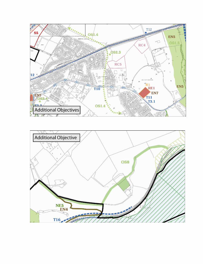
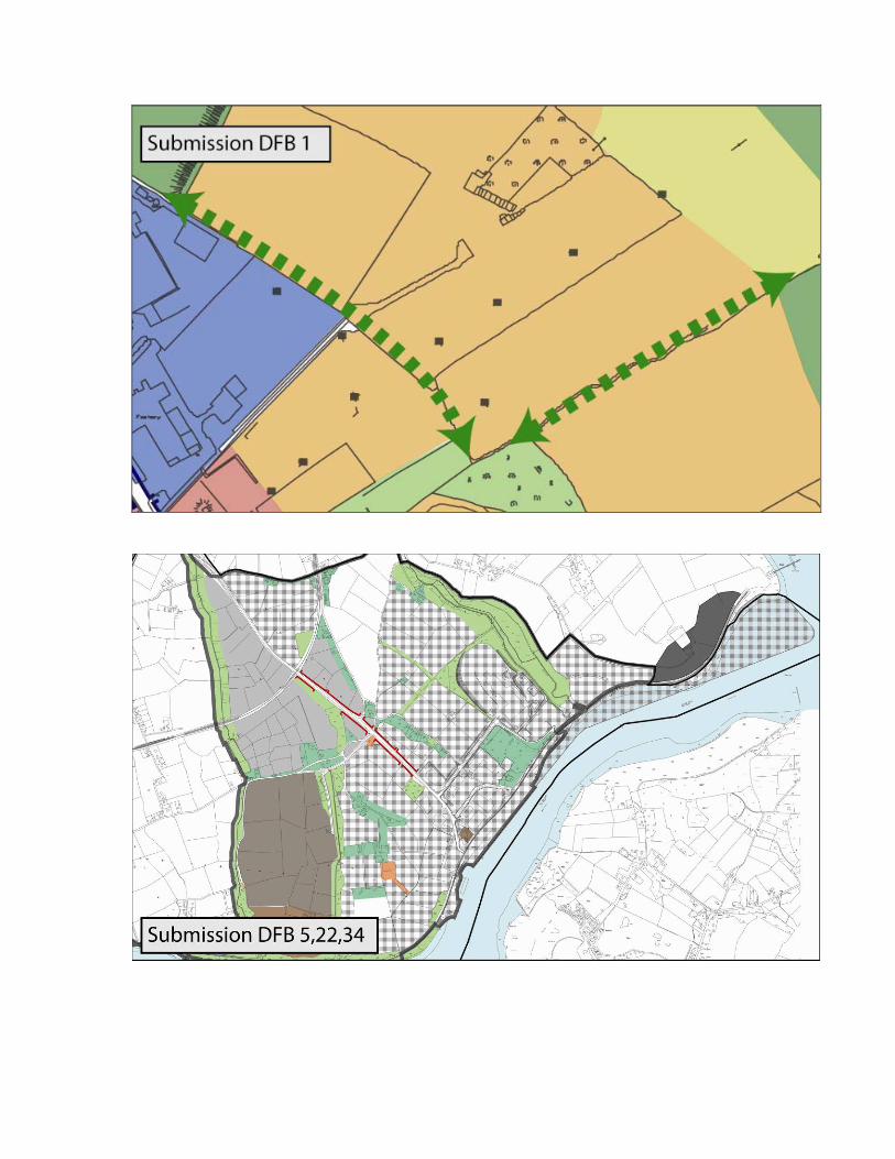
Page 52 (Matters Arising) Section 2.6.6, It is proposed to delete the following objective NE7 Request at planning application stage an Environmental Impact Assessment (EIA for any future large scale development project that may take place in the Belview Port area. Page 54: (Matters Arising) Section 2.7.5, It is proposed to add the following objective: OS1.4 Reserve a large strategic open space in the area from the N25 from the urban village area across the old Railway line and down in to Abbeylands to the west of the water reservoir which is already zoned open space Page 55: (DFB50) Section 2.7.5; Objective amend as follows: From OS3 Develop a system of linear parks with walkways and cycle paths, with significant tree planting and public seating, at the following locations: To OS3 Develop a system of linear parks with walkways and cycle paths, with significant tree planting and public seating in consultation with the NPWS at the following locations Page 55: (DFB50) Section 2.7.5; It is proposed to add the following text to OS6 as follows: OS6 Explore in conjunction with Iarnrod Eireann and NPWS, the possibility of developing one or more pedestrian crossings over the railway line with a broadwalk-style viewing platform along the River Suir (such a facility could also be used for recreational fishing) Page 55: (DFB14) It is proposed to include a development objective under section 2.7.5 as follows: OS3.6 From active open space lands at Clover Social Club linking eastwards to OS3.2 and northwards to the proposed active open space adjacent to Abbey Park. Page 55: (DFB15, DBF33, DBF35) It is proposed to include a development objective under section 2.7.5 as follows: OS7 A minimum landscape buffer will be required around all industrial site boundaries i.e. 5 metres back from the industrial site boundary. This landscape buffer will be required to be densely planted with a mix of conifer and deciduous species. Page 55: (DBF19) It is proposed to include a development objective under Section 2.7.5 as follows: OS8 Ensure a continous landscape buffer (15-20 metres wide) at Drumdowney which is to be densely planted. This should consist of mixed native woodland and surround the entirety of the site. This should extend west to the entrance and gate lodge of Snowhill house and east to the railway tunnel as shown on Map 2. Page 58: (Matters Arising) Section 2.8.4, Remove last sentence of the first paragraph The new Ferrybank-Abbeylands Shopping Centre will also have a crèche facility.

Page 59: (Matters Arising) Section 2.8.8, Remove second sentence of first paragraph The new Ferrybank-Abbeylands centre will include a medical centre. Page 59: (Matters Arising) Section 2.8.9, It is proposed to add the following policy RCP6 Require the provision of appropriate purpose built childcare facilities in association with proposals for new residential development of more than 75 dwelling units. Where appropriate the Council will operate this requirement in a flexible manner and will encourage and facilitate cooperation between developers to jointly provide facilities, having regard to the Kilkenny County Childcare Strategy. Page 59: (Matters Arising) Section 2.8.10, Reword Objective RC2 as follows From RC2 Develop a flagship, multi-purpose community facility which shall make provision for youth and elderly facilities, adult education, and indoor sports and recreation. An optimum location would be adjoining a zoned area of Active Open Space. (No Map Reference). To RC2 In cooperation with the local community to facilitate, encourage and support the development of a flagship, multi-purpose community facility which shall make provision for youth and elderly facilities, adult education, and indoor sports and recreation. An optimum location would be adjoining a zoned area of Active Open Space. (No Map Reference) Page 60: (Matters Arising) Section 2.9.3, Second paragraph, last line remove text “in 2008”. Page 67: (DBF2) Section 2.10.8. Second line of second paragraph omit the word “urban” Page 67: (DBF2) Section 2.10.8, Third paragraph, third line (1,000 gallons a day) should read 1,000,000 gallons a day. Page 68 (DBF5, DBF22, DBF34) Section 2.10.9, It is proposed to remove the last paragraph “Waste Management, Industry, Logistics and Transport Related Uses”. Given the expansion of Belview Port in recent years and the anticipated future expansion of port facilities, lands in this vicinity have been zoned WILT: Waste Management, Industry, Logistics and Transport Related Uses. There have been a number of expressions of interest in locating Bio-ethanol plants in the vicinity of the Port, as well as for storage areas for the importation/exportation of commercial vehicles. Tank farms may also be considered for the area at some point in the future. Therefore, this zoning should allow for the future growth of the port facilities and spin-off industries in the surrounding area.

Page 71: (DBF 2) Section 2.1.1, Remove the first paragraph and replace as follows: Remove There is presently no spare potable water capacity in the plan area. However, the Council is currently working on a scheme which will see the development of additional supplies. It is likely to be approximately two years before there is full capacity for the area. When full capacity is achieved, the network will serve a Population Equivalent (PE) of 20,000 -30,000, and a further 2,000-3,000 persons at Slieverue. Some 2 million gallons of water will be dispensed on a daily basis in order to meet both residential and industrial demand. Replace with: “Currently there is no spare capacity in the public water supply scheme serving the plan area. However the Council is working on a scheme which will see the development of additional supplies. It is likely that it will take two years before additional capacity becomes available in the water supply network. This additional capacity will largely directed towards the IDA’s strategic industry site in Belview. It is anticipated that by 2012, an upgraded water scheme will be in place which will cater for the plan area demand.” Page 71: (DFB2) Section 2.11.2: Paragraph 1, line one omit word “urban”. Page 74: (DFB2) Reword Policy ENP 1.2 as follows From ENP1.2 Promote the conservation of water where possible through a series of measures such as reducing water leakage rates and conservation education To ENP1.2 Promote the conservation of water through a wide ranging co-ordinated water conservation programme. Page 74: (DFB2) It is proposed to delete the following policy ENP1.1 ENP1.1 Ensure that the area has an adequate water supply for domestic, commercial and industrial use Page 74: (DFB2) Section 2.11.11; It is proposed to include the following policy ENP1.6 Support the preparation of a Water Conservation Strategy for the Plan area. This strategy should address new and existing development Page 74: (DFB2) Reword Policy ENP2.1 as follows From ENP2.1 Make provision for a new Wastewater Treatment Plant to service the Newrath area of the plan. To ENP2.1 It is a policy of the Council to provide for the servicing of the Newrath area for the disposal of foul waste water

Page 74: (DFB55) Section 2.11.11; It is proposed to include the following policy ENP1.7 Ensure the continued protection of groundwater sources and their associated habitats and species Page 75: (DFB55) Section 2.11.11; It is proposed to include the following policy ENP3.7 Ensure that due consideration is given to the DOELHG guidelines “The Planning System and Flood Risk Management Page 75: (DFB55) Section 2.11.11; It is proposed to include the following policy ENP3.8 In areas at risk from flooding, particularly at riverside locations a precautionary approach will apply and the methodology set out in the Planning Guidelines ‘The Planning System and Flood Risk Management’ will be applied to development proposals. Page 77: (DFB2, DFB51) Section 2.11.12, It is proposed to delete the following objective EN3 Make provision for a new waste water facility to service the Newrath area of the Plan. And replace with EN3 Make provision for the servicing of the Newrath Area for the disposal of foul waste water Page 77: (DFB55) Section 2.11.12, It is proposed to include the following objective EN10 Ensure that appropriate infrastructure in particular, adequate and appropriate wastewater treatment, water supply, surface drainage, transport, waste management, community services, should be planned and phased to address any current problems or deficits and to reflect predicted increases in population. Page 89: (Addendum to Managers Report) First Paragraph, Where a proposed development is located in close proximity to an established park area or zoned open space this may be relaxed depending on the nature and quality of existing provision. This relaxation will only be considered where the development pays a financial contribution towards the improvement of the open space so as to improve its quality and carrying capacity. Reduced provisions may only be acceptable in urban locations where there are more sustainable patterns of development and maximum use can be made of urban land or redevelopment schemes where open space is already available. Open space provision for smaller residential developments and schemes catering for special needs such as accommodation for the elderly will be considered more flexibly on its merits and having regard to the requirements of likely future residents.

PROPOSED AMENDMENTS TO ATTACHED MAPS Map 4 Environmental Parameters Map; It is proposed to reword ‘Natural Heritage Area’, should read ‘proposed Natural Heritage Area’ Map 4 Environmental Parameters Map: It is proposed to reword ‘Special Area of Conservation’, should read ‘candidate Special Area of Conservation’ Map 8 Development Objectives Map; It is proposed to include the Objective RE5 on lands at Newrath Map 8 Development Objectives Map; It is proposed to include the Objective RE6 on lands at Christendom Map 8 Development Objectives Map; It is proposed to include the Objective R4 on lands at Christendom Map 8 Development Objectives Map; It is proposed to include the Objective OS1.4 at Abbeylands Map 8 Development Objectives Map; It is proposed to include the Objective OS3.6 at Abbey Park Map 8 Development Objectives Map; It is proposed to include the Objective OS7 at Belview Port Map 8 Development Objectives Map; It is proposed to include the Objective OS8 at Drumdowney Map 8 Development Objectives Map; Objective EN1 omit “from Mullinavat” from sentence Map 8 Development Objectives Map; Proposed to remove objective EN4 placed on lands at Grannyferry Map 8 Development Objectives Map: It is proposed to remove objective NE7 at Belview Port Map 8 Development Objectives Map; it is proposed to remove objective NE3 at Grannyferry

PROPOSED AMENDMENTS TO ATTACHED APPENDICES Appendix 1: List of Appropriate Uses in Land Use Zones, Land Use Zone BRA: Belview Residential Amenity, it is proposed to include the following under “Uses Permitted in Principle” Dwelling Houses for immediate family members of landowners (sons and daughters only) Appendix 1: List of Appropriate Uses in Land Use Zones, Land Use Zone RP: Retail Park/Retail Warehousing; it is proposed to reword the following under ‘Uses Permitted in Principle’ ‘Service Station/Petrol Station to ‘Service/Petrol Station/Restaurant Facilities’ Appendix 1: List of Appropriate Uses in Land Use Zones, Land Use Zone AG: Agriculture; It is proposed to include the following text under ‘Uses Open for Consideration’ Residential uses are subject to the provisions as set out in Section 3.2.3 Appendix 1: List of Appropriate Uses in Land Use Zones, Land Use Zone PFI: Development of Port Facilities and Industry; It is proposed to include the following text under ‘Uses permitted in Principle’ ‘Silos and Storage Areas, Storage Tanks including Bulk Liquid Storage and General Warehousing’