Embed Size (px)
Citation preview
Final
Proposed Plan for Sediment and Surface Water
at Six Areas of ConcernMunitions Response Sites
Former Ravenna Army Ammunition Plant Portage and Trumbull Counties Ohio
Contract No W912QR-15-C-0046
Prepared for
US Army Corps of Engineers Louisville District
Prepared by
Leidos
8866 Commons Boulevard Suite 201 Twinsburg Ohio 44087
May 10 2019
CONTRACTOR STATEMENT OF INDEPENDENT TECHNICAL REVIEW Leidos has completed the Proposed Plan for Sediment and Surface Water at Six Areas of ConcernMunitions Response Sites at the Former Ravenna Army Ammunition Plant Portage and Trumbull Counties Ohio Notice is hereby given that an independent technical review has been conducted that is appropriate to the level of risk and complexity inherent in the project During the independent technical review compliance with established policy principles and procedures utilizing justified and valid assumptions was verified This included review of data quality objectives technical assumptions methods procedures and materials to be used the appropriateness of data used and level of data obtained and reasonableness of the results including whether the product meets the customerrsquos needs consistent with law and existing United States Army Corps of Engineers (USACE) policy In addition an independent verification was performed to ensure all applicable changes were made per regulatory and Army comments May 10 2019 Sarika Johnson Date StudyDesign Team Leader
May 10 2019 Rupa Price Date Independent Technical Review Team Leader Significant concerns and explanation of the resolutions are documented within the project file As noted above all concerns resulting from independent technical review of the project have been considered
May 10 2019 Lisa Jones-Bateman Date Senior Program Manager
Final
Proposed Plan for Sediment and Surface Water
at Six Areas of ConcernMunitions Response Sites
Former Ravenna Army Ammunition Plant Portage and Trumbull Counties Ohio
Contract No W912QR-15-C-0046
Prepared for US Army Corps of Engineers
Louisville District
Prepared by Leidos
8866 Commons Boulevard Suite 201 Twinsburg Ohio 44087
May 10 2019
DOCUMENT DISTRIBUTION for the Final
Proposed Plan for Sediment and Surface Water at Six Areas of ConcernMunitions Responses Sites
Former Ravenna Army Ammunition Plant Portage and Trumbull Counties Ohio
Number of Printed Number of NameOrganization Copies Electronic Copies
Nicholas Roope Ohio EPA-NEDO 1 1 Mark Johnson Ohio EPA-NEDO Email transmittal letter only Bob Princic Ohio EPA-NEDO Email transmittal letter only Tom Schneider Ohio EPA-SWDO Email transmittal letter only David Connolly ARNG IampE-Cleanup Branch 0 1 Katie Tait OHARNG Kevin Sedlak ARNG
Camp Camp
James James
A A
Garfield Garfield Email transmittal letter only
Craig Coombs USACE ndash Louisville District Email transmittal letter only Nathaniel Peters II USACE ndash Louisville District 1 1 Admin Records Manager ndash Camp James A Garfield 2 2 Pat Ryan Leidos-REIMS Email transmittal letter only Jed Thomas Leidos 1 1 Leidos Contract Document Management System 0 1 ARNG = Army National Guard IampE = Installations and Environment NEDO = Northeast District Office OHARNG = Ohio Army National Guard Ohio EPA = Ohio Environmental Protection Agency REIMS = Ravenna Environmental Information Management System SWDO = Southwest District Office USACE = US Army Corps of Engineers
Sediment and Surface Water at Six Areas of Concern Proposed Plan Page i and Munitions Response Sites
TABLE OF CONTENTS 10 INTRODUCTION 1 20 SITE BACKGROUND 2
21 Facility Description and Background 2
22 Facility-wide Sediment and Surface Water Assessment 2
23 Ramsdell Quarry Landfill Area 1 3
24 Erie Burning Grounds 3 25 Open Demolition Area 2 3 26 Fuze and Booster Quarry
LandfillPonds 4 27 Ramsdell Quarry Landfill MRS
Area 2 4 28 Block D Igloo MRS 4
30 SITE CHARACTERISTICS 4 31 Ramsdell Quarry Landfill
Area 1 4 311 1998 Phase I Remedial
Investigation 5 312 2006 Soil and Dry
Sediment Feasibility Study 5
313 2007 MMRP Site Inspection 5
314 2011 MMRP Remedial Investigation 5
315 2016 Supplemental Remedial Investigation 5
32 Erie Burning Grounds 6 321 1999 Phase I Remedial
Investigation 6 322 20032004 Phase II
Remedial Investigation 7 323 2006 Phase II RI
Addendum 7 324 2007 MMRP Site
Investigation 7 325 2012 MMRP Remedial
Investigation 8 326 2016 Supplemental
Remedial Investigation 8 33 Open Demolition Area 2 8
331 1998 Phase I Remedial Investigation 9
332 20022003 Phase II Remedial Investigation 9
333 2006 Phase II Remedial Investigation Addendum 9
334 2007 MMRP Site Investigation 9
335 20092011 Rocket Ridge Area Removal Actions 9
336 2011 MMRP Remedial Investigation 10
337 2016 Supplemental Remedial Investigation 10
338 Time Critical Removal Action 11
34 Fuze and Booster Quarry LandfillPonds 11 341 20032004 Phase I
Phase II Remedial Investigation 12
342 2003 Facility-wide Biological Water Quality Study 12
343 2006 Soil and Dry Sediment Feasibility Study 12
344 2007 MMRP Site Investigation 12
345 2011 MMRP Remedial Investigation 12
346 2016 Supplemental Remedial Investigation 13
35 Ramsdell Quarry Landfill MRS Area 2 13 351 2007 MMRP Site
Investigation 13 352 2011 MMRP Remedial
Investigation 14 353 2016 Supplemental
Remedial Investigation 14 36 Block D Igloo MRS 14
361 2007 MMRP Site Investigation 14
362 2011 MMRP Remedial Investigation 15
363 2016 Supplemental Remedial Investigation 15
40 SCOPE AND ROLE OF RESPONSE ACTION AND LAND USE 15
Sediment and Surface Water at Six Areas of Concern Proposed Plan Page ii and Munitions Response Sites
50 SUMMARY OF SITE RISKS 15 51 Human Health Risk
Assessment 16 511 Ramsdell Quarry
Landfill Area 1 16 512 Open Demolition
Area 2 16 513 Fuze and Booster
Quarry LandfillPonds 17 514 Ramsdell Quarry
Landfill MRS Area 2 17 52 Ecological Risk Assessment 17 53 Impacts to Groundwater 18
60 CONCLUSIONS 18 70 COMMUNITY PARTICIPATION 18
71 Public Comment Period 18 72 Written Comments 19 73 Public Meeting 19 74 Review of Public Comments 19
GLOSSARY OF TERMS 19 REFERENCES 21
LIST OF ATTACHMENTS
Attachment A Ohio EPA Comments
LIST OF FIGURES Figure 1 Location and Orientation of
Former RVAAPCamp James A Garfield 25
Figure 2 Location of the AOCs and MRSs within Camp James A Garfield 27
Figure 3 Ramsdell Quarry Landfill Area 1 Site Features 28
Figure 4 Erie Burning Grounds Site Features 29
Figure 5 Open Demolition Area 2 Site Features 30
Figure 6 Fuze and Booster Quarry LandfillPonds Site Features 31
Figure 7 Ramsdell Quarry Landfill MRS Area 2 Site Features 33
Figure 8 Block D Igloo MRS Site Features 34
LIST OF ACRONYMS
ACM Asbestos-containing Material amsl Above Mean Sea Level
AOC Area of Concern Army US Department of the Army ARNG Army National Guard bgs Below Ground Surface BMP Best Management Practice CERCLA Comprehensive Environmental
Response Compensation and Liability Act
CJAG Camp James A Garfield CMCOC Contaminant Migration
Chemical of Concern COC Chemical of Concern COEC Chemical of Ecological
Concern COI Chemical of Interest COPEC Chemical of Potential
Ecological Concern DERP Defense Environmental
Restoration Program DGM Digital Geophysical Mapping EBG Erie Burning Ground EPC Exposure Point Concentration ERA Ecological Risk Assessment FBQ Fuze and Booster Quarry
LandfillPonds FS Feasibility Study FWCUG Facility-wide Cleanup Goal HEGP High Explosive General
Purpose HHRA Human Health Risk
Assessment IRP Installation Restoration
Program ISM Incremental Sampling
Methodology MC Munitions Constituents MD Munitions Debris MEC Munitions and Explosives of
Concern MMRP Military Munitions Response
Program MRS Munitions Response Site NCP National Oil and Hazardous
Substances Pollution Contingency Plan
ODA2 Open Demolition Area No 2 OHARNG Ohio Army National Guard Ohio EPA Ohio Environmental Protection
Agency PAH Polycyclic Aromatic
Hydrocarbon
Sediment and Surface Water at Six Areas of Concern Proposed Plan Page iii and Munitions Response Sites
PCB Polychlorinated Biphenyl PP Proposed Plan RCRA Resource Conservation and
Recovery Act RDX Hexahydro-135-trinitro-135-
triazine RI Remedial Investigation ROD Record of Decision RQL Ramsdell Quarry Landfill RRA Rocket Ridge Area RSL Regional Screening Level RVAAP Ravenna Army Ammunition
Plant
SERA Screening Ecological Risk Assessment
SI Site Inspection SOR Sum-of-Ratio SRC Site-related Contaminant SVOC Semi-volatile Organic
Compound TCRA Time-critical Removal Action TNT 246-Trinitrotoluene USEPA US Environmental Protection
Agency UXO Unexploded Ordnance VOC Volatile Organic Compound
Sediment and Surface Water at Six Areas of Concern Proposed Plan Page iv and Munitions Response Sites
THIS PAGE INTENTIONALLY LEFT BLANK
Sediment and Surface Water at Six Areas of Concern Proposed Plan Page 1 and Munitions Response Sites
10 INTRODUCTION This Proposed Plan (PP) presents the conclusions and recommendations for sediment and surface water within the following areas of concern (AOCs) and munitions response site (MRS) within the former Ravenna Army Ammunition Plant (RVAAP)
The former RVAAP is now known as Camp James A Garfield (CJAG) Joint Military Training Center and is located in Portage and Trumbull counties Ohio (Figure 1) The Army National Guard (ARNG) in coordination with the Ohio Environmental Protection Agency (Ohio EPA) issues this PP to provide the public with information necessary to comment on the no further action recommendation The remedy will be selected after all comments submitted during the 30-day public comment period are considered Therefore the public is encouraged to review and comment on the no further action recommendation for these sites as presented in this PP ARNG is issuing this PP as part of its public participation responsibilities underSection 117(a) of the Comprehensive Environmental Response Compensation and Liability Act (CERCLA) of 1980 as amended by the Superfund Amendments and Reauthorization Act of 1986 and Section 300430(f) (2) of the National Oil and Hazardous Substances Pollution Contingency Plan (NCP) (40 Code of Federal Regulations 300) Selection and
implementation of a remedy will also be consistent with the requirements of the Ohio EPA Directorrsquos Final Findings and Orders dated June 10 2004 (Ohio EPA 2004)
Site Name 1 RVAAP-01 Ramsdell Quarry Landfill (RQL) and
RVAAP-001-R-02 RQL MRS Area 1 North 2 RVAAP-02 Erie Burning Grounds (EBG) and
RVAAP-002-R-01 EBG MRS 3 RVAAP-04 Open Demolition Area No 2 (ODA2)
and RVAAP-004-R-01 ODA2 MRS 4 RVAAP-16 Fuze and Booster Quarry LandfillPonds
(FBQ) and RVAAP-016-R-01 FBQ MRS 5 RVAAP-001-R-01 RQL MRS Area 2 6 RVAAP-060-R-01 Block D Igloo MRS
Public Comment Period August 12 2019 to September 10 2019
Public Meeting ARNG will hold an open house and public meeting to present the conclusions and additional details presented in the Supplemental Remedial Investigation for Sediment and Surface Water at RVAAP-01 RVAAP-04 RVAAP-16 RVAAP-001-R-01 (Leidos 2017) Oral and written comments will also be accepted at the meeting The open house and public meeting are scheduled for 600PM August 29 2019 at the Charlestown Town Hall 6735 Rock Spring Road Ravenna Ohio 44266
Information Repositories Information used in selecting the remedy is available for public review at the following locations
Reed Memorial Library 167 East Main Street Ravenna Ohio 44266 (330) 296-2827 Hours of operation 9AM-9PM Monday-Thursday 9AM-6PM Friday 9AM-5PM Saturday 1PM-5PM Sunday
Newton Falls Public Library 204 South Canal Street Newton Falls Ohio 44444 (330) 872-1282 Hours of operation 9AM-8PM Monday-Thursday 9AM-5PM Friday and Saturday
Online httpwwwrvaaporg The Administrative Record File containing information used in selecting the remedy is available for public review at the following location
Camp James A Garfield Joint Military Training Center (former Ravenna Army Ammunition Plant) Environmental Office 1438 State Route 534 SW Newton Falls Ohio 44444 (614) 336-6136 Note Access is restricted to Camp James A Garfield but the file can be obtained or viewed with prior notice
Sediment and Surface Water at Six Areas of Concern Proposed Plan Page 2 and Munitions Response Sites
This PP summarizes information about sediment and surface water that can be found in detail in the following documents bull Remedial Investigation Work Plan for
Sediment and Surface Water at RVAAP-01 RVAAP-04 RVAAP-16 RVAAP-001-R-01 and Inventory of Sediment and Surface Water at Multiple Sites (Leidos 2016 herein referred to as the Work Plan) and
bull Supplemental Remedial Investigation for Sediment and Surface Water at RVAAP-01 RVAAP-04 RVAAP-16 RVAAP-001-R-01 (Leidos 2017 herein referred to as the Supplemental Remedial Investigation [RI])
The Administrative Record contains other documents pertaining to these sites ARNG encourages the public to review applicable background documents to gain a more comprehensive understanding of the sites activities that have been conducted to date and the rationale for the no further action recommendation This PP proposes no further action for residual contamination in sediment and surface water at these sites Soil and dry sediment are not included in the scope of this PP as those media are being addressed separately
20 SITE BACKGROUND 21 Facility Description and Background The former RVAAP now known as CJAG located in northeastern Ohio within Portage and Trumbull counties is approximately 3 miles eastnortheast of the city of Ravenna and 1 mile northnorthwest of the city of Newton Falls (Figures 1 and 2) The facility is approximately 11 miles long and 35 miles wide The facility is bounded by State Route 5 the Michael J Kirwan Reservoir and the CSX System Railroad to the south Garrett McCormick and Berry Roads to the west the Norfolk Southern Railroad to the north and State Route 534 to the east In addition the facility is surrounded by the communities of Windham Garrettsville Charlestown and
Wayland The facility is federal property which has had multiple accountability transfers amongst multiple Army agencies making the property ownership and transfer history complex The most recent administrative accountability transfer occurred in September 2013 when the remaining acreage (not previously transferred) was transferred to the US Property and Fiscal Officer for Ohio and subsequently licensed to the Ohio Army National Guard (OHARNG) for use as a military training site (Camp James A Garfield) 22 Facility-wide Sediment and Surface
Water Assessment In 2016 the US Department of the Army (Army) developed the sediment and surface water Work Plan (Leidos 2016) The purpose of the Work Plan was to identify and assess sites that 1) required additional activities to attain a CERCLA decision for sediment and surface water and 2) did not have a contract or Army-directed activity with a goal of attaining this CERCLA decision The Work Plan identified six sites that met these criteria bull Ramsdell Quarry Landfill (RQL) Area 1
North bull Erie Burning Grounds (EBG) bull Open Demolition Area No 2 (ODA2) bull Fuze and Booster Quarry LandfillPonds
(FBQ) bull RQL MRS Area 2 South (RVAAP-001-R-
01) and bull Block D Igloo MRS (RVAAP-060-R-01) This PP addresses the AOC boundaries established in the Installation Restoration Program (IRP) and the MRS boundaries established in the Military Munitions Response Program (MMRP) at four of these sites RQL Area 1 North EBG ODA2 and FBQ This PP addresses the MRS boundaries for RQL MRS Area 2 South and Block D Igloo MRS those sites did not have AOCs established in the IRP Based on information available at that time the Work Plan (Leidos 2016) further
Sediment and Surface Water at Six Areas of Concern Proposed Plan Page 3 and Munitions Response Sites
concluded that EBG and the Block D Igloo MRS can be recommended for no further action In addition the Work Plan contained a screen of historical sediment and surface water data and provided a method for evaluating human health and ecological risk at the other four sites The Army developed the Supplemental RI (Leidos 2017) after the Work Plan (Leidos 2016) to 1) investigate the potential presence of chemical constituents in sediment and surface water at RQL Area 1 ODA2 FBQ and RQL MRS Area 2 as a result of historical activities 2) determine the nature and extent of chemical constituents that may exist in sediment and surface water 3) evaluate the fate and transport of contaminants in the environment and 4) determine if the chemical constituents pose an unacceptable risk to human health or the environment Figure 2 depicts locations of the sites presented in this PP The site histories and descriptions are described below 23 Ramsdell Quarry Landfill Area 1 RQL is located in the northeastern portion of CJAG (Figure 3) and has an approximately 7-acre MRS assessed under the MMRP called RQL MRS Area 1 North This site also has a 14-acre AOC assessed under the IRP called RQL For clarity and added distinction from other sites discussed in this PP this area will be called ldquoRQL Area 1rdquo RQL Area 1 was used as a quarry until 1941 During that time it was excavated to 30ndash40 ft below existing grade to provide road and construction ballast materials Between 1941 and 1989 the western and southern sections of the abandoned quarry were used for landfill operations No information is available regarding landfill disposal activities from 1941ndash1976 however only non-hazardous solid waste was deposited at the landfill from 1976ndash1989 The permitted sanitary landfill was closed in September 1990 under state of Ohio solid waste regulations
Based on available information the permitted landfill cap covers approximately 4 of the 14 acres comprising the RQL AOC In addition from 1946 to the 1950s the bottom of the quarry was used to burn waste explosives from Load Line 1 During this time approximately 18000 225-kg (500-lb) incendiary or napalm bombs were reportedly burned in the abandoned quarry Liquid residues from annealing operations also were dumped in the quarry No additional historical information is currently available on how the quarry was used other than for landfill operations from the 1950s until 1976 when operational records show that non-hazardous solid wastes were placed in RQL 24 Erie Burning Grounds EBG operated from 1941ndash1951 and was used for open burning of explosives and related materials Prior to its acquisition by the Army in 1940 the area may have been used for brick manufacturing (Jacobs 1989) 25 Open Demolition Area 2 From 1948ndash1991 ODA2 was used to detonate large-caliber munitions and off-specification bulk explosives that could not be demilitarized or deactivated through any other means due to their condition Past operations at ODA2 have also included burying munitions and ordnance components including disposing of white phosphorus on the south side of Sand Creek Known potential contamination source areas include areas used for open detonation areas used to thermally destroy sludge areas where projectiles were fired into targets burial sites and areas with munitions and explosives of concern (MEC) present on the surface [referred to as the Rocket Ridge Area (RRA)] ODA2 is the only active Resource Conservation and Recovery Act (RCRA) unit at the CJAG under the RCRA Part A permit for the storage and treatment of off- specification munitions and munitions-related waste The proposed remedy for sediment and
Sediment and Surface Water at Six Areas of Concern Proposed Plan Page 4 and Munitions Response Sites
surface water at ODA2 does not have any effect on the facilityrsquos RCRA permit 26 Fuze and Booster Quarry
LandfillPonds The quarry was reportedly used for open burning and as a landfill before 1976 The debris resulting from these activities was removed during construction of three quarry ponds in 1976 27 Ramsdell Quarry Landfill MRS
Area 2 RQL MRS Area 2 is an approximately 7-acre area that contains a small inactive soil borrow pit and wooded area where installation personnel had previously found munitions debris (MD) (e2M 2008) Information is not available regarding historical activities that occurred at RQL MRS Area 2 and it is unknown how MD arrived at this portion of the MRS However based on the debris found during RI fieldwork it is suspected that this portion of the MRS may have been used as a disposal area for the munitions that were thermally treated at RQL Area 1 along with other debris (e2M 2008) 28 Block D Igloo MRS The Block D Igloo MRS consists of the area contained within the suspected debris field that resulted when Igloo 7-D-15 (ldquoDrdquo Block) accidentally exploded on March 24 1943 The explosion occurred as a result of 2516 clusters of M-41 20-lb fragmentation bombs accidentally detonating The side walls of the igloo were sheared off at the footings during the explosion and the igloorsquos steel door was propelled 1800 ft to the east Concrete fragments were launched approximately 3800 ft to the east of the igloo location The slab of Igloo 7-D-15 is the only remaining part of the bunker
30 SITE CHARACTERISTICS The following subsections summarize the previous investigations at these sites and results that are pertinent to the sediment and surface water conclusions For EBG and Block D Igloo MRS the overall conclusions are presented in the Work Plan (Leidos 2016) For RQL Area 1 ODA2 FBQ and RQL MRS Area 2 the overall conclusions are presented in the Supplemental RI (Leidos 2017) These documents are located in the restoration program Administrative Records 31 Ramsdell Quarry Landfill Area 1 RQL is located in the northeastern portion of CJAG (Figure 3) Ground surface elevations range from approximately 955ndash990 ft above mean sea level (amsl) Because of former quarry operations bedrock is often exposed on the ground surface or the ground surface has a thin soil cover RQL Area 1 is underlain by weathered fractured fine- to medium-grained orthoquartzite sandstone Generally surface water at the site flows toward the quarry bottom which is the lowest point in the area No surface water drainage out of the quarry occurs The quarry bottom has a pond (or multiple ponds) intermittently but also has been observed to be dry for extended periods No standing water was observed in the quarry bottom during the 2016 investigation RQL Area 1 has been part of multiple RIs In 2013 the Record of Decision Amendment for Soil and Dry Sediment at RVAAP-01 Ramsdell Quarry Landfill (SAIC 2013 herein referred to as the RQL Record of Decision [ROD] Amendment) finalized decisions regarding soil and dry sediment at the site but did not include final decisions for wet sediment and surface water The selected remedy per the RQL ROD Amendment was to install a fence around the site to mitigate human exposure to soil and asbestos-containing material (ACM) contamination in the quarry bottom In addition 1100 tons of contaminated soil in the
Sediment and Surface Water at Six Areas of Concern Proposed Plan Page 5 and Munitions Response Sites
northeastern portion of the quarry bottom were removed The following subsections summarize investigations performed at RQL Area 1 to assess sediment and surface water 311 1998 Phase I Remedial Investigation In 1998 five sediment samples and nine surface water samples were collected to assess potential contamination within the RQL quarry bottom during the RQL Phase I RI The sample results were assessed in the Phase I Remedial Investigation Report for Ramsdell Quarry Landfill (SAIC 2005b) Using risk screening methodology available at that time four chemicals of concern (COCs) (arsenic chromium manganese benzo[a]pyrene) were identified in sediment and three COCs (arsenic manganese aldrin) were identified in surface water Based on the results of the human health risk assessment (HHRA) and ecological risk assessment (ERA) the site was recommended for further evaluation in a Feasibility Study (FS) 312 2006 Soil and Dry Sediment
Feasibility Study The Feasibility Study for Ramsdell Quarry Landfill (RVAAP-01) (SAIC 2006a) primarily focused on soil and dry sediment within the RQL quarry bottom The FS provided an initial evaluation of sediment and surface water COCs and chemicals of potential ecological concern (COPECs) at the site however the scope of the FS did not include evaluation of remedial alternatives if needed for aqueous media (sediment surface water groundwater) For soil and dry sediment the RQL ROD Amendment (SAIC 2013) was finalized to select an alternative to install a fence around the site to mitigate human exposure to soil and ACM contamination in the quarry bottom As part of this remedy for soil and dry sediment 1100 tons of contaminated soil in the northeast portion of the quarry bottom were removed In addition administrative land use
controls are in place to restrict access and digging at the site 313 2007 MMRP Site Inspection The 2007 MMRP SI (e2M 2008) consisted of a meandering path magnetometer- and metal detector-assisted unexploded ordnance (UXO) survey totaling approximately 3 acres Based on the findings of the UXO survey buried MECMD were suspected to be present around the pond at the quarry bottom Further characterization of MEC and munitions constituents (MC) in the pond in the northern quarry area was recommended 314 2011 MMRP Remedial Investigation The 2011 MMRP RI (CBampI 2015b) included a digital geophysical mapping (DGM) investigation an intrusive investigation of anomalies an underwater investigation to identify if MECMD were present in the pond sediment and a determination of whether unacceptable risks to human or ecological receptors associated with MECMD would require further actions No MECMD were found at RQL Area 1 therefore no samples were required to be collected for MC characterization in this portion of the MRS No further action was recommended under the MMRP for Area 1 because no evidence of MECMD was found 315 2016 Supplemental Remedial
Investigation The Work Plan (Leidos 2016) identified the need to collect additional samples due to the lack of sediment data for the southern ponded area and eastern side of the quarry No surface water samples were collected during field activities because no water was present during the October 2016 sampling event Using all available information including data from historical investigations the Supplemental RI (Leidos 2017) identified chemicals of interest (COIs) for exposure of
Sediment and Surface Water at Six Areas of Concern Proposed Plan Page 6 and Munitions Response Sites
Resident Receptors (Adult and Child) in sediment and surface water These COIs are presented below bull Semi-volatile organic compounds
(SVOCs) and polychlorinated biphenyls (PCBs) were not detected in surface water Fifteen metals were detected above the facility-wide background concentrations along with three volatile organic compounds (VOCs) (acetone methylene chloride tetrachloroethene) nitratenitrite sulfate and a single explosive (4-nitrotoluene) and pesticide (aldrin) Of these COIs six metals (aluminum arsenic cobalt lead manganese thallium) and aldrin exceeded the tap water regional screening levels (RSLs) in surface water at RQL Area 1
bull A total of 19 metals 6 explosives 18 SVOCs (primarily polycyclic aromatic hydrocarbons [PAHs]) PCB-1260 and 7 VOCs are considered COIs for wet sediment at RQL Area 1 Of these COIs three metals (arsenic manganese thallium) and one PAH (benzo[a]pyrene) exceeded the residential RSL in sediment at RQL Area 1
The extent of metals and organic concentrations exceeding RSLs is shown in Figure 3 32 Erie Burning Grounds EBG is located in the northeastern portion of CJAG and was evaluated as an MRS and AOC (Figure 4) The principal sources of contaminants are the ash residues derived from burning 246-trinitrotoluene (TNT) hexahydro-135-trinitro-135-triazine (RDX) and propellants These residues potentially contain small amounts of explosives and heavy metals Estimates of the quantities of waste disposed of by burning at EBG have reached as high as 1 million pounds (Jacobs 1989) but it is unknown if this estimate is accurate
EBG has been largely inundated with surface water since the early 1990s Surface water flows from the north entering from a culvert pipe beneath North Perimeter Road (also referred to as Blackberry Lane) and exits the site to the southwest via a culvert beneath Track 10 Three identified surface water basins (North Surface Water Basin East Surface Water Basin South Surface Water Basin) are shallow and subject to seasonal fluctuations in water level The water level in the basins occasionally drops low enough so that no outflow occurs The areas that remain above water include 1) the railroad embankment and track 2) the gravel access road 3) a portion of the elevated Burn Area D (also known as the T-Area) between the two pairs of parallel trenches 4) the portion of the site northwest of the soil borrow area and 5) a wooded area adjacent to the T-Area near the southeastern corner of EBG Dense brush vegetation now covers the portions of the site that are not submerged EBG has been part of multiple RIs In 2007 the Record of Decision for Soil and Dry Sediment at Erie Burning Grounds (SAIC 2007a) finalized the no further action decision for soil or dry sediment but did not finalize decisions regarding wet sediment and surface water Since 1982 EBG has been included in various site evaluations and RIs A Relative Risk Site Evaluation (USACHPPM 1996) classified EBG as a high-priority AOC the surface waterhuman endpoint was assessed as a ldquohighrdquo relative risk and the sedimenthuman endpoint was assessed as a ldquomoderaterdquo relative risk The following subsections summarize investigations performed at the site to assess sediment and surface water 321 1999 Phase I Remedial Investigation During the 1999 EBG Phase I RI (SAIC 2001) 86 sediment samples were collected from 59 sample locations Four additional sediment samples were collected outside of the AOC Co-located surface water samples were
Sediment and Surface Water at Six Areas of Concern Proposed Plan Page 7 and Munitions Response Sites
collected within 7 sub-areas at 18 of the sediment sample locations The results indicated levels of explosive organic and inorganic constituents that were above human health and ecological risk evaluation screening levels in sediment and surface water Chemicals of potential concern were identified and an additional characterization and a baseline risk assessment were recommended 322 20032004 Phase II Remedial
Investigation During the 20032004 EBG Phase II RI field activities seven discrete sediment samples and eight surface water samples were collected The Phase II Remedial Investigation Report for Erie Burning Grounds (RVAAP-02) (SAIC 2005c) evaluated all available data and determined the nature and extent of contamination in soil sediment and surface water The HHRA assessed risks and hazards for two representative receptors evaluated within the RVAAP Restoration Program (HunterTrapper and FireDust Suppression Worker) COCs were identified for the Resident Farmer in sediment and surface water however the focus of the Phase II RI was on the HunterTrapper and FireDust Suppression Worker as they were receptors applicable to the intended future land use at the time The EBG Phase II RI Report (SAIC 2005c) made the following recommendations identify the need for any additional human health risk evaluation or preliminary cleanup goal development and determine if further evaluation of ecological risks may be required or if ecological preliminary cleanup goals are required 323 2006 Phase II RI Addendum The Addendum to the Phase II Remedial Investigation Report for Erie Burning Grounds (RVAAP-02) (SAIC 2006b) was performed to 1) evaluate the fate and transport analysis
conducted in the Phase II RI 2) evaluate an Adult and Juvenile Trespasser scenario to supplement the baseline HHRA to provide information to support determination of the need for continued security at the facility 3) develop preliminary cleanup goals and based on land use considerations apply risk management considerations to the HHRA completed during the Phase II RI 4) incorporate further weight-of-evidence into the ERA completed during the Phase II RI and 5) determine if EBG will require no further action or will be the subject of an FS to evaluate potential remedies and future actions using the results of the updated risk assessments The HHRA indicated no COCs required remediation for the Resident Receptor in surface water Only one COC (antimony) was identified in wet sediment that required further evaluation for the Resident Receptor The ERA indicated that the terrestrial and aquatic ecosystems including a Category 3 wetland are relatively healthy and functioning and no preliminary cleanup values for ecological resources were recommended The ERA concluded that remediation or removal of soil or sediment to reduce COPEC concentrations was not warranted and would cause more ecological damage than the contaminant reduction was worth 324 2007 MMRP Site Investigation The 2007 MMRP SI (e2M 2008) consisted of a meandering path magnetometer- and metal detector-assisted UXO survey conducted at all accessible dry areas of the MRS Several subsurface anomalies were detected in the central and northwestern portions of the MRS but no MEC was observed Anomalies also were detected in the southwestern portion of the MRS and a partially buried potential MEC item was found in the northwestern portion Based on the results of the Site Inspection (SI) further investigation was recommended in the flooded areas of the MRS for MEC and MC in wet sediment
Sediment and Surface Water at Six Areas of Concern Proposed Plan Page 8 and Munitions Response Sites
325 2012 MMRP Remedial Investigation The 2012 MMRP RI (CBampI 2014) included a DGM investigation an intrusive investigation of anomalies identified during the DGM investigation wet sediment and surface water sampling to characterize nature and extent of contamination an evaluation to determine the presence of MC and a determination of whether unacceptable risks to human or ecological receptors associated with MECMD would require further actions No MEC was identified during the intrusive investigation activities however 33 MD items were identified at 5 of the exploratory trenches and 29 MD items were identified at the point-source anomaly locations Three surface water samples and six incremental sampling methodology (ISM) wet sediment samples were collected Surface water samples were collected at each of the main surface water areas the North Surface Water Basin the South Surface Water Basin and the East Surface Water Basin 326 2016 Supplemental Remedial
Investigation Using all available information the Work Plan (Leidos 2016) recommended no further action to address sediment and surface water at EBG Recent sampling for MC in wet sediment and surface water at EBG was comprehensive and representative of potential site-related constituents for all IRP and MMRP site activities for the following reasons bull Results in sediment and surface water are
consistent with the previous investigations under the IRP (ie Phase I RI and Phase II RI) which determined that detected contaminants in soil and dry sediment required no further action
bull Sediment samples collected under the MMRP are representative of the basins in their entirety
bull Sediment and surface water samples collected under the MMRP were collected
in 2012 providing a representation of current concentrations
bull Analytes evaluated from sediment ISM samples and surface water samples collected under the MMRP are not limited to MC and include the full range of site-related contaminants (SRCs) identified during the Phase II RI (ie no data gaps between the IRP Phase II RI and the MMRP RI)
33 Open Demolition Area 2 ODA2 is situated in the central portion of CJAG and has an approximately 320-acre MRS assessed under the MMRP and a 35-acre AOC assessed under the IRP as shown in Figure 5 ODA2 is characterized by gently to steeply sloping topography on a weathered shale bedrock surface Elevation across the AOC varies from approximately 1017ndash1071 ft amsl The primary surface water conveyance across the AOC is Sand Creek which flows across the center of the site from west to east Poorly drained soil is formed in silty clay loam or clay loam glacial till where bedrock is generally greater than 6 ft below ground surface (bgs) Runoff is typically medium to rapid and the soil is seasonally wet ODA2 has been part of multiple RIs In 2007 the Record of Decision for Soil and Dry Sediment at Open Demolition Area 2 (RVAAP-04) (SAIC 2007b) finalized the decisions regarding soil and dry sediment but did not finalize decisions regarding wet sediment and surface water The Preliminary Assessment conducted in 1996 indicated that ODA2 is considered a high-priority AOC (USACE 1996) The following subsections summarize investigations performed at the site to assess sediment and surface water
Sediment and Surface Water at Six Areas of Concern Proposed Plan Page 9 and Munitions Response Sites
331 1998 Phase I Remedial Investigation During a Phase I RI to assess high-priority AOCs (including ODA2) sediment samples were collected from three locations at areas north of Sand Creek No explosives pesticides PCBs or SVOCs were detected in the samples The Phase I RI Report (SAIC 1998) indicated that soil-related organic chemicals were not detected in stream sediment samples downstream from the AOC therefore it was assumed that contaminants are not migrating away from ODA2 via surface runoff 332 20022003 Phase II Remedial
Investigation The ODA2 Phase II RI determined the nature and extent of sediment and surface water contamination The HHRA and baseline ERA were summarized in the ODA2 Phase II RI Report (SAIC 2005d) One explosive metals SVOCs and VOCs were identified as SRCs in sediment samples collected from the drainage ditches and Sand Creek One explosive metals one SVOC and VOCs were identified as SRCs in surface water samples collected from Sand Creek The HHRA evaluated risks and hazards for one receptor (Security GuardMaintenance Worker) The Security GuardMaintenance Worker receptor scenario included exposure to soil but this receptorrsquos scenario did not include exposure to sediment surface water or groundwater One soil COC (arsenic) was identified for this receptor A Level II Screening Ecological Risk Assessment (SERA) was performed at ODA2 for soil sediment and surface water using Ohio EPA and guidance methods The Level II SERA systematically removed chemicals from further consideration Thirteen downstream COPECs and 12 upstream COPECs were retained for sediment Nine downstream COPECs and seven upstream COPECs were retained for surface water Based on the presence of multiple COPECs the Phase II RI Report recommended further evaluation
333 2006 Phase II Remedial Investigation Addendum
The Addendum to the Phase II Remedial Investigation Report for Open Demolition Area 2 (RVAAP-04) (SAIC 2006c) was performed to evaluate necessary CERCLA requirements with respect to chemical contamination in soil and dry sediment at ODA2 This investigation did not include the RCRA unit within the ODA2 boundary or the RRA The Phase II RI Addendum did not address wet sediment surface water or groundwater The addendum recommended no further action with respect to soil chemical contamination to be protective of the Security Guard Maintenance Worker and the environment which was further documented in the ODA2 ROD for soil and dry sediment (SAIC 2007b) 334 2007 MMRP Site Investigation During MMRP SI fieldwork a meandering path magnetometer- and metal detector-assisted UXO survey was conducted at all accessible dry areas of the MRS (e2M 2008) MEC items were found on and protruding through the ground surface at the RRA Bomb Disposal Area Burial Site 2 and on the hill across Sand Creek from the RRA 335 20092011 Rocket Ridge Area
Removal Actions The RRA is located adjacent to Sand Creek within ODA2 The RRA was likely used for disposing of demilitarized munitions although not all munitions had been completely demilitarized The RRA was remediated under two time-critical removal actions (TCRAs) that occurred in 2009 and 2011 Between July and August 2009 the first TCRA was conducted within the RRA in order to mitigate immediate explosive hazards (PIKA 2009) Additional activities in 2009 included the following bull Investigating three 500-lb high explosive
general purpose (HEGP) bombs and blow-in-place destruction of one 105-mm projectile
Sediment and Surface Water at Six Areas of Concern Proposed Plan Page 10 and Munitions Response Sites
bull Removing acceptable-to-move AN-M Series 500-lb HEGP bombs or providing the best recommendation to address unacceptable-to-move (if required) AN-M Series 500-lb HEGP bombs
bull Performing a radiation screening survey of the RRA and
bull Conducting an instrument-assisted MECMD density survey of the RRA MRS to determine and mark linear site boundaries and to determine the extent of contamination to assess the potential explosive hazards known to be present
The second TCRA conducted between April and November 2011 was completed as a follow up to remove all of the material potentially presenting an explosives hazard from the RRA including all soil found to contain explosives with concentrations greater than 10 explosives by weight for secondary explosives After the MEC operations confirmation sampling was performed to verify that secondary explosives concentrations in surface soil were less than 10 by weight and to verify the removal of white phosphorus contamination Two ISM surface soil samples and one ISM dry sediment sample were collected for confirmatory analyses following the TCRA at the RRA to assess the adequacy of the removal action and to ensure that no residual contamination remained after remediation activities were complete (CBampI 2015c) 336 2011 MMRP Remedial Investigation In 2011 an RI under the MMRP was conducted (CBampI 2015c) This RI included a subsurface investigation led by a magnetometer (mag and dig) an intrusive investigation of anomalies identified during a DGM investigation soil sampling to characterize nature and extent of contamination and evaluate for MC and a determination of whether unacceptable risks to human or ecological receptors associated with MECMD would require further actions
No MEC was found during the evaluation of accessible areas of the stream and wetlands However the MMRP RI (CBampI 2015c) indicated that due to the presence of MEC within the MRS MEC could potentially be present in uninvestigated areas of Sand Creek and associated wetland areas in the MRS The HHRA indicated that detected MC in surface and subsurface soil are not present at concentrations great enough to pose risks to the Security GuardMaintenance Worker and the National Guard Trainee the representative receptors for the future land use The ERA indicated that detected MC may pose potential threats to likely ecological receptors in the terrestrial environment particularly to the short-tailed shrew and American robin in surface soil The RI recommended an FS be conducted for ODA2 to address remaining MECMD 337 2016 Supplemental Remedial
Investigation The Work Plan (Leidos 2016) determined that no additional surface water or sediment samples were required for ODA2 to determine nature and extent of contamination and make risk assessment decisions in the Supplemental RI The COIs for exposure of Resident Receptors (Adult and Child) identified in the Supplemental RI in sediment and surface water are presented below bull SVOCs were not detected in surface water
Ten metals were detected above their facility-wide background concentrations along with two VOCs (carbon disulfide and chloroform) nitratenitrite sulfide and five explosivespropellants (135-trinitrobenzene octahydro-1357-tetranitro-1357-tetrazocine nitro-benzene nitrocellulose RDX) Of these COIs three metals (arsenic manganese thallium) exceeded the tap water RSLs in surface water at ODA2
Sediment and Surface Water at Six Areas of Concern Proposed Plan Page 11 and Munitions Response Sites
bull Thirteen metals nitratenitrite sulfide one propellant (nitrocellulose) two SVOCs (bis[2-ethylhexyl]phthalate di-n-butyl phthalate) PCB-1260 and two VOCs (2-butanone chloroform) were considered COIs for wet sediment at ODA2 Of these COIs only hexavalent chromium exceeded the residential RSL in sediment at ODA2
The extent of metals and organic concentrations exceeding RSLs is shown in Figure 5 338 Time Critical Removal Action A TCRA is being conducted at ODA2 to mitigate significant explosive safety hazards posed to the National Guard Trainee due to exposure to MECMPPEH that are a result of intentional detonations and potential burial of MEC and bulk explosives in site surface and subsurface soil Although this TCRA does not take place in the sediment and surface water media discussed in this PP best management practices (BMPs) are employed to ensure there is not a release of MC to the environment These BMPs include site inspections inspections of the stream site restoration and revegetation 34 Fuze and Booster Quarry
LandfillPonds FBQ is located in the central portion of CJAG (Figure 6) and includes the approximately 5-acre MRS evaluated under the MMRP and the 45-acre AOC evaluated under the IRP The site consists of 11 small shallow settling basins at the western portion of the site 3 man-made quarry ponds at the eastern portion of the site a drainage ditch leading from the quarry ponds to the settling basins gravel access roads and debris piles The wet sediment and surface water at this site consist of the quarry ponds Based on the underwater investigation performed during the MMRP RI (CBampI 2015a) the maximum depth of water at the ponds is approximately 10 ft at the northern portion of the southern pond but the average water depth of the three quarry
ponds was approximately 6ndash7 ft The ponds are separated by earthen berms and were constructed to receive spent brine regenerate groundwater iron oxide filtrant and sand filtration backwash water discharge from one of the former RVAAP water plants The discharge continued until 1993 and was regulated under a National Pollutant Discharge Elimination System permit The southern two quarry ponds are filled with water year round Water is typically present in the northern pond however water levels can vary widely and sometimes no water is present during very dry periods Surface water flows in the ponds from north to south through a series of gated culverts between the three ponds Surface water overflow exits the southernmost pond through a culvert to the drainage ditch at the southwestern corner of the pond (CBampI 2015a) FBQ is characterized by gently sloping to relatively flat-lying topography on a weathered sandstone bedrock surface Elevations across the areas vary from approximately 1088ndash 1160 ft amsl Surface water generally flows to the southwest where it eventually flows to the unnamed tributary to Hinkley Creek (SAIC 2005a) Poorly drained soil is formed in silty clay loam or clay loam glacial till where bedrock is generally greater than 6 ft bgs Runoff is typically medium to rapid and the soil is seasonally wet FBQ has been part of multiple RIs In 2007 the Record of Decision for Soil and Dry Sediment at the Fuze and Booster Quarry LandfillPonds (SAIC 2007c) was finalized The ROD addressed soil and dry sediment (which included the 11 settling basins and drainage ditch) resulting in the removal of 184 tons of contaminated dry sediment from the drainage ditch Subsequent to this remedial action no further action was required for soil or dry sediment to be protective of human health and the environment The wet sediment and surface water media within the quarry ponds were not included in the final decisions associated with the ROD
Sediment and Surface Water at Six Areas of Concern Proposed Plan Page 12 and Munitions Response Sites
FBQ has been included in various site evaluations and RIs A Relative Risk Site Evaluation (USACHPPM 1996) classified FBQ as a high-priority AOC The following subsections summarize investigations performed at the site to assess sediment and surface water 341 20032004 Phase IPhase II Remedial
Investigation The FBQ Phase IPhase II RI was performed to assess soil sediment surface water and groundwater at FBQ During the RI activities 17 sediment samples and 4 surface water samples were collected from the quarry ponds The FBQ Phase IPhase II RI Report (SAIC 2005a) recommended that decision makers carefully consider the need for further investigation or remedial action based on the calculated risks using these data 342 2003 Facility-wide Biological Water
Quality Study Two surface water samples and one ISM sediment sample were collected from a quarry pond at FBQ during the 2003 Facility-wide Biological Water Quality Study (USACE 2005) The samples were analyzed for target analyte list metals SVOCs PCBs pesticides explosive compounds percent solids cyanide ammonia nitrate and phosphorus The report determined that surface water and sediment quality was sufficient to not adversely impact the biological community 343 2006 Soil and Dry Sediment
Feasibility Study The Feasibility Study for Fuze and Booster Quarry LandfillPonds (RVAAP-16) (SAIC 2006d) primarily focused on soil and dry sediment at FBQ The FS recommended remediation within the drainage ditch (west of and downstream from the quarry ponds) which resulted in the removal of 184 tons of contaminated dry sediment in 2009 (SAIC 2010) The settling basins at FBQ were also
considered dry sediment and were determined not to have COCs requiring remediation The quarry ponds are rarely without surface water therefore the quarry pond sample aggregate was considered wet sediment For the wet sediment within the quarry ponds initial COCs were identified for the Resident Receptor and no COCs were identified in surface water 344 2007 MMRP Site Investigation The MMRP SI (e2M 2008) included a meandering path with a magnetometer- and metal detector-assisted UXO survey which was conducted on the banks and surrounding areas at all three ponds No MEC was observed however MD was found at the southeastern side of the southern pond In addition many subsurface anomalies presumed to represent buried MD and potentially MEC were detected along the eastern and northern sides of the northern pond the east side of the central pond and the southern and eastern sides of the southern pond Based on the results of the MMRP SI further characterization of the ponds was recommended to assess the buried anomalies and the MRS footprint was reduced to the 492-acre area including the three ponds and their associated banks 345 2011 MMRP Remedial Investigation In 2011 an MMRP RI (CBampI 2015a) was conducted This RI included a DGM investigation an intrusive investigation of anomalies identified during the DGM investigation an underwater investigation to identify if MECMD were present in the quarry pond sediment sampling of wet sediment to characterize nature and extent of contamination and evaluate for MC and a determination of whether unacceptable risks to human or ecological receptors associated with MECMD would require further actions
Sediment and Surface Water at Six Areas of Concern Proposed Plan Page 13 and Munitions Response Sites
No MECMD were found in the ponds during the underwater investigation Four wet sediment samples were collected from the quarry ponds during the RI field activities No explosives or propellants were detected in the wet sediment samples An HHRA was conducted to determine if the SRCs may pose a risk to the National Guard Trainee or Resident Receptor The Resident Receptor COCs in wet sediment consisted of antimony iron lead mercury benzo(a)pyrene benzo(b)fluoranthene dibenzo(ah)anthracene and Aroclor-1254 No COCs were identified in the wet sediment samples for the National Guard Trainee The potential for impact to ecological receptors in the aquatic environment from SRCs in wet sediment was identified in the ERA 346 2016 Supplemental Remedial
Investigation The Work Plan (Leidos 2016) included a data gap analysis and it was determined that no additional surface water or sediment samples were required for FBQ to determine nature and extent and make risk assessment decisions in the Supplemental RI The COIs for exposure of Resident Receptors (Adult and Child) identified in the Supplemental RI in sediment and surface water are presented below bull PCBs were not detected in surface water
Ten metals were detected above the facility-wide background concentrations along with two VOCs (acetone methylene chloride) two SVOCs (bis[2-ethylhexyl]phthalate di-n-butyl phthalate) nitrocellulose and nitrate nitrite Of these COIs only antimony exceeded the tap water RSLs in surface water at FBQ
bull VOCs explosives or nitratenitrite were not detected in wet sediment A total of 11 metals PCB-1254 and 21 SVOCs (primarily PAHs) are considered COIs for wet sediment at FBQ Of these COIs antimony lead mercury and
benzo(a)pyrene exceeded the residential RSL in sediment at FBQ
The extent of metals and organic concentrations exceeding RSLs is shown in Figure 6 35 Ramsdell Quarry Landfill MRS
Area 2 RQL MRS Area 2 is located in the northeastern portion of CJAG south of RQL and north of Load Line 1 (Figure 7) RQL MRS Area 2 is an approximately 7-acre area that contains a small inactive soil borrow pit and wooded area where Installation personnel had previously found MD (e2M 2008) The topography at RQL Area 2 is relatively flat with ground surface elevations gradually ranging upgradient to the west from approximately 975ndash990 ft amsl Approximately 05 acres of wetland were identifed in the former soil borrow pit at the eastern portion of RQL Area 2 Surface water flows to the east toward the borrow pit during heavy rainfall events Moderately deep somewhat poorly drained soil is formed in glacial till overlying sandstone bedrock The average soil depth to bedrock is approximately 5 ft bgs with areas of exposed bedrock at the former soil borrow pit (SAIC 2005b) Since 2007 RQL MRS Area 2 has undergone an SI and RI under the MMRP The following subsections summarize investigations performed at the site to assess sediment and surface water 351 2007 MMRP Site Investigation The MMRP SI (e2M 2008) consisted of a line abreast and a meandering path magnetometer- and metal detector-assisted UXO survey totaling approximately 2 acres Debris items including one empty 105-mm ceremonial shot cartridge and one empty 155-mm shot round were found at two locations within the MRS with one location at the soil borrow pit Four
Sediment and Surface Water at Six Areas of Concern Proposed Plan Page 14 and Munitions Response Sites
additional ISM surface soil samples were collected and analyzed for explosives propellants and target analyte list metals Lead and manganese identified as MC were detected in one sample at concentrations greater than background values The SI Report (e2M 2008) stated additional characterization of MEC was necessary in the southern soil borrow pit based on the presence of MC 352 2011 MMRP Remedial Investigation Areas of concentrated MD were encountered during the intrusive investigation activities at RQL Area 2 and two ISM surface soil samples were collected at locations that were biased to where MC would be expected to be found (CBampI 2015b) The risk assessments for MC indicated the detected SRCs in soil at RQL Area 2 did not pose risks to human or ecological receptors (CBampI 2015b) although sediment and surface water present at the former soil borrow pit and nearby wetlands were not sampled 353 2016 Supplemental Remedial
Investigation Following the historical review of investigations conducted at RQL MRS Area 2 it was determined that further investigation was warranted to determine the nature and extent of any contamination resulting from previous activities concerning MD (Leidos 2017) Four discrete sediment samples were collected in October 2016 and analyzed for metals SVOCs nitrocellulose explosivespropellants PCBs total organic carbon and pH No surface water samples could be collected because no water was present during the October 2016 sampling event A total of 10 metals PCB-1260 16 SVOCs (primarily PAHs) and 2 explosivespropellants (nitrocellulose nitroguanidine) were considered COIs for wet sediment at RQL
MRS Area 2 There were no COIs for surface water at RQL MRS Area 2 because no surface water samples were collected None of the COIs exceeded the RSLs thus no data are presented in Figure 7 36 Block D Igloo MRS The Block D Igloo MRS is located in the north-central portion of CJAG (Figure 8) The Block D Igloo MRS consists of the area contained within the suspected debris field that resulted when Igloo 7-D-15 (ldquoDrdquo Block) accidentally exploded on March 24 1943 The slab of Igloo 7-D-15 is the only remaining part of the bunker Surface water drainage for the MRS and surrounding area follows the topography toward the southeast An unnamed tributary to Sand Creek begins approximately 1000 ft southeast of the former igloo footprint and flows east to southeast Sand Creek ultimately enters the downstream perennial headwater stream to the Michael J Kirwan reservoir Since 2007 the Block D Igloo MRS has undergone an SI and RI under the MMRP The following subsections summarize investigations performed at the site to assess sediment and surface water 361 2007 MMRP Site Investigation The MMRP SI (e2M 2008) consisted of a meandering path magnetometer-assisted UXO survey around the former igloo and at four documented locations where debris was found totaling approximately 6 acres No MECMD were found lying on the ground within the interior of the former igloo and within a circumference of approximately 100 ft surrounding this area Several subsurface anomalies were recorded within the former igloo and may be attributed to the remnants of the reinforced concrete floor but no subsurface anomalies were detected in the 100-ft circumference surrounding the igloo
Sediment and Surface Water at Six Areas of Concern Proposed Plan Page 15 and Munitions Response Sites
At the four documented debris locations no visual evidence of MECMD was found and very few subsurface anomalies were detected 362 2011 MMRP Remedial Investigation Sampling for MC conducted at the Block D Igloo MRS determined that none of the detected soil SRCs posed any risk to human or ecological receptors (CBampI 2015d) Sediment and surface water samples were not collected from several small wetlands and a floodplain along the unnamed tributary to Sand Creek however MECMD were not observed in surface water or sediment during the visual survey The SRCs detected in the surrounding terrestrial environments were low and were determined not to pose risks to likely human or ecological receptors Therefore the aquatic environments including sediment and surface water are considered incomplete MC exposure pathways for the receptors 363 2016 Supplemental Remedial
Investigation Using all existing information collected during the MMRP RI the Work Plan (Leidos 2016) concluded that no additional investigation or sampling is needed MECMD were not observed in sediment or surface water and SRCs detected in the surrounding terrestrial environments were low and were determined not to pose risks to likely human or ecological receptors Therefore the aquatic environments including sediment and surface water are considered incomplete MC exposure pathways for the receptors 40 SCOPE AND ROLE OF RESPONSE
ACTION AND LAND USE ARNG in coordination with Ohio EPA is implementing the IRP with the overall program strategy of addressing the principal environmental threats at each site posing a risk to applicable receptors This PP addresses sediment and surface water The response action for these media at these six sites is being conducted to meet this overall program strategy Groundwater will be addressed under
the RVAAP Facility-wide Groundwater AOC (RVAAP-66) as a separate decision However the selected remedy also must be protective of groundwater The potential future uses for these six sites are Military Training Land Use or CommercialIndustrial Land Use Although residential use is not anticipated at CJAG or at these six sites Unrestricted (Residential) Land Use was evaluated in accordance with the Defense Environmental Restoration Program (DERP) Manual 471520 (DoD 2012) in order to make appropriate risk management decisions Resident Receptor (Adult and Child) Facility-wide Cleanup Goals (FWCUGs) were used to conduct an Unrestricted (Residential) Land Use evaluation Sites which meet the standards for Unrestricted (Residential) Land Use are considered protective for Military Training and Commercial Industrial Land Uses also The proposed response actions at these six sites will be implemented under the authority of and in accordance with the requirements of the Ohio EPA Directorrsquos Final Findings and Orders dated June 10 2004 (Ohio EPA 2004)
50 SUMMARY OF SITE RISKS The Work Plan (Leidos 2016) concluded that additional sampling was necessary at RQL Area 1 and RQL Area 2 to complete the assessment of sediment and surface water at these sites No additional sampling was necessary at ODA2 and FBQ these sites were recommended for risk assessment decisions For these four sites the Supplemental RI (Leidos 2017) summarized all sediment and surface water data provided risk assessments and evaluated the Resident Receptor (Adult and Child) and the Industrial Receptor (US Environmental Protection Agency [USEPA] Composite Worker) to be protective of full-time occupational exposures including Military Training Land Use The following sections summarize the risk assessments Using information available prior to 2016 the Work Plan (Leidos 2016) concluded that EBG
Sediment and Surface Water at Six Areas of Concern Proposed Plan Page 16 and Munitions Response Sites
and Block D Igloo did not require additional sampling or evaluation and can be recommended for no further action for sediment and surface water 51 Human Health Risk Assessment The media evaluated in the HHRA for the Resident Receptor (Adult and Child) were sediment and surface water at RQL Area 1 ODA2 FBQ and RQL MRS Area 2 The HHRA evaluated COIs identified in the Work Plan (Leidos 2016) to determine if there are sediment or surface water COCs requiring remediation at the four sites The methodology of comparing exposure concentrations to RSLs and determining COCs generally follows guidance presented in the Position Paper for Human Health Cleanup Goals (USACE 2012) and Technical Memorandum (ARNG 2014) and includes calculating a sum-of-ratios (SOR) for all non-carcinogenic and carcinogenic chemicals The reported concentration in each sample was compared to RSLs (ie the exposure point concentration [EPC] is the concentration in each individual sample) COIs were identified as COCs for a given receptor if 1 The EPC exceeds the most stringent RSL
for either the 1E-05 target cancer risk or the target hazard quotient of 1 or
2 The SOR for all carcinogens or non-carcinogens that may affect the same organ is greater than 1 Chemicals contributing more than 5ndash10 to an SOR greater than 1 are also considered COCs
The HHRA identified COCs and conducted risk management analysis to determine if COCs pose unacceptable risk to the Resident Receptor If there is no unacceptable risk to the Resident Receptor it can be concluded that no further action is required from a human health perspective The results of the HHRA for the sites are provided below
511 Ramsdell Quarry Landfill Area 1 Aluminum arsenic cobalt lead manganese thallium and aldrin exceed the tap water RSLs for the Resident Receptor and were identified as COCs in surface water The EPCs of all COCs are well below calculated RSLs for seasonal use of surface water for recreation (eg wading) by a resident with the corresponding SORs less than 1 Thus these COCs are not recommended for potential remediation Arsenic manganese thallium and benzo(a)pyrene exceeded the residential soil RSLs and were identified as COCs in sediment Cobalt and four additional PAHs contribute to SORs above 1 and were also identified as COCs The EPCs of all COCs are well below calculated RSLs for seasonal use of surface water for recreation (eg wading) by a resident with the corresponding SORs less than 1 Thus these COCs are not recommended for potential remediation 512 Open Demolition Area 2 Arsenic manganese and thallium exceeded the tap water RSLs for the Resident Receptor and were identified as COCs in surface water The maximum detected concentrations of all COCs are well below calculated RSLs for recreational use by a resident with the corresponding SORs less than 1 Thus these COCs are not recommended for potential remediation The detected concentration of hexavalent chromium in one of six samples exceeded the soil RSL for the Resident Receptor and contributed to an SOR above 1 Hexavalent chromium was identified as a COC in sediment The single hexavalent chromium detection is not recommended for potential remediation because the estimated risk is very close to the target risk even using the very conservative residential soil RSL
Sediment and Surface Water at Six Areas of Concern Proposed Plan Page 17 and Munitions Response Sites
513 Fuze and Booster Quarry LandfillPonds
The concentration of antimony slightly exceeded the tap water RSL for the Resident Receptor in one location thus antimony was identified as a COC in surface water The detected concentration of antimony was well below the calculated RSL for recreational use by a resident with the corresponding SORs less than 1 Thus this COC was not recommended for potential remediation Concentrations of antimony lead mercury and benzo(a)pyrene exceed the soil RSLs for the Resident Receptor and were identified as COCs in sediment in one or more of the pond exposure units While the detected concentrations slightly exceed the residential soil RSLs they are well below the calculated sediment RSLs and these metals and PAHs are not recommended for potential remediation Hexavalent chromium and the PAHs benz(a)anthracene benzo(a)pyrene benzo(b)fluoranthene and dibenz(ah)anthracene contribute to one or more SORs above 1 No COCs were identified for potential remediation within the Northern Pond Central Pond or Southern Pond at FBQ because the estimated risks are very close to the target risk even using the very conservative residential soil RSLs 514 Ramsdell Quarry Landfill MRS
Area 2 Because surface water was not present and no COCs were identified in sediment no COCs were identified for further evaluation in an FS for surface water or sediment at RQL MRS Area 2 52 Ecological Risk Assessment To assess the potential ecological risk at RQL Area 1 ODA2 FBQ and RQL MRS Area 2 the Supplemental RI included ERAs for sediment and surface water in accordance with the Level I Scoping ERA and Level II Screening ERA outlined in the Guidance for Conducting Ecological Risk Assessments
(Ohio EPA 2008) with specific application of components from other ecological risk guidance such as Ecological Risk Assessment Guidance for Superfund Process for Designing and Conducting Ecological Risk Assessments (USEPA 1997) A Level I ERA was conducted for RQL Area 1 ODA2 FBQ and RQL MRS Area 2 to determine the presenceabsence of important ecological places and resources and the presence of contamination Perennial surface water in creeks andor ponds and wetlands are important ecological resources at these four sites Because contamination and importantsignificant ecological resources exist at RQL Area 1 ODA2 and FBQ the ERAs continued to a Level II Screening ERA The Level II Screening ERA identified procedures to determine integrated COIs for each site and defined habitatsenvironmental setting suspected contaminants and possible exposure pathways Technical and refinement factors were then used to refine the integrated COIs from the Level II Screening ERA The factors included use of mean exposure concentrations and discussion of approved ecological screening values and other topics This type of assessment is Step 3A in the ERA process (USEPA 1997) Step 3A refined the list of integrated COIs to determine if there are chemicals of ecological concern (COECs) requiring further evaluation in Level III or remediation to protect ecological receptors or integrated COIs can be eliminated from further consideration This evaluation is an important part of Level II and is adapted from USEPA Step 3A outlined in the Ecological Risk Assessment Guidance for Superfund Process for Designing and Conducting Ecological Risk Assessments (USEPA 1997) and Risk Assessment Handbook Volume II Environmental Evaluation (USACE 2010) For RQL Area 1 ODA2 and FBQ the evaluation in Step 3A showed there is no ecological concern Consequently the ERAs for RQL Area 1 ODA2 and FBQ concluded with Level II that no further action is necessary to be protective of important ecological
Sediment and Surface Water at Six Areas of Concern Proposed Plan Page 18 and Munitions Response Sites
resources The ERA for the RQL MRS Area 2 AOC concluded with a Level I Scoping ERA and a recommendation that no further action is required to be protective of ecological resources 53 Impacts to Groundwater The potential for sediment contaminants to impact groundwater was evaluated in a fate and transport evaluation All of the SRCs identified in sediment were evaluated through the stepwise fate and transport evaluation Sediment screening analysis was performed by calculating chemical-specific dilution attenuation factors using co-located sediment and surface water concentrations for sediment SRCs at RQL Area 1 ODA2 and FBQ These dilution attenuation factors were used to identify the initial sediment contaminant migration chemicals of potential concern based on RVAAP facility-wide background concentrations and the lowest risk-based screening criteria Because surface water was not present at RQL MRS Area 2 and concentrations of sediment SRCs in groundwater did not exceed any criteria a fate and transport evaluation was not necessary for this MRS and no further action is required for sediment at RQL MRS Area 2 for the protection of groundwater A qualitative assessment of the sample results was performed and the limitations and assumptions of the models were considered to identify if constituents are present in sediment that may impact the groundwater This qualitative assessment concluded that no constituents were present in sediment that may impact the groundwater beneath their respective sources or at the downstream receptor locations Therefore no further action is required for sediment at RQL Area 1 ODA2 FBQ and RQL MRS Area 2 for the protection of groundwater
60 CONCLUSIONS Based on the investigation results sediment and surface water at RQL Area 1 EBG
ODA2 FBQ RQL MRS Area 2 and Block D Igloo MRS have been adequately characterized and the recommended path forward is no further action for sediment and surface water to attain Unrestricted (Residential) Land Use Further investigation is not warranted at these sites because 1) the current nature and extent of impacted media has been sufficiently characterized 2) the fate and transport modeling did not identify sediment contaminant migration chemicals of concern (CMCOCs) requiring further evaluation or remediation to protect groundwater 3) no CERCLA release-related human health COCs were identified in surface water or sediment requiring evaluation in an FS or remediation and 4) remedial actions to protect ecological resources are not warranted
70 COMMUNITY PARTICIPATION ARNG in coordination with Ohio EPA is soliciting input from the community on the no further action recommendation for the sites in this PP 71 Public Comment Period The 30-day comment period is from August 12 2019 to September 10 2019 and provides an opportunity for public involvement in the decision-making process for the proposed action This period includes a public meeting at which ARNG will present this PP All public comments will be considered by ARNG and Ohio EPA before selecting a remedy During the comment period the public is encouraged to review documents pertinent to RQL Area 1 EBG ODA2 FBQ RQL MRS Area 2 and Block D Igloo This information is available at the Information Repositories and online at wwwrvaaporg To obtain further information contact Kathryn Tait of the CJAG Environmental Office at kathrynstaitnfg mailmil
Sediment and Surface Water at Six Areas of Concern Proposed Plan Page 19 and Munitions Response Sites
72 Written Comments Administrative Record and Information Repositories If the public would like to comment in writing on this PP or other relevant issues please deliver comments to ARNG at the public meeting or mail written comments (postmarked no later than September 10 2019)
POINT OF CONTACT FOR WRITTEN COMMENTS
Mailing Address Camp James A Garfield Joint Military Training Center Environmental Office Attn Kathryn Tait 1438 State Route 534 SW Newton Falls Ohio 44444 Email Address kathrynstaitnfgmailmil
73 Public Meeting ARNG will hold an open house and public meeting on this PP on August 29 2019 at 600PM in the Charlestown Town Hall 6735 Rock Spring Road Ravenna Ohio 44266 to accept comments This meeting will provide an opportunity for the public to comment on the proposed action Comments made at the meeting will be transcribed 74 Review of Public Comments ARNG will review the publicrsquos comments as part of the process in reaching a final decision for the most appropriate action to be taken The Responsiveness Summary a document that summarizes ARNGrsquos responses to comments received during the public comment period will be included in the ROD ARNGrsquos final choice of action will be documented in the ROD The ROD will be added to the RVAAP Restoration Program
INFORMATION REPOSITORIES
Reed Memorial Library 167 East Main Street Ravenna Ohio 44266 (330) 296-2827 Hours of operation 9AM-9PM Monday-Thursday 9AM-6PM Friday 9AM-5PM Saturday 1PM-5PM Sunday Newton Falls Public Library 204 South Canal Street Newton Falls Ohio 44444 (330) 872-1282 Hours of operation 9AM-8PM Monday-Thursday 9AM-5PM Friday and Saturday Online httpwwwrvaaporg
ADMINISTRATIVE RECORD FILE
Camp James A Garfield Joint Military Training Center (former Ravenna Army Ammunition Plant) Environmental Office 1438 State Route 534 SW Newton Falls Ohio 44444 (614) 336-6136 Note Access is restricted to Camp James A Garfield but the file can be obtained or viewed with prior notice
GLOSSARY OF TERMS
Administrative Record a collection of documents typically reports and correspondence generated during site investigation and remedial activities Information in the Administrative Record represents the information used to select the preferred alternative
Sediment and Surface Water at Six Areas of Concern Proposed Plan Page 20 and Munitions Response Sites
Comprehensive Environmental Response Compensation and Liability Act (CERCLA) a Federal law passed in 1980 commonly referred to as the Superfund Program It provides liability compensation cleanup and emergency response in connection with the cleanup of inactive hazardous substance release sites that endanger public health or the environment
Contaminant Migration Chemical of Concern (CMCOC) a chemical substance specific to an area of concern that potentially poses significant potential to leach to groundwater at a concentration above human health risks goals CMCOCs are typically further evaluated for remedial action
Chemical of Concern (COC) a chemical substance specific to an area of concern that potentially poses significant human health or ecological risks COCs are typically further evaluated for remedial action
Chemical of Ecological Concern (COEC) a chemical substance specific to an area of concern that potentially poses ecological risks and requires further evaluation in the RI COECs are typically not evaluated for remedial action
Ecological Receptor a plant animal or habitat exposed to an adverse condition
Exposure Point Concentration (EPC) in accordance with the RVAAP Facility-wide Human Health Risk Assessors Manual ndash Amendment 1 (USACE 2005) the EPC is the calculated 95 percent upper confidence limit of the mean concentration of a chemical or the maximum detected concentration of a chemical whichever value is lowest
Human Receptor a hypothetical person based on current or potential future land use who may be exposed to an adverse condition For example the National Guard Trainee is considered the hypothetical person when evaluating Military Training Land Use at the former RVAAP
National Oil and Hazardous Substances Pollution Contingency Plan (NCP) the set of
regulations that implement CERCLA and address responses to hazardous substances and pollutants or contaminants
Record of Decision (ROD) a signed legal record that describes the cleanup action or remedy selected for a site the basis for selecting that remedy public comments and responses to comments
Remedial Investigation (RI) a CERCLA investigation that involves sampling environmental media such as air soil and water to determine the nature and extent of contamination and to calculate human health and environmental risks that result from the contamination
Responsiveness Summary a section of the ROD that documents and responds to written and oral comments received from the public about the PP
Risk Assessment an evaluation that determines potential harmful effects or lack thereof posed to human health and the environment due to exposure to chemicals found at a CERCLA site
Sum-of-Ratio (SOR) to adjust for multiple chemicals divide the standard for each COC by the number of COCs The adjusted value can then be compared to the single chemical value and each ratio summed If the summed ratios are less than one the applicable standards are met If summed ratios exceed one the applicable standards are not met
Target Risk the Ohio Environmental Protection Agency (2009) identifies 1E-05 as a target for cancer risk for carcinogens and an acceptable target hazard quotient of 1 for non-carcinogens
Unrestricted (Residential) Land Use defined for the former RVAAP restoration that is considered protective for all three land uses at Camp James A Garfield If an AOC meets the requirements for Unrestricted (Residential) Land Use then the AOC can also be used for Military Training and CommercialIndustrial purposes
Sediment and Surface Water at Six Areas of Concern Proposed Plan Page 21 and Munitions Response Sites
REFERENCES ARNG (Army National Guard-ILE Cleanup) 2014 Final Technical Memorandum Land Uses and Revised Risk Assessment Process for the Ravenna Army Ammunition Plant (RVAAP) Installation Restoration Program PortageTrumbull Counties Ohio Memorandum between ARNG-ILE Cleanup and the Ohio Environmental Protection Agency February 2014 CBampI (CBampI Federal Services LLC) 2014 Final Remedial Investigation Report for RVAAP-002-R-01 Erie Burning Grounds MRS0 August 2014 CBampI 2015a Final Remedial Investigation Report for RVAAP-016-R-01 Fuze and Booster Quarry MRS June 2015 CBampI 2015b Final Remedial Investigation Report for RVAAP-001-R-01 Ramsdell Quarry Landfill MRS January 2015 CBampI 2015c Final Remedial Investigation Report for RVAAP-004-R-01 Open Demolition Area 2 MRS February 2015 CBampI 2015d Remedial Investigation Report for RVAAP-019-R-01 Landfill North of Winklepeck MRS and RVAAP-060-R-01 Block D Igloo MRS March 2015 DoD (US Department of Defense) 2012 Defense Environmental Restoration Program (DERP) Management Manual Number 471520 March 2012 e2M (Engineering-Environmental Management Inc) 2008 Final Site Inspection Report Ravenna Army Ammunition Plant Ohio Military Munitions Response Sites May 2008 Jacobs (Jacobs Engineering Group Inc) 1989 Environmental Protection Agency Technical Enforcement Support at Hazardous Waste Sites Ravenna Army Ammunition Plant Ravenna Ohio RCRA Facility Assessment RRVSI Report October 1989
Leidos 2016 Remedial Investigation Work Plan for Sediment and Surface Water at RVAAP-01 RVAAP-04 RVAAP-16 RVAAP-001-R-01 and Inventory of Sediment and Surface Water at Multiple Sites Ravenna Army Ammunition Plant Ravenna Ohio August 2016 Leidos 2017 Supplemental Remedial Investigation for Sediment and Surface Water at RVAAP-01 RVAAP-04 RVAAP-16 RVAAP-001-R-01 Ravenna Army Ammunition Plant Ravenna Ohio November 2017 Ohio EPA (Ohio Environmental Protection Agency) 2004 Directorrsquos Final Findings and Orders for the Ravenna Army Ammunition Plant June 2004 Ohio EPA 2008 Guidance for Conducting Ecological Risk Assessments Ohio EPA Division of Environmental Response and Revitalization April 2008 Ohio EPA 2009 Technical Decision Compendium Human Health Cumulative Carcinogenic Risk and Non-carcinogenic Hazard Goals for DERR Remedial Response Program August 2009 PIKA (PIKA International Inc) 2009 Removal Action Report for the Time Critical Removal Action (TCRA) at the Rocket Ridge Area (RRA) within RVAAP-004-R-01 Open Demolition Area 2 MRS December 2009 SAIC (Science Applications International Corporation) 1998 Phase I Remedial Investigation Report for the Phase I Remedial Investigation of High Priority Areas of Concern at the Ravenna Army Ammunition Plant Volume 1 Ravenna Ohio February 1998 SAIC 2001 Phase I Remedial Investigation Report for the Erie Burning Grounds at the Ravenna Army Ammunition Plant Ravenna Ohio December 2001
Sediment and Surface Water at Six Areas of Concern Proposed Plan Page 22 and Munitions Response Sites
SAIC 2005a Phase IPhase II Remedial Investigation of the Fuze and Booster Quarry LandfillPonds (RVAAP-16) Volume 1-Main Report November 2005 SAIC 2005b Phase I Remedial Investigation Report Ramsdell Quarry Landfill at the Ravenna Army Ammunition Plant Ravenna Ohio September 2005 SAIC 2005c Phase II Remedial Investigation Report for Erie Burning Grounds (RVAAP-02) at the Ravenna Army Ammunition Plant September 2005 SAIC 2005d Phase II Remedial Investigation Report for the Open Demolition Area 2 (RVAAP-04) at the Ravenna Army Ammunition Plant Ravenna Ohio Volume 1 September 2005 SAIC 2006a Feasibility Study for Ramsdell Quarry Landfill (RVAAP-01) Ravenna Army Ammunition Plant Ravenna Ohio October 2006 SAIC 2006b Addendum to the Phase II Remedial Investigation Report for Erie Burning Grounds (RVAAP-02) September 2006 SAIC 2006c Addendum to the Phase II Remedial Investigation Report for Open Demolition Area 2 (RVAAP-04) Ravenna Army Ammunition Plant Ravenna Ohio September 2006 SAIC 2006d Feasibility Study for Fuze and Booster Quarry LandfillPonds (RVAAP-16) Ravenna Army Ammunition Plant Ravenna Ohio July 2006 SAIC 2007a Record of Decision for Soil and Dry Sediment at Erie Burning Grounds (RVAAP-02) September 2007 SAIC 2007b Record of Decision for Soil and Dry Sediment at the Open Demolition Area 2 (RVAAP-04) September 2007
SAIC 2007c Record of Decision for Soil and Dry Sediment at the Fuze and Booster Quarry LandfillPonds (RVAAP-16) September 2007 SAIC 2010 Remedial Action Report for the RVAAP-16 Fuze and Booster Quarry LandfillPonds March 2010 SAIC 2013 Record of Decision Amendment for Soils and Dry Sediment at the RVAAP-01 Ramsdell Quarry Landfill Ravenna Army Ammunition Plant Ravenna Ohio USACE (US Army Corps of Engineers) 1996 Preliminary Assessment for the Characterization of Areas of Contamination Ravenna Army Ammunition Plant Ravenna Ohio February 2006 USACE 2005 RVAAP Facility-wide Human Health Risk Assessors Manual ndash Amendment 1 December 2005 USACE 2010 Risk Assessment Handbook Volume II Environmental Evaluation December 2010 USACE 2012 Final (Revised) Position Paper for the Application and Use of Facility-Wide Human Health Cleanup Goals at the Ravenna Army Ammunition Plant February 2012 USACHPPM (US Army Center for Health Promotion and Preventative Medicine) 1996 Relative Risk Site Evaluation Hazardous and Medical Waste Study No 37-EF-5360-97 at the Ravenna Army Ammunition Plant Ravenna Ohio November 1996 USEPA (US Environmental Protection Agency) 1997 Ecological Risk Assessment Guidance for Superfund Process for Designing and Conducting Ecological Risk Assessments Interim Final June 1997
Sediment and Surface Water at Six Areas of Concern Proposed Plan Page 23 and Munitions Response Sites
FIGURES
Sediment and Surface Water at Six Areas of Concern Proposed Plan Page 24 and Munitions Response Sites
THIS PAGE INTENTIONALLY LEFT BLANK
Sediment and Surface Water at Six Areas of Concern Proposed Plan Page 25 and Munitions Response Sites
Figure 1 Location and Orientation of Former RVAAPCamp James A Garfield
Sediment and Surface Water at Six Areas of Concern Proposed Plan Page 26 and Munitions Response Sites
THIS PAGE INTENTIONALLY LEFT BLANK
Sediment and Surface Water at Six Areas of Concern Proposed Plan Page 27 and Munitions Response Sites
Figure 2 Location of the AOCs and MRSs within Camp James A Garfield
Sediment and Surface Water at Six Areas of Concern Proposed Plan Page 28 and Munitions Response Sites
Figure 3 Ramsdell Quarry Landfill Area 1 Site Features
Sediment and Surface Water at Six Areas of Concern Proposed Plan Page 29 and Munitions Response Sites
Figure 4 Erie Burning Grounds Site Features
Sediment and Surface Water at Six Areas of Concern Proposed Plan Page 30 and Munitions Response Sites
Figure 5 Open Demolition Area 2 Site Features
Sediment and Surface Water at Six Areas of Concern Proposed Plan Page 31 and Munitions Response Sites
Figure 6 Fuze and Booster Quarry LandfillPonds Site Features
Sediment and Surface Water at Six Areas of Concern Proposed Plan Page 32 and Munitions Response Sites
THIS PAGE INTENTIONALLY LEFT BLANK
Sediment and Surface Water at Six Areas of Concern Proposed Plan Page 33 and Munitions Response Sites
Figure 7 Ramsdell Quarry Landfill MRS Area 2 Site Features
Sediment and Surface Water at Six Areas of Concern Proposed Plan Page 34
Figure 8 Block D Igloo MRS Site Features
and Munitions Response Sites
APPENDIX A
Ohio EPA Comments
THIS PAGE INTENTIONALLY LEFT BLANK
Subject Ravenna Army Ammunition Plant (RVAAP) Restoration Program PortageTrumbull Counties Six Areas of ConcernMunitions Response Sites (Work Activity No 267-000-859-254)
2
Comment 1 No Munitions and Explosives of Concern (MEC) or Munitions Debris (MD) On Page 10 Section 336 lines 52 through 54 the text states No MECMD were found during the evaluation of accessible areas of the stream and wetlands However in October 2016 Ohio EPA staff along with USACE Baltimore District Unexploded Ordinance specialists performed a creek walk through Open Demolition Area 2 (ODA2) in search of Munitions and Explosives of ConcernMunitions Debris (MECMD) multiple fuses and additional Munitions Potentially Presenting an Explosive Hazard were discovered During the culvert removal project in February 2017 within the ODA2 boundary additional MD was discovered In addition ODA2 has an ongoing non-time critical removal action taking place to address the existing MECMD in soil and dry sediment areas surrounding the creek Please explain the apparent contradiction between the two discoveries of MECMD and the statement that No MECMD were found Please verify that the risk of exposure to potential munitions constituents (MC) as it relates to the MECMD discovered has been addressed Additionally an explanation of best management practices being implemented to prevent additional MC releases or contamination during the non-time critical removal action currently taking place in the ODA2 is recommended Army Response Clarification and agree The referenced Section 336 was a summary of the 2011 MMRP Investigation as was summarized in the 2015 MMRP RI for ODA2 (CBampI 2015) This predated the referenced October 2016 site walk During the 2011 investigation no MEC was found during the evaluation of accessible areas of the stream and wetlands For further clarity and to add supplemental text revisions have been made as follows
ldquoNo MEC was found during the evaluation of accessible areas of the stream and wetlands However the MMRP RI (CBampI 2015c) indicated that due to the presence of MEC within the MRS MEC could potentially be present in uninvestigated areas of Sand Creek and associated wetland areas in the MRS The HHRA indicated that detected MChelliprdquo
Regarding the risk of exposure to chemicals the 2016 Supplemental RI assessed the results of all available sediment and surface water data at ODA2 This included samples as early as 1996 to as recent as 2013 These available samples were assessed and it was concluded that no sediment or surface water COCs required evaluation in an FS due to impacts to groundwater human health risk or from an ecological perspective Regarding the BMPs implemented during the time critical removal action at ODA2 a new subsection 338 has been added to the plan as follows
338 Time Critical Removal Action A TCRA is being conducted at ODA2 to mitigate significant explosive safety hazards posed to National Guard Trainee due to exposure to MECMPPEH that are a result of intentional detonations and potential burial of MEC and bulk explosives in site surface and subsurface soil Although this TCRA does not take place in the sediment and surface water media discussed in this PP best management practices (BMPs) are employed to ensure there is not a release of MC to the environment These BMPs include site inspections inspections of the stream site restoration and revegetation
Subject Ravenna Army Ammunition Plant (RVAAP) Restoration Program PortageTrumbull Counties Six Areas of ConcernMunitions Response Sites (Work Activity No 267-000-859-254)
3
Comment 2 Including the Munitions Response Sites On Page 15 Section 50 Lines 78 through 83 the text states Using information available prior to 2016 the Work Plan (Leidos 2016) concluded that Erie Burning Grounds and Block D Igloo did not require additional sampling or evaluation and can be recommended for no further action for sediment and surface water However on Page 18 Section 71 lines 62 through 65 the public is encouraged to review documents pertinent to RQL Area 1 ODA2 Fuze and Booster Quarry (FBQ) and Ramsdell Quarry RQL MRS Area 2 Please revise the text to include all six Areas of Concern (AOCs) for which no further action is being proposed Army Response Agree EBG and Block D Igloo have been added to the list of AOCs presented in the second paragraph of Section 71 Comment 3 Identifying Receptors On Page 8 Section 326 lines 44 through 45 the text states pose risks to likely human or ecological receptors Please provide which receptor this statement applies to specifically following the Facility-wide Cleanup Goals Army Response Agree The specific receptors evaluated since the time of the Phase I and Phase II RIs have evolved under the restoration program (eg Resident Farmer versus Resident Receptor) Therefore this bullet has been revised as follows to simplify
ldquoResults in sediment and surface water are consistent with the previous investigations under the IRP (ie Phase I RI and Phase II RI) which determined that detected contaminants in soil and dry sediment required no further actionrdquo
Comment 4 Installation Restoration Program (IRP) versus the Military Munitions Response Program (MMRP) On Page 8 Section 33 lines 64 through 67 the text states ODA2 is situated in the central portion of the facility (Figure 5) and has an approximately 320-acre MRS assessed under the MMRP and a 35-acre AOC assessed under the IRP Thereafter it is unclear what work was completed under the IRP and where that work was performed in relationship to the work being completed under the MMRP Please provide additional information summarizing the IRP investigation in greater detail Army Response Clarification A description of the remedial investigations performed under the IRP are described in the following Section 331 1998 Phase I Remedial Investigation Section 332 20022003 Phase II Remedial Investigation and Section 333 2006 Phase II Remedial Investigation Addendum Figure 5 depicts the AOC boundary established in the IRP and the MRS boundary established in the MMRP
Subject Ravenna Army Ammunition Plant (RVAAP) Restoration Program PortageTrumbull Counties Six Areas of ConcernMunitions Response Sites (Work Activity No 267-000-859-254)
4
Comment 5 Defining the MMRP Boundaries On Page 2 Section 22 lines 95 through 99 the text states This PP addresses the MRS boundary for RQL MRS Area 2 South and Block D Igloo MRS as those sites did not have AOCs established in the MMRP This appears to be incorrect as an AOC would have to be established to be addressed through the MMRP for an investigation to occur Please revise the section to reflect the presence of a site boundary that was established and addressed consistent with the MMRP Army Response Agree The text is revised as follows ldquoThis PP addresses the MRS boundaries for RQL MRS Area 2 South and Block D Igloo MRS those sites did not have AOCs established in the IRPrdquo Comment 6 General Text Please address the following formatting grammatical and general inconsistencies in the text
bull The general naming convention for each site should be consistent through the text specifically Ramsdell Quarry Area 1 For example In the abstract RVAAP-01 Ramsdell Quarry Landfill Area 1 is used followed by both RVAAP-01 Ramsdell Quarry Landfill (RQL) and RVAAP-001-R-02 RQL MRS Area 1 North followed by Ramsdell Quarry Landfill (RQL) Area 1 North which is lastly followed by RQL Area 1 To the public this may appear as potentially five different sites instead of the two sites addressed under their respective programs that were merged due to their proximity to one another Please revise the text for consistency
Army Response Clarification and agree Given the differences in naming conventions of the same area (northern portion of RQL) the text below was presented in Section 31 to streamline the name of this area The PP has been revised to move this text earlier in the plan into Section 23 Ramsdell Quarry Landfill Area 1 However it is recommended that the actual names of the sites (eg RQL and RQL MRS Area 1 North) remain in Section 10
RQL is located in the northeastern portion of CJAG (Figure 3) and has an approximately 7-acre MRS assessed under the MMRP called RQL MRS Area 1 North This site also has a 14-acre AOC assessed under the IRP called RQL For clarity and added distinction from other sites discussed in this PP this area will be called ldquoRQL Area 1rdquo
bull Page 2 Section 22 lines 90 and 92 -The use of boundary versus boundaries Please revise the text to
reflect the multiple sites
Army Response Agree ldquoBoundaryrdquo has been replaced with ldquoboundariesrdquo
bull Page 8 Section 325 line 13 -Please revise the text by adding a space for the paragraph
Army Response Agree A space has been added between the first and second paragraphs within Section 325
Mike DeWine Governor hio Jon Husted Lt Governor Laurie A Stevenson Director Ohio Environmental
Protection Agency
March 13 2019 RE US Army Ravenna Ammunition Pit RVAAP Remediation Response Plans Remedial Response
Mr David Connolly Portage County Army National Guard Directorate ID 267000859254 Environmental Programs Division ARNG-ILE-CR 111 South George Mason Drive Arlington VA 22204
Subject Receipt and Review of the Draft Proposed Plan for Sediment and Surface Water at Six Areas of ConcernMunitions Response Sites Dated February 6 2019
Dear Mr Connolly
The Ohio Environmental Protection Agency (Ohio EPA) Northeast District Office (NEDO) Division of Environmental Response and Revitalization (DERR) has received and reviewed the document titled Draft Proposed Plan for Sediment and Surface Water at Six Areas of ConcernMunitions Response Sites This document received by Ohio EPA NEDO on February 6 2019 was prepared for the United States Army Corps of Engineers (USAGE) Louisville District by Leidos Ohio EPA has compiled a list of comments in response to the review found below
Comment 1 No Munitions and Explosives of Concern (MEC) or Munitions Debris (MD)
On Page 10 Section 336 lines 52 through 54 the text states No MEGMD were found during the evaluation of accessible areas of the stream and wetlands However in October 2016 Ohio EPA staff along with USACE Baltimore District Unexploded Ordinance specialists performed a creek walk through Open Demolition Area 2 (ODA2) in search of Munitions and Explosives of ConcernMunitions Debris (MEGMD) multiple fuses and additional Munitions Potentially Presenting an Explosive Hazard were discovered During the culvert removal project in February 2017 within the ODA2 boundary additional MD was discovered In addition ODA2 has an ongoing non-time critical removal action taking place to address the existing MECMD in soil and dry sediment areas surrounding the creek
Please explain the apparent contradiction between the two discoveries of MECMD and the statement that No MECMD were found Please verify that the risk of exposure to potential munitions constituents (MC) as it relates to the MECMD discovered has been addressed Additionally an explanation of best management practices being implemented
RECEIVED HAR 1 3 2019 Northeast District Office bull 2110 East Aurora Road bullTwinsburg OH 44087-1924
epaohiogov bull 330) 963-1200 bull (330) 487-0769 (fax)
MR CONNOLLY US ARMY RAVENNA AMMUNITION PL T RVAAP SIX AREAS OF CONCERNMUNITIONS RESPONSE SITES MARCH 13 2019 PAGE2
to prevent additional MC releases or contamination during the non-time critical removal action currently taking place in the ODA2 is recommended
Comment 2 Including the Munitions Response Sites
On Page 15 Section 50 Lines 78 through 83 the text states Using information available prior to 2016 the Work Plan (Leidos 2016) concluded that Erie Burning Grounds and Block D Igloo did not require additional sampling or evaluation and can be recommended for no further action for sediment and surface water However on Page 18 Section 71 lines 62 through 65 the public is encouraged to review documents pertinent to RQL Area 1 ODA2 Fuze and Booster Quarry (FBQ) and Ramsdell Quarry RQL MRS Area 2 Please revise the text to include all six Areas of Concern (AOCs) for which no further action is being proposed
Comment 3 Identifying Receptors
On Page 8 Section 326 lines 44 through 45 the text states pose risks to likely human or ecological receptors Please provide which receptor this statement applies to specifically following the Facility-wide Cleanup Goals
Comment 4 Installation Restoration Program (IRP) versus the Military Munitions Response Program (MMRP)
On Page 8 Section 33 lines 64 through 67 the text states ODA2 is situated in the central portion of the facility (Figure 5) and has an approximately 320-acre MRS assessed under the MMRP and a 35-acre AOC assessed under the IRP Thereafter it is unclear what work was completed under the IRP and where that work was performed in relationship to the work being completed under the MMRP Please provide additional information summarizing the IRP investigation in greater detail
Comment 5 Defining the MMRP Boundaries
On Page 2 Section 22 lines 95 through 99 the text states This PP addresses the MRS boundary for RQL MRS Area 2 South and Block D Igloo MRS as those sites did not have AOCs established in the MMRP This appears to be incorrect as an AOC would have to be established to be addressed through the MMRP for an investigation to occur Please revise the section to reflect the presence of a site boundary that was established and addressed consistent with the MMRP
Comment 6 General Text
Please address the following formatting grammatical and general inconsistencies in the text
bull The general naming convention for each site should be consistent through the text specifically Ramsdell Quarry Area 1 For example In the abstract RVAAP-01 Ramsdell Quarry Landfill Area 1 is used followed by both RVAAP-01 Ramsdell
MR CONNOLLY US ARMY RAVENNA AMMUNITION PL T RVAAP SIX AREAS OF CONCERNMUNITIONS RESPONSE SITES MARCH 13 2019 PAGE3
Quarry Landfill (RQL) and RVAAP-001-R-02 RQL MRS Area 1 North followed by Ramsdell Quarry Landfill (RQL) Area 1 North which is lastly followed by RQL Area 1 To the public this may appear as potentially five different sites instead of the two sites addressed under their respective programs that were merged due to their proximity to one another Please revise the text for consistency
bull Page 2 Section 22 lines 90 and 92 - The use of boundary versus boundaries Please revise the text to reflect the multiple sites
bull Page 8 Section 325 line 13 - Please revise the text by adding a space for the paragraph
If you have any questions or concerns please do not hesitate to contact me at (330) 963-1235
Sincerely
Nicholas Roope Site Coordinator Division of Environmental Response and Revitalization
NCRsc
ec Nat Peters USAGE Craig Coombs USAGE Katie Tait OHARNG RTLS Kevin Sedlak OHARNG RTLS Rebecca Shreffler Chenega David Connolly ARNG Mark Johnson Ohio EPA NEDO DERR Bob Princic Ohio EPA NEDO DERR Tom Schneider Ohio EPA Southwest District Office DERR
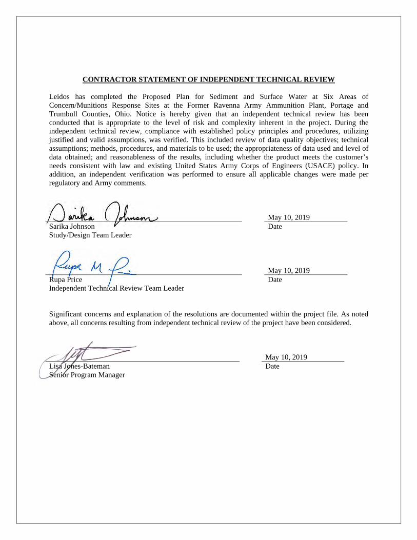
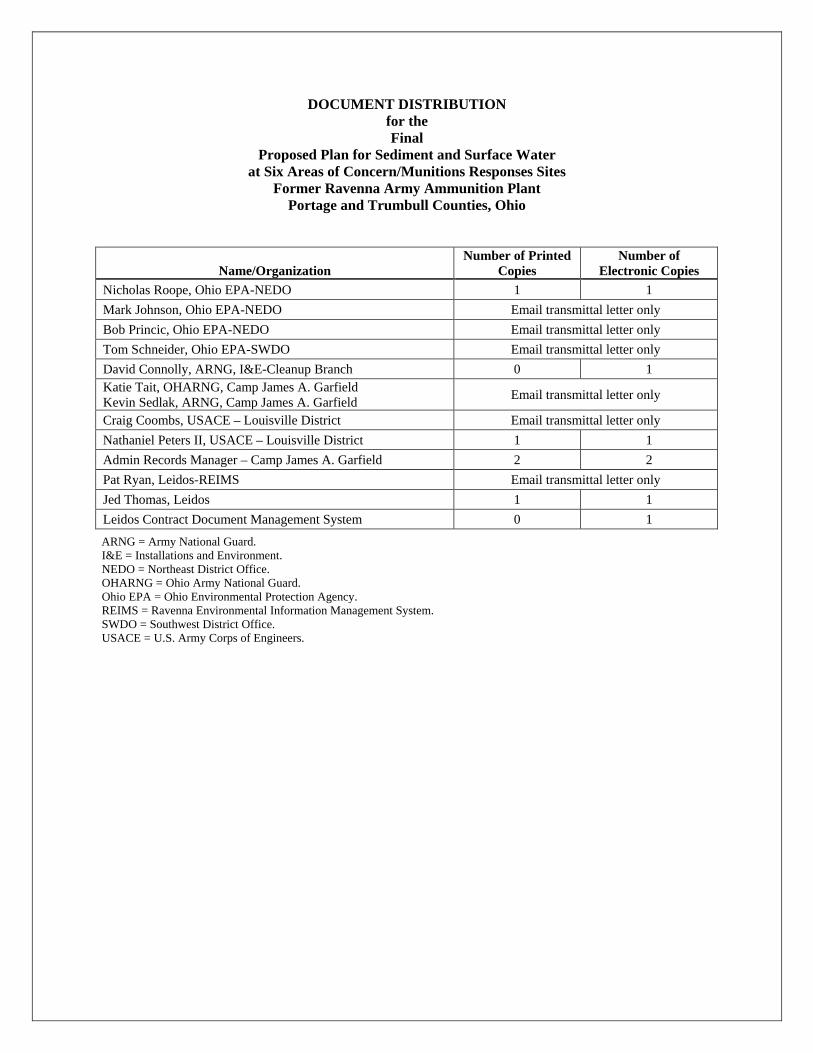
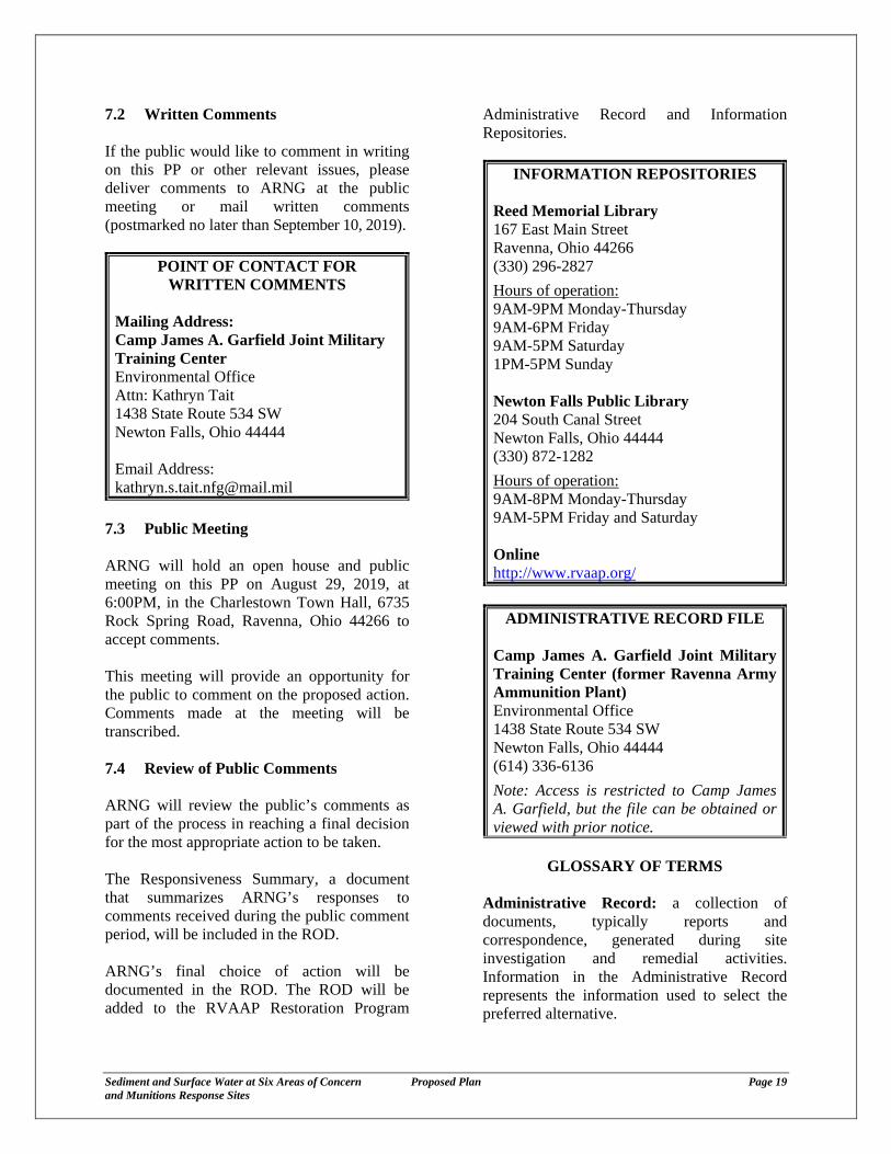
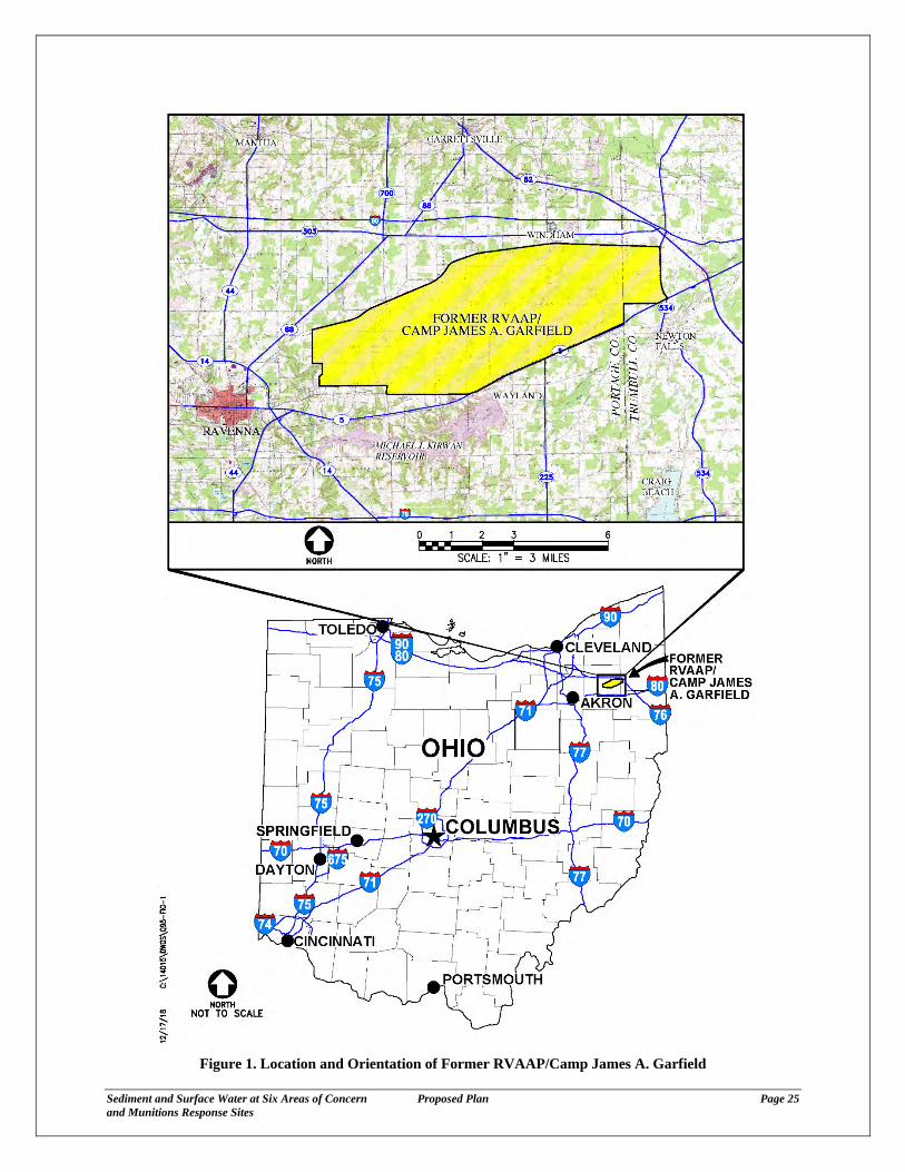
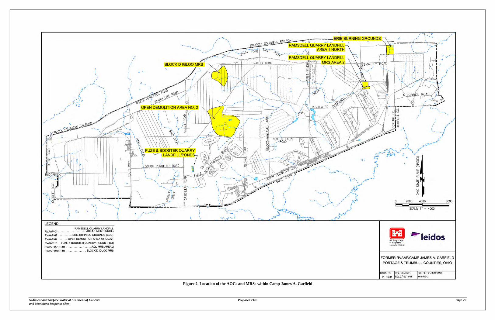
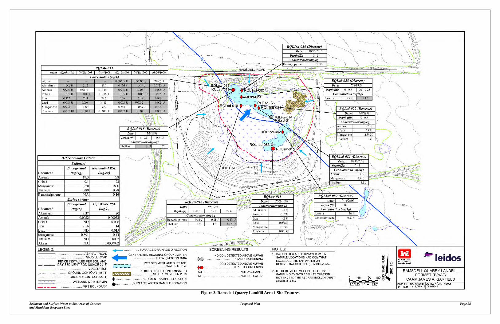
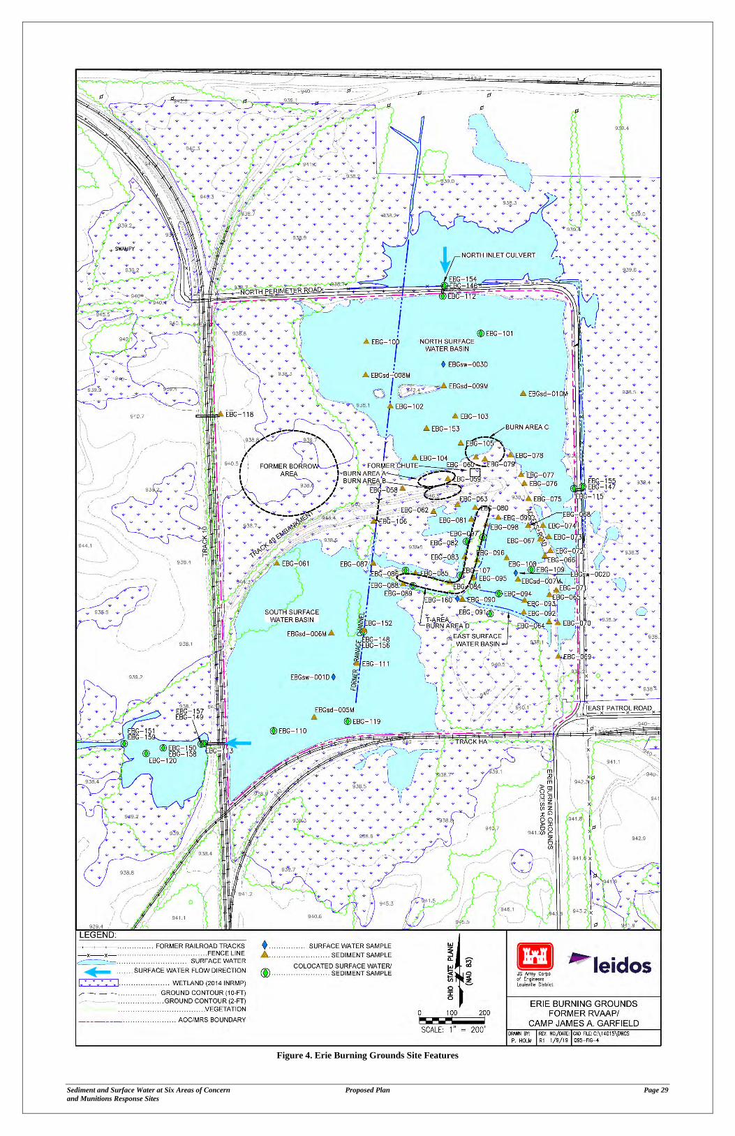
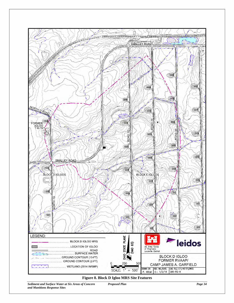
Subject Ravenna Army Ammunition Plant (RVAAP) Restoration Program PortageTrumbull Counties Six Areas of ConcernMunitions Response Sites (Work Activity No 267-000-859-254)
2
Comment 1 No Munitions and Explosives of Concern (MEC) or Munitions Debris (MD) On Page 10 Section 336 lines 52 through 54 the text states No MECMD were found during the evaluation of accessible areas of the stream and wetlands However in October 2016 Ohio EPA staff along with USACE Baltimore District Unexploded Ordinance specialists performed a creek walk through Open Demolition Area 2 (ODA2) in search of Munitions and Explosives of ConcernMunitions Debris (MECMD) multiple fuses and additional Munitions Potentially Presenting an Explosive Hazard were discovered During the culvert removal project in February 2017 within the ODA2 boundary additional MD was discovered In addition ODA2 has an ongoing non-time critical removal action taking place to address the existing MECMD in soil and dry sediment areas surrounding the creek Please explain the apparent contradiction between the two discoveries of MECMD and the statement that No MECMD were found Please verify that the risk of exposure to potential munitions constituents (MC) as it relates to the MECMD discovered has been addressed Additionally an explanation of best management practices being implemented to prevent additional MC releases or contamination during the non-time critical removal action currently taking place in the ODA2 is recommended Army Response Clarification and agree The referenced Section 336 was a summary of the 2011 MMRP Investigation as was summarized in the 2015 MMRP RI for ODA2 (CBampI 2015) This predated the referenced October 2016 site walk During the 2011 investigation no MEC was found during the evaluation of accessible areas of the stream and wetlands For further clarity and to add supplemental text revisions have been made as follows
ldquoNo MEC was found during the evaluation of accessible areas of the stream and wetlands However the MMRP RI (CBampI 2015c) indicated that due to the presence of MEC within the MRS MEC could potentially be present in uninvestigated areas of Sand Creek and associated wetland areas in the MRS The HHRA indicated that detected MChelliprdquo
Regarding the risk of exposure to chemicals the 2016 Supplemental RI assessed the results of all available sediment and surface water data at ODA2 This included samples as early as 1996 to as recent as 2013 These available samples were assessed and it was concluded that no sediment or surface water COCs required evaluation in an FS due to impacts to groundwater human health risk or from an ecological perspective Regarding the BMPs implemented during the time critical removal action at ODA2 a new subsection 338 has been added to the plan as follows
338 Time Critical Removal Action A TCRA is being conducted at ODA2 to mitigate significant explosive safety hazards posed to National Guard Trainee due to exposure to MECMPPEH that are a result of intentional detonations and potential burial of MEC and bulk explosives in site surface and subsurface soil Although this TCRA does not take place in the sediment and surface water media discussed in this PP best management practices (BMPs) are employed to ensure there is not a release of MC to the environment These BMPs include site inspections inspections of the stream site restoration and revegetation
Subject Ravenna Army Ammunition Plant (RVAAP) Restoration Program PortageTrumbull Counties Six Areas of ConcernMunitions Response Sites (Work Activity No 267-000-859-254)
3
Comment 2 Including the Munitions Response Sites On Page 15 Section 50 Lines 78 through 83 the text states Using information available prior to 2016 the Work Plan (Leidos 2016) concluded that Erie Burning Grounds and Block D Igloo did not require additional sampling or evaluation and can be recommended for no further action for sediment and surface water However on Page 18 Section 71 lines 62 through 65 the public is encouraged to review documents pertinent to RQL Area 1 ODA2 Fuze and Booster Quarry (FBQ) and Ramsdell Quarry RQL MRS Area 2 Please revise the text to include all six Areas of Concern (AOCs) for which no further action is being proposed Army Response Agree EBG and Block D Igloo have been added to the list of AOCs presented in the second paragraph of Section 71 Comment 3 Identifying Receptors On Page 8 Section 326 lines 44 through 45 the text states pose risks to likely human or ecological receptors Please provide which receptor this statement applies to specifically following the Facility-wide Cleanup Goals Army Response Agree The specific receptors evaluated since the time of the Phase I and Phase II RIs have evolved under the restoration program (eg Resident Farmer versus Resident Receptor) Therefore this bullet has been revised as follows to simplify
ldquoResults in sediment and surface water are consistent with the previous investigations under the IRP (ie Phase I RI and Phase II RI) which determined that detected contaminants in soil and dry sediment required no further actionrdquo
Comment 4 Installation Restoration Program (IRP) versus the Military Munitions Response Program (MMRP) On Page 8 Section 33 lines 64 through 67 the text states ODA2 is situated in the central portion of the facility (Figure 5) and has an approximately 320-acre MRS assessed under the MMRP and a 35-acre AOC assessed under the IRP Thereafter it is unclear what work was completed under the IRP and where that work was performed in relationship to the work being completed under the MMRP Please provide additional information summarizing the IRP investigation in greater detail Army Response Clarification A description of the remedial investigations performed under the IRP are described in the following Section 331 1998 Phase I Remedial Investigation Section 332 20022003 Phase II Remedial Investigation and Section 333 2006 Phase II Remedial Investigation Addendum Figure 5 depicts the AOC boundary established in the IRP and the MRS boundary established in the MMRP
Subject Ravenna Army Ammunition Plant (RVAAP) Restoration Program PortageTrumbull Counties Six Areas of ConcernMunitions Response Sites (Work Activity No 267-000-859-254)
4
Comment 5 Defining the MMRP Boundaries On Page 2 Section 22 lines 95 through 99 the text states This PP addresses the MRS boundary for RQL MRS Area 2 South and Block D Igloo MRS as those sites did not have AOCs established in the MMRP This appears to be incorrect as an AOC would have to be established to be addressed through the MMRP for an investigation to occur Please revise the section to reflect the presence of a site boundary that was established and addressed consistent with the MMRP Army Response Agree The text is revised as follows ldquoThis PP addresses the MRS boundaries for RQL MRS Area 2 South and Block D Igloo MRS those sites did not have AOCs established in the IRPrdquo Comment 6 General Text Please address the following formatting grammatical and general inconsistencies in the text
bull The general naming convention for each site should be consistent through the text specifically Ramsdell Quarry Area 1 For example In the abstract RVAAP-01 Ramsdell Quarry Landfill Area 1 is used followed by both RVAAP-01 Ramsdell Quarry Landfill (RQL) and RVAAP-001-R-02 RQL MRS Area 1 North followed by Ramsdell Quarry Landfill (RQL) Area 1 North which is lastly followed by RQL Area 1 To the public this may appear as potentially five different sites instead of the two sites addressed under their respective programs that were merged due to their proximity to one another Please revise the text for consistency
Army Response Clarification and agree Given the differences in naming conventions of the same area (northern portion of RQL) the text below was presented in Section 31 to streamline the name of this area The PP has been revised to move this text earlier in the plan into Section 23 Ramsdell Quarry Landfill Area 1 However it is recommended that the actual names of the sites (eg RQL and RQL MRS Area 1 North) remain in Section 10
RQL is located in the northeastern portion of CJAG (Figure 3) and has an approximately 7-acre MRS assessed under the MMRP called RQL MRS Area 1 North This site also has a 14-acre AOC assessed under the IRP called RQL For clarity and added distinction from other sites discussed in this PP this area will be called ldquoRQL Area 1rdquo
bull Page 2 Section 22 lines 90 and 92 -The use of boundary versus boundaries Please revise the text to
reflect the multiple sites
Army Response Agree ldquoBoundaryrdquo has been replaced with ldquoboundariesrdquo
bull Page 8 Section 325 line 13 -Please revise the text by adding a space for the paragraph
Army Response Agree A space has been added between the first and second paragraphs within Section 325
Mike DeWine Governor hio Jon Husted Lt Governor Laurie A Stevenson Director Ohio Environmental
Protection Agency
March 13 2019 RE US Army Ravenna Ammunition Pit RVAAP Remediation Response Plans Remedial Response
Mr David Connolly Portage County Army National Guard Directorate ID 267000859254 Environmental Programs Division ARNG-ILE-CR 111 South George Mason Drive Arlington VA 22204
Subject Receipt and Review of the Draft Proposed Plan for Sediment and Surface Water at Six Areas of ConcernMunitions Response Sites Dated February 6 2019
Dear Mr Connolly
The Ohio Environmental Protection Agency (Ohio EPA) Northeast District Office (NEDO) Division of Environmental Response and Revitalization (DERR) has received and reviewed the document titled Draft Proposed Plan for Sediment and Surface Water at Six Areas of ConcernMunitions Response Sites This document received by Ohio EPA NEDO on February 6 2019 was prepared for the United States Army Corps of Engineers (USAGE) Louisville District by Leidos Ohio EPA has compiled a list of comments in response to the review found below
Comment 1 No Munitions and Explosives of Concern (MEC) or Munitions Debris (MD)
On Page 10 Section 336 lines 52 through 54 the text states No MEGMD were found during the evaluation of accessible areas of the stream and wetlands However in October 2016 Ohio EPA staff along with USACE Baltimore District Unexploded Ordinance specialists performed a creek walk through Open Demolition Area 2 (ODA2) in search of Munitions and Explosives of ConcernMunitions Debris (MEGMD) multiple fuses and additional Munitions Potentially Presenting an Explosive Hazard were discovered During the culvert removal project in February 2017 within the ODA2 boundary additional MD was discovered In addition ODA2 has an ongoing non-time critical removal action taking place to address the existing MECMD in soil and dry sediment areas surrounding the creek
Please explain the apparent contradiction between the two discoveries of MECMD and the statement that No MECMD were found Please verify that the risk of exposure to potential munitions constituents (MC) as it relates to the MECMD discovered has been addressed Additionally an explanation of best management practices being implemented
RECEIVED HAR 1 3 2019 Northeast District Office bull 2110 East Aurora Road bullTwinsburg OH 44087-1924
epaohiogov bull 330) 963-1200 bull (330) 487-0769 (fax)
MR CONNOLLY US ARMY RAVENNA AMMUNITION PL T RVAAP SIX AREAS OF CONCERNMUNITIONS RESPONSE SITES MARCH 13 2019 PAGE2
to prevent additional MC releases or contamination during the non-time critical removal action currently taking place in the ODA2 is recommended
Comment 2 Including the Munitions Response Sites
On Page 15 Section 50 Lines 78 through 83 the text states Using information available prior to 2016 the Work Plan (Leidos 2016) concluded that Erie Burning Grounds and Block D Igloo did not require additional sampling or evaluation and can be recommended for no further action for sediment and surface water However on Page 18 Section 71 lines 62 through 65 the public is encouraged to review documents pertinent to RQL Area 1 ODA2 Fuze and Booster Quarry (FBQ) and Ramsdell Quarry RQL MRS Area 2 Please revise the text to include all six Areas of Concern (AOCs) for which no further action is being proposed
Comment 3 Identifying Receptors
On Page 8 Section 326 lines 44 through 45 the text states pose risks to likely human or ecological receptors Please provide which receptor this statement applies to specifically following the Facility-wide Cleanup Goals
Comment 4 Installation Restoration Program (IRP) versus the Military Munitions Response Program (MMRP)
On Page 8 Section 33 lines 64 through 67 the text states ODA2 is situated in the central portion of the facility (Figure 5) and has an approximately 320-acre MRS assessed under the MMRP and a 35-acre AOC assessed under the IRP Thereafter it is unclear what work was completed under the IRP and where that work was performed in relationship to the work being completed under the MMRP Please provide additional information summarizing the IRP investigation in greater detail
Comment 5 Defining the MMRP Boundaries
On Page 2 Section 22 lines 95 through 99 the text states This PP addresses the MRS boundary for RQL MRS Area 2 South and Block D Igloo MRS as those sites did not have AOCs established in the MMRP This appears to be incorrect as an AOC would have to be established to be addressed through the MMRP for an investigation to occur Please revise the section to reflect the presence of a site boundary that was established and addressed consistent with the MMRP
Comment 6 General Text
Please address the following formatting grammatical and general inconsistencies in the text
bull The general naming convention for each site should be consistent through the text specifically Ramsdell Quarry Area 1 For example In the abstract RVAAP-01 Ramsdell Quarry Landfill Area 1 is used followed by both RVAAP-01 Ramsdell
MR CONNOLLY US ARMY RAVENNA AMMUNITION PL T RVAAP SIX AREAS OF CONCERNMUNITIONS RESPONSE SITES MARCH 13 2019 PAGE3
Quarry Landfill (RQL) and RVAAP-001-R-02 RQL MRS Area 1 North followed by Ramsdell Quarry Landfill (RQL) Area 1 North which is lastly followed by RQL Area 1 To the public this may appear as potentially five different sites instead of the two sites addressed under their respective programs that were merged due to their proximity to one another Please revise the text for consistency
bull Page 2 Section 22 lines 90 and 92 - The use of boundary versus boundaries Please revise the text to reflect the multiple sites
bull Page 8 Section 325 line 13 - Please revise the text by adding a space for the paragraph
If you have any questions or concerns please do not hesitate to contact me at (330) 963-1235
Sincerely
Nicholas Roope Site Coordinator Division of Environmental Response and Revitalization
NCRsc
ec Nat Peters USAGE Craig Coombs USAGE Katie Tait OHARNG RTLS Kevin Sedlak OHARNG RTLS Rebecca Shreffler Chenega David Connolly ARNG Mark Johnson Ohio EPA NEDO DERR Bob Princic Ohio EPA NEDO DERR Tom Schneider Ohio EPA Southwest District Office DERR

Subject Ravenna Army Ammunition Plant (RVAAP) Restoration Program PortageTrumbull Counties Six Areas of ConcernMunitions Response Sites (Work Activity No 267-000-859-254)
3
Comment 2 Including the Munitions Response Sites On Page 15 Section 50 Lines 78 through 83 the text states Using information available prior to 2016 the Work Plan (Leidos 2016) concluded that Erie Burning Grounds and Block D Igloo did not require additional sampling or evaluation and can be recommended for no further action for sediment and surface water However on Page 18 Section 71 lines 62 through 65 the public is encouraged to review documents pertinent to RQL Area 1 ODA2 Fuze and Booster Quarry (FBQ) and Ramsdell Quarry RQL MRS Area 2 Please revise the text to include all six Areas of Concern (AOCs) for which no further action is being proposed Army Response Agree EBG and Block D Igloo have been added to the list of AOCs presented in the second paragraph of Section 71 Comment 3 Identifying Receptors On Page 8 Section 326 lines 44 through 45 the text states pose risks to likely human or ecological receptors Please provide which receptor this statement applies to specifically following the Facility-wide Cleanup Goals Army Response Agree The specific receptors evaluated since the time of the Phase I and Phase II RIs have evolved under the restoration program (eg Resident Farmer versus Resident Receptor) Therefore this bullet has been revised as follows to simplify
ldquoResults in sediment and surface water are consistent with the previous investigations under the IRP (ie Phase I RI and Phase II RI) which determined that detected contaminants in soil and dry sediment required no further actionrdquo
Comment 4 Installation Restoration Program (IRP) versus the Military Munitions Response Program (MMRP) On Page 8 Section 33 lines 64 through 67 the text states ODA2 is situated in the central portion of the facility (Figure 5) and has an approximately 320-acre MRS assessed under the MMRP and a 35-acre AOC assessed under the IRP Thereafter it is unclear what work was completed under the IRP and where that work was performed in relationship to the work being completed under the MMRP Please provide additional information summarizing the IRP investigation in greater detail Army Response Clarification A description of the remedial investigations performed under the IRP are described in the following Section 331 1998 Phase I Remedial Investigation Section 332 20022003 Phase II Remedial Investigation and Section 333 2006 Phase II Remedial Investigation Addendum Figure 5 depicts the AOC boundary established in the IRP and the MRS boundary established in the MMRP
Subject Ravenna Army Ammunition Plant (RVAAP) Restoration Program PortageTrumbull Counties Six Areas of ConcernMunitions Response Sites (Work Activity No 267-000-859-254)
4
Comment 5 Defining the MMRP Boundaries On Page 2 Section 22 lines 95 through 99 the text states This PP addresses the MRS boundary for RQL MRS Area 2 South and Block D Igloo MRS as those sites did not have AOCs established in the MMRP This appears to be incorrect as an AOC would have to be established to be addressed through the MMRP for an investigation to occur Please revise the section to reflect the presence of a site boundary that was established and addressed consistent with the MMRP Army Response Agree The text is revised as follows ldquoThis PP addresses the MRS boundaries for RQL MRS Area 2 South and Block D Igloo MRS those sites did not have AOCs established in the IRPrdquo Comment 6 General Text Please address the following formatting grammatical and general inconsistencies in the text
bull The general naming convention for each site should be consistent through the text specifically Ramsdell Quarry Area 1 For example In the abstract RVAAP-01 Ramsdell Quarry Landfill Area 1 is used followed by both RVAAP-01 Ramsdell Quarry Landfill (RQL) and RVAAP-001-R-02 RQL MRS Area 1 North followed by Ramsdell Quarry Landfill (RQL) Area 1 North which is lastly followed by RQL Area 1 To the public this may appear as potentially five different sites instead of the two sites addressed under their respective programs that were merged due to their proximity to one another Please revise the text for consistency
Army Response Clarification and agree Given the differences in naming conventions of the same area (northern portion of RQL) the text below was presented in Section 31 to streamline the name of this area The PP has been revised to move this text earlier in the plan into Section 23 Ramsdell Quarry Landfill Area 1 However it is recommended that the actual names of the sites (eg RQL and RQL MRS Area 1 North) remain in Section 10
RQL is located in the northeastern portion of CJAG (Figure 3) and has an approximately 7-acre MRS assessed under the MMRP called RQL MRS Area 1 North This site also has a 14-acre AOC assessed under the IRP called RQL For clarity and added distinction from other sites discussed in this PP this area will be called ldquoRQL Area 1rdquo
bull Page 2 Section 22 lines 90 and 92 -The use of boundary versus boundaries Please revise the text to
reflect the multiple sites
Army Response Agree ldquoBoundaryrdquo has been replaced with ldquoboundariesrdquo
bull Page 8 Section 325 line 13 -Please revise the text by adding a space for the paragraph
Army Response Agree A space has been added between the first and second paragraphs within Section 325
Mike DeWine Governor hio Jon Husted Lt Governor Laurie A Stevenson Director Ohio Environmental
Protection Agency
March 13 2019 RE US Army Ravenna Ammunition Pit RVAAP Remediation Response Plans Remedial Response
Mr David Connolly Portage County Army National Guard Directorate ID 267000859254 Environmental Programs Division ARNG-ILE-CR 111 South George Mason Drive Arlington VA 22204
Subject Receipt and Review of the Draft Proposed Plan for Sediment and Surface Water at Six Areas of ConcernMunitions Response Sites Dated February 6 2019
Dear Mr Connolly
The Ohio Environmental Protection Agency (Ohio EPA) Northeast District Office (NEDO) Division of Environmental Response and Revitalization (DERR) has received and reviewed the document titled Draft Proposed Plan for Sediment and Surface Water at Six Areas of ConcernMunitions Response Sites This document received by Ohio EPA NEDO on February 6 2019 was prepared for the United States Army Corps of Engineers (USAGE) Louisville District by Leidos Ohio EPA has compiled a list of comments in response to the review found below
Comment 1 No Munitions and Explosives of Concern (MEC) or Munitions Debris (MD)
On Page 10 Section 336 lines 52 through 54 the text states No MEGMD were found during the evaluation of accessible areas of the stream and wetlands However in October 2016 Ohio EPA staff along with USACE Baltimore District Unexploded Ordinance specialists performed a creek walk through Open Demolition Area 2 (ODA2) in search of Munitions and Explosives of ConcernMunitions Debris (MEGMD) multiple fuses and additional Munitions Potentially Presenting an Explosive Hazard were discovered During the culvert removal project in February 2017 within the ODA2 boundary additional MD was discovered In addition ODA2 has an ongoing non-time critical removal action taking place to address the existing MECMD in soil and dry sediment areas surrounding the creek
Please explain the apparent contradiction between the two discoveries of MECMD and the statement that No MECMD were found Please verify that the risk of exposure to potential munitions constituents (MC) as it relates to the MECMD discovered has been addressed Additionally an explanation of best management practices being implemented
RECEIVED HAR 1 3 2019 Northeast District Office bull 2110 East Aurora Road bullTwinsburg OH 44087-1924
epaohiogov bull 330) 963-1200 bull (330) 487-0769 (fax)
MR CONNOLLY US ARMY RAVENNA AMMUNITION PL T RVAAP SIX AREAS OF CONCERNMUNITIONS RESPONSE SITES MARCH 13 2019 PAGE2
to prevent additional MC releases or contamination during the non-time critical removal action currently taking place in the ODA2 is recommended
Comment 2 Including the Munitions Response Sites
On Page 15 Section 50 Lines 78 through 83 the text states Using information available prior to 2016 the Work Plan (Leidos 2016) concluded that Erie Burning Grounds and Block D Igloo did not require additional sampling or evaluation and can be recommended for no further action for sediment and surface water However on Page 18 Section 71 lines 62 through 65 the public is encouraged to review documents pertinent to RQL Area 1 ODA2 Fuze and Booster Quarry (FBQ) and Ramsdell Quarry RQL MRS Area 2 Please revise the text to include all six Areas of Concern (AOCs) for which no further action is being proposed
Comment 3 Identifying Receptors
On Page 8 Section 326 lines 44 through 45 the text states pose risks to likely human or ecological receptors Please provide which receptor this statement applies to specifically following the Facility-wide Cleanup Goals
Comment 4 Installation Restoration Program (IRP) versus the Military Munitions Response Program (MMRP)
On Page 8 Section 33 lines 64 through 67 the text states ODA2 is situated in the central portion of the facility (Figure 5) and has an approximately 320-acre MRS assessed under the MMRP and a 35-acre AOC assessed under the IRP Thereafter it is unclear what work was completed under the IRP and where that work was performed in relationship to the work being completed under the MMRP Please provide additional information summarizing the IRP investigation in greater detail
Comment 5 Defining the MMRP Boundaries
On Page 2 Section 22 lines 95 through 99 the text states This PP addresses the MRS boundary for RQL MRS Area 2 South and Block D Igloo MRS as those sites did not have AOCs established in the MMRP This appears to be incorrect as an AOC would have to be established to be addressed through the MMRP for an investigation to occur Please revise the section to reflect the presence of a site boundary that was established and addressed consistent with the MMRP
Comment 6 General Text
Please address the following formatting grammatical and general inconsistencies in the text
bull The general naming convention for each site should be consistent through the text specifically Ramsdell Quarry Area 1 For example In the abstract RVAAP-01 Ramsdell Quarry Landfill Area 1 is used followed by both RVAAP-01 Ramsdell
MR CONNOLLY US ARMY RAVENNA AMMUNITION PL T RVAAP SIX AREAS OF CONCERNMUNITIONS RESPONSE SITES MARCH 13 2019 PAGE3
Quarry Landfill (RQL) and RVAAP-001-R-02 RQL MRS Area 1 North followed by Ramsdell Quarry Landfill (RQL) Area 1 North which is lastly followed by RQL Area 1 To the public this may appear as potentially five different sites instead of the two sites addressed under their respective programs that were merged due to their proximity to one another Please revise the text for consistency
bull Page 2 Section 22 lines 90 and 92 - The use of boundary versus boundaries Please revise the text to reflect the multiple sites
bull Page 8 Section 325 line 13 - Please revise the text by adding a space for the paragraph
If you have any questions or concerns please do not hesitate to contact me at (330) 963-1235
Sincerely
Nicholas Roope Site Coordinator Division of Environmental Response and Revitalization
NCRsc
ec Nat Peters USAGE Craig Coombs USAGE Katie Tait OHARNG RTLS Kevin Sedlak OHARNG RTLS Rebecca Shreffler Chenega David Connolly ARNG Mark Johnson Ohio EPA NEDO DERR Bob Princic Ohio EPA NEDO DERR Tom Schneider Ohio EPA Southwest District Office DERR


![West Lake Update - Records CollectionsLegend Previous Sediment Sample • Location (January to March 2016) Proposed Sediment [!] Sample Location 0 i:=:J West Lake Landfill A N 350](https://img.pdfslide.net/doc/110x75/5f0a64337e708231d42b6831/west-lake-update-records-collections-legend-previous-sediment-sample-a-location.jpg)