Embed Size (px)
Citation preview
PROPOSED ST. CLAIR MOORE SOLAR FARM
LAMBTON COUNTY, ONTARIO
ENVIRONMENTAL IMPACT STUDY
Submitted to: First Solar Development (Canada) Inc. 400 Somerset, Corporate Boulevard
Bridgewater, NJ 08807 USA
Submitted by: AMEC Earth & Environmental
a division of AMEC Americas Limited 870 Confederation Street
Sarnia, Ontario N7T 2E5
February 2010
SW04090562

First Solar Development (Canada) Inc. Environmental Impact Study – St. Clair Moore Solar Farm Mooretown, Ontario February 2010 SW04090562
TABLE OF CONTENTS
PAGE
1.0 INTRODUCTION............................................................................................................... 1 1.1 Project Development Proposal .............................................................................. 1
2.0 RENEWABLE ENERGY APPROVALS (ONTARIO REGULATION 359/09) ................... 3 2.1 Natural Heritage .................................................................................................... 3
2.1.1 Records Review.................................................................................... 3 2.1.2 Site Investigation................................................................................... 5 2.1.3 Determination of Significance ............................................................... 6 2.1.4 Confirmation From MNR ....................................................................... 6
2.2 Water..................................................................................................................... 6 2.2.1 Records Review.................................................................................... 6 2.2.2 Site Investigation................................................................................... 7
3.0 EXISTING NATURAL ENVIRONMENT............................................................................ 8 3.1 Site Geology.......................................................................................................... 8 3.2 Soil and Groundwater Quality................................................................................ 8 3.3 Surface Water Drainage........................................................................................ 9 3.4 Terrestrial Ecosystem Existing Conditions ............................................................ 9
3.4.1 Methodology ......................................................................................... 9 3.4.2 Wildlife Communities .......................................................................... 10 3.4.3 Natural Heritage Features................................................................... 10
3.5 Land Use ............................................................................................................. 11
4.0 POTENTIAL ENVIRONMENTAL EFFECTS AND MITIGATION ................................... 13 4.1 Mitigation Methods and Significance of Residual Impacts .................................. 13
4.1.1 Construction Phase............................................................................. 13 4.1.2 Operations Phase ............................................................................... 14
5.0 CONCLUSIONS.............................................................................................................. 16
6.0 CLOSURE....................................................................................................................... 17
Page i
First Solar Development (Canada) Inc. Environmental Impact Study – St. Clair Moore Solar Farm Mooretown, Ontario February 2010 SW04090562
TABLE OF CONTENTS (cont) PAGE
LIST OF TABLES
Table 1 - NHIC/SARA Listed Species Located Near the Project Site 11 Table 2 - Potential Project-Environment Interactions 13
LIST OF FIGURES Figure 1 – Project Development Plan Figure 2 – Natural Heritage Constraint Plan (2007 NHIC Data) Figure 3 – Historical Oil and Gas – St. Clair Moore Site
LIST OF APPENDICES Appendix A – Site Photographs Appendix B – St. Clair Region Conservation Authority – Forest Inventory Appendix C – St. Clair Region Conservation Authority – Drainage Classification Maps
Page ii
First Solar Development (Canada) Inc. Environmental Impact Study – St. Clair Moore Solar Farm Mooretown, Ontario February 2010 SW04090562 1.0 INTRODUCTION AMEC Earth & Environmental, a division of AMEC Americas Limited (AMEC) was retained by First Solar Development (Canada) Inc. (First Solar) to conduct an Environmental Impact Study (EIS) for a proposed photovoltaic (solar) electrical power generating facility, the St. Clair Moore Solar Farm (Solar Farm), at a site located in St. Clair Township in the County of Lambton in southwestern Ontario. The proposed site is identified as Part Lots 25 and 26 Concession 9, St. Clair Township in the County of Lambton. The site area is approximately 120 hectares (ha) (of which 56 ha would be utilized for solar arrays) and is currently in agricultural use (Figure 1). This EIS intends to provide a detailed summary of the natural features assessment and water bodies assessment as required by Ontario Regulation 359/09 (O.Reg. 359/09) Renewable Energy Approvals made under the Environmental Protection Act. Specific objectives of the EIS were to evaluate the presence or absence of natural features and water bodies near the development site and determine the distance to the development from the features, if present. It should be noted that the Solar Farm is not located within the Oak Ridges Moraine planning area or the Niagara Escarpment planning area and as such, no further discussion of these features or their respective planning areas will be included in the EIS. It should also be noted that this EIS does not address the archaeological or cultural heritage resources in the area of the development. The archaeological and heritage assessments are presented in separate documents prepared by others on behalf of First Solar.
1.1 Project Development Proposal
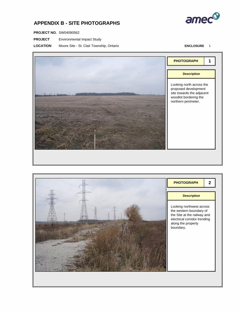
First Solar hopes to initiate construction of its Solar Farm in late 2010 and plan to have the development operational by the end of 2011. The proposed facility will be designed to convert sunlight to electricity through a photovoltaic process thereby providing a renewable source of electricity to the local power grid. The Solar Farm will utilize highly-efficient and proven passive technology to generate up to approximately 20 MW/ac of power for delivery to the transmission grid. The Project site is located on Part Lots 25 and 26, Concession 9, St. Clair Township and encompasses an area of approximately 120 ha, which is currently in agricultural use. Photographs of the proposed development site are presented in Appendix A. The Project requires approximately 72 ha for array construction; roadways and other facilities with the remaining area will be undeveloped with portions utilized for a short period during construction. The site lies in a mixed residential, agricultural and industrial land use within St. Clair Township. Figure 1 presents the project site location and preliminary facility layout.
Page 1
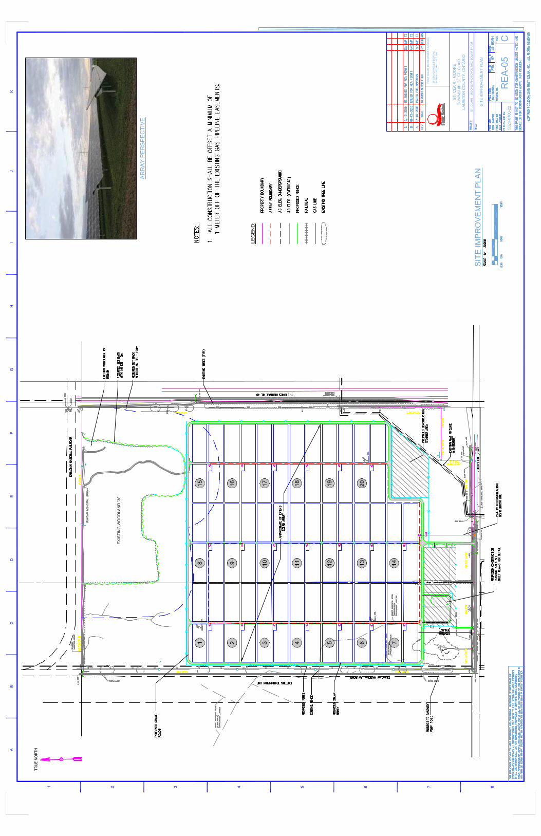

First Solar Development (Canada) Inc. Environmental Impact Study – St. Clair Moore Solar Farm Mooretown, Ontario February 2010 SW04090562 The site is bound by woodlands and a rail shunting and storage operation to the north, Highway 40 to the east, Rokeby Line to the south and railway corridor and agricultural field to the west. The property is located approximately 3.25 km southeast of the Town of Corunna. The Project’s access drive will enter off Rokeby Line. As part of the solar farm development, First Solar is also considering additional options for the on-going encouragement of the natural communities and visual impacts around the Site. One of these current considerations being looked at include the addition of new woodlot (at and around perimeter of existing woodlot land) as part development plan to encourage plant and wildlife viability and sustainability along the north of the Site and reinforce the already existing natural buffer area which exists on and adjacent to the Site boundary. There is one residential dwelling with associated structures (barn and silo) located along the southwest portion of the development Site, along Rokeby Line, to the north (Figure 1). This structure is inferred to have been utilized for historical farming efforts on the Site.
Page 2
First Solar Development (Canada) Inc. Environmental Impact Study – St. Clair Moore Solar Farm Mooretown, Ontario February 2010 SW04090562
2.0 Renewable Energy Approvals (Ontario Regulation 359/09)
The purpose of this report is to provide an EIS in support of obtaining approval for the project under O.Reg. 359/09 Renewable Energy Approvals of the Environmental Protection Act. According to O.Reg. 359/09, the Solar Farm is considered to be a Class 3 solar facility as it has a name plate capacity of greater than 10 kW. This EIS has been undertaken specifically to address the requirements outlined in Sections 24 to 31 of O.Reg. 359/09. In addition to the land use planning process reported herein, the facility will also require permits issued by the Ontario Ministry of Environment. Under this permitting process, the Ministry of Natural Resources and the St. Clair Region Conservation Authority have also been contacted for consultation with approvals pending upon their review. It is understood that additional review by government stakeholders may drive the need for additional assessment.
2.1 Natural Heritage
2.1.1 Records Review
As required by O.Reg. 359/09, in order to identify whether the Solar Farm is located in a natural feature; within 50 m of an area of natural or scientific interest (ANSI) related to earth science; or within 120 m of a natural feature that is not an ANSI related to earth science; AMEC reviewed the availability of information from following sources (if applicable):
- Provincial Parks/conservation reserves Not applicable – no provincial parks or conservation reserves are located
within 120 m of the proposed development area; - Ontario Ministry of Natural Resources
A search of the MNR Natural Heritage Information Centre (NHIC) website and database;
Meeting with MNR personnel on 2 December 2009 to obtain additional information on species at risk, ANSI, and any other information that may be applicable to the development site;
Response from the MNR on 11 January 2010 confirming no additional information found regarding additional information on species at risk, ANSI, or other natural features at or near the development site beyond preliminary information submitted 2 December 2009;
- Crown in Right of Canada Not Applicable – Proposed Development is not on, or within 120 m of any
Crown Land; - Conservation Authority
St. Clair Region Conservation Authority (SCRCA) personnel were contacted to request information related to their knowledge of the presence of any ANSI near the proposed development site;
Page 3

First Solar Development (Canada) Inc. Environmental Impact Study – St. Clair Moore Solar Farm Mooretown, Ontario February 2010 SW04090562
- Local and Upper-Tier Municipality
St. Clair Township and the County of Lambton are the municipal bodies responsible for the proposed development site and was contacted to request information related to the presence of any ANSI near the proposed development site;
- Planning Board Not Applicable – St. Clair Township and the County of Lambton are the
municipal bodies responsible for the proposed development site; - Municipal Planning Authority
Not Applicable - St. Clair Township and the County of Lambton are the municipal bodies responsible for the proposed development site;
- Local Roads Board Not Applicable - St. Clair Township and the County of Lambton are the
municipal bodies responsible for the proposed development site; - Local Services Board
Not applicable; - Niagara Escarpment Commission
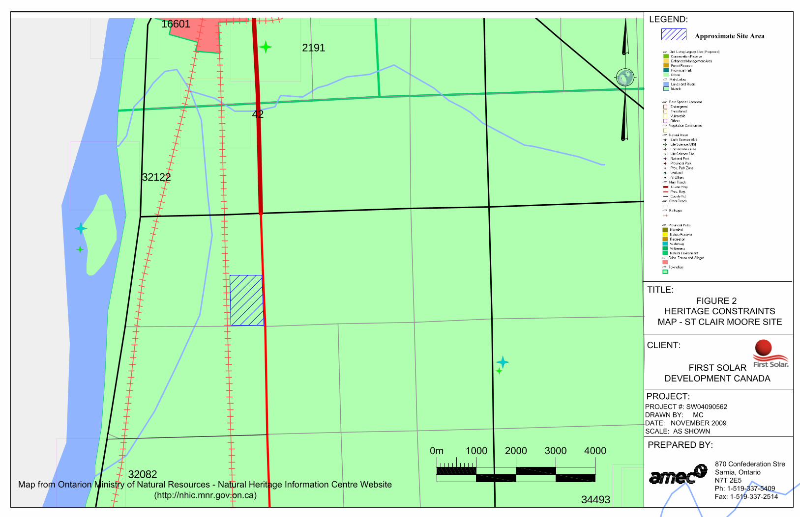
Not applicable It should be noted that although a number of the above agencies were contacted to obtain information related to natural features, or areas of natural or scientific interest, most deferred to the Ontario Ministry of Natural Resources as being the primary authority for this information. Although the records review did not identify any natural features, areas of natural or scientific interest or any species at risk within 120 m of the proposed development site the following records from the NHIC database were reviewed as the closest data points observed relative to the Site:
- One ANSI area (Stag Island) was identified as being present to the north and west of the Site, respectively at a distance greater than 120 m and upwards of 3 kilometres (km);
- One Provincial wetland (Stag Island) was identified as being present to the north and west of the Site, respectively at a distance greater than 120 m and upwards of 3 km; and
- Two rare fish species (the closest identified species on the NHIC website), namely the American Brook Lamprey and Spotted Sucker were identified as being present in areas greater than 120 m from the proposed development site.
In addition to the NHIC database and website available to the public, the SCRCA authority provided an updated table of NHIC information from the MNR with 2008 species data. The additional noted data identified 11 additional species in the general area of the Solar Farm site. After reviewing the table and location blocks, it appears that all noted additional species
Page 4

First Solar Development (Canada) Inc. Environmental Impact Study – St. Clair Moore Solar Farm Mooretown, Ontario February 2010 SW04090562 provided by the SCRCA would fall not only outside of 120 m from the proposed development site, but greater than 1 km. The response received from the MNR on 11 January 2010 detailing Species at Risk, did not note any species of concern at the project Site. Figure 2 presents the current NHIC information available on the MNR and their website posted data.
2.1.2 Site Investigation
A site investigation was undertaken on 27 September 2009 by AMEC personnel with a follow-up Site reconnaissance conducted on 7 December 2009. The site investigation focused on a woodlot located along the central portion of the northern property boundary and onto the adjacent property. The woodlot can be observed in Figure 1. This woodlot is approximately 12 ha in size does meet the criteria to be considered a woodlot under O.Reg. 359/09 or Schedule H of the Official Plan for the County of Lambton and as such has been included as a natural feature in this report. As part of the preliminary Site assessment and review activities, a copy of a forest inventory was obtained by the SCRCA for the Woodlot at the Site. This information will be utilized in the completion of an updated woodlot assessment study planned for the Site in the coming months. The updated woodlot study will be completed and prepared using the protocols established by the Ecological Land Classification (ELC) system for Southern Ontario (Lee et al., 1998). Lists of all plant and wildlife species observed will be compiled. Data recorded will include species composition, approximate size, age, health and condition of trees. Completed details of the site investigation will be presented in the document and appended to a final version of EIS to complement the SCRCA inventory and assessment previously completed. Woodlot information is available under Appendix B. In the woodlot report prepared by the SCRCA, no direct evidence of mammals were encountered; though a stick nest in a white oak tree was observed that may be a nesting for a red tailed hawk (Buteo jamaicensis), common in the area. In addition features of the woodlot would be expected to support and contribute to the nesting of varying wildlife. As noted above, the site investigation identified a woodlot located on-site, and within 120 m of the proposed development (immediately adjacent to the proposed development). Full details of the woodlot study (once completed) including the field notes prepared by AMEC field staff will be presented in Appendix B, along with the findings of the existing woodlot assessment prepared by the SCRCA. A summary of the woodlot details available to date are as follows:
- Type – Hardwood Forest
Page 5
34493
2191
32122
32082
16601
42
First Solar Development (Canada) Inc. Environmental Impact Study – St. Clair Moore Solar Farm Mooretown, Ontario February 2010 SW04090562
- Attributes – 12.0 ha in area, mixed deciduous - Composition – ELC classification is Bur oak (Quercus macrocarpa), Hard Maple
(Acer saccharum), White Oak (Quercus alba), White and Green Ash (Fraxinus americana and Fraxinus pennsylvanica, respectively), Basswood (Tilia americana) and While Elm (Ulmus americana) are the dominant tree species.
2.1.3 Determination of Significance
Based upon the results of the records search and the site investigation, the woodlot located on, and adjacent to, the proposed development property has been identified as meeting the criteria for significance as defined in Section 8 of the Official Plan for the County of Lambton. No other features were identified on the property as being significant, or provincially significant.
2.1.4 Confirmation from MNR
A response was received from the MNR on 11 January 2010 indicated that there were no Element Occurrences (“EO”) or known Species at Risk at, or near, the development Site.
2.2 Water
2.2.1 Records Review
As required by O.Reg. 359/09, in order to identify whether the Solar Farm is located in a water body; within 120 m of the average annual high water mark of a lake, other than a lake trout lake that is at or above development capacity; within 300 m of the average annual high water mark of a lake trout lake that is at or above development capacity; within 120 m of the average annual high water mark of a permanent or intermittent stream; or within 120 m of a seepage area; AMEC reviewed the availability of information from following sources (if applicable):
- Provincial Parks/conservation reserves Not applicable – no provincial parks or conservation reserves are located
within 120 m of the proposed development area; - Ontario Ministry of Natural Resources
A search of the MNR Natural Heritage Information Centre (NHIC) website and database;
Meeting with MNR personnel on 02 December 2009 to obtain additional information on water bodies, and any other information that may be applicable to the development site;
MNR indicated that they would defer to the St. Clair Region Conservation Authority’s setback distances and requirements under the Conservation Authorities Act;
- Crown in Right of Canada
Page 6
First Solar Development (Canada) Inc. Environmental Impact Study – St. Clair Moore Solar Farm Mooretown, Ontario February 2010 SW04090562
Not Applicable – Proposed Development is not on, or within 120 m of any Crown Land;
- Conservation Authority St. Clair Region Conservation Authority (SCRCA) personnel were
contacted to request information related to their knowledge of the presence of any water bodies near the proposed development site;
Response from the SCRCA indicates that the drainage system present at the development site is subject to Ontario Regulation 178/06 (O.Reg. 178/06) of the Conservation Authorities Act.
The SCRCA has provided information related to the setbacks required under O.Reg. 178/06. According to the SCRCA, the Site does not fall within a flood concern zone. In addition, the array development plan includes all work outside of the 30m setback required under the REA.
- Local and Upper-Tier Municipality The County of Lambton and St. Clair Township are the municipal bodies
responsible for the proposed development site and were contacted to request information related to the presence of any water bodies near the proposed development site;
Response from the St. Clair Township/County of Lambton Senior Planner and Drainage Superintendent indicated that the drains on the proposed development property are municipal drains and are maintained by the municipality;
- Planning Board Not Applicable - St. Clair Township and the County of Lambton are the
municipal bodies responsible for the proposed development site; - Municipal Planning Authority
Not Applicable – St. Clair Township and the County of Lambton are the municipal bodies responsible for the proposed development site;
- Local Roads Board Not Applicable - St. Clair Township and the County of Lambton are the
municipal bodies responsible for the proposed development site; - Local Services Board
Not applicable; - Niagara Escarpment Commission
Not applicable
2.2.2 Site Investigation
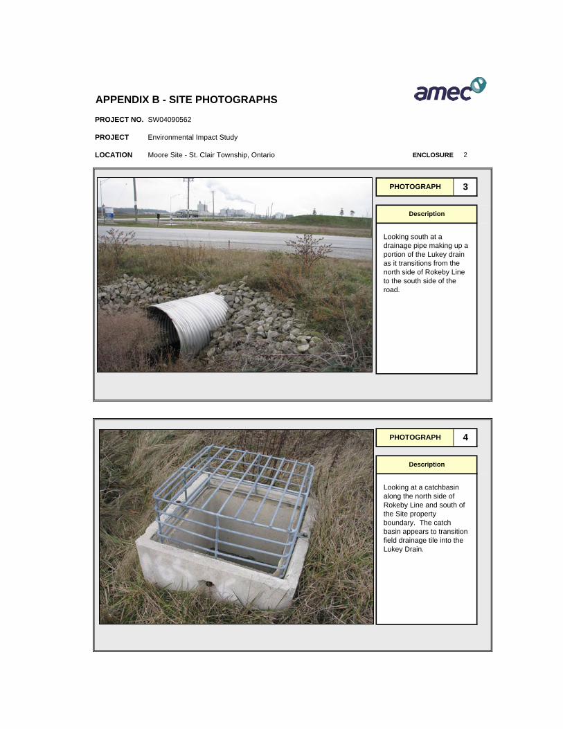
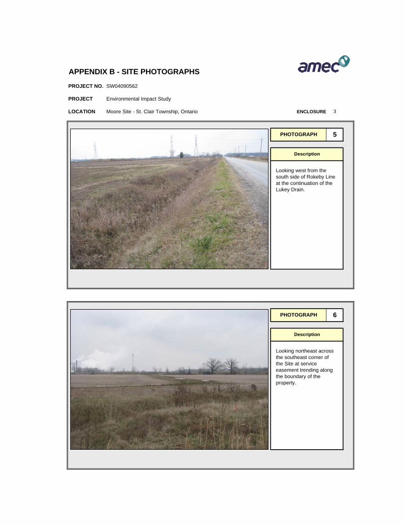
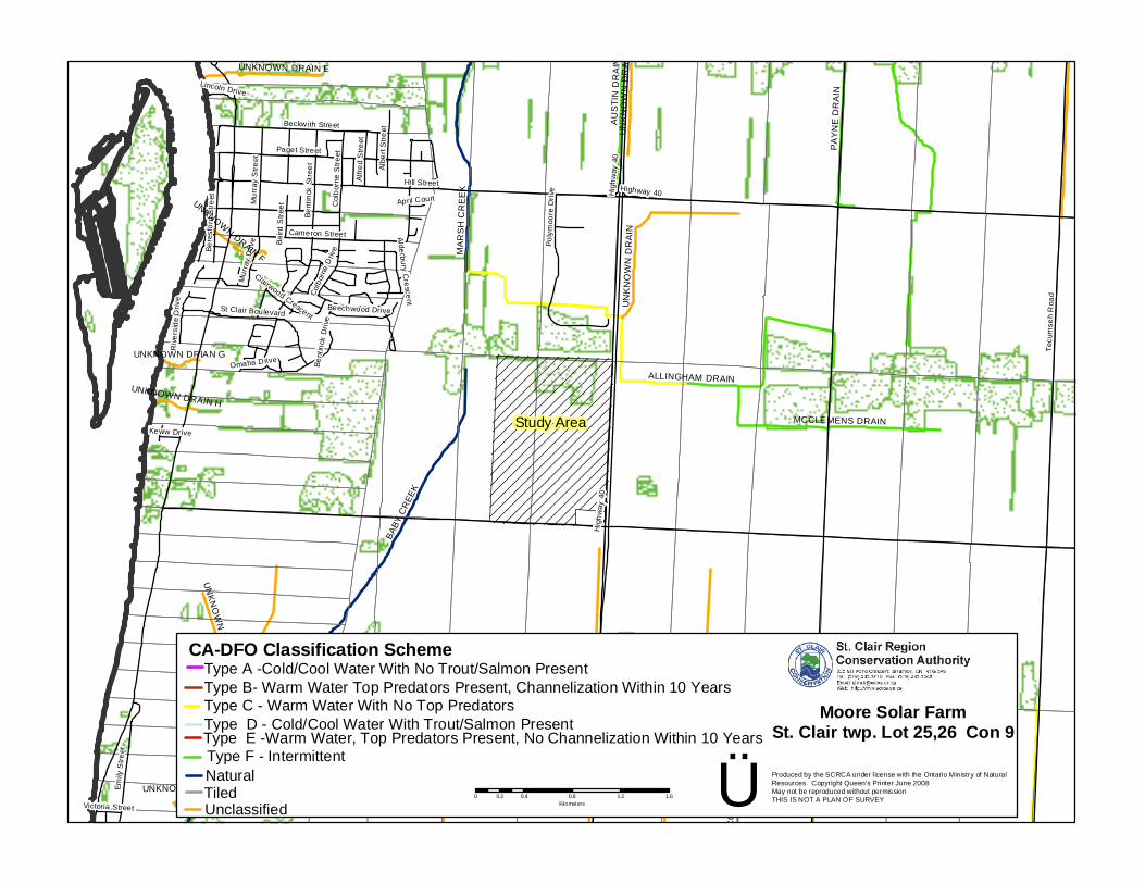
A site investigation was undertaken as part of a concurrent stormwater management site visit. The site investigation and review of information available from the SCRCA and St. Clair Township identified the presence of four drains in the general vicinity of the project site. The Rumohr (open ditch), Nesbit Award (tile drain circa 1916) and Lukey Drains (open ditch) are located adjacent/along the Site’s northern, western and southern property boundaries,
Page 7
First Solar Development (Canada) Inc. Environmental Impact Study – St. Clair Moore Solar Farm Mooretown, Ontario February 2010 SW04090562 respectively. These three drains are inferred transfer water from the site and surrounding properties into the Baby Creek Drain located approximately 300 m west of the Site and eventually conveying the water into the St. Clair River. The Allingham Drains was observed to be located generally within 50 m west of the Site northwest corner and 400 metres of the Site’s northern boundary. Water entering the Allingham Drain is inferred to be directed into Marsh Creek located 800 m north and west of the project site. Evidence of a below-grade drainage tile/features were observed transecting the Site, and based on the agricultural development of the Site area would be assumed that the Site tiling carrier the majority of Site infiltration runoff water into both the Nesbit Award and Lukey Drains, with a portion of surficial drainage water in the northwest portion of the Site being directed to the Rumohr drain. No other water bodies were identified on the site as part of the site investigation. There are no lakes, Lake Trout lakes, streams, or rivers present on the property.
3.0 EXISTING NATURAL ENVIRONMENT
3.1 Site Geology
The subject property is located on the St. Joseph’s Clay Plain, an area of glaciolacustrine silty clay overburden deposits, more commonly identified as Brookston Clay. These heavy silty clay soils were laid down under glacial period over Devonian limestone bedrock. The overburden thickness is typically 38 m to 43 m with at the proposed development site. The water table is generally found in the overburden several metres below ground surface and the shape of the water table surface is similar to the ground surface, but underlying it. A search of the Ontario Oil, Gas & Salt Resources on-line library indicates there are no current or oil or gas wells present on the proposed development site. However, one oil show (exploratory well) advanced and abandoned by Imperial Oil in 1949 was identified within the southeast quadrant of the Solar Farm site. Furthermore, three additional abandoned oil wells were observed to exist within 1 km of the project site’s western and northern boundary. Figure 3 shows the locations of the nearest wells to the Solar Farm site.
3.2 Soil and Groundwater Quality
A Phase I Environmental Site Assessment (AMEC, 2008) conforming to the Provincial requirements documented that the site is located in a primarily agricultural area and that the property has been in agricultural use since at least the 1950s and has not had a residential,
Page 8

First Solar Development (Canada) Inc. Environmental Impact Study – St. Clair Moore Solar Farm Mooretown, Ontario February 2010 SW04090562 commercial or industrial development registered beyond a typical farm house and barn development. No investigation of the soil and groundwater quality was undertaken as part of the EIS. However, the only compounds likely to impact the soil or groundwater are residues from pesticides/herbicides which are used at the site as part of the agricultural practice and possibly nitrates from excess application of fertilizers. It is considered unlikely that unacceptable concentrations of either of these can be detected in the groundwater in the bedrock aquifer. The site would be assumed to be of good environmental quality from a soil and groundwater perspective. In order to confirm this conclusion with more confidence, sampling and analysis of soil and groundwater would be required.
3.3 Surface Water Drainage
A portion of the site is traversed by two open ditch drains, namely, the Lukey and Rumohr Drains. These drains form part of the municipal drainage system maintained by St. Clair Township and the County of Lambton. Drainage from the site flows through the Lukey and Rumohr Drains into Baby Creek and subsequently the St. Clair River. Details of the stormwater management for the development will be presented under separate cover in the Stormwater Management Plan report currently being assessed and completed for the Site. Generally speaking, surface water drainage is not expected to be drastically modified by the proposed development, as the solar farm will continue to use the historical Site elevations and existing drainage contours under the current development plan.
3.4 Terrestrial Ecosystem Existing Conditions
The following section details the findings of the Forest Inventory completed for the Site and distributed by the SCRCA is referenced in Appendix B. Details below will be revised and updated with the completion of an additional Woodlot Assessment, to be completed in the coming months at the property. Furthermore, additional efforts to review wildlife and ecology will be required in the spring during the prominent growth and breeding season.
3.4.1 Methodology
The Site investigation was undertaken in October 2009. The site examination focused on the woodlot in existence along the central portion of the northern extent of the Site. It was not available in the SCRCA woodlot assessment document of October 2008 whether the information was collected and prepared using the protocols established by the Ecological Land
Page 9
First Solar Development (Canada) Inc. Environmental Impact Study – St. Clair Moore Solar Farm Mooretown, Ontario February 2010 SW04090562 Classification (ELC) system for Southern Ontario (Lee et al., 1998); however, during completion of the Woodlot Assessment planned in the coming weeks, such procedures will be followed. Lists of all plant and wildlife species observed were compiled within the October 2008 woodlot inventory. Data recorded included species composition, approximate size, age, health and condition of trees. The woodlot is a hardwood forest type. There is no current ELC classification available that describes this woodlot. Generally, the woodlot was noted to be in healthy condition; however, a number of trees were observed to be hollow, dead or exhibiting signs of disease. The presence of Dutch Elm Disease, Nectria Canker and Black Knot were noted. During management practices in 2004, the ash population was lowered from 20% to 10% of the woodlot to reduce the impact of the Emerald Ash Borer on the total woodlots viability. The trees are mature though not notably large in diameter (Table 1). Most of the trees were approximately 10 to 36 cm DBH. Oak trees are the dominant tree species (20%) in the canopy including Bur oak (Quercus macrocarpa), White Oak (Quercus alba), Shumard Oak (Quercus Shumardii) and Red Oak (Quercus rubra). Other common trees to the woodlot included Hard Maple (Acer saccharum), White and Green Ash (Fraxinus americana and Fraxinus pennsylvanica, respectively), Basswood (Tilia americana) and While Elm (Ulmus americana) as the dominant species. The shrub and herbaceous layer was composed of primarily Poison Ivy, Grape, Choke Cherry, Purging Buckthorn, Downy arrow-wood Viburnum, Virginia Creeper, Grey Dogwood, American Prickly-Ash, Witch Hazel, European Highbush Cranberry, Raspberry, Buttonbush and Currant.
3.4.2 Wildlife Communities
Evidence of mammal species encountered during the woodlot inventory included a stick nest in a white oak tree observed to contain a nest similar to that of a red tailed hawk (Buteo jamaicensis), common in the area. No additional species were noted in the inventory however, common species know to inhabit woodlots in southwestern Ontario may include White-tailed Deer (Odocoileus virginianus) Racoon (Procycon lotor) and Gray Squirrels (Sciurus carolinensis). Additional identification and discussion of wildlife and bird species will be included in the planned and upcoming woodlot assessment. Species identification during the assessment will consider the surrounding Site property.
3.4.3 Natural Heritage Features
The Solar Farm site is located in St. Clair Township in an area that is not known to contain any provincially significant natural heritage features. None of the species reported in the NHIC website were noted within the boundaries or within 120 metres of the Solar Farm site boundary
Page 10
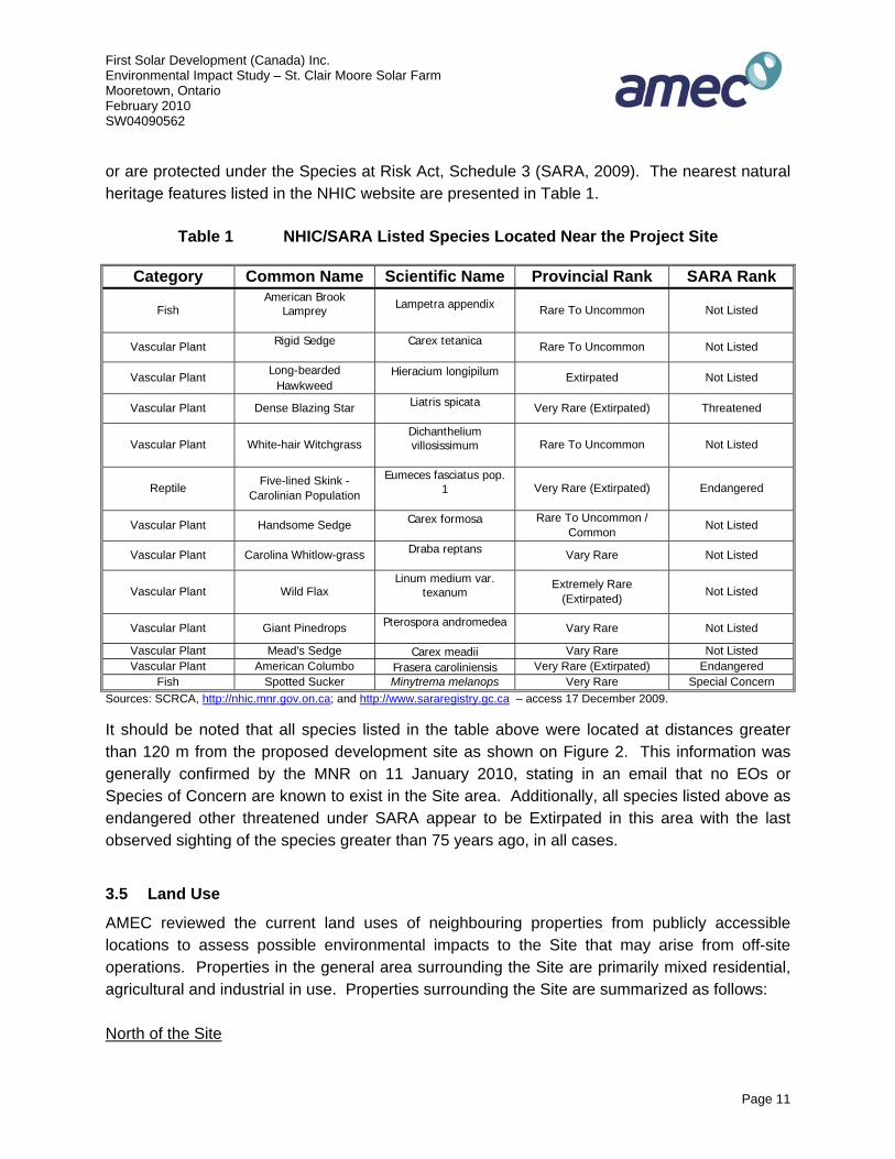
First Solar Development (Canada) Inc. Environmental Impact Study – St. Clair Moore Solar Farm Mooretown, Ontario February 2010 SW04090562 or are protected under the Species at Risk Act, Schedule 3 (SARA, 2009). The nearest natural heritage features listed in the NHIC website are presented in Table 1.
Table 1 NHIC/SARA Listed Species Located Near the Project Site
Category Common Name Scientific Name Provincial Rank SARA Rank
Fish American Brook
Lamprey
Lampetra appendix Rare To Uncommon Not Listed
Vascular Plant Rigid Sedge
Carex tetanica Rare To Uncommon Not Listed
Vascular Plant Long-bearded Hawkweed
Hieracium longipilum Extirpated Not Listed
Vascular Plant Dense Blazing Star Liatris spicata Very Rare (Extirpated) Threatened
Vascular Plant White-hair Witchgrass Dichanthelium villosissimum
Rare To Uncommon Not Listed
Reptile Five-lined Skink - Carolinian Population
Eumeces fasciatus pop. 1
Very Rare (Extirpated) Endangered
Vascular Plant Handsome Sedge Carex formosa
Rare To Uncommon / Common Not Listed
Vascular Plant Carolina Whitlow-grass Draba reptans Vary Rare Not Listed
Vascular Plant Wild Flax Linum medium var.
texanum
Extremely Rare (Extirpated) Not Listed
Vascular Plant Giant Pinedrops Pterospora andromedea Vary Rare Not Listed
Vascular Plant Mead's Sedge Carex meadii Vary Rare Not Listed Vascular Plant American Columbo Frasera caroliniensis Very Rare (Extirpated) Endangered
Fish Spotted Sucker Minytrema melanops Very Rare Special Concern Sources: SCRCA, http://nhic.mnr.gov.on.ca; and http://www.sararegistry.gc.ca – access 17 December 2009. It should be noted that all species listed in the table above were located at distances greater than 120 m from the proposed development site as shown on Figure 2. This information was generally confirmed by the MNR on 11 January 2010, stating in an email that no EOs or Species of Concern are known to exist in the Site area. Additionally, all species listed above as endangered other threatened under SARA appear to be Extirpated in this area with the last observed sighting of the species greater than 75 years ago, in all cases.
3.5 Land Use
AMEC reviewed the current land uses of neighbouring properties from publicly accessible locations to assess possible environmental impacts to the Site that may arise from off-site operations. Properties in the general area surrounding the Site are primarily mixed residential, agricultural and industrial in use. Properties surrounding the Site are summarized as follows: North of the Site
Page 11
First Solar Development (Canada) Inc. Environmental Impact Study – St. Clair Moore Solar Farm Mooretown, Ontario February 2010 SW04090562 North of the Site was a woodlot and railway shunting and storage area, beyond which, an industrial business park exists.
East of the Site
East of the Site is the Highway 40 right-of-way; beyond which are industrial operations associated with an adjacent NOVA chemicals refinery and agricultural fields.
South of the Site
South of the Site is the Rokeby Line right-of-way, beyond which is the Suncor Ethanol Plant and Nova Moore Plant.
West of the Site
West of the Site is a north/south trending railway corridor, beyond which is agricultural land and residential properties.
Page 12
First Solar Development (Canada) Inc. Environmental Impact Study – St. Clair Moore Solar Farm Mooretown, Ontario February 2010 SW04090562
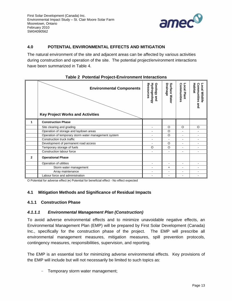
4.0 POTENTIAL ENVIRONMENTAL EFFECTS AND MITIGATION
The natural environment of the site and adjacent areas can be affected by various activities during construction and operation of the site. The potential project/environment interactions have been summarized in Table 4.
Table 2 Potential Project-Environment Interactions
Environmental Components
Key Project Works and Activities
Geology and
Hydrogeology
Resources
Surface Water
Drainage
Local Plant C
omm
unities
Local Wildlife
Com
munities and
Habitat
1 Construction Phase Site clearing and grading - O O O Operation of storage and laydown areas - O - - Operation of temporary storm water management system - O - - Construction truck traffic - - - - Development of permanent road access - O - - Temporary storage of fuels O O - - Construction labour force - - - -
2 Operational Phase
Operation of utilities - - - - Storm water management - + - - Array maintenance - - - - Labour force and administration - - - -
O Potential for adverse effect (•) Potential for beneficial effect - No effect expected
4.1 Mitigation Methods and Significance of Residual Impacts
4.1.1 Construction Phase
4.1.1.1 Environmental Management Plan (Construction)
To avoid adverse environmental effects and to minimize unavoidable negative effects, an Environmental Management Plan (EMP) will be prepared by First Solar Development (Canada) Inc., specifically for the construction phase of the project. The EMP will prescribe all environmental management measures, mitigation measures, spill prevention protocols, contingency measures, responsibilities, supervision, and reporting. The EMP is an essential tool for minimizing adverse environmental effects. Key provisions of the EMP will include but will not necessarily be limited to such topics as:
- Temporary storm water management;
Page 13
First Solar Development (Canada) Inc. Environmental Impact Study – St. Clair Moore Solar Farm Mooretown, Ontario February 2010 SW04090562
- Erosion Control Plan; - Storage of fuels and lubricants; - Material storage; - Spill prevention; - Spill containment and clean up protocols and equipment; - Maintenance of machinery; - Housekeeping protocols; - Construction waste management; - Dust management; - Encounter of finds of potential archaeological interest; - Encounter of contaminated soils; - Site access and construction traffic routing; - Construction envelop; - Tree protection; - Environmental supervision; - Health and Safety standards and protocols; and - Reporting.
4.1.2 Operations Phase
4.1.2.1 Environmental Management Plan (Operation)
Similar to the Environmental Management Plan (EMP) for the construction phase, an EMP will be developed by First Solar Development (Canada) Inc. for operation of the Solar Farm. The overall objective of the EMP is to ensure the Solar Farm operates in compliance with regulatory standards and permits issued by the Ministry of the Environment. The EMP will become integral part of the Solar Farm operation manuals and protocols and will be subject to periodic reviews and updating. Solar Farm management and maintenance personnel will be required to be familiar with the provisions of the EMP and will be responsible for its implementation including staff training and reporting. Key provisions of the EMP will include but will not necessarily be limited to such topics as:
- Responsibilities; - Environmental Procedures;
Storm Water discharges; Traffic management; Chemical management; Shut down policies; Inspections;
Page 14

First Solar Development (Canada) Inc. Environmental Impact Study – St. Clair Moore Solar Farm Mooretown, Ontario February 2010 SW04090562
Spill prevention; Monitoring;
- Equipment; Preventative maintenance;
- Health and safety; Policies; Standards and protocols; Requirements for contractors and suppliers; Incident reporting;
- Emergency preparedness and response plan; Responsibilities; Spill containment and clean up procedures and equipment;
- Management of Environmental Program; Training; Documentation; Reporting; Continuous Improvement; and Management review.
The EMP will be periodically reviewed and updated.
Page 15

First Solar Development (Canada) Inc. Environmental Impact Study – St. Clair Moore Solar Farm Mooretown, Ontario February 2010 SW04090562
5.0 CONCLUSIONS
Impacts associated with development of the site are primarily concerned with potential impacts to the Lukey, Rumohr and Nesbit Award Drains, along with potential impacts to the woodlot located along the north of the property. Impact details to the woodlot will be further assessed in the Woodlot Assessment to be conducted in the coming months. . As part of the solar farm development, First Solar is also considering additional options for the on-going encouragement of the natural communities and visual impacts around the Site. One of these current considerations being looked at include the addition of new woodlot (at and around perimeter of existing woodlot land) as part development plan to encourage plant and wildlife viability and sustainability along the north of the Site and reinforce the already existing natural buffer area which exists on and adjacent to the Site boundary. Details related to additional environmental and aesthetic project initiatives will be further addressed in the separate development plans being prepared for the Site. The Solar Farm arrays are expected to be positioned such that they will be located outside of the SCRCA Regulated areas (by a minimal margin of 30 metres) and St. Clair Township Municipal Drains (by a minimal margin of 15 metres from open drain or natural watercourse & 5 metres from buried municipal drains) thereby avoiding any encroachment on the Baby Creek Regulated Area and the Lukey, Rumohr and Nesbit Award Drains. That noted, the Site development plan will likely require the relocation/movement of a portion of buried drainage tile (circa 1916) associated with outflow into the Nesbit Award Drain. This mindset has already been raised by St. Clair Township Drainage Superintendent and would be part of finalizing the Site plan with the municipality. Adverse residual effect to the local Natural Heritage features is not currently anticipated; however, cannot currently be confirmed until follow-up review is completed of information from the upcoming woodlot assessment activities. Although, the proposed environmental mitigation strategies are anticipated to maintain the area’s natural heritage system form and function without impeding upon existing habitats or modifying land other than existing agricultural or residential developments. Preliminary review of the Natural Heritage information by the MNR has not identified potential concerns on the Site.
Page 16
First Solar Development (Canada) Inc. Environmental Impact Study – St. Clair Moore Solar Farm Mooretown, Ontario February 2010 SW04090562 6.0 CLOSURE
This report was prepared for the exclusive use of First Solar Development (Canada) Inc. Any use which a third party makes of this report, or any reliance on or decisions to be made based on it, are the responsibility of the third party. Should additional parties require reliance on this report, written authorization from AMEC will be required. With respect to third parties, AMEC has no liability or responsibility for losses of any kind whatsoever, including direct or consequential financial effects on transactions or property values, or requirements for follow-up action and costs.
The report is based on data and information collected during the Environmental Impact Study between 12 November and 18 December 2009. Except as otherwise may be specified, AMEC disclaims any obligation to update this report for events taking place, or with respect to information that becomes available to AMEC after the time during which AMEC conducted the investigation.
AMEC makes no other representations whatsoever, including those concerning the legal significance of its findings, or as to other legal matters touched on in this report, including, but not limited to, ownership of any property, or the application of any law to the facts set forth herein. With respect to regulatory compliance issues, regulatory statutes are subject to interpretation and change. Such interpretations and regulatory changes should be reviewed with legal counsel.
This Report is also subject to the further Standard Limitations contained in Technical Services Agreement dated 24 September 2009.
We trust that the information presented in this report meets your current requirements. Should you have any questions, or concerns, please do not hesitate to contact the undersigned.
Yours truly, AMEC Earth & Environmental a division of AMEC Americas Limited Mike Crabb, BES, CET, CCEP J. Brian Fogg, P.Eng. Environmental Scientist Senior Engineer
Page 17

Appendix A Site Photographs
PROJECT NO.
PROJECT
LOCATION Moore Site - St. Clair Township, Ontario ENCLOSURE
1
Description
APPENDIX B - SITE PHOTOGRAPHS
Looking northwest across the western boundary of the Site at the railway and electrical corridor trending along the property boundary.
SW04090562
Environmental Impact Study
PHOTOGRAPH
PHOTOGRAPH
1
2
Description
Looking north across the proposed development site towards the adjacent woodlot bordering the northern perimeter.
PROJECT NO.
PROJECT
LOCATION Moore Site - St. Clair Township, Ontario ENCLOSURE
PHOTOGRAPH 4
Description
Looking at a catchbasin along the north side of Rokeby Line and south of the Site property boundary. The catch basin appears to transition field drainage tile into the Lukey Drain.
PHOTOGRAPH 3
Description
Looking south at a drainage pipe making up a portion of the Lukey drain as it transitions from the north side of Rokeby Line to the south side of the road.
APPENDIX B - SITE PHOTOGRAPHS
SW04090562
Environmental Impact Study
2
PROJECT NO.
PROJECT
LOCATION Moore Site - St. Clair Township, Ontario ENCLOSURE
PHOTOGRAPH 6
Description
Looking northeast across the southeast corner of the Site at service easement trending along the boundary of the property.
PHOTOGRAPH 5
Description
Looking west from the south side of Rokeby Line at the continuation of the Lukey Drain.
APPENDIX B - SITE PHOTOGRAPHS
SW04090562
Environmental Impact Study
3

Appendix B St. Clair Region Conservation Authority – Forest Inventory
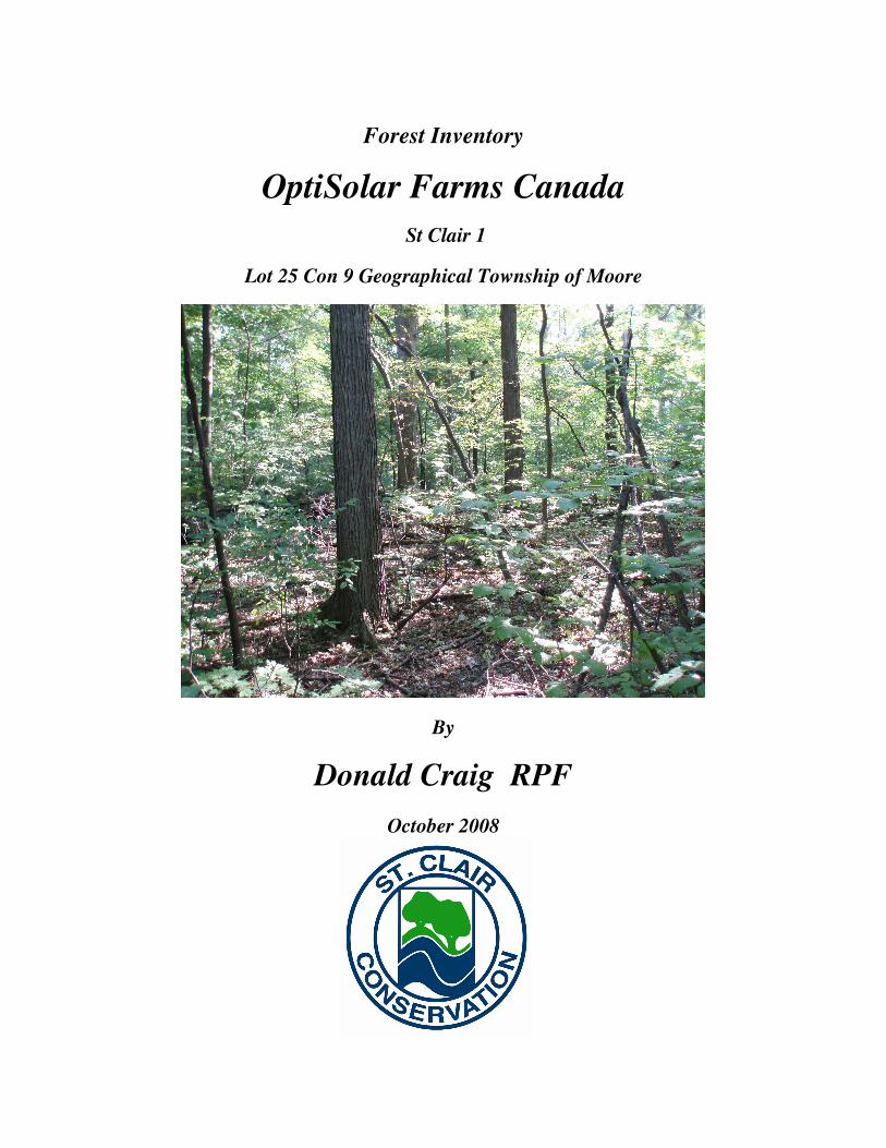
Forest Inventory
OptiSolar Farms Canada
St Clair 1
Lot 25 Con 9 Geographical Township of Moore
By
Donald Craig RPF
October 2008
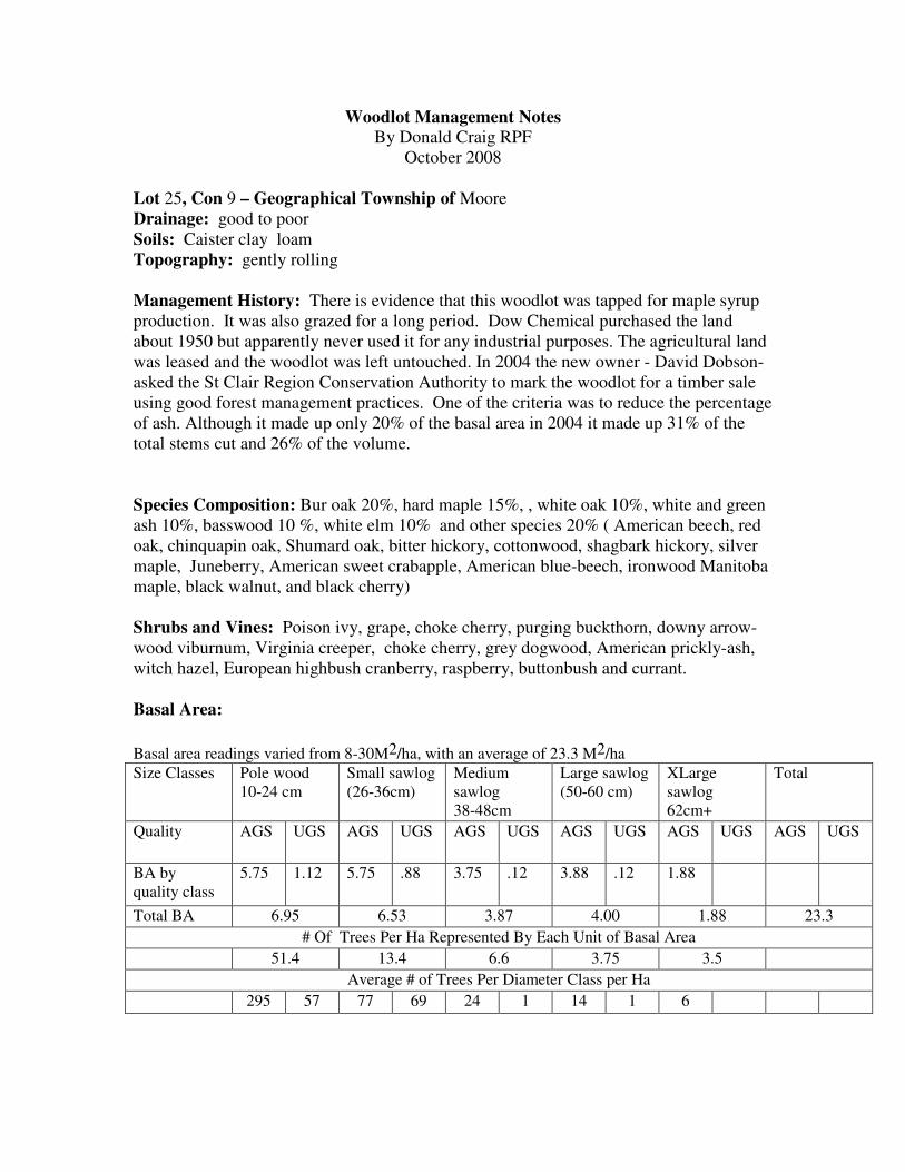
Woodlot Management Notes By Donald Craig RPF
October 2008
Lot 25, Con 9 – Geographical Township of Moore
Drainage: good to poor
Soils: Caister clay loam
Topography: gently rolling
Management History: There is evidence that this woodlot was tapped for maple syrup
production. It was also grazed for a long period. Dow Chemical purchased the land
about 1950 but apparently never used it for any industrial purposes. The agricultural land
was leased and the woodlot was left untouched. In 2004 the new owner - David Dobson-
asked the St Clair Region Conservation Authority to mark the woodlot for a timber sale
using good forest management practices. One of the criteria was to reduce the percentage
of ash. Although it made up only 20% of the basal area in 2004 it made up 31% of the
total stems cut and 26% of the volume.
Species Composition: Bur oak 20%, hard maple 15%, , white oak 10%, white and green
ash 10%, basswood 10 %, white elm 10% and other species 20% ( American beech, red
oak, chinquapin oak, Shumard oak, bitter hickory, cottonwood, shagbark hickory, silver
maple, Juneberry, American sweet crabapple, American blue-beech, ironwood Manitoba
maple, black walnut, and black cherry)
Shrubs and Vines: Poison ivy, grape, choke cherry, purging buckthorn, downy arrow-
wood viburnum, Virginia creeper, choke cherry, grey dogwood, American prickly-ash,
witch hazel, European highbush cranberry, raspberry, buttonbush and currant.
Basal Area:
Basal area readings varied from 8-30M2/ha, with an average of 23.3 M2/ha
Size Classes Pole wood
10-24 cm
Small sawlog
(26-36cm)
Medium
sawlog
38-48cm
Large sawlog
(50-60 cm)
XLarge
sawlog
62cm+
Total
Quality AGS UGS AGS UGS AGS UGS AGS UGS AGS UGS AGS UGS
BA by
quality class
5.75 1.12 5.75 .88 3.75 .12 3.88 .12 1.88
Total BA 6.95 6.53 3.87 4.00 1.88 23.3
# Of Trees Per Ha Represented By Each Unit of Basal Area
51.4 13.4 6.6 3.75 3.5
Average # of Trees Per Diameter Class per Ha
295 57 77 69 24 1 14 1 6

Disease and Insects: Even though there are a lot of hollow trees, dead trees and trees
with obvious disease overall the woodlot seems quite healthy.
Nectria (target) canker on white elm, basswood, hard maple and soft maple
Dutch elm disease
Black knot on choke cherry
Wildlife Features: 1 stick nest probably a red tailed hawk in a 70 cm DBH white oak.
Lots of cavities and mast trees, lots of ephemeral pools for amphibians
Comments for Management: This woodlot was harvested under good forest management practices in 2004. The
loggers did very good work and left little residual damage. The percentage of Ash was
lowered from 20% to 10%. Of more significance is the fact that 90% of the residual ash
are not dominant trees so if they are killed by emerald ash borer they will not have a
significant impact upon aesthetics, wildlife nor the rest of the forest canopy. As a result
of the canopy gaps created by the thinning there is adequate regeneration of white elm,
soft maple, hard maple, green ash and white ash as well as some regeneration of red,
white, burr and swamp white oak.
This woodlot makes a significant contribution to wildlife habitat in the area. It probably
qualifies as a”Significant” woodlot under the Lambton County Official Plan and The
Lambton County tree protection bylaw.
If EAB kills all the ash trees it will still be a viable woodlot.
There are a few buckthorn and honeysuckle which could be removed
In summary this is a healthy woodlot which will continue into the foreseeable future.
Reference Books
Trees in Canada by John Laird Farrar
Publishers: Fitzhenry and Whiteside
Trees of Ontario by Linda Kershaw
Publishers - Lone Pine
Trees of the Carolinian Forest by Gerry Waldron
The Boston Mills Press
Shrubs of Ontario
James H Soper and Margaret L Heimburger
The Royal Ontario Museum
A Silvicultural Guide to Southern Ontario Forests
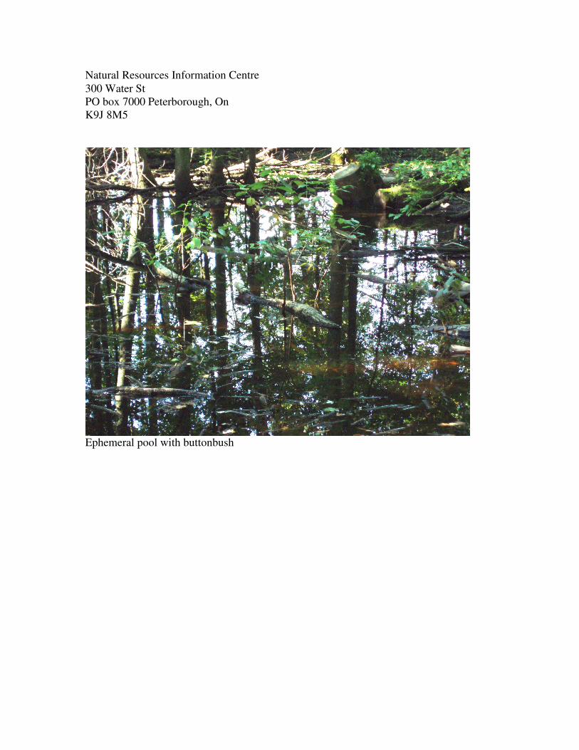
Natural Resources Information Centre
300 Water St
PO box 7000 Peterborough, On
K9J 8M5
Ephemeral pool with buttonbush

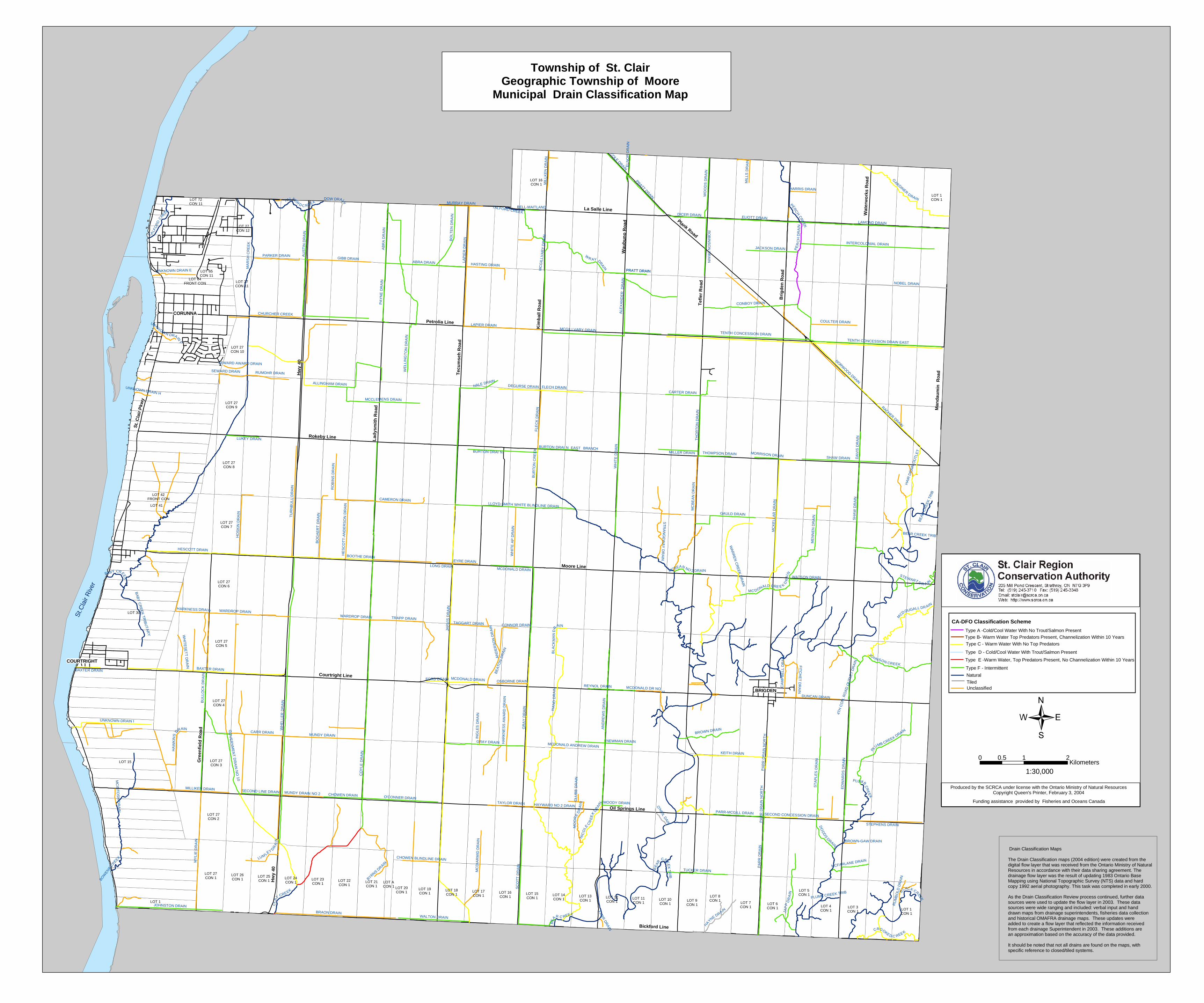
Appendix C St. Clair Region Conservation Authority – Drainage Classification Maps
!.!.
Lady
smith
Roa
d
Hill Street
Paget Street
Cameron Street
Emily
Stre
et
Bere
sfor
d S
treet
Poly
moo
re D
rive
Mur
ray
Stre
et
Bent
inck
Stre
et
Col
born
e S
treet
Albe
rt S
treet
St Clair Boulevard
Mur
ray
Driv
e Baird
Stre
et
Bent
inck
Driv
e
Riv
ersi
de D
rive
Colb
orne
Driv
e
St. James Street
Beechwood Drive
Clairwood Crescent
Alderbury Crescent
Omaha Drive
Keww Drive
Napoleon Street
April Court Hig
hway
40
Victoria Street
Highway 40
Hig
hway
40
Alfre
d S
treet
CO
YLE
DR
AIN
WH
ELL
ER
DR
AIN
BABY
CRE
EK
MA
RS
H C
RE
EK
ALLINGHAM DRAIN
TUR
NB
ULL
DR
AIN
HESCOTT DRAIN
HA
RK
NE
SS
DR
AIN
TRAPP DRAIN
WARDROP DRAIN
PAY
NE
DR
AIN
HE
SC
OTT
-AN
DE
RS
ON
DR
AIN
HO
SKI
N D
RA
IN
ROBINS DRAIN
MCCLEMENS DRAIN
BOG
AE
RT
DR
AIN
UNKNOWN DRAIN H
UN
KN
OW
N D
RA
IN
CAMERON DRAIN
UNKNO
WN D
RAIN
BAB
Y C
RE
EK
TRIB
UTA
RY
UNKNOWN DRAIN F
UNKNOWN DRIAN G
UNKNOWN DRAIN
UN
KN
OW
N D
RA
IN
UNKNO
WN D
RAIN
MOO016
Study Area
Water quality( SCR019) and Benthic Sampling (SCRMO7)Location
Produced by the SCRCA under license with the Ontario Ministry of NaturalResources. Copyright Queen's Printer June 2008May not be reproduced without permissionTHIS IS NOT A PLAN OF SURVEY
0 0.4 0.8 1.2 1.60.2Kilometers
Ü
Moore Solar FarmSt. Clair twp. Lot 25,26 Con 9Legend
Watercourses
Regulated Area (approx.)
!. Benthic and Water Quality Sampling Site
Woodlands
Electrofishing Site!.
Tecu
mse
h R
oad
Hill Street
Paget Street
Cameron Street
Beckwith StreetEm
ily S
treet
Bere
sfor
d S
treet
Poly
moo
re D
rive
Mur
ray
Stre
et
Bent
inck
Str
eet
Col
born
e S
treet
Albe
rt S
treet
St Clair Boulevard
Mur
ray
Driv
e Baird
Stre
et
Bent
inck
Driv
e
Riv
ersi
de D
rive Co
lbor
ne D
rive
St. James Street
Beechwood Drive
Clairwood Crescent
Alderbury Crescent
Lincoln Drive
Omaha Drive
Keww Drive
Napoleon Street
April Court Hig
hway
40
Victoria Street
Highway 40
Hig
hway
40
Alfre
d S
treet
CO
YLE
DR
AIN
BABY
CR
EEK
MA
RS
H C
RE
EK
ABRA DRAIN
LAP
IER
DR
AIN
WE
LLIN
GT
ON
DR
AIN
ALLINGHAM DRAIN
TUR
NB
ULL
DR
AIN
HESCOTT DRAIN
GIBB DRAIN
PA
YN
E D
RA
IN
HE
SC
OT
T-A
ND
ER
SO
N D
RA
IN
HO
SK
IN D
RA
IN
ROBINS DRAIN
AU
STI
N D
RA
IN
MCCLEMENS DRAIN
BO
GA
ER
T D
RA
IN
WHITE BLINDLINE DRAIN
HASTING DRAIN
UNKNOWN DRAIN E
UNKNOWN DRAIN H
UN
KN
OW
N D
RA
IN
CAMERON DRAIN
UNKN
OW
N D
RAIN
UNKNOWN DRAIN F
UNKNOWN DRIAN G
UN
KN
OW
N D
RA
IN
UNKNOWN DRAIN
UNKN
OW
N D
RAIN
PARKER DRAIN
Study Area
Produced by the SCRCA under l icense with the Ontario Ministry of NaturalResources. Copyright Queen's Printer June 2008May not be reproduced without permissionTHIS IS NOT A PLAN OF SURVEY0 0.4 0.8 1.2 1.60.2
Kilometers Ü
Moore Solar FarmSt. Clair twp. Lot 25,26 Con 9
Unclassified
CA-DFO Classification SchemeType A -Cold/Cool Water With No Trout/Salmon PresentType B- Warm Water Top Predators Present, Channelization Within 10 YearsType C - Warm Water With No Top PredatorsType D - Cold/Cool Water With Trout/Salmon PresentType E -Warm Water, Top Predators Present, No Channelization Within 10 YearsType F - IntermittentNaturalTiled
LOT 27CON 1 LOT 24
CON 1
LOT 26CON 1
LOT 21CON 1
LOT 25CON 1 LOT 22
CON 1
LOT 23CON 1
LOT 4CON 1
LOT 7CON 1
LOT 9CON 1
LOT 1CON 1
LOT 3CON 1
LOT 6CON 1
LOT 8CON 1
LOT 5CON 1
LOT 27CON 3
LOT 27CON 9
LOT 27CON 8
LOT 27CON 5
LOT 27CON 4
LOT 27CON 7
LOT 27CON 6
LOT 15CON 1
LOT 18CON 1
LOT 19CON 1 LOT 16
CON 1 LOT 12CON 1
LOT 13CON 1 LOT 10
CON 1
LOT 11CON 1
LOT 17CON 1 LOT 14
CON 1
LOT 27CON 2
LOT 20CON 1
LOT 27CON 10
LOT 27CON 12
LOT 1
LOT 27CON 11
LOT 15
LOT 65CON 11
LOT 30
LOT 41
LOT 72CON 11
LOT ACON 1
LOT 42FRONT CON
LOT 64FRONT CON
LOT 1CON 1
Kim
bal
l Ro
ad
Hw
y 40
Plank Road
Gre
enfi
eld
Ro
ad
Moore Line
La Salle Line
Bickford Line
Man
dau
min
Ro
ad
Wau
bu
no
Ro
ad
Tef
ler
Ro
ad
Lad
ysm
ith
Ro
ad
Tec
um
seh
Ro
ad
Petrolia Line
Courtright Line
Oil Springs Line
St.
Cla
ir P
kwy
Wat
erw
ork
s R
oad
Hw
y 40
Rokeby Line
Bri
gd
en R
oad
BE
AR C REEK
JAR
VIS
DR
AIN
CO
YLE
DR
AIN
BABY CREEK
GR
AY
DR
AIN
WH
EL
LER
DR
AIN
BU
RT
ON
CR
EE
K
WR AY DR
AIN
PLUMB CR
EE
K
WH
ITE
DR
AIN
BAXTER DRAIN
MA
RS
H C
RE
EK
PA
RR
DR
AIN
LAMOND DRAIN
AN
DR
EW
S D
RA
IN
WY
LIE
DR
AIN
PE
RC
H D
RA
IN
BRAON DRAIN
LAP
IER
DR
AIN
WE
L LIN
GT
ON
DR
AI N
GO
VE
RN
ME
NT
DR
AIN
NO
10
HA
ND
DR
AIN
MC
BE
AN
DR
AIN
ALLINGHAM DRAIN
MC
KE
LLA
R D
RA
IN
SH
AW
DR
AIN
BOW
ENS C
REEK
SC
OT
T D
RA
IN
ELIOTT DRAIN
AU
ST
IN D
RA
IN
J AP
P D
RA
IN
ABRA DRAIN
TU
RN
BU
LL
DR
AIN
CONBOY DRAIN
G
ARDINER DRAIN
JOHNSTON DRAIN
NOBEL DRAIN
INTERCOLONIAL DRAIN
KEITH DRAIN
MC DONALD CRE E K DR
AIN
B
LACK CREEK
HESCOTT DRAIN
MUNDY DRAIN
NIC
OLE
CR
EE
K DR
AIN
JOHNSON CREEK
GIBB DRAIN
HARKNESS DRAIN
TRAPP DRAIN
HA
WK
INS
D
RAIN
WARDROP DRAIN
WALTON DRAIN
TH
OR
TO
N D
RA
IN
ST
AP
LE
S D
RA
IN
PLUMB CREEK D
RAIN
GAULD DRAIN
PERC
H CR
EEK
FLE
CK
DR
AIN
O'CONNER DRAIN
PA
YN
E D
RA
IN
PARR-MCGILL DRAIN
HE
SC
OT
T-A
ND
ER
SO
N D
RA
IN
M
CDOUGALL DR AIN
UNKNOWN DRAIN I
BROWN DRAIN
HO
SK
IN D
RA
IN
MC
DIA
RM
ID D
RA
IN
BU
LLO
CK
DR
AIN
WO
OD
S D
RA
IN
RO
BIN
S D
RA
IN
TUCKER DRAIN
PRATT DRAIN
H
AYNE DRAIN
SECOND LINE DRAIN
MCCLEMENS DRAIN
TENTH CONCESSION DRAIN EAST
BO
GA
ER
T D
RA
IN
WH
ITE
AP
DR
AIN
BYRNS DRAIN
MILLIKEN DRAIN
CROOKED C REE K
BLA
CK
MA
N D
R
AIN
RO
BIN
SO
N D
RA
IN
DO
DD
S DRAIN
CARR DRAIN
JACKSON DRAIN
TAYLOR DRAIN
PARKER DRAIN
MCDONALD DR NO 2
NORWOOD DRAIN
CAMERON DRAIN
CL
A
Y CREEK
COLE DRAINSTEWART D R A IN
T ALF
OR
D C
REEK
MO
OR
E D
RA
IN
MURRAY DRAIN
DICER DRAIN
ME
NN
EN
DR
AIN
MIL
LK
EN
DR
AIN
HASTING DRAIN
DA
VIS
DR
AIN
CHOWEN DRAIN
CARTER DRAIN
UNKNOWN DRAIN E
LUM LEY D
RA
IN
MCDONALD DRAIN
MUNDY DRAIN NO 2
MIL
LS D
RA
IN
MCFARLANE DRAIN
DOW DRAIN
OSBORNE DRAIN
HARRIS DRAIN
FORD DRAIN
O'N
EIL DAIN
CHOWEN BLINDLINE DRAIN
MORRISON DRAIN
CHURCHER CREEK
CLU
BB
DR
AIN
UNK
NOWN DRAIN
F
MCBEAN NO 2 DRAIN
REYNOL DRAIN
PA
RR
DR
AIN
NO
RT
H
MC
GIL
LVA
RY
DR
AIN
RACHER DRAIN
PLUMB CREEK TRIB
MC
INT
OS
H D
RA
IN
BELL-MAITLAND
UNKNOWN DRAIN H
CA
MP
BE
LL
DR
AIN
FARR
DR
AIN
AB
RA
DR
AIN
BE
AR
CREE
K T
RIB
GRAY DRAIN
BE
AR
CR
EE
K T
RIB
PRATT DRAIN
BAXTER DRAIN
PA
RR
DR
AIN
NO
RT
H
BEAR CREEK TRIB
TALFO
RD C REEK
HA
IR D
RA
IN O
UTL
ET
FIT
CH
ET
DR
AIN
BA
BY
CR
EE
K T
RIB
UT
AR
Y
ST
RA
NG
EW
AY
DR
AIN
WH
ITE
SE
TT
DR
AIN
WA
RR
EN
CR
EE
K D
RA
IN
ELN
OR
DR
AIN
RU
MB
OLD
DR
AIN
SECOND CONCESSION DRAIN
4TH
CO
N. R
OA
D O
UT
LET
DR
AIN
HAYWARD NO 2 DRAIN
BROWN-GAW DRAIN
MCDONALD ANDREW DRAIN
TALFORD CREEK
SEWARD AWARD DRAIN
SEWARD DRAIN RUMOHR DRAIN
LUKEY DRAIN
BOOTHE DRAIN
WARDROP DRAIN
HA
RK
NE
SS
AW
AR
D D
RA
IN
ING
LES
DR
AIN
CONNOR DRAIN
AN
DE
RS
ON
DR
AIN
TAGGART DRAIN
BE
ATO
N D
RA
IN
EYRE DRAINLONG DRAIN
LLOYD-SMITH WHITE BLINDLINE DRAIN
MCDONALD DRAIN
BURTON DRAI N EAST BRANCH
FLECH DRAINHALE DRAINDEGURSE DRAIN
PRATT DRAIN
MCGILLVARY DRAIN
ALE
XA
ND
ER
DR
AIN
LAPIER DRAIN
BO
LTE
N D
RA
IN
TENTH CONCESSION DRAIN
COULTER DRAIN
SHAW DRAIN
THOMPSON DRAINMILLER DRAIN
WATSON DRAIN
DUNCAN DRAIN
STEPHENS DRAIN
ED
WA
RD
S D
RA
IN
MOODY DRAIN
NEWMAN DRAIN
BURTON DRAI N
CORUNNACORUNNA
COURTRIGHTCOURTRIGHT
BRIGDENBRIGDEN
LOT 16CON 1
Township of St. ClairGeographic Township of Moore
Municipal Drain Classification Map
St.C
lair
Riv
er
Produced by the SCRCA under license with the Ontario Ministry of Natural ResourcesCopyright Queen's Printer, February 3, 2004
1:30,000
0 1 20.5Kilometers
CA-DFO Classification Scheme
Type A -Cold/Cool Water With No Trout/Salmon Present
Tiled
Natural
Type F - Intermittent
Type D - Cold/Cool Water With Trout/Salmon Present
Type B- Warm Water Top Predators Present, Channelization Within 10 Years
Type E -Warm Water, Top Predators Present, No Channelization Within 10 Years
Type C - Warm Water With No Top Predators
Unclassified
Funding assistance provided by Fisheries and Oceans Canada
Drain Classification Maps
The Drain Classification maps (2004 edition) were created from thedigital flow layer that was received from the Ontario Ministry of Natural Resources in accordance with their data sharing agreement. The drainage flow layer was the result of updating 1983 Ontario Base Mapping using National Topographic Survey (NTS) data and hard copy 1992 aerial photography. This task was completed in early 2000.
As the Drain Classification Review process continued, further datasources were used to update the flow layer in 2003. These data sources were wide ranging and included: verbal input and hand drawn maps from drainage superintendents, fisheries data collection and historical OMAFRA drainage maps. These updates were added to create a flow layer that reflected the information receivedfrom each drainage Superintendent in 2003. These additions arean approximation based on the accuracy of the data provided.
It should be noted that not all drains are found on the maps, withspecific reference to closed/tiled systems.