Embed Size (px)
Citation preview
PROSPECTING REPORT
ON
HEDLY NORTH, HEDLY SOUTH AND WINTERS GOLD
MINERAL CLAIMS
OSOYOOS MINING DIVISION
N.T.S. 92H/8E
49'20' N. 120°03' W.
OWNER OF CLAIMS
OPERATOR
ZURICH ENERGY CORPORATION
B.A. FENWICK-WILSON
B.A. FENWICK WILSON
AUGUST 10, 1982
G E O L O G I C A L B R A N C H A S S E S S M E N T R E P O R T

TABLE OF CONTENTS
Page
SUMMARY
INTRODUCTION
Loca t i on and Access
Physiography
P rope r t y and Ownership
H i s t o r y and Prev ious Work
GEOLOGY
General Geol agy
Local Geology
DISCUSSION
CONCLUSION
REFERENCES
STATEMENT OF QUALIFICATIONS
STATEMENT OF COSTS
LIST OF ILLUSTRATIONS
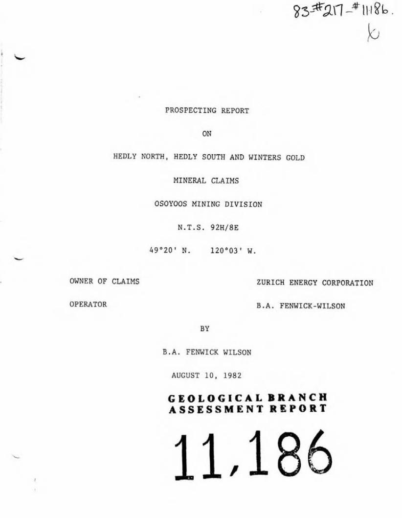
FIGURE 1 Local Map
FIGURE 2 Contour map of Hedley Area
FIGURE 3 Cla im Map
4 Reconnai sance Geology
1A
3A
5A
In Pocket

SUMMARY
The Hedly Nor th , Hedly South and Winters Gold m ine ra l c l a ims
a re l o c a t e d on t he e a s t s i d e of the Similkameen R i ve r , 3% km.
southeast of t he o l d g o l d m in ing town o f Hedley, B.C.
The c la ims a re u n d e r l a i n by Upper T r i a s s i c , N i c o l a Group meta-
sediments i n t r u d e d by Mesozoic dykes, s i l l s and s tocks o f
granodor i t e and gabbro.
Skarn a l t e r e d limy sediments occur i n var ious areas w i t h i n t h e
c l a i m groups. They a r e s t r o n g l y m i n e r a l i z e d w i t h p y r r h o t i t e
and l e s s e r amounts o f c h a l c o p y r i t e , b o r n i t e and a rsenopyr i t e .
The geo log i ca l s e t t i n g o f these c la ims i s a k i n t o t h a t o f t h e
N i cke l P la te , Good Hope, Canty and French mine environments.

L
Figure 1 LOCATION MAP
I Hedly North, Hedly South and w i n t e r s Gold C l a i m s Hedley Area Osoyoos M.D. 1:1,900,800

INTRODUCTION ' 2
T h i s r e p o r t i s based upon t h e r e s u l t s o f i n i t i a l p rospec t i ng t r ave rses over
t h e Hedly North, Hedly South and Winters Gold c la ims between June 1 0 t h and
J u l y l l t h , 1982.
Beside p rospec t i ng, t h e base 1 i nes were run w i t h Brunton and cha in w i t h wooden
p i c k e t s a t 100 meter i n t e r v a l s . L a t e r a l s were r un f rom these 100 meter
s t a t i o n s and r ibboned every 30 meters, p repa ra to r y t o a geochemical survey.
The S.W. and N.E. l e g a l survey corners o f C.G. 3467 were located. A survey
was made t o t i e i n t h e common l e g a l co rner pos t o f t h e Hedly Nor th and Hedly
South c la ims t o t h e S.W. co rner o f C.G. 3467.
T h i s r e p o r t i s be ing used f o r assessment purposes f o r these claims.

LOCATION AND ACCESS
The c la ims a r e l o c a t e d southeast o f Hedley i n southern B r i t i s h
Columbia, some 20 'km. e a s t o f P r i nce ton and approx imate ly 215 km.
e a s t o f Vancouver. (Map #1)
The midd le o f t h e c l a i m b lock i s approx imate ly 4 km. south-
e a s t o f Hedley. The c la ims l i e immediate ly e a s t o f and a d j o i n i n g
t he Churchuwayha I n d i a n Reserve No. 2. ( ~ a p #2)
Excel l e n t access t o t h e general area i s p rov ided by Highway #3
f rom Vancouver. Local access i s a l s o good. Hedly No r th and
Hedly South c l a ims a re t r ave rsed by the N i cke l P l a t e Mine road.
Th i s i s a good g rave l road which leaves Highway #3 near Redtop
Gulch creek some 25 km. southeast o f Hedley. Th i s road sw i t ch -
backs i t ' s way up t h e s teep road through t h e c la ims and then on
t o t he N i cke l P l a t e , Canty and o t h e r c la ims b e i n g developed
i n t h a t area, and then con t inues on pas t Apex Mountain t o Pen t i c t on .
Where t h i s road crosses the Hedly South c l a i m branch roads l e a d
o f f t o t he Good Hope and French Mines which p rov ide a d d i t i o n a l
access t o va r i ous p a r t s o f the Zu r i ch Energy p r o p e r t y .
The Winters Gold c l a ims l i e s immediate ly e a s t o f Highway #3 and i s
access ib l e from i t by a s h o r t farm road j u s t n o r t h o f Win te rs
Creek. Good access t o t h i s c l a i m i s p rov ided by t he o l d V i c t o r i a
Mine p a c k - t r a i l and which i s now used as a c a t t l e t r a i l t o t he summer
range h i g h e r up. The t r a i l f o l l o w s Winters Creek a l ong i t s bank,
q u i t e h i g h above t he creek bottom.
The Hedly Nor th , Hedly South and Winters Creek c la ims a r e covered
by Na t i ona l Topographic Ser ies map 92H/8E. Geographical co -o rd ina tes :
L a t i t u d e : 49°20' n o r t h : Longi tude : 1 2 0 ~ 0 2 ' west :

PHYSIOGRAPHY
The c l a i m area i s l o c a t e d on t he e a s t e r l y s i d e o f the Similkameen
R i ve r and occupies i n t he l owe r p o r t i o n s s teep s lopes which a re
c h a r a c t e r i s t i c o f , t h i s area. The upper p o r t i o n o f t he Hedly No r th
and Hedly South c la ims a re a more moderate t e r r a i n .
Douglas F i r , Aspen and sparse Ponderosa Pine cover the lower
s lopes. Whi le f ir predominates on the upper, mo i s te r , l e v e l s .
A l a r g e p o r t i o n o f t h e c l a i m i s open grassy s lopes between t he
t r e e s and rock covered areas.
The Hedly No r th and Hedly South c la ims have l a r g e rock ou tc rops and
c l i f f s . The r e s t o f t h e su r f ace coverage i s mos t l y sandy loam and
r e s i d u a l g rave l s , excep t t h a t p o r t i o n o f t he Hedly South c l a i m which
l i e s south o f C a h i l l Creek. Here, t he s o i l coverage i s l a r g e l y
g l a c i a l t i 1 1 of p o s s i b l y cons iderab le depth. The p r i n c i p a l ou t -
crops are i n t r u s i v e , whereas t h e sedimentary s e r i e s a re more
eroded and consequent ly have sparser ou tc rops .
The Winters Gold c l a i m has much c l i f f s and rocky ou t c rop on i t s
lower s lopes and t he ba lance o f t h i s p o r t i o n c o n s i s t s o f t a l u s o r
l i g h t sandy f ragmenta l s o i l . There i s sparse scrubby Pine and F i r .
I n t he upper p o r t i o n ad jacen t t o t he French Mine, t he t imbe r becomes
heav ie r , the s o i l cover deeper and rock outcrops l e s s prominent.
The Hedly Nor th and Hedly South c la ims a r e d ra ined by Redtop Gulch,
C a h i l l Creek and t h e i r t r i b u t a r i e s . Winters Gold c l a i m i s d ra i ned by
Winters Creek. A l l these creeks d r a i n i n t o t he Similkameen R i v e r .
E leva t ions va ry f rom about 475 meters on t he Winters Gold c l a i m near
t he Similkameen R i v e r t o 1400 meters on t he n o r t h p a r t o f the Hedly
Nor th c la im.

PROPERTY AND OWNERSHIP
The p r o p e r t y i s comprised o f t h r e e c l a ims t o t a l l i n g twenty-
f i v e u n i t s .
Claims Name No. o f U n i t s Record No. E x p i r y Date
Hedly South 15 11 C)6(6) June 19, 1983
Hedly Nor th 6 1107(6) June 19, 1983
Win te rs Gold 4 11 08(6) June 19, 1983
These c la ims a re owned by: Z u r i c h Energy Corpora t ion ,
809-837 West Hast ings S t ree t , Vancouver, B.C.
A p o r t i o n o f these c la ims ove r l ap p r e - e x i s t i n g crown-grants
and s taked c la ims .
'Csc A1 1 Legal Corner Posts were l o c a t e d and were no ted t o be
i n s c r i b e d accord ing t o t he B.C. M ine ra l Act .


HISTORY AND PREVIOUS WORK
The d iscovery o f go ld i n p lacers a long the S i m i l kameen R ive r
i n t h e 1860's l e d . to the search fo r t he lode depos i ts . The
d iscovery o f t he N icke l P la te mine i n 1897 marked t h e beg inn ing
o f m in ing operat ions i n the Hedley Min ing Camp, which cont inued
u n t i l 1955. The Ni ckel P l a t e Mine was operated by severa l
i n t e r e s t s u n t i l 1931 when i t was thought t he ore reserves had
been exhausted. I n 1932 Paul B i l l i n g s l e y and Augustus Locke
began a thorough study o f the mine and s t r u c t u r a l c o n t r o l o f
t h e go ld orebodies. As a r e s u l t severa l l a r g e new o re zones
'were d iscovered and the mine re-opened i n 1934 and cont inued
produc t ion u n t i l 1955. A new value t o t he p r i c e of g o l d has
resu l t ed i n a recent r e v i v a l o f t he Hedley area.
The N icke l P l a t e Mine was operated i n con junc t i on w i t h the
Hedley Mascot and together they mined n e a r l y 4,000,000 tons
which y i e l d e d some 1,557,000 oz. o f go ld and about 200,000
oz. o f s i l v e r .
Other mines have produced i n t h i s area; most no tab l y t he
Canty and Good Hope.
The French Mine, which i s l oca ted w i t h i n the overstaked south-
eastern p a r t o f the Hedly South c la im, was o r i g i n a l l y d iscovered
i n the e a r l y p a r t o f t h i s century. But was o n l y p u t i n t o
p roduc t ion from 1950-61 and produced some 72,000 tons y i e l d i n g
about 43,000 oz. o f go ld and 1,500 oz. o f s i l v e r .
M i n e r a l i z a t i o n i n a l l o f the above mines cons is ted o f go ld -
bear ing aresenopyri t e and chal copyr i t e and p y r r h o t i t e i n a
gangue o f garnet-pyroxene-epodite skarn. A t t he N icke l P l a t e
and Hedley Mascot Mines the skarn formed as a massive replacement

HISTORY AND PREVIOUS WORK
o f 1 imy beds. However, a t t h e Oregon (French) Mine i t formed
i n p a r t a l ong f r a c t u r e s r a t h e r than as a c o n s i s t e n t replacement
o f beds. I n t h e l a t t e r mine t h e r e i s n o t , t h e r e f o r e , n e c e s s a r i l y
a d i r e c t r e l a t i o n s h i p between t he d i s t r i b u t i o n o f m ine ra l i zed
skarn and t he a t t i t u d e o f bedding. Gold i n the French Mines was
found t o occur assoc ia ted w i t h a r senopy r i t e b u t was a l s o found
i n some areas i n which a r senopy r i t e and o t h e r s u l f i d e s were absent .
The V i c t o r i a Mine, l o c a t e d 500 m e a s t o f Winters Gold c l a i m ,
con ta ins a q u a r t z v e i n i n a r g i l l i t e and a r g i l l a c e o u s q u a r t z i t e .
The v e i n v a r i e s f r om 2 t o 66 cms i n w i d t h and c a r r i e s low va lues
i n go1 d assoc ia ted w i t h c h a l c o p y r i t e and p y r r h o t i t e .
No p rev ious r e p o r t s o f work ings on t he Hedly Nor th , Hedly South,
o r Winters Gold c l a ims c o u l d be found i n t h e var ious p u b l i c a t i o n s
consul ted. However, p i t s , t renches and one s h o r t a d i t were
l oca ted d u r i n g p r o s p e c t i n g t r ave rses , o the rs were r e p o r t e d on
v e r b a l l y by a l o c a l r e s i d e n t .
W i th i n t he l a s t t e n years , s i nce t h e r i s e i n t he p r i c e o f go ld ,
a c t i v e e x p l o r a t i o n has been c a r r i e d on w i t h i n a l a r g e r a d i u s o f
Hedley. I n p a r t i c u l a r , on t h e Micke l P l a t e and Mascot Mines where
i n t e n s i v e new work i s b e l i e v e d t o have proven ex tens i ve reserves .
I n 1981 t h e Good Hope mine shipped o r e t o the Dankoe Custom m i l l
a t Cawston f o r m i l l i n g . The French Mine mine has been d r i l l i n g ,
and Banbury Mines on Hen r i c reek has had some success i n
develop ing t h e i r p r o p e r t y .
I n t h e course o f p r o s p e c t i n g t r ave rses o l d p l a c e r work ings
were found on the Hedly South c l a i m on C a h i l l Creek, some 600
meters downstream f rom t h e S.E. co rner o f C.G. 3467.

HISTORY AND PREVIOUS WORK
Ex tens ive ve r y o l d p l a c e r work ings on Winters Gold c l a i m above
Highway #3 were noted. The creek had been d i v e r t e d i n seve ra l
p laces and l a r g e areas o f t h e f l a t worked over .
I n 1981 Z u r i c h Energy excavated two p i t s and t h r e e t renches w i t h
a backhoe on t h e Hed ly South c la ' im e a s t o f C a h i l l Creek.

GEOLOGY
GENERAL GEOLOGY
The Hedley area i s u n d e r l a i n by Upper T r i a s s i c N i c o l a Group
vo lcan ics and sediments i n t o whi.ch were i n t r u d e d smal l u l t r a -
b a s i c and l a r g e g r a n i t i c bodies of l a t e Mesozoic age. The
l a t t e r i n t r u s i v e s a lmost surround t h e N i c o l a Group rocks .
S t r u c t u a l l y , t he N i c o l a Group rocks form a p a r t o f the g e n t l y
d i p p i n g west 1 imb o f a n o r t h - s t r i k i n g a n t i c l i n a l f o l d . The
c o n t i n u i t y o f the s t r a t a o f t he f o l d i s broken by t he l a r g e
bodies o f i n t r u s i v e rock l o c a t e d a long i t ' s f o l d a x i s and about
the west s i d e i n p a r t i c u l a r .
I n a d d i t i o n t o t h e l a r g e g r a n i t i c bodies, t he sedimentary
s t r a t a were i n t r u d e d by innumerable d i o r i te-gabbro s i 11 s and
dykes produc ing a pronounced l aye red appearance. Th i s i s
c l e a r l y v i s i b l e f rom the highway a t Hedley.
The N i c o l a Group, i n t h e genera l P r i nce ton area, c o n s i s t s o f a
t h i c k succession o f l avas through which a re i r r e g u l a r i l y d i s t r i b u t e d
lenses o f t u f f aceous and a r g i l l a c e o u s rocks and o c c a s i o n a l l y beds
o f l imestone. However, i n t he N i cke l P l a t e Mine area a t Hedley,
t he sedimentary s t r a t a i s r e 1 a t i v e l y f r e e . from v o l c a n i c ma te r i a1 . It cons i s t s (R ice 1960) " o f approx imate ly 2745 m o f l imestone, t h i n -
bedded q u a r t z i t e , a r g i l l i t e , t u f f , and b recc ia , i n p a r t much
s i l i c i f i e d . The p r o d u c t i o n zone ( a t t he N i cke l P l a t e Mine) , l y i n g
365 m above t h e base, has been subd iv ided i n t o the Sunnyside
l imestone, t he Midd le member, and t he Upper member, i n a l l some
350 m t h i c k . The base o f N i cke l P l a t e Mountain c o n s i s t s of a
l a r g e body o f g r a n o d i o r i t e whose upper marg in rough l y f o l l o w s
the bedding i n the o v e r l y i n g i n t r u d e d sediments. Dykes and s i l l s

GEOLOGY
GENERAL GEOLOGY
from t h i s body c u t t he sediments, b u t a re n o t abundant, and
o n l y one of n o t a b l e s i z e c u t s t h e o re zone".
Most o f t h e sedimentary s t r a t a Cn t h e Hedley area has been
s t r o n g l y metamorphosed by the i n s t r u s i o n o f the many s i l l s and
dykes i n t o impure l i m y sediments. I n t he N i cke l P l a t e Mine
m i n e r a l i z a t i o n occurs i n skarn a l t e r e d l imes tone and impure l i m y
sediments ad jacenet t o d i o r i t e - g a b b r o s i l l s and dykes. I n o r d e r
o f abundance, t h e s u l f i d e m ine ra l s i n c l u d e a rsenopyr i t e , p y r r h o t i t e
and c h a l c o p y r i t e . Gold occurs assoc ia ted w i t h a r senopy r i t e . Lesser
amounts o f c o b a l t i t e and b ismuth t e l l u r i d e a re a l s o p resen t . The
c o n t a c t between t he m i n e r a l i z e d skarn and the u n a l t e r e d l imes tone
i s sharp and has been r e f e r r e d t o l o c a l l y as t he "marble l i n e " .
A t the French Pline t h e h o s t rock i s a l s o metmorphosed l i m y sediments.
I n one p o r t i o n o f t h i s mine t he re i s a s t r o n g f r a c t u r e zone w i t h
coarse b o r n i t e and c h a l c o p y r i t e a long w i t h a rsenopyr i t e and
p y r r h o t i t e i n a zone o f massive garne t -ep ido te skarn. Here t h e
g o l d occurs w i t h t he a rsenopyr i t e .' Bu t g o l d a l s o i s p resen t i n
t h e absence o f t h i s su lph ide . Gold e x i s t s i n a f r e e s t a t e through-
ou t much o f t h i s p rope r t y , n o t o n l y i n concen t ra t i ons o f su lph ide ,
b u t a l s o b o t h where t h e r e i s l i t t l e m i n e r a l i z a t i o n and a,lso i t ds
found i n o t h e r p laces i n l i m y sediments where t h e r e i s a t o t a l l a c k
o f su lph ide m i n e r a l i z a t i o n .
The French Mine environment resembles t h a t on t he west p o r t i o n o f
t h e Hedly Nor th and a l s o t h a t o f t he upper areas o f t h e Win te rs
Gold c l a i m wh ich l i e s c l ose t o t he south border o f t h e French Mine.

L O C A L GEOLOGY
Reconnaissance t r ave rses were made across t h e Hedly Nor th and Hedly South c la ims and
two over t h e Winters Gold claim. I n a d d i t i o n a l l t h e p r i n c i p a l roads, were examined
and mapped. (Map #4 i n pocket )
I nspec t i ons were made o f t h e N icke l P la te , Canty, French, and Good Hope Mines as a
gu ide f o r re1 a t i n g t h e i r m i n e r a l i z a t i o n t o t h a t d iscovered on t h e Z u r i c h Energy
p roper ty .
These t r ave rses were c o n t r o l l e d by t h e two new base l ines and a l s o by t h e l e g a l
co rners o f C.G. 3467.
Prospec t ing showed t h a t on t h e Hedly Nor th and South c la ims a l a r g e p o r t i o n i s
u n d e r l a i n by g r a n i t e and g ranod io r i t e . Metasediments were observed on t h e Hedly
N o r t h ' s no r t hwes te r l y p o r t i o n . These sediments inc luded dark f i ne-grained t u f f s ,
l i g h t green well-bedded t u f f s , minor q u a r t z i t e and cons iderab le l imestone, a l l
c o n t a i n i n g p y r r h o t i t e o f va ry i ng i n t e n s i t y . These sediments a re s t r o n g l y
s i 1 i c i f i e d , except some o f t h e 1 imestone which was marb i l i z e d and now i s s o f t and
crumbly near t h e west co rner o f t h e Hedly Nor th c laim.
G.S.C.Map568Ashows a body o f d i o r i t e - g a b b r o p a r t l y i n t h e northwest co rner o f t h e
Hedly Nor th c l a i m and p a r t l y ou t s i de t h e c l a i m boundary.

LOCAL GEOLOGY
From near t he N.W. corner o f t h e Hedly Nor th c l a i m a t rave rse
was taken downh i l l i n a w e s t e r l y d i r e c t i o n towards the Hedly Nor th
l e g a l corner post . Along t h i s l i n e the re was observed tu f faceous
rocks o v e r l a i n by grey-b lue marb i l i z e d 1 imestone which form
prominent b l u f f s on the west s i d e o f an unnamed creek g u l l y . Over-
l y i n g the l i nes tone , b u t p o o r l y exposed i n rubb l y outcrops and slumped
p i t s , are smal l outcrops of interbedded, dark s i l i c e o u s t u f f s , l ime-
stone, s i l i c i f i e d l imestone and garnet-epidote skarn. The l a t t e r
rock va r i es from f i n e t o coarse g ra ins o f garnet and ep ido te i n
l i g h t grey s i l i c e o u s l imestone t o massive garnet-epidote skarn.
The metamorphosed l i m y sediments a re w e l l m ine ra l i zed w i t h p y r r h o t i t e
and minor b o r n i t e and c h a l c o p y r i t e . Local l y there i s arsenopyr i t e .
An o l d a d i t , approx imate ly 15 m long, was l oca ted i n t he above area.
It i s c o l l a r e d i n h e a v i l y i r o n s ta ined dark s i l i c e o u s t o c h e r t y t u f f s
( a r g i l l i t e s ? ) and f o l l o w s a ~ 2 0 ~ / 9 0 ~ f r a c t u r e o r shear. The coun t r y
rock i s w e l l m ine ra l i zed w i t h p y r r h o t i t e and p y r i t e .
Apparent ly t h i s a d i t was d r i v e n t o i n t e r s e c t the downward ex tens ion
o f some w e l l m ine ra l i zed skarn up the h i l l above i t . b
To the eas t o f t he above metamorphosed sediments, across the unnamed
creek, abundant g ranod io r i t e ou tc rop was l oca ted forming the r i d g e
between the above creek and Redtop Gulch, c l i f f s a long bo th s ides o f
Redtop Gulch, and a l l o f t he h i g h ground between Redtop Gulch and
C a h i l l Creek. It a l s o forms h i g h c l i f f s a long the west boundary o f
Hedly South c la im, bo th above and below the access road. Th i s i s a
grey and b u f f co loured weather ing g ranod io r i t e . A s t rong shear zone
t rend ing about 030' - 045' occurs a long the access road i n the eas t
cen t ra l sec to r o f t he Hedly South c l a i m across some 100 metres o f
width. A no r thwes te r l y p a t t e r n o f j o i n t i n g and a t tendant shears i s

LOCAL GEOLOGY
a l s o p resen t i n t h i s zone. The g r a n o d i o r i t e i s h i g h l y a1 t e r e d
t o a brownish , crumbly, g ranu la r groundmass a t severa l l o c a t i o n s
i n t h i s shear zone.
Sca t te red outcrops o f s i m i l a r i n t r u s i v e s were l o c a t e d a long t he
t o p and lower roads t o the French Mine. Along these roads smal l
p o o r l y exposed sec t i ons o f q u a r t z i t e and t u f f were observed i n
t h e gaps between good i n t r u s i v e outcrops. If these sediments a re
i n p lace the i n t r u s i v e s must be i n t he form o f numerous, wide
s i l l s . On the lower road a gabbro s i l l o f a t l e a s t 3% meters
w i de was d iscovered.
Whi le no con tac t was found on t he west s i d e o f the p rope r t y
between t he metasediments and the i n t r u s i v e i t must l i e s l i g h t l y
eas t o f t he unnamed creek g u l l y and t r e n d south-wester ly . To t he
n o r t h t he con tac t appears t o swing eastward and then t o the no r th -
eas t near the upper road c ross ing o f Cahi 11 Creek. On t he eas t
s i d e o f Hedly South c la ims , on t he lower road t o the French Mine,
a sharp con tac t was seen between t he i n t r u s i v e and t he sediments.
Th i s c o n t a c t s t r i k e s N10E/35W. Fu r the r e a s t a long t h i s road t h e
sediments were observed t o d i p bo th t o the e a s t and west, i n d i c a t i n g
f o l d i n g i n these rocks near t he con tac t . No ou tc rop was observed
w i t h i n the c e n t r a l p a r t o f Hedly South c la im. This area i s mos t l y
open t h i n f o r e s t and grassy meadows. Road cu t s through t h i s s e c t i o n
show o n l y coarse bou lder t i l l .
I t i s b e l i e v e d t h a t sediments u n d e r l i e the open grass- lands
immediate ly e a s t o f C a h i l l Creek i n the c e n t r a l and n o r t h e a s t e r l y
p o r t i o n o f t h e Hedly South c la im. On t h i s c l a i m ' s e a s t boundary,
t h e r e a r e o l d caved p i t s w i t h meta-sediments on t he dump.

LOCAL GEOLOGY
A t r a v e r s e a l o n g t h e w e s t e r l y b a s e of t h e mountain on t h e Win te r s
Gold c l a i m i n d i c a t e d t h a t a l a r g e p a r t of i t s b a s e i s u n d e r l a i n by
g r a n o d i o r i t e . .Towards t h e n o r t h end of t h i s c l a i m t h e c o n t a c t
between t h e i n t r u s i v e and t h e sed iments a p p e a r s t o swing n o r t h -
e a s t e r l y up t h e h i l l and then i s c u t o f f by a n o r t h w e s t e r l y
s t r i k i n g f a u l t . South of t h i s f a u l t i s h e a v i l y i r o n - s t a i n e d
q u a r t z i t e on c o n t a c t w i t h t h i s g r a n o d i o r i t e . I n t e r b e d d e d w i t h
narrow s i l l s of q u a r t z i t e . To t h e e a s t of t h e r e i s a wide band
of l i m e s t o n e . Skarn , a s w e l l a s t h e above s e d i m e n t s , i s prominent
i n t h e t a l u s s l i d e s a t t h e b a s e of t h e s e c l i f f s .
Limestone , l imy sediments and minor q u a r t z i t e o u t c r o p a l l a l o n g
t h e s t e e p o l d V i c t o r i a mine p a c k - t r a i l which winds a l o n g t h e n o r t h
bank of Win te r s and a c r o s s t h e s o u t h p o r t i o n of t h e Win te r s Gold
c l a i m . Near t h e e a s t s i d e of t h i s c l a i m t h e r e i s a n o r t h e a s t
s t r i k i n g c o n t a c t w i t h da rk s i l i c e o u s t u f f s . S i l i c i f i e d
l imes tone wi th s k a r n replacement c o n t a i n i n g g a r n e t and e p i d o t e
and w e l l m i n e r a l i z e d w i t h p y r r h o t i t e was seen i n t h e t a l u s i n
s e v e r a l l o c a t i o n s a l o n g t h i s t r a i l .

DISCUSSION 15.
A rev iew o f G.S.C. Map 568A, gene ra l l y conf i rms t h e geology as noted d u r i n g
severa l p rospec t ing t raverses . The sediments mapped i n t h e nor thwestern
p o r t i o n o f t h e Hedly Nor th c l a i m belong t o t h e Redtop Formation. Sediments
t o t h e eas t o f Hedly South on t h e Winters Gold c l a i m and i n t h e v i c i n i t y o f t h e
French Mine a re mapped as "Undivided" and i n c l u d e some o r a l l o f t h e
sedimentary fo rmat ions found i n t h e N i cke l P l a t e Mine area.
The most obvious geo log i ca l d i f f e r e n c e between t h e examined c la ims and t h e
N i cke l P l a t e Mine area i s t h e apparent absence o f t h e numerous d i o r i t e - g a b b r o
s i 11 s and dykes and t h e i r assoc ia ted massive skarn rep1 acements. However,
t h e s i l l s and dykes cou ld be p resen t on t h e Hedly Nor th and South c la ims b u t
were no t observed due t o 1 i m i t e d ou tc rop exposure. Th is i s probably t h e case
s i nce a small 1 e n t i c u l a r body of d i o r i te-gabbro 1 i e s a t t h e nor thwest co rner
o f Hedly Nor th c laim. One gabbro s i 11 was noted on t h e lower French Mine
access road.
A t t h e French Mine, g o l d i s found i n massive bodies o f skarn, i n skarn
replacements a long f r a c t u r e s and i n r e l a t i v e l y una l t e red 1 imestone. I t has
been determined t h a t i n t h i s area go ld i s no t necessa r i l y assoc ia ted w i t h
su lph ide m i n e r a l i z a t i o n . A t some o t h e r mines i n t h i s area i t i s i n
con junc t i on w i t h a Tismuth t e l l u r i d e . Recent ly i n t h e French Mine it has
been d iscovered i n areas w i t h very sparse, o r even no, su lph ide
m i ne ra l i z a t i on.

DISCUSSION
The r e s u l t s o f , t h e prospec t ing and mapping so f a r i n d i c a t e s t h a t
the Hedly Nor th, Hedly South and Winters Gold c la ims are i n a
favourable geo log i ca l environment s i m i l a r t o the N icke l P l a t e and
Good Hope Mines, b u t i n p a r t i c u l a r t o the French Mine. The
d i f f e r e n t m i n e r a l i z a t i o n o f the above areas can be summarized
as fo l lows:
1. N i cke l P la te , Mascot and Canty Mines.
Here the g o l d i s associated w i t h arsenopyr i t e , and a l s o
c h a l c o p y r i t e and p y r r h o t i t e i n a gangue o f garnet-
pyroxene-epidote skarn. The skarn was formed by the
massive replacement of limy beds.
2. Good Hope Mine:
Here the g o l d occurs bo th w i t h heavy a rsenopy r i t e and a l s o
i n a f r e e s t a t e . It i s i n p laces i n a t e l l u r i d e .
3. French Mine: *
I n t h i s area the go ld can be found i n a f ree s t a t e w i t h
1 i t t l e o r no suphide m i n e r a l i z a t i o n . Genera l l y t he French
Mine 's m i n e r a l i z a t i o n i s q u i t e complex and var ied . I n p a r t
e n t i r e l y as a replacement o f l imestone beds. One o f the
r i c h e s t o f t h e o r i g i n a l l y mined p a r t s was a f r a c t u r e zone
i n skarn w i t h a rsenopy r i t e and coarse b o r n i t e . I n o t h e r
zones i n t h i s mine, g o l d i s w i t h a rsenopyr i te and a l s o i n
a f r e e s l a t e i n massive replacement o f 1 imy beds.
Th i s l i e s j u s t eas t o f t he Winters Gold c l a i m and i s a
qua r t z v e i n w i t h i n a r g i l l i t e s and a r g i l l a c e o n s q u a r t z i t e .
Vein v a r i e s f rom 2-65 cms i n w id th .

CONCLUSION
The N icke l P l a t e and Canty Mines 1 i e t o the no r theas t o f the
Hedly North c la im. The Good Hope Mine ground l i e s j u s t t o the
eas t o f t he Hedly South c la im. The Hedly South and Winters
Gold c la ims l i e t o the south, n o r t h and west o f the French
Mine area.
The geo log ica l s e t t i n g on the Hedly North, Hedly South and
Winters Gold c la ims has many s i m i l a r i t i e s w i t h t h a t i n t he
N icke l P la te , Canty, Good Hope and i n p a r t i c u l a r w i t h the
French Mine areas. A l l a re under la in by l i m y sediments and a
v a r i e t y o f i n t r u s i v e s . Sulphide m i n e r a l i z a t i o n i s a l s o s i m i l a r
i n a l l areas except as y e t no heavy concentrat ions o f su lph ide
have been d iscovered on the Zur ich Energy Group o f c la ims.
The o r i g i n a l e x p l o r a t i o n e f f o r t s were o r i e n t a t e d towards the
d iscovery o f massive su l ph i de replacements and go ld-bear ing
quar tz ve ins. Recent e x p l o r a t i o n has discovered t h a t go ld
e x i s t s w i t h i n t h i s area i n a f r e e s t a t e i n places n o t o n l y w i t h
a minimum o f su lph idh m ine ra l i za t i on , b u t a l s o where the re a re
no su l phides.
Thus any f u t u r e e x p l o r a t i o n programmes must be designed w i t h
t h i s new knowledge i n mind. Besides e x p l o r i n g f o r massive
sulphides , p a r t i c u l a r emphasis should be d i r e c t e d t o l o c a t i n g
gold i n areas o f minor sulphides and even l i m y rocks q u i t e
devoid su lph ide m i n e r a l i z a t i o n .
I n i t i a l l y a combinat ion o f a s o i l and rock geochemical programme
together w i t h geo log ica l mapping should be used t o d e l i n e a t e
the areas f o r f o l 1 ow-up work.
CONCLUSION
Prospect ing so f a r has l oca ted th ree areas which r e q u i r e
d e t a i l e d f o l 1 ow-up.
1. Winters Go1 d: - The e a s t e r l y ha1 f o f t h i s p rope r t y
i s composed o f mixed sediments con ta in ing skarn zones
i n an environment reminescent t o t h a t of the adjacent
French Mine.
Hedly North: - From the wes te r l y contac t o f the i n t r u s i v e
t o the west and n o r t h boundaries: - outcrops i n t h i s area
are p r i n c i p a l l y l i m y sediments w e l l m inera l i zed w i t h
p y r r h o t i t e and 1 ocal l y minor bo rn i t e , and cha lcopy r i t e . A
s t rong skarn zone outcrops west of and adjacent t o a
prominent g u l l y which i s hypothecated t o be the con tac t
between these sediments and the i n t r u s i v e . A wide, w e l l
m ine ra l i zed skarn zone outcrops n o r t h of t h i s g u l l y j u s t
ou ts ide and p a r a l l e l i n g t h i s claims n o r t h boundary f o r
a t l e a s t 100 meters. I t i s reasonable t o conclude t h a t
t h i s skarn cont inues downhi l l through the Hedly North
proper ty .
3. Hedly South: - The ground from the southeaster ly s i d e of
C a h i l l Creek through t o the area o f i n t r u s i v e s i l l s a long
the French Mine road i s covered by overburden. However,
u p h i l l f rom here a re the Good Hope claims and i t appears
t h a t these sediments cont inue wes te r l y down h i l l onto
the Hedly South c la ims. The area around the gabbro s i l l
on the lower road t o the French Mine should be i nves t i ga ted .

REFERENCES
B.C.M.M. Annual Reports 191 3, 191 7, 1930-36, 1955-60, 1970-73
Camsell, C. (1910) - geology and ore depos i ts Hedley M in ing D i s t r i c t , Geo. Survey, Can. Mem. No. 2
Rice, H.M.A. (1960) - Geology and Minera l Deposi ts of t h e Pr ince ton Map Area. Geo. Survey Can. Mem. 243
Maps : 568A, 888A, 889A, Geo. Survey Can. Geology Maps.

STATEMENT OF OUALIFICATIONS
I, B r i a n Fenwick-Wilson o f Mount Baldy Sk i Area, Box 687,
Osoyoos , B.C. , do hereby c e r t i f y t h a t :
1 . I took two years geology a t Lancing Col lege, England.
2. I have been engaged as a p rospec to r and geo log i ca l tech- n i c i a n f o r 36 years . My career t o da te i n t he minera l e x p l o r a t i o n f i e l d , may be summarized as f o l l ows :
Self-employed p rospec to r
Exp lo ra t i on manager & d i r e c t o r o f severa l syndicates and p r i v a t e companies.
U t i c a Mines and e x p l o r a t i o n syndicates.
Amax E x p l o r a t i o n
Cerro de Pasco
Newmont M in ing and p r i v a t e companies.
Self-employed, w i t h 2 e x p l o r a t i o n syndicates.
D i r e c t o r o f American F l u o r i t e and a d i r e c t o r and e x p l o r a t i o n manager o f o t h e r publ i c companies.
D i r e c t o r and Explorat i ,on manager o f severa l publ i c and p r i v a t e companies.
I have conducted many and ex tens ive e x p l o r a t i o n programmes du r i ng the p a s t 12 years.
3. The f a c t s and op in ions expressed h e r e i n a r e based on my personal knowledge, work on t h e ground and reviews o f pub l i shed maps and repo r t s .
B . FENW I CK-W I LSON Geolog ic Technic ian & Prospector

STATEMENT OF COSTS --
Wages :
June 10-14, J u l y 4-8, 1982 8 days11 man @ $125/day $ 1,000.00
J u l y 4-8 4 d a y s l l man (3 $75/day
Food & Accommodation:
Motel Meals & Grocer ies
T ranspo r t a t i on :
Truck 4 x 4 Gas
Assays :
D r a f t i ng Report p r e p a r a t i o n T Y P ~ ng
Suppl i es : F lagg iny Meter s t r i n g , maps, e t c . Phone C a l l s
Renta l :
Chain-Saw, O i l & Gas, e t c .
W.C.B.