Embed Size (px)
Citation preview
Page 88
UGMS OBJECTIVES 1. Encourage a diversity of population while targeting younger people to live and work in the area 2. Achieve the sustainable provision of physical infrastructure and community services 3. Balance the pressures of a high level of growth by safeguarding the environment, lifestyle and
prosperity
GROWTH SCENARIOS
Chapter Outline This chapter considers the possible future growth scenarios for Victor Harbor to the year 2030. Two “perceptual” growth scenarios are explored. The first scenario considers the possible economic, environmental and community qualities of Victor Harbor by the year 2030 if past growth trends continue. (identified in Chapter 3). The second
scenario considers one possible ‘vision’ for Victor Harbor by the year 2030. It describes the economic, environmental and community qualities of Victor Harbor if the opportunities identified in Chapter 3 are realised and growth is directed to meet the UGMS Objectives. Five possible physical growth scenarios are then explored, based upon projected land requirements (for residential, retail, commercial and industrial development) to 2030. The advantages and disadvantages of each growth scenario are compared having regard to the physical opportunities and constraints identified in Chapter 3, including environmental considerations (e.g. topography, watercourses, vegetation), physical infrastructure provision, economic development and community services provision. The preferred growth scenario is then chosen, based upon the best fit between the preferred “Vision” for Victor Harbor and the physical growth scenario that most effectively supports that vision, spatially.
Summary of Key Points
After reading this chapter, you should understand the following:
1. The advantages and disadvantages of different patterns of township growth. 2. The projected demand and the limited available supply of suitable land for residential,
retail, commercial and industrial development. 3. The spatial, economic, environmental and community implications of continuing with
the past growth management approach. 4. The Vision for Victor Harbor by 2030 and the preferred physical pattern of growth to
support that vision. 5. Actions taken now to re-direct growth have far reaching long term affects on the
spatial, economic, environmental and community qualities of Victor Harbor by 2030.
Chapter4
Growth Scenarios
Page 89
4.1 PERCEPTUAL GROWTH SCENARIOS
4.1.1 Continue with Existing Approach Possible Economic, Environmental and Community Qualities of Victor Harbor by the Year 2030 if Current Trends Continue without Intervention Victor Harbor has become very much a retirement centre. It attracts retirees from across the state and, to some extent, beyond – both those just starting retirement and those older people who have chosen Victor Harbor as the place where they wish to spend the last of their sunset years. The town remains attractive for some younger families seeking the quiet lifestyle it offers, but most family groups leave Victor Harbor when their children have finished their schooling, to pursue educational and employment opportunities in Adelaide. The relatively low incomes of its residents result in a town limited in both services and employment opportunities. Victor Harbor continues to lack advanced medical services and facilities. This results in its older residents in poor health moving elsewhere to be closer to those services or facilities, or relying heavily upon support from strained Council resources for assisted transport or local public hospital services. The quality of life for these older citizens diminishes markedly when their health fails and financial or other factors prevent such relocation. The lack of health services also discourages young families from moving into the area who rely on the reliability of and easy access to such services during early child rearing years. The continuing lack of services, facilities, educational and employment prospects makes for a subdued social and community atmosphere, although the town remains popular as a short term tourist destination, as it always has. The form of the town is typical of a suburban environment, with predominantly traditional dwelling stock sited on average to large allotments (in excess of 500m2). Residential areas encircle the town extending into the traditional grazing lands that once defined the urban and rural boundaries. The infrastructure costs of such low density design results in relatively high land (and therefore housing) prices, notwithstanding a relative lack of community, social and welfare services. The urban environment exhibits negligible public or streetscape works as a result of a poorer rate base and low level of business investment. The limited range of housing stock, borne from a limited demand for alternatives as a result of limited employment and educational options, entrenches for the longer term maintenance of the town’s population structure/composition and growth pattern. This ‘status quo’ is likely to be maintained until such time as the reducing revenue base of Council, and the establishment of key services at other centres (Goolwa, Noarlunga), renders the Town a dormant suburb – at which time property prices will likely become more affordable, albeit future residents will have a much lower quality of life
4.1.2 Vision for 2030 - Directed Growth to Meet UGMS Objectives Economic, Environmental and Community Qualities sought for Victor Harbor by the Year 2030 Victor Harbor encapsulates the broadest and most sought after qualities of urban life within a community based Township environment. It is a ‘smart city’, offering a full range of social and community services and actively encouraging a vibrant and active business environment. It is a healthy and wealthy town evidenced by its provision of key infrastructure and lifestyle attributes, all supported by a high rating base, business investment and active community. The provision of a range of tertiary education options and a strong employment base supports a broad population base of singles, students, young and mature couples/families, and retirees. This broad mix of residents further supports a diverse and active social and community based environment, with a high level of participation and volunteering in Council, public interest, environmental and support services. This active and enthusiastic participation further fosters community pride in the town – in its appearance, vitality and care for residents. Coupled with an expanded range of services and high level presentation of its public areas and foreshore, the town continues to attract large numbers of tourists seeking both short and longer term stays. The town boundaries are defined by undulating grazing land, with all urban development contained within a series of planned and serviced neighbourhoods linked to the town centre via a structured network of pedestrian, cycle and vehicular routes. Public transport links to Adelaide, intra town community buses, an upgraded road to Adelaide and high speed digital technology ensure residents and businesses are comprehensively and efficiently ‘linked’ to external opportunities and services. The town offers a wide mix of dwelling styles which, in turn, maintains its attractiveness to all population groups. Within and near the town centre, medium density apartment style dwellings and units/flats (attractive to students, singles and couples) supplement and extend the trading of local businesses whilst adding a ‘city centre’ flavour to the main streets. More traditional housing, environmentally sound in design and construction, and sited on a range of smaller and medium sized allotments extends to the town boundary in a range of new and refurbished neighbourhoods. All residential areas are of the highest order of appearance, ecologically sustainable design and streetscape presentation. Victor Harbor is renowned for its ‘clean green’ image attracting, accordingly, residents of similar thinking and commitment to sustainability and creating a ‘sense of place’.
Growth Scenarios
Page 90
4.2 PHYSICAL GROWTH SCENARIOS
4.2.1 Land Requirements
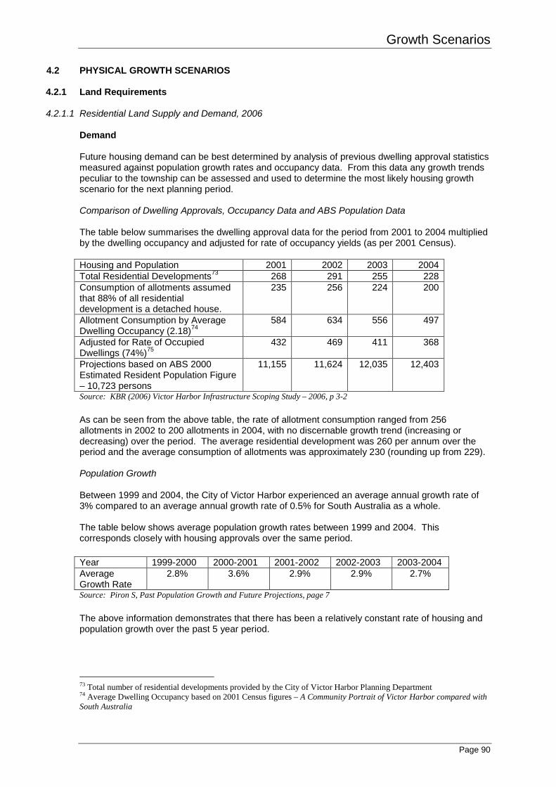
4.2.1.1 Residential Land Supply and Demand, 2006 Demand Future housing demand can be best determined by analysis of previous dwelling approval statistics measured against population growth rates and occupancy data. From this data any growth trends peculiar to the township can be assessed and used to determine the most likely housing growth scenario for the next planning period. Comparison of Dwelling Approvals, Occupancy Data and ABS Population Data The table below summarises the dwelling approval data for the period from 2001 to 2004 multiplied by the dwelling occupancy and adjusted for rate of occupancy yields (as per 2001 Census). Housing and Population 2001 2002 2003 2004 Total Residential Developments73 268 291 255 228 Consumption of allotments assumed that 88% of all residential development is a detached house.
235 256 224 200
Allotment Consumption by Average Dwelling Occupancy (2.18)74
584 634 556 497
Adjusted for Rate of Occupied Dwellings (74%)75
432 469 411 368
Projections based on ABS 2000 Estimated Resident Population Figure – 10,723 persons
11,155 11,624 12,035 12,403
Source: KBR (2006) Victor Harbor Infrastructure Scoping Study – 2006, p 3-2 As can be seen from the above table, the rate of allotment consumption ranged from 256 allotments in 2002 to 200 allotments in 2004, with no discernable growth trend (increasing or decreasing) over the period. The average residential development was 260 per annum over the period and the average consumption of allotments was approximately 230 (rounding up from 229). Population Growth Between 1999 and 2004, the City of Victor Harbor experienced an average annual growth rate of 3% compared to an average annual growth rate of 0.5% for South Australia as a whole. The table below shows average population growth rates between 1999 and 2004. This corresponds closely with housing approvals over the same period. Year 1999-2000 2000-2001 2001-2002 2002-2003 2003-2004 Average Growth Rate
2.8% 3.6% 2.9% 2.9% 2.7%
Source: Piron S, Past Population Growth and Future Projections, page 7 The above information demonstrates that there has been a relatively constant rate of housing and population growth over the past 5 year period.
73 Total number of residential developments provided by the City of Victor Harbor Planning Department 74 Average Dwelling Occupancy based on 2001 Census figures – A Community Portrait of Victor Harbor compared with South Australia
Growth Scenarios
Page 91
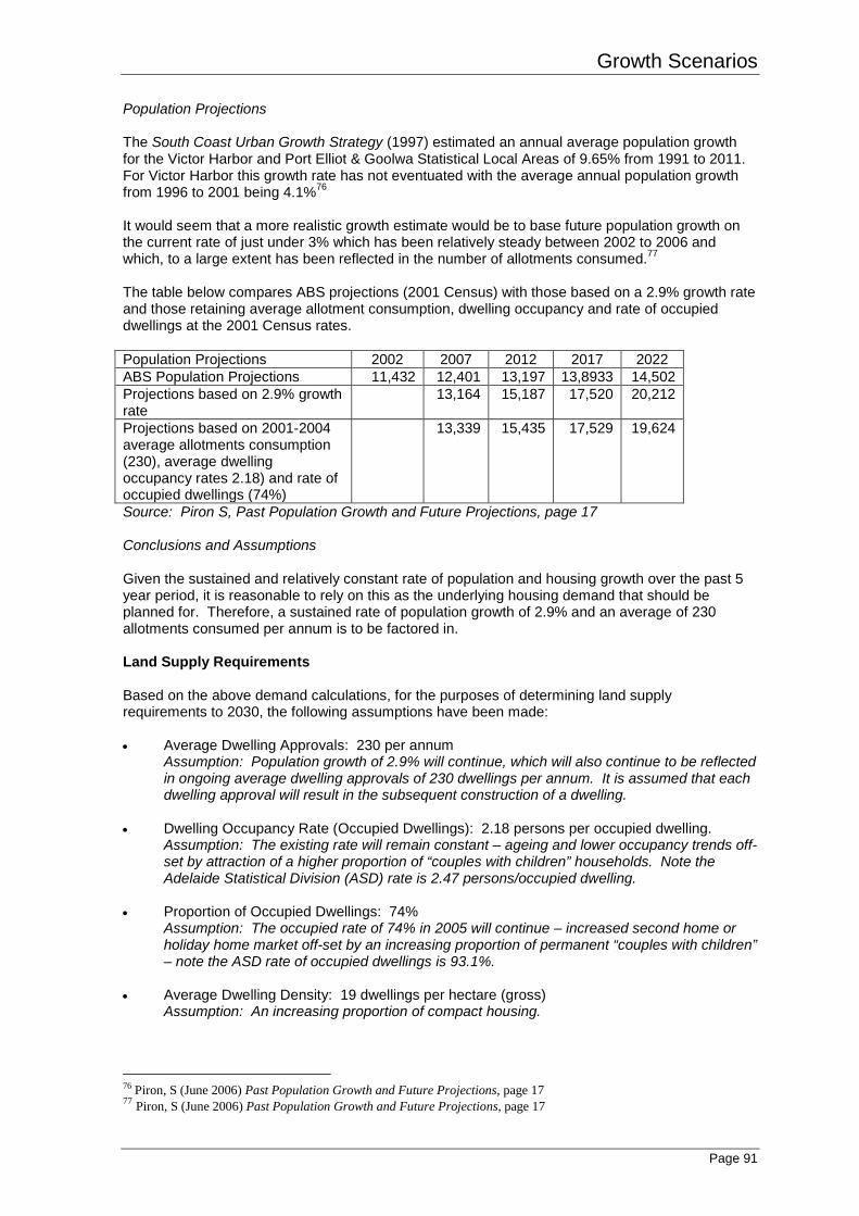
Population Projections The South Coast Urban Growth Strategy (1997) estimated an annual average population growth for the Victor Harbor and Port Elliot & Goolwa Statistical Local Areas of 9.65% from 1991 to 2011. For Victor Harbor this growth rate has not eventuated with the average annual population growth from 1996 to 2001 being 4.1%76 It would seem that a more realistic growth estimate would be to base future population growth on the current rate of just under 3% which has been relatively steady between 2002 to 2006 and which, to a large extent has been reflected in the number of allotments consumed.77 The table below compares ABS projections (2001 Census) with those based on a 2.9% growth rate and those retaining average allotment consumption, dwelling occupancy and rate of occupied dwellings at the 2001 Census rates. Population Projections 2002 2007 2012 2017 2022 ABS Population Projections 11,432 12,401 13,197 13,8933 14,502 Projections based on 2.9% growth rate
13,164 15,187 17,520 20,212
Projections based on 2001-2004 average allotments consumption (230), average dwelling occupancy rates 2.18) and rate of occupied dwellings (74%)
13,339 15,435 17,529 19,624
Source: Piron S, Past Population Growth and Future Projections, page 17 Conclusions and Assumptions Given the sustained and relatively constant rate of population and housing growth over the past 5 year period, it is reasonable to rely on this as the underlying housing demand that should be planned for. Therefore, a sustained rate of population growth of 2.9% and an average of 230 allotments consumed per annum is to be factored in. Land Supply Requirements Based on the above demand calculations, for the purposes of determining land supply requirements to 2030, the following assumptions have been made: • Average Dwelling Approvals: 230 per annum
Assumption: Population growth of 2.9% will continue, which will also continue to be reflected in ongoing average dwelling approvals of 230 dwellings per annum. It is assumed that each dwelling approval will result in the subsequent construction of a dwelling.
• Dwelling Occupancy Rate (Occupied Dwellings): 2.18 persons per occupied dwelling. Assumption: The existing rate will remain constant – ageing and lower occupancy trends off-set by attraction of a higher proportion of “couples with children” households. Note the Adelaide Statistical Division (ASD) rate is 2.47 persons/occupied dwelling.
• Proportion of Occupied Dwellings: 74% Assumption: The occupied rate of 74% in 2005 will continue – increased second home or holiday home market off-set by an increasing proportion of permanent “couples with children” – note the ASD rate of occupied dwellings is 93.1%.
• Average Dwelling Density: 19 dwellings per hectare (gross)
Assumption: An increasing proportion of compact housing.
76 Piron, S (June 2006) Past Population Growth and Future Projections, page 17 77 Piron, S (June 2006) Past Population Growth and Future Projections, page 17
Growth Scenarios
Page 92
• Annual Land Area Consumption: 12.1ha per annum Assumption: 230 dwellings per annum at a density of 19 dwellings per hectare. It is also assumed that each dwelling will be constructed on previously undeveloped land or land that has not accommodated a dwelling.
Therefore, based on an ongoing land area consumption rate of 12.1 ha per annum, or 230 allotments per annum, it is estimated that there is a residential land area requirement for approximately 303ha, or 5,750 allotments, to the year 2030. Existing Land Supply Existing land supply has been estimated, based on land supply results carried out by Planning SA, as follows:.78 • Vacant residentially zoned broadacre land (excluding Hindmarsh Valley PAR): 130.5ha or
1,299 allotments based on Development Plan minimum allotments sizes in 2006. • Existing vacant residentially zoned allotments (excluding broad acre land): 1192 allotments. • Additional allotments achievable from redevelopment of land currently containing a dwelling:
907 allotments. Therefore there is an estimated supply within the existing Residential Zones, based on 2006 Development Plan allotment sizes, of 3,398 allotments. Assuming that 80% of the existing vacant residentially zoned allotments are developed (2,491 – 20% = 1,993 allotments) and that only 25% of the additional allotments are achieved from redevelopment of land already containing a dwelling (ie 907 – 75% = 227 allotments), then the total number of allotments achievable within the existing Residential Zones is 2,220. As such, it is estimated that the stock of existing Residentially Zoned land (as at 2006) can provide for 9.5 years of housing demand based on allotments consumption rates of 230 per annum. Additional Land Requirements It has been estimated that 303ha of residential land, or 5,750 allotments, are required to the year 2030. From this, there is an existing supply of approximately 2,220 allotments within the existing residentially zoned areas (as at 2006 Development Plan allotments sizes). Therefore, it is estimated that an additional 3,530 allotments (5,750 – 2,220 = 3,530) equivalent to 186ha of additional residential land, will be needed to meet demand to the year 2030 However, using a more conservative approach, it is assumed for residential land release purposes (refer Map 24) that no additional dwellings will be constructed on existing vacant allotments within the residential zones or via redevelopment of allotments already containing a dwelling. On this basis, all of the required 303ha of residential land is to be provided in the land release plans by way of broadacre opportunities. Therefore, at least 303ha of broadacre residential land, equivalent to 5,750 allotments is to be provided. This is to comprise 130.5ha of existing residentially zoned broadacre land plus an additional 172.5ha to supply estimated demand to the year 2030. Possible infill and consolidation within existing residential areas (excluding existing broadacre land) may, however, yield a further 1,181 allotments79. These yields will be higher if increases to density are achieved within 500m of town centres (refer Map 21). The potential to achieve this development is dependent upon market acceptance of more compact housing forms and the rate at which land owners redevelop their land.
78 KBR (2006) Victor Harbor Infrastructure Scoping Study – 2006, Appendix A-1 79 Assumes 80% development of existing vacant allotments in established areas and 25% of redevelopment sites are developed (based on 2006 Development Plan rates). (1192 – 20% = 954) + (907 – 75% = 227) = 1,181.
Growth Scenarios
Page 93
Notes: The UGMS is to be used for broad strategic planning purposes only and is not intended to be used for short-term planning decision (ie it is not a “statement of investigations” to be used to inform a Development Plan Amendment). It is recommended that any short to medium term (5 – 10 year) planning projection use the demand/supply projections as a general guide only. Further refinement of these projections may be required taking into account the most recent ABS data and Council dwelling approval statistics. Further detail on the methodology used for the residential land supply and demand calculations can be found in the following reports, from which this section of the UGMS was derived: • Piron, S (June 2006) Past Population Growth and Future Projections, City of Victor Harbor;
and • KBR (2006) Victor Harbor Infrastructure Scoping Study - 2006 The projections contained in the above reports have been derived from the following sources: • ABS Population Projections 2002-2022; • Local derived projections based on dwelling approvals; • Population projections based on expectation of continued growth rates; • Piron, S (May 2005) City of Victor Harbor Vacant Allotment Survey 2005 • A Community Portrait of Victor Harbor compared with South Australia (prepared by The
Public Practice Pty Ltd); • South Coast Study: “Keeping Pace” Report, Centre for Economic Studies, December 2001; • Planning Strategy for the outer Metropolitan Adelaide Region, Government of South
Australia, April 2005.
Growth Scenarios
Page 94
4.2.1.2 Employment Land Floor Space Supply and Demand, 2006
Retail 200680 Supply • Existing retail floor space Supply: 25,500m2 (69% of floor space within the Town Centre) • Existing floor space Shortage: 5,000 – 6,000m2 to be supplied by a new neighbourhood
centre • No bulky goods retailing Assumptions • Population Growth Distributions81
Assumption: there will be no growth in the rural parts of the Council area and virtually all new dwellings to 2020 will be in new urban areas. Household occupancy will remain constant at 2.2 persons per dwelling.
• Land Supply Assumption: 5,000m2 of additional retail floor space equates to 1.6ha assuming a grossing up factor of 20%, car parking at 5.5 spaces/100m2 and a 15% margin on the resultant calculation for ancillary site areas.
• Definition of Retail82 Assumption: Bulky Goods Retailing, although a quasi-industrial activity, is included as a retail use for the purpose of retail floor space requirements/projections.
• Floor space ‘split’ Assumption: Floor space in any new neighbourhood centres will be split 70:30 for a smaller centre between food and non food retailing respectively, with these proportions reversed (30:70) for a larger centre.
Demand • Additional Demand between 2006 – 2011: 5,000 – 6,000m2 to be supplied in a second
neighbourhood centre • Additional Demand between 2011 – 2016: 15,500m2, made up of 12,000m2 in each of the
neighbourhood centres and 3,500m2 elsewhere • Total Additional Retail Floor space Demand by 2016 = 25,000m2 (8ha) • Total Additional Bulky Goods Floor Space Demand by 2016 = 15,500m2 (2.4ha) • Demand beyond 2016
No modelling has been undertaken beyond 2016 because of reduced reliability of forecasting at this distance. However, forecast population growth beyond this period confirms a need to reserve additional land to 2030.
80 Colliers International (2006) Victor Harbor Urban Growth Management Strategy: Commercial Land Use Review, Parts 1 and 2. 81 Methodology Consistent with Piron, S (July 2005) Population Projections Report, City of Victor Harbor 82 Colliers International (2006) Victor Harbor Urban Growth Management Strategy: Commercial Land Use Review, Parts 1 and 2.
Growth Scenarios
Page 95
Commercial83 Supply • Existing Supply: There is limited/heavily restricted supply of suitable commercial floor space
(eg offices, consulting rooms) within centre zones. • Existing floor space supply: 9,500m2 floor space (50% of which is within the Town Centre) Assumptions • Population Growth84
Assumption: Future demand has been modelled against a commercial floor space rate of 0.73m2 per person in Victor Harbor and 0.38m2 per person of the coastal strip in Alexandrina is included (requirement 3,000m2 by 2016 using the former and 4,500m2 using the latter).
Demand • Additional Demand between 2006 – 2016 = 4,500m2 • Additional Demand between 2016 – 2030 = 4,500m2 • Demand beyond 2016
No modelling has been undertaken beyond 2016 because of reduced reliability of forecasting at this distance. As a “broad brush” guide (Extrapolating figures to proceeding periods) a total of 9,000m2 of additional floor space may be required by 2030.
• Total Additional Demand by 2030 = 9,000m2
Other There is also projected demand for: • 2ha of tourist/visitor accommodation • 10.5ha (approximately) for car parking, access routes, landscaping
4.2.1.3 Industrial Land Supply and Demand, 200685 Supply Existing Supply = 40ha Assumptions • Population Growth
Assumption: Future supply equates to a past rate of 1 hectare per 264 people. Demand Additional Demand between 2006 – 2011 = 20ha Additional Demand between 2011 – 2016 = 10ha Additional Demand between 2016 – 2030 = 20ha Total Additional Demand by 2030 = 50ha Total Projected (possible) Supply = 39ha Total Projected Shortfall = 11ha All possible identified future industry sites will be exhausted by 2022 if all were to be rezoned for industry use.
83 Colliers International (2006) Victor Harbor Urban Growth Management Strategy: Commercial Land Use Review, Parts 1 and 2. 84 Methodology Consistent with Piron, S (July 2005) Population Projections Report, City of Victor Harbor 85 Colliers International (2006) Victor Harbor Urban Growth Management Strategy: Commercial Land Use Review, Parts 1 and 2 and Conner Holmes (2006) Industrial Land Study
Growth Scenarios
Page 96
4.2.1.4 Conclusions Based on the above projections, and the assumed increase in dwelling densities and consolidation/infill within the existing urban area, 220ha of the 269.7ha (or 82%) of available broad acre land inside the Ring Road will be exhausted by 2030. Rates of consumption may increase or decrease dependent upon household structure, density of development, availability of suitably zoned land ahead of supply, and rate of population growth. If, for example, consolidation/infill of the existing urban area is not realised, then all land within the Ring Road will be exhausted by 2030. Alternatively, if higher average densities are not realised in new broadacre housing development (ie assuming a “traditional” rate of 12 dwellings per ha) then there will be an increase in the consumption of land from the proposed 13.7ha to 21.6ha per annum, requiring an area of 418ha and exhausting all land within the Ring Road by 2017. Further, if all demand for industrial land is to be accommodated within Victor Harbor, this will displace areas otherwise suitable for residential and/or retail development and increase potential for impact upon resident amenity and township character. The following growth scenarios and the final structure plan limit industrial expansion to the expansion of existing industry zone to the north-east of the town only. No new industrial areas are proposed. All additional demand is to be directed to Goolwa,86 supported by improved freight links, in order to preserve and, where possible, improve township character.
86 In accordance with the Government of South Australia’s Planning Strategy for the Outer Metropolitan Adelaide Region (December 2007).
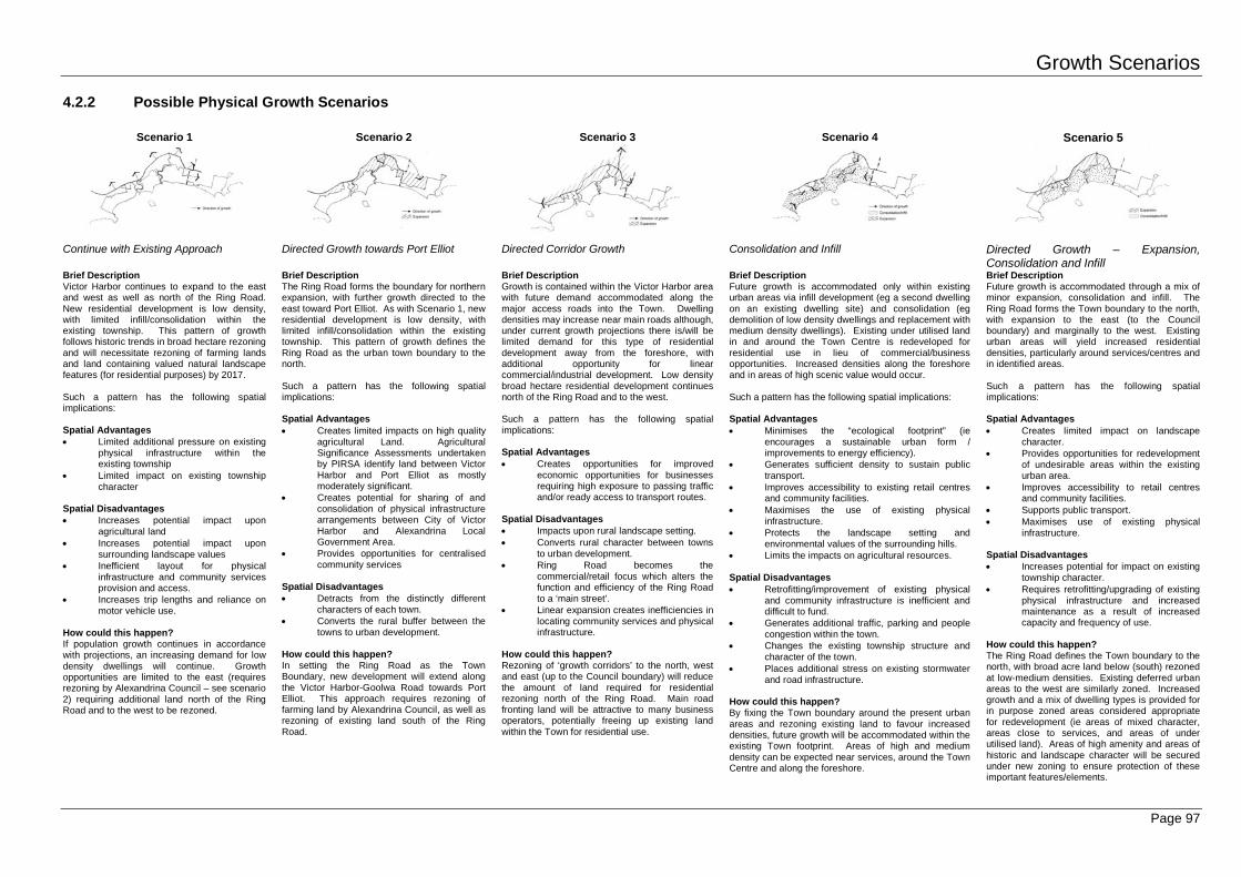
Growth Scenarios 4.2.2 Possible Physical Growth Scenarios
Page 97
Scenario 1
Scenario 2
Scenario 3
Scenario 4
Scenario 5
Continue with Existing Approach
Directed Growth towards Port Elliot
Directed Corridor Growth
Consolidation and Infill Directed Growth – Expansion, Consolidation and Infill
Brief Description Victor Harbor continues to expand to the east and west as well as north of the Ring Road. New residential development is low density, with limited infill/consolidation within the existing township. This pattern of growth follows historic trends in broad hectare rezoning and will necessitate rezoning of farming lands and land containing valued natural landscape features (for residential purposes) by 2017. Such a pattern has the following spatial implications: Spatial Advantages • Limited additional pressure on existing
physical infrastructure within the existing township
• Limited impact on existing township character
Spatial Disadvantages • Increases potential impact upon
agricultural land • Increases potential impact upon
surrounding landscape values • Inefficient layout for physical
infrastructure and community services provision and access.
• Increases trip lengths and reliance on motor vehicle use.
How could this happen? If population growth continues in accordance with projections, an increasing demand for low density dwellings will continue. Growth opportunities are limited to the east (requires rezoning by Alexandrina Council – see scenario 2) requiring additional land north of the Ring Road and to the west to be rezoned.
Brief Description The Ring Road forms the boundary for northern expansion, with further growth directed to the east toward Port Elliot. As with Scenario 1, new residential development is low density, with limited infill/consolidation within the existing township. This pattern of growth defines the Ring Road as the urban town boundary to the north. Such a pattern has the following spatial implications: Spatial Advantages • Creates limited impacts on high quality
agricultural Land. Agricultural Significance Assessments undertaken by PIRSA identify land between Victor Harbor and Port Elliot as mostly moderately significant.
• Creates potential for sharing of and consolidation of physical infrastructure arrangements between City of Victor Harbor and Alexandrina Local Government Area.
• Provides opportunities for centralised community services
Spatial Disadvantages • Detracts from the distinctly different
characters of each town. • Converts the rural buffer between the
towns to urban development. How could this happen? In setting the Ring Road as the Town Boundary, new development will extend along the Victor Harbor-Goolwa Road towards Port Elliot. This approach requires rezoning of farming land by Alexandrina Council, as well as rezoning of existing land south of the Ring Road.
Brief Description Growth is contained within the Victor Harbor area with future demand accommodated along the major access roads into the Town. Dwelling densities may increase near main roads although, under current growth projections there is/will be limited demand for this type of residential development away from the foreshore, with additional opportunity for linear commercial/industrial development. Low density broad hectare residential development continues north of the Ring Road and to the west. Such a pattern has the following spatial implications: Spatial Advantages • Creates opportunities for improved
economic opportunities for businesses requiring high exposure to passing traffic and/or ready access to transport routes.
Spatial Disadvantages • Impacts upon rural landscape setting. • Converts rural character between towns
to urban development. • Ring Road becomes the
commercial/retail focus which alters the function and efficiency of the Ring Road to a ‘main street’.
• Linear expansion creates inefficiencies in locating community services and physical infrastructure.
How could this happen? Rezoning of ‘growth corridors’ to the north, west and east (up to the Council boundary) will reduce the amount of land required for residential rezoning north of the Ring Road. Main road fronting land will be attractive to many business operators, potentially freeing up existing land within the Town for residential use.
Brief Description Future growth is accommodated only within existing urban areas via infill development (eg a second dwelling on an existing dwelling site) and consolidation (eg demolition of low density dwellings and replacement with medium density dwellings). Existing under utilised land in and around the Town Centre is redeveloped for residential use in lieu of commercial/business opportunities. Increased densities along the foreshore and in areas of high scenic value would occur. Such a pattern has the following spatial implications: Spatial Advantages • Minimises the “ecological footprint” (ie
encourages a sustainable urban form / improvements to energy efficiency).
• Generates sufficient density to sustain public transport.
• Improves accessibility to existing retail centres and community facilities.
• Maximises the use of existing physical infrastructure.
• Protects the landscape setting and environmental values of the surrounding hills.
• Limits the impacts on agricultural resources. Spatial Disadvantages • Retrofitting/improvement of existing physical
and community infrastructure is inefficient and difficult to fund.
• Generates additional traffic, parking and people congestion within the town.
• Changes the existing township structure and character of the town.
• Places additional stress on existing stormwater and road infrastructure.
How could this happen? By fixing the Town boundary around the present urban areas and rezoning existing land to favour increased densities, future growth will be accommodated within the existing Town footprint. Areas of high and medium density can be expected near services, around the Town Centre and along the foreshore.
Brief Description Future growth is accommodated through a mix of minor expansion, consolidation and infill. The Ring Road forms the Town boundary to the north, with expansion to the east (to the Council boundary) and marginally to the west. Existing urban areas will yield increased residential densities, particularly around services/centres and in identified areas. Such a pattern has the following spatial implications: Spatial Advantages • Creates limited impact on landscape
character. • Provides opportunities for redevelopment
of undesirable areas within the existing urban area.
• Improves accessibility to retail centres and community facilities.
• Supports public transport. • Maximises use of existing physical
infrastructure. Spatial Disadvantages • Increases potential for impact on existing
township character. • Requires retrofitting/upgrading of existing
physical infrastructure and increased maintenance as a result of increased capacity and frequency of use.
How could this happen? The Ring Road defines the Town boundary to the north, with broad acre land below (south) rezoned at low-medium densities. Existing deferred urban areas to the west are similarly zoned. Increased growth and a mix of dwelling types is provided for in purpose zoned areas considered appropriate for redevelopment (ie areas of mixed character, areas close to services, and areas of under utilised land). Areas of high amenity and areas of historic and landscape character will be secured under new zoning to ensure protection of these important features/elements.
Growth Scenarios
Page 98
Scenario 1
Scenario 2
Scenario 3
Scenario 4
Scenario 5
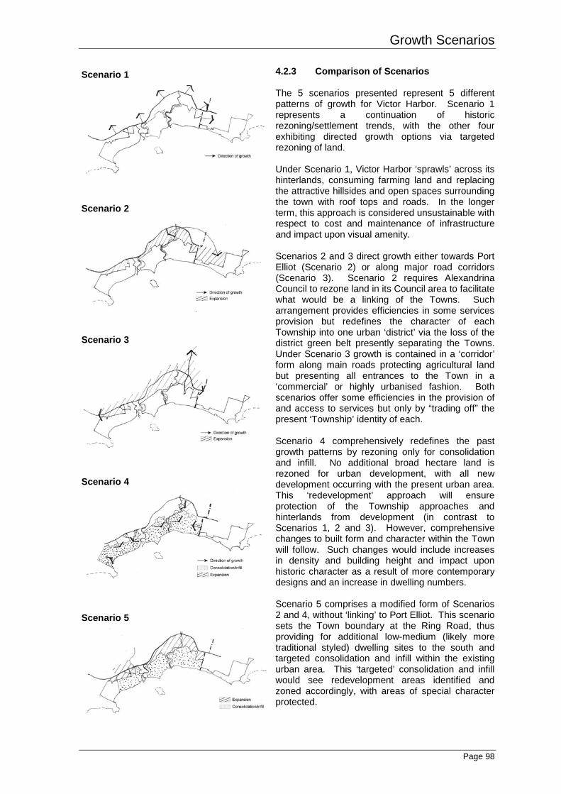
4.2.3 Comparison of Scenarios The 5 scenarios presented represent 5 different patterns of growth for Victor Harbor. Scenario 1 represents a continuation of historic rezoning/settlement trends, with the other four exhibiting directed growth options via targeted rezoning of land. Under Scenario 1, Victor Harbor ‘sprawls’ across its hinterlands, consuming farming land and replacing the attractive hillsides and open spaces surrounding the town with roof tops and roads. In the longer term, this approach is considered unsustainable with respect to cost and maintenance of infrastructure and impact upon visual amenity. Scenarios 2 and 3 direct growth either towards Port Elliot (Scenario 2) or along major road corridors (Scenario 3). Scenario 2 requires Alexandrina Council to rezone land in its Council area to facilitate what would be a linking of the Towns. Such arrangement provides efficiencies in some services provision but redefines the character of each Township into one urban ‘district’ via the loss of the district green belt presently separating the Towns. Under Scenario 3 growth is contained in a ‘corridor’ form along main roads protecting agricultural land but presenting all entrances to the Town in a ‘commercial’ or highly urbanised fashion. Both scenarios offer some efficiencies in the provision of and access to services but only by “trading off” the present ‘Township’ identity of each. Scenario 4 comprehensively redefines the past growth patterns by rezoning only for consolidation and infill. No additional broad hectare land is rezoned for urban development, with all new development occurring with the present urban area. This ‘redevelopment’ approach will ensure protection of the Township approaches and hinterlands from development (in contrast to Scenarios 1, 2 and 3). However, comprehensive changes to built form and character within the Town will follow. Such changes would include increases in density and building height and impact upon historic character as a result of more contemporary designs and an increase in dwelling numbers. Scenario 5 comprises a modified form of Scenarios 2 and 4, without ‘linking’ to Port Elliot. This scenario sets the Town boundary at the Ring Road, thus providing for additional low-medium (likely more traditional styled) dwelling sites to the south and targeted consolidation and infill within the existing urban area. This ‘targeted’ consolidation and infill would see redevelopment areas identified and zoned accordingly, with areas of special character protected.
Growth Scenarios
Page 99
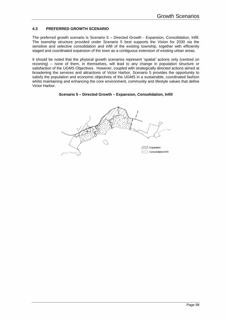
4.3 PREFERRED GROWTH SCENARIO The preferred growth scenario is Scenario 5 – Directed Growth - Expansion, Consolidation, Infill. The township structure provided under Scenario 5 best supports the Vision for 2030 via the sensitive and selective consolidation and infill of the existing township, together with efficiently staged and coordinated expansion of the town as a contiguous extension of existing urban areas. It should be noted that the physical growth scenarios represent ‘spatial’ actions only (centred on rezoning) – none of them, in themselves, will lead to any change in population structure or satisfaction of the UGMS Objectives. However, coupled with strategically directed actions aimed at broadening the services and attractions of Victor Harbor, Scenario 5 provides the opportunity to satisfy the population and economic objectives of the UGMS in a sustainable, coordinated fashion whilst maintaining and enhancing the core environment, community and lifestyle values that define Victor Harbor.
Scenario 5 – Directed Growth – Expansion, Consolidation, Infill