Embed Size (px)
Citation preview

PARKSProtected Areas Programme
Vol 8 No 1 • February 1998 Populations and Parks

Protected Areas Programme
PARKSThe international journal for protected area managersVol 8 No 1 • February 1998 ISSN: 0960-233X
Editor: Paul GoriupAssistant Editor: Martin HarveyTranslations: Lilia Knight (Spanish),Elizabeth Ganne (French)
PARKS Advisory BoardDavid Sheppard Chairman
(Head, IUCN Protected Areas Programme)Paul Goriup
(Managing Director, Nature Conservation Bureau Ltd)Jeremy Harrison (WCMC)Lota Melamari
(Director General, Tanzania National Parks)Gustavo Suárez de Freitas
(Executive Director, ProNaturaleza, Peru)Adrian Phillips (Chair, WCPA)
Subscription rates and advertisementsPlease see inside back cover for details of subscriptionand advertising rates. If you require any furtherinformation, please contact the editorial office at theaddress above.
Contributing to PARKSPARKS welcomes contributions for future issues.Potential authors should contact PARKS at theaddress above for details regarding manuscriptpreparation and deadlines before submitting material.
PARKS, 36 Kingfisher Court, HambridgeRoad, Newbury, RG14 5SJ, UKFax: [+ 44] (0)1635 550230Email: [email protected]
PARKS is published to strengthen international collaboration among protectedarea professionals and to enhance their role, status and activities by:
❚ maintaining and improving an effective network of protected area managers throughout the world, building on theestablished network of WCPA❚ serving as a leading global forum for the exchange of information on issues relating to protected area establishmentand management❚ ensuring that protected areas are placed at the forefront of contemporary environmental issues such as biodiversityconservation and ecologically sustainable development
Ideas and viewpoints expressed in PARKS do not necessarily reflect those of IUCN or their associates, collaboratorsor advisers. Moreover, the presentation of material and geographic designations employed do not imply any expressionof any opinion whatsoever on the part of IUCN or their associates, collaborators or advisers concerning the legal statusof any country, territory or area, or concerning the delimitation of its frontiers or boundaries.
All material may be reprinted unless it has been used in PARKS from an identified source publication in which caseno reprint is authorised except upon permission of the source publication. Reprinted material should bear the author’sname and credit to PARKS should be given. The Editor would appreciate two copies of any material so used.
Cover photo: Maasai living around the Ngorongoro Conservation Area, Tanzania, have been forced to change theirtraditional grazing strategies as populations have increased. Such changes can have far-reaching consequences forprotected areas. Photo: Jim Thorsell/IUCN.
© 1998 IUCN, Gland, Switzerland. Produced by the Nature Conservation Bureau Limited, UK.
Published three times a year by the World Commission on Protected Areas (WCPA) ofIUCN – The World Conservation Union.

Order form/Invoice proformaReturn to: PARKS, 36 Kingfisher Court, Hambridge Road, Newbury, RG14 5SJ, UK.Each subscription lasts for a year (three issues), and includes postage and packing. Thereis a reduced rate for multiple subscriptions.
Subscribing to PARKSEach Volume of PARKS consists of three issues, published in February, June and October.PARKS is produced and managed on behalf of WCPA by the Nature Conservation Bureau Ltd.ISSN: 0960-233X. Subscriptions are £18 plus postage per volume; reduced rate of £12 plus postageper volume for 10 or more copies of that volume delivered to a single address.
❚ Each issue of PARKS addresses a particular theme. In 1998 the themes are:Vol. 8 no. 1: Populations and ParksVol. 8 no. 2: Marine Protected AreasVol. 8 no. 3: Grassland Protected Areas
❚ PARKS is the leading global forum for information on issues relating toprotected area establishment and management
❚ PARKS puts protected areas at the forefront of contemporaryenvironmental issues, such as biodiversity conservation and ecologicallysustainable development.
PARKS is published by the World Commission on Protected Areas (WCPA) of IUCN – The WorldConservation Union. PARKS aims to strengthen international collaboration among protectedarea professionals and to enhance their role, status and activities.
Some back issues are still available, at £7.10 (UK), £7.50 (Europe) or £8.80 (rest of world) each(postage included). Please contact the PARKS office for a list of available issues.
AdvertisementsCamera-ready copy:full page (208×138 mm) £240;
half page (100×138 mm) £138;quarter page (NB 48×138 mm) £80.
Black and white reproduction of photos £10extra each. VAT extra, where applicable.
Further details available from the PARKS
office (see inside front cover).
I enclose a cheque/money order in £ sterling made payable toThe Nature Conservation Bureau Ltd.
I wish to pay by Visa/Mastercard, please charge to my account no.
Expiry date
Name on card
Signature
Please enter subscription/s to
PARKS for (year)
Delivery address: (please print clearly)
Name
Organisation
Address
Post/Zip Code Country
1–9 subscriptions:
UK: £21.30 each
Europe: £22.60 each
Rest of world: £26.40 each
10+ subscriptions to a single address:
UK: £15.30 each
Europe: £16.60 each
Rest of world: £20.40 each
1
EDITORIAL
Editorial
ALEX DE SHERBININ
HE MODERN day metaphor for protected areas is ‘islands of biodiversity’surrounded by seas of human altered landscapes. The new approach to
protected areas conservation, sometimes called the bioregional approach, placesprotected areas within their wider context, seeking to maximize the possibilities forsuccessful protection and propagation of species by managing larger swathes ofsurrounding land to provide appropriate habitat. In keeping with this trend, theProtected Areas in the 21st Century symposium sponsored by WCPA in Albany,Australia (November 1997), called for a movement from islands to networks ofprotected areas. Participants concluded that, among other things, “We need toestablish partnerships and encourage cooperation with neighbours and otherstakeholders, promote stewardship, enhance the use of relevant information, anddevelop and strengthen the policies, economic and other instruments which supportprotected areas objectives.”
If protected areas are islands, sometimes arranged in archipelagos called‘networks’, and if the bioregional approach demands attention to the state ofbiological resources immediately surrounding them, then the rising tide of humanpopulation in buffer zones and even within protected areas themselves needs to betaken into account in parks planning and management. The aim of this issue ofPARKS is to provide some practical tools and approaches for addressing populationdynamics in a proactive manner. The issue begins with an article on populationdynamics and protected areas in Tanzania that illustrates many of the issues currentlyconfronting protected areas managers in the developing world. This is followed byan article illustrating the use of demographic data in population and habitat viabilityassessments for threatened species. The next two articles provide examples of ‘bestpractice’ for integrating health and family planning services into conservationactivities, and innovative approaches for addressing migration to buffer zones andprotected areas. The final article provides a comparative study of communityinvolvement in protected areas management in Nepal and Britain. Communityinvolvement and collaborative management approaches represent some of the bestresponses available to reconcile growing human needs with conservation objectives.
Although this issue focuses on issues in the developing world, it is clear thatmigration to protected landscapes is also an issue in the developed world, thoughoften of a different nature. In the United States people are settling in the Rockies andPacific Northwest for ‘quality of life’, fresh air, and scenic beauty. This creates theneed for housing, infrastructure and economic opportunities that place pressures onprotected areas. It is hoped that a future issue of PARKS can address this trend andother issues related to urban protected areas in the developed world.
Throughout this issue it is important to bear in mind that the causes of habitatfragmentation and biodiversity loss are partly related to the number of people, theirdensity, and their expanding numbers, and partly to what they actually do near theprotected area. A small number of people engaged in intensive resource extractionwill, generally speaking, have a much greater impact than a large number ofsubsistence farmers. Both kinds of activities need to be assessed, and policy measures
T
2
PARKS VOL 8 NO 1 • FEBRUARY 1998
adopted to minimise their negative impacts. The articles in this issue suggest thatbiodiversity conservation will only succeed if conservationists and protected areasmanagers enlarge their focus and seek to play a more significant role at two levels.At the local level they need to be aware of and address the local dynamics affectingtheir conservation objectives, and at the national level they need to advocate policychanges that will ensure species survival and sustainable natural resource management.
Alex de Sherbinin is a University of Michigan Population-Environment Fellow withIUCN’s Social Policy Group.
IUCN – The World Conservation Union
Founded in 1948, The World Conservation Union brings together States, governmentagencies and a diverse range of non-governmental organisations in a unique worldpartnership: over 800 members in all, spread across some 125 countries.
As a Union, IUCN seeks to influence, encourage and assist societies throughoutthe world to conserve the integrity and diversity of nature and to ensure that anyuse of natural resources is equitable and ecologically sustainable.
The World Conservation Union builds on the strengths of its members,networks and partners to enhance their capacity and to support global alliances tosafeguard natural resources at local, regional and global levels.
IUCN, Rue Mauverney 28, CH-1196 Gland, SwitzerlandTel: ++ 41 22 999 0001, fax: ++ 41 22 999 0002,
internet email address: <[email protected]>
World Commission on Protected Areas (WCPA)
WCPA is the largest worldwide network of protected area managers and specialists.It comprises over 1,300 members in 140 countries. WCPA is one of the six voluntaryCommissions of IUCN – The World Conservation Union, and is serviced by theProgramme on Protected Areas at the IUCN Headquarters in Gland, Switzerland.WCPA can be contacted at the IUCN address above.
The WCPA mission is to promote the establishment andeffective management of a worldwide network of terrestrial
and marine protected areas.

3
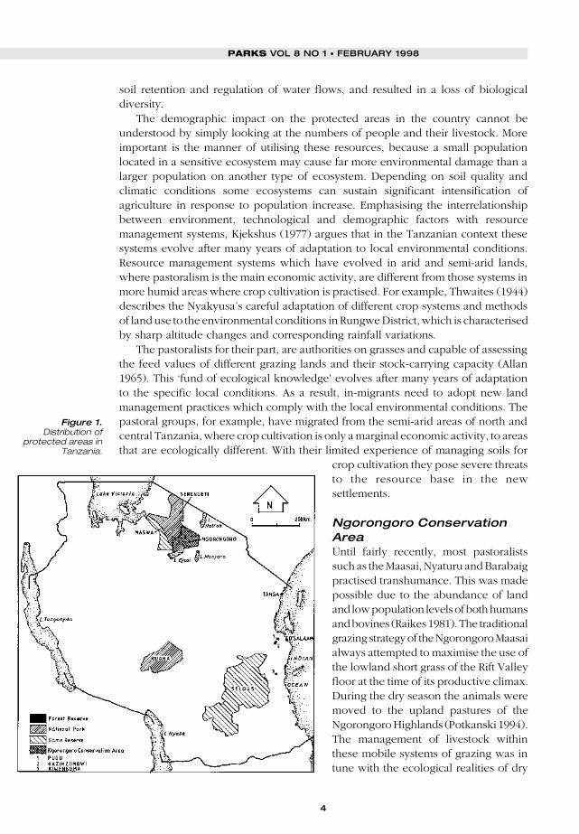
OCATED IN eastern Africa on the Indian Ocean, Tanzania is noted for itsbiological diversity and extensive system of protected areas featuring savanna
grassland ecosystems in the central areas, and tropical moist ecosystems in thenorthern mountains, along the coast and in the south. The country has an area of884,000 km2, which is almost equivalent to the combined territory of France andGermany. Of this land area, 11.5% is under protected status (IUCN categories I–V),which is twice the average percentage for sub-Saharan Africa, but roughly equal tothe percentage under protection in Europe, North America, and Australia (IUCN1994). With its population growth rate of 3% per year, Tanzania is confrontingincreasingly severe resource constraints. At this rate, Tanzania’s population willdouble from 30 million to 60 million by the year 2020 (PRB 1997).
Since the 1970s Tanzania’s protected areas have come under increasing threatfrom a combination of human activities. While natural forces such as prolongeddrought have been identified as major causes of environmental degradation, thereis also a growing realisation that the population dynamics of the surroundingsettlements have had adverse impacts on protected areas. The major population issueis migration, which has more dramatic short-term impacts on the environment. Thisis related, of course, to longer-term phenomena such as natural increase andurbanisation.
Population dynamics and impacts on protectedareasThe human population around most protected areas in Tanzania has, over the years,been changing in terms of its size, density and livelihood strategies. This is notedmostly among the pastoralists who occupy much of the fragile semi-arid parts ofTanzania. However, these changes have also involved cultivators who have beenexpanding their activities into more marginal lands in response to land shortages. Thefragility of the environment and the weakness of the underlying resource base implya limited capability to absorb increased numbers of people.
Population growth has increased the demand for resources such as land forcultivation and grazing, fuel-wood and other forest products, consequently leadingto deforestation and encroachment into the protected areas. The rapid clearance offorest cover has affected the ecological balance and environmental services, such as
Demographic impacts onprotected areas in Tanzaniaand options for action
DAVIS MWAMFUPE
Population growth and internal migration, when coupled with changes in land tenure,is exerting increasing pressure on the environment and natural resources in Tanzania.This paper examines population dynamics affecting seven protected areas, andhighlights factors such as poverty, alienation from land and resources, drought, andlack of local participation in conservation activities that are currently hinderingconservation efforts in the country.
L
DAVIS MWAMFUPE
4
PARKS VOL 8 NO 1 • FEBRUARY 1998
soil retention and regulation of water flows, and resulted in a loss of biologicaldiversity.
The demographic impact on the protected areas in the country cannot beunderstood by simply looking at the numbers of people and their livestock. Moreimportant is the manner of utilising these resources, because a small populationlocated in a sensitive ecosystem may cause far more environmental damage than alarger population on another type of ecosystem. Depending on soil quality andclimatic conditions some ecosystems can sustain significant intensification ofagriculture in response to population increase. Emphasising the interrelationshipbetween environment, technological and demographic factors with resourcemanagement systems, Kjekshus (1977) argues that in the Tanzanian context thesesystems evolve after many years of adaptation to local environmental conditions.Resource management systems which have evolved in arid and semi-arid lands,where pastoralism is the main economic activity, are different from those systems inmore humid areas where crop cultivation is practised. For example, Thwaites (1944)describes the Nyakyusa’s careful adaptation of different crop systems and methodsof land use to the environmental conditions in Rungwe District, which is characterisedby sharp altitude changes and corresponding rainfall variations.
The pastoralists for their part, are authorities on grasses and capable of assessingthe feed values of different grazing lands and their stock-carrying capacity (Allan1965). This ‘fund of ecological knowledge’ evolves after many years of adaptationto the specific local conditions. As a result, in-migrants need to adopt new landmanagement practices which comply with the local environmental conditions. Thepastoral groups, for example, have migrated from the semi-arid areas of north andcentral Tanzania, where crop cultivation is only a marginal economic activity, to areasthat are ecologically different. With their limited experience of managing soils for
crop cultivation they pose severe threatsto the resource base in the newsettlements.
Ngorongoro ConservationAreaUntil fairly recently, most pastoralistssuch as the Maasai, Nyaturu and Barabaigpractised transhumance. This was madepossible due to the abundance of landand low population levels of both humansand bovines (Raikes 1981). The traditionalgrazing strategy of the Ngorongoro Maasaialways attempted to maximise the use ofthe lowland short grass of the Rift Valleyfloor at the time of its productive climax.During the dry season the animals weremoved to the upland pastures of theNgorongoro Highlands (Potkanski 1994).The management of livestock withinthese mobile systems of grazing was intune with the ecological realities of dry
Figure 1.Distribution of
protected areas inTanzania.

5
land areas, where the pattern of rainfall and grazing is subject to high risk andvariability from season to season. Thus, this transhumant grazing made best use ofseasonally variable dry land pastures and was essentially a traditional drought-copingstrategy that had positive implications for the environment (Rugumamu 1989). In thisway land use conflicts between livestock keeping and wildlife were kept to aminimum.
In recent years, the population of the pastoralists living in the settlementssurrounding the Ngorongoro Conservation Area has been growing rapidly in responseto both internal and external factors. For example, the Maasai population in these areashas been growing at the rate of between 2%–3% per annum in the last few decadeslargely due to natural increase and immigration (Homewood and Rogers 1991). Theshortage of water, increase in the number of wildebeest and other ungulates, and theprohibition of burning as a range management tool have resulted in the shrinking ofpastures in much of the Ngorongoro Conservation Area, consequently causing theMaasai to abandon their traditional areas (Potkanski 1994, Nanagi and Lendyl 1996).Pressures on the environment have exacerbated the conflicts between farmers andherders, especially where permanent cultivation has been introduced in areaspreviously used by herders for seasonal migration. A case in point is the colonisationof the Maasai’s traditional land by sedentary tribes such as the Iraqw, the Chagga andothers who are also desperately in search of farming land.
Changes in people’s livelihood strategies in response to land alienation and theworsening environmental conditions is again related to population dynamics. Forexample, traditionally the Ngorongoro Maasai used to satisfy all of their grain needsthrough the sale of livestock and livestock products to their agricultural neighbours.However, the recent incidence of cattle diseases which have befallen the herds duringthe last few years have made cattle numbers fail to keep pace with the humanpopulation. Despite the wide availability of marketed foodstuffs in the NgorongoroConservation Area, the actual access to these agricultural products by manypastoralists is highly limited due to inflated prices and unfavourable terms of tradebetween pastoral and agricultural products. As a result of this, most Maasai householdshave recently also taken up cultivation as an alternative survival strategy. However,this new economic activity also requires land, which is increasingly hard to come by.
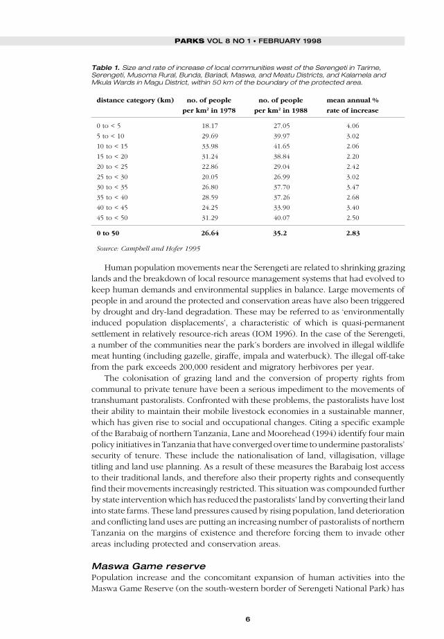
Serengeti National ParkRapid population growth is also observed in the districts west of Serengeti NationalPark, the total population of which reached 1.8 million in 1988 (Campbell and Hofer1995). From 1978 to 1988, the population within 5 km of the park boundary increasedby 4%, while a lower increase was noted in the band extending from 10 to 25 km.During this same period, the overall population density within 50 km of the protectedarea boundary increased from 26.6 to 35.2 persons per km2 (Table 1).
The fact that some of the settlements in the Arusha Region are right on theboundary of the Serengeti protected area means that encroachment throughcultivation, fuel-wood collection, grazing and other activities has become a majorconcern to the management of this protected area. There is a possibility that ruralmigration and the reduction of the human population north-west of the Serengetimight be related to local depletion of wildlife and that high rates of increase in someareas close to the south-western park boundary may be related to the greateravailability of wildlife in areas suitable for hunting (Campbell and Hofer 1995).
DAVIS MWAMFUPE
6
PARKS VOL 8 NO 1 • FEBRUARY 1998
Human population movements near the Serengeti are related to shrinking grazinglands and the breakdown of local resource management systems that had evolved tokeep human demands and environmental supplies in balance. Large movements ofpeople in and around the protected and conservation areas have also been triggeredby drought and dry-land degradation. These may be referred to as ‘environmentallyinduced population displacements’, a characteristic of which is quasi-permanentsettlement in relatively resource-rich areas (IOM 1996). In the case of the Serengeti,a number of the communities near the park’s borders are involved in illegal wildlifemeat hunting (including gazelle, giraffe, impala and waterbuck). The illegal off-takefrom the park exceeds 200,000 resident and migratory herbivores per year.
The colonisation of grazing land and the conversion of property rights fromcommunal to private tenure have been a serious impediment to the movements oftranshumant pastoralists. Confronted with these problems, the pastoralists have losttheir ability to maintain their mobile livestock economies in a sustainable manner,which has given rise to social and occupational changes. Citing a specific exampleof the Barabaig of northern Tanzania, Lane and Moorehead (1994) identify four mainpolicy initiatives in Tanzania that have converged over time to undermine pastoralists’security of tenure. These include the nationalisation of land, villagisation, villagetitling and land use planning. As a result of these measures the Barabaig lost accessto their traditional lands, and therefore also their property rights and consequentlyfind their movements increasingly restricted. This situation was compounded furtherby state intervention which has reduced the pastoralists’ land by converting their landinto state farms. These land pressures caused by rising population, land deteriorationand conflicting land uses are putting an increasing number of pastoralists of northernTanzania on the margins of existence and therefore forcing them to invade otherareas including protected and conservation areas.
Maswa Game reservePopulation increase and the concomitant expansion of human activities into theMaswa Game Reserve (on the south-western border of Serengeti National Park) has
Table 1. Size and rate of increase of local communities west of the Serengeti in Tarime,Serengeti, Musoma Rural, Bunda, Bariadi, Maswa, and Meatu Districts, and Kalamela andMkula Wards in Magu District, within 50 km of the boundary of the protected area.
distance category (km) no. of people no. of people mean annual %
per km2 in 1978 per km2 in 1988 rate of increase
0 to < 5 18.17 27.05 4.06
5 to < 10 29.69 39.97 3.02
10 to < 15 33.98 41.65 2.06
15 to < 20 31.24 38.84 2.20
20 to < 25 22.86 29.04 2.42
25 to < 30 20.05 26.99 3.02
30 to < 35 26.80 37.70 3.47
35 to < 40 28.59 37.26 2.68
40 to < 45 24.25 33.90 3.40
45 to < 50 31.29 40.07 2.50
0 to 50 26.64 35.2 2.83
Source: Campbell and Hofer 1995

7
resulted in land use conflicts between crop cultivation and wildlife conservation. Bycultivating (usually at an extensive scale) right on the edge of the Maswa GameReserve these farms are located in high risk areas, exposed to damage by wildlife.In response farmers feel justified to poach/hunt animals as a protection or defensivemeasure (Serengeti Regional Conservation Strategy 1994).
Ruaha National ParkBesides the short-distance migrations in and around protected areas in the countrythere are notable long-distance migrations of the pastoralists from northern Tanzaniainto the southern parts of the country. The Maasai, Nyaturu and Barabaig have, inthe recent past, migrated into parts of Morogoro Region and Usangu Plains (near theRuaha National Park) in Mbeya Region following the eastern Rift Valley (Mbonile andMwamfupe 1998). Some of these migrants have gone as far as crossing the bordersto neighbouring countries of Zambia and Malawi. These movements have beenprompted by drought and land conversion as mentioned above. In these areas too,pastoralists have been forced to adopt crop cultivation besides livestock keeping.
Migration into the Usangu Plains is not limited to pastoralists, since it has alsoinvolved crop cultivators from Makete and Rungwe districts, which face a criticalshortage of land as a result of population pressure and technological stagnation. Thecultivators who originate from areas that are ecologically different (with plenty ofrainfall almost throughout the year) are moving to an area where rainfall is seasonaland therefore supports different combinations of crops. These people, too, have hadto adopt extensive forms of cultivation and the resulting land use conflicts with theimmigrant pastoralists have pushed some of these crop cultivators into the marginsof the Ruaha National Park with near disastrous results. These include the decline inthe number of kongoni, topi and kudu which are poached for meat, and elephants,rhino and leopards which are killed by commercial poachers.
As a result of the north to south population movements described earlier, seriousconflicts of this nature are to be found in the Usangu Plains of Mbeya region, whereshifting cultivation is spreading and encroaching into the Ruaha National Park (Kikulaet al. 1996). This situation is further compounded by the presence of livestock in thenearby areas, which has also caused increasing competition for resources, contributingto the alarming decline of wildlifepopulations in the area including thecomplete disappearance of some species.
Selous Game ReserveThe land use conflict just discussed is notan isolated case. It is also noted in thesouth-west boundary of the Selous GameReserve in southern Tanzania. Shiftingcultivation in the villages of Kikulyungu,Ndapata, and Barikiwa is in direct conflictwith wildlife from the nearby reserve. Inthese villages, the local farmers complainof animals destroying their crops. On thegrounds that these farmers do not benefitfrom being close to the reserve they feel
DAVIS MWAMFUPE
Cattle grazingoutside a Maasaivillage in Tanzania.Photo: JimThorsell/IUCN.
8
PARKS VOL 8 NO 1 • FEBRUARY 1998
justified to hunt animals in the reserve (Mwamfupe et al. 1989). In effect they arecompensating directly for some of the costs that they have incurred due to cropdamage. Land use conflicts are also noted in the northern boundary of this reserve.The government’s decision to establish the Kisaki and Msolwa villages close to theTanzania Zambia Railway Authority (TAZARA) for the security of the railway stationdid not take into consideration the likely impacts of the settlements on wildlifeconservation. The creation of the Kisaki village took 6,000 hectares of land from thereserve. In 1971 the village had 200 people, this had increased to 2,015 people in1978. The population of Msolwa has grown from 500 people in 1971 to 5,107 in 1988.
Tanga CoastlineAlthough not a protected area, impact of population increase on biologically richareas is also noted for the coral reefs on the north coast of Tanzania, in the regioncalled Tanga (Horrill 1997). Population pressure and demand for fish have contributedto over-fishing, including the use of dynamite on coral reefs for fish extraction. Thisover-exploitation of the fishing grounds is exacerbated by the lack of alternativeincome sources among the people in the areas, although collaborative managementagreements are now successfully diminishing the pressures on the resource.
Pugu and Kazimzumbwi Forest ReservesThe coastal forests of Pugu and Kazimzumbwi Forest Reserves are remnants of aformer area of extensive forest cover belonging to the Zanzibar-inhambane sectionof the Guinea-Congolian Phytogeographical Region (White 1983). These forestreserves are located in the peri-urban zone of the Tanzanian capital, Dar es Salaam.Despite their limited size, these forests are recognised globally as ‘hot spots’ ofspecies diversity and endemism (Howell 1981). For example, of the 190 recognisedforest tree species in the Coast Region, 92 are endemic to the area (White 1983). Apartfrom their biological/botanical significance these coastal forest reserves are also asource of a wide range of valuable forest products, which are vitally important to thelivelihoods of many Tanzanians, particularly of Dar es Salaam and Coast Regions.
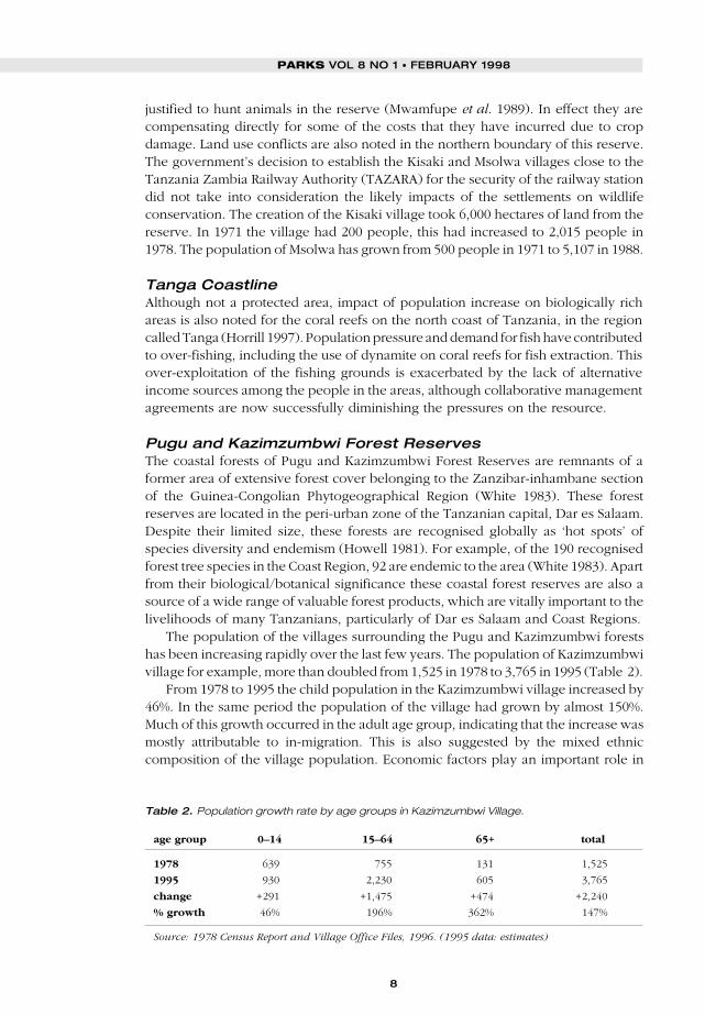
The population of the villages surrounding the Pugu and Kazimzumbwi forestshas been increasing rapidly over the last few years. The population of Kazimzumbwivillage for example, more than doubled from 1,525 in 1978 to 3,765 in 1995 (Table 2).
From 1978 to 1995 the child population in the Kazimzumbwi village increased by46%. In the same period the population of the village had grown by almost 150%.Much of this growth occurred in the adult age group, indicating that the increase wasmostly attributable to in-migration. This is also suggested by the mixed ethniccomposition of the village population. Economic factors play an important role in
Table 2. Population growth rate by age groups in Kazimzumbwi Village.
age group 0–14 15–64 65+ total
1978 639 755 131 1,525
1995 930 2,230 605 3,765
change +291 +1,475 +474 +2,240
% growth 46% 196% 362% 147%
Source: 1978 Census Report and Village Office Files, 1996. (1995 data: estimates)

9
most of these movements. People move into these peri-urban areas in search ofarable land. This is a result of a cycle of migration prompted by economic pressureswhere people first move from rural villages into the urban area of Dar es Salaam insearch of employment, then move out to peri-urban and rural areas to supplementtheir scarce urban incomes with rural farm plots. Due to the increase in populationof these outer villages the density has increased from 37 people per square kilometrein 1967 to 90 persons in 1978 and 120 people per square kilometre in 1988(Mwamfupe 1996).
In recent years Pugu and Kazimzumbwi Forest Reserves have come under threatfrom a combination of urban-induced human activities, mainly agriculture, fuel-wood collection and pole cutting. As human population grows, cultivation andresidential areas have expanded into the forested areas. The remaining areas of theforest are now subjected to unsustainable felling and logging. This situation is soserious that Pugu forest has become one of the most disturbed coastal natural forestsin Tanzania, and is subject to the greatest variety of land-use pressures.
The Pugu and Kazimzumbwi Forest Reserves are surrounded by villages whichare basically rural in character. Nevertheless, because these villages are adjacent (20–30 km) to the rapid expanding city of Dar es Salaam, they are susceptible to urbaninfluences. This influence is in terms of the growing demands for land for cultivation,residence, and the forest products of which charcoal and timber production are mostsignificant. Some villages, especially those on the eastern side of the Pugu ForestReserve, may, in the next five to ten years, be designated as part of urban areas ofthe city.
There is no doubt that the villagers recognise the importance of forests. However,most seem to value these forest more for the direct benefits (consumptive uses) thanthe indirect ones (non-consumptive uses). The ranking of the importance of forestsby the villagers in Pugu and Kazimzumbwi clearly show that “extraction factors” seemto be more prominent than the conservation. Forests as “sources of fuel-wood, timberand charcoal” are ranked as the three most important values of the forests. In contrast,aspects such as “water catchment” and “environment value” are ranked low in thesixth and eighth position respectively.
The dominant economic activities carried out in and around the two forestreserves include brick making, charcoal production, logging, and agriculture.Charcoal production is perhaps the most serious source of pressure on the two ForestReserves. Charcoal is produced for commercial purposes as prompted by the evergrowing demand by urban residents in Dar es Salaam city. Due to the high costs ofalternative energy source such as electricity and kerosene, charcoal has become themajor affordable source of energy (Yanda et al. 1998). Although timber extraction issupposed to be done only on the exotic species and then only by licensed people,this activity is largely uncontrolled. This explains the loss of 24% of the natural forestin the period between 1953 and 1988. Logging done on a commercial scale has apotentially damaging effect on growth potential by removing the young trees.
Cultivation in and around the forest reserves has expanded considerably. Suchexpansion has been at the expense of other forest covers such as natural forests, bushland, and grassland. Much of this agriculture is still shifting cultivation, although signsof intensification are beginning to appear, reflecting a response following an increasein population in the area. The brick and tile factory (located in the Pugu ForestReserve) depends on the forest as a source of firewood, which is normally used in
DAVIS MWAMFUPE

10
PARKS VOL 8 NO 1 • FEBRUARY 1998
the burning process to make the bricks durable. There is also open cast mining ofkaolin carried out within the Pugu Forest Reserve. Kaolin mining threatens the forestreserves because the mining involves a removal of top soil to a depth of 20–30 cm.
The effects of population dynamics are mediated through land use decisions anddemand for resources. Neither in-migration into the villages surrounding the forestreserves nor encroachment of forest land has been controlled. Clearly, the loss ofbiodiversity in the Pugu and Kazimzumbwi forest reserves are largely due topopulation pressure which has forced more people to gain their livelihoods onlimited areas of good land, with resultant resource over-exploitation (Mwalyosi1994).
RecommendationsFollowing the proceeding discussion anumber of questions arise. Why do peopleinvade forests and other protected areas?Are they doing this simply out of greedor malice? Is it for accumulation of wealth?Don’t they know the value of wildlife?Or, are these actions of desperation andthe need to survive? If it is a question oflocal livelihood, can these people beassisted not to encroach into the protectedareas? These are among the basicquestions, answers to which could resultin improved protected areas managementin Tanzania. This calls for a betterunderstanding of the socio-economicenvironment in which these people live,but also the impact of micro-economicpolicies impinging on them.
At the root of the conflicts betweenpopulation dynamics and theenvironment is the squeezing of peoplefrom land on which they used to graze orgrow crops for hundreds of years.Moreover, in some areas population hasbeen growing, but sometimes at pacesfar in excess of the capacity of the landto sustain this growth. Such dynamicshave especially been to the disadvantageof the pastoral communities who lackformal property rights. Their movements,sometimes into protected areas, havebeen prompted by the lack of alternativelivelihoods after being excluded fromland on which they used to earn a living.To some people, encroachment intoprotected areas is an act of desperation.
Maasai tribesman.Photo: Jim
Thorsell/IUCN.

11
Therefore, specific measures need to be taken which focus on and take into accountthe interest of pastoralists.
The socio-economic situation in the lands surrounding the Tanzanian protectedareas is shared by almost all rural communities in the Sub-Saharan Africa. The primefeature of this context is the widespread poverty of the population caused by acombination of harsh climatic conditions, economic problems and populationdynamics. Poverty is not a factor conducive to the conservation of natural resources,since the state of destitution of the population prompts it to exert growing pressureon its environment either by clearing fresh tracts of land, or else by occupyingmarginal land that is not particularly suitable for agriculture or stock raising. Theemphasis on poverty should not obscure the fact that political decisions may alsocontribute to environmental destruction. Thus, it is important to address the problemsof local livelihoods and poverty of communities adjacent to conservation areas aswell as political and institutional factors affecting resource conservation. Enhancingparticipation in natural resource management through collaborative managementagreements is one means by which to increase sustainable use (Borrini-Feyerabend1996).
Local participation involves three main aspects: taking part in design/planning,implementation, and sharing the returns. In practice however, plans are made awayfrom local people and brought to them for implementation. This gives rise to theproblem of excluding the local people in matters concerning the conservation ofwildlife in their localities. In rare cases where this has been done, participation hasmostly been limited to implementation, and does not include involvement in projectdesign and planning. For example, in most agro-forestry projects local people areinvolved in reforestation activities, but have no say in the choice of tree species. Thisignores the fund of knowledge that locals have accumulated on their forests, andresults in poor conservation practice. Similarly, locals know the migration patternsof the animals in the parks. This indigenous knowledge that the local people have,is central to the success of conserving wildlife, and should be tapped. In order toconserve forests and other wildlife and achieve its sustainable utilisation the localcommunity must be involved in all aspects of conservation and there must be anequitable sharing of benefits.
It has become increasingly clear that local people lack commitment to participationin conservation matters. Where there is sabotage it is because they have beenalienated, and do not benefit in any way from these protected areas. More often thannot they disproportionately bear the costs of conservation, while foreign tourists andcommercial enterprises enjoy the benefits. The aptly titled volume Whose Eden?,recently published by IIED (1994), showed that local populations have no incentiveto conserve wildlife from which they gain nothing, and may even lose. This is narratedby one villager living adjacent the Kiwengoma Forest Reserve in Rufiji district:
This is our forest, our ancestral forest, our ancestors’ burial place, we have sacred
places in there ... Today, outsiders harvest timber from our forests, and money is paid
to the district officials but nothing comes to us. Why are we not allowed to use part of
our forests just as the fishermen are doing to rivers in their places? Are you telling us
these forests do not belong to us?
(Mwajabu Nyakingwande – Rufiji district)
DAVIS MWAMFUPE

12
PARKS VOL 8 NO 1 • FEBRUARY 1998
At present the interactions between conservation agencies and localcommunities are generally not good. Perhaps with the exception of timber cuttingwhich is often monopolised by a few licensed business people, there are fewopportunities for local people to benefit from protected forests. Yet the samepeople are expected to bear the conservation tasks such as tree planting andforest patrols, as is the case in the Kiwengoma Forest Reserves in Rufiji district.Therefore, along the lines of the CAMPFIRE programme in Zimbabwe, tourismand legal hunting revenues should be channeled to local development projectsto improve the schools, health facilities or even the roads leading to these villages.In addition, communities should be allowed a sustainable off-take from naturalherds for household consumption.
There is ample evidence to show that most people living around the protectedareas in the country know the importance of wildlife. However, what is lacking is anawareness of the values of protected areas not only for hunting and fuel-woodcollection and other uses, but their biodiversity value too. That is why it is importantto educate people on the wider values of these protected areas. In relation to thisthere also seems to be little recognition of the population/environment linkagesamong the people living around most protected areas. What is needed is a long-termstrategy which involves, for example, inclusion of population and environmentissues in all school curricula.
Communities around protected areas should be assisted in making and adheringto appropriate land use plans and crop husbandry. Enforcement of government lawsand protection by forest guards alone, without involving the people living aroundthe protected areas, is not likely to be sufficient, and it can even be a catalyst forincreased destruction. Viable economic alternatives must be identified to secure thelocal community’s livelihood.
ConclusionPopulation dynamics, particularly in rural areas, have had an impact on the country’sprotected areas. The natural rates of population growth combined with migrationhave led to land use conflicts between agriculture and wildlife. At the root of theseconflicts is the colonisation of grazing land and the conversion of property rights fromcommunal to private tenure. This is partly a reflection of government’s failure toappreciate the impact of macro-economic policies at local levels. For example, thenationalisation of land, and more recently, the conversion of pastoralists’ land intostate farms, have all led to the breakdown of the resource management system, thusputting the pastoralists on a margin of existence. The result is an increasing incursioninto protected areas.
Lack of community participation also hinders conservation. When local peopledo not benefit from conservation, they lack commitment to conservation objectivesand conflict often ensues. Foremost, the local people must know for whom they areconserving the wildlife. With growing population pressure, relations between peopleand the protected areas will only improve when people see direct benefits from theseareas. If these important wildlife habitats are to survive they must be of value to localpeople. Therefore, it is important that there should be a flow of benefits down to thestakeholders. There is also a need to raise people’s awareness on the linkagesbetween population and environmental destruction, and, whenever possible,alternative sources of income should be sought to reduce the pressure on wildlife.
13
Population programmes can address family planning and reproductive health needs,and ultimately reduce population growth rates.
The complexity of conservation matters calls for a more comprehensive approachand cooperation between all government ministries. Conservationists might usefullycollaborate with the ministries for Land and Settlement, Natural Resources andTourism, and Agriculture and Livestock.
ReferencesAllan, W.A. 1965. The African Husbandman. Oliver and Boyd, Edinburgh.Borrini-Feyerabend, G. 1996. Collaborative Management of Protected Areas: Tailoring the Approach
to the Context. IUCN, Gland, Switzerland.Campbell, K., and Hofer, H. 1995. People and Wildlife: Spatial Dynamics and Zones of Interaction.
In: Sinclair, A.R.E., and Arcese, P. (eds.) Serengeti II Dynamics, Management, and Conservationof an Ecosystem. The University of Chicago Press, Chicago and London.
Homewood, K., and Rogers, W.A. 1991. Maasailand Ecology: Pastoralist Development and WildlifeConservation in Ngorongoro. Tanzania. Cambridge University Press, Cambridge, UK.
Horrill, J.C. 1997. Collaborative Fisheries Management in Tanga Region, Tanzania. Case studycommissioned by the IUCN Social Policy Group.
Howell, K.M. 1981. Pugu Forest Reserve: Biological Value and Development. African Journal ofEcology 19.
IIED. 1994. Whose Eden? An Overview of Community Approaches to Wildlife Management.International Institute for Environment and Development, London.
IOM 1996. Environmentally-Induced Population Displacements and Environmental ImpactsResulting from Mass Migrations. International Organization for Migration, United Nations HighCommission for Refugees, and Refugee Policy Group, Geneva, Switzerland.
IUCN. 1994. Guidelines for Protected Area Management Categories. IUCN, Gland, Switzerland.Kikula, I.S, Charnley, S., and Yanda, P. 1996. Ecological Changes in the Usangu Plains and Their
Implications on the Down Stream Flow of the Great Ruaha River in Tanzania. Institute ofResource Assessment Research Report No. 99, New Series, University of Dar es Salaam,Tanzania.
Kjekshus, H. 1977. Ecology Control and Economic Development in East African History. Heinemann,London.
Lane, C., and Moorehead, R. 1994. Who Should Own the Range? New Thinking on PastoralResource Tenure in Dryland Africa. Pastoral Land Tenure Series No. 3. Drylands Programme,IIED.
Le Berre, M., and Messan, L. 1995. The W Region of Niger: Assets and Implications for SustainableDevelopment. Nature and Resources 31(2): 18–31.
Mboni le, M.J., and Mwamfupe, D. 1997. In-migrants and their Impact on LandManagement: A Case of Usangu Plains, Tanzania. Journal of Population Studies andDevelopment 4 (1).
Mwalyosi, R.B. 1994. Managing Biodiversity in Tanzania. Paper presented in the Workshop onProtected Areas, Planning for Biodiversity Conservation in Tanzania. UNO/RAF/GEF. FieldDocument 4.
Mwamfupe, D., Schuler, U., and Lerise, F. 1989. Sustainable Management of Natural Resourcesin the Liwale Buffer zone. Selous Conservation Programme, Discussion Paper No. 10.
Mwamfupe, D. 1996. Impact of Human Population Factors on WWF Project: A Case Study of Puguand Kazimzumbwi Forest Reserves, Coast Region, Tanzania. A consultancy report submittedto WWF Tanzania office – Project No. Tz 0056.
Mwamfupe, D. 1997. A Socio-economic Survey of Villages Surrounding the Namakutwe-Nyamueteand Kiwengoma Forests in Rufiji District, Tanzania. A consultancy report submitted to WWFTanzania Office – Project No. Tz 0057.
Nanagi, E.G., and Lendyl, J.K. 1996. Use and Management of the range resources. A case studyof Olbaibai village in Ngorongoro Conservation Area (NCA). Ngorongoro Pastoralist Programme,Appendix 111, August 1996.
Pimbert, M.P., and Pretty, J.N. 1995. People and Professionals: Putting “Participation” intoProtected Area Management. United Nat ions Research Inst i tute for Socia lDevelopment, International Institute for Environment and Development, and World WideFund for Nature.
Potkanski, T. 1994. Property concepts, herding patterns and management of natural resourcesamong the Ngorongoro and Salei Maasai of Tanzania. Pastoral Land Tenure Series No. 6. IIED,London.
PRB. 1997. 1997 World Population Data Sheet. Population Reference Bureau, Washington, DC.Raikes, P.L. 1981. Livestock Development and Policy in East Africa. Uppsala Scandinavian of
Institute African Studies, pp 254.Rugumamu, W. 1989. Environmental Degradation and Land Conservation Practice in Tanzania.
Paper Presented at the DANIDA/SADET SEMINAR held in Arusha, 19 October 1989.Serengeti Regional Conservation Strategy. 1994. Maswa Game Reserve-General Management
Plan 1994–1998.
DAVIS MWAMFUPE

14
PARKS VOL 8 NO 1 • FEBRUARY 1998
Thwaites, D.H. 1944. Wanyakyusa Agriculture. East African Agricultural Journal 9: 236–239.White, F. 1983. Vegetation Map of Africa – A Descriptive memoir to Accompany the UNESCO/
AETFAT/UNSO.Yanda, P.Z., Shishira, E.K., and Lyimo, J.G. 1998. Human Pressure on Coastal Forests in Tanzania:
The case of Pugu and Kazimzumbwi Forest Reserves and surrounding Areas. Unpublishedmanuscript submitted to Plant Ecology.
Dr Davis Mwamfupe, Lecturer, Department of Geography and Demographic TrainingUnit, University of Dar es Salaam, Tanzania. Email: [email protected].

15
N 1987, the Brundtland Commission published its influential report Our CommonFuture, which firmly established sustainable development on the international
agenda for the 1990s. Among the priorities identified in the report was theconservation of species and ecosystems. “Species and their genetic materials”, theauthors argued, “promise to play an expanding role in development, and a powerfuleconomic rationale is emerging to bolster the ethical, aesthetic, and scientific casesfor preserving them”. This imperative was echoed in the IUCN’s basic policystatement Caring for the Earth (1991), and became the focus of the World ResourceInstitute, The World Conservation Union and the United Nations EnvironmentProgram’s Global Biodiversity Strategy (1992). In these documents a clear ethic ofsustainable development is presented: development has to be both people-centeredand conservation-based. Unless we protect the structure, functions and diversity ofthe world’s natural systems, on which our species and all others depend, developmentwill undermine itself and fail. Unless we use Earth’s resources sustainably andprudently, we will deny people their future. Development must not come at theexpense of other groups or later generations, nor threaten other species’ survival.
These statements reflect a growing concern with environmental conservation.Over the past two decades the concern has taken on an increasing urgency, due inpart to the world’s rapid population growth and economic development. Designatedparks and protected areas have been increasing exponentially (IUCN 1997). We havealso become more knowledgeable about the processes and dangers of speciesextinctions in specific habitats. Along with these moves for conservation, however,has come a relentless growth in people: numbers, production and consumption aregrowing rapidly and are placing heavy pressures on those species and habitats thatwe strive to protect.
A major weakness in our organised abilities to deal with this problem lies indisciplinary specialisation. Population specialists have developed powerful tools and
People and habitatprotection
FRANCES WESTLEY, ULYSSES SEAL, ONNIE BYERS AND GAYL D. NESS
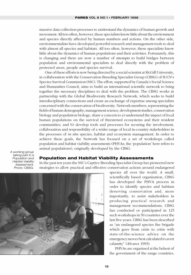
Human population, production and consumption are growing rapidly and are placingheavy pressures on those species and habitats that the conservation community isstriving to protect. A major weakness in our organised abilities to deal with this problemlies in disciplinary specialisation. The Global Biodiversity Research Network, aninternational scientific network, has been developed to bring together the necessarydisciplines of human demography, management science, development studies,conservation biology and population biology, in an effort to a) understand the impactof local human populations on the survival of threatened ecosystems and their residentcommunities, and b) develop tools and processes for securing the involvement,collaboration and responsibility of a wider range of local in-country stakeholders in theprocesses of in situ species, habitat and ecosystem management. One such processis the Population and Habitat Viability Assessment, an inclusive consultation processdesigned to help develop prorities and methods for species and habitat conservation.This paper describes how demographic data can help in the PHVA process, andprovides a case study of a PHVA undertaken in Uganda in 1997.
I
FRANCES WESTLEY, ULYSSES SEAL, ONNIE BYERS AND GAYL D. NESS
16
PARKS VOL 8 NO 1 • FEBRUARY 1998
massive data collection processes to understand the dynamics of human growth andmovement. All too often, however, these specialists know little about the environmentand species directly affected by human numbers and actions. On the other side,environmentalists have developed powerful research and management tools to dealwith almost all species and habitats. All too often, however, these specialists knowlittle about the dynamics of human populations and their activities. Fortunately, thisis changing and there are now a number of attempts to build bridges betweenpopulation and environmental specialists to deal directly with the problem ofprotected areas, people and species survival.
One of these efforts is now being directed by a social scientist at McGill University,in collaboration with the Conservation Breeding Specialist Group (CBSG) of IUCN’sSpecies Survival Commission (SSC). The effort, supported by Canada’s Social Scienceand Humanities Council, aims to build an international scientific network to bringtogether the necessary disciplines to deal with the problem. The CBSG works inpartnership with the Global Biodiversity Research Network, which seeks to buildinterdisciplinary connections and create an exchange of expertise among specialistsconcerned with the conservation of biodiversity. Network members, representing thefields of human demography, management science, development studies, conservationbiology and population biology, share a concern to a) understand the impact of localhuman populations on the survival of threatened ecosystems and their residentcommunities; and b) develop tools and processes for securing the involvement,collaboration and responsibility of a wider range of local in-country stakeholders inthe processes of in situ species, habitat and ecosystem management. In order toachieve these goals, the Network has focused on a set of workshops calledpopulation and habitat viability assessments (PHVAs; the ‘population’ here refers toanimal populations), originally developed by the CBSG.
Population and Habitat Viability AssessmentsIn the past ten years the SSC’s Captive Breeding Specialist Group has pioneered newstrategies to allow practical and effective conservation actions around endangered
species all over the world. A small,scientifically based organisation, CBSGhas developed the PHVA process inorder to identify species and habitatsdeserving conservation and, moreimportantly, to assist stakeholders inproducing practical research andmanagement recommendations. CBSGhas conducted or participated in 125such workshops in 50 countries over thelast five years. CBSG has been describedas “an endangered species fire brigadewhich goes from crisis to crisis withstate-of-the-science advice on theemergency moves best calculated to avertcalamity” (Alvarez 1993).
PHVAs are organised at the behest ofthe government of the range countries,
A working grouptaking part in aPopulation andHabitat Viability
Assessment.Photo: CBSG.

17
and they are designed to encourage equal participation among stakeholders and tominimise power differences. The workshops bring together the full range ofconservation stakeholders – including biologists, wildlife managers, captive breedingspecialists and government officials – who have an interest in conserving andmanaging species in their habitats or the consequences of such management. Onegoal in all workshops is to reach a common understanding of the state of scientificknowledge available and its possible application to the decision-making process andto needed management actions. CBSG has found the policy-driven workshopprocess, with risk characterisation tools, stochastic simulation modelling, scenariotesting, and deliberation among stakeholders, to be a powerful tool for extracting,assembling, and exploring information. During the PHVA process, participants workin small, self-selected groups to discuss these identified issues and each workinggroup produces a brief report on their topic, which is included in the PHVA documentresulting from the meeting.
The workshop centres on a computer simulation called VORTEX to modelextinction scenarios and align stakeholders’ research and action agendas around acommon direction and plan. This process encourages developing a sharedunderstanding across wide boundaries of training and expertise. The tools alsosupport building of working agreements and instill local ownership of the problems,the decisions required, and their management during the workshop process. Asparticipants appreciate the complexity of the problems as a group, they take moreownership of the process as well as the ultimate recommendations made to achieveworkable solutions. This is essential if the management recommendations generatedby the workshops are to succeed.
Frequently, local management agencies, external consultants and local expertshave identified management actions. However, an isolated narrow professionalapproach that focuses primarily on the perceived biological problems seems to havelittle effect on the required political and social changes (social learning) forcollaboration, effective management and conservation of habitat fragments orprotected areas and their species components. The PHVA process provides anobjective environment, expert knowledge, and a neutral facilitation process thatsupports sharing of available information across institutions and stakeholder groups,reaching agreement on the issues and available information, and then making usefuland practical management recommendations for the species and habitat systemunder consideration.
The PHVA process is based upon biological and social science. Effectiveconservation action is best built upon a synthesis of available biological information,but is dependent on actions of humans living within the range of the threatenedspecies as well as established national and international interests. There arecharacteristic patterns of human behaviour that cross disciplinary and culturalboundaries, which affect the processes of communication, problem-solving, andcollaboration: 1) in the acquisition, sharing, and analysis of information; 2) in theperception and characterisation of risk; 3) in the development of trust amongindividuals; and, 4) in ‘territoriality’ (personal, institutional, local, national). Each ofthese has strong emotional components that shape our interactions. Recognition ofthese patterns has been essential in the development of processes to assist peoplein working groups to reach agreement on required conservation actions, collaborationneeded, and to establish new working relationships.
FRANCES WESTLEY, ULYSSES SEAL, ONNIE BYERS AND GAYL D. NESS
18
PARKS VOL 8 NO 1 • FEBRUARY 1998
CBSG participants recognise that the present science is imperfect and thatmanagement policies and actions need to be designed as part of a biological andsocial learning process. The PHVA process essentially provides a means for designingmanagement decisions and programmes on the basis of sound science, whileallowing new information and unexpected events to be used for learning and toadjust management practices.
The basic set of tools for PHVA workshops include small group dynamic skills,explicit use in small groups of problem restatement, divergent thinking sessions,identification of the history and chronology of the problem, causal flow diagramming(elementary systems analysis), matrix methods for qualitative data and expertjudgments, paired and weighted ranking for making comparisons between sites,criteria, and options, utility analysis, and stochastic simulation modelling for singlepopulations and metapopulations.
The workshops produce assessments based upon in-depth analysis of informationon the species’ life history, population dynamics, ecology, and history of thepopulations. Information on population size and characteristics, genetics andenvironmental factors pertinent to assessing population status and risk of extinctionunder current management scenarios and perceived threats are assembled inpreparation for and during the workshops. Modelling and simulations provide aneutral focus for assembly of information, identifying assumptions, projectingpossible outcomes (risks), and examining for internal consistency. Timely reportsfrom the workshop are necessary to have impact on stakeholders and decisionmakers. Draft reports are distributed within four weeks of the workshop and finalreports within 90 days.
A primary output of stochastic modelling is risk assessment and scenarioevaluation. A stochastic population simulation model is a kind of model that attemptsto incorporate the uncertainty, randomness or unpredictability of life history andenvironmental events into the modelling process. Events whose occurrence isuncertain, unpredictable, and random are called stochastic. Most events in ananimal’s life have some level of uncertainty. Similarly, environmental factors, andtheir effect on the population process, are stochastic – they are not completelyrandom, but their effects are predictable within certain limits. There are a host ofreasons why simulation modelling is valuable for the workshop process anddevelopment of management tools. The primary advantage is to simulate scenariosand the impact of numerous variables on the population dynamics and potential forpopulation extinction.
Inclusion of demographic data: past experiencesCBSG has long recognised the value of inclusion of human demographic informationinto the PHVA process. In fact, to varying degrees, this type of social science datawas used to enrich the knowledge base on which management decisions were madein PHVAs for the Javan gibbon and langur, the Thai gibbon, and the Indian rhino(Sengupta and Patnaik 1994, Supriatna et al. 1994, Tunhikorn et al. 1994, Molur et al.1995). In each case, data on human fertility, mortality, migration and attitudes werepresented and used to aid in subjective evaluation of projected land use patterns andhabitat degradation as they concern the long-term management of the species. Thesedata were in some cases collected from local surveys and censuses, but more oftenfrom anecdotal information and personal communications. When data were not
19
available for the area in question, information gathered for a different, yet similar areawas used.
Although “Demproj”, a computer program designed to make demographicprojections, was used in the Javan gibbon and langur PHVA, no attempt was madeto translate this information into data appropriate for use in the VORTEX modellingprocess. Data indicate that population growth in the areas surrounding the habitatof these species continues (despite fertility reductions in some areas), as does in-migration, and places additional pressure on park resources. In addition it was foundthat community participation in park management is essential to the success of anyconservation programme. Recommendations from the human demography workinggroups in these three PHVAs urged cooperation, communication and participatoryplanning among residents, park managers, government agencies and NGOs todiscourage encroachment of the park lands and protected areas these threatenedspecies inhabit.
As yet, however, the workshops have been limited in terms of the inclusionof social science data, such as demographic data, land use data, and cultural andeconomic data, either in the modelling process, or in the planning process. CBSGalso recognises that preservation and protection of natural resources cannot bedone by biologists, social scientists and agency people alone. While thus far theworkshops have been successful in building collaboration between scientists andwildlife managers, non-scientific groups such as local landowners or tribes, grass-roots organisations and the private sector also need to be at the table. Socialscientists have also been under-represented. Workshop designs are urgentlyneeded to provide such inclusion, without compromising the sound sciencewhich is the PHVA signature.
The Global Biodiversity Research Network was designed to be an important stepin that direction, by creating an intensive exchange between social and naturalscientists around such tools and processes. One of the first issues to be confrontedis that of better incorporating human population dynamics into the PHVA process.
The human population: numbers and behaviourThe human impact on species and habitats is a function of both numbers andbehaviour. Numbers have become particularly important with the recent rapidgrowth of population, especially in the less developed regions. In these areas, rapidlygrowing populations with low levels of income and weak government structuresimply heavy pressures on all habitats. In the more developed regions, numbers maybe less important than behaviour, in part because greater government capacities canprovide more effective protection of designated habitats and species.
NumbersDemographic theory and methods provide us with some powerful tools forprojecting population numbers into the future. Projections for the next 10–20 yearsare often quite accurate, largely because birth and death rates tend not to change veryrapidly and the people who will give birth are already here and their numbers andreproductive habits can be fairly well known. There is even good experienceassessing the impact of various diseases, famines, and various forms of health caresupport (like family planning). Populations tend to bounce back relatively quicklyafter widespread epidemics, famines and even wars. More recently, there have been
FRANCES WESTLEY, ULYSSES SEAL, ONNIE BYERS AND GAYL D. NESS

20
PARKS VOL 8 NO 1 • FEBRUARY 1998
very rapid declines in fertility when family planning services are made available (Nessand Golay 1997).
Note, however, that projections of human population size and composition areonly as good as the assumptions upon which they are based. In the case of birthsand deaths, accurate predictions of future trends are relatively easy to make.Migration is quite a different matter. Data are weak, and migration trends are heavilyaffected by opportunities within both sending and receiving areas, making futuretrends difficult to predict. To cope with this uncertainty, alternate projections can bemade based on different scenarios concerning the likely future trends in fertility,mortality and migration. Another caveat relates to the size of the population beingprojected. UN world projections have been accurate to within 1% for the past 40years. But projections made in the 1950s for Latin America overestimated its presentday population by 9%. For individual countries, provinces and districts, projectionsare much more difficult, though not impossible, to make.
Projections allow us not only to learn about the future size of a population, butalso to predict its likely age and sex composition. Rapid population growth will giveus a younger population, including lots of new babies and infants. That meansincreased demands for maternal and child health services, schools and various formsof infant care. It is also possible to project the growth of the ‘young male’ population(ages 15–24), a highly volatile and rapidly growing group in most poor countries. Aswill be seen in the Uganda field experiment (below), young males played a key rolein the breakdown of social order in Rwanda and Eastern Congo, which contributedto habitat loss for the mountain gorilla. Young males are high in energy andtestosterone, and low in judgment, and a sense of the future. They are often foundat the centre of urban or ethnic violence, and in frontier areas of extremeenvironmental degradation. But what these young males actually do depends on theopportunities open to them.
At present there are useful computer programs, such as Demproj, which can beused easily in the field to make future projections. Local census publications will oftencontain counts of people in and around protected areas, from which projections canbe made. These will be more accurate if local informants can provide informationon migration streams. Such projections can provide environmental managers with auseful view of the future pressures they can expect from human numbers.
BehaviourAlthough numbers are important, what people actually do is far more important, and,unfortunately, less easy to assess than are the numbers. There are, however, severalmajor factors affecting behaviour that can be tracked relatively easily, and translatedinto probabilities of population encroachment on the habitat and species.
The first factor is education. Statistics on enrolment levels are generally available,and even at local levels, informants can provide accurate information. Educationusually means a more controlled young population, with increasing levels of skill andproductivity, and possibly greater environmental awareness. Poverty levels are alsoimportant. The poorer the local population, the more dependent they may be onprotected habitats for food, fuel and fodder. Average land holding size may be oneuseful indicator of wealth where figures on income are absent.
Another factor is economic incentives. If there are incentives to clear land ortransform habitat into pasturage, then people will respond to those incentives. Here,
21
national policy measures may be important for removing perverse incentives thataffect conservation objectives. Traditional livelihoods and present-day incentives anddisincentives will likely play a dual role in affecting land use. People who havetraditionally hunted, fished, or cultivated in an area may continue to use practicesthat, while once highly adapted to the local environment, have subsequently becomemaladapted due to changing circumstances of population growth, reductions of landarea available, or combinations thereof.
Ethnic diversity in any region implies a potential for violent disruptions that canhave a devastating impact on the environment, as will be shown in the cases ofRwanda and eastern Congo. Even more important, however, are governmentleadership and policies. Government leaders may either foment and exacerbateethnic violence, or promote greater unity and acceptance.
All these factors affecting behaviour can be identified and specified in the smallarea of any PHVA. They may constitute a useful checklist of questions to put to localinformants who might be contracted or organised to develop a PHVA-specificdatabase for a forthcoming workshop. Some can be included in the modellingactivities as well.
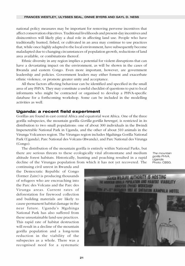
Uganda: a recent field experimentGorillas are found in east central Africa and equatorial west Africa. One of the threegorilla subspecies, the mountain gorilla Gorilla gorilla berengei, is restricted in itsdistribution to two small populations: one of about 300 individuals in the BwindiImpenetrable National Park in Uganda, and the other of about 310 animals in theVirunga Volcanoes region. The Virungas region includes Mgahinga Gorilla NationalPark (Uganda), Parc National des Volcans (Rwanda), and Parc National des Virunga(Congo).
The distribution of the mountain gorilla is entirely within National Parks, butthere are serious threats to these ecologically vital afromontane and mediumaltitude forest habitats. Historically, hunting and poaching resulted in a rapiddecline of the Virungas population from which it has not yet recovered. Thecontinuing civil unrest in Rwanda andthe Democratic Republic of Congo(former Zaire) is producing thousandsof refugees who are encroaching intothe Parc des Volcans and the Parc desVirunga areas. Current rates ofdeforestation for firewood collectionand building materials are likely tocause permanent habitat damage in thenear future. Uganda’s MgahingaNational Park has also suffered fromthese unsustainable land-use practices.This rapid rate of habitat destructionwill result in a decline of the mountaingorilla population and a long-termreduction in the viability of thesubspecies as a whole. There was arecognised need for a systematic
FRANCES WESTLEY, ULYSSES SEAL, ONNIE BYERS AND GAYL D. NESS
The mountaingorilla PHVA,Uganda.Photo: CBSG.

22
PARKS VOL 8 NO 1 • FEBRUARY 1998
evaluation of mountain gorilla population viability and development of a regionalmanagement plan that incorporates the needs of all relevant governmental, non-governmental, public and private stakeholders.
The CBSG, in collaboration with the Primate Specialist Group, was invited by theDirector of Uganda Wildlife Authority (UWA), the Office Rwandais de Tourisme etParcs Nationaux, and the Institut Congolais pour la Conservation de la Nature toconduct a PHVA for the mountain gorilla in December 1997 in Kampala, Uganda.Participants included biologists, researchers, and wildlife managers from Uganda,Congo and Rwanda, and international experts on mountain gorilla populationbiology and ecology. Approximately 52 people participated in the entire five-dayWorkshop. Participants included 26 nationals from the range states. Eighteen peoplewere from protected area authorities and 16 from NGOs active in range management.The NGOs’ long history of international collaboration, as well as the recognition bythe local organisers of the need to bring all available tools to bear on the problemof gorilla conservation, resulted in their willingness to include a wider range ofstakeholders and to incorporate a human demographic element into the PHVAprocess.
Therefore, after two meetings and wide ranging theoretical discussions, theGlobal Biodiversity Research Network seized upon this opportunity to try out atleast one goal of the Network: the inclusion of better human demographic datain the PHVA process. Demographic data for Uganda were available at thenational level. In order to be useful, however, they would need to be combinedwith local knowledge in order to get input on numbers and some behaviours ofpeople in and around the protected area. A list was therefore generated ofindividuals to contact who could help identify sociologists, agricultural economists,demographers, anthropologists and CARE employees at the local level. Once therelevant local expertise was secured, data on human numbers and behaviourwould then have to be linked to a variety of species specific effects (e.g. habitatquality, carrying capacity, etc.) in order to link with VORTEX. This requireddiscussions and communication between the biologists and sociologists at thePHVA.
As Bob Lacy, the VORTEX modeller, pointed out, two translations would berequired: from human to habitat and then habitat to biology. He suggestedparticipants could start with best estimates and then could address uncertainties, withthe value being in the discussion that would take place trying to come up with thenumbers to be inputted. They would also establish which parameters they need tochange in order to ensure survival. In the Ugandan context, it was felt that the DOSversion of VORTEX rather than the newer Windows version would be the best: witha broader group of individuals, the slow entering of parameters would translate intoclearer understanding and greater ownership.
In the weeks leading up to the PHVA, a number of individuals in Uganda andelsewhere were contacted by email in hopes that the Network members could securea broad based representation of social scientists. National level Ugandan data wereobtained from the UN publications, and a graduate student working at McGillUniversity did a library and Internet search, producing a set of documents on theprevalence of AIDS, local demographic trends near the parks (Bwindi in Uganda andVirunga on the border of Rwanda, Congo and Uganda), and the history of institutionalarrangements in these parks where the gorillas lived.

23
The human demographic impactInclusion of human demographic data presented some problems. Network membershad national data and found material in a World Bank report about local populationgrowth as well as in and out migration. However, it quickly became obvious that thiswas not easy to translate into impact, at least in the Bwindi case. Here populationgrowth did not translate into gradual erosion of the protected area. It did seem toincrease three pressures: a) pressure to change national policy (due to local demandsfor more access to park resources) in the event that there was some sort of democraticor local empowerment process in place; b) human-animal conflicts, and c) possiblesabotage (fire, poaching) if benefit-sharing was seen by locals as inadequate (inBwindi a resource sharing scheme was in place and serious incidence of sabotagehad diminished).
Another interesting possibility that the Uganda experience suggested was to workwith human epidemiologists to try to get a measure of the likelihood of increasedhuman population density surrounding parks to translate into increase human toanimal disease transmission. During the PHVA, Network members tried to get thisfigure from the veterinarians present, but they referred the Network to sanitaryengineers or to human epidemiologists. This is something to work on further beforethe next PHVA.
A quite different picture of human population dynamics emerged whenlooking at the social and ecological history of the second park habitat area,Virunga, which lies on the border of Rwanda, Congo and Uganda. There, it waseasier to make estimates about population pressures and ecosystem/habitat/species destruction, because they were so extreme. The area was at the centreof protracted warfare and had suffered accordingly. No government protected theparks and calculations were available of the exact impact of refugees camped onthe border of Virunga, in terms of the amount of wood that was removed fromthe park and the amount of human organic waste dumped in the park as well asthe increased number of animals killed and poached (I-Mage Consult 1997). Twoof these could be turned into a measure of reduction of carrying capacity: rateof deforestation + rate of human consumption of gorilla food (bamboo) =reduction of habitat carrying capacity. Two others could be turned into a measureof mortality: rate of poaching + increased rate of disease transmission throughhuman contamination. Workshop participants experimented with combiningthese two separate equations in a catastrophe scenario and this could bemodelled as occurring at some frequency based on political upheavals in sub-Saharan Africa (say every 10–15 years). It could be modelled as having an initialsevere impact which tapers off to a less severe but continuing impact.
It also became very obvious as working group discussion proceeded that inaddition to figuring out how to model human demographics, the network needed tofind a good way to introduce the impact of resource use on species survival. It wasthought that a resource economist might be of help in this regard. The complexitiesof economic and conservation needs loomed large in a number of working groups,as well as the impact of different revenue generating schemes on the survival of thegorilla and its habitat. A lot of information seemed to be available but discussionswould have benefited from more expertise.
In sum, this first experiment stimulated much thought about how to constructivelymodel the impacts of human population pressures in several scenarios. It also
FRANCES WESTLEY, ULYSSES SEAL, ONNIE BYERS AND GAYL D. NESS

24
PARKS VOL 8 NO 1 • FEBRUARY 1998
suggested, however, the importance of modelling resource use and generation asimportant variables influencing species survival.
Impact of institutional contextNetwork members went to the Uganda situation with the idea that a number ofcontextual factors would affect the success of any conservation initiative. Thesefactors included the presence and strength of government policies on conservation,monitoring of conservation, political stability, and general well being of thepopulation. There was a great deal of information on these variables from publicsources. The Network members were not, however, trying to model these as impacts.Rather, they were interested in whether participants in the workshop seemed to feelthey were important. Governance as an issue attracted a lot of attention and aroseas an important issue in three working groups. All admitted, however, to sufferingfrom an expertise deficit, as there were not enough social scientists present (only onelocal expert) and only one lawyer. Discussions in these groups revealed that therewas the possibility of creating two distinctive scenarios.❚ The catastrophe scenario in which active government does not exist and in whichthe only positive actions were stimulated by the direct intervention of InternationalNon-Governmental Organisations (INGOs) or the collaboration of local park officialswith the INGOs. The only management regime which seemed to offer any hope inthese circumstances was one of protection, and this only worked if armies and parkofficials had a global perspective: i.e., felt that the gorillas were an important resourceto be conserved because of their global significance and importance to internationaltourism and conservation groups. Otherwise deforestation, contamination andrandom killings had the potential to threaten the viability of species survival.❚ The stable government scenario with some empowerment of local populationsin which such schemes as trusts, revenue sharing (from ecotourism) and multiple useof the parks seemed to have fairly positive benefits. Here population pressure wouldnot immediately translate into habitat destruction but over time might result in suddenpolicy shifts which would remove protection. More discussion of how to estimateprobabilities is required.
These two scenarios probably have fairly wide applicability to the developingworld.
On the whole, it appears that information concerning institutional context is fairlyeasy to obtain through journals and Internet sources. The literature search conductedat McGill turned up some very interesting material of good quality. This particularprocess, however, suggested that in addition to the amount and kind of governmentregulation and monitoring, the general well-being of the population and the politicalstability of the regime, the presence and active involvement of INGOs is a criticalcontextual factor, especially in unstable scenarios. In the stable scenarios, thepresence of some kind of resource/revenue sharing regime is also critical ifconservation is to work. It also suggested that the idea of developing some ideal-typical scenarios about institutional context is promising.
Impact of inclusion of expanded stakeholder groupThe Network failed to secure an expanded stakeholder group at the Uganda PHVA.This was due in part to the lack of lead time and in part to lack of awareness of whothose people would be. It became evident that defining the right mix of social and

25
biological scientists and practitioners, and obtaining the cooperation of local peopleby explaining their ‘stake’ in the process, demanded extensive and skilfulcommunication to organisers. Specialists, working in their own discipline, needexpanded definitions of the expertise of other specialists and a clear rationale for theirinclusion. From the Network perspective, the Uganda workshop and our projectcould have benefited from the following experts: a) resource economists, b) naturalresource management (e.g. forestry) experts, c) social anthropologists (with aninterest in conservation), d) demographers, and e) human epidemiologists. Theyshould be contacted early in the planning process and might be identified throughthe IUCN Social Policy Group or a local IUCN office.
Community representation remains a challenge. Network members were told thatincluding representation below the district level would be difficult as people wouldnot have the sophistication to deal with this kind of workshop.
In sum, the Network’s mountain gorilla PHVA experience stimulated a much moredetailed protocol for an expanded process. It is obvious that this workshop wouldhave been strengthened by the addition of this expertise in the room, as many of thegroups regretted its absence. In the case of this species, the biology was fairly wellestablished, and people were eager to deal with some of the social science, economicand management topics.
Adequate expertise is especially important in order to include issues in theworkshop agenda. A topic cannot be forced, either by a facilitator or a group member.It was decided by the end of the workshop that it would probably be a good ideato have a ‘human process modeller’ working side by side with the VORTEX modellerin the modelling group. This person could then try running demographic models oreconomic models and appeal to the working groups for input. The Network memberscould be used for this task. At a bare minimum, the Network members should includea demographer who can run Demproj in every workshop.
At the time of writing, the next Network meeting was scheduled for June 1998 inCanada. Future plans include experimenting with Canadian/North American PHVAs.This will give the Network a chance to compare situations where human populationgrowth is not a driving dynamic to the cases where it is, such as Uganda. The Networkmembers also hope to experiment with the use of Participatory Action Research(PAR) at another developing world PHVA, in order to bring in more local data as wellas stakeholders. The Global Biodiversity Research Network PHVAs are very much awork in process.
ReferencesAlvarez, K. 1993. The Twilight of the Panther. Sarasota, FL: Myakka River Publishing.I-Mage Consult. 1997. Deboisement dans le Parc National des Virunga. Poster of satellite images
produced by UNHCR, European Commission, ADG, and ICCN.IUCN. 1998. 1997 United Nations List of National Parks and Protected Areas. Gland, Switzerland.IUCN. 1991. Caring for the Earth. IUCN/UNEP/WWF, Gland, Switzerland.Molur, S., Sukumar, R., Seal, U., and Walker, S. (eds.). 1995. Population and Habitat Viability
Analysis Report for Great Indian One-horned Rhinoceros. IUCN/SSC Conservation BreedingSpecialist Group: Apple Valley, MN.
Ness, G., and Golay, M. 1997. Population and Strategies for National Sustainable Development.London: Earthscan Publications.
Sengupta, N., and Patnaik, S. 1994. Wildlife Habitat and Adjacent Villages: A Case Study inJaldapara Wildlife Sanctuary, West Bengal. Study conducted for IUCN by DevelopmentAlternatives, New Delhi, India.
Supriatna, J., Tilson, R., Gurmaya, K., Manansang, J., Wardojo, W., Sriyanto, A., Teare, A., Castle,K., and Seal, U. (eds.). 1994. Javan Gibbon and Javan Langur Population and Habitat ViabilityAnalysis Report. IUCN/SSC Conservation Breeding Specialist Group: Apple Valley, MN.
FRANCES WESTLEY, ULYSSES SEAL, ONNIE BYERS AND GAYL D. NESS
26
PARKS VOL 8 NO 1 • FEBRUARY 1998
Tunhikorn, S., Brockelman, W., Tilson, R., Nimmanheminda, U., Rantanakorn, P., Cook, R., Teare,A., Castle, K., and Seal, U. (eds.). 1994. Population and Habitat Viability Analysis Report for ThaiGibbons: Hylobates lar and H. pileatus. IUCN/SSC Conservation Breeding Specialist Group:Apple Valley, MN.
WCED. 1987. Our Common Future. Oxford University Press, Oxford, UK.WR1. 1992. Global Biodiversity Strategy. A Policy Maker’s Guide. A publication of the World
Resource Institute, International Union for the Conservation of Nature and United NationsEnvironmental Protection.
Demproj: This simple demographic projection software is available at no cost from The FuturesGroup International, 1050 17th Street, Washington, DC 20036. Fax: +1 202 775 9694.
Frances Westley is Professor of Strategy at McGill University in Montreal,Canada. Sheteaches, researches and consults in the area of strategies for sustainable development,managing strategic change and strategic leadership. Email:[email protected].
Ulie Seal has served as chairman of the Conservation Breeding Specialist Group(CBSG) since 1979. His areas of expertise include physiology, endocrinology,pharmacology, nutrition, genetics and computer modelling. Ulysses Seal, Chair,IUCN/SSC Conservation Breeding Specialist Group, Apple Valley, Minnesota, USA.
Onnie Byers has a background in both human and animal reproduction and hasbeen a Program Officer with the Conservation Breeding Specialist Group since 1993.Onnie Byers, Program Officer, IUCN/SSC Conservation Breeding Specialist Group,Apple Valley, Minnesota, USA. Email: [email protected].
Gayl D. Ness is professor emeritus of Sociology at the University of Michigan anddirector of a research and training programme, the Population-Environment DynamicsProject. Gayl D. Ness, Department of Sociology, University of Michigan, Ann Arbor,Michigan, USA. Fax: +1 734 763 6887. Email: [email protected].
27
N RECENT years, conservation practitioners have adopted protected areamanagement strategies that attempt to both protect biologically diverse
landscapes and attend to the needs of local people. While the biosphere reserveconcept presented an early model for linking core protected areas with bufferzones and surrounding communities (Batisse 1984), it was not until the early1990s that the so-called integrated conservation and development projects(ICDPs) gained wide currency (Wells and Brandon 1992, Pimbert and Pretty 1995,Larson et al. 1998). In many circles conventional national park managementstrategies were strongly criticised as overly authoritarian. Antagonism betweenpark managers and local communities at times led to violent conflicts. In thewidely cited case surrounding the creation of Kidepo National Park in Uganda,officials forcefully relocated the Ik people and caused irreversible cultural andsocial impacts (West and Brechin 1991).
Integrated conservation and development strategies (ICDPs) emerged in responseto the problems associated with the ‘fences and fines’ approach to protected areamanagement. ICDPs seek to improve social and economic conditions for naturalresource dependent communities while protecting ecologically valuable habitats.Proponents of the ICDP approach reason that local communities will degrade forestsand other areas less if they are organised to take action, have control and access tothe natural resource base, possess adequate information and knowledge, and believethat their economic and social situations will improve (WWF-US 1995). Fundamentalto the ICDP strategy is the notion that by seeking to provide local communities withadequate livelihoods, and by involving them to varying degrees in protected areasmanagement, they will have a greater stake in protecting or sustainably using theresources within the protected area.
Local social and economic development involves a range of activities includingimproved agricultural and animal husbandry practices, income generation opportunities
Towards best practices forpopulation-environmentpartnerships
CARLOS ARAMBURÚ, PETER R. WILSHUSEN AND FRANK D. ZINN
Integrated conservation and development projects (ICDPs) are a widely used approachthat seeks to improve social and economic conditions for natural resource dependentcommunities while protecting ecologically valuable habitats. While such projectsfrequently address income generation, education and health needs of local populations,they often overlook population issues such as family planning and reproductive healthservices. Since 1993, the University of Michigan Population-Environment FellowsProgram has fostered partnerships between conservation and population organisationsin a number of ecologically important areas around the world in order to address locallydefined population concerns. This article presents examples of two such partnershipsfrom Uganda and Brazil. Population-environment partnerships appear to increase trustwith local communities, encourage inter-organisational learning and, in certain cases,economise on scarce resources. Over the long run, these linked interventions maycontribute to population stabilisation around protected areas.
I
CARLOS ARAMBURÚ, PETER R. WILSHUSEN AND FRANK D. ZINN

28
PARKS VOL 8 NO 1 • FEBRUARY 1998
(such as low interest, revolving loanprogrammes), nature-based tourism,health and sanitation improvement, andagro-forestry. Several on-going projectsfrom places such as Costa Rica, India,and Nepal suggest that community-based,participatory management strategies canwork well under certain circumstances(Western et al. 1994). Strong investmentin ICDPs by World Wildlife Fund-US isan indicator of the approach’s prevalenceand importance. In a recent review of theorganisation’s experiences with ICDPs,Larson et al. (1998) state that these typesof projects receive over half of WWF’sfunding.
Compared to economic development and education initiatives, populationactivities such as the provision of reproductive health services have received lessattention in the literature on ICDPs specifically and community-based conservationin general. In the context of this special issue of PARKS, the University of MichiganPopulation-Environment Fellows Program (PEFP) represents an example of aconcerted attempt to join these two fields in and around protected areas wherepopulation pressures appear to be especially acute with respect to the conservationof biological diversity. As a recent report by Population Action Internationalsuggests, community-based population and environment (CBPE) programmesare increasingly prevalent, largely in response to the self-identified needs ofcommunity members, especially women whose role and potential for conservationwork has often been overlooked. The report profiles 42 projects in Latin America,Africa, and Asia where organisations are pursuing both natural resourceconservation and reproductive health activities, including improved access tofamily planning services (Engelman 1998).
This article presents some initial experiences of the University of MichiganPopulation-Environment Fellows Program and explores some key issues that haveemerged for individual Fellows working in the field. The article describes the PEFPand introduces two case studies that explain how Fellows have created bridgesbetween population and environmental organisations in order to establish jointprojects in and around protected areas. It also provides a short discussion of someof the concepts and strategies that the PEFP uses to guide its programme. The articleconcludes with a discussion of some of the key lessons that emerge from the casestudies as well as from conversations held at recent PEFP workshops.
The University of Michigan Population-EnvironmentFellows ProgramThe Population-Environment Fellows Program was established at the University ofMichigan School of Public Health in 1993 with funding from the United States Agencyfor International Development (USAID). The programme offers two-year overseasfellowships to graduates with advanced degrees in areas related to population andenvironment. Applicants to the programme usually have a graduate degree in a
Communitymembers near UnaBiological Reserve,
Brazil, presentingtheir environmental
and healthinitiatives as part of
a Population-Environment
Fellows Programproject to establish
closer linksbetween health
and environmentalorganisations.
Photo: Alex deSherbinin/IUCN.
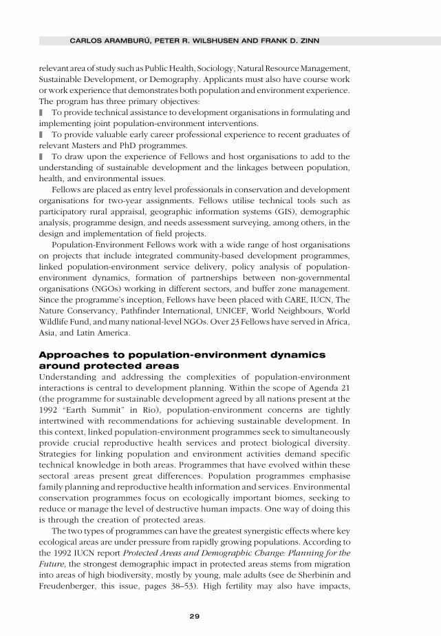
29
relevant area of study such as Public Health, Sociology, Natural Resource Management,Sustainable Development, or Demography. Applicants must also have course workor work experience that demonstrates both population and environment experience.The program has three primary objectives:❚ To provide technical assistance to development organisations in formulating andimplementing joint population-environment interventions.❚ To provide valuable early career professional experience to recent graduates ofrelevant Masters and PhD programmes.❚ To draw upon the experience of Fellows and host organisations to add to theunderstanding of sustainable development and the linkages between population,health, and environmental issues.
Fellows are placed as entry level professionals in conservation and developmentorganisations for two-year assignments. Fellows utilise technical tools such asparticipatory rural appraisal, geographic information systems (GIS), demographicanalysis, programme design, and needs assessment surveying, among others, in thedesign and implementation of field projects.
Population-Environment Fellows work with a wide range of host organisationson projects that include integrated community-based development programmes,linked population-environment service delivery, policy analysis of population-environment dynamics, formation of partnerships between non-governmentalorganisations (NGOs) working in different sectors, and buffer zone management.Since the programme’s inception, Fellows have been placed with CARE, IUCN, TheNature Conservancy, Pathfinder International, UNICEF, World Neighbours, WorldWildlife Fund, and many national-level NGOs. Over 23 Fellows have served in Africa,Asia, and Latin America.
Approaches to population-environment dynamicsaround protected areasUnderstanding and addressing the complexities of population-environmentinteractions is central to development planning. Within the scope of Agenda 21(the programme for sustainable development agreed by all nations present at the1992 “Earth Summit” in Rio), population-environment concerns are tightlyintertwined with recommendations for achieving sustainable development. Inthis context, linked population-environment programmes seek to simultaneouslyprovide crucial reproductive health services and protect biological diversity.Strategies for linking population and environment activities demand specifictechnical knowledge in both areas. Programmes that have evolved within thesesectoral areas present great differences. Population programmes emphasisefamily planning and reproductive health information and services. Environmentalconservation programmes focus on ecologically important biomes, seeking toreduce or manage the level of destructive human impacts. One way of doing thisis through the creation of protected areas.
The two types of programmes can have the greatest synergistic effects where keyecological areas are under pressure from rapidly growing populations. According tothe 1992 IUCN report Protected Areas and Demographic Change: Planning for theFuture, the strongest demographic impact in protected areas stems from migrationinto areas of high biodiversity, mostly by young, male adults (see de Sherbinin andFreudenberger, this issue, pages 38–53). High fertility may also have impacts,
CARLOS ARAMBURÚ, PETER R. WILSHUSEN AND FRANK D. ZINN
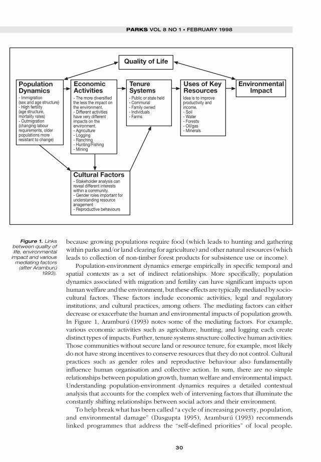
30
PARKS VOL 8 NO 1 • FEBRUARY 1998
because growing populations require food (which leads to hunting and gatheringwithin parks and/or land clearing for agriculture) and other natural resources (whichleads to collection of non-timber forest products for subsistence use or income).
Population-environment dynamics emerge empirically in specific temporal andspatial contexts as a set of indirect relationships. More specifically, populationdynamics associated with migration and fertility can have significant impacts uponhuman welfare and the environment, but these effects are typically mediated by socio-cultural factors. These factors include economic activities, legal and regulatoryinstitutions, and cultural practices, among others. The mediating factors can eitherdecrease or exacerbate the human and environmental impacts of population growth.In Figure 1, Aramburú (1993) notes some of the mediating factors. For example,various economic activities such as agriculture, hunting, and logging each createdistinct types of impacts. Further, tenure systems structure collective human activities.Those communities without secure land or resource tenure, for example, most likelydo not have strong incentives to conserve resources that they do not control. Culturalpractices such as gender roles and reproductive behaviour also fundamentallyinfluence human organisation and collective action. In sum, there are no simplerelationships between population growth, human welfare and environmental impact.Understanding population-environment dynamics requires a detailed contextualanalysis that accounts for the complex web of intervening factors that illuminate theconstantly shifting relationships between social actors and their environment.
To help break what has been called “a cycle of increasing poverty, population,and environmental damage” (Dasgupta 1995), Aramburú (1993) recommendslinked programmes that address the “self-defined priorities” of local people.
Quality of Life
PopulationDynamics
EconomicActivities
EnvironmentalImpact
Cultural Factors
- Immigration(sex and age structure)- High fertility(age structure,mortality rates)- Outmigration(changing labourrequirements, olderpopulations moreresistant to change)
- The more diversifiedthe less the impact onthe environment.- Different activitieshave very differentimpacts on theenvironment.- Agriculture- Logging- Ranching- Hunting/Fishing- Mining
TenureSystems- Public or state held- Communal- Family owned- Individuals- Farms
Uses of KeyResourcesIdea is to improveproductivity andincome.- Soil- Water- Forests- Oil/gas- Minerals
- Stakeholder analysis canreveal different interestswithin a community.- Gender roles important forunderstanding resourceanagement- Reproductive behaviours
Figure 1. Linksbetween quality oflife, environmental
impact and variousmediating factors
(after Aramburú1993).

31
Linked population-environment programmes maintain the specialisations of eachtype of organisation but attempt to join the population, health, environment andother sectors at the local level. Table 1, adapted from Aramburú (1993), identifiesan initial framework for integrating prototypical family planning and conservationprogrammes.
In order to link population and environmental concerns, the PEFP places Fellowswhere they can actively pursue partnerships between organisations or programmatic
Table 1. Towards linked population-environment programmes (after Aramburú 1993).
strategic population integrated conservationist
criteria perspective perspective perspective
1. Programme • Demographic impact Improve quality of life: • Resource conservation
focus • Increased • Income generation • Wildlife preservation
contraceptive through better use of
prevalence natural resources
• Improve health
standards and status of
women
2. Target • Urban, densely • Border area • Located in protected or
population populated rural areas populations ecologically significant
• Low contraceptive • Urban populations areas
prevalence with low health and
sanitation levels
3. Community • Vertical family • Community defines • External prioritisation of
participation planning programme economic and health resources that require
• Reliance on female needs conservation or
voluntary workers • Gender issues protection
approach • No analysis of economic
• Channel programme value of resources to
through local local community
organisations • Actions through male
promoters/guards
4. Technological • Emphasis on • Value and utilise local • Emphasis on
innovation introduction of knowledge related to conservation and
contraceptive methods health and resource protection rather than
• Weak integration with management rational use
other health • “Package” approach • Use of external
interventions knowledge and
technologies
5. Programme • Transfer of costs to • Enhance income • Sanctuary approach
sustainability clients generation and • External patrolling and
• Integration of family economic development control over protected
planning into other • Create local culture areas
services for resource
conservation, sustainable
use, reproductive health
• Community autonomy
and empowerment
CARLOS ARAMBURÚ, PETER R. WILSHUSEN AND FRANK D. ZINN

32
PARKS VOL 8 NO 1 • FEBRUARY 1998
integration within organisations. Partnerships in this context represent collaborativerelationships between two organisations or departments to provide multiple servicesor information to a specified target population. Presumably, partnerships will allowspecialised organisations (or programmes within organisations) to respond topopulation and environmental challenges more comprehensively while minimisingoutlays of technical and financial resources.
Case studies from the Population-EnvironmentFellows ProgramWhen integrated conservation and development projects start up in local communitiessurrounding protected areas, often one of the needs that becomes apparent almostimmediately is health care. This concern is especially voiced by local women whogenerally have a longer-term view of their communities’ needs and problems giventheir concern for the future of their children. PEFP Fellows have facilitatedpartnerships and programme integration to expand the reach of reproductive healthservices into these remote areas. For example, Population-Environment Fellow TomSafford facilitated a working partnership between two Brazilian environmentalorganisations and Pathfinder International to bring needed reproductive healthinformation and services to populations living in and around Grande Sertão VeredasNational Park and Una Biological Reserve. Polly Dolan, a fellow based in Uganda,established a partnership between CARE/Uganda’s conservation project in QueenElizabeth National Park and a USAID-funded reproductive health project in order toexpand both organisations’ reach. These two case studies are discussed below.
Reproductive health services around Grande SertãoVeredas National Park and Una Biological Reserve, BrazilTom Safford was placed with Pathfinder Brazil from September 1995 to September1997. His work helped establish formal working relationships between PathfinderInternational, a family planning organisation, and two local environmental NGOs.The first partnership was established with an organisation known as Funatura(Fundação Pró-Natureza). Based in Brasília, Funatura is the oldest and one of thelargest Brazilian environmental NGOs. Its partnership with Pathfinder has focusedon the provision of health and family planning services to communities living in andaround Grande Sertão Veredas National Park.
The park was established in 1989 and covers 84,000 ha of biologically diverse highplains areas characteristic of the cerrado or mixed savannah biome. Cerradolandscape features veredas or forest patches of spring-fed Mauritania palm trees. Inaddition, it contains areas of dense, thorny vegetation known as caatinga. GrandeSertão Veredas National Park houses many unique and threatened species of plantsand animals including the jaguar, ocelot, maned wolf, pampas deer, and the red andgreen macaw (The Nature Conservancy 1996). Expansion of large-scale soyagriculture presents the single largest threat to this fragile biome.
The partnership between Funatura and Pathfinder-Brazil was established in orderto improve the living conditions of communities in and around the park, specificallyhealth and hygiene standards related to poor service provision and environmentalconditions. Other objectives include: (1) to raise awareness about the linkagesbetween environmental conservation and health issues, (2) to provide familyplanning services and information to communities in the region of the park, (3) to
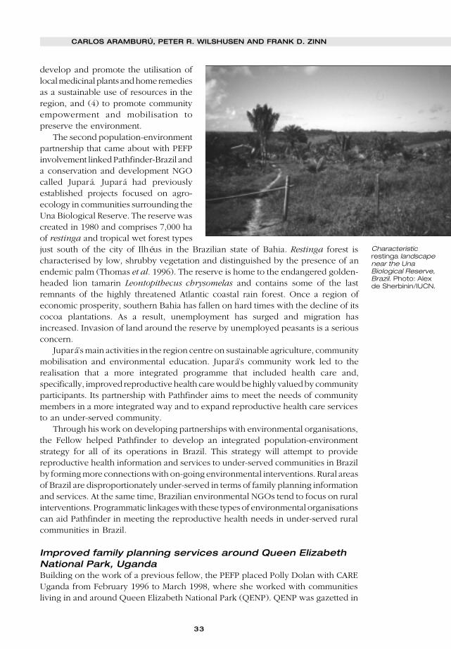
33
develop and promote the utilisation oflocal medicinal plants and home remediesas a sustainable use of resources in theregion, and (4) to promote communityempowerment and mobilisation topreserve the environment.
The second population-environmentpartnership that came about with PEFPinvolvement linked Pathfinder-Brazil anda conservation and development NGOcalled Jupará. Jupará had previouslyestablished projects focused on agro-ecology in communities surrounding theUna Biological Reserve. The reserve wascreated in 1980 and comprises 7,000 haof restinga and tropical wet forest typesjust south of the city of Ilhéus in the Brazilian state of Bahia. Restinga forest ischaracterised by low, shrubby vegetation and distinguished by the presence of anendemic palm (Thomas et al. 1996). The reserve is home to the endangered golden-headed lion tamarin Leontopithecus chrysomelas and contains some of the lastremnants of the highly threatened Atlantic coastal rain forest. Once a region ofeconomic prosperity, southern Bahia has fallen on hard times with the decline of itscocoa plantations. As a result, unemployment has surged and migration hasincreased. Invasion of land around the reserve by unemployed peasants is a seriousconcern.
Jupará’s main activities in the region centre on sustainable agriculture, communitymobilisation and environmental education. Jupará’s community work led to therealisation that a more integrated programme that included health care and,specifically, improved reproductive health care would be highly valued by communityparticipants. Its partnership with Pathfinder aims to meet the needs of communitymembers in a more integrated way and to expand reproductive health care servicesto an under-served community.
Through his work on developing partnerships with environmental organisations,the Fellow helped Pathfinder to develop an integrated population-environmentstrategy for all of its operations in Brazil. This strategy will attempt to providereproductive health information and services to under-served communities in Brazilby forming more connections with on-going environmental interventions. Rural areasof Brazil are disproportionately under-served in terms of family planning informationand services. At the same time, Brazilian environmental NGOs tend to focus on ruralinterventions. Programmatic linkages with these types of environmental organisationscan aid Pathfinder in meeting the reproductive health needs in under-served ruralcommunities in Brazil.
Improved family planning services around Queen ElizabethNational Park, UgandaBuilding on the work of a previous fellow, the PEFP placed Polly Dolan with CAREUganda from February 1996 to March 1998, where she worked with communitiesliving in and around Queen Elizabeth National Park (QENP). QENP was gazetted in
CARLOS ARAMBURÚ, PETER R. WILSHUSEN AND FRANK D. ZINN
Characteristicrestinga landscapenear the UnaBiological Reserve,Brazil. Photo: Alexde Sherbinin/IUCN.

34
PARKS VOL 8 NO 1 • FEBRUARY 1998
1952 and covers 1,978 km2 in Uganda’s Rift Valley. Approximately 25,000 people livewithin the park in ten villages and earn their livelihood fishing on lakes George andEdward. CARE Uganda has worked with a total of 13 villages in and around the parksince January of 1996 in a project called the Queen Elizabeth National Park FishingVillages Conservation Project (QENP-FVC).
The fishing village populations subsist almost entirely on resources found withinthe Park and lakes. Very little agriculture is performed in the villages, and fish is themain staple food. Fishing is also the economic basis for the villages, providing incometo fishermen and in turn to other businesses and service-related enterprises presentin the communities. Both licensed and unlicensed fishermen use unsustainablefishing methods such as undersized nets and destructive ‘beating the water’techniques, and are putting increasing pressure on the fish resource. While collectingresources such as fuel-wood, poles, ambatch (floats) and grass (for thatching) isillegal in all but three of the villages, the communities depend on the Park for theseresources. An unofficial but well-organised system of bribe payments to Park rangersexists, despite efforts by the Park management to eradicate it.
Conflicts between the Park’s management and the fishing village residents haveexisted ever since the Park’s establishment. Conflicts have been mainly related tovillagers’ exploitation of natural resources within the Park, such as poaching, farming,bush burning, cattle grazing, and especially collection of fuel-wood and buildingmaterials. The fishing village communities resent the Park authorities for preventingthem from undertaking activities within the Park boundaries necessary for theirlivelihoods, such as collecting wood for both cooking and fish smoking. Likewise,Park authorities consider the presence of people in the Park to be a threat toconservation.
The goal of CARE’s QENP-FVC project is to improve the livelihood security ofcommunities through ways that support the environmental conservation objectivesof the park management. The project has encouraged conservation throughimproving sustainable access to fuel-wood outside the park, introducing sustainablefish harvesting methods, and bolstering community involvement in resource usepolicy development.
CARE’s interactions with the fishing village communities revealed from thebeginning that an exclusive focus on natural resource management was aninadequate response to the challenges faced by people living in the fishingvillages. The community identified improved health and family planning servicesas pressing needs that should be addressed to strengthen their householdlivelihood and security.
In response to this un-met need, the Fellow identified an opportunity to developa partnership between CARE’s conservation project and the South Rwenzori Diocesefamily planning service delivery project (SRD), a project that is part of a larger USAID-funded programme. The SRD project works in 15 villages, five of which are alsoQENP-FVC project villages. The collaboration between the projects to date hasconsisted of shared training activities, increased sharing of data and information, andjoint household visits by the project’s extension agents when feasible. The collaborationbetween projects has attempted to educate all extension agents and field staff on bothreproductive health and natural resource issues, but has emphasised the importanceof generating referrals to agents trained in a specific area in order to keep workloadsmanageable.
35
CARE has recognised the benefits of linking with SRD because it meets some ofthe expressed needs of the community. In fact, links between CARE field agents andSRD’s community-based family planning distributors have helped to increase thelevel of trust among local communities. SRD has also gained by improving access toreproductive health information among men, a population that had not previouslybeen reached as effectively. Extension agents from CARE’s QENP-FVC project can actas sources of information about reproductive health for men and refer them to SRD’sdistributors for further information or services. While the partnership between thesetwo organisations is still in its nascent stages, the benefits of partnering have beenapparent for both.
Conversely, both CARE and SRD have learned important lessons about theorganisational challenges inherent in partnering. In this case, CARE has greaterorganisational capacity than SRD. Concerns have emerged that one partner might endup carrying greater financial and organisational responsibilities. Additionally, whileCARE has paid its extension agents a small allowance, SRD community-baseddistributors have worked on a voluntary basis. Both organisations have becomeconcerned that this difference might produce contention at the community level.Finally, both CARE and SRD became aware that the extra responsibilities associatedwith the partnership might overburden their respective field staffs. As a result, eachorganisation has opted to maintain the beneficial communication links that thepartnership offers while maintaining their individual specialisations (Dolan 1997).
Initial conclusions regarding linked population-environment programmesA well-formed partnership can ensure that the goals of both a population and anenvironmental organisation are met, not only by using the capacities of bothorganisations to deliver both population and environmental services, but also bystrengthening each organisation’s capacity to meet its goals. An organisation canincrease its capacity by learning from the strengths of the sectoral strategies andapproaches of its partner. Another positive aspect is that partnerships are seen aspowerful approaches in the eyes of communities since they ensure that a broadspectrum of needs are being met.
When entering into a partnership, however, several things must be kept in mind.For instance, partnerships require strong organisational, administrative and strategicplanning commitments. In addition, modes of partnering will differ depending on theobjectives, size, style etc. of the two organisations involved. Organisations consideringpartnering should expect that the sustainability of projects supported by partnershipswill become an important issue.
Population-environment integration in developmentorganisationsPartnering is not the only approach to linking population and the environment. Manydevelopment organisations can implement integrated strategies on their own (i.e.offering services in both population and environment). However, many of the issuesraised regarding partnering still hold, since these organisations may also implementsectoral interventions individually.
Strategies for integrating population and the environment within a singledevelopment organisation can be classified as weak or strong. A weak
CARLOS ARAMBURÚ, PETER R. WILSHUSEN AND FRANK D. ZINN

36
PARKS VOL 8 NO 1 • FEBRUARY 1998
integration strategy might involve only training and service referral activitieswhile a strong integration strategy would additionally involve directly offeringpopulation and environment services. While providing training and servicereferral represents a step in the right direction, this type of strategy does notnecessarily ensure that a community’s needs are being met. This type of strategywould also require that a sectoral organisation be available to provide servicesand accept referrals.
Conservation organisations are becoming increasingly involved in communitydevelopment. Integrated conservation and development projects (ICDPs) tend tofocus primarily on conservation, resource management, and income generatingprojects and often de-emphasise the family planning and reproductive health needsof a community. Where applicable, there is a need to more strongly emphasise in theICDP framework components addressing family planning, as well as family andreproductive health. Conservation programmes have the opportunity to take a leadrole in integrating these services.
Sustainability of linked interventionsSince the Population-Environment Fellows Program is moving out of the pilotproject phase, it has begun to take a systematic look at how to ensure thesustainability of linked population-environment interventions. A project that hasthe long-term commitment of two organisations may be more sustainable, as theresources of both organisations can be utilised to meet the community’s needsand the project’s goals.
Regardless of the model used for linking population and the environment,projects need to secure funding to survive. In addition, sustained funding helps toensure the continuation of projects, as well as the continued motivation oforganisations to achieve their goals through linking population and environment.Sources for long-term funding include, but are not limited to: fees for service, incomegeneration, and linking public and private organisations, to identify both national andlocal sources of funds. Building connections to national organisations, in both thepublic and private sectors, provides projects with potential resources for long-termfunding and also provides projects with the social and political support needed tosustain linked interventions.
By involving the local community in the policy process, organisations can buildsupport for their programmes and improve programme effectiveness. In addition,when a community is able to take over a project from more short-term participantsor is able to implement programmes on its own, projects will become moresustainable.
Indicators of project impactLinked interventions, such as those being undertaken by Population-EnvironmentFellows, are new and thus have begun to develop indicators for evaluating both theirlong and short-term impact. One important impact that integrated or linkedpopulation-environment projects can have is the increased awareness of the goalsand approaches of the various sectors involved in the project. For example,population organisations will have a better understanding of the approaches andgoals of environmental organisations, and vice versa. As a result, these sectoralorganisations can learn from and draw on the strengths of each other.
37
Much of the work that Population-Environment Fellows are undertaking isexperimental. While not all of the strategies will be successful, each one provideslessons to draw on for future attempts at implementing linked interventions as wellas future attempts at attaining long-term population and environmental goals.
ReferencesAramburú, C. 1993. Population and Environment: Perspectives and Propositions. Unpublished
position paper.Batisse, M. 1982. The Biosphere Reserve: A Tool for Environmental Conservation and Management.
Environmental Conservation 9(2): 101–111.Dasgupta, P. 1995. Population, Poverty and the Local Environment. Scientific American. February.Dolan, P. 1997. Population, Poverty and Environmental Degradation: Entry Points for CARE-
Uganda. In Partnering for Sustainability: Experiences of Population-Environment Fellows.Proceedings from the Population-Environment Fellows Workshop, Oaxaca, Mexico, March3–7.
Engelman, R. 1998. Plan and Conserve: A Source Book on Linking Population and EnvironmentalServices in Communities. Population Action International, Washington, DC.
IUCN. 1992. Protected Areas and Demographic Change: Planning for the Future. A WorkingReport. IVth World Congress on National Parks and Protected Areas, Caracas Venezuela.IUCN, Gland.
Larson, P., Freudenberger, M., and Wyckoff-Baird, B. 1998. WWF Integrated Conservation andDevelopment Projects: Ten Lessons from the Field 1985–1996. WWF-US, Washington, DC.
Ness, G.D., Drake, W.D., and Brechin, S.R. 1993. Population-Environment Dynamics: Ideas andObservations. University of Michigan Press, Ann Arbor, MI.
Pimbert, M.P., and Pretty, J.N. 1995. Parks, People, and Professionals: Putting Participation intoProtected Area Management. United Nations Institute for Social Research (UNRISD) DiscussionPaper No. 57. UNRISD, Geneva, Switzerland.
Stem, C. 1997. The Population-Environment Fellows Program: Documenting Results. Population-Environment Fellows Program, University of Michigan, Ann Arbor, MI.
The Nature Conservancy. 1996. The Nature Conservancy and Funatura Protecting the Cerrado:Grande Sertão Veredas National Park. URL:<http://www.tnc.org/infield/intprograms/LATIN_AM/BRAZIL/cerrado.htm>
Thomas, W.W., de Carvalho, A.M., Amorim, A., and Garrison, J. 1996. Preliminary Checklist of theFlora of the Una Biological Reserve. New York Botanical Garden. URL:<http://www.nybg.org/bsci/res/una.html>
Wells, M., and Brandon, K. 1992. People and Parks: Linking Protected Area Management withLocal Communities. The World Bank, Washington, DC.
West, P.C. and Brechin, S.R. (eds.). 1991. Resident Peoples and National Parks: Social Dilemmasand Strategies in International Conservation. University of Arizona Press, Tucson, AZ.
Western, D., Wright, R.M., and Strum, S. (eds.). 1994. Natural Connections: Perspectives inCommunity-based Conservation. Island Press, Washington DC and Covelo, CA.
World Wildlife Fund-US. 1995. What’s In a Name? Integrated Conservation and DevelopmentProjects (ICDPs). Discussion paper of the Social Science and Economics Program preparedfor Workshop I of the ICDP Review: Linking Conservation to Human Needs: Creating EconomicIncentives. WWF-US, Washington, DC.
Carlos Aramburú is an international development consultant based in Lima, andformerly worked with Pathfinder International and WWF-Peru. Avenida delParque 543, Urbanización La Planicie, La Molina, Lima 12, Peru. Email:[email protected].
Peter R. Wilshusen, University of Michigan, School of Natural Resources andEnvironment, 430 E. University, Dana Building, Ann Arbor, MI 48109-1115, USA.Email: [email protected].
Frank D. Zinn, Director, Population Fellows Program, University of Michigan,School of Public Health, Ann Arbor, MI 48109-2029, USA. Email: [email protected].
CARLOS ARAMBURÚ, PETER R. WILSHUSEN AND FRANK D. ZINN
38
PARKS VOL 8 NO 1 • FEBRUARY 1998
ERHAPS THE single biggest demographic issue confronting protected areas inthe developing world is in-migration1. Unlike natural increase (births minus
deaths), which tends to produce slow but steady growth in human populations,migration flows respond very quickly to changed circumstances in both migrantsending and receiving areas. Precisely because many of the factors that influencemigration are outside the control of protected areas managers (or, for that matter,government agencies of any kind), it can often seem an impossible task to managethese flows in ways that diminish the negative impacts on biodiversity. The purposeof this article is to explore the issue of migration in and around protected areasthrough an examination of specific case examples in different ecological anddemographic contexts, and to propose some policy options for dealing moreeffectively and proactively with population movements.
Before addressing the specifics of migration in the protected areas context, it isimportant to understand why people migrate. Here, economic motives reignsupreme. In essence, people are willing to pay the cost of and overcome the barriersto migration because they expect an improvement in well-being. In rare instances,due to poor communication flows between destination and source areas, theexpectation of improved circumstances may not be realised. But, more often than not,migrants do indeed experience tangible benefits from moving, even if the sheernumber of people on the move is resulting in increased competition for jobs, land,and/or resources in destination areas. Non-economic factors influencing migrationflows, such as family reunification or retirement, are typically much less important,particularly in the case of rural-to-rural migrations that characterise most populationmovements in and around protected areas.
Migration researchers speak of ‘push’ factors, which influence people’s decisionsto leave a particular area, and ‘pull’ factors, which influence people’s decisions tosettle in a given area. In the case of migration to protected areas and buffer zones,
1 Although it is somewhat artificial to separate migration from the larger issue of population growth, wedo so here for the purpose of clarity. Evidence suggests that countries with high rates of population growthalso experience high rates of urban-rural and rural-rural migration. Population growth in source areas isone of the factors that can ‘push’ people to migrate to urban and/or frontier areas, as described in thepaper on Tanzania by Mwamfupe, this issue, pages 3–14.
Migration to protectedareas and buffer zones: canwe stem the tide?
ALEX DE SHERBININ AND MARK FREUDENBERGER
Through a series of case examples, this article examines population movements in andaround protected areas, and suggests a series of policy responses at national andlocal levels. These include, among others, policies related to infrastructure andinvestment, land tenure, and access to and management of natural resources. Theauthors conclude that protected areas can benefit from strategic partnershipsbetween conservation NGOs, protected area managers and public policy experts toaddress demographic trends that affect conservation.
P

39
a review of more than 30 case studies has revealed a number of major push and pullfactors, many of which operate simultaneously (see Table 1). In addition to thesefactors, there may be a number of underlying conditions (or intervening obstacles)that facilitate or impede migration into an area. These include, among others,accessibility by land or sea (i.e. the quality and density of the road network, proximityto major water bodies, etc.), the distance from more populated areas, the topography(i.e. mountainous or flat terrain) and communication links (telephone, radio etc.).Often, the development of roads and infrastructure for one purpose, be it logging ortourism, will facilitate migration into that area for other purposes such as cattleranching, cultivation, or resource extraction. In this sense, migrants often followeconomic investments.
Of the ‘push’ factors listed in Table 1, many are outside the control of protectedareas managers. Economic stagnation, land scarcity and resource depletion inmigrant source areas can generally only be dealt with in the areas of origin, andrequire attention from the relevant national authorities, international developmentagencies, and development NGOs. For instance, economic recessions in urban areas,a factor in many African countries, are resulting in an increasing number of urbandwellers who return to their native areas, either permanently or seasonally, to plantcrops for supplemental income. This is increasing pressure on some forest reservesand protected areas, and yet little can be done about it at the local level.
The factors in the ‘pull’ column, by contrast, offer greater scope for local andregional action. The strategies for addressing these pull factors – such as land titling,land use planning, co-management and conditional territorial exclusion – will be
Table 1. Migration to protected areas and buffer zones: ‘push and pull’ factors.
push ➞➞➞➞➞ pull
Scarcity of land and resources in rural areas Availability of land and resources
(due to population pressure, climatic change, (frontier areas, government owned ‘open
degradation, unsustainable use etc.) access’ lands etc.)
Scarcity of employment and economic Existence of economic opportunities (e.g.
opportunities in urban and rural areas development projects, tourism operations),
and, in some cases, proximity to urban areas
Migration as ‘rite of passage’ for young males Any of the above
or females
Civil conflict, tenure conflict, wars, expulsions Relative peace, absence of conflict, safe refuge
Ethnic differences, minority status Ethnic affinities, or lack of traditional ethnic
claims to land/resources
Lack of social services (health facilities, Availability of social services and other
schools etc.) infrastructure
Government resettlement schemes No ‘pull’ factor necessarily present, though
land availability may be a rationale
Any of the above Lack of enforcement and consequent facility of
carrying out illicit activities (e.g. logging, drug
cultivation, gold/diamond extraction etc.)
ALEX DE SHERBININ AND MARK FREUDENBERGER

40
PARKS VOL 8 NO 1 • FEBRUARY 1998
presented in greater detail in the section on policy options. In some cases, solutionswill still reside at higher levels. For example, changing land tenure policies thatfacilitate the conversion of forested areas to private property through land clearingmay require advocacy efforts in the national capital.
The next two sections examine migration issues in different ecological andgeographic contexts. The first addresses frontier migration to tropical forest areas andisland protected areas, the second addresses migration from densely settled anddegraded ecosystems to relatively resource abundant ecosystems. Examples are usedto illustrate the major issues and the actual or potential policy responses.
Frontier migrationMany of the protected areas of highest biodiversity value are located in frontier areasof the developing world; areas that were at one time isolated from population trendsin the heartland by virtue of their remote locations. However, as land and otherresources become scarcer in the more densely settled urban and rural ‘core areas’,there is an increasing tendency for landless poor to migrate to ‘the peripheries’ – i.e.frontier areas. Studies in Costa Rica and the Philippines also demonstrate a strongcorrelation between the economic downturn brought on by the debt crisis of the early1980s and frontier migration (Cruz et al. 1992).
In many countries, governments provide direct and indirect incentives forrelocation to frontier areas. In Indonesia and Zimbabwe these take the form of overtrelocation schemes. In much of Latin America, migration to resource-rich areas canbe characterised as politically expedient, insofar as it postpones the need for landredistribution, siphons off the unemployed, and creates opportunities where fewothers exist. In the case of Costa Rica, Cruz et al. point out that land and resourcepolicies dating from early in this century, when unexploited forest areas were seenas a hindrance to ‘development’, have facilitated present day deforestation and landconversion. Thus, the combination of governments’ laissez-faire attitudes and theeconomic needs of thousands of would-be migrants conspire to induce even furthermigration to frontier areas.
Three case examples illustrate the processes at work in frontier migration. Thefirst is Calakmul Biosphere Reserve (CBR) located in the southern Yucatán Peninsulaof Mexico along the border with Guatemala, and the second is the Dzanga-NdokiNational Park in south-western Central African Republic, sandwiched betweenCongo and Cameroon. These sites have a number of things in common, includingpresence of nearby international borders, trafficking in illicit goods (timber anddiamonds, respectively), large areas of until now unspoiled timber resources, and therelative lack of law enforcement. The third case example, that of the GalapagosIslands, illustrates issues in frontier migration to island protected areas.
The Calakmul Biosphere Reserve of the Yucatán of MexicoThe Calakmul Biosphere Reserve is an important site for biodiversity conservationbecause it constitutes part of a larger system of protected areas known as the La SelvaMaya, which joins Mexico, Guatemala and Belize to form an ecological corridor ofover two million hectares stretching between the central Yucatán and the Belizianforests (Ericson et al. 1998). Established by presidential decree in 1989 and acceptedinto the UNESCO network of biosphere reserves in 1993, the reserve coversapproximately 800,000 ha including core and buffer zones. Although to date no

41
management plan has yet been approved, the general understanding is thatecologically sustainable production activities are allowed within the buffer zonewhile no human activity is permitted within the core zone. Conflicts with localcommunities arise from the fact that the borders of the core zone cut across theterritory of pre-existing communal lands (ejidos) and privately held properties.Indeed, the future of the reserve is compromised by both a steady influx of migrantsinto the core and buffer zones and rapid natural population growth rates in the ejidocommunities surrounding the reserve.
Throughout the region of the Calakmul Biosphere Reserve there are ruins fromPre-Classic and Classic Maya civilisation that attest to the long history of humansettlement. Archaeological discoveries indicate that the Classic Mayans used intensiveagricultural practices and elaborate hydrological works to support substantialpopulation densities. Since the decline of the Classic Maya civilisation (circa AD 950),the southern lowland regions became largely uninhabited. For centuries after theSpanish conquest, the area provided a safe refuge for Mayan resistance. In the early1900s, labourers in the chicle and timber industries first migrated into the region. Dueto the seasonal nature of their work, these relatively few migrants were largelytransient and dependent on fluctuating markets and on available jobs. By the 1970s,ejidal colonists began arriving in the region and continue to arrive today. Thepopulation living around the reserve is now estimated to be about 25,000 people.While population density is only 2.5 persons per square kilometre (including thereserve), the aggregate growth rates of some communities are very high ranging from9% to 23% per year. Some communities are expected to double their population ina mere 3–7 years. Total fertility rates based on government census data show a rangeof 3.9–5.2 births per woman.
The people now living in and around the reserve have been pushed from theirplaces of origin by lack of land, lack of employment, displacement by commercialagriculture, ecological catastrophe, and social unrest, as in the case of Chiapas, inrecent years. They are subject to the pull of available land and the chance to establishnew lives in a relatively unpopulated and still peaceful area. A fourth wave of in-migration, mostly government and service-industry workers, can be anticipated withthe recent establishment of the ecological municipality of Calakmul, the strengtheningof infrastructure, and the developmentof tourism in the region.
While the population density appearsrather low in and around the CalakmulBiosphere Reserve, the ecological impactof the rapidly growing region is profound.Newly arrived settlers clear land in andalong the poorly protected reserve forcash crop production of chillies, destinedfor the urban Mexican and north Americanmarkets. Forests are being converted tofood crop production and then livestockraising. Illegal cutting of high valuetropical forest species in and around thereserve further depletes the resourcebase. At a time when rapid forest
Mayan ruins at theCalakmulBiosphere Reservein the Yucatán ofMexico. Mayanruins are a majorattraction fortourists, and in-migration has beenstimulated by thegrowth of thetourist industry.Photo: MarkFreudenberger/WWF.
ALEX DE SHERBININ AND MARK FREUDENBERGER

42
PARKS VOL 8 NO 1 • FEBRUARY 1998
conversion is occurring, the national and international tourist industry, attracted bythe magnificently restored Mayan ruins, is moving quickly to expand tourist facilitiesthrough construction of access roads to the reserve, a pipeline bringing fresh waterfrom the highlands near the Guatemala border, four-star hotels and an airport nearthe reserve. Migrants are further drawn into the area by the expanded employmentopportunities.
The Dzanga-Ndoki National Park of the Central AfricanRepublicThe rich biodiversity of the central African forests found within the Dzanga-NdokiNational Park of south-western Central African Republic is threatened by an influxof migrant labour drawn by the pull of extensive logging taking place in concessionsin the buffer zones around the reserve and widespread artisanal diamond miningtaking place in the northern buffer zone (Mogba et al. 1996, Mogba and Freudenberger1998). These twin economic engines draw labourers into the region from as far awayas Senegal and Mauritania. The story of the artisanal diamond mining industry isindicative of the role mining plays in frontier areas of the world. Similar stories occurelsewhere with gold mining in the Amazonian forests, sapphire extraction inMadagascar, and gold mining elsewhere in central and southern Africa.
The Central African Republic has long been an exporter of diamonds. Diamondsprovide roughly 60% of the national exports. The precious mineral is located inalluvial deposits along the many streams and rivers of the dense tropical forest areasof the country. The south-western corner of the Central African Republic, where theDzanga-Ndoki National Park is located, is known as a highly productive area fordiamond mining. Throughout the forested regions of the country, diamond miningcamps are found along the stream courses where diamonds have been discovered,often by the BaAka and other ‘pygmy’ populations of the region. No comprehensivecensus has been conducted, but camps range in size from 50 to 4,000 residents.Camps grow and decline rapidly in size in relation to the richness of the diamondfields. Young men and women in these settlements dig into the stream beds and alongthe banks to remove vegetation and top soil until they reach the layer of gravel thatcontains raw diamonds. Craters cut into the soil sometimes reach 5–8 metres in depth.
The area excavated for diamonds oftenresembles a moonscape of craterssurrounded by piles of sterile mud andclay.
The ecological impact of diamondmining is severe on vegetation andwildlife. The extraction of diamonds fromlarge pits destroys habitat along themany streams and rivers and pollutes thewaters. Fish habitats are thus decimatedby mining activities. But most importantlyfor the future of the Dzanga-NdokiNational Park, diamond miningcontributes significantly to wildlifepoaching in both the Special DenseForest Reserve and the national park.
A diamond-minercleaning diamond-
laden gravel, dugup from deep pits
cut into the streambed. Sangha-
Dzanga SpecialDense Forest
Reserve, CentralAfrican Republic.
Photo: MarkFreudenberger/
WWF.
43
Poaching is prevalent because miners pay handsomely for wild meat hunted in thisluxuriant and bountiful tropical forest. Meat from domesticated livestock is generallynot available in local markets because tsetse fly infestation limits the expansion ofgoat and cattle production. Hunters have largely decimated the wildlife fromimmediate areas surrounding the diamond camps. While wildlife populations aremost likely declining around these settlements, forest clearing for agriculture isexpanding. Miners consume prodigious amounts of alcohol fermented from maniocand corn. Women are the main producers of alcoholic beverages and are also theprinciple growers of crops consumed for food and grain-based alcoholic drinks.Using slash and burn techniques, fields are cut out of the dense tropical forest aroundthe major diamond mining settlements. This in turn further degrades the habitats sovital to wildlife.
Galapagos Islands in EcuadorThe Galapagos islands are among the largest, most complex, and most biologicallydiverse archipelagos remaining in the world that are still largely in a pristine condition(MacFarland and Cifuentes 1996). Galapagos National Park, founded in 1959, is oneof the best known national parks in the world. The Galapagos’ natural beauty andimportance for biological research make them a popular destination for tourists fromaround the world. The park’s 60,000 visitors a year generate over $3 million in parkfees and roughly $40 million in tourism dollars, which makes it an important assetfor the national economy. World attention has been recently focused on the wavesof migrants from mainland Ecuador to the Galapagos Islands. In-migration underminesthe IUCN World Heritage Site due to a number of threats linked to the arrival ofworkers on the islands and the unsustainable practices and species they bring.Species are being depleted at an alarming rate due to overfishing, increasedagricultural production, the arrival of goats, pigs, rats and cats as well as theintroduction of fast growing species such as guava and raspberry.
Archaeological evidence clearly indicates that the Galapagos never receivedaboriginal residents. After accidental discovery of the islands by the Spanish in 1535,the islands became the base for a succession of seafarers. The islands were used asanchorages and refuges as well as places to obtain water, firewood, salt, and freshmeat. With the annexation of the islands in 1832 by Ecuador, attempts were madeto colonise the islands. Many attempts were unsuccessful, but by 1900 the populationof the island numbered approximately 600. From 1900 to 1940, the net increase insize of the human population was nearly nil. However, by 1949 population growthbegan to occur, characterised by waves of migrants moving on to the islands afterearthquakes, droughts, and other disasters on the mainland. While populationgrowth in the early 1960s was low, by the 1980s nature tourism began to draw inworkers. Later, booms in the fishing industry drew in further migrants.
The income generated by tourism and fishing booms on the Galapagos hascreated an income differential in relation to the mainland, and government subsidiesto the energy and transport sectors further fuel migration. At 6% per year, the annualgrowth rate on the islands is three times the national average (Fundación Natura andWWF 1998). It is estimated that with the high rate of in-migration, population maydouble every 7–12 years. By 2003, the population of the islands is expected to growto 14,000–20,000. Most migrants come in search of higher wage opportunitiessupplied by the tourist, fishing, service and public sectors. The labour force is highly
ALEX DE SHERBININ AND MARK FREUDENBERGER
44
PARKS VOL 8 NO 1 • FEBRUARY 1998
mobile with much movement between the mainland and the islands occurring. Whilethe precise causes and dynamics of both in-migration and out-migration are not yetfully understood, it is clear that many factors push people to leave the mainland andother factors pull them to new employment and livelihood opportunities on theislands.
As the three case studies described above exemplify, migration is caused by awide range of factors ranging from transformations in the international economyto profound changes in local economies and societies. Tracing back the causesof in-migration to areas of high biodiversity, often located in national parks andother state reserves, requires a multifaceted and historical approach tounderstanding how and why settlement patterns change over time. Lightlypopulated areas are often found along national frontiers or in peripheral locationsin the national economy, yet national governments often exercise little effectiveresource management control over the national parks and other state reservessituated in these remote areas. With growing alarm, conservationists note thatindigenous management regimes are often breaking down because of a lack ofrecognition and protection from the state and the onslaught of newcomers whofail to respect the resource norms and practices of the local peoples. Indeed,frontier areas of high biodiversity are the places where illegal and ecologicallydeleterious resource extraction activities often proliferate because effectiveresource management regimes are lacking.
Migration in degraded environmentsIn many areas of the developing world, subsistence farmers, fishermen andpastoralists are heavily dependent for their survival on a fragile natural resource base.In such ‘constrained ecosystems’ (Agbo et al. 1993), environmental fragility is linkedto periodic drought, poor soils, steep slopes or any combination of the above. Inmany such areas, land and resource degradation have reached such a critical pointthat people are forced to leave their rural areas of origin to seek a better life. The setof destinations is generally limited to three options: other countries (as has occurredfrom Haiti and Mexico to the United States or between countries in Sub-SaharanAfrica), urban areas, and other rural areas. In countries with few, if any, resource richareas, migration to zones that have received some protection status, or in whichecosystems are being rehabilitated, is a promising option. These are the ‘islands ofbiodiversity’ surrounded by seas of human-altered landscapes referred to in theeditorial.
This section will provide examples of protected areas in the African Sahel and theIndian sub-continent that are attracting migrants from resource poor areas, andbriefly outlines actual or potential coping strategies. The Sahel, situated between thehumid tropics and the Saharan desert, is a thinly populated region known for itsfragile soils and periodic drought conditions. Population densities range from 2persons per km2 in Mauritania to 45 in Senegal. In contrast, the Indian sub-continentis graced with more abundant water resources and higher quality soils, and yet thepopulation densities are the world’s highest for largely agrarian societies. India, thedemographic giant, has a density of 326 persons per km2, and Bangladesh has nearlythree times this level. The Sahelian protected areas covered in this section includeW, Pendjari and Waza national parks in Niger, Benin and Cameroon, respectively.
45
The examples from south Asia include Jaladpara Wildlife Refuge in West Bengal,India, and Royal Bardia National Park in Nepal.
W and Pendjari National Parks in Niger and BeninWith over one million hectares straddling Niger, Burkina Faso, and Benin, W NationalPark is one of the largest transfrontier parks in West Africa (Le Berre and Messan1995). The 220,000 ha located in Niger is in the most humid zone, where rainfallaverages 600–800 mm per year. The park contains a remarkable variety of relativelyunspoiled ecosystems, from flood plains and wetlands associated with the NigerRiver, to gallery forests, clear forests, thorn covered savanna and banded vegetation.Due to the annual flooding by the Niger, the park is species-rich, including crocodiles,African and Royal pythons, hippopotamus, African elephant, bushbuck, Cape andRed duiker, and the last surviving individuals of a giraffe sub-species particular toWest Africa. Some of the reptiles and mammals are subject to illegal poaching. Thepark also plays host to 400 bird species that frequent the region during the northernwinter.
Due to the droughts of the 1970s and 1980s, many nomadic pastoralists werepushed from northern Niger to the southern parts of the country and northern Beninin search of pasture. As a consequence of in-migration and natural increase, thepopulation of Say District, of which the park is a part, more than doubled from 74,800to 164,300 people between 1977 and 1987. Demographic trends and changes in parkregulations have led to an adaptation of survival strategies in the area. Villages in thepast that relied primarily on hunting or fishing are turning to agriculture because ofrestrictions on hunting and declining fish stocks. Nomadic pastoralists are tending tosettle down in the area adjacent to the park, practising a mix of agriculture andlivestock raising.
By and large, the local population values the park as a source of natural resources,and do not resent its protected status. High densities of wild herbivores in the parkresult in the movement of surplus animals into surrounding areas, where the localpopulation exploits them through hunting cooperatives, big game hunting, andphoto safaris. The park has resulted in a net gain for local standards of living. Thepark authorities have granted privileged access to local villages for the collection ofpoles, dried palmyra palm fronds, and grass, and for regulated fishing. According toLe Berre and Messan, “these channelled activities represent a source of reciprocalearnings and alert the local people to the need to reserve these markets forthemselves”. This reduces the uncontrolled exploitation of park resources. Currently,the park is under consideration as a Biosphere Reserve, which would increase thecapacity to adopt a bioregional approach to conservation.
Located just 25 km to the south-west, Pendjari National Park in Benin is a studyin contrasts. A strictly protectionist stance has contributed to malnutrition among thelocal population, where natural increase and government sponsored transmigrationschemes have resulted in a dramatic increase in population density over the past 20years. The current density just outside the park is 38 persons per km2, which is threetimes the corresponding level in Niger. The local population is largely alienated fromthe park, gaining nothing from their location on park boundaries, and often losinglivestock to marauding baboons. Agbo et al. suggest that locals might be givenaccess to the park for controlled hunting in order to diversify their diets and generategood will.
ALEX DE SHERBININ AND MARK FREUDENBERGER
46
PARKS VOL 8 NO 1 • FEBRUARY 1998
Waza National Park in CameroonAlso contrasting with W National Park is Waza National Park in northernCameroon, 1,200 km due east (and 800 km north of Dzangha-Ndoki), where theintensity of local resource use is threatening to undermine conservation efforts(Scholte 1997). Situated in the Sudano-Sahelian zone, the park has 170,000 ha offlood plain on the Logone River. It contains populations of large mammals,including elephant, giraffe, hippopotamus, several antelope species, threeprimate species, warthog and predators such as lion and spotted and stripedhyena. In the early 1980s the park was cut off from its water supply due to theMaga dam and associated large-scale irrigated rice perimeters. As the flood plainlost its value for fishing and grazing, many locals migrated out of the area in searchof other opportunities.
Gazetted in 1968, the park was established in an area that had traditionallyreceived nomadic pastoralists and fishermen on an annual basis following floods ofthe Logone river. Since 1994, IUCN’s Waza Logone project has undertaken efforts torestore the ecosystem through controlled inundation of 800,000 hectares of floodplain. These have succeeded to such an extent that conservation objectives arepotentially being undermined by the number of people moving into the area to takeadvantage of abundant fisheries and rejuvenated pasturage. In this case, the primary‘pull’ factor is ecosystem rehabilitation. The population of the villages surroundingthe park edges is increasing at an annual growth rate of 5%, composed of roughly3% in-migration and 2% natural increase. The flooding resulted in a 34% increase insedentary fishermen after 2 years, and the number of pastoral group camps doubledfrom 71 to 150.
One factor that may ultimately limit the influx is a physical feature: villages canonly be built on mounds raised above the flood plain, and these are limited in numberand geographic extent. The Waza Logone project plans to experiment with a policyof ‘social fencing’ that will grant privileged access to park resources to differentcategories of local stakeholders, based on (a) proximity of their territory to the park,(b) traditional use rights (fishermen and pastoralists), and (c) kinship (e.g. descendantsof local people). It is hoped that through this mechanism, village councils and chiefs,whose traditional authority has been eroded in recent years, will be empowered torestrict new settlement in the area.
Jaldapara Wildlife Reserve in West Bengal, IndiaJaldapara Wildlife Reserve is located near the border with Bhutan in the area of WestBengal north of Bangladesh. The Reserve, just 17,200 ha in size, is home to 34endangered Asian Rhinos as well as elephant, leopard, hog deer, sambar, cheetal, andwildboar. Situated around the reserve are 37 villages and eight tea estates with a totalpopulation of 200,000 people (Sengupta and Patnaik 1994). The villagers are heavilydependent on the reserve for a variety of natural resources, including firewood (forlocal consumption and for sale), timber (for construction), cotton floss (to stuff quiltsand pillows), grasses (for thatching and mat production), and grazing areas for theirlivestock. The latter poses serious competition for rhinos and other herbivores in thereserve and is also a potential vector for disease to the wildlife. Owing to thesanctuary’s peculiar ‘wish-bone’ shape, there is virtually no part that is untouched byhuman pressures. On the other hand, wildlife depredation of crops is a problem inmany villages.
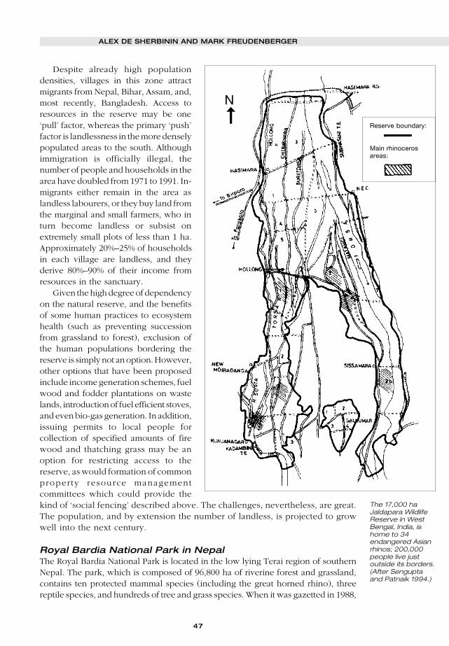
47
Despite already high populationdensities, villages in this zone attractmigrants from Nepal, Bihar, Assam, and,most recently, Bangladesh. Access toresources in the reserve may be one‘pull’ factor, whereas the primary ‘push’factor is landlessness in the more denselypopulated areas to the south. Althoughimmigration is officially illegal, thenumber of people and households in thearea have doubled from 1971 to 1991. In-migrants either remain in the area aslandless labourers, or they buy land fromthe marginal and small farmers, who inturn become landless or subsist onextremely small plots of less than 1 ha.Approximately 20%–25% of householdsin each village are landless, and theyderive 80%–90% of their income fromresources in the sanctuary.
Given the high degree of dependencyon the natural reserve, and the benefitsof some human practices to ecosystemhealth (such as preventing successionfrom grassland to forest), exclusion ofthe human populations bordering thereserve is simply not an option. However,other options that have been proposedinclude income generation schemes, fuelwood and fodder plantations on wastelands, introduction of fuel efficient stoves,and even bio-gas generation. In addition,issuing permits to local people forcollection of specified amounts of firewood and thatching grass may be anoption for restricting access to thereserve, as would formation of commonproperty resource managementcommittees which could provide thekind of ‘social fencing’ described above. The challenges, nevertheless, are great.The population, and by extension the number of landless, is projected to growwell into the next century.
Royal Bardia National Park in NepalThe Royal Bardia National Park is located in the low lying Terai region of southernNepal. The park, which is composed of 96,800 ha of riverine forest and grassland,contains ten protected mammal species (including the great horned rhino), threereptile species, and hundreds of tree and grass species. When it was gazetted in 1988,
N
The 17,000 haJaldapara WildlifeReserve in WestBengal, India, ishome to 34endangered Asianrhinos; 200,000people live justoutside its borders.(After Senguptaand Patnaik 1994.)
Reserve boundary:
Main rhinocerosareas:
➞
ALEX DE SHERBININ AND MARK FREUDENBERGER

48
PARKS VOL 8 NO 1 • FEBRUARY 1998
the park displaced 1,500 families, which together with bans on hunting and fishinghave been the source of intense people-park conflicts (WWF-UK 1998). In recentyears the park has faced a number of challenges emanating from the arrival of peoplefrom neighbouring hill districts and expansion of development activities along itsperiphery. About 345,000 people live around the park, and the population is growingat 3.5% per year. Since 1971, the population density surrounding the park has morethan tripled, from 50 to 170 persons per km2. Illegal encroachment for collection offire wood, timber and fodder has been rampant.
A WWF project is seeking to ease conflicts by introducing community developmentprojects such as income generation and health care. Furthermore, the project ismonitoring population trends, including information on age and sex distribution,with the aim of developing more gender-sensitive approaches to conservation. Suchmonitoring systems can also provide vital information on migration trends that wouldhelp as government agencies consider policy responses to the influx in this regionof high biodiversity.
These five cases clearly demonstrate the pressures to which protected areas aresubjected in heavily degraded landscapes where human needs are great. In southAsia, the pressures on habitat are so great that they may eventually lead to the localextinction of endangered species. In all cases, it seems imperative to increasecommunity involvement in and commitment to protected area and natural resourcesmanagement (a topic covered below). Various kinds of ‘social fencing’ are alsoimportant elements in strategies to keep these islands of biodiversity from graduallysinking into the surrounding sea.
Policy optionsAs these cases demonstrate, influencing the direction and magnitude of populationmovements to buffer zones and protected areas is not an easy matter. As onedemographer noted, “of all population problems, those of migration appear the mostintractable” (Ness and Golay 1997). While public policy and programmatic responsesmust occur at multiple levels and among a wide array of actors, the success storiesare few and far between. The root causes of migration must often be addressed,though these are often politically difficult measures to enact. For instance, in-migration around the Calakmul Biosphere Reserve in Mexico might be slowed ifnational policies and programmes were put in place to resolve civil conflict in thestate of Chiapas, a factor that forces residents to flee to other parts of the country.Concurrently, national subsidies for chilli, maize, and livestock production wouldneed to be reduced – a politically difficult choice to make. In Ecuador, nationallegislation has been passed to control the flow of migrants to the Galapagos islands.But so long as public subsidies to the energy and transport sector continue, migrantswill most likely find it financially beneficial to settle on the islands. In both theGalapagos islands and in the diamond mining areas of the Central Africa Republic,migrants will always be lured by promises of employment in the boominginternationally linked extractive industries, while in Niger preventing north-to-southmigration of pastoralists is practically impossible in light of the repeated droughts thathave struck the entire Sahel.
The responses to the ecological and social impacts of in-migration that may bethe most promising are those that promote community-based conservation. Covenants
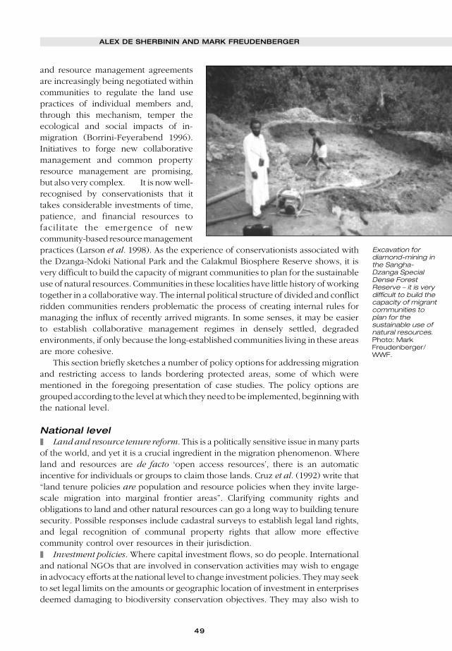
49
and resource management agreementsare increasingly being negotiated withincommunities to regulate the land usepractices of individual members and,through this mechanism, temper theecological and social impacts of in-migration (Borrini-Feyerabend 1996).Initiatives to forge new collaborativemanagement and common propertyresource management are promising,but also very complex. It is now well-recognised by conservationists that ittakes considerable investments of time,patience, and financial resources tofacilitate the emergence of newcommunity-based resource managementpractices (Larson et al. 1998). As the experience of conservationists associated withthe Dzanga-Ndoki National Park and the Calakmul Biosphere Reserve shows, it isvery difficult to build the capacity of migrant communities to plan for the sustainableuse of natural resources. Communities in these localities have little history of workingtogether in a collaborative way. The internal political structure of divided and conflictridden communities renders problematic the process of creating internal rules formanaging the influx of recently arrived migrants. In some senses, it may be easierto establish collaborative management regimes in densely settled, degradedenvironments, if only because the long-established communities living in these areasare more cohesive.
This section briefly sketches a number of policy options for addressing migrationand restricting access to lands bordering protected areas, some of which werementioned in the foregoing presentation of case studies. The policy options aregrouped according to the level at which they need to be implemented, beginning withthe national level.
National level❚ Land and resource tenure reform. This is a politically sensitive issue in many partsof the world, and yet it is a crucial ingredient in the migration phenomenon. Whereland and resources are de facto ‘open access resources’, there is an automaticincentive for individuals or groups to claim those lands. Cruz et al. (1992) write that“land tenure policies are population and resource policies when they invite large-scale migration into marginal frontier areas”. Clarifying community rights andobligations to land and other natural resources can go a long way to building tenuresecurity. Possible responses include cadastral surveys to establish legal land rights,and legal recognition of communal property rights that allow more effectivecommunity control over resources in their jurisdiction.❚ Investment policies. Where capital investment flows, so do people. Internationaland national NGOs that are involved in conservation activities may wish to engagein advocacy efforts at the national level to change investment policies. They may seekto set legal limits on the amounts or geographic location of investment in enterprisesdeemed damaging to biodiversity conservation objectives. They may also wish to
Excavation fordiamond-mining inthe Sangha-Dzanga SpecialDense ForestReserve – it is verydifficult to build thecapacity of migrantcommunities toplan for thesustainable use ofnatural resources.Photo: MarkFreudenberger/WWF.
ALEX DE SHERBININ AND MARK FREUDENBERGER
50
PARKS VOL 8 NO 1 • FEBRUARY 1998
reform outdated agricultural and forestry policies that provide incentives for landclearing and frontier migration.❚ Migration policy. Aside from authoritarian regimes, very few countries havesucceeded in controlling population flows to any significant degree. Nevertheless,if the political will around biodiversity conservation exists (see the last point below),policy makers will increasingly be forced to confront the ethical and legalcontroversies surrounding tools to reduce access of populations from one area of acountry to resources in another. Long-term residents of some localities, likeindigenous groups in South America, are indeed taking matters in their own handsby restricting access by outsiders to traditional lands. Legal recognition of native landsis increasingly part of the public policy arsenal in many Latin American countries.Pressures will grow to construct mechanisms to control settlement in ecologicallysensitive zones.❚ Administrative practice. Internal administrative policies often shape the flow ofpopulation movements. Administrative restrictions attached to oil or lumber concessionscan do much to alleviate the impact of in-migration. By encouraging oil companies,for instance, to limit the size and ecological ‘footprint’ of labour camps in ecologicallysensitive areas, great strides can be made to limit incentives for in-migration.❚ Stronger political support for protected areas. In the absence of strong support forconservation objectives, it is very difficult to establish ‘macro’ policies that addresstrends in migration and investment. Thus, building political support may beconsidered the linchpin for the efforts outlined above. One potential strategy wouldbe to conduct tours of protected areas for political leaders to educate them on theimportance of the ecosystems (beyond their ‘scenic’ value) and the ecological andsocial impacts of in-migration. Mapping demographic trends and modelling populationgrowth scenarios – tools which have been used in the population field for many years– are compelling ways of opening decision-makers’ eyes to the value of biodiversityand ecosystem services.
Protected area level❚ Collaborative management of protected areas. Collaborative managementarrangements increase local peoples’ stake in conserving natural resources, andtherefore should be seen as a key strategy in almost any context (Borrini-Feyerabend1996). Establishing agreements requires extensive negotiations, but can yieldtremendous benefits, not least of which is greater assistance with enforcement ofpoaching, grazing and other restrictions. Numerous studies have confirmed that, inthe face of rising demographic pressures, real protection can only be achievedthrough the involvement of local populations in management decision-making andactivities.❚ Land zonation and enforcement. Governments play an important role in creatingthe regulatory framework for effective land use planning. Creating officiallyrecognised buffer zones with restrictions on land use practices in those zones isanother option. While buffer zones exist around many protected areas, restrictionson land uses might limit the numbers of settlers allowed to arrive in an area in anygiven year or severely sanction agricultural practices deemed ecologically unsound.Such measures would require political support and collaboration between relevantgovernment authorities (local and national) and local populations. Such an optionnecessitates an effective presence of the state in and around protected areas.

51
❚ Community-based conservation and development. ICDPs have sometimes beencriticised for attracting migration (Salafsky 1994, Scholte 1997), but the evidence isincomplete. Extension of health and education services and development ofalternative income generation strategies that are less resource intensive can meetboth humanitarian and conservation objectives. Yet, conservationists need tomonitor carefully further whether there is a linkage between the provision of publicservices and in-migration.❚ Infrastructure. The construction of roads into areas of high biodiversity appearsto be one of the central incentives for in-migration. In tropical areas of Asia, Africa,and Latin America, the evidence is now quite clear that roads constructed into denseforested areas facilitate greatly the movement of rural peoples. The relationshipbetween road construction, land use changes in areas of high biodiversity, and in-migration needs to be continually monitored. Unless sound land use planningpractices accompany road construction into areas of high biodiversity, conservationobjectives may be seriously undermined.❚ Population monitoring. The collection of baseline data on population size,composition and distribution around protected areas, and periodically monitoringincreases, can be of considerable use for conservation planning and managementpurposes. If conservation staff lack the necessary experience, or if it is politicallysensitive, then university demography departments or government census bureauxmay be able to collect the necessary data. Local populations should nevertheless beencouraged through the use of participatory applied research techniques to monitorand consider the dynamics and causes of population growth rates within their owncommunities (Barton et al. 1997). Such participatory techniques can also helpconservation staff to better appreciate the historical dynamics of populationmovements, which is a first step in understanding the motivations and rationales ofmigrants and, ultimately, in resolving conflicts that may exist.❚ Increase regulatory presence. This consists primarily of enforcing park regulationsso as to discourage illegal activities, thereby reducing incentives for people to moveinto protected areas.
Village level❚ Conditional territorial exclusion. Co-management of natural resources entails theestablishment of agreements between government and local resource users to limitresource extraction to ecologically sustainable levels. At the local level, this impliesthe adoption of a ‘conditional exclusion’ strategy whereby long-term residents aregranted the authority to establish rules, or tenure agreements, to limit entry into acommunity unless appropriate behaviours toward natural resources and the communityare observed. As described in the W and Waza Logone case examples, someconservation projects are granting privileged access to resources to ‘locals’ and thosewith traditional use rights. As with collaborative management arrangements, it isassumed that long-term local residents will have a stake in maintaining the protectedarea resources, and will be more likely to be opposed to further migration into theareas.❚ Land use planning. Local level land use planning entails the creation andenforcement of rules, obligations and sanctions by community organisations todetermine the present and future uses of natural resources. Considerable experiencenow exists of the possibilities and challenges of community-based land use planning
ALEX DE SHERBININ AND MARK FREUDENBERGER

52
PARKS VOL 8 NO 1 • FEBRUARY 1998
(Borrini-Feyerabend and Buchan 1997). Community land use planning is thefoundation for effective actions to combat the social and ecological consequences ofin-migration to areas of high biodiversity. Unless rural communities construct thecovenants and agreements to sanction inappropriate uses of natural resources foundwithin the territorial boundaries of the community, little hope exists to respond toin-migration. Many types of participatory research and planning methods, such asworking with communities to imagine ‘alternate futures’, are useful for this kind oflocal-level planning (Barton et al. 1997).
ConclusionsAs can be seen from the collection of case studies and the policy section above, thereare very few ‘recipes’ for managing population flows in and around protected areas.Designing public policies and programmes is particularly difficult in frontier areas inlight of the institutional vacuums generally existing in these areas. Success, asevaluated from a conservation perspective, is rare. Nevertheless, there is a real needto develop more tools and to learn from successful experiences. While efforts to stemthe tide of in-migration to areas of high biodiversity are required at the national andinternational scale, these measures can be very politically difficult to implement. Fewpolicy makers in the national and international economic and political spheres havean interest in reducing or mitigating labour flows both within countries and betweennations. Conservationists may have few choices but to consider ways to mitigate theimpacts of migration flows at the local level.
Until very recently, conservation organisations and government agencies chargedwith protected areas management have seen issues such as land tenure reform, landuse planning and investment policies as outside their purview. The concern was withwhat went on inside the park, not on its borders, much less regions hundreds ofkilometres away. With increasing population and economic development pressuresaround protected areas, such an isolationist stance is no longer tenable. Conservationorganisations and protected area managers must begin to work with public policyexperts to identify key policy levers at national and local levels that will promoteconservation objectives like those of responding to the emerging threats of humanin-migration to protected areas. Once these policy measures are identified, internationaland national conservation NGOs can either advocate for their implementation at thenational and international level, or seek funding from government and donors for thenecessary work at the local level.
ReferencesAgbo, V., Sokpon, N., Hough, J., and West, P. 1993. Population-Environment in a Constrained
Ecosystem in Northern Benin. In: Ness, G., Drake, W., and Brechin, S. (eds.). Population-Environment Dynamics: Ideas and Observations. 283–300. University of Michigan Press, AnnArbor, MI.
Barton, T., Borrini-Feyerabend, G., de Sherbinin, A., and Warren, P. 1997. Our People, OurResources. IUCN and UNFPA, Gland, Switzerland.
Borrini-Feyerabend, G., and Buchan, D. (eds.). 1997. Beyond Fences: Seeking Social Sustainabilityin Conservation. Volumes I and II. IUCN, Gland, Switzerland.
Borrini-Feyerabend, G. 1996. Collaborative Management of Protected Areas: Tailoring the Approachto the Context. IUCN, Gland, Switzerland.
Cruz, M.C., Meyer, C.A., Repetto, R., and Woodward, R. 1992. Population Growth, Poverty, andEnvironmental Stress: Frontier Migration in the Philippines and Costa Rica. World ResourcesInstitute, Washington, DC.
Ericson, J., Boege, E., Freudenberger, M.S. 1998. Population Dynamics, Migration, and the Futureof the Calakmul Biosphere Reserve. Paper presented to the Latin American Regional Meetingon Population and the Environment, March 1997, US National Academy of Sciences, International

53
Institute for Applied Systems Analysis, and the Centro de Investigación y Estudios Avanzados,Merida, Yucatan.
Fundación Natura and WWF. 1998. The Galapagos Report, 1996–1997. Fundación Natura and theWorld Wide Fund for Nature, Quito, Ecuador.
Larson, P., Freudenberger, M., and Wyckoff-Baird, B. 1998. WWF Integrated Conservation andDevelopment Projects: Ten Lessons from the Field, World Wildlife Fund, Washington, DC.
Le Berre, M., and Messan, L. 1995. The W Region of Niger: Assets and Implications for SustainableDevelopment. Nature & Resources 31(2): 18–31.
MacFarland, C., and Cifuentes, M. 1996. Case Study: Ecuador. In: V. Dompka (ed.). HumanPopulation, Biodiversity and Protected Areas: Science and Policy Issues. 135–188. AmericanAssociation for the Advancement of Science, Washington DC.
Mogba, Z., and Freudenberger, M. 1998. Les Migrations dans les aires protégées de l’AfriqueCentrale: Le Cas du Réserve Spéciale de Dzanga-Sangha. World Wildlife Fund. Social Scienceand Economics Program.
Mogba, Z., Freudenberger, M., Zana, H., and Missosso, M. 1996. Migrations humaines et leursimpacts sur la conservation des ressources naturelles dans la réserve de Dzanga-Sangha:Etude de cas de l’économie de diamant à Ndélengué, République Centreafricaine. WorldWildlife Fund, Social Science and Economics Program.
Ness, G., and Golay, M. 1997. Population and Strategies for National Sustainable Development: AGuide to Assist National Policy Makers in Linking Population and Environment in Strategies forSustainable Development. London: Earthscan Publications Ltd.
Salafsky, N. 1994. Ecological Limits and Opportunities for Community-based Conservation. In:Western, D., Wright, R.M., and Strum, S. (eds.). Natural Connections. 448–471. Island Press,Washington, DC.
Scholte, P. 1997. Immigration, a Potential Time Bomb under the Integration of Conservation andDevelopment. Unpublished paper.
Sengupta, N., and Patnaik, S. 1994. Wildlife Habitat and Adjacent Villages: A Case Study inJaldapara Wildlife Sanctuary, West Bengal. Study conducted for IUCN by DevelopmentAlternatives, New Delhi, India.
Thorsell, J., and Sigaty, T. 1998. Human Populations in World Heritage Natural Sites: A GlobalInventory. A contribution to the Global Theme Study of World Heritage Natural Sites, Part I ofWorking Paper 5, IUCN, Gland, Switzerland.
WWF-UK. 1998. Do Numbers Matter? Population Impacts on Environmental Projects. WWF-UK,Godalming, UK.
Alex de Sherbinin is a Population-Environment Fellow with the Social Policy Group,IUCN, Rue Mauverney 28, CH-1196 Gland, Switzerland. Email: [email protected].
Mark S. Freudenberger is a regional coordinator for an ecoregion-basedconservation project in Madagascar, c/o Chemonics - Madagascar LDI, 1133 20thStreet, N.W., Suite 600, Washington, DC 20036. Email: [email protected]. He co-authored this article while serving as a senior social scientist with WWF-US.
ALEX DE SHERBININ AND MARK FREUDENBERGER
54
PARKS VOL 8 NO 1 • FEBRUARY 1998
N 1994 the Federation of Nature and National Parks of Europe (now theEuroparc Federation) established its Partnership and Exchange Programme
between protected areas in Europe, Asia and Latin America. Funding for theProgramme was secured from the European Commission, through its tropicalforest budget, the Commission believing that ‘the establishment of a mechanismfor the exchange of skills and experience will lead to a long-lasting improvementin protected area management in developing tropical countries’ and that ‘thepartnerships can bring some valuable lessons back to Europe, for instance in localcommunity participation in protected area management’ (Roby 1996). By the endof 1997 15 Partnership Agreements had been signed, linking individual parks,groups of parks and protected area systems whose authorities are prepared toinvest time and resources to support long-term collaboration and joint working.In December 1996 a Partnership Agreement was signed between the DartmoorNational Park Authority, the Department of National Parks and Wildlife Conservationof His Majesty’s Government of Nepal and the Royal Chitwan National Park.
Dartmoor is the largest open space in southern England. It is an area ofopen heather and grass moorland, granite tors, incised river valleys clad inbroadleaved woodlands, with surrounding small fields enclosed by stonewalls and hedgebanks. Its landscape is among the richest in Europe in termsof its archaeological remains. Its blanket bog, raised bog, upland heathland,upland oakwood, caves and mines are among habitats of internationalimportance. It is home to buzzards, otters, wild ponies and a great variety oflichens, birds, plants and insects. Key Red Data Book species include dunlinCalidris alpina and breeding golden plover Pluvialis apricaria, at theextreme south-west of their European range, southern damselfly Coenagrionmercuriale, high brown fritillary butterfly Argynnis adippe, blue groundbeetle Carabus inticatus, and Irish lady’s-tresses Spiranthes romanzoffiana.Dartmoor also has a resident population of 33,000 people.
Involving communities inmanaging protected areas:contrasting initiatives inNepal and Britain
JEFF S. HAYNES
Dartmoor National Park (England) and the Royal Chitwan National Park (Nepal) haveentered into a partnership agreement under the auspices of the Europarc Partnershipand Exchange Programme. This paper concentrates upon the critical area ofcommunication between park authorities and local communities, in securing theconservation and management of protected areas. It contrasts the current efforts topromote local involvement in park management in Nepal, through the direct redistributionof park income to the local communities, with the changes in representation uponBritish national park authorities, designed to increase local democracy and localinvolvement in decision making.
I
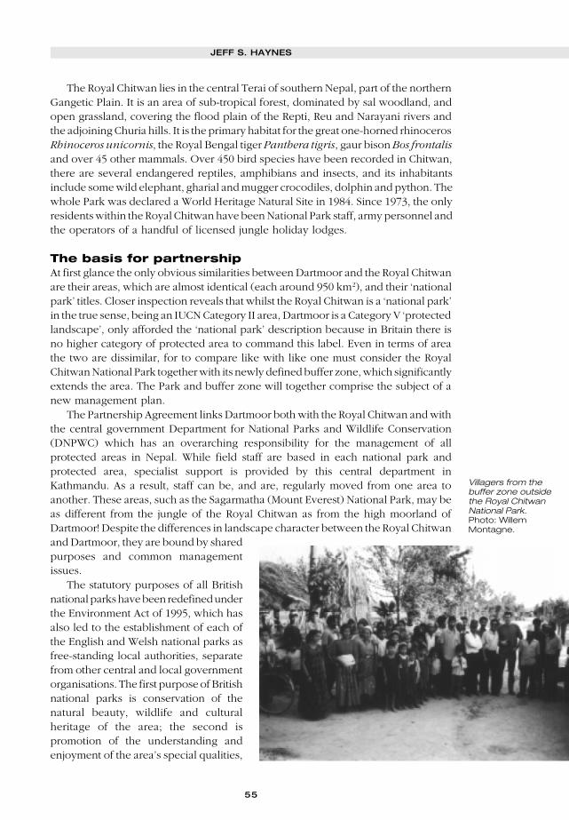
55
The Royal Chitwan lies in the central Terai of southern Nepal, part of the northernGangetic Plain. It is an area of sub-tropical forest, dominated by sal woodland, andopen grassland, covering the flood plain of the Repti, Reu and Narayani rivers andthe adjoining Churia hills. It is the primary habitat for the great one-horned rhinocerosRhinoceros unicornis, the Royal Bengal tiger Panthera tigris, gaur bison Bos frontalisand over 45 other mammals. Over 450 bird species have been recorded in Chitwan,there are several endangered reptiles, amphibians and insects, and its inhabitantsinclude some wild elephant, gharial and mugger crocodiles, dolphin and python. Thewhole Park was declared a World Heritage Natural Site in 1984. Since 1973, the onlyresidents within the Royal Chitwan have been National Park staff, army personnel andthe operators of a handful of licensed jungle holiday lodges.
The basis for partnershipAt first glance the only obvious similarities between Dartmoor and the Royal Chitwanare their areas, which are almost identical (each around 950 km2), and their ‘nationalpark’ titles. Closer inspection reveals that whilst the Royal Chitwan is a ‘national park’in the true sense, being an IUCN Category II area, Dartmoor is a Category V ‘protectedlandscape’, only afforded the ‘national park’ description because in Britain there isno higher category of protected area to command this label. Even in terms of areathe two are dissimilar, for to compare like with like one must consider the RoyalChitwan National Park together with its newly defined buffer zone, which significantlyextends the area. The Park and buffer zone will together comprise the subject of anew management plan.
The Partnership Agreement links Dartmoor both with the Royal Chitwan and withthe central government Department for National Parks and Wildlife Conservation(DNPWC) which has an overarching responsibility for the management of allprotected areas in Nepal. While field staff are based in each national park andprotected area, specialist support is provided by this central department inKathmandu. As a result, staff can be, and are, regularly moved from one area toanother. These areas, such as the Sagarmatha (Mount Everest) National Park, may beas different from the jungle of the Royal Chitwan as from the high moorland ofDartmoor! Despite the differences in landscape character between the Royal Chitwanand Dartmoor, they are bound by sharedpurposes and common managementissues.
The statutory purposes of all Britishnational parks have been redefined underthe Environment Act of 1995, which hasalso led to the establishment of each ofthe English and Welsh national parks asfree-standing local authorities, separatefrom other central and local governmentorganisations. The first purpose of Britishnational parks is conservation of thenatural beauty, wildlife and culturalheritage of the area; the second ispromotion of the understanding andenjoyment of the area’s special qualities,
Villagers from thebuffer zone outsidethe Royal ChitwanNational Park.Photo: WillemMontagne.
JEFF S. HAYNES
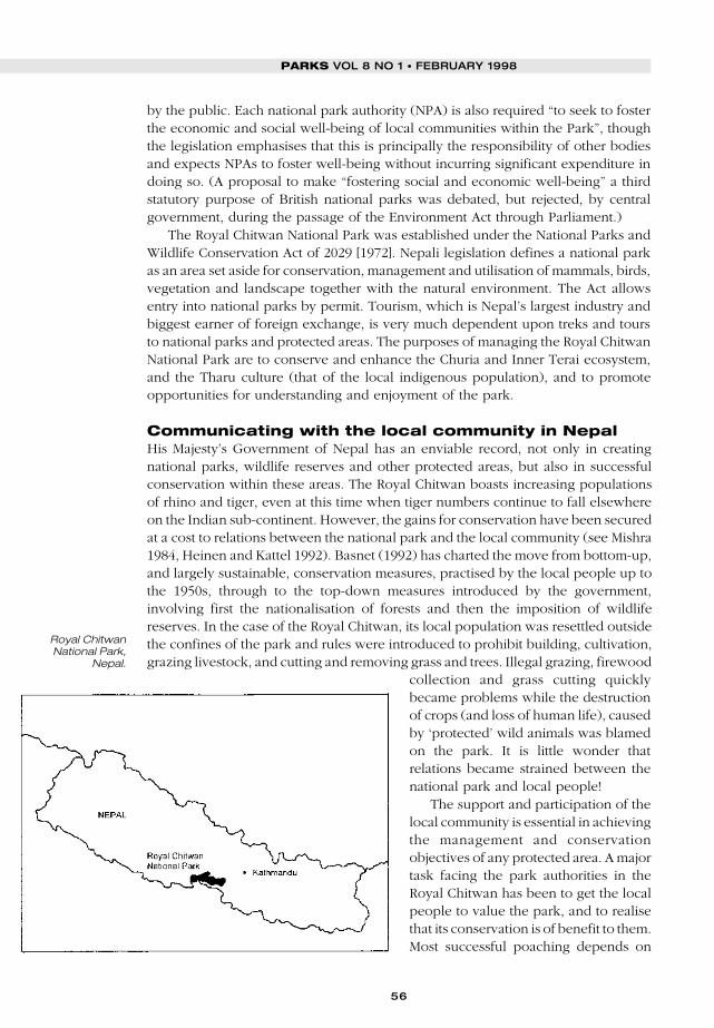
56
PARKS VOL 8 NO 1 • FEBRUARY 1998
by the public. Each national park authority (NPA) is also required “to seek to fosterthe economic and social well-being of local communities within the Park”, thoughthe legislation emphasises that this is principally the responsibility of other bodiesand expects NPAs to foster well-being without incurring significant expenditure indoing so. (A proposal to make “fostering social and economic well-being” a thirdstatutory purpose of British national parks was debated, but rejected, by centralgovernment, during the passage of the Environment Act through Parliament.)
The Royal Chitwan National Park was established under the National Parks andWildlife Conservation Act of 2029 [1972]. Nepali legislation defines a national parkas an area set aside for conservation, management and utilisation of mammals, birds,vegetation and landscape together with the natural environment. The Act allowsentry into national parks by permit. Tourism, which is Nepal’s largest industry andbiggest earner of foreign exchange, is very much dependent upon treks and toursto national parks and protected areas. The purposes of managing the Royal ChitwanNational Park are to conserve and enhance the Churia and Inner Terai ecosystem,and the Tharu culture (that of the local indigenous population), and to promoteopportunities for understanding and enjoyment of the park.
Communicating with the local community in NepalHis Majesty’s Government of Nepal has an enviable record, not only in creatingnational parks, wildlife reserves and other protected areas, but also in successfulconservation within these areas. The Royal Chitwan boasts increasing populationsof rhino and tiger, even at this time when tiger numbers continue to fall elsewhereon the Indian sub-continent. However, the gains for conservation have been securedat a cost to relations between the national park and the local community (see Mishra1984, Heinen and Kattel 1992). Basnet (1992) has charted the move from bottom-up,and largely sustainable, conservation measures, practised by the local people up tothe 1950s, through to the top-down measures introduced by the government,involving first the nationalisation of forests and then the imposition of wildlifereserves. In the case of the Royal Chitwan, its local population was resettled outsidethe confines of the park and rules were introduced to prohibit building, cultivation,grazing livestock, and cutting and removing grass and trees. Illegal grazing, firewood
collection and grass cutting quicklybecame problems while the destructionof crops (and loss of human life), causedby ‘protected’ wild animals was blamedon the park. It is little wonder thatrelations became strained between thenational park and local people!
The support and participation of thelocal community is essential in achievingthe management and conservationobjectives of any protected area. A majortask facing the park authorities in theRoyal Chitwan has been to get the localpeople to value the park, and to realisethat its conservation is of benefit to them.Most successful poaching depends on
Royal ChitwanNational Park,
Nepal.

57
access to local knowledge and localpeople are likely to part with thatknowledge, especially for large financialinducements, much more willingly ifthey do not see any value to them inprotecting the park’s wildlife. Explainingindirect benefits to local people is alwaysdifficult and in the case of the RoyalChitwan the most obvious benefits, thosefrom tourism, were accruing toaccommodation owners and tourorganisers based far away in Kathmandu.
The DNPWC, in collaboration withthe United Nations DevelopmentProgram, has established the “Parks andPeople Project”, a communitydevelopment initiative operating in five of the Terai parks and reserves. There are36 Village Development Committees (VDCs) in the Royal Chitwan buffer zone,representing something over 275,000 people. The Parks and People Project herebegan in 1994 as a pilot in two VDCs and was extended to six VDCs in 1995. It aimsto improve the socioeconomic conditions of local people through a range of activitiesincluding an income development programme, training people in the skills of fabricworking, tailoring and sewing, tourist guiding and TV/radio repair. Small poultry/vegetable farming and weaving projects have been supported with expert advice andtraining brought in from outside and funding has been provided to match savingsschemes devoted to community health, education, drinking water and otherprogrammes, selected by the VDCs. An awareness and conservation educationprogramme is an important part of the effort to develop trust and understandingbetween the park and the local people.
This Project is itself a pilot for a future in which there is to be a direct transfer ofthe economic benefits of the national park to the local people. The Buffer ZoneManagement Rules of 2052 [1996] now require that between 30% and 50% of allnational park revenue is ploughed back into the communities of the buffer zone.Over the next few years, the national park will be working closely with localcommunities on a buffer zone development programme, on tourism developmentprojects, and on the preparation of management plans for the park and buffer zoneareas. In this way, indigenous systems of sustainable conservation management willbe revived within the buffer zone and local people will become involved insupporting and achieving national park objectives.
Communicating with the local community andvisitors to DartmoorDespite the lack of such fundamental conflicts as would have been raised by policiesof resettlement, relations with local communities have also been strained, to a greateror lesser extent, within British national parks. The National Parks Review Panel(1991), which examined and reported upon all aspects of British national parks,concluded that “local people consider that their interests are not properly represented”in national park administration. The Panel recommended the establishment of new,
Hookney Tor,Dartmoor NationalPark. Photo:Dartmoor NationalPark Authority.
JEFF S. HAYNES
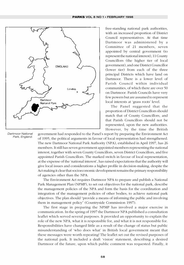
58
PARKS VOL 8 NO 1 • FEBRUARY 1998
free-standing national park authorities,with an increased proportion of DistrictCouncil representatives. At that timeDartmoor was administered by aCommittee of 21 members, sevenappointed by central government (torepresent the national interest), 11 CountyCouncillors (the higher tier of localgovernment), and one District Councillor(lower tier) from each of the threeprincipal Districts which have land onDartmoor. There is a lower level ofParish Council within individualcommunities, of which there are over 50on Dartmoor. Parish Councils have veryfew powers but are assumed to representlocal interests at ‘grass roots’ level.
The Panel suggested that theproportion of District Councillors shouldmatch that of County Councillors, andthat Parish Councillors should not berepresented, upon the new authorities.However, by the time the British
government had responded to the Panel’s report by preparing the Environment Actof 1995, the political arguments in favour of local representation had strengthened.The new Dartmoor National Park Authority (NPA), established in April 1997, has 26members. It still has seven government appointed members representing the nationalinterest, together with seven County Councillors, seven District Councillors, and fiveappointed Parish Councillors. The marked switch in favour of local representation,at the expense of the ‘national interest’, has raised expectations that the authority willgive local issues and considerations a higher profile in decision-making, despite theAct making it clear that socioeconomic development remains the primary responsibilityof agencies other than the NPA.
The Environment Act requires Dartmoor NPA to prepare and publish a NationalPark Management Plan (NPMP), to set out objectives for the national park, describethe management policies of the NPA and form the basis for the coordination andintegration of the management policies of other bodies, to achieve national parkobjectives. The plan should “provide a means of informing the public and involvingthem in management policy” (Countryside Commission 1997).
The first stage in preparing the NPMP has involved a major exercise incommunication. In the spring of 1997 the Dartmoor NPA published a consultationleaflet which served several purposes. It provided an opportunity to explain therole of the new NPA, what it is responsible for, and what it is not responsible for.Responsibilities have changed little as a result of the change of status but publicmisunderstanding of ‘who does what’ in British local government meant thatthese messages were worth repeating! The leaflet set out the revised purposes ofthe national park. It included a draft ‘vision’ statement, describing a desiredDartmoor of the future, upon which public comment was requested. Finally, it
Dartmoor NationalPark, England.

59
asked the public to identify the special qualities of Dartmoor and challenged themto select those issues which they felt the new NPMP should address. Over athousand responses were received, from individuals, residents and visitors,school children, local communities and various interest groups. The analysis ofresponses has enabled the vision statement to be refined to reflect wideropinions, and it has usefully highlighted where such opinion is divided. It has alsoprovided a sound starting block from which to develop strategic managementpolicies which reflect the concerns and aspirations of both residents and visitors,which are very often, but not always, coincident. This two-way communicationexercise, seeking both to inform and to gather comment, was the first publicgesture from the new NPA and therefore played an important role in establishingits public image and standing.
Dartmoor calculates its visitors in millions and they now come to enjoy the opencountry all the year round. In recent years the erosion effects of high visitor use havebecome increasingly pronounced. Tourism is the most important industry in thesouth-west of England and many businesses, on and around Dartmoor, depend uponthe maintenance of an attractive landscape to ensure that visitors enjoy, and repeat,their stay.
In 1997 Dartmoor NPA launched its “Moor Care, Less Wear” campaign, whichaims to raise public awareness of the potential impacts which each visitor has on thenational park. This is part of a “Moorcare Programme”, which was successful inattracting European Agricultural Guidance and Guarantee Fund support under theEuropean Commission’s Objective 5b Programme. The package comprises twoelements: a repair programme, under which physical damage to paths, popularaccess land, archaeological sites and stone walls is being remedied; and a protectionprogramme, which includes training local people in stone walling and hedging skills,careful management and signing of access, surveys of visitor disturbance to ground-nesting birds, and the launch of a major awareness campaign. This is the first timethat effort has been concentrated on explaining to users of the national park whyrecreation has to be managed and the ways in which they, as individuals, can avoidadding to the erosion pressures.
The campaign has involved a staffed travelling exhibition caravan, which is takento popular visitor sites and to areas where erosion damage is occurring or beingrepaired. This is being supported by thepreparation and distribution of codes ofpractice for different park users – walkers,riders, cyclists etc. – a leaflet to promotethe campaign, and a number ofinformation staff, guides and studentrangers, trained to spread the word bytalking to visitors. Merchandising alsoforms an important part of the effort toraise awareness with T-shirts, car stickersand other products carrying the speciallydesigned “Moor Care, Less Wear” logo,simultaneously raising more income tobe ploughed back into erosion repairwork.
Shepherd and flockof sheep onDartmoor. Photo:Chris Chapman/DNPA.
JEFF S. HAYNES
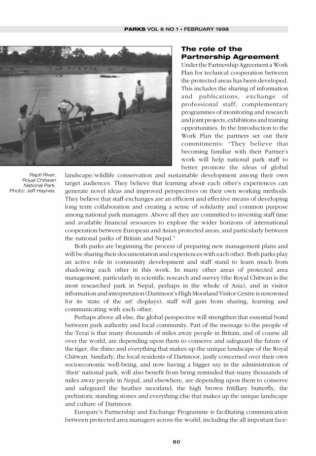
60
PARKS VOL 8 NO 1 • FEBRUARY 1998
The role of thePartnership AgreementUnder the Partnership Agreement a WorkPlan for technical cooperation betweenthe protected areas has been developed.This includes the sharing of informationand publications, exchange ofprofessional staff, complementaryprogrammes of monitoring and researchand joint projects, exhibitions and trainingopportunities. In the Introduction to theWork Plan the partners set out theircommitments: “They believe thatbecoming familiar with their Partner’swork will help national park staff tobetter promote the ideas of global
landscape/wildlife conservation and sustainable development among their owntarget audiences. They believe that learning about each other’s experiences cangenerate novel ideas and improved perspectives on their own working methods.They believe that staff exchanges are an efficient and effective means of developinglong term collaboration and creating a sense of solidarity and common purposeamong national park managers. Above all they are committed to investing staff timeand available financial resources to explore the wider horizons of internationalcooperation between European and Asian protected areas, and particularly betweenthe national parks of Britain and Nepal.”
Both parks are beginning the process of preparing new management plans andwill be sharing their documentation and experiences with each other. Both parks playan active role in community development and staff stand to learn much fromshadowing each other in this work. In many other areas of protected areamanagement, particularly in scientific research and survey (the Royal Chitwan is themost researched park in Nepal, perhaps in the whole of Asia), and in visitorinformation and interpretation (Dartmoor’s High Moorland Visitor Centre is renownedfor its ‘state of the art’ displays), staff will gain from sharing, learning andcommunicating with each other.
Perhaps above all else, the global perspective will strengthen that essential bondbetween park authority and local community. Part of the message to the people ofthe Terai is that many thousands of miles away people in Britain, and of course allover the world, are depending upon them to conserve and safeguard the future ofthe tiger, the rhino and everything that makes up the unique landscape of the RoyalChitwan. Similarly, the local residents of Dartmoor, justly concerned over their ownsocioeconomic well-being, and now having a bigger say in the administration of‘their’ national park, will also benefit from being reminded that many thousands ofmiles away people in Nepal, and elsewhere, are depending upon them to conserveand safeguard the heather moorland, the high brown fritillary butterfly, theprehistoric standing stones and everything else that makes up the unique landscapeand culture of Dartmoor.
Europarc’s Partnership and Exchange Programme is facilitating communicationbetween protected area managers across the world, including the all important face-
Rapti River,Royal ChitwanNational Park.
Photo: Jeff Haynes.

61
to-face communication permitted through the funding of 24 return journeys for staff,over a three year period. Anything that they can learn from each other aboutcommunicating effectively with local communities will contribute to the very basisof sustainable conservation policies.
ReferencesBasnet, K. 1992. Conservation Practices in Nepal: Past and Present. Ambio 6(1): 390–393.Countryside Commission. 1997. National Park Management Plans Guidance. CCP525. Countryside
Commission, Cheltenham, England.Heinen, J.T., and Kattel, B. 1992. Parks, People and Conservation: A Review of Management
Issues in Nepal’s Protected Areas. Population and Environment: A Journal of InterdisciplinaryStudies. 14 (1): 49–84. Human Sciences Press Inc.
Mishra, H.R. 1984. A Delicate Balance: Tigers, rhinoceros, tourists and park management vs theneeds of local people in Royal Chitwan National Park. In: McNeely, J., and Miller, K.R. (eds.).National Parks, Conservation and Development. 197–205. Smithsonian Institution Press.Washington D.C.
National Parks Review Panel. 1991. Fit for the Future (Report of the National Parks Review Panel).CCP 334. Countryside Commission, Cheltenham, England.
Roby, A. 1996. A New Approach to Forest Conservation. Nature and National Parks – EuropeanBulletin 34(130): 15. FNNPE, Grafenau, Germany.
Jeff S. Haynes is Assistant National Park Officer at Dartmoor National Park Authority,where he has particular responsibility for the Visitor Services Group, the National ParkManagement Plan and international links. In September/October 1996 he andRosmarie Reuss, a Freelance Consultant working for the Europarc Federation,conducted a joint mission to Nepal to assess the scope for establishing an agreementbetween the Dartmoor and Royal Chitwan National Parks which resulted, inDecember 1996, in the signing of a Partnership Agreement endorsed by the EuroparcFederation.
Jeff S. Haynes, Dartmoor National Park Authority, Parke, Bovey Tracey, NewtonAbbot, Devon, TQ13 9JQ, England. Fax: +44 1626 834684. Email:[email protected].
JEFF S. HAYNES
62
PARKS VOL 8 NO 1 • FEBRUARY 1998
Resumenes
Los impactos demográficos en las áreas protegidas de Tanzanía ylas opciones para actuarDAVIS MWAMFUPE
El crecimiento de la población y la migración interna con la adición de los cambios en la propiedad dela tierra, están ejerciendo una presión creciente en el medio ambiente y en los recursos naturales deTanzanía. Este artículo examina la dinámica de la población que afecta a siete áreas protegidas y enfatizafactores tales como: la pobreza, la alienación de la tierra y los recursos, la sequía, y la falta de participaciónlocal en las actividades de conservación que están actualmente impidiendo los esfuerzos de conservaciónen el país.
El pueblo y la protección del medioFRANCES WESTLEY, ULYSSES SEAL, ONNIE BYERS AND GAIL D. NESS
La población humana, la producción y el consumo están aumentando rápidamente y están poniendo granpresión en esas especies y habitats que la comunidad conservacionista está luchando por proteger. Unade las mayores flaquezas en nuestra capacidad organizada para lidiar con este problema yace en laespecialización en multiples disciplines. La Red de Investigación de la Biodiversidad Global, una redcientífica internacional, ha sido desarrollada para brindar juntas las necesarias disciplinas de demografíahumana, las ciencias organizativas, los estudios de desarrollo, la biología de conservación y la biologíade la población, en un esfuerzo para: a) comprender el impacto de las poblaciones humanas locales enla sobrevivencia de los sistemas amenazados y las comunidades en residencia y b) desarrollar lasherramientas y procesos para asegurar el envolvimiento, la colaboración y la responsabilidad de una seriemás amplia de propietarios locales de intereses dentro del país en los procesos de conservación deespecies in situ, en el medio y en el manejo del ecosistema.
Hacia las mejores prácticas para las asociaciones entre lapoblación y el entornoCARLOS ARAMBURÚ, PETER R. WILSHUSEN Y FRANK D. ZINN
La conservación integrada y los proyectos de desarrollo (ICDPs) son un enfoque que se ha usadoampliamente cuando se busca la mejora de las condiciones socio- económicas de las comunidadesdependientes de recursos naturales mientras protegen los habitats ecológicamente valiosos. Mientrastales proyectos se concentran frecuentemente en la generación de ingresos, educación y necesidades desalud de las poblaciones locales, a menudo pasan por alto cuestiones tales como el planeamiento de lafamilia y los servicios de salud relacionados con la reproducción. Desde 1993, el programa de losmiembros de la “Población y el entorno” de la Universidad de Michigan ha fomentado asociaciones entrela conservación y las organizaciones de la población en varias áreas ecológicamente importantesalrededor del mundo con el fin de prestar atención a las determinadas preocupaciones de la población.Este artículo presenta ejemplos de dos de estas asociaciones, en Uganda y en Brasil. La asociación entrela población y el entorno parecen aumentar la confianza de las comunidades locales, incentivan elaprendizaje inter- organizador y en ciertos casos economizan en sus magros recursos. Con el tiempo, estasintervenciones integradas pueden contribuir a la estabilización de la población alrededor de las áreasprotegidas.
La migración hacia áreas protegidas y las zonas amortiguadoras:¿podremos contener la corriente?ALEX DE SHERBININ Y MARK FREUDENBERGER
A través de una serie de casos tomados como ejemplo, este artículo examina los movimientos de lapoblación en y alrededor de las áreas protegidas y sugiere una serie de respuestas políticas a nivel localy nacional. Estas incluyen entre otras, normas relacionadas con la infraestructura e inversión, tenenciade la tierra y el acceso y administración de los recursos naturales. Los autores llegan a la conclusión de
63
que las áreas protegidas se pueden beneficiar con la asociación estratégica entre los NGOs deconservación, los administradores de las áreas protegidas y los expertos en reglamentos públicos con elfin de determinar las tendencias demográficas que afectan la conservación.
Integrando las comunidades con la administración de las áreasprotegidas: dos iniciativas contrastantes: en Nepal y en GranBretañaJEFF S. HAYNES
El parque nacional de Dartmoor (Inglaterra) y el real parque nacional de Chitwan (Nepal) han entradoen un acuerdo para asociarse bajo los auspicios de la Asociación Europarc y su Programa de intercambio.Este artículo se concentra en el área crítica de la comunicación entre las autoridades del parque y lascomunidades locales para asegurar la conservación y administración de las áreas protegidas. Contrastalos esfuerzos actuales para promover la intervención local en la administración de los parques de Nepala través de la redistribución directa de los ingresos del parque hacia las comunidades locales, con loscambios en la representación sobre las autoridades del parque nacional británico, diseñado paraaumentar la democracia y el envolvimiento local en la toma de decisiones.
RESUMENES
Résumés
Incidences démographiques sur les zones protégées de Tanzanieet solutions envisageablesDAVIS MWAMFUPE
En Tanzanie, l’augmentation de la population et les migrations internes, lorsqu’elles interviennentparallèlement à des changements du régime foncier, exercent des pressions croissantes sur l’environnementet les ressources naturelles. Examinant les répercussions de la démographie sur sept zones protégées,l’auteur impute les obstacles aux initiatives en faveur de la conservation à des facteurs tels que la pauvreté,la réduction ou la perte de l’accès aux terres et aux ressources, la sécheresse et l’absence de participationlocale aux activités liées à la conservation.
La population et la protection de l’habitatFRANCES WESTLEY, ULYSSES SEAL, ONNIE BYERS ET GAIL D. NESS
L’accroissement rapide de la population, de la production et de la consommation pèse lourdement surles espèces et les habitats que les instances pour la conservation s’efforcent de protéger. L’inaptitude denos structures à résoudre cette question tient notamment à la spécialisation de chaque discipline. Unréseau scientifique international, le Global Biodiversity Research Network (Réseau mondial de recherchessur la biodiversité), a été créé en vue de regrouper les disciplines concernées : démographie, sciencesde la gestion, étude du développement, biologie de la conservation et biologie démographique. Le doubleobjectif est a) de comprendre l’incidence des populations locales sur la survie des écosystèmes menacéset de leurs habitants, et b) d’élaborer des instruments et des processus visant à garantir la participation,la collaboration et la responsabilité d’une plus grande diversité de parties prenantes sur le terrain enmatière de gestion in situ des espèces, des habitats et des écosystèmes.
Sur la voie de meilleures pratiques pour les partenariatspopulation-environnementCARLOS ARAMBURÚ, PETER R. WILSHUSEN ET FRANK D. ZINN
En vue d’améliorer le statut socio-économique des communautés tributaires des ressources naturelles touten protégeant les habitats importants sur le plan écologique, on a largement recours aux projets intégrésde conservation et de développement (ICDP en anglais). Si les projets de ce type prennent généralementen compte les besoins des populations locales en terme de création de revenus, d’éducation et de santé,
64
PARKS VOL 8 NO 1 • FEBRUARY 1998
ils négligent souvent les aspects démographiques tels que la planification familiale et la santé de lareproduction. Depuis 1993, le Population-Environment Fellows Program (programme de boursesuniversitaires liées à la population et à l’environnement) de l’Université de Michigan encourage la créationde partenariats entre des organisations pour la conservation et la démographie dans de nombreusesrégions ayant une importance écologique à travers le monde, afin d’aborder les priorités définies par lapopulation locale. Les auteurs présentent deux exemples de partenariats de ce type en Ouganda et auBrésil. Il semble que les partenariats population-environnement favorisent la confiance des communautéslocales, encouragent les échanges d’expérience entre organisations et, dans certains cas, permettentd’économiser des ressources limitées. À long terme, ces initiatives étroitement liées pourraient contribuerà la stabilisation démographique à proximité des zones protégées.
Est-il possible d’endiguer la marée des migrations vers les zonesprotégées et les zones tampons ?ALEX DE SHERBININ ET MARK FREUDENBERGER
S’appuyant sur plusieurs études de cas, les auteurs analysent les mouvements de population dans leszones protégées et à proximité. Ils proposent une série de mesures aux niveaux national et local, liéesnotamment à l’infrastructure et aux investissements, aux régimes fonciers et à l’accès aux ressourcesnaturelles ainsi qu’à leur gestion. Ils concluent que, face aux tendances démographiques ayant desincidences sur la conservation, les partenariats stratégiques entre les ONG pour la conservation, lesresponsables de zones protégées et les experts publics présentent des avantages pour les zonesprotégées.
La participation des communautés à la gestion des zonesprotégées : deux initiatives contrastées au Népal et en AngleterreJEFF S. HAYNES
Le parc national de Dartmoor (Angleterre) et le parc national royal de Chitwan (Népal) ont conclu unaccord de partenariat sous les auspices du Europarc Partnership and Exchange Programme (programmeEuroparc de partenariat et d’échanges). L’auteur étudie la communication entre les responsables de parcset les communautés locales, un facteur décisif lorsqu’il s’agit de garantir la conservation et la gestion deszones protégées. Il compare l’initiative visant à encourager la participation locale à la gestion du parcnépalais, grâce à la redistribution directe de ses revenus aux communautés locales, avec la restructurationde la représentation des intérêts au sein des parcs nationaux britanniques, qui vise à accroître au planlocal la démocratie et la participation à la prise de décision.
PARKSProtected Areas Programme
Vol 8 No 1 • February 1998 Populations and Parks
© 1998 IUCN, Gland, Switzerland. ISSN: 0960-233X
Guest editor: Alex de Sherbinin
Contents
Editorial
ALEX DE SHERBININ 1
Demographic impacts on protected areas in Tanzaniaand options for action
DAVID MWAMFUPE 3
People and habitat protection
FRANCES WESTLEY, ULYSSES SEAL, ONNIE BYERS AND GAYL D. NESS 15
Towards best practices for population-environment partnerships
CARLOS ARAMBURÚ, PETER R. WILSHUSEN AND FRANK D. ZINN 27
Migration to protected areas and buffer zones: can we stem the tide?
ALEX DE SHERBININ AND MARK FREUDENBERGER 38
Involving communities in managing protected areas:contrasting initiatives in Nepal and Britain
JEFF S. HAYNES 54
Resumenes/Résumés62
Subscription/advertising detailsinside back cover


![International Journal of Mass Spectrometry - - [email protected]](https://img.pdfslide.net/doc/110x75/61fb44082e268c58cd5c211e/international-journal-of-mass-spectrometry-emailprotected.jpg)

![International barter - [email protected]](https://img.pdfslide.net/doc/110x75/6204ea574c89d3190e0c7bc6/international-barter-emailprotected.jpg)

![International Human Resource Management: - [email protected]](https://img.pdfslide.net/doc/110x75/6203a3c3da24ad121e4bbee7/international-human-resource-management-emailprotected.jpg)

![[protected+nostamp] International Equity & Global](https://img.pdfslide.net/doc/110x75/61d8f6d53de7fb748f315a0a/protectednostamp-international-equity-amp-global-.jpg)
