Embed Size (px)
Citation preview
Protective Action Strategies for Resources at Risk Along the Southeast Shoreline of Corpus Christi Bay
After Action Report
June 1, 2010
This project was conducted to develop booming strategies and techniques to protect resources at risk along the southeast shoreline of Corpus Christi Bay in Corpus Christi, Texas. The project included booming strategies, locations of potential staging areas and oil recovery collection points, shoreline type descriptions, habitat sensitivities and recommended cleanup strategies. These activities were incorporated into the ESCI 4330/5330 Oil Spill Prevention and Response course at Texas A&M University-Corpus Christi in order to give the students practical experience in planning and responding to oil spills. Spatial Boundaries
: The geographic limits of the project extended along the south and southeast shoreline of Corpus Christi Bay from Cole Park near downtown Corpus Christi to Demit Point at Naval Air Station-Corpus Christi. This geographic area includes city parks along the Corpus Christi bayfront, the “Blind Oso” channel, University Beach, the entrance to Oso Bay and the Naval base shoreline.
Goals and Objectives• Develop protective action strategy for the “Blind Oso” channel. Completed May 7,
2010.
:
• Develop protective action strategy for University Beach. Completed April 29, 2010. • Develop and test protective booming strategy for the entrance to Oso Bay. Completed
April 23, 2010. • Develop and test booming strategies to contain a spill at NAS-Corpus Christi storm water
outfall. Completed April 16, 2010. • Identify potential staging areas within the geographic scope of the project. Completed
April 1, 2010. • Identify potential oil recovery collection points within the geographic scope of the
project. Completed May 6, 2010. • Determine minimum estimated time to deploy (METD) equipment. Completed May 6,
2010. • Conduct a full-scale tabletop and equipment deployment exercise. Completed April 30,
2010. Logistical Support
: Equipment and personnel for the project were supplied by: Texas A&M University-Corpus Christi, Texas General Land Office, Corpus Christi Area Oil Spill Control Association, the Corpus Christi Marina and Naval Air Station-Corpus Christi.
Execution Timeline
: Project timeframe coincided with the Spring 2010 academic semester (January 15-May 15, 2010) at Texas A&M University-Corpus Christi. Actual equipment deployment was conducted between April 2 and May 15, 2010.
Points of ContactDavid Jensen (Co-P.I.) – Texas A&M University-Corpus Christi – 361 658-7852
:
Brent Koza – Texas General Land Office – 361 825-3300 Tony Martinez – BTB Refining – 361 939-5122
Jennifer Smith-Engle (Co-P.I.) - Texas A&M University-Corpus Christi – 361 825-2241 Appendices
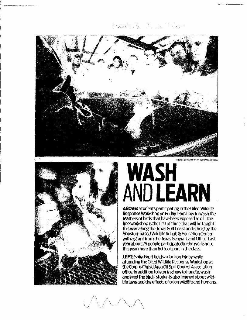
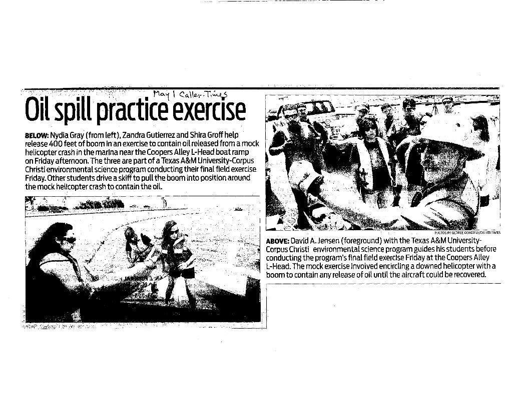
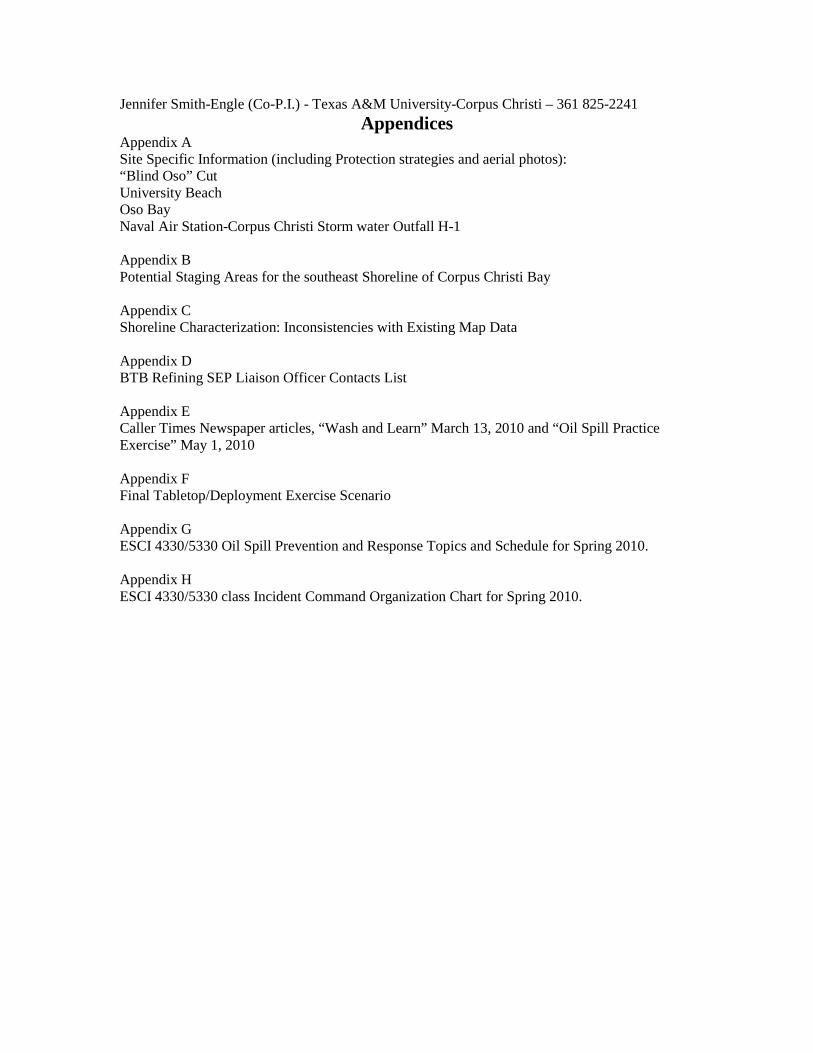
Appendix A Site Specific Information (including Protection strategies and aerial photos): “Blind Oso” Cut University Beach Oso Bay Naval Air Station-Corpus Christi Storm water Outfall H-1 Appendix B Potential Staging Areas for the southeast Shoreline of Corpus Christi Bay Appendix C Shoreline Characterization: Inconsistencies with Existing Map Data Appendix D BTB Refining SEP Liaison Officer Contacts List Appendix E Caller Times Newspaper articles, “Wash and Learn” March 13, 2010 and “Oil Spill Practice Exercise” May 1, 2010 Appendix F Final Tabletop/Deployment Exercise Scenario Appendix G ESCI 4330/5330 Oil Spill Prevention and Response Topics and Schedule for Spring 2010. Appendix H ESCI 4330/5330 class Incident Command Organization Chart for Spring 2010.
David Jensen Incident Commander
Zandra Gutierrez Safety Officer
Henry Walther Liaison Officer
Sara Miller Public Info Officer
Oscar Villarreal Finance Section
Chief
Shira Groff Environmental
Unit
David Garza Situation Unit
Andrew VanHorn Documentation
Jennifer Vyvlecka Resources Unit
Travis Baran Planning Section
Chief
Jacob Coffey Decontamination
Leon DelToro Shore Side Recovery
Aaron Wright On-Water
Recovery Unit
Nydia Gray Protection Group
Jose Torres Staging Area
Manager
Phillip Nail Operations
Section Chief
Trent Wacker Security
Tobias Richards Support Branch
Michael Garcia Logistics Section
Chief
Robert Nailon Services Branch
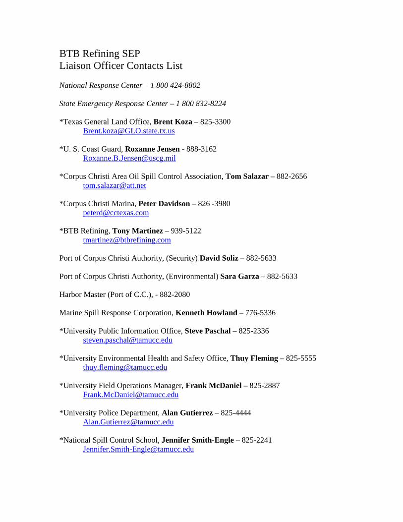
BTB Refining SEP Liaison Officer Contacts List National Response Center – 1 800 424-8802 State Emergency Response Center – 1 800 832-8224 *Texas General Land Office, Brent Koza – 825-3300 [email protected] *U. S. Coast Guard, Roxanne Jensen - 888-3162 [email protected] *Corpus Christi Area Oil Spill Control Association, Tom Salazar – 882-2656 [email protected] *Corpus Christi Marina, Peter Davidson – 826 -3980 [email protected] *BTB Refining, Tony Martinez – 939-5122 [email protected] Port of Corpus Christi Authority, (Security) David Soliz – 882-5633 Port of Corpus Christi Authority, (Environmental) Sara Garza – 882-5633 Harbor Master (Port of C.C.), - 882-2080 Marine Spill Response Corporation, Kenneth Howland – 776-5336 *University Public Information Office, Steve Paschal – 825-2336 [email protected] *University Environmental Health and Safety Office, Thuy Fleming – 825-5555 [email protected] *University Field Operations Manager, Frank McDaniel – 825-2887 [email protected] *University Police Department, Alan Gutierrez – 825-4444 [email protected] *National Spill Control School, Jennifer Smith-Engle – 825-2241 [email protected]
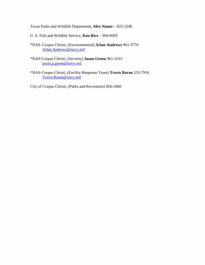
Texas Parks and Wildlife Department, Alex Nunez – 825-3246 U. S. Fish and Wildlife Service, Ken Rice – 994-9005 *NAS–Corpus Christi, (Environmental) Arlan Andrews 961-3776 [email protected] *NAS-Corpus Christi, (Security) Jason Green 961-3333 [email protected] *NAS-Corpus Christi, (Facility Response Team) Travis Baran 533-7916 [email protected] City of Corpus Christi, (Parks and Recreation) 826-3460
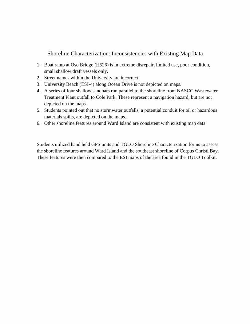
Shoreline Characterization: Inconsistencies with Existing Map Data
1. Boat ramp at Oso Bridge (H526) is in extreme disrepair, limited use, poor condition, small shallow draft vessels only.
2. Street names within the University are incorrect. 3. University Beach (ESI-4) along Ocean Drive is not depicted on maps. 4. A series of four shallow sandbars run parallel to the shoreline from NASCC Wastewater
Treatment Plant outfall to Cole Park. These represent a navigation hazard, but are not depicted on the maps.
5. Students pointed out that no stormwater outfalls, a potential conduit for oil or hazardous materials spills, are depicted on the maps.
6. Other shoreline features around Ward Island are consistent with existing map data.
Students utilized hand held GPS units and TGLO Shoreline Characterization forms to assess the shoreline features around Ward Island and the southeast shoreline of Corpus Christi Bay. These features were then compared to the ESI maps of the area found in the TGLO Toolkit.
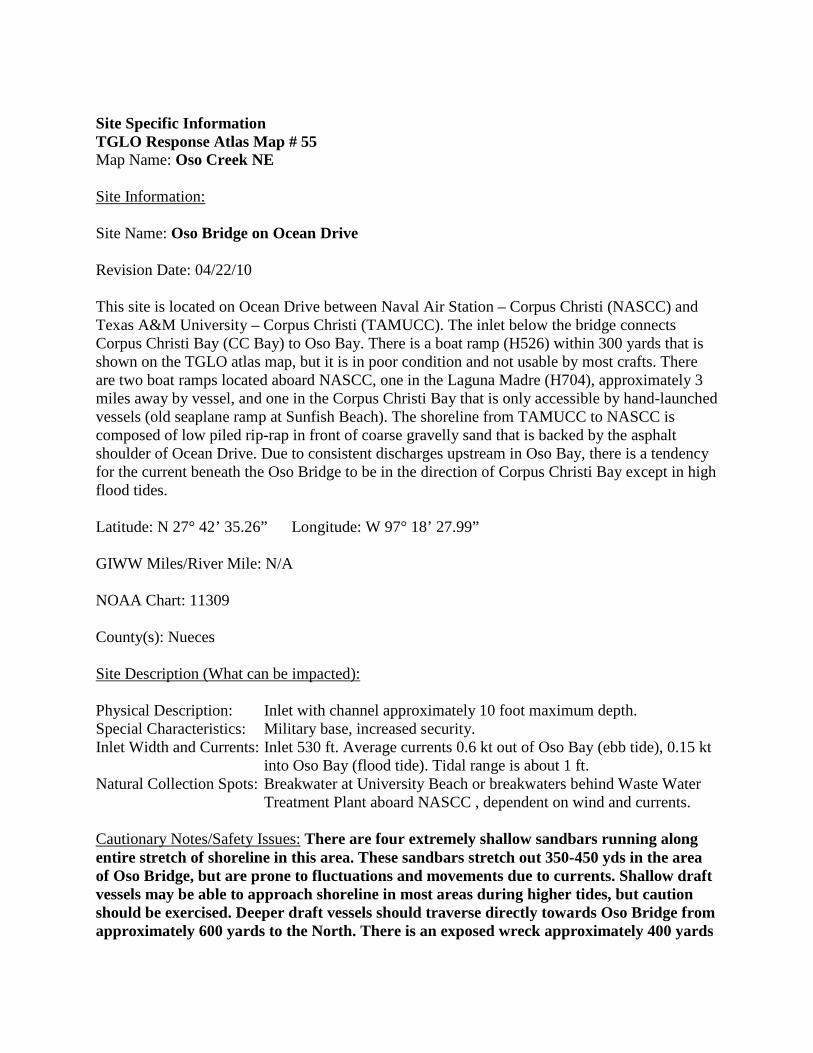
Site Specific Information TGLO Response Atlas Map # 55 Map Name: Oso Creek NE
Site Information:
Site Name: Oso Bridge on Ocean Drive Revision Date: 04/22/10 This site is located on Ocean Drive between Naval Air Station – Corpus Christi (NASCC) and Texas A&M University – Corpus Christi (TAMUCC). The inlet below the bridge connects Corpus Christi Bay (CC Bay) to Oso Bay. There is a boat ramp (H526) within 300 yards that is shown on the TGLO atlas map, but it is in poor condition and not usable by most crafts. There are two boat ramps located aboard NASCC, one in the Laguna Madre (H704), approximately 3 miles away by vessel, and one in the Corpus Christi Bay that is only accessible by hand-launched vessels (old seaplane ramp at Sunfish Beach). The shoreline from TAMUCC to NASCC is composed of low piled rip-rap in front of coarse gravelly sand that is backed by the asphalt shoulder of Ocean Drive. Due to consistent discharges upstream in Oso Bay, there is a tendency for the current beneath the Oso Bridge to be in the direction of Corpus Christi Bay except in high flood tides. Latitude: N 27° 42’ 35.26” Longitude: W 97° 18’ 27.99” GIWW Miles/River Mile: N/A NOAA Chart: 11309 County(s): Nueces
Site Description (What can be impacted):
Physical Description: Inlet with channel approximately 10 foot maximum depth. Special Characteristics: Military base, increased security. Inlet Width and Currents: Inlet 530 ft. Average currents 0.6 kt out of Oso Bay (ebb tide), 0.15 kt
into Oso Bay (flood tide). Tidal range is about 1 ft. Natural Collection Spots: Breakwater at University Beach or breakwaters behind Waste Water
Treatment Plant aboard NASCC , dependent on wind and currents. Cautionary Notes/Safety Issues: There are four extremely shallow sandbars running along entire stretch of shoreline in this area. These sandbars stretch out 350-450 yds in the area of Oso Bridge, but are prone to fluctuations and movements due to currents. Shallow draft vessels may be able to approach shoreline in most areas during higher tides, but caution should be exercised. Deeper draft vessels should traverse directly towards Oso Bridge from approximately 600 yards to the North. There is an exposed wreck approximately 400 yards
North of Oso Bridge. There are pilings that are exposed only during lower tides within 50 ft. of Oso Bridge on the CC Bay side of the structure. Exposed and submerged riprap covered with algal growth along the shoreline presents slip, trip and fall hazards to shoreline crews.
Closest Airport: Corpus Christi International Airport, NAS Corpus Christi Access:
By Land: Interstate Highway 37 to Shoreline Drive, East to Ocean Drive. By Water: Corpus Christi Ship Channel, CC Bay Closest boat ramp: NASCC Marina (H704), Oso Bridge (H526) (Limited use, poor condition) Boat type recommended: shallow draft vessel (16-20 ft) Comments that will affect Access: Oso Bridge is within the NASCC property line, and therefore subject to Navy jurisdiction. While this area is not fenced, it is the property of NASCC and to prevent unnecessary confusion , base security should be notified prior to response. The rest of NASCC is a secure DOD facility, requiring clearance or authorized escorts. Contact Pass and Tag office at the South gate for base access. Base Security and Emergency Response may be reached at (361) 961-3333. Access Phone Numbers: NASCC Security/fire – (361) 961-3333 Trustees/Contact Numbers:
NASCC ENV (361) 961-3776 NASCC Security/fire – 961-3333
USCG (via NRC) (800) 424-8802 TGLO/TCEQ (via hotline) (800) 832-8224 USFWS (361) 994-9005 TPWD (361) 825- 3246
Resources at Risk ESI/Atlas Ratings:
Atlas Priority: High Environmental: Habitat for numerous shorebirds, wading birds and fish species, especially in shallow flats of Oso Bay. Federal/State listed threatened shorebird, Piping Plover. Aquatic Nursery, seagrass beds and wetlands nearby on Oso Bay side adjacent to both Ward Island and NASCC. Socio-Economic: Highly utilized shoreline fishing area, boat traffic light but present. Historic/Archaeological: N/A
Organization: Site Specific Local Knowledge Contacts:
Texas A&M University Corpus Christi, College of Science and Technology (361) 825-5777 NASCC Environmental Office (361)961-3776 (See GRP resource appendix and phone list)
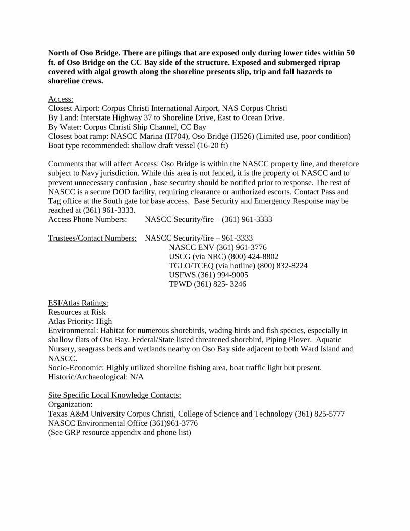
Exclusion Booming: Strategies:
900 ft. of 18 inch containment boom affixed to rip-rap structure on either side of Oso Bridge in CC Bay. 6 anchor systems affixed every 100 ft at end connectors. Shoreline connection points should include at least 50 ft. of overlap, parallel to shoreline. Estimated time to deploy – 2.5 Hours. While establishing shoreline connections, set center offshore anchor system. Develop convex booming configuration as illustrated.
Boom needed (type and amount): 900 ft. of 18 inch oil spill containment boom. Estimated Equipment/Personnel Needs:
Personnel: 4 Boat Crew, 2 Shore Crew. Boats (type and amount): 2 aluminum shallow draft vessels (16-20 ft.) Special Equipment Needs: 6 anchor systems, 4 shoreline anchoring lines. (If incoming currents are strong an additional boat and crew may be necessary.)
Lessons learned from drills or past spills: None Available. Additional Information/Comments for responder use:

Site Specific Information TGLO Response Atlas Map # 55 Map Name: Oso Creek NE Site InformationSite Name: University Beach
:
Revision Date: 05/28/10 This site is located on the Corpus Christi bay front off of Ocean Drive across from Texas A&M University-Corpus Christi. University Beach is a man-made public beach that was mainly constructed so that students could utilize it for recreational and educational purposes. Environmental resources are limited, as it is primarily used for recreation, such as kayaking and fishing. There are three potential large staging areas nearby. The closest is the Hammerhead parking lot located 0.1 miles south of the beach, across Ocean Drive on the TAMUCC campus. The nearest boat ramp is approximately 0.5 miles ESE of the beach along the shoreline also on Ocean Drive (H-526, poor condition). Other potential large staging areas include Poenisch Park on Ocean Drive (1.5 miles WNW of beach) and the Naval Air Station (3.0 miles ESE of beach). Latitude: N 27 42 54 Longitude: W 97 19 16 GIWW Miles/River Mile: N/A NOAA Chart: 11309 County(s): Nueces Site Description (What can be impacted)Physical Description: Sandy public beach, 1275 ft. long, bordered to the east and west by riprap groins oriented perpendicular to the shore. There are three 180-225 ft. long shoreline stabilization structures/detached breakwaters that parallel the shoreline approximately 250 ft. from the shore. The overall average water depth is 2-3 feet, but is variable due to tidal fluctuations.
:
Special Characteristics: Series of 4 very shallow sand bars parallel to the shoreline, the beach is maintained by TAMUCC. Inlet Width and Currents: 4 breakwater openings ranging from 80-220 ft. wide. Tidal range ~1 ft. Natural Collection Spots: Either side of the beach along shoreline dependent on prevailing winds. Cautionary Notes/Safety Issues: The primary safety concerns when booming this area is exposed riprap structures which compose the breakwaters and groins. Riprap can pose serious injury risks when wet or when crews are not wearing appropriate foot wear or PPE. Also, shallow water depths and the 4 offshore sand bars pose serious hazards to boats and personnel in the water.
AccessClosest Airport: NASCC, Corpus Christi International Airport
:
By Land: Interstate Highway 37 to Highway 358 South, exit Ennis Joslin, turn right onto Ocean Drive, head toward TAMUCC, beach is on left side. By Water: Corpus Christi Ship Channel, Corpus Christi Bay Closest boat ramp: H526 on Ocean Drive (limited use, poor condition), H704 on NASCC Boat type recommended: Shallow draft vessel (minimum 16 ft.) Trustees/Contact Numbers TGLO/TCEQ (via hotline) (800) 832-8224
: USCG (via NRC) (800) 424-8802
USFWS (361) 994-9005 TPWD (361) 825- 3246 NASCC Security/Fire (361) 961-3333 NASCC Environmental (361) 961-3776 ESI/Atlas RatingsResources at Risk
:
Atlas Priority: N/A (Low) Environmental: Fish, shrimp, crabs, squid, oysters in nearby Corpus Christi Bay, foraging birds Socio-Economic: public accessible beach, recreation (fishing, kayaking) Historic/Archaeological: N/A Site Specific Local Knowledge ContactsOrganization: Conrad Blucher Institute at TAMUCC
:
Contact: Diedre Williams, Research Specialist (361) 825-2714 Strategies (in order of priority)Exclusion Booming: (Option 1 – Limited time/resource deployment, expected riprap impacts)
:
Three 200 ft. sections and one 300 ft. section of 18 inch containment boom anchored between each of the detached breakwaters. One anchor system will be set in the middle of each 200 ft. section and 2 anchor systems set at 100 and 200 ft. for the 300 ft. section of boom. All four boom runs should create convex configurations into Corpus Christi Bay. Note: This strategy will require close monitoring of boom due to possible boom damage caused by exposed riprap. Estimated time to deploy – 2 hours and 15 minutes. (See aerial photo #1 attached) Exclusion Booming: (Option 2 – Long-term, long deployment time, complete beach protection) 2200 ft. of 18 inch containment boom anchored to the shoreline to the north and south of University Beach. Two shoreline anchor systems at each end of the boom run and an additional 21 anchor systems deployed at every 100 ft. to create a convex configuration into Corpus Christi Bay. Note: This strategy will require close monitoring of boom due to potential failures caused by boom length. Estimated time to deploy – 4 hours. (See aerial photo #2 attached)
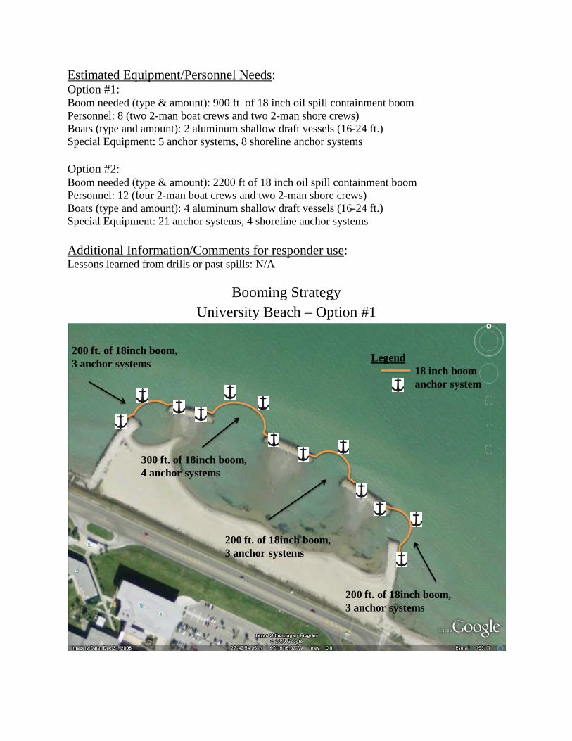
Estimated Equipment/Personnel NeedsOption #1:
:
Boom needed (type & amount): 900 ft. of 18 inch oil spill containment boom Personnel: 8 (two 2-man boat crews and two 2-man shore crews) Boats (type and amount): 2 aluminum shallow draft vessels (16-24 ft.) Special Equipment: 5 anchor systems, 8 shoreline anchor systems Option #2: Boom needed (type & amount): 2200 ft of 18 inch oil spill containment boom Personnel: 12 (four 2-man boat crews and two 2-man shore crews) Boats (type and amount): 4 aluminum shallow draft vessels (16-24 ft.) Special Equipment: 21 anchor systems, 4 shoreline anchor systems Additional Information/Comments for responder useLessons learned from drills or past spills: N/A
:
Booming Strategy
University Beach – Option #1
Legend18 inch boomanchor system
200 ft. of 18inch boom,3 anchor systems
300 ft. of 18inch boom,4 anchor systems
200 ft. of 18inch boom,3 anchor systems
200 ft. of 18inch boom,3 anchor systems
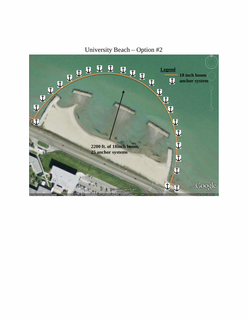
University Beach – Option #2
Legend18 inch boomanchor system
2200 ft. of 18inch boom,25 anchor systems
Specific Information TGLO Response Atlas Map #55 Map Name: Oso Creek NE Site InformationSite Name: Blind Oso
:
Revision Date: 05/27/10 This site is located on the Northwest quadrant of Ward Island. This area is characterized as sandy tidal flats and sparse wetlands vegetation. However, exposed rip rap and manmade structures are the primary shoreline types around the inlet where protective booming will be conducted. The area is a high priority due to the environmentally sensitive marsh area that produces year-round bird and fish activity and includes potential nursery areas for threatened piping plovers and peregrine falcons. The inlet itself is approximately 33 feet wide. Latitude: N 27 43 06.02 Longitude: W 97 19 52.67 GIWW Miles/River Mile: N/A NOAA Chart: 11309 County(s): Nueces Site Description (What can be impacted)Physical description: Brackish water inlet with clay sediment topped with a thin layer of sand. The Blind Oso area is an environmentally sensitive wetland that is characterized by wind/tidal flats. The tidal flats are typically free of water throughout the year but under certain high tide and wind conditions the tidal flats have been known to flood.
:
Special Characteristics: The Hans and Pat Suter Wildlife Area is habitat to many avian species and is a popular bird watching area near the Blind Oso. Oso Creek watershed is dominated by wastewater discharges including an outfall located nearby on the west shoreline. Inlet Width & Currents: Inlet width ~33ft, currents wind driven/seasonal, tidal range is ~1 ft. Natural Collection Spots: Breakwater at TAMUCC Beach to the south, cove at Oso Pier to the north and within the tidal flats during flooding periods. Cautionary Notes/Safety IssuesThe primary safety concerns when booming this area is exposed rip rap structures which compose the Corpus Christi Bay shoreline. Rip rap can pose serious injury risks when wet or when crews are not wearing appropriate foot wear or PPE. Submerged rocks were noted in the channel during extremely low tide. Also, shallow water depths and 4 offshore sand bars pose serious hazards to boats and personnel in the water.
:
Closest Airport: Corpus Christi International Airport, NAS Corpus Christi Access:
Land: Interstate Highway 37 to Shoreline Drive, East to Ocean Drive Water: Corpus Christi Ship Channel, Corpus Christi Bay Closest boat ramp: Oso Bridge (H526) on Ocean Drive (poor condition), NASCC Marina (H704) Boat type recommended: shallow draft vessel (14-16 ft) Trustees/Contact Numbers
TGLO/TCEQ (via Hotline) 1-800-832-8224 : USCG (via NRC) 1-800-424-8802
USFWS (361) 994-9005 TPWD 361-825-3246 NASCC Security/Fire (361) 961-3333 NASCC Environmental (361) 961-3776
Resources at Risk ESI/Atlas Ratings:
Atlas Priority: High Environment: The area consists of threatened shorebirds, threatened raptors, gulls, terns, diving birds, wading birds, other reptiles/amphibians, fish, shrimp, crabs, upland/wetland plants, and squid. (See #716 Lower Coast of Texas Data)Socio-Economic: Low traffic area but is utilized for fishing and bird watching. Seasonal: Area receives seasonal migratory birds.
Organization: Site Specific Local Knowledge Contacts:
Texas A&M University Corpus Christi, College of Science and Technology (361) 825-5777 NASCC Environmental Office (361) 961-3776
Exclusion Booming: (Option #1 – Rapid deployment option) Strategies:
Two 50 ft. sections of 12-18 inch containment (boom size dependant on wave action) boom should be deployed across the inlet on both the north and south sides of the Blind Oso Bridge. All four boom end points should have ~10 ft. of overlap with the concrete bridge supports and should be anchored as close as possible to the concrete structures using rebar stakes. Note: This strategy will require close monitoring of boom due to possible boom damage caused by exposed riprap and the small potential for splash over and/or entrainment. Estimated time to deploy – 30 minutes. (See aerial photo #1 attached) Exclusion Booming: (Option #2 – Limited use due to water level) 50 ft. of 18 inch containment boom anchored to the bulkhead at both ends on the north side of the Blind Oso Bridge. One anchor system set at the midpoint of the boom run to maintain a convex configuration into Corpus Christi Bay. Seasonal variation in water levels may restrict the use of this option. Note: This strategy will require close monitoring of boom due to possible

boom damage caused by exposed riprap. Estimated time to deploy – 45 minutes. (See aerial photo #2 attached) Estimated Equipment/Personnel NeedsOption #1:
:
Boom needed (type & amount): Two 50 ft. sections of 12-18 inch oil spill containment boom Personnel: 4 Boats: N/A Special Equipment: 4 shoreline anchor systems, 1 small pick-up truck or similar vehicle Option #2: Boom needed (type & amount): 50 ft of 18 inch oil spill containment boom Personnel: 6 (2 on-water and 2 on each shore side) Boats: 1 aluminum shallow draft vessel (14-16ft) Special Equipment: 1 anchor system, 2 shoreline anchor systems
Lessons learned from drills or past spills: Additional Information/Comments for Responder Use:
A third option to protect the Blind Oso may be to create a temporary dam across the inlet. This option could be utilized as a long-term response option but would require thorough planning based on actual conditions during an incident and would require ~1600 cubic feet of sand material. Based on a 05/20/10 exercise, quickest deployment option to protect the Blind Oso is option #1. Which may be conducted by lowering the two boom runs directly off the bridge down to shore crews at either side of the inlet. (See pictures below)
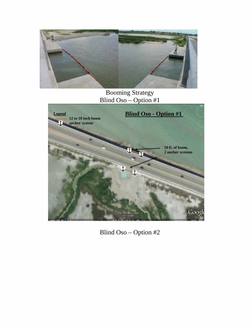
Booming Strategy
Blind Oso – Option #1
Legend12 to 18 inch boomanchor system
50 ft. of boom,2 anchor systems
Blind Oso - Option #1
Blind Oso – Option #2
Legend18 inch boomanchor system
50 ft. of boom,3 anchor systems
Blind Oso - Option #2
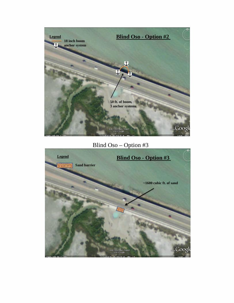
Blind Oso – Option #3
Legend
Sand barrier
~1600 cubic ft. of sand
Blind Oso - Option #3
Site Specific Information TGLO Response Atlas Map # 55 Map Name: Oso Creek NE Site InformationSite Name: Naval Air Station Corpus Christi (NASCC) Storm Water Outfall H-1
:
Revision Date: 04/05/10 This site is located on the waterfront bulkhead of Naval Air Station Corpus Christi’s helicopter landing strip, adjacent to the Corpus Christi bayfront. This location was once the NASCC seaplane area but is no longer used and traffic in the area is minimal due to stringent base security restrictions. Environmental resources are limited; the area is predominantly used for recreational fishing by base personnel. There are two large staging areas nearby. The closest is located along the same bulkhead 1 mile south of outfall H-1 and contains both a boat ramp and covered pavilion. The other large staging area is adjacent to boat ramp H704 about 2 miles south of the outfall but on the opposite side of Demit Point. Several smaller sites for staging are available throughout the base. Latitude: N 27 42 09 Longitude: W 97 16 25 GIWW Miles/River Mile: N/A NOAA Chart: 11309 County(s): Nueces Site Description (What can be impacted)Physical Description: NASCC seaplane restricted area with overall average depth of 6 ft.
:
Special Characteristics: Military base restricted access, storm water outfall Inlet Width and Currents: 4 breakwater openings ranging from 500 to 1200 ft., numerous small (less than 1 ft) openings throughout the entire breakwater bulkhead. Tidal range is about 1 ft. Natural Collection Spots: Northwest or southeast corner of bulkhead (dependent on prevailing winds) Cautionary Notes/Safety Issues
: This site is an active helicopter landing strip and base guidelines require escorts, prior notification before access and hazard lights on all vehicles. Response personnel on the flight line should be strictly limited. The bulkhead is lined with large pieces of riprap containing exposed rebar that may present hazards to shoreline crews. Water depths and sand bars pose serious hazards to boats and personnel in the water.
AccessClosest Airport: NASCC, Corpus Christi International Airport
:
By Land: Interstate Highway 37 to Highway 358 South, take NASCC/CCAD exit to South Gate By Water: Corpus Christi Ship Channel, Corpus Christi Bay, Intracoastal Waterway Closest boat ramp: H704 on NASCC, H526 on Ocean Drive (limited use, poor condition) Boat type recommended: Shallow draft vessel (minimum 16 ft.)
Comments that will affect Access (locked gates, boat ramps, low water crossings….) Significant access restrictions to military base. Must obtain permission from base guard with escort by base personnel; recommend having escort meet at gate to support access. Access Phone Numbers: NASCC Security/Fire: (361) 961-3333 Trustees/Contact Numbers NASCC Environmental (361) 961-3776
: NASCC Security/Fire (361) 961-3333
USCG (via NRC) (800) 424-8802 TGLO/TCEQ (via hotline) (800) 832-8224 USFWS (361) 994-9005 TPWD (361) 825- 3246 ESI/Atlas RatingsResources at Risk
:
Atlas Priority: N/A (Low) Environmental: Fish, shrimp, crabs, squid in nearby Corpus Christi Bay Socio-Economic: NASCC seaplane bulkhead, fishing site Historic/Archaeological: N/A Site Specific Local Knowledge ContactsOrganization: NASCC Environmental (361) 961-3776
:
(See GRP resource appendix and phone list) StrategiesCollection Booming:
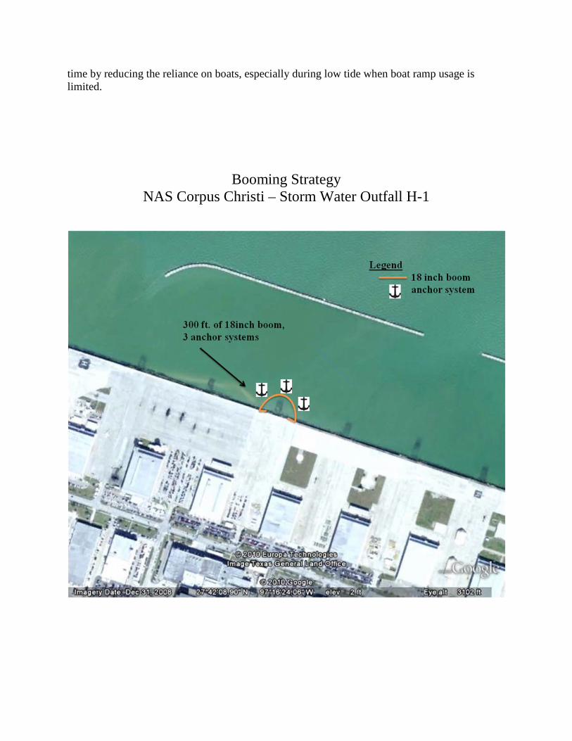
:
300 ft. of 18 inch containment boom anchored on the bulkhead on both sides of the 48 inch storm water outfall. Three anchors systems set at 75, 150 and 225 ft. along the boom run into the seaplane area to maintain a convex configuration away from the outfall. Note: This strategy will require close monitoring of boom due to possible boom damage caused by exposed riprap. (See aerial photo attached.). Estimated time to deploy – 1 hour. Estimated Equipment/Personnel NeedsBoom needed (type and amount): 300 ft. of 18 inch oil spill containment boom.
:
Personnel: 4 Boats (type and amount): 2 aluminum shallow draft vessels (16-24 ft.) Special Equipment Needs: 3 anchor systems, 2 anchors for shoreline seal Additional Information/Comments for responder useLessons learned from drills or past spills:
:
Recommend installing permanent tide slides to act as anchor points on both sides of storm water outfall H-1. This would also require the clearing of riprap around the locations of the tide slides to prevent damage to deployed boom. Furthermore, having a mobile boom cart with 300 ft. of 18 inch containment boom available to be rolled to outfall H-1 will help decrease boom deployment
time by reducing the reliance on boats, especially during low tide when boat ramp usage is limited.
Booming Strategy NAS Corpus Christi – Storm Water Outfall H-1
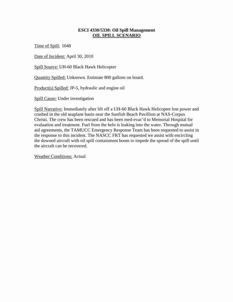
ESCI 4330/5330: Oil Spill Management
OIL SPILL SCENARIO
Time of Spill:
1048
Date of Incident: April 30, 2010 Spill Source: UH-60 Black Hawk Helicopter Quantity Spilled: Unknown. Estimate 800 gallons on board. Product(s) Spilled: JP-5, hydraulic and engine oil Spill Cause: Under investigation Spill Narrative: Immediately after lift off a UH-60 Black Hawk Helicopter lost power and crashed in the old seaplane basin near the Sunfish Beach Pavillion at NAS-Corpus Christi. The crew has been rescued and has been med-evac’d to Memorial Hospital for evaluation and treatment. Fuel from the helo is leaking into the water. Through mutual aid agreements, the TAMUCC Emergency Response Team has been requested to assist in the response to this incident. The NASCC FRT has requested we assist with encircling the downed aircraft with oil spill containment boom to impede the spread of the spill until the aircraft can be recovered. Weather Conditions: Actual
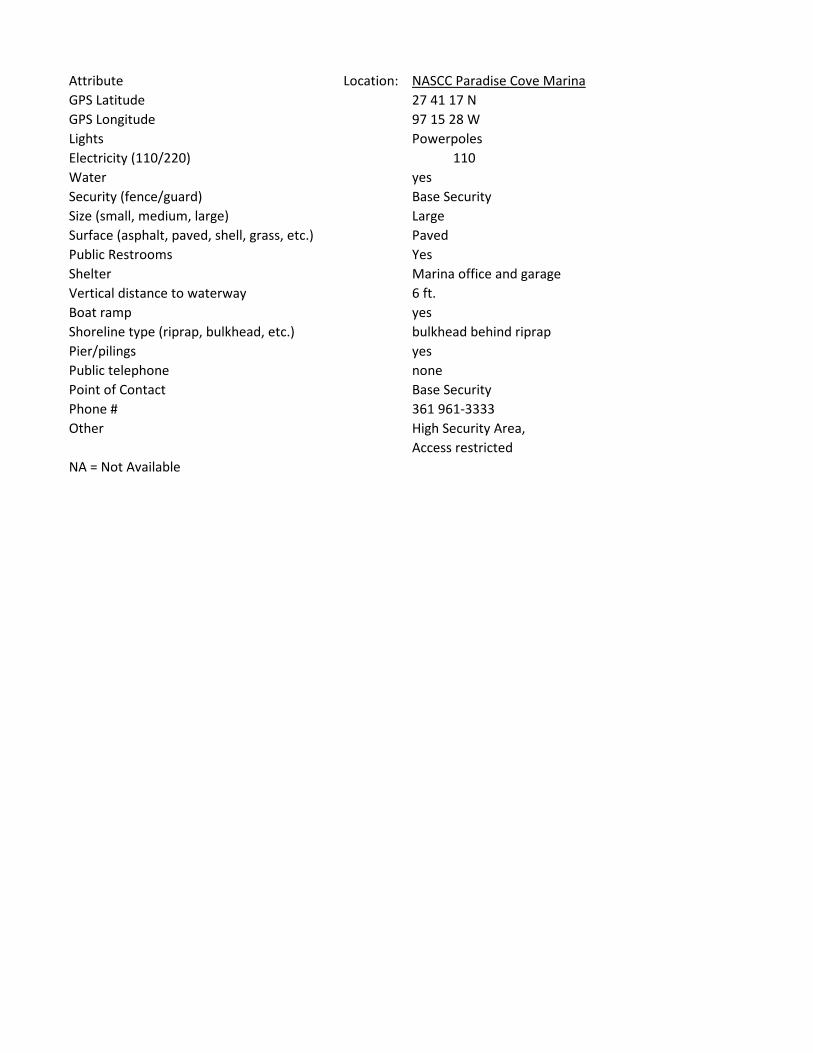
Attribute Location: NASCC Paradise Cove MarinaGPS Latitude 27 41 17 NGPS Longitude 97 15 28 WLights PowerpolesElectricity (110/220) 110Water yesSecurity (fence/guard) Base SecuritySize (small, medium, large) LargeSurface (asphalt, paved, shell, grass, etc.) PavedPublic Restrooms YesShelter Marina office and garageVertical distance to waterway 6 ft.Boat ramp yesShoreline type (riprap, bulkhead, etc.) bulkhead behind riprapPier/pilings yesPublic telephone nonePoint of Contact Base SecurityPhone # 361 961-3333Other High Security Area,
Access restrictedNA = Not Available
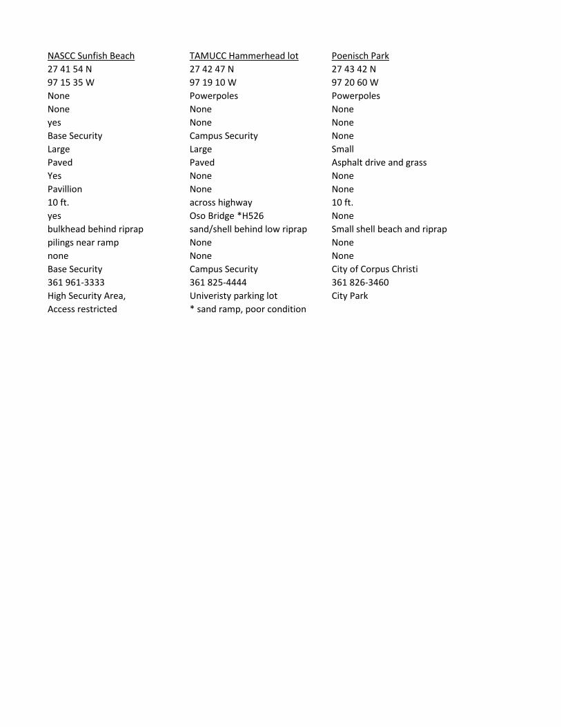
NASCC Sunfish Beach TAMUCC Hammerhead lot Poenisch Park27 41 54 N 27 42 47 N 27 43 42 N97 15 35 W 97 19 10 W 97 20 60 WNone Powerpoles PowerpolesNone None Noneyes None NoneBase Security Campus Security NoneLarge Large SmallPaved Paved Asphalt drive and grassYes None NonePavillion None None10 ft. across highway 10 ft.yes Oso Bridge *H526 Nonebulkhead behind riprap sand/shell behind low riprap Small shell beach and riprappilings near ramp None Nonenone None NoneBase Security Campus Security City of Corpus Christi361 961-3333 361 825-4444 361 826-3460High Security Area, Univeristy parking lot City ParkAccess restricted * sand ramp, poor condition

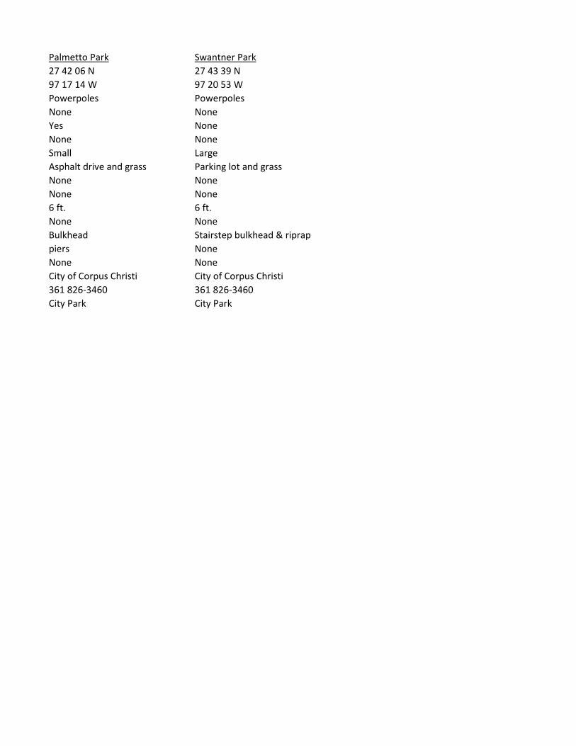
Palmetto Park Swantner Park27 42 06 N 27 43 39 N97 17 14 W 97 20 53 WPowerpoles PowerpolesNone NoneYes NoneNone NoneSmall LargeAsphalt drive and grass Parking lot and grassNone NoneNone None6 ft. 6 ft.None NoneBulkhead Stairstep bulkhead & riprappiers NoneNone NoneCity of Corpus Christi City of Corpus Christi361 826-3460 361 826-3460City Park City Park

Attribute Location: NASCC Paradise Cove MarinaGPS Latitude 27 41 17 NGPS Longitude 97 15 28 WLights PowerpolesElectricity (110/220) 110Water yesSecurity (fence/guard) Base SecuritySize (small, medium, large) LargeSurface (asphalt, paved, shell, grass, etc.) PavedPublic Restrooms YesShelter Marina office and garageVertical distance to waterway 6 ft.Boat ramp yesShoreline type (riprap, bulkhead, etc.) bulkhead behind riprapPier/pilings yesPublic telephone nonePoint of Contact Base SecurityPhone # 361 961-3333Other High Security Area,
Access restrictedNA = Not Available

NASCC Sunfish Beach TAMUCC Hammerhead lot Poenisch Park27 41 54 N 27 42 47 N 27 43 42 N97 15 35 W 97 19 10 W 97 20 60 WNone Powerpoles PowerpolesNone None Noneyes None NoneBase Security Campus Security NoneLarge Large SmallPaved Paved Asphalt drive and grassYes None NonePavillion None None10 ft. across highway 10 ft.yes Oso Bridge *H526 Nonebulkhead behind riprap sand/shell behind low riprap Small shell beach and riprappilings near ramp None Nonenone None NoneBase Security Campus Security City of Corpus Christi361 961-3333 361 825-4444 361 826-3460High Security Area, Univeristy parking lot City ParkAccess restricted * sand ramp, poor condition
Palmetto Park Swantner Park27 42 06 N 27 43 39 N97 17 14 W 97 20 53 WPowerpoles PowerpolesNone NoneYes NoneNone NoneSmall LargeAsphalt drive and grass Parking lot and grassNone NoneNone None6 ft. 6 ft.None NoneBulkhead Stairstep bulkhead & riprappiers NoneNone NoneCity of Corpus Christi City of Corpus Christi361 826-3460 361 826-3460City Park City Park
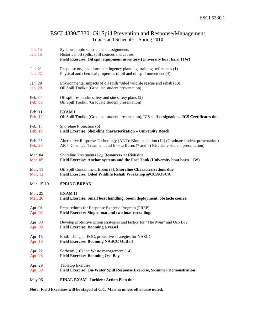
ESCI 5330 1
ESCI 4330/5330: Oil Spill Prevention and Response/Management Topics and Schedule – Spring 2010
Jan. 14 Syllabus, topic schedule and assignments Jan. 15 Historical oil spills, spill sources and causes
Field Exercise: Oil spill equipment inventory (University boat barn 11W) Jan. 21 Response organizations, contingency planning, training, references (1) Jan. 22 Physical and chemical properties of oil and oil spill movement (4) Jan. 28 Environmental impacts of oil spills/Oiled wildlife rescue and rehab (13) Jan. 29 Oil Spill Toolkit (Graduate student presentation) Feb. 04 Oil spill responder safety and site safety plans (2) Feb. 05 Oil Spill Toolkit (Graduate student presentation) Feb. 11 EXAM I Feb. 12 Oil Spill Toolkit (Graduate student presentation), ICS staff designations. ICS Certificates due Feb. 18 Shoreline Protection (6) Feb. 19 Field Exercise: Shoreline characterization – University Beach Feb. 25 Alternative Response Technology (ART): Bioremediation (12) (Graduate student presentation) Feb. 26 ART: Chemical Treatment and In-situ Burns (7 and 8) (Graduate student presentation) Mar. 04 Shoreline Treatment (12,) Resources at Risk due Mar. 05 Field Exercise: Anchor systems and the Fast Tank (University boat barn 11W) Mar. 11 Oil Spill Containment Boom (5), Shoreline Characterizations due Mar. 12 Field Exercise: Oiled Wildlife Rehab Workshop @CCAOSCA Mar. 15-19 SPRING BREAK Mar. 25 EXAM II Mar. 26 Field Exercise: Small boat handling, boom deployment, obstacle course Apr. 01 Preparedness for Response Exercise Program (PREP) Apr. 02 Field Exercise: Single boat and two boat corralling. Apr. 08 Develop protective action strategies and tactics for “The Nina” and Oso Bay Apr. 09 Field Exercise: Booming a vessel Apr. 15 Establishing an EOC, protective strategies for NASCC Apr. 16 Field Exercise: Booming NASCC Outfall Apr. 22 Sorbents (10) and Waste management (14) Apr. 23 Field Exercise: Booming Oso Bay Apr. 29 Tabletop Exercise Apr. 30 Field Exercise: On-Water Spill Response Exercise, Skimmer Demonstration May 06 FINAL EXAM Incident Action Plan due Note: Field Exercises will be staged at C.C. Marina unless otherwise noted.