Embed Size (px)
Citation preview
Providing Location
Abstract
Information in a Ubiquitous Computing Environment
Mike Spreitzer and Marvin Theimer
Xerox Palo Alto
To take full advantage of the promise of ubiquitous com-
puting requires the use of location information, yet peo-
ple should have control over who may know their where-
abouts. We present an architecture that achieves these
goals for an interesting set of applications. Personal in-
formation is managed by User Agents, and a partially
decentralized Location Query Service is used to facili-
tate location-based operations. This architecture gives
users primary control over their location information, at
the cost of making more expensive certain queries, such
as those wherein location and identity closely interact.
We also discuss various extensions to our architecture
that offer users additional trade-offs between privacy
and efficiency. Finally, we report some measurements
of the unextended system in operation, focusing on how
well the system is actually able to track people. Our sys-
tem uses two kinds of location information, which turn
out to provide partial and complementary coverage.
1 Introduction
Mobile and ubiquitous computing requires and can ex-
ploit a variety of kinds of location information[9, 7, 4].
Just providing a person with access to their normal com-
puting services on a continual basis requires that their
location be known to a certain extent. In addition, if
information is available about who and what is in the
vicinity of a person, then that person’s computing en-
vironment and applications can behave in a context-
sensitive manner. Applications can reflect a user’s cur-
rent circumstances and and can respond to changes that
might occur in the user’s environment.
While desiring to exploit location information, weconsider unrestricted access to a person’s location data
*This research was supported in part by the Advanced Re-
sesrch Projects Agency under contract DABT63-91-C-0027.
Permission to copy without fee all or part of this material ISgranted provided that the copies are not made or distributed for
d!rect commercial advantage, the ACM copyright notice and the
title of the publication and its date appear, and notice IS g)ven
that copying is by permission of the Association for Computing
Machinery. To copy otherwise, or to republish, requires a fee
and/or specific permission.
SIGOPS ‘93/12 /93/N. C., USA0 1993 ACM o-8g791-632-8/93 /0012 . ..$ 5050
Research Center
to be an unacceptable invasion of privacy[5]. One way
to address this fundamental tension between location-
based functionality and privacy is to try to give each
user control over their location information and over
who may gain access to it. Unfortunately, guarantee-
ing that no one can gain unauthorized access to one’s
location information is, in general, very difficult and ex-
pensive.
Another important issue is the accuracy and temporal
resolution of location information. The sensing facilities
we have available to us are not perfect and hence it is
important to determine how well they work in practice.
Temporal resolution comes into play because it implic-
itly defines how small a movement the sensing facilities
are able to distinguish, and hence how quickly they are
likely to detect a change in someone’s location. Pro-
viding useful location information to applications thus
faces both the problems of limits of the location sens-
ing technologies used as well as protection of users from
abuse of those technologies.
A topic not covered in this paper is the spatial resolu-
tion provided by a system and the implications that has
for the kinds of applications that can be implemented.
We did not explore this topic because the only spa-
tial resolution provided by our sensing technologies is
“room-level” resolution. This enables applications such
as migrating display windows from one’s office to a con-
ference room, but does not easily support finer-grained
applications, such as “flicking” a window from one’s
portable notebook computer to that of a neighbor sit-
ting in the next chair.
In order to understand the issues of providing loca-
tion information to a system we have chosen a suite
of location-based applications to focus on and have de-signed and built a location infrastructure in support of
them. The applications we have built or prototype
include the following:
Visitor guidance : Guide a person to a designatedlocation.
Migrating windows : Migrate a user’s windows to a
designated location.
Note distribution : Send a message to all persons at
a given location or set of locations.
270
Ubiquitous Message Delivery (UMD) : A mes-
sage submitted for delivery is delivered at the soon-
est “acceptable)’ time via the most “appropriate”
terminal near the recipient. Acceptable delivery
time depends on the context of the recipient. For
example, the recipient’s profile may specify that
messages below a certain priority level should not
be delivered when the recipient is in a meeting with
other people. Similarly, the most appropriate ter-minal to use will depend on which devices are avail-
able at the recipient’s current location.
Me&la Call : A user can request to be connected to
one or more other users—wherever they currently
are—by the “best” means available. Choices in-
clude video, audio, and teletype “talk” connections.
As with UMD, users may specify policy constraints
that control which kinds of connections may be es-
tablished under various circumstances.
Scoreboard : This application is an information-
oriented “screen saver”. When a display is not be-
ing used for anything else, it displays information
of general interest, but tailored to the interests of
the people nearby.
Responsive environment : A “smart building” can
optimize its energy usage by exploiting knowledge
about which rooms are occupied. It can also control
the environmental settings of each room according
to the preferences of the people in them[3].
FindNearest : Find the nearest resource or per-
son matching a given specification, such as “color
printer” or “Unix wizard”.
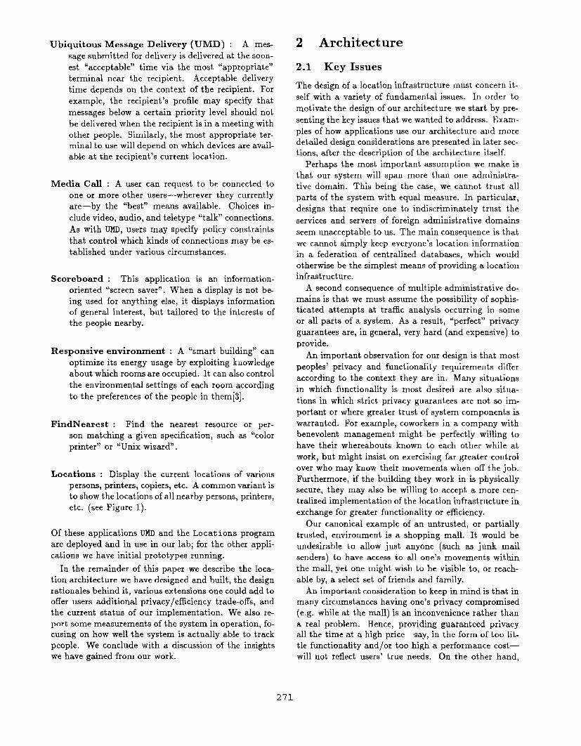
Locations : Display the current locations of various
persons, printers, copiers, etc. A common variant is
to show the locations of all nearby persons, printers,
etc. (see Figure 1).
Of these applications UMD and the Locations program
are deployed and in use in our lab; for the other appli-
cations we have initial prototypes running.
In the remainder of this paper we describe the loca-
tion architecture we have designed and built, the design
rat ion ales behind it, various extensions one could add to
offer users additional privacy/efficiency trade-offs, and
the current status of our implementation. We also re-
port some measurements of the system in operation, fo-
cusing on how well the system is actually able to track
people. We conclude with a discussion of the insights
we have gained from our work.
2 Architecture
2.1 Key Issues
The design of a location infrastructure must concern it-
self with a variety of fundamental issues. In order to
motivate the design of our architecture we start by pre-
senting the key issues that we wanted to address. Exam-
ples of how applications use our architecture and moredetailed design considerations are presented in later sec-
tions, after the description of the architecture itself.
Perhaps the most important assumption we make is
that our system will span more than one administra-
tive domain. This being the case, we cannot trust all
parts of the system with equal measure. In particular,
designs that require one to indiscriminately trust the
services and servers of foreign administrative domains
seem unacceptable to us. The main consequence is that
we cannot simply keep everyone’s location information
in a federation of centralized databases, which would
otherwise be the simplest means of providing a location
infrastructure.
A second consequence of multiple administrative do-
mains is that we must assume the possibility of sophis-ticated attempts at traffic analysis occurring in some
or all parts of a system. As a result, “perfect” privacy
guarantees are, in general, very hard (and expensive) to
provide.
An important observation for our design is that most
peoples’ privacy and functionality requirements differ
according to the context they are in. Many situations
in which functionality is most desired are also situa-
tions in which strict privacy guarantees are not so im-
portant or where greater trust of system components is
warranted. For example, coworkers in a company with
benevolent management might be perfectly willing to
have their whereabouts known to each other while at
work, but might insist on exercising far greater control
over who may know their movements when off the job.
Furthermore, if the building they work in is physically
secure, they may also be willing to accept a more cen-
tralized implementation of the location infrastructure in
exchange for greater functionality or efficiency.
Our canonical example of an untrusted, or partially
trusted, environment is a shopping mall. It would be
undesirable to allow just anyone (such as junk mail
senders) to have access to all one’s movements within
the mall, yet one might wish to be visible to, or reach-
able by, a select set of friends and family.
An important consideration to keep in mind is that in
many circumstances having one’s privacy compromised
(e.g. while at the mall) is an inconvenience rather than
a real problem. Hence, providing guaranteed privacyall the time at a high price—say, in the form of too lit-
tle functionality andjor too high a performance cost—
will not reflect users’ true needs. On the other hand,
271
Computer Science Laboratory
td__._r &7r_l -m
1w’
,..
I
Tm’,t%T5STii 2301
UiliD
:!.,, ,
n’” 2354
37, ,.
,. .,.,
\i, (Won, m 2332
@< e, , f! 234B
JD ..6
0
n
,te. a, COuoll
a
3*.1*
‘aam06
c1Con .Fwwe m 23il
m !3!ii!!1—
Tue Aug 1713:35:191993
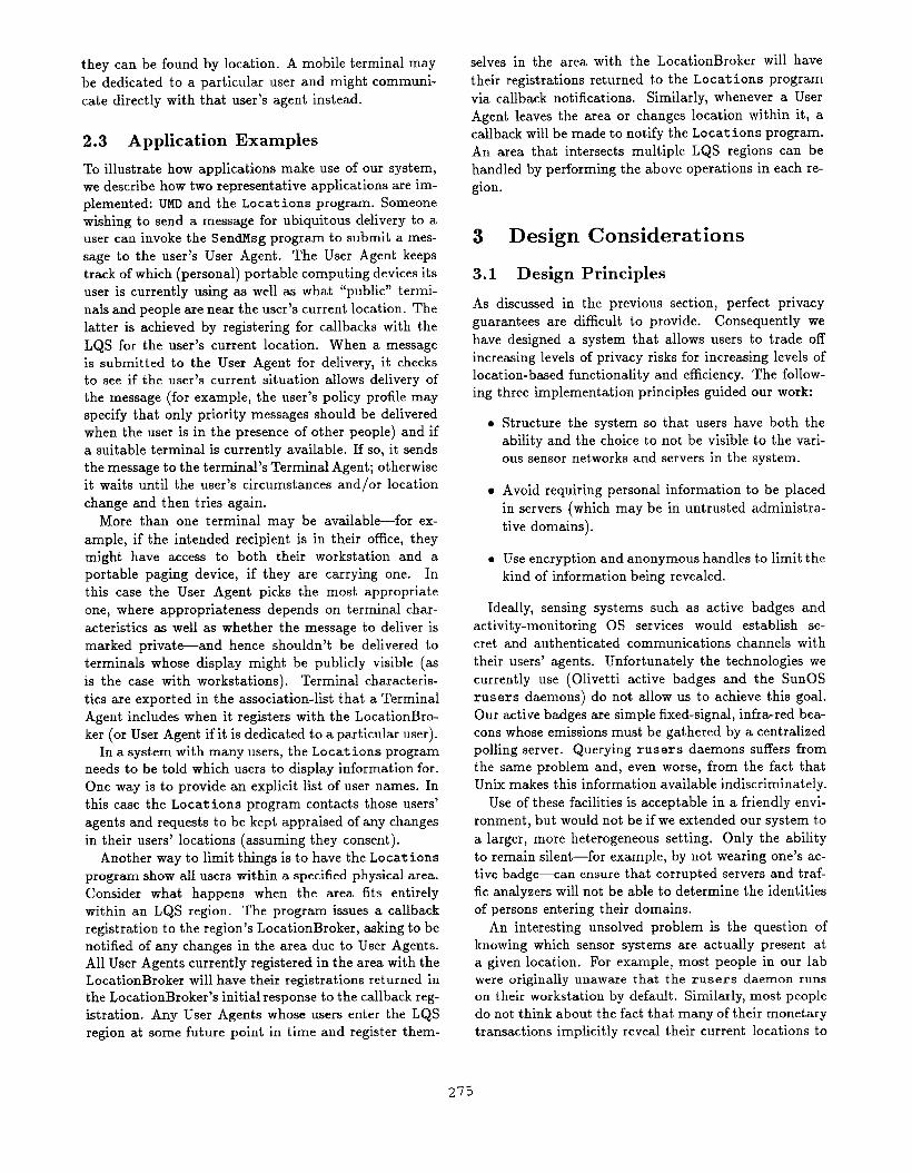
of the Locations program: displays the location of all nearby people willing to beFigure 1: Output of one variant
publicly visible.
there are clearly circumstances of location information while the gray arrows show the
path of a ubiquitous message delivery. Not shown are
various application-specific servers and our Name-and-
Maintenance Service, which uses familiar techniques to
enable lookup of servers by name and keep programs up
and running.
There is one User Agent for each user. Access con-
trol for personal information is implemented primarily
by a user’s agent. That is, each User Agent collects and
controls all the personal information pertaining to its
user and applications can only get personal information
from a user’s agent—and only if that agent consents. In
fact, a user’s agent can lie about the user’s personal in-
formation, because consumers of that information have
no other authoritative way of determining that infor-
mation. A user’s agent is under the control of the user:
he determines “the policies implemented by his agent,
chooses which implementation of the agent to run (or
when very strong pri-
vacy guarantees are a requirement. The conclusion we
draw from these examples is that we need an architec-
ture that provides user-controllable trade-offs between
privacy guarantees and both functionality and efficiency.
Much of our design focuses on how to selectively regain
the efficiency achievable by centralized designs when
users are willing to risk trusting various system com-
ponents to some degree.
2.2 Description
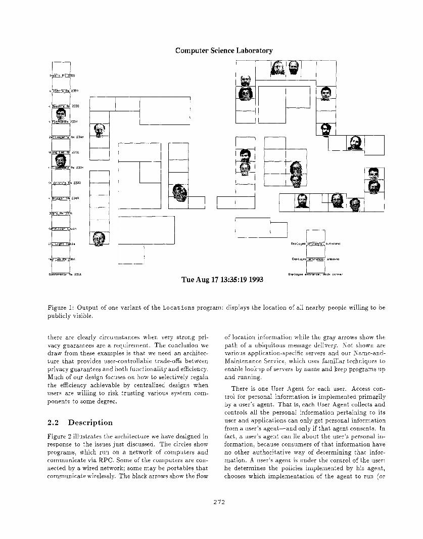
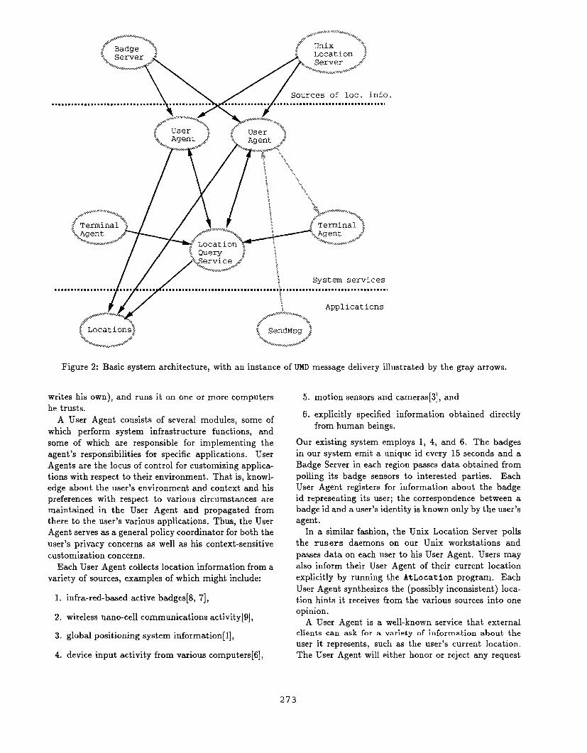
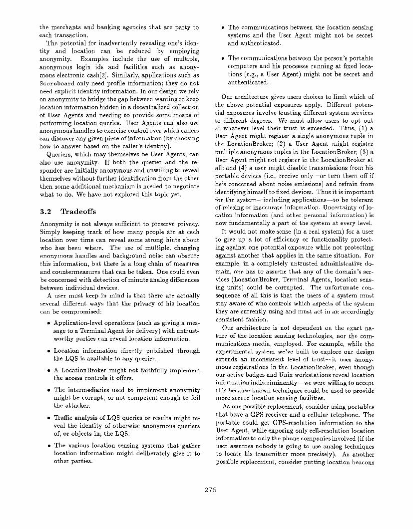
Figure 2 illustrates the architecture we have designed in
response to the issues just discussed. The circles show
programs, which run on a network of computers and
communicate via RPC, Some of the computers are con-
nected by a wired network; some may be portables that
communicate tirelessly. The black arrows show the flow
272
.,...’.’.’’.’.’-:..,...,.,:,,....,.,+ ..,:,
‘“’’:;E\\/k2in................................................................................................1
.. . . . . .
...‘,...
i.,~...
...j:.........................................,,:,,.:::.. ..::..
Figure 2: Basic system architecture, with an instance of UMD message delivery illustrated by the gray
writes his own), and runs it on one or more computers
he trusts.
A User Agent consists of several modules, some of
which perform system infrastructure functions, and
some of which are responsible for implementing the
agent’s responsibilities for specific applications. User
Agents are the locus of control for customizing applica-
tions with respect to their environment. That is, knowl-
edge about the user’s environment and context and his
preferences with respect to various circumstances are
maintained in the User Agent and propagated from
there to the user’s various applications. Thus, the User
Agent serves as a general policy coordinator for both the
user’s privacy concerns as well as his context-sensitive
customization concerns.
Each User Agent collects location information from a
variety of sources, examples of which might include:
1. infra-red-based active badges[8, 7],
2. wireless nano-cell communications activity[9],
3. global positioning system informational],
4. device input activity from various computers[6],
arrows.
5. motion sensors and cameras[3], and
6. explicitly specified information obtained directly
from human beings,
Our existing system employs 1, 4, and 6. The badges
in our system emit a unique id every 15 seconds and a
Badge Server in each region passes data obtained from
polling its badge sensors to interested parties. Each
User Agent registers for information about the badge
id representing its user; the correspondence between a
badge id and a user’s identity is known only by the user’s
agent.
In a similar fashion, the Unix Location Server polls
the rusers daemons on our Unix workstations and
passes data on each user to his User Agent. Users may
also inform their User Agent of their current location
explicitly by running the AtLocation program. Each
User Agent synthesizes the (possibly inconsistent) loca-
tion hints it receives from the various sources into one
opinion.
A User Agent is a well-known service that external
clients can ask for a variety of information about the
user it represents, such as the user’s current Iocat ion.
The User Agent will either honor or reject any request
273
depending on the policy its user has specified. Subject
to the user’s policy, the agent also makes its user find-
able by location using the facilities described later.
Some applications work by simply interacting with
User Agents. For example, submitting a message for
ubiquitous delivery consists of simply giving the mes-
sage to the User Agents for the recipients; each agent
then takes care of getting the message to its user. Other
applications, like Scoreboard, Responsive Environment,
and FindNearest, are primarily concerned with a given
location, and must perform some kind of a query to find
the agents for the people at or near that location. Some-
times User Agents themselves need to perform location-
based queries—for example, to find nearby terminals
through which to present a message for ubiquitous de-
livery.
One of the key problems addressed by our architec-
ture is how to keep disclosure of the association between
a person’s identity and that person’s location under the
control of that person while supporting our applica-
tions with reasonable efficiency. Our architecture pro-
vides control through the User Agent: (1) an applica-
tion starting from a person’s identity can only discover
that person’s location by asking the person’s agent, and
(2) an application starting from a location must use the
Location Query Service (see below) to discover the iden-
tities of the people at that location, and the Location
Query Service is designed to give User Agents control
over the circumstances of the release of that informa-
tion.
The Location Query Service (LQS) provides a way of
executing location queries that offers different trade-offs
between efficiency and privacy. It is built around the
idea of queries over located objects. A located object is
represent ed by a t uple consist ing of a location, an RPC
handle, and an association-list describing the object’s
type and other information that the object chooses to
make available.1 Examples of located objects include
users (represented by User Agents) and terminals (rep-
resented by Terminal Agents). A query is a predicate
over a location and an association-list; the result of a
query is the set of tuples that satisfy the predicate.
A key feature of the LQS is that located objects can
be anonymous. That is, a tuple’s association-list may
reveal only its type and its RPC handle may employ
techniques such as indirection through trustworthy in-
termediaries to hide the true identity of the real server
behind the handle. A client getting a query response
listing a tuple with an anonymous RPC handle and no
identity in the association-list would have to use the
RPC handle to ask the object for its identity.2 That ob-
ject (e.g., a User Agent) can respond truthfully, falsely,
10bject type is used indicate which RPC interface to use withthe RPC handle.
2III a similar way, a client can hide its identity by issuing itsqueries from an anonymous RPC handle.
or not at all, depending on its policy (which might, for
example, require authenticating the caller).
Note that a located object could register several tu-
ples for itself, in order to make traffic analysis more
difficult.
The LQS is organized by regions, with a centralized
server, called the LocationBroker, running in each re-
gion. Public objects whose identities and locations are
not meant to be kept secret—such as printers and office
display terminals—register a full description of them-
selves in the LocationBroker covering the region they in-
habit. A private object—such as a User Agent—who is
willing to reveal that someone (without revealing who)
is at their current location, registers itself in the appro-
priate LocationBroker in an anonymous fashion.
Each region’s LocationBroker also supports standing
queries: a client can submit a query and a callback RPC
handle, with the LocationBroker notifying the client of
the change whenever the answer to the query changes.
This is used, for example, by the Locations program
to monitor a given area.
A final efficiency trade-off that LocationBrokers can
be provide is to implement access control on behalf of
an object. This amounts to selectively returning a tu-
ple, or portions of its association list, in the results of a
query according to a policy specified by the object when
it registers itself. An object using a region’s Location-
Broker thus has the choice of (1) registering minimal
information (location, type, and anonymous RPC han-
dle) with the LocationBroker and implementing access
control entirely on its o~n, (2) using (and thus trusting)
the access control functionality of the region’s Location-
Broker, or (3) any combination of the previous two.3
Note that for regions where most User Agents are will-
ing to entrust their access controls to the region’s Lo-
cationBroker, that region’s LQS has essentially become
a centralized design, with all the efficiency benefits and
privacy risks that implies.
The last piece of our architecture concerns 1/0 de-
vices. There is one Terminal Agent for each “terminal”,
or cluster of 1/0 devices that operate together (for ex-
ample, a workstation’s keyboard, mouse, screen, and
sound card comprise one terminal). As with the User
Agent, the Terminal Agent consists of several modules,
some infrastructure and some application-specific. The
agent provides access through a device-independent in-
terface, and manages the multiple demands on the ter-
minal.
Because terminals have owners, and are dedicated (in
some cases) to specified uses, there are also policy deci-
sions to be made by Terminal Agents. Agents for non-
mobile terminals register in the LocationBroker, so that
3Since our interest is in exploring what happens when serversare not trusted, we have not implemented access controls in ourLocationBroker.
274
they can be found by location. A mobile terminal may
be dedicated to a particular user and might communi-
cate directly with that user’s agent instead.
2.3 Application Examples
To illustrate how applications make use of our system,
we describe how two representative applications are im-
plemented: UMD and the Locations program. Someone
wishing to send a message for ubiquitous delivery to a
user can invoke the SendMsg program to submit a mes-
sage to the user’s User Agent. The User Agent keeps
track of which (personal) portable computing devices its
user is currently using as well as what “public” termi-
nals and people are near the user’s current location. The
latter is achieved by registering for callbacks with the
LQS for the user’s current location. When a message
is submitted to the User Agent for delivery, it checks
to see if the user’s current situation allows delivery of
the message (for example, the user’s policy profile may
specify that only priority messages should be delivered
when the user is in the presence of other people) and if
a suitable terminal is currently available. If so, it sends
the message to the terminal’s Terminal Agent; otherwise
it waits until the user’s circumstances and/or location
change and then tries again.
More than one terminal may be available—for ex-
ample, if the intended recipient is in their office, they
might have access to both their workstation and a
portable paging device, if they are carrying one. In
this case the User Agent picks the most appropriate
one, where appropriateness depends on terminal char-
acteristics as well as whether the message to deliver is
marked private—and hence shouldn’t be delivered to
terminals whose display might be publicly visible (as
is the case with workstations). Terminal characteris-
tics are exported in the association-list that a Terminal
Agent includes when it registers with the LocationBro-
ker (or User Agent if it is dedicated to a particular user).
In a system with many users, the Locations program
needs to be told which users to display information for.
One way is to provide an explicit list of user names. In
this case the Locations program contacts those users’
agents and requests to be kept appraised of any changes
in their users’ locations (assuming they consent).
Another way to limit things is to have the Locations
program show all users within a specified physical area.
Consider what happens when the area fits entirely
within an LQS region. The program issues a callback
registration to the region’s LocationBroker, asking to be
notified of any changes in the area due to User Agents.
All User Agents currently registered in the area with the
LocationBroker will have their registrations returned in
the LocationBroker’s initial response to the callback reg-
istration. Any User Agents whose users enter the LQS
region at some future point in time and register them-
selves in the area with the LocationBroker will have
their registrations returned to the Locations program
via callback notifications. Similarly, whenever a User
Agent leaves the area or changes location within it, a
callback will be made to notify the Locations program.
An area that intersects multiple LQS regions can be
handled by performing the above operations in each re-
gion.
3 Design Considerations
3.1 Design Principles
As discussed in the previous section, perfect privacy
guarantees are difficult to provide. Consequently we
have designed a system that allows users to trade off
increasing levels of privacy risks for increasing levels of
location-based functionality and efficiency. The follow-
ing three implementation principles guided our work:
●
●
●
Structure the system so that users have both the
ability and the choice to not be visible to the vari-
ous sensor networks and servers in the system.
Avoid requiring personal information to be placed
in servers (which may be in untrusted administra-
tive domains).
Use encryption and anonymous handles to limit the
kind of information being revealed.
Ideally, sensing systems such as active badges and
activity-monitoring OS services would establish se-
cret and authenticated communications channels with
their users’ agents. Unfortunately the technologies we
currently use (Olivetti active badges and the SunOS
rus ers daemons) do not allow us to achieve this goal.
Our active badges are simple fixed-signal, infra-red bea-
cons whose emissions must be gathered by a centralized
polling server. Querying rusers daemons suffers from
the same problem and, even worse, from the fact that
Unix makes this information available indiscriminately.
Use of these facilities is acceptable in a friendly envi-
ronment, but would not be if we extended our system to
a larger, more heterogeneous setting. Only the ability
to remain silent—for example, by not wearing one’s ac-
tive badge—can ensure that corrupted servers and traf-
fic analyzers will not be able to determine the identities
of persons entering their domains.
An interesting unsolved problem is the question of
knowing which sensor systems are actually present at
a given location. For example, most people in our lab
were originally unaware that the rusers daemon runs
on their workst at ion by default. Similarly, most people
do not think about the fact that many of their monetary
transactions implicitly reveal their current locations to
275
the merchants and banking agencies that are party to
each transaction.
The potential for inadvertently revealing one’s iden-
tity and location can be reduced by employing
anonymity. Examples include the use of multiple,
anonymous login ids and facilities such as anony-
mous electronic cash[2]. Similarly, applications such as
Scoreboard only need profile information; they do not
need explicit identity information. In our design we rely
on anonymity to bridge the gap between wanting to keep
location information hidden in a decentralized collection
of User Agents and needing to provide some means of
performing location queries. User Agents can also use
anonymous handles to exercise control over which callers
can discover any given piece of information (by choosing
how to answer based on the caller’s identity).
Queriers, which may themselves be User Agents, can
also use anonymity. If both the querier and the re-
sponder are initially anonymous and unwilling to reveal
themselves without further identification from the other
then some additional mechanism is needed to negotiate
what to do. We have not explored this topic yet.
3.2 Tradeoffs
Anonymity is not always sufficient to preserve privacy.
Simply keeping track of how many people are at each
location over time can reveal some strong hints about
who has been where. The use of multiple, changing
anonymous handles and background noise can obscure
this information, but there is a long chain of measures
and countermeasures that can be taken. One could even
be concerned with detection of minute analog differences
between individual devices.
A user must keep in mind is that there are actually
several different ways that the privacy of his location
can be compromised:
●
●
o
●
e
●
Application-level operations (such as giving a mes-
sage to a Terminal Agent for delivery) with untrust-
worthy parties can reveal location information.
Location information directly published through
the LQS is available to any querier.
A LocationBroker might not faithfully implement
the access cent rols it offers.
The intermediaries used to implement anonymity
might be corrupt, or not competent enough to foil
the attacker.
Traffic analysis of LQS queries or results might re-
veal the identity of otherwise anonymous queriers
of, or objects in, the LQS.
The various location sensing systems that gather
location information might deliberately give it to
other parties.
●
●
The communications between the location sensing
systems and the User Agent might not be secret
and authenticated.
The communications between the person’s portable
computers and his processes running at fixed loca-
tions (e.g., a User Agent) might not be secret and
authenticated.
Our architecture gives users choices to limit which of
the above potential exposures apply. Different poten-
tial exposures involve trusting different system services
to different degrees. We must allow users to opt out
at whatever level their trust is exceeded. Thus, (1) a
User Agent might register a single anonymous tuple in
the LocationBroker; (2) a User Agent might register
multiple anonymous tuples in the LocationBroker; (3) a
User Agent might not register in the LocationBroker at
all; and (4) a user might disable transmissions from his
portable devices (i.e., receive only—or turn them off if
he’s concerned about noise emissions) and refrain from
identifying himself to fixed devices. Thus it is important
for the system—including applications—to be tolerant
of missing or inaccurate information. Uncertainty of lo-
cation information (and other personal information) is
now fundamentally a part of the system at every level.
It would not make sense (in a real system) for a user
to give up a lot of efficiency or functionality protect-
ing against one potential exposure while not protecting
against another that applies in the same situation. For
example, in a completely untrusted administrative do-
main, one has to assume that any of the domain’s ser-
vices (LocationBroker, Terminal Agents, location sens-
ing units) could be corrupted. The unfortunate con-
sequence of all this is that the users of a system must
stay aware of who controls which aspects of the system
they are currently using and must act in an accordingly
consist ent fashion.
Our architecture is not dependent on the exact na-
ture of the location sensing technologies, nor the com-
munications media, employed. For example, while the
experimental system we’ve built to explore our design
extends an inconsistent level of trust—it uses anony-
mous registrations in the LocationBroker, even though
our active badges and Unix workstations reveal location
information indiscriminantly—we were willing to accept
this because known techniques could be used to provide
more secure location sensing facilities.
As one possible replacement, consider using portables
that have a GPS receiver and a cellular telephone. The
portable could get GPS-resolution information to the
User Agent, while exposing only cell-resolution location
information to only the phone companies involved (if the
user assumes nobody is going to use analog techniques
to locate his transmitter more precisely), As another
possible replacement, consider put ting location beacons
276
in each room, and having an active badge that relays
a received location to its User Agent by sending an en-
crypted message through a chain of intermediaries. In
this case the User Agent gets room-resolution location
information, trusting the intermediaries to hide the link
between location and identity, and revealing that some-
one is in the room to anyone that can see such an agent-
bound message and discover its room of origin.
A User Agent trades privacy against functionality
when choosing how much information to reveal to which
other parties. A completely mistrustful User Agent can-
not be found by FindNearest or Note Distribution, can-
not customize a Scoreboard or a Responsive Environ-
ment, and cannot ubiquitously deliver a message or par-
ticipate in a Media Call.
In addition to allowing trade-offs between privacy and
functionality, our system allows users to make trade-offs
between privacy and efficiency. The LQS offers a User
Agent three choices in this regard. The first choice is
how much information to include in the association list
describing the agent. When all the information needed
by an information-seeking application is found in the
association list, the application need not contact the
agent to complete its job; including this information
thus increases efficiency, at the privacy cost of perhaps
indiscriminately revealing that information.
The second choice offered by the LQS is between reg-
istering one or several tuples for a located object. Use
of several tuples will cause the User Agent to appear
in more query results and hence have to answer more
follow-up questions from potentially interested clients.
The third choice offered by the LQS pertains to the
use of access controls within the LocationBroker. If
most User Agents participating in the LQS of a region
are willing to completely trust the region’s Location-
Broker then certain kinds of queries can be made much
more efficient. In particular, queries where the set of
User Agents that will appear in the result cannot be
well approximated on the basis of location alone will
benefit from this optimization. For example, consider
querying for the k users in some set of locations whose
names are alphabetically nearest one given name (such
as might appear in the middle of a scrolling list). Before
the final k can be chosen, all agents registered anony-
mously at those locations must be queried individually
for their names.
3.3 Alternatives
An interesting addition to our architecture to consider
is the use of multicast. One could imagine having a mul-
ticast group instead of a LocationBroker for each LQS
region and having clients of the LQS multicast their
location queries to all members of a region’s multicast
group. Interested parties, such as the User Agents of all
users currently in a region, would anonymously listen
to the region’s multicast group to hear location queries.
They would answer a query if they matched it and if
their current privacy policy allowed it.
The advantage of using multicast is that it only re-
veals the association between an RPC handle and the
region, and that only to the multicast routing infras-
tructure. In contrast, using the LocationBroker reveals
the association between an RPC handle and a specific
location. The disadvantage of multicast is increased
computation and communication: location queries go
to, and must be processed by, all listening objects in
the ~egion instead of just the LocationBroker, and the
cost of multicasting to User Agents located somewhere
on the Internet may be substantially more than the cost
of communicating just with the LocationBroker. Note
also that we require reliable multicast for the design j ust
described.
One way to address the inefficiency problems of mul-
ticast is to offer it as an option, in addition to the option
of using a LocationBroker. Thus, each LQS region could
maintain both a multicast group and a LocationBroker,
with the LocationBroker listening to its region’s mul-
ticast group and processing all location queries against
the objects that are registered in it. User Agents would
thus have a choice between listening to a region’s mul-
ticast group for greater privacy or registering with a
region’s LocationBroker for greater efficiency.
Unfortunately, if multicast is unavailable then clients
have no choice but to register with the LocationBroker
(if they wish to be findable) and accept the increased
risk that implies. Not e also that a User Agent wishing
to listen to a region’s multicast group must be able to
register in the multicast group from whatever address it
(or the last intermediary of its anonymous indirection
chain) has. Such functionality is not yet widely available
in the Internet.
There are other, radically different, architectures one
could design to protect one’s privacy, but these do not
support all the applications we are interested in. For ex-
ample, if all we cared about were visitor guidance then a
simple scheme whereby each location contains a broad-
cast location beacon that could be received by nearby
portable devices would suffice. Such a scheme would
provide strong privacy guarantees as long as no portable
device tried to communicate with the rest of the world.
Another alternative design could be constructed around
“proximity-based” communications and sensing facili-
ties. These could be used to enable communications
and presence detection among objects at a particular
location without requiring more wide-ranging commu-
nications that would be easier to monitor by exter-
nal parties. Such facilities, combined with portable
computer devices, could be used to implement things
like Scoreboard, in-room note distribution, and in-room
window migration. However, finding out about things
LIl
beyond one’s immediate proximity—as is needed by the
FindNearest and Locations applications would not be
possible.
4 Status and Experience
Our location infrastructure is built and currently de-
ployed within part of our lab with 12 User Agents, 21
Terminal Agents, and one LocationBroker running. The
act ive badge system includes about 120 infra-red sensors
that are deployed in about 70 offices, 10 common areas
and lab rooms, and the corridors interconnect ing them,4
This represents about 10% of the entire floor plan of our
building. Thus, the people participating in our system
are still outside the system a considerable amount of
time; both during the work day and outside of it.
As mentioned in the introduction, the two applica-
tions currently in use in our system are the Locations
program and UMD. The more popular one is the
Locations program, which people tend to keep running
all the time in a background window on their worksta-
tions. Its primary use seems to be as a quick “hint”
reference source to know if someone is currently in or
where they might currently be. When run with the
-map option, the program also provides a convenient
map of the lab instead of just an alphabetically sorted
list of (name, location) pairs. However, the map output
option also takes up more screen space, making it less
popular as a permanent background facility.
The UMD application manages to successfully deliver
about 63% of all submitted messages to their intended
recipients within one minute and about 7370 within five
minutes.5 Unfortunately, these statistics are not very
informative because they are dominated by the fact that
our users are not always near a display terminal and are
frequently outside the range of our system altogether.
As a consequence, messages may require a considerable
time before being delivered, even when the basic loca-
tion tracking system is functioning perfectly.
Our experience with UMD verified our expectation that
recipient context is very important. Originally, we
silently popped up a window when a message was deliv-
ered to someone. However, because our terminals run
screen savers when they aren’t in active use, many of-
fered messages didn’t get noticed. Unfortunately, when
we added an audio beep to announce message deliv-
ery, we found that message delivery was perceived as
being intrusive if the recipient was with other people.
This was especially the case if an unimportant message
was delivered to the electronic whiteboard of one of our
conference rooms during a meeting. Although UMD pro-
4Our infrastructure is a follow-on to an earlier and simpler,but more widely deployed one.
5Successful delivery means that the recipient explicitly ac-knowledged receipt of the message.
vides mechanism for implementing context-sensitivity,
it is still unclear what policies are desirable to effect
ubiquitous message delivery in both an effective and a
socially desirable manner.
In the remainder of this section we describe the data
we have gathered concerning how well our system is able
to track people.
4.1 Active Badge ‘hacking System
Our badge system consists of strings of infra-red sensors,
mounted in the ceilings of rooms and corridors, that
are periodically polled by programs running on work-
stations. Offices and corridors typically have one sensor
installed in them, while common areas and lab rooms
have between two and four sensors installed. Our instal-
lation includes three separate strings of sensors; each
attached to a different workstation. Each of the three
poller programs feeds its raw data into the Badge Server,
which then forwards the appropriate parts to each User
Agent that has registered with it.
Our badges emit a fixed-id signal every 15 seconds and
it takes roughly 2 to 3 seconds for each poller program
to interrogate all the sensors on the sensor string it is
responsible for; this implies that the minimum temporal
resolution of our system is about 15 to 18 seconds. In or-
der to get a handle on how reliably the infra-red sensors
manage to detect badge emissions, we have structured
the data presented in this section around the notion of
a “sighting interval”, which is the time between subse-
quent sightings of the same badge (or a person’s input
activity in the case of the rus ers data presented later
on). If badge emissions are reliably detected by the sen-
sor system then the average sighting interval for a per-
son, while they are in the area covered by the sensors,
should be around 15 to 20 seconds. Longer sighting in-
tervals will occur when a badge’s emissions are missed
by the sensor system.
Because people are frequently not within the area
that the badge sensor system covers, we have applied
two heuristics in this paper to account for absences. To
approximate the working day, we only consider badge
sighting intervals between the first sighting of a day and
the last sighting, with days considered to end at 2AM.
While this heuristic does the wrong thing for people
who work at 2AM, none of our subjects fall into that
category. We have also tried to filter out periods when
someone leaves the badge sensor area to go to another
part of the building or to leave the building during the
“work day”. This is done by excluding from considera-
tion intervals longer than an upper bound; we consider
several different values for this upper bound because
other effects (such as obstructing a badge’s emissions)
can also produce long intervals.
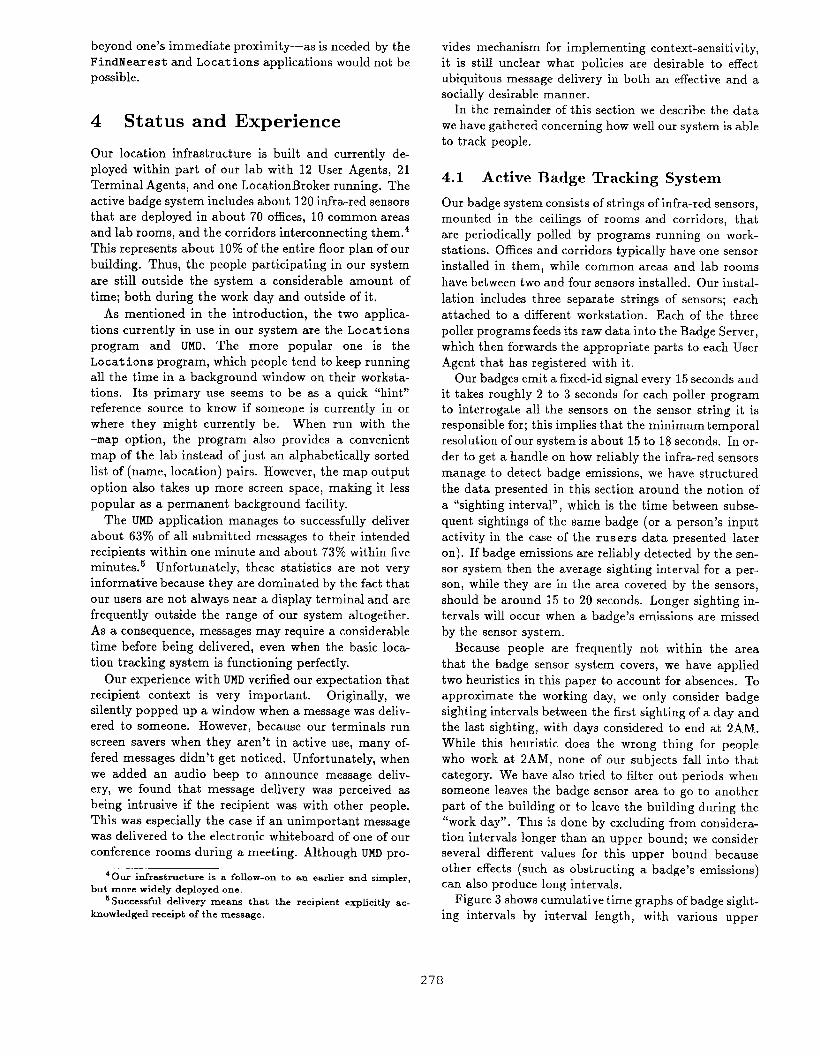
Figure 3 shows cumulative time graphs of badge sight-
ing intervals by interval length, with various upper
278

100
90
80
.g 70
%
@ 60
50
40
Intervals <10 Ulin
Intel-vials<30 Ulin
Intervsls <1 hr
Intervals <2 llrs
Illtervsls <4 hrs
Au intervals
100
90Au interv’u”
80 -
70 ‘
60 -/ N
50 -
40 - J
m I I 1 I I I I m ~.“
o 103 200 300 400 500 600 3:001 0.01 0.1sea hrs
Figure 3: Cumulative graphs of badge sighting intervals by interval length, with various upper
length considered.
bounds on interval length considered. The curve for all
intervals (within a “working day” ) is shown extended
out to 10 hours in the side plot. Each point on a curve
represents the total amount of time spent in intervals
shorter in length than that point’s x axis time value as
a fraction of the time spent in all intervals considered
for the curve. Note that over the region shown by the
main figure, the curves are actually just scaled versions
of each other because the sum of the interval values
used for any x axis point is the same for each curve.
The purpose of showing multiple curves is to give the
reader some idea of how the (same) data looks as we
apply ever-more-aggressive versions of our heuristic for
filtering out intervals during which a person is outside
the system.
When all intervals during the “working day” are in-
cluded then short sighting intervals account for a dis-
tressingly small percentage of the time. Accounting for
likely absences improves the numbers but still leaves sig-
nificant periods of time during which a user is sighted
only after a lengthy interval.
When the badge sighting data is broken down by per-
son, considerable variation is seen between people. For
example, the percentage of time spent in intervals less
than 20 seconds long varied from 9% to 63?10 for the “all
intervals” cases. When intervals greater than 1 hour are
thrown out then the time spent in intervals of less than
20 seconds varied from 12% to 78V0. These variations
1 10
bounds on interval
seem to be due to a variety of factors, such as time spent
outside the badge system area during the day, whether
or not a person wears their badge all the time, and how
“visible” their badge is to sensors. The latter issue is
problematic for several reasons:
●
●
●
Both natural light and some of our ceiling lighting
interfere with the sensitivity of our IR sensors.
Many people prefer wearing their badge on their
belt rather than pinned to their chest. Unfortu-
nately a belt-worn badge is frequently obscured by
a person’s arms or other objects; especially when
they are seated.
Our offices typically have only one sensor in them,
yet people tend to face different directions when
performing different activities. A common exam-
ple is working at a computer versus talking with a
colleague.
One of the questions we had with using an infra-
red-based badge system was how often multiple sensors
would see a badge at the same time, This can occur
in large rooms containing multiple sensors, at corridor
intersections, and for glass-walled offices that happen
to have a corridor sensor outside them. Our system has
multiple-location sightings about 0.270 of the time; with
the bulk of them occurring in our meeting rooms and
279
l~FFTJTn’”ds<’O-Y
80 A ~ Intends <30 LlliIl/
A-
i+!fEEHo 100 200 300 400 500 6CM
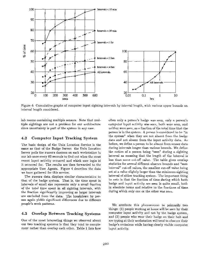
Figure 4: Cumulative graphs of computer input sighting intervals by
interval length considered.
lab rooms containing multiple sensors. Note that mul-
tiple sightings are not a problem for our architecture
since uncertainty is part of the system in any case.
4.2 Computer Input Tracking System
The basic design of the Unix Location Service is the
same as that of the Badge Server: the Unix Location
Server polls the rus ers daemon on each workstation in
our lab once every 60 seconds to find out when the most
recent input activity occurred and which user login id
it occurred for. The results are then forwarded to the
appropriate User Agents. Figure 4 describes the data
we have gathered for this service.
The rusers data displays similar characteristics to
that of the badge system. That is, the time spent in
intervals of small size represents only a small fraction
of the total time spent in all sighting intervals, with
the fraction significantly improving as larger intervals
are excluded from the data, The breakdown by per-
son again yields significant differences due to different
people’s work patterns.
4.3 Overlap Between Tracking Systems
One of the most interesting things we observed about
our two tracking systems is that they tend to comple-
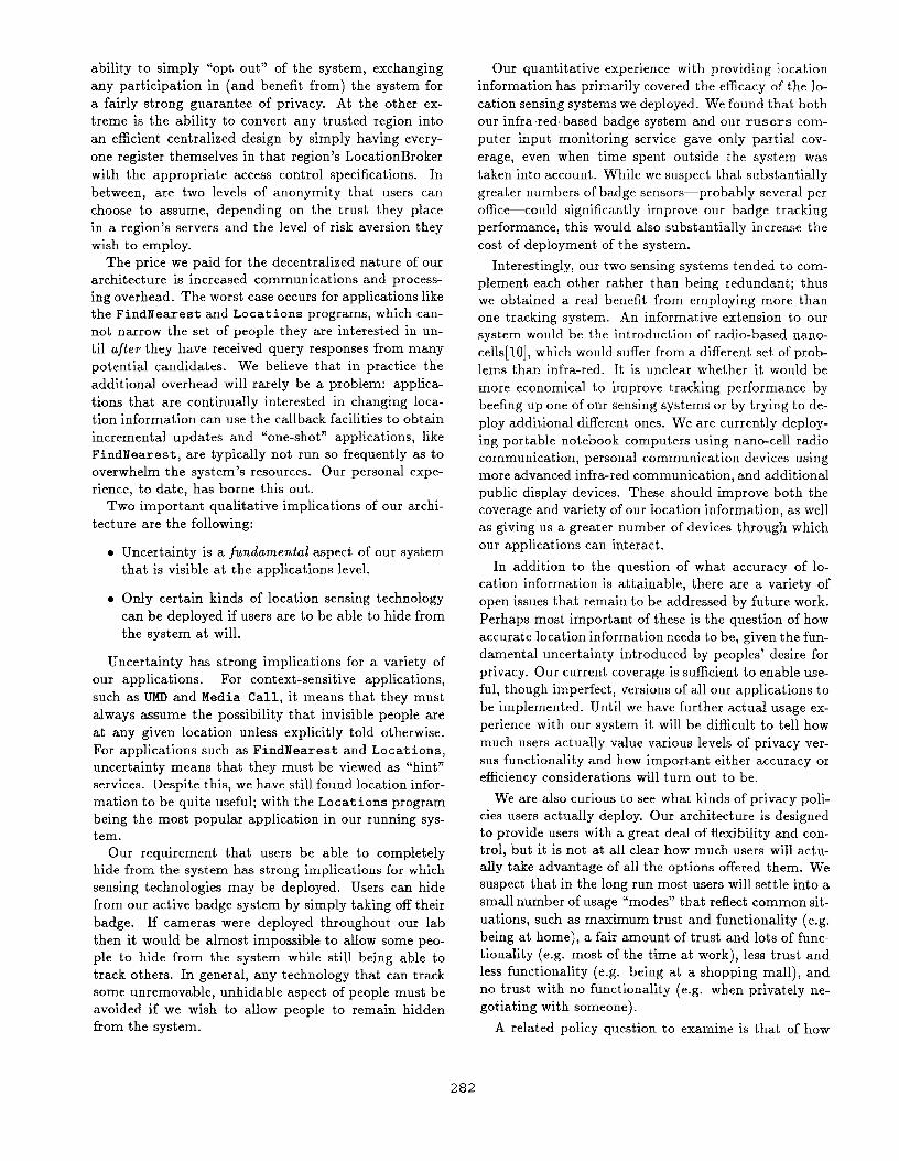
ment rather than overlap each other. Table 1 lists how
100
80
60
200.01 0.1 1 10
hrs
interval length, with various upper bounds on
often only a person’s badge was seen, only a person’s
computer input activity was seen, both were seen, and
neither were seen, as a fraction of the total time that the
person is in the system. A person is considered to be “in
the system” when they are not absent from the badge
data and not absent from the input activity data. As
before, we define a person to be absent from sensor data
during intervals longer than various bounds. We define
the notion of a person being “seen” during a sighting
interval as meaning that the length of the interval is
less than some cut-off value. The table gives overlap
statistics for several different absence bounds and “seen
interval” cut-off values, the smallest cut-off value being
set at a value slightly larger than the minimum sighting
interval of either tracking system. The important thing
to note is that the fraction of time during which both
badge and input activity are seen is quite small, both
in absolute terms and relative to the fractions of time
during which only one or the other was seen.
We attribute this phenomenon to primarily two
things: (1) people working at home will be seen by their
computer input act ivit, y and not by the badge syst em,
and (2) people who wear their badge on their belt and
are typing at their workstation will tend to obscure their
badge’s emissions while having clearly visible computer
input activity.
280
Seen interval cut-off size: 75 sec. 150 sec. 5 min. 10 min.
All working-day intervals:
Only badge seen: 19% 20% 21% 21%
Only input activity seen: 17% 20% 21% 23%
Both seen: 7% 9% 10% 13%
Neither seen: 57% 51% 48% 43%
Only intervals less than 1 hr. considered:
Only badge seen: 26% 26% 28% 29%
Only input activity seen: 23% 28% 29% 32%
Both seen: 9% 12% 14% 17%
Neither seen: 42% 34% 29% 22%
Only intervals less than 10 min. considered:
Only badge seen: 32% 33% 35% 36%
Only input activity seen: 31% 36% 38% 43%
Both seen: 11% 15% 17% 21%
Neither seen: 26% 16% 10% o%
Table 1: Table of badge and computer input activity sighting overlap statist its.
4.4 Tracking Moving Persons
People sitting within their ofIice provide a different
sighting profile to the active badge system than do peo-
ple who are moving around. To get a handle on how well
our active badge system could track moving persons—
such as visitors—we performed several “walk-about” ex-
periments to see how well the badge system could follow
us.
As mentioned earlier, the basic badge sighting inter-
val is 15 seconds; which is enough time to walk past
about a half dozen offices and perhaps a corridor or
two in our lab. We found that a person who randomly
walked about our corridors was seen, on average, every
22 seconds, with a standard deviation of 17 seconds. VVe
also tried the same experiment with the badge emission
period changed to 10 seconds and obtained an average
sighting interval of 17 seconds, with a standard devia-
tion of 13 seconds.
Note that 17 seconds is still enough time to add no-
ticeable inaccuracy to an application such as Visitor
Guidance. Decreasing the badge emission interval to 5
seconds would presumably give us an average interval
length somewhere between 5 and 10 seconds; but would
cut the battery lifetime of our badges from its current
value of about 3 months to about 1 month.
We did not have much trouble with people be-
ing sighted in offices while walking past, even though
roughly half, on average, of the front wall of each office
in our lab is open to IR. Only about 11~0 of the sightings
from hall-walking experiments were in offices. While we
recognize that the exact placement of a badge sensor
within a room can greatly affect this result, we mention
it because our sensors were placed in a fashion to op-
timize office coverage, without much concern about the
hall “cross-talk”.
We infer from this that message delivery “chase” ef-
fects while people move about should probably not dis-
turb the denizens of every office a person walks by.
Anecdotal evidence has corroborated this — only one
person has reported seeing an attempt at ubiquitous
message delivery in his office for someone not present.
5 Conclusions
We have designed and built an infrastructure for provid-
ing location information and various applications that
use that information. The architecture we advocate is
a user-centric one in which the personal information for
each user—including location information—is managed
and controlled by that user’s User Agent. A Location
Query Service consisting of a LocationBroker per region
is provided to facilitate queries by location.
The principle assumptions behind our design were
two-fold:
● The design should scale to use in multiple admin-
ist rat ive domains.
. We did not rule out the existence of untrustworthy
servers and sophisticated traffic analysis attacks in
some domains.
The consequences of these assumptions were that we
could not use strictly centralized designs that rely on
trusted location databases and we had to accept the fact
that strict privacy guarantees are in general difficult and
expensive to provide.
The hybrid decentralized architecture we designed
gives each user a range of privacy options that they
may dynamical y choose from. At one extreme is the
281
ability to simply “opt out” of the system, exchanging
any participation in (and benefit from) the system for
a fairly strong guarantee of privacy. At the other ex-
treme is the ability to convert any trusted region into
an efficient centralized design by simply having every-
one register themselves in that region’s LocationBroker
with the appropriate access control specifications. In
between, are two levels of anonymity that users can
choose to assume, depending on the trust they place
in a region’s servers and the level of risk aversion they
wish to employ.
The price we paid for the decentralized nature of our
architecture is increased communications and process-
ing overhead. The worst case occurs for applications like
the FindNearest and Locations programs, which can-
not narrow the set of people they are interested in un-
til afteT they have received query responses from many
potential candidates. We believe that in practice the
additional overhead will rarely be a problem: applica-
tions that are continually interested in changing loca-
tion information can use the callback facilities to obtain
increment al updates and “one-shot” applications, like
FindNeare st, are typically not run so frequently as to
overwhelm the syst em’s resources. Our personal expe-
rience, to date, has borne this out.
Two important qualitative implications of our archi-
tecture are the following:
●
●
Uncertainty is a fundamental aspect of our system
that is visible at the applications level.
Only certain kinds of location sensing technology
can be deployed if users are to be able to hide from
the system at will.
Uncertainty has strong implications for a variety of
our applications. For context-sensitive applications,
such as UMD and Media Call, it means that they must
always assume the possibility that invisible people are
at any given location unless explicitly told otherwise.
For applications such as FindNearest and Locations,
uncertainty means that they must be viewed as “hint”
services. Despite this, we have still found location infor-
mation to be quite useful; with the Locations program
being the most popular application in our running sys-
tem.
Our requirement that users be able to completely
hide from the system has strong implications for which
sensing technologies may be deployed. Users can hide
from our active badge system by simply taking off their
badge. If cameras were deployed throughout our lab
then it would be almost impossible to allow some peo-
ple to hide from the system while still being able to
track others. In general, any technology that can track
some unremovable, unhidable aspect of people must be
avoided if we wish to allow people to remain hidden
from the system.
Our quantitative experience with providing location
information has primarily covered the efficacy of the lo-
cation sensing systems we deployed. We found that both
our infra-red-based badge system and our rusers com-
puter input monitoring service gave only partial cov-
erage, even when time spent outside the system was
taken into account. While we suspect that substantially
greater numbers of badge sensors—probably several per
office-could significantly improve our badge tracking
performance, this would also substantially increase the
cost of deployment of the system.
Interestingly, our two sensing systems tended to com-
plement each other rather than being redundant; thus
we obtained a real benefit from employing more than
one tracking system. An informative extension to our
system would be the introduction of radio-based nano-
cells [l O], which would suffer from a different set of prob-
lems than infra-red. It is unclear whether it would be
more economical to improve tracking performance by
beefing up one of our sensing systems or by trying to de-
ploy additional different ones. We are currently deploy-
ing portable notebook computers using nano-cell radio
communication, personal communication devices using
more advanced infra-red communicant ion, and additional
public display devices. These should improve both the
coverage and variety of our location information, as well
as giving us a greater number of devices through which
our applications can interact.
In addition to the question of what accuracy of lo-
cation information is attainable, there are a variety of
open issues that remain to be addressed by future work.
Perhaps most important of these is the question of how
accurate location information needs to be, given the fun-
damental uncertainty introduced by peoples’ desire for
privacy. Our current coverage is sufficient to enable use-
ful, though imperfect, versions of all our applications to
be implemented. Until we have further actual usage ex-
perience with our system it will be difficult to tell how
much users actually value various levels of privacy ver-
sus functionality and how important either accuracy or
efficiency considerations will turn out to be.
We are also curious to see what kinds of privacy poli-
cies users actually deploy. Our architecture is designed
to provide users with a great deal of flexibility and con-
t rol, but it is not at all clear how much users will actu-
ally take advantage of all the options offered them. We
suspect that in the long run most users will settle into a
small number of usage “modes” t b at reflect common sit-
uations, such as maximum trust and functionalist y (e.g.
being at home), a fair amount of trust and lots of func-
tionalist y (e.g. most of the time at work), less trust and
less functionality (e.g. being at a shopping mall), and
no trust with no functionality (e.g. when privately ne-
gotiating with someone).
A related policy question to examine is that of how
282
many intrusions users are willing to tolerate in order to
improve application performance. For example, appli-
cations such as UMD and Media Call can initiate a pre-
liminary dialogue with a user to verify the social context
the user is in. Similarly, an application such as note dis-
tribution can employ external feedback mechanisms to
verify its successful execution. Active participation by
users allows an application to overcome inaccurate and
incomplete location information by having users modify
their behavior. The result is a system that may provide
greater privacy safeguards, but is also more intrusive
and less automated than it might be.
In addition to these policy issues there are at least
two other infrastructure questions that deserve mention
for future work. We listed the addition of multicast
to our system as an interesting extension to consider.
However, whereas the properties of local-area multicast
are fairly well understood, it is unclear what the behav-
ior and scaling properties of reliable Internet multicast
are. Consequently, it is unclear what would happen if
a large-scale deployment of a multicast-based location
infrastructure ever happened.
The second infrastructure problem we mention is that
of how two anonymous parties can agree to conditionally
reveal information to each other. Although special cases
of this problem are easy to solve and may represent the
common usage case, it is unclear if there is a general
solution that will be satisfactory in all cases.
References
[1]
[2]
[3]
[4]
[5]
[6]
N. Ackroyd and R. Lorimer. Global Navigation: A
GPS User’s Guide. Lloyd’s of London Press, 1990.
D. Chaum. Security without identification: trans-
action systems to make big brother obsolete.
CA CM, 28(10):1030-1044, October 1985.
S. Elrod, G. Hall, R. Costanza, M. Dixon, and
J. desRivieres. The responsive environment: Using
ubiquitous computing for office comfort and energy
management. Technical Report CSL-93-5, Xerox
Palo Alto Research Center, 1993.
B.N. Schilit, M.M. Theimer, and B.B. Welch.
Customizing mobile application. In Proceed-
ings USENIX Symposium on Mobile & Location-
Independent Computing, pages 129-138. USENIX
Association, August 1993.
M. Spreitzer and M.M. Theimer. Scalable, se-
cure, mobile computing with location information.
CACM, 36(7):27, July 1993.
ruser manual entry of the SUNOS UNIX manual.
[7]
[8]
[9]
[10]
R. Want and A. Hopper. Active badges and per-
sonal interactive computing objects. Transactions
on C’onsumer Eiect?’onzcs, 38(1), February 1992.
R. Want, A. Hopper, V. Falcao, and J. Gibbons.
The active badge location system. Transactions on
Info?’mation Systems, 10(1), January 1992.
M. Weiser. The computer for the twenty-first cen-
tury. Scientific American, pages 94–104, Septem-
ber 1992.
M. Weiser. Some computer science problems in
ubiquitous computing. CA CM, 36(7):74-83, July
1993.
283