Embed Size (px)
Citation preview

² Select the most suitable answer and write it on the given space for question no 01 to 10.
01 Water in the Earth contains as water vapour in the ................................................................
(Atmosphere / Hydrosphere / Lithosphere)
02 The ................................................ forms 2/3 of the land mass of the earth. (Crust / Mantle / Core)
03 Mindanao trench is located in the .............................................. ocean. (Indian / Atlantic / Pacific)
04 .................................................... is the south Asian country that produce the highest production
of wheat. (India / China / Russia)
05 .................................................................. is used to harvest fish in the deep sea fishing industry.
(Seine / Triple net / Cast - net)
06 When .................................................................. was discovered, the demand for iron and steel
came down. (Copper / Tin / Aluminum)
07 Today countries like china and ................................................................... have come to the
forefront in the ship building industry. (South Korea / North Korea / Viatnam )
08 The contribution of 25% in the composition of the industrial products is based in
........................................................... industry. (Food production / Garment / Rubber and plastic)
09 The mineral oil refinery in Sri Lanka is located at ....... (Kolonnawa / Kelaniya / Sapugaskanda)
10 On the 1:50 000 topographic maps, the ................................................. is indicated at the lower
margin of the outer border. (Direction / type of the map / no. of the map)
² If the following statements are true circle "T" if not circle "F" for question no 11 to 15.
11 Carbon dioxide is necessary for the process of photosynthesis of plants. ( T / F )
12 Nile delta is a main region where paddy is cultivated in Asia. ( T / F )
13 Rubber cultivation is mostly distributed in the wet zone in Sri Lanka. ( T / F )
14 Food and beverages producing industry in Sri Lanka comes under large scale industries. ( T / F )
15 General motors of USA incorporated with Shanghai company, China and launched
productions. ( T / F )
01
ish¨u ysñlï weúßKs' All Rights Reserved
Grade 10
Name / Index No. :
Three Hours
THIRD TERM TEST 2019Geography I
PROVINCIAL DEPARTMENT OF EDUCATION NORTH WESTERN PROVINCE
²² Answer all the questions on this paper itself using given guidelines.
This paper consists with 40 questions.
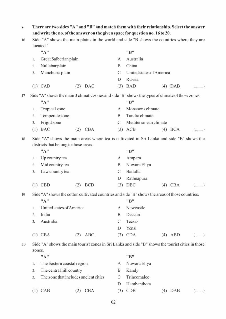
² There are two sides "A" and "B" and match them with their relationship. Select the answer
and write the no. of the answer on the given space for question no. 16 to 20.
16 Side "A" shows the main plains in the world and side "B shows the countries where they are
located."
"A" "B"
1' Great Saiberian plain A Australia
2' Nullabar plain B China
3' Manchuria plain C United states of America
D Russia
(1) CAD (2) DAC (3) BAD (4) DAB ^'''''''''&
17 Side "A" shows the main 3 climatic zones and side "B" shows the types of climate of those zones.
"A" "B"
1' Tropical zone A Monsoons climate
2' Temperate zone B Tundra climate
3' Frigid zone C Mediterranean climate
(1) BAC (2) CBA (3) ACB (4) BCA ^'''''''''&
18 Side "A" shows the main areas where tea is cultivated in Sri Lanka and side "B" shows the
districts that belong to those areas.
"A" "B"
1' Up country tea A Ampara
2' Mid country tea B Nuwara Eliya
3' Law country tea C Badulla
D Rathnapura
(1) CBD (2) BCD (3) DBC (4) CBA ^'''''''''&
19 Side "A" shows the cotton cultivated countries and side "B" shows the areas of those countries.
"A" "B"
1' United states of America A Newcastle
2' India B Deccan
3' Australia C Tecsas
D Yensi
(1) CBA (2) ABC (3) CDA (4) ABD ^'''''''''&
20 Side "A" shows the main tourist zones in Sri Lanka and side "B" shows the tourist cities in those
zones.
"A" "B"
1' The Eastern coastal region A Nuwara Eliya
2' The central hill country B Kandy
3' The zone that includes ancient cities C Trincomalee
D Hambanthota
(1) CAB (2) CBA (3) CDB (4) DAB ^'''''''''&
02

² Complete the blanks using the suitable word for question no. 21 to 26.
21 The temperature decreases with altitude is called the ...................................................................
22 The .............................................. introduced tea plantation to most of the countries of the world.
23 ....................................................... dairy cattle center has been set up to exchange lactating cows.
24 ........................................................... has made the greastest contribution to the production
capacity of iron and steel industry.
25 The contour interval is set ............................ metes of the 1:50000 topographic maps in Sri Lanka.
26 At present, the demand for natural rubber is ....................................... due to the development of
the auto mobile industry.
² Study the given graph and answer the questions for question no 27 to 30.
27 The lowest production of tea is reported in
year .............................................
28 The highest production of tea is reported in
year ........................................
29 The quantity of production of tea is equal
in both years 2011 and ..............................
30 The quantity of the production of tea in
2007 is ........................ million kilograms.
² Select the most suitable answer from given answers and write the number of the answer on
the given space for question no 31 to 40.
31 What is the main layer that consists with thick metal ?
^1& Upper mantle ^2& lower mantle
^3& outer core ^4& Inner core ^'''''''''&
32 20% of the fresh water is known as ..............
^1& Ice caps and glaciers ^2& surface water
^3& ground water ^4& lake water ^'''''''''&
33 What is the climatic zone located between the tropic of cancer and the Arctic circle ?
^1& Northern polar zone ^2& Northern temperate zone
^3& Southern polar zone ^4& Southern temperate zone. ^'''''''''&
34 A special feature of the wheat cultivation comparing the paddy cultivation is,
^1& Mechanization as a large scale. ^2& Cultivated in a small plots of lands
^3& have not a wide market ^4& aim is consumption ^'''''''''&
03
uc
n M
Kil
ogm
Pro
dti
oil
lion
ra
s
0207
2008 9
200 0210 1
201
21020
335
325
315
305
295
285
Quantity of production Tea in Sri Lanka(2007 - 2012)

35 A physical factor related to the tea cultivation is,
^1& Temperature between 15°C - 27°C ^2& Rainfall about 2000 mm
^3& Flat lands ^4& Caboc soil ^'''''''''&
36 A reason that is not affected to a special attention for minor export corps in Sri Lanka is,
^1& Can not sure only traditional exports.
^2& decrease the demand for minor expert crops in the world trade.
^3& arise problems regarding foreign exchange.
^4& can grow as a cover crop. ^'''''''''&
37 The correct statement regarding the features of iron and steel industry is,
^1& can not recycle after using.
^2& decrease the production due to the removal of traditional technology.
^3& use as a basic metal for various productions in every country in the world.
^4& can not mix with other metals. ^'''''''''&
² Study the given information to answer the question no 38 & 39.
A import
B local industries
C foreign exchange
D multi national companies
E arrival of tourists
38 The two letters that affect to increase one factor with decreasing another factor are,
^1& C and E ^2& A and D ^3& B and D ^4& A and B ^'''''''''&
39 The two letters that affect to increase one factor with increasing another factor are,
^1& A and D ^2& D and B ^3& E and A ^4& E and C ^'''''''''&
40 What is the symbol that is used to show the police station in the 1:50 000 topographic maps ?
^1&
^2&
^3&
^4& ^'''''''''&
04

Part I
^01& (a) Study the given 1:50 000 topographic map and answer the given questions.
² Select and write the most suitable answer for (i) to (iv).
(i) What is the relief feature shown by A - B line ? (valley / Gap / plain) (01 m.)
(ii) What is the relief feature shown by D - D line ? (spur / Gentle slope / mountain range)
(01 m.)
(iii) What is the relief feature shown by letter "C"? (mountain / plateau / rock) (01 m.)
(iv) What is the type of vegetation shown by letter "F"? (forests/throny bushes/grasslands)
(01 m.)
(v) What is the cultivation crop that can be mostly seen in the mapped area ? (01 m.)
(vi) calculate the length of the main road across towards the mapped area using the pillars of
kilo meters.
(01 m.)
(vii) Write two institutions that provide public service in the squared area shown by letter E.
(01 m.)
² Study the mapped area and write "T" if the statements is true if not write "F"
in front of the statement.
(viii) Mountain ridges are located North west to South east in the mapped area. ^ &
(ix) This mapped area belongs to two provinces. ^ &
(10 m.)
(b) Study the given map of the world and write answers for the following questions.
(i) The letter that shows the Atlas mountain range among the letters A, B and C.
(ii) The letter that shows the Amerzon river among the letters D, E and F.
(iii) The letter that shows the Parmeer plateau among the letters G, H and J.
(iv) The letter that shows the Boltic sea among the letters K, L and M.
(v) The letter that shows Bejin city among the letters P, Q and R. (05 m.)
01
Important² There are 2 parts of this paper part I & II.² All the parts of first question (a), (b) and (c) are compulsory. Use the given paper to answer
them.² Answer only four questions from part II.² Altogether answer five questions.
ish¨u ysñlï weúßKs' All Rights Reserved
Grade 10
Name / Index No. :
Two Hours
THIRD TERM TEST 2019Geography II
PROVINCIAL DEPARTMENT OF EDUCATION NORTH WESTERN PROVINCE

^b& Study the given map of Sri Lanka and answer the following questions.
(i) The letter that shows Mee oya among the letters A, B and C.
(ii) The letter that shows Arugam bay among the letters D, E and F.
(iii) The letter that shows Batticola town among the letters G, H and J.
(iv) The letter that shows the Pedro Pearl dune among the letters K, L and M.
(v) The letter that shows Raththota where produce the ceramic ware among the letters P, Q
and R. (05 m.)
Part II
^02& This picture shows the crusts of the Earth.
(i) Name the two crusts shown by letters
A and B. (02 m.)
(ii) a) Name the boundary shown by letter D.
b) Write the basic rocks that are used to
compose the crusts shown by letter A
& B respectively. (03 m.)
(iii) a) What is the name for the uppermost
thin layer of the crust ?
b) Explain 2 effects that caused due to the human activities to this layer.
(05 m.)
^03& Following picture shows the water cycle of the Earth.
(i) What is the meaning of the water
cycle? (02 m.)
(ii) Name the 3 occasion shown by A, B &
C. (03 m.)
(iii) a) Name the occasion shown by letter
"C"
b) This above mentioned process
effects to the man and to the
environment. Explain it using two
facts. (05 m.)
02
Sea levelA
D C
BB
BB
CCDD
AA

² Use the given map of the world to answer question no 4 & 5.
^04& According to the above map,
(i) Name the tea cultivated country shown by letter A and the rubber cultivated country
shown by letter B. (02 m.)
(ii) a) Name teh two countries that are doing diary farming shown by letter C & D.
b) What are the types of lands used for the diary farming ? (03 m.)
(iii) a) Write 2 facts that are caused for the development of the commercial diary farming.
b) Explain two new trends regarding the commercial diary farming. (05 m.)
^05& According to the above map,
(i) Write the letters of the following two countries that are doing automobile industry,
a) India
b) South Korea (02 m.)
(ii) a) Write 2 facts for the rapid development of the automobile industry at present.
b) What is the letter for Japan which is pioneer for electronic industry ? (03 m.)
(iii) a) Write two main electronic equipment produced in China.
b) Explain 2 new trends regarding teh electronic industry briefly. (05 m.)
03

04
A
B
C
1
2
2
^06& (i) Write 2 factors that are influenced the location of industries. (02 m.)
(ii) Write
a) a problem related to raw materials
b) a problem related to labour
c) a problem related to market regarding the manufacturing industries in the world.
(03 m.)
(iii) a) What is the province where more industries are distributed in Sri Lanka ?
b) Explain the importance of the industrial sector in the economy of Sri Lanka.
(05 m.)
² Study the given map of Sri Lanka to answer question no 7 and 8.
^07& (i) Write 2 physical factors that are caused to
distribute paddy cultivation in Sri Lanka.
(02 m.)
(ii) What are the districts mentioned in the map
A, B and C that belong to the following
zones.
dry zone
wet zone
Intermediate zone (03 m.)
(iii) a) What is the area that the central
agricultural research institute is
located ?
b) Explain 2 advantages by gaining
through developing the vegetable and
fruit cultivation in Sri Lanka. (05 m.)
^08& (i) Name the two main graphite mines shown by no 1 & 2. (02 m.)
(ii) a) Name the two kinds of graphite that can be found in Sri Lanka.
b) Name a raw material that are used for ceramicware industry. (03 m.)
(iii) a) Write 2 kinds of boats that are produced in Sri Lanka.
b) Explain briefly the two reasons that are affected to establish the automobile
assembling industry in Sri Lanka. (05 m.)

01 (a) 10 5+ (b) 5+ (c) = 20
(i)
(ii)
(iii)
(iv)
(v)
01 (c)
01 (b)
(i)
(ii)
(iii)
(iv)
(v)
Grade 10 - Geography10 fY%aKsh - N+f.da, úoHdj

N+f.da, úoHdjúNd. wxlh
^01& ^a&
^i&
^ii&
^iii&
^iv&
^v&
^vi&
.''''''''''''''''''''''''''''''''''''''''''''''''''''''''''''''''''''''''''''''''''''''''''''''''''''
'.'''''''''''''''''''''''''''''''''''''''''''''''''''''''''''''''''''''''''''''''''''''''''''''''''''
''.''''''''''''''''''''''''''''''''''''''''''''''''''''''''''''''''''''''''''''''''''''''''''''''''''
'''.'''''''''''''''''''''''''''''''''''''''''''''''''''''''''''''''''''''''''''''''''''''''''''''''''
''''.''''''''''''''''''''''''''''''''''''''''''''''''''''''''''''''''''''''''''''''''''''''''''''''''
''''.''''''''''''''''''''''''''''''''''''''''''''''''''''''''''''''''''''''''''''''''''''''''''''''''
''''.''''''''''''''''''''''''''''''''''''''''''''''''''''''''''''''''''''''''''''''''''''''''''''''''
''''.''''''''''''''''''''''''''''''''''''''''''''''''''''''''''''''''''''''''''''''''''''''''''''''''
''''.''''''''''''''''''''''''''''''''''''''''''''''''''''''''''''''''''''''''''''''''''''''''''''''''
''''.''''''''''''''''''''''''''''''''''''''''''''''''''''''''''''''''''''''''''''''''''''''''''''''''
10
fY%aKsh$Grade : ......................
Geography
IIIIII
Index Number
......................................................}
jhU m<d;a wOHdmk fomd¾;fïka;=j f;jk jdr mÍËKh - 2019Third Term Test - 2019Department of Provincial Education - NWP
10 fY%aKsh
^vii&
^viii&
^ix&

Answer sheet - Paper I
(1x40 = 40 marks)Paper II
01 Atmosphere 02 Mantle 03 Pacific ocean 04 India05 Triple net06 Aluminum 07 South Korea 08 Garments 09 Sapugaskanda 10 Direction
11 T12 F13 T14 F15 T16 ^4&17 ^3&18 ^2&19 ^1&20 ^1&
21 Lapse rate 22 Foreigners/Western nations 23 Meewanapalana24 China25 2026 increase27 200928 201029 201230 305
31 ^4&32 ^3&33 ^2&34 ^1&35 ^1&36 ^2&37 ^3&38 ^4&39 ^4&40 ^3&
Part I
^01& ^a& (i) Gap (1 m.) (ii) spur (1 m.)
(iii) Rock (1 m.) (iv) Forests (1 m.)
(v) Coconuts (1 m.) (vi) 10 km (1 m.)
(vii) Hospital / post office (2 m.)
court / Railway station / school (viii)T (1 m.)
(ix) T (1 m.)
^b& (i) A (ii) E (iii) J (iv) K (v) Q (5 m.)
^c& (i) C (ii) D (iii) G (iv) M (v) R (5 m.)
Part II
^02& (i) A - Continental crust B - oceanic crust (2 m.)
(ii) a) D - Mohoruvicic discontinuity
b) A - Granitic rocks B - Basaltic rocks (3 m.)
(iii) a) soil (1 m.)
b) ³ loss of animal habitats due to the destruction of forests.
³ destruction of the bio-system
³ erosion of the surface soil
³ infertility of soil (4 m.)
^03& (i) The water contained in solid and liquid form in the lithosphere, as water vapour and clouds in the
atmosphere, and also the water contained within the plants and bodies of living beings in the
biosphere circulates within these system in a cyclical manner is called the water cycle. (2 m.)
(ii) A - Evaporation B - Condensation/clouds D - Surface runoff (3 m.)
(iii) a) C - Precipitation (1 m.)
b) To the man ³ for agricultural activities
³ for day today activities
³ for generating electricity etc.
To the environment ³ for growing plants
³ for sources of water
³ to increase the ground water level (4 m.)^04& (i) A - Turkey B - Malaysia (2 m.)
(ii) a) C - Australia D - Brazilb) ² The marginal lands with cool climate which cannot be used for other types of
cultivation. (3 m.)(iii) a) ² availability of grasslands and water ² skilled labour
² large market ² the presence of modern technology
Grade 10
THIRD TERM TEST 2019
Geography
PROVINCIAL DEPARTMENT OF EDUCATION NORTH WESTERN PROVINCE

b) ³ use gene technology to obtain an increased yield by breeding improved cows.
³ Using improved techniques to obtain milk, transportation and storage of milk.
³ Vaccinating lactating cows with hormones to increase the quantity of milk from one cow. (BST Hormone)
³ Expansion of the market for liquid milk and products
³ Increase in the consumption of milk products such as cheese, Butter and yoghurt. (5 m.)
^05& (i) a) F b) E (2 m.)
(ii) a) ² Machinery labour is used. (Robots, automatic machines)
² Popular as assembling industry etc.
b) G (3 m.)
(iii) a) ³ Laser disk players ³ Digital cameras
³ computer component sets ³ mobile phones
³ colour TV component sets
b) ³ ownership belong to Multi-national companies (2 m.)
³ Day by day, new products are launched to meet the competitive market.
³ The same countries that export electronic appliances also import the same products from other countries.
³ A market for by - products has been created etc. (3 m.)
^06& (i) ³ Raw material ³ Power & energy ³ labour
³ Market ³ Transport ³ capital
³ state policy ³ infrastructure facilities (2 m.)
(ii) a) ³ lack of raw materials ³ use arificial raw materials
b) ³ use machinery labour ³ lack of skilled labour
³ increase the labour expenditure ³ labour problems.
c) ³ competition of the market ³ effects from the substitutes
³ increase the price of goods
³ economic scandal of European countries (3 m.)
(iii) a) ² Western province
b) ² Contribution for the Gross National Product (31.4%) (1 m.)
² Contribution for the employment (2.1 millions)
² earn foreign exchange. (exports 75.4%) (4 m.)
^07& (i) ³ rainfall over 1900 mm ³ temperature between 21°C - 35 °C
³ Alluvial soil ³ dry climate when collecting harvest ³ flat lands (2 m.)
(ii) ³ dry zone - B ³ wet zone - C ³ intermediate zone - A (3 m.)
(iii) a) Gannoruwa
b) ³ can earn foreign exchange ³ a solution for unemployment
³ take the effective use of land ³ Increase the local production
³ can supply the necessities from the country. (5 m.)
^08& (i) 1 - Kahatagaha mines 2 - Bogala mines (2 m.)
(ii) a) ³ Vein graphite ³ Mica
b) ³ Keolin (3 m.)
(iii) a) ³ Fishing boats ³ passenger boats
³ tourist boats ³ safety boats (2 m.)
b) ³ high demand in the local market for auto mobiles
³ prices of imported vehicles (3 m.)
Answer sheet - continuation Grade 10
THIRD TERM TEST 2019
Geography
PROVINCIAL DEPARTMENT OF EDUCATION NORTH WESTERN PROVINCE