Embed Size (px)
Citation preview

Prowers CountyMaster Plan

Acknowledgements
Prowers County Master Plan
Prowers County Board of County Commissioners Leroy Mauch, Chair Clede Widener John Stulp Prowers County Planning Commission Ken Ullom, Chair Leroy Brase James Peterson James Harper Richard Widener Planning Team HNTB Martin Landers, AICP, Project Director Brian Comer, AICP, Project Planner Joshua Logsdon, Graphics Special Thanks To: Mary Root Executive Director, Southeastern Land and Environment Chris Henderson Southeastern Land and Environment Mayor David Willhite Holly Mayor Marsha Willhite Holly Administrator Bruce Roup Holly City Council Jerry Smith Holly City Council Jill Briggs Holly City Council Heck Phillips Holly City Council David Crossland Holly City Council Sandy Mc Lemore Holly City Council John Lefferdink Prowers County Attorney Andy Wyatt Prowers County Assessor Janet Marriott Prowers County Assessor’s Office …and everyone who worked toward the completion of the Prowers County Master Plan!

Table of Contents
Prowers County Master Plan TOC-1
PAGE CHAPTER 1: INTRODUCTION INTRODUCTION .........................................................................................................................1-1 PLAN JURISDICTION ..................................................................................................................1-1 RELATIONSHIP TO LAMAR COMPREHENSIVE PLAN ......................................................................1-1 LAMAR JOINT PLANNING AREA (LJPA).......................................................................................1-1 PLAN PURPOSE AND NEED ........................................................................................................1-1 PLAN PROCESS AND COMMUNITY INVOLVEMENT ........................................................................1-2 PLAN FORMAT AND USE ............................................................................................................1-3 CHAPTER 2: ISSUES AND ANALYSIS CONTEXT .................................................................................................................................2-1 GOVERNMENT...........................................................................................................................2-1 POPULATION CHARACTERISTICS ................................................................................................2-1 HOUSING..................................................................................................................................2-2 SOCIAL SERVICES.....................................................................................................................2-3 ECONOMY ................................................................................................................................2-4 NATURAL ENVIRONMENT ...........................................................................................................2-5 COUNTYWIDE RESOURCES........................................................................................................2-8 HISTORIC RESOURCES..............................................................................................................2-9 TRANSPORTATION...................................................................................................................2-12 SERVICES AND INFRASTRUCTURE ............................................................................................2-13 EMERGENCY SERVICES...........................................................................................................2-14 COUNTY FAIRGROUNDS ..........................................................................................................2-14 EDUCATION ............................................................................................................................2-14 COMMUNITY FACILITIES ..........................................................................................................2-15 LAND USE ..............................................................................................................................2-16 ZONING ..................................................................................................................................2-18 SUMMARY...............................................................................................................................2-19 CHAPTER 3: ALTERNATIVES ALTERNATIVE DEVELOPMENT ....................................................................................................3-1 COUNTY POLICY CONCEPTS ...............................................................................................3-1 LJPA ALTERNATIVE 1: MODIFIED TREND .............................................................................3-2 LJPA ALTERNATIVE 2: TARGETED ENHANCEMENT ...............................................................3-2 LJPA ALTERNATIVE 3: BALANCED GROWTH ........................................................................3-3 EVALUATION OF ALTERNATIVES .................................................................................................3-4 CHAPTER 4: GOALS AND OBJECTIVES DEFINING GOALS AND OBJECTIVES............................................................................................4-1 INTERGOVERNMENTAL COORDINATION.......................................................................................4-1 NATURAL ENVIRONMENT ...........................................................................................................4-1 AGRICULTURAL CHARACTER......................................................................................................4-2 HISTORIC RESOURCES..............................................................................................................4-2 TRANSPORTATION.....................................................................................................................4-2 INFRASTRUCTURE .....................................................................................................................4-3 ECONOMY ................................................................................................................................4-3 LAND USE ................................................................................................................................4-3

Table of Contents
Prowers County Master Plan TOC-2
CHAPTER 5: FRAMEWORK PLANS FRAMEWORK PLANS .................................................................................................................5-1 PROWERS COUNTY FRAMEWORK PLAN ................................................................................5-1 LAMAR JOINT PLANNING AREA FRAMEWORK PLAN................................................................5-3 SUMMARY.................................................................................................................................5-6 PAGE CHAPTER 6: IMPLEMENTATION INTRODUCTION .........................................................................................................................6-1 INTERGOVERNMENTAL COORDINATION RECOMMENDATIONS .......................................................6-1 NATURAL ENVIRONMENT RECOMMENDATIONS............................................................................6-1 AGRICULTURAL CHARACTER RECOMMENDATIONS ......................................................................6-1 TRANSPORTATION RECOMMENDATIONS .....................................................................................6-2 SERVICES AND INFRASTRUCTURE RECOMMENDATIONS...............................................................6-2 ECONOMY RECOMMENDATIONS .................................................................................................6-3 LAND USE RECOMMENDATIONS .................................................................................................6-4 GENERAL RECOMMENDATIONS ..................................................................................................6-5 FUNDING SOURCES...................................................................................................................6-5 MONITORING ............................................................................................................................6-7 IMPLEMENTATION MATRIX..........................................................................................................6-8 PROJECT BIBLIOGRAPHY......................................................................................................... APPENDIX

Chapter 1: Introduction
Prowers County Master Plan Page 1-1
INTRODUCTION Prowers County, with support from the City of Lamar, applied for and received an Energy Impact Assistance Grant in 2002 from the Colorado Department of Local Affairs to develop regional planning tools. In February 2003, Prowers County entered into a contract with HNTB Architects Engineers Planners to prepare the Prowers County Master Plan and the City of Lamar Comprehensive Plan. The 2003 Prowers County Master Plan (Plan) is a broad public policy tool for guiding decisions concerning land use and future growth. The Plan builds upon and succeeds previous master planning efforts, primarily the Prowers County Growth Management Plan completed in 1977. This Plan serves as a guide for the physical, social and fiscal health and well being of the county. As such, its goals and objectives, policies and recommenda-tions are to be used to guide the future growth and change of Prowers County. PLAN JURISDICTION The Plan has jurisdiction within un-incorporated Prowers County. The Plan does not have jurisdiction within the in-corporated communities of Wiley, Lamar, Hartman, Granada, and Holly. However, these communities do have a significant impact upon the unincorporated area’s character, resources, economy and quality of life. Therefore, the Plan’s analysis, direction and recommendations reflect these community’s impacts upon the unincorporated county. RELATIONSHIP TO LAMAR COMPREHENSIVE PLAN The Prowers County Master Plan and the Lamar Comprehensive Plan were created utilizing a joint planning process. Creating an atmosphere of intergovernmental
cooperation is a vitally important component of the planning process. Thus, both plans were prepared in the spirit of C.R.S. 29-20-105, where “local governments are authorized and encouraged to cooperate or contract with other units of government…for the purposes of planning and regulating the development of land”. The common element that ties both plans together is the Lamar Joint Planning Area (LJPA). LAMAR JOINT PLANNING AREA (LJPA) The City of Lamar, the largest community in the county, has a significant impact upon the unincorporated area. This impact is particularly evident on the city’s fringe. Per C.R.S. 29-20-105, the State of Colorado allows Inter-governmental Agreements (IGAs) between a county and city to address planning issues of mutual interest. As part of the planning project, Prowers County and the City of Lamar reviewed and updated a draft IGA for the LJPA, a three-mile area outside of Lamar’s municipal boundaries. The draft IGA provides the opportunity for cooperation between the city and county; this Plan will provide land use guidelines for the LJPA. PLAN PURPOSE AND NEED The Plan is prepared in accordance with state statutes that authorize the Prowers County Planning Commission to develop a master plan for the physical develop-ment of the unincorporated territory within Prowers County. Per C.R.S. 30-28-107, the purpose of the Plan is “guiding and accomplishing a coordinated and har-monious development of the relevant territory, which, in accordance with present and future needs and resources, will best promote the general welfare of the inhabitants” of Prowers County.

Chapter 1: Introduction
Prowers County Master Plan Page 1-2
Although advisory in nature, the Plan is the basis for regulatory measures inclusive of zoning and subdivision code updates, as well as project review recommendations. The Plan also serves as the foundation for intergovernmental agreements, capital improvement pro-gramming, and detailed studies and pro-grams coordinated by public jurisdictions. The Plan is a database, and can be used as supporting documentation for pursuing grants for community development activities. PLAN PROCESS AND COMMUNITY INVOLVEMENT In order to be successful, a master plan must reflect public needs and values. Therefore, public participation is essential. The Plan’s concepts, direction and final recommendations are all created as a result of an inclusive public participation program. This program included six public workshops held throughout the project. Publicity for public meetings included press releases and paid advertising in the Lamar Daily Press newspaper, public service announce-ments on local radio and television stations and a project poster distributed to area businesses and organizations. Each of these workshops was designed to be fully interactive to maximize public input. A brief summary of each workshop is provided below: PUBLIC WORKSHOP SERIES 1 (April 30th and May 1st, 2003) The first set of workshops was designed to educate the public about the master planning process and to identify key concerns and issues within Prowers County. The consultant collected comments and incorporated them into a Countywide Issues Map and three Plan Alternatives for the LJPA (see Chapter 3, Alternatives).
PUBLIC WORKSHOP SERIES 2 (July 30th and 31st, 2003) Using information from the first set of meetings and the results of a planning analysis outlining environmental, land use, and service and infrastructure conditions, the consultant prepared a County Policy Concepts Map and three draft Plan Alternatives for the LJPA. The review of the draft concepts and alternatives began with a Steering Committee work session held on July 15, 2003. The draft concepts and alternatives were then refined and provided to the public in the form of a questionnaire. This questionnaire included a plan map for the concepts and each alternative delineating future land use areas and recommendations. In an effort to garner additional public input, a County Concepts and Plan Alternatives exhibit was displayed at the Prowers County Fair, on successive days from August 4th, 2003 through August 8th, 2003. During the County Fair, the general public completed questionnaires expressing preferences for Plan concepts. PUBLIC WORKSHOP SERIES 3 (September 24th and 25th, 2003) During the intervening months, the consultant worked to synthesize the technical issues, public input, analysis of concepts and alternatives into a single “draft” plan. The September 2003 Working Draft Prowers County Master Plan was presented in public meetings for comment. Following these meetings, copies of the draft document were available for review at the Southeastern Land and Environment Office. Based on comments collected during the review period, a Final Draft Plan was prepared. A public hearing concerning its adoption was held before the Prowers County Planning Commission, in accordance with C.R.S 31-23-208.

Chapter 1: Introduction
Prowers County Master Plan Page 1-3
PLAN FORMAT AND USE Following this Introduction, Chapter Two (Issues and Analysis) establishes the fundamental background information and mapping that influence the planning policy summarized in proceeding chapters. This analysis includes a summary of existing conditions including demographic trends, environmental issues, transportation, ser-vice and infrastructure, existing land use and economy. Chapter Three (Plan Alternatives) provides a description of the plan development process, including the formulation of a County Concepts Map and three plan alternatives for the LJPA. Chapter Four (Plan Alternatives) (Goals and Objectives) provides the basis for the preferred plan framework. Chapter Five (Framework) provides the Plan components for the unincorporated county and LJPA. Chapter Six (Implementation) provides a set of recommendations and action items. Actions are coupled into short-term (one to five years), mid-term (five to ten years) and long-term (more than ten years) timeframes for completion. The Plan should be consulted by County staff, the Planning Commission, and the County Commissioners when considering development proposals, updating land use regulations, working on intergovernmental issues, outlining work programs, preparing annual budgets, and reviewing progress toward meeting identified goals. The Plan should be also used to guide residents, land owners, and project applicants concerning land planning and community development objectives. The Plan should be reviewed annually and revised as specific actions are achieved and new strategies are identified. The goals and objectives should also be reviewed periodically when new circumstances or changing conditions warrant reconsideration.

Chapter 2: Issues and Analysis
Prowers County Master Plan ` Page 2-1
CONTEXT Prowers County is located on the Arkansas River in the southeastern corner of Colorado, adjacent to the Kansas border. The county comprises five incor-porated communities: Lamar, the largest community and county seat, Wiley, Granada, Hartman and Holly. The county encompasses approximately 1,645 square miles. GOVERNMENT County Unincorporated Prowers County is governed by a County Commission. Land use regulations and policies are administered by the Prowers County Land Use Department of Southeastern Land and Environment along with the Prowers County Planning Commission. Land use policies are governed by the Southeast Land and Environment’s zoning and subdivision regulations and permitting process. While these regulations do not affect all land use decisions, they can have a tremendous impact upon the size, scale and density of a particular development. Municipalities The City of Lamar is governed by a Mayor and City Council. Development proposals are reviewed by the Planning Commission. Lamar has a Building Codes Department which administers and enforces the city’s land use regulations and building codes. The communities of Wiley, Granada, Hartman and Holly are governed by a Mayor and Board of Alderman. These communities do not have zoning regulations.
POPULATION CHARACTERISTICS As the table below indicates, the county’s population has fluctuated since 1900 yet has seen steady growth in recent years. The county’s estimated 2002 population is approximately 14,219. This is a slight decrease of 215 persons since 2000. However, this dip should level off and rebound to an estimated population just over 15,000 persons in 2010 and just under 16,500 in 2020. POPULATION (1900-2020)
Year PopulationAggregate
ChangePercent Change
1900 3,768 - -
1910 9,520 5,752 60%
1920 13,845 4,325 31%
1930 14,762 917 6%
1940 12,304 -2,458 -20%
1950 14,836 2,532 17%
1960 13,296 -1,540 -12%
1970 13,258 -38 0%
1980 13,070 -188 -1%
1990 13,237 167 1%
2000 14,434 1,197 8%
2010* 15,188 754 5%
2020* 16,449 1,261 8%
Source: US Census Bureau; Colorado Economic and Demographic Information System The county is comprised of five municipalities and a large unincorporated area. Lamar, the largest community and county seat, has a current population of 8,889 accounting for 61 percent of the county’s population. The other incor-porated municipalities have a combined population of 2,262 accounting for 15 percent of the county’s population. The unincorporated area has a population of 3,283 accounting for 24 percent of the county’s population.

Chapter 2: Issues and Analysis
Prowers County Master Plan ` Page 2-2
MUNICIPAL 2000 POPULATION Municipality Population
Lamar 8,869Holly 1,048
Granada 640Wiley 483
Hartman 111Unincorporated 3,283
Total Population 14,434 Source: Colorado Economic and Demographic Information System Approximately 38 percent of the population resides within “rural” areas of the county. Of this total, 11 percent live on farms and/or ranches.
RURAL POPULATION (2000)
Farm11%
Nonfarm89%
Source: US Census Bureau
The following figure shows age dis-tribution of the county. The largest percentage of the population (14%) falls within the 35-44 age group. This is consistent with national and state averages. COUNTY AGE DISTRIBUTION (2000)
0%
2%
4%
6%
8%
10%
12%
14%
16%
>5 5-9 10-14 15-19 20-24 25-29 30-34 35-44 45-54 55-59 60-64 <65 Source: US Census Bureau
HOUSING There are approximately 5,900 total housing units in the county with just over 5,300 of these units occupied. The average household size within the county is 2.67 persons per unit. This is slightly higher than the state average of 2.53 persons per unit and the national average of 2.59 persons per unit. Over 66 percent of the residential dwelling units within the county are owner occupied, four percent higher than the state average. HOUSING OCCUPANCY (2000)
Renter Occupied
34%
Owner Occupied
66% Source: US Census Bureau As shown on the following chart, single-family detached units comprise the majority of the county’s housing stock (73 percent), followed by manufactured homes (16 percent), and multiple attached units such as duplexes, triplexes, town homes, and apartment buildings (11 percent of total units). COUNTY DWELLING UNITS (2000)
1 Unit Detached73%
2-4 Units Attached6%
5-9 Units Attached2%
10 or More Units Attached
3%
Manufactured Home16%
Source: US Census Bureau
Chapter 2: Issues and Analysis
Prowers County Master Plan ` Page 2-3
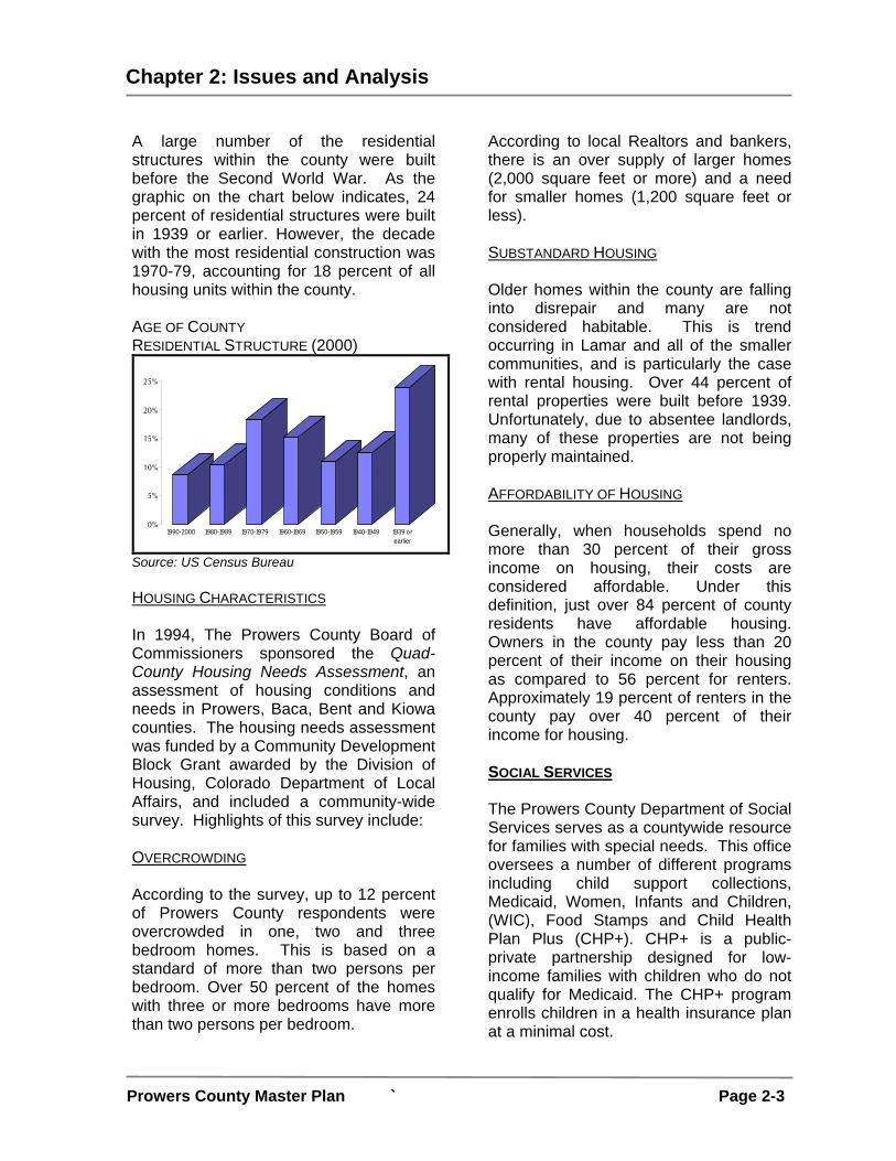
A large number of the residential structures within the county were built before the Second World War. As the graphic on the chart below indicates, 24 percent of residential structures were built in 1939 or earlier. However, the decade with the most residential construction was 1970-79, accounting for 18 percent of all housing units within the county.
AGE OF COUNTY RESIDENTIAL STRUCTURE (2000)
0%
5%
10%
15%
20%
25%
1990-2000 1980-1989 1970-1979 1960-1969 1950-1959 1940-1949 1939 orearlier
Source: US Census Bureau HOUSING CHARACTERISTICS In 1994, The Prowers County Board of Commissioners sponsored the Quad-County Housing Needs Assessment, an assessment of housing conditions and needs in Prowers, Baca, Bent and Kiowa counties. The housing needs assessment was funded by a Community Development Block Grant awarded by the Division of Housing, Colorado Department of Local Affairs, and included a community-wide survey. Highlights of this survey include: OVERCROWDING According to the survey, up to 12 percent of Prowers County respondents were overcrowded in one, two and three bedroom homes. This is based on a standard of more than two persons per bedroom. Over 50 percent of the homes with three or more bedrooms have more than two persons per bedroom.
According to local Realtors and bankers, there is an over supply of larger homes (2,000 square feet or more) and a need for smaller homes (1,200 square feet or less). SUBSTANDARD HOUSING Older homes within the county are falling into disrepair and many are not considered habitable. This is trend occurring in Lamar and all of the smaller communities, and is particularly the case with rental housing. Over 44 percent of rental properties were built before 1939. Unfortunately, due to absentee landlords, many of these properties are not being properly maintained. AFFORDABILITY OF HOUSING Generally, when households spend no more than 30 percent of their gross income on housing, their costs are considered affordable. Under this definition, just over 84 percent of county residents have affordable housing. Owners in the county pay less than 20 percent of their income on their housing as compared to 56 percent for renters. Approximately 19 percent of renters in the county pay over 40 percent of their income for housing. SOCIAL SERVICES The Prowers County Department of Social Services serves as a countywide resource for families with special needs. This office oversees a number of different programs including child support collections, Medicaid, Women, Infants and Children, (WIC), Food Stamps and Child Health Plan Plus (CHP+). CHP+ is a public-private partnership designed for low-income families with children who do not qualify for Medicaid. The CHP+ program enrolls children in a health insurance plan at a minimal cost.

Chapter 2: Issues and Analysis
Prowers County Master Plan ` Page 2-4
HOME CHILD AND FAMILY DEVELOPMENT CENTER The Welcome Home Child and Family Development Center, located in Lamar, provides child care with on-site access to programs such as Head Start. The Center is one of only about 100 child care facilities in the United States to offer Internet access to parents so that they can “see” their child at any time. This is accomplished via placement of cameras in each classroom. HOMELESS AND VICTIMS OF DOMESTIC VIOLENCE SHELTERS The Southeastern Colorado Compassion Center along with the Mary and Martha Pantry located in Lamar provide basic support for those people in need. Also located in Lamar is the Domestic Safety Resource Center offering support and safety for victims of family violence and sexual assault. ECONOMY There are approximately 6,011 jobs in the county with an employment base of 6,667 persons accounting for an unemployment rate of 2.9 percent. Less than 19 percent of population is below the poverty level. Historically, the county’s economy has been heavily dependent upon agriculture. In recent years, the economy has diversified supporting a variety of industries and services. The graph below illustrates the breakdown of employment percentage by industry. According to this illustration, the largest industries by employment percentage are Agriculture, Retail Trade, Services, Manufacturing, and Health Care.
COUNTY EMPLOYMENT BY INDUSTRY (2000)
Agriculture13%
Services13%
M anufacturing12%
Heath Care11%
Education7%
Warehousing5%
Wholesale Trade4%
Construction6%
Government5%
Other11% Retail Trade
13%
Source: US Census Bureau Total employment by industry only paints part of the economic picture. Earnings are also an important economic indicator. The largest industries in 2000 were state and local government at 18.7 percent of earnings; farm at 17.6 percent; and services at 16.4 percent. Of the industries that accounted for at least five percent of earnings in 2000, the slowest growing from 1999 to 2000 was farm, which decreased 41.0 percent; the fastest was services, which increased 22.8 percent.
Neoplan, a large bus manufacturer located in Northeast Lamar, is the largest employer in Prowers County. The county has a 2000 median household income of $29,935. This is 63 percent of the statewide median household income and 71 percent of the national median household income.

Chapter 2: Issues and Analysis
Prowers County Master Plan ` Page 2-5
MEDIAN HOUSEHOLD INCOME (2000)
$0$5,000
$10,000$15,000$20,000$25,000$30,000$35,000$40,000$45,000$50,000
United States State ofColorado
ProwersCounty
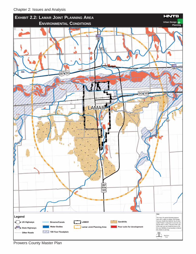
Source: US Census Bureau NATURAL ENVIRONMENT The following information describes environmental conditions that influence the preparation of the Plan. Information collected from a variety of resources is compiled for analysis, and includes work drawn from previous planning efforts. Each environmental condition is described and followed, where applicable, by a brief discussion of potential issues associated with future land use or development activity. Exhibit 2.1 and Exhibit 2.2 (Environmental Conditions) delineate these environmental conditions within the county and the LJPA. TOPOGRAPHY Prowers County lies within the Arkansas River Valley. The topography is generally flat within the central portions of the valley with some topographic relief occurring within the sand hills. In most areas the county, the elevation ranges between 3,400 and 4,200 feet. The lowest point in Prowers County (and in Colorado) occurs at the point where the Arkansas River leaves the county at an elevation of only 3,350 feet. The highest point in the county occurs at Two Buttes Dome, where the elevation is 4,716 feet.
The county topography is generally flat with some topographic relief in the sand hills. CLIMATE The climate of Prowers County is mild to warm and typical of a semi-arid environment. The winters are short and have extreme variations in temperature. The summers are long and have hot days and cool nights. The average annual temperature is 36 degrees Fahrenheit in January and 83 degrees Fahrenheit in August. Annual rainfall levels vary greatly throughout the spring, summer and fall months. Most of the rainfall is in the form of summer showers which tend to be heavy in volume but short in duration. The rainfall in a given area is so unreliable that crop production in dry-farming areas can be difficult. AIR QUALITY Air quality within the county has worsened in recent years. Truck traffic utilizing US Highway 50 and 287 cuts through the heart of Lamar, Granada and Holly. Although there is a proposal for a bypass through Lamar, funding has not been procured to date. The Colorado Department of Transportation is conducting a study for both US Highway 287 and US 50 investigating future align-ment options that may mitigate the through traffic in the future. Additional sources of air pollution include livestock confinement operations. Although the

Chapter 2: Issues and Analysis
Prowers County Master Plan
Urban DesignPlanning
EXHIBIT 2.1: COUNTY ENVIRONMENTAL CONDITIONS
Note:
This map is for general planning purposesonly, and is subject to updates and changes.Any user should check with the City of Lamarand/or Prowers County prior to use to be surethat the data is correct. Because of the scaleof this map, any user should not rely on it forthe exact definition of any boundary or divisionline shown on said map.
North
Map Not toScale
Chapter 2: Issues and Analysis
Prowers County Master Plan
Urban DesignPlanning
EXHIBIT 2.2: LAMAR JOINT PLANNING AREA
ENVIRONMENTAL CONDITIONS
Note:
This map is for general planning purposesonly, and is subject to updates and changes.Any user should check with the City of Lamarand/or Prowers County prior to use to be surethat the data is correct. Because of the scaleof this map, any user should not rely on it forthe exact definition of any boundary or divisionline shown on said map.
North
Map Not toScale

Chapter 2: Issues and Analysis
Prowers County Master Plan ` Page 2-6
county is heavily dependent upon the livestock industry, these types of facilities should be located at least three miles downwind of municipal limits. GEOLOGY Prowers County is in the area known as the Eastern Plains of Colorado. The major features of this area include the Arkansas River Valley surrounded by large expanses of intermittent rolling grassland and sand hills. The predomi-nate rock type is sedimentary. SOILS Countywide soil conditions were studied to provide a clear understanding of the problems associated with certain soil types with regard to construction, support of foundations for permanent structures and suitability for septic systems. Soil Classifications – Developability Soil types can influence design, con-struction and maintenance of buildings, structures and roads. The soil properties most important for these uses are per-meability to water, water-holding capacity, shear strength, compaction charac-teristics, drainage, shrink-swell character-istics, dispersion characteristics, grain size, plasticity, and reaction. Other in-fluencing factors include depth to water table, depth to bedrock and topography. Based upon these factors, three broad soil classifications are delineated on the Environmental Conditions Map (Exhibit 2.1) based upon soil conditions with respect to developability of buildings, structures and roads. Poor Soil Types Severe soils are due to high water, bedrock conditions or unstable gravels. Construction within these areas should account for these conditions.
South of the Arkansas River and along the major drainages exists an expanse of sandy soils. These sands are deep in places and continue to shift with the wind. Although these soils produce only slight building constraints, the shifting and eroding nature of these sandy soils can cause problems.
Sandy soils are prevalent south of the Arkansas River. Intermittent portions of the county south of the Arkansas River are comprised of an area referred to as the sand hills. The sand hills are active sand dunes that have little or no vegetation. The sand can be deep; however, large portions of these areas are experiencing extensive erosion. Water in these areas is absorbed rapidly, and permeability is very rapid. The sand hills are extremely difficult to manage. The landforms are constantly changing due to shifting and blowing sand. Blowing sand can cause visual hazards, especially near populated areas south of Lamar. There have been attempts to control blowing sand by placing heavy objects on and around the dunes to control the erosion. However, these efforts have met with modest success. Additionally, these areas have become an illegal dumping ground for commercial and domestic waste. The County continues to receive numerous complaints concerning this issue.

Chapter 2: Issues and Analysis
Prowers County Master Plan ` Page 2-7
VEGETATION Most of the county is comprised of range-lands. The majority of native vegetation within these areas consists of short prairie grasses, blue grama, buffalo grass, alkali sacaton, galleta, saltgrass and sand dropseed. Other grasses include western wheatgrass, vinemesquite, sideoats grama, sand bluestem, needle-and-thread, little bluestem, sandreed, and blowoutgrass. The shrubs are mainly sand sage, rabbitbush, tamarisk and winterfat. There are a few small areas of remnant forested lands along the Arkansas River and Two Butte Creek. The stands within these areas are mostly cottonwood, but willow and tamarisk also grow in the area. Most of the forested areas have been lost within the past 100 years due primarily to flooding and farming. Generally, the planting of trees for windbreaks has not been successful due to blowing sand, competition from weeds and cycles of inadequate yearly rainfall. However, in nearly all irrigated areas, trees and shrubs do well. WATER The primary water resources in the county are the Arkansas River and water diverted to the canal system. The system associated with the river is used extensively for agricultural irrigation. Additionally, the county utilizes underground aquifers containing water of varying quality. Most of the southern portion of the county is severely constrained by lack of water. A majority of this area is open prairie or utilized for dryland farming.
Irrigation Water Water for irrigation is drawn from the Arkansas River, storage reservoirs, and wells and in a few cases, drainage ditches. The largest amount of water used for irrigation is supplied through the Amity and Fort Lyon Canals. South of the Fort Lyon and Amity canals, extending to the Fort Bent and Lamar canals, is where the majority of irrigated farmland lies in Prowers County. The amount of water available in these canals is dependent upon the amount of flow in the Arkansas River and upon the amount of water stored in the John Martin Reservoir, located in Bent County. The canals draw water from the Arkansas River and flood-irrigate the farmlands. The quality of irrigated water is poor. Water from the Arkansas River and from reservoirs contain a large amount of salts. The amount and type of salts in the water from the river and from reservoirs depend on how much rainfall has occurred and on the source of the runoff.
Drainage canal near the Lamar city limits. The water pumped from wells is generally of good quality for irrigation. The water from deep wells in the uplands generally contains less salts than that from the shallow wells in the valley. Irrigation water taken from the canals generally carries a large amount of silt and clay, especially after a hard rain if runoff has been rapid.

Chapter 2: Issues and Analysis
Prowers County Master Plan ` Page 2-8
When muddy water is used for irrigation, part of the sediment settles in the canals. Drinking Water A large portion of drinking water within unincorporated county areas is pumped from wells. Water quality from these wells varies throughout the county but is generally poor. FLOODPLAINS The Arkansas River Valley has experienced major flood events in 1921, 1951 and 1965. The 1965 flood approached the 500-year flood event classification and produced severe dam-age along the Valley and impacted communities from Lamar to Dodge City, Kansas. Since the 1965 flood, Lamar has adopted floodplain management regula-tions determined by FEMA. Many areas within the communities of Lamar, Granada and Holly, and much of the land adjacent to the Arkansas River are located within the designated floodplain. The areas located within the 100-year floodplain present development constraints, as flooding is likely. Construction of new permanent structures should be discouraged within floodplains. Floodplains have significant potential for other uses. They are ideal for both active and passive open space, and recreational uses which will be the least affected in the event of a flood. STORMWATER AND DRAINAGE All drainage from the county is to the Arkansas River. Several intermittent streams and one perennial stream eventually flow into the Arkansas River. The largest of these and the only perennial stream, Big Sandy Creek, drains an area of 3,151 square miles. Big Sandy
Creek enters the county from the north and flows southward to the river. The next largest stream is Two Butte Creek, which drains an area of 818 square miles. It enters the county from the southwest and flows generally northeast to join the Arkansas River at Holly. During rain events, storm water from developed areas is diverted through the canal system. COUNTYWIDE RESOURCES Prowers County is fortunate to have natural environmental conditions that promote an abundant wildlife population and numerous recreational opportunities. WILDLIFE The county is home to a variety of outdoor recreational opportunities including excellent hunting, fishing and wildlife watching. Today, hunters come to this “goose hunting capital of the nation” for goose, pheasant, antelope and deer. Wildlife observers come to see eagles and thousands of geese flying in formation over the Arkansas River Valley. STATE WILDLIFE AREAS Within Prowers County, the Colorado Division of Wildlife oversees just under 6,000 acres on six properties. Descriptions of each of these properties are provided below: Arkansas River/Holly State Wildlife Area The Arkansas River/Holly State Wildlife Area comprises 153 acres on two properties near Holly. The Arkansas River portion of the wildlife area is located east of Holly near the Kansas state line. The Holly portion is located northwest of Holly. Hunting opportunities within this area include rabbit, pheasant, dove, waterfowl, deer, squirrel, and bobwhite
Chapter 2: Issues and Analysis
Prowers County Master Plan ` Page 2-9
quail. Other recreation opportunities within this area include fishing, camping, hiking and wildlife observation. Red Dog State Wildlife Area The Red Dog State Wildlife Area comprises 570 acres north of Holly at the intersection of County Roads JJ and 37. Recreational opportunities within this area consist of small game hunting and wildlife observation. Deadman State Wildlife Area The Deadman State Wildlife Area comprises 504 acres approximately three miles north of Granada just off County Road 27. Hunting opportunities within this area include deer, small game and waterfowl. The main recreational use within this area aside from hunting is wildlife observation. Granada State Wildlife Area The Granada State Wildlife Area comprises 3,672 acres approximately two miles east of Granada along the Arkansas River. Hunting opportunities within this area include deer, small game and waterfowl. Primary recreational uses within this area are hunting and wildlife observation. Mike Higbee State Wildlife Area The Mike Higbee State Wildlife Area comprises 876 acres approximately four miles east of Lamar on US 50. Hunting opportunities within this area include deer, rabbit, squirrel, pheasant, bobwhite and scaled quail, dove, waterfowl and trap-ping. Other recreation opportunities within this area include camping, hiking, archery, rifle ranges and wildlife observation.
Thurston Reservoir State Wildlife Area The Thurston Reservoir State Wildlife Area comprises 173 acres approximately eight miles north of Lamar just off State Highway 196. Hunting opportunities within this area include dove, waterfowl, pheasant, deer and rabbit. This area is recognized for excellent warm water fishing for crappie, catfish, walleye, saugeye, largemouth bass, tiger muskie, drum and sunfish. Other recreation opportunities include power boating, sail boating, sail boarding, water skiing, camping and wildlife observation. WILDLIFE-RELATED ATTRACTIONS Two Shot Celebrity Goose Hunt In its 38th year, the Two Shot Celebrity Goose Hunt continues to grow in popularity and includes teams from all over the country. The event features ten traditional stations where hunters pay a fee to shoot ten rounds at each station. Proceeds from the hunt go to wildlife related projects, generally selected with the assistance of the Colorado Division of Wildlife HISTORIC RESOURCES There are numerous historic structures and properties throughout Prowers County. Although a majority of these structures are located in Lamar and along the rail line, a number of historic properties are also located in the smaller communities and unincorporated portions of the county.
PROWERS COUNTY COURTHOUSE (301 S. Main Street, Lamar) Denver architect Robert K. Fuller de-signed the elegant neo-classical court-house building constructed of Indiana limestone in 1929. The entrance and main

Chapter 2: Issues and Analysis
Prowers County Master Plan ` Page 2-10
corridor feature panels displaying carved depictions of the registered cattle brands in Prowers County at the time of the building's construction. The Prowers County Courthouse is listed on the National Register of Historic Places. LAMAR DEPOT The original Lamar Depot still serves as a train station for Amtrak passengers. “The Madonna of the Trail” honors the pioneer mothers of the covered wagon days on the Santa Fe Trail. This monument is one of only 12 in the world and stands in front of the Lamar Depot.
The historic Lamar Depot still serves as an active passenger train station and is home to the Colorado Welcome Center and the Chamber of Commerce. DAVIES HOTEL (122 N. Main Street) The Davies Hotel, built in 1902 of locally quarried sandstone, is listed on the National Register of Historic Places and is typical of the numerous small town hotels located near the railroad depot.
LAMAR POST OFFICE (300 S. Fifth Street)
Built in 1936, the neo-classical Lamar Post office with Spanish Colonial/ Mediterranean influences is listed on the National Register of Historic Places.
Other historic structures in the Lamar vicinity include:
ALTA VISTA SCHOOL (8785 Road LL) Constructed in 1917, the two-level red brick building has remained in continuous use as a public school since its con-struction. Now housing the Alta Vista Charter School, the building is listed on the Colorado State Register of Historic Places.
PETTICREW STAGE STOP
In the early 1890s, the John L. Petticrew family settled in southern Prowers County and operated a stage stop between Lamar and Springfield. The locally quarried sandstone house, barn and associated rock walls are notable as a cultural landscape listed on both national and state historic registers. The barn is also a rare surviving example of a stone barn.
Stone barn south of Holly.
PAULSON FARM (39035 Road 7) This property, listed on the National Register of Historic Places, has been associated with agriculture in the Lamar area since Claus Paulsen established the farm in 1901. The farmhouse is a good local example of the foursquare-type of

Chapter 2: Issues and Analysis
Prowers County Master Plan ` Page 2-11
dwelling. The barn is an important surviving example of a once popular but increasingly rare type of wood frame gambrel-roofed barn, a type often replaced by more modern agricultural buildings or lost with the transformation of agricultural lands to other uses. DOUGLAS CROSSING BRIDGE (County Road 28) Constructed in 1936 of locally quarried stone by an eight-man Work Projects Administration (WPA) crew, this filled arch was faced with rusticated stone and features six 14-foot span semicircular arches springing from battered piers. Listed on the National Register of Historic Places, the bridge served as an important crossing for the nearby agricultural community.
Granada Bridge (US Highway 38) Designed by the Colorado Department of Highways, fabricated by Burkhardt Steel Company, and constructed by C.L. Hubner Company, the 1949 steel stringer bridge runs for 423 feet across the Arkansas River. Consisting of five spans, the longest of which extends 90 feet, the bridge is notable for its relatively long spans and excellent state of preservation. The Granada Bridge is listed on the National Register of Historic Places.
CAMP AMACHE (Approximately 1 mile SW of Granada)
Listed on both national and state historic registers, Camp Amache is nationally significant as one of ten camps which housed Japanese Americans from 1942 to 1945 following their forced removal from the West Coast by military authorities. The camp held 7,318 residents at its peak.
The sign depicts the layout of the Amache Japanese Relocation Camp.
HARTMAN GYMNASIUM (School Avenue)
The circa 1938 gymnasium, listed on the Colorado State Register of Historic Places is the only example of WPA construction in Hartman and one of the few such projects in the county. HOLLY SANTA FE DEPOT (302 S. Main Street) The Atchison, Topeka and Santa Fe Railroad built this brick, second gen-eration depot in 1912 as a "combination" depot, handling both passengers and freight. Listed on the National Register of Historic Places, it is one of only four in Colorado possessing the Mission style detailing that became a trademark of the Santa Fe Railroad.
The Holly Santa Fe Depot with the Santa Fe Railroad trademark Mission Style detailing.

Chapter 2: Issues and Analysis
Prowers County Master Plan ` Page 2-12
TRANSPORTATION The following section provides an overview of the existing transportation facilities and basic conditions within the county. Exhibits 2.3 and 2.4 (Services and Infrastructure) provide a breakdown of the locations and classifications of each roadway type. US HIGHWAYS US Highways crossing Prowers County are US 50, 287 and 385. US 50 runs along the Arkansas River, US Highway 287 extends north and south through Lamar, and US 385 heads north from US 50 through Bristol and into Kiowa County. US 50 ALTERNATIVE ALIGNMENT STUDY Recently, the Colorado Department of Transportation (CDOT) commissioned a study to evaluate corridor alignment alternatives for US 50 from Pueblo to the Kansas border. US 50 presently cuts through Lamar, Granada and Holly. US 287 AT LAMAR (BYPASS) STUDY Several years ago, a task force comprised of local business owners and public officials began to study an alternate truck route or bypass for US 287 around Lamar. The task force approached CDOT and requested that the bypass be included in long range planning efforts. CDOT initiated a feasibility study in 1999 to consider several alignment options for the bypass. As a result of this evaluation, an east side alignment option was selected. This alignment extends approximately nine miles from the southern edge of Lamar near County Road CC, north across the Arkansas River and connects to State Highway 196 north of Lamar. Although the project is yet to be funded, the County has acquired most of the necessary right-of-way.
US 287 – “PORTS TO PLAINS TRADE CORRIDOR” US 287 is an important trade corridor, connecting Mexico, the United States and Canada. Planned improvements include construction of a high-mobility four-lane divided highway connecting port cities in Texas to Denver, Colorado. STATE HIGHWAYS State Highway 196 runs east-west across the northern portion of the county connecting US 287 and US 385. This highway bisects the town of Wiley and provides an important connection and travel route for the communities north of the Arkansas River. State Highway 89 runs north-south connecting the eastern portions of the county with US 50. COUNTY ROADS County roads make up a majority of roads within Prowers County. For the most part, county roads are in excellent shape. A number of these roads are rural section, two-lane unimproved. Most of the roads south of the Arkansas River are unpaved. IMPROVED COUNTY ROADS Improved county roads are paved two-lane rural sections with a gravel or unimproved shoulder. These roads cover approximately 16 percent of total county roads. A large number of these roads are adjacent to incorporated municipalities. Many of these roads are asphalt with a small percentage are bituminous, which is a combination of gravel or fill covered and compacted with an oil surface. UNIMPROVED COUNTY ROADS Unimproved roads are gravel two-lane and one lane roads with no shoulder. These roads cover approximately 84

Chapter 2: Issues and Analysis
Prowers County Master Plan ` Page 2-13
percent of total county roads. These county roads provide connections from large farms, ranches and rural residences to the improved county roads, which provide access to the major state and US Highways.
Typical unpaved County road with no shoulder. AIRPORTS The largest airport within Prowers County is the Lamar Municipal Airport, located approximately five miles west of Lamar. Holly operates a small general aviation airport south of town for small single-engine “prop” planes. There is also a small airport in the southwest portion of the county, Springfield Station Airport, which provides general aviation service for small single-engine planes.
Lamar Municipal Airport Terminal. RAILROAD Burlington Northern Sante Fe Railroad provides for the transport of goods
through Prowers County. Amtrak provides one westbound and one eastbound train each day for passenger service to Lamar. TRANSIT Prowers Area Transit Services is a community-based transit system providing transit service including demand-response service, contact services and special trips. Three vehicles operate on weekdays. The Sandhaven Nursing Home also provides transportation to clients on weekdays in Lamar. Primary trips are for medical appointments and adult day care. The nursing home has one van for clients. The Holly Nursing Care Center operates one accessible van for nursing home residents in the Holly area and Lamar. The van is used daily, including week-ends, for medical and social/recreational purposes. Texas, New Mexico and Oklahoma Coaches provide bus service between Lamar and Denver, as well as other destinations on a daily basis. SERVICES AND INFRASTRUCTURE The following section discusses the current infrastructure and service issues within Prowers County. Exhibit 2.3 and Exhibit 2.4 (Services and Infrastructure) delineate infrastructure types and locations. WATER The communities of Lamar, Wiley, Bristol, Hartman, Granada and Holly also provide water within their limits and surrounding areas. Water in the unincorporated area is provided by four service providers: A and B Water Association, Granada Rural Water, Prosperity Lane Community Water Association and May Valley Water.

Chapter 2: Issues and Analysis
Prowers County Master Plan
Urban DesignPlanning
EXHIBIT 2.3: COUNTY SERVICES AND INFRASTRUCTURE

Chapter 2: Issues and Analysis
Prowers County Master Plan
Urban DesignPlanning
EXHIBIT 2.4: LAMAR JOINT PLANNING AREASERVICES AND INFRASTRUCTURE
Note:
This map is for general planning purposesonly, and is subject to updates and changes.Any user should check with the City of Lamarand/or Prowers County prior to use to be surethat the data is correct. Because of the scaleof this map, any user should not rely on it forthe exact definition of any boundary or divisionline shown on said map.
North
Map Not toScale

Chapter 2: Issues and Analysis
Prowers County Master Plan ` Page 2-14
WASTEWATER One of the biggest development con-siderations of any potential property is access to quality wastewater facilities. These facilities can include community central sewer systems within or on the fringe of County towns or individual septic systems within rural areas. Central Sewer The City of Lamar provides central sewer service within its municipal boundaries and in some outlying areas. Additional service within the county is provided by the North Lamar Sewer District and the Bristol Sewer District. A significant amount of development within the county outside of Lamar is provided by community package plants and individual septic systems. Septic Systems Septic systems are utilized by farms, ranches and rural residences. These systems are comprised of an absorption field and sometimes a lateral field. These fields are subsurface systems of tile or perforated pipe that distribute effluent from a septic tank into the natural soil. Properties and features that affect absorption of the effluent are permeability, depth to seasonal high water table, depth to bedrock and susceptibility to flooding. A majority of the residences within the unincorporated area are on septic systems. Lamar, Wiley, Bristol, Hartman Granada and Holly have extended limited central sewer service to areas generally within one mile of their city limits. TELECOMMUNICATIONS Prowers County and much of the Southeast Colorado region has one of the best rural fiber optic cable systems of any
in the nation. Within the past ten years, an extensive fiber optic cable system has been developed throughout the Southeast Colorado region. This system provides businesses and government with inex-pensive high speed connectivity through-out the world. EMERGENCY SERVICES LAW ENFORCEMENT Lamar operates the only police force independent of the County. The balance of municipalities and the unincorporated area is served by the County Sheriff’s Office. Fire Protection Prowers County contains four fire districts. These include Wiley, Lamar, Granada and Holly. The Lamar Fire and Ambulance de-partments cover all of Prowers County except for Wiley, Granada and Holly. The City of Lamar has two fire stations. The fire districts outside of Lamar are comprised of volunteers. COUNTY FAIRGROUNDS The Prowers County Sand & Sage Fairgrounds are located just south of the Lamar city limits along US 287/385. The Fairgrounds are home to the County Fair and host a number of other events throughout the year. The Fairgrounds are also home to the Sand and Sage baseball fields that host a number of local and regional tournaments during the fall and summer. Additionally, the County leases space to commercial vendors and other interested parties for special events.
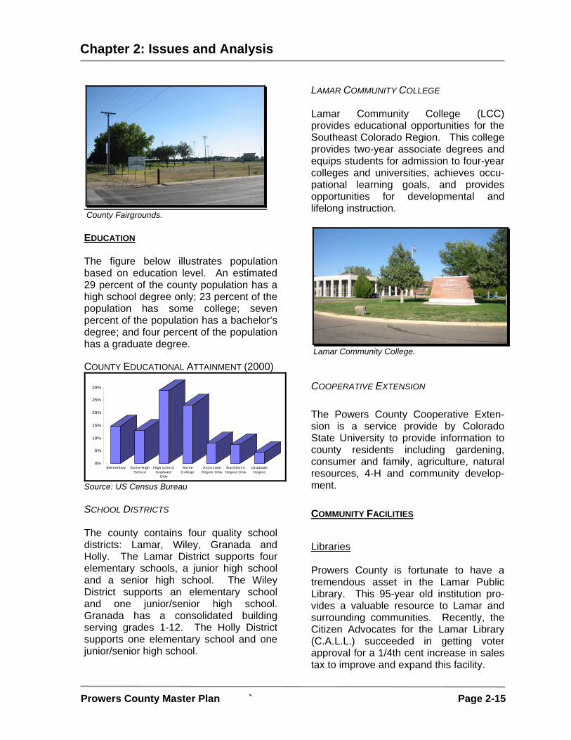
Chapter 2: Issues and Analysis
Prowers County Master Plan ` Page 2-15
County Fairgrounds. EDUCATION The figure below illustrates population based on education level. An estimated 29 percent of the county population has a high school degree only; 23 percent of the population has some college; seven percent of the population has a bachelor’s degree; and four percent of the population has a graduate degree. COUNTY EDUCATIONAL ATTAINMENT (2000)
0%
5%
10%
15%
20%
25%
30%
Elementary Some HighSchool
High schoolGraduate
Only
SomeCollege
AssociateDegree Only
Bachelor'sDegree Only
GraduateDegree
Source: US Census Bureau SCHOOL DISTRICTS The county contains four quality school districts: Lamar, Wiley, Granada and Holly. The Lamar District supports four elementary schools, a junior high school and a senior high school. The Wiley District supports an elementary school and one junior/senior high school. Granada has a consolidated building serving grades 1-12. The Holly District supports one elementary school and one junior/senior high school.
LAMAR COMMUNITY COLLEGE Lamar Community College (LCC) provides educational opportunities for the Southeast Colorado Region. This college provides two-year associate degrees and equips students for admission to four-year colleges and universities, achieves occu-pational learning goals, and provides opportunities for developmental and lifelong instruction.
Lamar Community College. COOPERATIVE EXTENSION The Powers County Cooperative Exten-sion is a service provide by Colorado State University to provide information to county residents including gardening, consumer and family, agriculture, natural resources, 4-H and community develop-ment. COMMUNITY FACILITIES Libraries Prowers County is fortunate to have a tremendous asset in the Lamar Public Library. This 95-year old institution pro-vides a valuable resource to Lamar and surrounding communities. Recently, the Citizen Advocates for the Lamar Library (C.A.L.L.) succeeded in getting voter approval for a 1/4th cent increase in sales tax to improve and expand this facility.

Chapter 2: Issues and Analysis
Prowers County Master Plan ` Page 2-16
Museums The Big Timbers Museum displays Native American artifacts such as arrowheads, war clubs, beads, stone tools, and bows and arrows. There are also cowboy saddles, clothing, and gear and pioneer fashions, furniture, and firearms at the museum. Health Care Prowers County Medical Center serves Lamar and much of southeastern Colorado. Prowers County Public Health Nursing Service provides presumptive eligibility for Medicaid, EPSDT, WIC, immunizations, tobacco prevention, communicable disease control, CHP+, HCP, school health services and options for long term care. Southeastern Colorado Family Guidance and Mental Health Center offers Mental Health evaluations, counseling and treatment. Prowers County is also served by the Wiley and Holly Medical Clinics. The High Plains Community Health and Dental Center provides medical services to Prowers County and surrounding areas. This facility opened in 1995, and serves over 11,000 individuals annually.
Prowers County Medical Center. Cemeteries Prowers County is home to a number of cemeteries including Granada, Hartman,
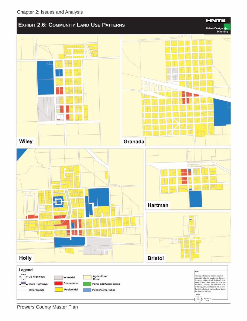
Holly, Hutman, Fairmount, Mount Hope, Riverside, Southside, Sunnyslope, Taft Wilde, and Amache cemetery. LAND USE Exhibit 2.5 (County Land Use Patterns), Exhibit 2.6 (Community Land Use Patterns) and Exhibit 2.7 (Lamar Joint Planning Area Land Use Patterns) provides generalized land-use patterns found within unincorporated Prowers County and the small communities. Notable trends displayed on these exhibits include a significant portion of growth along the major transportation corridors. Land uses within the county are also heavily influenced by natural features. The Arkansas River Valley provides an important resource for farming and development. However, portions of the valley are subject to flood inundation and poor soils that serve as a development constraint. AGRICULTURE AND RANCHING The economy of Prowers County is heavily dependent upon agriculture. The crops of greatest economic importance are irrigated alfalfa and dryland wheat. Other major crops include corn, onions and oil seed crops. Additionally, beef and pork producers make up a significant portion of the county’s economy. The Colorado Beef Feedyard houses over 60,000 head of cattle at full capacity. MINING The county is home to a number of large sand and gravel extraction and storage sites. A majority of these sites are near US 50 and the Arkansas River corridors.

Chapter 2: Issues and Analysis
Prowers County Master Plan
Urban DesignPlanning
EXHIBIT 2.5: COUNTY LAND USE PATTERNS
Chapter 2: Issues and Analysis
Prowers County Master Plan
Urban DesignPlanning
EXHIBIT 2.6: COMMUNITY LAND USE PATTERNS
Note:
This map is for general planning purposesonly, and is subject to updates and changes.Any user should check with the City of Lamarand/or Prowers County prior to use to be surethat the data is correct. Because of the scaleof this map, any user should not rely on it forthe exact definition of any boundary or divisionline shown on said map.
North
Map Not toScale

Chapter 2: Issues and Analysis
Prowers County Master Plan
Urban DesignPlanning
EXHIBIT 2.7: LAMAR JOINT PLANNING AREA LAND USE PATTERNS

Chapter 2: Issues and Analysis
Prowers County Master Plan ` Page 2-17
ENERGY PRODUCTION Southeastern Colorado is an ideal location for wind power projects. Studies show that Colorado is the 11th windiest state in the nation. Prowers County will be home to the fifth largest windfarm in the nation, with the construction of 108 wind turbines. Each turbine is approximately 80-meters high. These turbines will produce enough power to serve 75,000 homes annually. Phase I of the project will cover approximately 11,860-acres and Phase II will cover 9,000-acres. Xcel Energy has agreed to purchase the entire output from the wind farm. RURAL RESIDENTIAL Most of Prowers County is comprised of large tracts of farm and ranchland with scattered rural residences. Excluding agriculture and ranch tracts, a majority of these residences are on tracts that range in size from one to ten acres. COMMUNITIES Lamar Lamar is the largest community in the county, with approximately 8,889 re-sidents and serves as the industrial and retail center for southeastern Colorado. The city is transected by two major highway routes: US 287/385 (Main Street) and US 50/385 (Olive Street). The major commercial areas are located within the Downtown on Main Street north of Olive Street. The commercial uses on the east-end of town along Olive Street include big-box grocery and the Wal-Mart Super Center. The commercial areas on the south-end of town along Main Street include auto-oriented businesses such as fast food establishments, banks, motels as well as small office and service related businesses.
Downtown Lamar The major industrial areas are in the northeastern portion of the city with excellent access to US 287/50 as well as a major rail line that cuts through the heart of the city. A majority of the land uses within the city are comprised of compact single-family neighborhoods. There are a few multi-family complexes but a majority of the residential structures within the community are detached. A large percentage of the new housing is occurring to the south and east of the city. Wiley Wiley is located in the northwestern portion of the county and has approximately 483 residents. A majority portion of the land uses within the com-munity consist of single-family residences. There area a few commercial businesses and a small downtown core.
Downtown Wiley.

Chapter 2: Issues and Analysis
Prowers County Master Plan ` Page 2-18
Granada Granada, located between Lamar and Holly on US Highway 50, has a population of just 640 persons. Most of the land uses within the community consist of single-family residences. There area a few commercial businesses supported by the community including convenience stores and restaurants. Hartman Hartman, located in the eastern portion of the County about 10 miles northwest of Holly. Hartman, is the smallest community in the county, with a population of just over 100 persons. Hartman, a farming community, is comprised of residential, rural residential and some vacant commercial areas.
Outskirts of Hartman. Holly Holly, located in the northeast portion of the county near the Kansas border on US 50, is the second largest community with a population of just over 1,050 persons. Holly is comprised of tightly-knit neighborhoods within the core and scattered large-lot and rural residences surrounding the city. US 50 provides sufficient traffic to support some commercial and service uses along the corridor. Holly has an active downtown area south of US 50 with a grocery store, drug store and community-owned theatre.
Downtown Holly. Bristol Bristol is an unincorporated community located on US Highway 385 north of Granada. Bristol is small residential community that supports a few agricultural-related businesses. ZONING A large portion of the county is zoned for agriculture. The agriculture designation allows a multitude of uses ranging in intensity from single-family residential to light-industrial uses. A few tracts along US Highway 50 between Lamar and Holly are zoned for industrial and are comprised of mining and extraction. These uses are appropriate as long as they do not interfere with existing rural residences. There are nine county zoning districts:
A-1 Irrigated Land A-2 Non-Irrigated Land A-3 Fragile Land R-1 Single-Family Residential R-2 Mixed Residential C-1 Local Commercial C-2 Highway Commercial I-1 Industrial F-1 Floodplain
A majority of the properties south of the Arkansas River are zoned A-2, while the majority of the properties north of the Arkansas River are zoned A-1 or A-2. The areas adjacent to the river and within

Chapter 2: Issues and Analysis
Prowers County Master Plan ` Page 2-19
the floodplain are zoned A-1. The properties located just south and adjacent to the floodplain are primarily zoned A-3. There are a few areas on the fringes of the towns zoned for R-1 or R-2. The properties zoned C-1 are typically located in the unincorporated town of Bristol. The properties zoned C-2 and I-1 are primarily located on the fringes of the towns along US and State Highways. SUMMARY The purpose of this Plan is to provide a sound and workable approach to addressing county land use issues based upon the preceding analysis. This Plan will utilize these issues as well as public input to formulate alternatives, define goals and objectives and shape recommendations.

Chapter 3: Alternatives
Prowers County Master Plan Page 3-1
ALTERNATIVE DEVELOPMENT Preparing conceptual land use maps (“alternatives”) is an exercise designed to develop a set of possible but different land use futures for the county. These futures are based upon a set of realistic choices, and are not intended to represent an entire universe of options. A County Policy Concepts was developed for unincorporated Prowers County, and three additional Plan Alternatives were prepared for the LJPA. Each alternative represents a distinct and divergent future land use and redevelopment possibility. The County Policy Concepts and Plan Alternatives are described below: COUNTY POLICY CONCEPTS OVERVIEW The County Policy Concepts (Exhibit 3.1) envisions growth occurring primarily within Lamar over the next twenty years. New employment will be created primarily in the agricultural confinement, energy distribution and criminal justice sectors. Commercial, industrial and residential development activity will occur in various areas in and around Lamar, taking advantage of relatively low land costs and an available city water supply. Major transportation enhancements will be limited to the improvement of the current bypass alignment, generating demand for extending commercial and industrial corridor development south of Lamar. Existing service levels will be sustained with capital improvements focused on maintaining highway corridors and county roads.
CHARACTERISTICS
• Agricultural land subject to market forces, with agricultural zoning serving as a holding zone for potential future suburbanization.
• Cattle and hog confinement opera-tions continue to grow, with on-going monitoring for meeting public health and environmental quality standards.
• Occasional annexation activity, with pre-annexation agreement re-quired for new development to connect to city sewer and water infrastructure.
• Density of residential development diminishes further away from Lamar and its treated water sup-ply, with larger lot subdivisions (five to ten acres) relying on well and septic systems.
• Limited access and development along an improved bypass route, with market dictating land use at major points of access.
ADVANTAGES
• Protects agriculture • Provides land use compatibility
guidelines for rural communities. • Provides stability to unincor-
porated areas of the County. • Promotes economic growth oppo-
rtunities in the energy sector. DISADVANTAGES
• Could limit property rights. • Could limit housing choices in rural
areas. • Slower economic growth in unin-
corporated area. • Requires significant investments to
rehab and redevelop portions of US 50 and race track.

Chapter 3: Alternatives
Prowers County Master Plan
Urban DesignPlanning
EXHIBIT 3.1: COUNTY POLICY CONCEPTS

Chapter 3: Alternatives
Prowers County Master Plan Page 3-2
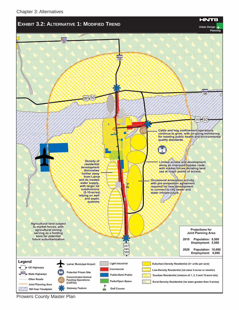
ALTERNATIVE 1: MODIFIED TREND
OVERVIEW The Modified Trend Alternative (Exhibit 3.2) continues current land use trends in Prowers County with sporadic growth in the Lamar vicinity during the next twenty years. New employment will be created primarily in the agricultural confinement, energy distribution and criminal justice sectors. Commercial, industrial and residential development activity will occur in various areas in and around Lamar, taking advantage of relatively low land costs and an available city water supply. Major transportation enhancements will be limited to the improvement of the current bypass alignment, generating demand for the extension of commercial and industrial development south of Lamar. Existing service levels will be sustained with capital improvements focused on maintaining highways and county roads. CHARACTERISTICS • Agricultural land subject to market
forces, with agricultural zoning serving as a holding zone for potential future urbanization.
• Cattle and hog confinement operations continue to grow, with on-going monitoring for compliance with public health and environmental quality standards.
• Occasional annexation activity, with pre-annexation agreement required for new development to connect to city sewer and water infrastructure.
• Density of residential development diminishes further away from Lamar and its treated water supply, with larger lot subdivisions (five-ten acres) relying on well and septic systems.
• Limited access and development along an improved bypass route, with the market dictating land use at major points of access.
• Corrections facility located near bypass route or in Sand Hills.
ADVANTAGES • Maximizes individual property rights. • Steady job growth. • More housing choices in rural areas. • Residential transition between lower
intensity rural areas and higher intensity urban areas.
DISADVANTAGES • Incompatible land uses more com-
mon. • Zoning fails to protect public and
private investments. • Community image not substantially
enhanced. • Non-contiguous development pattern
hems in future growth potential of Lamar.
• Increase in truck traffic through Lamar impacts road safety and maintenance.
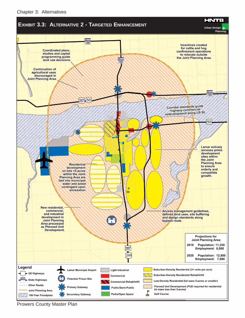
ALTERNATIVE 2: TARGETED ENHANCEMENT OVERVIEW The Targeted Enhancement Alternative (Exhibit 3.3) envisions an aggressive, targeted approach to enhancing the image and economic development potential of Lamar and its surrounding areas. New employment will be created primarily in the manufacturing and construction sectors. Land use efforts will be focused on attracting job-creating development to the unincorporated area surrounding Lamar. A Joint Planning Area will be established for the three mile area sur-rounding Lamar via intergovernmental agreement. Sub area and highway corridor plans will be supplemented with major updates to zoning, subdivision and other land use tools to create cohesive commercial design standards, signage,
Chapter 3: Alternatives
Prowers County Master Plan
Urban DesignPlanning
EXHIBIT 3.2: ALTERNATIVE 1: MODIFIED TREND
Chapter 3: Alternatives
Prowers County Master Plan
Urban DesignPlanning
EXHIBIT 3.3: ALTERNATIVE 2 - TARGETED ENHANCEMENT

Chapter 3: Alternatives
Prowers County Master Plan Page 3-3
landscaping and entry treatments. Trans-portation priorities include the extension and completion of a limited access truck bypass and improving arterial roadway circulation and mobility. Functional plans for streets, water, wastewater, recreation and other community infrastructure will be updated to provide the basis for capital improvement programming. CHARACTERISTICS • Coordinated plans, studies and
capital programming guide land use decisions.
• Lamar proactively annexes prime development sites within the Joint Planning Area to ensure orderly and compatible growth.
• Residential developments on lots greater than five acres within the Joint Planning Area are tied into municipal water and sewer contingent upon annexation.
• Continuation of agricultural uses discouraged in Joint Planning Area.
• Incentives created for cattle and hog confinement operations to relocate outside the Joint Planning Area.
• New residential, commercial, and industrial development in Joint Planning Area processed as Planned Unit Development.
• Corridor standards guide highway commercial redevelopment along US 50.
• Access management guidelines, defined land uses, site buffering and design standards along bypass route.
ADVANTAGES • Balances property rights with
protections of public and private investments within Lamar and its surrounding unincorporated area.
• Proactively preserves areas within Lamar’s surrounding area for future growth.
• Maximizes land use potential within Lamar and surrounding area.
• Joint planning between Lamar and County.
• Promotes close coordination between Lamar, County and service providers.
• Maximizes public infrastructure investments.
DISADVANTAGES • Will require difficult political decisions
with Joint Planning Area. • Time consuming and expensive to
implement.
ALTERNATIVE 3: BALANCED GROWTH OVERVIEW The Balanced Growth Alternative (Exhibit 3.4) directs new development away from rural agricultural and environmentally sensitive areas and into existing communities. The urban-rural interface is well-defined. New employment will be created primarily in the downtown commercial sectors. Land use efforts will be focused on infill development and redevelopment activities. Transportation improvements will be limited to ongoing road maintenance and actions to improve downtown parking, traffic circulation and pedestrian mobility. CHARACTERISTICS • Right-to-farm legislation and “Code of
the West” education to protect agriculture.
• Delineation of environmentally sen-sitive areas (e.g. riparian corridors, sand hills, prime farmland) tied to land use policies and codes to ensure preservation.
• Delineation of environmentally hazardous areas (e.g. 100-year flood plains) tied to land use policies and codes to promote health and safety.

Chapter 3: Alternatives
Prowers County Master Plan
Urban DesignPlanning
EXHIBIT 3.4: ALTERNATIVE 3 - BALANCED GROWTH

Chapter 3: Alternatives
Prowers County Master Plan Page 3-4
• Agricultural zoning district limited to large-scale agricultural uses.
• Non-agricultural related commercial and industrial development directed to urbanized areas.
• Residential lots less than five acres and greater than 35 acres outside urban areas are limited to cluster developments that preserve open lands and protect agricultural lifestyles.
• Substandard housing renovated or replaced.
• Continued maintenance and limited upgrading of County roads and infrastructure.
• Limited government services in rural areas (sewer and water, police, fire, etc.)
• Promote infill and redevelopment within all Prowers County com-munities.
ADVANTAGES • Preserves rural character and sensi-
tive lands. • Protects large-scale agricultural uses. • Reduces conflicts with historic,
cultural and natural amenities. • Reduced pressure for road improve-
ments. • Lower infrastructure costs.
DISADVANTAGES • Slow development of the county. • Decline in potential economic growth. • Possible reduction in housing choices
and affordability.
EVALUATION OF ALTERNATIVES The review of the draft alternatives began with a Steering Committee work session held on July 15, 2003. The draft County Policy Concepts and Plan Alternatives were then refined and provided to the public in the form of questionnaires. This questionnaire included a plan map for each plan alternative delineating future land use areas and improvements as well as a description of associated policies and recommendations. In an effort to garner additional public input, a Plan Alternatives exhibit was displayed at the Prowers County Fair, on successive days from August 4th, 2003 through August 8th, 2003. During the County Fair, the general public completed questionnaires expressing preferences for plan concepts. A sum-mary of these comments follows below. COUNTY POLICY CONCEPTS
Overall, the County Policy Concepts was favorably received by the public. In particular, the public favored protecting agriculture, protecting the irrigated farm supply and promoting economic growth opportunities in the energy sector. In general, the public was comfortable with some of the trade-offs associated with some of these plan policies such as the potential of limiting housing choices in rural areas to protect agriculture. However, the public had mixed opinions on the potential of limiting property rights to accomplish plan goals.
LAMAR JOINT PLANNING AREA ALTERNATIVE PREFERENCES
Alternative 2: Targeted Enhancement, garnered the most support from the public. The public was split on Alternative 1: Modified Trend and Alternative 3: Balanced Growth. The public was largely agreeable to the characteristics of the Balanced Growth Scenario but were not

Chapter 3: Alternatives
Prowers County Master Plan Page 3-5
willing to accept the tradeoffs associated with the plan disadvantages including the reduction in housing choice and afford-ability and the lack of public infrastructure investments within the unincorporated county. The public was largely undecided on the Modified Trend Scenario and this was reflected in the responses for the characteristics and plan advantages and disadvantages. Based upon an analysis of existing conditions throughout the plan development process and upon public input, Alternative 2: Targeted Enhance-ment along with goals and objectives identified in Chapter 4, will be used as the basis for the County Framework Plan and Lamar Joint Planning Area Framework Plan identified in Chapter 5.

Chapter 4: Goals and Objectives
Prowers County Master Plan Page 4-1
DEFINING GOALS AND OBJECTIVES The following goals and objectives are a direct result of the issues and concerns voiced by County residents and public officials during the planning process, as well as a careful review of existing conditions throughout the County and the LJPA. The goals and objectives are categorized into eight subheadings: Intergovernmental Coordination, Natural Environment, Agricultural Character, Historic Resources, Transportation, Services and Infrastructure, Economy, and Land Use.
GOALS – These are the broad aspirations that the public have determined are most important for the County to achieve.
• OBJECTIVES – The objectives are
stated purposes within the broader goal. Each objective relates to a goal, and represents a more specific purpose.
Together, goals and objectives serve as the basis for county policies and development decisions. INTERGOVERNMENTAL COORDINATION
GOAL 1: Coordinate with Lamar on
land use and infrastructure issues within the LJPA.
• OBJECTIVE 1.1: Draft and execute an intergovernmental agreement between the County and Lamar to address issues within the LJPA.
• OBJECTIVE 1.2: Develop a joint development review process between the County and Lamar for development proposals within the LJPA.
• OBJECTIVE 1.3: Coordinate in-frastructure improvements and/or provisions between the County and Lamar within the LJPA.
• OBJECTIVE 1.4: Promote an open dialogue between the County and the incorporated towns on land use and infrastructure issues.
• OBJECTIVE 1.5: Identify future growth areas for growth of towns within the county.
• OBJECTIVE 1.6: Determine County and City staffing requirements for the LJPA.
NATURAL ENVIRONMENT
GOAL 2: Protect and conserve the County’s environmental resources.
• OBJECTIVE 2.1: Restrict inappro-priate development within the 100-year flood plain.
• OBJECTIVE 2.2: Limit development of the sand hills.
• OBJECTIVE 2.3: Utilize state and county lands responsibly.
• OBJECTIVE 2.4 Encourage develop-ment in areas with good soils – particularly when septic systems are used.
• OBJECTIVE 2.5: Actively support the preservation and conservation of natural and scenic features in new developments.

Chapter 4: Goals and Objectives
Prowers County Master Plan Page 4-2
AGRICULTURAL CHARACTER
GOAL 3: Conserve the agricultural and rural character of the County in appropriate areas.
• OBJECTIVE 3.1: Designate appro-priate zoning in rural and agri-cultural areas to help maintain rural character.
• OBJECTIVE 3.2: Discourage non-agricultural development in areas with good potential for agricultural productivity – particularly within ir-rigated areas.
• OBJECTIVE 3.3: Support the essential agricultural businesses within agricultural areas.
• OBJECTIVE 3.4: Encourage the introduction of local agricultural businesses on agricultural and rural lands within the County.
• OBJECTIVE 3.5: Encourage CAFOs to locate away from populated areas.
• OBJECTIVE 3.6: Encourage clus-tered development to preserve agricultural lands and rural character.
• OBJECTIVE 3.7: Promote the Prowers County Code of the West Concept.
GOAL 4: The County should take steps to protect the irrigated water supply.
• OBJECTIVE 4.1: Limit non-agricultural land uses within irrigated farmland areas in the Rural Policy Area.
HISTORIC RESOURCES
GOAL 5: Preserve and protect the County’s historic resources.
• OBJECTIVE 5.1: Emphasize preservation or adaptive reuse as the preferred approach in address-ing historic structures.
• OBJECTIVE 5.2: Encourage public/private partnerships to help encourage the relocation of valuable historic structures when they become threatened.
• OBJECTIVE 5.3: New developments adjacent to historic structures should, when appropriate, reflect the character and historic refer-ences of adjacent structures.
TRANSPORTATION
GOAL 6: Promote an effective and safe transportation system through the improvement and upgrading of County roads.
• OBJECTIVE 6.1: Maintain and up-grade existing County roads.
• OBJECTIVE 6.2: Coordinate with CDOT on the improvements to US 50, US 287 and the Bypass at Lamar.
• OBJECTIVE 6.3: Work with CDOT to improve State Highway 87.
GOAL 7: Integrate transportation and
land use planning efforts within the LJPA.
• OBJECTIVE 7.1: Encourage new development in areas with access to quality or improved roads.

Chapter 4: Goals and Objectives
Prowers County Master Plan Page 4-3
• OBJECTIVE 7.2: Evaluate the feasibility of including access man-agement tools in the review of development proposals, including eliminating flag lots, minimum spacing between access points, and creation of access roads (where appropriate).
• OBJECTIVE 7.3: Require that ad-joining subdivisions, where ap-propriate, have vehicular and pedestrian connections to each other.
INFRASTRUCTURE
GOAL 8: Locate new development on existing adequate infrastructure sys-tems, where appropriate, to minimize tax effects on current residents.
• OBJECTIVE 8.1: Coordinate with local water and sewer providers to promote the balanced and intelligent extension and main-tenance of utilities and infrastructure.
• OBJECTIVE 8.2: Examine ways in which new development can pay its fair share of the costs of infrastructure and facilities that are necessary to serve that development.
• OBJECTIVE 8.3: Promote residential and urban develop-ments on existing infrastructure systems that can feasibly be served by reasonable utility extensions.
• OBJECTIVE 8.4: Support appropriate residential densities with adequate infrastructure and services.
• OBJECTIVE 8.5: Amend subdivision regulations to require all new
residential lots smaller than two acres to be connected to water and sewer systems.
ECONOMY
GOAL 9: Promote economic develop-ment within the County by creating reasonable and positive incentives for new development.
• OBJECTIVE 9.1: Attract a large-scale energy producer (wind farms) in the southwestern portion of the county.
• OBJECTIVE 9.2: Attract DC tie for electric distribution.
• OBJECTIVE 9.3: Work with Lamar to find a suitable site for potential medium-security prison.
• OBJECTIVE 9.4: Work with the agricultural community and others to protect irrigated and dryland economy.
LAND USE
GOAL 10: Designate appropriate loca-tions for different uses of land, coordinating them with the future placement of utilities, roads, and other infrastructure and services.
• OBJECTIVE 10.1: Promote consistent and compatible development patterns
• OBJECTIVE 10.2: Evaluate the use of additional land use tools to help limit the intrusion of non-agri-cultural businesses into rural areas.
• OBJECTIVE 10.3: Inform developers of the benefits of creating quality

Chapter 4: Goals and Objectives
Prowers County Master Plan Page 4-4
developments, following principles of good design and site layout.
• OBJECTIVE 10.4: Encourage developments and uses of appro-priate scale that will not diminish the reasonable enjoyment of resi-dents on adjacent properties. Adequate setbacks and buffer areas should be provided where appropriate.
• OBJECTIVE 10.5: Identify key interchange areas along the pro-posed Lamar Bypass with good potential for light industrial or commercial use.
• OBJECTIVE 10.6: Discourage pre-mature development at State High-way intersections where major road improvements or roadway realignment is projected or identi-fied but not yet planned.
• OBJECTIVE 10.7: Support the con-tinued coordination and communi-cation between the County and its incorporated jurisdictions in relation to land use planning and development review.
• OBJECTIVE 10.8: Encourage the protection of open lands and rural character in the county by promoting higher densities within and adjacent to existing communities.
• OBJECTIVE 10.9: Allow for the creation of residential communities that encompass a range of hous- ing types that are visually attract- tive and provide for the lifestyles of residents.
• OBJECTIVE 10.10: Encourage the removal and clean up of illegal dumping areas, junkyards, trash pits and junk cars, especially within the town fringe policy area
through enforcement of existing zoning. The County has received numerous complaints about these uses due to possible health hazards, devaluation of property and the negative impact to the local economy.
• OBJECTIVE 10.11: Initiate a formalized review process for special use permits. Currently, these permits are only reviewed when complaints are received.
• OBJECTIVE 10.12: Development approvals should be required for all parts of the County. Development sometimes occurs without the knowledge of the Land Use or Assessors Office.

Chapter 5: Framework Plans
Prowers County Master Plan Page 5-1
FRAMEWORK PLANS The Framework Plans reinforce the goals and objectives by providing specific recommendations for the County and the Lamar Joint Planning Area. These recommendations build on the themes and major elements addressed in Chapter 4, Goals and Objectives. Together, these Framework Plans will provide a guideline for future development within the County and LJPA. The Framework Plans represent the County’s desire to plan for efficient and compatible growth. Availability of ad-equate public facilities is critical to ensuring the health, safety and welfare of County residents. The County should coordinate with local utility providers to ensure that all new developments and development plans will not exceed the ability of the County to provide service to growing areas. Additionally, the County should seek to ensure that new de-velopment within the unincorporated area is compatible with existing development. The following planning principles form the basis for development of the Framework Plans:
1. Property rights should be pro-tected.
2. The economic viability of ag-
ricultural areas should be pre-served.
3. Suburban residential development
should be directed to cities and towns.
4. Municipalities should utilize pol-
icies that tie extension of in-frastructure to a requirement for annexation.
PROWERS COUNTY FRAMEWORK PLAN The Prowers County Framework (Exhibit 5.1) serves as a guide for future de-velopment within unincorporated Prowers County. This section defines development locations, outlines types of uses and re-commends development parameters such as densities (lot sizes) and minimum in-frastructure guidelines. The Prowers County Framework is divid-ed into three distinct policy areas:
• RURAL POLICY AREA • CONSERVATION POLICY AREA • TOWN FRINGE POLICY AREA
RURAL POLICY AREA The Rural Policy Area is intended to serve agricultural uses and rural residences.
Recommended Densities
• One dwelling unit per 35 acres or greater
Minimum Required Infrastructure
• On-site septic system • Municipal water or on-site
wells (no cisterns) • Chip and seal or gravel roads
Recommended Uses
• Large-lot rural residences • Agricultural operations
(including CAFOs) • Energy-related facilities

Chapter 5: Framework
Prowers County Master Plan
Urban DesignPlanning
EXHIBIT 5.1: COUNTY FRAMEWORK PLAN
Note:
This map is for general planning purposesonly, and is subject to updates and changes.Any user should check with the City of Lamarand/or Prowers County prior to use to be surethat the data is correct. Because of the scaleof this map, any user should not rely on it forthe exact definition of any boundary or divisionline shown on said map.
North
Map Not toScale

Chapter 5: Framework Plans
Prowers County Master Plan Page 5-2
CONSERVATION POLICY AREA The Conservation Policy Area is comprised of areas within the 100-year floodplain and areas with extremely poor soils. Land development is not re-commended, and any development within the 100 year floodplain or sand hills should include environmental hazards mitigation. There is an opportunity to utilize the floodplain as a green belt with a series of parks and trails.
Recommended Densities
• None
Minimum Required Infrastructure
• Gravel roads
Recommended Uses
• Agriculture • Prisons • Parks • Trails
Discouraged Uses
• Permanent structures (other
than agricultural-related struc-tures or prisons) are discouraged within the 100-year flood plain and within the sand hills.
TOWN FRINGE POLICY AREA Town Fringe Policy Areas represent the future expansion and growth areas for communities in Prowers County, with the exception of Lamar, which is covered by the LJPA.
Recommended Densities
• One lot per five acres or more
Minimum Required Infrastructure
• Temporary on-site septic sy-stems; central sewer system should be provided in future.
• Treated water system. • Gravel roads. Paved roads
are preferred. • If there is not sufficient ca-
pacity for new development, the developer may be given the option to improve the roadway and other infra-structure to meet minimal level of service standards for infrastructure.
• An annexation agreement may be required with the adjacent municipality in ex-change for services such as electricity, water and sewer.
Recommended Uses
• Rural residences • Small farms • Agricultural-related commercial
Discouraged Uses
• Concentrated Animal Feeding
Operations (CAFOs). These operations can produce an un-pleasant odor as well as excess dust that will impact adjacent cities. These uses are more appropriately located in the Rural Policy Area.

Chapter 5: Framework Plans
Prowers County Master Plan Page 5-3
LAMAR JOINT PLANNING AREA (LJPA) FRAMEWORK PLAN The LJPA Framework Plan (Exhibit 5.2) serves as a guide for future development within the three-mile area surrounding the City of Lamar. The LJPA is divided into six policy areas:
• LIGHT INDUSTRIAL NODE • COMMERCIAL NODE • SUBURBAN DENSITY RESIDENTIAL • LOW DENSITY RESIDENTIAL • RURAL ESTATE RESIDENTIAL • SAND HILLS/CONSERVATION
LIGHT INDUSTRIAL NODE These areas are reserved for light industrial development. Because of ex-cellent highway access, these areas provide an ideal location for distribution facilities.
Recommended Densities
• A Floor Area Ratio of .25 or greater
Minimum Required Infrastructure
• Central sewer • City water/water district • Highway access approved by
CDOT • An annexation agreement
may be required with Lamar in exchange for services such as electricity, water and sewer.
Landscape Improvements
• 25 to 50-foot setbacks, w/ a
landscape buffer consisting of a combination of a fence/structure, groundcover, shrubs and trees (except when the adjacent use is industrial in nature)
• Landscape treatments should also be provided along the property frontage to screen the building and parking areas from an adjacent highway.
Recommended Uses
• Light manufacturing
and assembly • Warehouse • Indoor storage • Distribution centers
Discouraged Uses
• Residential uses
COMMERCIAL NODE These areas are reserved for commercial developments. Because of excellent high-way access, these areas are ideal for regional commercial centers.
Recommended Densities
• 75,000 square feet or greater
Minimum Required Infrastructure
• Central sewer • City water/water district • Highway access approved by
CDOT. • An annexation agreement may
be required with Lamar in exchange for services such as electricity, water and sewer.
Landscape Improvements
• 25 to 50-foot setbacks, w/ a
landscape buffer consisting of a combination of a fence/structure, groundcover, shrubs and trees (except when the adjacent use is industrial in nature)

Chapter 5: Framework
Prowers County Master Plan
Urban DesignPlanning
EXHIBIT 5.2: LAMAR JOINT PLANNING AREA FRAMEWORK
Note:
This map is for general planning purposesonly, and is subject to updates and changes.Any user should check with the City of Lamarand/or Prowers County prior to use to be surethat the data is correct. Because of the scaleof this map, any user should not rely on it forthe exact definition of any boundary or divisionline shown on said map.
North
Map Not toScale

Chapter 5: Framework Plans
Prowers County Master Plan Page 5-4
• Landscape treatments should also be provided along the property frontage to screen the building and parking areas from an adjacent highway.
Recommended Uses
• Medium to large-scale com-
mercial retail uses including big-box stores and accessory uses such as banks, restaurants and offices.
Discouraged Uses
• Small-scale single use dev-
elopments. These areas should be preserved for medium to large-scale local and regional commercial uses.
• Residential uses SUBURBAN RESIDENTIAL These areas are reserved for future suburban neighborhoods. The County should encourage the use of permanent foundations, garages or carports and minimal articulation of the facades of such structures including dormers, shutters, stoops and porches on such structures.
Recommended Densities • 3-6 dwelling units per acre
Minimum Required Infrastructure
• Central sewer • City water/water district • Improved paved roads with
curb, gutter and sidewalks. • New subdivisions should be
designed to tie-in new road improvements into the exist-ing grids and to connect adjacent developments when possible.
• An annexation agreement may be required with Lamar in exchange for services such as electricity, water and sewer.
Landscape Improvements
• New subdivisions should
utilize good site design prin-ciples by incorporating quality landscaping and treatments such as gateways and neighborhood signage.
Recommended Uses
• Single-family detached dwell-
ing units • Manufactured homes • Attached dwelling units such
as townhomes, duplexes and small-scale apartment comp-lexes.
Discouraged Uses
• Industrial uses
LOW DENSITY RESIDENTIAL These areas are reserved for residences of varying low density, and can be independent of a planned subdivision. Prospective residents should be aware that they are moving into active farming and rural areas. As a result, one can expect a higher level of incompatible land uses and be subject to a number of nuisances associated with rural areas. These include slow-moving farm ma-chinery, excessive dust and intermittent noise from farming operations.
Recommended Densities • One lot per two acres
Chapter 5: Framework Plans
Prowers County Master Plan Page 5-5
Minimum Required Infrastructure
• On-site septic systems (cen-tral sewer system should be provided in future).
• On-site wells (no cisterns) or City water/water district
• Gravel roads allowed; paved roads preferred
• An annexation agreement may be required with Lamar in exchange for services such as electricity, water and sewer.
Landscape Improvements
• Minimal landscape treatments
are allowed within these areas.
Recommended Uses
• Single-family detached dwell-
ing units. • Manufactured homes
Discouraged Uses
RURAL ESTATE RESIDENTIAL These areas are reserved for low-density residential subdivisions. These resid-ences are recommended to be part of a planned subdivision.
Recommended Densities • One lot per five acres
Minimum Required Infrastructure:
• On-site septic systems • On-site wells (no cisterns) or
City water • Gravel roads allowed; paved
roads are preferred. • An annexation agreement
may be required with Lamar in exchange for services such as electricity, water and sewer.
Landscape Improvements
• Minimal landscape treatments are allowed within these areas. However, large-lot subdivisions should be en-couraged to incorporate quality landscaping and treat-ments such as gateways and neighborhood signage.
Recommended Uses:
• Large-lot single-family attach-
ed dwelling units. These units must be of consistent quality and include permanent found-ations, garages and architec-tural detailing including dor-mers, stoops and/or porches.
Discouraged Uses
• Industrial uses • Commercial uses • Manufactured housing uses
CONSERVATION The Conservation Area is comprised of areas within the 100-year floodplain and the sand hills. Land development is not recommended, and any development within the 100 year floodplain or sand hills should include environmental hazards mitigation. There is an opportunity to utilize the floodplain as a green belt with a series of parks and trails.
Recommended Densities
• None
Minimum Required Infrastructure
• Gravel roads

Chapter 5: Framework Plans
Prowers County Master Plan Page 5-6
Recommended Uses
• Agriculture • Prisons • Parks • Trails
Discouraged Uses
• Permanent structures (other
than agricultural-related struc-tures or prisons) are discouraged within the 100-year flood plain and within the sand hills.
In addition to the six Policy Areas described above, the County and the City of Lamar should work together to develop policies to project other health, safety and welfare concerns of residents within the LJPA. In particular, regulating the burning of trash and weeds should be mutually addressed. Numerous complaints have been received over the last few years in regards to the burning and dumping of trash just outside of Lamar’s municipal limits. SUMMARY The Framework Plans represent the County’s desire to encourage compatible and beneficial land use patterns through-out the unincorporated area, and to pro-mote regional decision-making.

Chapter 6: Implementation
Prowers County Master Plan Page 6-1
INTRODUCTION Successful implementation of the Plan will be the responsibility of many individuals over many years. This chapter builds on the Plan goals and objectives and the framework elements in the previous chapter to delineate specific work tasks, to establish priorities, timing and responsi-bilities. INTERGOVERNMENTAL COORDINATION RECOMMENDATIONS
1. EXECUTE INTERGOVERNMENTAL AGREEMENT (IGA) WITH THE CITY OF LAMAR FOR THE LJPA.
Through this planning process, the County and the City of Lamar agreed to jointly participate in multi-jurisdictional planning. The State of Colorado permits IGAs between a county and city. An IGA provides the opportunity for joint cooperation between the County and Lamar within the LJPA. The execution of an IGA between the County and the City of Lamar for the LJPA is an important first step to working together on land use decisions, annexations, capital improvements programs and priorities as well as infrastructure extension policies within the LJPA.
NATURAL ENVIRONMENT RECOMMENDATIONS
2. IDENTIFY NATURAL RESOURCES IN AREAS PROPOSED TO BE DEVELOPED. The County should require an inventory of natural resources in areas proposed to be developed to determine the potential impacts on natural systems including stream systems, riparian corridors, stream
buffers, wetlands, steep slopes, forest cover, floodplains, important habitats and other features of special significance.
3. DEVELOP STREAM SETBACK REGULATIONS.
The County should prepare stream setback regulations to protect important riparian corridors. These regulations should limit im-pacts to the County's stream valleys and minimize undesirable and irrevocable change to natural drainage systems.
4. INCREASE RESTRICTIONS ON
DEVELOPMENT IN THE FLOODPLAIN
The County should limit develop-ment within the areas designated by the Federal Emergency Man-agement Agency (FEMA) as a 100-year floodplain.
5. THE COUNTY SHOULD PROMOTE STATE WILDLIFE AREAS.
The County should work with the Colorado Division of Wildlife, area municipalities and the Lamar Chamber of Commerce to actively promote State Wildlife Areas as an important county resource.
AGRICULTURAL CHARACTER RECOMMENDATIONS
6. DESIGNATE APPROPRIATE ZONING IN RURAL AND AGRICULTURAL AREAS TO HELP MAINTAIN RURAL CHAR-ACTER AND PROTECT AGRICULTURAL OPERATIONS FROM ENCROACHING DEVELOPMENT. THE UPDATED RE-SOLUTION SHOULD:
• Discourage non-agricultural de-
velopment in areas with good

Chapter 6: Implementation
Prowers County Master Plan Page 6-2
potential for agricultural produc-tivity particularly within irrigated areas.
• Encourage CAFOs to locate within
the Rural Policy Area. These areas should be discouraged within the Town Fringe Policy Area and the LJPA.
• Encourage clustered development
to preserve agricultural lands and rural character.
TRANSPORTATION RECOMMENDATIONS
7. CONTINUE ONGOING MAINTENANCE AND UPGRADING OF COUNTY ROADS. The County should continue ongoing maintenance and up-grading of the County road system. Major improvements to County roads will occur on a limited basis.
8. WIDEN STATE HIGHWAY 89 SOUTH
OF HOLLY. The County should work with CDOT to widen State Highway 89, to start five miles south of Holly and end at the Holly municipal limits.
9. COMMISSION CORRIDOR STUDY ALONG THE IMPROVED U.S. HIGHWAY 50 ALIGNMENT THROUGH HOLLY.
The study should include: • Development Plan • Break in Access Guidelines • Redevelopment of Gateway
Downs Racetrack • Redevelopment of
commercial properties west of Holly
10. COMMISSION AND ADOPT A CORRIDOR PLAN FOR THE PROPOSED BYPASS AT US 287.
The County should work with the City of Lamar and CDOT to commission a corridor plan for the proposed bypass. The corridor plan should be jointly adopted by the County and the City and incorporated into both the County and City zoning regulations as an overlay district. New developments within this area should be reviewed jointly by the County and City in accordance with the IGA. At a minimum, this plan should address the following elements:
• Access management plan to regulate the number, size and location of breaks in access along proposed route.
• Development plan based upon the LPJA Frame-work.
• Aesthetic improvements in-cluding the incorporation of gateway elements, land-scaping, buffering, set-backs and design guide-lines.
SERVICES AND INFRASTRUCTURE RECOMMENDATIONS
11. AMEND REGULATIONS TO REQUIRE DEVELOPMENTS ADJACENT TO MUNICIPALITIES TO MEET MUNICIPAL REQUIREMENTS.
The County should consider amending regulations to require developments adjacent to munici-palities to meet municipal standards when such de-velopments are within either a Town Fringe Area or the LJPA.

Chapter 6: Implementation
Prowers County Master Plan Page 6-3
12. ADOPT A CONCURRENCY STANDARD FOR PUBLIC FACILITIES.
The County should adopt a concurrency standard requiring property developers to show that adequate facilities exist to support a proposed project, considering both existing and programmed infrastructure. Adequacy standards should be developed initially for roads and then possibly for sewer, water and schools.
13. THE COUNTY SHOULD REQUIRE DE-
VELOPMENTS WITH A CERTAIN NUMBER OF LOTS TO CONNECT TO CENTRAL SANITARY SEWER SYSTEMS.
The County should determine a threshold for developments within the unincorporated area before they are required to connect to sanitary sewer systems. It is re-commended that developments with five or more lots be required to connect to central sewer sys-tems.
14. REQUIRE NEW RESIDENTIAL HOMES
LOCATED ON LOTS OF LESS THAN TWO ACRES TO BE CONNECTED TO CENTRAL SEWER SYSTEMS.
The County should amend sub-
division regulations to require all new residential homes located on lots of less than two acres to be connected to central sewer sys-tems.
ECONOMY RECOMMENDATIONS
15. ATTRACT A LARGE-SCALE ENERGY PRODUCER IN THE SOUTHWESTERN PORTION OF THE COUNTY.
The County should promote the use and integration of windfarms in the southwestern portion of the county. The wind turbines are an excellent source of revenue for local property owners and do not impact farming and ranching operations.
16. ATTRACT A DC TIE FOR ELECTRIC DISTRIBUTION.
A transmission line is planned to carry power from the wind farms in the southwestern portion of the county to a substation for distribution just north of Lamar. The County should attract a DC tie at this site.
17. ASSIST LAMAR WITH SITE SELECTION OF POTENTIAL MEDIUM-SECURITY PRISON.
The County should assist Lamar with the site selection and due diligence efforts for the proposed medium-security prison. This facility will most likely be located within the LJPA. The County should coordinate with Lamar on infrastructure needs and potential land use impacts.
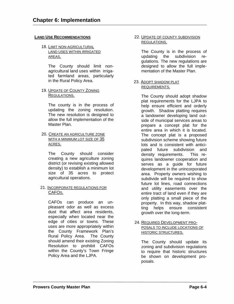
Chapter 6: Implementation
Prowers County Master Plan Page 6-4
LAND USE RECOMMENDATIONS
18. LIMIT NON-AGRICULTURAL LAND USES WITHIN IRRIGATED AREAS.
The County should limit non- agricultural land uses within irriga- ted farmland areas, particularly in the Rural Policy Area.
19. UPDATE OF COUNTY ZONING
REGULATIONS.
The county is in the process of updating the zoning resolution. The new resolution is designed to allow the full implementation of the Master Plan.
20. CREATE AN AGRICULTURE ZONE
WITH A MINIMUM LOT SIZE OF 35 ACRES.
The County should consider creating a new agriculture zoning district (or revising existing allowed density) to establish a minimum lot size of 35 acres to protect agricultural operations.
21. INCORPORATE REGULATIONS FOR CAFOS.
CAFOs can produce an un-pleasant odor as well as excess dust that affect area residents, especially when located near the edge of cities or towns. These uses are more appropriately within the County Framework Plan’s Rural Policy Area. The County should amend their existing Zoning Resolution to prohibit CAFOs within the County’s Town Fringe Policy Area and the LJPA.
22. UPDATE OF COUNTY SUBDIVISION REGULATIONS.
The County is in the process of updating the subdivision re-gulations. The new regulations are designed to allow the full imple-mentation of the Master Plan.
23. ADOPT SHADOW PLAT
REQUIREMENTS.
The County should adopt shadow plat requirements for the LJPA to help ensure efficient and orderly growth. Shadow platting requires a landowner developing land out-side of municipal services areas to prepare a concept plat for the entire area in which it is located. The concept plat is a proposed subdivision scheme showing future lots and is consistent with antici-pated future subdivision and density requirements. This re-quires landowner cooperation and serves as a guide for future development in the unincorporated area. Property owners wishing to subdivide will be required to show future lot lines, road connections and utility easements over the entire tract of land even if they are only platting a small piece of the property. In this way, shadow plat-ting helps ensure consistent growth over the long-term.
24. REQUIRED DEVELOPMENT PRO-
POSALS TO INCLUDE LOCATIONS OF HISTORIC STRUCTURES.
The County should update its zoning and subdivision regulations to require that historic structures be shown on development pro-posals.

Chapter 6: Implementation
Prowers County Master Plan Page 6-5
25. ENCOURAGE DEVELOPMENTS THAT RELY ON SEPTIC SYSTEMS TO LOCATE OUTSIDE OF THE SAND HILLS.
The soils in the sand hills are not
suitable for supporting septic sys-tems. Developments relying on septic systems should be en-couraged to locate outside of these areas.
26. INVESTIGATE THE FEASIBILITY OF
ADOPTING BUILIDING CODES WITHIN THE COUNTY.
The County should study the feasibility of adopting building codes within the County. This study should include efforts to educate the residents of the unincorporated areas about the benefits of building codes. GENERAL RECOMMENDATIONS
27. PROMOTE THE CONTINUAL EDUCA-
TION OF STAFF, ELECTED AND APPOINTED OFFICIALS WITH THE BEST DEVELOPMENT PRACTICES.
The County should strive to provide opportunities for staff and elected and appointed officials to stay up to date on the latest methods and development practices around the country. This includes sending staff and officials to local, state and national professional conferences as well as planning commissioner workshops and work sessions.
28. DEVELOP A GEOGRAPHIC INFOR-MATION SYSTEM (GIS) TO UPDATE PLAN AND ZONING MAPS.
The Southeastern Land and Environment Office should partner with the County Assessor and the
City of Lamar to develop a GIS. Initial layers should be developed and updated utilizing the Assessor’s parcel base.
29. ENSURE THAT STAFFING IS ADEQUATE TO MAKE A CONCERTED EFFORT AT ATTAINING THE COUNTY GOALS.
The County should continue to ensure that staffing levels are adequate to help meet the goals and objectives contained within this Plan.
FUNDING SOURCES TRANSPORTATION EQUITY ACT FOR THE 21ST CENTURY (TEA-21) The Transportation Equity Act for the 21st Century (TEA-21) is the major source of federal funding for all transportation projects in the United States. Several TEA-21 programs offer funding for the type of improvements recommended in this plan. The reauthorization of a similar measure (Safe, Accountable, Flexible and Efficient Transportation Equity Act (SAFETEA) is expected in 2003-2004. CONSERVATION TRUST FUND
The Colorado Department of Local Affairs (DOLA) distributes Conservation Trust Fund monies from net Lottery proceeds to over 400 eligible local governments: counties, cities, towns and eligible special districts that provide park and recreation services. Funding can be used for interests in land and water, park or recreation purposes, for all types of open space, including but not limited to floodplains, green belts, agricultural lands or scenic areas and for any scientific, historic, scenic, recreation, aesthetic or similar purpose (CRS 29-21-101).

Chapter 6: Implementation
Prowers County Master Plan Page 6-6
GREAT OUTDOORS COLORADO TRUST FUND (GOCO) Great Outdoors Colorado Trust Fund (GOCO) awards grants to projects that preserve and enhance Colorado's open space, parks, outdoor recreation, wildlife, rivers and trails. There are five competitive grant programs: Legacy, Open Space, Local Government Parks, Outdoor Recreation & Environmental Education Facilities, Trails, and Planning/Capacity Building. GOCO also awards grants through the Colorado Division of Wildlife and Colorado State Parks. Matching requirements for local governments range from 25 percent to 50 percent, with a minimum of 10 percent to 25 percent of the total project cost as a cash match, depending on the program. GOCO applications require project sponsors to meet several of the following funding criteria:
• Partnerships are encouraged to forge strong relationships that will result in maximum leveraging of resources.
• Matching resources for projects - both cash and in-kind -- are required to obtain funding.
• Integration encourages sponsors to encompass as many components of GOCO's four funding quadrants (wildlife, outdoor recreation, open space and local government) as possible.
• Planning is key; projects that are a part of an overall community, regional, or statewide plan will be scored higher.
• Environmental education access and opportunities afforded by projects may also improve scoring.
• Project sustainability requires sponsors to demonstrate their ability to complete and plan for the operation, maintenance, and management of projects.
• Impact of all projects should address a local or statewide need and the benefits to a local community, a region, or the state.
• Environmental impact requires that all projects should minimize any negative impacts to wildlife and wildlife habitat and where possible provide beneficial conditions for wildlife and wildlife habitat.
• Urgency and whether or not there is an immediate need for the project is considered.
ENERGY AND MINERAL IMPACT ASSISTANCE FUND The Energy and Mineral Impact Assistance program assists communities affected by the growth and decline of energy and mineral industries in the state. Funds come from the state severance tax on energy and mineral production and from a portion of the state's share of royalties paid to the federal government for mining and drilling of minerals and mineral fuels on federally-owned land.
DOLA administers the program and is assisted by a nine-member Energy and Mineral Impact Assistance Advisory Committee, which meets several times each year, to consider applications for grants and low-interest loans.
Eligible entities to receive grants and loans include municipalities, counties, school districts, special districts and other political subdivisions and state agencies. The kinds of projects that are funded include -- but are not limited to -- water

Chapter 6: Implementation
Prowers County Master Plan Page 6-7
and sewer improvements, road improve-ments, construction/improvements to recreation centers, senior centers and other public facilities, fire protection buildings and equipment, and local government planning.
STATE HISTORICAL FUND
The State Historical Fund (SHF) directs a portion of gaming taxes to be used for historic preservation throughout the state. Approximately 28% of the revenue generated from gaming is paid into the State Historical Fund. Of the 28% disbursed to the fund 80% is directed to the statewide grants program SHF.
Approximately $15 million is available for distribution annually, and funds are distributed through a competitive process. All projects must demonstrate strong public benefit and community support. Grants vary in size, from a few hundred dollars to amounts in excess of $100,000. The SHF assists in a wide variety of preservation projects including restoration
and rehabilitation of historic buildings, architectural assessments, archaeological excavations, designation and interpreta-tion of historic places, preservation planning studies, and education and training programs throughout the state. MONITORING
The County’s work is not done with the adoption of this Plan. The Plan is never complete, as it is a dynamic document that should keep pace with changing conditions and evolving community aspirations. As such, the Plan goals and objectives should adapt to the ever-changing needs of the County. Citizen involvement should continue, and as projects are undertaken and completed, the community should discuss new projects and new priorities
.

Chapter 6: Implementation
Prowers County Master Plan Page 6-8
IMPLEMENTATION MATRIX The implementation matrix on the following page identifies a work program for the County to undertake over the next several years to move the community forward to reaching Plan goals. This work program identifies specific actions for each goal and framework element as well as timing and responsibility. Additionally, this work program identifies potential funding sources. Item Actions Time Frame Coordinator Partner Funding 1. Execute
Intergovernmental Agreement (IGA) with the City of Lamar for the LJPA.
Short-Term (1-5 years)
County
Lamar
General revenue
2. Identify natural resources in areas proposed to be developed.
Ongoing
State and
County
Municipalities
Conservation Trust Fund,
GOCO
3 Develop stream setback regulations.
Mid-Term
(5-10 years)
County
Municipalities
(Regulatory)
4. Increase Restrictions on Development in the Floodplain
Short-Term (1-5 years)
County
FEMA, Municipalities
(Regulatory)
5. Promote state wildlife areas
Ongoing
County
State (Colorado Division of Wildlife)
Conservation Trust Fund, GOCO
6. Designate appro-priate zoning in rural and agricultural areas to help maintain rural character and protect agricultural operations from encroaching development.
Mid-Term (5-10 years)
County
Agricultural Extension
(Regulatory)
7. Continue ongoing maintenance and upgrading of County roads
Ongoing
County
CDOT,
Municipalities
General revenue
8. Widen State Highway 89 south of Holly
Long-Term (10+ years)
County
CDOT
State Funding
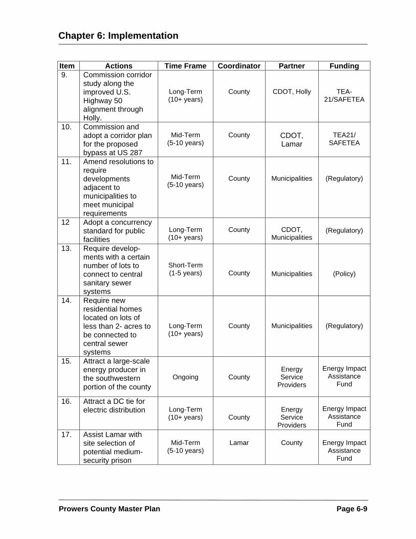
Chapter 6: Implementation
Prowers County Master Plan Page 6-9
Item Actions Time Frame Coordinator Partner Funding 9. Commission corridor
study along the improved U.S. Highway 50 alignment through Holly.
Long-Term (10+ years)
County
CDOT, Holly
TEA-21/SAFETEA
10. Commission and adopt a corridor plan for the proposed bypass at US 287
Mid-Term
(5-10 years)
County
CDOT, Lamar
TEA21/
SAFETEA
11. Amend resolutions to require developments adjacent to municipalities to meet municipal requirements
Mid-Term (5-10 years)
County
Municipalities
(Regulatory)
12 Adopt a concurrency standard for public facilities
Long-Term (10+ years)
County
CDOT,
Municipalities
(Regulatory)
13. Require develop-ments with a certain number of lots to connect to central sanitary sewer systems
Short-Term (1-5 years)
County
Municipalities
(Policy)
14. Require new residential homes located on lots of less than 2- acres to be connected to central sewer systems
Long-Term (10+ years)
County
Municipalities
(Regulatory)
15. Attract a large-scale energy producer in the southwestern portion of the county
Ongoing
County
Energy Service
Providers
Energy Impact
Assistance Fund
16. Attract a DC tie for
electric distribution
Long-Term (10+ years)
County
Energy Service
Providers
Energy Impact
Assistance Fund
17. Assist Lamar with site selection of potential medium-security prison
Mid-Term
(5-10 years)
Lamar
County
Energy Impact
Assistance Fund

Chapter 6: Implementation
Prowers County Master Plan Page 6-10
Item Actions Time Frame Coordinator Partner Funding 18. Limit non-agricultural
land uses within irrigated areas
Mid-Term
(5-10 years)
County
Municipalities
(Regulatory)
19. Update County Zoning Regulations
Ongoing
County - (Regulatory)
20. Create an agriculture zone with a minimum lot size of 35-acres
Mid-Term (5-10 years)
County
Agricultural Extension
(Regulatory)
21. Incorporate regulations for CAFOs
Mid-Term
(5-10 years)
County
State, Agricultural Extension
(Regulatory)
22. Update of county subdivision regulations
Ongoing
County
-
(Regulatory)
23. Adopt shadow plat requirements
Long-Term (10+ years)
County
Municipalities
(Regulatory)
24. Require development proposals to include locations of historic structures
Mid-Term
(5-10 years)
County
State and Local Historic
Societies
(Regulatory)
25. Encourage developments that rely on septic systems to locate outside of the sand hills
Mid-Term (5-10 years)
County
State Department of Environmental Quality Local
(Regulatory)
26. Investigate the feasibility of adopting builiding codes within the County.
Ongoing
County
-
General funds
27. Promote the continual education of staff and elected officials with the best development practices
Ongoing
County
State (DOLA), Professional Organizations such as: The American Planning Association, Urban Land Institute, National Association of Home Builders
General funds,State (DOLA)
Grants
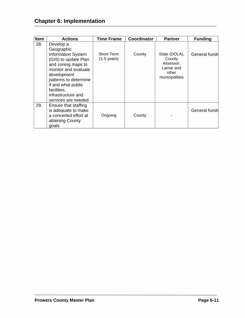
Chapter 6: Implementation
Prowers County Master Plan Page 6-11
Item Actions Time Frame Coordinator Partner Funding 28. Develop a
Geographic Information System (GIS) to update Plan and zoning maps to monitor and evaluate development patterns to determine if and what public facilities, infrastructure and services are needed
Short-Term (1-5 years)
County
State (DOLA), County
Assessor, Lamar and
other municipalities
General funds
29. Ensure that staffing is adequate to make a concerted effort at attaining County goals
Ongoing
County
-
General funds

Appendix
Prowers County Master Plan A-1
PROJECT BIBLIOGRAPHY PLANS AND REPORTS PROWERS COUNTY GROWTH MANAGEMENT PLAN, PREPARED FOR PROWERS COUNTY AND THE INCORPORATED COMMUNITIES OF WILEY, LAMAR, GRANADA, HARTMAN AND HOLLY, CO, PREPARED BY: RAHENKAMP-OLDHAM, DENVER, CO, 1976 COMPREHENSIVE COMMUNITY PLAN, PREPARED FOR THE CITY OF LAMAR, CO, PREPARED BY WILSON & COMPANY, ENGINEERS AND ARCHITECTS, COLORADO SPRINGS, CO, 1985 LAMAR MUNICIPAL AIRPORT MASTER PLAN 1990-2010, PREPARED FOR THE CITY OF LAMAR, COLORADO, PREPARED BY MULLER, SIRHALL AND ASSOCIATES, AIRPORT CONSULTANTS, ENGINEERS AND PLANNERS, AURORA, CO, 1991 MASTER DRAINAGE STUDY, PREPARED FOR THE CITY OF LAMAR, COLORADO, PREPARED BY THE ENGINEERING COMPANY, FORT COLLINS, CO, 1995 WATER SYSTEM MASTER PLAN, PREPARED FOR THE CITY OF LAMAR, COLORADO, PREPARED BY THE ENGINEERING COMPANY, FORT COLLINS, CO, 1998 US 287 AT LAMAR ENVIRONMENTAL ASSESSMENT, “PARTNERSHIP WITH THE COMMUNITY”, PREPARED FOR THE COLORADO DEPARTMENT OF TRANSPORTATION, PREPARED BY KIRKHAM MICHAEL, CONSULTING ENGINEERS, DENVER, CO, 2002 PROJECT DESCRIPTION AND SETTING FOR THE COLORADO GREEN HOLDINGS, LLC PROWERS COUNTY WIND POWER PROJECT, PREPARED FOR FE WIND ENERGY, LLC, PREPARED BY ENVIRONMENTAL STEWARDSHIP AND PLANNING, SACRAMENTO, CA, 2003 ARKANSAS RIVER RESTORATION PROJECT, SECTION 1135 PRELIMINARY RESTORATION PLAN, 2003 QUAD-COUNTY HOUSING NEEDS ASSESSMENT, ASI ASSOCIATES INC., 1994 SOUTHEAST COLORADO REGIONAL TRANSIT ELEMENT, LSC TRANSPORTATION CONSULTANTS, 2001 DEMOGRAPHIC AND ECONOMIC INFORMATION MUNICIPAL DEMOGRAPHIC INFORMATION (LAMAR, GRANADA, HARTMAN, HOLLY AND WILEY) • HISTORICAL CENSUS POPULATION, US CENSUS BUREAU • POPULATION ESTIMATES TO 2001, DEPARTMENT OF LOCAL AFFAIRS, DEMOGRAPHY SECTION • TOTAL ASSESSED VALUE, MILL LEVY, SATE SALES TAX AND RETAIL SALES, COLORADO ECONOMIC AND DEMOGRAPHIC INFORMATION SYSTEM • VEHICLE REGISTRATION AND MILES OF ROAD, COLORADO ECONOMIC AND DEMOGRAPHIC INFORMATION SYSTEM CITY OF LAMAR PROFILE, CITY WEBSITE • POPULATION PROJECTION • CLIMATE – YEARLY AVERAGES • HOUSES SOLD BY YEAR • AVERAGE HOUSING PRICE • AVERAGE RENT ESTIMATE • UTILITY DEMAND AND CAPACITY • UTILITY TAP FEES
Appendix
Prowers County Master Plan A-2
• HEALTH CARE FACILITIES • SCHOOL ENROLLMENT AND GENERAL INFORMATION • EMPLOYMENT – TOTAL LABOR FORCE • EMPLOYMENT BY SECTOR • MAJOR EMPLOYERS • MUNICIPAL GOVERNMENT CONTACT INFORMATION • TAX INFORMATION GEOGRAPHIC INFORMATION SYSTEMS AERIAL PHOTOGRAPHY • PROWERS COUNTY ORTHO-PHOTOS TRANSPORTATION • ROADS TIGER FILE ENVIRONMENTAL • COUNTY SOILS • 100-YEAR FLOODPLAIN (RASTER) • DIGITAL RASTER GRAPHIC DRG (RASTER) MISCELLANEOUS • MUNICIPAL LIMITS • COUNTY BOUNDARIES • WATER BODIES PROWERS COUNTY CENSUS INFORMATION (US CENSUS BUREAU) • COUNTY PROFILE (QUICK FACTS) • HISTORICAL POPULATION • POPULATION FORECASTS BY COUNTY • EDUCATIONAL ATTAINMENT • RACE • URBAN AND RURAL POPULATION • FAMILY INCOME • AVERAGE WAGE • PERSONAL INCOME • PERSONAL INCOME CHANGE • PER CAPITA INCOME • POVERTY • HOUSEHOLD INCOME BY RACE • HOUSEHOLD TYPE • HOUSING UNITS • AGE OF STRUCTURE • UNITS IN STRUCTURE • LABOR FORCE AND TOTAL EMPLOYMENT • OCCUPANCY • WORKERS BY INDUSTRY • MEANS OF TRANSPORTATION TO WORK • VEHICLE REGISTRATION AND MILES OF ROAD

Appendix
Prowers County Master Plan A-3
WEBSITES PROWERS COUNTY, COLORADO, WWW.PROWERSCOUNTY.NET CITY OF LAMAR, COLORADO, HTTP://WWW.CI.LAMAR.CO.US LAMAR CHAMBER OF COMMERCE, WWW.LAMARCHAMBER.COM COLORADO DEPARTMENT OF LOCAL AFFAIRS, WWW.DOLA.STATE.CO.US SOUTHERN COLORADO ECONOMIC DEVELOPMENT DISTRICT (SCEDD), WWW.SCEDD.COM COLORADO SOUTHEAST NETWORK, WWW.SECOLO.ORG US CENSUS BUREAU, WWW.CENSUS.GOV