Embed Size (px)
Citation preview
TheendlePWayBoulsworth Hill
Section Four - 10.5km (6.5miles)
Laneshaw Bridge - Wycoller - Coldwell Inn
Emmott Arms
The pub takes its name from the local land-owning family. Williamthe Conqueror granted the estate to the Emmotts, who lived hereuntil 1939. Emmott Hall, just off the Haworth Road, had ahandsome 18th century façade concealing an earlier building, butwas demolished in 1968.
Carriers Row
The name of this terrace of cottages suggests that the earlyoccupants moved goods to and from the towns by packhorse.They may have carried wool and finished cloth for the domestictextile industry.
Wycoller
This was once a royal hunting area which was granted to the deLacy family in the 12th century. It was an Anglo-Saxon traditionto name settlements after the prominent tree in the area andWycoller derives from Wic-alr, meaning the dairy farm among thealders.There were two cattle farms in Wycoller and you can stillsee the 14th century vaccary wall enclosures.The term is derivedfrom the Latin vacca for cow. The cottage industries of handloomweaving took over Wycoller in the 18th century, but the growth ofthe mills drove people to the towns. In the 1890s the WaterBoard intended to flood the valley to provide a reservoir. Thethreat was lifted in the 1940s and this fascinating village with itsancient bridges was bought by Lancashire County Council tocreate a country park.
Wycoller Hall
Wycoller Hall was the home of the Cunliffe family who owned theestate. The last squire, Henry Owen Cunliffe, was a wild characterwith a passion for cockfighting. He died in 1818 and with thebreak-up of the estate to pay his debts, the hall was left to fallinto ruins. Charlotte Brontë is said to have based FerndeanManor in ‘Jane Eyre’ on Wycoller Hall.
Foster’s Leap
Foster’s Leap, an outcrop of large boulders above Wycoller Dean, isthe scene of a feat of daring by Foster Cunliffe, a relation of theWycoller family. He reputedly managed to clear the notinconsiderable gap between the boulders without mishap.
Brink Ends
A bronze age burial mound of around 1,500 BC was discovered atBrink Ends in 1959 by a local historian, the late Stanley Cookson.
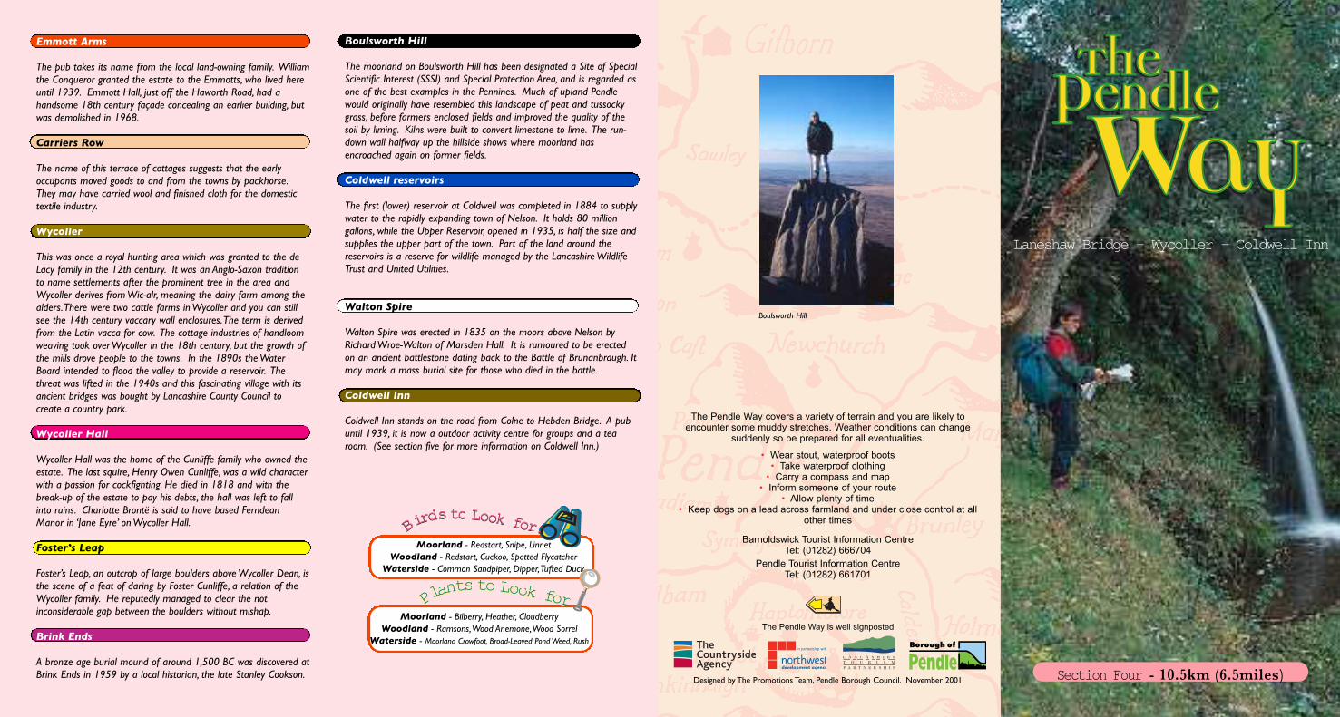
Boulsworth Hill
The moorland on Boulsworth Hill has been designated a Site of SpecialScientific Interest (SSSI) and Special Protection Area, and is regarded asone of the best examples in the Pennines. Much of upland Pendlewould originally have resembled this landscape of peat and tussockygrass, before farmers enclosed fields and improved the quality of thesoil by liming. Kilns were built to convert limestone to lime. The run-down wall halfway up the hillside shows where moorland hasencroached again on former fields.
Coldwell reservoirs
The first (lower) reservoir at Coldwell was completed in 1884 to supplywater to the rapidly expanding town of Nelson. It holds 80 milliongallons, while the Upper Reservoir, opened in 1935, is half the size andsupplies the upper part of the town. Part of the land around thereservoirs is a reserve for wildlife managed by the Lancashire WildlifeTrust and United Utilities.
Walton Spire
Walton Spire was erected in 1835 on the moors above Nelson byRichard Wroe-Walton of Marsden Hall. It is rumoured to be erectedon an ancient battlestone dating back to the Battle of Brunanbraugh. Itmay mark a mass burial site for those who died in the battle.
Coldwell Inn
Coldwell Inn stands on the road from Colne to Hebden Bridge. A pubuntil 1939, it is now a outdoor activity centre for groups and a tearoom. (See section five for more information on Coldwell Inn.)
Moorland - Bilberry, Heather, CloudberryWoodland - Ramsons,Wood Anemone,Wood Sorrel
Waterside - Moorland Crowfoot, Broad-Leaved Pond Weed, Rush
Moorland - Redstart, Snipe, LinnetWoodland - Redstart, Cuckoo, Spotted Flycatcher
Waterside - Common Sandpiper, Dipper,Tufted Duck
Plantsto Look for!Plantsto Look for!
Birdsto Look for!Birdsto Look for!
Plantsto Look for!Plantsto Look for!
Birdsto Look for!Birdsto Look for!
The Pendle Way covers a variety of terrain and you are likely toencounter some muddy stretches. Weather conditions can change
suddenly so be prepared for all eventualities.
• Wear stout, waterproof boots• Take waterproof clothing
• Carry a compass and map• Inform someone of your route
• Allow plenty of time• Keep dogs on a lead across farmland and under close control at all
other times
Barnoldswick Tourist Information Centre Tel: (01282) 666704
Pendle Tourist Information Centre Tel: (01282) 661701
The Pendle Way is well signposted.
Borough ofL A N C A S H I R E
P A R T N E R S H I P T O U R I S M
Designed by The Promotions Team, Pendle Borough Council. November 2001
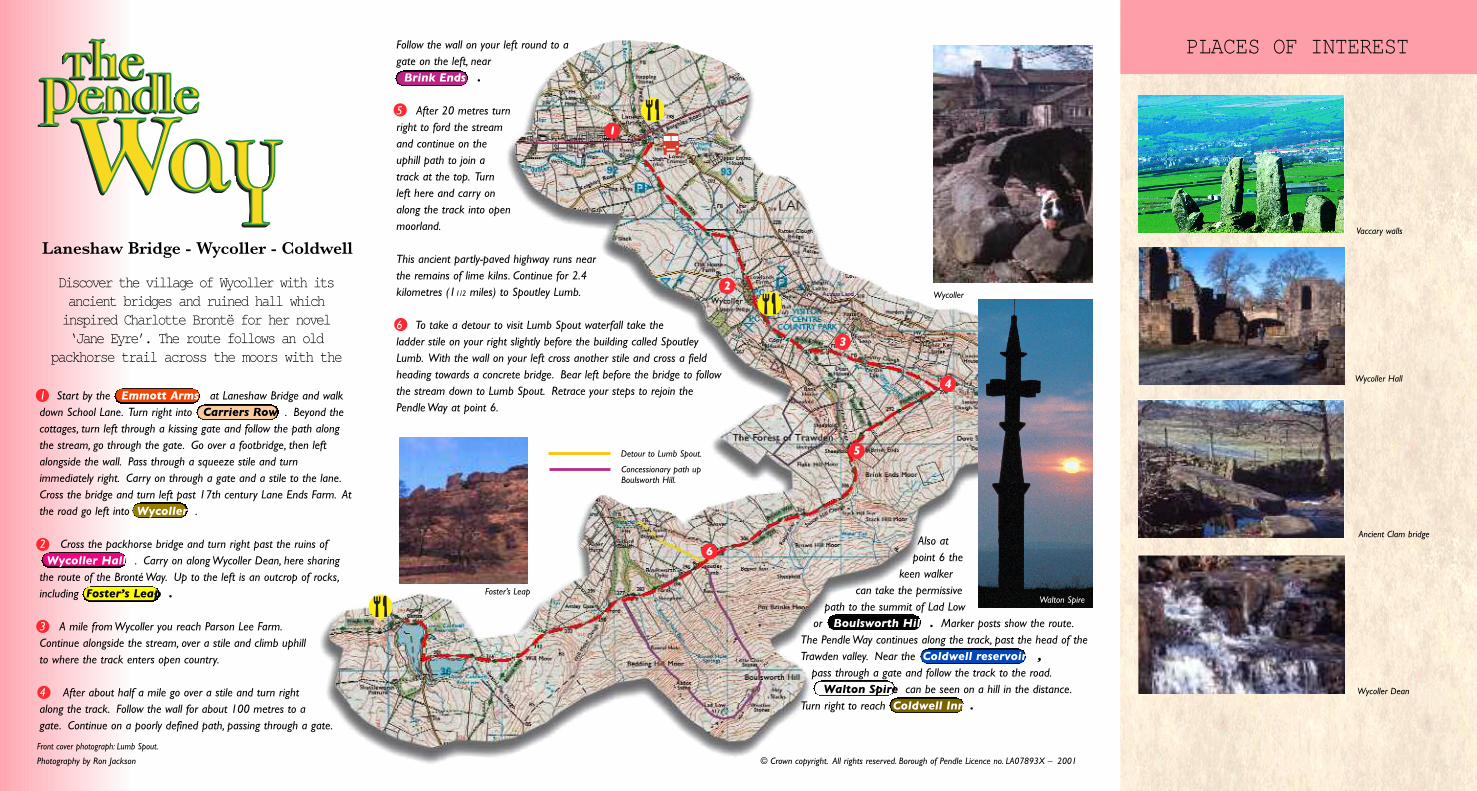
Laneshaw Bridge - Wycoller - Coldwell
Discover the village of Wycoller with itsancient bridges and ruined hall whichinspired Charlotte Brontë for her novel‘Jane Eyre’. The route follows an old
packhorse trail across the moors with the
1 Start by the Emmott Arms at Laneshaw Bridge and walkdown School Lane. Turn right into Carriers Row . Beyond thecottages, turn left through a kissing gate and follow the path alongthe stream, go through the gate. Go over a footbridge, then leftalongside the wall. Pass through a squeeze stile and turnimmediately right. Carry on through a gate and a stile to the lane.Cross the bridge and turn left past 17th century Lane Ends Farm. Atthe road go left into Wycoller .
2 Cross the packhorse bridge and turn right past the ruins ofWycoller Hall . Carry on along Wycoller Dean, here sharing
the route of the Bronté Way. Up to the left is an outcrop of rocks,including Foster’s Leap .
3 A mile from Wycoller you reach Parson Lee Farm.Continue alongside the stream, over a stile and climb uphillto where the track enters open country.
4 After about half a mile go over a stile and turn rightalong the track. Follow the wall for about 100 metres to agate. Continue on a poorly defined path, passing through a gate.
Follow the wall on your left round to agate on the left, near
Brink Ends .
5 After 20 metres turnright to ford the streamand continue on theuphill path to join atrack at the top. Turnleft here and carry onalong the track into openmoorland.
This ancient partly-paved highway runs nearthe remains of lime kilns. Continue for 2.4kilometres (11/2 miles) to Spoutley Lumb.
6 To take a detour to visit Lumb Spout waterfall take theladder stile on your right slightly before the building called SpoutleyLumb. With the wall on your left cross another stile and cross a fieldheading towards a concrete bridge. Bear left before the bridge to followthe stream down to Lumb Spout. Retrace your steps to rejoin thePendle Way at point 6.
PLACES OF INTEREST
© Crown copyright. All rights reserved. Borough of Pendle Licence no. LA07893X – 2001
Front cover photograph: Lumb Spout.
Photography by Ron Jackson
Wycoller
Vaccary walls
Wycoller Hall
Ancient Clam bridge
Wycoller Dean
Foster’s Leap
1
2
3
4
5
6Also at
point 6 thekeen walker
can take the permissivepath to the summit of Lad Low
or Boulsworth Hill . Marker posts show the route.The Pendle Way continues along the track, past the head of theTrawden valley. Near the Coldwell reservoirs ,
pass through a gate and follow the track to the road.Walton Spire can be seen on a hill in the distance.
Turn right to reach Coldwell Inn .
Walton Spire
Detour to Lumb Spout.
Concessionary path upBoulsworth Hill.