Embed Size (px)
Citation preview
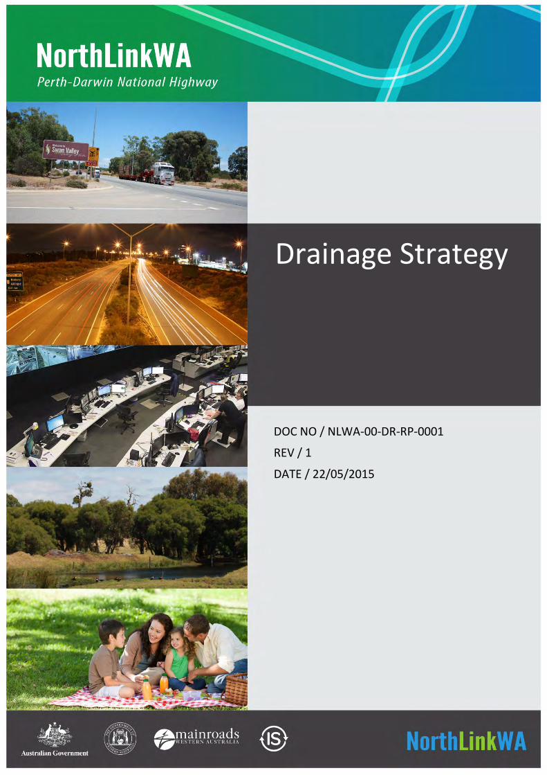
DOC NO / NLWA-00-DR-RP-0001
REV / 1
DATE / 22/05/2015
Drainage Strategy
22 May 2015 NLWA-00-DR-RP-0001 / Rev 1 Page i
CONTENTS
1 INTRODUCTION 1
1.1 Project Description 1
1.2 Project Performance Framework 2
2 ZONES 5
3 STAKEHOLDER ENGAGEMENT 8
3.1 General 8
3.2 Drainage Reference Group 8
3.3 Environment Reference Group 9
4 ISCA 10
4.1 General 10
4.2 Dis-1 Water 10
4.3 LAN-4 Flooding Design 10
4.4 IS Rating Credits in the Northlink WA Context 11
5 EXISTING DRAINAGE 12
5.1 Urban Zone 12
5.2 P1 Zone 12
5.3 Palusplain Zone 13
6 ORDER OF DESIGN 14
7 OBJECTIVES 15
7.1 Urban Zone 15
7.2 P1 Zone 15
7.3 Palusplain 15
8 GROUNDWATER 16
9 OPPORTUNITIES 17
9.1 Wetlands 17
10 DRAINAGE STRATEGY 18
10.1 General 18
10.2 Urban Zone 18
10.3 P1 Zone 18
22 May 2015 NLWA-00-DR-RP-0001 / Rev 1 Page 1
1 INTRODUCTION
1.1 Project Description
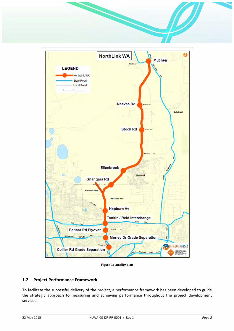
A consortium of consultancies led by BG&E has been appointed to undertake the project development work for the NorthLink WA project. The project is funded by the Federal and State Governments and exists in two parts as follows:
The Swan Valley Bypass - construction of a new 37km highway link between the junction of Reid Highway / Tonkin Highway and Great Northern Highway / Brand Highway at Muchea. This is the northern section of the project; and
Tonkin Grade Separations - grade separation of the intersections of Tonkin Highway with Collier Road, Morley Drive and Benara Road, and associated works. This is the southern section of the project.
This project is a vital component of a wider series of improvements to the Perth Darwin National Highway. The primary objective of these improvements is to enhance freight efficiency and productivity by reducing travel time and improving journey time reliability between the Perth Metropolitan Area and the north west of Australia.
These projects are separately funded, with both receiving State and Federal Government funding.
Construction is scheduled to commence in 2016 and finish in 2019.
22 May 2015 NLWA-00-DR-RP-0001 / Rev 1 Page 2
Figure 1: Locality plan
1.2 Project Performance Framework
To facilitate the successful delivery of the project, a performance framework has been developed to guide the strategic approach to measuring and achieving performance throughout the project development services.
22 May 2015 NLWA-00-DR-RP-0001 / Rev 1 Page 3
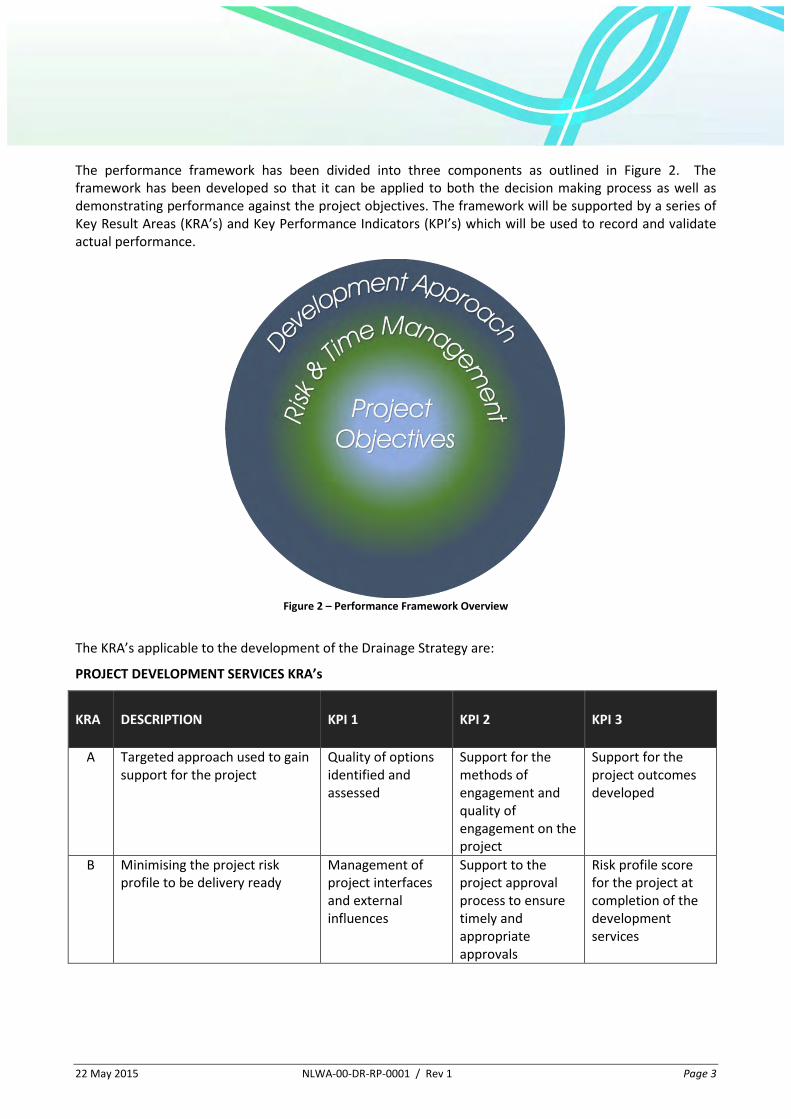
The performance framework has been divided into three components as outlined in Figure 2. The framework has been developed so that it can be applied to both the decision making process as well as demonstrating performance against the project objectives. The framework will be supported by a series of Key Result Areas (KRA’s) and Key Performance Indicators (KPI’s) which will be used to record and validate actual performance.
Figure 2 – Performance Framework Overview
The KRA’s applicable to the development of the Drainage Strategy are:
PROJECT DEVELOPMENT SERVICES KRA’s
KRA DESCRIPTION KPI 1 KPI 2 KPI 3
A Targeted approach used to gain support for the project
Quality of options identified and assessed
Support for the methods of engagement and quality of engagement on the project
Support for the project outcomes developed
B Minimising the project risk profile to be delivery ready
Management of project interfaces and external influences
Support to the project approval process to ensure timely and appropriate approvals
Risk profile score for the project at completion of the development services
22 May 2015 NLWA-00-DR-RP-0001 / Rev 1 Page 4
PROJECT OBJECTIVES
KRA DESCRIPTION KPI 1 KPI 2 KPI 3
3 Improve road safety through the "Towards Zero" initiative
AusRAP safety assessment of design
Blank Blank
4 Improve amenity for the community, tourists and road users
Enhanced Journeys - Provision for Roadside Stopping Facilities
Access to parks, community facilities, tourist attractions and amenities
Opportunities to enhance local environment within the project corridor
5 Maximise Sustainability through economic social and environmental improvement
Maximising opportunity for environmental enhancements outside of the project
Maximising opportunity for social enhancements outside of the project
Maximising opportunity for economic enhancements outside of the project
6 Creating value through affordable infrastructure
Delivering affordable solutions
Primary commercial benefits
Secondary commercial benefits
The drainage strategy has been developed utilising the performance framework.
22 May 2015 NLWA-00-DR-RP-0001 / Rev 1 Page 5
2 ZONES
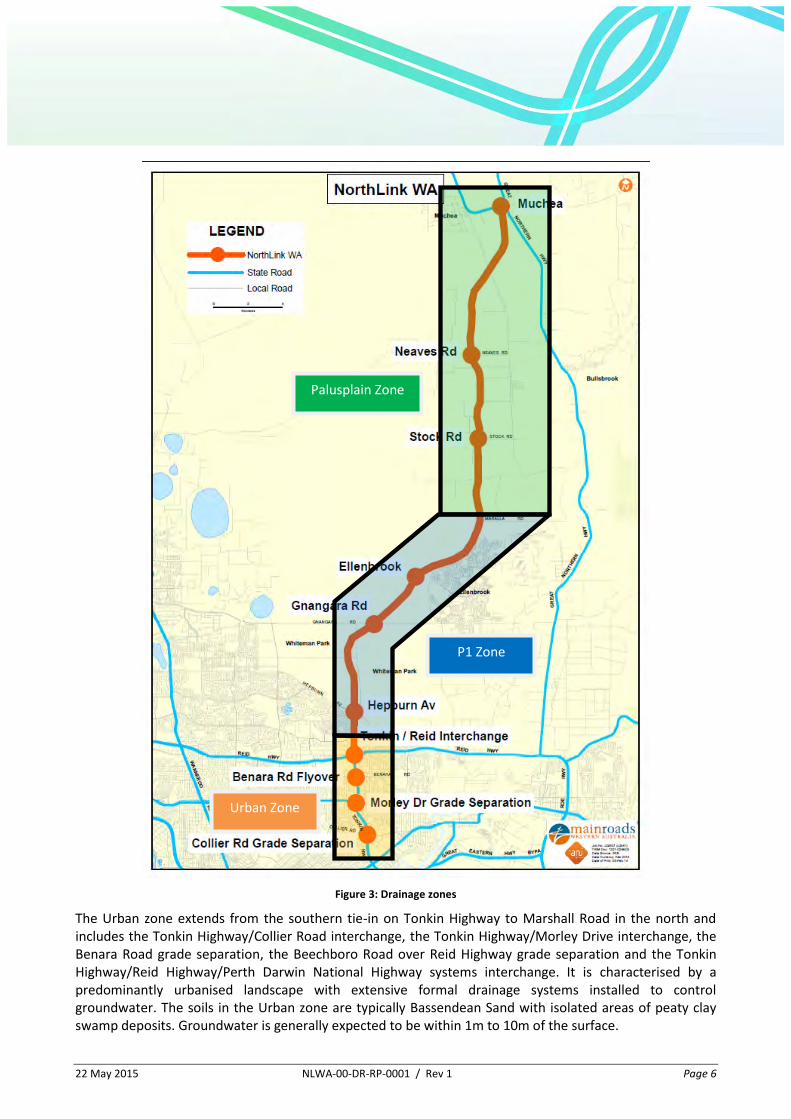
The NorthLink project covers some 42km, starting in the suburb of Bayswater at the southern end of the alignment and finishing in the rural town of Muchea in the north and traverses through urban areas, state forest and pastoral land.
It was identified that from a drainage perspective, the project could be broken down into three zones that displayed similar geographic and hydrologic characteristics and that also had specific drainage management needs. These three zones are shown on Figure 3 below and have been labelled as the Urban zone, the P1 zone and the Palusplain zone.
22 May 2015 NLWA-00-DR-RP-0001 / Rev 1 Page 6
Figure 3: Drainage zones
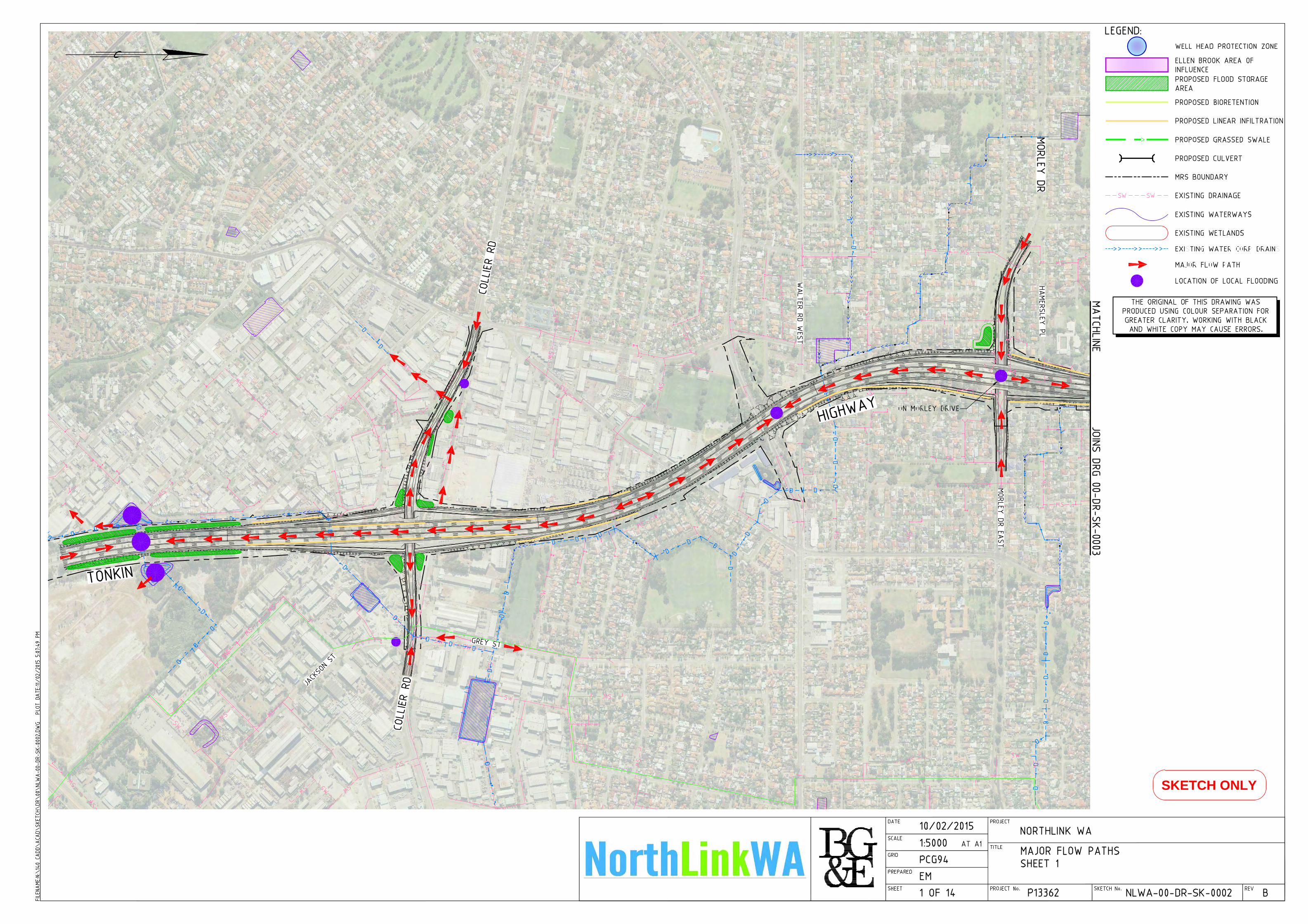
The Urban zone extends from the southern tie-in on Tonkin Highway to Marshall Road in the north and includes the Tonkin Highway/Collier Road interchange, the Tonkin Highway/Morley Drive interchange, the Benara Road grade separation, the Beechboro Road over Reid Highway grade separation and the Tonkin Highway/Reid Highway/Perth Darwin National Highway systems interchange. It is characterised by a predominantly urbanised landscape with extensive formal drainage systems installed to control groundwater. The soils in the Urban zone are typically Bassendean Sand with isolated areas of peaty clay swamp deposits. Groundwater is generally expected to be within 1m to 10m of the surface.
Urban Zone
P1 Zone
Palusplain Zone
22 May 2015 NLWA-00-DR-RP-0001 / Rev 1 Page 7
The P1 zone extends from Marshall Road in the south to Maralla Road in the north. For most of this zone the highway is located in the Priority 1 Source Protection Area (SPA) of the Gnangara Mound Underground Water Pollution Control Area (UWPCA). The Water Corporations water supply bores are located in the UWPCA and are located adjacent to the alignment at several locations through this zone. The area is characterised by an interdunal landscape, with minimal watercourses present. The soils in the P1 zone are typically Bassendean sand with isolated areas of peaty clay swamp deposits. Groundwater is generally expected to be within 1m to 10m of the surface however surface water and wetlands are present in interdunal swales. The land use in this zone is largely low density and includes Whiteman Park to the east, Cullacubardee to the west, State Forest (pine plantation) and a Rocla sand quarry. Some higher density land use exists west of the highway, at the southern end (Ballajura); and east of the highway, towards the north of the zone (Ellenbrook).
The Palusplain zone extends from Maralla Road in the south to the northern extent of the project at Muchea. It is characterised by a gently sloping plain subject to seasonal inundation/waterlogging from a shallow groundwater table. The Palusplain zone sits to the north and east of the Gnangara Mound source protection area and contains numerous small ephemeral streams, wetlands and the major waterway of Ellen Brook. In the vicinity of Ellen Brook and further to the east, the soils comprise a variable thickness of Bassendean Sand overlying and interfingering with both sandy and clayey soils of the Guildford Formation. Isolated peaty clay swamp deposits are also present. In the general locality of Ellen Brook, discrete clayey lenses or a more extensive clayey layer have been encountered at about 2m depth. Much of the Palusplain zone has been cleared for agriculture.
22 May 2015 NLWA-00-DR-RP-0001 / Rev 1 Page 8
3 STAKEHOLDER ENGAGEMENT
3.1 General
Consultation with the major stakeholders was undertaken through the creation of two reference groups, the Drainage Reference Group (DRG) and the Environmental Reference Group (ERG). The role of these groups and the consultation conducted at each is discussed further in the following sections. The minutes from the meetings of both groups are included in Appendix B.
3.2 Drainage Reference Group
The DRG was formed to investigate the opportunities, issues and options related to drainage and water management across the project site.
The DRG had representation from the following stakeholders:
Chittering Landcare / Ellen Brockman Catchment Group;
City of Bayswater;
City of Swan;
Department of Health;
Department of Parks and Wildlife;
Department of Water – Urban Drainage;
Department of Water – Water Resource Protection;
Eastern Metropolitan Regional Council;
Main Roads Western Australia;
Perth Region NRM;
Shire of Chittering; and
Swan River Trust.
The DRG has met twice during the preparation of the Drainage Strategy. The first meeting contained background project information including the division of the project into 3 zones for drainage management purposes. Options for flood mitigation and the management of stormwater quality were presented and discussed. The stakeholders were also given an opportunity to raise critical issues for stormwater management that should be addressed by the Drainage Strategy.
The second meeting of the DRG presented the preferred options for flood mitigation and water quality management for each zone and stakeholder feedback was sought.
22 May 2015 NLWA-00-DR-RP-0001 / Rev 1 Page 9
3.3 Environment Reference Group
The ERG was formed to engage the relevant stakeholders regarding environmental issues on the project.
The ERG has representation from the following stakeholders:
Chittering Landcare / Ellen Brockman Catchment Council;
City of Bayswater;
City of Swan;
Conservation Council of WA;
Department of Parks and Wildlife;
Department of Water;
Eastern Metropolitan Regional Council;
Main Roads Western Australia;
Perth Region NRM;
Shire of Chittering;
Snappy Gum (Aboriginal Heritage representation);
Whiteman Park / Community Groups; and
Wildflower Society of WA.
Whilst the organisational membership of the ERG is similar to the DRG, many of the attendees are from different departments within the organisations and have a different focus.
Issues relating to drainage management raised in the first meeting of the ERG have been included in the formulation of the drainage strategy. A summary of the Drainage Strategy was presented at the second ERG meeting.
22 May 2015 NLWA-00-DR-RP-0001 / Rev 1 Page 10
4 ISCA
4.1 General
The NorthLink WA project has been registered with the Infrastructure Sustainability Council of Australia (ISCA) for a Design rating and is aiming to achieve a rating of Leading. To aid in achieving this rating, the ISCA rating tool is being applied at the project development phase to ensure sustainability is embedded in the project.
There are two credits that apply directly to the Drainage Strategy development and these are discussed in the sections below.
4.2 Dis-1 Water
The aim of this credit is to reward the management of impacts on local receiving water quality from discharges of runoff from the project.
To achieve a Level 1 score for this credit the following are required:
baseline studies of the existing receiving water environment;
predictions for receiving water quality impacts are made;
measures to minimise adverse impacts to local receiving water quality during construction and operation are identified and implemented; and
monitoring of water discharges is undertaken during construction and operation.
In addition to the requirements for a Level 1 score, a Level 2 score requires that monitoring and modelling demonstrates no exceedance of water discharge or water quality goals as well as achieving certain goals during construction. A Level 3 score requires that Level 1 and 2 requirements are met and that opportunities to improve local receiving water quality are identified, implemented and that monitoring and modelling demonstrate the improvement.
The drainage strategy has been developed to achieve this through the implementation of Best Management Practice in accordance with the Manual for Urban Stormwater Management in WA.
4.3 LAN-4 Flooding Design
The aim of this credit is to reward designing for flood events.
A Level 1 score for this credit is awarded when run-off, flood risk and potential increased flood risk elsewhere as a result of the project have all been assessed and appropriate flood resilience measures have been included in the design so that there is no increase in flood risk.
A Level 2 score requires the same assessments as Level 1 but that the flood resilience measures included in the design result in a significant decrease in flood risk.
There is no Level 3 score applicable to this credit.
22 May 2015 NLWA-00-DR-RP-0001 / Rev 1 Page 11
The drainage strategy identifies appropriate flood mitigation options for each of the zones. These can be designed to achieve the desired level for this category in subsequent design stages.
4.4 IS Rating Credits in the NorthLink WA Context
Management of issues relating to water and environment are recognised by NorthLink WA as a key focus area which must be addressed to achieve successful project delivery.
In terms of road drainage, the following aspects have been considered relevant to developing an appropriate outcome in the regional context of NorthLink WA:
Runoff water quality and potential impacts on sensitive water systems (i.e. the Gnangara Mound drinking water protection area and sensitive wetlands) (relevant to Dis-1 credit);
Interruption to existing surface water and groundwater flow (relevant to Lan-4 credit);
Flood risk (relevant to Lan-4 credit); and
Footprint of area required to manage infiltration (relevant to Ecology credits and not covered further in this document).
The runoff water quality and potential impacts on sensitive water systems have been addressed through the adoption of appropriate water quality systems as discussed in Sections 8 and 10. Modelling of the proposed water quality systems to make predictions of the impact on receiving water quality have not been conducted at this stage but will be required at the detailed design stage to achieve a level 1 score.
The drainage strategy has been developed to minimise interruption to surface and groundwater flow patterns, in particular to minimise the impact to the existing flow patterns on the palusplain and to maintain groundwater recharge across the Gnangara Mound. This is documented in Sections 8 and 10 and will be detailed further in the Concept Freeways, Highways and Drainage Design Reports for the Tonkin Grade Separations and the Swan Valley Bypass.
The management of flood risk, relevant to the Lan-4 credit, has been addressed through the adoption of appropriate flood mitigation measures as discussed in Sections 8 and 10. Further, the Planning Design Criteria and Objectives Report (NLWA-00-PL-RP-0001) details the criteria to be applied to drainage systems and basins. The Concept Freeways, Highways and Drainage Design Reports for the Tonkin Grade Separations and the Swan Valley Bypass will contain some concept design information for the proposed flood mitigation measures, with full details developed as part of the detailed design developed during the delivery phase.
22 May 2015 NLWA-00-DR-RP-0001 / Rev 1 Page 12
5 EXISTING DRAINAGE
5.1 Urban Zone
The Urban zone is characterised by a shallow water table and generally urbanised nature surrounding the project alignment. The urban area features major drainage systems to control groundwater and provide for flood mitigation.
The existing Tonkin Highway is largely unkerbed with runoff from the carriageways sheeting to the verge or median to infiltrate. Kerbing is used at the intersections with Collier Road, Morley Drive, Benara Road and Reid Highway.
At the Collier Road intersection, the kerbed sections discharge to adjacent verges, either by small piped systems or kerb openings.
The Morley Drive intersection features a small infiltration basin in the south east quadrant that caters for runoff from Tonkin Highway south of the intersection. A larger infiltration basin is located in the north east quadrant. This larger basin drains a section of Morley Drive and Tonkin Highway at the intersection via a piped system.
Runoff from Tonkin Highway, between Morley Drive and Benara Road, sheets to swale drains within the verge and median areas, where it is collected in a series of catch pits located approximately 600m south of Benara Road. These catchpits are connected to the Water Corporation’s Wonga Road Main Drain (approx 200m to the north) by a 450 dia pipe. There are two small compensating basins connected to the catchpits that act in a ‘push-pull’ manner.
At the intersection of Tonkin Highway and Benara Road, runoff from Benara Road is directed to an infiltration basin in the north east quadrant of the intersection via a piped drainage system. The same piped system collects runoff from the short section of Tonkin Highway that is kerbed north of the intersection. The kerbed section of Tonkin Highway south of the intersection drains to the verge via kerb terminations.
With respect to pavement drainage, there is an existing 500m section of 100mm diameter subsoil drainage (along both carriageways) just south of Broun Avenue (adjacent to Beechboro Road).
The site of the proposed Tonkin Highway/Reid Highway/PDNH system interchange consists of an area of wetland in the northern portion and a sandy disturbed bushland area in the southern portion, which is dominated by three large groundwater fed ponds/lakes that were formed by the construction of borrow pits. These borrow pits are connected by a pipe network to the Water Corporation’s Victoria Road Branch Drain and serve to control groundwater in the area.
5.2 P1 Zone
The P1 zone is predominantly situated in undeveloped/’greenfields’ site with the exception of the southern 1.5km, which occupies the existing Hepburn Avenue alignment.
Hepburn Avenue is generally unkerbed and runoff sheets to the verge to infiltrate, with the exception of the intersection with Pass Way, which is kerbed. This kerbed section is drained by pit and pipe networks that discharge to the adjacent verge area.
The existing Gnangara Road, which traverses east-west through the zone, is unkerbed with runoff sheeting to the adjacent verges to infiltrate.
22 May 2015 NLWA-00-DR-RP-0001 / Rev 1 Page 13
The zone is characterised by an interdunal nature with gently undulating sandy crests with wetlands/damplands formed in the valleys. The area generally has a shallow groundwater table contributing to the formation of the wetlands.
In the southern end of the zone, the Water Corporations Emu Swamp Main Drain crosses the alignment just north of Marshall Road and a tributary of Mussel Creek crosses the alignment just north of Hepburn Ave. North of the Mussel Creek tributary there are no other watercourses in the P1 zone. The tributary is ephemeral and passes under Beechboro Road to the east of the proposed PDNH via a small culvert.
5.3 Palusplain Zone
The PDNH alignment through the Palusplain zone traverses farming land and minor roads.
The flow of groundwater and surface runoff through the Palusplain zone is generally towards Ellen Brook. Therefore up to the crossing of Ellen Brook at Cha 34400 flow is generally west to east and then becomes east to west following the crossing of Ellen Brook.
The existing land use is predominantly grazing/agriculture and features little formalised drainage. Minor roads adjacent to/across the project site are generally drained by table drains with minor culverts at cross-roads.
There are several wetlands along/adjacent the alignment through this zone, with the significant wetland of Twin Swamps being approximately 2.6km east of the project. There are three stream lines along the PDNH alignment between Cha 117100 and 118400. A review of the LIDAR data available at the time that the Drainage Strategy has been developed shows that these streamlines pass to the south and north of Twin Swamps and do not flow directly into the reserve.
22 May 2015 NLWA-00-DR-RP-0001 / Rev 1 Page 14
6 ORDER OF DESIGN
The order of design for the drainage elements should follow the Department of Water “Decision process for stormwater management in WA: Draft for comment” (October 2014).
In general this requires the consideration of groundwater issues, followed by the management of the small frequent rainfall event (up to a 15mm rainfall depth), and then considering flood management issues.
The “Decision process for stormwater management in WA” was followed in the development of the drainage strategy.
22 May 2015 NLWA-00-DR-RP-0001 / Rev 1 Page 15
7 OBJECTIVES
7.1 Urban Zone
Within the Urban zone, flood mitigation for both the road and the adjacent properties is a primary objective for storm events up to the 1% Annual Exceedance Probability (AEP).
Another important objective is to maintain or improve the water quality of the receiving waters. The Urban zone is within the Bayswater Main Drain (Bayswater Brook) and Bennet Brook drainage catchments, both of which have Local Swan Canning Water Quality Improvement Plans (SCWQIPs) prepared under the Swan River Trust Healthy Rivers Action Plan. The SCWIPs outline the existing condition of the water course, sets environmental values for the water course, sets objectives for the water course and identifies annual pollutant load targets
7.2 P1 Zone
The primary objective for the drainage in the P1 zone is the protection of the Gnangara Groundwater Mound with a particular focus on the Well Head Protection Zones (WHPZ) around the extraction bores. The maintenance of groundwater recharge on the mound is an important aspect of the protection of the mound.
Flood mitigation is another important objective where there is development adjacent to the highway (i.e. Ballajura, Ellenbrook, Cullacabardee and the Rick Hamersley Centre). Outside developed areas, excess runoff from major events will be allowed to follow the existing natural major flow paths where possible.
7.3 Palusplain
The primary objective in the Palusplain zone is to maintain the existing hydrology/surface flow as much as possible, whilst protecting wetlands and Ellen Brook.
22 May 2015 NLWA-00-DR-RP-0001 / Rev 1 Page 16
8 GROUNDWATER
Groundwater is a significant feature of the NorthLink WA project. The southern section of the project (the Tonkin Grade Separations/Urban zone) traverses through urban areas in which significant trunk drainage systems have been installed to control groundwater levels. The middle section of the project traverses the Gnangara Mound Underground Water Pollution Control Area, Priority 1 Source Protection Area and the northern section traverses palusplain formed between the Gnangara Mound and Ellen Brook.
There is a need to ensure that road construction (i.e. embankment) doesn’t impact upon groundwater flows, particularly adjacent to significant wetlands. This includes the potential for ‘mounding’ of groundwater upstream of the embankment and lowering of groundwater (and reduction of flow) downstream of the embankment.
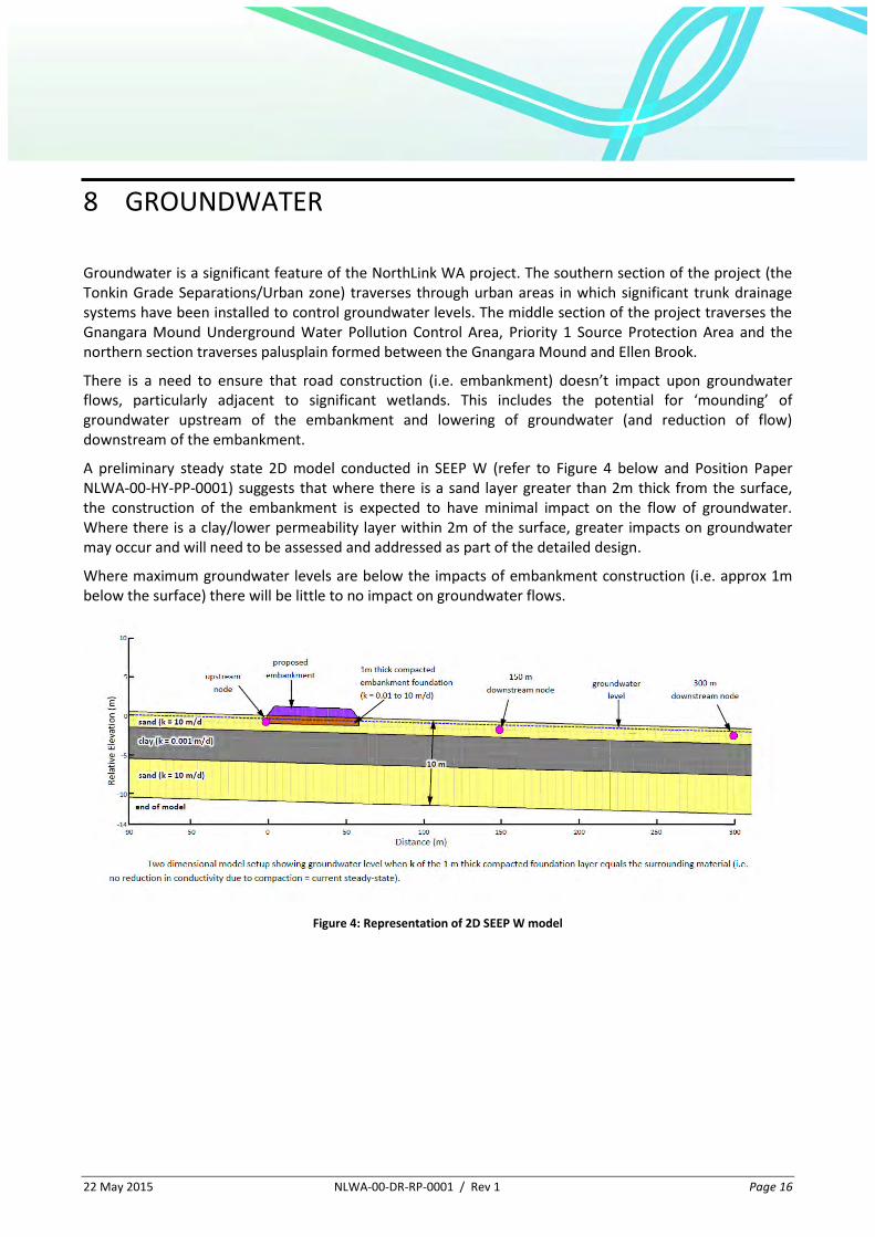
A preliminary steady state 2D model conducted in SEEP W (refer to Figure 4 below and Position Paper NLWA-00-HY-PP-0001) suggests that where there is a sand layer greater than 2m thick from the surface, the construction of the embankment is expected to have minimal impact on the flow of groundwater. Where there is a clay/lower permeability layer within 2m of the surface, greater impacts on groundwater may occur and will need to be assessed and addressed as part of the detailed design.
Where maximum groundwater levels are below the impacts of embankment construction (i.e. approx 1m below the surface) there will be little to no impact on groundwater flows.
Figure 4: Representation of 2D SEEP W model
22 May 2015 NLWA-00-DR-RP-0001 / Rev 1 Page 17
9 OPPORTUNITIES
9.1 Wetlands
Whilst the construction of wetlands for providing treatment for the highway runoff has not been included as part of the drainage strategy, the construction or enhancement of existing wetlands for both environmental and social benefit has been identified as a legacy opportunity for the project and is being pursued by a working group including the Sustainability and Innovation manager, Environmental team, Landscape and Urban Design team and the Drainage and Water Management manager.
22 May 2015 NLWA-00-DR-RP-0001 / Rev 1 Page 18
10 DRAINAGE STRATEGY
10.1 General
The focus of the drainage strategy across the project is to provide disconnection of the drainage system where possible. How this is achieved across the zones will differ and is discussed in more detail for each zone in the sections below.
10.2 Urban Zone
The drainage strategy within the Urban zone is to provide for flood mitigation through infiltration or where this is not possible through detention to existing or agreed levels into the trunk drainage systems in the area.
Water quality is to be addressed through infiltration of common rainfall events. This will include the use of leaky pits and infiltration systems used for flood mitigation. Where buried infiltration or detention systems that are not easily maintainable are required an oil and sediment separator should be provided upstream of the buried system.
Transverse drainage within the Urban zone consists of Water Corporation or LGA drainage systems, which are generally piped across the project. Impacts to these systems need to be addressed in co-operation with the appropriate authority.
Special Considerations - Tonkin Highway / Reid Highway / PDNH interchange
The existing groundwater fed lakes (created by sand quarrying during the construction of Reid Highway and Tonkin Highway in the early 90’s) in the Tonkin Highway / Reid Highway / PDNH interchange can be incorporated into the drainage system as part of the flood mitigation measures provided that runoff from road/paved surfaces is treated prior to discharge into the lakes.
Special Considerations – Existing subsoil drainage
The existing sub-soil drainage along Tonkin Highway to the south of the Broun Avenue / Walter Road overpass will need to be duplicated for the widened highway. The profile of the highway needs to be lowered slightly through this section to achieve the required clearance to the existing Broun Ave / Walter Road overpass. The implications of this will need to be assessed once details of the existing subsoil system are known.
10.3 P1 Zone
The drainage strategy within the P1 zone is to provide for flood mitigation through infiltration, either in formalised infiltration areas or within existing depressions outside the site where this won’t increase the flood risk to properties. The infiltration of major events should be outside the WHPZs where possible.
The use of detention for flood mitigation for the catchment draining toward the Water Corporation’s Emu Swamp Branch Drain can also be explored during detailed design.

22 May 2015 NLWA-00-DR-RP-0001 / Rev 1 Page 19
Water quality is to be addressed through infiltration of common rainfall events via leaky pits, grassed/vegetated swales and flow over existing vegetated surfaces. Within WHPZs water quality is to be addressed by the provision of bioretention swales. The bioretention swales should be sized to treat the common rainfall event, with excess runoff directed away from the bores.
There are two transverse drainage lines within the P1 zone. The Water Corporations Emu Swamp Branch Drain, which crosses PDNH north of Marshall Road and is currently piped under most of the alignment, will require liaison with the Water Corporation to ensure the piped section of drain is protected. The tributary of Mussel Brook, which crosses PDNH just north of the Hepburn Ave interchange, will require a culvert to ensure flow is maintained into the system downstream.
Special Considerations – Spill Management
An Emergency Spill Response plan needs to be developed to address any spills that occur on the Highway or associated interchanges within the Priority 1 SPA. The plan needs to detail which agencies are to be involved and needs to be widely distributed.
Special Considerations - Wetlands
The hydrology (quantity and quality) and hydrogeology of wetlands (Conservation and Resource Enhancement Category) adjacent to the highway needs to be maintained. The hydrology will be addressed through the provision of bioretention swales within a 100m buffer of the wetland to infiltrate common rainfall events. The effect of the highway on the hydrogeology at the wetland will need to be assessed.
The Conservation Category Wetland at PDNH Cha 3475 & 3700 is bisected by the highway and will require culverts to provide for the transverse movement of water across the highway within the wetland.
Special Considerations – Bores
Whilst the drainage strategy has been developed with a focus on the water quality within the WHPZs, the alignment comes in close proximity to the bores themselves in some locations and particular attention should be given to the drainage of the highway at these locations, such as avoiding a sag in the vertical alignment adjacent the bores.
10.4 Palusplain Zone
The drainage strategy for the Palusplain zone is to allow the runoff to sheet off the highway to the adjacent verges where it can flow across the vegetated verge and adjacent land.
The existing surface drainage in the Palsuplain zone features numerous small ephemeral streams, wetlands and areas of sheet flow. To minimise the impacts of water shadow downstream of the alignment culverts should be provided for the conveyance of major flows (i.e. on the ephemeral streams/creeks) and for environmental flows at wetlands and minor depressions along the alignment.
Special Considerations – Wetlands
The hydrology (quantity and quality) and hydrogeology of wetlands (Conservation and Resource Enhancement Category) adjacent to the highway needs to be maintained. The hydrology will be addressed through the provision of bioretention swales within a 100m buffer of the wetland to infiltrate common rainfall events. The effect of the highway on the hydrogeology at the wetland will need to be assessed.
22 May 2015 NLWA-00-DR-RP-0001 / Rev 1 Page 20
Due to the waterlogged nature of the Palusplain zone in winter the bioretention systems will need to be ‘perched’ (i.e. constructed in fill above the existing ground) and/or have a base drain added to ensure the filter media drains between rainfall events.
Special Considerations – Interchanges
The interchanges proposed in the Palusplain zone are likely to introduce concentration of flow due to kerbing requirements for delineation and to prevent scour down the batters for the elevated roads. The outlets of these concentrated systems should feature a detention/infiltration area for the common rainfall event to minimise the impacts downstream.
Special Considerations – Ellen Brook
Ellen Brook is a significant tributary of the Swan River and is crossed by the PDNH at Cha 34400. As the alignment approaches and crosses Ellen Brook, the distance of overland flow through vegetation reduces and thus the effectiveness of this treatment reduces. It is recommended that where the overland flow distance to Ellen Brook is less than 400m alternative water quality improvement measures are employed such as detention/retention areas for the common rainfall event.
Special Considerations – PDNH / GNH Interchange
Anecdotal evidence was given at the DRG that the existing Great Northern Highway / Brand Highway intersection generates more detritus off trucks than is noticed at other locations. This was attributed to this intersection being the first major obstacle for many trucks entering the Perth region from the north. Often these trucks will have travelled for extended periods of time resulting in warm/hot tires susceptible to deterioration at the interchange. The stopping motion at the interchange can/does also lead to loss of material from the trucks load beds, including livestock trucks. With the WAMIA cattle yards to the east of the proposed interchange these issues are likely to persist for the new interchange.
With the proximity of the proposed interchange to Ellen Brook, the water quality treatment at the interchange should target these pollutants via the use of systems that promote sedimentation and biological action such as vegetated swales and basins, to protect/improve the quality of the runoff entering Ellen Brook.
Special Considerations – Twin Swamps Nature Reserve
Twin Swamps Nature reserve is located to the south of Warbrook Road approximately 2.6km east of the proposed PDNH alignment. The reserve is of significance as it houses a population of Western Swamp Tortoise, which is the most endangered reptile in the world.
An assessment of the topography between the PDNH alignment and Twin Swamps, using contours generated from LIDAR data, showed that runoff from the PDNH alignment would not flow into Twin Swamps. As runoff does not flow directly from the highway into Twin Swamps, no additional treatment of the road runoff above that proposed as part of the general drainage strategy is proposed.
22 May 2015 NLWA-00-DR-RP-0001 / Rev 1 Page 21
11 CLIMATE CHANGE
In alignment with MRWA’s Guide to Climate Change (MRWA Doc No D10#97260), the potential effects of climate change on the drainage design will be considered.
NorthLink WA has prepared a position paper documenting the likely scenarios for climate change within the project area.
The main climate change elements that potentially affect the drainage of the project are:
Reduced annual rainfall;
Potential intensification of rainfall events; and
Sea level rise.
The risks to the proposed infrastructure as a result of these climate change scenarios were explored and rated at a specific climate change risk workshop. The options to accommodate/address these risks to provide a climate change adapted asset will be assessed and included in a subsequent revision of the Drainage Strategy where necessary.
It is noted that the potential climate change elements listed above are not likely to impact the Drainage Strategy directly, however they may impact on individual elements affecting road safety, such as the drainage of kerbed sections of road, which can be addressed through the criteria these elements are designed to.
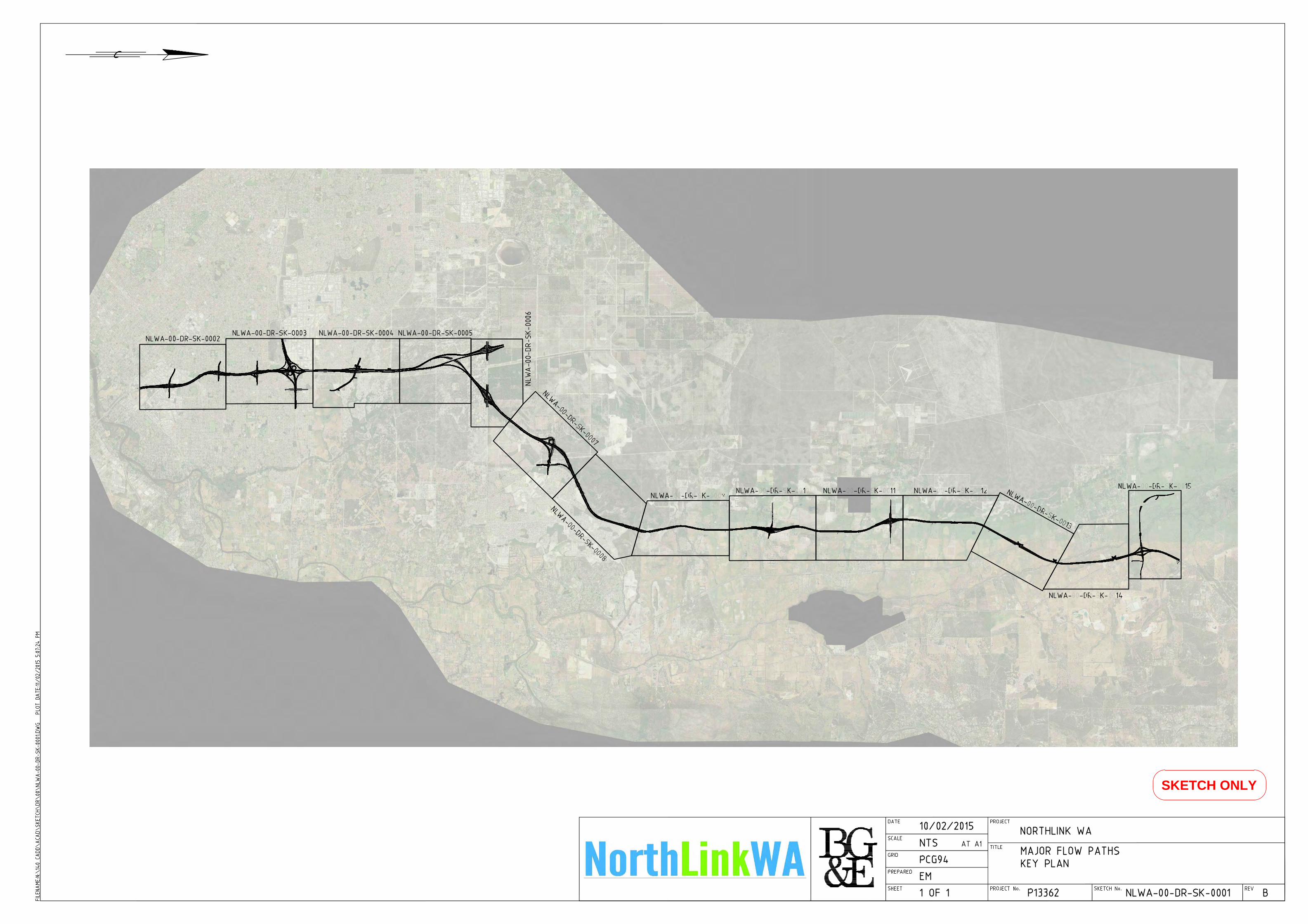
APPENDIX A
Major Event Flow Paths
SKETCH ONLY
SKETCH ONLY