Embed Size (px)
Citation preview

Auckland Transport consulted on the proposed Northcote Safe Cycle Route between Monday 28 July and Friday 29 August 2014
i
Public Feedback and Decisions Report
Proposed Northcote Safe Cycle Route

Auckland Transport consulted on the proposed Northcote Safe Cycle Route between Monday 28 July and Friday 29 August 2014
ii
Table of Contents 1. Executive Summary...................................................................................................... 1
2. Background .................................................................................................................. 3
2.1 Key facts ................................................................................................................. 3
2.2 Proposed changes .................................................................................................. 3
3. Consultation Activities ................................................................................................. 4
4. Consultation Responses .............................................................................................. 4
5. Summary of Feedback ................................................................................................. 5
5.1 Likes ....................................................................................................................... 5
5.2 Dislikes ................................................................................................................. 11
5.3 Other Comments .................................................................................................. 27
6. Changes to the project design resulting from feedback.......................................... 34
7. Key feedback points, AT responses, changes to project design ............................ 36
Appendix 1: Overview Map ............................................................................................... 55

1
1. Executive Summary
Auckland Transport (AT) consulted on the proposed safe cycle route in the Northcote Area in order to understand the views of the local community and to hear specific suggestions for changes to the proposal.
The consultation period was from 28 July to 29 August 2014. In total 790 feedback responses were received, including one submission from local residents that included a petition containing 1400 signatures.
When asked what they liked about the proposal, one third of participants (32%) said they were positive about the way in which the proposal would make cycling safer for residents (especially the off road part of the route), would markedly improve safety for children cycling to school, and would make sporting venues and parks in the area more accessible by bike.
Other positive aspects mentioned by participants included a feeling that the proposal could encourage active transport and lead to healthier communities and reduced congestion on the roads.
However, there was a significant level of opposition to the proposal, with a number of participants saying they didn’t like anything about it.
By far the most frequently mentioned cause for concern (mentioned by 58% of participants) related to the loss of on-street parking (especially on Queen St), and the impact of this on the local community and businesses in the area. In particular, residents (primarily from Queen St) said a large number of homes don’t have off-street parking and would be unable to create or add this to their heritage properties. People felt that businesses would be negatively affected by customers not being able to park nearby, and/or that elderly and disabled residents, and families with small children would be unable to find a park near their home. Similarly, some raised concerns about a loss of parking in light of plans to intensify housing density and/or thought that the SkyPath project would also require additional parking facilities in the area.
Some felt that this would impact on the local community too greatly to warrant the project (particularly the Queen St section), and/or that their needs were not being given equal weight to that of cyclists.
Other reasons for disliking or opposing the proposal included:
o a perception that the cycle path was not necessary (particularly in Queen Street), as it was already a safe area, and there were not enough cyclists to warrant it
o concerns that it would lead to congestion in the area – particularly due to the loss of the left turning lane from Queen Street onto Onewa Road
o concerns about the safety of the proposed cycle route, particularly around the crossing at Onewa Road junction, the roundabouts at Northcote and Raleigh Roads, and Lake Road. Others also had safety concerns around the potential for pedestrians to share a path with cyclists
o concerns about the research, consultation and communication processes used by AT in developing the proposal – with the sense that more discussion,
2
research and due diligence was needed before the proposal could be considered
o the lack of alternative options to the proposed cycleway put forward, particularly given residents’ concerns. Some made suggestions of their own for alternative routes including Seapath, or an equivalent path next to the motorway, Naturepath, Sulphur Beach, and incorporating Tuff Crater and College Road
o concerns about the cost of the proposed cycleway, particularly given the belief that few would use it or that it was unwarranted
o uncertainty around the SkyPath development, and the potential impacts of SkyPath on the cycle route.
There were a number of detailed and lengthy submissions, excerpts of which have been included in the body of the report below.
As a result of the feedback received on the proposal AT has:
Made 14 changes to the design of the cycle route. One of these changes includes the major redesign of facilities along Queen Street.
Initiated 3 further investigations. One of these investigations covers investigations into several cycle routes suggested by respondents.
Initiated 1 further action. This is an education campaign for residents prior to the cycle route being open for public use.
A list of the changes to the project design resulting from feedback is provided in Section 6. The key points made through the feedback process, AT’s response to those points and any resulting changes to the project are outlined in Section 7.

3
2. Background In order to improve the safety of pedestrians and cyclists and to implement this section of the Auckland Cycle Network, AT is proposing the Northcote safe cycle route. This route is 5.2 kilometres of proposed walking and cycling improvements along Northcote Road, Lake Road and Queen Street from Taharoto Road/Northcote Road Intersection (near Smales Farm) to Northcote Point Ferry Terminal.
2.1 Key facts
There are four sections to the proposed safe cycle route – Northcote Road, Lake Road (two section on Lake Road) and Queen Street – see the overview map in Appendix 1, or go to www.at.govt.nz/northcotecycleroute for detailed maps of the final route and the route that was proposed during the public feedback period.
On-street parking is being removed in some locations to accommodate the proposed cycling facilities.
2.2 Proposed changes
The proposed improvements are required to improve the safety of pedestrians and cyclists and to implement this section of the Auckland Cycle Network. Some of the key changes that were proposed include:
An off-road shared walking and cycling path on either side of Northcote Road from the Taharoto Road/Northcote Road intersection to the Northcote Road/Ocean View Road/Lake Road intersection
Improvements to walking and cycling facilities at the Northcote Road/Ocean View Road/Lake Road roundabout
An on-road cycle lane on either side of Lake Road and an off-road shared walking and cycling path on the eastern side of Lake Road from the Northcote Road/Ocean View Road/Lake Road intersection to Exmouth Road/Raleigh Road/Lake Road intersection.
Improvements to walking and cycling facilities at the Exmouth Road/Raleigh Road/Lake Road roundabout
An on-road cycle lane on the western side of Lake Road and an off-road shared walking and cycling path on the eastern side of Lake Road from the Exmouth Road/Raleigh Road/Lake Road intersection to the Lake Road/Onewa Road intersection
Improvements to walking and cycling facilities at the Lake Road/Onewa Road/Queen Street intersection
An on-road cycle lane on either side of Queen Street from the Onewa Road/Queen Street intersection to the entry to the Northcote Point Ferry Terminal

4
3. Consultation Activities The consultation period ran from Monday 28 July to Friday 29 August 2014, although submissions were accepted until early September. Activities to raise awareness of the consultation included:
A letter drop and freepost feedback form was sent to over 6,000 residents, property owners and other interested parties.
Two newspaper advertisements in the Northshore Times.
Media release.
An article about the project in the OurAuckland publication, which is delivered to all households in Auckland.
An article about the project was sent to local schools for inclusion in their school newsletter.
Information about the project was distributed at AUT University and to parents during pick-up time at Northcote Intermediate.
A project webpage www.at.govt.nz/northcotecycleroute and online feedback form
Two drop-in sessions for the public were held at Northcote Library and one at Onepoto Primary School. AT staff were on hand to discuss the proposed cycle route and answer questions.
4. Consultation Responses Auckland Transport received 790 feedback responses on the proposed changes - 554 online feedback forms and 236 hard copy submissions, letters and emails. One response from the local community included a petition containing 1400 signatures (this has been counted as one submission, but has been noted in the report in relevant sections). The project feedback form included three questions:
1. What aspects of the proposal do you like, and why? 2. What aspects of the proposal do you not like, and why? 3. Do you have any other comments on the proposal?
Comments from each of these questions are reported below. Comments from the letters, emails and other correspondence (those not using the feedback forms) have been included in the relevant sections – i.e. under likes, dislikes and other comments, as appropriate.

5
5. Summary of Feedback
5.1 Likes
Base: 663 responses. Multiple responses were allowed, responses add to over 100%
16%
7%
0%
1%
1%
2%
2%
4%
8%
10%
12%
14%
16%
32%
32%
0% 10% 20% 30% 40%
No comment
Other
Retention of parking from Onewa to lights atStafford
On road cycle routes - faster for commuters
Would like other areas included in plan
Like the idea only if no negative effect onbusiness/residents
Cost related concerns
Priority of cyclists over on street parking/cars
Like separate (dedicated) cycle lanes/buffered bike lanes/ path on both sides of rd
Step towards full cycling grid/link to existingroutes/skypath (harbour bridge walkway/
cycleway)
Proposal will reduce traffic/potential to reducetraffic/link to transport hubs
Generally encourages activetransport/healthier communities/livable city/
includes people with disabilities
Everything/like proposal/generally positive
Improved cycling facilities makes cycling safer/especially off rd / safer for children getting to
school/sporting venues/AUT
Nothing/not necessary/negatively affectsresidents/loss of parking/poorly concieved/will
create congestion
What aspects of the proposal do you like, and why?

6
When asked what they liked about the proposed safe cycle route, there was an even split (32%) between those who said they didn’t like anything about the plan, and those who saw the cycle route as improving safety for cyclists in the area. Some participants were also generally positive about the plan, liked the fact that it encouraged active transport, and thought it would contribute to a reduction in traffic congestion. As per the chart above, a third of participants were positive about the way in which the proposal would make cycling safer for residents (especially the off road part of the route), would markedly improve safety for children cycling to school, and would make sporting venues and parks in the area more accessible by bike. The comments below illustrate typical responses on this topic:
“I love the initiative; it is something that we desperately need and I totally support. I like cycling and want to do more of it in a safe environment. As you probably know, we need more biking routes on the North shore as many of us use this type of transport on a regular basis (not only for fun), but children also biked to school and work regularly.” “The cycleway will promote and encourage more people to choose cycling/walking as a safe alternative to cars. - The cycleway provides more pedestrian crossings for our walk to school (Duxeberry Ave to Northcote Primary). - Hopefully more children will use cycling as a safe and viable measure of travel to and from school.” “Thrilled to see our city embrace more healthy means of transport i.e. cycling, and very keen to be able to do this with our young family in our own neighbourhood. Currently safety is of real concern to family friendly cycling. Also pleased to see the plan working in conjunction with the proposed SkyPath to open up a real network of safe cycling on the North Shore.” “I like the idea of a safer area for people to cycle on around Northcote. There are a great deal of schools and sporting venues in the area and I think the people using these would benefit from being able to feel safe biking.” “As a local cyclist and runner, I support all aspects of this improvement as provides safer and better defined non-motorised areas. I also support the SkyPath initiative.” “I like the idea of having shared walk/bike paths. This would help the numerous school children get to and from school a lot more safely than they currently do.”
However, there were an equal number of submitters (32%) who were generally negative about the cycle route and said there was nothing they liked, as they felt the proposal was unnecessary, (particularly the Queen St section), that it would negatively affect residents in the area, severely reduce parking, add to congestion, and/or that it was poorly conceived (see detail in section 5.2 below):
“For Queen Street- none. But I don't think any of the other proposal streets are better off.” “I cannot see any positive aspects of the proposal only adverse and negative effects on the whole area if the planned cycle path from Northcote point right through to Smales Farm goes ahead.”

7
“I do not like the proposal as it is totally unnecessary. The whole idea is a waste of time and money, not to mention the upheaval caused to all forms of traffic during the implementation of the "plan".” “Please undertake more research on how parking in this area is utilised: -many school children and elderly people use the cinema and rely on close parking - they will be marginalised by the cycle lane. Safety issues-more research needs to be done by Council.” “Nothing. Stop ruining the environment, useability and homes of residents so non-residents can enjoy the SkyPath plaything. Be honest -this is totally about sucking up to SkyPath which is going to ruin the living spaces of residents.” “The idea of a cycle/work lane across the bridge is fantastic. However a cycle lane in Lake Rd is ridiculous for this over congested road. I have to drive my daughter to school and we spend 20 minutes every day in heavy traffic on Lake Rd - thus a cycle lane would further exacerbate the problem.”
Conversely, 16% of those who commented said they liked everything about the proposal or were generally positive about the initiative to improve and encourage cycling in the area: “All of it. It's great.” “Making area cycle friendly.” “I'm all for encouraging cycling so I support the proposal.”
“It improves cycling and walking, and will help everyone in the community. Kids, families, older people, all cultures, will benefit.” “The concept of giving bikes a chance.” “I agree with the overall objective of improving cyclist/pedestrian access.”
Some thought the cycle route would encourage active transport, healthier communities, better lifestyles, and a more liveable city:
“Cycling is to be encouraged as a more healthy transport option where it is practical for both the individual, and for the community in which it is being encouraged. Shared walkways are a good example of where this has minimal impact on pedestrians, cyclists, parkers and traffic. It would be useful for families to utilise in weekends a safe environment to take children on bikes around the area.” “I like the whole concept of a proposed cycle way, as such. I do think it will impact on the local community because of the increase in volume of cyclists within the area. I like the whole concept of not burning fossil fuels to transport people from one point to the next. I like the idea of improving the Health and well-being of people engaging in cycling. I like the idea of lessening fumes and congestion on our already busy roads. The council talks about wanting to be the world's most live able city, so here is their chance to achieve that goal.” “The provision of a safe cycle route along this corridor will be a great improvement to the area for existing cyclists and will enable and encourage more people to cycle for non-recreational purposes. The proposal route appears to be high quality for most of its length. The fact that it uses a well-known route that includes shopping centres

8
makes it particularly useful. I like the use of off-road lanes where space permits and novel use of parking protected cycle lanes.” “I strongly believe that any improvements made to establishing/improving cycle/pedestrian access and safety are fundamental to addressing/promoting issues around having safe and healthy lifestyles.” “1. XXXX is supportive of the majority of the proposed improvements and project details as laid out on the consultation website. 2. The proposed route, as part of the Auckland Cycle Network, signals a commitment to providing active transport options. 3. The provision of active transport options contributes to Auckland Plan targets which place strong emphasis on increasing levels of physical activity. 4. As well as contributing to a lack of physical exercise, car usage is linked to many other problems within the Auckland region including obesity, cardio-respiratory disease from air pollution, climate change and health inequalities. 5. Evidence suggests that active transportation and changes in urban design that lead to changes in how people commute are an effective way of combating obesity in developed countries. 6. One recent study found that people who live near a cycle path are more likely to do more exercise overall and that the increase in walking and cycling that came about as a result of proximity to a cycle path was not offset by a reduction in other physical activity. These findings support the case for changing the environment to promote physical activity by making walking and cycling safer and more convenient. 7. Due to the health impacts of excessive vehicle dependency in the Auckland region, ARPHS advocates for a phased approach be undertaken to actively reduce vehicle dependency. The proposed route would contribute to such an approach.”
Others thought the proposal could lead to a reduction in traffic, especially school traffic, and saw it as particularly effective when linked to transport networks such as the ferry or bus.
“I live in Birkenhead point and work at Smales Farm, I currently drive and add to the congestion, one thing putting me off cycling is the risk of getting hit by a car in busy road conditions. If this cycle way was in place I would happily commute on my bike as I did so when I lived in Orakei. I also support the harbour bridge cycleway and I'm pleased to see any incremental work towards this.” “Having cycle routes that end up at public transport stations makes a lot of sense. There is a lot of congestion around the Northcote Onewa road intersection and by ensuring safety around these areas will hopefully allow for more people to cycle to the ferry or the bus.” “I love the fact that AT is promoting cycling and making it safer to cycle around Auckland! I like the way you are trying to link the big transport hubs (ferry terminal/bus station) together.” “All of it as I enjoy cycling and believe the cyclepath will encourage more people to cycle. More people cycling means less emissions, less traffic, health benefits and ultimately more cyclepaths. I think it is an excellent idea to remove off street parking as this is a public good, not for a few residents to park outside their house. Also this will be a great connection to my house and the rest of Northcote when the SkyPath is built.” “The route encompasses both directions for a good distance and rather than being a 'cycle lane to nowhere' as has happened in the past, it is a thoroughly professional and carefully planned way to link a large captive area with the wider Auckland area by carrying to and from the ferry terminal and hopefully soon to be SkyPath.”

9
“A fantastic idea. Auckland has to implement as many of these projects as possible to promote safe, efficient, and ultimately enjoyable cycling. Auckland must start to move out of its 'car is king' mentality and get people out on safe cycle ways. This is environmentally friendly, promotes health and wellbeing and gets people sharing the roadways in a safe environment...which ultimately means more people will use it. This is a must. The more the better. “
Some saw the Northcote Safe Cycle Route as part of a wider network of cycle paths and the first step towards a full cycling grid across Auckland, linking with the SkyPath to cross the bridge:
“The connectivity of the route, and the fact that it will be dedicated infrastructure. I have a friend who lives up Chivalry Rd, so having this route in place will mean that it'll be easier to get to his place by bicycle - taking the ferry over, then up towards Northcote Rd, then up Sunnybrae Rd towards Chilvary Rd. Having infrastructure such as this will enable me to have some safety along half of my route.” “The fact that this will give people cycling from the city to the north shore a safe route to ride on. There needs to be cycle lanes like this all over the Auckland region so having one such as this will be a good start and proof to that cycle lanes such as these are the way of the future. I am in favour of all aspects of this proposal, if it was not to happen this would be a massive step backwards for alternative transport and the promotion of healthy lifestyles. New Zealand and in particular Auckland are too reliant on cars for transport, this cycle lane will go a long way to changing this.” “I love that we will finally be able to cross the bridge either by foot or by bicycle. A connected city at last!” “I really like the new proposal, as it is a start to improving the network of safe cycleways around the North Shore. I cycle to work most days and would use part of section 2 and 3, I know cycling is dangerous and dedicated cycle lanes make it considerably safer.” “Forward thinking on linking the North Shore to the Bridge.” “I support the proposed cycle route. It is essential that cycling facilities on the Shore are significantly improved, both for utility and recreational cycling, so that cycling becomes a real option for more people. I cycle regularly, as a means of transport not just for recreation, but this is in spite of, not because of, the on-road facilities for cyclists. Talking to many people, I'm confident that cycling numbers are low at present due primarily to concerns over safety, and the lack of on-road facilities. My understanding is that there are no on-road cycle paths in the Kaipatiki local board area (except for the upgraded section of Glenfield Road). The proposed cycle route begins to address this major problem, and links well with the proposed SkyPath.”
Others commented on particular aspects of the proposed cycleway, saying their preference is for separate (dedicated) cycle lanes or that they liked the buffered bike lanes and the provision for a path on both sides of the road:
“Plans for separated cycle/pedestrian lanes (where these are indicated i.e. keeping cycles and pedestrians apart). Good to be encouraging cycling into traffic solutions for North Shore.”

10
“I am delighted that Auckland Transport is taking practical steps to improve cycling safety on the North Shore through the provision of high quality cycling infrastructure. I particularly like that AT has gone beyond the typical painted bike lanes as the proposed design includes Copenhagen style bike lanes and buffered bike lanes. These types of bike lanes provide more separation from general traffic than just a painted white line which is especially important for inexperienced cyclists. I fully support the removal of on-street parking spaces along one side of Queen Street as part of this project as I feel that the storage of cars should not come before the safety of other road users. Under any realistic budget widening the road corridor via buying up properties to provide space for cycle lanes is not a feasible option. Therefore reallocating the existing road space to cyclists at the expense of parking spaces is the best way to significantly improve cycle safety without being prohibitively expensive from rate payers.” “1. The attempt to separate cyclists and vehicular traffic. 2. The Northcote Rd from Taharoto to Lake is well planned. 3. Raised cycle way separating traffic and cyclists.” “I strongly support separated cycle ways, and the removal of parking where it is taking space that is required for separated cycle ways, and/or where it may threaten the safe use of those cycle ways (in terms of pulling in, door opening, etc.).” “The proposal looks to be a massive improvement to an area that is in need of some alternative transport options. I’m a much bigger fan of dedicated cycle lanes & paths than shared paths, but I realise that many people will find it safer cycling on a shared path, away from traffic. I like that this project largely uses both off-road and on-road options. The connection down to Northcote looks like it will well with the SkyPath project and lead to a similar situation that Sydney enjoys with its harbour bridge. I'm a big fan of separated cycling lanes that protect cyclists, promote it as a form of transport and ensure that it is safe. I like that there is a path on both sides of the road, I always end up on the wrong side of the road from the cycle path with difficulty getting to them without becoming a pedestrian.”
A few had cost related concerns, or wanted to express their approval for the plan, but wouldn’t like it to go ahead at the expense of local businesses and residents, while some said they agreed with prioritising cyclists over parked cars:
“There are no likeable aspects of the proposal. It is a poor waste of ratepayers’ funds. These funds should be spent elsewhere or applied as rate reductions.” “Cycling is a great form of transport and Auckland needs to meet the needs of cyclists. Tokyo and Amsterdam are cities that work because people are out of their cars and on their bikes. But there must be some middle ground where cyclists can be accommodated without effecting off street parking.” “I like the addition of new cycle ways on important roadways. I think it is very very important that cycle infrastructure takes precedence over on street parking.”

11
5.2 Dislikes
Base: 677 responses. Multiple responses were allowed, responses add to over 100%
7%
6%
6%
7%
9%
10%
11%
11%
16%
17%
21%
25%
33%
33%
58%
0% 20% 40% 60% 80%
None/project should proceed
Other
Needs better public transport/links tohubs/Northcote ferry unreliable-not bike friendly
Safety concerns - cycleway on rd/create abarrier/off rd all the way/separate from
cars/dangerous for children
Safety concerns - shared path/ cyclists &pedestrians incompatible/especiallychildren/Northcote Rd/widen path
No regard for heritage area/character Queen St
Need to wait for Skypath approval/ includeSkypath in planning/unsure of impact
Concerns about cost/costs unjustified
Lack of alternatives considered/suggestalternatives/additional routes: Seapath/Tuff
Crater/Sulphur Beach/link to College Rd
Lack of consultation/communication/poorplanning/research/ work with locals
Safety concerns with cycleway generally/route -Onewa Rd junction/roundabouts Northcote &
Raleigh Rds, Lake Rd/crossings/busy rds
Loss of turning lane will increase congestion /especially Queen St
Not necessary/ especially Queen St/alreadysafe/both sides of rd/not the number of cyclists/
can share footpath
Negative impact on local community toogreat/especially Queen St/ generally disagree
Loss of parking/especially Queen St/negativelyaffects businesses/Lake Rd school
parking/elderly/ commuters
What aspects of the proposal do you not like, and why?

12
When asked what they disliked about the proposal, many participants (58%) were opposed to a loss of parking (especially on Queen St), said the proposal would negatively impact the local community, that it wasn’t necessary (not enough cyclists to warrant it) and/or that it would lead to congestion in the area. As there were a number of extended and detailed submissions on these themes, they are outlined below under separate headings. Parking: The most strongly opposed aspect of the proposal (mentioned by 58% of participants) was the potential loss of on-street parking. In particular, residents (primarily from Queen St) said a large number of homes don’t have off-street parking and would be unable to create or add this to their heritage properties. People felt that businesses would be negatively affected by customers not being able to park nearby, as would elderly and disabled residents, families with small children and shift workers coming home late at night and being unable to find a park (this raised additional concerns about safety, mentioned below). Similarly, some raised concerns about a loss of parking in light of plans to intensify housing density and/or thought that the SkyPath project would also require additional parking facilities. Lake Road was also mentioned as an area that would be affected by a loss of parking, especially outside Northcote Primary. The comments below illustrate typical responses on this topic:
“We are AGAINST the Cycle lanes on Queen Street. We object to the removal of parking from Queen St as; It is unnecessary to remove parking to provide cycle paths on Queen St (safety Stats we have seen do not demonstrate a safety issue across this section of road). This road is already sufficiently wide and safe for cyclists, so we feel this is a pointless investment given lack of benefits. Concerned that removal of parking will impact key facilities and services in Northcote Point such as, the Bridgeway Theatre, the Engine Room, as well as impacting residential parking.”
“XXX Queen St has no off-Street parking it already has broken yellow lines outside the front which does hinder the dropping off of the very elderly members for club functions this means it is already difficult for tradesmen even the lawn mower man – further reduction of parking would make the situation virtually impossible. Over recent times parking has become a major issue, with the lack of on street parking in Queen Street already a deterrent to some wishing to use the house, especially on weekends. The extra Cinema at the Bridgeway, and more recently the increased demand for parking by the expanded Engine Room has impacted on us considerably; any further reduction in on-street parking on Queen will simply mean that Northcote Point Senior Citizens and its iconic community house will not survive.” Northcote Point Senior Citizens Association
“I am not in agreement with the removal of parking along Lake Road and putting in a dedicated cycle lane on the existing road. Both the businesses and residents require on road parking and it is not reasonable to remove the parking in favour of one minority group. Auckland Transport has an obligation to provide a balanced solution to all the ratepayers and road users. The proposal removing car parks puts too much favour on a minority set of users and penalises a significant set of other citizens who also have requirements for parking and safe passage along Lake Road. How far will they need to park away from their homes and walk back to their property? What if they have items to carry or deliver? What if they have more than one trip required to bring items from their vehicles? What about their safety and security? Street lighting is poor in the side streets. What about the disturbance to the property owners in the

13
side streets...vehicle movements not associated with their residency; doors shutting, voices and so on.” “Apart from the concept I don't like anything about it. There has been little to no research done as to the effect on the local Northcote point community. It is 100% unacceptable to even consider removing the number of car parks you have proposed. The wider reaching implications have scarcely been given a thought in your 'safe' cycle way route. As discussed at the public meetings there are far better ways of implementing a cycle path than to remove a whole street’s parking, local businesses’ clients and a left turning clearway all for the benefit of 2-10 cyclists a week!” “This project is being progressed independently of SkyPath, which is yet to receive a resource consent. Even if a resource consent is obtained, it is not clear what the final design at the northern landing will be. Auckland Transport officials have told me that the Cycle Route is completely independent of any decision on SkyPath. That seems illogical, especially since SkyPath will be underwritten by the Auckland Council; furthermore SkyPath's business plan outlines the need for more parking, while of course the Cycle Route will remove most of the Queen St Parking. Add to this the fact that a number of local businesses gained consent to expand on the basis of a parking plan that would now be compromised. This leaves the overriding impression that there is no overall strategic coordination on the part of AT and Auckland City Council regarding the issues of SkyPath, the Cycle Route and a parking plan for Queen St and the surrounding streets.” “An on-road cycle lane on either side of Queen Street from the Onewa Road/Queen Street intersection to the entry to the Northcote Point Ferry Terminal: 1. The section of Queen Street from Bellvue Rd up to Onewa Road, west side, already has no parking. Therefore vehicles park on the east side of Queen Street in this section. Cyclists coming from Lake Road could be brought to the west side of Queen Street that already has no parking in its upper section and use a cycle lane there or the wide footpath in this area. 2. Visitors need somewhere to park. I would not like to see parking removed from the east side of Queen Street given there is none in this section on the west. Faulkner Street nearby has parking both sides but this road is narrow and parked vehicles tend to block this street making access difficult. This will become worse if Queen Street has no parking either side in its upper section. 3. The footpath is wide on both sides of Queen Street. There is scope to have a cycle lane on the footpath and I would encourage this ahead of removing parking provision on both sides for its full length. 4. Visitors to the dairy use both sides of the road to park while they make their purchases. Preventing parking would unfairly and adversely affect that business. 5 I am a cyclist and regularly cycle down to Northcote Point ferry terminal and back. Once I have passed the Rodney Road /Stafford Road intersections there is little traffic and I feel safe cycling on Queen Street. Furthermore this road is wide so there is scope to be out from parked cars and to not hold up any cars that may be using this section of road. From Stafford Road south the road is not used as a drag strip (and if it was judder bars could address that), it serves a relatively small population and I understand has no record of cycle accidents. A cycle lane in this section is therefore not warranted. 6. I request that existing provisions remain for this section of Queen Street to the wharf. Alternatively, given the wide footpaths, designate a cycle route and direction, either side of the road in the footpath for this section (north on west side and south on east side) and keep the existing parking both sides.

14
7. Given the limited opportunities for cyclists in the city and good bus options to the City, it is unlikely that many cyclists would use this. 8. Any cycle provision for Northcote Point should use the existing and wide footpaths and not compromise the existing street parking provisions. (Many dwellings along Queen Street have limited parking opportunities for visitors).” “1. I totally oppose removal of any of the parking on Queen St. Many people do not have off street parking, and large numbers of people come into the area to visit the Bridgeway Cinema, Northcote Tavern, Tongan Church and a range of businesses. Removal of parking will have a very negative effect on quality of life for residents, and will also affect the viability of local businesses. 2. Removal of parking outside Northcote Primary will make life very difficult for parents dropping children at the school. 3. The council is extremely strapped for cash, and there is limited public demand for a cycle route. I don't believe that this cycle route represents good use of public money. 4. Queen St is a safe road and there is no need for this cycle route down Queen St.” “1. Reduction in resident on street parking. I understand the clause that says on street parking is a lower priority however surely this only applies when street residents all have their own off street parking. Because of the age of this area many houses do not have off street parking. How is it increasing pedestrian safety by making elderly or those with children walk a long way to get to their house? It does not seem right to take away an aged person’s ability to carry their groceries into their house for example. It will also result in more pedestrians in the area, not because of the new SkyPath etc. but simply because of everyone walking to their homes. 2. Reduction in on street parking for local businesses. The parking is already a challenge for the theatre and restaurant, this will get completely unmanageable and I can only see that the theatre would close which is a tragic loss. The small businesses near Stafford road would also close as much of their trade comes from people passing in cars. These small businesses work just fine in places like Spain but in these places the population density is so much higher to support them. At the very least, could on street parking be allowed at sometimes of the day to support these businesses which are an important part of the community.”
Negative impact on the community, especially Queen St: Approximately one third (33%) of participants felt the cycle way would impact on the local community too greatly (particularly the Queen St section), that their needs were not being given equal weight to that of cyclists, or that the plan simply wasn’t feasible. A lot of these participants’ concerns related to the potential loss of parking and the impacts this would cause, as above, but they also talked about the wider impacts this would have to the community and general community wellbeing:
“We want our heritage area to stay the same. A pleasant road that is already safe to walk, cycle and drive with parking for all. There is no argument against the desire for safe cycle provisions or improved connectivity between different parts of the city. There is however, a strong agreement against introducing change to an area which destroys the very thing Auckland Transport is advocating for - safety for members of the community, physical, economic, social and cultural connectivity as well as environmental.”
“1. The removal of 1/3 of on street parking in Northcote Point will have a catastrophic impact on local business and massively inconvenience residents. 2. Property values will decrease as a consequence. 3. Even with a cycle path there will be a huge danger to cyclists from motorists exiting properties along the street. 4. Danger to

15
children going to school from cyclists. 5. 24/7 loss of parking when there will be minimal use of cycle path for extended periods.” “As a Northcote Point resident I have concerns that this proposal will have huge implications on parking availability. Not only for residents but also for the visitors to the area, in particular the restaurants, theatre and Northcote Tavern. This area of hospitality has developed considerably for the area and is rather unique. I believe this proposal will have severe impacts on our community.” “I do not agree with the design solutions that have been developed for the Queen Street section of the cycleway and ask for serious consideration to the investigation of alternative solutions. Given the particular dynamics of this stretch of roading.” “Cycle paths are a great idea on roads, which have the capacity to accommodate such a project. It is my opinion that Queen Street does not fall into that category. The resulting lack of parking spaces is going to interfere with residents' lifestyles on a daily basis and will threaten the survival of much liked and well established businesses and community venues (for example the Bridgeway and the Senior Citizen Club). Ultimately this is going to destroy the community cohesion, rather than adding to the existing quality of lifestyle.” “I feel that consideration has not been thought through for the people who live there nor for the people who frequently visit the area. Where will we park? Consideration to visitors, the elderly and disabled needs to be addressed. If there are no customers, businesses will go, there will be no need to have car parks and this very special area will lose its character and uniqueness. This is not progress – It is selfishness.”
Not necessary/already safe/cyclists can use footpath: Another third (33%) of participants said the cycle path was not necessary (particularly in Queen Street), as it was already a safe area, infrequently used by cyclists, with a fairly wide footpath - and therefore the changes weren’t warranted:
“The need for a dual cycleway for the Queen St leg of the proportions envisaged appears to be “overkill" given the roadway and footpath dimensions and the amount of foot and vehicle traffic. Advice at the Drop-In indicated that current cyclist usage to and from the ferry may be 2 cyclists per ferry trip. Cycle-enthusiast blogs indicate a possible current usage of 5-7 cyclists per day. It may be that a study of current demand suggests a single cycleway initially and additional cycleway upon increasing demand and funds. It may also show that pedestrians and cyclists may co-exist on the existing footpath with suitable advisory markings. Is AT intending to obtain cyclist/pedestrian data as a tool to assess cycleway capacity requirements?”
“Imposition of priority to pedestrians and cyclists over the amenity of local residents. Use of ratepayer's money on a project servicing an unproven need. It is likely that the impetuous for this project is from special interest groups "pushing their own barrow" and has not been based on robust investigation determining actual need. Auckland Transport has already shown that they have a propensity to waste ratepayer's money on cycle based projects that had inept research and eventuated in pathetic use - the cycle parking facility at Birkenhead wharf.” “It seems strange to switch between a separated cycle lane and a lane marked on the road, on Lake Road. Surely it should be one or the other. The provision of cycle lanes around the Onewa Road/Lake Road/Queen St intersection needs improving. Perhaps the cyclists need advance green lights as well as advance lanes? I don't see

16
any real benefit to putting cycle lanes on Queen St. This is already a fairly quiet and easily cyclable residential street. Save the money and avoid upsetting the residents.” “My response relates only to the Northcote Point/ Queen St. section of the proposal. The cycleway, especially the Queen Street section, is unnecessary. Proposed improvements are required to improve safety of pedestrians and cyclists. According to AT stats there have been zero accidents involving cyclists on Queen St. in the last 5 years. No data has been provided with the proposal to support the necessity of a cycleway. There is no detail around the current or predicted usage. Queen St. is not an arterial route. Removal of parking will cause unnecessary hardship for many Queen St. residents, many of whom don't have off street parking. Residents of surrounding streets will also be affected by the removal of parking, as there will be increased demand for parking in the adjacent streets. There are no obvious improvements to pedestrian safety, particularly on the Queen St. section. Putting pedestrians and cyclists on shared footpaths makes safety worse! The removal of the refuge at the corner of Rodney Rd. Queen St. intersection will make it less safe for pedestrians. The proposal also intends to "improve walking and cycling facilities for school children, which should improve their safety." There are no obvious improvements to the safety of school children especially those on foot. Putting both together on the same path, such as the section between Bellvue Ave and Stafford Road, decreases their safety.” “What figures does AT have for school ch ildren's bike use, if any over the Queen St. area? Earlier surveys did not include Northcote Primary or Northcote College for cycles on site, presumably because there weren't any.”
Congestion, especially that caused by loss of left turning lane: A quarter of people thought the proposed cycle route would contribute to additional congestion, particularly in Queen Street, with the loss of the left hand turning lane out of Queen Street and on to Onewa Road:
“Losing Queen Street double lane to a cycle and bus way will have a major impact on morning congestion and the time it takes to get to work. Currently traffic congestion in Queen Street is already terrible in the mornings with commuters turning right into Onewa Road to get into the city via the motorway. The only good thing is that currently the left hand lane is free for those who travel north or need to drop children at school, with the double-lane and left hand turn onto Queen Street. Removing this will literally clog traffic up past our door. What is wrong with cyclists using the road as they currently do? This is already an area that needs attention given to the traffic congestion - please don't go and make it worse instead of improving it!!” “My sons take the only bus to Westlake that needs to go up Queen St in peak hour (8am) northbound and with clearway at moment only takes 3 minutes. With one lane this could take 20-25 minutes. I also work at Northcote Primary and would take 20 minutes to get up to Onewa Rd. We still need clearway and two lanes northbound otherwise getting to school and work we and everyone else who needs to travel in peak will be affected. Please go back and review and consider putting a two way cycle lane southbound on Queen St.” “Numerous problems with plan, an off-road shared walking and cycling path is a better design solution. Issues not addressed: morning rush hour queues out of Queen St; parking requirements for local businesses and community facilities; high use of on-street parking; resident reliance on street parking.”

17
“Queen Street at the moment is very congested morning and evening. The proposal to narrow the road to install a cycle way on the eastern side would increase an already unacceptable level of waiting times to exit both left and right into Onewa Road. Many business in the Northcote Point area will be severely affected by eliminating parking areas. Many homes do not have off street parking, where are they to park? Queen Street is a dead end road so why will cyclists be travelling en masse along a dead end road? Queen Street already is, statistically, a safe road for cyclists. I have seen very few cyclists on Queen Street so why is this project even being considered on a dead end road?”
Safety concerns generally: A number of people (21%) had concerns about the safety aspects of the proposed cycle route. This included concerns around the crossing at Onewa Road junction (which was seen as dangerous already), the roundabouts at Northcote and Raleigh Roads, Lake Road, dangers from cars backing out onto the cycle path and apparent gaps in the cycle path:
“The 2 roundabouts are currently inadequate for traffic speeds through the Exmouth/Raleigh/Lake roundabout [and they] are dangerous. The roundabout probably needs a re-design to slow traffic down. It might then be safe for cyclists.”
“The intersection with Taharoto Road needs to be considered carefully - the cycle path ends quite abruptly at this point. Cycle facilities on Taharoto Road are rudimentary and do not feel safe given high traffic volumes on the road. Does AT have a plan for completing the network on this end - e.g. by joining up the hospital and Takapuna town centre? While the design of the facility seems generally good, there are some apparent gaps in cycle lanes - e.g. on the north side of the road in Maps 3A and 3B - that may cause safety issues.” “The junctions are dangerous for cyclists at rush hour and will inhibit traffic flow. Onewa Road Junction: - Onewa road is the most deadly part of the whole route and no assistance at all is given, whilst cyclists will be expected to change lanes in a short space on a busy, fast, narrow road. This is an accident waiting to happen. A possible safety improvement would be to add a right turn bike lane and/or an extra sequence to the lights – however the sequence is already at breaking point during the rush hour. Coming from Queen Street to turn right onto Onewa between about 0730 and 0830 takes about 20 minutes of staring at a traffic light. Also, there is no room for this. In my opinion the only workable solution is a two-way bike bridge across Onewa Road, with 2-way bike paths up one side of both Queen Street and Lake Road, and a toucan crossing a few tens of metres from the junction to get cyclists back onto the correct side. Lake Road Roundabout - The Lake Road roundabout will have 4 zebras on it. If these are used they will clog up the roundabout badly, and this gets very busy at rush hour – it’s already hard enough to get out sometimes. Because of the angles, many cyclists are likely to give them a miss (as they will look like too much of a detour), putting them in danger on the roundabout. Bikes and roundabouts don’t mix well, since the aim of roundabouts is to maintain a continuous relatively fast flow of traffic, which is at odds with bikes. Due to the business at rush hour, an underpass would seem the best solution (or to go a different way). However, Onewa should be more of a priority for any budget due to the sheer traffic volume and danger faced there. Northcote Road:- The bridge over the motorway looks deadly, with cyclists expected to negotiate the motorway sliproad exits without assistance.”
“The route is the most dangerous and hilly route I can think of. Those intersections are the most dangerous in our area.”

18
“Pinch-‐points that occur throughout the cycle route, such as transition through traffic light areas, are hazardous for cyclists and motorists alike.”
“The impact of the cycle lane creates a narrowing of the vehicle roadway. This is a significant link road in both directions and serves residential properties, schools, businesses and a shopping centre. It is unwise to create a narrow arterial route on a significant road as this makes it dangerous.”
“The section of the route at the Onewa Road-Queen Street-Lake Road intersection is not well designed and is dangerous. Here the separated cycle ways disappear suddenly at the most dangerous and scary point in the route. It would be better to also include shared paths in this section and allow cyclist to use the pedestrian crossing phases of the traffic lights (with any necessary alterations). The cyclist advance boxes and other elements at these intersection can still be included for more confident cyclists but provision needs to be made for the least confident and skilled cyclist to enable them to get through these intersections safety and also to give the confidence that they can get through this section without are going through a stressful experience. A separated cycleway northbound on Lake Road immediately after the Onewa Road-Lake Road intersection (adjacent to Northcote Primary School) is also missing. A shared path should be installed in this section to ensure that separated cycleways are included for the whole length of the route. The Lake Road-Raleigh Road-Exmouth roundabout is also a bit concerning. Visibility is poor at this roundabout and it is not entirely clear how cyclist will be able to navigate this intersection safely.” Onewa Road junction showing converging traffic near proposed cycle crossing:
Lack of consultation/ communication/ planning/ work with locals: Some (17%) felt the level and style of consultation on the project was poor, that the plan was based on insufficient research and planning, lacked a coordinated approach, and showed an inability to work with local residents and bring them on board with the plans. These participants essentially felt that more discussion, research and due diligence was needed before the proposal could be considered:
“While overseas evidence indicates that cycling and walking facilities will increase commerce in built up city areas, we believe the reduction in parking facilities should be introduced progressively and in consultation with the local community – particularly in traditional communities such as Northcote and Birkenhead Point. The Northcote Safe Cycle Route documents we have seen focus almost exclusively on

19
the engineering components of cycle planning – the document should present or reference a comprehensive approach to the role of cycling facilities in the wider context of community needs and aspirations. In addition to engineering, a cycle plan for Kaipatiki should address education, enforcement, encouragement, public health, the environment and ecotourism. The Northcote Safe Cycle Route should be planned in the context of an overall cycle strategy for Northcote; planning should identify the linkages with the proposed cycling and walking routes:
the proposed Seapath/Naturepath from Stafford Park to Akoranga Drive and
the Northcote Greenway from the shopping centre through behind Northcote Intermediate, Onepoto Primary and Hato Petera”
“As we have been advised, the parking availability and demand has been based upon observations on 2 days (1 weekday and 1 Saturday) up until approximately 5 or 7pm. Most regular visitors and local people would suggest that the congestion of traffic and parking occurs from after 5 or 7pm, either in motorists’ search for theatre, restaurant, church, cafe parking or family visors and family members returning home. The current data is not representative of a need which would justify wholesale parking removal. Will AT undertake a parking and traffic assessment which reflects real conditions and impact on the community?” “What is AT's professional definition of 'consultation' when it rules out the key
element of the proposal by saying that it is not part of the 'consultation?'” “The board wishes to note its concerns relating to the consultation process for this project: The board was not briefed on the detail of the proposal prior to the consultation details being finalised. If the board had been briefed, the specific concerns outlined at point 1 in particular above would have been raised at that point. The communications surrounding the consultation were misleading and have led members of the community to see the project as definitely going ahead in its current form. The board has since been assured that this is not the case. The status of the project and the purpose of the consultation should have been clearer to the community from the outset of the consultation process. The board requests that the next design stage is presented to the board prior to being finalised for the board’s review and further feedback.” Kaipatiki Local Board
“I have attended the drop in workshops and a number of public meetings. I am astonished at the lack of due diligence that has been applied to this proposal for these two sections. The planning and consultation appears to be shallow. At the various meetings and drop-ins that I attended, not one AT person made any notes. Is it a foregone outcome? In my discussions with AT, it appears the following have not been undertaken: 1. A Traffic Study 2. An Economic Impact Study 3. A Social Impact Study”
“Normal planning procedures would routinely ensure that prior to deciding to spend $4M in support of any particular facility (SkyPath in this instance) that such facility was likely to proceed, and that such facility should proceed. To do otherwise is contrary to elementary principles of sound planning.” “The high-handed autocracy in AT's attitude to the residents of Northcote. I find it deeply offensive as a resident of over 40 years in Queen Street to be treated like some form or 3rd world peasant. There does not appear to be any co-ordination between this proposal and the development of the future housing areas on Northcote Road and the Special Housing Area in Northcote Central along with the proposed

20
Upgrade of the shopping centre. The superstition that The SkyPath project is a given fact. The Lake Road-Onewa Road - Queen Street intersection is a death trap. Cycle lanes in Queen Street are totally unnecessary. Cycle lanes for half a dozen cyclists a day? A total lack of co-ordination between different Branches of AT in regard to the Stafford Road, Queen Street, Vincent Road, Rodney Road Intersection. The unnecessary removal of parking spaces. Why is there no plan for the last section of road down to the Ferry Terminal? What surprises await us for this section?” “What studies or data back the claim that the proposed improvements are required to improve the safety of pedestrians and cyclists? How many accidents involving pedestrians, cyclists, etc. have there been (and where along the route)? The AT website says that “Auckland Transport is seeking views on a proposed cycle route from Northcote Road to Northcote Point on the North Shore.” However, the posted material says the cycle route is going ahead, and the consultation is only about the design of the cycle route. Why is there no consultation on the cycleway itself?”
Lack of alternatives considered/ suggested alternatives: A further 16% would have liked some alternatives to the proposed cycleway put forward, particularly given residents’ concerns. Some made suggestions of their own for alternative routes including Seapath, or an equivalent path next to the motorway, Naturepath, Sulphur Beach, and incorporating Tuff Crater and College Road. In addition, a set of resolutions outlining alternatives to the Queen St section of the proposal was passed by around 120 people at a meeting at Northcote College on August 25th (the quote directly below):
“That whatever the final design of the cycle route, existing parking on Queen St should be preserved in its entirety. That lowered speed limits should be imposed on Queen St to improve safety. That sharrow markings should be painted on the road in Queen St to warn of the presence of cyclists. That AT should present to residents at a public meeting after they have fully considered submissions and made any alterations to the route design.”
“I do not agree with the design solutions that have been developed for the Queen Street section of the cycleway and ask for serious consideration to the investigation of alternative solutions”. “1. Would have liked to see more imagination in the route from Onewa Domain to Queen St. A route through Onewa Domain and through reserves in the area of Tonnar St and crossing College Road and eventually joining Lake Road near Kawana St or event going as far as the Bridgeway theatre before joining traffic routes, would have provided a much more interesting route making a clear separation between cyclists and motor traffic. And I suspect a shorter route, but clearly cheaper to construct. 2. The drawing of road markings in Queen St is extremely poorly done and exaggerates the amount of curb side parking available as it tends to ignore vehicle crossings to adjacent properties.”
“The Naturepath cycleway under Onewa Road should be prioritised to offer an off road connection as an alternative to the Onewa/Lake/Queen intersection.” “AT has suggested using the main commuter routes for cycle routes when alternative quieter roads would be better for both cyclists and commuters. It suggests that AT is attempting to use cyclists to make it difficult for car drivers to use roads. How many cyclists will be killed to satisfy Auckland Transport? AT has not said what

21
the effect is on the current traffic lanes i.e. will there still be two lanes going North on Queen St? “Can we widen the intersection at the top of Queen Street? The area around Northcote primary is always busy, slightly aggressive at school times and we would be adding more kids on bikes around the area. Perhaps a more direct bike path could direct you through Onepoto domain/ rotary grove. That way the cool bike bridge could be used more?” “I think the 'Safe Cycleway' should extend down College Road (in addition to or instead of Northcote Road), as the current College Road cycleway/pedestrian way is poorly laid out for safety, particularly given there are a large number of students in the area who would opt to bike if it was safer. College Road also provides direct access to Takapuna via an existing cycle-way along Akoaranga Drive. It would be more logical to utilise this roadway for access to Northcote Point or as an alternative.” “It is not necessary to significantly compromise the residential, commercial, cultural and social life of Northcote Point in order make cycling and walking safe and attractive. An inclusive, integrated solution is possible. The Livable City Option: The trees embedded in the footpaths effectively render the spaces between unused. Encroaching on the footpath space by approx. one metre width between the trees would allow for kerbside parking and cycle lanes of the same width as the current proposal. Many lampposts on the eastern side are already on the fence line. In the process of reshaping the footpath the other lampposts could be moved and, to make it really liveable, power lines placed underground.” “I am not convinced about the route choice - I think that an off-road track built along the water’s edge from Esmonde Road to the harbour bridge (to connect with the SkyPath) would get much higher use, as it would be very popular for recreational users at the weekend, and for commuter users during the week. It would also be a more direct route, with less hazards, such as crossing busy Northcote and Onewa Roads. If the existing route is to remain, then overall I think it is about as good as you could expect given the space constraints, but overall I don't think it is ideal, as it does not really provide an ideal solution for everyone - the commuter / serious cyclist has on-road cycle lanes in part, but is mixing it with the traffic in other areas, whilst the recreational cyclist has to cross hundreds of vehicle crossings, side streets, cross busy roads, mix it with pedestrians etc. Also, I am not a fan of the off-road path along Northcote Road being divided by a narrow strip of vegetation between cyclists and peds: the reality is that peds will walk on both paths, so the overall width available for a cyclist and pedestrian to pass each other is halved. Also, the strip of vegetation in the middle will be hard to maintain, and will probably look shabby quite quickly.” “I'd like to see a bike/pedestrian bridge across Tuff Crater (parallet to M/Way) and the route avoid Lake Rd altogether (flatter, shorter, and is off road - safer).”
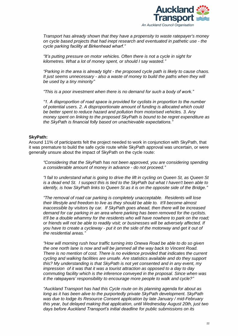
Concerns about costs/costs unjustified: Some were concerned about the cost of the proposed cycleway, particularly given the belief that few would use it or that it was unwarranted (as discussed above):
“Imposition of priority to pedestrians and cyclists over the amenity of local residents. Use of ratepayer's money on a project servicing an unproven need. It is likely that the impetuous for this project is from special interest groups "pushing their own barrow" and has not been based on robust investigation determining actual need. Auckland
22
Transport has already shown that they have a propensity to waste ratepayer's money on cycle based projects that had inept research and eventuated in pathetic use - the cycle parking facility at Birkenhead wharf.” “It’s putting pressure on motor vehicles. Often there is not a cycle in sight for kilometres. What a lot of money spent, or should I say wasted.” “Parking in the area is already tight - the proposed cycle path is likely to cause chaos. It just seems unnecessary - also a waste of money to build the paths when they will be used by a tiny minority” “This is a poor investment when there is no demand for such a body of work.” “1. A disproportion of road space is provided for cyclists in proportion to the number of potential users. 2. A disproportionate amount of funding is allocated which could be better spent to reduce hazard and pollution from motorised vehicles. 3. Any money spent on linking to the proposed SkyPath is bound to be regret expenditure as the SkyPath is financial folly based on unachievable expectations.”
SkyPath: Around 11% of participants felt the project needed to work in conjunction with SkyPath, that it was premature to build the safe cycle route while SkyPath approval was uncertain, or were generally unsure about the impact of SkyPath on the cycle route:
“Considering that the SkyPath has not been approved, you are considering spending a considerable amount of money in advance - do not proceed.” “I fail to understand what is going to drive the lift in cycling on Queen St, as Queen St is a dead end St. I suspect this is tied to the SkyPath but what I haven't been able to identify, is how SkyPath links to Queen St as it is on the opposite side of the Bridge.” “The removal of road car parking is completely unacceptable. Residents will lose their lifestyle and freedom to live as they should be able to. It'll become almost inaccessible by visitors by car. If SkyPath goes ahead, then there will be increased demand for car parking in an area where parking has been removed for the cyclists. It'll be a double whammy for the residents who will have nowhere to park on the road; or friends will not be able to readily visit; or businesses will be adversely affected. If you have to create a cycleway - put it on the side of the motorway and get it out of the residential areas.” “How will morning rush hour traffic turning into Onewa Road be able to do so given the one north lane is now and will be jammed all the way back to Vincent Road. There is no mention of cost. There is no evidence provided that indicates the current cycling and walking facilities are unsafe. Are statistics available and do they support this? My understanding is that SkyPath is not yet consented and in any event, my impression of it was that it was a tourist attraction as opposed to a day to day commuting facility which is the inference conveyed in the proposal. Since when was it the ratepayers’ responsibility to encourage more people to walk and cycle?”
“Auckland Transport has had this Cycle route on its planning agenda for about as long as it has been alive to the purportedly private SkyPath development. SkyPath was due to lodge its Resource Consent application by late January / mid-February this year, but delayed making that application, until Wednesday August 20th, just two days before Auckland Transport’s initial deadline for public submissions on its

23
associated Cycle Path project. It is compelling to conclude that the two actions are part of a closely integrated assault on the Northcote Point neighbourhood. In the view of many, both are Council funded schemes, designed to aid and facilitate publicly funded environmental vandalism. Prior to expending $4M on a cycleway needed only for SkyPath, it is submitted that AT has a responsibility to ensure that the above-referred and enormous crowds can be safely and sensibly accommodated, from a traffic management point of view. No such evidence has been sighted. Please provide it.”
No regard for heritage area: Some thought the cycle route, and particularly the section on Queen Street, demonstrated a lack of regard for the heritage values and character of the area, especially in relation to the lack of off-street parking many heritage homes had:
“Northcote Point’s acknowledged heritage qualities are purportedly protected via Council’s Proposed Auckland Unitary Plan (PAUP). If Council is unable to provide adequate protection to that heritage environment, it will be in breach of its own PAUP. It is hard to see how Council could possibly meet that obligation and certainly, it has done nothing to date to demonstrate how it proposes to. Council’s active and financial support of a proposal that breaches its own PAUP, is likely to further taint its standing as a regulatory and consenting authority and to further underscore its inability to properly undertake its governance responsibilities regarding the planning and sound financial management of infrastructure needed for the city.” “The single-focus Transport Auckland proposal for Queen Street Northcote Point has not been received well. They are treating cycling as good and automobile access to homes, cafes, restaurants, galleries and cinemas as bad. A livable city requires suitable options for both. Queen Street is not a busy street and has the charm of a historic area. While some residents have off-street parking, many like us, do not because our homes were among the many buildings that lined Queen Street in the pre-bridge days. Even those that do have off-street parking need the social benefit of kerbside parking for family /friend visitors. We value the social and cultural amenity the Bridgeway Cinema, Sausalito, The Engine Room, Blikfang Gallery, etc. bring to Northcote Point and believe their commercial viability will be severely compromised if parking is removed from Queen Street. As well as customer parking they, and other small businesses, need to accommodate deliveries. It is not necessary to significantly compromise the residential and commercial life of Northcote Point in order make cycling and walking safe and attractive……What consideration has been given to the impact of this proposal on a heritage area?” “Unnecessary waste of ratepayers’ money. Not enough cycle traffic to warrant it. Not enough traffic to warrant it. Where are home owners without off-street parking going to park? Overflow into neighbouring streets? Loss of left turn lane Queen into Onewa is ridiculous - at peak times right lane already often queues back to Rodney Road and beyond. More bloody signs and road painting in a heritage area - we don't need it.” “Changes Historic charm of Queen St – which is made up of historic shops & homes, and many do not have off-street parking. / / - Removal of left hand clearway on Queen St – which increases morning traffic issues – flow on effect huge into neighbouring streets.”

24
Safety concerns – shared path/ cyclists and pedestrians incompatible: Others had concerns about the safety of the proposed improvements, particularly with regard to pedestrians sharing a path with cyclists (cyclists also found this annoying in terms of slowing their journey). There was a feeling also that the changes provided little benefit to pedestrians generally, and especially to children in the area:
“I think that shared foot and bike paths are not ideal due to potential collisions between pedestrians and cyclists if lanes are not clearly marked and if awareness of shared lanes is low. For cyclists it is also not ideal to have their lane on the pavement as it usually means having to give way to cars on side roads and also being less visible to driver. Additionally, having to go up and down curbs is not ideal either.” “Again, it delivers little, and if anything potentially detracts from pedestrian safety, whilst pouring significant resources towards the cycle lobby and their hobby. Given the schools and recreational facilities along the route, the focus should be on delivering meaningful and measurable improvements for these facilities, and given that mostly access to these would be via walking, that is what should be targeted. This is especially the case given that these predominately young pedestrians are likely to be the ones who struggle with issues surrounding risk-taking and safety around roads. Example, Northcote Primary does not have a 'School Zone' 40 Km/Hr zone, nor suitable 'School Patrol' signs, and could probably benefit from additional places to cross on Lake Road. Issues like this could be fixed for fractions of the costs associated with this project, and given that AT data suggests that pedestrian numbers at Onewa Rd/Lake Rd intersection average in excess of 1600 per weekday, whilst cycle numbers average 16, I struggle to see why there is the single focus on cycling at the expense of primary school children via shared path creation, and parking reduction for parents. And as for those ‘build it and the children will ride’ proponents - that is a nonsense, the gradient surrounding Northcote Primary via Lake/Onewa Roads is prohibitively steep for the young. There are parts of the route (section 1) for example near Taharoto/Northcote Road intersection where effort should be made, and then there are parts of the route (Sections 3 to 4) on Northcote Point where quite obviously there is no need…. So to summarise, the Queen Street section is essentially $4million to improve safety on the safest, lowest-speed lowest-volume street, with zero reported accidents, for an average of 2 cyclists per weekday, on a dead-end cul-de-sac route already recommended by cyclists for cyclists as safe, whilst removing ½ the parking and narrowing the road to a potentially unsafe width for residents, and arguably removing access and detracting from safety for the primary school walkers.”
“As a five day a week rain or shine confident commuter cyclist I don't like off road cycle paths as having to slow down/stop for side roads and being aware of cars coming out of driveways slows you down and is more dangerous. I would be staying on the road. This would be especially true in the cases where the off road cycle path appears to deviate away from the road.”
“1. The use of combined walking and cycling pathways, particularly around the vicinity of Onewa domain and the netball courts on Onewa Road. I commute by bicycle regularly and this area is particular hazardous in the evenings with cars and buses servicing the netball courts in particular, and high pedestrian volumes using the pathways. Inclusion of on road cycle lanes at this point and signs warning of cyclists at the car park entrances would significantly raise awareness in this area and improve safety. In rush hour left turning traffic can easily fail to indicate and be unaware of cyclists on combined pathways. Cyclists using on road cycle lanes (or simply riding on the road) are far more aware of the traffic around them and vice versa. Where parallel parking is adjacent to footpath cycle ways there is increased

25
risk of passenger doors being opened in front of cyclists (road side doors are typically opened with more care) With high pedestrian volumes such as experienced at these times (which are also typically commuter periods) shared footpath/cycle lanes have a tendency to be ignored by pedestrians, resulting in delays and hazards, which ultimately end up in cyclists using the road anyway.”
Safety concerns – on road cycle way: For some the sections of the route that involved an on-road cycle lane created a safety issue, with suggestions that the cycle route should be completely separate from cars, or that some kind of barrier should separate cars and cyclists:
“I haven't seen all the detail. I would like to see a cycle path not just painted on the road but separated by a kerb, or otherwise parked cars if there is room.”
“1. Route chosen -fails to create best cycle route, especially full separation of cycles from motorised and pedestrian traffic. Mixed use is a necessary compromise - fails to link major transport hubs (Akoranga/Smales) though runs nearby. -impinges on narrow roads (especially Queen St) and irreplaceable parking (especially Bridgeway Theatre). 2. Sketchy plan and limits on consultation/outcomes -"not consulting... whenever... go dead". 3. Vaguness -"improvement at major intersections". “I would prefer complete separation of cycle ways from traffic - with this proposal I would still be frightened cycling through the Onewa Road intersections in particular. I note that the north western motorway cycle path that has complete separation from traffic has been very popular and appears to have a large uptake of users. I do not think there is much improvement to the cycleway on Northcote Road which I used to cycle on my way to Smales Farm, and think it is likely commuting cyclists would still use the road for this section rather than dealing with uneven crossings, and sharing the path with pedestrians. The proposed Seapath in my opinion as a cyclist would be better solution providing complete separation from traffic and also providing an easier gradient for cyclists (as well as providing better views). Ideally I would like to see the SeaPath being built as well as these some of these cycle route improvements. I note that removal of the Queen Street northbound peak time clear way from Rodney Terrace to Onewa Road will create issues for school busses and commuters seeking to turn left onto Onewa Road. They will suffer significant delays. However, the removal of this lane would resolve the issue faced by us, as residents of Church Street, of cars using the left lane to turn into Faulkner and do a U turn (completely blocking Faulkner Road).”
“In areas where the cycle lane is placed between the pavement and a zone for parked cars, the two are separated only by a flush buffer. I might have misunderstood the design, but this appears to offer no physical separation between the two, thus creating the real possibility that drivers will overlap the cycle lane or, worse, park right over it. That no doubt will be illegal, but being on the wrong side of the rules isn't typically a bar to Auckland drivers who can often be seen parking across pavements. I suggest a form of physical separation -- a ripple strip would be a good start, even better would be planters or poles set in the ground.”
“I would prefer it if the cycleway was totally separated the entire length of the proposed route. It looks like the intersection with Lake Rd and Onewa Rd needs more work. Cyclists coming from Northcote would just be dumped onto the road or footpath at a very busy intersection.”

26
Others thought that for the proposal to be workable it would require better public transport links, particularly to buses and ferries – with some noting that the ferry to Northcote is an unreliable service subject to weather conditions:
“Ideally, the path would run along Princes Street to better connect with SeaPath and the link that will eventually be built between SkyPath and the Northcote Ferry Terminal. In this respect, Council should simultaneously commit to development of "SeaPath" along Shoal Bay. This has not been addressed in the consultation. The Cycle Path should also be extended towards Highbury/Birkenhead shopping area to make that shopping precinct a more attractive destination for cyclists with a secondary start/finish point at Birkenhead Ferry Terminal (which has a more frequent ferry service to the city).”
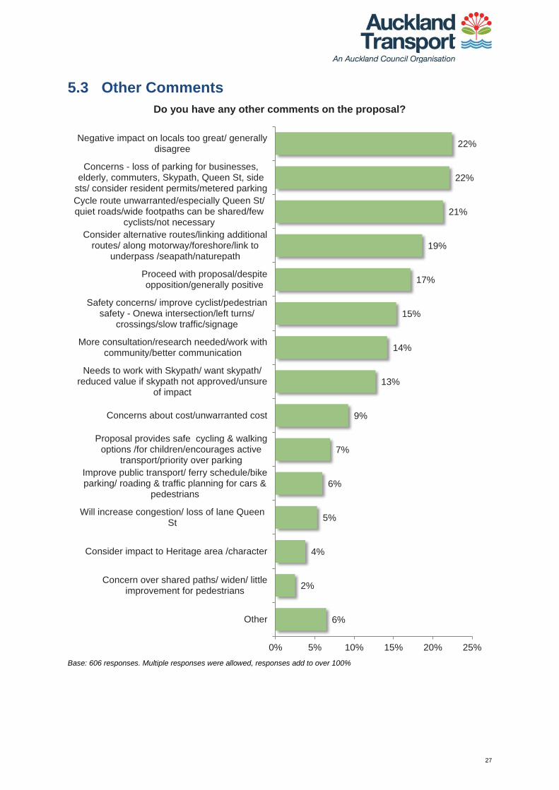
27
5.3 Other Comments
Base: 606 responses. Multiple responses were allowed, responses add to over 100%
6%
2%
4%
5%
6%
7%
9%
13%
14%
15%
17%
19%
21%
22%
22%
0% 5% 10% 15% 20% 25%
Other
Concern over shared paths/ widen/ littleimprovement for pedestrians
Consider impact to Heritage area /character
Will increase congestion/ loss of lane QueenSt
Improve public transport/ ferry schedule/bikeparking/ roading & traffic planning for cars &
pedestrians
Proposal provides safe cycling & walkingoptions /for children/encourages active
transport/priority over parking
Concerns about cost/unwarranted cost
Needs to work with Skypath/ want skypath/reduced value if skypath not approved/unsure
of impact
More consultation/research needed/work withcommunity/better communication
Safety concerns/ improve cyclist/pedestriansafety - Onewa intersection/left turns/
crossings/slow traffic/signage
Proceed with proposal/despiteopposition/generally positive
Consider alternative routes/linking additionalroutes/ along motorway/foreshore/link to
underpass /seapath/naturepath
Cycle route unwarranted/especially Queen St/quiet roads/wide footpaths can be shared/few
cyclists/not necessary
Concerns - loss of parking for businesses,elderly, commuters, Skypath, Queen St, side
sts/ consider resident permits/metered parking
Negative impact on locals too great/ generallydisagree
Do you have any other comments on the proposal?

28
When asked if they had any other comments on the proposal, many people reiterated the themes above. They said they thought the plan in its current form would impact too negatively on locals, or generally disagreed with it. They had concerns about parking and said the project was unwarranted (particularly in Queen St) since the area was already safe for cyclists. There was also a call to consider alternative routes and/or link additional routes to the plan. As noted above in section 5.2, the two most commonly mentioned themes (22% each) are largely connected and relate particularly to residents in Queen Street – these are that the proposal impacts locals too negatively, and concerns about a loss of parking:
“What surveys have you done on likely usage of the cycleways? My observation is that the number of cyclists a day you could probably count on one hand! You are inconveniencing a large number of people for the benefit of a handful.” “The proposal lacks simple common sense and there needs to be alternative routes identified which does result in significant community damage.” “If you go ahead with cutting such already limited parking to build a cycle path, I believe it will become a much larger issue than Auckland Transport rulings and will privilege those rulings over Auckland commercial interests. Small businesses could easily be forced to close if clients cannot park. While small business may not interest Auckland Transport, no doubt public outcry will.” “A really nice idea but the loss of the car parking along the route will be very hard for residents in older homes that were built before driveways were thought of - and they park on the road. The churches and schools add to the car parking. The movie theatre would suffer as would the restaurant/bars. The community house serves older people who cannot walk far - particularly in winter when cold and wet.” “Complete the proposal other than the Queen St section as: 1) It is not needed to meet Council the objectives 2) It is not a good use of money 3) The balance is wrong as it disadvantages far more individuals than it benefits – infrastructure and amenity value is primarily to support the community in which they are in, this proposal works against the interests of the vast majority of the local community.” “I am against this proposal. Cyclists can still be easily accommodated on Queen St and we have had zero accidents in the last five years, Removal of parking will have a dramatic effect on local business, local life and residents.”
In a similar vein, participants said the cycle route was unwarranted (especially Queen St), that the roads were safe, or the footpath could be shared to accommodate cyclists:
“General consensus is there is no issue for the cyclists that do utilise Queen St, however if there must be some solution to this Non-existent issue then just reduce the speed limit.” “The road is quite wide enough to provide a safe journey for a cyclist to travel through this area without the council having to create a specific cycle lane. We live close to the road and spend many hours outside in our front yard. We get to witness the traffic up and down the road at all times of the day. We would see about 5 cyclists a day passing by our house and they are in no danger from the stream of cars along this road. / Many homes do not have off street parking and need to have close on street parking to enable them and their children to safely park their cars and return to or leave their homes. We also have a lot of elderly in street who need to have

29
reliable and safe parking near their homes. A cycle lane would jeopardise this. / The few businesses that we have in this area provide a variety of entertainment options particularly for the elderly who use the wonderful boutique movie theatre, the Senior Citizens home on the corner of Bartley Street and the restaurants and cafes in the area rely heavily on the availability of car parks.” “Suggest that we do not have any cycle lanes on Queen Street Northcote point as the volume of cyclist does not warrant the impact on the neighbourhood and parking and the businesses that would be impacted.” “Queen Street is a reasonably quiet street and would be deemed to be a reasonably safe street to cycle. We cycle along there with our 4 year old child and have confidence in vehicles being courteous. I have seldom seen cyclists using Queen Street to access the ferry, and wondered what objective data you have to know that this initiative will actually be used. And by how many???? It seems a lot of expense and unrest for residents for something that is likely to be readily used by an insignificant number of people.”
As in the previous section, some thought alternative routes should be considered, or suggested additional routes they would like included in the plan:
“I liked the cycle network that was developed by the Kaipatiki Local Board. I would like to see that implemented.” “How does this tie in with the proposed Seapath? I would think that the money might be well invested in pushing that forward rather than doubling up. However if the overall strategy is for both then I am certainly for making cycling and more accessible for all ages. Good work Auckland City!” “Why can't the cycle lane be half of the footpath? This would cause much less disruption. An alternate route could also be beside the motorway and past Sulphur Beach and then up to Princes Street footpath and down to Northcote Point Wharf.” “I thought the plan was to have a cycleway/walkway path straight off the harbour bridge along the seashore (eastern side of motorway) directly to Barrys Point Road? This would be ideal and avoid roads altogether. Is this still planned and if so when for? Thank you “ “The Naturepath seems to cater more for families/all age groups whereas the Northcote cycleway only seems to cater for adults who are confident cycling on the road. There are a few things that are very unclear in the current proposal i.e. expected numbers of people using the Northcote cycle way and how it connects to the SkyPath. It is not clearly communicated how this will work. I would strongly recommend that Auckland Transport seriously considers spending the taxpayers’ money wisely and catering for all age groups rather than just adults and supporting the Naturepath proposal/route instead.”
Others were generally positive and wanted the proposal to proceed despite opposition:
“Get it done...we have needed something like this for a long time.” “Great idea, keep up the good work and look forward to seeing more of these cycle routes in Auckland. Well done and don't let the locals put you off.”

30
“The proposed route looks very good, particularly the off road cycle paths for cyclists only. The shared paths are great, particularly for less confident cyclists. I would always like to see more protection given for the on road cycle lanes, even if it was just a series of catseyes or barriers to stop motorists infringing on the cycle lane. I hope it isn't scaled back due to concerns around parking as the project will lead to more and more interest in cycling as a form of transportation.” “I look forward to when this section links up with the proposed bridge cycle/walkway so I can commute to/from work in the city without having to either drive my car or take the ferry.”
Some had safety concerns, particularly concerning the Onewa Road junction, and crossings within the proposal:
“What is going to happen to the poles holding up the wires down each side of Queen Street? Will they be moved? If they stay where they are, they will be right in the middle of the cycle path creating a major problem! I would be in favour of putting the wires underground. I don't know how I feel riding down the inside of parked cars, I feel this will create more accidents with pedestrians opening doors not looking for bikes.” “1. The raised cycle way needs to be wider but uni-directional so that it can be on one side of the road only. As with vehicular traffic it will be in one direction in the morning and afternoon rushes. It needs to be wider so that cyclists can easily overtake a slower moving cyclist. At off peak times the lower unidirectional volumes can easily cope with passing in the opposite direction. 2. Along Lake Rd the Eastern verge is very wide which will easily accommodate a wider raised cycle way. 3. If promoting cycle ways they must be raised and separated from vehicular traffic. Not flush as proposed in Queen ST.” “If the proposed arterial cycle way is so important then the design should include consideration of such things as : a complete review of and reconfiguration of usage of the whole width of the road reserve; power lines should be under grounded and at major intersections e.g. the Lake Road / Onewa Road the cycle way should be incorporated into an underpass. Basically I consider the current cycle way proposal to be simplistic and wasteful; it has all the attributes of an ill - thought out quick fix for a safety problem that demonstrably doesn't exist. Should the SkyPath proposal secure resource consent then the proposed arterial cycle way should receive a complete rethink.” “It is paramount that safe crossings are included in this proposal. Namely more between Exmouth/Raleigh Roads & Northcote Primary School on the corner of Lake and Onewa Roads - both on the side roads & crossing Lake Road near the entrance to Northcote School.”
Others said the proposal would benefit from more consultation, research and greater communication and partnership with the local community:
“I believe that there may be a way to accommodate a cycleway and residential parking. Queen Street is wide with wide footpaths which could be narrowed without compromising the rights of pedestrians. It is possible that the proposed SkyPath could feed onto the proposed Sea Path instead of Queen Street and provide cyclists with a more scenic route. No action on Queen Street should be undertaken until more is known about the progress of these concepts. In the meantime if the priority is to increase safety for cyclists and pedestrians reducing car speeds should be

31
considered. This is a time for a creative solution, a resolution of differing views - not a polarising 'solution' that can't be questioned. Applying design process to the urban planning of Northcote Point will encompass effective research and meet the transport needs as integral to the way Northcote Point could develop. This could be a model for other parts of Auckland as we strive to be the most liveable city in the world.”
“Before telling us about your powers to do whatever you like, there should have been an initial and thorough consultation with all the residents, businesses and other stakeholders in Northcote Point and elsewhere. Cyclists whether you like it or not, are and will continue to be a small % of all residents. Prove that isn’t the case! Given that fact, their needs should be subservient to the needs of locals. This would have to be one of the worst examples of the abuse of democracy by a local body. Put this to a referendum and see what result you would get? If this is what this council thinks is democracy, pity help us.”
“It is a challenge to design traffic systems which meet the demands of community. I commend Auckland Transport for trying to create new solutions to North Shore's road congestion through the use of bicycle lanes. I believe long term solutions for all road users can only be found through involving the local communities. Hopefully the submission process will initiate such collaboration. At a meeting held on 25th August 2014 for concerned residents of Queen Street and representatives of Auckland Transport it was suggested that Sharrow markings on lowering the speed limit down Queen Street could be used as an alternative to the current proposal. I agree with the proposed alternatives suggested at the meeting.” “There's more citizens on the Shore than the vocal minority shouting about 'losing their on street parking'. The benefits to home and shop owners from cycle lanes (in terms of hard figure spends per cyclist) need to be better communicated.”
“We are amazed at the isolation of the planning of a project from its effect on other planning and other projects including those made or known about by AC, NZTA and ordinary people in communities affected. We are amazed that no local knowledge was obtained before going to print and at notification with such peremptory wording. It was good to see at the public meeting at Northcote College on 25 August that the project team leader acknowledged lack of local knowledge and said the proposal would be modified as a result of consultation. We support all recommendations proposed by Jonathan Coleman and carried by the meeting. We all know that increasing population necessitates some changes and some sacrifices. The current proposal takes away a lot from virtually the whole population of Northcote Point and many in the rest of Northcote without giving people anything in return. Only people from other areas who want cycle access to the ferry or the Harbour Bridge will gain any advantage. A few people in the area may benefit if they are prepared to ride over the SkyPath if it proceeds and if they work in the City or Ponsonby. At present they have a very good bus service into the city. “
Some people mentioned the SkyPath, and wanted the Safe Cycle Route to work in conjunction with the SkyPath proposal, or were unsure of how the two proposals would work together:
“1. Common sense is lacking from the proposal. It seems to have been deliberately planned to coincide with SkyPath lodging their resource consent application. If the intent is purely designed to assist SkyPath, why would you not wait until SkyPath has resource consent? 2. Auckland Council patronage estimates for SkyPath reveal that 39% of patrons will require parking, primarily in Northcote Point. Has Auckland Transport reviewed the patronage figures in planning for this proposed cycle path?

32
The vast majority of patrons are walkers, NOT cyclists. In fact, only 10% of patrons are expected to be cyclists, so why would you focus on cycling lanes and not footpath improvements. 3. The Year 1 summer weekend figures claim that more than 8,000 people per day will use the SkyPath facility. Therefore more than 3,000 car parks will be required somewhere in Northcote Point. Have Auckland Transport undertaken any planning on traffic management in Northcote Point, if the SkyPath project proceeds? Where will these patrons park?” “1. Consultation has been very poor. 2. AT seems determined that this goes ahead regardless of whether SkyPath is consented- that is illogical. Let's see if SkyPath actually happens, then consider other cycling infrastructure.” “In my view, provision of a safe cycle route between the bridge and Takapuna is essential for the success of SkyPath. A few on-street car parks are a small price to pay for a package of projects to transform the usefulness and safety of cycling in the area. AT should place more weight on delivering an integrated cycle network rather than routing cycle lanes around each individual obstacle.” “I think the SkyPath is a vital link in the cycle/walking project for Auckland and should be fast tracked to allow more people to get out of their cars and use environmentally friendly ways to get around.”
A few had concerns about costs:
“In all the times I have visited my daughter I have yet to see a cyclist on Queen Street - what a waste of money. I am sure Auckland Transport could find something better to spend their $4M on.” “The project is another example of waste or potential waste of rate payers moving in Auckland. It should be abandoned as part of the cost cutting needed and unnecessary expenditure.” “Yes it should be scrapped ASAP, a complete waste of money. Until cyclists start paying to use the road they should continue to share the highway. Also the T3 on Onewa Rd is also another example of poor planning.” “Minority self-interest groups pushing their own barrows should shut up and be ignored. Underlying agenda for harbour bridge cycle lanes should be brought into the open, debated and scuppered. A total waste of ratepayers’ money.” “This is a 'nice to have' at ratepayer cost which has dubious benefits to safety in relation to other ways of improving safety on the roads.”
Others were generally happy with the safe walking and cycling options the proposal would bring, wanted improved public transport and management, thought the proposal would increase congestion, expressed concern at changes to the heritage area of Northcote Point, and/or disliked shared cycling/pedestrian paths:
“To be honest, we're excited and can't wait! Fantastic forward thinking and planning - at last! The realignment of Lake Road & T3 has been a mixed bag with faults and the pinch point past the primary school has actually put me off cycling to work in Takapuna which I still sometimes do. This will assist immeasurably and hopefully many many others. Look forward to good volumes of visiting transiting walkers and cyclists through our neighbourhood, I embrace the whole idea. Thank you!”

33
“The proposal doesn't seem to take account the erratic ferry service to Northcote wharf due to weather conditions. There are at least 5 other ferry points which would have a more reliable service. The project has been described as a solution looking for a problem. This appears to be the case with minimal current usage along Queen Street and no recent accidents. The city is currently living beyond its means. Projects such as this should be axed with the funds prioritised to such projects as the City Rail link. If people in Auckland Transport have time to dream up such schemes then they are obviously surplus and should be made redundant.”
“Getting out of Queen Street in the mornings to get to school is already pretty much congested even with the clearway turning left at present. Loss of this clearway would result in chaos for anyone wanting to turn left into Onewa Road. / The proposal as it stands in its initial form is totally unviable for anyone who lives in the area and further studies re traffic flow etc. need to be carried out. Not just two days over a 12 hour period!”
“This is a heritage street that I have lived in for over 30 years and this would have to be the most insane proposal yet. I have off street parking so whilst it won’t affect me directly I will have family and friends who will visit - where are they supposes to park. I can count on one hand the number of cyclists who use Queen St on a regular basis.” “We have heard, on more than one occasion, of people being badly injured when cyclists collide with them!! We are very opposed to sharing footpaths with cyclists. Most paths are too narrow anyway! We have a right to walk safely on footpaths without risking injury from inconsiderate cyclists!”

34
6. Changes to the project design resulting from feedback
For details of the feedback points that lead to the changes listed below, please refer to Section 7 of this report. To view the revised cycle route maps please visit www.at.govt.nz/northcotecycleroute.
Type of action or change Final map reference
Actions in response to general feedback
1
AT will undertake an education campaign prior to the launch of the new facilities to ensure those properties abutting the facilities are aware that there is likely to be an increase in cyclists using them and to take care when exiting/entering their driveways.
N/A
Actions in response to alternative route suggestions
2 Alternative routes described by respondents will be investigated as part of the on-going development of the local cycling network.
N/A
Changes in response to feedback on the Queen Street section of the cycle route
3 Sharrow markings (image of a bicycle with arrows painted on road) have been added to the road on Queen Street.
Map 4A – Map 4F
4
To reduce vehicle speeds and make this section of Queen Street safer for pedestrians, cyclists and vehicles the design has been changed to provide traffic calming (e.g. speed bumps) along the section of Queen Street with lower traffic volumes (as opposed to the dedicated cycling facilities previously proposed).
Map 4A – Map 4D
5
The project design has undergone significant changes from what was originally proposed for Queen Street. The revised design means that only 14 car parks will be removed, compared to the removal of 150 car parks which was originally proposed. The removal of 14 parking spaces is proposed to accommodate the speed/raised tables towards the lower end of Queen Street. The revised design also includes the provision of new angled parking on Rodney Road, which creates an additional 10 parking spaces. For details please refer to the revised cycle route maps at www.at.govt.nz/northcotecycleroute.
Map 3C – Map 4D
6
To reduce vehicle speeds and improve safety for pedestrians, cyclists and vehicles at the Queen Street/ Stafford Road/ Vincent Road/ Rodney Road intersection, Queen Street has been narrowed at this location and a speed table (a long/wide speed bump) has been installed.
Map 3F
7 The existing left turn lane from Queen Street to Onewa Road will no longer be removed.
Map 3C
Changes in response to feedback on the Lake Road section of the cycle route
8
AT is carrying out investigations into improvements at the Lake Road/Onewa Road intersection for cyclists. However, due to the scale and potential costs of these improvements they are being investigated separately so as not to delay the implementation of the current project.
Map 3C
9
AT is investigating a shared path on the west side of Lake Road (leading up to the Lake Road intersection); if the path is viable in terms of cost it will be constructed at the same time as this project.
Map 3B
10 The project has been amended to provide recessed parking in front of No.12 and 14 Lake Road.
Map 3A
11
The shared path will continue through the slip lane at approximately 41 Lake Road on a raised platform. The shared path will have a different surface to make it clear to vehicles exiting and entering the slip lane that pedestrians and cyclists have the right of way.
Map 3A

35
Type of action or change Final map reference
12
On Lake Road just after the Northcote Road/Lake Road intersection, the point where the off-road shared walking and cycling path enters the road and becomes an on-road cycle lane has been moved southward to improve the entry point.
Map 1I
Changes in response to feedback on the Northcote Road section of the cycle route
13
On Ocean View Road (just west of the Ocean View/Northcote/Lake Road intersection) an on-ramp will be provided to accommodate cyclists travelling along Ocean View Rd and wanting to continue along Northcote Rd on the off-road shared path.
Map 1I
14
To improve cyclist safety the on-road cycle lane has been removed from the north side of the Northcote / Sunnybrae intersection. But the design still includes advanced stop boxes at the intersection to give on-road cyclists priority.
Map 1G
15
The off-road shared path will now be on a raised table across the entries/exits to the netball courts/sports facilities car park on the south side of Northcote Road. The shared path will have different surface to make it clear to vehicles exiting and entering the car park that pedestrians and cyclists have the right of way.
Map 1F
16
The shared path will now be on a raised table across the entry/exit to the golf course car park. The shared path will have different surface to make it clear to vehicles exiting and entering the golf course car park that pedestrians and cyclists have the right of way.
Map 1E
17
The Northcote Road over-bridge is being widened to allow wider walking and cycling facilities across the bridge. The widening will include artwork and designs to improve the visual attractiveness of the bridge.
Map 1C
18 To improve cyclist safety the on-road cycle lane will now start immediately east of slip lane to The Avenue.
Map 1B

36
7. Key feedback points, AT responses, changes to project design
No. Feedback AT Response Changes to Project
General Comments
1 The project will improve safety for school children cycling to school and should encourage more children to cycle to and from school.
Thanks for your comments in support of the proposal. No changes
2
The proposed cycle path is well planned and encompasses a large distance linking to many attractions, it is much better than cycle lanes to nowhere which has happened in the past.
Thanks for your comments in support of the project. No changes
3 Like the inclusion of dedicated and protected cycle lanes and paths, this will make cycling safer and more appealing.
Thanks. One of the project objectives is to provide safe and attractive cycle facilities for users of various abilities.
No changes
4 Cycling facilities should take precedence over on-street parking.
AT must balance the needs of all users in determining how the road corridor will function.
No changes
5 The project will improve cyclist safety and encourage more people (adults, children, families) to cycle.
Thanks for your comments in support of the proposal. No changes
6 The project will encourage more healthy modes of transport and lifestyles
Thanks for your comments in support of the proposal. No changes
7 The project will reduce congestion on the roads (by getting people onto bikes)
Thanks for your comments in support of the proposal. No changes
8 The project will help decrease vehicle fumes and emissions in the area.
Thanks for your comments in support of the proposal. No changes
9 The project is a start to address the lack of dedicated cycling facilities in the area.
Thanks for your comments in support of the proposal. No changes
10 Provide physical separation between all on-road cycle lanes and traffic lanes.
All the proposed on-road cycle lanes are separated by kerb, parking spaces or 0.5m of painted buffer.
No changes
11
Proposal focuses too much on cyclists when improvements to the pedestrian environment could be made at a fraction the cost and would benefit more people.
Disagree. The project includes improvements to pedestrian paths, pedestrian crossings at intersections and entry/exit points to parks and businesses. The objective of the project is to benefit both pedestrians and cyclists.
No changes

37
No. Feedback AT Response Changes to Project
12
The whole proposal is unnecessary Disagree. Currently there are limited or no dedicated cycling facilities along the proposed route. The route services many different attractions that could be accessed by bicycle, such as schools, leisure activities, shopping centres, places of employment and public transport interchanges. The improvements will make travelling to these destinations safer for cyclists and pedestrians (including school children). The project will also encourage more people to walk and cycle. Cycling and walking are much more environmentally sustainable forms of transport than private motor vehicle use as they have no emissions or pollution associated with the end user, they occupy much less space (so can help reduce congestion), and have health benefits for the user.
No changes
13
Proposal is being pushed to accommodate Skypath. Disagree. The Northcote Safe Cycle route is independent of the Skypath project, although there will be complementary benefits if both projects go ahead. The objective of this project is to encourage more local trips to be taken by bicycle (as well as improve pedestrian facilities). If Skypath does go ahead, AT will investigate what changes will need to be made in Northcote Point to link cyclists from Skypath to the Northcote Cycle Route. Currently there is limited to no dedicated cycling facilities along the proposed route. The route services many different attractions that could be accessed by bicycle, such as schools, leisure activities, shopping centres, places of employment and public transport interchanges including the Northcote Ferry Terminal. The purpose of this project is to make travelling to these destinations safer for cyclists and pedestrians (including school children). The project will also encourage more people to walk and cycle.
No changes
14
Maps should indicate the wider context of cycle travel planning – indicating how the routes shown in the current plan are expected to link to other cycling and walking destinations on adjacent roads – without these links being identified.
Agree. In future more information on the current/future cycling network for the area will be included in materials developed for public feedback on cycle routes.
No changes

38
No. Feedback AT Response Changes to Project
15
Need an education campaign to ensure those most affected by the implementation of the off-road shared paths are aware of them and display caution when using them or crossing them in a motor vehicle.
Auckland Transport will undertake an education campaign prior to the launch of the new facilities to ensure those properties abutting the facilities are aware that there is likely to be an increase in cyclists using them and to take care when exiting/entering their driveways.
Auckland Transport will undertake an education campaign prior to the launch of the new facilities to ensure those properties abutting the facilities are aware that there is likely to be an increase in cyclists using them and to take care when exiting/entering their driveways.
16
One feature of this plan which particularly concerns us is the implementation of “shared off-road cycle paths”. These will clearly benefit cyclists who do not feel safe using the on road facilities, but in effect shared paths diminish the walking experience.
Whilst it would be preferable to have pedestrians and cyclists separate, this is often not possible due to physical and financial constraints. In some cases the cost of building separated facilities is prohibitive due to physical constraints.
No changes
17
Cyclists using the off-road shared walking and cycling path should have right of way over vehicular traffic.
We determine who has right of way (cyclists/pedestrians or vehicles) on a case by case basis (e.g. intersection by intersection, vehicle crossing by vehicle crossing). When determining who has right of way we favour the side of safety. In some locations it would be dangerous and confusing to give users of the shared path right of way. Generally where the shared path crosses driveways pedestrians and cyclists have right of way, unless clearly shown otherwise.
No changes
18
If your target group is school children (and contemplative cyclists), would you be better to have a dual direction cycle way (off road and on road protected by Copenhagen style barriers on the side that most of the schools are). By moving the route to one side of the road would you create a safer environment for the target group?
Bi-directional (dual directional) paths can create conflict at intersections and are therefore only appropriate in certain situations. This route has a large number of intersections. Shared paths have been provided outside Northcote Intermediate which allows for cyclists to go in both directions.
No changes

39
No. Feedback AT Response Changes to Project
19
Are the facilities designed for commuter or recreational cyclists? Currently they appear to be designed predominantly for recreational cyclists and will not benefit commuter cyclists who will continue to cycle on-road rather than on off-road shared paths.
Whilst it would be preferable to have pedestrians and cyclists separate, this is often not possible due to physical and financial constraints. Where feasible the project provides both on-road and off-road facilities, although space and financial constraints prevent both these facilities being used along the whole route. It is expected that more confident cyclists who want to travel at faster speeds will use the on-road facilities leaving the shared paths for less experienced cyclists, including school children.
No changes
20
Cycling facilities should all be on-road as they are safer than the off-road paths proposed for sections of the route. Also on-road means that cyclist don't need to give-way to vehicles on side roads.
This is not true for all users. For novice users off-road is usually safer, where's for experienced users travelling at greater speeds, on road is usually safer. Where possible we have provided off and on road cycling facilities to accommodate all users, but due to space and financial constraints this is not always possible.
No changes
21
The sections of off-road cycle path that diverge away from the road and closer to property boundaries are dangerous as they create more potential for conflicts between cyclists and cars exiting driveways.
The off-road shared path will have a different surface to make it clear to vehicles exiting properties that users of the shared path have right of way. Where possible there is a gap between the shared path and the property boundary, the shared path only abuts property boundaries when there is limited space and physical constraints to widening. Just prior to the launch of the facilities AT will carry out an education campaign with abutting properties to raise awareness that people will be using the shared path, and to advise people they will need to exit their properties cautiously.
No changes
22
Splitter islands must be large enough to accommodate the expected users: caregivers with pram and children, cyclists, groups of teenagers.
The splitter island area is determined by the road space available. All splitter islands will be 2m deep and wide enough to accommodate between 5 to 10 people at once.
No changes
23
Pedestrians should also be able to cross any side of an intersection, that is, they should not be forced to make unnecessary road crossings to get to the desired destination. It is not clear from these plans that these principles are reflected in all locations on this route.
Pedestrian crossings are provided at all intersections along the route, at busier intersections zebra crossings and signalised pedestrian crossings are provided. Also, where feasible/practical, in-between intersections we have provided a range of crossings opportunities (such as refugee islands) adjacent to main destinations.
No changes
24 My vehicle crossing is not shown on the plans / the plans show vehicle crossings that aren't there
Sorry, these are errors on the map - Auckland Transport does not propose to remove or add any vehicle crossings as part of the project.
No changes

40
No. Feedback AT Response Changes to Project
Alternative and Additional Route Suggestions
25
Use Naturepath route instead. Naturepath route does not meet all of the objectives of this project which is connecting schools, town centres, public transport interchanges and places of employment.
No changes - However the route describe by the respondent will be investigated as part of the on-going development of this local network.
26
The Naturepath route offers an alternative for Northcote and Birkenhead Point residents cycling to Akoranga and beyond and should be implemented as soon as possible. Arguably Northcote residents cycling to Northcote Intermediate could be served by the Naturepath route to Onepoto Basin and then could cycle up through Howard Road if a shared path was created through College Road to the proposed Northcote Greenway.
Naturepath route does not meet all of the objectives of this project which is connecting schools, town centres, public transport interchanges and places of employment; as such it is not a viable alternative to the project. The Northcote Safe Cycle Route is a standalone project and will become the backbone of a wider walking and cycling network as shown on the Auckland Cycle Network and in the Kaipatiki Local Board Network Plan. The route describe by the respondent will be investigated as part of the on-going development of this local network.
No changes - However the route describe by the respondent will be investigated as part of the on-going development of this local network.
27
The area around Northcote primary is always busy, slightly aggressive at school times and we would be adding more kids on bikes around the area. Perhaps a more direct bike path could direct you through Onepoto domain/ rotary grove. That way the cool bike bridge could be used more?
This route does not meet all of the objectives of this project which is connecting schools, town centres, public transport interchanges and places of employment; as such it is not a viable alternative to the project. The Northcote Safe Cycle Route is a stand-alone project and will become the backbone of a wider walking and cycling network as shown on the Auckland Cycle Network and in the Kaipatiki Local Board Network Plan. The route describe by the respondent will be investigated as part of the on-going development of this local network.
No changes - However the route describe by the respondent will be investigated as part of the on-going development of this local network.
28
Would have liked to see more imagination in the route from Onewa Domain to Queen St. A route through Onewa Domain and through reserves in the area of Tonnar St and crossing College Road and eventually joining Lake Road near Kawana St or event going as far as the Bridgeway theatre before joining traffic routes, would have provided a much more interesting route making a clear separation between cyclists and motor traffic. And I suspect a shorter route, but clearly cheaper to construct.
The route described here is not direct enough and does not meet all of objectives of this project which is connecting schools, town centres, public transport interchanges and places of employment, however Auckland Transport will consider it as part of the on-going development of this local network.
No changes - However the route describe by the respondent will be investigated as part of the on-going development of this local network.

41
No. Feedback AT Response Changes to Project
29
The 'Safe Cycleway' should extend down College Road (in addition too or instead of Northcote Road), as the current College Road cycleway/pedestrian way is poorly laid out for safety, particularly given there are a large number of students in the area who would opt to bike if it was safer. College Road also provides direct access to Takapuna via an existing cycle-way along Akoaranga Drive. It would be more logical to utilise this roadway for access to Northcote Point or as an alternative.
This route does not meet all of the objectives of this project which is connecting schools, town centres, public transport interchanges and places of employment; as such it is not a viable alternative to the project. The Northcote Safe Cycle Route is a stand-alone project and will become the backbone of a wider walking and cycling network as shown on the Auckland Cycle Network and in the Kaipatiki Local Board Network Plan. The route describe by the respondent will be investigated as part of the on-going development of this local network.
No changes - However the route describe by the respondent will be investigated as part of the on-going development of this local network.
30
I am not convinced about the route choice - I think that an off-road track built along the water’s edge from Esmonde Road to the harbour bridge (to connect with the Skypath) would get much higher use, as it would be very popular for recreational users at the weekend, and for commuter users during the week.
The proposal you refer to is currently under investigation by NZTA, it is being called Seapath. Seapath and the Northcote Safe Cycle Route will have differing functions, but they will complement each other and provide safer cycling facilities in the area. The function of the Northcote Safe Cycle route is to provide safe and connected walking and cycling connections to public transport interchanges, leisure activities, shopping centres, places of employment and schools in the area, Seapath would not achieve this.
No changes
31
I'd like to see a bike/pedestrian bridge across Tuff Crater (parallet to M/Way) and the route avoid Lake Rd altogether (flatter, shorter, and is off road - safer).
The function of the Northcote Safe Cycle Route is to provide safe and connected walking and cycling connections to public transport interchanges, leisure activities, shopping centres, places of employment and schools in the area, The suggested route will not achieve this. The Northcote Safe Cycle Route is a stand-alone project and will become the backbone of a wider walking and cycling network as shown on the Auckland Cycle Network and in the Kaipatiki Local Board Network Plan. The route describe by the respondent will be investigated as part of the on-going development of this local network.
No changes - However the route describe by the respondent will be investigated as part of the on-going development of this local network.

42
No. Feedback AT Response Changes to Project
32
The cycleway should have a diversion from the bottom of the "dip" on Lake Rd (opposite Kawana) through the Rotary Reserve and alongside the current rough walking track to the entrance of Onepoto Domain. The walking path could be made safe again at the same time. You may also find that it better optimises the available road corridor for cyclists and other vehicles. Adopting this suggestion may also reduce the capital cost of the project (at least by one clip on over the motorway) which, notwithstanding Government's recent announcement of increased funding for cycling, may be worth achieving given the pressures on AT's budget.
The function of the Northcote Safe Cycle route is to provide safe and connected walking and cycling connections to public transport interchanges, leisure activities, shopping centres, places of employment and schools in the area, The suggested route will not achieve this. The Northcote Safe Routes scheme is a stand-alone project and will become the backbone of a wider walking and cycling network as shown on the Auckland Cycle Network and in the Kaipatiki Local Board Network Plan. The route describe by the respondent will be investigated as part of the on-going development of this local network.
No changes - However the route describe by the respondent will be investigated as part of the on-going development of this local network.
33
Need more cycle routes in area that interconnect to other destinations such as Birkenhead shopping area.
This route is the 'backbone' of a wider cycle network for the area. Once this route is in place AT will continue to investigate and implement improvements to other routes that connect to this ‘backbone’ route. For example a shared path is planned to be constructed on Onewa Rd to Birkenhead as part of the Onewa Rd T3 transit lane project. AT is also working on a webpage which will provide more information on cycling in Auckland including implementation of the Auckland Cycle Network.
No changes
Queen Street
34
Don't support the proposed removal of car parking on Queen Street
The project design has undergone significant changes from what was originally proposed for Queen Street. The revised design means that only 14 car parks will be removed, compared to the removal of 150 car parks which was originally proposed. The removal of 14 parking spaces is proposed to accommodate the speed/raised tables towards the lower end of Queen Street. The revised design also includes the provision of new angled parking on Rodney Road, which creates an additional 10 parking spaces. For details please refer to the revised cycle route maps at www.at.govt.nz/northcotecycleroute.
The project has been revised to now only remove 14 car parks instead of around 150 car parks which were previously proposed to be removed along Queen Street.

43
No. Feedback AT Response Changes to Project
35
Lower speed limits should be imposed on Queen St to improve safety.
The revised design includes speed tables along parts of Queen Street. They are proposed to slow the traffic down and make it safer for cyclists to share the traffic lane with motorists. In general, Auckland Transport prefer to reduce vehicle speeds through changes to the physical environment as they are self-regulating (i.e. do not require enforcement to be effective). Additionally to satisfy legislation to reduce speed limits in this location the average vehicle speed (excluding cyclists) must be no more than 35km. As such physical measures to reduce vehicle speeds would still be required in the first instance. At this stage Auckland Transport do not intend to reduce speed limits along this road, but will monitor the situation after implementation of the traffic calming measures.
The revised design includes speed tables along parts of Queen Street to reduce vehicle speeds.
36
Sharrow markings should be painted on the road in Queen St to warn of the presence of cyclists.
Agree. The revised design includes sharrow markings on the road on Queen Street. Sharrow markings are currently being trialled in NZ to determine their effectiveness. They are currently not regulatory signage.
Sharrow markings have been added to the road on Queen Street.
37
Queen Street is already safe for cyclists, proposed facilities are over the top
Disagree. Parts of Queen St have high traffic volumes and therefore require appropriate cycle facilities. In the section of Queen St where traffic volumes are lower, traffic calming will be implemented in the revised design.
Design revised to provide traffic calming along the section of Queen Street with lower traffic volumes (as opposed to the dedicated cycling facilities previously proposed).
38
Use an alternative route to Queen Street Disagree. An alternative route will not meet all of objectives of this project which is connecting schools, town centres, public transport interchanges and places of employment.
No changes

44
No. Feedback AT Response Changes to Project
39
Why are you connecting to the unreliable Northcote Ferry Terminal service? Connecting to the more frequent Birkenhead Ferry Terminal would be a better idea.
Information provided by the AT Ferry Services Team indicate that on average 2 ferry services at Northcote Ferry Terminal are cancelled per month. Regular users of the ferry services are contacted by various media of a cancellation so they can arrange alternative transport. Walking and cycling connections to the Birkenhead Ferry Terminal are to be improved as part of an on-going programme of improving links to public transport. Connecting with the ferry terminal is only one objective of the project on Queen St. Other objectives are to encourage local cycle trips and cycling to schools.
No changes - However, improved cycle connections to Birkenhead Ferry Terminal are being investigated, but are a separate project to this one.
40
Currently the most unsafe point of Queen St is the bend in the vicinity of Bartly St/Bridgeway where southbound motorists execute a U-tum at a blind corner to park or access the Bridgeway/Sausallto businesses. Near-misses are a regular occurrence at all times and will be an increased safety risk for cyclists and motorists which must be addressed. This location already suffers-from vehicle parking contrary to the marked yellow lines and parking signage which adds to the safety risk.
AT cannot prevent people making U-turns in this location; the best way to improve safety in this location is to change the physical environment to reduce vehicle speeds, thus reducing the chance and potential severity of crashes involving u-turning vehicles. The installation of cycling facilities along the route should create an environment where motorists feel they should travel at lower speeds.
The installation of cycling facilities along the route should create an environment where motorists feel they should travel at lower speeds, but we are not looking at additional traffic calming in response to this comment.
41
Stafford Rd Intersection - Return to earlier dangerous traffic conditions solved by a reconfiguration 10-15 years ago that will now be obliterated. Over a decade ago, there were some serious crashes (cars only) on the corner of Stafford and Queen. This was because drivers exiting Stafford were never sure whether a right turning car coming up Queen from Onewa was going to turn into Rodney or Vincent. Council then redesigned the intersection, with a pedestrian refuge and a central waiting lane for those turning right into Rodney and a left-hand lane for those continuing to Vincent or along Queen. This has worked well. It tells those exiting Stafford what is about to happen. Already AT has put out a consultation document to residents to redesign the intersection differently, in which both the pedestrian refuge and the waiting lane for Rodney have disappeared. Now AT’s cycle lane plan obliterates both features, while making the road much
The narrowing of the road and installation of a speed table (long/wide speed bump) will considerably reduce traffic speeds in this location. It will also reduce the distance that pedestrians need to cross the road. These factors will make the location safer for vehicles and pedestrians than the historical layout referred to. The installation of speed tables/humps will force vehicles to slow and reduce the risk of collisions in instances where confusion regarding right turning vehicles does occur.
Road to be narrowed and a speed table (long/wide speed bump) will be installed to reduce vehicle speeds.

45
No. Feedback AT Response Changes to Project
narrower by squeezing in two lanes. There is no allowance for a central waiting lane for those turning right into Rodney. The result will be a return to the bad old days of traffic confusion and danger at the Stafford/Queen intersection, with cyclists now in the in mix, and pedestrians without their traffic island refuge.
42
How is cyclists' safety improved at the Rodney/Stafford/Vincent/Queen St intersection Also at the same intersection, cars turning left out of Rodney Road into Queen St often take the corner quite widely. The centre line under the current proposal will be moved CLOSER to Rodney Road, thus making the turn even sharper. This may well lead to cars turning from Rodney Road crossing the new centre line, which could lead to a car vs car accident or force a car colliding from the Opposite direction to swerve into the cycle lane (and any cyclist using it at that time).
Rodney Rd is a stop sign so vehicles should be stopping before making the turn. There is sufficient space for traffic to turn left into Queen St from Rodney without crossing the centreline - there is enough space for an 11m long vehicle to execute this turn safely (eg rubbish truck)
No change
43
At XXX Queen St I have assessed leaving our house in the morning by car over the past week and with the proposed plan, I would have to sit across the cycle path 100% blocking the path from all bikes up to 3 - 5 min at a time waiting for a break in the traffic to pull out. I can picture the cyclists wouldn't be very happy about this.
It is illegal to sit across the footpath or cycle lane. You should wait at your property before making the movement. Alternatively there maybe space between the traffic lane and the shared path for you to sit while waiting to make the turn (due to the row of parking for cars).
No change
44
Map 3D: Don't like cycle lane on inside of parking. There is a 0.5m buffer between parked cars and the cycle lane. Also this type of facility/treatment is recognised nationally and internationally as a safe solution.
No change
45
Don't support the removal of the clearway and left-turn lane from Queen Street onto Onewa Road, it will significantly increase congestion.
The existing left turn lane from Queen Street to Onewa Road will no longer be removed and will remain unchanged.
Existing left turn lane from Queen Street to Onewa Road to remain.
Lake Road
46 Don't support the removal of parking from Lake Road We have completed a car parking survey and after removal of parking
there will still be enough car parks available to accommodate demand for parking.
No change

46
No. Feedback AT Response Changes to Project
47
Cycle facilities on Lake Road will make traffic congestion worse.
Disagree. The cycling facilities on Lake Road do not remove or alter any traffic lanes, and as such they should not create any traffic congestion (i.e. should not have any effect on the operation of the traffic lanes). Also the cycling facilities should encourage more people to cycle, which will get them out of cars and help to reduce congestion.
No change
48
The proposal does not improve the dangerous Onewa Road/Lake Road/Queen Street intersection. Further improvements are required to this intersection for cyclists.
Improvements for this section are currently being investigated. Due to the scale and potential costs of these improvements they are being investigated separately so as not to delay the implementation of this project.
No change to this project. However, improvements for this section are currently being investigated.
49
A separated cycleway northbound on Lake Road immediately after the Onewa Road-Lake Road intersection (adjacent to Northcote Primary School) is missing. A shared path should be installed in this section to ensure that separated cycleways are included for the whole length of the route.
Agree. AT is investigating a shared path on the west side of lake Rd, if the path is viable in terms of cost it will be constructed at the same time as this project. Alternatively children will need to get off their bike at the end of the shared path and walk to the Onewa Rd intersection and cross at signalised crossing.
AT is investigating a shared path on the west side of lake Rd, if the path is viable in terms of cost it will be constructed at the same time as this project.
50
The proposed route does not appear to create any practical safe route to Northcote Primary school for children in the surrounding area. The off road shared path is on the eastern side of Lake Rd, and terminates some distance before Onewa Rd, opposite the school but with no apparent means to cross the road safely. The western side of the road has only an on-road cycle path which may not be sufficiently safe for primary age children.
Agree. AT is investigating a shared path on the west side of lake Rd, if the path is viable in terms of cost it will be constructed at the same time as this project. Alternatively children will need to get off their bike at the end of the shared path and walk to the Onewa Rd intersection and cross at signalised crossing.
AT is investigating a shared path on the west side of lake Rd, if the path is viable in terms of cost it will be constructed at the same time as this project.
51
We are particularly concerned with the proposal for Lake Rd between Raleigh Rd and Onewa Rd, containing as it does a T3 lane, bus stops and a primary school. Picking up and dropping off children twice a day will become even more risky (for children and cyclists) than it already is.
The project has been amended to provide recessed parking in front of No.12 and 14 Lake road.
The project has been amended to provide recessed parking in front of No.12 and 14 Lake road.

47
No. Feedback AT Response Changes to Project
52
Lake Rd between Raleigh Rd and Onewa Rd - the south bound cycle lane will be very close to property driveways nearly all of which are steep slopes down from road level - hazardous now to pedestrians but will be extremely more so to cyclists.
The off-road shared path will have a different surface to make it clear to vehicles exiting properties that users of the shared path have right of way. Where possible there is a gap between the shared path and the property boundary, the shared path only abuts property boundaries when there is limited space and physical constraints to widening. Just prior to the launch of the facilities AT will carry out an education campaign with abutting properties to raise awareness that people will be using the shared path, and to advise people they will need to exit their properties cautiously.
No changes
53
At approximately 41 Lake Rd the off road shared path appears to deviate into the slip lane, with no marked pedestrian crossing. Given low usage of vehicles of this lane, it would be appropriate for a shared path to continue across it on a raised platform, clearly marked so that vehicles give way to cyclists rather than the other way around.
Agree, shared path will continue through the intersection on a raised platform. The shared path will have different surface to make it clear to vehicles exiting and entering the slip lane that pedestrians and cyclists have the right of way.
Agree, shared path will continue through the intersection on a raised platform. The shared path will have different surface to make it clear to vehicles exiting and entering the slip lane that pedestrians and cyclists have the right of way.
54
Maps 2F, 2G, 2H, 3A The provision of a shared path on the west (even numbered) side of Lake Road would allow unconfident cyclists to cycle away from traffic – especially up the hill towards Raleigh Rd. A setback shared path crossing could be considered for Kawana Street.
Due to physical constraints it is cost-prohibitive to provide a shared path in this location.
No changes
55
Map 2G: No pedestrian crossing across Korero St? Due to low vehicle volumes on this street a zebra crossing is not justified. However the proposal includes crossing facilities, but pedestrians and cyclists using the facilities will have to give way to vehicles.
No changes
56
The pedestrian crossings at the Lake Road/Exmouth/Raleigh Road roundabout will create traffic congestion.
In peak traffic hours when traffic congestion is most of a concern, vehicles are moving at slow speeds. As such some pedestrian/cyclist movements will have little effect on traffic congestion. Also we need to provide safe crossing facilities for cyclists and pedestrians where there is demand.
No changes
57 Cyclists won't use the pedestrian crossings at the Lake Road/Exmouth/Raleigh Road roundabout and instead will navigate the dangerous intersection.
That is their choice, but we are giving them a safer option than is currently available - the new facilities are likely to be an attractive option to venerable cyclists such as school children.
No changes

48
No. Feedback AT Response Changes to Project
58
A safe crossing for pedestrians is also needed on the western side of the Lake Road/Exmouth/Raleigh Road roundabout, for those kids that live on that side e.g. Gladstone Rd/Fowler St.
The zebra crossings provided at the Lake Rd/Raleigh Rd/Exmouth Rd roundabout will solve this safety issue. The school children would be able to use the zebra crossing proposed on the western leg of the roundabout.
No changes
59
Map 2E - The Exmouth/Raleigh Road roundabout is difficult for motorists let alone for cyclists and pedestrians. This is exacerbated by the poor sightlines that obscure vehicles approaching south from Northcote Shopping Centre. One would have to question the justification for any planting at this intersection – because of the risk it will obscure approaching vehicles.
The plantings will help reduce speeds through the intersection as they will require vehicles to slow down on the approach to the intersection and check whether the intersection is clear of vehicles before proceeding. Without plantings vehicles can approach the intersection at higher speeds as they can see whether there are vehicles in the intersection from a greater distance before they reach the give way lines. Reduced vehicle speeds will improve safety at the intersection. Pedestrian crossings have also been provided to improve pedestrian and cyclist safety.
No changes
60
The crossing angles and widths needs to be increased in all locations at the Lake Road/Exmouth/Raleigh Road roundabout. Additional space should be provided for cycles waiting to cross the road so they don’t impede straight through cyclists.
Pedestrians and cyclists have right of way at crossings so will clear off the path quickly. As such it's unlikely that they will impede straight through pedestrian and cyclist traffic. In addition cycle speeds at these points will not be fast as the cyclist would have either just exited or be approaching the intersection.
No changes
61
It is not clear from the map whether speed reduction (traffic calming) techniques are proposed to reduce the number of motorists who proceed through the Lake Road/Exmouth/Raleigh Road roundabout at incautious speeds. To encourage parents to have confidence that this is a safe cycling location may require more work.
We are providing plantings at the intersection which will help reduce speeds through the intersection as they will require vehicles to slow down on the approach to the intersection and check whether the intersection is clear of vehicles before proceeding. Without plantings vehicles can approach the intersection at higher speeds as they can see whether there are vehicles in the intersection from a greater distance before they reach the give way lines.
No changes
62
The Lake Road/Exmouth/Raleigh Road roundabout sits on a ridge, so cars will enter the roundabout from an uphill direction and then have to brake suddenly at the roundabout if they encounter pedestrians crossing that have been hidden by the ridge. The entire roadway may need to be flattened and the central garden removed to increase visibility across the intersection for all modes.
The sight lines for vehicle approaching pedestrian crossings are adequate for vehicles to see them and slow down.
No changes

49
No. Feedback AT Response Changes to Project
63
The cycleway should have a diversion from the bottom of the "dip" on Lake Rd (opposite Kawana) through the Rotary Reserve and alongside the current rough walking track to the entrance of Onepoto Domain. The walking path could be made safe again at the same time.
This route is being investigated by the local board as a separate project. No changes
64
The cycleway provides more pedestrian crossings for our walk to school (Deuxberry Ave to Northcote Primary).
Thanks for your comments in support of the project. No changes
65
Suggest the installation of a zebra crossing at the Deuxberry Avenue/College Road intersection. Also a zebra crossing at the College Road/Exmouth Road intersection would help my children safely get to school across these very busy roads. It would help to feed on safely to the new cycle route.
The zebra crossings location suggested is out scope of Northcote Safe Cycle Route; however we have passed your comment onto the relevant AT department for consideration.
No changes
66 Supermarket entrance/exits at Northcote Shopping Centre need to be controlled by traffic lights.
This will be investigated as part of Northcote Town Centre upgrade. No changes
67
Map 2D - The entrance/exits to the Northcote Shopping Centre look as though they would create awkward and potentially dangerous points for cyclists. Turning bays at the street edge with the shared path inset back a car length would address this.
On-road cyclists have right of way, off-road cyclists have to give way to vehicles. The arrangement for on-road cyclists is similar to most T-intersections where the through-road has a cycle lane on it.
No changes
68
The sections of off-road cycle path that diverge away from the road and closer to property boundaries are dangerous as they create more potential for conflicts between cyclists and cars exiting driveways.
The off-road shared path will have a different surface to make it clear to vehicles exiting properties that users of the shared path have right of way. Where possible there is a gap between the shared path and the property boundary, the shared path only abuts property boundaries when there is limited space and physical constraints to widening. Just prior to the launch of the facilities AT will carry out an education campaign with abutting properties to raise awareness that people will be using the shared path, and to advise people they will need to exit their properties cautiously.
No changes
69
It seems strange to switch between a separated cycle lane and a lane marked on the road, on Lake Road. Surely it should be one or the other.
The type of cycling facility provided depends on factors such as available space. Where space is available off-road cycle lanes are provided because they are considered safer than on-road cycle lanes. The realignment of the kerb line in this location to extend the off-road cycle path westward would be costly. To move everything east would require the removal of several trees and path widening which would be costly and have negative implications from an environmental perspective.
No changes

50
No. Feedback AT Response Changes to Project
70
Why can't the berm space on the west side of Lake Road be used for a shared path to cater for elderly cyclists and children.
The shared path is provided on the side of the road with the most destinations. Space and cost constraints prevent the construction of a shared path on both sides of the road.
No changes
71
At 216 Lake Road, why has the shared path been discontinued / why is there an isolated section of shared path on the west side of the road in this location?
This is not a shared path; it is a footpath (pedestrians only) that will be reconstructed. The key/legend on the maps has been amended to show the difference between shared path and footpath improvements.
The key/legend on the maps has been amended to show the difference between shared path and footpath improvements
72
Map 2A: Re-entry on to road is always unsafe for cyclists - consider keeping route on road. I know this is currently a popular detail but has hazards of car doors opening, people leaving items on cycleway as they load their cars and also a quite narrow feeling route, which reduces cyclist desirable speed. Similar comment applies throughout.
The point where cyclists using the shared path can enter the road onto an on-road cycle lane has been moved southward to improve the entry point. There's not enough space on Northcote Rd to have a cycle lane and shared path.
The point where cyclists using the shared path can enter the road onto an on-road cycle lane has been moved southward to improve the entry point.
73
Why is the on-road cycle lane discontinued over the pedestrian crossings near 123, 193 and 227 Lake Road? Please remove the proposed raised islands as they force cyclists into the path of traffic. Or provide a route for cyclists behind where waiting pedestrians stand.
Raised islands were constructed as part of a safety project. Pedestrians have priority through zebra crossings so the cycle lane cannot be extended through the pedestrian crossing as this creates conflicting messages as to who has priority at this point. The width through the crossing is the same as the combined width of the traffic lane and cycle lane just prior to the pedestrian crossing; therefore there is no pinch point.
No changes
74 Map 2E - Make pedestrian crossings raised tables to slow traffic speed and improve pedestrian/cyclist safety
There would be very little to no benefit from a raised table in this location.
No changes
75
Map 1I - Request that pedestrian crossing on Lake Road is moved closer to the roundabout to improve pedestrian safety.
The zebra crossing is located next to the heavily used pedestrian path through to Ocean View Road and is considered a better location for children wishing to access Onepoto Primary School and Hato Petera College; which is where the majority of people using the pedestrian crossing are expected to be heading. AT will draw attention to the pedestrian crossing by providing a different coloured road surface with anti-skid materials. An additional crossing point is to be provided close to the roundabout as part of this project but it will not be a zebra crossing as it is not a safe location for such a crossing; as such pedestrians will have to give way to vehicles.
No changes

51
No. Feedback AT Response Changes to Project
Northcote Road
76 Project will encourage more people to cycle to public transport stations, and reduce congestion in the vicinity of the stations.
Thanks for your comments in support of the project No changes
77
You need to carefully consider how the roundabout at Ocean View Road/ Lake Road is altered. At present my property at 13 Ocean View Road has a driveway at the roundabout. It is presently EXTREMELY dangerous to exit from the driveway at Number 13 onto Ocean View Road, as cars illegally belt down the bus lane. The Bus Lane should be removed. Consider putting lights on this roundabout, as was done at the Onewa Road/Birkenhead Av intersection many years ago.
The Ocean View Rd/Lake Rd roundabout has been altered to slow traffic down approaching the roundabout. Visibility from this driveway has also been improved. We believe a roundabout is the best solution for this intersection due to the location of driveway entrances and the effect of traffic lights on traffic flow.
No changes
78
Map 1I - consider improved access / signage from Ocean View Rd onto off-road cycle path - it is a sharp angle onto the footpath for these cyclists.
The pram ramps provided are to accommodate pedestrians and cyclists crossing Ocean View Road. Further up Ocean View Road an on-ramp will be provided to accommodate cyclists travelling along Ocean View Road and wanting to continue along Northcote Rd on the off-road shared path.
Further up Ocean View Road an on-ramp will be provided to accommodate cyclists travelling along Ocean View Rd and wanting to continue along Northcote Rd on the off-road shared path.
79 The separate left turn lane from Lake into Ocean View Road should be restored.
We are not changing this lane alignment No changes
80
Map 1G: Northcote / Sunnybrae intersection, north side - this is a very unsafe detail for cyclists - why are they forced to cross the line of traffic with no protection?? It is unusual, which reduces the overall safety. Require a give way to be effective.
Agree. The on-road cycle lane has now been removed from this location. But the design does include advanced stop boxes at the intersection to give on-road cyclists priority.
The on-road cycle lane has been removed from this location
81
The crossing angles over Sunnybrae and Akoranga look unduly sharp The angles should be adjusted and the marked crossing path widened to make it easier for cyclists to negotiation while also looking out for other traffic.
Cyclists need to disembark through the pedestrian crossings. The locations of the crossing points reduce the crossing distance and the alignment at right angles to the road improves safety by allowing pedestrians and cyclists to look right rather than looking over their shoulder, which would be the case if the alignment was changed to make it less sharp.
No changes
82 Trees by the present footpath alongside Onewa Domain should be left intact when the footpath is widened for cycles.
We are only removing one tree alongside Onewa Domain. No changes

52
No. Feedback AT Response Changes to Project
83
Map 1E - Why is there no pedestrian and cycle crossing at carpark exit?
The shared path will be on a raised table on the car park exit. The shared path will have different surface to make it clear to vehicles exiting and entering the car park that pedestrians and cyclists have the right of way.
The shared path will be on a raised table on the car park exit. The shared path will have different surface to make it clear to vehicles exiting and entering the car park that pedestrians and cyclists have the right of way.
84
Map 1E, 1F Cycling along Northcote Road when sports crowds are leaving the carparks is very difficult. The continuity of cycling on the shared path at the entrance to the carpark on the Fred Thomas Park side and the Netball Court side could be enhanced by providing a lane offset from the road allowing a turning bay for a vehicle between the cycle crossing and the road.
The shared path will be on a raised table across those two entrances. The shared path will have different surface to make it clear to vehicles exiting and entering the car park that pedestrians and cyclists have the right of way.
The shared path will be on a raised table across those two entrances. The shared path will have different surface to make it clear to vehicles exiting and entering the car park that pedestrians and cyclists have the right of way.
85
It appears that bumps for vehicles will be placed at the entrance to the car park on the southern side of Northcote Road, but not on the entrance to the car park on the northern side. A bump should be placed here as well.
The shared path will be on a raised table at the entry/exit to golf course car park. The shared path will have different surface to make it clear to vehicles exiting and entering the golf course car park that pedestrians and cyclists have the right of way.
The shared path will be on a raised table at the entry/exit to golf course car park. The shared path will have different surface to make it clear to vehicles exiting and entering the golf course car park that pedestrians and cyclists have the right of way.
86
A separated cycle path/lane would be preferable adjacent to the netball and tennis courts as from about 4-8 most winter evenings and all day Saturday that area is teeming with hundreds of people, many of which are trying to cross the road. Given the need for wide footpaths for this very reason (the ones currently are woefully inadequate) I’m not sure if there’s an alternative, but I could see it being pretty difficult to navigate as a cyclist during these times. One minor change to help at the lights may be Council/AT creating a larger waiting space for pedestrians outside of the shared path and within the southern car park where there are currently no marked car parks, but which are regularly used as such during busy times.
Can't fit a separated cycle lane in this space, however waiting space for pedestrians has been increased (this widening was part of the original proposal).
No changes

53
No. Feedback AT Response Changes to Project
87
Map 1E - Northcote Road/Onewa Domain. The board suggests that the off-road section adjacent to the Netball Centre’s car park is lengthened to allow additional space for the drop off zone for the Netball Centre.
The existing parking bay adjacent to the Netball Centre can't be lengthened because of physical constraints.
No changes
88 The project will improve safety for people cycling to and from sporting venues and AUT.
Thanks for your comments in support of the project. No changes
89
I commute by bicycle regularly and this area is particular hazardous in the evenings with cars and buses servicing the netball courts in particular, and high pedestrian volumes using the pathways. Inclusion of on road cycle lanes at this point and signs warning of cyclists at the car park entrances would significantly raise awareness in this area and improve safety. In rush hour left turning traffic can easily fail to indicate and be unaware of cyclists on combined pathways.
Due to space constraints we could not provide both off-road and on-road cycle facilities. We have chosen off-road facilities as it's better for vulnerable users.
No changes
90 Map 1C - Widen Northcote Road over-bridge to widen walking/cycling facilities.
Agree. Auckland Transport is now going to widen the bridge. The widening will include artwork and designs to improve the visual attractiveness of the bridge.
The bridge is being widened.
91
We support improvements to intersections which will make these safer for pedestrians of all abilities to cross. This should include marked pedestrian crossings or signalised crossings at all left turns off or on to major roads (including motorway ramps), and standard features such as ramps and tactile paving to assist disabled people.
Pedestrian crossings are provided at all motorway on/off ramps (either zebra crossings or light phases for pedestrians). All crossing points have tactile pavements at the drop kerb. This was part of the original proposal.
No changes
92
It is tricky getting across the motorway on Northcote road. Consider making the left turn lanes cycle lanes, instead of having cyclists go up and down curbs onto footpaths, and dealing with left turning traffic that may not give way.
The lane arrangement will not be changed because it would increase traffic congestion near the Northcote motorway overbridged.
No changes
93
Map 1B What provision is made for school children attending Takapuna Intermediate?
We are widening the pavement to provide a shared path all the way along Northcote Rd and across the bridge. This includes widening the path across the bridge.
The bridge is being widened.

54
No. Feedback AT Response Changes to Project
94
Improvements are required to the lane at 26 Northcote Rd by relocating the existing pedestrian crossing (and raising the surface) so that cyclists/pedestrians do not need to make two right angled deviations to continue their route along Northcote Rd - essentially prioritising cyclists and pedestrians over cars.
Due to large numbers of students using the crossing at peak times, there is a possibility of students spilling out onto Northcote Rd if the crossing is too close to Northcote Rd. So for safety reasons it is slightly indented/set back from Northcote Road.
No changes
95
Map 1B, with the east bound traffic, I have a concern that cyclists have a green cycle lane starting at the same point traffic diverges north up the avenue. I would be confused here as to who has right of way - the cyclist pulling out into a dedicated lane going straight or a car turning left across the lane with a cyclist pulling out in front of them? I think it would be better if the cycle lane started a little earlier so there wasn't such an obvious collision point.
Agree. Cycle lane will now start further east. Cycle lane will now start further east.
96
Map 1B - there appears to be an omission regarding one of the exits from Smales Farm? Why no pedestrian crossing and 'green lane' across the third (central) side road?
This section is not greened out because this part of the intersection is controlled by lights. Traffic regulations do not allow a cycle lane to continue through a signalised intersection. The pedestrian crossing is not a zebra because it's signalised.
No changes
97
The intersection with Taharoto Road needs to be considered carefully - the cycle path ends quite abruptly at this point. Cycle facilities on Taharoto Road are rudimentary and do not feel safe given high traffic volumes on the road. Does AT have a plan for completing the network on this end - e.g. by joining up the hospital and Takapuna town centre?
Improved cycle connections to the hospital and Takapuna are aspirations of both AT and the Local Board. The Northcote Safe Routes scheme when completed will become the backbone of a wider walking and cycling network for the area. Connections to key local destinations will be developed and improved in the future to encourage more people to cycle more often. Many of these local links have been prioritised in Local Board Network Plans.
No changes

55
Appendix 1: Overview Map For more detailed maps please go to www.at.govt.nz/northcotecycleroute