Embed Size (px)
Citation preview
Public Hearing - April 30, 2014 & May 1, 2014 Project ID: 1229-04-01 - Silver Spring Drive to WIS 60 - Milwaukee and Ozaukee Counties
I-43 North-South FreewayCorridor Study
Public Hearing
WELCOMEPurpose of the hearing:
Obtain public opinion on the following aspects of the
I-43 North-South Freeway Corridor Study
• Proposed improvements and alternatives being considered
• The Environmental Impact Statement (EIS) is the decision document for the proposed improvements. Copies of the Draft EIS are available at today’s hearing
• Project activities that require authorization from the U.S. Army Corps of Engineers under the Clean Water Act; For example, placing fill into waters of the U.S. including wetlands
Thank you for attending and contributing to the I-43 North-South Corridor Study!
I-43 North-South FreewayCorridor Study
Project ID: 1229-04-01 - Silver Spring Drive to WIS 60 - Milwaukee and Ozaukee Counties Public Hearing - April 30, 2014 & May 1, 2014
I-43 NORTH-SOUTH FREEWAY CORRIDOR STUDY
BIKE AND PEDESTRIAN ACCOMMODATIONS IN A DIVERGING DIAMOND INTERCHANGE (DDI) 08.15.2013
RA
MP
RA
MP
RA
MP
RA
MP
Bike/Pedestrian AccessSIDE ROAD
INTE
RS
TATE
= East= West
ARROWCOLORS
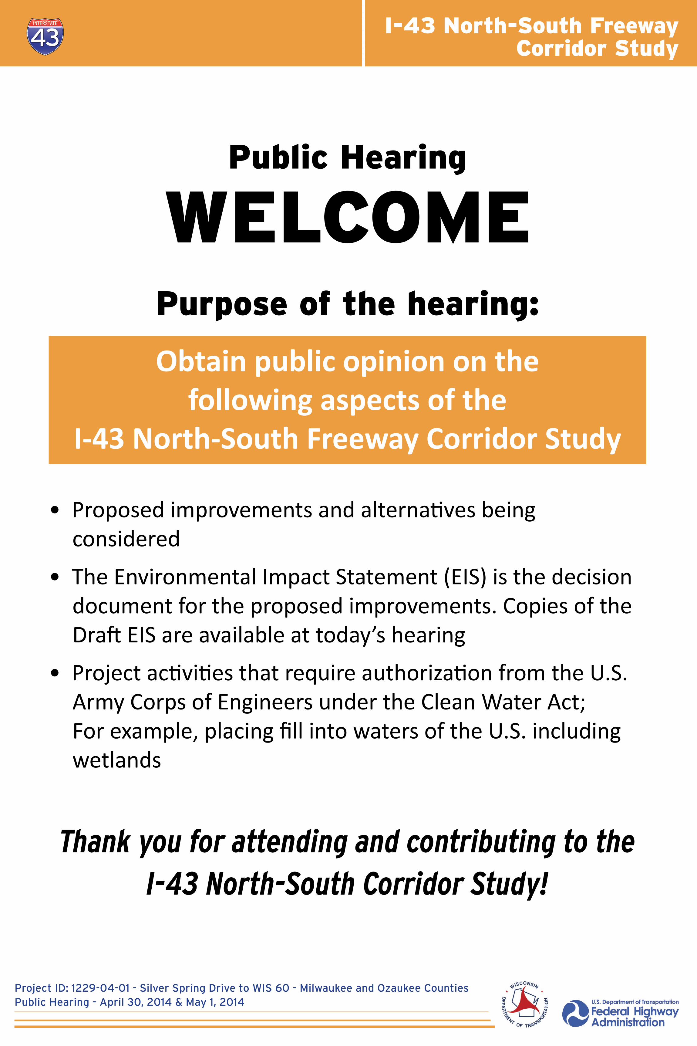
Bike and Pedestrian Accommodations in a Diverging Diamond Interchange (DDI) Brown Deer Road
I-43 North-South FreewayCorridor Study
Project ID: 1229-04-01 - Silver Spring Drive to WIS 60 - Milwaukee and Ozaukee Counties Public Hearing - April 30, 2014 & May 1, 2014
Alternative Screening Summary: I-43 Mainline (North of Green Tree Road)
Retain Alternative for Detailed StudyAlternatives
NORTH SEGMENT: GREEN TREE ROAD TO WIS 60
CORRIDOR-WIDE LOWER LEVEL IMPROVEMENTS
Modernization - 6 lanes
Modernization - 4 lanes
TSM and TDM Measures Only
TSM/TDM Plus Spot Improvements
TSM/TDM Plus Reconstruction without Capacity Expansion
Milwaukee County Option Inside widening
See Modernization 6 lanes Evaluation Factors above
See Modernization 6 lanes Evaluation Factors above
See Modernization 6 lanes Evaluation Factors above
Ozaukee County Option 1Inside widening
Ozaukee County Option 2Outside widening
AddressesDesign
DeficienciesImproves
Safety
YES YES YES YES See Magnitude of Environmental impacts below See widening options below
YESAddresses design deficiencies, improves safety
concerns, future traffic demand andis consistent with regional plans
YESAddresses design deficiencies, improves safety
concerns, future traffic demand andis consistent with regional plans
NOHigher magnitude of impacts to wetlands, streams
and farmland compared towidening to inside
NODoes not address future traffic demand;
not consistent with regionaltransportation plans
NOAs stand-alone alternative, does not address design deficiencies, safety issues or future traffic demand; not consistent with regional transportation plans
NODoes not address design deficiencies or future traffic demand; limited improvement of safety issues; not
consistent with regional transportation plansNO
Does not address future traffic demand; not consistent with regional transportation plans
MODERATE Wetland impacts
MODERATE Wetland impacts
LOW No impacts
LOW No impacts
LOW/MODERATE Minimal impacts
MODERATE/HIGH Impacts to wetlands and farmlands,
stream relocation
LOW Minimal wetland impacts
$57.2
$117.6
R/W Impacts
R/W impacts
Limited R/W impacts
Limited R/W impacts
Limited R/W impacts
Limted widening andR/W impactsYES YES NO NO
YES YES NO NO
NO NO NO NO
NO NO NO
Relative Total Cost(construction, right-of-way
(R/W) acquisition)$ (millions)*
Magnitude of Environmental Impacts
AddressesFutureTraffic
Demand
Consistentwith
RegionalPlan
Key Purpose and Need Factors Other Factors
NOTE: All Build Alternatives include Transportation System Management (TSM)/Transportation Demand Management (TDM) measures *Current Year Dollars
Preferred Alternative
YES(spot locations)

I-43 North-South FreewayCorridor Study
Project ID: 1229-04-01 - Silver Spring Drive to WIS 60 - Milwaukee and Ozaukee Counties Public Hearing - April 30, 2014 & May 1, 2014
Alternative Screening Summary: County C (Pioneer Road) Interchange
Retain Alternative for Detailed StudyAlternatives
COUNTY C (PIONEER ROAD) INTERCHANGE
Diamond
Spot Improvements
AddressesDesign
DeficienciesImproves
Safety
YES YES YES YES
NO NO NO
MODERATEWetland impacts; no relocations
LOWWetland impacts; no relocations
YESMaintains existing interchange configuration but improves
traffic operations
NODoes not address design deficiencies or future traffic demand; limited improvement of safety issues; not
consistent with regional transportation plans
$9.7Structure replacement and
R/W impacts
Structure replacement likely due to age
Relative Total Cost(construction, right-of-way
(R/W) acquisition)$ (millions)*
Magnitude of Environmental Impacts
AddressesFutureTraffic
Demand
Consistentwith
RegionalPlan
Key Purpose and Need Factors Other Factors
NOTE: All Build Alternatives include Transportation System Management (TSM)/Transportation Demand Management (TDM) measures *Current Year Dollars
Preferred Alternative
YES(spot locations)

I-43 North-South FreewayCorridor Study
Project ID: 1229-04-01 - Silver Spring Drive to WIS 60 - Milwaukee and Ozaukee Counties Public Hearing - April 30, 2014 & May 1, 2014
Alternative Screening Summary: Highland Road
Retain Alternative for Detailed StudyAlternatives
HIGHLAND ROAD (no existing interchange at this location)
No Access
Tight Diamond
AddressesDesign
DeficienciesImproves
Safety
N/A N/A YES NO
YES YES YES YES
LOW/MODERATEWetland impacts; no relocations;
increased congestion and impacts toPort Washington Road/Mequon Road
intersection
LOW/MODERATEWetland impacts; no relocations
YESNo interchange would be constructed without a local cost
share agreement
YESAlternative conforms to regional plans by creating a full interchange at this location; helps manage future traffic
demand at Port Washington Road intersections withMequon Road and County C (Pioneer Road)
$0.7**No interchange constructed
$20.7Retaining walls required;
R/W impacts
Relative Total Cost(construction, right-of-way
(R/W) acquisition)$ (millions)*
Magnitude of Environmental Impacts
AddressesFutureTraffic
Demand
Consistentwith
RegionalPlan
Key Purpose and Need Factors Other Factors
NOTE: All Build Alternatives include Transportation System Management (TSM)/Transportation Demand Management (TDM) measures *Current Year Dollars ** For Intersection improvements required at Mequon Road and Port Washington Road
Preferred Alternative
I-43 North-South FreewayCorridor Study
Project ID: 1229-04-01 - Silver Spring Drive to WIS 60 - Milwaukee and Ozaukee Counties Public Hearing - April 30, 2014 & May 1, 2014
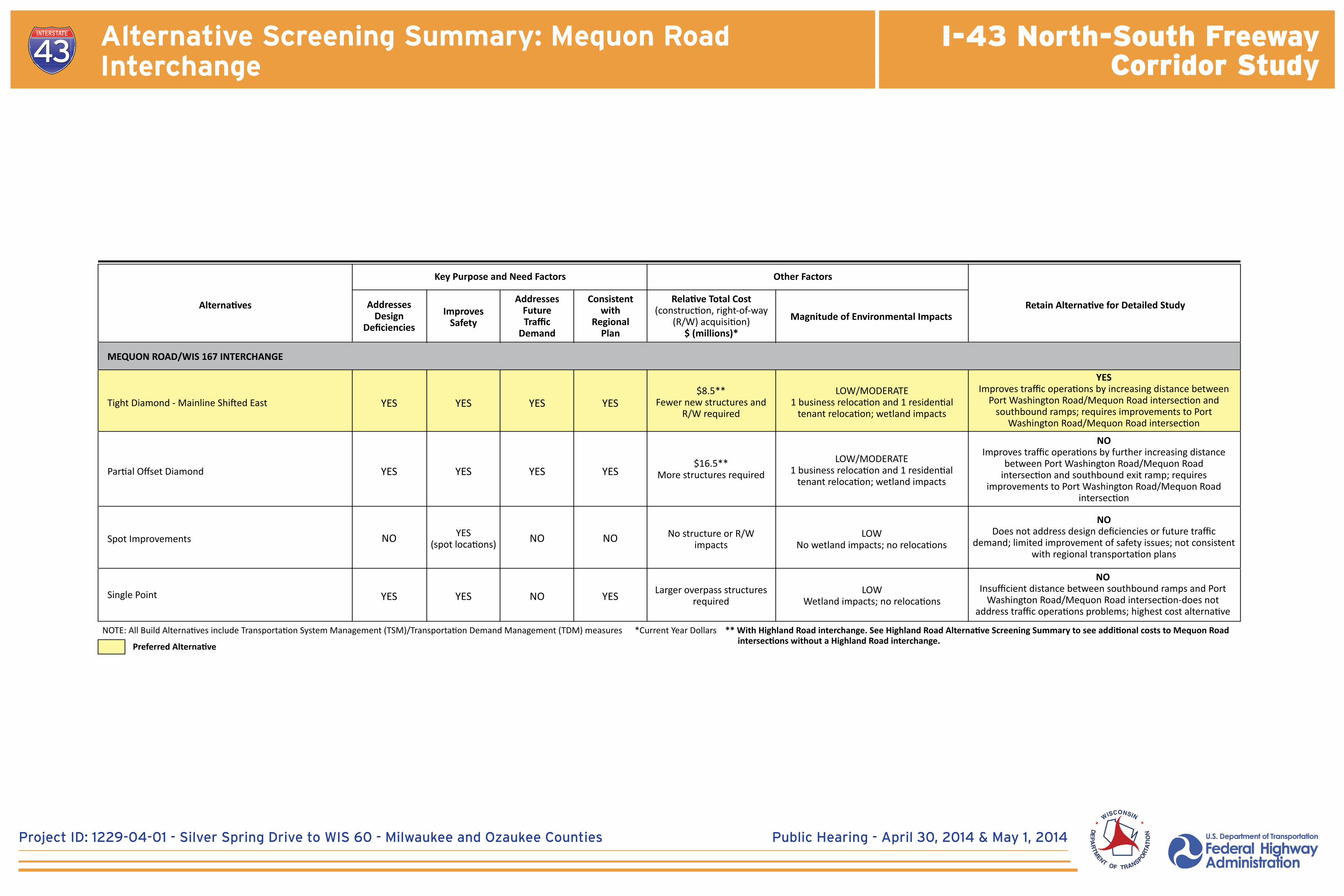
Alternative Screening Summary: Mequon Road Interchange
Retain Alternative for Detailed StudyAlternatives
MEQUON ROAD/WIS 167 INTERCHANGE
Tight Diamond - Mainline Shifted East
Partial Offset Diamond
Spot Improvements
Single Point
AddressesDesign
DeficienciesImproves
Safety
YES YES YES YES
YES YES YES YES
NO NO NO
LOW/MODERATE1 business relocation and 1 residential
tenant relocation; wetland impacts
LOW/MODERATE1 business relocation and 1 residential
tenant relocation; wetland impacts
LOWNo wetland impacts; no relocations
YESImproves traffic operations by increasing distance between
Port Washington Road/Mequon Road intersection and southbound ramps; requires improvements to Port
Washington Road/Mequon Road intersection
NODoes not address design deficiencies or future traffic
demand; limited improvement of safety issues; not consistent with regional transportation plans
NOImproves traffic operations by further increasing distance
between Port Washington Road/Mequon Road intersection and southbound exit ramp; requires
improvements to Port Washington Road/Mequon Road intersection
NOInsufficient distance between southbound ramps and Port
Washington Road/Mequon Road intersection-does not address traffic operations problems; highest cost alternative
LOWWetland impacts; no relocations
$8.5**Fewer new structures and
R/W required
$16.5**More structures required
Larger overpass structures required
No structure or R/Wimpacts
YES YES NO YES
Relative Total Cost(construction, right-of-way
(R/W) acquisition)$ (millions)*
Magnitude of Environmental Impacts
AddressesFutureTraffic
Demand
Consistentwith
RegionalPlan
Key Purpose and Need Factors Other Factors
NOTE: All Build Alternatives include Transportation System Management (TSM)/Transportation Demand Management (TDM) measures *Current Year Dollars ** With Highland Road interchange. See Highland Road Alternative Screening Summary to see additional costs to Mequon Road intersections without a Highland Road interchange.Preferred Alternative
YES(spot locations)

I-43 North-South FreewayCorridor Study
Project ID: 1229-04-01 - Silver Spring Drive to WIS 60 - Milwaukee and Ozaukee Counties Public Hearing - April 30, 2014 & May 1, 2014
Alternative Screening Summary: County Line Road Interchange
Retain Alternative for Detailed StudyAlternatives
COUNTY LINE ROAD INTERCHANGE
Split Diamond Hybrid
Partial Diamond
With Katherine Drivegrade separation
Without grade separation
With grade separation
With Katherine Drivegrade separation
Split Diamond
Full Diamond
Spot Improvements
AddressesDesign
DeficienciesImproves
Safety
YES YES YES
NOSEWRPC would
need to update long range plan to
include a full access interchange
YES YES YES
NOSEWRPC would
need to update long range plan to
include a full access interchange
NODoes not meet
FWHA Requirements to provide all traffic
movements
YES YES YES
YES YES YES
NOSEWRPC would
need to update long range plan to
include a full access interchange
NOSEWRPC would
need to update long range plan to
include a full access interchange
NOSEWRPC would
need to update long range plan to
include a full access interchange
NOSEWRPC would
need to update long range plan to
include a full access interchange
YES YES YES
LOW/MODERATENo relocations; 1 acre wetland impacts; travel pattern changes; maintains local
access
LOW/MODERATENo relocation; 1 acre wetland impacts
LOW/MODERATELimited R/W; wetland impacts
LOW/MODERATELimited R/W; wetland impacts
YESProvides for all traffic movements consistent with federal
policy; minimizes impacts to surrounding homes and businesses; maintains access for local traffic compared to
grade separated split diamond alternative
LOW/MODERATENo relocations; 1 acre wetland impacts; travel pattern changes; maintains local
access
YESProvides for all traffic movements consistent with federal
policy; minimizes impacts to surrounding homes and businesses; maintains access for local traffic compared to
grade separated split diamond alternative
YESDoes not provide for all traffic movements; addresses design deficiency of exit ramp weave movement with Brown Deer
Road interchange northbound exit ramp; serves the surrounding land use and community well
NOProvides standard full diamond interchange that provides for
all traffic movements consistent with federal policy
NOProvides for all traffic movements consistent with federal
policy; minimizes impacts to surrounding homes and businesses
NOProvides for all traffic movements consistent with federal
policy; minimizes impacts to surrounding homes and businesses
NOProvides for all traffic movements consistent with federal
policy; minimizes impacts to surrounding homes and businesses
NOAlternative has highest cost, R/W acquisition and
relocations compared to other alternatives that address design deficiencies, safety issues and future traffic demand
MODERATE/HIGHWetland impacts; 6 to 9 residential
relocations for new overpass; changed travel pattern
LOW/MODERATELimited R/W; wetland impacts; changed
travel pattern
LOWLimited R/W and wetland impacts, no
relocations
$20.1Construct new full
interchange; limitedR/W impacts
$22.9Construct new full
interchange; limitedR/W impacts
No Access YES YES N/A NO
LOW/MODERATEWetland impacts; no relocations; travel
pattern changes for surrounding community; traffic diverted to other
interchanges
YESAlternative would eliminate all access but does not adversely
affect design deficiencies, safety issues or future traffic demand; consistent with federal policy to avoid partial traffic
movements at interchanges
$12.9Two ramps removed;
new structures
$15.5
$16.5Construct new full
interchange
$19.4Construct new full
interchange
$28.8Construct new full
interchange; R/W impacts
$21.2Construct new full
interchange
Two ramps constructed;Limited R/W required
NO NOYES(spot locations)
NO
YES YES YES
YES YES YES
Relative Total Cost(construction, right-of-way
(R/W) acquisition)$ (millions)*
Magnitude of Environmental Impacts
AddressesFutureTraffic
Demand
Consistentwith
RegionalPlan
Key Purpose and Need Factors Other Factors
NOTE: All Build Alternatives include Transportation System Management (TSM)/Transportation Demand Management (TDM) measures *Current Year DollarsPreferred Alternative

I-43 North-South FreewayCorridor Study
Project ID: 1229-04-01 - Silver Spring Drive to WIS 60 - Milwaukee and Ozaukee Counties Public Hearing - April 30, 2014 & May 1, 2014
Alternative Screening Summary: Brown Deer Road Interchange
Retain Alternative for Detailed StudyAlternatives
BROWN DEER ROAD INTERCHANGE
Diamond
Diverging Diamond
Spot Improvements
Single Point
Horseshoe
AddressesDesign
DeficienciesImproves
Safety
YES YES YES YES
YES YES YES YES
NO NO NO
LOW/MODERATEWetland impacts; no relocations
LOW/MODERATEWetland impacts; no relocations
LOWLimited wetland impacts
YESIncreases distance between ramp terminal and Brown Deer
Road/Port Washington Road intersection; cost, traffic operations and R/W acquisition comparable to other
alternatives
NODoes not address design deficiencies or future traffic
demand; limited improvement of safety issues; not consistent with regional transportation plans
YESIncreases distance between ramp terminal and Brown Deer Road/Port Washington Road intersection; cost, traffic operations and R/W acquisition comparable to
other alternatives
NOSkewed angle between I-43 and Brown Deer Road creates traffic safety concerns with this interchange configuration
NOAlternative has highest cost, R/W acquisition and
relocations compared to other alternatives that address design deficiencies, safety issues and future traffic demand
LOWLimited wetland impacts; no relocations
MODERATE1 commercial relocation; wetland impacts
$12.2Minimal structures and R/W impacts; retains Brown Deer
Road bridges
$11.2Low R/W impacts; retains Brown Deer Road bridges
Minimal structures and R/W acquisition; retains Brown
Deer Road bridges
Minimal structures and R/W impacts
Multiple structures; R/W impacts; replaces Brown
Deer Road bridgesYES YES
NAAlternative
eliminated - no analysis
YES
YES NO YES YES
Relative Total Cost(construction, right-of-way
(R/W) acquisition)$ (millions)*
Magnitude of Environmental Impacts
AddressesFutureTraffic
Demand
Consistentwith
RegionalPlan
Key Purpose and Need Factors Other Factors
NOTE: All Build Alternatives include Transportation System Management (TSM)/Transportation Demand Management (TDM) measures *Current Year Dollars
Preferred Alternative
YES(spot locations)

I-43 North-South FreewayCorridor Study
Project ID: 1229-04-01 - Silver Spring Drive to WIS 60 - Milwaukee and Ozaukee Counties Public Hearing - April 30, 2014 & May 1, 2014
Alternative Screening Summary: Good Hope Road Interchange
Retain Alternative for Detailed StudyAlternatives
GOOD HOPE ROAD INTERCHANGE
Tight Diamond
Tight Diamond (Mainline Shifted West)
Spot Improvements
Diverging Diamond
Tight Diamond with Northbound Ramp Split (Hook Ramp)
Split Diamond
Single Point
Single Point with Northbound Ramp Split (Hook Ramp)
Horseshoe
AddressesDesign
DeficienciesImproves
Safety
YES YES YES YES
YES YES YES YES
NO NO NO
MODERATE1 residential relocations; wetland impacts
MODERATE2 residential relocations; wetland impacts
LOW1 residential relocation
MODERATE1 residential relocation; wetland impacts
MODERATE1 residential relocation; wetland
impacts
YESMaximizes distance between northbound ramp terminal intersection with Good Hope Road and the Good Hope
Road/Port Washington Road intersection; retains existing Good Hope Road bridges
NODoes not address design deficiencies or future traffic
demand; limited improvement of safety issues; not consistent with regional transportation plans
NOFurther increases distance between northbound ramp
terminal intersection with Good Hope Road and the Good Hope Road/Port Washington Road intersection
NOLocal concerns about commercial relocation and
neighborhood impacts of hook ramp
NOHigh cost; high R/W acquisition and relocation impacts;
potential traffic increase in residential area
NOSubstantial widening of Good Hope Road bridges needed to accommodate ramps; No added benefit compared to tight
diamond alternatives
NODoes not address future traffic demand; short weaving distance between ramp terminals and Port Washington
Road; creates lane continuity issues at Port Washington Road
NOHigh cost; high R/W acquisition and relocation impacts
NOSimilar to Single Point, but traffic operations improved with
separate northbound hook; local concerns about commercial relocation and neighborhood impacts of hook ramp
MODERATE1 residential relocations and 1 business
relocation; wetland impacts
MODERATE/HIGH3 residential relocations; wetland impacts;
increases traffic volume on Green Tree Road
MODERATE2 residential relocations; wetland impacts
MODERATE1 residential and 1 business relocation;
wetland impacts
$17.3Relatively low construction
cost; retains Good Hope Road bridges; R/W impacts
$18.3Relatively low construction cost; replaces Good Hope
Road bridges; R/W impacts
Relatively low cost interchange to construct; retains Good Hope Road
bridges; lower R/W acquisition
Relatively low cost interchange to construct; retains Good Hope Road bridges; R/W acquisition
No right-of-way (R/W) impacts
Similar to Single Point but slightly higher R/W impact
Relatively low cost interchange to construct;
widens existing Good Hope Road bridge; R/W acquisition
Multiple structures; high R/W acquisition; retains Good Hope Road bridges
Multiple structures; replaces Good Hope Road bridges;
R/W impacts
YES YES
NAAlternative
eliminated - no analysis
NAAlternative
eliminated - no analysis
YES
YES YES NO NO
YES YES YES YES
YES YES YES YES
YES YES YES
YES YESYES with
modification (tight right
turn)
YES
Relative Total Cost(construction, right-of-way
(R/W) acquisition)$ (millions)*
Magnitude of Environmental Impacts
AddressesFutureTraffic
Demand
Consistentwith
RegionalPlan
Key Purpose and Need Factors Other Factors
NOTE: All Build Alternatives include Transportation System Management (TSM)/Transportation Demand Management (TDM) measures *Current Year Dollars
Preferred Alternative
YES(spot locations)
I-43 North-South FreewayCorridor Study
Project ID: 1229-04-01 - Silver Spring Drive to WIS 60 - Milwaukee and Ozaukee Counties Public Hearing - April 30, 2014 & May 1, 2014
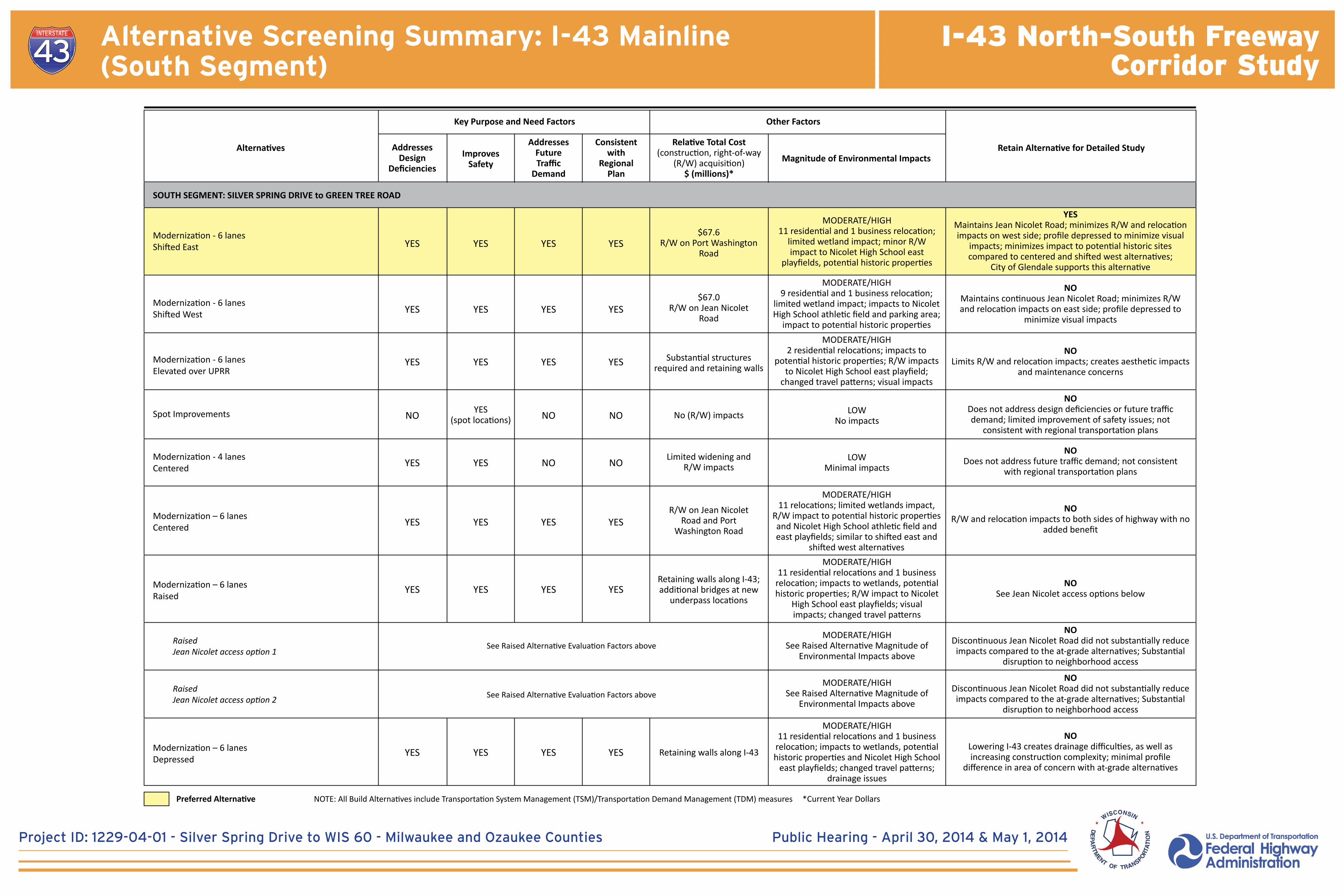
Alternative Screening Summary: I-43 Mainline (South Segment)
RaisedJean Nicolet access option 1
RaisedJean Nicolet access option 2
See Raised Alternative Evaluation Factors above
See Raised Alternative Evaluation Factors above
Retain Alternative for Detailed StudyAlternatives
SOUTH SEGMENT: SILVER SPRING DRIVE to GREEN TREE ROAD
Modernization - 6 lanesShifted East
Modernization - 6 lanesShifted West
Modernization - 6 lanesElevated over UPRR
Modernization – 6 lanesCentered
Spot Improvements
Modernization - 4 lanesCentered
Modernization – 6 lanesRaised
Modernization – 6 lanesDepressed
AddressesDesign
DeficienciesImproves
Safety
YES YES YES YES
YES YES YES YES
YES YES YES YES
MODERATE/HIGH11 residential and 1 business relocation;
limited wetland impact; minor R/W impact to Nicolet High School east
playfields, potential historic properties
MODERATE/HIGH9 residential and 1 business relocation;
limited wetland impact; impacts to Nicolet High School athletic field and parking area;
impact to potential historic propertiesMODERATE/HIGH
2 residential relocations; impacts to potential historic properties; R/W impacts
to Nicolet High School east playfield; changed travel patterns; visual impacts
MODERATE/HIGH11 relocations; limited wetlands impact,
R/W impact to potential historic properties and Nicolet High School athletic field and east playfields; similar to shifted east and
shifted west alternativesMODERATE/HIGH
11 residential relocations and 1 business relocation; impacts to wetlands, potential historic properties; R/W impact to Nicolet
High School east playfields; visual impacts; changed travel patterns
YESMaintains Jean Nicolet Road; minimizes R/W and relocation impacts on west side; profile depressed to minimize visual
impacts; minimizes impact to potential historic sites compared to centered and shifted west alternatives;
City of Glendale supports this alternative
NOLimits R/W and relocation impacts; creates aesthetic impacts
and maintenance concerns
NOMaintains continuous Jean Nicolet Road; minimizes R/W and relocation impacts on east side; profile depressed to
minimize visual impacts
NODoes not address design deficiencies or future traffic demand; limited improvement of safety issues; not
consistent with regional transportation plans
NODoes not address future traffic demand; not consistent
with regional transportation plans
NOSee Jean Nicolet access options below
NOR/W and relocation impacts to both sides of highway with no
added benefit
NODiscontinuous Jean Nicolet Road did not substantially reduce impacts compared to the at-grade alternatives; Substantial
disruption to neighborhood access
NOLowering I-43 creates drainage difficulties, as well as increasing construction complexity; minimal profile
difference in area of concern with at-grade alternatives
NODiscontinuous Jean Nicolet Road did not substantially reduce impacts compared to the at-grade alternatives; Substantial
disruption to neighborhood access
LOW No impacts
LOW Minimal impacts
MODERATE/HIGHSee Raised Alternative Magnitude of
Environmental Impacts above
MODERATE/HIGH11 residential relocations and 1 business
relocation; impacts to wetlands, potential historic properties and Nicolet High School
east playfields; changed travel patterns; drainage issues
MODERATE/HIGHSee Raised Alternative Magnitude of
Environmental Impacts above
Retaining walls along I-43
$67.6R/W on Port Washington
Road
$67.0R/W on Jean Nicolet
Road
R/W on Jean NicoletRoad and Port
Washington Road
No (R/W) impacts
Substantial structures required and retaining walls
Retaining walls along I-43; additional bridges at new
underpass locations
Limited widening andR/W impactsYES YES NO NO
YES YES YES YES
YES YES YES YES
NO NO NO
YES YES YES YES
Relative Total Cost(construction, right-of-way
(R/W) acquisition)$ (millions)*
Magnitude of Environmental Impacts
AddressesFutureTraffic
Demand
Consistentwith
RegionalPlan
Key Purpose and Need Factors Other Factors
NOTE: All Build Alternatives include Transportation System Management (TSM)/Transportation Demand Management (TDM) measures *Current Year DollarsPreferred Alternative
YES(spot locations)
I-43 North-South FreewayCorridor Study
Public Hearing - April 30, 2014 & May 1, 2014
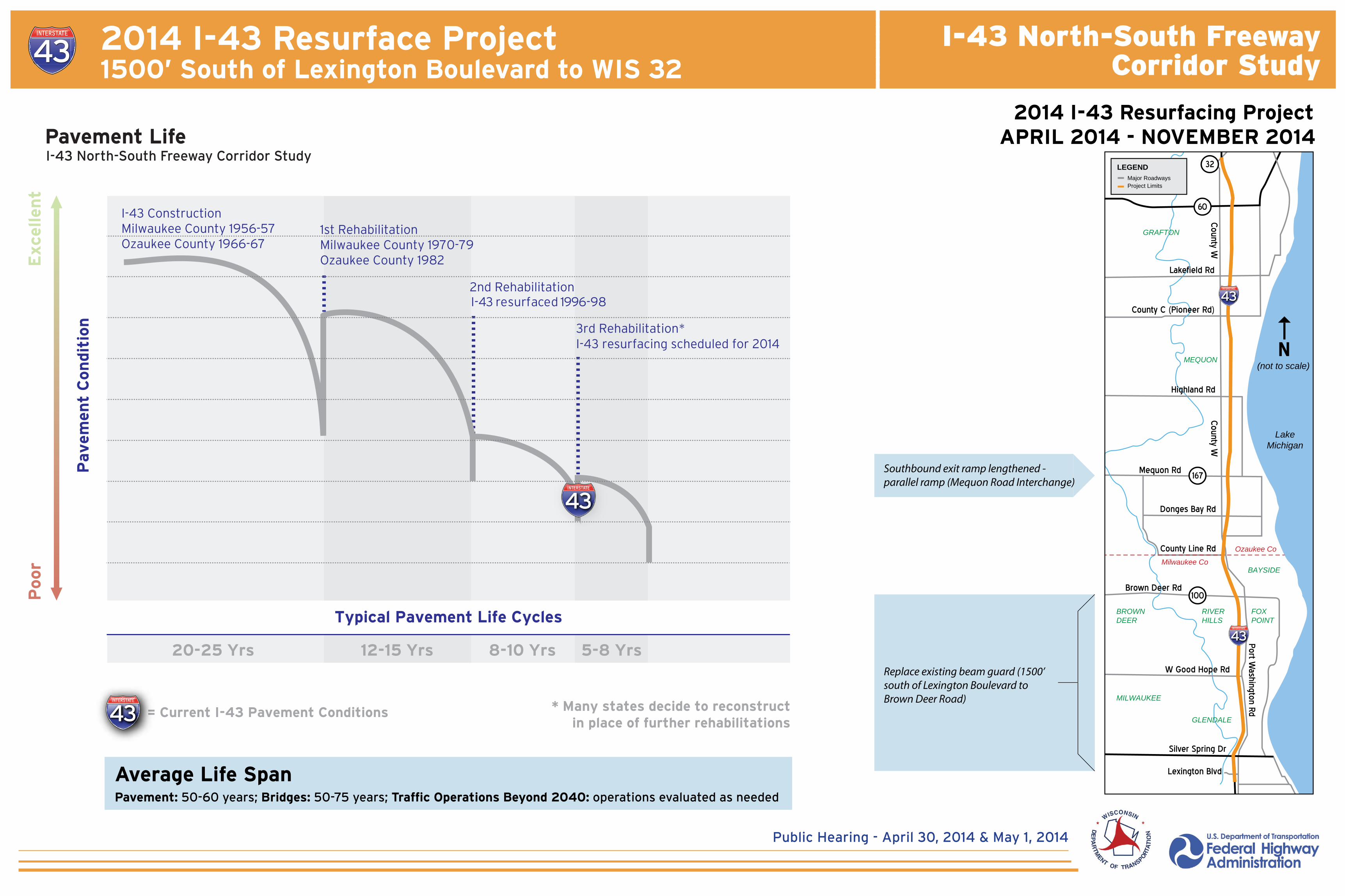
2014 I-43 Resurface Project1500’ South of Lexington Boulevard to WIS 32
1st RehabilitationMilwaukee County 1970-79Ozaukee County 1982
I-43 ConstructionMilwaukee County 1956-57Ozaukee County 1966-67
2nd Rehabilitation
3rd Rehabilitation*
Exce
llen
tP
oor
Pavem
ent
Con
dit
ion
* Many states decide to reconstructin place of further rehabilitations
Typical Pavement Life Cycles
I-43 resurfaced 1996-98
I-43 resurfacing scheduled for 2014
= Current I-43 Pavement Conditions
12-15 Yrs20-25 Yrs 8-10 Yrs 5-8 Yrs
Pavement LifeI-43 North-South Freeway Corridor Study
60
167
100
Silver Spring Dr
W Good Hope Rd
Highland Rd
CTH
W
CTH
W
Port Washington Rd
Lakefield Rd
County Line Rd
Donges Bay Rd
LakeMichigan
(not to scale)
FOXPOINT
RIVERHILLS
BROWNDEER
MILWAUKEE
GLENDALE
BAYSIDE
Lexington Blvd
Ozaukee Co
Milwaukee Co
MEQUON
GRAFTON
LEGENDMajor Roadways
N
Mequon Rd
Brown Deer Rd
County C (Pioneer Rd)
County W
County W
Project Limits
32
APRIL 2014 - NOVEMBER 20142014 I-43 Resurfacing Project
Average Life SpanPavement: 50-60 years; Bridges: 50-75 years; Traffic Operations Beyond 2040: operations evaluated as needed
Southbound exit ramp lengthened - parallel ramp (Mequon Road Interchange)
Replace existing beam guard (1500’ south of Lexington Boulevard to Brown Deer Road)
Project ID: 1229-04-01 - Silver Spring Drive to WIS 60 - Milwaukee and Ozaukee Counties Public Hearing - April 30, 2014 & May 1, 2014
TOWN OF GRAFTON
VILLAGE OF GRAFTON
MEQUON
Lake Michigan
ULA
O R
OA
DW
IS 6
0
FALLS
ROA
D
LAKEFIE
LD R
OA
D
PIO
NEER R
OA
DCOU
NTY
C
BON
NIW
ELL R
OA
D
HIG
HLA
ND R
OA
D
GLE
N O
AKS LA
NE
WIS
167
DON
GES B
AY
ROA
D
MEQ
UON
ROA
D
PORT WASHINGTON ROAD
LAKESHORE DRIVE
UNION PACIFIC RAILROAD
PORT WASHINGTON ROAD
Milwaukee River
Ulao Creek
Aerial - SEWRPC 2010
(not shown to scale)
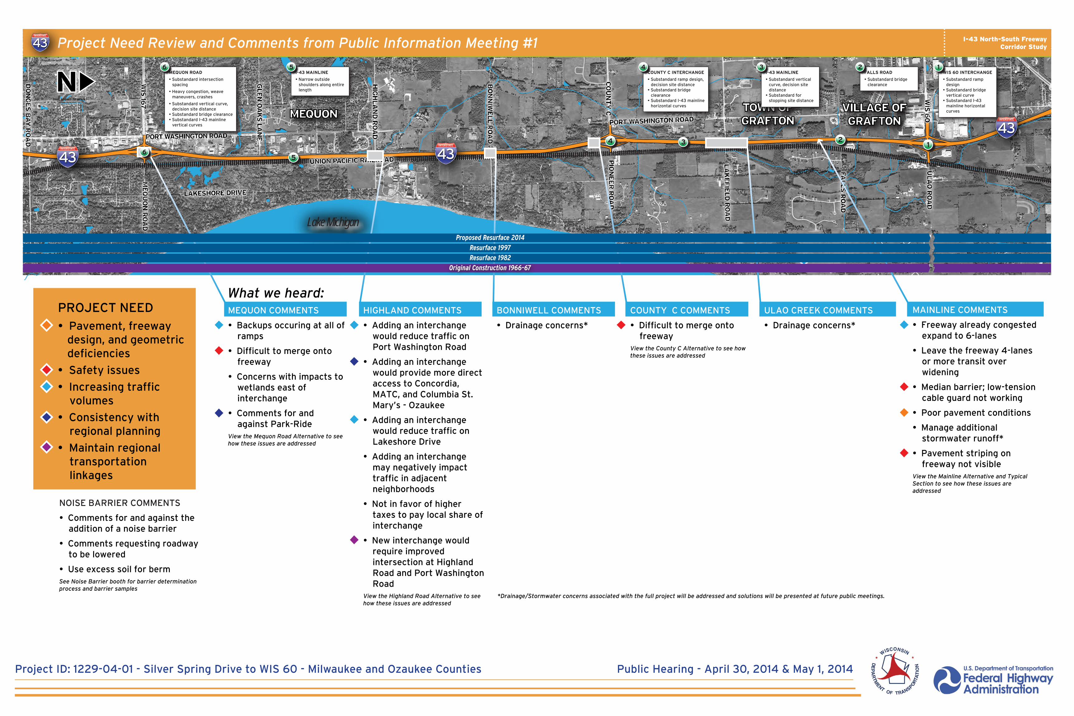
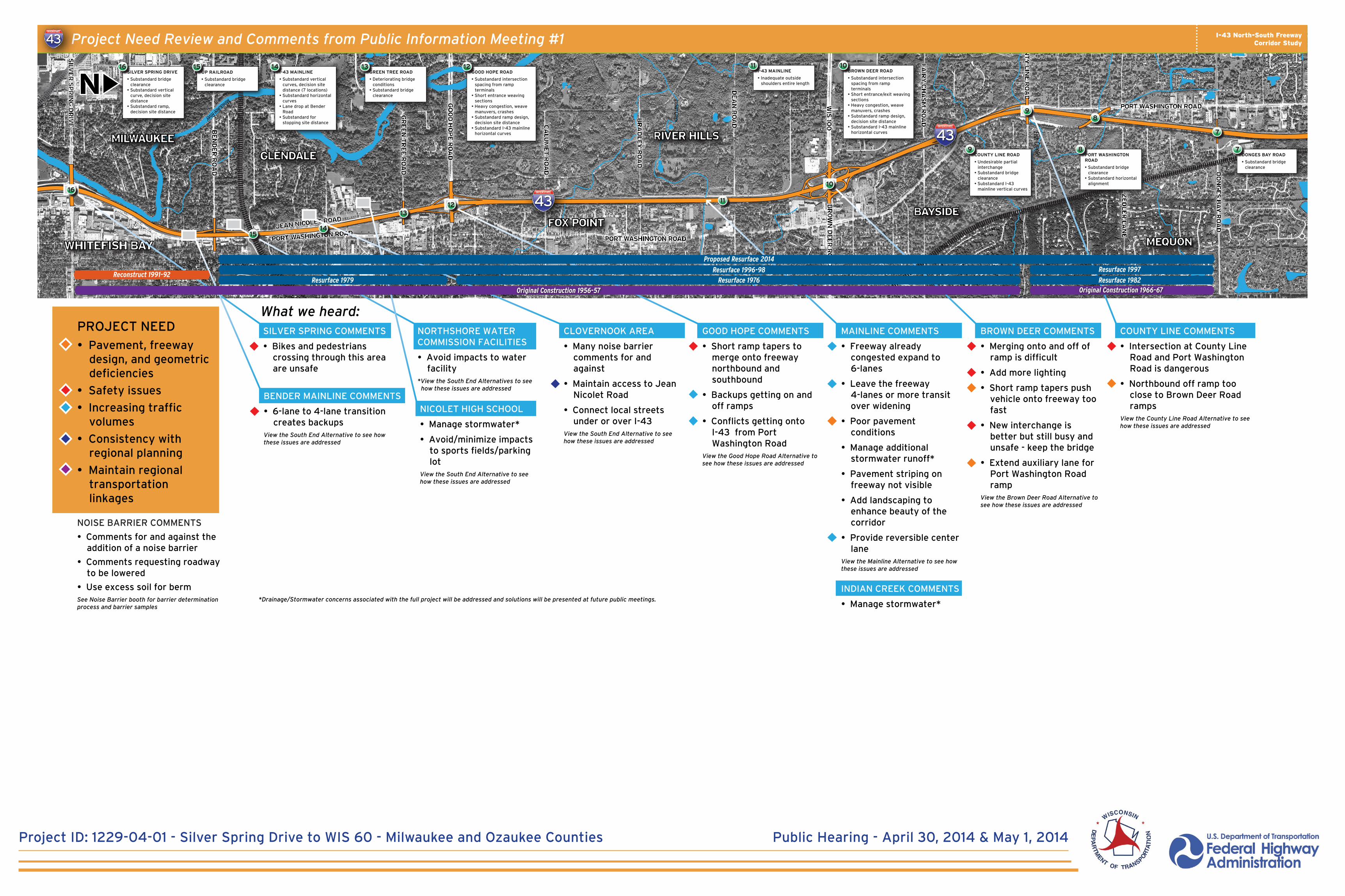
PROJECT NEED
• Pavement, freeway design, and geometric deficiencies
• Safety issues
• Increasing traffic volumes
• Consistency with regional planning
• Maintain regional transportation linkages
What we heard:MAINLINE COMMENTS
• Freeway already congested expand to 6-lanes
• Leave the freeway 4-lanes or more transit over widening
• Median barrier; low-tension cable guard not working
• Poor pavement conditions
• Manage additional stormwater runoff*
• Pavement striping on freeway not visible
View the Mainline Alternative and Typical Section to see how these issues are addressed
ULAO CREEK COMMENTS
• Drainage concerns*
COUNTY C COMMENTS
• Difficult to merge onto freeway
View the County C Alternative to see how these issues are addressed
BONNIWELL COMMENTS
• Drainage concerns*
MEQUON COMMENTS
• Backups occuring at all of ramps
• Difficult to merge onto freeway
• Concerns with impacts to wetlands east of interchange
• Comments for and against Park-Ride
View the Mequon Road Alternative to see how these issues are addressed
HIGHLAND COMMENTS
• Adding an interchange would reduce traffic on Port Washington Road
• Adding an interchange would provide more direct access to Concordia, MATC, and Columbia St. Mary’s - Ozaukee
• Adding an interchange would reduce traffic on Lakeshore Drive
• Adding an interchange may negatively impact traffic in adjacent neighborhoods
• Not in favor of higher taxes to pay local share of interchange
• New interchange would require improved intersection at Highland Road and Port Washington Road
View the Highland Road Alternative to see how these issues are addressed
NOISE BARRIER COMMENTS
• Comments for and against the addition of a noise barrier
• Comments requesting roadway to be lowered
• Use excess soil for bermSee Noise Barrier booth for barrier determination process and barrier samples
1
WIS 60 INTERCHANGE
• Substandard ramp design
• Substandard bridge vertical curve
• Substandard I-43 mainline horizontal curves
1I-43 MAINLINE
• Substandard vertical curve, decision site distance
• Substandard for stopping site distance
3I-43 MAINLINE
• Narrow outside shoulders along entire length
5MEQUON ROAD
• Substandard intersection spacing
• Heavy congestion, weave maneuvers, crashes
• Substandard vertical curve, decision site distance
• Substandard bridge clearance• Substandard I-43 mainline
vertical curves
6
6
COUNTY C INTERCHANGE
• Substandard ramp design, decision site distance
• Substandard bridge clearance
• Substandard I-43 mainline horizontal curves
4FALLS ROAD
• Substandard bridge clearance
2
234
5
*Drainage/Stormwater concerns associated with the full project will be addressed and solutions will be presented at future public meetings.
Resurface 1982
Resurface 1997
Proposed Resurface 2014
Original Construction 1966-67
I-43 North-South FreewayCorridor StudyProject Need Review and Comments from Public Information Meeting #1
Project ID: 1229-04-01 - Silver Spring Drive to WIS 60 - Milwaukee and Ozaukee Counties Public Hearing - April 30, 2014 & May 1, 2014
Project ID: 1229-04-01 - Silver Spring Drive to WIS 60 - Milwaukee and Ozaukee Counties Public Hearing - April 30, 2014 & May 1, 2014
MILWAUKEE
GLENDALE
RIVER HILLS
BAYSIDE
MEQUON
FOX POINT
DON
GES B
AY
ROA
D
ZEDLE
R LA
NE
COU
NTY
LINE R
OA
D
PORT WASHINGTON ROAD
FAIR
Y C
HASM
ROA
D
WIS
100
BROW
N D
EER R
OA
D
DEA
N R
OA
D
BRA
DLE
Y R
OA
D
CA
LUM
ET R
OA
D
GOOD H
OPE R
OA
D
GREEN
TREE R
OA
D
SILV
ER S
PRIN
G D
RIV
E
PORT WASHINGTON ROADPORT WASHINGTON ROADJEAN NICOLET ROAD
BEN
DER R
OA
D
Indian Creek
Fish Creek
Milwaukee RiverMilwaukee River
WHITEFISH BAY
Aerial - SEWRPC 2010
(not shown to scale)
COUNTY LINE COMMENTS
• Intersection at County Line Road and Port Washington Road is dangerous
• Northbound off ramp too close to Brown Deer Road ramps
View the County Line Road Alternative to see how these issues are addressed
BROWN DEER COMMENTS
• Merging onto and off of ramp is difficult
• Add more lighting
• Short ramp tapers push vehicle onto freeway too fast
• New interchange is better but still busy and unsafe - keep the bridge
• Extend auxiliary lane for Port Washington Road ramp
View the Brown Deer Road Alternative to see how these issues are addressed
INDIAN CREEK COMMENTS
• Manage stormwater*
MAINLINE COMMENTS
• Freeway already congested expand to 6-lanes
• Leave the freeway 4-lanes or more transit over widening
• Poor pavement conditions
• Manage additional stormwater runoff*
• Pavement striping on freeway not visible
• Add landscaping to enhance beauty of the corridor
• Provide reversible center lane
View the Mainline Alternative to see how these issues are addressed
CLOVERNOOK AREA
• Many noise barrier comments for and against
• Maintain access to Jean Nicolet Road
• Connect local streets under or over I-43
View the South End Alternative to see how these issues are addressed
NORTHSHORE WATER COMMISSION FACILITIES
• Avoid impacts to water facility
*View the South End Alternatives to see how these issues are addressed
NICOLET HIGH SCHOOL
• Manage stormwater*
• Avoid/minimize impacts to sports fields/parking lot
View the South End Alternative to see how these issues are addressed
SILVER SPRING COMMENTS
• Bikes and pedestrians crossing through this area are unsafe
GOOD HOPE COMMENTS
• Short ramp tapers to merge onto freeway northbound and southbound
• Backups getting on and off ramps
• Conflicts getting onto I-43 from Port Washington Road
View the Good Hope Road Alternative to see how these issues are addressed
BENDER MAINLINE COMMENTS
• 6-lane to 4-lane transition creates backups
View the South End Alternative to see how these issues are addressed
PROJECT NEED• Pavement, freeway
design, and geometric deficiencies
• Safety issues
• Increasing traffic volumes
• Consistency with regional planning
• Maintain regional transportation linkages
PORT WASHINGTON ROAD
• Substandard bridge clearance
• Substandard horizontal alignment
8COUNTY LINE ROAD
• Undesirable partial interchange
• Substandard bridge clearance
• Substandard I-43 mainline vertical curves
9
I-43 MAINLINE
• Inadequate outside shoulders entire length
NOISE BARRIER COMMENTS
• Comments for and against the addition of a noise barrier
• Comments requesting roadway to be lowered
• Use excess soil for bermSee Noise Barrier booth for barrier determination process and barrier samples
11
11
BROWN DEER ROAD
• Substandard intersection spacing from ramp terminals
• Short entrance/exit weaving sections
• Heavy congestion, weave manuvers, crashes
• Substandard ramp design, decision site distance
• Substandard I-43 mainline horizontal curves
10
10
GOOD HOPE ROAD
• Substandard intersection spacing from ramp terminals
• Short entrance weaving sections
• Heavy congestion, weave manuvers, crashes
• Substandard ramp design, decision site distance
• Substandard I-43 mainline horizontal curves
12
1213
I-43 MAINLINE
• Substandard vertical curves, decision site distance (7 locations)
• Substandard horizontal curves
• Lane drop at Bender Road
• Substandard for stopping site distance
14
14
GREEN TREE ROAD
• Deteriorating bridge conditions
• Substandard bridge clearance
13UP RAILROAD
• Substandard bridge clearance
15
15
SILVER SPRING DRIVE
• Substandard bridge clearance
• Substandard vertical curve, decision site distance
• Substandard ramp, decision site distance
16
16
98
DONGES BAY ROAD
• Substandard bridge clearance
7
7
What we heard:
*Drainage/Stormwater concerns associated with the full project will be addressed and solutions will be presented at future public meetings.
Resurface 1976Resurface 1979Reconstruct 1991-92
Resurface 1982
Resurface 1997Resurface 1996-98
Proposed Resurface 2014
Original Construction 1956-57 Original Construction 1966-67
I-43 North-South FreewayCorridor StudyProject Need Review and Comments from Public Information Meeting #1
Project ID: 1229-04-01 - Silver Spring Drive to WIS 60 - Milwaukee and Ozaukee Counties Public Hearing - April 30, 2014 & May 1, 2014
I-43 North-South FreewayCorridor Study
Project ID: 1229-04-01 - Silver Spring Drive to WIS 60 - Milwaukee and Ozaukee Counties Public Hearing - April 30, 2014 & May 1, 2014
60
167100
Silver Spring Dr
W G
ood Hope Rd
Highland Rd
Mequon Rd
Brown D
eer Rd
Port Washington Rd
Port Washington Rd
County C
(Pioneer Rd)
Lakefield Rd
County Line Rd
Donges Bay Rd
(not to scale)FOXPOINT
RIVERHILLS
GLENDALE
BAYSIDE
Ozaukee C
oM
ilwaukee C
o
MEQUON GRAFTON
N
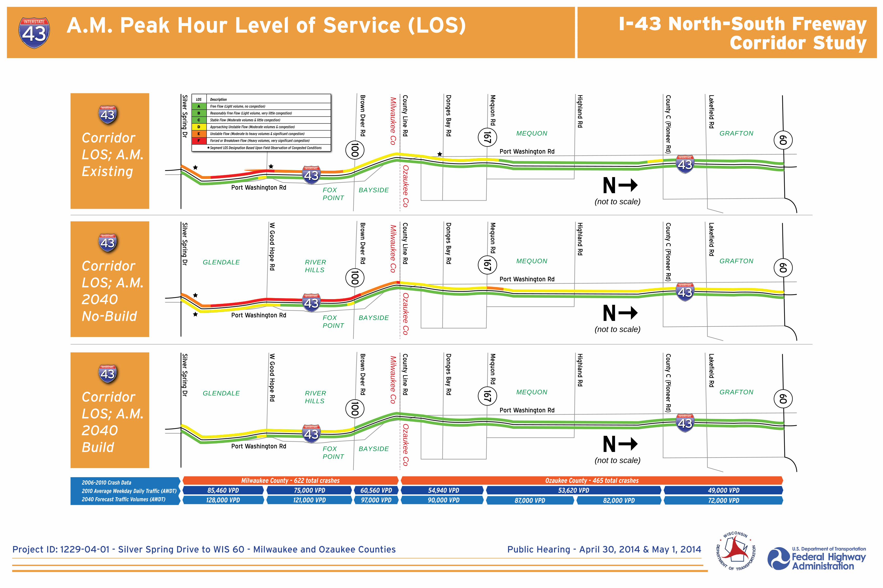
CorridorLOS; A.M.2040Build
60
167100
Silver Spring Dr
W G
ood Hope Rd
Highland Rd
Mequon Rd
Brown D
eer Rd
Port Washington Rd
Port Washington Rd
County C
(Pioneer Rd)
Lakefield Rd
County Line Rd
Donges Bay Rd
(not to scale)FOXPOINT
RIVERHILLS
GLENDALE
BAYSIDE
Ozaukee C
oM
ilwaukee C
o
MEQUON GRAFTON
N
CorridorLOS; A.M.2040No-Build
60
167100
Silver Spring Dr
W G
ood Hope Rd
Highland Rd
Mequon Rd
Brown D
eer Rd
Port Washington Rd
Port Washington Rd
County C
(Pioneer Rd)
Lakefield Rd
County Line Rd
Donges Bay Rd
(not to scale)FOXPOINT
RIVERHILLS
GLENDALE
BAYSIDE
Ozaukee C
oM
ilwaukee C
o
MEQUON GRAFTON
N
CorridorLOS; A.M.Existing *
LOS
A
B
C
D
E
F
Description
Free Flow (Light volume, no congestion)
Reasonably Free Flow (Light volume, very little congestion)
Stable Flow (Moderate volumes & little congestion)
Approaching Unstable Flow (Moderate volumes & congestion)
Unstable Flow (Moderate to heavy volumes & significant congestion)
Forced or Breakdown Flow (Heavy volumes, very significant congestion)
Segment LOS Designation Based Upon Field Observation of Congested Conditions
2010 Average Weekday Daily Traffic (AWDT)
2040 Forecast Traffic Volumes (AWDT)
2006-2010 Crash Data
75,000 VPD 60,560 VPD
97,000 VPD
54,940 VPD
90,000 VPD
49,000 VPD
72,000 VPD
53,620 VPD
87,000 VPD 82,000 VPD
Milwaukee County - 622 total crashes Ozaukee County - 465 total crashes
85,460 VPD
128,000 VPD 121,000 VPD
A.M. Peak Hour Level of Service (LOS)
I-43 North-South FreewayCorridor Study
Project ID: 1229-04-01 - Silver Spring Drive to WIS 60 - Milwaukee and Ozaukee Counties Public Hearing - April 30, 2014 & May 1, 2014
60
167100
Silver Spring Dr
W G
ood Hope Rd
Highland Rd
Mequon Rd
Brown D
eer Rd
Port Washington Rd
Port Washington Rd
County C
(Pioneer Rd)
Lakefield Rd
County Line Rd
Donges Bay Rd
(not to scale)FOXPOINT
RIVERHILLS
GLENDALE
BAYSIDE
Ozaukee C
oM
ilwaukee C
o
MEQUON GRAFTON
N
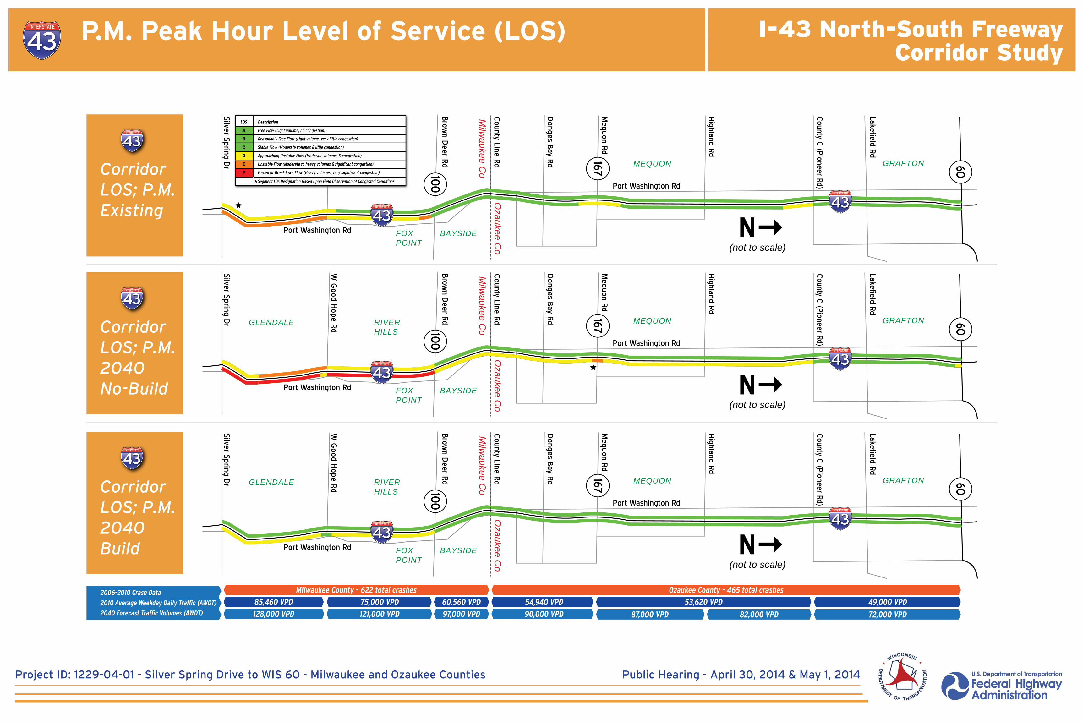
CorridorLOS; P.M.2040Build
60
167100
Silver Spring Dr
W G
ood Hope Rd
Highland Rd
Mequon Rd
Brown D
eer Rd
Port Washington Rd
Port Washington Rd
County C
(Pioneer Rd)
Lakefield Rd
County Line Rd
Donges Bay Rd
(not to scale)FOXPOINT
RIVERHILLS
GLENDALE
BAYSIDE
Ozaukee C
oM
ilwaukee C
o
MEQUON GRAFTON
N
CorridorLOS; P.M.2040No-Build
60
167100
Silver Spring Dr
W G
ood Hope Rd
Highland Rd
Mequon Rd
Brown D
eer Rd
Port Washington Rd
Port Washington Rd
County C
(Pioneer Rd)
Lakefield Rd
County Line Rd
Donges Bay Rd
(not to scale)FOXPOINT
RIVERHILLS
GLENDALE
BAYSIDE
Ozaukee C
oM
ilwaukee C
o
MEQUON GRAFTON
N
CorridorLOS; P.M. Existing
LOS
A
B
C
D
E
F
Description
Free Flow (Light volume, no congestion)
Reasonably Free Flow (Light volume, very little congestion)
Stable Flow (Moderate volumes & little congestion)
Approaching Unstable Flow (Moderate volumes & congestion)
Unstable Flow (Moderate to heavy volumes & significant congestion)
Forced or Breakdown Flow (Heavy volumes, very significant congestion)
Segment LOS Designation Based Upon Field Observation of Congested Conditions
2010 Average Weekday Daily Traffic (AWDT)
2040 Forecast Traffic Volumes (AWDT)
2006-2010 Crash Data
75,000 VPD 60,560 VPD
97,000 VPD
54,940 VPD
90,000 VPD
49,000 VPD
72,000 VPD
53,620 VPD
87,000 VPD 82,000 VPD
85,460 VPD
128,000 VPD 121,000 VPD
Milwaukee County - 622 total crashes Ozaukee County - 465 total crashes
P.M. Peak Hour Level of Service (LOS)
I-43 North-South FreewayCorridor Study
Project ID: 1229-04-01 - Silver Spring Drive to WIS 60 - Milwaukee and Ozaukee Counties Public Hearing - April 30, 2014 & May 1, 2014
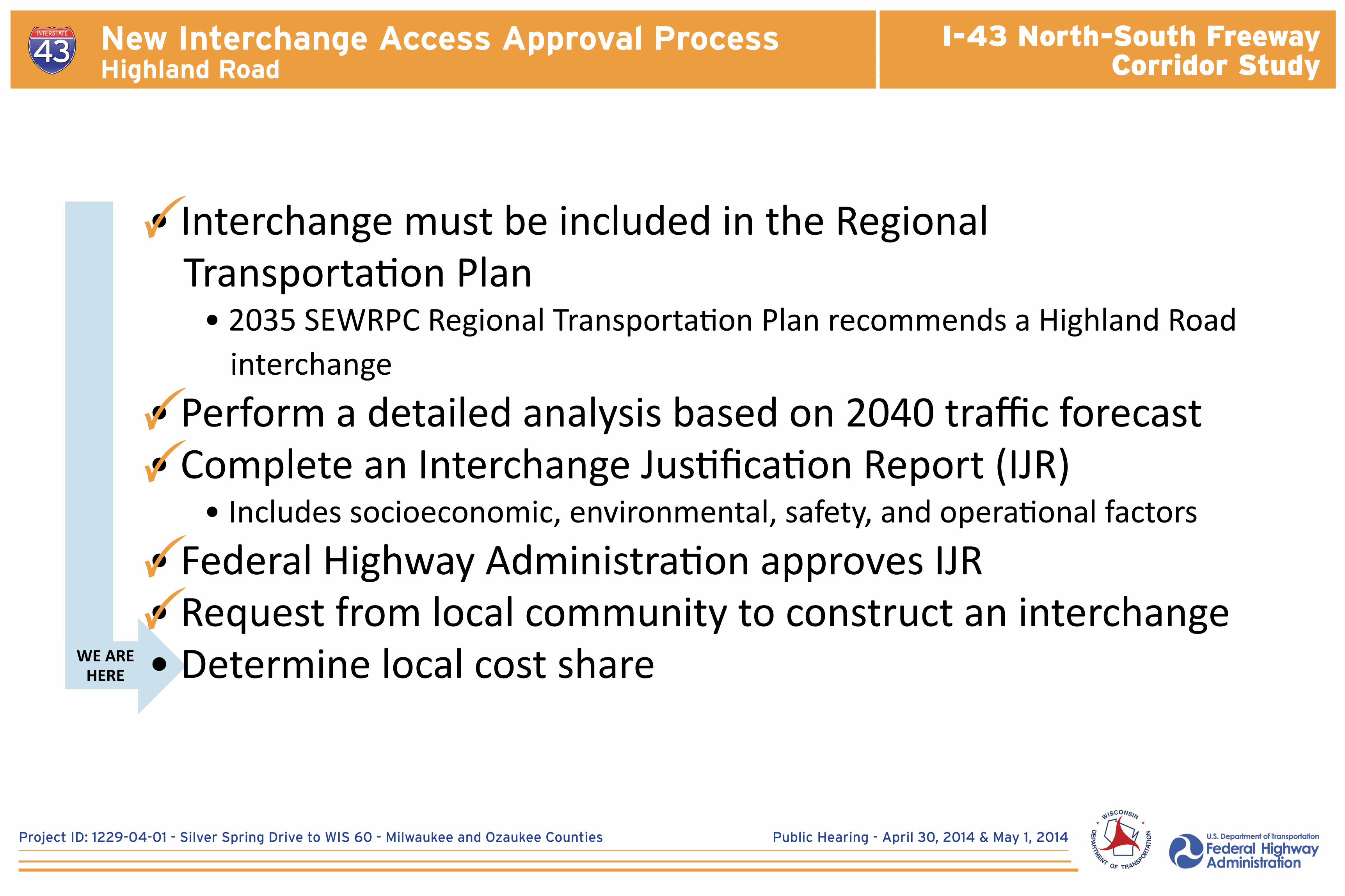
WE AREHERE
• Interchange must be included in the Regional Transportation Plan
• 2035 SEWRPC Regional Transportation Plan recommends a Highland Road interchange
• Perform a detailed analysis based on 2040 traffic forecast• Complete an Interchange Justification Report (IJR) • Includes socioeconomic, environmental, safety, and operational factors• Federal Highway Administration approves IJR• Request from local community to construct an interchange• Determine local cost share
New Interchange Access Approval Process Highland Road
I-43 North-South FreewayCorridor Study
Project ID: 1229-04-01 - Silver Spring Drive to WIS 60 - Milwaukee and Ozaukee Counties Public Hearing - April 30, 2014 & May 1, 2014
Transportation Demand Management - Public Transit
#****
#
X
##**** ##
#
#
#****
###
#
#**** #
#****
#****
# ###****
#
#****
#X
#
#
#
#****
#****
#
# #****
#****
X
#
X
XY
#****
#****
#
#****
#****
X
#
XY
X
#
X#****
#****#****##
#
#
# #
#****#
# ##
#****#
#
#
#****
#
#****X
##
#****
#****
#****
XY
#****#
#
#
#
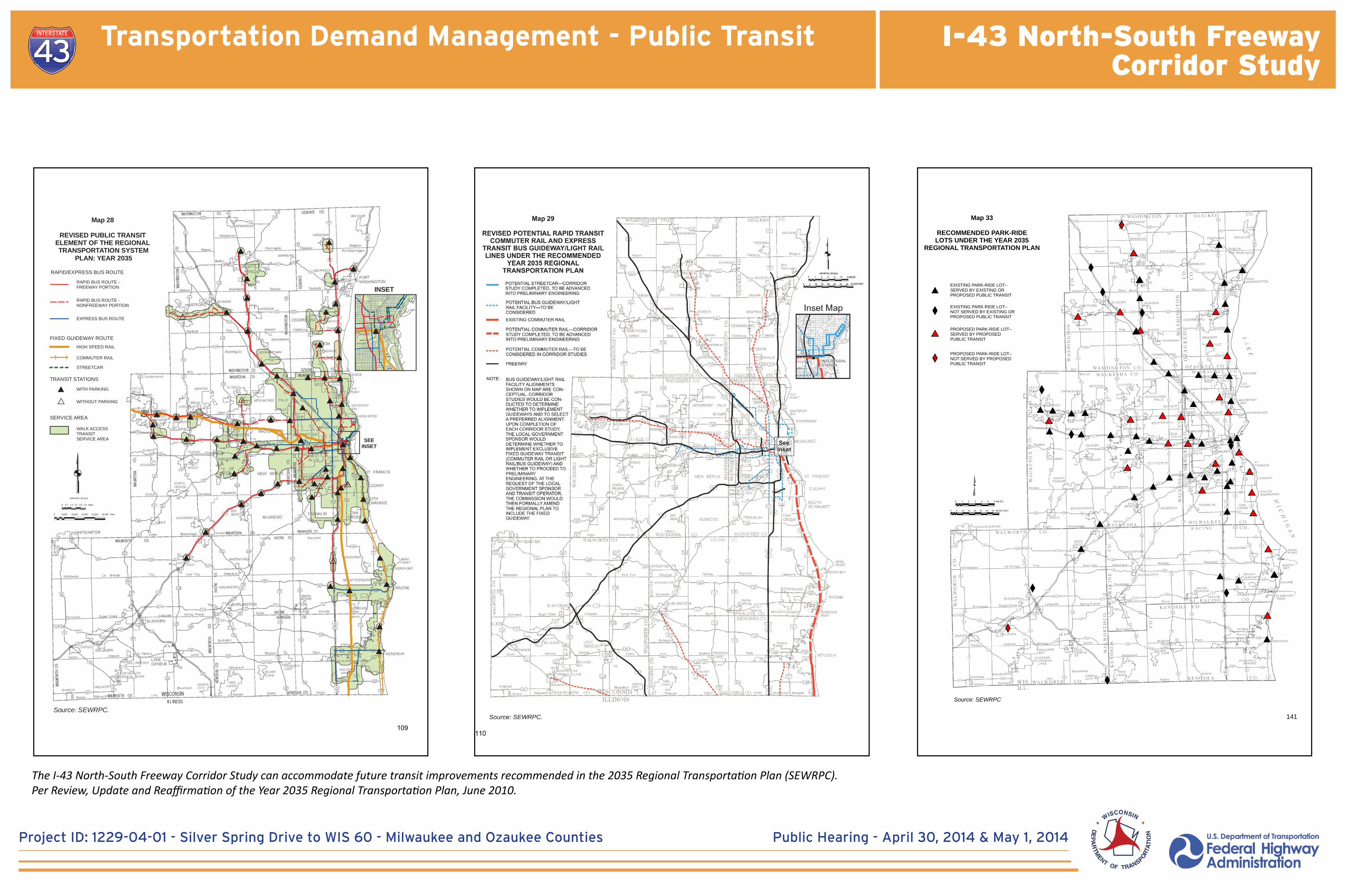
Map 33
RECOMMENDED PARK-RIDELOTS UNDER THE YEAR 2035
REGIONAL TRANSPORTATION PLAN
Source: SEWRPC
0 1 2 3 4 5 6 MILES
³FEET0 5 10 15 20 25 30 35 40,000
#
X
#****
XY
EXISTING PARK-RIDE LOT--SERVED BY EXISTING OR PROPOSED PUBLIC TRANSIT
EXISTING PARK-RIDE LOT--NOT SERVED BY EXISTING OR PROPOSED PUBLIC TRANSIT
PROPOSED PARK-RIDE LOT--SERVED BY PROPOSED PUBLIC TRANSIT
PROPOSED PARK-RIDE LOT--NOT SERVED BY PROPOSED PUBLIC TRANSIT
141
## ##
#
****#
#
###
#
# #
#
#
# ##
#
#
#
#
********
****
****
#
#
#
****
#
##
#
###
#
#
#
#
#
****
#
# #
#
****
##
#
##
#
#
#
#
#
#
#
#
#
#
#****
#
#
#
#
#
#
#
#
#
Map 28
REVISED PUBLIC TRANSIT ELEMENT OF THE REGIONAL TRANSPORTATION SYSTEM
PLAN: YEAR 2035
WALK ACCESS TRANSIT SERVICE AREA
EXPRESS BUS ROUTE
RAPID BUS ROUTE - NONFREEWAY PORTION
RAPID BUS ROUTE - FREEWAY PORTION
RAPID/EXPRESS BUS ROUTE
SERVICE AREA
Source: SEWRPC.
COMMUTER RAIL
TRANSIT STATIONS
WITH PARKING
WITHOUT PARKING****
#
0 0.7 1.4 2.1 2.8 3.5 Miles
GRAPHIC SCALE
0 8,000 16,000 24,000 32,000 40,000 Feet
FIXED GUIDEWAY ROUTEHIGH SPEED RAIL
INSET
****#
SEEINSET
STREETCAR
109
The I-43 North-South Freeway Corridor Study can accommodate future transit improvements recommended in the 2035 Regional Transportation Plan (SEWRPC).Per Review, Update and Reaffirmation of the Year 2035 Regional Transportation Plan, June 2010.

I-43 North-South FreewayCorridor Study
Project ID: 1229-04-01 - Silver Spring Drive to WIS 60 - Milwaukee and Ozaukee Counties Public Hearing - April 30, 2014 & May 1, 2014
• Transportation System Management (TSM) TSM elements improve existing transportation facilities and travel efficiency through highway and street traffic
management and other measures to help alleviate congestion.
Included in the I-43 North-South Freeway corridor:• Ramp Metering• Traffic Detectors• Freeway Monitoring/Advisory Information • Closed circuit television cameras• Crash investigation sites• Enhanced mile-marker reference posts (with highway shield and mile number)
• Transportation Demand Management (TDM) TDM elements reduce personal vehicular travel or shift travel to alternative times and routes, allowing for more efficient
use of the existing transportation system’s capacity.
Included in the I-43 North-South Freeway corridor:• See “Transportation Demand Management - Public Transit” display
Transportation System Management & Transportation Demand Management
I-43 North-South FreewayCorridor Study
Project ID: 1229-04-01 - Silver Spring Drive to WIS 60 - Milwaukee and Ozaukee Counties PIM 3 - August 20 & 22, 2013
Transportation Demand Management - Public Transit
#****
#
X
##**** ##
#
#
#****
###
#
#**** #
#****
#****
# ###****
#
#****
#X
#
#
#
#****
#****
#
# #****
#****
X
#
X
XY
#****
#****
#
#****
#****
X
#
XY
X
#
X#****
#****#****##
#
#
# #
#****#
# ##
#****#
#
#
#****
#
#****X
##
#****
#****
#****
XY
#****#
#
#
#
Map 33
RECOMMENDED PARK-RIDELOTS UNDER THE YEAR 2035
REGIONAL TRANSPORTATION PLAN
Source: SEWRPC
0 1 2 3 4 5 6 MILES
³FEET0 5 10 15 20 25 30 35 40,000
#
X
#****
XY
EXISTING PARK-RIDE LOT--SERVED BY EXISTING OR PROPOSED PUBLIC TRANSIT
EXISTING PARK-RIDE LOT--NOT SERVED BY EXISTING OR PROPOSED PUBLIC TRANSIT
PROPOSED PARK-RIDE LOT--SERVED BY PROPOSED PUBLIC TRANSIT
PROPOSED PARK-RIDE LOT--NOT SERVED BY PROPOSED PUBLIC TRANSIT
141
## ##
#
****#
#
###
#
# #
#
#
# ##
#
#
#
#
********
****
****
#
#
#
****
#
##
#
###
#
#
#
#
#
****
#
# #
#
****
##
#
##
#
#
#
#
#
#
#
#
#
#
#****
#
#
#
#
#
#
#
#
#
Map 28
REVISED PUBLIC TRANSIT ELEMENT OF THE REGIONAL TRANSPORTATION SYSTEM
PLAN: YEAR 2035
WALK ACCESS TRANSIT SERVICE AREA
EXPRESS BUS ROUTE
RAPID BUS ROUTE - NONFREEWAY PORTION
RAPID BUS ROUTE - FREEWAY PORTION
RAPID/EXPRESS BUS ROUTE
SERVICE AREA
Source: SEWRPC.
COMMUTER RAIL
TRANSIT STATIONS
WITH PARKING
WITHOUT PARKING****
#
0 0.7 1.4 2.1 2.8 3.5 Miles
GRAPHIC SCALE
0 8,000 16,000 24,000 32,000 40,000 Feet
FIXED GUIDEWAY ROUTEHIGH SPEED RAIL
INSET
****#
SEEINSET
STREETCAR
109
The I-43 North-South Freeway Corridor Study can accommodate future transit improvements recommended in the 2035 Regional Transportation Plan (SEWRPC).

I-43 North-South FreewayCorridor Study
Project ID: 1229-04-01 - Silver Spring Drive to WIS 60 - Milwaukee and Ozaukee Counties Public Hearing - April 30, 2014 & May 1, 2014
PURPOSE & NEED ALTERNATIVE DEVELOPMENT
ALTERNATIVESCREENING
RECOMMENDEDALTERNATIVE SELECTION
2012 2013 2014
Functional Plans
Public Information Meeting (PIM)
Public Hearing
Draft Environmental Impact Statement (EIS)
Final EIS
Recommended Alternative
Screened Alternative
Initial Alternative Development
ALTERNATIVE DEVELOPMENT
ENVIRONMENTAL
PUBLIC INVOLVEMENT
Record of Decision (ROD), Environmental Clearance
12/2012
8 /2013
1/2014
2/2014
1/2014
8/2014
8/2014
8/2012, 1/2013 & 8/2013
4/2014
STUDY MILESTONE TARGETS(Subject to change)
DataGathering
Alternative Development
Environmental
Agency Coordination
Public Involvement
AGENCY COORDINATION
Technical Advisory Committee (TAC) &Community Advisory Committee (CAC)
12/2012, 3/2013, 7/2013, 4/2014
J F M A M J J A S O N D J F M A M J J A S O N D J F M A M J J A S O N D
Study Schedule
I-43 North-South FreewayCorridor Study
Project ID: 1229-04-01 - Silver Spring Drive to WIS 60 - Milwaukee and Ozaukee Counties Public Hearing - April 30, 2014 & May 1, 2014
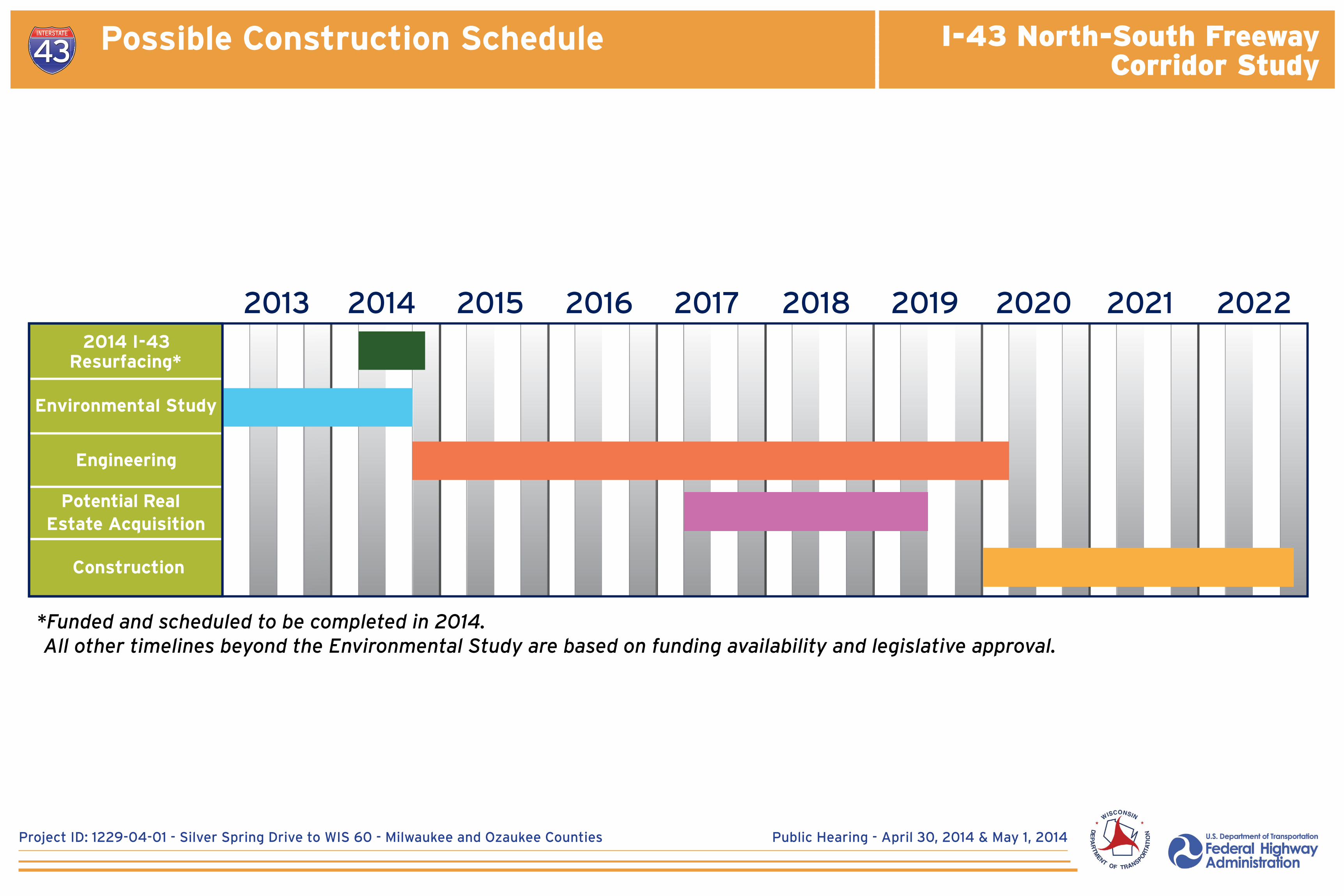
Engineering
2014 I-43Resurfacing*
Environmental Study
Potential Real Estate Acquisition
20142013 2015 2016 2017 2018 2019 2020 2021 2022
Construction
*Funded and programmed to be completed in 2014. All other timelines beyond the Environmental Study are based on funding availability and legislative approval.
Possible Construction Schedule
*Funded and scheduled to be completed in 2014. All other timelines beyond the Environmental Study are based on funding availability and legislative approval.
I-43 North-South FreewayCorridor Study
Project ID: 1229-04-01 - Silver Spring Drive to WIS 60 - Milwaukee and Ozaukee Counties Public Hearing - April 30, 2014 & May 1, 2014
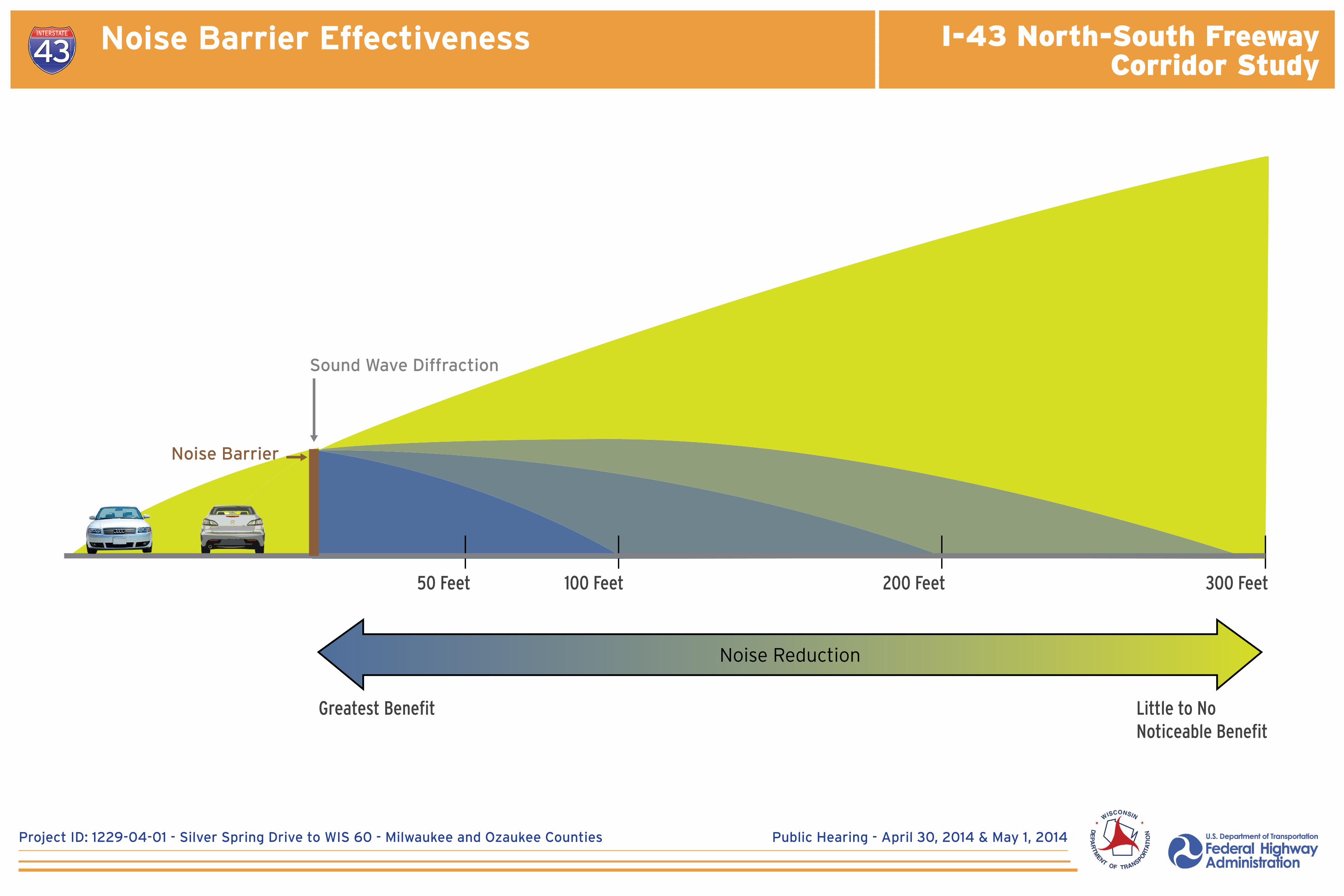
Noise Barrier Effectiveness
Noise Barrier
Sound Wave Diffraction
Noise Barrier Effectiveness
50 Feet 100 Feet 200 Feet 300 Feet
Noise Reduction
Greatest Benefit Little to NoNoticeable Benefit

I-43 North-South FreewayCorridor Study
Project ID: 1229-04-01 - Silver Spring Drive to WIS 60 - Milwaukee and Ozaukee Counties Public Hearing - April 30, 2014 & May 1, 2014
Executive SummaryI-43 North-South Freeway Corridor Study Draft EIS
ES-11
Table ES-1: Impacts Summary
Environmental Factors
Alternatives
No-Build Build1
Brown Deer Road Interchange County Line Road Interchange Highland Road Interchange
DiamondDiverging Diamond2 No Access
Split Diamond Hybrid2, 3 Partial Diamond No Access Tight Diamond2
New right of way (acres) 0 23.12 1.84 2.14 1.59 1.72 1.72 0 1.32
Traffic LOS in design year 2040 E/F C/D C/D C/D NA C C N/A C
Residential relocations 0 12 0 0 0 0 0 0 0
Commercial relocations 0 3 0 0 0 0 0 0 0
Total wetland (acres) 0 20.3 0.75 0.72 1.01 1.03 1.03 2.10 5.43
Advanced identification of wetland disposal areas (acres) 0 2.51 0 0 0 0 0 0 0
Environmental corridors and isolated natural resource areas (acres) 0 4.07 0 0 0 0 0 0 0.16
Stream crossings 214 204 0 0 1 1 1 0 0
100-year floodplain crossings 8 7 0 0 0 0 0 0 1
100-year floodplain fill (acres) 0 4.78 0 0 0 0 0 0 0.14
Farmland (acres) 0 9.6 0 0 0 0 0 0 0
Threatened/endangered species (potential for impacts) No Yes5 Yes5 Yes5 Yes5 Yes5 Yes5 Yes5 Yes5
Historic structures/properties (North Shore Water Treatment Plant) 0 1 0 0 0 0 0 0 0
Archaeological sites 0 0 0 0 0 0 0 0 0
Public use facilities (Craig Counsell Park, Nicolet High School land) 0 2 0 0 0 0 0 0 0
Noise receptors impacted (design year 2040) N/A
• 290 residences• 2 school athletic
fields• 1 place of
worship• 1 day care center
• 290 residences• 2 school athletic
fields• 1 place of
worship• 1 day care center
• 290 residences• 2 school athletic
fields• 1 place of
worship• 1 day care center
• 280 residences• 2 school athletic
fields• 1 place of
worship• 2 day care
centers
• 279-280 residences5
• 2 school athletic fields
• 1 place of worship
• 1 day care center
• 280 residences• 2 school athletic
fields• 1 place of
worship• 2 day care
centers
• 290 residences• 2 school athletic
fields• 1 place of
worship• 1 day care center
• 290 residences• 2 school athletic
fields• 1 place of
worship• 1 day care center
Notes:
1. The build alternative includes the preferred I-43 mainline Modernization – 6 Lanes alternatives for the South and North segments, and preferred alternatives for the interchanges at Good Hope Road, Mequon Road and County C.
2. Preferred alternative.
3. Includes theSplit Diamond Hybrid grade separation/without grade separation subalternatives.
4. Stream crossings include Fish Creek, its tributaries and tributaries to the Milwaukee River, including Ulao Creek and Indian Creek. All existing structures are either concrete box culverts or pipe culverts.
5. Potential habitat for the seaside crowfoot (Ranunculus cymbalaria), a state-listed threatened species, observed in the study corridor. Impacts to other threatened and endangered species and their habitat in the study corridor can be avoided.
6. Residential noise receptors impacted: 279 with Split Diamond Hybrid (without Grade Separation); 280 with Split Diamond Hybrid (Grade Separation).
Environmental Impacts Summary
I-43 North-South FreewayCorridor Study
Project ID: 1229-04-01 - Silver Spring Drive to WIS 60 - Milwaukee and Ozaukee Counties Public Hearing - April 30, 2014 & May 1, 2014
Executive SummaryI-43 North-South Freeway Corridor Study Draft EIS
ES-12
Environmental Factors
Alternatives
No-Build Build1
Brown Deer Road Interchange County Line Road Interchange Highland Road Interchange
DiamondDiverging Diamond2 No Access
Split Diamond Hybrid2, 3 Partial Diamond No Access Tight Diamond2
Potential contaminated sites (recommended for further investigation) N/A 30
Part of corridorwide analysis; no difference among interchange alternatives
Part of corridorwide analysis; no difference among interchange alternatives
Part of corridorwide analysis; no difference among interchange alternatives
Part of corridorwide analysis; no difference among interchange alternatives
Part of corridorwide analysis; no difference among interchange alternatives
Part of corridorwide analysis; no difference among interchange alternatives
Part of corridorwide analysis; no difference among interchange alternatives
Air quality concerns No No No No No No No No No
Indirect effects anticipated?
Land use effect: Increasing congestion could cause development to shift away from primary study area (and to a lesser extent within secondary study area) to locations within the region that have less congestion
Land use effect: Facilitates planned redevelopment and development within primary study area (and to a lesser extent within the secondary study area)
Limited land use effect: Maintains existing access; supports existing businesses and neighborhoods and planned redevelopment within Milwaukee County primary study area
Limited land use effect: Maintains existing access; supports existing businesses and neighborhoods and planned redevelopment within Milwaukee County primary study area
Limited land use effect: Established land uses minimize effect; changed travel patterns; access available from nearby interchanges
Limited land use effect: Established land uses minimize effect. Some local concerns about traffic impacts and travel indirection of the “Grade Separation” subalternative; the “without Grade Separation” subalternative minimizes indirection. Supports Port Washington Road business corridors in Mequon, Bayside and Fox Point.
No change from existing conditions
Limited land use effect: Planned land uses likely to occur regardless of interchange alternative; nearby freeway access is already available.
Improved access and local implementation of the Mequon East Growth Area Plan would facilitate planned land uses.
Cumulative effects anticipated? NoLimited effect: Mitigation measures minimize effects
Limited effect: Mitigation measures minimize effects
Limited effect: Mitigation measures minimize effects
Limited effect: Mitigation measures minimize effects
Limited effect: Mitigation measures minimize effects
No change from existing conditions
Limited effect: Mitigation measures minimize effects
Limited effect: Mitigation measures minimize effects
Environmental justice effects anticipated? No
Build alternative’s indirect and cumulative land use effects could facilitate employment land uses in areas that are not accessible by transit.
Part of corridorwide analysis; no difference among interchange alternatives
Part of corridorwide analysis; no difference among interchange alternatives
Part of corridorwide analysis; no difference among interchange alternatives
Part of corridorwide analysis; no difference among interchange alternatives
Part of corridorwide analysis; no difference among interchange alternatives
Part of corridorwide analysis; no difference among interchange alternatives
Part of corridorwide analysis; no difference among interchange alternatives
Notes:
1. The build alternative includes the preferred I-43 mainline Modernization – 6 Lanes alternatives for the South and North segments, and preferred alternatives for the interchanges at Good Hope Road, Mequon Road and County C.
2. Preferred alternative.
3. Includes theSplit Diamond Hybrid grade separation/without grade separation subalternatives.
4. Stream crossings include Fish Creek, its tributaries and tributaries to the Milwaukee River, including Ulao Creek and Indian Creek. All existing structures are either concrete box culverts or pipe culverts.
5. Potential habitat for the seaside crowfoot (Ranunculus cymbalaria), a state-listed threatened species, observed in the study corridor. Impacts to other threatened and endangered species and their habitat in the study corridor can be avoided.
6. Residential noise receptors impacted: 279 with Split Diamond Hybrid (without Grade Separation); 280 with Split Diamond Hybrid (Grade Separation).
Environmental Impacts Summary

Public Hearing - April 30, 2014 & May 1, 2014 Project ID: 1229-04-01 - Silver Spring Drive to WIS 60 - Milwaukee and Ozaukee Counties
I-43 North-South FreewayCorridor Study
Stable Flow (Moderate volumes & little congestion)
TB042007005MKE 1.4_Level_of_Service_Examples_v2.ai 06.19.07 cae
Level of Service A
Level of Service C
Level of Service B
Level of Service D
Level of Service E
Level of Service F
EXHIBIT 1-4 Levels of Service Examples
Reasonably Free Flow (Light volume, very little congestion)
TB042007005MKE 1.4_Level_of_Service_Examples_v2.ai 06.19.07 cae
Level of Service A
Level of Service C
Level of Service B
Level of Service D
Level of Service E
Level of Service F
EXHIBIT 1-4 Levels of Service Examples
Level of Service (LOS)
TB042007005MKE 1.4_Level_of_Service_Examples_v2.ai 06.19.07 cae
Level of Service A
Level of Service C
Level of Service B
Level of Service D
Level of Service E
Level of Service F
EXHIBIT 1-4 Levels of Service Examples
TB042007005MKE 1.4_Level_of_Service_Examples_v2.ai 06.19.07 cae
Level of Service A
Level of Service C
Level of Service B
Level of Service D
Level of Service E
Level of Service F
EXHIBIT 1-4 Levels of Service Examples
TB042007005MKE 1.4_Level_of_Service_Examples_v2.ai 06.19.07 cae
Level of Service A
Level of Service C
Level of Service B
Level of Service D
Level of Service E
Level of Service F
EXHIBIT 1-4 Levels of Service Examples
Free Flow (Light volume, no congestion)
Approaching Unstable Flow (Moderate volumes & congestion)
Unstable Flow (Moderate to heavy volumes & significant congestion) Forced or Breakdown Flow (Heavy volumes, very significant congestion)
TB042007005MKE 1.4_Level_of_Service_Examples_v2.ai 06.19.07 cae
Level of Service A
Level of Service C
Level of Service B
Level of Service D
Level of Service E
Level of Service F
EXHIBIT 1-4 Levels of Service Examples
Public Hearing - April 30, 2014 & May 1, 2014 Project ID: 1229-04-01 - Silver Spring Drive to WIS 60 - Milwaukee and Ozaukee Counties
I-43 North-South FreewayCorridor Study
Testimony
Options and Instructions for Providing TestimonyWisDOT and FHWA will review and consider your testimony as part of the process for choosing the preferred alternative. Testimony should be limited to tonight’s public hearing aspects, and statements or opinions about the project. Provide comments on the alternative(s) you support, or oppose, and your reasons. Questions related to the project can be directed to WisDOT staff during informal discussions and will not be recorded by the court reporter or included in the public hearing record.
Private verbal testimonyThis option may be preferred if you wish to make your statement privately to the court reporter rather than in front of the audience:
• Available during the entire public hearing• Follow the signs or ask directions to the location for private testimony• Complete a registration slip• Wait for an opening• Give the court reporter your comments
Public verbal testimonyFollowing the WisDOT presentation until the hearing closes, public verbal testimony will take place:
• Complete a Registration Slip for Public Verbal Testimony (included in the handout packet and on table in commons area)
• Give it to the WisDOT staff at the designated table any time before, during, or immediately following the presentation
• Your name will be called in the order registration slips are received• When you are called to the microphone to provide testimony, please state your name,
address, and if applicable, the group organization, or business you are representing• Please limit your testimony to 3 minutes
Written testimonyYou may provide written testimony in addition to, or in place of, verbal testimony. Complete the Written Testimony Form (included at the back of this handout packet and on the comment tables near the exhibits). You may also use your own stationery. Include your name, address, and if applicable, the group, organization, or business you are representing. If you have prepared written comments prior to the public hearing, you may also submit those. There are two options for submitting your written testimony as described below:
Submit tonight: Complete the written testimony form and place in comment box located on table in commons areaORMail in*: You may prefer this option if you would like additional time to organize your thoughts/comments. The Written Testimony Form is pre-addressed and does not require postage. You may also send written comments via e-mail to [email protected]*Mailed or emailed comments must be postmarked no later than May 12, 2014 to be included in the official public hearing record.