Embed Size (px)
Citation preview
M4 Corridor around Newport
PUBLIC INQUIRY QUESTION
REFERENCE NO. : PIQ / 121
RAISED BY: The Inspectors DATE: 16/05/17 & 14/06/17
RESPONDED BY: Matthew Jones DATE: 18/07/17
SUBJECT: Response to Questions on Objectors’ Suggested Alternatives that do not have a promoter appearing at the Inquiry
During the 16/05/17 and 14/06/17 round table discussions of the Objectors’ Suggested Alternatives (OSAs) that do not have a promoter appearing at the Inquiry, the Inspectors raised a series of questions, which are listed below with answers.
CVJV/Q/0135
General 1. Provide a full list of OSAs including the promoters and objection references.
Appendix A of this document contains the full list.
2. Provide a summary of key benefits and disbenefits.
Appendix B of this document contains the summary.
3. Provide information regarding Monmouthshire County Council’s public consultation on access to Severn Tunnel Junction station.
During April and May 2016, Monmouthshire County Council (MCC) carried out a public consultation regarding access and parking facilities at Severn Tunnel Junction station. The consultation consisted of questionnaires which were made available at the station and online. At present no results have been made available by MCC. Appendix C of this document contains a screenshot from MCC’s website which provides further information.
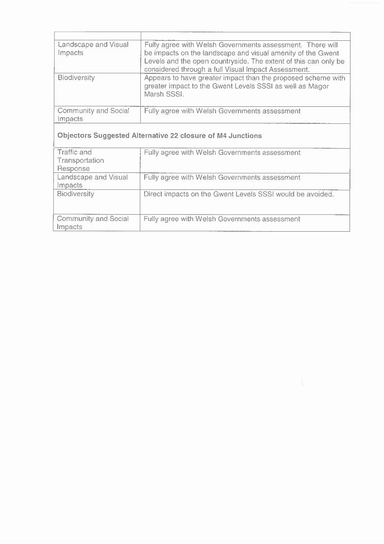
4. Monmouthshire County Council’s and Newport City Council’s comments on the Objectors’ Suggested Alternatives are to be highlighted to the Inspectors.
Appendix D of this document contains relevant comments from Newport City Council. The only comments received from Monmouthshire County Council include an email to Mr Smith dated 17/01/17 stating they would not support OSA 3 Green Route, and an email to the Project Team dated 10/05/17 commenting on the landscape/ecology/conservation impacts of OSAs 1‐7 (both emails included in Appendix D).
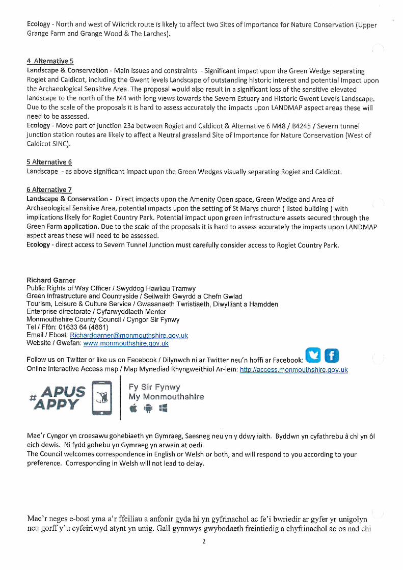
Alternative 4: North & West of Wilcrick Route 5. What is the effect of OSA 4 on Wilcrick Fort?
Regarding landscape and townscape, there would be no specific impacts beyond those already commented on for general receptors. Regarding cultural heritage, OSA 4 would have an impact on the significance of the Scheduled hillfort at Wilcrick Hill due to a change within its setting and also on the significance of the Scheduled deserted medieval village just west of Wilcrick Hill for the same reason. There is the potential for impact on the significance of the Scheduled Bishton Castle motte.
Alternative 5: Move Part of J23 between Rogiet and Caldicot 6. What exactly are the effects of OSA 5 on the aquifer, as mentioned in the Objectors’
Suggested Alternative Report?
The additional works proposed for OSA 5 begin to encroach upon the Triassic aquifer in South East Wales, more so than the Published Scheme. This aquifer is defined as moderately productive and a “locally important aquifer generally producing hard groundwater from solution enhanced joints”. The fractured nature of limestone aquifers makes them more sensitive to pollution events. Construction and operational risks could be managed by implementations of appropriate risk assessments and management strategies. Data received from Monmouthshire County Council indicate the presence of potable groundwater abstractions in the Rogiet area. The potential impact upon such abstractions as a result of the proposed OSA 5 roundabout and slip road would require assessment.
7. Is the effect of OSA 5 on the prehistoric/Roman settlement enclosures east of Ifton Manor, as mentioned in the Objectors’ Suggested Alternative Report, direct or indirect?
The impacts would be direct. The route of OSA 5 passes through an area to the east of Ifton Manor that is known from aerial photographs and available on‐line information to contain the buried remains of at least two rectangular enclosures which are likely to be of later prehistoric or Roman date. A small cemetery of five burials is located nearby, one of which was within a stone cist. Therefore, there could be impacts on buried archaeological remains during construction of the alternative. See Figure 1 below for locations:
1 = Rectangular enclosure c. 60m across, probably Roman.
2 = Rectangular enclosure c. 60m across set within an outer concentric circular enclosure, probably Roman.
3 = Cemetery with five individual burials, one in a stone cist. All of the land between Sites 1 and 2 is of high archaeological potential.
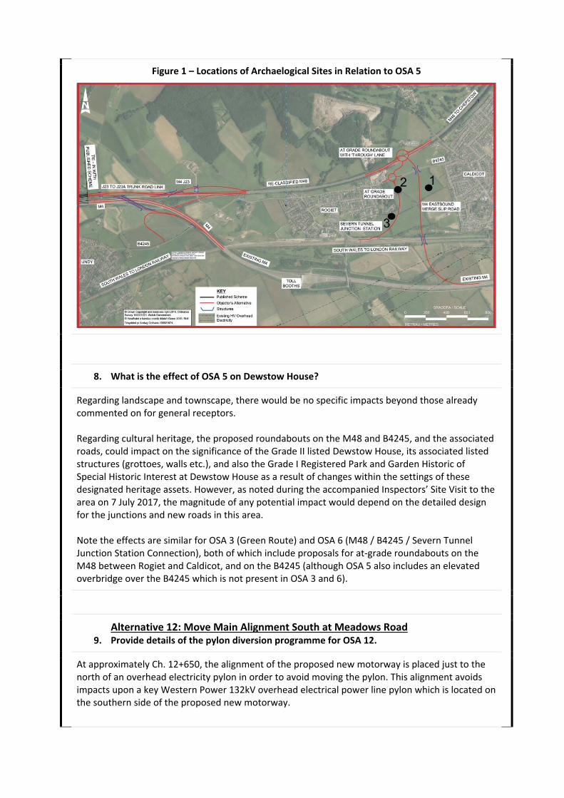
Figure 1 – Locations of Archaelogical Sites in Relation to OSA 5
8. What is the effect of OSA 5 on Dewstow House?
Regarding landscape and townscape, there would be no specific impacts beyond those already commented on for general receptors. Regarding cultural heritage, the proposed roundabouts on the M48 and B4245, and the associated roads, could impact on the significance of the Grade II listed Dewstow House, its associated listed structures (grottoes, walls etc.), and also the Grade I Registered Park and Garden Historic of Special Historic Interest at Dewstow House as a result of changes within the settings of these designated heritage assets. However, as noted during the accompanied Inspectors’ Site Visit to the area on 7 July 2017, the magnitude of any potential impact would depend on the detailed design for the junctions and new roads in this area. Note the effects are similar for OSA 3 (Green Route) and OSA 6 (M48 / B4245 / Severn Tunnel Junction Station Connection), both of which include proposals for at‐grade roundabouts on the M48 between Rogiet and Caldicot, and on the B4245 (although OSA 5 also includes an elevated overbridge over the B4245 which is not present in OSA 3 and 6).
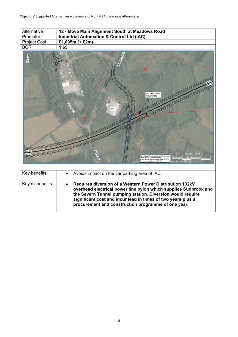
Alternative 12: Move Main Alignment South at Meadows Road 9. Provide details of the pylon diversion programme for OSA 12.
At approximately Ch. 12+650, the alignment of the proposed new motorway is placed just to the north of an overhead electricity pylon in order to avoid moving the pylon. This alignment avoids impacts upon a key Western Power 132kV overhead electrical power line pylon which is located on the southern side of the proposed new motorway.
This design was informed by a meeting with Western Power Distribution (WPD) on the 26 March 2015, where the Project Team were advised that this particular 132kV circuit, referred to as the P‐circuit, is a critical feed supplying Sudbrook and the Severn Tunnel pumping station, and that any diversion should be avoided. Such a diversion would be expensive, with long programme lead in times of two years plus a procurement and construction programme of one year. Following the objection from IAC, after publication of draft Orders and receipt of their Objectors’ Suggested Alternative 12, the need to divert this service was re‐evaluated. A meeting was held with WPD on the 17 January 2017 and once again they reiterated that this is a high risk route for them and that a diversion should be avoided if possible. At this meeting WPD provided more information on the programme for diversion of the pylon, and also confirmed that if the pylon was diverted then planning permission would be required. Should any objections arise during the planning process, then a Public Inquiry would be required which WPD advised could take between 18‐24 months. The construction programme would revolve around the outage dates for 132kV supplies which are April – September yearly. Details of the programme as advised by WPD are listed below, assuming that no Public Inquiry would be required. If a Public Inquiry was required the overall programme would increase by 18‐24 months.
WPD design for pylon diversion – 12 months
WG approval of design – 6 months
Planning permission (assume no objections/Public Inquiry) – 6 months
WPD procurement – 6 months
WPD diversion works (civils) – 4 months
WPD diversion works (outage works) – 2 months, on seasonal calendar
Total = 36 months
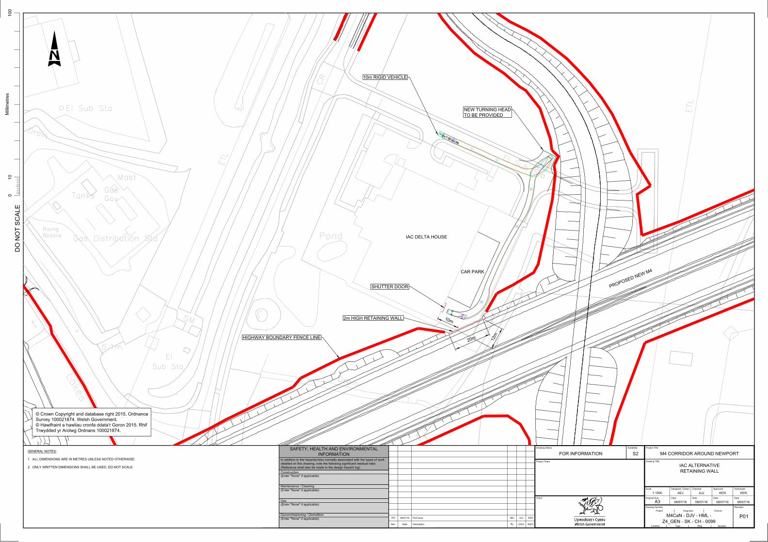
10. Provide details of the operations of Industrial Automation and Control Ltd (IAC).
As a result of the alignment choice to avoid the Western Power 132kV overhead electrical power line pylon, the proposed new motorway would impact upon the parking area and access arrangements to IAC’s building to the north of the Scheme at Ch. 12+550. One of the proposed modifications to the draft Orders (CPO MOD 50) adds a retaining wall alongside the proposed new motorway at Ch. 12+550 in order to reduce the impact on the parking and access to the rear of IAC’s building.
During a meeting between the Project Team and IAC on 2nd June 2016, it was confirmed that the largest delivery vehicles (10m rigid HGV) reverse into the car park and a fork lift is used to transfer the delivery to and from the factory. Sketch M4CaN‐DJV‐HGN‐ZG_GEN‐SK‐CH‐0099 in Appendix E of this document presents further detail of the proposed retaining wall together with a turning head to make reversing to the entrance easier. This arrangement would allow continued access by large vehicles reversing into the car park as they do presently. It would also not prohibit fork lift truck movement of the largest components into/out of the factory (6m x 3m as advised in the meeting of 2nd June 2016).
Alternative 18: Free‐flow J23 and Connection at J23A (2006 TR111) 11. What exactly are the effects of OSA 18 on the aquifer, as mentioned in the Objectors’
Suggested Alternative Report?
The work proposed for OSA 18 (specifically to the north of the existing M4) would require extensive works (potential cuttings) over a sensitive karstic limestone aquifer which is described as “moderately productive” (yields up to 40l/s) and having a “rapid response to rainfall”. The fractured nature of limestone aquifers makes them more sensitive to pollution events. In addition, data provided by Monmouthshire County Council indicate the presence of potable groundwater abstractions in the area that would require assessment to determine potential impacts upon supply. Construction and operational risks could be managed by implementations of appropriate risk assessments and management strategies however.
Alternative 19: Online Widening of Existing M4 including Brynglas Tunnels 12. Provide more information on the traffic impacts and calculation of the BCR value for OSA
19.
Appendix F of this document contains detailed economic appraisal results for all of the alternatives appraised within the Objectors’ Suggested Alternative Report but not promoted at the Inquiry, including OSA 19. OSA 19 would increase capacity along the existing motorway between J29 and J25, including at the existing ‘bottleneck’ at the Brynglas Tunnels. This would alleviate congestion problems along this section of motorway. However, this would attract more traffic, causing the section between J24 and J25 (where there would be no increase in capacity) to replace the Brynglas Tunnels as the most congested section. It was noted during the round table discussion that providing an additional tunnel to the north of the existing Brynglas tunnels (instead of to the south, as per OSA 19) would have a greater cost but would bring no further traffic benefits.
13. Confirm whether QUADRO is included and provide detail about its effect for OSA 19.
The economic appraisal of all OSAs excludes accident impacts and impacts on users during construction and maintenance. Therefore, QUADRO is not included. Regarding OSA 19, it is expected that impacts during construction would be highly negative because of the online nature of the Alternative. Roadworks would impact on traffic using the M4 over much greater lengths and for longer periods compared to the Published Scheme (which is offline and would therefore limit construction impacts to the points of tie‐in to the existing motorway). Benefits during maintenance would also be reduced because an online widening scheme does not provide an alternative route.
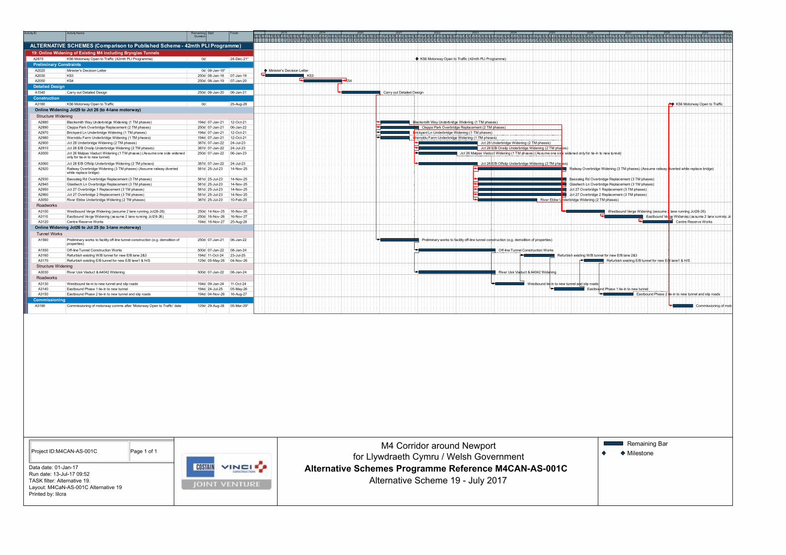
14. Provide details of the programme and construction sequence for OSA 19.
Programme: This is a highly complex scheme with substantial online works which would result in lengthy periods of traffic management on the M4 and the affected side roads. OSA 19 would involve a construction programme of approximately 7.5 years, plus an estimated 3 years for Key Stage 3, Key Stage 4 and initial detailed design. A full programme is included in Appendix G.

Programme assumptions as follows:
Unhindered access to all areas is given at the start of the construction works
There is enough land take included to construct new overbridges off‐line and realign the associated highway or close the side roads for the duration of the demolition and construction of the replacement bridge
The railway line can be diverted for the duration of the demolition and construction of the new overbridge
Roadworks between Junction 28 and Junction 26 required reduction to 2‐lane motorway during the widening of the westbound and eastbound verges
No works included for Junction 25, except realignment of slip roads
No allowance made for any statutory undertaker diversions
No works included for Junction 29, including works to Pound Hill Overbridge Construction Sequence: Construction would be carried out in two sections as per Figure 2 below. Section 1 would be the online widening of the existing M4 between Jct29 and Jct26 to a 4‐lane motorway. Section 2 would be the construction of a new 3‐lane tunnel at Brynglas and the online widening of the existing M4 between Jct26 and Jct25 to a 3‐lane motorway. Section 1 would be constructed in two main stages. Stage 1 would be the widening of the existing structures to facilitate a 4‐lane motorway. This would be carried out in three phases with Phase 1 including 4 bridges, Phase 2 including 4 bridges and Phase 3 including 6 bridges. Depending on complexity of structures and traffic management requirement each phase would take between 12 months and 27 months. Stage 2 would be the roadworks element of the online widening, including retaining walls and minor structure widenings, such as culverts, that could not be completed during Stage 1. This would be carried out in three phases starting with westbound verge, then eastbound verge and finally centre reserve works. Section 2 would be constructed in two main stages. Stage 1 would be the construction of the new tunnel off‐line and the widening of the existing structures over the River Usk to the east of the tunnel, including demolition of existing buildings to facilitate the works. Stage 2 would be the tie‐in of the new tunnel and slip roads and the refurbishment of the existing tunnels. This work would be carried out under three main traffic management phases.
Figure 2 – Construction Phasing of OSA 19
Alternative 21: South of Magor Route 15. Confirm the length of OSA 21 within the SSSI and Magor Marsh Nature Reserve compared
to the Published Scheme.
Length of Route in SSSI Length of Route in Magor Marsh Nature Reserve
Published Scheme 9,300m 0m
Alternative 21 11,775m 660m
Difference +2,475m +660m
Alternative 22: Closure of Existing M4 Junctions 16. Confirm the traffic impact of OSA 22 compared to the Do Minimum scenario.
For OSA 22, the Transport Economic Efficiency (TEE) section of the Objectors’ Suggested Alternative Report notes a large increase in M4 traffic flows compared with the Published Scheme. These flows would be largely comparable with those in the Do Minimum scenario ‐ there would be a minor reduction in traffic between Junctions 24 and 26 at peak times, and a minor increase in traffic between Junctions 26 and 28 at peak times, generally amounting to less than 5%. Regarding local traffic, closing the junctions would reduce access to/from Newport compared to the Do Minimum scenario. Local traffic that, in the Do Minimum scenario, uses the junctions being closed would have to divert to alternative junctions. These alternative junctions are already subject to significant peak time congestion, particularly Junction 28 and Junction 26, and the result would be an increase in local congestion at these points.
Alternative 23: Blue Route and Duffryn Link & Alternative 24: Amber Route 17. Provide appraisals of the recently submitted OSAs from Councillor White (23: Blue Route
and Duffryn Link) and Mr Keelan (24: Amber Route).
Appendix H of this document contains appraisals in the same format as those prepared for the Objectors’ Suggested Alternatives Report.
18. Provide reasoning for the BCR values for OSA 23 and 24 (0.64 and 0.47 respectively), as they appear lower than expected.
OSA 23: Blue Route and Duffryn Link: While the Duffryn Link itself operates successfully, it has knock‐on effects elsewhere in Newport because of the additional traffic attracted onto the main part of the Blue Route. One of the disadvantages of the Blue Route is the reduced accessibility onto the SDR that is created for traffic in the Ringland area, with the removal of the Balfe Road junction, leading to significant congestion at the remaining access points from this area. The addition of the Duffryn Link exacerbates this problem, and as is common for junctions already experiencing congestion, any exacerbation leads to an exponential increase in delays. The issue of accessibility in the Ringland area is also the reason why the BCR for the Blue Route increases when the improvement to the link up to Junction 24 is omitted from the scheme, as it is the improvement to Junction 24 which reduces the local accessibility in the Ringland area. It should be noted that scheme benefits are not calculated just on the traffic using the route in question, but across the network as a whole. In this case, while the Duffryn Link itself operates

successfully it has consequences for route choice, link volumes and junction operation over a much wider area. OSA 24: Amber Route: The route itself operates successfully, however, it requires the diversion of the existing SDR from the Alexandra Road junction onto Docks Way (to enable it to join the Amber Route at the Maesglas junction). This leads to a significant increase in traffic volumes on Docks Way, causing some of the existing accesses to the Docks and the retail parks to become overloaded. In addition, the additional traffic attracted onto the Amber Route creates significant congestion at the eastern end of the A4810 on the entry to Junction 23A. As with OSA 23, it should be noted that scheme benefits are not calculated just on the traffic using the route in question, but across the network as a whole. In this case, while the Amber Route itself operates successfully it has consequences for route choice, link volumes and junction operation over a much wider area. The calculation of the BCR is highly complex, and is carried out using the Department for Transport’s TUBA software. This software has been applied to the Published Scheme and each of the OSAs in an identical manner.
19. Provide a larger scale drawing showing the westerly junction of OSA 24.
The Amber Route consists of a 3‐way free‐flow T‐layout at the westerly tie‐in with M4 J28, as previously considered as part of the Blue Route development. Appendix I of this document contains the relevant drawing from the Blue Route development phase.

Appendix A ‐
Full List of Objectors’ Suggested Alternatives and
Promoters

Alternative Ref
Alternative Name Objection Ref Organisation First Name Surname Address 1 Address 2 City / Town County Post Code E Mail
1 Blue Route OBJ0247 Cycling UK Prof Stuart Cole & Hugh Mackay [email protected] Blue Route (Phase 1) OBJ0247 Cycling UK Prof Stuart Cole & Hugh Mackay [email protected]
OBJ0210 Mike Smith 1 Windmill Cottage Windmill Lane Rogiet Monmouthshire NP26 3UH N/A
OBJ0287 Graham Wynton2 Windmill Cottages
Windmill Lane Rogiet Monmouthshire NP26 3UH [email protected] North and West of Wilcrick Route OBJ0034 P.J. Brannigan 26 Blenheim Ave Magor Monmouthshire NP26 3NB [email protected] Move Part of J23 between Rogiet and Caldicot OBJ0151 Robert Hayes 2 Green Close Rogiet Monmouthshire NP26 3SW [email protected] M48 / B4245 / Severn Tunnel Junction Station Connection OBJ0004 Linda Guppy 9 Starling Close Rogiet Monmouthshire NP26 3UU [email protected] Direct Access to Severn Tunnel Junction Station from J23 OBJ0009 Matthew Sutton [email protected]
1011
Free-flow J23 & Connection at J23A, with Grade Separated M48 RbtFree-flow J23 & Connection at J23A, without M48 RbtFree-flow J23 & Connection at J23A, with At-Grade M48 RbtJ23A Westbound On-slip
OBJ0026 Road Chef Simon Turl Norton Canes MSA Betty's Lane, Norton Canes
Cannock Staffordshire WS11 9UX [email protected]
12 Move Main Alignment South at Meadows Road OBJ0068 IAC Systems Peter Lewis Delta House Meadows Road Newport Gwent NP19 4SS [email protected]
Northern Dock Route 1 (High – no junction)Northern Dock Route 2 (High – with junction)Northern Dock Route 3 (Low – no junction)Northern Dock Route 4 (Low – with junction)Remove Docks Way Junction and Link
OBJ0031Associated British Ports
Matthew KennerleyQueen Alexandra House
Cargo Road Cardiff CF10 4LY [email protected]
18 Free-flow J23 and Connection at J23A (2006 TR111 Route) OBJ0152 S.E. Phillips Elder Cottage Common-y-Coed Magor Monmouthshire NP26 3AX N/AOBJ0002 Dr. Anthony Owen 15 Duchess Road Monmouth Monmouthshire NP25 3HT N/A
OBJ0020 David James [email protected]
OBJ0104 Gareth Jones [email protected]
OBJ0107 Dru Brooke Taylor 2 Oldfield Road Hotwells Bristol BS8 4QQ [email protected]
OBJ0135 R.B. Griffin Mountain View Llanvair Discoed Chepstow NP166LX [email protected]
OBJ0182 Maria Phipps [email protected]
OBJ0206Rogiet Community Council
Maureen Williams Clerk to Rogiet Community Council
OBJ0309 Catherine Baker 3 Semour Way Magor Monmouthshire [email protected]
OBJ0311 Dr Mario Bisi 3 Semour Way Magor Monmouthshire [email protected] Sue Collingbourne [email protected] Thomas Timbul 14 Acorn Place Castleton CF3 2WE [email protected] Anne Picton 9 Nellive Park Wentloog Newport Gwent NP10 8SE [email protected] Julia Shaw [email protected] P McCann 78 Mallards Reach Marshfield CF3 2PR N/A
21 South of Magor Route OBJ0276 Anthony & CatherineVenn Well Cottage Llandevenny Magor Monmouthshire NP26 3DB N/A
22 Closure of Existing M4 Junctions OBJ0125Friends of the Earth Cymru
Gareth Clubb [email protected]
23 Blue Route and Duffryn Link ALT/043 Councillor Richard White [email protected] Amber Route ALT/035 Peter Keelan 15 Old Hill Crescent Newport Gwent NP18 1JL [email protected]
Objectors' Suggested Alternatives
Historical Alternatives
Green Route3
Tunnel from Magor to Castleton20
19 Online Widening of Existing M4 including Brynglas Tunnels

Appendix B ‐
Objectors’ Suggested Alternatives Summary
Objectors’ Suggested Alternatives – Summary of Non‐PLI Appearance Alternatives
1
Objectors’ Suggested Alternatives – Summary of Non‐PLI Appearance Alternatives
This document summarises the key benefits and disbenefits, compared to the Published Scheme, of those
Objectors’ Suggested Alternatives (OSAs) that do not have a promoter appearing at the Public Local Inquiry.
Full appraisals of each of the OSAs can be found in the Objectors’ Suggested Alternatives Report.
A full list of the OSAs that do not have a promoter appearing at the Inquiry is as follows:
Alternative 4: North & West of Wilcrick Route
Alternative 5: Move Part of J23 between Rogiet and Caldicot
Alternative 6: M48 / B4245 / Severn Tunnel Junction Station Connection
Alternative 7: Direct Access to Severn Tunnel Junction Station from J23
Alternative 12: Move Main Alignment South at Meadows Road
Alternative 18: Free‐flow J23 and Connection at J23A (2006 TR111)
Alternative 19: Online Widening of Existing M4 including Brynglas Tunnels
Alternative 20: Tunnel from Magor to Castleton
Alternative 21: South of Magor Route
Alternative 22: Closure of Existing M4 Junctions
Alternative 23: Blue Route and Duffryn Link
Alternative 24: Amber Route
Objectors’ Suggested Alternatives – Summary of Non‐PLI Appearance Alternatives
2
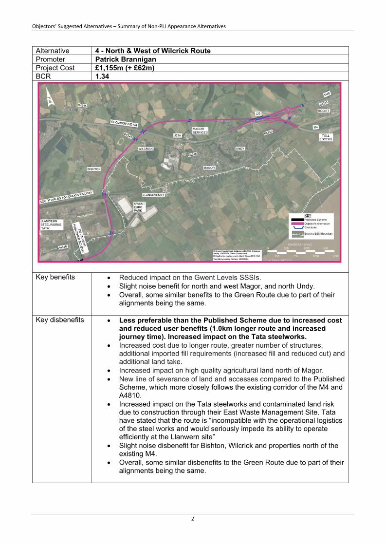
Alternative 4 - North & West of Wilcrick Route Promoter Patrick Brannigan Project Cost £1,155m (+ £62m) BCR 1.34
Key benefits Reduced impact on the Gwent Levels SSSIs.
Slight noise benefit for north and west Magor, and north Undy. Overall, some similar benefits to the Green Route due to part of their
alignments being the same.
Key disbenefits Less preferable than the Published Scheme due to increased cost and reduced user benefits (1.0km longer route and increased journey time). Increased impact on the Tata steelworks.
Increased cost due to longer route, greater number of structures, additional imported fill requirements (increased fill and reduced cut) and additional land take.
Increased impact on high quality agricultural land north of Magor. New line of severance of land and accesses compared to the Published
Scheme, which more closely follows the existing corridor of the M4 and A4810.
Increased impact on the Tata steelworks and contaminated land risk due to construction through their East Waste Management Site. Tata have stated that the route is “incompatible with the operational logistics of the steel works and would seriously impede its ability to operate efficiently at the Llanwern site”
Slight noise disbenefit for Bishton, Wilcrick and properties north of the existing M4.
Overall, some similar disbenefits to the Green Route due to part of their alignments being the same.
Objectors’ Suggested Alternatives – Summary of Non‐PLI Appearance Alternatives
3
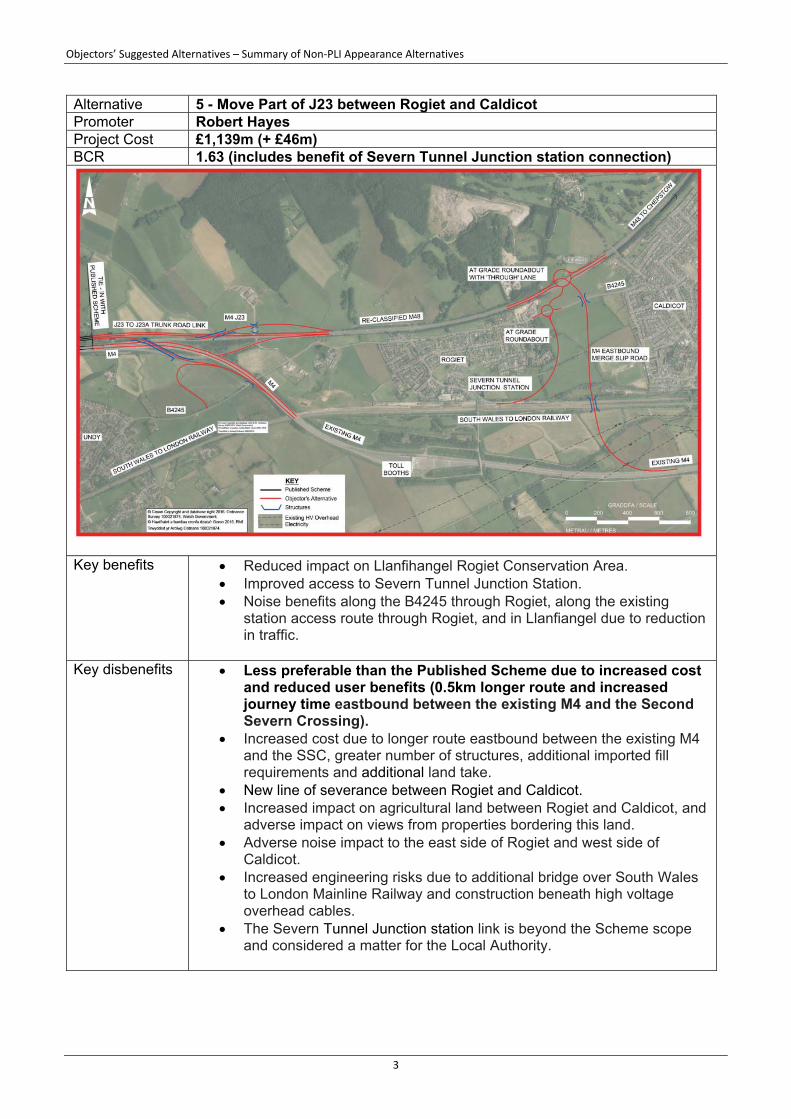
Alternative 5 - Move Part of J23 between Rogiet and Caldicot Promoter Robert Hayes Project Cost £1,139m (+ £46m) BCR 1.63 (includes benefit of Severn Tunnel Junction station connection)
Key benefits Reduced impact on Llanfihangel Rogiet Conservation Area.
Improved access to Severn Tunnel Junction Station. Noise benefits along the B4245 through Rogiet, along the existing
station access route through Rogiet, and in Llanfiangel due to reduction in traffic.
Key disbenefits Less preferable than the Published Scheme due to increased cost
and reduced user benefits (0.5km longer route and increased journey time eastbound between the existing M4 and the Second Severn Crossing).
Increased cost due to longer route eastbound between the existing M4 and the SSC, greater number of structures, additional imported fill requirements and additional land take.
New line of severance between Rogiet and Caldicot. Increased impact on agricultural land between Rogiet and Caldicot, and
adverse impact on views from properties bordering this land. Adverse noise impact to the east side of Rogiet and west side of
Caldicot. Increased engineering risks due to additional bridge over South Wales
to London Mainline Railway and construction beneath high voltage overhead cables.
The Severn Tunnel Junction station link is beyond the Scheme scope and considered a matter for the Local Authority.

Objectors’ Suggested Alternatives – Summary of Non‐PLI Appearance Alternatives
4
Alternative 6 - M48 / B4245 / Severn Tunnel Junction Station Connection Promoter Linda Guppy Project Cost £1,104m (+ £11m) BCR 1.72 (includes benefit of Severn Tunnel Junction station connection)
Key benefits Improved access to Severn Tunnel Junction Station.
Small increase in the BCR. Noise benefits along the B4245 through Rogiet and along the existing
station access route through Rogiet due to reduction in traffic.
Key disbenefits The alternative is entirely separate from the Published Scheme and could be implemented at a future date. As such it is beyond the Scheme scope and considered a matter for the Local Authority.
Increased cost due to additional road construction and additional land take.
New line of severance between Rogiet and Caldicot. Increased impact on agricultural land between Rogiet and Caldicot, and
adverse impact on views from properties bordering this land. Slight increase in journey times for M48 traffic due to roundabout. Adverse noise impact to east side of Rogiet and west side of Caldicot.
Objectors’ Suggested Alternatives – Summary of Non‐PLI Appearance Alternatives
5
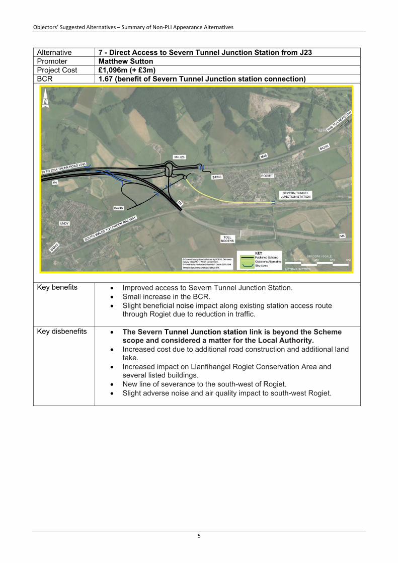
Alternative 7 - Direct Access to Severn Tunnel Junction Station from J23 Promoter Matthew Sutton Project Cost £1,096m (+ £3m) BCR 1.67 (benefit of Severn Tunnel Junction station connection)
Key benefits Improved access to Severn Tunnel Junction Station.
Small increase in the BCR. Slight beneficial noise impact along existing station access route
through Rogiet due to reduction in traffic.
Key disbenefits The Severn Tunnel Junction station link is beyond the Scheme scope and considered a matter for the Local Authority.
Increased cost due to additional road construction and additional land take.
Increased impact on Llanfihangel Rogiet Conservation Area and several listed buildings.
New line of severance to the south-west of Rogiet. Slight adverse noise and air quality impact to south-west Rogiet.
Objectors’ Suggested Alternatives – Summary of Non‐PLI Appearance Alternatives
6
Alternative 12 - Move Main Alignment South at Meadows Road Promoter Industrial Automation & Control Ltd (IAC) Project Cost £1,095m (+ £2m) BCR 1.65
Key benefits Avoids impact on the car parking area of IAC.
Key disbenefits Requires diversion of a Western Power Distribution 132kV
overhead electrical power line pylon which supplies Sudbrook and the Severn Tunnel pumping station. Diversion would require significant cost and incur lead in times of two years plus a procurement and construction programme of one year.
Objectors’ Suggested Alternatives – Summary of Non‐PLI Appearance Alternatives
7
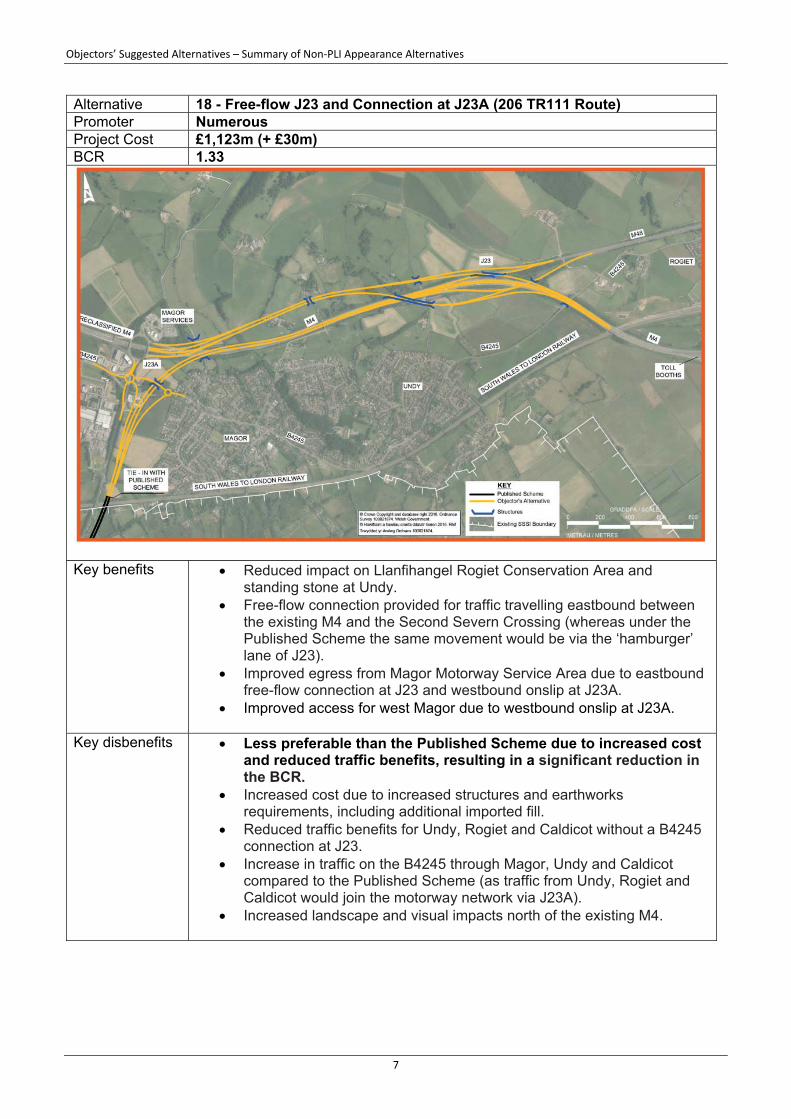
Alternative 18 - Free-flow J23 and Connection at J23A (206 TR111 Route) Promoter Numerous Project Cost £1,123m (+ £30m) BCR 1.33
Key benefits Reduced impact on Llanfihangel Rogiet Conservation Area and
standing stone at Undy. Free-flow connection provided for traffic travelling eastbound between
the existing M4 and the Second Severn Crossing (whereas under the Published Scheme the same movement would be via the ‘hamburger’ lane of J23).
Improved egress from Magor Motorway Service Area due to eastbound free-flow connection at J23 and westbound onslip at J23A.
Improved access for west Magor due to westbound onslip at J23A.
Key disbenefits Less preferable than the Published Scheme due to increased cost and reduced traffic benefits, resulting in a significant reduction in the BCR.
Increased cost due to increased structures and earthworks requirements, including additional imported fill.
Reduced traffic benefits for Undy, Rogiet and Caldicot without a B4245 connection at J23.
Increase in traffic on the B4245 through Magor, Undy and Caldicot compared to the Published Scheme (as traffic from Undy, Rogiet and Caldicot would join the motorway network via J23A).
Increased landscape and visual impacts north of the existing M4.
Objectors’ Suggested Alternatives – Summary of Non‐PLI Appearance Alternatives
8
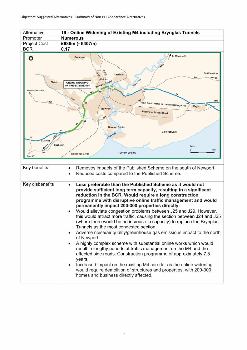
Alternative 19 - Online Widening of Existing M4 including Brynglas Tunnels Promoter Numerous Project Cost £686m (- £407m) BCR 0.17
Key benefits Removes impacts of the Published Scheme on the south of Newport.
Reduced costs compared to the Published Scheme.
Key disbenefits Less preferable than the Published Scheme as it would not provide sufficient long term capacity, resulting in a significant reduction in the BCR. Would require a long construction programme with disruptive online traffic management and would permanently impact 200-300 properties directly.
Would alleviate congestion problems between J25 and J29. However, this would attract more traffic, causing the section between J24 and J25 (where there would be no increase in capacity) to replace the Brynglas Tunnels as the most congested section.
Adverse noise/air quality/greenhouse gas emissions impact to the north of Newport.
A highly complex scheme with substantial online works which would result in lengthy periods of traffic management on the M4 and the affected side roads. Construction programme of approximately 7.5 years.
Increased impact on the existing M4 corridor as the online widening would require demolition of structures and properties, with 200-300 homes and business directly affected.
Objectors’ Suggested Alternatives – Summary of Non‐PLI Appearance Alternatives
9
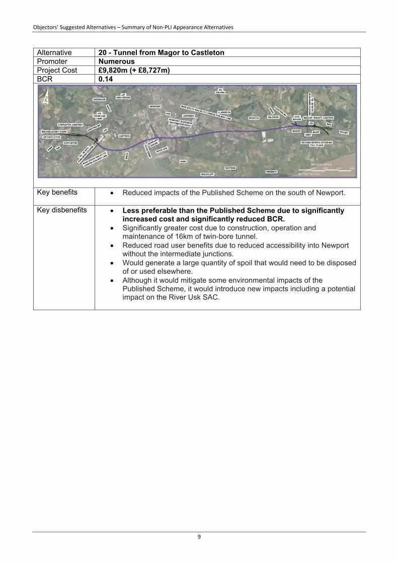
Alternative 20 - Tunnel from Magor to Castleton Promoter Numerous Project Cost £9,820m (+ £8,727m) BCR 0.14
Key benefits Reduced impacts of the Published Scheme on the south of Newport.
Key disbenefits Less preferable than the Published Scheme due to significantly
increased cost and significantly reduced BCR. Significantly greater cost due to construction, operation and
maintenance of 16km of twin-bore tunnel. Reduced road user benefits due to reduced accessibility into Newport
without the intermediate junctions. Would generate a large quantity of spoil that would need to be disposed
of or used elsewhere. Although it would mitigate some environmental impacts of the
Published Scheme, it would introduce new impacts including a potential impact on the River Usk SAC.

Objectors’ Suggested Alternatives – Summary of Non‐PLI Appearance Alternatives
10
Alternative 21 - South of Magor Route Promoter Numerous Project Cost £1,179m (+ £86m) BCR 1.27
Key benefits Journey time savings for through traffic as the route is more direct.
Reduced impact on the Llanfihangel Rogiet Conservation Area and standing stone at Undy.
Reduced impact on properties located to the north and west of Magor, and the north of Undy.
Key disbenefits Less preferable than the Published Scheme due to an additional
length of route within the Gwent Levels SSSIs of almost 2.5km, including 0.6km through Magor Marsh Nature Reserve. Increased cost and reduced connectivity resulting in a significant reduction in the BCR.
Increased cost due to additional ground treatment and imported fill requirements, resulting from a combination of increased fill (the additional section through the Gwent Levels would be built on embankment) and reduced cut.
11,775m overall length in SSSI compared to 9,300m for the Published Scheme.
660m length in Magor Marsh compared to 0m for the Published Scheme.
Reduced traffic benefits for Undy, Rogiet and Caldicot without a B4245 connection at J23.
Increased negative impact on Magor Motorway Service Area. Increased impact on properties located to the south of Magor/Undy.
Objectors’ Suggested Alternatives – Summary of Non‐PLI Appearance Alternatives
11
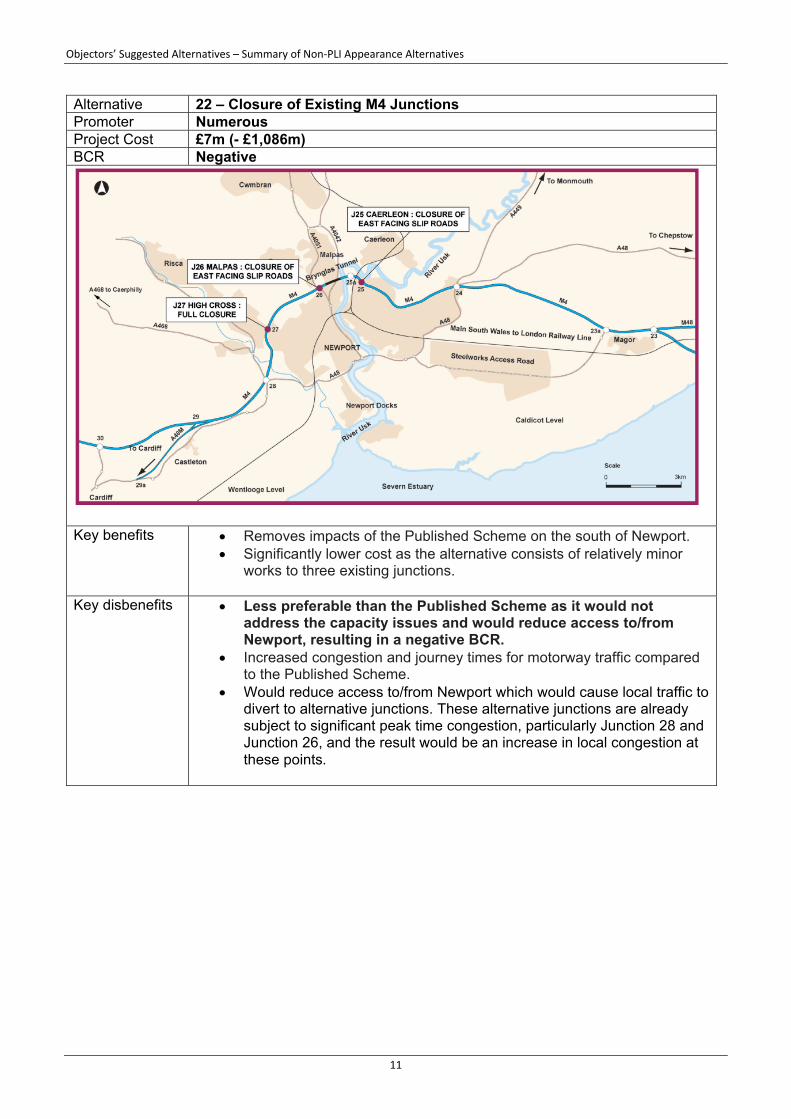
Alternative 22 – Closure of Existing M4 Junctions Promoter Numerous Project Cost £7m (- £1,086m) BCR Negative
Key benefits Removes impacts of the Published Scheme on the south of Newport.
Significantly lower cost as the alternative consists of relatively minor works to three existing junctions.
Key disbenefits Less preferable than the Published Scheme as it would not address the capacity issues and would reduce access to/from Newport, resulting in a negative BCR.
Increased congestion and journey times for motorway traffic compared to the Published Scheme.
Would reduce access to/from Newport which would cause local traffic to divert to alternative junctions. These alternative junctions are already subject to significant peak time congestion, particularly Junction 28 and Junction 26, and the result would be an increase in local congestion at these points.

Objectors’ Suggested Alternatives – Summary of Non‐PLI Appearance Alternatives
12
Alternative 23 – Blue Route and Duffryn Link Promoter Richard White Project Cost £853m (- £240m) BCR 0.64
Key benefits Similar benefits to the Blue Route.
Key disbenefits Overall, provides similar benefits and disbenefits to the Blue
Route. However, the addition of the Duffryn Link has negative traffic impacts compared to the Blue Route, hence a decrease in BCR that is disproportionate to the increase in cost.
While the Duffryn Link itself operates successfully, it has knock-on effects elsewhere in Newport because of the additional traffic attracted onto the main part of the Blue Route. One of the disadvantages of the Blue Route is the reduced accessibility onto the SDR that is created for traffic in the Ringland area, with the removal of the Balfe Road junction, leading to significant congestion at the remaining access points from this area. The addition of the Duffryn Link exacerbates this problem, and, as is common for junctions already experiencing congestion, any exacerbation leads to an exponential increase in delays.

Objectors’ Suggested Alternatives – Summary of Non‐PLI Appearance Alternatives
13
Alternative 24 – Amber Route (Blue Route Variation) Promoter Peter Keelan Project Cost £1,169m (+ £76m) BCR 0.47
Key benefits Similar benefits to Blue Route Phase 1, primarily reduced impacts of
the Published Scheme on the south of Newport.
Key disbenefits Overall, provides similar benefits and disbenefits to the Blue Route Phase 1. However, the diversion of the existing SDR from the Alexandra Road junction onto Docks Way (to enable it to join the Amber Route at the Maesglas junction) has negative traffic impacts compared to the Blue Route Phase 1, hence a decrease in BCR that is disproportionate to the increase in cost.
While the Amber Route itself operates successfully, the diversion of the existing SDR leads to a significant increase in traffic volumes on Docks Way, causing some of the existing accesses to the Docks and the retail parks to become overloaded. In addition, the additional traffic attracted onto the Amber Route creates significant congestion at the eastern end of the A4810 on the entry to Junction 23A.
Significant increase in costs compared to the Blue Route (and Blue Route Phase 1) due to 5.4km section of new-build carriageway (including section elevated on structures through Newport Docks and across the River Usk) and free-flow connections at Junction 28.
Increased visual impact on the Transporter Bridge as River Usk bridge would be closer than Published Scheme.
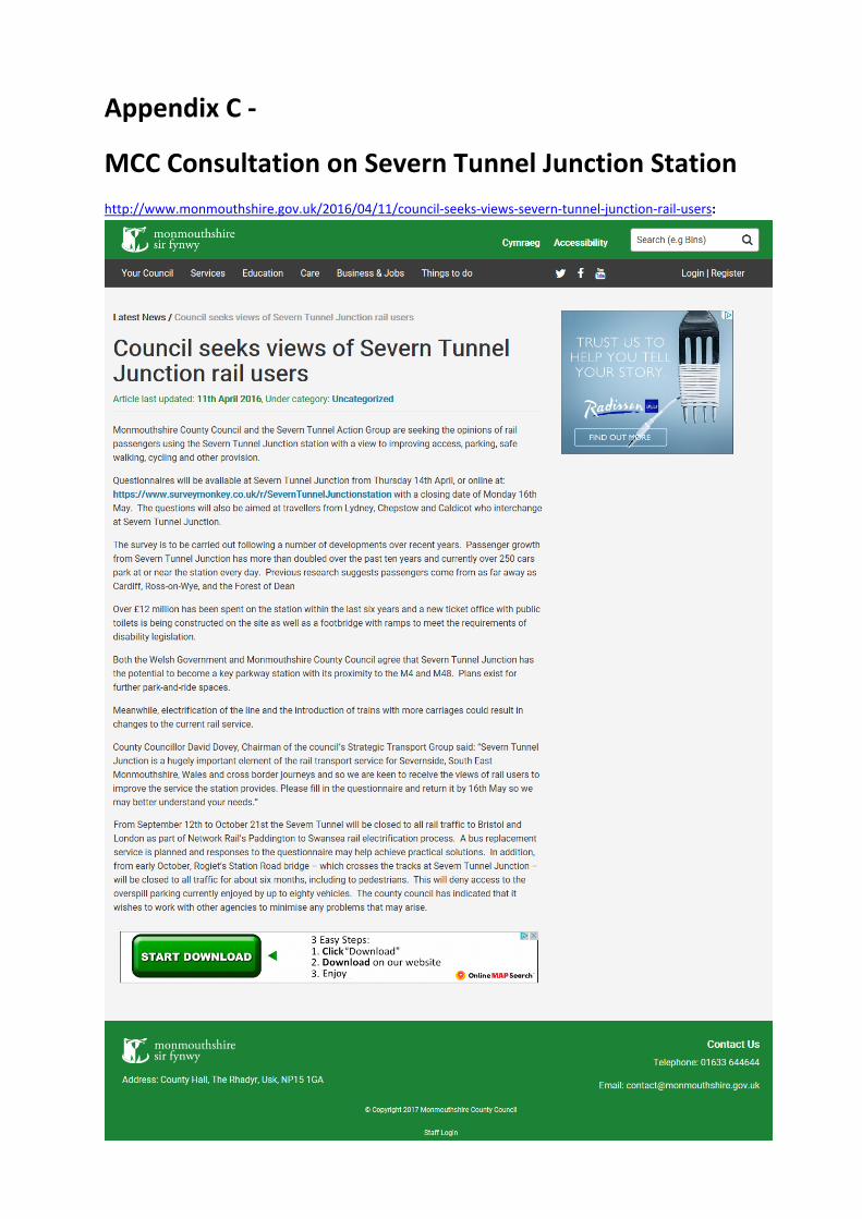
Appendix C ‐
MCC Consultation on Severn Tunnel Junction Station
http://www.monmouthshire.gov.uk/2016/04/11/council‐seeks‐views‐severn‐tunnel‐junction‐rail‐users:

Appendix D ‐
NCC & MCC Comments

NCC COMMENTS:


MCC COMMENTS(EMAIL RE: GREEN ROUTE):

MCC COMMENTS (LANDSCAPE/ECOLOGY/CONSERVATION):

Appendix E ‐
IAC Swept Path Drawing
First Issue KENP01
08/07/16
KEN
08/07/16
KEN
08/07/1608/07/16
S2
P01
M4 CORRIDOR AROUND NEWPORTINFORMATION
SAFETY, HEALTH AND ENVIRONMENTAL
(Reference shall also be made to the design hazard log).
detailed on this drawing, note the following significant residual risks
In addition to the hazards/risks normally associated with the types of work
Construction
(Enter "None" if applicable)
Maintenance / Cleaning
(Enter "None" if applicable)
Use
(Enter "None" if applicable)
Decommissioning / Demolition
(Enter "None" if applicable)
ONLY WRITTEN DIMENSIONS SHALL BE USED, DO NOT SCALE.2.
ALL DIMENSIONS ARE IN METRES UNLESS NOTED OTHERWISE.1.
GENERAL NOTES:
Z4_GEN - SK - CH - 0099
M4CaN - DJV - HML -08/07/16 AJJAEJ
AJJAEJ
RETAINING WALL
IAC ALTERNATIVE
1:1000
FOR INFORMATION
A3
Scale
Drawing Title
Project TitleDrawing Status
DO N
OT S
CA
LE
Client Original Size
Suitability
Drawing Number Revision
Millim
etres
100
10
0
Location Type Role Number
Project Originator Volume
Date Date Date Date
Designed / Drawn Checked Approved Authorised
Rev. Date Description By Chk'd App'd
Project Team
Trwydded yr Arolwg Ordnans 100021874.
© Hawlfraint a hawliau cronfa ddata'r Goron 2015. Rhif
Survey 100021874. Welsh Government.
© Crown Copyright and database right 2015. Ordnance
ETL
El
Sub Sta
Lakes
Reen
Mast
SM
ETL
6.1m
Drain
El Sub Sta
Und
CR
Tanks
Bollard
Rising
Pond
Gas
Drain
Gas Distribution Sta
Drain
El Sub Sta
Gov
2m HIGH RETAINING WALL
10m RIGID VEHICLE
TO BE PROVIDED
NEW TURNING HEAD
PROPOSED NEW
M4
IAC DELTA HOUSE
CAR PARK
20m
10m
12
m
SHUTTER DOOR
HIGHWAY BOUNDARY FENCE LINE
0%
66%
FTA Design HG Rigid Vehicle (1998)

Appendix F ‐
Detailed Economic Appraisal Results
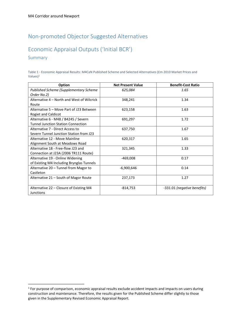
M4 Corridor around Newport
Non-promoted Objector Suggested Alternatives
Economic Appraisal Outputs (‘Initial BCR’)
Summary
Table 1 - Economic Appraisal Results: M4CaN Published Scheme and Selected Alternatives (£m 2010 Market Prices and Values)1
Option Net Present Value Benefit-Cost Ratio
Published Scheme (Supplementary Scheme Order No.2)
625,084 1.65
Alternative 4 – North and West of Wilcrick Route
348,241 1.34
Alternative 5 – Move Part of J23 Between Rogiet and Caldicot
623,158 1.63
Alternative 6 - M48 / B4245 / Severn Tunnel Junction Station Connection
691,297 1.72
Alternative 7 - Direct Access to Severn Tunnel Junction Station from J23
637,750 1.67
Alternative 12 - Move Mainline Alignment South at Meadows Road
620,317 1.65
Alternative 18 - Free-flow J23 and Connection at J23A (2006 TR111 Route)
321,345 1.33
Alternative 19 - Online Widening of Existing M4 Including Brynglas Tunnels
-469,008 0.17
Alternative 20 – Tunnel from Magor to Castleton
-6,900,646 0.14
Alternative 21 – South of Magor Route
237,173 1.27
Alternative 22 – Closure of Existing M4 Junctions
-814,753 -331.01 (negative benefits)
1 For purpose of comparison, economic appraisal results exclude accident impacts and impacts on users during construction and maintenance. Therefore, the results given for the Published Scheme differ slightly to those given in the Supplementary Revised Economic Appraisal Report.

M4 Corridor around Newport
Detailed Appraisal Outputs
Table 2 - Detailed Economic Appraisal Results: M4CaN Published Scheme and Selected Alternatives (£m 2010 Market Prices and Values)
Published Scheme (Supplementary Scheme Order No.2)
Alternative 4 – North and West of Wilcrick Route
Alternative 5 – Move Part of J23 Between Rogiet and Caldicot
Alternative 6 - M48 / B4245 / Severn Tunnel Junction Station Connection
Alternative 7 - Direct Access to Severn Tunnel Junction Station from J23
Alternative 12 - Move Mainline Alignment South at Meadows Road
Alternative 18 - Free-flow J23 and Connection at J23A
Alternative 19 - Online Widening of Existing M4 Including Brynglas Tunnels
Alternative 20 – Tunnel from Magor to Castleton
Alternative 21 – South of Magor Route
Alternative 22 – Closure of Existing M4 Junctions
User Benefits (Commuters) 245,206 215,631 258,365 265,700 250,605 248,840 181,103 -63,173 109,218 161,025 -309,074
- Travel Time 250,665 228,427 262,799 268,439 256,088 253,961 193,031 -45,838 116,130 171,126 -286,844
- Vehicle Operating Costs -5,231 -12,564 -4,124 -2,401 -5,243 -4,892 -11,813 -17,304 -6,701 -9,863 -22,110
- User Charges -228 -232 -310 -338 -240 -229 -115 -31 -211 -238 -120
User Benefits (Other) 630,131 556,535 659,950 673,867 642,140 630,347 502,888 40,972 431,658 479,636 -333,186
- Travel Time 625,955 577,355 648,204 658,985 636,028 626,241 515,433 84,797 432,854 496,167 -277,154
- Vehicle Operating Costs 5,922 -19,328 14,057 17,289 7,870 5,855 -11,833 -43,707 1,041 -15,062 -55,879
- User Charges -1,746 -1,492 -2,311 -2,407 -1,758 -1,749 -712 -118 -2,237 -1,469 -153
User Benefits (Business) 711,212 587,657 714,558 730,531 715,981 710,709 628,083 95,521 563,697 668,600 -195,832
- Travel Time 586,048 523,419 593,707 602,143 590,852 586,235 516,494 107,902 415,602 519,038 -164,704
- Vehicle Operating Costs 128,501 66,421 124,422 132,083 128,466 127,804 114,641 -12,140 153,243 156,103 -30,699
- User Charges -3,337 -2,183 -3,571 -3,695 -3,337 -3,330 -3,052 -241 -5,148 -6,541 -429
Wider Public Finances -19,693 9,581 -22,202 -27,324 -20,980 -19,559 -2,882 49,122 -24,064 -14,681 56,152
Greenhouse Gases 6,258 -8,281 7,450 10,122 6,929 6,152 -2,187 -26,855 7,879 3,410 -30,359
Present Value of Benefits (PVB)
1,573,114 1,361,123 1,618,121 1,652,896 1,594,675 1,576,489 1,307,005 95,587 1,088,388 1,297,990 -812,299
Revenue (Severn Crossing Tolls)
-17,016 -14,703 -17,998 -18,539 -16,980 -17,010 -14,535 -8,410 -20,301 -22,738 -7,793
Maintenance and Operating Costs
66,363 66,363 66,363 66,363 66,363 66,363 66,363 0 0 66,363 0
Investment Costs 904,920 961,222 946,598 913,775 907,542 906,819 933,832 573,005 8,009,335 981,192 10,247
Present Value Costs (PVC) 954,267 1,012,882 994,963 961,599 956,925 956,172 985,660 564,595 7,989,034 1,024,817 2,454
Net Present Value (NPV) 618,847 348,241 623,158 691,297 637,750 620,317 321,345 -469,008 -6,900,646 273,173 -814,753
Benefit-Cost Ratio (BCR) 1.65 1.34 1.63 1.72 1.67 1.65 1.33 0.17 0.14 1.27 -331.01

Appendix G ‐
Programme for OSA 19 ‘Online Widening’
Activity ID Activity Name RemainingDuration
Start Finish
ALTERNATIVE SCHEMES (Comparison to Published Scheme - 42mth PLI Programme)ALTERNATIVE SCHEMES (Comparison to Published Scheme - 42mth PLI Programme)ALTERNATIVE SCHEMES (Comparison to Published Scheme - 42mth PLI Programme)ALTERNATIVE SCHEMES (Comparison to Published Scheme - 42mth PLI Programme)ALTERNATIVE SCHEMES (Comparison to Published Scheme - 42mth PLI Programme)
19: Online Widening of Existing M4 including Brynglas Tunnels19: Online Widening of Existing M4 including Brynglas Tunnels19: Online Widening of Existing M4 including Brynglas Tunnels19: Online Widening of Existing M4 including Brynglas Tunnels19: Online Widening of Existing M4 including Brynglas Tunnels
A2870 KS6 Motorway Open to Traffic (42mth PLI Programme) 0d 24-Dec-21*
Preliminary ConstraintsPreliminary ConstraintsPreliminary ConstraintsPreliminary ConstraintsPreliminary Constraints
A2020 Minister's Decision Letter 0d 08-Jan-18*
A2030 KS3 250d 08-Jan-18 07-Jan-19
A2050 KS4 250d 08-Jan-19 07-Jan-20
Detailed DesignDetailed DesignDetailed DesignDetailed DesignDetailed Design
A1540 Carry out Detailed Design 250d 08-Jan-20 06-Jan-21
ConstructionConstructionConstructionConstructionConstruction
A3180 KS6 Motorway Open to Traffic 0d 25-Aug-28
Online Widening Jct29 to Jct 26 (to 4-lane motorway)Online Widening Jct29 to Jct 26 (to 4-lane motorway)Online Widening Jct29 to Jct 26 (to 4-lane motorway)Online Widening Jct29 to Jct 26 (to 4-lane motorway)Online Widening Jct29 to Jct 26 (to 4-lane motorway)
Structure WideningStructure WideningStructure WideningStructure WideningStructure Widening
A2880 Blacksmith Way Underbridge Widening (1 TM phases) 194d 07-Jan-21 12-Oct-21
A2890 Cleppa Park Overbridge Replacement (2 TM phases) 250d 07-Jan-21 06-Jan-22
A2970 Brickyard Ln Underbridge Widening (1 TM phases) 194d 07-Jan-21 12-Oct-21
A2980 Wernddu Farm Underbridge Widening (1 TM phases) 194d 07-Jan-21 12-Oct-21
A2900 Jct 28 Underbridge Widening (2 TM phases) 387d 07-Jan-22 24-Jul-23
A2910 Jct 28 E/B Onslip Underbridge Widening (2 TM phases) 387d 07-Jan-22 24-Jul-23
A3000 Jct 26 Malpas Viaduct Widening (1 TM phases) (Assume one s ide widened only for tie-in to new tunnel)
250d 07-Jan-22 06-Jan-23
A3060 Jct 28 E/B Offslip Underbridge Widening (2 TM phases) 387d 07-Jan-22 24-Jul-23
A2920 Railway Overbridge Widening (3 TM phases) (Assume railway diverted while replace bridge)
581d 25-Jul-23 14-Nov-25
A2930 Bassaleg Rd Overbridge Replacement (3 TM phases) 581d 25-Jul-23 14-Nov-25
A2940 Glasllwch Ln Overbridge Replacement (3 TM phases) 581d 25-Jul-23 14-Nov-25
A2950 Jct 27 Overbridge 1 Replacement (3 TM phases) 581d 25-Jul-23 14-Nov-25
A2960 Jct 27 Overbridge 2 Replacement (3 TM phases) 581d 25-Jul-23 14-Nov-25
A3050 River Ebbw Underbridge Widening (2 TM phases) 387d 25-Jul-23 10-Feb-25
RoadworksRoadworksRoadworksRoadworksRoadworks
A3100 Westbound Verge Widening (assume 2 lane running Jct28-26) 250d 14-Nov-25 16-Nov-26
A3110 Eastbound Verge Widening (assume 2 lane running Jc t28-26) 250d 16-Nov-26 16-Nov-27
A3120 Centre Reserve Works 194d 16-Nov-27 25-Aug-28
Online Widening Jct26 to Jct 25 (to 3-lane motorway)Online Widening Jct26 to Jct 25 (to 3-lane motorway)Online Widening Jct26 to Jct 25 (to 3-lane motorway)Online Widening Jct26 to Jct 25 (to 3-lane motorway)Online Widening Jct26 to Jct 25 (to 3-lane motorway)
Tunnel WorksTunnel WorksTunnel WorksTunnel WorksTunnel Works
A1560 Preliminary works to facility off-line tunnel construction (e.g. demolition of properties)
250d 07-Jan-21 06-Jan-22
A1550 Off-line Tunnel Construction Works 500d 07-Jan-22 08-Jan-24
A3160 Refurbish existing W/B tunnel for new E/B lane 2&3 194d 11-Oct-24 23-Jul-25
A3170 Refurbish existing E/B tunnel for new E/B lane1 & H/S 129d 05-May-26 04-Nov-26
Structure WideningStructure WideningStructure WideningStructure WideningStructure Widening
A3030 River Usk Viaduct & A4042 Widening 500d 07-Jan-22 08-Jan-24
RoadworksRoadworksRoadworksRoadworksRoadworks
A3130 Westbound tie-in to new tunnel and slip roads 194d 09-Jan-24 11-Oct-24
A3140 Eastbound Phase 1 tie-in to new tunnel 194d 24-Jul-25 05-May-26
A3150 Eastbound Phase 2 tie-in to new tunnel and slip roads 194d 04-Nov-26 16-Aug-27
CommissioningCommissioningCommissioningCommissioningCommissioning
A3190 Commissioning of motorway comms after 'Motorway Open to Traffic' date 129d 29-Aug-28 05-Mar-29*
- - - - - - - - - - 1 2 3 4 5 6 7 8 9 1 1 1 1 1 1 1 1 1 1 2 2 2 2 2 2 2 2 2 2 3 3 3 3 3 3 3 3 3 3 4 4 4 4 4 4 4 4 4 4 5 5 5 5 5 5 5 5 5 5 6 6 6 6 6 6 6 6 6 6 7 7 7 7 7 7 7 7 7 7 8 8 8 8 8 8 8 8 8 8 9 9 9 9 9 9 9 9 9 9 1 1 1 1 1 1 1 1 1 1 1 1 1 1 1 1 1 1 1 1 1 1 1 1 1 1 1 1 1 1 1 1 1 1 1 1 1 1 1 1 1 1
S O N D J F M A M J J A S O N D J F M A M J J A S O N D J F M AM J J A S O N D J F M A M J J A S O N D J F M A M J J A S O N D J F M A M J J A S O N D J F M A M J J A S O N D J F M A M J J A S O N D J F M A M J J A S ON D J F M A M J J A S O N D J F M A M J J A S O N D J F M A M J J A S O N D J FM
2018 2019 2020 2021 2022 2023 2024 2025 2026 2027 2028 2029 2030
KS6 Motorway Open to Traffic (42mth PLI Programme)
Minister's Decision Letter
KS3
KS4
Carry out Detailed Design
KS6 Motorway Open to Traffic
Blacksmith Way Underbridge Widening (1 TM phases)
Cleppa Park Overbridge Replacement (2 TM phases)
Brickyard Ln Underbridge Widening (1 TM phases)
Wernddu Farm Underbridge Widening (1 TM phases)
Jct 28 Underbridge Widening (2 TM phases)
Jct 28 E/B Onslip Underbridge Widening (2 TM phases)
Jct 26 Malpas Viaduct Widening (1 TM phases) (Assume one s ide widened only for tie-in to new tunnel)
Jct 28 E/B Offslip Underbridge Widening (2 TM phases)
Railway Overbridge Widening (3 TM phases) (Assume railway diverted while replace bridge)
Bassaleg Rd Overbridge Replacement (3 TM phases)
Glasllwch Ln Overbridge Replacement (3 TM phases)
Jct 27 Overbridge 1 Replacement (3 TM phases)
Jct 27 Overbridge 2 Replacement (3 TM phases)
River Ebbw Underbridge Widening (2 TM phases)
Westbound Verge Widening (assume 2 lane running Jct28-26)
Eastbound Verge Widening (assume 2 lane running Jc t28-26)
Centre Reserve Works
Preliminary works to facility off-line tunnel construction (e.g. demolition of properties)
Off-line Tunnel Construction Works
Refurbish existing W/B tunnel for new E/B lane 2&3
Refurbish existing E/B tunnel for new E/B lane1 & H/S
River Usk Viaduct & A4042 Widening
Westbound tie-in to new tunnel and slip roads
Eastbound Phase 1 tie-in to new tunnel
Eastbound Phase 2 tie-in to new tunnel and slip roads
Commissioning of motorway comms after 'Motorway Open to Traffic' date
Project ID:M4CAN-AS-001C Page 1 of 1
Data date: 01-Jan-17
Run date: 13-Jul-17 09:52
TASK filter: Alternative 19.
Layout: M4CaN-AS-001C Alternative 19
Printed by: lilcra
M4 Corridor around Newport
for Llywdraeth Cymru / Welsh Government
Alternative Schemes Programme Reference M4CAN-AS-001C
Alternative Scheme 19 - July 2017
Remaining Bar
Milestone

Appendix H ‐
Appraisals of OSA 23 ‘Blue Route and Duffryn Link’
and OSA 24 ‘Amber Route’

1 The Welsh Government is not promoting the Objectors’ Suggested Alternatives
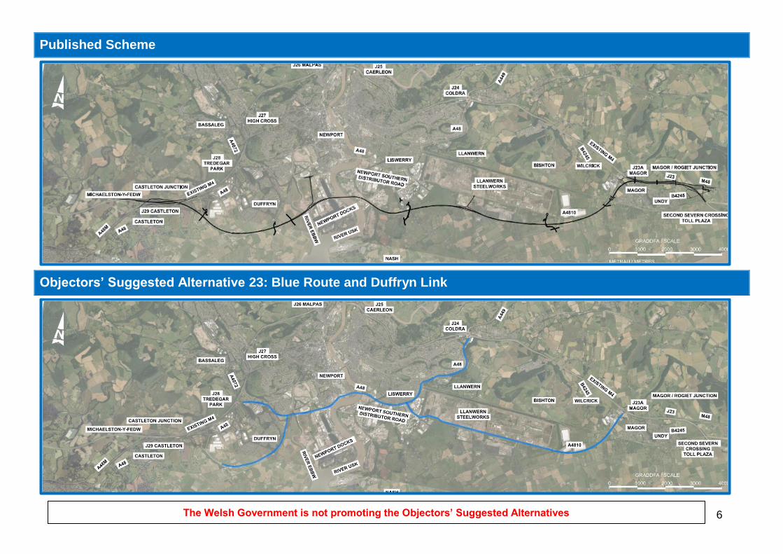
Objectors’ Suggested Alternative 23: Blue Route and Duffryn Link
This suggested alternative is a variation of the Blue Route proposal that was appraised within the full
Objectors’ Suggested Alternatives Report. The proposal comprises improvements to the Newport A48
Southern Distributor Road (SDR), and A4810 (known locally as the Steelworks Access Road or
Queensway) and completion of the Duffryn Link Road. The Blue Route proposals involve works to junctions
along roads joining the SDR between Junction 28 (Tredegar Park) and Junction 24 (Coldra), and along the
SDR and A4810 between Junction 28 and Junction 23a (Magor). The Duffryn Link would connect the dual
carriageway link South of Imperial Park Coedkernew, constructed by Newport City Council, to the A48
(SDR) Maesglas Roundabout. The Duffryn Link alignment would run north of the South Wales to London
Mainline Railway Line and adjacent to the south-east extents of the Duffryn residential area. A single
intermediate at grade roundabout would provide connection to the Duffryn residential area. The proposal is
shown on page 6.
Appraisal against Scheme Specific Objectives
Meets six scheme objectives but all less well than the Published Scheme (1 to 5, 14). Does not meet nine
scheme objectives (6 to 13, 15).
Appraisal Compared to Published Scheme
Ec
on
om
y
Project Cost Estimate: £853m Benefit to Cost Ratio (BCR): 0.64
Transport Economic Efficiency (TEE): The Blue Route and Duffryn Link would improve network
resilience and is likely to provide local accessibility benefits in the short term. However, it would
provide little relief to congestion on the M4, initial benefits of the Blue Route and Duffryn Link would
begin to be offset by traffic growth and associated capacity issues. The Blue Route and Duffryn Link
would not provide a long-term solution to the transport related problems on the M4 around Newport
which would continue to experience operational problems. With a BCR of less than 1.0, the Blue
Route and Duffryn Link offers poor value for money.
Economic Activity & Location Impacts (EALI): The Blue Route and Duffryn Link would improve
access to employment sites in the south of Newport although beneficial effects on the economy would
be more limited and localised than the Published Scheme.
2 The Welsh Government is not promoting the Objectors’ Suggested Alternatives
En
vir
on
me
nt
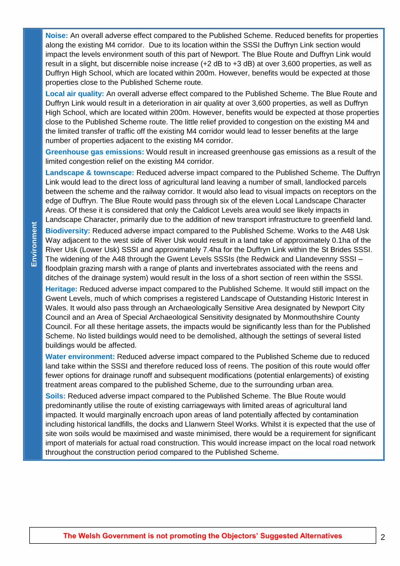
Noise: An overall adverse effect compared to the Published Scheme. Reduced benefits for properties
along the existing M4 corridor. Due to its location within the SSSI the Duffryn Link section would
impact the levels environment south of this part of Newport. The Blue Route and Duffryn Link would
result in a slight, but discernible noise increase (+2 dB to +3 dB) at over 3,600 properties, as well as
Duffryn High School, which are located within 200m. However, benefits would be expected at those
properties close to the Published Scheme route.
Local air quality: An overall adverse effect compared to the Published Scheme. The Blue Route and
Duffryn Link would result in a deterioration in air quality at over 3,600 properties, as well as Duffryn
High School, which are located within 200m. However, benefits would be expected at those properties
close to the Published Scheme route. The little relief provided to congestion on the existing M4 and
the limited transfer of traffic off the existing M4 corridor would lead to lesser benefits at the large
number of properties adjacent to the existing M4 corridor.
Greenhouse gas emissions: Would result in increased greenhouse gas emissions as a result of the
limited congestion relief on the existing M4 corridor.
Landscape & townscape: Reduced adverse impact compared to the Published Scheme. The Duffryn
Link would lead to the direct loss of agricultural land leaving a number of small, landlocked parcels
between the scheme and the railway corridor. It would also lead to visual impacts on receptors on the
edge of Duffryn. The Blue Route would pass through six of the eleven Local Landscape Character
Areas. Of these it is considered that only the Caldicot Levels area would see likely impacts in
Landscape Character, primarily due to the addition of new transport infrastructure to greenfield land.
Biodiversity: Reduced adverse impact compared to the Published Scheme. Works to the A48 Usk
Way adjacent to the west side of River Usk would result in a land take of approximately 0.1ha of the
River Usk (Lower Usk) SSSI and approximately 7.4ha for the Duffryn Link within the St Brides SSSI.
The widening of the A48 through the Gwent Levels SSSIs (the Redwick and Llandevenny SSSI –
floodplain grazing marsh with a range of plants and invertebrates associated with the reens and
ditches of the drainage system) would result in the loss of a short section of reen within the SSSI.
Heritage: Reduced adverse impact compared to the Published Scheme. It would still impact on the
Gwent Levels, much of which comprises a registered Landscape of Outstanding Historic Interest in
Wales. It would also pass through an Archaeologically Sensitive Area designated by Newport City
Council and an Area of Special Archaeological Sensitivity designated by Monmouthshire County
Council. For all these heritage assets, the impacts would be significantly less than for the Published
Scheme. No listed buildings would need to be demolished, although the settings of several listed
buildings would be affected.
Water environment: Reduced adverse impact compared to the Published Scheme due to reduced
land take within the SSSI and therefore reduced loss of reens. The position of this route would offer
fewer options for drainage runoff and subsequent modifications (potential enlargements) of existing
treatment areas compared to the published Scheme, due to the surrounding urban area.
Soils: Reduced adverse impact compared to the Published Scheme. The Blue Route would
predominantly utilise the route of existing carriageways with limited areas of agricultural land
impacted. It would marginally encroach upon areas of land potentially affected by contamination
including historical landfills, the docks and Llanwern Steel Works. Whilst it is expected that the use of
site won soils would be maximised and waste minimised, there would be a requirement for significant
import of materials for actual road construction. This would increase impact on the local road network
throughout the construction period compared to the Published Scheme.

3 The Welsh Government is not promoting the Objectors’ Suggested Alternatives
So
cia
l
So
cia
l
Transport safety: Adverse impact compared to the Published Scheme. There would be little relief to
motorway congestion as a result of the Blue Route and Duffryn Link. Whilst it is anticipated that there
would be an initial reduction in congestion, there would be operational problems along the Blue Route
by 2037. As such, it is not expected that the Blue Route and Duffryn Link would improve transport
safety.
Personal security: Adverse impact compared to the Published Scheme. The introduction of grade
separated junctions would reduce the need for stopping. This would in turn reduce the risk of personal
security incidents whilst waiting at junctions. However, along the Dyffryn Link where at grade rural
roundabouts are proposed this personal security risk would remain. However, by 2037 there would be
operational problems along the Blue Route and Duffryn Link and severe operational problems on the
M4 around Newport, which would increase personal security risks.
Permeability: Adverse impact compared to the Published Scheme. There would be adverse impacts
upon pedestrian and cyclist movements as a result of increased severance issues with increased
traffic volumes and junction works along the SDR, A4810 and Duffryn Link route. Alternative
pedestrian and cycle routes would need to be provided. There would be limited opportunities to
provide new or improved active travel measures with the Blue Route and Duffryn Link.
Physical fitness: Adverse impact compared to the Published Scheme. Transport modelling has
indicated little relief to motorway congestion as a result of the Blue Route and Duffryn Link, which
would not contribute to reducing air pollution along the corridor. Traffic and congestion along the SDR,
A4810 and Duffryn Link would have a detrimental impact upon the health of Newport and Duffryn
residents. There would also be an increase in noise levels. By increasing severance along the route,
there would be a negative impact upon physical fitness as a result of a reduction in permeability and
attractiveness of cycling and walking.
Social inclusion: By increasing severance along the route, there would be a negative impact upon
the movement of people using non-motorised modes.
Equality, diversity and human rights: Adverse impact compared to the Published Scheme. By
increasing severance along the route, there would be a negative impact upon the movement of people
without access to a car, including vulnerable groups. Approximately 1,500 residential and commercial
properties would be potentially blighted by the Blue and Duffryn Link Route as a result of land take, air
pollution and noise impacts.
4 The Welsh Government is not promoting the Objectors’ Suggested Alternatives
Oth
er
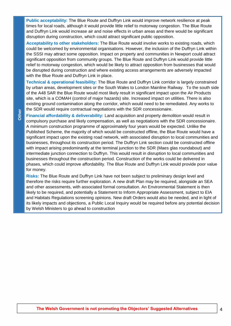
Public acceptability: The Blue Route and Duffryn Link would improve network resilience at peak
times for local roads, although it would provide little relief to motorway congestion. The Blue Route
and Duffryn Link would increase air and noise effects in urban areas and there would be significant
disruption during construction, which could attract significant public opposition.
Acceptability to other stakeholders: The Blue Route would involve works to existing roads, which
could be welcomed by environmental organisations. However, the inclusion of the Duffryn Link within
the SSSI may attract some opposition. Impact on property and communities in Newport could attract
significant opposition from community groups. The Blue Route and Duffryn Link would provide little
relief to motorway congestion, which would be likely to attract opposition from businesses that would
be disrupted during construction and where existing access arrangements are adversely impacted
with the Blue Route and Duffryn Link in place.
Technical & operational feasibility: The Blue Route and Duffryn Link corridor is largely constrained
by urban areas, development sites or the South Wales to London Mainline Railway. To the south side
of the A48 SAR the Blue Route would most likely result in significant impact upon the Air Products
site, which is a COMAH (control of major hazards) site. Increased impact on utilities. There is also
existing ground contamination along the corridor, which would need to be remediated. Any works to
the SDR would require contractual negotiations with the SDR concessionaire.
Financial affordability & deliverability: Land acquisition and property demolition would result in
compulsory purchase and likely compensation, as well as negotiations with the SDR concessionaire.
A minimum construction programme of approximately four years would be expected. Unlike the
Published Scheme, the majority of which would be constructed offline, the Blue Route would have a
significant impact upon the existing road network, with associated disruption to local communities and
businesses, throughout its construction period. The Duffryn Link section could be constructed offline
with impact arising predominantly at the terminal junction to the SDR (Maes glas roundabout) and
intermediate junction connection to Duffryn. This would result in disruption to local communities and
businesses throughout the construction period. Construction of the works could be delivered in
phases, which could improve affordability. The Blue Route and Duffryn Link would provide poor value
for money.
Risks: The Blue Route and Duffryn Link have not been subject to preliminary design level and
therefore the risks require further exploration. A new draft Plan may be required, alongside an SEA
and other assessments, with associated formal consultation. An Environmental Statement is then
likely to be required, and potentially a Statement to Inform Appropriate Assessment, subject to EIA
and Habitats Regulations screening opinions. New draft Orders would also be needed, and in light of
its likely impacts and objections, a Public Local Inquiry would be required before any potential decision
by Welsh Ministers to go ahead to construction

5 The Welsh Government is not promoting the Objectors’ Suggested Alternatives
Key Points
The Blue Route and Duffryn Link, despite having a lower capital cost compared to the Scheme, would offer poor value for money, with its costs being greater than its benefits.
The Blue Route and Duffryn Link would provide local benefits to accessibility and would reduce transport costs and improve journey times to a limited extent, however the Published Scheme would offer significantly greater benefits to the local and regional economy.
Given its urban nature it would impact a greater number properties and commercial premises with respect to noise, air quality and blight.
Compared to the Published Scheme, the Blue Route and Duffryn Link would result in less adverse environmental impacts with respect to the Gwent Levels SSSI, biodiversity, landscape and heritage. However, it would result in greater noise and air quality effects on the existing M4 corridor.
Unlike the Published Scheme, the majority of which would be constructed offline, the Blue Route would have a significant impact upon the existing road network, with associated disruption to local communities and businesses, throughout its construction period. The Duffryn Link section could be constructed offline with impact arising predominantly at the terminal junction to the SDR (Maes glas roundabout) and intermediate junction connection to Duffryn.
6 The Welsh Government is not promoting the Objectors’ Suggested Alternatives
Published Scheme
Objectors’ Suggested Alternative 23: Blue Route and Duffryn Link
The Welsh Government is not promoting the Objectors’ Suggested Alternatives
1
Objectors’ Suggested Alternative 24: Amber Route
This suggested alternative is a variation of the Blue Route Phase 1 proposal that was appraised within the
full Objectors’ Suggested Alternatives Report. The proposal comprises improvements to the A4810 (known
locally as the Steelworks Access Road or Queensway) and the western part of the Newport A48 Southern
Distributer Road (SDR). A new 5.4km section of road would be constructed further south to link the two
upgraded sections. This would include a new bridge over the River Usk, an elevated section through
Newport Docks east of the river and a grade separated junction on the A4810 to connect to the A48. At the
connection to M4 Junction 28 (Tredegar Park), free-flow connections would be provided for the major
movements. The proposal is shown on page 6.
Appraisal against Scheme Specific Objectives
Meets six scheme objectives but all less well than the Published Scheme (1 to 5, 14). Does not meet nine
scheme objectives (6 to 13, 15).
Appraisal Compared to Published Scheme
Ec
on
om
y
Project Cost Estimate: £1,169m Benefit to Cost Ratio (BCR): 0.47
Transport Economic Efficiency (TEE): The Amber Route would improve network resilience and is
likely to provide local accessibility benefits. However, it would provide little relief to congestion on
the M4. By 2037 the initial benefits of the Amber Route would begin to be offset by traffic growth
and associated capacity issues. The Amber Route would not provide a long term solution to the
transport related problems on the M4 around Newport which would continue to experience
operational problems.
Economic Activity & Location Impacts (EALI): The Amber Route would improve access to
employment sites in the South of Newport although beneficial effects to the economy would be
more limited and localised than the Published Scheme.

The Welsh Government is not promoting the Objectors’ Suggested Alternatives
2
En
vir
on
me
nt
En
vir
on
me
nt
Noise: An overall adverse effect compared to the Published Scheme. Would result in a slight, but
discernible noise increase at properties along the Amber Route but would avoid impacts through
the Levels south of Newport. The little relief provided to congestion on the existing M4 and the
limited transfer of traffic off the existing M4 corridor would lead to lesser benefits at the large
number of properties adjacent to the existing M4 corridor.
Local air quality: An overall adverse effect compared to the Published Scheme. Would result in a
deterioration in air quality at properties along the Amber Route but benefits would be expected at
those properties close to the Published Scheme route. The little relief provided to congestion on the
existing M4 and the limited transfer of traffic off the existing M4 corridor would lead to lesser
benefits at the large number of properties adjacent to the existing M4 corridor.
Greenhouse gas emissions: Would result in increased greenhouse gas emissions as a result of
the limited congestion relief on the existing M4 corridor.
Landscape & townscape: Reduced adverse impact compared to the Published Scheme. There
would be an adverse visual impact on commercial and visual receptors within Newport and an
adverse visual impact of the new River Usk bridge being adjacent to and parallel with the Newport
Transporter Bridge.
Biodiversity: Reduced adverse impact compared to the Published Scheme. Would impact the
SSSI and reens, but would have significantly less impact than the Published Scheme.
Heritage: Reduced adverse impact compared to the Published Scheme. It would still impact on the
Gwent Levels, much of which comprises a registered Landscape of Outstanding Historic Interest in
Wales. It would also pass through an Archaeologically Sensitive Area designated by Newport City
Council and an Area of Special Archaeological Sensitivity designated by Monmouthshire County
Council. For all these heritage assets, the impacts would be significantly less than for the Published
Scheme. No listed buildings would need to be demolished, although the settings of several listed
buildings would be affected. There would be an increased impact on the Grade I listed Newport
Transporter Bridge as the new River Usk bridge would be closer to it than the Published Scheme.
Water environment: Reduced adverse impact compared to the Published Scheme due to reduced
land take within the SSSI and therefore reduced loss of reens. The position of this route would offer
fewer options for drainage runoff and subsequent modifications (potential enlargements) of existing
treatment areas compared to the Published Scheme, due to the surrounding urban area.
Soils: Reduced adverse impact compared to the Published Scheme. Parts of the Amber Route
would utilise the route of existing carriageways with limited areas of agricultural land impacted. It
would encroach upon areas of land potentially affected by contamination including historical
landfills, the docks and Llanwern Steel Works. Whilst it is expected that the use of site won soils
would be maximised and waste minimised, there would be a requirement for significant import of
materials for actual road construction, in particular the section of the Amber Route immediately east
of Newport Docks which would be raised on embankment. This would increase impact on the local
road network throughout the construction period compared to the Published Scheme.
The Welsh Government is not promoting the Objectors’ Suggested Alternatives
3
So
cia
l
So
cia
l
Transport safety: Adverse impact compared to the Published Scheme. There would be little relief
to motorway congestion as a result of the Amber Route. Whilst it is anticipated that there would be
an initial reduction in congestion, there would be operational problems along the Amber Route by
2037. As such, it is not expected that the Amber Route would improve transport safety.
Personal security: Adverse impact compared to the Published Scheme. The introduction of grade
separated junctions would reduce the need for stopping. This would in turn reduce the risk of
personal security incidents whilst waiting at junctions. However, by 2037 there would be operational
problems along the Amber Route and severe operational problems on the M4 around Newport,
which would increase personal security risks.
Permeability: Adverse impact compared to the Published Scheme. There would be adverse
impacts upon pedestrian and cyclist movements as a result of increased severance issues with
increased traffic volumes and junction works along part of the SDR and A4810 route. Alternative
pedestrian and cycle routes would need to be provided. There would be limited opportunities to
provide new or improved active travel measures with the Amber Route.
Physical fitness: Adverse impact compared to the Published Scheme. Transport modelling has
indicated little relief to motorway congestion as a result of the Amber Route, which would not
contribute to reducing air pollution along the corridor. Traffic and congestion along the Amber Route
would have a detrimental impact upon the health of Newport residents. By increasing severance
along the route, there would be a negative impact upon physical fitness as a result of a reduction in
permeability and attractiveness of cycling and walking.
Social inclusion: By increasing severance along the route, there would be a negative impact upon
the movement of people using non-motorised modes.
Equality, diversity and human rights: Adverse impact compared to the Published Scheme. By
increasing severance along the route, there would be a negative impact upon the movement of
people without access to a car, including vulnerable groups.
The Welsh Government is not promoting the Objectors’ Suggested Alternatives
4
Oth
er
Public acceptability: The Amber Route would improve network resilience at peak times for local
roads, although it would provide little relief to motorway congestion. The Amber Route would
increase air and noise effects in urban areas and there would be significant disruption during
construction, which could attract significant public opposition.
Acceptability to other stakeholders: The majority of the Amber Route would involve works to
existing roads, which could be welcomed by environmental organisations. However, impact on
property and communities in Newport could attract significant opposition from community groups.
The Amber Route would provide little relief to motorway congestion, which would be likely to attract
opposition from businesses that would be disrupted during construction and where existing access
arrangements are adversely impacted with the Amber Route in place. Increased impact on
commercial properties through the area of Newport Docks to the east of the River Usk
Technical & operational feasibility: The online sections of the Amber Route are largely
constrained by commercial sites. Increased impact on commercial properties and overhead
electrical cables through the area of Newport Docks to the east of the River Usk. There is also
existing ground contamination along the corridor, which would need to be remediated. Any works to
the SDR would require contractual negotiations with the SDR concessionaire.
Financial affordability & deliverability: Land acquisition and property demolition would result in
compulsory purchase and likely compensation, as well as negotiations with the SDR
concessionaire. Unlike the Published Scheme, the majority of which would be constructed offline,
the Amber Route would have a significant impact upon the existing road network. This would result
in disruption to local communities and businesses throughout the construction period. Construction
of the works could be delivered in phases, which could improve affordability. The Amber Route
would provide poor value for money.
Risks: The Amber Route has not been subject to preliminary design level and therefore the risks
require further exploration. A new draft Plan may be required, alongside an SEA and other
assessments, with associated formal consultation. An Environmental Statement is then likely to be
required, and potentially a Statement to Inform Appropriate Assessment, subject to EIA and
Habitats Regulations screening opinions. New draft Orders would also be needed, and in light of its
likely impacts and objections, a Public Local Inquiry would be required before any potential decision
by Welsh Ministers to go ahead to construction.

The Welsh Government is not promoting the Objectors’ Suggested Alternatives
5
Key Points
The Amber Route has a greater capital cost than the Published Scheme but offers reduced user benefits, and would therefore offer poor value for money.
The Amber Route would provide local benefits to accessibility and would reduce transport costs and improve journey times to a limited extent, however the Published Scheme would offer significantly greater benefits to the local and regional economy.
Compared to the Published Scheme, the Amber Route would result in less adverse environmental impacts with respect to the Gwent Levels SSSI, biodiversity and landscape. However, it would result in greater noise and air quality effects on the existing M4 corridor.
Increased visual impact on the Grade I listed Newport Transporter Bridge as River Usk bridge would be closer than Published Scheme.
It would impact a greater number of commercial premises compared to the Published Scheme.
Unlike the Published Scheme, the majority of which would be constructed offline, the Amber Route would have a significant impact upon the existing road network, with associated disruption to local communities and businesses, throughout its lengthy construction period.
Significant increase in costs compared to the Blue Route (and Blue Route Phase 1) due to 5.4km section of new-build carriageway (including section elevated on structures through Newport Docks and across the River Usk) and free-flow connections at Junction 28.

6 The Welsh Government is not promoting the Objectors’ Suggested Alternatives
Published Scheme
Objectors’ Suggested Alternative 24: Amber Route

Appendix I ‐
Osa 24 ‘Amber Route’ West Junction Drawing
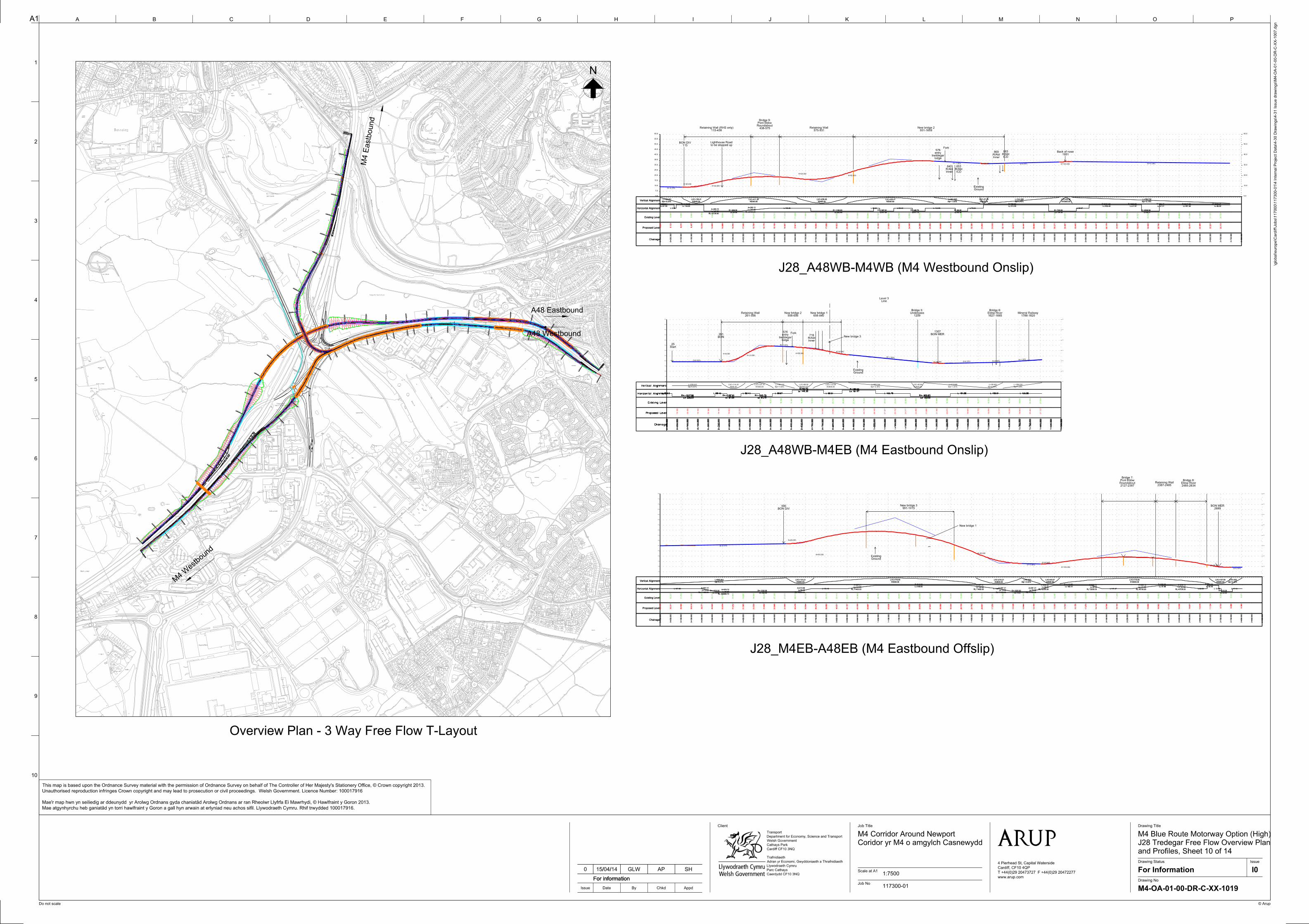
0+000.0
00
0+100.0
00
0+200.0
00
0+300.0
00
0+400.0
00
0+500.0
00
0+600.0
00
0+700.000
0+80
0.000
0+900.000
1+000.000
1+100.000
1+200.000
1+300.000
1+400.000
1+500.000
1+600.000
1+700.000
1+800.000
1+806.8051+806.805
0+000.0
00
0+100.000
0+200.000
0+300.000
0+400.0
00
0+500.0
00
0+600.0
00
0+700.0
00
0+800.0
00
0+900.0
00
1+000.0
00
1+100.0
00
1+200.0
00
1+300.0
00
1+400.0
00
1+50
0.000
1+60
0.00
0
1+70
0.00
0
1+800.000
1+900.000
2+00
0.00
0
2+10
0.00
0
2+20
0.00
0
2+30
0.00
0
2+40
0.00
0
2+500.000
2+600.000
2+700.000
2+745.394
2+745.394
0+000.000
0+100.000
0+200.000
0+300.000
0+400.000
0+500.000
0+600.000
0+700.000
0+800.000
0+900.000
1+000.000
1+100.000
1+200.000
1+300.0
00
1+400.0
00
1+500.0
00
1+600.0
00
1+700.0
00
1+800.0
00
1+900.0
00
2+000.0
00
2+100.0
00
2+200.0
00
2+300.0
00
2+400.0
00
2+500.000
2+600.000
2+700.000
2+800.000
2+804.076
2+804.076
558-656New bridge 2
261-558Retaining Wall
BON261
656-840New bridge 1
1788-1820Mineral Railway
Fork
0.0
5.0
10.0
15.0
20.0
25.0
30.0
35.0
40.0
45.0
50.0
55.0
60.0
0.0
10.0
20.0
30.0
40.0
50.0
60.0
BON DIV595
Vertical Alignment Slp=0.00%
L=238.643
R900.00
LVC=114.43
R1000.00
LVC=137.15
Slp=-1.00%
L=100.110
R2600.00
LVC=88.02
R3000.00
LVC=172.08
Slp=-3.35%
L=303.144
R2600.00
LVC=60.84
Slp=-1.01%
L=319.860
Slp=0.40%
L=58.849
Slp=1.28%
L=188.678
Horizontal Alignment L 25.63
Lc 206.03
R=-1237.90
L 58.43
Lc 67.09
R=-1187.91
L 90.43
Lc 61.75
R=-345.70
L 95.67
Lc 149.32
R=93.70
L 90.21
Lc 161.97
R=180.00
L 165.75
Lc 193.50
R=-820.63
L 151.06 L 159.91 L 130.06
Existing Level 17.9
11
18.5
73
18.1
60
14.4
07
16.0
05
19.8
29
17.7
49
23.7
12
29.8
39
21.4
54
19.3
58
31.0
85
29.3
21
25.6
41
22.9
93
22.3
40
15.0
78
15.4
49
16.1
46
16.6
10
17.5
25
18.1
77
18.5
28
16.5
65
18.7
92
19.4
01
20.0
90
21.0
38
Proposed Level 19.1
88
19.1
88
19.1
88
19.1
88
19.1
88
19.9
23
23.3
32
29.0
11
33.0
22
34.5
34
34.1
49
33.6
49
33.3
81
34.0
28
34.8
56
34.8
55
34.0
20
32.4
53
30.7
78
29.1
02
27.4
27
25.7
52
24.0
77
22.4
90
21.6
86
21.1
80
20.6
75
20.1
70
19.6
65
19.1
59
18.6
54
18.7
24
19.2
04
19.8
43
20.4
82
21.1
21
Chainage
0+
000.0
00
0+
050.0
00
0+
100.0
00
0+
150.0
00
0+
200.0
00
0+
250.0
00
0+
300.0
00
0+
350.0
00
0+
400.0
00
0+
450.0
00
0+
500.0
00
0+
550.0
00
0+
600.0
00
0+
650.0
00
0+
700.0
00
0+
750.0
00
0+
800.0
00
0+
850.0
00
0+
900.0
00
0+
950.0
00
1+
000.0
00
1+
050.0
00
1+
100.0
00
1+
150.0
00
1+
200.0
00
1+
250.0
00
1+
300.0
00
1+
350.0
00
1+
400.0
00
1+
450.0
00
1+
500.0
00
1+
550.0
00
1+
600.0
00
1+
650.0
00
1+
700.0
00
1+
750.0
00
1+
800.0
00
1+
850.0
00
1+
900.0
00
lodgetreddegar
entry576
Start25
1627-1665Ebbw River
Bridge 6:
1209UnderpassBridge 5:
New bridge 1
GroundExisting
GroundExisting
InnerR/Abt718
LineLevel 3
New bridge 3BON MER
1307
+
+
+
G=0.00%
G=-1.00%
G=-1.90%
G=0.32% G=0.40%G=1.28%
K=9.000K=10.000
K=55.000K=26.000
K=26.000
J28_A48WB-M4WB (M4 Westbound Onslip)
J28_A48WB-M4EB (M4 Eastbound Onslip)
J28_M4EB-A48EB (M4 Eastbound Offslip)
0.0
5.0
10.0
15.0
20.0
25.0
30.0
35.0
40.0
45.0
50.0
55.0
60.0
65.0
70.0
75.0
80.0
0.0
10.0
20.0
30.0
40.0
50.0
60.0
70.0
80.0
2689BON MER
+
+
+
+
G=0.31%
G=-0.35%
G=0.16%
K=26.000
K=55.000K=26.000
K=26.000
K=100.000
K=26.000
991-1415New bridge 3
2127-2387RoundaboutPont EbbwBridge 7:
Vertical Alignment Slp=0.31%
L=608.843
R2600.00
LVC=133.21
R5500.00
LVC=779.65
R2600.00
LVC=218.21
Slp=-0.35%
L=91.931
R2600.00
LVC=93.07
R10000.00
LVC=719.84
R2600.00
LVC=107.50
Slp=0.16%
L=51.822
Horizontal Alignment L 197.90
RL 71400.00
Ls 70.00
A=267.21
Lc 33.82
R=-1020.00
RL 332608.70
Ls 60.00
A=576.72
Lc 304.95
R=-1250.00RL 75000.00
Ls 60.00
A=273.86 L 172.19 RL 71400.00
Ls 140.00
A=267.21Lc 449.83
R=510.00
RL 71400.00
Ls 140.00
A=267.21
L 1.82
RL 71400.00
Ls 70.00
A=267.21
Lc 75.47
R=-1020.00RL 71400.00
Ls 70.00
A=267.21RL 72000.00
Ls 50.00
A=268.33Lc 182.41
R=1440.00
RL 72000.00
Ls 50.00
A=268.33
L 141.47 RL 43736.00
Ls 142.00
A=209.13Lc 47.98
R=308.00
RL 43736.00
Ls 142.00
A=209.13
L 32.83
Lc 55.40
R=510.00
L 12.98
Lc 53.88
R=-510.00
L 47.14
Existing Level 30.1
57
30.2
27
31.0
52
31.0
60
33.3
49
30.2
15
32.7
72
33.6
86
33.6
61
34.5
06
39.2
35
37.1
26
37.6
72
36.5
19
35.2
35
34.6
13
39.0
33
33.4
19
29.9
17
34.9
66
28.4
63
28.7
02
27.3
36
26.0
01
26.5
04
20.4
96
26.4
23
16.8
54
16.2
25
13.2
08
13.4
48
Proposed Level 30.1
57
30.3
11
30.4
64
30.6
18
30.7
71
30.9
25
31.0
78
31.2
32
31.3
85
31.5
39
31.6
92
31.8
46
31.9
99
32.4
78
33.9
04
36.2
74
38.6
89
40.6
51
42.1
57
43.2
09
43.8
07
43.9
50
43.6
38
42.8
72
41.6
52
39.9
76
37.8
47
35.2
62
32.2
24
28.7
30
24.7
82
20.6
07
17.2
59
14.8
73
13.4
48
12.9
66
12.7
90
12.6
77
13.3
30
14.7
93
16.1
56
17.2
70
18.1
33
18.7
46
19.1
09
19.2
22
19.0
85
18.6
99
18.0
62
17.1
75
16.0
38
14.6
51
13.0
15
11.1
34
9.7
30
9.2
88
9.3
69
Chainage
0+000.0
00
0+050.0
00
0+100.0
00
0+150.0
00
0+200.0
00
0+250.0
00
0+300.0
00
0+350.0
00
0+400.0
00
0+450.0
00
0+500.0
00
0+550.0
00
0+600.0
00
0+650.0
00
0+700.0
00
0+750.0
00
0+800.0
00
0+850.0
00
0+900.0
00
0+950.0
00
1+000.0
00
1+050.0
00
1+100.0
00
1+150.0
00
1+200.0
00
1+250.0
00
1+300.0
00
1+350.0
00
1+400.0
00
1+450.0
00
1+500.0
00
1+550.0
00
1+600.0
00
1+650.0
00
1+700.0
00
1+750.0
00
1+800.0
00
1+850.0
00
1+900.0
00
1+950.0
00
2+000.0
00
2+050.0
00
2+100.0
00
2+150.0
00
2+200.0
00
2+250.0
00
2+300.0
00
2+350.0
00
2+400.0
00
2+450.0
00
2+500.0
00
2+550.0
00
2+600.0
00
2+650.0
00
2+700.0
00
2+750.0
00
2+800.0
00
2+850.0
00
2+900.0
00
Vertical Alignment Slp=0.31%
L=608.843
R2600.00
LVC=133.21
R5500.00
LVC=779.65
R2600.00
LVC=218.21
Slp=-0.35%
L=91.931
R2600.00
LVC=93.07
R10000.00
LVC=719.84
R2600.00
LVC=107.50
Slp=0.16%
L=51.822
Horizontal Alignment L 197.90
RL 71400.00
Ls 70.00
A=267.21
Lc 33.82
R=-1020.00
RL 332608.70
Ls 60.00
A=576.72
Lc 304.95
R=-1250.00RL 75000.00
Ls 60.00
A=273.86 L 172.19 RL 71400.00
Ls 140.00
A=267.21Lc 449.83
R=510.00
RL 71400.00
Ls 140.00
A=267.21
L 1.82
RL 71400.00
Ls 70.00
A=267.21
Lc 75.47
R=-1020.00RL 71400.00
Ls 70.00
A=267.21RL 72000.00
Ls 50.00
A=268.33Lc 182.41
R=1440.00
RL 72000.00
Ls 50.00
A=268.33
L 141.47 RL 43736.00
Ls 142.00
A=209.13Lc 47.98
R=308.00
RL 43736.00
Ls 142.00
A=209.13
L 32.83
Lc 55.40
R=510.00
L 12.98
Lc 53.88
R=-510.00
L 47.14
Existing Level 14.1
52
13.4
12
13.3
37
13.0
69
12.8
43
12.3
58
12.6
99
12.6
78
12.5
91
12.4
88
12.3
38
12.0
74
11.8
65
11.6
38
11.2
40
10.9
62
10.6
84
10.4
11
10.0
62
10.0
00
9.7
16
9.0
70
9.1
04
9.2
33
9.2
90
9.3
12
9.3
71
Proposed Level 30.1
57
30.3
11
30.4
64
30.6
18
30.7
71
30.9
25
31.0
78
31.2
32
31.3
85
31.5
39
31.6
92
31.8
46
31.9
99
32.4
78
33.9
04
36.2
74
38.6
89
40.6
51
42.1
57
43.2
09
43.8
07
43.9
50
43.6
38
42.8
72
41.6
52
39.9
76
37.8
47
35.2
62
32.2
24
28.7
30
24.7
82
20.6
07
17.2
59
14.8
73
13.4
48
12.9
66
12.7
90
12.6
77
13.3
30
14.7
93
16.1
56
17.2
70
18.1
33
18.7
46
19.1
09
19.2
22
19.0
85
18.6
99
18.0
62
17.1
75
16.0
38
14.6
51
13.0
15
11.1
34
9.7
30
9.2
88
9.3
69
Chainage
0+000.0
00
0+050.0
00
0+100.0
00
0+150.0
00
0+200.0
00
0+250.0
00
0+300.0
00
0+350.0
00
0+400.0
00
0+450.0
00
0+500.0
00
0+550.0
00
0+600.0
00
0+650.0
00
0+700.0
00
0+750.0
00
0+800.0
00
0+850.0
00
0+900.0
00
0+950.0
00
1+000.0
00
1+050.0
00
1+100.0
00
1+150.0
00
1+200.0
00
1+250.0
00
1+300.0
00
1+350.0
00
1+400.0
00
1+450.0
00
1+500.0
00
1+550.0
00
1+600.0
00
1+650.0
00
1+700.0
00
1+750.0
00
1+800.0
00
1+850.0
00
1+900.0
00
1+950.0
00
2+000.0
00
2+050.0
00
2+100.0
00
2+150.0
00
2+200.0
00
2+250.0
00
2+300.0
00
2+350.0
00
2+400.0
00
2+450.0
00
2+500.0
00
2+550.0
00
2+600.0
00
2+650.0
00
2+700.0
00
2+750.0
00
2+800.0
00
2+850.0
00
2+900.0
00
2485-2634Ebbw River
Bridge 8:
0.0
5.0
10.0
15.0
20.0
25.0
30.0
35.0
40.0
45.0
50.0
55.0
60.0
0.0
10.0
20.0
30.0
40.0
50.0
60.0
+
+
+
+
++
G=-0.23%
G=-1.00% G=0.45% G=-0.18%
K=26.000K=55.000
K=26.000K=55.000
K=26.000 K=100.000
Vertical Alignment Slp=-0.23%
L=105.031
R2600.00
LVC=136.41
R5500.00
LVC=417.28
R2600.00
LVC=239.45
R5500.00
LVC=420.41
Slp=-1.00%
L=221.823
R2600.00
LVC=37.78
Slp=0.45%
L=344.626
R10000.00
LVC=62.88
Slp=-0.18%
L=759.702
Horizontal Alignment Lc 67.29
R=1028.84
L 9.22
Lc 134.63
R=1440.00
RL 43736.00
Ls 142.00
A=209.13
Lc 34.95
R=-308.00RL 43736.00
Ls 142.00
A=209.13 L 195.65
Lc 302.68
R=-1100.00
L 29.34
Lc 67.09
R=-1187.91
L 90.43
Lc 61.75
R=-345.70
L 144.00
Lc 60.39
R=-90.00
L 76.34
Lc 313.29
R=720.00
Lc 134.35
R=-720.00
L 60.67
Lc 205.48
R=2151.62
Lc 47.67
R=1530.66
Lc 85.51
R=-2290.58
Lc 47.27
R=352.47
Lc 207.59
R=2347.02
Lc 85.82
R=2680.27
Existing Level 15.7
62
16.8
51
17.8
47
19.5
02
21.5
74
24.3
23
26.2
45
27.7
29
30.4
57
31.8
50
32.1
18
33.5
57
35.0
43
34.0
63
34.6
67
34.0
73
33.7
28
33.7
90
34.5
27
33.7
02
31.3
03
31.4
99
30.6
50
31.0
86
31.3
49
31.1
25
30.7
30
Proposed Level 9.2
36
9.1
23
9.0
10
9.2
87
10.5
19
12.6
93
14.8
99
16.6
50
17.9
46
18.7
88
19.1
76
19.1
09
18.5
87
17.6
11
16.6
62
16.6
54
17.6
08
19.5
23
22.3
98
25.4
76
28.0
99
30.2
68
31.9
83
33.2
42
34.0
48
34.3
98
34.2
95
33.8
26
33.3
26
32.8
26
32.3
26
31.8
44
31.9
18
32.1
44
32.3
71
32.5
97
32.8
24
33.0
51
33.2
77
33.4
67
33.4
43
33.3
55
33.2
67
33.1
79
33.0
91
33.0
04
32.9
16
32.8
28
32.7
40
32.6
52
32.5
65
32.4
77
32.3
89
32.3
01
32.2
13
Chainage
0+000.0
00
0+050.0
00
0+100.0
00
0+150.0
00
0+200.0
00
0+250.0
00
0+300.0
00
0+350.0
00
0+400.0
00
0+450.0
00
0+500.0
00
0+550.0
00
0+600.0
00
0+650.0
00
0+700.0
00
0+750.0
00
0+800.0
00
0+850.0
00
0+900.0
00
0+950.0
00
1+000.0
00
1+050.0
00
1+100.0
00
1+150.0
00
1+200.0
00
1+250.0
00
1+300.0
00
1+350.0
00
1+400.0
00
1+450.0
00
1+500.0
00
1+550.0
00
1+600.0
00
1+650.0
00
1+700.0
00
1+750.0
00
1+800.0
00
1+850.0
00
1+900.0
00
1+950.0
00
2+000.0
00
2+050.0
00
2+100.0
00
2+150.0
00
2+200.0
00
2+250.0
00
2+300.0
00
2+350.0
00
2+400.0
00
2+450.0
00
2+500.0
00
2+550.0
00
2+600.0
00
2+650.0
00
2+700.0
00
2+750.0
00
2+800.0
00
Vertical Alignment Slp=-0.23%
L=105.031
R2600.00
LVC=136.41
R5500.00
LVC=417.28
R2600.00
LVC=239.45
R5500.00
LVC=420.41
Slp=-1.00%
L=221.823
R2600.00
LVC=37.78
Slp=0.45%
L=344.626
R10000.00
LVC=62.88
Slp=-0.18%
L=759.702
Horizontal Alignment Lc 67.29
R=1028.84
L 9.22
Lc 134.63
R=1440.00
RL 43736.00
Ls 142.00
A=209.13
Lc 34.95
R=-308.00RL 43736.00
Ls 142.00
A=209.13 L 195.65
Lc 302.68
R=-1100.00
L 29.34
Lc 67.09
R=-1187.91
L 90.43
Lc 61.75
R=-345.70
L 144.00
Lc 60.39
R=-90.00
L 76.34
Lc 313.29
R=720.00
Lc 134.35
R=-720.00
L 60.67
Lc 205.48
R=2151.62
Lc 47.67
R=1530.66
Lc 85.51
R=-2290.58
Lc 47.27
R=352.47
Lc 207.59
R=2347.02
Lc 85.82
R=2680.27
Existing Level 9.2
36
9.0
88
8.9
66
8.8
63
8.7
81
8.6
59
9.0
30
9.6
33
10.0
00
10.2
10
10.4
50
10.7
37
11.0
23
11.3
28
11.5
50
11.7
72
12.0
39
12.2
52
12.3
57
12.4
49
12.3
94
12.1
29
12.5
23
12.7
06
12.8
92
13.1
79
13.2
48
13.7
06
Proposed Level 9.2
36
9.1
23
9.0
10
9.2
87
10.5
19
12.6
93
14.8
99
16.6
50
17.9
46
18.7
88
19.1
76
19.1
09
18.5
87
17.6
11
16.6
62
16.6
54
17.6
08
19.5
23
22.3
98
25.4
76
28.0
99
30.2
68
31.9
83
33.2
42
34.0
48
34.3
98
34.2
95
33.8
26
33.3
26
32.8
26
32.3
26
31.8
44
31.9
18
32.1
44
32.3
71
32.5
97
32.8
24
33.0
51
33.2
77
33.4
67
33.4
43
33.3
55
33.2
67
33.1
79
33.0
91
33.0
04
32.9
16
32.8
28
32.7
40
32.6
52
32.5
65
32.4
77
32.3
89
32.3
01
32.2
13
Chainage
0+000.0
00
0+050.0
00
0+100.0
00
0+150.0
00
0+200.0
00
0+250.0
00
0+300.0
00
0+350.0
00
0+400.0
00
0+450.0
00
0+500.0
00
0+550.0
00
0+600.0
00
0+650.0
00
0+700.0
00
0+750.0
00
0+800.0
00
0+850.0
00
0+900.0
00
0+950.0
00
1+000.0
00
1+050.0
00
1+100.0
00
1+150.0
00
1+200.0
00
1+250.0
00
1+300.0
00
1+350.0
00
1+400.0
00
1+450.0
00
1+500.0
00
1+550.0
00
1+600.0
00
1+650.0
00
1+700.0
00
1+750.0
00
1+800.0
00
1+850.0
00
1+900.0
00
1+950.0
00
2+000.0
00
2+050.0
00
2+100.0
00
2+150.0
00
2+200.0
00
2+250.0
00
2+300.0
00
2+350.0
00
2+400.0
00
2+450.0
00
2+500.0
00
2+550.0
00
2+600.0
00
2+650.0
00
2+700.0
00
2+750.0
00
2+800.0
00
115BON DIV
ICDR/Abt653
InnerR/Abt640
lodgetreddegar
entry576
Fork
GroundExisting
931-1659New bridge 2
InnerR/Abt869
ICDR/Abt883
1951Back of nose
575-931Retaining Wall
to be stopped upLighthouse Road
115-438Retaining Wall (RHS only)
2387-2485Retaining Wall
438-575RoundaboutPont EbbwBridge 9:
A1 A
9
B C D E F G H I J K L M N O P
Job No
Drawing Status
Scale at A1
Drawing No
Issue
Drawing Title
Issue Date By Chkd Appd
Job TitleClient
10
8
7
6
5
4
2
1
3
Do not scale ' Arup
Mae atgynhyrchu heb ganiatâd yn torri hawlfraint y Goron a gall hyn arwain at erlyniad neu achos sifil. Llywodraeth Cymru. Rhif trwydded 100017916.
Mae’r map hwn yn seiliedig ar ddeunydd yr Arolwg Ordnans gyda chaniatâd Arolwg Ordnans ar ran Rheolwr Llyfrfa Ei Mawrhydi, ' Hawlfraint y Goron 2013.
Unauthorised reproduction infringes Crown copyright and may lead to prosecution or civil proceedings. Welsh Government. Licence Number: 100017916
This map is based upon the Ordnance Survey material with the permission of Ordnance Survey on behalf of The Controller of Her Majesty’s Stationery Office, ' Crown copyright 2013.
Lly
Adran yr Economi, Gwyddoniaeth a Thrafnidiaeth
Cardiff
Cathays Park
Welsh Government
Department for Economy, Science and Transport
Transport
Caerdydd CF10 3NQ
Parc Cathays
wodraeth Cymru
Trafnidiaeth
CF10 3NQ
/ /
Overview Plan - 3 Way Free Flow T-Layout
www.arup.com
T +44(0)29 20473727 F +44(0)29 20472277
Cardiff, CF10 4QP
4 Pierhead St, Capital Waterside
\glo
bal\euro
pe\C
ardiff\Jobs\1
17000\1
17300-0
1\4 Intern
al Project
Data\4-3
0 Dra
win
gs\4-3
1 Issue dra
win
gs\M
4-O
A-0
1-0
0-D
R-C-X
X-1
007.d
gn
Coridor yr M4 o amgylch Casnewydd
M4 Corridor Around Newport
1:7500
117300-01M4-OA-01-00-DR-C-XX-1019
0 15/04/14 AP SH For Information
N
M4
Westbou
nd
M4 E
astb
ound
A48 Eastbound
A48 Westbound
For informationFor information
GLW I0
M4 Blue Route Motorway Option (High)
J28 Tredegar Free Flow Overview Plan
and Profiles, Sheet 10 of 14


![PUBLIC INQUIRY DOCUMENT - bailey.persona-pi.combailey.persona-pi.com/Public-Inquiries/M4-Newport/E - PI Documents/PID... · to 2] in some sections, forms part of this strategy. This](https://img.pdfslide.net/doc/110x75/5e1d7550cefd1a29ad72cd97/public-inquiry-document-pi-documentspid-to-2-in-some-sections-forms.jpg)

![bailey.persona-pi.combailey.persona-pi.com/Public-Inquiries/Cambridge/E... · spaJ as]asn se sÁemÁq as .pnpuoo 40 apoo e SMOIIOJ aq-L m uê9/vuaq u! saoeld ppo -10 Sîu!SSOJ3 pas](https://img.pdfslide.net/doc/110x75/5d0570ab88c99375438be574/-spaj-asasn-se-saemaq-as-pnpuoo-40-apoo-e-smoiioj-aq-l-m-ue9vuaq-u-saoeld.jpg)