Embed Size (px)
Citation preview

DEPARTMENT OF THE ARMY U.S. ARMY ENGINEER DISTRICT, MOBILE DISTRICT
CORPS OF ENGINEERS P.O. BOX 2288
MOBILE, ALABAMA 36628-0001 CESAM-PD-EI 20 November 2014 PUBLIC NOTICE NO. FP15-BT01-17
JOINT PUBLIC NOTICE U.S. ARMY CORPS OF ENGINEERS
AND ALABAMA DEPARTMENT OF ENVIRONMENTAL MANAGEMENT
RECERTIFICATION OF THE OPERATIONS AND MAINTENANCE PLAN
FOR OPERATION AND MAINTENANCE OF THE FEDERAL NAVIGATION CHANNEL
AND THE MAINTENANCE DREDGING AND DISPOSAL PLAN
FOR NEW AND PREVIOUSLY APPROVED WITHIN-BANKS DISPOSAL AREAS, SMALL BOAT ACCESS CHANNELS
AND JACKSON BAR DIVERTER JETTIES
BLACK WARRIOR TOMBIGBEE WATERWAY, ALABAMA
A FEDERALLY AUTHORIZED PROJECT Interested persons are hereby notified that the U.S. Army Corps of Engineers (USACE), Mobile District proposes a plan to continue long-term maintenance dredging and disposal of dredged material for the Black Warrior and Tombigbee (BWT) Rivers, Alabama. The proposed action involves the continued use of all new and previously approved within-banks, disposal sites, upland disposal sites, small boat access channels and proposed construction of diverter jetties at Jackson Bar on the BWT Rivers, Alabama. This public notice is issued in accordance with rules and regulations published in the Federal Register on 26 April 1988. These regulations provide for the review of dredging programs for federally authorized projects under the Clean Water Act (33 U.S.C. 1344) whenever dredged or fill materials may enter waters of the United States. The recipient of this notice is specifically requested to review the proposed action as it may impact water quality relative to the requirements of Section 404(b)(1) of the Clean Water Act. Comments on any other potential impacts also are requested.
CESAM-PD-EI 20 November 2014 PUBLIC NOTICE NO. FP15-BT01-17
2
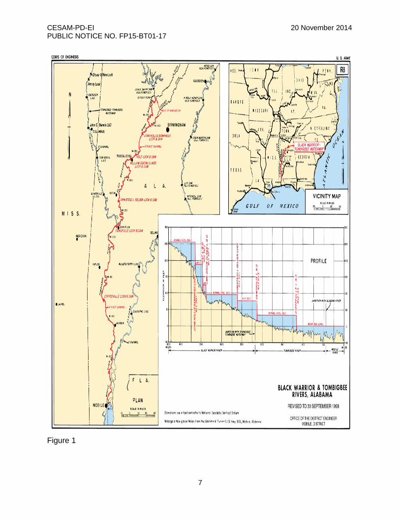
WATERWAY AND LOCATION: The proposed action is to be performed on the BWT Rivers, Alabama. DESCRIPTION OF ENTIRE AUTHORIZED PROJECT: The existing BWT River System was authorized for navigation by various River and Harbor Acts from 1884 through 1960. Replacement of obsolete structures (old locks and dams) was authorized by the 1907 and 1909 River and Harbor Acts. The project was completed for beneficial use, to existing channel dimensions in 1938. The existing project provides a navigation channel 9 feet deep and 200 feet wide from the mouth of the Tombigbee River, 45 miles above Mobile, to the vicinity of Birmingham via the BWT Rivers to mile 430.4 (waterway miles above Mobile) on the Sipsey Fork, mile 429.6 on the Mulberry Fork, and mile 407.8 on the Locust Fork. The project also provides for maintenance by snagging of the Mobile River above the mouth of Chickasaw Creek for a total waterway project distance of about 463 miles. Six locks and dams accomplish the waterway’s total lift of 256 feet. DESCRIPTION OF THE PROPOSED ACTION: Annual maintenance dredging is conducted along the BWT waterway (Figure 1) to maintain the authorized project dimensions. Dredging activity is seasonally limited and generally performed during periods of low water, which range from April to December. Maintenance dredging usually is accomplished by hydraulic pipeline dredge; however, dragline or clamshell equipment may be required in isolated instances. Continued operation and maintenance (O&M) activities are necessary for safe and unobstructed navigation on the waterway. To accomplish these objectives, future dredging and disposal requirements were determined. These determinations are based on O&M requirements and visual observations. Table 1 identifies areas that required dredging in the past. Approximately 83 percent of the dredging occurs on Warrior Lake and below Coffeeville Lock and Dam. Current dredging practices call for dredging to be performed at a depth of 9 feet plus 4 feet of advanced maintenance, 2 feet of allowable overdepth and 3 feet of disturbance. This practice allows a buffer zone in which four feet of material may accumulate during river stage fluctuations while maintaining the integrity of the authorized channel. Additionally, this practice helps preclude more than one dredging operation per site per season. Within-banks are the preferred method for disposal of dredged material in all but the heavy shoaling reaches. However, as ‘within-banks” sites reach capacity, plans have been developed to convert to diked upland disposal areas. Table 2 provides a listing of previously approved upland disposal areas, and Table 3 provides a listing of existing and proposed within-banks disposal sites. In addition to maintenance of the primary river channel, routine dredging is necessary to assure access to small boat channels, public ramps, creeks, sloughs, and public docking facilities for pleasure boats. These areas are maintained by priority based on available funding. Access channels are dredged to a depth of four to four and one half feet and approximately 30 feet wide. A clamshell dredge, bucket dragline or small

CESAM-PD-EI 20 November 2014 PUBLIC NOTICE NO. FP15-BT01-17
3
hydraulic pipeline dredge is used to maintain these channels. Table 4 provides a listing of presently approved and proposed small boat access areas. While the annual O&M activities are being conducted, the USACE is also proposing to construct diverter jetties at Jackson Bar requiring approximately 85,000 to 90,000 cubic yards of riprap. Navigation of this section of the river is hazardous due to the location of the Northfolk Southern Railroad Bridge relative to the bend and the accreting sand bar. The diverter jetties are the initial component of the recommended alternative that the USACE Engineer Research and Development Center (ERDC) developed and modeled to correct the hazard at Jackson Bar. WATER QUALITY CERTIFICATION: Pursuant to section 401 of the Clean Water Act, state water quality certification is required for the proposed activities. A decision on state water quality certification will be made by the Alabama Department of Environmental Management (ADEM) after completion of the comment period of this public notice. USE BY OTHERS: The proposed project may have a temporary negative impact on local fishing and boating activities, but these activities will benefit long-term because the project will aid in maintaining navigation for commercial and recreational boaters. NATIONAL ENVIRONMENTAL POLICY ACT (NEPA) CONSIDERATIONS: In accordance with the requirements of NEPA, O&M of the BWT was addresses in the project’s Final Environmental Impact Statement (FEIS) as filed with the President’s Council on Environmental Quality in 16 April 1976. Subsequent Environmental Assessments (EAs) were prepared to address additional maintenance activities. The Final Supplement to the FEIS (FSFEIS) was filed with the U.S. Environmental Protection Agency (EPA) on 13 April 1987, and a Record of Decision was signed by the Division Engineer on 29 September 1987. In addition the eighteen new proposed small boat access channels, twelve new proposed within-banks disposal areas and proposed construction of diverter jetties at Jackson Bar are addressed in Draft Environmental Assessments (EA), being coordinated as part of this public notice. The assessments indicate environmental impact statements for the small boat access channels, the within-banks disposal areas and diverter jetties are not needed. The EA is available for review at the USACE, Mobile District webpage: http://www.sam.usace.army.mil/Missions/PlanningEnvironmental/EnvironmentalAssessments.aspx. Upon completion of the coordination period set forth in this notice, comments received will be incorporated into the EAs and final determination of NEPA documentation requirements made. If the determination is to finalize the EAs and prepare Finding of No Significant Impact, these documents will be placed on the USACE, Mobile District webpage for future reference. SECTION 404(b)(1) EVALUATION REPORT: Water quality impacts associated with placing dredged/fill material into waters of the United States as a result of continual use

CESAM-PD-EI 20 November 2014 PUBLIC NOTICE NO. FP15-BT01-17
4
of previously approved disposal areas are addressed in a Section 404 (b)(1) Evaluation Report. This report was prepared in accordance with guidelines promulgated by the EPA under Section 404 (b)(1) of the Clean Water Act and is incorporated into the FSFEIS. The report is on file in the Mobile District Office. CULTURAL/HISTORIC RESOURCES CONSIDERATIONS: The Mobile District has determined that 6 of the 12 within banks disposal areas will require avoidance and or monitoring plans to ensure that there are no significant impacts to cultural resources. Avoidance plans will be developed for all cultural resources that are indentified within or in close proximity of the proposed within banks disposal areas. Monitoring plans will be developed and the sites will be monitored to ensure that adverse effects associated with the proposed action are not occurring. These effects may be due to increased access, erosion, or deposition. These plans will be coordinated with the Alabama SHPO and interested federally recognized Tribes. No previously recorded cultural resources were identified within the area of potential effect for the 18 small boat access channel sites and associated disposal areas. The Mobile District has determined no historic properties affected by the proposed action as per 36 Code of Regulation 800.4(d)(1). This project will not have a significant impact on cultural resources. The Jackson Jetty project is in the preliminary stages and finalized construction drawings are not available for review. Background research shows that the proposed work area between river miles 90.5 to 92.5 has a high sensitivity for cultural resources. Prior to construction a terrestrial and submerged phase I cultural resources assessment will be required. The results of these phase I surveys and the Mobile District’s effects determination will be provided to the SHPO and interested federally recognized Tribes for comment and review. If cultural resources eligible for listing on the National Register of Historic Places are identified as a result of these phase I cultural resources surveys appropriate avoidance, monitoring, testing, mitigation plans, and or memorandum of agreements will be developed and provided to the appropriate agencies for review and comment. ENDANGERED/THREATENED SPECIES: Federally listed species with potential to occur in the proposed action areas include the Gulf sturgeon, Alabama sturgeon, southern acornshell, southern combshell, Coosa moccasinshell, southern pigtoe, orange-nacre mucket, inflated heelsplitter and Alabama moccasinshell. The USACE coordinated with the U.S. Fish and Wildlife Service (FWS) regarding the species potentially affected by the continued and new dredging disposal efforts of the newly proposed within-banks disposal areas and construction of diverter jetties as well as existing previously approved dredging locations, within-bank disposal areas, upland disposal areas and small boat access channels along the BWT River. On March 5, 1993 the FWS issued a Biological Opinion (BO) for Maintenance Dredging of the BWT Rivers for impacts to the inflated heelsplitter. This BO was revised in 1998 and amended in 2002 through the coordination process. In a letter dated December 20,
CESAM-PD-EI 20 November 2014 PUBLIC NOTICE NO. FP15-BT01-17
5
2013, the FWS recommended review of the level of incidental take authorized through the amended BO to ensure take would not be exceeded by the current proposal. The USACE believes the current proposal will not exceed the level of incidental take authorized through the amended BO. In addition, surveys will need to be conducted for the mussel at the proposed within-banks disposal areas and previously approved within-banks disposal areas if these sites have not be used in the past six years. In this letter, the FWS also concurred with our determination that avoiding dredging in the Federal navigation channel and small boat access channels during the period of March through May would minimize impacts to Gulf sturgeon. EVALUATION: The decision whether to proceed with the proposed action will be based on evaluation of the probable impact, including cumulative impacts of the proposed activity on the public interest. That decision will reflect the national concern for both protection and utilization of important resources. The benefits which may be reasonably expected to accrue from the proposal must be balanced against its reasonably foreseeable detriments. All factors which may be relevant to the proposal will be considered, including the cumulative effects thereof; among those are conservation, economics, aesthetics, general environmental concerns, wetlands, historic properties, fish and wildlife values, flood hazards, flood plain values, land use, navigation, shore erosion and accretion, recreation, water supply and conservation, water quality, energy needs, safety, food and fiber production, mineral needs, considerations of property ownership, and in general, the needs and welfare of the people. Inasmuch as the proposed work would involve the discharge of materials into waters of the United States, designation of the proposed disposal site associated with this Federal project is being made through application of guidelines promulgated by the Administrator of the Environmental Protection Agency in conjunction with the Secretary of the Army. If these guidelines alone prohibit the designation of the proposed disposal site, any potential impairment of the maintenance of navigation, including any economic impact on navigation and anchorage which would result from the failure to use the disposal site, will also be considered. COORDINATION: The Corps of Engineers is soliciting comments from the general public; Federal, State, and local agencies, and officials; American Indian Tribes, and other interested parties in order to consider and evaluate the impacts of the proposed activity. Any comments received will be used by the Corps of Engineers to determine whether or not to proceed with the proposed action. To make this decision, comments are used to assess impacts on endangered species, historic properties, water quality, general environmental effects, and the other public interest factors listed above. Comments are also used to determine the need for a public hearing and to determine the overall public interest in the proposed activity and in preparing an Environmental Assessment and/or an Environmental Impact Statement pursuant to the NEPA compliance.
CESAM-PD-EI 20 November 2014 PUBLIC NOTICE NO. FP15-BT01-17
7
Figure 1
CESAM-PD-EI 20 November 2014 PUBLIC NOTICE NO. FP15-BT01-17
8
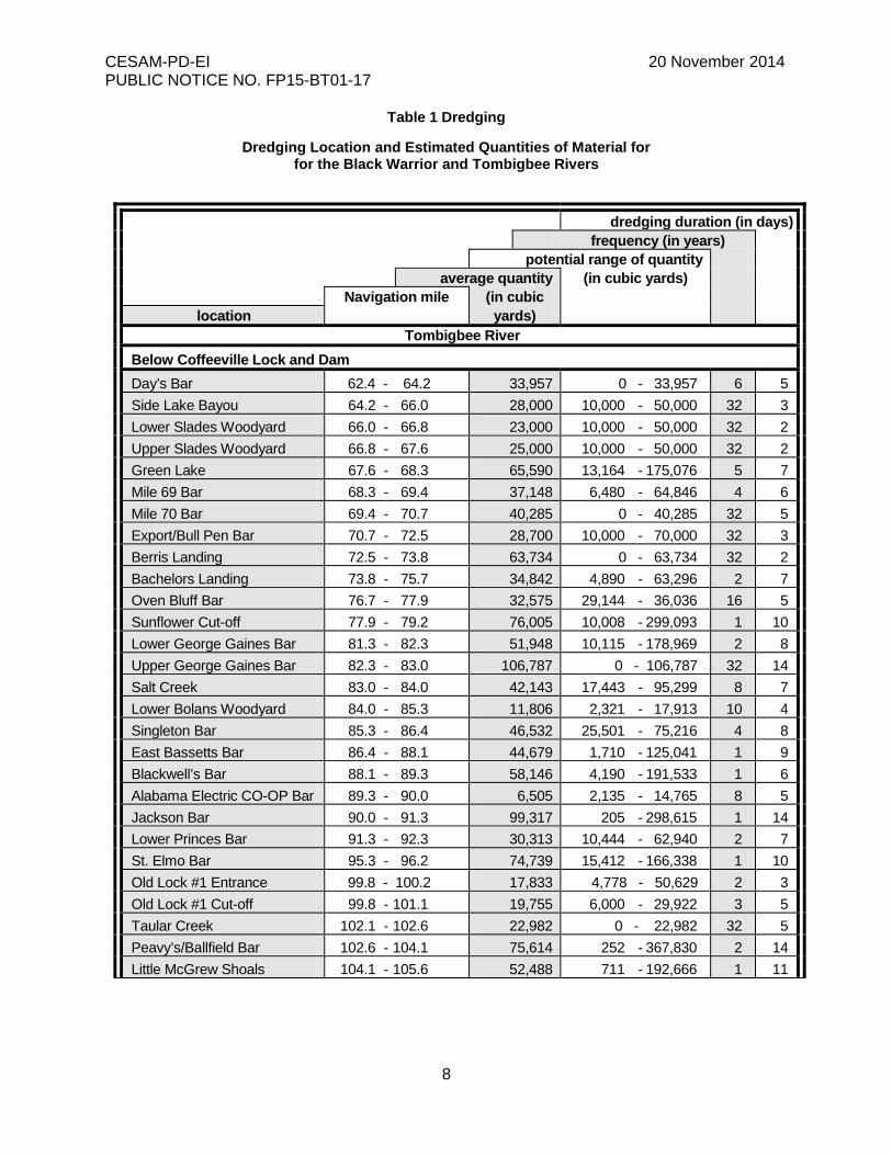
Table 1 Dredging
Dredging Location and Estimated Quantities of Material for for the Black Warrior and Tombigbee Rivers
dredging duration (in days) frequency (in years)
potential range of quantity average quantity (in cubic yards)
Navigation mile (in cubic location yards)
Tombigbee River Below Coffeeville Lock and Dam Day’s Bar 62.4 - 64.2 33,957 0 - 33,957 6 5 Side Lake Bayou 64.2 - 66.0 28,000 10,000 - 50,000 32 3 Lower Slades Woodyard 66.0 - 66.8 23,000 10,000 - 50,000 32 2 Upper Slades Woodyard 66.8 - 67.6 25,000 10,000 - 50,000 32 2 Green Lake 67.6 - 68.3 65,590 13,164 - 175,076 5 7 Mile 69 Bar 68.3 - 69.4 37,148 6,480 - 64,846 4 6 Mile 70 Bar 69.4 - 70.7 40,285 0 - 40,285 32 5 Export/Bull Pen Bar 70.7 - 72.5 28,700 10,000 - 70,000 32 3 Berris Landing 72.5 - 73.8 63,734 0 - 63,734 32 2 Bachelors Landing 73.8 - 75.7 34,842 4,890 - 63,296 2 7 Oven Bluff Bar 76.7 - 77.9 32,575 29,144 - 36,036 16 5 Sunflower Cut-off 77.9 - 79.2 76,005 10,008 - 299,093 1 10 Lower George Gaines Bar 81.3 - 82.3 51,948 10,115 - 178,969 2 8 Upper George Gaines Bar 82.3 - 83.0 106,787 0 - 106,787 32 14 Salt Creek 83.0 - 84.0 42,143 17,443 - 95,299 8 7 Lower Bolans Woodyard 84.0 - 85.3 11,806 2,321 - 17,913 10 4 Singleton Bar 85.3 - 86.4 46,532 25,501 - 75,216 4 8 East Bassetts Bar 86.4 - 88.1 44,679 1,710 - 125,041 1 9 Blackwell’s Bar 88.1 - 89.3 58,146 4,190 - 191,533 1 6 Alabama Electric CO-OP Bar 89.3 - 90.0 6,505 2,135 - 14,765 8 5 Jackson Bar 90.0 - 91.3 99,317 205 - 298,615 1 14 Lower Princes Bar 91.3 - 92.3 30,313 10,444 - 62,940 2 7 St. Elmo Bar 95.3 - 96.2 74,739 15,412 - 166,338 1 10 Old Lock #1 Entrance 99.8 - 100.2 17,833 4,778 - 50,629 2 3 Old Lock #1 Cut-off 99.8 - 101.1 19,755 6,000 - 29,922 3 5 Taular Creek 102.1 - 102.6 22,982 0 - 22,982 32 5 Peavy’s/Ballfield Bar 102.6 - 104.1 75,614 252 - 367,830 2 14 Little McGrew Shoals 104.1 - 105.6 52,488 711 - 192,666 1 11
CESAM-PD-EI 20 November 2014 PUBLIC NOTICE NO. FP15-BT01-17
9
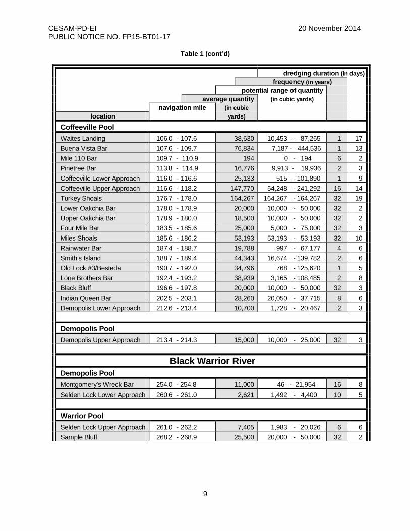
Table 1 (cont’d)
dredging duration (in days) frequency (in years)
potential range of quantity average quantity (in cubic yards)
navigation mile (in cubic location yards)
Coffeeville Pool Waites Landing 106.0 - 107.6 38,630 10,453 - 87,265 1 17 Buena Vista Bar 107.6 - 109.7 76,834 7,187 - 444,536 1 13 Mile 110 Bar 109.7 - 110.9 194 0 - 194 6 2 Pinetree Bar 113.8 - 114.9 16,776 9,913 - 19,936 2 3 Coffeeville Lower Approach 116.0 - 116.6 25,133 515 - 101,890 1 9 Coffeeville Upper Approach 116.6 - 118.2 147,770 54,248 - 241,292 16 14 Turkey Shoals 176.7 - 178.0 164,267 164,267 - 164,267 32 19 Lower Oakchia Bar 178.0 - 178.9 20,000 10,000 - 50,000 32 2 Upper Oakchia Bar 178.9 - 180.0 18,500 10,000 - 50,000 32 2 Four Mile Bar 183.5 - 185.6 25,000 5,000 - 75,000 32 3 Miles Shoals 185.6 - 186.2 53,193 53,193 - 53,193 32 10 Rainwater Bar 187.4 - 188.7 19,788 997 - 67,177 4 6 Smith’s Island 188.7 - 189.4 44,343 16,674 - 139,782 2 6 Old Lock #3/Besteda 190.7 - 192.0 34,796 768 - 125,620 1 5 Lone Brothers Bar 192.4 - 193.2 38,939 3,165 - 108,485 2 8 Black Bluff 196.6 - 197.8 20,000 10,000 - 50,000 32 3 Indian Queen Bar 202.5 - 203.1 28,260 20,050 - 37,715 8 6 Demopolis Lower Approach 212.6 - 213.4 10,700 1,728 - 20,467 2 3 Demopolis Pool Demopolis Upper Approach 213.4 - 214.3 15,000 10,000 - 25,000 32 3
Black Warrior River
Demopolis Pool Montgomery’s Wreck Bar 254.0 - 254.8 11,000 46 - 21,954 16 8 Selden Lock Lower Approach 260.6 - 261.0 2,621 1,492 - 4,400 10 5 Warrior Pool Selden Lock Upper Approach 261.0 - 262.2 7,405 1,983 - 20,026 6 6 Sample Bluff 268.2 - 268.9 25,500 20,000 - 50,000 32 2

CESAM-PD-EI 20 November 2014 PUBLIC NOTICE NO. FP15-BT01-17
10
Table 1 (cont’d)
dredging duration (in days) frequency (in years)
potential range of quantity average quantity (in cubic yards)
navigation mile (in cubic location yards)
Warrior Pool (cont') Stave Bluff Landing 268.9 - 270.5 3,000 2,000 - 10,000 32 1 Childs Ferry 272.1 - 272.9 20,000 10,000 - 50,000 32 2 Bartees Point 272.9 - 273.2 17,000 17,000 - 19,000 32 1 Broadnax Bar 274.0 - 274.3 20,000 10,000 - 50,000 32 2 Z Logan Bar 275.7 - 277.0 11.000 10,000 - 25,000 32 1 Jones Field Bar 279.6 - 280.3 20,100 20,100 - 20,100 32 2 Spencers Mill Creek 281.7 - 282.3 8,500 2,000 - 10,000 32 1 Mary H. Bar 282.3 - 283.2 14,200 8,000 - 50,000 32 1 Kings Cut-Off 290.5 - 291.0 6,000 10,000 - 50,000 32 4 Dropout/Old Lock #9 Bar 292.0 - 293.6 30,256 697 - 59,815 16 6 Hazzard Bar 293.6 - 294.4 22,000 10,000 - 50,000 32 2 Izzard Shoals 294.4 - 294.9 10,833 9,620 - 12,145 16 3 Willifords Landing 294.9 - 295.7 12,114 2,090 - 30,435 8 4 Grays Bluff 296.2 - 298.0 54,875 1,328 - 270,347 2 9 Burroughs Landing 298.0 - 299.0 66,291 1,225 - 179,789 1 10 Toxey Bend 299.0 - 300.0 28,000 10,000 - 50,000 32 3 Beals Landing 300.0 - 300.9 34,383 9,105 - 133,315 2 6 Hemphill Landing 300.9 - 301.3 40,000 27,000 - 70,000 32 3 Wildhorse Bar 301.3 - 302.0 20,400 17,900 - 23,981 10 4 Mud Bar 302.0 - 303.1 53,804 32,488 - 64,956 5 5 McGowan Bluff 303.1 - 304.5 8,943 2,628 - 13,555 8 3 Mile 305 Bar 304.5 - 305.0 9,491 8,056 - 10,926 16 3 Van Cleave/Lewis Bar 305.0 - 306.7 19,615 13,745 - 31,232 6 8 Big Sandy/Bald Bar 306.7 - 308.2 107,769 19,661 - 231,892 2 11 Sharpes Ferry Landing 308.2 - 308.5 20,000 10,000 - 50,000 32 2 Hull’s Landing 308.5 - 310.0 37,796 17,453 - 72,039 2 7 Dillard’s Duck Bar 310.6 - 311.4 29,407 17,103 - 39,874 6 4 Kings Mountain Bar 311.4 - 311.7 22,163 22,163 - 22,163 32 5 Little Sandy Creek 311.7 - 312.4 41,176 23,808 - 75,015 6 4 Little Log Shoals 312.4 - 314.2 78,816 17,829 - 192,245 2 10 Timothy Bar 314.2 - 315.1 23,879 911 - 56,458 4 8
CESAM-PD-EI 20 November 2014 PUBLIC NOTICE NO. FP15-BT01-17
11
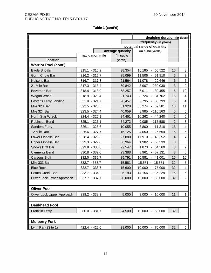
Table 1 (cont’d)
dredging duration (in days) frequency (in years)
potential range of quantity average quantity (in cubic yards)
navigation mile (in cubic location yards)
Warrior Pool (cont') Eagle Shoals 315.1 - 316.2 38,354 16,185 - 60,522 16 8 Gunn Chute Bar 316.2 - 316.7 35,099 11,506 - 51,810 6 7 Nelsons Bar 316.7 - 317.3 21,564 11,078 - 29,646 6 5 21 Mile Bar 317.3 - 318.4 59,842 3,907 - 230,030 3 9 Bozeman Bar 318.4 - 318.9 58,257 6,011 - 130,455 6 12 Wagon Wheel 318.9 - 320.4 21,743 8,724 - 34,762 16 4 Foster’s Ferry Landing 321.0 - 321.7 20,457 2,795 - 38,799 5 4 Mile 323 Bar 322.5 - 323.5 51,328 33,274 - 69,381 16 11 Mile 324 Bar 323.5 - 324.4 40,959 8,985 - 116,163 5 5 North Star Wreck 324.4 - 325.1 24,451 10,262 - 44,240 2 6 Robinson Bend 325.1 - 326.1 54,272 9,085 - 117,588 2 8 Sanders Ferry 326.1 - 326.6 10,055 8,800 - 11,310 16 4 12 Mile Rock 326.6 - 327.7 15,125 4,050 - 25,654 5 5 Lower Ophelia Bar 328.4 - 329.3 27,880 17,910 - 48,252 4 7 Upper Ophelia Bar 329.3 - 329.8 36,964 1,902 - 65,339 3 6 Snows Drift Bar 329.8 - 330.8 22,547 1,873 - 64,569 3 7 Clements Bend 330.8 - 332.0 23,388 3,961 - 57,131 3 6 Carsons Bluff 332.0 - 332.7 25,791 10,581 - 41,001 16 10 Mile 333 Bar 332.7 - 333.7 15,581 15,581 - 15,581 32 6 Blue Rock 332.7 - 333.7 15,600 10,000 - 75,000 32 4 Potato Creek Bar 333.7 - 334.2 25,193 14,156 - 36,229 16 6 Oliver Lock Lower Approach 337.7 - 337.7 20,000 10,000 - 50,000 32 2 Oliver Pool Oliver Lock Upper Approach 338.2 - 338.3 5,000 3,000 - 10,000 11 1 Bankhead Pool Franklin Ferry 380.0 - 381.7 24,500 10,000 - 50,000 32 3 Mulberry Fork Lynn Park (Site 1) 422.4 - 422.6 38,000 10,000 - 70,000 32 5
CESAM-PD-EI 20 November 2014 PUBLIC NOTICE NO. FP15-BT01-17
12
Table 1 (cont’d)
dredging duration (in days) frequency (in years)
potential range of quantity average quantity (in cubic yards)
navigation mile (in cubic location yards)
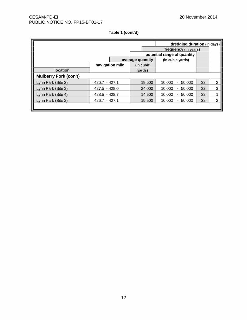
Mulberry Fork (con’t) Lynn Park (Site 2) 426.7 - 427.1 19,500 10,000 - 50,000 32 2 Lynn Park (Site 3) 427.5 - 428.0 24,000 10,000 - 50,000 32 3 Lynn Park (Site 4) 428.5 - 428.7 14,500 10,000 - 50,000 32 1 Lynn Park (Site 2) 426.7 - 427.1 19,500 10,000 - 50,000 32 2

CESAM-PD-EI 20 November 2014 PUBLIC NOTICE NO. FP15-BT01-17
13
Table 2
Diked Disposal Areas for the Black Warrior and Tombigbee Rivers
Navigation
Mile
Site
Designation
Descending Bank
Location
County
Estimated Acreage for
Disposal 73.0 A right Washington 70 78.2 C left Clarke 85 82.3 D-1 left Clarke 74 86.0 E right Washington 42 87.0 E-2 left Clarke 50 88.5 F right Washington 57 89.0 G right Washington 3 90.8 H left Clarke 47 91.5 I right Washington 55 96.0 J left Clarke 102
104.0 N right Washington 80 104.2 O-1 left Clarke 25 104.3 O left Clarke 25 104.4 O-2 left Clarke 23 104.4 P right Washington 21 104.7 Q right Washington 24 105.0 R left Clarke 110 107.7 V right Washington 29 108.0 W right Washington 12 108.0 V-1 right Washington 6 108.0 X-2 left Clarke 36 108.3 X right Washington 27 108.3 X-3 left Clarke 30 108.3 X-4 left Clarke 42 109.0 Z right Washington 40 109.1 AA left Clarke 100 116.0 AC right Choctaw 112 191.1 CA-1 right Sumpter 68 261.7 BC right Greene 22 279.6 BF right Greene 40 297.0 BA right Tuscaloosa 43 298.5 AD left Tuscaloosa 66 300.0 AE right Tuscaloosa 99 307.6 AF right Tuscaloosa 85 312.7 AG left Tuscaloosa 166 318.0 BG left Tuscaloosa 55 324.1 BE-1 right Tuscaloosa 40 324.5 BE-2 right Tuscaloosa 20 329.0 BD right Tuscaloosa 55
CESAM-PD-EI 20 November 2014 PUBLIC NOTICE NO. FP15-BT01-17
14
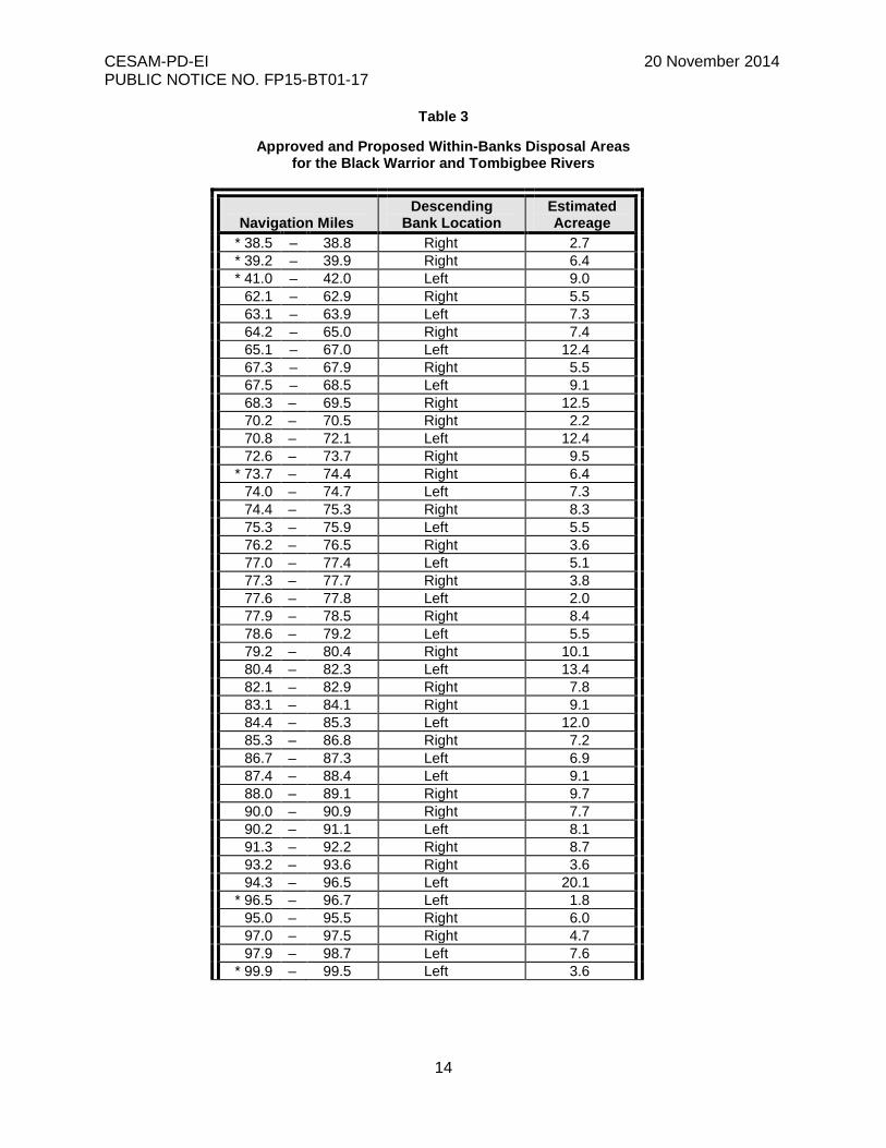
Table 3
Approved and Proposed Within-Banks Disposal Areas for the Black Warrior and Tombigbee Rivers
Navigation Miles
Descending Bank Location
Estimated Acreage
* 38.5 – 38.8 Right 2.7 * 39.2 – 39.9 Right 6.4 * 41.0 – 42.0 Left 9.0
62.1 – 62.9 Right 5.5 63.1 – 63.9 Left 7.3 64.2 – 65.0 Right 7.4 65.1 – 67.0 Left 12.4 67.3 – 67.9 Right 5.5 67.5 – 68.5 Left 9.1 68.3 – 69.5 Right 12.5 70.2 – 70.5 Right 2.2 70.8 – 72.1 Left 12.4 72.6 – 73.7 Right 9.5
* 73.7 – 74.4 Right 6.4 74.0 – 74.7 Left 7.3 74.4 – 75.3 Right 8.3 75.3 – 75.9 Left 5.5 76.2 – 76.5 Right 3.6 77.0 – 77.4 Left 5.1 77.3 – 77.7 Right 3.8 77.6 – 77.8 Left 2.0 77.9 – 78.5 Right 8.4 78.6 – 79.2 Left 5.5 79.2 – 80.4 Right 10.1 80.4 – 82.3 Left 13.4 82.1 – 82.9 Right 7.8 83.1 – 84.1 Right 9.1 84.4 – 85.3 Left 12.0 85.3 – 86.8 Right 7.2 86.7 – 87.3 Left 6.9 87.4 – 88.4 Left 9.1 88.0 – 89.1 Right 9.7 90.0 – 90.9 Right 7.7 90.2 – 91.1 Left 8.1 91.3 – 92.2 Right 8.7 93.2 – 93.6 Right 3.6 94.3 – 96.5 Left 20.1
* 96.5 – 96.7 Left 1.8 95.0 – 95.5 Right 6.0 97.0 – 97.5 Right 4.7 97.9 – 98.7 Left 7.6
* 99.9 – 99.5 Left 3.6

CESAM-PD-EI 20 November 2014 PUBLIC NOTICE NO. FP15-BT01-17
15
Table 3 (cont’d)
Navigation Miles
Descending Bank Location
Estimated Acreage
99.3 – 101.1 Right 16.0 101.9 – 103.1 Left 11.3 102.4 – 102.7 Right 2.4 103.4 – 104.6 Right 14.5 104.3 – 105.8 Left 18.6 104.9 – 105.5 Right 5.5 106.0 – 106.5 Right 4.6 106.5 – 107.0 Left 5.1 107.3 – 109.3 Right 17.2 108.9 – 110.6 Left 17.7 111.3 – 112.3 Left 12.0 112.8 – 113.3 Right 6.0 113.6 – 114.4 left 7.6 114.6 – 115.0 right 6.0 115.1 – 116.1 right 9.2 116.0 – 116.5 left 21.2 116.9 – 117.1 right 1.7
* 145.0 – 145.5 right 4.5 * 160.5 – 161.5 right 9.0 * 166.2 – 166.8 right 5.5
176.5 – 176.9 right 3.3 176.8 – 177.5 left 5.9 177.2 – 178.5 right 9.7 178.3 – 179.9 left 16.2 179.0 – 181.0 right 18.2 182.5 – 183.2 right 8.0 183.5 – 184.9 right 12.7 183.5 – 185.0 left 14.3
* 185.2 – 185.8 right 5.5 185.8 – 186.7 right 8.8 187.1 – 187.4 right 3.6 187.5 – 188.3 left 8.9 187.9 – 189.2 right 10.7 188.9 – 190.0 left 12.9 190.0 – 190.6 right 7.2 190.9 – 192.6 right 16.8 190.9 – 191.6 left 6.8 192.6 – 193.3 left 9.5 194.0 – 194.3 right 3.6 194.8 – 195.1 right 3.6 195.5 – 195.9 right 4.8 196.6 – 198.4 left 19.0 199.2 – 200.8 left 17.4 201.8 – 203.3 left 15.0 203.6 – 204.0 right 4.8
CESAM-PD-EI 20 November 2014 PUBLIC NOTICE NO. FP15-BT01-17
16
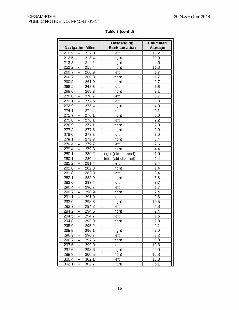
Table 3 (cont’d)
Navigation Miles
Descending Bank Location
Estimated Acreage
210.9 – 212.0 left 13.2 212.5 – 213.4 right 20.0 213.8 – 214.2 right 4.5 252.2 - 253.4 right 11.3 260.7 – 260.9 left 1.7 260.7 – 260.8 right 1.7 260.8 – 261.0 right 2.7 268.2 – 268.5 left 3.6 268.6 – 269.3 right 8.1 270.0 – 270.7 left 3.7 272.1 – 272.6 left 3.3 272.9 – 273.4 right 4.0 274.1 – 274.4 left 2.1 275.7 – 276.1 right 5.0 275.8 – 276.1 left 2.2 276.9 – 277.1 right 2.0 277.3 – 277.6 right 3.0 278.0 – 278.5 left 5.0 279.1 – 279.3 right 2.4 279.4 – 279.7 left 2.6 279.4 – 279.8 right 4.4 280.1 – 280.2 right (old channel) 1.0 280.1 – 280.4 left (old channel) 2.4 281.2 – 281.4 left 2.4 281.8 – 282.0 right 1.4 281.8 – 282.3 left 3.4 282.1 – 283.0 right 5.6 283.0 – 283.4 left 3.7 290.4 – 290.7 left 1.7 290.7 – 290.9 right 2.4 291.1 – 291.9 left 9.6 293.0 – 293.8 right 10.5 293.7 – 294.2 left 4.8 294.2 – 294.5 right 2.4 294.5 – 294.7 left 1.5 294.8 – 295.0 right 2.8 295.0 – 295.2 left 2.1 295.5 – 296.1 right 5.0 296.3 – 296.7 left 2.2 296.7 – 297.5 right 8.3 297.6 – 299.0 left 13.8 297.6 – 298.6 right 9.0 298.9 – 300.6 right 15.8 300.4 – 302.1 left 13.3 302.1 – 302.7 right 5.1
CESAM-PD-EI 20 November 2014 PUBLIC NOTICE NO. FP15-BT01-17
17
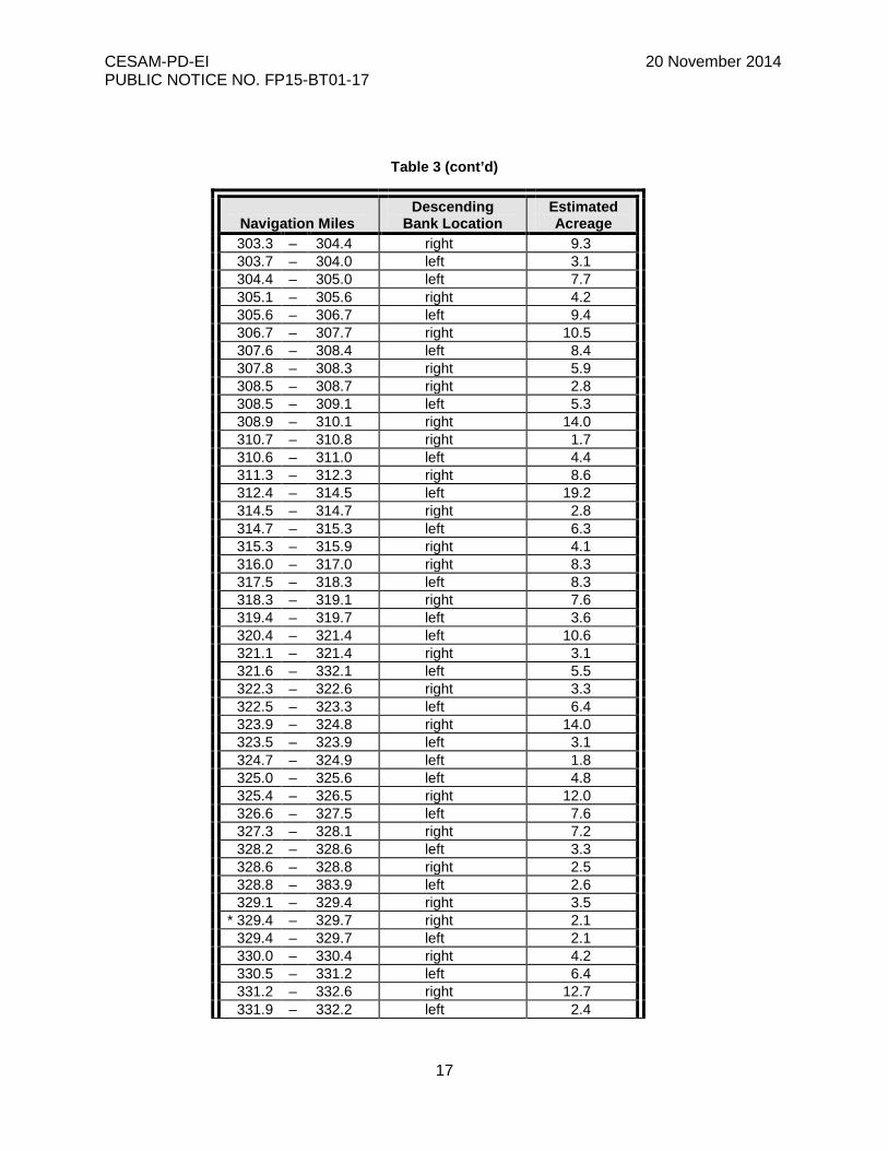
Table 3 (cont’d)
Navigation Miles
Descending Bank Location
Estimated Acreage
303.3 – 304.4 right 9.3 303.7 – 304.0 left 3.1 304.4 – 305.0 left 7.7 305.1 – 305.6 right 4.2 305.6 – 306.7 left 9.4 306.7 – 307.7 right 10.5 307.6 – 308.4 left 8.4 307.8 – 308.3 right 5.9 308.5 – 308.7 right 2.8 308.5 – 309.1 left 5.3 308.9 – 310.1 right 14.0 310.7 – 310.8 right 1.7 310.6 – 311.0 left 4.4 311.3 – 312.3 right 8.6 312.4 – 314.5 left 19.2 314.5 – 314.7 right 2.8 314.7 – 315.3 left 6.3 315.3 – 315.9 right 4.1 316.0 – 317.0 right 8.3 317.5 – 318.3 left 8.3 318.3 – 319.1 right 7.6 319.4 – 319.7 left 3.6 320.4 – 321.4 left 10.6 321.1 – 321.4 right 3.1 321.6 – 332.1 left 5.5 322.3 – 322.6 right 3.3 322.5 – 323.3 left 6.4 323.9 – 324.8 right 14.0 323.5 – 323.9 left 3.1 324.7 – 324.9 left 1.8 325.0 – 325.6 left 4.8 325.4 – 326.5 right 12.0 326.6 – 327.5 left 7.6 327.3 – 328.1 right 7.2 328.2 – 328.6 left 3.3 328.6 – 328.8 right 2.5 328.8 – 383.9 left 2.6 329.1 – 329.4 right 3.5
* 329.4 – 329.7 right 2.1 329.4 – 329.7 left 2.1 330.0 – 330.4 right 4.2 330.5 – 331.2 left 6.4 331.2 – 332.6 right 12.7 331.9 – 332.2 left 2.4
CESAM-PD-EI 20 November 2014 PUBLIC NOTICE NO. FP15-BT01-17
18
Table 3 (cont’d)
Navigation Miles
Descending Bank Location
Estimated Acreage
332.8 – 333.1 right 3.6 333.2 – 334.0 left 6.6 333.8 – 334.2 right 2.8 334.3 – 334.9 right 3.6 334.6 – 334.7 left 2.0 335.0 – 335.8 right 10.8 335.9 – 336.3 left 4.8 337.1 – 338.2 right 11.5 366.0 – 366.4 center 27.0
* Proposed within-banks disposal areas.
CESAM-PD-EI 20 November 2014 PUBLIC NOTICE NO. FP15-BT01-17
19
Table 4 Small Boat Access Channels
of the Black Warrior and Tombigbee Waterway
Navigation
Estimated Quantity
Miles Location of Descending
of Dredged Material (in cubic yards)
Bank Type of Disposal for Existing Area Name or Area Type Dredged Material WQC
Mobile River 41.1 right Mt. Vernon Landing Within-Banks 1150 No
Tombigbee River 99.9 left Lock 1 PUA* Within-Banks 300 Yes
108.5 left Satilpa Creek Within-Banks 300 Yes 110.0 right Sinta Bogue Within-Banks 200 Yes 113.9 right Seyouyah Creek Within-Banks 250 Yes 115.4 left Ulkanush Creek Within-Banks 300 Yes 117.5 right Service PUA* Ramp Within-Banks 575 Yes 118.3 right Campground Slough Within-Banks 400 Yes 119.0 right Bladen Springs Landing Open-Water 200 Yes 119.2 right Slough – NWR Within-Banks 100 Yes 119.6 right Slough – NWR Within-Banks 300 Yes 120.7 right Turkey Creek Within-Banks 200 Yes 123.2 right Okatuppa Creek Within-Banks 200 Yes
124.4
right
Choctaw NWR (Wrights Landing)
Within-Banks
675
Yes
125.1 left West Bend PUA* Within-Banks 175 Yes 125.3 left Adrian House Slough Within-Banks 400 Yes
125.8
right
Lenoir Landing PUA* (Tallawampa Creek)
Within-Banks
735
Yes
126.1 right Oil Dock Slough Within-Banks 600 Yes 126.3 right Osage Bar Slough Within-Banks 300 Yes 127.2 left Sellers Landing Slough Within-Banks 100 Yes 127.9 left Slough Within-Banks 300 Yes 128.4 left Slough Within-Banks 350 Yes 128.5 right Slough Within-Banks 300 Yes 130.1 right Salt and Copper Creeks Within-Banks 50 Yes 130.5 right Two Sloughs Within-Banks 400 Yes 131.0 left Cowans Gin Within-Banks 350 Yes 131.4 right Slough Within-Banks 300 Yes 134.9 left Slough Within-Banks 250 Yes 136.5 left Woods Bluff PUA* Within-Banks 50 Yes 141.2 right McCarty’s Ferry PUA* Within-Banks 1000 Yes
142.3
right
Emery Creek (Melton Spring Branch)
Within-Banks
300
Yes
145.0 left Bashi Creek PUA* Within-Banks 250 Yes Tombigbee River (cont’d)
147.2 left Big Bunny Creek Within-Banks 150 Yes 153.3 right Wahalak Creek Within-Banks 300 Yes 156.3 right Tuscahoma Landing Within-Banks 400 Yes 157.9 right Sucarbowa Creek Within-Banks 300 Yes 160.6 left Horse Creek Within-Banks 300 Yes
CESAM-PD-EI 20 November 2014 PUBLIC NOTICE NO. FP15-BT01-17
20
Navigation
Estimated Quantity
Miles Location of Descending
of Dredged Material (in cubic yards)
Bank Type of Disposal for Existing Area Name or Area Type Dredged Material WQC
165.1 right Ezell Landing Within-Banks 200 Yes 165.7 right Slough Within-Banks 350 Yes 167.4 right Tuckabum Creek Within-Banks 400 Yes 168.6 right Lock 2 PUA* Within-Banks 200 Yes 170.4 left Beaver Creek Within-Banks 200 Yes 173.7 right Kemps Landing Within-Banks 200 Yes 174.3 right Slough Within-Banks 350 Yes 175.5 left Slough Within-Banks 400 Yes 175.6 left Slough Within-Banks 300 Yes 175.9 right Kinterbish Creek Within-banks 250 Yes 186.0 left Lost Creek Landing Within-Banks 400 Yes 187.4 left Chickasaw Bogue Within-Banks 6600 Yes 190.8 right Old Lock # 3 Open-Water 200 Yes 190.8 left 6 Mile Creek, Old Lock #3 Within-Banks 900 Yes 193.9 right Cotohaga Creek Within-Banks 300 Yes 200.6 right Sucarnoochee River Within-Banks 800 Yes 207.5 left Mill Creek Within-Banks 200 Yes 210.0 right Halls Creek Within-Banks 300 Yes 213.7 right Dam Warning Sign Slough Within-Banks 500 Yes 213.9 right Slough - WMA Within-Banks 2500 No 214.1 left Foscue Creek On Bank 675 Yes 214.2 left Foscue Creek PUA* On Bank 1400 No 215.0 left Grain Elevator Slough Within-Banks 750 No
215.2
left
Short Creek (Whitfield Canal)
Within-Banks
340
Yes
216.1 left Demopolis City Landing Within-Banks 3000 Yes 216.6 left Lock 4 PUA* Ramp Within-Banks 1300 Yes 216.8 left Culpeppers Slough Within-Banks 625 Yes
Black Warrior River 217.7 right Daub’s Swamp Within-Banks 400 Yes 218.1 left Slough Within-Banks 600 Yes 218.5 right Runaway Branch PUA* Within-Banks 780 Yes 218.7 right Bridge Slough (Watson #1) Within-Banks 775 Yes 218.9 right Corps Slough (Watson #2) Within-Banks 825 Yes 219.1 right Kelly's Slough On Bank 1150 Yes 219.4 left Slough Within-Banks 800 Yes
Black Warrior River (cont’d) 219.5 left Slough Within-Banks 300 Yes 219.8 left Slough Within-Banks 800 Yes 220.1 right Dead Lake Slough Within-Banks 400 Yes 220.3 right Devil’s Run Within-Banks 700 No 220.6 right Slough Within-Banks 800 No 220.8 right Two Sloughs Within-Banks 280 Yes 221.0 left Slough Within-Banks 200 Yes 221.4 right Slough Within-Banks 400 Yes
CESAM-PD-EI 20 November 2014 PUBLIC NOTICE NO. FP15-BT01-17
21
Navigation
Estimated Quantity
Miles Location of Descending
of Dredged Material (in cubic yards)
Bank Type of Disposal for Existing Area Name or Area Type Dredged Material WQC
221.5 left Slough Within-Banks 200 Yes 221.6 left Slough Within-Banks 200 Yes 222.2 left Slough Within-Banks 200 Yes 222.8 left French Creek Within-Banks 1300 Yes 223.1 right Slough Within-Banks 400 Yes 223.4 left Slough Within-Banks 300 Yes 224.4 left Slough below Taylor’s Bar Within-Banks 250 Yes 224.9 left Powerline Slough Within-Banks 3300 Yes 225.5 right Backbone Slough Within-Banks 800 Yes 225.6 right Backbone Creek PUA* Within-Banks 5500 Yes 225.8 right Haint Hole (Corps) Within-Banks 2450 Yes 226.0 right Bottleneck Slough Within-Banks 1525 Yes 226.3 left Yellow Creek (Arcola*) Within-Banks 4325 Yes 227.1 left Slough Within-Banks 600 Yes 227.3 left Slough Open-Water 2170 Yes 228.1 right Slough Within-Banks 300 Yes 228.6 left Slough Within-Banks 1200 Yes 228.8 right Slough Within-Banks 400 Yes 229.0 right Johnson Branch Within-Banks 4250 Yes 229.3 right Willow Creek Slough Within-Banks 3560 Yes 230.7 left Lime Kiln Creek Within-Banks 800 Yes 231.1 left Big Prairie Creek Within-Banks 1450 Yes 231.7 right Outlaw Creek Slough Within-Banks 1505 Yes 231.8 right Slough Within-Banks 400 Yes 232.0 left Lock 5 PUA* Within-Banks 350 Yes 232.5 left Candy Landing Within-Banks 250 Yes 232.6 left Jacks Branch Within-Banks 1800 Yes 233.3 left Buzzard’s Roost Slough Within-Banks 350 Yes 233.7 left Drakes Landing Within-Banks 300 Yes 233.8 left Camp House Slough Within-Banks 1200 Yes 234.4 left Old Tindell’s Ferry Within-Banks 400 Yes 234.8 left Slough Within-Banks 400 Yes 235.0 left Slough Within-Banks 525 Yes
Black Warrior River (cont’d) 235.2 left Sycamore Slough (Area 19) Within-Banks 1790 Yes 235.5 left Twin Oaks Slough Within-Banks 1045 Yes 236.0 left Slough Within-Banks 400 Yes 236.5 left Slough Within-Banks 400 Yes 237.6 left Slough Within-Banks 400 Yes 237.8 left Slough Within-Banks 995 Yes 238.4 left Slough Within-Banks 400 Yes 239.2 right McIntyres Shoal Slough Within-Banks 1315 Yes 240.7 right Clemens Slough (Area 18) Open-Water 1635 Yes 242.4 right Slough Within-Banks 665 Yes 242.6 right Slough Within-Banks 300 Yes
CESAM-PD-EI 20 November 2014 PUBLIC NOTICE NO. FP15-BT01-17
22
Navigation
Estimated Quantity
Miles Location of Descending
of Dredged Material (in cubic yards)
Bank Type of Disposal for Existing Area Name or Area Type Dredged Material WQC
242.7 right Slough Within-Banks 300 Yes 244.1 left Limestone Creek Within-Banks 445 Yes 245.7 left Slough Within-Banks 100 Yes 248.4 right Hines Mill Creek Within-Banks 3215 Yes 249.2 right Needham Creek Within-Banks 3965 Yes 250.2 left Slough Within-Banks 300 Yes 251.0 left Hines Creek Within-Banks 250 Yes 252.3 left Lock 6 PUA* Ramp Within-Banks 400 Yes 252.4 left Slough Within-Banks 200 Yes 253.0 left Slough Within-Banks 2955 Yes 255.4 right Dollarhide Creek Within-Banks 400 Yes 256.4 right Slough Within-Banks 400 Yes 256.7 right Slough Within-Banks 300 Yes 257.3 right Slough Open-Water/Within-Banks 300 Yes 257.8 left Wright's Creek Open-Water/Within-Banks 300 Yes 259.0 left Presley Ford Branch Open-Water/Within-Banks 300 Yes
Cutoff right (Selden) Damsite PUA* Within-Banks/On Bank 2400 No 262.1 right Lock 7 West PUA* Ramp Within-Banks 485 Yes 262.6 left Lock 7 East* (Bee Branch) Within-Banks 600 Yes 262.7 right Slough Open-Water 1150 Yes
263.9
left
Clear Creek (Jennings Ferry PUA*)
On Bank
2600
Yes
264.6 left Slough Open-Water 400 Yes 265.0 right Grinnel Pond Slough Within-Banks 200 Yes 265.6 left Slough Open-Water/Within-Banks 300 Yes 266.1 right Slough Open-Water/Within-Banks 300 Yes 266.4 left Big Brush Creek Within-Banks 400 Yes 266.9 left Slough Open-Water/Within-Banks 300 Yes 267.3 left Slough Open-Water/Within-Banks 300 Yes 267.7 right Finches Ferry PUA* Within-Banks 810 Yes
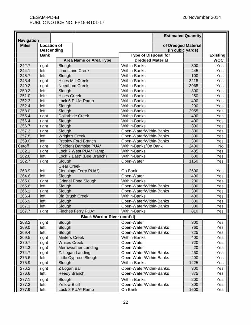
Black Warrior River (cont’d) 268.2 right Slough Open-Water 300 Yes 269.0 left Slough Open-Water/Within-Banks 760 Yes 269.4 left Slough Open-Water/Within-Banks 325 Yes 269.5 right Minters Creek Within-Banks 400 Yes 270.7 right Whites Creek Open-Water 720 Yes 274.3 right Merriweather Landing Open-Water 20 Yes 274.7 right Z. Logan Landing Open-Water/Within-Banks 450 Yes 275.6 left Little Cypress Slough Open-Water/Within-Banks 400 Yes 275.9 right Slough Within-Banks 1225 Yes 276.2 right Z Logan Bar Open-Water/Within-Banks. 300 Yes 276.6 left Reedy Branch Open-Water/Within-Banks 875 Yes 277.1 right Slough Within-Banks 200 Yes 277.2 left Yellow Bluff Open-Water/Within-Banks 300 Yes 277.9 left Lock 8 PUA* Ramp On Bank 1600 Yes

CESAM-PD-EI 20 November 2014 PUBLIC NOTICE NO. FP15-BT01-17
23
Navigation
Estimated Quantity
Miles Location of Descending
of Dredged Material (in cubic yards)
Bank Type of Disposal for Existing Area Name or Area Type Dredged Material WQC
277.9 left Slough Open-Water/Within-Banks 400 Yes 278.8 left Slough Open-Water/Within-Banks 400 Yes 279.2 left Five Mile Creek Open-Water 1400 Yes 279.4 left Slough Within-Banks 1500 No 279.9 left Martin Slough (lower) Open-Water 2400 Yes 280.1 left Martin Slough (upper) Within-Banks 1925 No 282.0 right Spencers Mill Creek Open-Water/Within-Banks 900 Yes 282.8 left Slough Open-Water 400 Yes 283.4 right Sims Creek Open-Water/Within-Banks 300 Yes 283.8 left Bohannon’s Cut-Off Open-Water 1100 Yes 284.1 right Big Cypress Slough Within-Banks 350 Yes 286.2 left Gabriel’s Creek Open-Water 100 Yes 290.1 right Buck Creek Open-Water/Within-Banks 300 Yes 291.0 left King’s Cut-Off Open-Water/Within-Banks 450 Yes 293.0 left Elliotts Creek Open-Water/Within-Banks 400 Yes 295.2 right Williford’s Landing Open-Water/Within-Banks 500 Yes 295.6 left Slough Within-Banks 400 Yes 296.7 right Grant Creek Open-Water/Within-Banks 500 Yes 307.2 left Big Sandy Creek Open-Water/Within-Banks 400 Yes 311.6 left Cunningham Branch Open-Water/Within-Banks 300 Yes 312.0 left Little Sandy Creek Open-Water/Within-Banks 300 Yes 312.4 left Big Creek Open-Water 400 Yes 322.2 right Slough Open-Water/Within-Banks 400 Yes 326.6 right Sanders Mill Creek Within-Banks 300 Yes 333.5 right Big Creek Open-Water/Within-Banks 350 Yes 334.5 right Potato Creek Open-Water 350 Yes 334.9 right Tater Hill Creek Within-Banks 300 Yes
Black Warrior River (cont’d) 337.4 right Mill Creek PUA* Ramp Within-Banks 500 No 339.4 right Snows Creek Open-Water 300 Yes 343.7 right North River Open-Water 200 Yes 346.3 left Hurricane Creek Within-Banks 300 Yes 346.9 right Yellow Creek Within-Banks 300 Yes 347.1 right Jim Mack Branch Within-Banks 200 Yes 347.2 left Holt Lock & Dam Within-Banks 200 Yes 347.3 left Marina Slough Open-Water 200 Yes 347.5 right Deerlick Creek Open-Water 200 Yes 348.0 left Rock Quarry Ramp* Within-Banks 300 Yes 348.3 left Eagle Cove Marina Within-Banks 200 Yes 348.5 left Slough Within-Banks 200 Yes 348.9 left Slough Within-Banks 200 Yes 348.9 right Deerlick Boat Ramp* Within-Banks 200 Yes 349.1 right Slough Within-Banks 200 Yes 349.4 left Rocky Branch Open-Water 200 Yes 349.5 left Rocky Branch Boat ramp* Open-Water/Within-Banks 300 Yes
CESAM-PD-EI 20 November 2014 PUBLIC NOTICE NO. FP15-BT01-17
24
Navigation
Estimated Quantity
Miles Location of Descending
of Dredged Material (in cubic yards)
Bank Type of Disposal for Existing Area Name or Area Type Dredged Material WQC
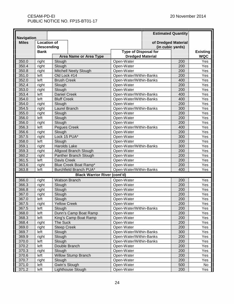
350.0 right Slough Open-Water 200 Yes 350.4 right Slough Open-Water 200 Yes 350.8 right Mitchell Neely Slough Open-Water 200 Yes 351.0 left Old Lock #14 Open-Water/Within-Banks 200 Yes 352.0 left Brush Creek Open-Water/Within-Banks 400 Yes 352.4 right Slough Open-Water 200 Yes 353.0 right Slough Open-Water 200 Yes 353.4 left Daniel Creek Open-Water/Within-Banks 400 Yes 354.0 left Bluff Creek Open-Water/Within-Banks 400 Yes 354.0 right Slough Open-Water 200 Yes 354.5 right Laurel Branch Open-Water/Within-Banks 300 Yes 355.0 right Slough Open-Water 200 Yes 356.0 left Slough Open-Water 200 Yes 356.0 right Slough Open-Water 200 Yes 356.3 left Pegues Creek Open-Water/Within-Banks 400 Yes 356.6 right Slough Open-Water 200 Yes 357.5 right Lock 15 PUA* Open-Water 300 Yes 358.0 left Slough Open-Water 200 Yes 359.1 right Harolds Lake Open-Water/Within-Banks 300 Yes 359.3 right Allgood Branch Slough Open-Water 200 Yes 360.2 right Panther Branch Slough Open-Water 200 Yes 361.5 left Davis Creek Open-Water 200 Yes 363.6 right Blue Creek Boat Ramp* Open-Water 200 Yes 363.8 left Burchfield Branch PUA* Open-Water/Within-Banks 400 Yes
Black Warrior River (cont’d) 366.0 right Watson Branch Open-Water 200 Yes 366.3 right Slough Open-Water 200 Yes 366.8 right Slough Open-Water 200 Yes 367.0 right Slough Open-Water 200 Yes 367.0 left Slough Open-Water 200 Yes 367.5 right Yellow Creek Open-Water 200 Yes 367.5 left Slough Open-Water/Within-Banks 200 Yes 368.0 left Dunn’s Camp Boat Ramp Open-Water 200 Yes 368.3 left King’s Camp Boat Ramp Open-Water 200 Yes 368.4 right The Suck Open-Water 200 Yes 369.0 right Steep Creek Open Water 200 Yes 369.7 left Slough Open-Water/Within-Banks 300 Yes 369.9 right Slough Open-Water/Within-Banks 200 Yes 370.0 left Slough Open-Water/Within-Banks 200 Yes 370.2 left Double Branch Open-Water 200 Yes 370.3 right Slough Open-Water 200 Yes 370.6 left Willow Stump Branch Open-Water 200 Yes 370.7 right Slough Open-Water 200 Yes 371.0 left Gwin’s Slough Open-Water 500 No 371.2 left Lighthouse Slough Open-Water 200 Yes
CESAM-PD-EI 20 November 2014 PUBLIC NOTICE NO. FP15-BT01-17
25
Navigation
Estimated Quantity
Miles Location of Descending
of Dredged Material (in cubic yards)
Bank Type of Disposal for Existing Area Name or Area Type Dredged Material WQC
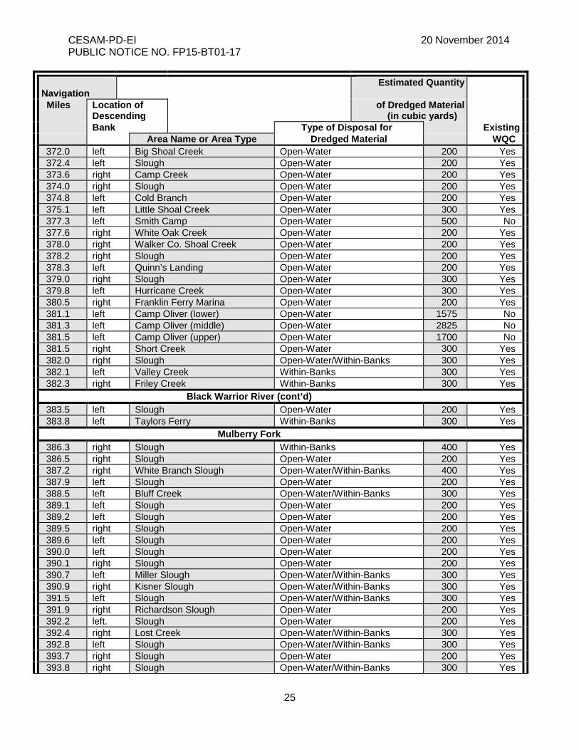
372.0 left Big Shoal Creek Open-Water 200 Yes 372.4 left Slough Open-Water 200 Yes 373.6 right Camp Creek Open-Water 200 Yes 374.0 right Slough Open-Water 200 Yes 374.8 left Cold Branch Open-Water 200 Yes 375.1 left Little Shoal Creek Open-Water 300 Yes 377.3 left Smith Camp Open-Water 500 No 377.6 right White Oak Creek Open-Water 200 Yes 378.0 right Walker Co. Shoal Creek Open-Water 200 Yes 378.2 right Slough Open-Water 200 Yes 378.3 left Quinn’s Landing Open-Water 200 Yes 379.0 right Slough Open-Water 300 Yes 379.8 left Hurricane Creek Open-Water 300 Yes 380.5 right Franklin Ferry Marina Open-Water 200 Yes 381.1 left Camp Oliver (lower) Open-Water 1575 No 381.3 left Camp Oliver (middle) Open-Water 2825 No 381.5 left Camp Oliver (upper) Open-Water 1700 No 381.5 right Short Creek Open-Water 300 Yes 382.0 right Slough Open-Water/Within-Banks 300 Yes 382.1 left Valley Creek Within-Banks 300 Yes 382.3 right Friley Creek Within-Banks 300 Yes
Black Warrior River (cont’d) 383.5 left Slough Open-Water 200 Yes 383.8 left Taylors Ferry Within-Banks 300 Yes
Mulberry Fork 386.3 right Slough Within-Banks 400 Yes 386.5 right Slough Open-Water 200 Yes 387.2 right White Branch Slough Open-Water/Within-Banks 400 Yes 387.9 left Slough Open-Water 200 Yes 388.5 left Bluff Creek Open-Water/Within-Banks 300 Yes 389.1 left Slough Open-Water 200 Yes 389.2 left Slough Open-Water 200 Yes 389.5 right Slough Open-Water 200 Yes 389.6 left Slough Open-Water 200 Yes 390.0 left Slough Open-Water 200 Yes 390.1 right Slough Open-Water 200 Yes 390.7 left Miller Slough Open-Water/Within-Banks 300 Yes 390.9 right Kisner Slough Open-Water/Within-Banks 300 Yes 391.5 left Slough Open-Water/Within-Banks 300 Yes 391.9 right Richardson Slough Open-Water 200 Yes 392.2 left. Slough Open-Water 200 Yes 392.4 right Lost Creek Open-Water/Within-Banks 300 Yes 392.8 left Slough Open-Water/Within-Banks 300 Yes 393.7 right Slough Open-Water 200 Yes 393.8 right Slough Open-Water/Within-Banks 300 Yes
CESAM-PD-EI 20 November 2014 PUBLIC NOTICE NO. FP15-BT01-17
26
Navigation
Estimated Quantity
Miles Location of Descending
of Dredged Material (in cubic yards)
Bank Type of Disposal for Existing Area Name or Area Type Dredged Material WQC
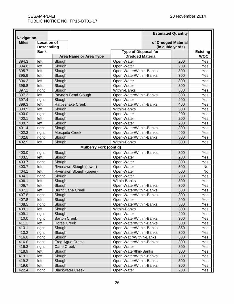
394.3 left Slough Open-Water 200 Yes 394.6 left Slough Open-Water 200 Yes 395.7 left Slough Open-Water/Within-Banks 300 Yes 395.9 left Slough Open-Water/Within-Banks 300 Yes 396.3 left Slough Open-Water 300 Yes 396.8 left Slough Open-Water 300 Yes 397.1 right Slough Within-Banks 300 Yes 397.3 left Payne’s Bend Slough Open-Water/Within-Banks 300 Yes 397.4 right Slough Open-Water 200 Yes 399.3 left Rattlesnake Creek Open-Water/Within-Banks 400 Yes 399.5 left Slough Within-Banks 300 Yes 400.0 right Slough Open-Water 200 Yes 400.1 left Slough Open-Water 200 Yes 400.7 left Slough Open-Water 200 Yes 401.4 right Slough Open-Water/Within-Banks 300 Yes 402.3 right Mosquito Creek Open-Water/Within-Banks 400 Yes 402.8 right Slough Open-Water/Within-Banks 300 Yes 402.9 left Slough Within-Banks 300 Yes
Mulberry Fork (cont’d) 403.0 right Slough Open-Water/Within-Banks 300 Yes 403.5 left Slough Open-Water 200 Yes 403.7 right Slough Open-Water 300 Yes 403.7 left Riverlawn Slough (lower) Open-Water 500 No 404.1 left Riverlawn Slough (upper) Open-Water 500 No 404.1 right Slough Open-Water 200 Yes 406.1 left Slough Within-Banks 300 Yes 406.7 left Slough Open-Water/Within-Banks 300 Yes 407.1 left Burnt Cane Creek Open-Water/Within-Banks 300 Yes 407.8 right Slough Open-Water/Within-Banks 300 Yes 407.8 left Slough Open-Water 200 Yes 408.5 right Slough Open-Water/Within-Banks 300 Yes 409.1 left Slough Within-Banks 300 Yes 409.1 right Slough Open-Water 200 Yes 410.0 right Barton Creek Open-Water/Within-Banks 300 Yes 411.2 left Horse Creek Open-Water/Within-Banks 300 Yes 413.1 right Slough Open-Water/Within-Banks 350 Yes 413.2 right Slough Open-Water/Within-Banks 300 Yes 416.0 right Slough Open-Wat.r/Within-Banks 300 Yes 416.0 right Frog Ague Creek Open-Water/Within-Banks 300 Yes 416.3 right Cane Creek Open-Water 300 Yes 418.9 left Slough Open-Water/thin-Banks 300 Yes 419.1 left Slough Open-Water/Within-Banks 300 Yes 419.3 left Slough Open-Water/Within-Banks 300 Yes 419.6 left Slough Open-Water/Within-Banks 300 Yes 422.4 right Blackwater Creek Open-Water 200 Yes
CESAM-PD-EI 20 November 2014 PUBLIC NOTICE NO. FP15-BT01-17
27
Navigation
Estimated Quantity
Miles Location of Descending
of Dredged Material (in cubic yards)
Bank Type of Disposal for Existing Area Name or Area Type Dredged Material WQC
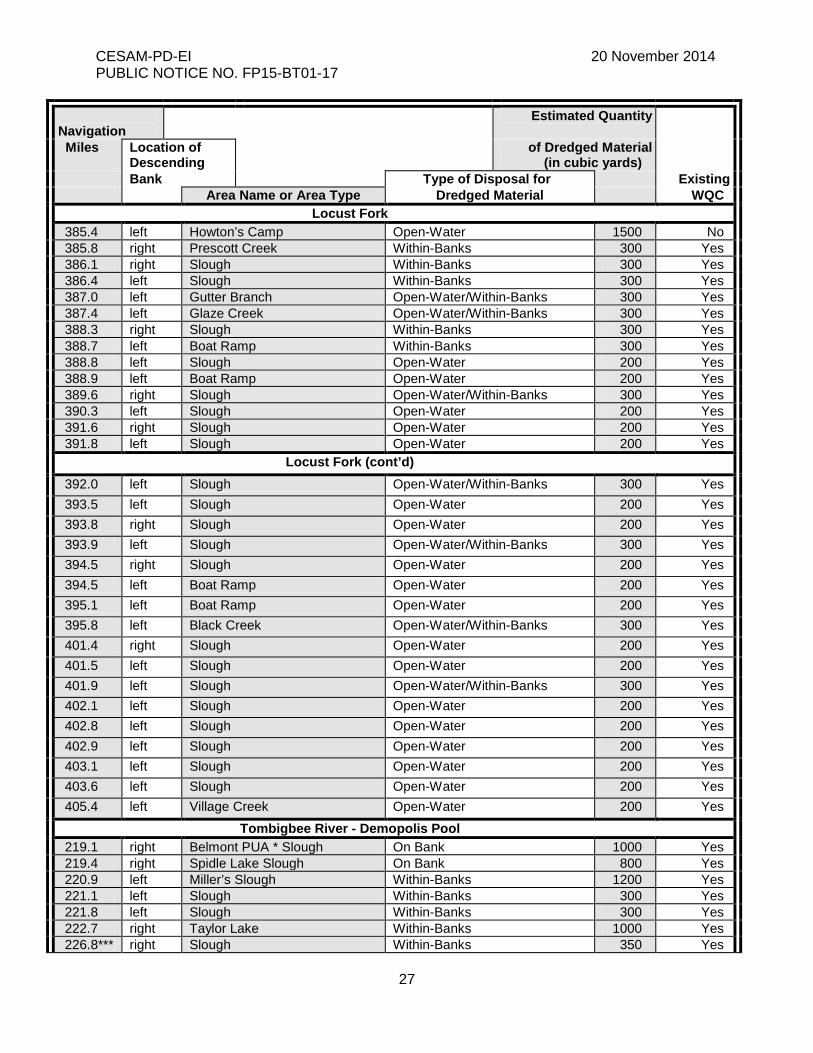
Locust Fork 385.4 left Howton’s Camp Open-Water 1500 No 385.8 right Prescott Creek Within-Banks 300 Yes 386.1 right Slough Within-Banks 300 Yes 386.4 left Slough Within-Banks 300 Yes 387.0 left Gutter Branch Open-Water/Within-Banks 300 Yes 387.4 left Glaze Creek Open-Water/Within-Banks 300 Yes 388.3 right Slough Within-Banks 300 Yes 388.7 left Boat Ramp Within-Banks 300 Yes 388.8 left Slough Open-Water 200 Yes 388.9 left Boat Ramp Open-Water 200 Yes 389.6 right Slough Open-Water/Within-Banks 300 Yes 390.3 left Slough Open-Water 200 Yes 391.6 right Slough Open-Water 200 Yes 391.8 left Slough Open-Water 200 Yes
Locust Fork (cont’d) 392.0 left Slough Open-Water/Within-Banks 300 Yes 393.5 left Slough Open-Water 200 Yes 393.8 right Slough Open-Water 200 Yes 393.9 left Slough Open-Water/Within-Banks 300 Yes 394.5 right Slough Open-Water 200 Yes 394.5 left Boat Ramp Open-Water 200 Yes 395.1 left Boat Ramp Open-Water 200 Yes 395.8 left Black Creek Open-Water/Within-Banks 300 Yes 401.4 right Slough Open-Water 200 Yes 401.5 left Slough Open-Water 200 Yes 401.9 left Slough Open-Water/Within-Banks 300 Yes 402.1 left Slough Open-Water 200 Yes 402.8 left Slough Open-Water 200 Yes 402.9 left Slough Open-Water 200 Yes 403.1 left Slough Open-Water 200 Yes 403.6 left Slough Open-Water 200 Yes 405.4 left Village Creek Open-Water 200 Yes
Tombigbee River - Demopolis Pool 219.1 right Belmont PUA * Slough On Bank 1000 Yes 219.4 right Spidle Lake Slough On Bank 800 Yes 220.9 left Miller’s Slough Within-Banks 1200 Yes 221.1 left Slough Within-Banks 300 Yes 221.8 left Slough Within-Banks 300 Yes 222.7 right Taylor Lake Within-Banks 1000 Yes 226.8*** right Slough Within-Banks 350 Yes
CESAM-PD-EI 20 November 2014 PUBLIC NOTICE NO. FP15-BT01-17
28
Navigation
Estimated Quantity
Miles Location of Descending
of Dredged Material (in cubic yards)
Bank Type of Disposal for Existing Area Name or Area Type Dredged Material WQC
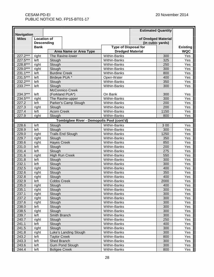
227.2*** right The Ravine-lower Within-Banks 300 Yes 227.5*** left Slough Within-Banks 325 Yes 228.8*** right Slough Within-Banks 250 Yes 229.0*** right Slough Within-Banks 300 Yes 231.1*** left Burdine Creek Within-Banks 800 Yes 231.5*** left Birdeye PUA * Open-Water 400 Yes 232.2*** left Slough Within-Banks 350 Yes 233.7*** left Slough Within-Banks 300 Yes
234.3***
left
McConnico Creek (Forkland PUA*)
On Bank
300
Yes
234.5*** right The Ravine-upper Within-Banks 300 Yes 227.2 left Parker’s Camp Slough Within-Banks 200 Yes 227.3 right Slough Within-Banks 200 Yes 227.4 left Acorn Creek Within-Banks 1150 Yes 227.9 right Slough Within-Banks 800 Yes
Tombigbee River - Demopolis Pool (cont’d) 228.6 left Slough Within-Banks 3 00 Yes 228.9 left Slough Within-Banks 300 Yes 229.0 right Trails End Slough Within-Banks 1250 Yes 229.7 right Slough Within-Banks 350 Yes 230.6 right Hayes Creek Within-Banks 850 Yes 231.0 left Slough Within-Banks 200 Yes 231.4 left Slough Within-Banks 275 Yes 231.6 right High Run Creek Within-Banks 550 Yes 231.8 left Slough Within-Banks 300 Yes 232.1 left Slough Within-Banks 300 Yes 232.5 right Slough Within-Banks 400 Yes 232.6 right Slough Within-Banks 350 Yes 232.8 right Slough Within-Banks 400 Yes 232.9 left Cobbs Creek Within-Banks 2000 Yes 235.0 right Slough Within-Banks 400 Yes 235.1 right Slough Within-Banks 300 Yes 237.1 right Slough Within-Banks 300 Yes 237.2 right Slough Within-Banks 300 Yes 237.6 right Slough Within-Banks 300 Yes 238.0 left Slough Within-Banks 300 Yes 238.5 right Slough Within-Banks 300 Yes 239.7 left Smith Branch Within-Banks 300 Yes 240.7 right Slough Within-Banks 250 Yes 241.1 left Slough Within-Banks 400 Yes 241.5 right Slough Within-Banks 300 Yes 241.8 right Luke’s Landing Slough Within-Banks 300 Yes 243.2 left Taylor Creek Within-Banks 800 Yes 243.3 left Shed Branch Within-Banks 300 Yes 243.6 left Gum Pond Slough Within-Banks 300 Yes 244.4 left Boligee Creek Within-Banks 800 Yes
CESAM-PD-EI 20 November 2014 PUBLIC NOTICE NO. FP15-BT01-17
29
Navigation
Estimated Quantity
Miles Location of Descending
of Dredged Material (in cubic yards)
Bank Type of Disposal for Existing Area Name or Area Type Dredged Material WQC
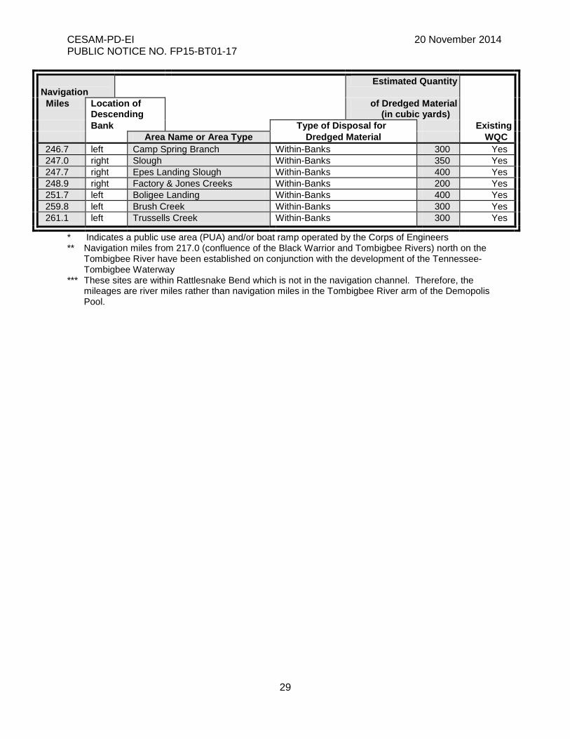
246.7 left Camp Spring Branch Within-Banks 300 Yes 247.0 right Slough Within-Banks 350 Yes 247.7 right Epes Landing Slough Within-Banks 400 Yes 248.9 right Factory & Jones Creeks Within-Banks 200 Yes 251.7 left Boligee Landing Within-Banks 400 Yes 259.8 left Brush Creek Within-Banks 300 Yes 261.1 left Trussells Creek Within-Banks 300 Yes
* Indicates a public use area (PUA) and/or boat ramp operated by the Corps of Engineers ** Navigation miles from 217.0 (confluence of the Black Warrior and Tombigbee Rivers) north on the
Tombigbee River have been established on conjunction with the development of the Tennessee-Tombigbee Waterway
*** These sites are within Rattlesnake Bend which is not in the navigation channel. Therefore, the mileages are river miles rather than navigation miles in the Tombigbee River arm of the Demopolis Pool.
![Index [quyhoach.xaydung.gov.vn]quyhoach.xaydung.gov.vn/Images/Quyhoach/fileDK... · BT01—BT69, tông sô 550 lô vói tâng cao < 02 tâng, mat dQ xây dung < 30%. + Nhà liên](https://img.pdfslide.net/doc/110x75/5fbda4aa7a07365d6a09010a/index-bt01abt69-tng-s-550-l-vi-tng-cao-02-tng-mat-dq-xy.jpg)