Embed Size (px)
Citation preview

MTP/SCS 2016 Sacramento Area Council of Governments Draft Environmental Impact Report Public Services and Recreation – Page 15–1
Chapter 15—Public Services and Recreation 15.1 Introduction
This chapter describes existing conditions (environmental and regulatory) for public services and recreation and assesses the potential of the 2016 Metropolitan Transportation Plan/Sustainable Communities Strategy (proposed MTP/SCS) to affect the provision of public services (police protection, fire protection, emergency services, social services, schools, libraries, and parks and recreation) within the MTP/SCS plan area. This chapter evaluates potential impacts on public services that may result from implementation of the proposed MTP/SCS. Where necessary and feasible, mitigation measures are identified to reduce these impacts.
The information presented in this chapter is based on a review of existing and available information and is regional in scope. Data provided in this section is programmatic. It is appropriate for general policy planning and tiering of subsequent environmental documents; however, site-specific evaluations may be necessary to determine future project-level environmental effects and appropriate mitigation.
One comment letter submitted by the Delta Protection Commission (DPC), regarding public services was received in response to the Notice of Preparation (NOP). The comment letter requested consideration of policies regarding recreational resources within the Land Use and Resource Management Plan (LURMP), coordination with the Commission’s Delta Trail planning process for connectivity of regional trail network, and that the EIR address the Great California Delta Trail project in Sacramento and Yolo counties. Appendix PD-1 contains the full set of letters submitted during circulation of the NOP.
15.2 Environmental Setting
15.2.1 Police Protection Services
Police protection services are provided at both the state and local level. Law enforcement services include crime investigation, crime prevention, traffic management, traffic collision investigation, homeland security activities, and emergency response. For a discussion of other emergency services (e.g., hospitals, emergency response plans), see Chapter 10 – Hazards and Hazardous Materials.
CALIFORNIA HIGHWAY PATROL (CHP)
CHP has statewide authority to conduct law enforcement activities and criminal investigations, but generally provides traffic regulation enforcement, emergency accident management and service, and assistance on state roadways and other major roadways in unincorporated portions of the region. The CHP service area is along the state route and interstate highway system that runs through the MTP/SCS plan area. Counties may contract with CHP for services in unincorporated areas ranging from primary jurisdiction for road patrol and traffic enforcement to non-traffic law enforcement and criminal investigations. CHP also provides state police for the Capitol. CHP cooperates with both county and city police departments when the need arises, providing support to local police and helping coordinate multi-jurisdictional task force activities in serious or complicated cases.

MTP/SCS 2016 Sacramento Area Council of Governments Draft Environmental Impact Report Public Services and Recreation – Page 15–2
LOCAL POLICE PROTECTION
Each of the six counties within the MTP/SCS plan area has its own county sheriff’s department, which is responsible for providing police protection within unincorporated areas. Each incorporated city and town in the MTP/SCS plan area also either provides its own police services or contracts with the sheriff’s department for the provision of such services. The Sacramento Regional Transit District, University of California-Davis, California State University-Sacramento, Los Rios Community College District, and Yuba Community College District all have their own police departments. The locations of police facilities are shown in Figure 15.1.
Additionally, AMTRAK and the Sacramento Regional Transit District (RT) maintain their own policing services to enforce agency policies and provide for the public safety at transit stops and stations, including additional staff for implementation of new transit service.
TRIBAL POLICE PROTECTION
The Shingle Springs Band of Miwok Indians has a Tribal Police Department (Shingle Springs Band of Miwok Indians, 2014). The United Auburn Indian Community (UAIC) has signed memorandums with Placer County and the City of Lincoln for police protection services and the Yocha Dehe Wintun Nation is part of the Yolo Emergency Communications Agency Joint Powers Agreement for shared police services (United Auburn Indian Community, 2014; Yolo County, 2012). In addition, UAIC and the Placer County Indian Gaming Local Community Benefit Committee (LCBC) have awarded grants to the Placer County, Lincoln, Roseville, and Rocklin police departments in order to mitigate the effects of tribal gaming. Wilton Rancheria currently does not have any developed tribal lands requiring police protection services.
15.2.2 Fire Protection Services
Fire suppression is the responsibility of various fire departments and districts, which often employ paramedics for emergency medical services. See Chapter 10 – Hazards and Hazardous Materials for a discussion of fire threats (e.g., urban fires, wildland fires, and wildland-urban interface zones).
The MTP/SCS plan area includes 49 fire districts and 16 city fire departments, as well as several other public fire departments. There is also a private fire department: Aerojet Fire Services in Folsom. The locations of fire stations are shown in Figure 15.1. Table 15.1 lists the local fire protection districts and fire departments in the MTP/SCS plan area.
U.S. FOREST SERVICE (USFS)
USFS is responsible for fire prevention and suppression in the Eldorado National Forest, Tahoe National Forest, and those privately-owned lands within the forest boundaries.
NATIONAL INDIAN FORESTRY AND WILDLAND FIRE MANAGEMENT PROGRAM
The National Indian Forestry and Wildland Fire Management Program is a cooperative effort of the United States Department of the Interior, Bureau of Indian Affairs, Office of the Deputy Director - Trust Services, Division of Forestry and Wildland Fire Management, Intertribal Timber Council, and individual Tribal governments on reservations that contain forest resources.

MTP/SCS 2016 Sacramento Area Council of Governments Draft Environmental Impact Report Public Services and Recreation – Page 15–3
Figure 15.1 MTP/SCS Plan Area Police Stations, Fire Stations, and Hospitals

MTP/SCS 2016 Sacramento Area Council of Governments Draft Environmental Impact Report Public Services and Recreation – Page 15–4
Table 15.1 MTP/SCS Plan Area Fire Protection Districts
El Dorado County Sutter County Cameron Park Community Services District Unincorporated Diamond Springs/El Dorado Fire District County Service Area C (Nicolaus Fire Department) El Dorado County Fire Protection District County Service Area D (Pleasant Grove Fire Department) El Dorado Hills Fire Department County Service Area F (Live Oak, Sutter, and Oswold- Garden Valley Fire Protection District Tudor Fire Stations) Georgetown Fire Protection District Meridian Fire Protection District Latrobe Fire Protection District Sutter Basin (Robbins) Fire Protection District Mosquito Fire Protection District Incorporated Pioneer Fire Protection District City of Yuba City Fire Department Rescue Fire Protection District Yolo County Shingle Springs Rancheria Fire Department Unincorporated
Placer County Capay Fire Protection District Unincorporated Clarksburg Fire Protection District
Alta Volunteer Fire Protection District Dunnigan Fire Protection District Foresthill/Iowa Hill Fire Protection District East Davis Fire Protection District Newcastle Fire Protection District Elkhorn Fire Protection District Penryn Fire Protection District Esparto Fire Protection District Placer Consolidated Fire Protection District Knights Landing Fire Protection District Placer Hills Fire Protection District Madison Fire Protection District Sacramento Metropolitan Fire District No Man’s Land Fire Protection District South Placer Fire Protection District Rumsey Rancheria Fire Department
Incorporated Springlake Fire Protection District City of Auburn Fire Department UC Davis Fire Department City of Colfax Volunteer Fire Department West Plainfield Fire Protection District City of Lincoln Fire Department Willow Oak Fire Protection District Town of Loomis Fire Department Yolo Fire Protection District City of Rocklin Fire Department Zamora Fire Protection District City of Roseville Fire Department Incorporated
Sacramento County City of Davis Fire Department Unincorporated City of West Sacramento Fire Department
California Army National Guard Fire Department City of Winters Fire Department Courtland Fire Protection District City of Woodland Fire Department Delta Fire Protection District Yuba County Folsom State Prison Fire Department Unincorporated Herald Fire Protection District Beale Air Force Base Fire Department Natomas Fire Protection District (contract with the City of Sacramento)
Camptonville Volunteer Fire Department
Pacific Fruitridge Fire Protection District Dobbins-Oregon House Fire Protection District River Delta Fire District Foothill Volunteer Fire Department Sacramento County Airport Fire Department Linda Fire Department Sacramento Metropolitan Fire District Loma Rica-Browns Valley Community Service District Wilton Fire Protection District Marysville Fire Department Walnut Grove Fire Protection District Olivehurst Public Utility District
Incorporated Smartsville Fire Protection District City of Folsom Fire Department Incorporated City of Isleton Fire Department City of Marysville Fire Department City of Sacramento Fire Department City of Wheatland Fire Department Cosumnes Community Services District --
Source: SACOG, 2014; California Professional Firefighters Association, 2014
MTP/SCS 2016 Sacramento Area Council of Governments Draft Environmental Impact Report Public Services and Recreation – Page 15–5
CALIFORNIA DEPARTMENT OF FORESTRY AND FIRE PROTECTION (CAL FIRE)
CAL FIRE provides response to all wildland fires within the unincorporated, privately-owned areas of the MTP/SCS plan area. CAL FIRE is also called to assist with emergencies which require more resources than the local city and county emergency responders are able to provide. Because of the Department's size and major incident management experience, CAL FIRE is often asked to assist or take the lead in disasters, such as floods, toxic spills, earthquakes, and major urban and rural fires. Within the MTP/SCS plan area, CAL FIRE operates 23 fire stations, including 11 in Placer County, seven in El Dorado County, four in Yuba County, and one in Yolo County. El Dorado County is also home to one conservation camp jointly operated by the California Department of Corrections with crews of prison inmates that respond to wildland fires (California Department of Forestry and Fire Protection, 2014).
LOCAL FIRE PROTECTION SERVICES
County fire departments provide fire prevention and suppression and emergency services to the unincorporated areas of the six counties, as well as those municipalities that contract for fire protection and emergency services. City fire departments are more prevalent among older and/or larger municipalities. The varied topographic features, environmental settings, and demographics of the region require fire protection personnel to respond to various types of emergencies in rural, suburban, and urban settings. The wide diversity of emergency incidents require firefighters to be proficient in wildland firefighting, structural firefighting, crash fire rescue, technical rescue, swift water rescue, hazardous material mitigation, and paramedic medical services.
TRIBAL FIRE PROTECTION SERVICES
The Shingle Springs Band of Miwok Indians in El Dorado County and the Yocha Dehe Wintun Nation in Yolo County operate tribal fire departments (Shingle Springs Band of Miwok Indians, 2014; Yocha Dehe Wintun Nation, 2014). The Yocha Dehe Wintun Nation is also part of the Yolo Emergency Communications Agency Joint Powers Agreement for shared fire services (Yolo County, 2012). The UAIC in Placer County has signed agreements with the City of Lincoln and the County, by contract with CALFIRE, to provide fire protection. UAIC funded the construction of a new fire station near the Thunder Valley Casino and has provided the Placer County Fire Department with a new ladder truck (United Auburn Indian Community, 2014). Wilton Rancheria currently does not have any developed tribal lands requiring fire protection services.
15.2.3 Social Services
Social services are provided by government agencies, private non-profit organizations, and private for-profit organizations. Figure 15.2 displays the locations of these services. The following types of social services currently available in the MTP/SCS plan area:
Alcohol, Drug, and Mental Health Services: provides alcohol and drug abuse prevention and treatment services to adults and juveniles, and mental health services to seriously mentally ill adults, youth, and families.
Adult Education and Job Training: provides educational and job training opportunities to give adult students the knowledge and skills necessary to participate effectively as citizens, employees, parents, and family members.

MTP/SCS 2016 Sacramento Area Council of Governments Draft Environmental Impact Report Public Services and Recreation – Page 15–6
Child Support Services: determines parentage, establishes orders for support and medical coverage, and collects and distributes funds from absent parents who have a financial responsibility to support their children.
Civic Buildings and Community Centers: includes libraries, community centers, and other public buildings not otherwise classified.
Courts and Parole Offices: hears and gives rulings on the following types of court cases: appeals, civil, criminal, family and children, juvenile, and traffic. Parole offices coordinate parole hearings and supervise defendants not yet sentenced to a term of incarceration and offenders released from incarceration.
Heath and Disabled Services: provides programs for the medically indigent, older adults, the disabled, and detainees; communicable disease prevention and control; protection of food and water; waste and vector control; vital records; nutrition and safety education; and public health nursing services.
Homeless and Housing Assistance: provides temporary shelter, food assistance, mental health services, and transitional housing assistance to adults, juveniles, and families.
Human Assistance: administers various federal, state, and local government programs designed to provide cash assistance, food stamps, and other social services not otherwise classified.
Veteran Affairs: provides medical, mental health, vocational rehabilitation and employment, educational, and other training to veterans.

MTP/SCS 2016 Sacramento Area Council of Governments Draft Environmental Impact Report Public Services and Recreation – Page 15–7
Figure 15.2 MTP/SCS Plan Area Social Service Access by Transit

MTP/SCS 2016 Sacramento Area Council of Governments Draft Environmental Impact Report Public Services and Recreation – Page 15–8
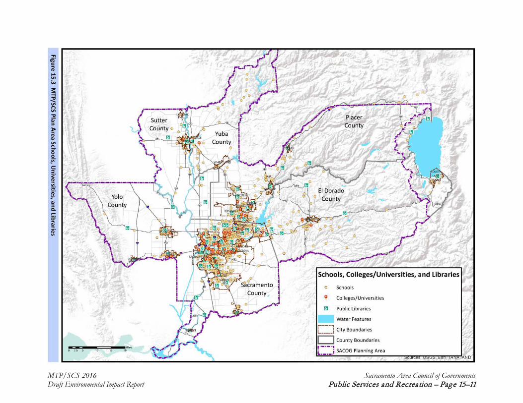
15.2.4 Schools
School districts and local jurisdictions within the MTP/SCS plan area provide public education facilities and services, including elementary schools, middle schools, secondary schools, post-secondary schools, and colleges and universities, as well as special and adult education. School districts plan for school facilities, while standards relating to class size and funding for new school construction are set at the state level. There are more than 700 elementary, middle, secondary, and post-secondary schools, colleges and universities, alternative education, continuation, special education, and adult school services in the region. Table 15.2 lists the public school districts serving each of the six SACOG-region counties and the number of each type of school within that district. Figure 15.3 shows the location of public educational facilities.
Table 15.2 MTP/SCS Plan Area Public Education Facilities
Public School District
Number of Public Schools by Type Total
Schools K-8 K-12 Elementary Middle/ Junior High
Secondary/ High
School
College Adult
EL DORADO COUNTY 6 4 26 9 14 1 1 62 Black Oak Mine Unified - 1 3 - 2 - - 6 Buckeye Union 1 - 7 2 - - - 10 Camino Union 2 - - - - - - 2 Central Sierra ROP - - - - 1 - - 1 El Dorado County Office of Education/Charter Community 1 3 - - 2 - 1 7
El Dorado Union High - - - - 9 - - 9 Gold Oak Union - - 1 1 - - - 2 Gold Trail Union - - 2 - - - - 2 Indian Diggings 1 - - - - - - 1 Latrobe - - 2 - - - - 2 Los Rios Community College - - - - - 1 - 1 Mother Lode Union - - 1 1 - - - 2 Pioneer Union - - 2 1 - - - 3 Placerville Union - - 2 1 - - - 3 Pollock Pines - - 1 1 - - - 2 Rescue Union - - 5 2 - - - 7 Silver Fork 1 - - - - - - 1 PLACER COUNTY 17 16 51 14 20 2 3 125 Ackerman Charter 1 - - - - - - 1 Alta-Dutch Flat 2 - - - - - - 2 Auburn Union - - 4 1 - - - 5 Colfax Elementary 1 - - - - - - 1 Dry Creek Joint Elementary - 1 6 2 - - - 9 Eureka Union - - 5 2 - - - 7 Foresthill Union 1 - - - - - - 1 Forty-Niner Regional Occupational Program - - - - 1 - - 1
Loomis Union 7 1 - - - - - 8 Newcastle Elementary 4 3 - - - - - 7 Placer County Office of - 6 - - - - - 6

MTP/SCS 2016 Sacramento Area Council of Governments Draft Environmental Impact Report Public Services and Recreation – Page 15–9
Public School District
Number of Public Schools by Type Total
Schools K-8 K-12 Elementary Middle/ Junior High
Secondary/ High
School
College Adult
Education Placer Hills Union - - 2 1 - - - 3 Placer Union High - - - - 6 - 1 7 Rocklin Unified 1 3 13 2 3 - - 22 Roseville City - - 14 4 - - - 18 Roseville Joint Union High - - - - 7 - 1 8 Sierra Joint Community - - - - - 2 - 2 Western Placer Unified - 2 7 2 2 - 1 14 Western Sierra Collegiate Academy - - - - 1 - - 1
SACRAMENTO COUNTY 39 23 193 45 85 8 11 412 Aroche Union 1 - - - - - - 1 California Education Authority Headquarters - - - - 4 - - 4
Center Joint Unified - - 4 1 4 - 1 10 California State University, Sacramento - - - - - 1 - 1
Elk Grove Unified 1 1 39 9 15 - 1 66 Elverta Joint - 1 1 1 - - - 3 Folsom Cordova Unified 1 1 22 4 7 - 1 36 Galt Joint Union - - 5 1 - - - 6 Galt Joint Union High - - - - 3 - 1 4 Los Rios Community College - - - - - 7 - 7 Natomas Unified 1 2 8 4 4 - - 19 River Delta Unified - 1 5 2 4 - 1 13 Robla - - 6 - - - - 6 Sacramento City Unified 14 1 45 8 13 - 2 83 Sacramento County Office of Education 1 2 - - 6 - - 9
Sacramento County Regional Occupational Program - - - - 1 - - 1
San Juan Unified 11 8 37 8 13 - 2 79 Twin Rivers Unified 9 6 21 7 11 - 2 56 SUTTER COUNTY 12 11 8 2 10 1 1 228 Brittan Elementary 1 - - - - - - 1 Browns Elementary 1 - - - - - - 1 East Nicolaus High - - - - 2 - - 2 Franklin Elementary 1 - - - - - - 1 Live Oak Unified 1 1 1 1 2 - - 6 Marcum-Illinois 1 1 - - - - - 2 Meridian Elementary 1 1 - - - - - 2 Nuestro Elementary 1 - - - - - - 1 Pleasant Grove Elementary 1 - - - - - - 1 Sutter County Office of Education - 1 - - 1 - 1 3
Sutter Union High - - - - 2 - - 2 Winship-Robbins Elementary 2 - - - - - - 2

MTP/SCS 2016 Sacramento Area Council of Governments Draft Environmental Impact Report Public Services and Recreation – Page 15–10
Public School District
Number of Public Schools by Type Total
Schools K-8 K-12 Elementary Middle/ Junior High
Secondary/ High
School
College Adult
Yuba City Unified 2 7 7 1 3 - - 20 Yuba Community College - - - - - 1 - 1 YOLO COUNTY 2 0 32 9 13 4 3 241 Davis Joint Unified 1 - 10 3 3 - 1 18 Esparto Unified - - 1 1 2 - - 4 Washington Unified 1 - 9 2 2 - 1 15 Winters Joint Unified - - 1 1 2 - - 4 Woodland Joint Unified - - 11 2 3 - 1 17 Los Rios Community College - - - - - 2 - 2 University of CA - Davis - - - - - 1 - 1 Yolo County ROP - - - - 1 - - 1 Yuba Community College - - - - - 1 - 1 YUBA COUNTY 3 5 19 5 8 2 0 212 Camptonville 1 1 - - - - - 2 Marysville Joint Unified 1 1 14 3 5 - - 24 Plumas - - 2 1 - - - 3 Wheatland Elementary - - 3 1 - - - 4 Wheatland Union High - - - - 2 - - 2 Yuba County Office of Education 1 3 - - 1 - - 5
Yuba Community College - - - - - 2 - 2 REGION 79 59 329 84 150 18 19 738
Source: California Department of Education, 2013-2014
MTP/SCS 2016 Sacramento Area Council of Governments Draft Environmental Impact Report Public Services and Recreation – Page 15–11
Figure 15.3 MTP/SCS Plan Area Schools, Universities, and Libraries

MTP/SCS 2016 Sacramento Area Council of Governments Draft Environmental Impact Report Public Services and Recreation – Page 15–12
15.2.5 Libraries
Public libraries serve communities by providing access to collections of broadly-based materials that interest and benefit all ages and abilities, and reflect community needs, wants, and use. There are 64 libraries and three bookmobiles in the MTP/SCS plan area. In addition, local colleges and high schools offer library services for their students. Table 15.3 is an inventory of existing library facilities in the MTP/SCS plan area. The locations of these libraries are shown in Figure 15.3.
Table 15.3 Table MTP/SCS Plan Area Public Libraries
County Library
El Dorado County
Bookmobile Cameron Park Branch Library El Dorado Hills Branch Library Georgetown Branch Library Placerville Main Library Pollock Pines Branch Library
Placer County
Applegate Branch Library Auburn Branch Library Bookmobile Carnegie Public Library (Lincoln) Colfax Branch Library Foresthill Branch Library Granite Bay Branch Library Kings Beach Branch Library Loomis Branch Library Maidu Branch Library (Roseville) Martha Riley Community Branch Library (Roseville) Meadow Vista Branch Library Penryn Branch Library Rocklin Branch Library Roseville Downtown Public Library (Roseville) Twelve Bridges Branch Library (Lincoln)
Sacramento County
Arcade Branch Library Arden-Dimick Branch Library Belle Cooledge (Land Park) Branch Library Carmichael Branch Library Bookmobile Carmichael Branch Library Central Sacramento Public Library Colonial Heights Branch Library Courtland Branch Library Del Paso Heights Branch Library Elk Grove Branch Library Ella K. McClatchy Branch Library Fair Oaks Branch Library Folsom Branch Library (Folsom) Franklin Community Branch Library (Elk Grove) Galt-Marian O. Lawrence Branch Library
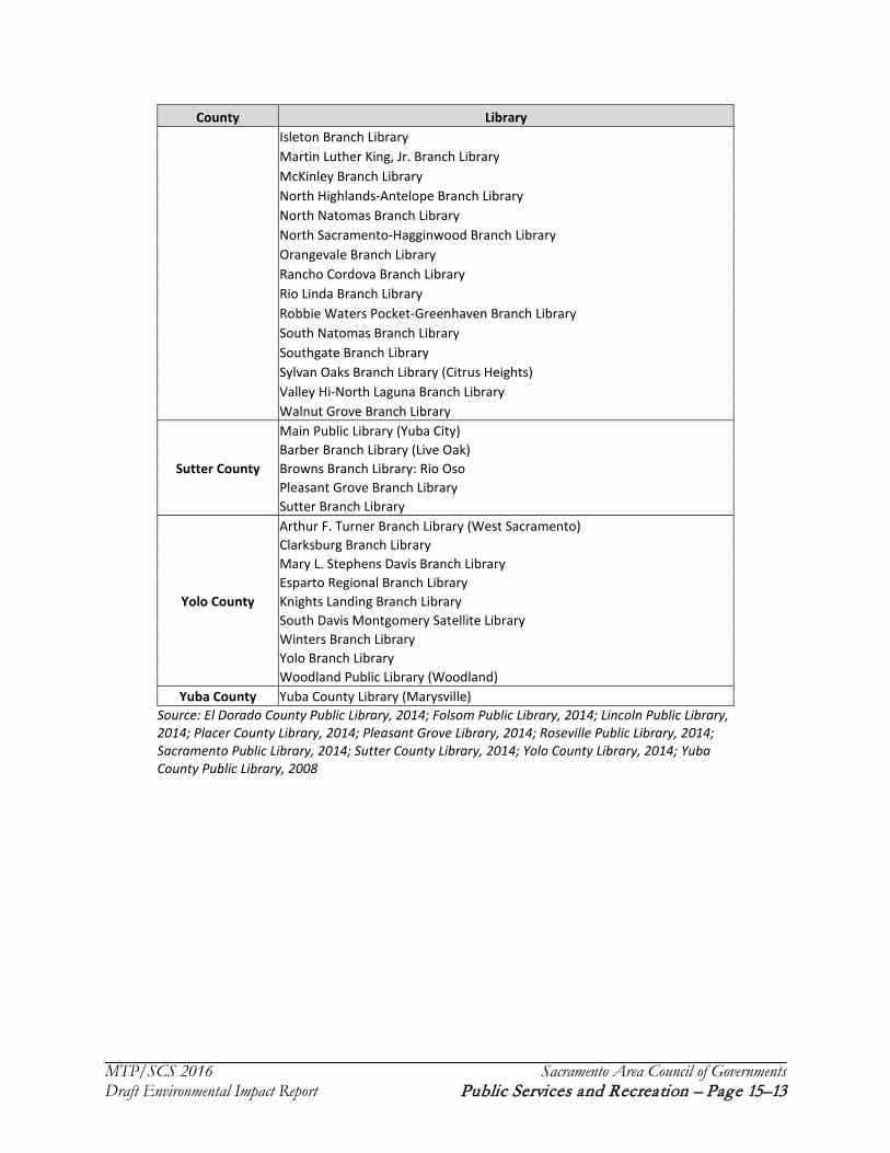
MTP/SCS 2016 Sacramento Area Council of Governments Draft Environmental Impact Report Public Services and Recreation – Page 15–13
County Library Isleton Branch Library Martin Luther King, Jr. Branch Library McKinley Branch Library North Highlands-Antelope Branch Library North Natomas Branch Library North Sacramento-Hagginwood Branch Library Orangevale Branch Library Rancho Cordova Branch Library Rio Linda Branch Library Robbie Waters Pocket-Greenhaven Branch Library South Natomas Branch Library Southgate Branch Library Sylvan Oaks Branch Library (Citrus Heights) Valley Hi-North Laguna Branch Library Walnut Grove Branch Library
Sutter County
Main Public Library (Yuba City) Barber Branch Library (Live Oak) Browns Branch Library: Rio Oso Pleasant Grove Branch Library Sutter Branch Library
Yolo County
Arthur F. Turner Branch Library (West Sacramento) Clarksburg Branch Library Mary L. Stephens Davis Branch Library Esparto Regional Branch Library Knights Landing Branch Library South Davis Montgomery Satellite Library Winters Branch Library Yolo Branch Library Woodland Public Library (Woodland)
Yuba County Yuba County Library (Marysville) Source: El Dorado County Public Library, 2014; Folsom Public Library, 2014; Lincoln Public Library, 2014; Placer County Library, 2014; Pleasant Grove Library, 2014; Roseville Public Library, 2014; Sacramento Public Library, 2014; Sutter County Library, 2014; Yolo County Library, 2014; Yuba County Public Library, 2008

MTP/SCS 2016 Sacramento Area Council of Governments Draft Environmental Impact Report Public Services and Recreation – Page 15–14
15.2.6 Parks and Recreation
NATIONAL MONUMENTS, PARKS, FORESTS, AND WILDERNESS AREAS
USFS manages two national forests in the MTP/SCS plan area: the Eldorado National Forest (El Dorado and Placer counties) and the Tahoe National Forest (Placer and Yuba Counties). The forests provide diverse recreational opportunities including: camping, fishing, water sports (e.g., rafting, canoeing, kayaking), motorized use trails (on designated trails and roads), non-motorized use trails (e.g., hiking, cycling, equestrian), rental cabins, shooting (e.g., plinking and target shooting), winter sports (e.g., cross-country skiing, downhill skiing, snowboarding, snowshoeing), and snowmobiling. There are three wilderness areas within these two National Forests: Granite Chief Wilderness (Tahoe National Forest), Desolation Wilderness (Eldorado National Forest), and Mokelumne Wilderness (Eldorado National Forest). However, all three of these wilderness areas are outside the MTP/SCS plan area. On July 10, 2015, President Obama signed a proclamation declaring over 330,000 acres of Berryessa Snow Mountain as a national monument. A portion of this area is located within Yolo County.
While there are no national parks within the MTP/SCS plan area, there are other federally-managed open space and conservation areas located within the region. The Bureau of Land Management (BLM) manages several special, critical environmental concern, and other management areas within the region, including Cronan Ranch, Greenwood, Kanaka Valley, Norton Ravine, and Pine Hill Preserve in El Dorado County; Consumnes River Preserve in the Sacramento Delta; and the South Yuba Wild and Scenic River Recreation Area in Yuba County. The U.S. Fish and Wildlife Service (UFWS) manages the Sutter National Wildlife Refuge near Yuba City and the Stone Lakes National Wildlife Refuge in Sacramento County (in partnership with the California Department of Parks and Recreation [DPR]). Finally, the Bureau of Reclamation (BOR) operates the Putah Creek Fishing Site in Yolo County and the Folsom S. Canal in Sacramento County and the U.S. Army Corps of Engineers (Army) manages Harry L. Englebright Lake in Yuba County. Figure 15.4 shows existing land in the MTP/SCS plan area designated as parks and open space.
National Trails
The NPS designates national historic and scenic trails. The National Trails System Act of 1968 made it federal policy to provide financial assistance, volunteer support, and coordination between state and other agencies in order to recognize and promote trails. NPS has established 11 national scenic trails and 19 national historic trails. Depending on the trail, some combination of the NPS, USFS, and BLM are designated as administering agencies. Portions of the Pony Express National Historic Trail and California National Historic Trail are within the MTP/SCS plan area (National Park Service, 2014). NPS is preparing a feasibility study under the Omnibus Public Land Management Act of 2009 to evaluate potentially adding 64 routes to existing national historic trails. A total of 41 of these proposed routes are part of the California National Historic Trail (National Park Service, 2014). Figure 15.5 shows the location of national historic and scenic trails.
In addition to national historic and scenic trails, NPS designates National Recreation Trails in the MTP/SCS plan area, including Carson Emigrant Historic in El Dorado County; Pioneer Trail in Placer County; and California Aqueduct Bikeway, Jedediah Smith (also known as the American River Parkway), South Yuba, and Western States Pioneer Trail in Sacramento County.

MTP/SCS 2016 Sacramento Area Council of Governments Draft Environmental Impact Report Public Services and Recreation – Page 15–15
Figure 15.4 MTP/SCS Plan Area Parks, Open Space, and Forested Land

MTP/SCS 2016 Sacramento Area Council of Governments Draft Environmental Impact Report Public Services and Recreation – Page 15–16
Figure 15.5 National and State Trails
Source: California State Parks, 2011; National Park Service, 2014

MTP/SCS 2016 Sacramento Area Council of Governments Draft Environmental Impact Report Public Services and Recreation – Page 15–17
STATE PARKS, RECREATION AREAS, HISTORIC PARKS, PARK PROPERTIES, AND POINTS OF INTEREST
DPR currently manages 279 parks in the state, providing for the health and education of the people of California by helping to preserve the state’s extraordinary biological diversity, protecting its most valued natural and cultural resources, and creating opportunities for high-quality outdoor recreation. Figure 15.4 shows existing land in the MTP/SCS plan area designated as parks and open space. Because of state budget cuts, up to 70 state parks were designated for closure on or before July 1, 2012. Parks on this list within the MTP/SCS planning area included the Governor’s Mansion State Historic Park, the Leland Stanford Mansion State Historic Park, and the Brannan Island State Recreation Area (California Department of Parks and Recreation, 2011).
However, park closures in the region were prevented through a concerted effort by non-profit organizations and private donors, as well as a funding extension from the state. All of the parks in the MTP/SCS plan area avoided closure through fundraising and private donations (Sacramento Bee, 2012). The 2014 state budget included additional funding for state parks, preventing future closures. While state parks have avoided permanent closure since 2012, most have cut back hours and services in response to a diminishing budget. Table 15.4 includes current State parks, recreation areas, historic sites, properties, and points of interest within the MTP/SCS plan area.
Table 15.4 MTP/SCS Plan Area State Parks, Recreation Areas, Park Properties, and Points of Interest
Park Name Type of Park Description El Dorado County
Auburn State Recreation Area
State Recreation Area
The Auburn State Recreation Area covers 40 miles of the North and Middle Forks of the American River. Major recreational uses include hiking, swimming, boating, fishing, camping, mountain biking, gold panning, equestrian/horseback riding trails, and off-highway motorcycle riding.
Folsom Lake State Recreation Area
State Recreation Area
Located at the base of the Sierra foothills, the Folsom Lake State and Recreation Area offers opportunities for hiking, biking, running, camping, picnicking, horseback riding, water-skiing, and boating.
Marshall Gold Discovery State Historic Park
State Historic Park
The Marshall Gold Discovery State Historic Park secures and makes the gold discovery site available for public observation, inspiration, and enjoyment. The park provides activities demonstrating an accurate portrayal of the story that unfolded at the time of the discovery and Gold Rush.
Placer County
Auburn State Recreation Area
State Recreation Area
See description above.
Folsom Lake State Recreation Area
State Recreation Area
See description above.

MTP/SCS 2016 Sacramento Area Council of Governments Draft Environmental Impact Report Public Services and Recreation – Page 15–18
Sacramento County
Brannan Island State Recreation Area
State Recreation Area
Brannan Island State Recreation Area is a maze of waterways within the Sacramento-San Joaquin Delta. One of the outstanding water-oriented recreation areas in the world, the area offers great fishing, including striped bass, sturgeon, catfish, bluegill, perch and bullhead. Frank's Tract, a protected wetland marsh, is home to beaver, muskrat, river otter, mink, and 76 species of birds.
Folsom Lake State Recreation Area
State Recreation Area
See description above.
Prairie City State Vehicular Recreation Area
Prairie City park is at the base of the Sierra Nevada. The park has flat, open grasslands, rolling hills with native blue oak trees, and acres of cobbled mine tailings. The area off highway vehicle (OHV) facilities, including open space and trails for motorcycles, all-terrain vehicles, and four-wheel drive vehicles.
Folsom Powerhouse State Historic Park
Once called “the greatest operative electrical plant on the American continent”, the Folsom Powerhouse produced electricity for Sacramento residents from 1885 to 1952. Visitors touring the powerhouse can see the massive General Electric transformers, each capable of conducting from 800 to 11,000 volts of electricity, in addition to the forebays and canal system that brought water from the dam.
Governor’s Mansion State Historic Park
California’s executive mansion, popularly known at the Governor's Mansion, was built in 1877 for Albert and Clemenza Gallatin. The State of California purchased the house from Joseph and Louisa Steffens to use as a home for California’s first families in 1903.
Leland Stanford Mansion
State Historic Park
Originally built in 1856 by Gold Rush merchant Sheldon Fogus, the Leland Stanford Mansion was later purchased and remodeled by Leland and Jane Stanford. Leland Stanford served as Governor of California from 1862-1863. The Mansion served as the office of three governors during the 1860’s: Leland Stanford, Fredrick Low, and Henry Haight.
Old Sacramento State Historic Park
Old Sacramento State Historic Park is a cluster of noteworthy, early Gold Rush commercial structures. Historic buildings include the 1849 Eagle Theater, the 1853 B. F. Hastings Building (once home to the California Supreme Court), and the 1855 Big Four Building. Old Sacramento's historical significance comes from it being the western terminus of the Pony Express postal system, the first transcontinental railroad, and the transcontinental telegraph. Old Sacramento is a California Historical Landmark. The National Park Service named the entire original historic 1850s business district of Old Sacramento a National Historic Landmark in 1965. With over 50 historic buildings, Old Sacramento has more buildings of historic value in its 28 acres than any area of similar size in the West.
State Indian Museum State Historic Park
The California State Indian Museum displays exhibits illustrating the cultures of the state’s first inhabitants. California's prehistoric population, one of the largest and most diverse in the Western hemisphere, was made up of over 150 distinct tribal groups who spoke at least 64 different languages. California native american cultural items in the museum include basketry, beadwork, clothing and exhibits about the ongoing traditions of various tribes.

MTP/SCS 2016 Sacramento Area Council of Governments Draft Environmental Impact Report Public Services and Recreation – Page 15–19
Sutter’s Fort State Historic Park
Sutter’s Fort was built by Swiss immigrant John Sutter more than 150 years ago. Today, the Fort is furnished and reconstructed to reflect its 1846 appearance and includes many activities and programs that recreate the past.
California State Capitol Park Property
At the California State Capitol, visitors can tour the restored historic offices of the Secretary of State, Treasurer, and Governor of the State of California. Surrounding the Capitol is Capitol Park, which includes a Civil War Memorial Grove, a life-sized statue of Father Junípero Serra, the California Vietnam Veterans Memorial, the California Veterans Memorial, and various gardens and trees.
Delta Meadows Park Property The Delta Meadows Park Property is closed.
Stone Lake Park Property
The Stone Lake property preserves and protects two rare natural Central Valley lakes and their surrounding riparian habitat and grassland areas. The property lies within the Pacific Flyway and provides wintering grounds for a variety of waterfowl and other migratory birds, as well as habitat for indigenous species such as the listed Swainsons hawk, the giant garter snake, and the longhorn elderberry beetle. The property contains a number of Native American occupancy sites. Located on the southern edge of the Sacramento metropolitan area, the property serves as valuable urban open space.
California State Railroad Museum
Point of Interest
The California State Railroad Museum houses more than 20 restored locomotives and railroad cars along with thousands of smaller artifacts and a variety of exhibits.
California Indian Heritage Center Park Property
The California Indian Heritage Center (CIHC) honors the diversity and history of California Indian people by preserving cultural and tribal traditions, nurturing contemporary expressions, and facilitating research and education, for California, the nation, and the world. The CIHC will be a distinctive and honorable place where past, present and future experiences and achievements of California Indians are recognized, celebrated and shared. The CIHC will replace the California State Indian Museum when it opens, estimated June 30, 2019.
Sutter County
Sutter Buttes State Park State Park
In 2003, California State Parks acquired property on the north side of the Sutter Buttes, which represents a unique resource within the State Park System. There is currently no public access point to enter this park. This park has not been officially named.
Yolo County
Woodland Opera House State Historic Park
Built in 1885, the original Woodland Opera House burned down in 1892. It was rebuilt on the same site, using some of the remaining foundations and bricks from the walls, reopening in 1896.
Source: California Department of Parks and Recreation, 2014
State Trails
DPR produces a Recreational Trails Plan that provides guidance for establishing and maintaining the state’s trail systems. This includes integrating program efforts with local government agencies and private organizations for trail system planning, funding, development, operation, and maintenance. A total of 85 percent of Californians live within 10 miles of the 27 routes identified in the state’s Recreational Trails System (California Department of Parks and Recreation, 2011). Five of these trails, which include federally-designated trails, are within the MTP/SCS plan area:

MTP/SCS 2016 Sacramento Area Council of Governments Draft Environmental Impact Report Public Services and Recreation – Page 15–20
American Discovery Trail: The American Discovery trail is managed by the American Discovery Trail Society. The California segments of the trail include the Point Reyes National Seashore, as well as routes near the San Francisco Bay, Delta, and American River Parkway. The trail runs east/west through Placer and Sacramento counties in the MTP/SCS plan area.
Cross California Ecological Corridor: The Cross California Ecological Corridor is not currently managed by a state or federal agency or non-profit organization. The 180-mile corridor follows Highway 20 and was recently promoted on National Geographic’s Geotourism mapguides as an important tourist destination in the west. The trail runs east/west through Placer, Yuba, and Sutter counties in the MTP/SCS plan area.
Mokelumne Coast to Crest Trail: The Mokelumne Coast to Crest Trail is managed by the East Bay Municipal Utility District, USFS, BLM, and Pacific Gas and Electric (PG&E). The 330-mile trail travels through a diverse landscape from the East Bay hills through the Delta, across the valley, up the foothills, and to the peaks of the Sierra. The trail runs east/west through Sacramento county in the MTP/SCS plan area.
Pacific Crest National Scenic Trail: The Pacific Crest National Trail is managed by USFS. The Pacific Crest Trail spans 2,650 miles across the length of California. The trail runs north/south through El Dorado and Placer counties in the MTP/SCS plan area.
Pony Express National Historic Trail: The Pony Express National Historic Trail is managed by NPS and the National Pony Express Association. This heritage corridor extends 140 miles in California, tracing the historic route of the Pony Express from 1860 to 1861. This trail runs east/west through El Dorado and Sacramento counties in the MTP/SCS plan area.
Additionally, the Folsom Lake State Recreational Area and Old Sacramento State Historic Park also contain several trails. Figure 15.5 shows the location of California Recreational Trails.
RECREATIONAL LANDS WITHIN THE DELTA PRIMARY ZONE
The Delta Protection Commission (DPC) adopted the first LURMP for the Sacramento-San Joaquin Delta on February 23, 1995 and updated the plan on February 25, 2010. The LURMP guides the conservation and enhancement of natural resources in the Delta, while sustaining agriculture and meeting increased recreational demand. It defines a Primary Zone, which comprises the principal jurisdiction of DPC, and a Secondary Zone outside the Primary Zone and jurisdiction of DPC, but within the legal Delta area.
Within the MTP/SCS plan area, the southernmost portions of Sacramento and Yolo counties are located in a Delta Primary Zone. See Chapter 12− Land Use Planning for a map and further discussion of MTP/SCS plan area land falling within Delta Primary and Secondary Zones. Most of the land in this area is privately-owned, with recreational facilities provided through private marinas, reducing the availability of land-based recreation (Delta Protection Commission, 2010).
The LURMP identifies concerns regarding existing and future recreational activities within the Delta, including:
compatibility with agricultural operations and other private property uses,

MTP/SCS 2016 Sacramento Area Council of Governments Draft Environmental Impact Report Public Services and Recreation – Page 15–21
funding availability for the long-term maintenance and supervision of existing recreational facilities,
funding availability for the development of new recreational facilities,
compatibility with wildlife uses and levee maintenance requirements,
overuse of existing facilities and popular waterways,
the abandonment of vessels and other debris within Delta waterways, and
increased demands on law enforcement and other emergency response providers.
Though there may be concerns about providing recreational opportunities within the Delta, the LURMP also identifies opportunities for new recreational facilities on publicly-owned land. Some potential opportunities include pedestrian access on publicly-owned levees adjacent to the Brannan Island State Recreation Area; construction of new visitor facilities, interpretive facilities, and trails at the Stone Lake National Wildlife Refuge; and new pedestrian trails, visitor facilities, and water access facilities at Delta Meadows.
Senate Bill 1556 required that DPC adopt a plan and implementation program for a continuous recreational corridor trail network linking the San Francisco Bay Trail system to the planned Sacramento River trails in Yolo and Sacramento counties. The Great California Delta Trail Plan will include routes for bicycling and hiking that connect to other trails and park and recreational facilities, as well as route connections to public transportation. DPC is currently working on a Blueprint Report for the Eastern region of the Delta that includes Sacramento and Yolo counties. The only adopted Delta trail segment within the MTP/SCS plan area to date is the Sacramento River Parkway (Delta Protection Commission, 2014).
LOCAL PARKS
Diverse natural resources provide a wide range of recreational opportunities for residents and tourists alike. Natural and recreational sites range from small neighborhood parks, featuring playground equipment and sports fields, to vast expanses of wilderness with hiking trails, rafting, and camping. In addition to parks providing opportunities for active recreation, the MTP/SCS plan area also has a diverse array of open space areas. As of 2013, general plans designate approximately 991,652 acres of parks, recreation, and open space in the region. These lands are governed by a variety of agencies, including dependent and independent park districts, counties, cities, community service districts, and federal and state agencies. Figure 15.4 shows existing land in the MTP/SCS plan area designated as parks and open space, as well as federal- and state-designated trails.
Parks are classified into several subgroups: neighborhood parks, community parks, city or regional parks, specialized recreation areas, state and federal recreation areas, open space areas, and recreational trails:
Neighborhood Park: A park or playground developed primarily to serve the recreational needs of citizens living within a half-mile radius of the park. Neighborhood parks include pocket parks and neighborhood playgrounds.
Community Park: A larger park or facility developed to meet the park and recreational needs of those living or working within a three-mile radius. Community parks may have a variety of playing fields and community recreation facilities.

MTP/SCS 2016 Sacramento Area Council of Governments Draft Environmental Impact Report Public Services and Recreation – Page 15–22
City or Regional Park: A park or facility that is larger than a community park and meets the recreational needs of the entire city and a portion of the larger region. City or regional parks include destination attractions and are often located near public transit.
Specialized Recreation Area: A park or facility that include sports fields or courts, beach amenities, or other designated natural areas. These facilities may also include stand-alone parks designed to serve a particular use, such as a golf course or a marina. A specialized recreation area meets the active recreation needs of the entire city and a portion of the larger region.
State or Federal Recreation Area: A park designated and managed by either the California Department of Parks and Recreation (DPR) or the U.S. National Park Service (NPS). State and federal recreation areas serve the larger state and national population and preserve large scenic areas and natural habitats.
Open Space Area: An area that provides for passive, low-impact recreational use by city and regional residents. These areas also protect wildlife and habitat, establish community separators, and preserve scenic vistas. Open space areas are generally larger in size, ranging from the size of a community park to a national park.
Trail and corridors: These are the linear features that connect other parkland and open space areas. Recreational trails or linear parkways may be located within a park or connect a series of parks. They provide recreational opportunities and access for bicycles, pedestrians, and other users.
TRIBAL LANDS
The Sacramento region includes tribal reservations that provide open space, habitat, and recreational opportunities. The Shingle Springs Band of Miwok Indians in El Dorado County, UAIC in Placer County, Wilton Miwok Indians in Sacramento County, and Yocha Dehe Wintun Nation in Yolo County all have either developed and undeveloped tribal sovereign lands within the MTP/SCS plan area. Although jurisdictions within the region have no direct authority over these lands, they work closely with the United States Bureau of Indian Affairs, United States Bureau of Reclamation, and the tribes themselves to coordinate protection and conservation of the region’s wilderness.
PRIVATELY-OWNED OPEN SPACE AND RECREATION LANDS
In addition to the parks and recreation facilities offered by governmental agencies, many private landowners and non-profit conservation organizations also contribute to the open space acreage in the region. Types of privately-owned open space can include private parks, private nature preserves, golf courses, playing fields, animal parks, off-road-vehicle parks, private arboretums, and fallow farmland.
15.3 Regulatory Setting
15.3.1 Federal Regulations
While the most direct regulation of public services and recreation in the plan area is provided by city and county governments, there are numerous laws, regulations, policies, programs, and codes at the federal and state levels of government that also regulate public services and recreation in various

MTP/SCS 2016 Sacramento Area Council of Governments Draft Environmental Impact Report Public Services and Recreation – Page 15–23
ways within the MTP/SCS plan area. To simplify the volume and complexity of the regulations presented, this regulatory setting focuses on laws, regulations, policies, and programs that directly affect public services and recreation. Laws, regulations, policies, and programs that indirectly affect public services and recreation are included in other chapters of this EIR.
LAND AND WATER CONSERVATION FUND ACT OF 1965 (LWCF ACT), SECTION 6(F)(3)
Section 6(f)(3) of the LWCF Act (16 U.S. Code, § 460l et seq.) contains provisions to protect federal investments in park and recreation resources and the quality of those assisted resources. The law recognizes the likelihood that changes in land use or development may make park use of some areas purchased with LWCF Act funds obsolete over time, particularly in rapidly changing urban areas, and provides for conversion to other use pursuant to certain specific conditions.
No property acquired or developed with assistance under Section 6(f)(3) shall, without the approval of the Secretary, be converted to other than public outdoor recreation uses. The Secretary shall approve such conversion only if he or she finds it to be in accord with the then existing comprehensive statewide outdoor recreation plan and only upon such conditions as he or she deems necessary to assure the substitution of other recreation properties of at least equal fair market value and of reasonably equivalent usefulness and location.
This requirement applies to all parks and other sites that have been the subject of LWCF Act grants of any type, and includes acquisition of parkland and development or rehabilitation of park facilities. If a transportation project would have an effect upon a park or site that has received LWCF Act funds, the requirements of Section 6(f)(3) would apply.
UNITED STATES DEPARTMENT OF TRANSPORTATION ACT OF 1966 (DOT ACT), SECTION 4(F)
Section 4(f) of the DOT Act (49 U.S. Code, § 303) was enacted to preserve the natural beauty of the countryside and public park and recreation lands, wildlife and waterfowl refuges, and historic sites. Section 4(f) requires a comprehensive evaluation of all environmental impacts resulting from federal-aid transportation projects administered by the Federal Highway Administration (FHA), Federal Transit Administration (FTA), and Federal Aviation Administration (FAA) that involve the use or interference with use of the following types of land:
public park lands;
recreation areas;
wildlife and waterfowl refuges; and
publicly- or privately-owned historic properties of federal, state, or local significance.
This evaluation, called the Section 4(f) statement, must be sufficiently detailed to permit the U.S. Secretary of Transportation to determine that:
there is no feasible and prudent alternative to the use of such land;
the program includes all possible planning to minimize harm to any park, recreation area, wildlife and waterfowl refuge, or historic site that would result from the use of such lands; or

MTP/SCS 2016 Sacramento Area Council of Governments Draft Environmental Impact Report Public Services and Recreation – Page 15–24
if there is a feasible and prudent alternative, a proposed project using Section 4(f) lands cannot be approved by the Secretary; or if there is no feasible and prudent alternative, the proposed project must include all possible planning to minimize harm to the affected lands.
Detailed inventories of the locations and likely impacts on resources that fall into the Section 4(f) category are required in project-level environmental assessments.
In August 2005, Section 4(f) was amended to simplify the process for approval of projects that have only minimal impacts on lands affected by Section 4(f). Under the new provisions, the U.S. Secretary of Transportation may find such a minimal impact if consultation with the State Historic Preservation Officer (SHPO) results in a determination that a transportation project will have no adverse effect on the historic site or that there will be no historic properties affected by the proposed action. In this instance, analysis of avoidance alternatives is not required and the Section 4(f) evaluation process is complete.
15.3.2 State Regulations
STATE PUBLIC PARK PRESERVATION ACT OF 1971
The primary instrument for protecting and preserving parkland is the State Public Park Preservation Act (Pub. Resources Code, §§ 5400-5409). Under the Act, cities and counties may not acquire any real property that is in use as a public park for any non-park use unless compensation or land, or both, are provided to replace the parkland acquired. This provides no net loss of parkland and facilities.
THE QUIMBY ACT OF 1975
The Quimby Act (Gov. Code, § 66477) states that “the legislative body of a city or county may, by ordinance, require the dedication of land or impose a requirement of the payment of fees in lieu thereof, or a combination of both, for park or recreational purposes as a condition to the approval of a tentative or parcel map.” The Quimby Act only applies to the acquisition of new parkland and does not apply to the physical development of new park facilities or associated operations and maintenance costs. The Quimby Act effectively preserves open space needed to develop parkland and recreational facilities; however, the actual development of parks and other recreational facilities is subject to discretionary approval and is evaluated on a case-by-case basis with new residential development.
ASSEMBLY BILL (AB) 2926, 1986
In 1986, AB 2926 (Stats. 1986, ch. 887) authorized the levy of statutory fees on new residential, commercial, and industrial development in order to pay for school facilities.
DELTA PROTECTION ACT OF 1992- DELTA PROTECTION COMMISSION, LAND USE RESOURCES MANAGEMENT PLAN
Pursuant to the Delta Protection Act of 1992 (Pub. Resources Code, § 29760 et seq.), DPC adopted the LURMP, on February 23, 1995 and updated the plan on February 25, 2010. The Act defines two delta zones: the Primary Zone comprises the principal jurisdiction of the DPC, and the Secondary Zone, while part of the “Legal Delta” is outside the planning area of the DPC. Both Primary and

MTP/SCS 2016 Sacramento Area Council of Governments Draft Environmental Impact Report Public Services and Recreation – Page 15–25
Secondary Delta Zones overlay the southern end of the plan area within Yolo County and Sacramento County. The plan guides the conservation and enhancement of natural resources in the Sacramento-San Joaquin Delta, while sustaining agriculture and meeting increased recreational demand. The LURMP sets forth a description of the needs and goals for the Delta and a statement of the policies, standards, and elements for implementing those goals.
CLASS SIZE REDUCTION KINDERGARTEN-UNIVERSITY PUBLIC EDUCATION FACILITIES BOND ACT OF 1998 (PROPOSITION 1A)
Proposition 1A (Ed. Code, §§ 100400. - 100405) was a school construction funding measure approved by the voters on the November 3, 1998 ballot. The Act created the School Facility Program where eligible school districts may obtain state bond funds.
LEROY GREENE SCHOOL FACILITIES ACT OF 1998
The Leroy Greene School Facilities Act (Ed. Code, §§ 17070.10-17079.30) eliminated the ability of cities and counties to require full mitigation of school impacts and replaced it with the ability for school districts to assess fees directly to offset the costs associated with increasing school capacity as a result of new development. The Act states that payment of developer fees is “deemed to be complete and full mitigation” of the impacts of new development.
CORTESE-KNOX-HERTZBERG LOCAL GOVERNMENT REORGANIZATION ACT OF 2000 (CORTESE-KNOX-HERTZBERG ACT)
The Cortese-Knox-Hertzberg Act (Gov. Code, § 56000 et seq.) establishes the process through which local agency boundaries are established and revised. Each county must have a local agency formation commission (LAFCo), which is the agency that has the responsibility to create orderly local government boundaries, with the goal of encouraging “planned, well-ordered, efficient urban development patterns,” the preservation of open-space lands, and the discouragement of urban sprawl. A LAFCo typically consists of two county supervisors, two representatives of the county’s cities, and one member of the public. Many LAFCos also include one special district representative.
While LAFCos have no land use power, their actions determine which local government will be responsible for planning new areas. LAFCos address a wide range of boundary actions, including creation of spheres of influence (SOI) for cities, adjustments to boundaries of special districts, annexations, incorporations, detachments of areas from cities, and dissolutions of cities. A city’s SOI is an indication of the city’s future boundaries. Since 1992, state law requires that the incorporation of a new city must not financially harm the county and must result in a positive cash flow for the new city. This requirement has slowed the rate of new city incorporation.
THE GREAT CALIFORNIA DELTA TRAIL SYSTEM OF 2006
DPC is required to preserve, protect, maintain, and enhance the Sacramento-San Joaquin Delta region’s environmental resources and quality, including preserving and protecting agriculture, wildlife habitats, open spaces, outdoor recreational activities, public access, and use of public lands under existing law. The Great California Trail Act (Chapter 839, statute of 2006) requires DPC to establish a continuous recreation corridor, including bicycle and hiking trails, around the five county region of the Delta, as defined.
MTP/SCS 2016 Sacramento Area Council of Governments Draft Environmental Impact Report Public Services and Recreation – Page 15–26
DPC is required to adopt a plan and implementation program for a continuous recreational corridor trail network linking the San Francisco Bay Trail system to the planned Sacramento River trails in Yolo and Sacramento Counties. The Great California Delta Trail Plan will include routes for bicycling and hiking that connect to other trails, park and recreational facilities, and public transportation. DPC will serve as a facilitator for this effort, working in partnership with local entities to coordinate planning and implementation across jurisdictional boundaries. DPC is currently working on a Blueprint Report for the Eastern region of the Delta that includes Sacramento and Yolo counties (Delta Protection Commission, 2014).
5 CALIFORNIA CODE OF REGULATIONS (CAL. CODE REGS.) DIVISION 1-10
Division 10 of Title 5 of the California Code of Regulations governs all aspects of education within the state.
8 CAL. CODE REGS. SECTIONS 1270 AND 6773
In accordance with the California Code of Regulations, Title 8 Sections 1270 Fire Prevention and 6773 Fire Protection and Fire Equipment, the California Occupational Safety and Health Administration (Cal OSHA) has established minimum standards for fire suppression and emergency medical services. The standards include, but are not limited to, guidelines on the handling of highly combustible materials, fire hosing sizing requirements, restrictions on the use of compressed air, access roads, and the testing, maintenance, and use of all firefighting and emergency medical equipment.
13 CAL. CODE REGS. DIVISION 2
Division 2 of Title 13 of the California Code of Regulations governs the operations of CHP.
CALIFORNIA HEALTH AND SAFETY CODE (HEALTH & SAF. CODE)
State fire regulations are set forth in Sections 13000 et seq. of the California Health and Safety Code, which includes regulations for building standards (as set forth in the California Building Code), fire protection and notification systems, fire protection devices, and fire suppression training.
UNIFORM FIRE CODE (UFC)
UFC contains regulations relating to construction, maintenance, and use of buildings. Topics addressed in the code include fire department access, fire hydrants, automatic sprinkler systems, fire alarm systems, fire and explosion hazards safety, hazardous materials storage and use, provisions intended to protect and assist fire responders, industrial processes, and many other general and specialized fire-safety requirements for new and existing buildings and the surrounding premises.
15.3.3 Local Regulations
GENERAL PLANS
Local planning policies related to public services and recreation are established in each jurisdiction’s general plan. In general, jurisdictions have policies in place stating that public services must be

MTP/SCS 2016 Sacramento Area Council of Governments Draft Environmental Impact Report Public Services and Recreation – Page 15–27
provided at the same time as (or in advance of) the need for that service. In addition to these general policies, jurisdictions may have more specific policies tailored to performance objectives, such as those outlined below.
Policies and strategies for police protection services might include language pertaining to the development of law enforcement programs to reduce and control crime, the planning of future law enforcement facilities concurrently with growth, and the prevention of crime through education. Many jurisdictions also have specific goals, such as a maintaining a certain ratio of sworn officers to citizens, reducing response times, or reducing the overall number of crimes in the community.
Policies and strategies for fire protection services and emergency response might include goals for service provision (such as an average response time) and supporting policies to help meet those goals, such as implementing emergency signal activation or requiring sprinkler systems in new developments. Each jurisdiction’s general plan policies and goals will differ slightly depending on the level of need and type of services provided.
General plan policies relating to library services may involve the library level of service, capital facility funding, and library siting. In addition, general plans can evaluate proposed library facilities for consistency with library master plans and explore methods for financing new, expanded, or upgraded library facilities.
Policies and strategies for parks and recreation may include standards for park acreage and requirements for the provision of parks in new residential developments. They also contain policies to develop self-supporting recreation programs and pursue joint use of school sites; utility rights-of-way; trail development, maintenance and integration; and other public lands for park, recreation, and open space purposes.
General plan policies relating to school services may involve coordination with local school districts or encouragement or support for school curriculum or programs to meet the needs of all populations. School districts set standards related to class size, student-teacher ratio, or State standardized test scores.
General plan policies relating to social services may include linking transportation facilities to social services or planning for social services in underserved, disproportionately low-income, and/or minority neighborhoods.
BICYCLE, PEDESTRIAN, AND TRAILS MASTER PLANS
Bicycle, Pedestrian, and Trails Master Plans are planning documents used to guide future development of a jurisdictions’ bicycle and pedestrian facilities. Class I bike paths with a completely separate right of way for exclusive use by bicyclists and pedestrians. At a minimum, these plans usually contain an inventory of existing facilities, a discussion of the plan’s goals, recommendations for new projects, and an implementation plan. General plans typically include policies for bicycle and pedestrian infrastructure for jurisdictions without a Bicycle, Pedestrian, and Trails Master Plan.

MTP/SCS 2016 Sacramento Area Council of Governments Draft Environmental Impact Report Public Services and Recreation – Page 15–28
FIRE DISTRICT MASTER PLANS
Many jurisdictions and fire districts in the region have adopted or are planning to adopt Fire Department or District Master Plans. A master plan addresses staffing needs, facility needs, and service goals for the service area, and serves as a guiding document for the organization and daily functions of the department. In jurisdictions without a Fire District Master Plan, the general plan typically includes policies for facility siting and level of service.
PARKS AND RECREATION MASTER PLANS
Parks and Recreation Master Plans outline projected parks and recreation needs and strategies for fulfilling those needs. The main purpose of Parks and Recreation Master Plans is to provide guidance for addressing preservation, use, development, and administration of recreation facilities. These policy and action documents ensure the preservation of the naturalistic environment, while providing developments to facilitate human enjoyment of the parks and recreation areas. Plans can target goals and future actions for a specific park or be generalized to a collection of parks in a larger system. In jurisdictions without a Parks and Recreation Master Plan, the general plan typically includes policies for facility siting and level of service.
PUBLIC LIBRARY FACILITY MASTER PLANS AND STANDARDS
Many public library systems have facility master plans that provide general standards and criteria for the renovation and construction of new libraries. These plans establish preferred facility sizing and footprint, as well as desirable components such as volumes and collections, meeting rooms, study areas, computer terminals. These items are standards driven. In public library systems without a facility master plan, the general plan typically includes policies for siting and level of service.
SCHOOL DISTRICT MASTER PLANS
School District Master Plans are planning documents used to assess current school assets and needs. The documents often provide a schedule for performing maintenance on and making improvements to district facilities. The plans usually lay out a finance plan and may include demographic information and trends to help schools plan for future needs.
15.4 Impacts and Mitigation Measures
15.4.1 Methods and Assumptions
For each impact, implementation of the proposed MTP/SCS is assessed on three levels. First, impacts are assessed at the regional level. Second, the analysis considers impacts in the region based on five Community Types: Center and Corridor Communities, Established Communities, Developing Communities, Rural Residential Communities, and Lands Not Identified for Development in the proposed MTP/SCS. Finally, implementation of the proposed MTP/SCS is assessed in terms of its impacts to the region’s Transit Priority Areas (TPAs). TPAs are areas of the region that are within one-half mile of a major transit stop or high-quality transit corridor. For a full description of Community Types and TPAs in the region, see Chapter 2 – Project Description.

MTP/SCS 2016 Sacramento Area Council of Governments Draft Environmental Impact Report Public Services and Recreation – Page 15–29
For each of the three levels of analysis (regional, Community Type, and Transit Priority Areas), impacts are assessed in terms of both the proposed land use pattern and transportation network. By 2036, implementation of the proposed MTP/SCS will result in a land use pattern and transportation network that is different from existing conditions. Unless otherwise stated, “existing conditions” in the proposed MTP/SCS refers to conditions in the baseline year of 2012. The proposed MTP/SCS uses 2012 because it is the most recent year for which comprehensive land use, demographic, traffic count, and VMT data are available for the SACOG region. Chapter 1- Introduction includes a more detailed discussion of the baseline year for the proposed MTP/SCS.
The analysis of the land use pattern assesses the amount of growth (population, housing, and employment) projected for the region, in each Community Type, and in the TPAs by 2036 and how that growth might impact the provision of public services. Although the proposed project sites within the MTP/SCS plan area were not physically surveyed, a brief description of existing public services is given above in the settings section.
15.4.2 Criteria for Determining Significance
For the purposes of this EIR, SACOG has determined that adoption and/or implementation of the proposed MTP/SCS (including adoption of the MTP policies, adoption of the SCS, and adoption of the transportation project list and financing plan) would result in significant impacts under CEQA, if any of the following would occur:
1. Impede achievement of acceptable levels of service for police protection, fire protection, emergency response, school, library, social, parks and recreation, and/or other public services, including capital capacity, programming, equipment, and personnel.
2. Result in impacts associated with the construction of new or the expansion of existing facilities required to maintain adequate capital capacity for police protection, fire protection, emergency response, school, library, social, park and recreation services, and/or other public services.
15.4.3 Impacts and Mitigation Measures
IMPACT PS-1: IMPEDE ACHIEVEMENT OF ACCEPTABLE LEVELS OF SERVICE FOR POLICE PROTECTION, FIRE PROTECTION, EMERGENCY RESPONSE, SCHOOL, LIBRARY, SOCIAL, PARKS AND RECREATION, AND/OR OTHER PUBLIC SERVICES, INCLUDING CAPITAL CAPACITY, PROGRAMMING, EQUIPMENT, AND PERSONNEL.
Regional Impacts
Depending on growth and housing patterns from implementation of the proposed MTP/SCS (see Chapter 2 – Project Description for more information on land use changes in the proposed MTP/SCS), some police protection, fire protection, emergency response, school, library, social service, and parks and recreation facilities may become overused. In these cases, implementation of the proposed MTP/SCS would require additional capital capacity, programming, equipment, or personnel to ensure acceptable levels of service in order to meet increased demand.
The proposed MTP/SCS identifies the general location of uses, residential densities, and building intensities within the region in the proposed MTP/SCS Land Use Forecast, described in detail in Chapter 2 – Project Description. The land use allocation uses the adopted and proposed land use
MTP/SCS 2016 Sacramento Area Council of Governments Draft Environmental Impact Report Public Services and Recreation – Page 15–30
plans from the cities and counties of the SACOG region to help determine where housing and employment growth is likely to occur, and assumes increases in public services facilities and infrastructure as the population increases. Therefore, the land use growth footprint of the proposed MTP/SCS includes the land supply needed to accommodate necessary increases in public services facilities, including those for police protection, fire protection, emergency services, schools, libraries, parks and recreation, social services, and other public facilities.
However, SACOG does not attribute un-sited public service facilities to specific parcels. Instead, this land supply is included in the MTP/SCS in one of two ways: 1) where local plans identify specific locations and acreages for these services, they are included in the “public” and “office and commercial” development categories of the land use forecast; and 2) where local plans do not identify specific locations and acreages, they are accounted for in the gross acreages of the “residential” development category of the land use forecast. This approach to the land use forecast is used because SACOG has no land use authority to adopt local land use plans or approve local land use projects. Ultimately, local governments make decisions about land use, including the type, level, timing, and siting of services necessary to support new development. Local governments also have the authority to ensure the timing of capital facilities for most local public services through general plan policies, regulatory standards, CEQA mitigation measures, and project conditions of approval.
The proposed MTP/SCS does not include standards for public service provision. Public service standards, performance measures, and related policies are usually set in city and county general plans or topical master plans. Police protection, fire protection, and emergency response levels of service are generally evaluated based on travel duration by the public agency to homes and businesses, with performance measured by personnel ratios and response times to calls for service. School, library, social service, and parks and recreation levels of service are generally evaluated based on their accessibility for residents traveling from their homes or places of work to the facility itself, with performance measured by facility capacity and transportation access. The following public service standards, performance measures, and related policies are applicable to the region and, unless otherwise stated, impacts to these levels of service are analyzed together below:
• Police Protection, Fire Protection, and Emergency Response: Level of service standards for emergency services usually take the form of average response times to calls for service or personnel ratios per 1,000 residents. Some individual jurisdictions also adopt fire or police master plans that include additional information supporting these goals and policies. Many jurisdictions also require developers to pay fees to support fire and/or police departments serving a proposed project.
• Schools: School standards relating to class size are predominately set at the state level, with school districts also planning for school facilities. Funding for new school construction is provided through state and local revenue sources in the form of development fees. Senate Bill (SB) 50 (Chapter 407, Statutes of 1998) governs the amount of fees that can be levied against new development. Payment of fees authorized by the statute is deemed “full and complete mitigation,” and, as such, agencies cannot require additional mitigation for any school impacts. School impact fees would be used in combination with state and other funds to construct new schools.

MTP/SCS 2016 Sacramento Area Council of Governments Draft Environmental Impact Report Public Services and Recreation – Page 15–31
Therefore, SB 50 restricts the ability of local agencies to analyze school level of service based on local standards and deny project approvals or require mitigation on the basis that public school facilities are inadequate. Because proposed projects would be required to pay applicable school fees up to the maximum amount authorized by statute to mitigate potential impacts, such projects would result in a less than significant impact on the need for school facilities.
• Libraries: Library facilities typically use a service standard of facility feet or acres per capita or per 1,000 residents.
• Social Services: Performance measures for social services are more subjective and service standards vary depending on the type of services offered and the jurisdiction where services are being provided.
• Parks and Recreation: Parks and recreation facilities typically use a service standard of facility feet or acres per capita or per 1,000 residents. Generally, the standard is 5 acres of developed parkland per 1,000 residents or 0.005 acres per capita. The parks and recreation standards for counties in the region include: 0.005 acres per capita in El Dorado County, 0.01 acres per capita in Placer County, 0.01 acres per capita in Sutter County, 0.02 acres per capita in Sacramento County, 0.02 acres per capita in Yolo County, and 0.005 acres per capita in Yuba County. Additionally, the Quimby Act authorizes jurisdictions to require developers to pay fees, dedicate land, or build parks to serve a proposed project.
New and expanded capacity projects, bicycle and pedestrian improvements, and increased transit service in the proposed MTP/SCS have the potential to convert open space to transportation uses. Currently, the MTP/SCS plan area contains approximately 921,655 acres of open space and parkland and 2,268,138 people, which equates to about .42 acres per person over the entire region. Without increasing the amount of open space and parkland, implementation of the proposed MTP/SCS would result in the conversion of open space to urban uses and cause acres of parkland and open space per capita to decrease. However, the proposed MTP/SCS far exceeds the goals and standards for acceptable amounts of parkland per capita, resulting in a less than significant impact.
While there are general level of service measures defined for public services as described above, public services are regulated at the local level. Jurisdictions have different specific goals, standards, and policies related to the provision of public services, and have the authority to determine the circumstances in which exceeding these standards is acceptable. Historically, local jurisdictions have generally accommodated increases in public service demand by first leveraging existing facilities, equipment, and personnel before constructing new facilities. By developing more compactly, the proposed MTP/SCS directs more growth to areas that are already urbanized, which decreases impacts to service areas and increases the potential to leverage existing facilities. Many jurisdictions also require developers to pay fees to help provide certain public services to serve the proposed project. Future increases in demand will likely be handled in the same way.
While the MTP/SCS does accommodate for additional public services consistent with local land use plans, it is ultimately local jurisdictions that have the authority over land use, set and implement level of service standards, and determine the siting and timing of public service projects. These policies and standards may limit the potential adverse effects to public services capital capacity,

MTP/SCS 2016 Sacramento Area Council of Governments Draft Environmental Impact Report Public Services and Recreation – Page 15–32
programming, personnel, and equipment needs from a project. However, because levels of service standards are implemented differently among the various jurisdictions in the MTP/SCS plan areas, it is possible that implementation of the proposed MTP/SCS will result in the need for additional public services. Therefore, the impacts on public service (police protection, fire protection, emergency service, school, library, social services, and parks and recreation) capital capacity, programming, personnel, and equipment needs related to land use changes associated with implementation of the proposed MTP/SCS at the regional level are considered potentially significant (PS) for Impact PS-1. Mitigation Measure PS-1 is described below.
Transportation projects that increase capacity, such as road widenings, newly constructed roads, and HOV lanes, have the potential to increase access to school, library, social service, and parks and recreation facilities, as well as improve response times for emergency service providers (see Chapter 2 – Project Description for more information on transportation changes in the proposed MTP/SCS). This is especially true for heavily-congested areas where such projects will alleviate bottlenecks and reduce congestion. Similarly, implementation of the region’s transit projects will increase access to public service facilities by increasing the frequency of transit service and expanding the service area to include new public service facilities. The same is true for pedestrian and bicycle improvements, such as Safe Routes to School projects that construct additional facilities near schools and thereby increase non-motorized access for schoolchildren.
Implementing the land use changes and transportation investments in the proposed MTP/SCS will reduce the need to travel by vehicle, as demonstrated by declining regional weekly household-generated vehicle miles traveled (VMT) and per capita congested VMT (C-VMT) over the life of the plan (for more information on the transportation system and VMT see Chapter 16 – Transportation and Traffic). Therefore, implementation of the proposed MTP/SCS will result in more effective travel choices than under base year conditions and the construction of roadway projects that coincide with new housing and employment developments, thereby facilitating efficient access to these developments by emergency service providers and from these developments by public service users. As such, the transportation projects that comprise the proposed MTP/SCS will generally have beneficial effects for public services access.
While roadway improvements increase efficiency and therefore response times, certain projects may also increase the service area for emergency service providers and therefore increase service demands. Similarly, additional Class I and Class II bicycle facilities could potentially increase service areas if new trails or bike lanes are constructed outside of current service boundaries. Transit projects could also potentially increase the size of the service areas of emergency services providers, as new stations and transfer points will require patrolling in order to maintain public safety. For example, AMTRAK and the Sacramento Regional Transit District (RT) maintain their own policing services to enforce agency policies and provide for the public safety at transit stops and stations, including additional staff for implementation of new transit service.
However, most of the potential increased demand resulting from roadway improvements will occur in areas that are already covered by existing services. The anticipated increase in demand will be small when compared to baseline conditions and therefore may not require additional services beyond what is provided today. The timing, siting, and project-specific details of individual development projects will dictate the necessity of increasing service in existing service areas or expanding service to new areas. Additionally, as discussed above in the land use analysis, the land
MTP/SCS 2016 Sacramento Area Council of Governments Draft Environmental Impact Report Public Services and Recreation – Page 15–33
use growth footprint of the proposed MTP/SCS includes the land supply needed to accommodate necessary increases in public services facilities.
Overall, development of proposed MTP/SCS transportation improvements in the region will generally improve overall transportation system efficiency and in some instances, improve capacity, which will result in decreasing VMT and C-VMT. In the few instances where new transportation improvements will minimally increase the demand for public services, the land use growth footprint of the proposed MTP/SCS includes the land supply needed to accommodate additional public service facilities. However, while not probable, there is a possibility that implementation of the proposed MTP/SCS could increase police, fire, and other emergency response times. These levels of service standards are defined in general plans or master plans by individual jurisdictions and, thus, each jurisdiction may choose to revise the standard or accept a level of service that is below the standard. Because level of service standards may be exceeded, the impacts on public service (police protection, fire protection, emergency services, school, library, social service, and parks and recreation) capital capacity, programming, personnel, and equipment needs related to transportation improvements associated with implementation of the proposed MTP/SCS at the regional level are considered potentially significant (PS) for Impact PS-1. Mitigation Measure PS-1 is described below.
Localized Impacts
Center and Corridor Communities Chapter 2 – Project Description includes information on land use and transportation changes in the proposed MTP/SCS by Community Type.
Center and Corridor Communities are already built out and have established public services, including police protection, fire protection, emergency response, school, library, social services, and parks and recreation. Because new development would mostly be infill, the service area of public service providers would not increase, but the total number of residents served would increase. More compact development will allow service providers to meet accepted levels of service standards by leveraging existing facilities, equipment, programs, and personnel without necessarily needing to construct additional facilities. However, because levels of service standards are implemented differently among the various jurisdictions in the MTP/SCS plan areas, it is possible that implementation of the proposed MTP/SCS will result in the need for additional public services.
Therefore, the potential for adverse impacts to public service related to land use changes from the implementation of the proposed MTP/SCS in Center and Corridor Communities are considered potentially significant (PS) for Impact PS-1. Mitigation Measure PS-1 is described below.
The proposed MTP/SCS includes a variety of transportation improvements that increase capacity in Center and Corridor Communities, such as road widenings, newly constructed roads, and HOV lanes, which have the potential to increase public access to school, library, social service, and parks and recreation facilities, as well as improve response times for emergency service providers. Similarly, implementation of various new transit, bicycle, and pedestrian improvements in this Community Type will increase access to public facilities. New transit, bicycle, and pedestrian projects will be constructed within current service area boundaries, therefore not extending the existing public service beyond what it is today.

MTP/SCS 2016 Sacramento Area Council of Governments Draft Environmental Impact Report Public Services and Recreation – Page 15–34
Implementation of the proposed MTP/SCS will result in an overall decrease in the amount of weekday household-generated congested VMT in Center and Corridor Communities (for more information on the transportation system and VMT see Chapter 16 – Transportation and Traffic). Because Center and Corridor Communities often have large employment and commercial districts, they also tend to have higher rates of congestion, as large volumes of people try to travel to the same destinations at the same times of day. More congestion could lead to longer response times for emergency services providers. However, Center and Corridor Communities are expected to become more dense and compact through implementation of the proposed MTP/SCS, meaning that destinations will be closer together and there will be more opportunities for shorter trips by non-auto modes of travel. As such, in addition to decreasing weekday household-generated VMT per capita overall, Center and Corridor Communities have the lowest per capita weekday congested VMT of the Community Types. This improved system performance could potentially lead to faster emergency service response times and increased access to other public services.
However, while not probable, there is a possibility that implementation of the proposed MTP/SCS could increase police, fire, and other emergency response times. These levels of service standards are defined in general plans or master plans by individual jurisdictions and, thus, each jurisdiction may choose to revise the standard or accept a level of service that is below the standard. Because level of service standards may be exceeded, the potential for adverse impacts to public services related to transportation improvements from implementation of the proposed MTP/SCS in Center and Corridor Communities are considered potentially significant (PS) for Impact PS-1. Mitigation Measure PS-1 is described below.
Established Communities Chapter 2 – Project Description includes information on land use and transportation changes in the proposed MTP/SCS by Community Type.
Established Communities are already built out and have established public services, including police protection, fire protection, emergency response, school, library, social service, and parks and recreation facilities. Because new development would mostly be infill, the service area of public service providers will not increase, but the total number of residents served will increase. More compact development will allow service providers to meet accepted service standards by leveraging existing facilities, equipment, programs, and personnel without necessarily needing to construct additional facilities. However, because levels of service standards are implemented differently among the various jurisdictions in the MTP/SCS plan areas, it is possible that implementation of the proposed MTP/SCS will result in the need for additional public services.
Therefore, the potential for adverse impacts to public service related to land use changes from the implementation of the proposed MTP/SCS in Established Communities are considered potentially significant (PS) for Impact PS-1. Mitigation Measure PS-1 is described below.
Established Communities will experience transportation improvements similar to those found in Center and Corridor Communities. Capacity increasing roadway improvements in Established Communities have the potential to increase public access to school, library, social service, and parks and recreation facilities, as well as improve response times for emergency service providers. Similarly, implementation of various new transit, bicycle, and pedestrian improvements in this Community Type will increase access to public facilities. New transit, bicycle, and pedestrian

MTP/SCS 2016 Sacramento Area Council of Governments Draft Environmental Impact Report Public Services and Recreation – Page 15–35
projects will also be constructed within current service area boundaries, therefore not expanding the existing public service area beyond what it is today.
Implementing the land use changes and transportation investments in the proposed MTP/SCS will reduce the need to travel by vehicle, as demonstrated by declining regional weekday household-generated VMT over the life of the plan (for more information on the transportation system and VMT see Chapter 16 – Transportation and Traffic). Weekday household-generated congested VMT will decrease overall in Established Communities at a greater rate than the regional average. These changes result in more effective travel choices than under base year conditions, which have the potential to facilitate more efficient access to public service facilities. As with Center and Corridor Communities, the increased density in Established Communities could potentially help emergency service providers achieve acceptable response times by decreasing the distance between the providers and the public, as well as increasing access to public services by decreasing the distance between public service facilities and users.
However, while not probable, there is a possibility that implementation of the proposed MTP/SCS could increase police, fire, and other emergency response times. These levels of service standards are defined in general plans or master plans by individual jurisdictions and, thus, each jurisdiction may choose to revise the standard or accept a level of service that is below the standard. Because level of service standards may be exceeded, the potential for adverse impacts to public services related to transportation improvements from implementation of the proposed MTP/SCS in Established Communities are considered potentially significant (PS) for Impact PS-1. Mitigation Measure PS-1 is described below.
Developing Communities Chapter 2 – Project Description includes information on land use and transportation changes in the proposed MTP/SCS by Community Type.
Developing Communities already have some capacity for providing public services, but with the type of population growth planned for these areas, it would likely be necessary to increase capital capacity, equipment, programs, and personnel in order to achieve acceptable public service levels and emergency response times. Because growth in Developing Communities will occur at the edge of Established Communities, there may be some limited potential for public service providers to leverage existing facilities, equipment, programs, and personnel by expanding current public service boundaries to include future developments. Additionally, as described above for the regional level, the proposed MTP/SCS land use allocation assumes increases in public service facilities and infrastructure as the population increases.
However, because levels of service standards are implemented differently among the various jurisdictions in the MTP/SCS plan areas, it is possible that implementation of the proposed MTP/SCS will result in the need for additional public services. Therefore, the land use changes from implementation of the proposed MTP/SCS in Developing Communities are considered potentially significant (PS) for Impact PS-1. Mitigation Measure PS-1 is described below.
Implementation of the proposed MTP/SCS will result in the construction of various transportation improvement projects throughout Developing Communities. However, Developing Communities will not necessarily see the same mix of transportation projects as Center and Corridor Communities and Established Communities. Developing Communities will see more road widening projects and

MTP/SCS 2016 Sacramento Area Council of Governments Draft Environmental Impact Report Public Services and Recreation – Page 15–36
newly constructed road projects to serve the new residential and employment developments that will be built by 2036. These types of roadway capacity increasing improvements have the potential to increase public access to school, library, social service, and parks and recreation facilities, as well as improve response times for emergency service providers. Developing Communities will also see road maintenance and rehabilitation projects, but because these areas have less transportation infrastructure to begin with, these projects will not be as prevalent as in Center and Corridor Communities and Established Communities.
While Developing Communities are generally not served by transit or bicycle and pedestrian facilities today, new transit, bicycle, and pedestrian service will be added incrementally to align with the completion of new housing and employment centers. Implementation of these types of improvements within this Community Type will increase access to public facilities as they are phased in over the life of the proposed MTP/SCS. However, new transit, bicycle, and pedestrian projects may require expansion of the service area for emergency service providers, depending on the location of specific projects, and therefore could potentially increase service demands. However, the anticipated demand increase are likely to be small when compared to baseline conditions and may not require additional public services or facilities beyond what is provided today.
Overall, Developing Communities will see weekday household-generated congested VMT per capita decrease by 2036 at a greater rate than the regional average. Improvements in regional accessibility between residential and employment land uses and increase in use of transit, bicycling, and walking as a mode of transportation will result in decreasing overall weekday household-generated VMT. Implementation of the proposed MTP/SCS will result in more effective travel choices than under base year conditions and the construction of roadway projects that coincide with new housing and employment developments, thereby facilitating efficient access to these developments by emergency service providers and from these developments by public service users.
However, while not probable, there is a possibility that implementation of the proposed MTP/SCS could increase police, fire, and other emergency response times. These levels of service standards are defined in general plans or master plans by individual jurisdictions and, thus, each jurisdiction may choose to revise the standard or accept a level of service that is below the standard. Because level of service standards may be exceeded, the potential for adverse impacts to public services related to transportation improvements from implementation of the proposed MTP/SCS in Developing Communities are considered potentially significant (PS) for Impact PS-1. Mitigation Measure PS-1 is described below.
Rural Residential Communities Chapter 2 – Project Description includes information on land use and transportation changes in the proposed MTP/SCS by Community Type.
Rural Residential Communities already have some capacity for providing public services. With less growth projected in these areas and lower levels of service than other areas, some of the growth resulting from implementation of the proposed MTP/SCS could likely be accommodated by expanding service boundaries to include future developments. The proposed MTP/SCS land use allocation also assumes increases in public services facilities and infrastructure as the population increases. However, similar to the regional discussion above, because Rural Residential Communities cover such a vast area of the MTP/SCS plan area, it is also likely that new equipment and facilities will be necessary to serve populations in this Community Type. It is possible that implementation of

MTP/SCS 2016 Sacramento Area Council of Governments Draft Environmental Impact Report Public Services and Recreation – Page 15–37
the proposed MTP/SCS will result in the need for additional public services, because levels of service standards are implemented differently among the various jurisdictions in the MTP/SCS plan areas.
Therefore, the land use changes from the implementation of the proposed MTP/SCS in Rural Residential Communities are considered potentially significant (PS) for Impact PS-1. Mitigation Measure PS-1 is described below.
Transportation infrastructure in Rural Residential Communities consists primarily of roads serving automobile traffic with some very limited transit service in a few places in the region. Implementation of the proposed MTP/SCS will result in the construction of roadway improvements including road maintenance and rehabilitation, roadway widenings, newly constructed roadways, and freeway improvements. There may also be limited improvements to transit service and minor investment in bicycle and transit infrastructure in Rural Residential Communities by 2036. Certain capacity-increasing transportation projects may increase the service area for public service providers and therefore increase service and facility demands. However, due to the very low anticipated demand increase compared to baseline conditions, additional services will not be required beyond what is provided today.
Weekday household-generated congested VMT per capita in Rural Residential Communities decreases the most of all the Community Types. Land use changes and transportation improvements in neighboring Developing and Established Communities will bring important destinations closer and reduce the need to travel long distances on a regular basis. Therefore, implementation of the proposed MTP/SCS will result in more effective travel choices than under base year conditions and the construction of roadway projects that coincide with new housing and employment developments, thereby facilitating efficient access to these developments by emergency service providers and from these developments by public service users.
However, while not probable, there is a possibility that implementation of the proposed MTP/SCS could increase police, fire, and other emergency response times. These levels of service standards are defined in general plans or master plans by individual jurisdictions and, thus, each jurisdiction may choose to revise the standard or accept a level of service that is below the standard. Because level of service standards may be exceeded, the potential for adverse impacts to public services related to transportation improvements from implementation of the proposed MTP/SCS in Rural Residential Communities are considered potentially significant (PS) for Impact PS-1. Mitigation Measure PS-1 is described below.
Lands Not Identified for Development in the Proposed MTP/SCS Chapter 2 – Project Description includes information on land use and transportation changes in the proposed MTP/SCS by Community Type.
Although some housing and employment growth consistent with historical trends, associated with agriculture, forestry, mining, and other rural uses, may occur in this Community Type within the MTP/SCS planning period, the proposed MTP/SCS does not forecast any development in these areas by 2036. Therefore, the potential for adverse impacts to public services related to land use changes from the implementation of the proposed MTP/SCS in Lands Not Identified for Development are considered less than significant (LS) for Impact PS-1. No mitigation is required.

MTP/SCS 2016 Sacramento Area Council of Governments Draft Environmental Impact Report Public Services and Recreation – Page 15–38
With respect to transportation changes in Lands Not Identified for Development, the proposed MTP/SCS will make a limited number of transportation investments by 2036, including road maintenance, safety enhancements, other roadway operational improvements, and targeted capacity improvements to existing facilities that accommodate increased travel between urban areas. With limited transportation changes and no change to weekday household-generated VMT, access to public services in these areas is not expected to change from the base year condition. Most of the potential increased demand resulting from the minimal roadway, transit, and bicycle and pedestrian improvements will occur in areas that are already covered by existing services. Any increase in demand that occurs will be small when compared to baseline conditions and will not require additional services beyond what is provided today.
Therefore, with no change in weekday household-generated VMT and minimal increase in demand anticipated, the potential for adverse impacts to public services related to transportation improvements from implementation of the proposed MTP/SCS in Lands Not Identified for Development are considered less than significant (LS) for Impact PS-1. No mitigation is required.
Transit Priority Area Impacts
Placer County Transit Priority Areas Chapter 2 – Project Description includes information on land use and transportation changes in the proposed MTP/SCS by Transit Priority Area.
Placer County TPAs have established public services, including police protection, fire protection, emergency response, school, library, social services, and parks and recreation. Because new development would mostly be infill, service areas would not increase, but the total number of residents served would increase. More compact development would allow public service providers to meet accepted service standards by leveraging existing facilities, equipment, programs, and personnel without necessarily needing to construct additional facilities. However, because levels of service standards are implemented differently among the various jurisdictions in the MTP/SCS plan areas, it is possible that implementation of the proposed MTP/SCS will result in the need for additional public services.
Therefore, the potential for adverse impacts to public service related to land use changes from the implementation of the proposed MTP/SCS in Placer County TPAs are considered potentially significant (PS) for Impact PS-1. Mitigation Measure PS-1 is described below.
Placer County TPAs will see a variety of transportation improvements by 2036, including new HOV lanes, auxiliary lanes, roadway widenings, bicycle and pedestrian infrastructure improvements, transit facilities, increased transit service (primarily commuter service to downtown Sacramento), and roadway maintenance and rehabilitation projects. Capacity increasing roadway improvements have the potential to increase public access to school, library, social service, and parks and recreation facilities, as well as improve response times for emergency service providers. Similarly, implementation of various new transit, bicycle, and pedestrian improvements in this Community Type will increase access to public facilities. New transit, bicycle, and pedestrian projects will be constructed within current service area boundaries, therefore not expanding the existing public service area beyond what it is today.

MTP/SCS 2016 Sacramento Area Council of Governments Draft Environmental Impact Report Public Services and Recreation – Page 15–39
Weekday household-generated congested VMT per capita in Placer County TPAs is expected to decrease at a rate similar to the regional average. Additionally, Placer County TPAs are expected to become more dense and compact and include more mixed use development through implementation of the proposed MTP/SCS, meaning that destinations will be closer together and, therefore, will be more effectively served by transit, support potentially higher rates of walking and biking, and generate less vehicle travel. The land use changes together with the transportation investments in Placer County TPAs will reduce overall weekday household-generated VMT by putting people closer to jobs and other destinations and by increasing opportunities to bicycle, walk, or ride transit, thus lessening the need to travel frequently or over long distances using single occupancy vehicles. This improved system performance could potentially lead to faster emergency service response times and increased access to other public services.
However, while not probable, there is a possibility that implementation of the proposed MTP/SCS could increase police, fire, and other emergency response times. These levels of service standards are defined in general plans or master plans by individual jurisdictions and, thus, each jurisdiction may choose to revise the standard or accept a level of service that is below the standard. Because level of service standards may be exceeded, the potential for adverse impacts to public services related to transportation improvements from implementation of the proposed MTP/SCS in Placer County TPAs are considered potentially significant (PS) for Impact PS-1. Mitigation Measure PS-1 is described below.
Sacramento County Transit Priority Areas Chapter 2 – Project Description includes information on land use and transportation changes in the proposed MTP/SCS by Transit Priority Area.
Sacramento County TPAs are already built out and have established public services, including police protection, fire protection, emergency response, school, library, social services, and parks and recreation. Because new development would mostly be infill, service areas would not increase, but the total number of residents served will increase. More compact development would allow service providers to meet accepted service standards by leveraging existing facilities, equipment, programs, and personnel without necessarily needing to construct additional facilities. However, because levels of service standards are implemented differently among the various jurisdictions in the MTP/SCS plan areas, it is possible that implementation of the proposed MTP/SCS will result in the need for additional public services.
Therefore, the potential for adverse impacts to public service related to land use changes from the implementation of the proposed MTP/SCS in Sacramento County TPAs are considered potentially significant (PS) for Impact PS-1. Mitigation Measure PS-1 is described below.
Sacramento County TPAs will see a variety of transportation improvements by 2036, including new HOV lanes, auxiliary lanes, roadway widenings, bicycle and pedestrian infrastructure improvements, transit facilities (i.e., bus, light rail, streetcar), increased transit service (i.e., bus, light rail, and streetcar), and roadway maintenance and rehabilitation projects. Capacity increasing roadway improvements have the potential to improve public access to school, library, social service, and parks and recreation facilities, as well as response times for emergency service providers. Transit in the Sacramento TPAs is connected to the larger regional transit network, providing more opportunities for shorter trips and non-auto forms of travel. Implementation of various new transit, bicycle, and pedestrian improvements in this Community Type will increase access to public

MTP/SCS 2016 Sacramento Area Council of Governments Draft Environmental Impact Report Public Services and Recreation – Page 15–40
facilities. New transit, bicycle, and pedestrian projects will be constructed within current service area boundaries, therefore not expanding the existing public service area beyond what it is today.
Because the Sacramento TPAs have large employment and commercial districts, they also tend to have higher rates of congestion, as large volumes of people try to travel to the same destinations at the same times of day. Implementation of the proposed MTP/SCS will result in an overall decrease in the amount of weekday household-generated congested VMT per capita in the these areas at a rate similar to the regional average. Weekday household-generated congested VMT per capita in Sacramento County TPAs increases at a rate similar to that of the regional average and is also the lowest of the TPAs. In addition, these areas are expected to become more dense and compact through implementation of the proposed MTP/SCS, meaning that destinations will be closer together and, therefore, will be more effectively served by transit, support potentially higher rates of walking and biking, and generate less vehicle travel. The land use changes together with the transportation investments in Sacramento County TPAs will reduce overall VMT by putting people closer to jobs and other destinations and by increasing opportunities to bicycle, walk, or ride transit, thus lessening the need to travel frequently or over long distances using single occupancy vehicles. This improved system performance could potentially lead to faster emergency service response times and increased access to other public services.
However, while not probable, there is a possibility that the increase in congested VMT resulting from implementation of the proposed MTP/SCS could increase police, fire, and other emergency response times. These levels of service standards are defined in general plans or master plans by individual jurisdictions and, thus, each jurisdiction may choose to revise the standard or accept a level of service that is below the standard. Because level of service standards may be exceeded, the potential for adverse impacts to public services related to transportation improvements from implementation of the proposed MTP/SCS in Sacramento County TPAs are considered potentially significant (PS) for Impact PS-1. Mitigation Measure PS-1 is described below.
Yolo County Transit Priority Areas Chapter 2 – Project Description includes information on land use and transportation changes in the proposed MTP/SCS by Transit Priority Area.
Yolo County TPAs are already built out and have established public services, including police protection, fire protection, emergency response, school, library, social services, and parks and recreation. Because new development would mostly be infill, service areas would not increase, but the total number of residents served will increase. More compact development would allow public service providers to meet accepted service standards by leveraging existing facilities, equipment, programs, and personnel without necessarily needing to construct additional facilities. However, because levels of service standards are implemented differently among the various jurisdictions in the MTP/SCS plan areas, it is possible that implementation of the proposed MTP/SCS will result in the need for additional public services.
Therefore, the potential for adverse impacts to public service related to land use changes from the implementation of the proposed MTP/SCS in Yolo County TPAs are considered potentially significant (PS) for Impact PS-1. Mitigation Measure PS-1 is described below.
Yolo County TPAs will see a variety of transportation improvements by 2036, including new HOV lanes, auxiliary lanes, roadway widenings, bicycle and pedestrian infrastructure improvements, transit

MTP/SCS 2016 Sacramento Area Council of Governments Draft Environmental Impact Report Public Services and Recreation – Page 15–41
facilities (i.e., bus, streetcar, lightrail), increased transit service (i.e., bus), and roadway maintenance and rehabilitation projects. Roadway improvements that increase have the potential to improve public access to school, library, social service, and parks and recreation facilities, as well as response times for emergency service providers. New transit services will be connected to new and existing regional transit service. Implementation of various new transit, bicycle, and pedestrian improvements in this Community Type will increase access to public facilities. New transit, bicycle, and pedestrian projects will be constructed within current service area boundaries, therefore not requiring additional public services beyond what is provided today.
Weekday household-generated congested VMT per capita in Yolo County TPAs will increase by 2036s. Because these areas have large employment and commercial districts, they also tend to have higher rates of congestion, as large volumes of people try to travel to the same destinations at the same times of day. More congestion in these areas could lead to longer response times for emergency services providers. However, Yolo County TPAs are expected to become more dense and compact through implementation of the proposed MTP/SCS, meaning that destinations will be closer together and, therefore, will be more effectively served by transit, support potentially higher rates of walking and biking, and generate less vehicle travel. The land use changes together with the transportation investments in these areas will reduce overall weekday household-generated VMT by putting people closer to jobs and other destinations and by increasing opportunities to bicycle, walk, or ride transit, thus lessening the need to travel frequently or over long distances using single occupancy vehicles. This improved system performance could potentially lead to faster emergency service response times and increased access to other public services.
However, while not probable, there is a possibility that the increase in congested VMT resulting from implementation of the proposed MTP/SCS could increase police, fire, and other emergency response times. These levels of service standards are defined in general plans or master plans by individual jurisdictions and, thus, each jurisdiction may choose to revise the standard or accept a level of service that is below the standard. Because level of service standards may be exceeded, the potential for adverse impacts to public services related to transportation improvements from implementation of the proposed MTP/SCS in Yolo County TPAs are considered potentially significant (PS) for Impact PS-1. Mitigation Measure PS-1 is described below.
MITIGATION MEASURES
As part of planning, design, and engineering for projects that result from the proposed MTP/SCS, the implementing agency shall ensure levels of service for public services are consistent with applicable federal, state, and local laws and regulations. SACOG does not have authority to require the implementing agencies to adopt the identified mitigation measures; the mitigation measures are within the responsibility and jurisdiction of another public agency. However, implementation of the following measure(s) at a project-level would reduce the impacts to levels of service for public services, and agencies with jurisdiction to adopt these measures should do so (Pub. Resources Code, § 21081).
Mitigation Measure PS-1: Ensure adequate public services and utilities will be available to satisfy applicable service levels.

MTP/SCS 2016 Sacramento Area Council of Governments Draft Environmental Impact Report Public Services and Recreation – Page 15–42
The implementing agency shall ensure that public services and utilities will be available to meet or satisfy applicable service levels. This shall be documented in the form of a capacity analysis or provider will-serve letter.
SIGNIFICANCE AFTER MITIGATION
If an implementing agency adopts this mitigation measure, Impact PS-1 would be reduced to less than significant (LS). Projects taking advantage of CEQA Streamlining provisions of SB 375 (Pub. Resources Code § 21155.1, 21155.2, and 21159.28) must apply the mitigation measure described above to address site-specific conditions, resulting in impacts that are less than significant (LS). However, because SACOG cannot require the implementing agency to adopt this mitigation measure, and it is ultimately the responsibility of a lead agency to determine and adopt project-specific mitigation, this impact remains significant and unavoidable (SU).
IMPACT PS-2: RESULT IN IMPACTS ASSOCIATED WITH THE CONSTRUCTION OF NEW OR THE EXPANSION OF EXISTING FACILITIES REQUIRED TO MAINTAIN ADEQUATE CAPITAL CAPACITY FOR POLICE PROTECTION, FIRE PROTECTION, EMERGENCY, SCHOOL, LIBRARY, SOCIAL, PARK AND RECREATION SERVICES, AND/OR OTHER PUBLIC SERVICES.
Regional Impacts
Implementation of the proposed MTP/SCS will result in increased demand for public services, including police protection, fire protection, emergency service, school, library, social services, and parks and recreation (see Chapter 2 – Project Description for more information on land use and transportation changes in the proposed MTP/SCS). Regional development could include a variety of land uses, ranging from residential to commercial or industrial uses, to provide increased goods and services to the region. The amount of growth allocated to these areas could result in the construction of some additional facilities in order to maintain adequate service levels. However, a more dense and compact growth pattern in existing areas within the proposed MTP/SCS should allow jurisdictions to leverage existing facilities and absorb some of the increased demand with facilities that are currently underutilized, especially since the potential increase in demand is expected to be low. This approach should limit the number of new facilities needed to maintain adequate levels of service and at the same time reduce per capita costs to construct and maintain those new facilities that are built.
On the transportation side, a variety of improvements are included in the proposed MTP/SCS, such as new HOV lanes, auxiliary lanes, roadway widening, bicycle and pedestrian infrastructure improvements, transit facilities, increased transit service, and roadway maintenance and rehabilitation projects. During construction, road closures and detours may be necessary. These are normally part of a Traffic Control Plan or Transportation Management Plan that allows emergency service providers to be aware of the current access restrictions and the alternatives available, while allowing people to travel to their destination.
Construction of new or expansion of existing public service facilities to support the land use changes and transportation improvements in the proposed MTP/SCS could result in impacts to the public or the environment during both the construction process and the conversion of undeveloped land to accommodate expanded facilities. These impacts could adversely affect aesthetics, air quality, cultural resources, geology, land use, noise, transportation, utilities, and other related resources and infrastructure. However, construction of any new public service facilities will be subject to federal,

MTP/SCS 2016 Sacramento Area Council of Governments Draft Environmental Impact Report Public Services and Recreation – Page 15–43
state, and local laws. Construction-related impacts are typically short-term and can be mitigated below a level of significance through actions of the implementing agency. This EIR discusses and addresses construction impacts by impact type in the following chapters:
Chapter 3 −Aesthetics: impacts AES-4a, AES 4b, and AES 4c and mitigation measures AES-7, AES-8, AES-11, AES-12, and AES-13;
Chapter 4 − Agriculture and Forestry Resources: impact AG-6 and mitigation measure AG-6;
Chapter 5 − Air Quality: impacts AIR-4a, AIR-4b, AIR-4c, and AIR-4d and mitigation measure AIR-3 and AIR-4;
Chapter 6 − Biological Resources: impacts BIO-1, BIO-2, BIO-3, BIO-4, and BIO-5 and mitigation measures BIO-1, BIO-2, BIO-3, BIO-4, and BIO-5;
Chapter 7 − Cultural Resources: impacts CR-1, CR-2, CR-3, and CR-4 and mitigation measures CR-1, CR-2, CR-3, CR-4, and CR-5;
Chapter 8 – Energy and Global Climate Change: impacts ENE-4 and ENE-9;
Chapter 9 – Geology, Soils, and Seismicity: impacts GEO-6 and GEO-9;
Chapter 10 – Hazards and Hazardous Materials: impact HAZ-9;
Chapter 11 – Hydrology and Water Quality: impact HYD-8 and mitigation measures HYD-1, HYD-2, and HYD-3;
Chapter 13 – Noise and Vibration: impact NOI-3 and mitigation measure NOI-3;
Chapter 16 – Transportation and Traffic: impact TRN-9 and mitigation measure TRN-3; and
Chapter 17 – Utilities and Service Systems: impact USS-3.
Construction impacts to the public and the environment are regulated by various federal, state, and local regulations, and are discussed in the chapters identified above and include mitigation measures to reduce risk where necessary. However, the impacts from the construction of new facilities for public services could result in adverse environmental impacts during both the construction process and the conversion of undeveloped land to accommodate expanded facilities. Therefore, the impacts from the construction of public services facilities related to the land use changes and transportation improvements from implementation of the proposed MTP/SCS at the regional level are considered potentially significant (PS) for Impact PS-2. Mitigation Measure PS-2 is described below.
Localized Impacts
Center and Corridor Communities, Established Communities, Developing Communities, Rural Residential Communities, and Lands Not Identified for Development in the MTP/SCS The localized impacts associated with implementation of the MTP/SCS are the same in each of the Community Types as described in the regional impacts discussion above. Land use changes and transportation improvements in Center and Corridor Communities, Established Communities, Developing Communities, Rural Residential Communities, and Lands Not Identified for Development have the potential to result in significant impacts to the public or the environment associated with the construction of new or the expansion of existing public service facilities.

MTP/SCS 2016 Sacramento Area Council of Governments Draft Environmental Impact Report Public Services and Recreation – Page 15–44
Impacts on public services related to land use and transportation improvements from implementation of the proposed MTP/SCS for these Community Types are considered potentially significant (PS) for Impact PS-2. Mitigation Measure PS-2 is described below.
Transit Priority Area Impacts
Placer County, Sacramento County, and Yolo County TPAs As with the localized impacts discussed above, the Transit Priority Area impacts associated with implementation of the MTP/SCS are the same in each of the TPAs as described in the regional impacts discussion above. Land use changes and transportation improvements in Transit Priority Areas have the potential to result in significant impacts to the public or the environment associated with the construction of new or the expansion of existing public service facilities.
Impacts on public services related to land use and transportation improvements from implementation of the proposed MTP/SCS for all TPAs are considered potentially significant (PS) for Impact PS-2. Mitigation Measure PS-2 is described below.
MITIGATION MEASURES
As part of planning, design, and engineering for projects that result from the proposed MTP/SCS, the implementing agency shall ensure that construction of public service facilities is consistent with applicable federal, state, and local laws and regulations. SACOG does not have authority to require the implementing agencies to adopt the identified mitigation measures; the mitigation measures are within the responsibility and jurisdiction of another public agency. However, implementation of the following mitigation measure(s) at a project-level would reduce the impacts from construction of public services facilities, and agencies with jurisdiction to adopt these measures should do so (Pub. Resources Code, § 21081).
Mitigation Measure PS-2: Implement the construction-related mitigation measures identified in other chapters of this EIR.
SIGNIFICANCE AFTER MITIGATION
If an implementing agency adopts this mitigation measure, Impact PS-2 would be reduced to less than significant (LS). Projects taking advantage of CEQA Streamlining provisions of SB 375 (Pub. Resources Code, § 21155.1, 21155.2, and 21159.28) must apply the mitigation measure described above to address site-specific conditions, resulting in impacts that are less than significant (LS). However, because SACOG cannot require the implementing agency to adopt this mitigation measure, and it is ultimately the responsibility of a lead agency to determine and adopt project-specific mitigation, this impact remains significant and unavoidable (SU).


![Privatisation of public spaces [pre final] 1.docx](https://img.pdfslide.net/doc/110x75/55cf8efc550346703b97bc64/privatisation-of-public-spaces-pre-final-1docx.jpg)