Embed Size (px)
Citation preview

STATE OF CALIFORNIA Edmund G. Brown Jr., Governor
PUBLIC UTILITIES COMMISSION
505 VAN NESS AVENUE
SAN FRANCISCO, CA 94102-3298
January 3, 2017
Advice Letter 4728-E
Erik Jacobson
Director, Regulatory Relations
Pacific Gas and Electric Company
77 Beale Street, Mail Code B10C
P.O. Box 770000
San Francisco, CA 94177
Subject: Lower Drum – Bear River Pinecroft Reserve Land Donation –
Request for Approval Under D.08-11-043, D.10-08-004 and
Public Utilities Code Section 851
Dear Mr. Jacobson:
Advice Letter 4728-E is effective as of December 15, 2016 per Resolution E-4766.
Sincerely,
Edward Randolph
Director, Energy Division

October 29, 2015 Advice 4728-E (Pacific Gas and Electric Company ID U 39 E)
Public Utilities Commission of the State of California Subject: Lower Drum – Bear River Pinecroft Reserve Land Donation -
Request for Approval under Decision (D.) 08-11-043, D.10-08-004 and Public Utilities Code Section 851
Purpose Pursuant to the streamlined procedures adopted by the California Public Utilities Commission (“Commission” or “CPUC”) in Decision (“D.”) 08-11-043 (as modified by D.10-08-004), Pacific Gas and Electric Company (“PG&E”) requests a disposition letter approving PG&E’s donation of fee simple title to approximately 10 acres of land in Placer County known as Bear River Pinecroft Reserve (“Property”) to County of Placer (“Placer County”). This donation is being made in the public interest and will protect and preserve the Beneficial Public Values (“BPVs”) on the Property, including the habitat of fish, wildlife and plants, forest resources, the scenic viewshed of the Property, outdoor recreation, and identified historic and cultural values by restricting any use of the Property that would significantly impair or interfere with the protection of these values. This donation is in accordance with the terms and conditions specified in the Settlement Agreement and Stipulation that were approved by the Commission in D.03-12-035 (“Stipulation”). Background Pursuant to the Stipulation, the Pacific Forest and Watershed Lands Stewardship Council (Stewardship Council) was established in 2004 to develop a plan to permanently protect, for the benefit of the citizens of California, more than 140,000 acres of watershed lands (Watershed Lands) owned by PG&E. This effort is known as PG&E’s “Land Conservation Commitment”. PG&E is fulfilling its commitment through fee donation of certain Watershed Lands and/or the conveyance of conservation easements (or satisfactory assurance in another form) that each parcel will be managed consistent with the purpose of the Land Conservation Commitment. PG&E will not make fee simple donations of lands that contain hydroelectric project features, hydroelectric projects licensed by the
Erik Jacobson
Director Regulatory Relations
Pacific Gas and Electric Company 77 Beale St., Mail Code B10C P.O. Box 770000 San Francisco, CA 94177 Fax: 415-973-7226

Advice 4728-E - 2 - October 29, 2015 Federal Energy Regulatory Commission (“FERC”), or properties whose ownership is otherwise required for utility operations. A detailed description of this proposed donation, which addresses the requirements set forth in Section 12(a) of the Stipulation, is provided in the attached Land Conservation and Conveyance Plan (Attachment A) prepared by the Stewardship Council and approved by its Board of Directors. Land Conservation and Conveyance Plans will be issued serially for all Watershed Lands and together will comprise the Land Conservation Plan Volume III. Property Specific Considerations PG&E’s existing ownership rights to the 10-acres parcel do not contain any restriction on an owner’s future ability to construct improvements, assuming all necessary agency approvals are obtained. However, Placer County is accepting donation of the parcel subject to a conservation easement that will prohibit all future improvements with the following limited exceptions:
1. The right to construct, alter, or remove recreational and maintenance structures as needed to facilitate the recreational use of the Property, including but not limited to, fences, benches, interpretive kiosks and displays, trails, and/or a water system for visitors to the Property and the nearby Bear River Campground.
2. The future ability to construct, alter, or remove a caretaker’s residence not
to exceed 1,200 square feet, and other related improvements. The conservation easement further limits Placer County’s right to construct future improvements within an identified 0.5-acre site, and such improvements are only permissible if they enhance the BPVs, or improve maintenance and security of the Property. (See Attachment C, p. 5 and Exhibit D.) The conservation easement does not – and legally cannot – grant any local approvals or entitlements that would allow actual construction. If Placer County decides to construct any improvements, it would be required to obtain all necessary permits and authorizations in compliance with local, state, and federal laws governing that activity, including CEQA. During the permitting process, the details of what will be constructed would be known and evaluated, including the precise size, shape, appearance, purpose and location of any improvement within the identified 0.5-acre area. At this time, the conservation easement limits the existing ownership rights by prohibiting all but limited development. In accordance with the streamlined procedure adopted by the Commission in D.08-11-043, PG&E provides the following information as required by Ordering Paragraph 2:

Advice 4728-E - 3 - October 29, 2015 (1) Identity of the Conservation Property
The Property, 10 acres within the 21 acre parcel identified as Parcel 871 on the map included in Attachment A, page 4, is located in Placer County along the Bear River, and adjacent to the Bear River Campground maintained by Placer County. The Property is primarily wooded canyon lands and surrounded by private lands, and California Fish and Wildlife property. The remaining 11 acres within Parcel 871 will be retained by PG&E and will be addressed in a separate Land Conservation and Conveyance Plan.
(2) Type of Property Interest Disposition
Per Stewardship Council recommendation, PG&E will convey fee simple title to Placer County. Placer County will then immediately convey a conservation easement to Placer Land Trust, to permanently protect the BPVs on the Property. For the complete text of the grant deed and conservation easement, see Attachments B and C respectively. The State Board of Equalization estimates the value of the entire 20 acre parcel is $72,100. Based on a per acre calculation, the value of the Property is $36,050 (Attachment D).
A. Property Encumbrances and Uses
There is one unrecorded encumbrance on the Property for a lease to Placer County for the purpose of a caretaker’s mobile home, campground water treatment facility, and public hiking trails. This lease will be extinguished upon transfer of the acreage to Placer County. There are no existing economic uses or recorded encumbrances on the Property.
B. PG&E’s Assumption of Liability
Section 12(f) of the Stipulation requires that PG&E hold the donee and/or conservation organization harmless for hazardous waste or substance liability. Fulfillment of that obligation is reflected in the Environmental Agreements, attached hereto as Attachments E1 and E2.

Advice 4728-E - 4 - October 29, 2015 (3) Legal Name and Location of Receiving Parties County of Placer
Facility Services Department Attention: Property Manager 11476 C Avenue Auburn, CA 95603 Telephone: (530) 886-4900 Email: [email protected] Placer Land Trust Attention: Executive Director 11661 Blocker Drive, Suite 110 Auburn, CA 95603 Telephone: (530) 887-9222 Email: [email protected]
(4) Proposed Uses and Conservation Management Objectives:
As set forth in the Stipulation, the cornerstone of the Land Conservation Commitment is its requirement the Watershed Lands be preserved and enhanced for the following broad range of BPVs, which are as follows:
• Protection of the Natural Habitat of Fish, Wildlife, and Plants
• Preservation of Open Space
• Outdoor Recreation by the General Public
• Sustainable Forestry
• Agricultural Uses
• Historic Values The conservation easement for the Property ensures permanent protection of the BPVs. Exhibit C of the conservation easement provides the following:
A. Protection of the Natural Habitat of Fish, Wildlife, and Plants
The property will be managed to protect habitat for plants, trees and wildlife that are native to the area.
B. Preservation of Open Space The property will be managed to preserve the scenic character of the Property, including viewsheds from adjoining public roadways.

Advice 4728-E - 5 - October 29, 2015
C. Outdoor Recreation by the General Public The property shall be managed for future recreational access and use of the Property, including non-motorized multiple-use trail use, picnicking, and similar passive recreational uses that are not incompatible with the Conservation Values of the Property.
D. Sustainable Forestry
The Property does not support commercially viable timber and Sustainable Forestry is not identified as a BPV in the conservation easement.
E. Agricultural Uses There is no grazing or other agricultural uses currently on the Property. As such, Agricultural Uses is not identified as a BPV in the conservation easement.
F. Historic Values Athough Historic Values are not identified as a BPV in the conservation easement, the conservation easement provides that there shall be no activities, actions or uses that disturb or impair any cultural resources (as defined in Title XIV of the California Code of Regulations) on the Property in violation of any applicable law, statute, or regulation.
(5) Environmental Information
The proposed transaction constitutes a change in ownership with no proposed changes to land uses other than limiting existing rights for future development. No direct or indirect physical changes to the environment are proposed and, thus, no direct or indirect environmental impacts will occur as a result1. Therefore, the transaction does not constitute a “project” under the California Environmental Quality Act (CEQA). (See CEQA Guidelines §15378(a).) The conservation easement limits future improvements, and no particular improvements are proposed or described sufficiently to permit meaningful environmental review at this time. (See, e.g., McCloud Citizens v. McCloud Community Services District (2007) 147 Cal.App.4th 181, 197 (approval of conceptual agreement anticipating future CEQA review of specific project not itself a project under CEQA because “description of the physical location and specifications of the proposed project lack any
1 While the conservation easement restricts development to recreational and maintenance
structures and improvements on all but 0.5 acres of the Property’s ten acres, and within 0.5 acres restricts development to the specific purpose of protecting and enhancing the BPVs, and improving proper maintenance and security of the Property, these restrictions do not describe or authorize a specific project.

Advice 4728-E - 6 - October 29, 2015
certainty or definition” and, thus, CEQA review would be “wholly speculative and essentially meaningless”). Accordingly, as stated in D.99-12-030 (pages 7 and 9), this advice letter process is not subject to review under CEQA.
PG&E’s Review & Finding PG&E has reviewed the transaction and documents herein, and has determined that the proposed transaction is compliant with requirements of the Stipulation. Additionally, this transaction will not have an adverse effect on the public interest or on the ability of the utility to provide safe and reliable service to customers at reasonable rates. Lastly, the Stewardship Council intends to provide funding to satisfy property tax payments in perpetuity for the Property.2 After the CPUC has approved the fee title donation of the Property, Placer County may select the option of either receiving a lump sum payment or an annual payment from a trustee selected by the Stewardship Council. Protests Anyone wishing to protest this filing may do so by letter sent via U.S. mail, facsimile or E-mail, no later than November 18, 2015, which is 20 days after the date of this filing. Protests must be submitted to:
CPUC Energy Division ED Tariff Unit 505 Van Ness Avenue, 4th Floor San Francisco, California 94102 Facsimile: (415) 703-2200 E-mail: [email protected]
Copies of protests also should be mailed to the attention of the Director, Energy Division, Room 4004, at the address shown above. The protest shall also be sent to PG&E either via E-mail or U.S. mail (and by facsimile, if possible) at the address shown below on the same date it is mailed or delivered to the Commission:
2 As stated in Resolution E-4644 the Commission endorses the 1) Guidelines Regarding
Satisfaction of Tax Neutrality, and 2) the Property Tax Neutrality Methodology adopted by the Stewardship Council.
Advice 4728-E - 7 - October 29, 2015
Erik Jacobson Director, Regulatory Relations c/o Megan Lawson Pacific Gas and Electric Company 77 Beale Street, Mail Code B10C P.O. Box 770000 San Francisco, California 94177 Facsimile: (415) 973-7226 E-mail: [email protected]
Any person (including individuals, groups, or organizations) may protest or respond to an advice letter (General Order 96-B, Section 7.4). The protest shall contain the following information: specification of the advice letter protested; grounds for the protest; supporting factual information or legal argument; name, telephone number, postal address, and (where appropriate) e-mail address of the protestant; and statement that the protest was sent to the utility no later than the day on which the protest was submitted to the reviewing Industry Division (General Order 96-B, Section 3.11); see also Decision 08-11-043 (as modified by Decision 10-08-004). Effective Date
Pursuant to the review process outlined in D.08-11-043 (as modified by D.10-08-004), PG&E requests that this Category 1 advice filing become effective as soon as possible.
Notice
In accordance with General Order 96-B, Section IV, and D.08-11-043, a copy of this advice letter is being sent electronically and via U.S. mail to parties shown on the attached list, Service List A.08-04-020, Appendix A and additional parties identified by the Stewardship Council. Address changes to the General Order 96-B service list should be directed to e-mail [email protected]. For changes to any other service list, please contact the Commission’s Process Office at (415) 703-2021 or at [email protected]. Send all electronic approvals to [email protected]. Advice letter filings can also be accessed electronically at: http://www.pge.com/tariffs. /S/
Erik Jacobson Director, Regulatory Relations

Advice 4728-E - 8 - October 29, 2015 Attachments:
A Land Conservation and Conveyance Plan B Grant Deed C Conservation Easement D State Board of Equalization Land Appraisal Record E1 Environmental Agreement (Fee Grantee) E2 Environmental Agreement (Easement Grantee) Note: (1) The Transaction Agreement between PG&E, Placer County and Placer
Land Trust is available upon request. cc: Service List Appendix A - Advice Letter 4728-E Service List A.08-04-020
Additional Parties Identified by the Stewardship Council

Advice 4728-E - 9 - October 29, 2015
*********** SERVICE LIST Advice 4728-E ***********
APPENDIX A
David M. Gamson Administrative Law Judge Division 505 Van Ness Avenue San Francisco, CA 94102 (415) 703-1232 [email protected] Jonathan Reiger Legal Division 505 Van Ness Avenue San Francisco, CA 94102 (415) 355-5596 [email protected] Mary Jo Borak Energy Division 505 Van Ness Avenue San Francisco, CA 94102 (415) 703-1333 [email protected] Brewster Fong Division of Ratepayer Advocates 505 Van Ness Avenue San Francisco, CA 94102 (415) 703- 2187 [email protected] Andrew Barnsdale Energy Division 505 Van Ness Avenue San Francisco, CA 94102 (415) 703-3221 [email protected]
County of Placer Facility Services Department Attention: Property Manager 11476 C Avenue Auburn, CA 95603 (530) 886-4900 [email protected] Placer Land Trust Attention: Executive Director 11661 Blocker Drive, Suite 110 Auburn, CA 95603 (530) 887-9222 [email protected] Sierra Nevada Conservancy Attention: Executive Director 11521 Blocker Drive, Suite 205 Auburn, CA 95603 (530) 823-4667 [email protected]
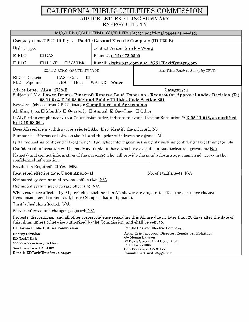
CALIFORNIA PUBLIC UTILITIES COMMISSION
ADVICE LETTER FILING SUMMARY
ENERGY UTILITY
MUST BE COMPLETED BY UTILITY (Attach additional pages as needed)
Company name/CPUC Utility No. Pacific Gas and Electric Company (ID U39 E)
Utility type: Contact Person: Shirley Wong
� ELC � GAS Phone #: (415) 972-5505
� PLC � HEAT � WATER E-mail: [email protected] and PG&[email protected]
EXPLANATION OF UTILITY TYPE
ELC = Electric GAS = Gas �
PLC = Pipeline HEAT = Heat WATER = Water
(Date Filed/ Received Stamp by CPUC)
Advice Letter (AL) #: 4728-E Category: 1
Subject of AL: Lower Drum - Pinecroft Reserve Land Donation - Request for Approval under Decision (D.)
08-11-043, D.10-08-004 and Public Utilities Code Section 851
Keywords (choose from CPUC listing): Compliance and Agreements
AL filing type: � Monthly � Quarterly � Annual � One-Time � Other _____________________________
If AL filed in compliance with a Commission order, indicate relevant Decision/Resolution #: D.08-11-043, as modified
by D.10-08-004.
Does AL replace a withdrawn or rejected AL? If so, identify the prior AL: No
Summarize differences between the AL and the prior withdrawn or rejected AL:
Is AL requesting confidential treatment? If so, what information is the utility seeking confidential treatment for: No
Confidential information will be made available to those who have executed a nondisclosure agreement: N/A
Name(s) and contact information of the person(s) who will provide the nondisclosure agreement and access to the
confidential information: ___________________________________________
Resolution Required? � Yes �No
Requested effective date: Upon Approval No. of tariff sheets: N/A
Estimated system annual revenue effect (%): N/A
Estimated system average rate effect (%): N/A
When rates are affected by AL, include attachment in AL showing average rate effects on customer classes
(residential, small commercial, large C/I, agricultural, lighting).
Tariff schedules affected: N/A
Service affected and changes proposed: N/A
Protests, dispositions, and all other correspondence regarding this AL are due no later than 20 days after the date of
this filing, unless otherwise authorized by the Commission, and shall be sent to:
California Public Utilities Commission Pacific Gas and Electric Company
Energy Division
ED Tariff Unit
505 Van Ness Ave., 4th Floor
San Francisco, CA 94102
E-mail: [email protected]
Attn: Eric Jacobson, Director, Regulatory Relations
c/o Megan Lawson
77 Beale Street, Mail Code B10C
P.O. Box 770000
San Francisco, CA 94177
E-mail: [email protected]

Advice 4728-E
Attachment A
Land Conservation and Conveyance Plan

Land Conservation and Conveyance Plan
Lands for Donation to Placer County (Bear River Pinecroft Reserve - Adjacent to
Bear River Campground)Lower Drum Planning Unit
Final LCCPSeptember 10, 2014

Lower Drum Planning Unit LCCP (Bear River Pinecroft
Reserve - Adjacent to the Bear River Campground) September 10, 2014
Executive Summary
Subject
LCCP Lower Drum Planning Unit
Land Conservation Plan Parcel Identification Number 871 as shown on the map attached
as Exhibit 1.
Type of Property Interest Disposition
Placer County to hold fee simple title to approximately 10 acres within LCP
Parcel 871 of the Lower Drum planning unit.
Placer Land Trust (PLT) to hold the conservation easement on the property within
Parcel 871 donated to Placer County.
Summary
The Stewardship Council has recommended that 15 acres within one parcel (Parcel 871)
be donated to Placer County. Subsequent to survey work, the acreage identified to
transfer encompasses approximately 10 acres. Pending California Public Utilities
Commission (CPUC) approval, and immediately following PG&E's conveyance of
property within Parcel 871 to Placer County, the County and PLT will enter into the
conservation easement.
The 10 acres in Parcel 871 to be donated to Placer County are outside the Drum-
Spaulding FERC Project boundary (FERC #2310) and PG&E has determined this
acreage does not need to be retained for existing or future utility operations. Therefore,
this acreage is available for donation, subject to PG&E’s reserved rights. The remaining
11 acres within Parcel 871 will be retained by PG&E and will be addressed in a separate
Land Conservation and Conveyance Plan (LCCP).
This transaction will not have an adverse effect on the public interest or on the ability of
the utility to provide safe and reliable service to customers at reasonable rates.
Property Location
The property subject to this LCCP consists of approximately 10 acres in Placer County
along the Bear River, and adjacent to the Bear River Campground maintained by Placer
County.
Economic Uses and Agreements
Currently, there is a lease to Placer County for a campground caretaker’s mobile home,
campground water treatment facility, and public hiking trails on the lands to be donated
to Placer County. Other than this lease, there are no existing economic uses or recorded
encumbrances on the lands to be donated to Placer County in the Lower Drum planning
unit.
Lower Drum (Pinecroft Reserve) Final LCCP 1

Lower Drum Planning Unit LCCP (Bear River Pinecroft
Reserve - Adjacent to the Bear River Campground) September 10, 2014
PG&E will reserve its rights to maintain and operate existing and future utility facilities
on the parcel to be conveyed in fee. The specific reserved rights are set forth in the grant
deed and conservation easement, which can be found in Appendices 2 and 3,
respectively.
Permanent Protection of the Beneficial Public Values
The grant deed transferring fee title to Placer County includes a recital that Placer County
and PG&E acknowledge that the conveyance, together with the conservation easement
transaction being entered into by Placer County and PLT, is being made in the public
interest with the intent to ensure the permanent protection of the beneficial public values
(BPVs) on the Property as identified in the Land Conservation Plan while allowing the
ongoing use of the Property by PG&E for hydroelectric operations, water delivery, and
related activities, and acknowledging and honoring the existing third party uses.
Conservation Management Objectives to Preserve and/or Enhance the
Beneficial Public Values
The Land Conservation Commitment provides that “PG&E shall ensure that the
Watershed Lands it owns… are conserved for a broad range of beneficial public values,
including the protection of the natural habitat of fish, wildlife and plants, the preservation
of open space, outdoor recreation by the general public, sustainable forestry, agricultural
uses, and historic values. PG&E will protect these beneficial public values associated
with the Watershed Lands… from uses that would conflict with their conservation.
PG&E recognizes that such lands are important to maintaining the quality of life of local
communities and all the people of California in many ways, and it is PG&E’s intention to
protect and preserve the beneficial public values of these lands under the terms of any
agreements concerning their future ownership or management.”1
The conservation easement on subject donated land will ensure the permanent protection
and preservation of the following BPVs:
Habitat for plants, trees and wildlife that are native to the area.
Scenic character of the Property, including viewsheds from adjoining public
roadways.
Future recreational access and use of the Property, including non-motorized
multiple-use trail use, picnicking, and similar passive recreational uses that are
not incompatible with the Conservation Values of the Property.
Tax Neutrality
The Stewardship Council intends to provide funding to satisfy property tax payments in
perpetuity for the Property.
1 Land Conservation Commitment I.02-04-026, Appendix E, p. 38
Lower Drum (Pinecroft Reserve) Final LCCP 2

Lower Drum Planning Unit LCCP (Bear River Pinecroft
Reserve - Adjacent to the Bear River Campground) September 10, 2014
Pending CPUC approval of the fee title donation of the Property, Placer County may
select the option of either receiving a lump sum payment of $41,425 or an annual
payment from a trustee selected by the Stewardship Council. Annual payments would be
equal to 4% of a rolling 20 quarter average of the principal balance invested for the
parcel, consistent with the methodology described in the Property Tax Neutrality
Methodology adopted on June 27, 2012 by the Stewardship Council.
Hazardous Waste Disclosure
PG&E has provided the Lower Drum Planning Unit Environmental Site Assessment
Report dated December 1, 2011 to Placer County and PLT, fulfilling the disclosure
requirements of the Land Conservation Commitment.
Consideration of Parcel Split
Within Parcel 871, approximately 10 acres are proposed for transfer to Placer County. At
closing, the 10 acre property as well as the remainder of the parcel must comply with the
California Subdivision Map Act (Government Code Section 66410, et seq.) as separate
legal parcels. Certain exemptions to the Map Act apply to public utilities and/or to
governmental entities and may apply to this conveyance.
Applicable CEQA Exemption(s) or Reason Why Transaction is not a
“Project Under CEQA”
The establishment of a conservation easement is categorically exempt under Section
15325 of the CEQA Guidelines (CFR Title 14, Chapter 3).
The subject transaction will not result in a direct physical change or a reasonably
foreseeable indirect physical change in the environment; therefore, the Stewardship
Council does not believe that the transaction is a project under CEQA.
Lower Drum (Pinecroft Reserve) Final LCCP 3

Lower Drum Planning Unit LCCP (Bear River Pinecroft
Reserve - Adjacent to the Bear River Campground) September 10, 2014
Exhibit 1. Map of the Property
Lower Drum (Pinecroft Reserve) Final LCCP 4

Lower Drum Planning Unit LCCP (Bear River Pinecroft
Reserve - Adjacent to the Bear River Campground) September 10, 2014
Table of Contents
Executive Summary ...........................................................................................1
Introduction ....................................................................................................... 6
1. Acreage, Existing Economic Uses and Agreements ...............................9
2. Objectives to Preserve and/or Enhance the BPVs .................................10
3. Recommendations for Conservation Easement and Fee
SimpleDonation .........................................................................................12
4. Finding of Donee Funding and Other Capacity to Maintain Lands to
Preserve and/or Enhance the BPVs .........................................................14
5. Analysis of Tax and Other Economic and Physical Impacts ................16
6. Hazardous Waste Disclosure ....................................................................18
7. Consideration of Parcel Split ....................................................................19
8. Strategy for Physical Measures to Enhance the BPVs............................20
9. Monitoring Plan for the Economic and Physical Impacts of Disposition
and Implementation of Enhancement Measures ..................................21
10. Implementation Schedule for Transactions and Measures ..................22
Appendices
Appendix 1. Summary of Public Outreach................................................................................. 23
Appendix 2. Grant Deed ............................................................................................................... 29
Appendix 3. Conservation Easement and Management Plan.............................................. 39
Appendix 4. Stewardship Council Funding Agreement .......................................................... 94
Appendix 5. Property Tax Neutrality Methodology ................................................................ 102
Appendix 6. Map ........................................................................................................................... 111
Appendix 7. Settlement Agreement, Appendix E .................................................................. 112
Lower Drum (Pinecroft Reserve) Final LCCP 5

Lower Drum Planning Unit LCCP (Bear River Pinecroft
Reserve - Adjacent to the Bear River Campground) September 10, 2014
Introduction
The Pacific Forest and Watershed Lands Stewardship Council (Stewardship Council) is a
private, nonprofit foundation established in 2004 pursuant to a Settlement Agreement and
a Stipulation Resolving Issues Regarding the Land Conservation Commitment approved
by the California Public Utilities Commission (CPUC) in Decision 03-12-035 (Dec. 18,
2003). The Stewardship Council Board of Directors includes appointees from state and
federal agencies, water districts, Native American and rural interests, forest and farm
industry groups, conservation organizations, the CPUC, and Pacific Gas and Electric
Company (PG&E).
The Stewardship Council has developed a plan to protect more than 140,000 acres of
watershed lands (Watershed Lands) currently owned by PG&E for the benefit of the
citizens of California. Protecting the Watershed Lands will be accomplished through (1)
PG&E’s grant of conservation easements to one or more public agencies or qualified
conservation organizations so as to protect the natural habitat of fish, wildlife, and plants,
the preservation of open space, outdoor recreation by the general public, sustainable
forestry, agricultural uses, and historic values (collectively the Beneficial Public Values),
and in some cases, (2) PG&E’s donation of the Watershed Lands in fee to one or more
public entities or qualified conservation organizations, whose ownership would be
consistent with these conservation objectives.
Located primarily in the Sierra Nevada and Cascade Mountain range watersheds, the
Watershed Lands contain some of the most pristine and resource-rich landscapes found in
the state. The properties are diverse and geographically remote, located in 21 counties
from the northern reaches of the state to the southern end of the Central Valley.
As required by the Settlement and Stipulation, the Stewardship Council prepared a Land
Conservation Plan (LCP) to establish a framework for the conservation and/or
enhancement of the Watershed Lands, and to ensure the permanent protection of these
lands for the benefit of current and future generations of Californians. To address the
challenge of a conservation effort of this large scope and unique nature, and to facilitate
engagement of a wide range of stakeholders and interested members of the public, the
Stewardship Council grouped the Watershed Lands into 47 planning units and established
a phased approach to development and implementation of the LCP.
In 2007, the Stewardship Council board adopted Volumes I and II of the LCP:
Volume I: The Land Conservation Framework establishes the overall framework
for the LCP, including legal requirements, the planning process, methodologies,
public involvement, and relevant regulatory processes.
Volume II: Planning Unit Concepts documents existing conditions and presents
management objectives, potential measures, and conceptual plans to preserve
and/or enhance the Beneficial Public Values (BPVs) within each planning unit. It
also documents existing economic uses.
Lower Drum (Pinecroft Reserve) Final LCCP 6

Lower Drum Planning Unit LCCP (Bear River Pinecroft
Reserve - Adjacent to the Bear River Campground) September 10, 2014
Volume III, consisting of Land Conservation and Conveyance Plans (LCCPs) to be
issued serially and cumulatively, will encompass a series of real estate transaction
packages that will detail the specific land conservation and/or disposition requirements
for each parcel or parcel cluster. LCCPs represent the Stewardship Council’s
recommendations for preserving and/or enhancing the BPVs of the Watershed Lands, and
are intended to support required regulatory approvals of the land transactions resulting
from the Stewardship Council’s recommendations. The content of the LCCP spans a
number of issues required by the Settlement and Stipulation, such as an express
reservation of a right for continued operation and maintenance of hydroelectric facilities
and associated water delivery facilities, including project replacements and improvements
required to meet existing and future water delivery requirements for power generation
and consumptive water use by existing users, compliance with any Federal Energy
Regulatory Commission (FERC) license, FERC license renewal, or other regulatory
requirements. In addition, conservation easements will honor existing agreements for
economic uses, including consumptive water deliveries, and preserve or enhance
reasonable public access to the Watershed Lands.
During the development of LCP Volumes I and II and the LCCPs, the Stewardship
Council implemented a public outreach program to ensure local communities, elected
representatives, neighboring property owners, and other key stakeholders had many
opportunities to engage in the Stewardship Council’s effort to preserve and enhance the
Watershed Lands. To solicit additional input from the public on potential fee title
recipients or conservation easement holders (referred to as donees), the Stewardship
Council hosted a series of public information meetings. These meetings were designed to
(1) provide an overview and update on the Stewardship Council’s Land Conservation
Program, (2) outline next steps, timeline, and opportunities for additional public input,
and (3) solicit public input on the desired qualifications of potential donees and the future
stewardship of the planning units.
Public input that the Stewardship Council received as a result of the public outreach
process, including comments on Volume II of the LCP, comments from public
information meetings on the selection of donees and other issues, and correspondence
received by the Stewardship Council were considered by the Stewardship Council in its
evaluation of the potential donees and their land stewardship proposals. In addition to
public meetings, the public was given the opportunity to participate in all of the
Stewardship Council’s public board meetings where decisions were made on fee title and
conservation easement donees. Prior to making a decision regarding the disposition of
any parcel, the Stewardship Council will provide notice to the Board of Supervisors of
the affected county, each affected city, town, and water supply entity, each affected Tribe
and/or co-licensee, and each landowner located within one mile of the exterior boundary
of the parcel, by mail or other effective manner. A summary of the public outreach
process for this subject LCCP, the Lower Drum planning unit, is provided in Appendix 1.
Furthermore, the proposed LCCP will be made available for public review and comment
before it is forwarded by the Watershed Planning Committee to the board for its review
and approval.
The Stewardship Council Board of Directors recommends that Placer County
receive 10 acres within one parcel (#871) of the Lower Drum planning unit in fee
Lower Drum (Pinecroft Reserve) Final LCCP 7

Lower Drum Planning Unit LCCP (Bear River Pinecroft
Reserve - Adjacent to the Bear River Campground) September 10, 2014
and that the Placer Land Trust (PLT) hold a conservation easement over the lands
recommended for donation to Placer County in the Lower Drum planning unit.
Table 1 identifies Stipulation requirements that will be addressed in the LCCP and
includes pertinent language from the Stipulation.
Table 1 Stipulation 12(a) Requirements
(1) Acreage, Existing Economic Uses and Agreements
“Reasonably exact estimates of acreage, by parcel, within or outside licensed project
boundaries, and existing economic uses (including all related agreements);”
(2) Objectives to Preserve and/or Enhance
“Objectives to preserve and/or enhance the BPVs, as defined in the Settlement
Agreement, Appendix E, of each individual parcel;”
(3) Recommendations for Conservation Easement and Fee Simple Donation
“A recommendation for grant of a conservation easement or fee simple donation for
each such parcel;”
(4) Finding of Donee Funding and Other Capacity to Maintain Lands to Preserve and/or
Enhance BPVs
“A finding that the intended donee of such easement or fee simple has the funding and
other capacity to maintain that property interest so as to preserve and/or enhance the
BPVs thereof;”
(5) Analysis of Tax and Other Economic and Physical Impacts
“An analysis of tax and other economic and physical impacts of such disposition strategy,
and a commitment by an appropriate entity to provide property tax revenue, other
equivalent revenue source, or a lump sum payment, so that the totality of dispositions in
each affected county under the LCC will be ’tax neutral’ for that county;”
(6) Hazardous Waste Disclosure
“A disclosure of all known hazardous waste or substance contamination or other such
environmental liabilities associated with each parcel;”
(7) Consideration of Parcel Split
“Appropriate consideration whether to split any parcel which is partly used or useful for
operation of PG&E’s and/or a co-licensee’s hydroelectric facilities, where the beneficial
public values of the unused part may be enhanced by such split, provided that it is
consistent with Section 12(b)(4) of this Stipulation and that, in the event that
governmental approval of a parcel split imposes conditions or restrictions on other PG&E
property, the decision to accept or reject such conditions will be at PG&E’s sole
discretion;”
(8) Strategy for Physical Measures to Enhance BPVs
“A strategy to undertake appropriate physical measures to enhance the BPVs of
individual parcels; provided that no such measure will be in conflict with the provisions of
Settlement Agreement paragraph 17(c) and Appendix E paragraph 1;”
(9) Monitoring Plan for the Economic and Physical Impacts of Disposition and
Implementation of Enhancement Measures
“A plan to monitor the economic and physical impacts of disposition and implementation
of enhancement measures on the applicable management objectives;“
(10) Implementation Schedule for Transactions and Measures
“A schedule for the implementing transactions and measures.”
Lower Drum (Pinecroft Reserve) Final LCCP 8

Lower Drum Planning Unit LCCP (Bear River Pinecroft
Reserve - Adjacent to the Bear River Campground) September 10, 2014
1. Acreage, Existing Economic Uses and Agreements
Acreage and Property Description
Ten acres in Parcel 871 will be donated to Placer County and, consistent with the
conditions in the Settlement Agreement, the Property will be subject to a perpetual
conservation easement granted by Placer County to PLT. The remaining 11 acres within
Parcel 871 will be retained by PG&E and be subject to a conservation easement that will
be the subject of a forthcoming LCCP.
Placer County has leased 15 acres of the parcel for a campground caretaker’s mobile
home, campground water treatment facility, and public hiking trails since 1973. PG&E’s
Bear River Canal and Pinecroft Spillway run through the eastern and southern portions of
the parcel, respectively. The County has indicated that the physical barrier imposed by
the canal structure and future maintenance and access activities associated with the canal
structure makes the development and use of recreational amenities on the easterly portion
infeasible.
The property is accessible from the adjacent Bear River campground and offers
opportunities for passive recreation including hiking or picnicking.
Adjacent and Nearby Landowners
The parcel subject to donation to Placer County is primarily wooded canyon lands and
surrounded by private lands as well as California Department of Fish and Wildlife
property. The parcel can be accessed via Milk Ranch Road.
The Stewardship Council notified and invited landowners located within one mile of the
subject parcel to provide comment during key phases of the land conservation and
conveyance planning process. Several private landowners submitted comments
expressing concerns about the County’s ability to manage the subject property and the
adjoining Bear River Campground. Comments received were brought to the attention of
the Stewardship Council Board of Directors.
Existing Economic Uses and Agreements
There is one unrecorded encumbrance on the property to be donated to Placer County:
Lease to Placer County for a campground caretaker’s mobile home, campground
water treatment facility, and public hiking trails.
This lease will be extinguished upon transfer of the acreage to Placer County. PG&E’s
specific reserved rights are set forth in the grant deed and conservation easement, which
can be found in Appendices 2 and 3, respectively.
Lower Drum (Pinecroft Reserve) Final LCCP 9

Lower Drum Planning Unit LCCP (Bear River Pinecroft
Reserve - Adjacent to the Bear River Campground) September 10, 2014
2. Objectives to Preserve and/or Enhance the BPVs
The Land Conservation Commitment provides that “PG&E shall ensure that the
Watershed Lands it owns… are conserved for a broad range of beneficial public values,
including the protection of the natural habitat of fish, wildlife and plants, the preservation
of open space, outdoor recreation by the general public, sustainable forestry, agricultural
uses, and historic values. PG&E will protect these beneficial public values associated
with the Watershed Lands… from uses that would conflict with their conservation.
PG&E recognizes that such lands are important to maintaining the quality of life of local
communities and all the people of California in many ways, and it is PG&E’s intention to
protect and preserve the beneficial public values of these lands under the terms of any
agreements concerning their future ownership or management.”2
The following text lists the objectives for each BPV at the Lower Drum planning unit that
the Stewardship Council board approved in LCP Volume II, as well as a description of
how the transaction, as summarized by this LCCP, supports each objective and preserves
and/or enhances the BPVs.
The conservation easement will protect the BPVs, subject to PG&E’s hydro and other
reserved rights as provided in the conservation easement.
1. Objective: Preserve and enhance habitat in order to protect special biological
resources.
Placer County proposes to maintain the property in its natural state as well as restore
habitat values where it is appropriate and feasible. The conservation easement (Appendix
3) will permanently protect habitat by restricting development and limiting the
landowner’s uses to those that are consistent with the protection of the BPVs on the
property.
2. Objective: Preserve open space in order to protect natural and cultural resources
and the recreation setting.
The conservation easement will ensure that no further development will occur unless
specifically authorized by the conservation easement and consistent with the BPVs on the
property. Placer County proposes to maintain the property as open space, without
modifications to the landscape other than a possible caretaker’s residence and other
limited improvements allowed within a building envelope.
3. Objective: Enhance recreational facilities in order to provide additional public
access, education, and recreation opportunities.
Placer County will continue to manage the property for current and future public
recreational uses. The conservation easement ensures that opportunities to promote
passive recreation via the development of facilities such as picnic areas or natural surface
trails remain.
2 Land Conservation Commitment I.02-04-026, Appendix E, p. 38
Lower Drum (Pinecroft Reserve) Final LCCP 10
Lower Drum Planning Unit LCCP (Bear River Pinecroft
Reserve - Adjacent to the Bear River Campground) September 10, 2014
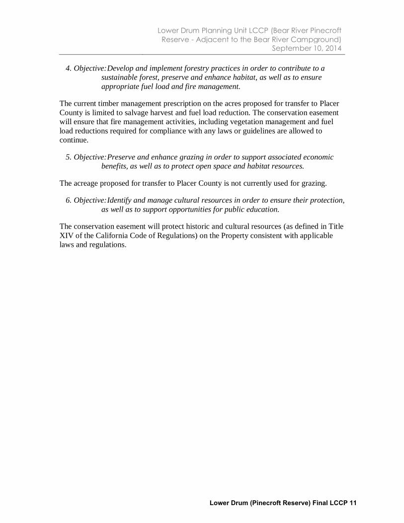
4. Objective: Develop and implement forestry practices in order to contribute to a
sustainable forest, preserve and enhance habitat, as well as to ensure
appropriate fuel load and fire management.
The current timber management prescription on the acres proposed for transfer to Placer
County is limited to salvage harvest and fuel load reduction. The conservation easement
will ensure that fire management activities, including vegetation management and fuel
load reductions required for compliance with any laws or guidelines are allowed to
continue.
5. Objective: Preserve and enhance grazing in order to support associated economic
benefits, as well as to protect open space and habitat resources.
The acreage proposed for transfer to Placer County is not currently used for grazing.
6. Objective: Identify and manage cultural resources in order to ensure their protection,
as well as to support opportunities for public education.
The conservation easement will protect historic and cultural resources (as defined in Title
XIV of the California Code of Regulations) on the Property consistent with applicable
laws and regulations.
Lower Drum (Pinecroft Reserve) Final LCCP 11

Lower Drum Planning Unit LCCP (Bear River Pinecroft
Reserve - Adjacent to the Bear River Campground) September 10, 2014
3. Recommendations for Conservation Easement and Fee
Simple Donation
The Settlement and Stipulation require that the Watershed Lands: (1) be subject to
permanent conservation easements restricting development of the Watershed Lands so as
to protect and preserve the BPVs, and/or (2) be donated in fee simple to one or more
public entities or qualified nonprofit conservation organizations, whose ownership will
ensure the protection of these BPVs.
Conservation Easement
The Settlement Agreement states that “the conservation easements shall provide for the
preservation of land areas for the protection of the natural habitat of fish, wildlife and
plants, the preservation of open space, outdoor recreation by the general public,
sustainable forestry, agricultural uses, and historic values and, shall prevent any other
uses that will significantly impair or interfere with those values. Conservation easements
on the Watershed Lands will include an express reservation of a right for continued
operation and maintenance of hydroelectric facilities and associated water delivery
facilities, including project replacements and improvements required to meet existing and
future water delivery requirements for power generation and consumptive water use by
existing users, compliance with any FERC license, FERC license renewal or other
regulatory requirements. In addition, conservation easements will honor existing
agreements for economic uses, including consumptive water deliveries. The conservation
easements shall be donated to and managed by one or more non-profit conservation
trustees, qualified conservation organizations or public agencies with the experience and
expertise to fully and strictly implement the conservation easements” (Land Conservation
Commitment I.02-04-026, Appendix E, pp. 38-39).
For the complete text of the conservation easement, see Appendix 3.
Conservation easements must be donated to nonprofit organizations, Native American
tribes, or public agencies that meet the requirements of California Civil Code section
815.3 and possess the experience and capacity to fully and strictly implement the terms of
the conservation easement. The Placer Land Trust (PLT) will hold the conservation
easement over the lands to be donated to Placer County in the Lower Drum planning unit.
The qualifications of PLT are described in Chapter 4.
Accordingly, immediately following PG&E's conveyance of the lands to be donated to
Placer County in the Lower Drum planning unit, the County will convey the conservation
easement to PLT.
Retention or Donation of Fee Title
The Settlement Agreement states that PG&E will not be expected to make fee simple
donations of Watershed Lands with hydroelectric project features, and conservation
easements and enhancements may not interfere with hydroelectric operations. In general,
PG&E will retain fee title to those Watershed Lands within the boundaries of
hydroelectric projects licensed by the FERC, as well as other properties required for
continuing and future utility operations. However, these Watershed Lands will be Lower Drum (Pinecroft Reserve) Final LCCP 12

Lower Drum Planning Unit LCCP (Bear River Pinecroft
Reserve - Adjacent to the Bear River Campground) September 10, 2014
conserved via a conservation easement. See Appendix 7 for a description of PG&E’s
Land Conservation Commitment.
The 10 acres proposed for donation are located outside the FERC Project boundary and
were identified as available for donation, subject to PG&E’s reserved rights.
Lands to be Donated by PG&E
The legal description of the parcel is included in the grant deed, which is provided in
Appendix 2. The qualifications and capacity of Placer County to manage the Lower
Drum property recommended for donation are described in Chapter 4.
The map attached in Appendix 6 shows all the land within Parcel 871 in the Lower Drum
planning unit that will be donated. The map also shows key features in the planning unit
and surrounding area, and the ownership of adjacent land.
Lands to be Retained by PG&E
The remaining 11 acres in Parcel 871 in the Lower Drum planning unit will be retained
by PG&E and will be the subject of a separate LCCP.
Lower Drum (Pinecroft Reserve) Final LCCP 13

Lower Drum Planning Unit LCCP (Bear River Pinecroft
Reserve - Adjacent to the Bear River Campground) September 10, 2014
4. Finding of Donee Funding and Other Capacity to Maintain
Lands to Preserve and/or Enhance the BPVs
Selected Organizations
At the conclusion of the selection process referenced below, the following organizations
were endorsed by the Stewardship Council board on September 15, 2011:
Placer County to hold fee simple title to 15 acres within Parcel 871.
Placer Land Trust (PLT) to hold a conservation easement over the 15 acres to be
donated to Placer County in Parcel 871.
Capacity of Selected Organizations
The Stewardship Council board finds that Placer County and PLT will have the funding
and other capacity to maintain the property interest so as to preserve and/or enhance the
BPVs3.
A. Placer County:
Under a PG&E lease, the County has managed this property since 1973. The
County also operates the 207-acre Bear River Campground adjacent to the subject
property. The campground is a public facility that offers family and group
campsites, day use areas, five miles of multiple-use trails and several access
points for fishing, rafting, swimming and gold panning.
The County currently leases 192 acres of adjacent land from the State of
California (California Department of Fish and Wildlife) to maintain the Bear
River Campground, day use areas, trails, and open space for public benefit.
The County has established standards and practices to own and manage property,
in the form of a General Land Use Plan that guides growth and development as
well as codes, ordinances, and policies established to protect public health and
safety.
The County owns and manages over 200 properties, including over 1,800 acres of
parks, 164 acres of landscaped grounds, 79 miles of trails, and 198 acres of open
space.
The County Parks Division has 27 full-time employees and hires seasonal staff.
The County has a history of successful partnerships with a variety of local
stakeholders and volunteer organizations to implement multiple conservation
projects. At the Bear River Campground specifically, individual volunteers and
groups such as the Meadow Vista Trails Association and Boy Scouts of America
have assisted the County with trail rehabilitation work and maintenance,
3 Stipulation, Section 12(a)(4)
Lower Drum (Pinecroft Reserve) Final LCCP 14

Lower Drum Planning Unit LCCP (Bear River Pinecroft
Reserve - Adjacent to the Bear River Campground) September 10, 2014
construction of water crossings, campground cleanup, kiosk development,
painting projects, and grading rough areas of the day use areas with a tractor.
B. PLT:
Established in 1991, PLT’s mission is to work with willing landowners and
conservation partners to permanently preserve natural and agricultural lands in
Placer County for future generations.
PLT holds 17 conservation easements totaling 3,537 acres, including three over
lands owned by public agencies. In addition, PLT owns 14 fee properties totaling
3,984 acres.
PLT is guided by a ten-member board of directors and is staffed by an executive
director, assistant director, stewardship manager, land manager, community
relations manager, program manager and office assistant. PLT’s staff has
expertise in strategic land acquisitions, natural resources management, forestry,
habitat restoration, ecology, agriculture and community outreach and volunteer
management.
PLT is an accredited land trust.
Donee Selection Process
The Stewardship Council used a formal multi-step process to solicit and select
organizations interested in receiving a donation of Watershed Lands or becoming a
conservation easement holder at the Lower Drum planning unit. The process consisted of
the following key steps:
Organizations were invited to register via the Stewardship Council’s Interested
Donee Registry and were invited to submit a statement of qualifications (SOQ).
The Stewardship Council reviewed the SOQs that were submitted to identify
organizations that: (a) were determined to be a qualified nonprofit conservation
organization; a federal, state or local governmental entity; or, a recognized tribe;
(b) appeared to have sufficient financial and organizational capacity relative to the
property interest sought within the planning unit; and, (c) appeared to be capable
of satisfying the requirements of the Settlement and Stipulation for receiving a
donation of fee title or to hold the conservation easement.
Organizations interested in a fee title donation were invited to submit a land
stewardship proposal (“LSP” or “proposal”) describing their capacity and interest
in preserving and enhancing the BPVs. The LSPs were posted on the Stewardship
Council’s website.
Organizations demonstrating sufficient capacity and determined by the
Stewardship Council to be best-suited to receive a donation of property interest
(fee or conservation easement) in particular Watershed Lands within a planning
unit are being recommended to PG&E to receive fee title and/or conservation
easements.
Lower Drum (Pinecroft Reserve) Final LCCP 15

Lower Drum Planning Unit LCCP (Bear River Pinecroft
Reserve - Adjacent to the Bear River Campground) September 10, 2014
5. Analysis of Tax and Other Economic and Physical Impacts
Analysis of Tax and Other Economic and Physical Impacts
The Stipulation requires that the LCCP provide “an analysis of tax and other economic
and physical impacts of such disposition strategy, and a commitment by an appropriate
entity [which may be PG&E, subject to being authorized by the Commission to fully
recover in rates any such costs in approving PG&E’s Section 851 application or in
another appropriate Commission proceeding, Stewardship Council, donee, or a third
party, depending on the individual circumstances] to provide property tax revenue, other
equivalent revenue source, or a lump sum payment, so that the totality of dispositions in
each affected county under this Land Conservation Commitment will be ‘tax neutral’ for
that county.”
The following sections address the Stewardship Council’s plan for achieving tax
neutrality for Placer County, the county in which the Property is located. The final LCCP
submitted for all PG&E Watershed Lands located in Placer County will address tax
neutrality for the totality of all fee title transfers within the county, as required under the
Settlement and Stipulation.
Stewardship Council Board Policies and Guidelines
The Stewardship Council board adopted a set of Guidelines Regarding Satisfaction of
Tax Neutrality on March 30, 2011, after an opportunity for public comment. Under the
guidelines, the Stewardship Council outlined the following overarching assumptions:
1. The Stewardship Council will address property tax neutrality based upon the most
current property taxes paid by PG&E on the lands being transferred at the time of
the actual transfer of fee title from PG&E to the selected donee.
2. The Stewardship Council’s achievement of property tax neutrality applies to all
property taxes that would be distributed directly to County General Funds, School
and Fire Districts, Regional Conservation and Water Districts, and any other
special districts as defined by the applicable Tax Rate Area.
3. The Settlement and Stipulation direct the Stewardship Council to ensure that the
effects of distributions be made tax neutral for the affected counties. Therefore,
the Stewardship Council’s property tax neutrality commitment will not apply to
any amount of property tax payments that are subject to apportionment by the
State of California.
On June 27, 2012, the Stewardship Council board approved an amendment to the
property tax methodology it had adopted on May 2, 2012, after an opportunity for public
comment and specific outreach to all potentially affected counties. The methodology
establishes a standard payment process when lands are transferred to organizations that
are exempt from paying property taxes (see Appendix 5). The methodology outlines two
in-lieu payment options: a one-time lump sum payment from the Stewardship Council
directly to counties, and the Stewardship Council’s establishment of an endowment
account that would be designed to generate enough investment income to make annual
Lower Drum (Pinecroft Reserve) Final LCCP 16
Lower Drum Planning Unit LCCP (Bear River Pinecroft
Reserve - Adjacent to the Bear River Campground) September 10, 2014
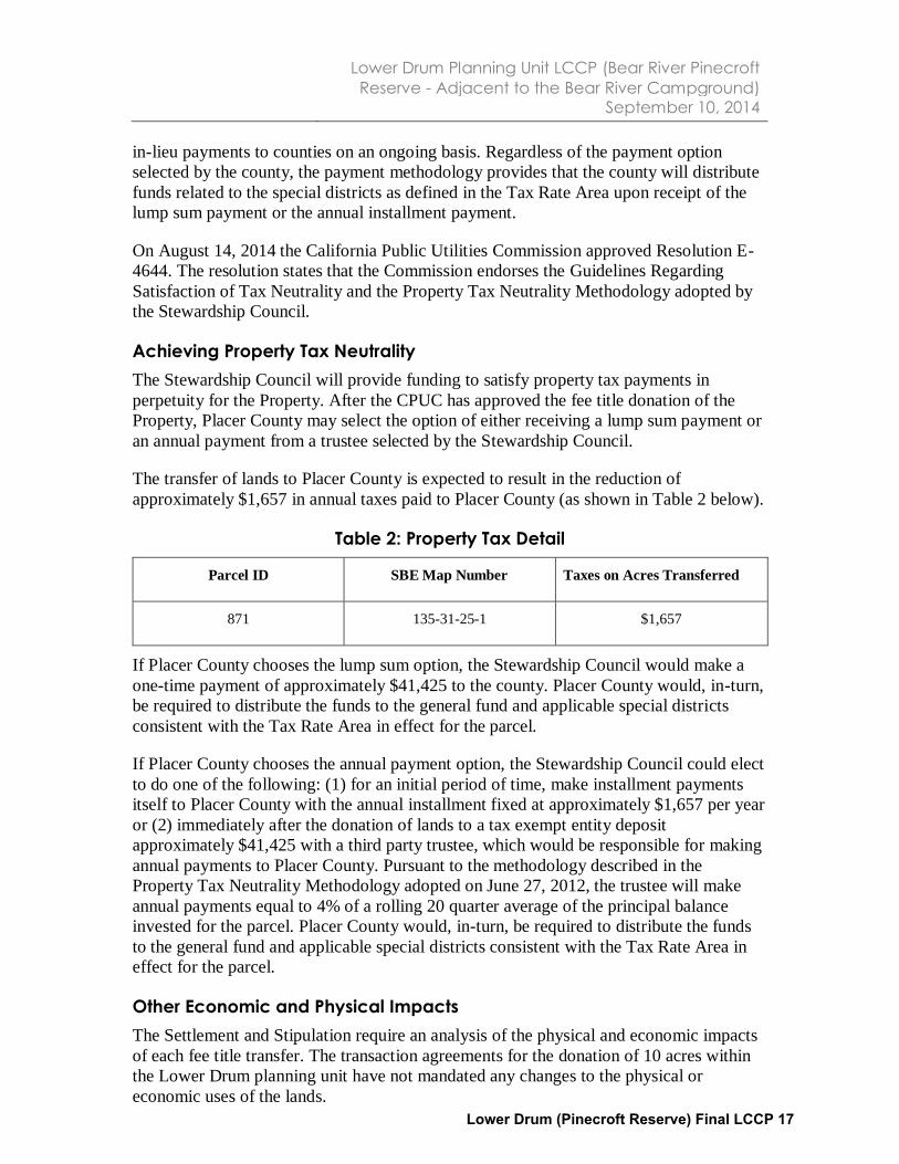
in-lieu payments to counties on an ongoing basis. Regardless of the payment option
selected by the county, the payment methodology provides that the county will distribute
funds related to the special districts as defined in the Tax Rate Area upon receipt of the
lump sum payment or the annual installment payment.
On August 14, 2014 the California Public Utilities Commission approved Resolution E-
4644. The resolution states that the Commission endorses the Guidelines Regarding
Satisfaction of Tax Neutrality and the Property Tax Neutrality Methodology adopted by
the Stewardship Council.
Achieving Property Tax Neutrality
The Stewardship Council will provide funding to satisfy property tax payments in
perpetuity for the Property. After the CPUC has approved the fee title donation of the
Property, Placer County may select the option of either receiving a lump sum payment or
an annual payment from a trustee selected by the Stewardship Council.
The transfer of lands to Placer County is expected to result in the reduction of
approximately $1,657 in annual taxes paid to Placer County (as shown in Table 2 below).
Table 2: Property Tax Detail
Parcel ID SBE Map Number Taxes on Acres Transferred
871 135-31-25-1 $1,657
If Placer County chooses the lump sum option, the Stewardship Council would make a
one-time payment of approximately $41,425 to the county. Placer County would, in-turn,
be required to distribute the funds to the general fund and applicable special districts
consistent with the Tax Rate Area in effect for the parcel.
If Placer County chooses the annual payment option, the Stewardship Council could elect
to do one of the following: (1) for an initial period of time, make installment payments
itself to Placer County with the annual installment fixed at approximately $1,657 per year
or (2) immediately after the donation of lands to a tax exempt entity deposit
approximately $41,425 with a third party trustee, which would be responsible for making
annual payments to Placer County. Pursuant to the methodology described in the
Property Tax Neutrality Methodology adopted on June 27, 2012, the trustee will make
annual payments equal to 4% of a rolling 20 quarter average of the principal balance
invested for the parcel. Placer County would, in-turn, be required to distribute the funds
to the general fund and applicable special districts consistent with the Tax Rate Area in
effect for the parcel.
Other Economic and Physical Impacts
The Settlement and Stipulation require an analysis of the physical and economic impacts
of each fee title transfer. The transaction agreements for the donation of 10 acres within
the Lower Drum planning unit have not mandated any changes to the physical or
economic uses of the lands. Lower Drum (Pinecroft Reserve) Final LCCP 17

Lower Drum Planning Unit LCCP (Bear River Pinecroft
Reserve - Adjacent to the Bear River Campground) September 10, 2014
6. Hazardous Waste Disclosure
The Stipulation states that in the transfer of fee title and conveyance of a conservation
easement, PG&E will disclose all known hazardous waste, substance contamination, or
other such environmental liabilities associated with each parcel and hold the donee
harmless.
Lands to be Retained by PG&E
Approximately 11 acres within Parcel 871 in the Lower Drum planning unit will be
retained by PG&E.
Lands to be Donated by PG&E
The Lower Drum Planning Unit Environmental Site Assessment Report dated December
1, 2011, was provided to Placer County and PLT in fulfillment of the disclosure
requirements of the Land Conservation Commitment.
Environmental Agreement
Pending CPUC approval of the transaction, PG&E will execute Environmental
Agreements with Placer County and PLT, satisfying the requirements of Section 12(f) of
the Stipulation.
Lower Drum (Pinecroft Reserve) Final LCCP 18

Lower Drum Planning Unit LCCP (Bear River Pinecroft
Reserve - Adjacent to the Bear River Campground) September 10, 2014
7. Consideration of Parcel Split
To effectuate transfer of the 10 acres identified for donation to Placer County within
Parcel 871, a parcel split is required to comply with the California Subdivision Map Act
(Government Code Section 66410, et seq.). Certain exemptions to the Map Act apply to
public utilities and/or to governmental entities and may apply to this conveyance.
Lower Drum (Pinecroft Reserve) Final LCCP 19
Lower Drum Planning Unit LCCP (Bear River Pinecroft
Reserve - Adjacent to the Bear River Campground) September 10, 2014
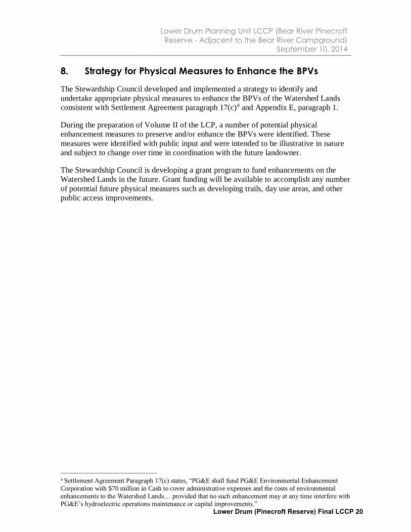
8. Strategy for Physical Measures to Enhance the BPVs
The Stewardship Council developed and implemented a strategy to identify and
undertake appropriate physical measures to enhance the BPVs of the Watershed Lands
consistent with Settlement Agreement paragraph 17(c)4 and Appendix E, paragraph 1.
During the preparation of Volume II of the LCP, a number of potential physical
enhancement measures to preserve and/or enhance the BPVs were identified. These
measures were identified with public input and were intended to be illustrative in nature
and subject to change over time in coordination with the future landowner.
The Stewardship Council is developing a grant program to fund enhancements on the
Watershed Lands in the future. Grant funding will be available to accomplish any number
of potential future physical measures such as developing trails, day use areas, and other
public access improvements.
4 Settlement Agreement Paragraph 17(c) states, “PG&E shall fund PG&E Environmental Enhancement
Corporation with $70 million in Cash to cover administrative expenses and the costs of environmental
enhancements to the Watershed Lands… provided that no such enhancement may at any time interfere with
PG&E’s hydroelectric operations maintenance or capital improvements.”
Lower Drum (Pinecroft Reserve) Final LCCP 20

Lower Drum Planning Unit LCCP (Bear River Pinecroft
Reserve - Adjacent to the Bear River Campground) September 10, 2014
9. Monitoring Plan for the Economic and Physical Impacts of
Disposition and Implementation of Enhancement
Measures
The Stipulation requires that the LCCP outline a plan to monitor the economic and
physical impacts of disposition and implementation of enhancement measures.
The conservation easement holder is required to monitor every conservation easement
that it holds to ensure that the landowner is complying with the terms of the easement.
The Stewardship Council will enter into a Conservation Easement Funding Agreement
(See Appendix 4) with each conservation easement holder whereby the holder will
receive a monitoring and enforcement endowment from the Stewardship Council to fund
its monitoring activities.
To further meet the requirement of monitoring the economic and physical impacts, the
Stewardship Council will enter into an agreement with the Sierra Nevada Conservancy
(SNC), a state agency, whereby the agency will agree to undertake certain duties
designed to monitor the impacts of PG&E’s Land Conservation Commitment.
When the Stewardship Council has completed its work, it will be dissolved. Prior to its
dissolution, the Stewardship Council expects to prepare a report providing an assessment
of any economic and physical impacts resulting from the Land Conservation
Commitment as of that time. Stewardship Council’s close-out report will include, among
other things, the following information:
How the property tax neutrality requirement was satisfied with regard to each
parcel donated to a tax exempt organization.
A report regarding the enhancements that were funded by the Stewardship
Council.
It is anticipated that several years after the dissolution of the Stewardship Council, SNC
will prepare a report assessing the physical and economic impacts of the Land
Conservation Commitment up until that time. The report is expected to cover the
following topics:
Impact of the Land Conservation Commitment on agreements for economic uses.
Changes in entities holding conservation easements or fee title.
Performance of duties by conservation easement holders.
In addition to preparing an assessment report, which will be submitted to the CPUC and
PG&E, SNC will serve as a public repository for key transaction documents and other
documents pertaining to the Land Conservation Commitment through June 2025.
Lower Drum (Pinecroft Reserve) Final LCCP 21

Lower Drum Planning Unit LCCP (Bear River Pinecroft
Reserve - Adjacent to the Bear River Campground) September 10, 2014
10. Implementation Schedule for Transactions and Measures
Schedule for Transaction
CPUC review and approval (2014)
Close of escrow (2015)
Stewardship Council release of funds to PLT per conservation easement funding
agreement (2015)
Compliance with Local Land Use Planning Requirements
Future management of the donated property in the Lower Drum planning unit is
anticipated to comply with all applicable Placer County ordinances and/or General Plan
policies.
Lower Drum (Pinecroft Reserve) Final LCCP 22

SUMMARY OF PUBLIC OUTREACH PROGRAM
The Stewardship Council established a comprehensive public outreach program to both inform and
solicit input from the public on the development and implementation of a plan to permanently protect
over 140,000 acres of PG&E watershed lands. A variety of tools and techniques are used to engage the
public, including:
Stewardship Council Website: the website provides background information on the land
conservation program and is regularly updated with board meeting agendas and minutes,
proposed recommendations, and other announcements.
Stakeholder Database and E-mailing: regular e-mail notifications are sent directly to individuals
and organizations that have signed-up to receive e-mails. The e-mails provide updates on the
status of the land conservation program, including pending actions by the board and upcoming
public meetings.
Targeted Newspaper Noticing and Paid Advertisements: newspaper advertisements and notices
are placed in local newspapers circulated in the area where a board or public meeting is taking
place or in communities that may have an interest in a particular topic on an upcoming meeting
agenda.
News Releases: news releases are issued to statewide and local media outlets at key intervals
during the planning process.
Public Information Meetings and Workshops: public information meetings and workshops are
conducted throughout the watershed lands to provide updates and solicit input from interested
stakeholders on the land conservation program and individual planning units. In many
workshops, public comments were sought on potential measures to protect and enhance the
beneficial public values on specific lands as well as the desired qualifications of potential donee
organizations. Individuals and organizations unable to attend are provided an opportunity to
submit comments in writing and review meeting summaries posted on the web site.
Notice by Mail of Pending Decisions Regarding the Conveyance of Individual Parcels and
Invitation to Comment:
o Noticing of Affected Governmental Entities: prior to the Watershed Planning Committee
forwarding a recommendation to the board that a proposed Land Conservation and
Conveyance Plan (LCCP) be adopted by the board, a notice will be mailed to the Board of
Supervisors of the affected county; each affected city, town, and water supply entity;
and each affected tribe and/or co-licensee.
o Noticing of landowners: postcards or letters are sent to all landowners located within
one mile of lands that are the subject of a proposed LCCP prior to the Watershed
Planning Committee forwarding a recommendation to the board that the proposed
LCCP be adopted by the board.
Individual Meetings with Stakeholders: Over the course of the preparation of Volumes I and II of
the Land Conservation Plan (LCP) and the LCCP, Stewardship Council staff met, and
communicated via the telephone and email, with a number of stakeholders interested in the
Watershed Lands.
Appendix 1: Summary of Public Outreach
Lower Drum (Pinecroft Reserve) Final LCCP 23

The Stewardship Council Board of Directors meets five to six times per year, typically on a
bimonthly schedule. At the board meetings, the public is invited to directly address the board on
an agenda item or on any other matter. The meetings have been held at locations in northern
and central California and across the watershed lands to help facilitate public participation.
Agendas are available one week prior to meetings, and meeting minutes are posted on the
Stewardship Council public website approximately three weeks following those meetings.
LOWER DRUM PLANNING UNIT PUBLIC OUTREACH
Highlighted below are the opportunities that have been, or are being, provided for public input on key
documents and decisions concerning the Lower Drum planning unit and the land conservation and
conveyance process.
I. PUBLIC REVIEW OF VOLUMES I AND II OF THE LCP
The Draft Land Conservation Plan Volumes I and II were released in June 2007 for a 60-day public
comment period. During this time, the Stewardship Council held ten public meetings to publicize the
availability of the Draft LCP and to encourage public comment. These meetings were advertised via an e-
mail sent to contacts in the Stewardship Council’s database, an announcement posted on the
Stewardship Council’s web site, a press release issued to local newspapers, a paid advertisement in local
papers, and a postcard sent to all landowners on record that reside within one mile of any PG&E parcel.
Comments were received via email, the website, and hardcopy letters. The comments were reviewed,
and responded to individually; and the text in the draft LCP was revised as appropriate.
No public comments were submitted concerning the Lower Drum planning unit during public review of
Volumes I and II of the LCP.
II. NOTICING OF LANDOWNERS WITHIN ONE MILE
In the fall of 2006 a postcard was distributed to the approximately 26,000 landowners located within
one mile of the exterior boundary of all the parcels to notify and invite comment on Volume I and II of
the LCP. A postcard was also sent to notify and invite all landowners located within one mile of the
parcels within the Lower Drum planning unit to a Public Information Meeting that was held in Auburn on
April 14, 2011. In addition, simultaneous with the release of the proposed subject LCCP for public
comment, adjacent landowners located within one mile of the subject parcels are noticed by mail 30
days before the Watershed Planning Committee considers forwarding the proposed subject LCCP to the
board for final approval.
III. PUBLIC INFORMATION MEETING
A Public Information Meeting workshop for several planning units in the Yuba-Bear Watershed Area was
hosted by the Stewardship Council on April 14, 2011, in Auburn, California. The meeting concerned six
planning units: Bear River, Chili Bar, Fordyce Lake, Lake Spaulding, Lower Drum, and Narrows. Attendees
Appendix 1: Summary of Public Outreach
Lower Drum (Pinecroft Reserve) Final LCCP 24

at the workshop included a total of 58 individuals representing a wide variety of interests including local,
state, federal, and tribal governments; and community organizations. The meeting was advertised via an
e-mail sent to contacts in the Stewardship Council’s database, an announcement posted on the
Stewardship Council’s web site, a press release issued to the local newspaper, and a postcard sent to all
landowners on record located within one mile of any PG&E parcel associated with the Lower Drum
planning unit.
The purpose of the workshop was to: (1) provide a review and update on the Stewardship Council’s Land
Conservation Program; and, (2) solicit additional public input on future stewardship of the six planning
units. Stations were set up with maps, other pertinent information, and easels with blank paper. Below
is a summary of comments related to the Lower Drum planning unit that were recorded on the easels
and provided on comment cards.
Lower Drum Planning Unit
Develop an equestrian trail from Halsey Afterbay to Halsey Forebay, Sugar Pine Mountain
Trail, and Winchester Trail
Implement fire prevention treatments where there is a need, specifically on extremely
overgrown areas.
Support for the County’s acquisition of property for development of a riparian recreation area.
Develop a trail that would provide access to the entire planning unit
Enhance recreation in the Rock Creek Reservoir area for nearby residents
Develop a baseball field northeast of Halsey Afterbay on Parcel 888
Support for a donation of lands to the Auburn Area Recreation and Park District
Improve fishing access along the area between Rollins Reservoir and Hwy 174
General Comments Concerning the Yuba-Bear Watershed Area
• Mineral resources should be included as a beneficial public value.
• Lands available for donation should be transferred to an entity that will preserve and enhance
public access.
• Understand that all of the parcels have a history of land use and are no longer pristine.
• Provide adequate time for the public to review and provide comments on the land
stewardship proposals, proposed donee recommendations, and conservation easements.
• Provide parcel-specific goals to promote public understanding and comment.
IV. PUBLIC REVIEW OF LAND STEWARDSHIP PROPOSALS
On May 13, 2011, the Stewardship Council received three Land Stewardship Proposals from
organizations interested in being considered for a donation of fee title to certain lands located within
the Lower Drum planning unit. The Auburn Area Recreation and Park District, Placer County, and Placer
County Water Agency. Each of the organizations prepared and submitted its proposal which was posted
on the Stewardship Council’s website for public review and comment, and an e-mail was sent to
contacts in the Stewardship Council’s database to notify them of the postings.
Appendix 1: Summary of Public Outreach
Lower Drum (Pinecroft Reserve) Final LCCP 25

V. PUBLIC REVIEW OF LAND CONSERVATION PROGRAM POLICIES & GUIDELINES
Public comment was sought on policies and guidelines that helped inform the Stewardship Council’s
land conservation and conveyance process. These documents were provided to the public in advance of
being reviewed and endorsed by the Watershed Planning Committee or Fiduciary Committee and
forwarded to the board for review and consideration.
Land Conservation Program Funding Policy
The Stewardship Council created a Land Conservation Program Funding Policy to help guide future
planning and decision-making regarding funding of the long term management and stewardship of the
watershed lands. In June and July, 2009, the draft policy was posted on the Stewardship Council’s web
site and made available for review and comment to a group of stakeholders consisting of all registered
potential donees and representatives of the counties in which the watershed lands are located. Two
comments were received during the 30-day review and comment period. Both comments were
reviewed, and it was determined that neither comment necessitated a change in the draft policy. The
Stewardship Council’s Board of Directors adopted the policy at a public board meeting in Sonora on
September 17, 2009.
Guidelines for Achieving Property Tax Neutrality
The Stewardship Council created guidelines for achieving property tax neutrality to describe scenarios
when the Stewardship Council will make property tax payments to affected counties as in lieu payments
for property taxes that are lost due to the donation of PG&E watershed lands to an entity that is exempt
from paying property taxes. The guidelines also defined a set of overarching assumptions regarding
property tax neutrality payments. The draft guidelines were posted on the Stewardship Council’s web
site in December 2010. A notice inviting review and comment on the guidelines was sent to the
Stewardship Council’s stakeholder database. Additional targeted outreach was performed to inform the
affected counties. Nine comments were received during the 60-day review and comment period. After
consideration of public comments, the Stewardship Council Board adopted a set of guidelines at its
public board meeting on March 30, 2011.
Proposed methodology for achieving tax neutrality
The proposed methodology for achieving tax neutrality on donated lands was e-mailed to all land
stakeholders and posted on Stewardship Council’s website for public review and comment on January 9,
2012. The deadline for submission of comments was March 9, 2012. The Stewardship Council received
one request to extend this deadline, which was granted. By the new deadline March 30, 2012, six
comments were received. Upon consideration of the comments received, the Stewardship Council
board deferred adoption of the full methodology until the June 27, 2012 board meeting so that the
affected counties could be notified of the proposed change to the capitalization rate. No comments
were received on the revised capitalization rate. The revised methodology was adopted by the board at
its June 27, 2012 meeting.
Appendix 1: Summary of Public Outreach
Lower Drum (Pinecroft Reserve) Final LCCP 26

VI. WATERSHED PLANNING COMMITTEE RECOMMENDATIONS OF FEE TITLE AND CONSERVATION EASEMENT DONEES
Staff recommendations for prospective fee title donees and conservation easement holders that are
endorsed by the Watershed Planning Committee are posted on the Stewardship Council’s website for
public review and comment. The proposed board action is noticed via an e-mail sent to contacts in the
Stewardship Council’s database. In addition, public board meetings are advertised via an e-mail sent to
contacts in the Stewardship Council’s database, an announcement posted on the Stewardship Council’s
web site, a press release issued to local papers, and an advertisement placed in local newspapers in the
area where a board or public meeting is taking place or in communities that may have an interest in a
particular topic on an upcoming meeting agenda. The board action taken is also noted in the meeting
minutes that are posted on the Stewardship Council’s website following each meeting.
All public comments received by staff concerning the fee and conservation easement recommendations
at the Lower Drum planning unit were provided to the board for consideration at the relevant public
board meetings.
VII. PUBLIC REVIEW OF THE LAND CONSERVATION AND CONVEYANCE PLANS
The public is provided an opportunity to review and comment on the proposed Land Conservation and
Conveyance Plans (LCCPs), and the comments received are shared with board members prior to the
Watershed Planning Committee’s forwarding the proposed LCCP to the board for its review and
approval. The 30-day public review and comment periods are announced via an e-mail sent to contacts
in the Stewardship Council’s database, a posting on the Stewardship Council’s web site, and an
advertisement placed in local newspapers in communities that may have an interest in a particular
planning unit. A notice inviting review and comment on the proposed LCCP is also sent to all landowners
on record located within one mile of the subject PG&E parcels and to PG&E leaseholders. In addition, a
notice is mailed to the board of supervisors of the affected county; each affected city, town, and water
supply entity; and each affected tribe and/or co-licensee. After receiving public comment, the
Watershed Planning Committee may make revisions to a proposed LCCP prior to forwarding a
recommendation to the board.
VIII. STEWARDSHIP COUNCIL BOARD OF DIRECTORS MEETINGS
Proposed LCCPs endorsed by the Watershed Planning Committee are posted on the Stewardship
Council’s website for additional public review and comment approximately 30 days prior to being
considered by the board at a public board meeting. The posting of proposed LCCPs is advertised via an e-
mail sent to contacts in the Stewardship Council’s database. In addition, public board meetings are
advertised via an e-mail sent to contacts in the Stewardship Council’s database, an announcement
posted on the Stewardship Council’s web site, a press release issued to local papers, and an
advertisement placed in local newspapers in the area where a board or public meeting is taking place or
in communities that may have an interest in a particular topic on an upcoming meeting agenda. The
Appendix 1: Summary of Public Outreach
Lower Drum (Pinecroft Reserve) Final LCCP 27

board action taken is noted in the meeting minutes that are posted on the Stewardship Council’s
website following each meeting.
All public comments received will be provided to the board. There is also an additional opportunity for
public comment at the public board meeting when the board considers approval of the proposed LCCP.
Adoption of an LCCP by the board would be the final step in the Stewardship Council’s process for
selecting donees. The prospective donees are responsible for securing its own internal approvals prior to
the transaction being completed. Transactions will be finalized upon LCCP review and transaction
approval by the California Public Utilities Commission.
Appendix 1: Summary of Public Outreach
Lower Drum (Pinecroft Reserve) Final LCCP 28

Grant Deed (REV. 02/07)
RECORDING REQUESTED BY AND RETURN
TO:
PACIFIC GAS AND ELECTRIC COMPANY
245 Market Street, N10A, Room 1015
P.O. Box 770000
San Francisco, California 94177
CPDB Draft 8/20/12
For Discussion Purposes Only
Location: City/Uninc______________________
Recording Fee $_____________________________
Document Transfer Tax $ __________
[ ] This is a conveyance where the consideration and
Value is less than $100.00 (R&T 11911).
[ ] Computed on Full Value of Property Conveyed, or
[ ] Computed on Full Value Less Liens
& Encumbrances Remaining at Time of Sale
Signature of declarant or agent determining tax
(SPACE ABOVE FOR RECORDER'S USE ONLY)
LD DEED
02898.357 2085652v2 - 1 -
No Recording Fees pursuant to California Government Code §27383
DOCUMENTARY TRANSFER TAX IS $0 –
Transfer Tax exempt due to California Revenue and Taxation Code §11922
GRANT DEED, RESERVATION OF RIGHTS AND EASEMENTS, AND
ASSIGNMENT OF RIGHTS
I. CONVEYANCE OF FEE
PACIFIC GAS AND ELECTRIC COMPANY, a California corporation, hereinafter called
Grantor, hereby grants, without warranty express or implied, to COUNTY OF PLACER, a
political subdivision of the State of California, hereinafter called Grantee, the real property
(“Property”), situated in the unincorporated area of the County of Placer, State of California,
described as follows:
as described in EXHIBIT A attached hereto and made a part hereof.
In connection with such grant, Grantor and Grantee have agreed, for good and valuable
consideration, that Grantor shall reserve certain easements and rights, as more fully
described below.
II. RECITALS
A. Grantor is a party to that certain Settlement Agreement (“Settlement
Agreement”) as modified and approved by the Public Utilities Commission of the State of
California (“CPUC”) in its Opinion and Order of December 18, 2003 (Decision 03-12-035).
B. In furtherance of the Settlement Agreement, and to provide additional detail
regarding the implementation of the “Land Conservation Commitment” (defined below), the
parties to the Settlement Agreement and other interested parties entered into that certain
Appendix 2: Grant Deed
Lower Drum (Pinecroft Reserve) Final LCCP 29
- 2 -
Stipulation Resolving Issues Regarding the Land Conservation Commitment dated September 25,
2003 (“Stipulation”).
C. The Settlement Agreement and the Stipulation (collectively, “Governing
Documents”) require Grantor to ensure that approximately 140,000 acres of watershed lands , all
owned by Grantor (collectively, “Watershed Lands”), including the Property, are conserved for
a broad range of beneficial public values, including the protection of the natural habitat of fish,
wildlife and plants; the preservation of open space; outdoor recreation by the general public;
sustainable forestry; agricultural uses; and historic values. The obligations of Grantor to convey
fee interests and/or conservation easements and protect such beneficial public values on the
Watershed Lands, as well as certain other obligations related thereto, are set forth in detail in
Appendix E of the Settlement Agreement (as further explicated in Section 12 of the Stipulation),
and are defined therein as the “Land Conservation Commitment.”
D. Pursuant to the Governing Documents, the Pacific Forest and Watershed Lands
Stewardship Council, a California non-profit public benefit corporation (“Stewardship Council”)
was created to oversee and carry out the Land Conservation Commitment. Pursuant to the
Governing Documents, the Stewardship Council developed a plan for protection of the Watershed
Lands for the benefit of the citizens of California (“Land Conservation Plan” or “LCP”). The
LCP includes, among other things, objectives to preserve and/or enhance the beneficial public
values identified on each parcel of Watershed Lands.
E. Grantor has used and continues to use the Property for the purposes of generating
and transmitting hydroelectric energy, managing and monitoring the flow of water over the
existing waterways for consumptive and non-consumptive uses, conducting various biological and
land use studies mandated by the Federal Energy Regulatory Commission (“FERC”) (collectively,
“Hydroelectric Facilities and associated Water Delivery Facilities”), and for other purposes as
described more fully in the Reservation of Rights contained herein.
F. Consistent with the terms of the Governing Documents, Grantor and Grantee
desire to ensure the permanent protection of the beneficial public values on the Property as
identified in the LCP while allowing the ongoing use of the Property by Grantor for hydroelectric
operations, water delivery and other related activities, and acknowledging and honoring the
existing third party uses.
Appendix 2: Grant Deed
Lower Drum (Pinecroft Reserve) Final LCCP 30

- 3 -
III. RESERVATION OF RIGHTS AND EASEMENTS
Grantor expressly reserves the right to engage in or invite or permit others to engage in
the activities and uses set forth below (collectively, the “Reserved Rights”) as Grantor may
determine in Grantor's sole discretion exercised in good faith is required for Grantor’s continued
operation and maintenance of Hydroelectric Facilities and associated Water Delivery Facilities.
Grantor will use reasonable efforts to notify and consult with Grantee in advance of the exercise
of the Reserved Rights, and use reasonable efforts to employ methods and practices that will not
significantly impair the beneficial public values.
An exercise of Grantor's Reserved Rights shall be "required" (as used in the preceding
paragraph) where Grantor determines in its sole discretion exercised in good faith that such
exercise is necessary to fulfill requirements or directives of any one or more of the following:
(a) the CPUC or the FERC, (b) other local, state or federal governmental entities, (c) any
applicable law, ordinance, rule or regulation of local, state or federal governmental entity, (d) any
third party agreement entered into by Grantor in good faith or by which Grantor is bound, or
(e) professional engineering and design standards governing the ownership, maintenance, and/or
operation of the Hydroelectric Facilities and associated Water Delivery Facilities.
(a) Grantor reserves, for its beneficial uses, all riparian water rights inherent in and part and
parcel of the Property; all appropriative surface water rights (including, but not limited to, any
appropriative surface water rights having a point of diversion, place of storage, or place of use on
the Property); all prescriptive surface water rights; and all other right, title and interest of any
nature whatsoever in and to the surface waters (including subsurface flow) which are now or
hereafter located or flowing upon or abutting the Property.
(b) Grantor reserves the permanent right to operate, maintain, repair, alter, replace and
expand existing and future Hydroelectric Facilities and associated Water Delivery Facilities,
including project replacements and improvements required to meet existing and future water
delivery and other requirements for power generation and consumptive water use by existing and
future users, compliance with any FERC License, FERC License renewal or other regulatory or
legal requirements. In furtherance of and without in any way limiting the generality of the
foregoing, the following rights will be expressly reserved:
(1) Reserving to PG&E all riparian water rights inherent in and part and parcel of the
Property, all appropriative surface water rights (including, but not limited to, any appropriative
surface water rights having a point of diversion, place of storage, or place of use on the Property);
all prescriptive surface water rights; and all other right, title and interest of any nature whatsoever
in and to the surface waters (including subsurface flow) which are now or hereafter located or
flowing upon or abutting the Property;
(2) The rights for PG&E’s existing and future facilities for transformation, transmission
and distribution of electric energy and for communication purposes within the strips of land
described below and also the rights to reconstruct, replace, remove, maintain and use the same as
Appendix 2: Grant Deed
Lower Drum (Pinecroft Reserve) Final LCCP 31

- 4 -
PG&E shall at any time and from time to time deem necessary, together with the rights to
excavate for, construct, install, repair, reconstruct, replace, remove, maintain and use, at any time
and from time to time, additional facilities for the transformation, transmission and distribution of
electric energy and for communication purposes, consisting of such devices and equipment with
suitable concrete pads and adequate protection therefor necessary for transforming electric
energy, one or more lines of towers, poles and/or other structures, wires and cables, including
both underground and overhead ground wires, and all necessary and proper foundations, footings,
cross arms and other appliances and fixtures for use in connection with said towers, poles and/or
other structures, wires and cables; all to be on land described as follows:
(a) Strips of land of the uniform width of 20 feet, lying 10 feet on each side of
the alignment of the existing electric distribution and communications pole line
facilities; strips of land of the uniform width of 10 feet, lying 5 feet on each
side of the alignment of the existing underground electric and communication
facilities;
(3) The right of ingress to and egress from said easement areas over and across said
real property by means of any and all existing and future roads and lanes thereon; if such there be,
otherwise by such route or routes as shall occasion the least practicable damage and
inconvenience to Grantee and to use said roads, lanes, or routes to provide access to any of
PG&E’s easements and facilities on lands adjacent to said real property.
(4) The right to install, maintain and use gates in all fences which now or shall hereafter
cross said real property.
(5) The rights to trim and cut down and clear away any and all trees and brush now or
hereafter on or near PG&E's facilities and the further right to trim and to cut down and clear away
any trees on the property adjacent to said facilities which in the opinion of PG&E may be a hazard
to such facilities by reason of the danger of falling thereon or contacting transmission or
distribution wires, or may interfere with the exercise of PG&E’s reserved rights.
IV. TERMS OF GRANT
The conveyance by Grantor to Grantee pursuant to this Grant Deed, Reservation
of Rights and Easements, and Assignment of Rights is subject to: (a) a lien securing
payment of real estate taxes and assessments; (b) all matters that would be disclosed by a
physical inspection or survey of the Property or that are actually known to Grantee; and
(c) all contracts, leases, licenses, covenants, conditions, easements, restrictions, liens,
encumbrances and other exceptions of record or unrecorded.
Appendix 2: Grant Deed
Lower Drum (Pinecroft Reserve) Final LCCP 32

- 5 -
The provisions hereof shall inure to the benefit of and bind the successors and assigns of
the respective parties hereto, and all covenants shall apply to and run with the Property. All
future conveyances of the fee interest in the Property shall be consistent with the terms of the
Governing Documents. In accordance with Section 12 b (4) of the Stipulation, Grantee and its
successors and assigns shall not convey all or any portion of the fee interest in the Property to any
governmental entity, public agency or any Native American tribe that may currently have, or come
to possess, authority to expand Grantor’s obligations under Part 1 of the FPA, without the prior
written consent of the Grantor, which consent shall be in Grantor's sole discretion exercised in
good faith.
VI. MISCELLANEOUS
If any provision of this Grant Deed, Reservation of Rights and Easements, and
Assumption of Rights shall be unenforceable or invalid, the same shall not affect the remaining
provisions hereof and to this end the provisions hereof are intended to be and shall be severable.
The real property hereby conveyed is no longer necessary or useful to Grantor in the
performance by it of its duties to the public.
The California Public Utilities Commission, in Decision No. ____________, has approved
transfer of the Property under State of California Public Utilities Code Section 851.
Dated _________________________ , 20____.
PACIFIC GAS AND ELECTRIC COMPANY,
a California corporation
By
Attested
Appendix 2: Grant Deed
Lower Drum (Pinecroft Reserve) Final LCCP 33

Appendix 2: Grant Deed
Lower Drum (Pinecroft Reserve) Final LCCP 34

Appendix 2: Grant Deed
Lower Drum (Pinecroft Reserve) Final LCCP 35

Appendix 2: Grant Deed
Lower Drum (Pinecroft Reserve) Final LCCP 36

Appendix 2: Grant Deed
Lower Drum (Pinecroft Reserve) Final LCCP 37

Appendix 2: Grant Deed
Lower Drum (Pinecroft Reserve) Final LCCP 38

DRAFT 08.18.14
Page 1 of 22
Recorded at the request of, and
when recorded return to:
Placer Land Trust
Attn: Executive Director
11661 Blocker Drive, Suite 110
Auburn, CA 95603
DEED OF CONSERVATION EASEMENT
(Bear River Pinecroft Reserve, Placer County)
On this ______ day of ________, the County of Placer, a political subdivision of the State of
California , having an address at 11476 C Avenue, Auburn, CA, 95603 (hereinafter the
“Grantor”), for full and fair consideration paid, hereby grants to Placer Land Trust, a California
nonprofit public benefit corporation, having an address at 11661 Blocker Drive, Suite 110,
Auburn, CA, 95603 (hereinafter the “Grantee”) the following described conservation easement
(hereinafter the “Easement”) on real estate in the County of Placer in the State of California,
currently designated as portions of Placer County Assessor’s Parcel Number 101-120-001, and
more particularly described in Exhibit A, attached hereto and made a part hereof by reference
(hereinafter the “Property”), exclusively for the purpose as follows:
1. PURPOSE. The purpose of this Easement (hereinafter the “Purpose”) is to protect and
preserve the Conservation Values (as defined in Exhibit C herein) in perpetuity by
preventing any use of the Property that will significantly impair the Conservation Values.
Grantor and Grantee intend that, subject to the provisions of this Easement, this Easement
will confine the use of the Property only to such activities that are consistent with the
Purpose and terms of this Easement.
As used in this Easement, the term “impair” or “impairment” means to diminish in
quantity, quality, value, strength or viability. As used in this Easement, the term
“significantly” or “significant,” when used with “impair” and “impairment” respectively,
means a greater than negligible adverse impact, for more than a transient period.
It is intended that this Easement shall allow uses on the Property that are consistent with
the protection and preservation of each of the Conservation Values in harmony with each
other. While permitted actions required or taken to protect and preserve one or more
individual Conservation Values may impair, on an individual and stand-alone basis, one or
Appendix 3: Conversation Easement and Management Plan
Lower Drum (Pinecroft Reserve) Final LCCP 39

DRAFT 08.18.14
Page 2 of 22
more other Conservation Values, Grantor and Grantee understand that achieving the
Purpose requires the preservation and protection, on balance, of all of the Beneficial Public
Values actually existing on the Property outside the Building Envelope, to the extent
possible. It is recognized that in protecting and/or enhancing one or more of the
Conservation Values, another ConservationValue may be impaired, but this is not meant to
be a permanent occurrence, nor a reason to re-prioritize one Conservation Value over
another. All attempts should be made to balance on a collective basis, the Conservation
Values on the whole property whenever possible. This Easement prohibits the use of the
Property for any purpose that would significantly impair the Purpose on a collective, not
individual, basis, taking into account the relative condition and quality of each of the
Conservation Values on the Property as of the Effective Date.
2. RECITALS. The following recitals are incorporated in this Easement.
A. The Grantor is the sole owner in fee simple of the Property, which consists of two
separate non-contiguous parcels totaling approximately 10.12 acres of land.
B. Grantee is a publicly supported, tax-exempt nonprofit public benefit organization under
Section 501(c)(3) and qualified to acquire and hold conservation easements for public
benefit under Section 170(h), respectively, of the Internal Revenue Code of 1986, as
amended, and the regulations promulgated thereunder (hereinafter the “Internal
Revenue Code”). Grantee is also qualified to acquire and hold conservation easements
in California under Sections 815 and 816 of the California Civil Code. Grantee’s
primary purpose is the preservation of natural and agricultural land in Placer County.
C. Pacific Gas and Electric Company, a public utility corporation (hereinafter “PG&E”),
transferred to Grantor fee title in the Property in accordance with that certain Grant
Deed, recorded in the Official Records of the County of Placer, concurrently with the
recording of this Easement (hereinafter the “Grant Deed”), attached hereto as Exhibit B
and incorporated herein by reference, subject to PG&E’s reservation of certain rights in
and to the Property, as set forth in the Grant Deed (hereinafter “PG&E Reserved
Rights”).
D. PG&E transferred fee title to the Property to Grantor in connection with PG&E’s
implementation of the “Land Conservation Commitment,” defined below, provided for
in the following documents and described more fully below:
(a) That certain Settlement Agreement (hereinafter the “Settlement Agreement”) as
modified and approved by the Public Utilities Commission of the State of
California (hereinafter the “Commission”) in its Opinion and Order of December
18, 2003 (Decision 03-12-035); and
(b) That certain Stipulation Resolving Issues Regarding the Land Conservation
Commitment dated September 25, 2003 (hereinafter the “Stipulation”).
E. The Settlement Agreement and the Stipulation (hereinafter, collectively, the “Governing
Documents”) require PG&E to ensure that approximately 140,000 acres of watershed
lands, all located in California and owned by PG&E as of the date the Governing
Appendix 3: Conversation Easement and Management Plan
Lower Drum (Pinecroft Reserve) Final LCCP 40

DRAFT 08.18.14
Page 3 of 22
Documents were entered into (hereinafter, collectively, the “Watershed Lands”), are
conserved for a broad range of beneficial public values, including the protection of the
natural habitat of fish, wildlife and plants; the preservation of open space; outdoor
recreation by the general public; sustainable forestry; agricultural uses; and historic
values (hereinafter, collectively, the “Beneficial Public Values” or “BPVs”). The
Stipulation provides that the conservation easements will preserve or enhance
reasonable public access. Land Conservation Commitment constitutes the obligations
of PG&E to convey fee title and conservation easements to Watershed Lands, and to
protect the Beneficial Public Values of the Watershed Lands, as well as certain other
obligations related thereto (hereinafter the “Land Conservation Commitment”), as set
forth in detail in the Governing Documents.
F. The Property is included in the Watershed Lands, and contains significant natural
values of great importance to Grantor, Grantee, the people of Placer County and the
State of California. The Property includes the specific Beneficial Public Values
identified on Exhibit C attached hereto and incorporated herein by reference
(hereinafter, collectively, the “Conservation Values”). The Conservation Values are
further described in the Baseline Documentation Report for Bear River Pinecroft
Reserve, Placer County, dated ______, incorporated by this reference and on file in
the office of the Grantee (hereinafter the “Baseline Documentation Report”), which
consists of reports, maps, photographs, and other documentation that the Grantor and
Grantee agree provide, collectively, an accurate representation of the Property and the
existing Beneficial Public Values at the time of this Easement and which is intended to
serve as an objective, though nonexclusive, information baseline for monitoring
compliance with the terms of this Easement.
G. The protection of the Property is consistent with multiple goals and objectives of the
State of California. The Legislature of the State of California, as set forth in California
Civil Code section 815 et seq., has found and declared it to be the public policy and in
the public interest of this state to encourage the preservation of land predominantly in
its natural, scenic, agricultural, historical, forested, or open space condition.
H. The protection of the Property is consistent with the County of Placer’s public policy to
“protect and conserve open space, natural resources and agricultural lands throughout
the county” and is consistent with the goals of the Placer County General Plan (1994)
and the Placer Legacy Open Space and Agricultural Conservation Program (2000).
I. The Governing Documents require that conservation easements include an express
reservation of a right for continued operation and maintenance of hydroelectric
facilities and associated water delivery facilities, including, project replacements and
improvements required to meet existing and future water delivery requirements for
power generation and consumptive water use by existing users, compliance with any
Federal Energy Regulatory Commission (hereinafter the “FERC”) license, FERC
license renewal or other regulatory requirements.
Appendix 3: Conversation Easement and Management Plan
Lower Drum (Pinecroft Reserve) Final LCCP 41
DRAFT 08.18.14
Page 4 of 22
J. The Governing Documents also include a requirement that conservation easements
encumbering Watershed Lands honor existing agreements for economic uses, including
consumptive water deliveries; however, in the case of this Property, there are no such
agreements in existence as of the date of this Easement.
K. Pursuant to the Governing Documents, the Pacific Forest and Watershed Lands
Stewardship Council, a California nonprofit public benefit corporation (hereinafter the
“Stewardship Council”), was created to oversee and carry out the Land Conservation
Commitment. Pursuant to the Governing Documents, the Stewardship Council
developed a plan for protection of the Watershed Lands for the benefit of the citizens of
California (hereinafter the “Land Conservation Plan” or “LCP”). The LCP includes,
among other things, objectives to preserve and/or enhance the Beneficial Public Values
identified on each parcel of Watershed Lands, including the Property.
L. Grantor and Grantee each desires through this Easement to ensure the permanent
protection of the Conservation Values on the Property, subject to PG&E’s Reserved
Rights, and subject to those specific rights permitted in the Easement, including but not
limited to those permitted in the Building Envelope, as further described and depicted
in Exhibit D, attached hereto and made a part hereof by reference (hereinafter the
“Building Envelope”). Grantor and Grantee further intend to continue to permit
compatible and beneficial uses of the Property including but not limited to outdoor
recreation by the general public and a residence for a caretaker to manage the Property.
M. Grantor and Grantee intend that Grantor’s management of the Property shall further be
subject to that certain Management Plan for Bear River Pinecroft Reserve, Placer
County, dated _____, 2014, as it may be amended, an adaptive management document
containing specific terms and conditions that may change over time upon the agreement
of Grantor and Grantee, that is completely subservient to this Easement, located on file
at the offices of both Grantor and Grantee, an incorporated by this reference
(“Management Plan”).
N. In furtherance of the Land Conservation Commitment and the above-described public
policy purposes, Grantor intends, as owner of the Property, to convey to Grantee the
right to preserve and protect the Conservation Values of the Property in perpetuity
according to the terms and conditions of this Easement.
3. INCORPORATION OF PURPOSE AND RECITALS.
NOW THEREFORE, in consideration of the foregoing Purpose and Recitals, for the
benefit of the general public, and pursuant to the laws of the State of California; the
Grantor and Grantee have established this Easement on, over, and across the Property
consisting of the foregoing Purpose and Recitals and the following terms, covenants,
restrictions, conditions, exhibits, and affirmative rights that the Grantor has voluntarily
granted to Grantee, which shall run with and bind the Property in perpetuity.
4. RESTRICTIONS AND RESERVED RIGHTS. To further accomplish the Purpose of this
Appendix 3: Conversation Easement and Management Plan
Lower Drum (Pinecroft Reserve) Final LCCP 42
DRAFT 08.18.14
Page 5 of 22
Easement, the Grantor and Grantee agree to the following restrictions and reserved rights.
4.1 Subdivision. The Property shall remain in unified ownership, which may be joint or
undivided, but without division, subdivision, partition or other legal or de facto creation
of lots or parcels in separate ownership. The foregoing does not prohibit the lease of all
or a portion of the Property if otherwise consistent with the terms of this Easement.
4.2 Development. No new structures, temporary or permanent, may be constructed,
located, placed, or installed on the Property, with the following exceptions.
(a) Recreational and Maintenance Structures and Improvements. Grantor reserves to
itself and its successors and assigns the following development rights and
allowable activities, as specifically allowed and described in the Management
Plan: the right to construct, erect, install, maintain, alter, improve, remove, and
replace recreational and maintenance structures and improvements that are
necessary to facilitate the recreational use of the Property as part of the
Conservation Values, including but not limited to, boundary monuments, fences,
gates, benches, interpretive kiosks and displays, hardscape or natural trails,
bollards, boardwalks and bridges, and a water system to provide water to visitors
of the Property and the nearby Bear River Campground.
(b) Building Envelope. In addition to the rights and activities described in Section
4.2(a) above, Grantor reserves to itself and its successors and assigns the right to
construct, erect, maintain, alter, improve, remove, and replace structures and
improvements within the Building Envelope, as defined, set forth, and limited by
the terms in Exhibit D.
(c) Property Signage. Property signage as required by PG&E, Stewardship Council,
Commission, Grantor or Grantee to acknowledge persons or organizations
contributing funds or approval for the creation of the Easement or the protection of
the Property is allowed as generally described in the Management Plan. Signs
clarifying allowed or prohibited uses, interpretive and educational signs,
directional and informational signs, signs as needed for Americans with
Disabilities Act compliance or for public health and safety, and warning signs for
waterways, are allowed.
4.3 Transfer of Rights. All rights to develop or use the Property that are specifically
prohibited in this Easement or otherwise inconsistent with the Purpose of this Easement
are extinguished, and cannot be used now or in the future to use or transfer
development rights to other land not subject to this Easement, or to permit, entitle or
otherwise facilitate increased development density or increased natural resource use or
extraction on other land not subject to this Easement.
4.4 Land Use. Land uses that significantly impair the Conservation Values of the Property
or are inconsistent with the Purpose of this Easement are prohibited. Without limiting
the generality of the foregoing, the following land uses and activities on the Property
Appendix 3: Conversation Easement and Management Plan
Lower Drum (Pinecroft Reserve) Final LCCP 43

DRAFT 08.18.14
Page 6 of 22
are expressly prohibited:
(a) Industrial activity. Any and all industrial activity on the Property is prohibited.
(b) Mining and excavation activity. Mining and the removal or extraction of soil or
minerals from the Property is prohibited. Filling, excavating, draining, dredging,
mining, drilling, removing, exploring for or extracting minerals, loam, gravel, soil,
rock, sand or other material on or below the surface of the Property, or granting or
authorizing surface entry for any of these purposes, is prohibited. However,
Grantor reserves the right to permit limited excavation of the surface of the
Property to create recreational and maintenance structures and improvements as
described in Sections 4.2(a) and 4.2(b) above, or for ecological or scientific
research or archaeological investigation, if conducted under then current generally
accepted professional standards without adverse impact to the Conservation
Values.
(c) Commercial activity. Any and all commercial activity on the Property is
prohibited, except for activities that enhance or protect the Conservation Values.
(d) Overgrazing. Overgrazing, as further defined in the Management Plan, is
prohibited.
(e) Irrigation. Irrigation outside of the Building Envelope is prohibited, except as
necessary to facilitate restoration and enhancement of natural habitat and approved
by Grantee.
(f) Off-road motorized vehicles. The use of motorized vehicles off of established road
is prohibited, except: (i) if by Grantor or under the Grantor’s control for property
management, or (ii) if the use of motorized vehicles is by Grantee for the purposes
of monitoring and enforcing this Easement.
(g) Roads. The construction or creation of new roads and/or parking area for the
public to access the Property for recreational use, or as necessary to properly
manage and maintain the Property and its Conservation Values, is prohibited,
unless included in the Management Plan or approved in advance by Grantee.
Maintenance of existing roads is allowed.
(h) Dumping. The dumping or accumulation of trash, ashes, garbage, inoperative or
unserviceable vehicles, equipment or parts thereof, waste, or other debris on the
Property including, without limitation Hazardous Materials, is prohibited. For the
purposes of this instrument, “Hazardous Materials” shall mean any substance
defined, listed, or otherwise classified pursuant to any federal, state, or local law,
regulations, or requirements as hazardous, toxic, polluting, or otherwise
contaminating to the air, water, or soil, or in any way harmful or threatening to
human health or the environment. This prohibition shall not be construed to
prevent the use, storage, or disposal of organic matter or compost that does not
significantly impair the Conservation Values. No filling, dumping, excavation, or
other alteration may be made to the surface or subsurface of the Property or to its
Appendix 3: Conversation Easement and Management Plan
Lower Drum (Pinecroft Reserve) Final LCCP 44

DRAFT 08.18.14
Page 7 of 22
surface waters or wetlands; except as may be necessary to create recreational and
maintenance structures and improvements as described in Sections 4.2(a) and
4.2(b) herein, or for ecological or scientific research or archaeological
investigation, if conducted under the current generally accepted professional
standards without adverse impact to the Conservation Values.
4.5 Water Quality and Water Protection. Activities and uses otherwise permitted under
this Easement, which result in significant damage or degradation of water quality, are
prohibited. Stockpiling animal wastes, compost, loose soil or toxic materials in a
manner whereby runoff or leakage adversely affects water quality, is prohibited.
Discharge of any septic waste, wastewater, toxic waste, pollution, or other
environmentally harmful substances into surface waters, springs or drainages on the
Property is prohibited.
4.6 Water and Mineral Rights. Grantor warrants that the Property includes all surface
and subsurface mineral rights, including all mining and quarrying rights and all right to
excavate or remove subsurface oil, gas, and other minerals, all geothermal energy rights
(hereinafter, collectively the “Mineral Rights”). To the best of Grantor’s knowledge,
the Property includes all water and water rights, ditches and ditch rights, springs and
spring rights, reservoir and storage rights, wells and groundwater rights, and other
rights in and to the use of water historically used on the or otherwise appurtenant to the
Property (hereinafter, collectively, the “Water Rights”).
Grantor reserves all Water Rights, provided that such Water Rights, if any, are used on
the Property in a manner not inconsistent with the purpose and terms of this Easement,
and provided that any and all Water Rights necessary to maintain or restore the
Conservation Values are used accordingly.
Grantor shall not transfer, encumber, sell, lease, or otherwise separate the Mineral
Rights or Water Rights from the Property, or in the case of Water Rights, in any way
diminish or reduce the historic use of the Water Rights, without the consent of the
Grantee. Grantor shall not abandon or allow the abandonment of, by action or inaction,
any of the Water Rights without the consent of the Grantee.
4.7 Surface Alterations. As of the date of this Easement, there are surface alterations on
the Property, as documented in the Baseline Documentation Report. Any new
alteration to the surface of the Property is prohibited, with the exception of the
following reserved rights of the Grantor:
(a) Grantor reserves the right to make new surface alterations reasonably necessary to
manage the Property, to enhance or restore habitat consistent with the
Conservation Values, and to create and maintain recreational and maintenance
structures and improvements as described in Sections 4.2(a) and 4.2(b) above,
provided the alterations do not significantly impair the Conservation Values.
(b) Subject to Exhibit D, the Grantor reserves the right to make surface alterations
within the Building Envelope.
Appendix 3: Conversation Easement and Management Plan
Lower Drum (Pinecroft Reserve) Final LCCP 45

DRAFT 08.18.14
Page 8 of 22
4.8 Fire Suppression. This Easement shall not prohibit Grantor from complying with any
applicable local, state, and federal laws or guidelines regarding the prevention and
suppression of wildfire.
4.9 Public Access and Informal Uses. Grantor and Grantee recognize that the Property
has been used by third parties for recreational, cultural, and other non-commercial or
informal purposes without formal written agreements to conduct such activities
(hereinafter “Informal Uses”). Grantor and Grantee further recognize that access to
the Property is inherent or may be inherent in the enjoyment of the Conservation
Values and the Informal Uses. Consistent with the objectives articulated in the
Governing Documents to provide continued reasonable access by the public to the
Watershed Lands, Grantor shall allow public access to the Property that is substantially
consistent with the public access existing on the Effective Date of this Easement.
Grantor reserves the right to make reasonable rules and regulations to control, limit, or,
as necessary, exclude Informal Uses and public access. Grantor shall not allow
Informal Uses that significantly impair the Conservation Values.
As outlined in paragraph 5(b) herein, Grantee or its designee may access the Property
for purposes of monitoring and enforcing this Easement. Additionally, Grantee or its
designee may lead educational tours as allowed, limited, and described in the
Management Plan.
If Grantor desires to allow new public access or Informal Uses or expansion of public
access or Informal Uses on the Property, Grantee’s advance written approval is
required, which approval shall not be unreasonably withheld.
Grantor and Grantee claim all of the rights and immunities against liability for injury to
the fullest extent allowable by law.
As part of Grantee’s annual compliance monitoring, (a) Grantor and Grantee shall
consult on the known Informal Uses and public access on the Property for the purpose
of Grantee’s assessment of Grantor’s compliance with the requirements set forth above
in this section; and (b) with respect to known Informal Uses and public access on the
Property, Grantor and Grantee will consult and develop recommendations, if any,
regarding the necessity of controlling, limiting, or excluding Informal Uses or public
access to ensure the preservation of the Conservation Values.
4.10 PG&E Reserved Rights. All rights and obligations of Grantor and Grantee under this
Easement are subject to the PG&E Reserved Rights specified in the Grant Deed in
Exhibit B. In the event PG&E notifies Grantor of its intention to exercise any of the
PG&E Reserved Rights, Grantor shall notify Grantee, in writing, of said intention
within sixty (60) days.
4.11 Cultural Resources. There shall be no activities, actions or uses that disturb or impair
any cultural resources (as defined in Title XIV of the California Code of Regulations)
Appendix 3: Conversation Easement and Management Plan
Lower Drum (Pinecroft Reserve) Final LCCP 46

DRAFT 08.18.14
Page 9 of 22
on the Property in violation of any applicable law, statute or regulation.
5. GRANTEE’S AFFIRMATIVE RIGHTS. To accomplish the purpose of this Easement the
following rights are conveyed to Grantee by this Easement:
(a) To identify, preserve and protect the Conservation Values, and to prevent any activity on
or use of the Property that is inconsistent with the Purpose of this Easement.
(b) To access, enter upon, monitor, inspect, observe, and study the Property, including the
right to access the Property, including the Building Envelope, by motorized vehicle over
and on roads owned by Grantor and any rights-of-way or other access ways now or
hereafter available to Grantor for access to the Property, at reasonable times not more
often than four times per year except when necessary to prevent a violation or potential
violation of the terms of this Easement or to monitor and observe specific activities to
ensure compliance with the terms of this Easement. Grantor shall provide Grantee with
keys, combinations, instructions or other means to open any locked gates that are on the
Property and/or that are necessary to access the Property. Grantee will make reasonable
efforts to notify Grantor prior to entry onto the Property except when immediately
necessary to prevent a violation of the terms of this Easement. Notwithstanding
anything to the contrary contained herein, Grantee when entering or traveling on the
Property for inspection or monitoring purposes shall be entitled to travel on all existing
roads on the Property.
(c) To prevent any activity on, use of or practice on the Property that is inconsistent with the
purpose and terms of this Easement and to require the restoration of such areas or
features of the Property that may be damaged by any inconsistent activity or use,
pursuant to the remedies set forth in Section 8 below.
(d) To require that Grantor’s reserved rights be exercised in a manner that does not
significantly impair the Conservation Values.
(e) To erect and maintain Property signage as described in the Management Plan.
(f) To pursue damages from third parties for damage to the Conservation Values, but not to
the exclusion of any right of the Grantor to seek damages or relief from any third party
for damage to the Property.
6. RIGHTS OF LANDOWNER. In addition to any specific reserved rights set forth in
Section 4 above, Grantor reserves to itself, its representatives, assigns, and all future
transferees, all rights accruing from its ownership of the Property, including the right to
engage in, or permit or invite others to engage in, all uses of the Property that do not
significantly impair the Conservation Values, are not expressly prohibited herein, and are not
inconsistent with the Purpose of this Easement. Without limiting the generality of the
foregoing, the following activities and uses are specifically reserved as Grantor’s rights as
owner of the Property:
(a) The ownership and right to sell or transfer the Property in its entirety.
Appendix 3: Conversation Easement and Management Plan
Lower Drum (Pinecroft Reserve) Final LCCP 47

DRAFT 08.18.14
Page 10 of 22
(b) Those rights relative to the Building Envelope specified in the Easement.
(c) The right to control predatory and invasive animals (including feral pigs) by the use of
selective control techniques.
(d) The right to utilize the Property for recreational or educational purposes that do not
significantly impair the Conservation Values and that require or cause no significant
surface alteration or other development or impairment of the land outside of the
Building Envelope.
(e) All rights for the management and improvement of the Property that are specifically
allowed by the Management Plan and otherwise consistent with the terms of this
Easement.
7. NOTICE TO GRANTEE, GRANTEE APPROVAL.
7.1 Means of Notice. Any notices to Grantee required in this Easement shall be sent by
first class postage prepaid mail, or other courier providing reliable proof of delivery, or
served personally to the following person and address, or other person or address as
may be hereafter specified:
Placer Land Trust
Attn: Executive Director
11661 Blocker Drive, Suite 110
Auburn, CA 95603
All other communication shall be made by reasonable means under the circumstances,
provided that facsimile and electronic mail (hereinafter “E-mail”) will not be deemed
received unless accompanied by delivery of one of the foregoing methods. For routine
communication, Grantee may be contacted by telephone, facsimile, or E-mail as
follows:
Telephone: (530) 887-9222
Facsimile: (530) 888-7720
E-mail: [email protected]
It shall be the duty and responsibility of the Grantee, or its assigns, representatives or
successors to notify the Grantor of any and all change of address to which legal notice
is to be directed, in writing, by certified U.S. Mail, or other such equivalent mail
delivery, within thirty (30) days of such change. Grantee will also endeavor to inform
Grantor of any other changes to its contact information.
7.2 Purpose and Content of Notice. The purpose of requiring Grantor to notify Grantee
prior to undertaking certain activities as permitted and limited in Sections 4 and 6
above, is to afford Grantee an adequate opportunity to monitor the activities in question
to ensure that they are designed and carried out in a manner consistent with the terms
and Purpose of this Easement. Further, the purpose of notice is to prevent Easement
Appendix 3: Conversation Easement and Management Plan
Lower Drum (Pinecroft Reserve) Final LCCP 48

DRAFT 08.18.14
Page 11 of 22
violations through a cooperative approach. Notices to Grantee or requests for Grantee
consent, required or contemplated hereunder, must include, at a minimum, sufficient
information, including the nature, scope, design, location, timetable, and any other
material aspect of the proposed activity, in sufficient detail to enable Grantee to
determine whether proposed plans are consistent with the requirements of this
Easement.
7.3 Process of Notice and Approval. Whenever notice to Grantee is required, and unless
otherwise specified to the contrary in this Easement, Grantor shall notify Grantee in
writing not less than 30 days prior to the date Grantor intends to undertake the activity
in question. Where Grantee’s approval is required, as in Section 4 above, Grantee shall
grant or withhold its approval in writing within 30 days of receipt of Grantor’s written
request therefore. Grantee’s approval may be withheld only upon a reasonable
determination by Grantee that the action as proposed would be inconsistent with the
Purpose of this Easement and the protection of the Conservation Values.
7.4 Failure to Respond. If Grantee approval is required under the terms of this Easement
prior to the exercise of a reserved right that is the subject of the notification and request
for approval, failure of Grantee to respond within thirty (30) days shall be deemed to be
approval of any activity proposed in such notice.
7.5 Transfers of Ownership. Grantor may transfer of any interest in the Property,
including but not limited to any sale, gift, conveyance, or phased transfer subject to
Grantee’s approval and the conditions herein; provided, however, Grantee shall not
convey any additional conservation easement interest, deed restriction or other property
interest that imposes any additional restrictions on any specific Conservation Value that
modifies in any way the balancing of all of the Conservation Values required under
Section 1 herein. Grantor agrees to give written notice to Grantee of the intended
transfer at least sixty (60) days prior to the date of such transfer. Prior to any such
transfer, Grantor shall provide written notice to the prospective transferee(s) that the
Property is subject to this Easement, with a copy of this notice provided to Grantee.
Prior to Grantor’s transfer of the Property, Grantor shall pay, or cause to be paid, to
Grantee an unrestricted sum of Ten Thousand Dollars ($10,000.00) in consideration of
the increased cost of Easement stewardship. If Grantor fails to provide the notice and
$10,000.00 as required herein, Grantee may withhold approval of the transfer. Grantor
shall provide Grantee with written proof of any transfer of ownership within fifteen
(15) days after the date of any such transfer, which notice shall include a certified copy
of the grant deed.
8. GRANTEE’S REMEDIES.
8.1 Corrective Action. If Grantee determines that a violation of the terms of this Easement
has occurred or is threatened or impending, Grantee shall give written notice to Grantor
within three (3) business days of Grantee’s determination. If the violation has occurred,
Grantee has the right and authority to demand corrective action from the party causing
the violation, sufficient to cure the violation and, where the violation involves injury to
Appendix 3: Conversation Easement and Management Plan
Lower Drum (Pinecroft Reserve) Final LCCP 49

DRAFT 08.18.14
Page 12 of 22
the Property resulting from any use or activity inconsistent with the purpose of this
Easement, to restore the portion of the Property so injured to its prior condition in
accordance with a plan approved by Grantee.
8.2 Injunctive Relief. If Grantor fails to cure the violation within 30 days after receipt of
notice thereof from Grantee, or under circumstances where the violation cannot
reasonably be cured within a 30-day period, fails to begin curing such violation within
the 30-day period, or fails to continue diligently to cure such violation until finally
cured, Grantee may bring an action at law or in equity in a court of competent
jurisdiction to enforce the terms of this Easement, to enjoin the violation, ex parte as
necessary, by temporary or permanent injunction, and to require the restoration of the
Property to the condition that existed prior to any such injury. Nothing in this
Easement shall be construed to impair Grantee’s right to seek temporary or permanent
injunctive relief, including emergency relief, ex parte as necessary, to enforce the terms
of this Easement against a violation or threatened violation hereof.
8.3 Damages. Grantee shall be entitled to recover actual damages from Grantor for actions
by Grantor in violation of the terms of this Easement or causing injury to any
Conservation Values protected by this Easement, including, without limitation, actual
damages for the loss of scenic, aesthetic, or environmental values. Without limiting
Grantor’s liability therefor, Grantee, in its sole discretion, may apply any damages
recovered to the cost of undertaking any corrective action on the Property. In any
action brought to enforce the obligations of Grantor under this Agreement, the
judgment or decree shall be enforceable as far as the issue of monetary damages only in
an amount not to exceed the value of the Property as determined by an appraisal
process as generally set forth in Section 13.2 herein.
8.4 Emergency Enforcement. If Grantee, in its reasonable discretion, determines that
immediate action is required to prevent or mitigate significant damage to the
Conservation Values of the Property, Grantee may pursue its remedies under this
Section 8 without prior notice to Grantor or without waiting for the period provided for
cure to expire. In the event Grantee takes action pursuant to this Section, Grantee shall
as soon as reasonably practical give notice to Grantor of the situation giving rise to the
need for immediate action and the action taken and to be taken.
8.5 Scope of Relief. Grantee’s rights under this Section 8 apply equally in the event of
either actual or threatened violations of the terms of this Easement. Grantor agrees that
Grantee’s remedies at law for any violation of the terms of this Easement are
inadequate and that Grantee shall be entitled to the injunctive relief described in
paragraph 8.2 above, both prohibitive and mandatory, in addition to such other relief to
which Grantee may be entitled, including specific performance of the terms of this
Easement, without the necessity of proving either actual damages or the inadequacy of
otherwise available legal remedies. Grantee’s remedies described in this Section 8 shall
be cumulative and shall be in addition to all remedies now or hereafter existing at law
or in equity.
Appendix 3: Conversation Easement and Management Plan
Lower Drum (Pinecroft Reserve) Final LCCP 50

DRAFT 08.18.14
Page 13 of 22
8.6 Costs of Enforcement. All reasonable costs incurred by Grantee in enforcing the terms
of this Easement against Grantor following a breach by Grantor of the terms of this
Easement that remains uncured after the expiration of the cure period, including,
without limitation, costs and expenses of suit and reasonable attorneys’ fees, and any
costs of restoration necessitated by Grantor’s violation of the terms of this Easement
shall be borne by Grantor; provided, however, that if Grantor ultimately prevails in a
judicial enforcement action Grantee shall pay all costs and expenses of suit and
reasonable attorneys’ fees incurred by Grantor in the defense of such action. Grantor or
Grantee, as applicable, shall reimburse the prevailing party for any reasonable costs of
enforcement, including court costs, reasonable attorney’s fees, and any other payments
ordered through mediation as described in Section 10 below, or as ordered by a court of
competent jurisdiction.
8.7 Forbearance. Forbearance by Grantee to exercise its rights under this Easement in the
event of any breach of any term of this Easement by Grantor shall not be deemed or
construed to be a waiver by Grantee of such term or of any subsequent breach of the
same or any other term of this Easement or of any of Grantee’s rights under this
Easement. No delay or omission by Grantee in the exercise of any right or remedy upon
any breach by Grantor shall impair such right or remedy or be construed as a waiver.
8.8 Acts Beyond Grantor’s Control. Nothing contained in this Easement shall be
construed to entitle Grantee to bring any action against Grantor for any injury to or
change in the Property resulting from natural environmental causes beyond Grantor’s
control, including, without limitation, fire, flood, storm, and earth movement caused by
earthquake, or from any prudent action taken by Grantor under emergency conditions to
prevent, abate, or mitigate significant injury to the Property resulting from such causes.
In addition, Grantor shall have no liability under this Easement to prevent or remediate
any naturally-occurring deterioration or degradation of the Conservation Values or
damage to the Property or Conservation Values caused by acts of Grantee or third
parties; provided that Grantor shall have taken reasonably prudent landowner actions to
prevent such damage caused by third parties.
9. NOTICE TO GRANTOR.
9.1 Means of Notice. Any notices to Grantor required in this Easement shall be sent by
first class postage prepaid mail, or other courier providing reliable proof of delivery, or
served personally to the following person and address, or other person or address as
may be hereafter specified:
County of Placer
Facility Services Department
Attention: Property Manager
11476 C Avenue
Auburn, CA 95603
Telephone: (530) 886-4900
Fax: (530) 889-6857
Appendix 3: Conversation Easement and Management Plan
Lower Drum (Pinecroft Reserve) Final LCCP 51

DRAFT 08.18.14
Page 14 of 22
It shall be the duty and responsibility of the Grantor, or its heirs, assigns,
representatives or successors to notify the Grantee of any and all change of address to
which legal notice is to be directed, in writing, by certified U.S. Mail, or other such
equivalent mail delivery, within 30 days of such change. Grantor will also endeavor to
inform Grantee of any other changes to their contact information.
Any notices to Sierra Nevada Conservancy (“SNC”), as relates to Section 12.2 herein,
shall be sent by first class postage prepaid mail, or other courier providing reliable
proof of delivery, or served personally to the following person and address, or other
person or address as may be hereafter specified:
Sierra Nevada Conservancy
Attention: Executive Director
11521 Blocker Drive, Suite 205
Auburn, CA 95603
9.2 Grantor’s Designee. In the event that the Property is ever owned by a public or quasi-
public agency, trust, business entity, or any common or jointly held ownership, the
Grantor shall provide Grantee with written notice of a designated representative, who
shall be responsible for the receipt of notices on behalf of Grantor hereunder. The
approval of, or notice to, the designated representative shall be deemed the approval of,
or notice to, the entity or all owners, as the case may be.
10. MEDIATION. If a dispute arises between the Grantor and Grantee (hereinafter, each
individually a “Party”, and collectively the “Parties”) concerning use or activities on the
Property, or the terms and conditions of this Easement, either Party may refer the dispute to
mediation by request made in writing to the other, and the Parties agree not to proceed with
the use or activity pending resolution of the dispute. Within ten (10) days of the receipt of
such a request, the Parties shall select a single trained and impartial mediator. If the Parties
are unable to agree on the selection of a single mediator, then the Parties shall, within fifteen
(15) days of receipt of the initial request, jointly apply to a proper court for the appointment
of a trained and impartial mediator. Mediation shall then proceed in accordance with the
following guidelines:
(a) Purpose. The purpose of the mediation is to: (i) promote discussion between the Parties;
(ii) assist the Parties to develop and exchange pertinent information concerning the
issues in dispute; and (iii) assist the Parties to develop proposals which will enable them
to arrive at a mutually acceptable resolution of the controversy. The mediation is not
intended to result in any express or de facto modification or amendment of the terms,
conditions, or restrictions of this Easement.
(b) Participation. The mediator may meet with the Parties and their counsel jointly or ex
parte. The Parties agree that they will participate in the mediation process in good faith
and expeditiously, attending all sessions scheduled by the mediator. Representatives of
the Parties with settlement authority will attend mediation sessions as requested by the
mediator.
Appendix 3: Conversation Easement and Management Plan
Lower Drum (Pinecroft Reserve) Final LCCP 52

DRAFT 08.18.14
Page 15 of 22
(c) Confidentiality. All information presented to the mediator shall be deemed confidential
and shall be disclosed by the mediator only with the consent of the Parties or their
respective counsel. The mediator shall not be subject to subpoena by any Party. No
statements made or documents prepared for mediation sessions shall be disclosed in any
subsequent proceeding or construed as an admission of a Party.
(d) Time Period. Neither Party shall be obligated to continue the mediation process beyond
a period of ninety (90) days from the date of receipt of the initial request or if the
mediator concludes that there is no reasonable likelihood that continuing mediation will
result in a mutually agreeable resolution of the dispute.
(e) Costs. The costs of the mediator shall be borne equally by Grantor and Grantee; the
Parties shall bear their own expenses, including attorneys’ fees, individually.
11. COSTS, LIABILITIES, TAXES AND ENVIRONMENTAL COMPLIANCE.
11.1 Control. Grantor acknowledges that Grantee has neither possessory rights in the
Property, nor any responsibility or right to control, maintain, or keep up the Property
other than those rights assigned to Grantee in Section 5 above, and those rights
assigned to Grantee in the Management Plan. Nothing in this Easement shall be
construed as giving rise, in the absence of a judicial decree, to any right or ability in
Grantee to exercise physical or managerial control over the day-to-day operations of
the Property, or any of Grantor’s activities on the Property, or otherwise to become an
“owner” or “operator” with respect to the Property within the meaning of the
Comprehensive Environmental Response, Compensation and Liability Act of 1980, as
amended (42 USCA Section 9601 et seq.) or any successor or related law (hereinafter
“CERCLA”), and corresponding state statute.
11.2 Taxes. Grantor shall pay and discharge before delinquency all taxes, assessments,
fees, and charges of whatever description levied on or assessed against the Property
and any uses thereof by competent authority (hereinafter, collectively “Taxes”),
including any Taxes imposed upon, or incurred as a result of, this Easement, and shall
furnish Grantee with satisfactory evidence of payment upon request. Grantee may, at
its discretion, pay any outstanding Taxes and shall then be entitled to reimbursement
by Grantor.
11.3 Monetary Liens and Mortgages. Grantor represents that as of the date of this grant,
there are no monetary liens or mortgages outstanding against the Property. Grantor
has the right to use the Property as collateral to secure the repayment of debt, provided
that any lien or other rights granted for such purpose, regardless of date, are
subordinate to Grantee’s rights under this Easement. Under no circumstances may
Grantee’s rights be extinguished or otherwise affected by the recording, foreclosure, or
any other action taken concerning any subsequent lien or other interest in the Property,
including without limitation those arising out of any work performed for, materials
furnished to, or obligations incurred by Grantor.
Appendix 3: Conversation Easement and Management Plan
Lower Drum (Pinecroft Reserve) Final LCCP 53

DRAFT 08.18.14
Page 16 of 22
11.4 Hold Harmless. Grantor shall indemnify, defend, and hold harmless Grantee and its
members, directors, officers, employees, agents, and contractors and the heirs,
personal representatives, successors, from and against any and all liabilities, penalties,
fines, charges, costs, losses, damages, expenses, causes of action, claims, demands,
orders, judgments, or administrative actions, including, without limitation, reasonable
attorneys’ fees, arising from or in any way connected with: (1) injury to or the death of
any person, or physical damage to any property, resulting from any act, omission,
condition, or other matter related to or occurring on or about the Property, in each
case, due solely to the acts of Grantor and its employees, agents, and contractors and
the heirs, personal representatives, successors; (2) the violation or alleged violation of,
or other failure to comply with, any state, federal, or local law, regulation, or
requirement, including, without limitation, CERCLA and corresponding state statute
by Grantor and its employees, agents, and contractors and the heirs, personal
representatives, successors, in any way affecting, involving, or relating to the Property;
and (3) the release in, on, from, or about the Property by Grantor and its employees,
agents, and contractors and the heirs, personal representatives, successors, at any time,
of any substance now or hereafter defined, listed, or otherwise classified pursuant to
any federal, state, or local law, regulation, or requirement as hazardous, toxic,
polluting, or otherwise contaminating to the air, water, or soil, or in any way harmful
or threatening to human health or the environment.
11.5 Liability Insurance. Grantor retains all responsibilities and shall bear all costs and
liabilities of any kind related to the ownership, operation, upkeep, and maintenance of
the Property, including the maintenance of adequate liability insurance coverage.
Grantor shall provide Grantee with a certificate of insurance naming Grantee as
additional insured.
11.6 Permits and Applicability of Other Laws. Grantor remains solely responsible for
obtaining any applicable governmental permits and approvals for any construction or
other activity or use permitted by this Easement, and all such construction or other
activity or use shall be undertaken in accordance with all applicable federal, state, and
local laws, regulations, and requirements. Nothing herein shall be construed to: (i)
supersede or exempt the Property from the application of laws and regulations
affecting land uses on the Property, or to (ii) permit any activity otherwise prohibited
by existing or future laws and regulations imposed by any federal, state, or local
government or governmental agency having jurisdiction of the Property, or to (iii)
prohibit the imposition of further land use restrictions consistent with the terms of this
Easement and Management Plan by Grantor or by operation of law.
11.7 Environmental Laws and Remediation. Grantor is solely responsible, and Grantee
has no responsibility whatsoever, for the operation of the Property or the monitoring of
hazardous and other conditions thereon. Grantor is solely responsible for compliance
with any federal, state, local, or administrative agency statute, regulation, rule,
ordinance, order, or requirement relating to environmental conditions or hazardous
substances. Notwithstanding any other provision of this Easement to the contrary, the
Parties do not intend, and the Easement shall not be construed, such that it creates in
Appendix 3: Conversation Easement and Management Plan
Lower Drum (Pinecroft Reserve) Final LCCP 54

DRAFT 08.18.14
Page 17 of 22
the Grantee obligations or liabilities of a person described in 42 U.S. Code Section
9607(a)(3) or any successor or related law.
If there occurs a release in, on, or about the Property of any substance which causes
damage to the values protected by this Easement and either Grantor caused the release
or Grantor is required by federal, state, local, or administrative agency statute,
regulation, rule, ordinance, order, or requirement to take steps to assure its
containment and remediation, including any cleanup and restoration that may be
required, Grantor agrees to take all such steps unless the release was caused by
Grantee, in which case Grantee shall be responsible for those costs.
12. CONSERVATION EASEMENT REQUIREMENTS UNDER STATE AND FEDERAL
LAW.
12.1 Qualified Organization. As described in Recital B, Grantee is an organization
qualified to accept and hold conservation easements. The acceptance of this Deed of
Conservation Easement is consistent with the Grantee’s mission to work with willing
landowners to permanently preserve natural and agricultural lands in the Placer
County region.
12.2 Voluntary and Involuntary Assignment, Executory Limitation, Successors. Grantee may voluntarily assign its rights and obligations under this Easement and its
interest in this Easement only to an organization that is: (i) qualified to hold a
conservation easement under Section 815.3 of the California Civil Code, (ii)
experienced in holding and monitoring conservation easements on properties similar to
the Property, and (iii) willing and financially able to assume all of the responsibilities
imposed on the Grantee under this Easement. Before assigning its interest in this
Easement, Grantee shall provide written notice of such intention to transfer to both the
SNC or its successor organization, and the Grantor (hereinafter “Transfer Notice”).
Grantee will provide the Transfer Notice to Grantor and SNC at least 60 days prior to
the date of transfer. The Transfer Notice shall identify the proposed assignee and
include a description of how the proposed assignee meets the assignee designation
criteria set forth in this section. The failure of Grantee to provide the Transfer Notice
shall not affect the validity of such assignment nor shall it impair the validity of this
Easement or limit its enforceability in any way. If SNC or the Grantor does not
approve the proposed assignee, SNC or the Grantor shall provide the other party and
the Grantee with the reasons behind such decision. SNC’s or Grantor’s approval of
the transfer may not be unreasonably withheld.
Further, if Grantee shall cease to exist or to be authorized to acquire and hold
conservation easements under Sections 815 and 816 of the California Civil Code, then
SNC shall, in consultation with Grantor, select an assignee that meets all the
designation criteria specified in this section. If SNC is unable to identify an assignee
that: (i) meets all the designation criteria specified in this section, and (ii) is willing to
accept such assignment, then SNC may elect to serve as such assignee.
Notwithstanding the foregoing, SNC may elect to exercise the rights of Grantee
Appendix 3: Conversation Easement and Management Plan
Lower Drum (Pinecroft Reserve) Final LCCP 55

DRAFT 08.18.14
Page 18 of 22
hereunder during any period that a successor assignee for Grantee is not yet in place.
As conditions to any assignment of this Easement, Grantee and/or SNC shall: (i)
require the assignee to expressly agree in writing to assume Grantee’s obligations
hereunder, and (ii) ensure that assignee has the resources to fulfill its obligations under
the Easement.
Upon any liquidation or dissolution of SNC, SNC or the State of California shall have
the right to assign SNC’s rights and obligations under this section to another entity that
has a conservation mission and level of expertise consistent with that of SNC and
sufficient resources and capacity to carry out the obligations of SNC.
The covenants, terms, conditions, and restrictions of this Easement shall be binding
upon, and inure to the benefit of, the Parties hereto and any heirs, successors, and
assigns and shall continue as a servitude running in perpetuity with the Property. A
Party’s rights and obligations under this Easement terminate upon transfer of the
Party’s interest in the Easement or Property, except that liability for acts or omissions
occurring prior to transfer shall survive transfer.
13. EXTINGUISHMENT, VALUATION, AND CONDEMNATION.
13.1 Extinguishment. The Grantor and Grantee, and subsequent landowners and holders of
the Easement, cannot voluntarily extinguish the Easement. If circumstances arise in
the future that render the purpose of this Easement impossible to accomplish, this
Easement can only be terminated or extinguished, whether in whole or in part, by
judicial proceedings in a court of competent jurisdiction. The amount of the proceeds
to which Grantee shall be entitled, after the satisfaction of prior claims, from any sale,
exchange, or involuntary conversion of all or any portion of the Property subsequent to
such termination or extinguishment, shall be the stipulated fair market value of the
Easement, or proportionate part thereof, as determined in accordance with paragraph
13.2 below.
13.2 Valuation. This Easement constitutes a real property interest immediately vested in
Grantee, which the Parties stipulate to have a fair market value determined by the
standard practice of determining the appraised value of the Property with and without
the Easement at the time of termination. This appraisal valuation is to be completed
following accepted Internal Revenue Service and Unified Standards of Professional
Appraisal Practice (USPAP) standards, by an appraiser approved by Grantee and
Grantor with experience valuing conservation easements. The appraisal will
determine the value of the Easement being the difference between the value of the
Property at its highest and best use according to economic value, and the value of the
Property with this Easement in effect, as of the date of the appraisal. The appraisal
will take into account investments made by any party into the Property that may affect
valuation.
13.3 Condemnation. If all or any part of the Property is acquired by exercise of the power
of eminent domain or by purchase in lieu of a related condemnation proceeding,
Appendix 3: Conversation Easement and Management Plan
Lower Drum (Pinecroft Reserve) Final LCCP 56

DRAFT 08.18.14
Page 19 of 22
whether by public, corporate, or other authority, so as to terminate this Easement, in
whole or in part, Grantor and Grantee shall act jointly to recover the full value of the
interests in the Property subject to the taking or in lieu purchase and all direct or
incidental damages resulting there from and to have their interests valued separately to
the extent reasonably possible. All expenses reasonably incurred by Grantor and
Grantee in connection with the taking or in lieu purchase shall first be paid out of the
amount recovered. Then, the Grantee’s share of the amount recovered after expenses
shall be equal to the proportion that the value of the portion of the Easement that is so
taken (based upon the total value for the Easement set forth in Section 13.2 above)
bears to the fair market value of the fee interest in the Property that is so taken. Any
remaining amount shall be paid to the Grantor.
13.4 Application of Proceeds. Grantee shall use any proceeds received under the
circumstances described in this Section 13 in a manner consistent with its stated
conservation purposes.
14. GENERAL PROVISIONS.
14.1 Controlling Law. This Easement is subject to the laws and jurisdiction of the State of
California. In the event that any court action should be brought in conjunction with
this Easement, it shall be subject to interpretation under the laws of the State of
California, and any legal proceedings shall be brought under the jurisdiction of the
Superior Court of the County of Placer, State of California. Grantor and Grantee each
waive any federal court removal and/or original jurisdiction rights it may have.
14.2 Liberal Construction. This Easement shall be liberally construed in favor of the grant
to affect the purpose of this Easement and the policy and purpose of California State
Civil Code, Sections 815 and 816. If any provision in this instrument is found to be
ambiguous, an interpretation consistent with the purpose of this Easement that would
render the provision valid shall be favored over any interpretation that would render it
invalid.
14.3 Joint Obligation. A person’s obligation hereunder as Grantor, or successor owner of
the Property, shall be joint and several, and will cease, if and when such person or
entity ceases to have any present, partial, contingent, collateral, or future interest in the
Property (or pertinent portion thereof), but only to the extent that the Property (or
relevant portion thereof) is then in compliance herewith. Responsibility of owners for
breaches of this Easement that occur prior to the transfer of title will survive such
transfer, provided that the new owner shall also be responsible for bringing the
Property into compliance.
14.4. Subsequent Deeds and Transfers. Grantor agrees to incorporate the terms of this
Easement by reference in any deed or other legal instrument by which they divest
themselves of any interest in all or a portion of the Property, including, without
limitation, a leasehold interest. Grantor shall adhere to Section 7.5 herein for any such
divestment or transfer. Grantor further agrees to give written notice to Grantee of the
Appendix 3: Conversation Easement and Management Plan
Lower Drum (Pinecroft Reserve) Final LCCP 57

DRAFT 08.18.14
Page 20 of 22
transfer of any interest at least thirty (30) days prior to the date of such transfer. The
grant or transfer of any new or existing easement or license for public or private
ingress and egress through or across the Property or benefitting any other Property not
subject to this Easement is prohibited. The failure of Grantor to perform any act
required by this paragraph shall not impair the validity of this Easement or limit its
enforceability in any way.
14.5. Estoppel Certificates. Upon request by Grantor, Grantee shall execute and deliver to
Grantor, or to any party designated by Grantor, any document, including an estoppel
certificate, which indicates the extent to which, to the best of Grantee’s knowledge
after due inquiry, the Property is in compliance with the terms of this Easement, after
an inspection by Grantee made at Grantor’s cost within a reasonable time after
Grantor’s written request therefore. Such certificate shall be limited to the condition
of the Property as of Grantee’s most recent inspection.
14.6 Amendment. The Parties recognize that circumstances could arise which justify
amendment of certain of the terms, covenants, or restrictions contained in this
Easement, and that some activities may require the discretionary consent of Grantee.
To this end, Grantor and Grantee have the right to agree to amendments and
discretionary consents to this Easement without prior notice to any other party,
provided that in the sole and exclusive judgment of the Grantee, such amendment or
discretionary consent furthers or is not inconsistent with the purpose of this Easement.
Amendments will become effective upon the signature of both Parties and recording at
the Placer County Recorder’s Office. Notwithstanding the foregoing, the Grantor and
Grantee have no right or power to consent to any action or agree to any amendment
that would be inconsistent with the Purpose of this Easement, including but not limited
to any increase in the level of residential development permitted by the terms of this
Easement or limit the term or result in termination of this Easement, or adversely
affect the qualification of this Easement or the status of Grantee under applicable laws,
including the Internal Revenue Code.
14.7 Economic Hardship. In making this grant, Grantor has considered the possibility that
uses prohibited by the terms of this Easement may become more economically
valuable than permitted uses, and that neighboring properties may in the future be put
entirely to such prohibited uses. It is the intent of both Parties that any such changes
shall not be deemed to be circumstances justifying the termination or extinguishment
of this Easement pursuant to Section 13 above. In addition, the inability of Grantor, or
its heirs, successors, or assigns, to conduct or implement any or all of the uses
permitted under the terms of this Easement, or the unprofitability of doing so, shall not
impair the validity of this Easement or be considered grounds for its termination or
extinguishment.
14.8 Waiver of Certain Defenses. The failure or delay of Grantee, for any reason
whatsoever, to discover a violation or initiate an action to enforce this Easement shall
not constitute a waiver or estoppel of its rights to do so at a delayed or later time.
Grantor hereby waives any defense of latches, estoppel or prescription with regard to
Appendix 3: Conversation Easement and Management Plan
Lower Drum (Pinecroft Reserve) Final LCCP 58

DRAFT 08.18.14
Page 21 of 22
the enforcement of all other terms of this Easement.
14.9 Severability. If any provision of this Easement or the application of any provision to
a particular person or circumstance is found to be invalid, the remainder of this
Easement and the application of such provision to any other person, or in any other
circumstance, shall remain valid.
14.10 Entire Agreement. This instrument (including all Attachments) sets forth the entire
agreement of the Parties with respect to the Easement and supersedes all prior
discussions, negotiations, understandings, or agreements relating to the Easement, all
of which are merged herein.
14.11 No Forfeiture. Nothing contained herein will result in a forfeiture of this Easement or
reversion to Grantor of any rights conveyed hereby.
14.12 Standing to Enforce. Excepting the rights of SNC set forth in Section 12.2 herein,
Grantee and Grantor may bring an action to enforce this Easement, and nothing herein
should be construed to grant any other individual or entity standing to bring an action
hereunder, nor any rights in the Property by adverse possession or otherwise, provided
that nothing in this Easement shall affect any public rights in or to the Property
acquired by common law, adverse possession, prescription, or other law,
independently of this Easement.
14.13 Captions. The captions in this instrument have been inserted solely for convenience
of reference and are not a part of this instrument and shall have no effect upon
construction or interpretation.
14.14 Counterparts. The Parties may execute this instrument in two or more counterparts,
which shall, in the aggregate, be signed by all Parties; each counterpart shall be
deemed an original instrument as against any Party who has signed it. In the event of
any disparity between the counterparts produced, the recorded counterpart shall be
controlling.
14.15 Recordation. Grantee shall record this instrument in timely fashion in the official
records of Placer County, California, and may re-record it at any time as may be
required to preserve its rights in this Easement.
TO HAVE AND TO HOLD the said Easement unto the said Grantee and its successors and
assigns forever.
IN WITNESS WHEREOF Grantor and Grantee have set their hands on the day and year first
above written.
Grantor: County of Placer
11476 C Avenue
Appendix 3: Conversation Easement and Management Plan
Lower Drum (Pinecroft Reserve) Final LCCP 59

DRAFT 08.18.14
Page 22 of 22
Auburn, CA 95603
__________________________________________
Mary Dietrich
Director of Facility Services
As authorized by the Board of Supervisors
Resolution No.________
Date of Board Approval: ______
Grantee: Placer Land Trust
11661 Blocker Drive, Suite 110
Auburn, CA 95603
__________________________________________
Fred Yeager
President
__________________________________________
Larry Welch
Secretary
SCHEDULE OF EXHIBITS
Exhibit A Legal Description of Property
Exhibit B Grant Deed & PG&E Reserved Rights
Exhibit C Existing Beneficial Public Values (Conservation Values)
Exhibit D Building Envelope Description, Restrictions and Allowable Activities
Note: Notary acknowledgements also attached as unnumbered pages.
Appendix 3: Conversation Easement and Management Plan
Lower Drum (Pinecroft Reserve) Final LCCP 60

DRAFT 08.18.14
Exhibit A, Page 1 of 5
Exhibit A
Legal Description of Property
Appendix 3: Conversation Easement and Management Plan
Lower Drum (Pinecroft Reserve) Final LCCP 61
DRAFT 08.18.14
Exhibit A, Page 2 of 5
Appendix 3: Conversation Easement and Management Plan
Lower Drum (Pinecroft Reserve) Final LCCP 62

DRAFT 08.18.14
Exhibit A, Page 3 of 5
Appendix 3: Conversation Easement and Management Plan
Lower Drum (Pinecroft Reserve) Final LCCP 63

DRAFT 08.18.14
Exhibit A, Page 4 of 5
Exhibit A (continued)
MAP
Appendix 3: Conversation Easement and Management Plan
Lower Drum (Pinecroft Reserve) Final LCCP 64
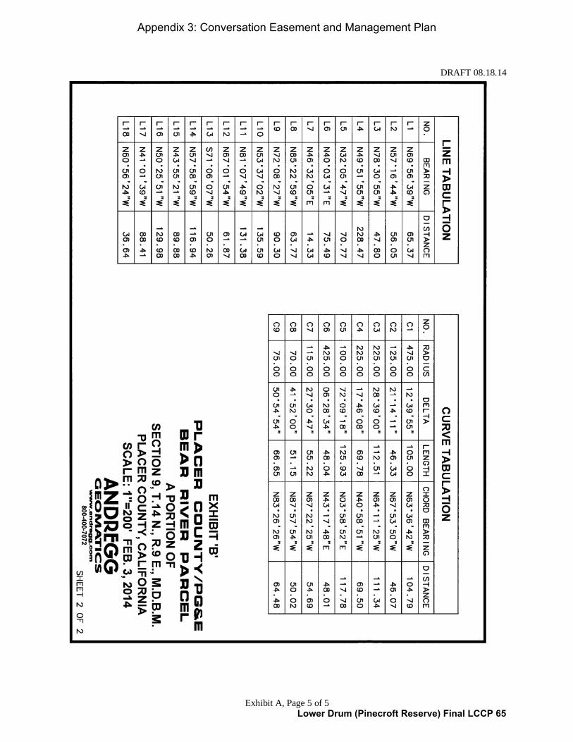
DRAFT 08.18.14
Exhibit A, Page 5 of 5
Appendix 3: Conversation Easement and Management Plan
Lower Drum (Pinecroft Reserve) Final LCCP 65

DRAFT 08.18.14
Exhibit B
Exhibit B
Grant Deed and PG&E Reserved Rights
[ATTACHED ON THE FOLLOWING PAGES]
Appendix 3: Conversation Easement and Management Plan
Lower Drum (Pinecroft Reserve) Final LCCP 66

DRAFT 08.18.14
Exhibit C
Exhibit C
Existing Beneficial Public Values (Conservation Values)
The purpose of conservation easements for Land Conservation Commitment is to protect the
Beneficial Public Values (BPVs) of the properties in the Land Conservation Plan (LCP).
The specific BPVs for this Property (Conservation Values) are summarized below and described
in more detail in the Baseline Documentation Report:
(a) Habitat for plants, trees and wildlife that are native to the area.
(b) Scenic character of the Property, including viewsheds from adjoining public roadways.
(c) Future recreational access and use of the Property, including non-motorized multiple-use
trail use, picnicking, and similar passive recreational uses that are not incompatible with
the Conservation Values of the Property.
Appendix 3: Conversation Easement and Management Plan
Lower Drum (Pinecroft Reserve) Final LCCP 67

DRAFT 08.18.14
Exhibit D, Page 1 of 3
Exhibit D
Building Envelope Description, Restrictions and Allowable Activities
1. DESCRIPTION
The Building Envelope is the central portion of the Property, approximately one-half acre (0.5
acres) in size and further described below, where future development is anticipated and allowed
in order to enhance the recreational use and public benefit of the Property.
a) Geographic Description
The Building Envelope is geographically located using Geographic Positioning Systems
(GPS) and Geographic Information Systems technology, which at the time of the recordation
of this Easement locates geographic points with a degree of accuracy within approximately
30 feet; the Parties agree that the geographic description of the Building Envelope may vary
by this 30-foot amount. The coordinate system for the GPS points listed below is
NAD_1983_StatePlane_California_II_FIPS_0402_Feet.
The Building Envelope is contained within an area bounded by the following GPS points,
listed clockwise starting at GPS Point 1:
GPS Point Northing Easting Description
1 2158088.55 6849296.99 Point on the northwest corner of the Building Envelope
2 2157964.26 6849540.62 Point on the northeast corner of the Building Envelope
3 2157936.08 6849525.7 Point on the southeast corner of the Building Envelope
4 2157954.87 6849458.86 Point on the south boundary of the Building Envelope
5 2157928.35 6849362.18 Point on the south boundary of the Building Envelope
6 2157997.4 6849247.83 Point on the southwest corner of the Building Envelope
Although it is not required by this Easement, the Grantor may, at its own cost, survey the
Building Envelope to create a legal description to more precisely define this area; in such
case, the resulting legal description, if approved by the Parties in writing, would replace the
above geographic description of the Building Envelope.
Appendix 3: Conversation Easement and Management Plan
Lower Drum (Pinecroft Reserve) Final LCCP 68

DRAFT 08.18.14
Exhibit D, Page 2 of 3
b) Map
This map of the Property shows the approximate location of the Building Envelope, with
GPS points noted.
Appendix 3: Conversation Easement and Management Plan
Lower Drum (Pinecroft Reserve) Final LCCP 69

DRAFT 08.18.14
Exhibit D, Page 3 of 3
2. RESTRICTIONS
The objective of the Building Envelope contingency within this Easement is to allow the
development of additional recreational structures and infrastructure to protect and enhance the
Conservation Values, and improve proper maintenance and security of the Property.
Grantor shall ensure that no activity in the Building Envelope is inconsistent with the protection
of the Conservation Values on the remainder of the Property, with the exception of those
activities in the Building Envelope that may affect the scenic values of the Property.
3. ALLOWABLE ACTIVITIES
Grantor reserves to itself and its successors and assigns the right to construct, maintain, alter, and
improve, remove, and replace structures in the Building Envelope, subject to the restrictions in
this Easement. Grantor shall be entitled to make other use of the Building Envelope as permitted
by the Placer County’s F-B-100 Zoning Ordinance that is in effect on the Property as of the date
of this Easement, provided such use is not inconsistent with the protection of the Conservation
Values. This Easement anticipates and allows public recreational use of the Property, including
the Building Envelope.
Specifically within the Building Envelope, this Easement also anticipates and allows
construction and maintenance activities including, but not limited to, site preparation, grading,
leveling, landscaping, irrigation, tree and vegetation trimming and removal, mowing, fuel load
reduction, placement of storage sheds, and similar activities. Furthermore, specifically within
the Building Envelope, this Easement also anticipates and allows the development of a
caretaker’s residence). The development of a caretaker’s residence may include the construction
of a concrete pad. The residential structure must have a maximum size of 1,200 square feet, and
must be developed in accordance with the F-B-100 zoning district regulations found in the Placer
County Zoning Ordinance.
Appendix 3: Conversation Easement and Management Plan
Lower Drum (Pinecroft Reserve) Final LCCP 70

Management Plan for
Bear River Pinecroft Reserve Placer County
DRAFT First Created: August 18, 2014
Last Updated: ______________
Prepared by Placer Land Trust and
approved by the County of Placer
Signed:
___________________________________ Date: ____________
Jeff Darlington
Executive Director, Placer Land Trust
___________________________________ Date: ____________
Mary Dietrich
Director, Facility Services County of Placer
Appendix 3: Conservation Easement and Management Plan
Lower Drum (Pinecroft Reserve) Final LCCP 71

Management Plan for Bear River Pinecroft Reserve DRAFT 08.18.14 i
TABLE OF CONTENTS
1.0 INTRODUCTION ...........................................................................................................1
1.1 Abbreviations and Definitions ...............................................................................1
1.2 Executive Summary ................................................................................................3
2.0 PLAN OBJECTIVES ..........................................................................................................4
2.1 Project Purpose .......................................................................................................4
2.2 Management Plan Development ..........................................................................4
2.3 Management Plan Purpose & Goals .....................................................................4
2.4 Management Plan Review & Amendments ........................................................4
3.0 METHOD OF PROTECTION ..........................................................................................5
3.1 Property Ownership ...............................................................................................5
3.2 Conservation Easement .........................................................................................5
3.3 Successors .................................................................................................................5
3.4 Funding Mechanism ................................................................................................5
4.0 PLAN IMPLEMENTATION ..............................................................................................7
4.1 Landowner Responsibilities ...................................................................................7
5.0 PROPERTY MANAGEMENT PROVISIONS .....................................................................8
5.1 Prohibited Activities ...............................................................................................8
5.2 Potential Threats ....................................................................................................8
5.3 Voluntary Restoration and Enhancement...........................................................8
5.4 Adaptive Management ...........................................................................................8
5.5 Fencing ...........................................................................................................................8
5.6 Public Access and Recreation ...............................................................................8
5.7 Motorized Vehicle Use ...........................................................................................9
5.8 Research, Archaeological and Educational Uses ...............................................9
5.9 Vegetation Management ........................................................................................9
5.10 Wildlife Management ........................................................................................... 10
5.11 Water Quality Management ............................................................................... 10
5.12 Cultural Resources ................................................................................................ 10
6.0 LIST OF ATTACHMENTS ............................................................................................. 11
Attachment A: Legal Description of Property ............................................................ A
Attachment B-1: Vicinity Map ...................................................................................... B-1
Attachment B-2: Aerial Map ......................................................................................... B-2
Attachment B-3: Topographic Map ............................................................................. B-3
Attachment B-4: Land Cover Map.............................................................................. B-4
Attachment B-5: Building Envelope Map .................................................................. B-5
Appendix 3: Conservation Easement and Management Plan
Lower Drum (Pinecroft Reserve) Final LCCP 72

Management Plan for Bear River Pinecroft Reserve DRAFT 08.18.14 Page 1 of 11 Management Plan CLEAN for County BR Pinecroft Reserve DRAFT 08.18.14
1.0 INTRODUCTION
1.1 Abbreviations and Definitions
Important abbreviations and definitions in this document are defined as follows.
Baseline Documentation Report
That certain Baseline Documentation Report (Bear River Pinecroft Reserve, Placer County), dated
______ containing a description of the condition of the Property at the time of the recordation
of the Conservation Easement.
Building Envelope
A half-acre portion of the Property where future development is anticipated and allowed in
order to enhance the recreational use and public benefit of the Property. Located in the
southern portion of the northern parcel of the Property, more completely described in the
Conservation Easement. For reference purposes in this Management Plan, the Building Envelope
is shown on Attachment B-5.
Conservation Easement
That certain Deed of Conservation Easement (Bear River Pinecroft Reserve, Placer County), dated
______ recorded on title of the Property and containing terms and conditions that
permanently protect the Property.
Conservation Values
The Conservation Values are the important habitat, scenic, and recreational attributes of the
Property, as defined in Exhibit D of the Conservation Easement, and as further described and
depicted in the Baseline Documentation Report.
Easement Holder
The Easement Holder is a qualified owner of the Conservation Easement and the entity
responsible for enforcing the terms of the Conservation Easement and the Management Plan to
ensure the permanent protection of the Property and its Conservation Values. The current
Easement Holder is Placer Land Trust, a California nonprofit public benefit corporation, having
an address at 11661 Blocker Drive, Suite 110, Auburn, CA 95603.
Land Stewardship Proposal
Placer County’s Land Stewardship Proposal for the Lower Drum Planning Unit #871, dated May 13,
2011, containing Placer County’s intent to own and manage the Property in support the PG&E
Land Conservation Commitment.
Landowner
The current Landowner is the County of Placer, a political subdivision of the State of California,
having an address at 11476 C Avenue, Auburn, CA 95603.
Appendix 3: Conservation Easement and Management Plan
Lower Drum (Pinecroft Reserve) Final LCCP 73

Management Plan for Bear River Pinecroft Reserve DRAFT 08.18.14 Page 2 of 11 Management Plan CLEAN for County BR Pinecroft Reserve DRAFT 08.18.14
Management Plan
(This document.) The Management Plan for Bear River Pinecroft Reserve, Placer County, dated
______, or as it may be amended or replaced. This document and its attachments define the
roles and responsibilities of the Landowner in the management of the Property and the
protection the Conservation Values, and the roles and responsibilities of the Easement Holder
in support of this management.
PG&E
Pacific Gas and Electric Company, a public utility corporation (PG&E).
PG&E Land Conservation Commitment
PG&E is required to ensure that approximately 140,000 acres of watershed lands (including this
Property) are preserved for a broad range of beneficial public values by conveying fee title and
conservation easements to qualified entities (including Placer County and PLT), per that certain
Stipulation Resolving Issues Regarding the Land Conservation Commitment dated
September 25, 2003, and that certain Settlement Agreement as modified and approved by the
Public Utilities Commission of the State of California in its Opinion and Order of December 18,
2003 (Decision 03-12-035).
PG&E Property
The real property running along both sides of the Pinecroft Spill Channel that separates and is
located between the two non-contiguous parcels of the Property, approximately 9.9 acres
owned by PG&E.
PLT
Placer Land Trust, a California nonprofit public benefit corporation.
Property
The real property owned by the Landowner; in this case, 10.12 acres identified as two non-
contiguous portions of Placer County Assessor’s Parcel Number 101-120-001-000 as of the
time of the recordation of the Conservation Easement. The legal description of the Property is attached as Attachment A.
Stewardship
As narrowly defined in this document, land stewardship includes the ongoing and perpetual
management, monitoring, protection and defense of the Conservation Values of the Property.
Stewardship Council
A California nonprofit public benefit corporation created to assist in the implementation of the
PG&E Land Conservation Commitment.
Appendix 3: Conservation Easement and Management Plan
Lower Drum (Pinecroft Reserve) Final LCCP 74

Management Plan for Bear River Pinecroft Reserve DRAFT 08.18.14 Page 3 of 11 Management Plan CLEAN for County BR Pinecroft Reserve DRAFT 08.18.14
1.2 Executive Summary
The Property is known colloquially as the “Bear River Pinecroft Reserve” and is approximately
10.12 acres in two non-contiguous parcels on either side of the 9.9-acre PG&E Property,
situated at the southeast of the corner of Campground Road and Milk Ranch Road in the
unincorporated area of Placer County northeast of Auburn, at an elevation of approximately
1,760-1,900 feet. For 41 years, the Property was owned by PG&E and leased to the Placer
County for maintaining the surrounding Bear River Campground, including a residence for a
caretaker, and recreational uses, including primarily hiking. The Property is directly adjacent to
the Bear River Campground and is now vacant land owned and operated by Placer County.
The Property contains mixed conifer and hardwood forest and an unnamed perennial stream
that support a variety of plant communities and wildlife species within the Bear River watershed
of Placer County.
In 2010, PLT submitted a request to the Stewardship Council to be the conservation easement
holder for this Property and certain other properties in support of the PG&E Land
Conservation Commitment.
In 2011, the County submitted the Land Stewardship Proposal to the Stewardship Council,
requesting to be the fee title owner of this Property. The County’s Land Stewardship Proposal
sets forth the County’s intent to own and manage the property, potentially including but not
limited to the following activities: setting aside and protecting open space, restoring and
enhancing natural values, maintaining and protecting wildlife corridors, removing unnecessary
improvements, constructing a caretaker’s residence, enhancing recreational opportunities,
constructing and managing multi-use trails, and erecting appropriate signage including
interpretive signs and kiosks.
The Property was legally separated from the adjacent PG&E Property on ___________. The
PG&E Property is not subject to this Conservation Easement or Management Plan.
The Property was granted to the County of Placer on _______ by PG&E as part of the PG&E
Stipulation and Settlement Agreement, which requires PG&E to ensure that approximately
140,000 acres of watershed lands, all owned by PG&E, including the Property, are conserved
for a broad range of beneficial public values, including the protection of the natural habitat of
fish, wildlife and plants; the preservation of open space; outdoor recreation by the general public; sustainable forestry; agricultural uses; and historic values. In particular, the Property is
being managed to ensure its habitat, scenic, and recreational values are permanently protected.
With the prior approval of PG&E and the Stewardship Council, the County of Placer granted
the Conservation Easement to PLT on ________ with the intent to ensure the permanent
protection of the Conservation Values on the Property. This Management Plan supports the
Conservation Easement by outlining how the Property should be managed to achieve the goal
of permanent protection.
Appendix 3: Conservation Easement and Management Plan
Lower Drum (Pinecroft Reserve) Final LCCP 75

Management Plan for Bear River Pinecroft Reserve DRAFT 08.18.14 Page 4 of 11 Management Plan CLEAN for County BR Pinecroft Reserve DRAFT 08.18.14
2.0 PLAN OBJECTIVES
2.1 Project Purpose
The primary goals in transferring fee title of the Property to Placer County and burdening the
Property with the Conservation Easement held by PLT are the protection of habitat, scenic
open space, and outdoor recreation on the Property, and to satisfy conditions of the PG&E
Land Conservation Commitment.
2.2 Management Plan Development
This Management Plan was developed by PLT staff, namely Executive Director Jeff Darlington
and Stewardship Manager Jeff Ward, with assistance from Assistant Director Jessica Daugherty,
Land Manager Justin Wages, and professional and volunteer assistance. Data was collected from
various sources to complete this Management Plan, including: discussions among PLT, Placer
County, the Stewardship Council and PG&E; property and project document review;
photography and mapping, physical site inspections, etc.
2.3 Management Plan Purpose & Goals
To support the terms and conditions of the Conservation Easement and to protect the
Property’s Conservation Values, collectively as opposed to individually, this Management Plan
sets forth roles and obligations for the permanent protection of the Property. The primary
goal in the implementation of this Management Plan is the permanent protection of the habitat,
scenic and recreational attributes and values of the Property.
2.4 Management Plan Review & Amendments
The Easement Holder will review this Management Plan at least annually, in conjunction with an
annual monitoring visit. The Easement Holder and the Landowner may discuss potential
changes to the management of the Property and the protection of the Conservation Values
using an adaptive management approach (as described in Section 5.4). All decisions regarding
the management of the Property shall be consistent with the Management Plan goal and the
terms of the Conservation Easement. The Easement Holder and the Landowner shall jointly
review and approve any management decision not expressly prescribed in this Management
Plan. If a major change is needed that would necessitate an amendment to this Management
Plan, the Management Plan may be amended by the mutual consent and written agreement of
the Landowner and Easement Holder.
Appendix 3: Conservation Easement and Management Plan
Lower Drum (Pinecroft Reserve) Final LCCP 76

Management Plan for Bear River Pinecroft Reserve DRAFT 08.18.14 Page 5 of 11 Management Plan CLEAN for County BR Pinecroft Reserve DRAFT 08.18.14
3.0 METHOD OF PROTECTION
3.1 Property Ownership
The Property is owned by the Landowner. The Landowner has agreed to be bound by the
terms of the Conservation Easement and the Management Plan.
3.2 Conservation Easement
The Property shall be protected in perpetuity by a Conservation Easement, a legally binding
agreement, which includes and incorporates this Management Plan and encumbers the deed of
the Property.
3.2.1 Easement Holder
PLT shall hold the Conservation Easement. As the Easement Holder, PLT is bound by the
terms of the Easement and the Management Plan. PLT is a publicly supported, tax-exempt
nonprofit public benefit organization under Section 501(c)(3) and is qualified to acquire
and hold conservation easements for public benefit under Section 170(h), respectively, of
the Internal Revenue Code of 1986, as amended, and the regulations promulgated
thereunder. PLT is also qualified to acquire and hold conservation easements in California
under Sections 815 and 816 of the California Civil Code. The Conservation Easement
and this Management Plan are consistent with PLT’s mission to work with willing
landowners and conservation partners to permanently protect natural and agricultural
lands in the Placer County region for future generations.
3.2.2 Supremacy of Conservation Easement
This Management Plan is incorporated in and consistent with the Conservation Easement
on the Property held by PLT. All management activities on and uses of the Property must
comply with the terms of the Conservation Easement, and in the case of any
inconsistency, the Conservation Easement supersedes this Management Plan. Any other
agreements or encumbrances on or related to the Property (including existing documents
such as the Land Stewardship Proposal, and any future documents) are and must be
subordinate to the Conservation Easement.
3.3 Successors
The Conservation Easement and this Management Plan are legally binding, in perpetuity, for
current and future Landowners and Easement Holders, including heirs and successors.
3.4 Funding Mechanism
PLT obtained funding to assist with the perpetual stewardship and defense of the Conservation
Easement from the Stewardship Council.
Appendix 3: Conservation Easement and Management Plan
Lower Drum (Pinecroft Reserve) Final LCCP 77

Management Plan for Bear River Pinecroft Reserve DRAFT 08.18.14 Page 6 of 11 Management Plan CLEAN for County BR Pinecroft Reserve DRAFT 08.18.14
3.4.1 Stewardship Fund
A contribution to PLT’s Stewardship Fund has been made by the Stewardship Council to
assist with PLT’s ongoing and perpetual protection and stewardship of the Property’s
Conservation Values. PLT may accomplish its stewardship tasks using these or other
funds, and/or through the work of salaried staff, volunteers, and/or paid consultants. PLT
invests its Stewardship Fund to generate annual interest to expend on annual stewardship
expenses. When invested using a conservative yield of four percent, the Stewardship
Council’s contribution should generate significant annual income. PLT’s annual
stewardship expenses for this Property will vary, but on average are estimated at $4,000.
In years when PLT’s investment interest is not sufficient to cover PLT’s stewardship
expenses, PLT will consider temporary measures to reduce stewardship expenses
(including, if needed, reducing service levels), and/or PLT may seek supplemental funding
to make up the difference. In years when PLT’s investment interest is greater than PLT’s
stewardship expenses, PLT may re-invest the remaining interest back into the Stewardship
Fund.
3.4.2 Legal Defense Fund
A contribution to PLT’s Legal Defense Fund in the amount of $10,000 has been made by
the Stewardship Council to assist with PLT’s defense of the Property’s Conservation
Values. PLT invests its Legal Defense Fund to grow over time to assist in funding
unanticipated expenses related to Conservation Easement approvals, clarifications,
violations, deterrents, and enforcement actions, including legal remedies such as
injunctions, restraining orders, and litigation.
Appendix 3: Conservation Easement and Management Plan
Lower Drum (Pinecroft Reserve) Final LCCP 78

Management Plan for Bear River Pinecroft Reserve DRAFT 08.18.14 Page 7 of 11 Management Plan CLEAN for County BR Pinecroft Reserve DRAFT 08.18.14
4.0 PLAN IMPLEMENTATION
4.1 Landowner Responsibilities
The Landowner is responsible for all obligations resulting from and consistent with ownership,
maintenance and management of the Property, and complying with all laws affecting the
Property. Notably, Landowner responsibilities include, but are not limited to, the following.
4.1.1 Habitat Management
The Landowner is responsible for any and all habitat management duties as described in
this Management Plan.
4.1.2 Property Management
The Landowner is responsible for any and all property management as described in this
Management Plan.
4.1.3 Title Protection
The Landowner is responsible for obtaining title insurance on the Property, and keeping
title of the Property free from any new liens, loans, and encumbrances that are
inconsistent with the protection of the Conservation Values.
Appendix 3: Conservation Easement and Management Plan
Lower Drum (Pinecroft Reserve) Final LCCP 79

Management Plan for Bear River Pinecroft Reserve DRAFT 08.18.14 Page 8 of 11 Management Plan CLEAN for County BR Pinecroft Reserve DRAFT 08.18.14
5.0 PROPERTY MANAGEMENT PROVISIONS
5.1 Prohibited Activities
Any activity or use of the Property that would result in significant impairment to the
Conservation Values of the Property is prohibited, with the exception of certain activities
within the Building Envelope. For a full description of prohibited activities, see the
Conservation Easement.
5.2 Potential Threats
The primary potential threats to the Conservation Values on the Property include vandalism,
dumping and littering, and invasive species. The Easement Holder will monitor the Property at
least annually and will document and report threats to the Conservation Values as they arise or
have the potential to arise.
5.3 Voluntary Restoration and Enhancement
Although no specific habitat restoration and enhancement activities are required, it is
recognized that the Landowner may want to conduct habitat restoration or enhancements in
the future. Such activities are allowed and should be governed by this Management Plan, as it
may be amended.
5.4 Adaptive Management
The management of the Property should strive to follow adaptive management practices.
Adaptive management allows the Landowner and the Easement Holder some flexibility in
management decision-making, which enables the parties to permanently protect the
Conservation Values from changing conditions that may affect the Property. Adaptive
management is defined as a type of natural resource management in which decisions are made
as part of an ongoing science-based process. Adaptive management may involve research,
testing, monitoring, and evaluating applied strategies, and incorporating new knowledge into
management approaches that are based on scientific findings and the needs of society. Results
are used to modify management policy, strategies and practices.
5.5 Fencing
There is no existing fencing on the Property. External, interior and temporary fencing may be
placed on the Property by the Landowner in the future, as fencing can be an important tool in
managing property. Should fencing be installed in the future, the type of fence should
reasonably accommodate known or suspected wildlife migration. The Landowner may place
gates on fencing to permit public access to public areas, and Landowner access to restricted
areas, if applicable. The placement of fencing on the Property must not significantly impair the
Conservation Values or significantly restrict public access.
5.6 Public Access and Recreation
Public access and public recreation is allowed on the Property. The development and
improvement of public access and recreation improvements are allowed if they do not conflict
with the terms of the Conservation Easement. The Property has in the past and presently
supports recreational uses consisting of hiking and similar recreational uses that are not
incompatible with the Conservation Values of the Property. The Landowner is allowed to
Appendix 3: Conservation Easement and Management Plan
Lower Drum (Pinecroft Reserve) Final LCCP 80

Management Plan for Bear River Pinecroft Reserve DRAFT 08.18.14 Page 9 of 11 Management Plan CLEAN for County BR Pinecroft Reserve DRAFT 08.18.14
create non-motorized public trails and bridges on the Property (including grading, necessary
tree removal work, and signage associated with public trails). The Landowner is allowed to
develop a caretaker’s residence in the Building Envelope, subject to the terms of the
Conservation Easement; a caretaker’s presence on the Property should aid in the protection of
the Conservation Values. The Easement Holder is not responsible for the management of
recreation activities on the Property, and the Landowner agrees to hold the Easement Holder
harmless for any claims related to or resulting from public access and recreation.
5.7 Motorized Vehicle Use
Motorized vehicle use is allowed only for the management, maintenance, and enhancement of
the Property, and the monitoring and enforcement of the Conservation Easement. Reasonable
care should be taken that vehicle use does not unnecessarily damage, erode or scar the
landscape, or transport invasive plants onto the Property. At this time, motorized vehicle use
is only allowed on the Property when under Landowner’s control or in the case of the
Easement Holder, for purposes of monitoring or enforcing the Conservation Easement. For
the purpose of general Property management and maintenance purposes, motorized vehicles
may be used “off road” as long as the use does not have a significant adverse effect on the
Conservation Values.
5.8 Research, Archaeological and Educational Uses
Individuals or groups wishing to use the Property for scientific research, archaeological
research, or educational purposes that are consistent with the protection of the Conservation
Values may be allowed by the Landowner.
5.9 Vegetation Management
No unnecessary harm to vegetation should result from any management activities on or uses of
the Property outside the Building Envelope, except as needed to provide balanced protection
to the Conservation Values.
5.9.1 Public Trails
The Landowner may alter or remove vegetation in order to create and maintain non-motorized public trails on the Property.
5.9.2 Fire and Fuels Management
The Landowner bears the obligation and cost of meeting any fire management and
suppression responsibilities according to applicable ordinance or law.
5.9.3 Invasive Plant Management
Although no invasive plant species management is required, it is recognized that use of the
Property could influence existing vegetation distribution and composition, and invasive
plant management is encouraged. Management of invasive plant species can be a complex
and expensive task. It is important to recognize that the Landowner can only conduct as
much exotic species management as can be accomplished with available funding and within
the constraints of other management objectives. Vegetation management using a
combination of mechanical and chemical control is identified as the best strategy of
control of non-native species. Unless Easement Holder makes a determination in writing,
Appendix 3: Conservation Easement and Management Plan
Lower Drum (Pinecroft Reserve) Final LCCP 81

Management Plan for Bear River Pinecroft Reserve DRAFT 08.18.14 Page 10 of 11 Management Plan CLEAN for County BR Pinecroft Reserve DRAFT 08.18.14
backed by scientific evidence, that the invasive plants on the Property are significantly and
adversely affecting the Conservation Values, then invasive plant management is an activity
that may be undertaken, or not, at Landowner’s sole discretion.
5.10 Wildlife Management
No unnecessary harm to wildlife should result from any management activities on or uses of
the Property outside the Building Envelope, except as needed to provide balanced protection
to the Conservation Values.
5.10.1 Invasive Animal Management
Although no invasive animal species management is required, it is recognized that certain
non-native and invasive animal species, such as wild pigs, have the potential to negatively
impact the Conservation Values. Management of invasive animal species can be a complex
and expensive task. It is important to recognize that the Landowner can only conduct as
much invasive species management as can be accomplished with available funding and
within the constraints of other management objectives. The Landowner may conduct or
approve invasive animal management using a lethal and/or non-lethal means, including but
not limited to sport hunting and depredation in accordance with the laws and guidelines of
the California Department of Fish & Wildlife. Unless Easement Holder makes a
determination in writing, backed by scientific evidence, that the invasive animals on the
Property are significantly and adversely affecting the Conservation Values, then invasive
animal management is an activity that may be undertaken, or not, at Landowner’s sole
discretion.
5.11 Water Quality Management
Activities on and use of the Property should not significantly degrade water quality. The
following prohibitions and restrictions should help protect water quality:
a) Direct herbicide application into waterways is prohibited.
b) Any significant erosion should be immediately remedied.
5.12 Cultural Resources
The Landowner shall take measures to avoid disturbance and damage to any known or
suspected cultural resources on the Property.
Appendix 3: Conservation Easement and Management Plan
Lower Drum (Pinecroft Reserve) Final LCCP 82

Management Plan for Bear River Pinecroft Reserve DRAFT 08.18.14 Page 11 of 11 Management Plan CLEAN for County BR Pinecroft Reserve DRAFT 08.18.14
6.0 LIST OF ATTACHMENTS
Attachment A – Legal Description of Property
Attachment B-1 – Vicinity Map
Attachment B-2 – Aerial Map
Attachment B-3 – Topographic Map
Attachment B-4 – Land Cover Map
Attachment B-5 – Building Envelope Map
Appendix 3: Conservation Easement and Management Plan
Lower Drum (Pinecroft Reserve) Final LCCP 83

Management Plan for Bear River Pinecroft Reserve DRAFT 08.18.14 Attachment A
Attachment A: Legal Description of Property
Appendix 3: Conservation Easement and Management Plan
Lower Drum (Pinecroft Reserve) Final LCCP 84
Management Plan for Bear River Pinecroft Reserve DRAFT 08.18.14 Attachment A
Appendix 3: Conservation Easement and Management Plan
Lower Drum (Pinecroft Reserve) Final LCCP 85

Management Plan for Bear River Pinecroft Reserve DRAFT 08.18.14 Attachment A
Appendix 3: Conservation Easement and Management Plan
Lower Drum (Pinecroft Reserve) Final LCCP 86

Management Plan for Bear River Pinecroft Reserve DRAFT 08.18.14 Attachment A
Appendix 3: Conservation Easement and Management Plan
Lower Drum (Pinecroft Reserve) Final LCCP 87

Management Plan for Bear River Pinecroft Reserve DRAFT 08.18.14 Attachment A
Appendix 3: Conservation Easement and Management Plan
Lower Drum (Pinecroft Reserve) Final LCCP 88

Management Plan for Bear River Pinecroft Reserve DRAFT 08.18.14 Attachment B-1
Attachment B-1: Vicinity Map
Appendix 3: Conservation Easement and Management Plan
Lower Drum (Pinecroft Reserve) Final LCCP 89

Management Plan for Bear River Pinecroft Reserve DRAFT 08.18.14 Attachment B-2
Attachment B-2: Aerial Map
Appendix 3: Conservation Easement and Management Plan
Lower Drum (Pinecroft Reserve) Final LCCP 90

Management Plan for Bear River Pinecroft Reserve DRAFT 08.18.14 Attachment B-3
Attachment B-3: Topographic Map
Appendix 3: Conservation Easement and Management Plan
Lower Drum (Pinecroft Reserve) Final LCCP 91

Management Plan for Bear River Pinecroft Reserve DRAFT 08.18.14 Attachment B-4
Attachment B-4: Land Cover Map
Appendix 3: Conservation Easement and Management Plan
Lower Drum (Pinecroft Reserve) Final LCCP 92

Management Plan for Bear River Pinecroft Reserve DRAFT 08.18.14 Attachment B-5
Attachment B-5 – Building Envelope Map
Appendix 3: Conservation Easement and Management Plan
Lower Drum (Pinecroft Reserve) Final LCCP 93

Conservation Easement Funding Agreement (Bear River Pinecroft Reserve) 1
Conservation Easement Funding Agreement Lower Drum Planning Unit
(Parcel #871, Bear River Pinecroft Reserve) This Conservation Easement Funding Agreement (“Agreement”) is entered into as of the Effective Date (defined below) by and between the Pacific Forest and Watershed Lands Stewardship Council, a California nonprofit public benefit corporation (the “Stewardship Council”) and Placer Land Trust, a California nonprofit public benefit corporation (“Grantee”) with reference to the following facts: A. The Stewardship Council was created to oversee the “Land Conservation Commitment” described in (1) that certain Settlement Agreement among Pacific Gas and Electric Company (“PG&E”), PG&E Corporation, and the California Public Utilities Commission (the “Commission”) as modified and approved by the Commission in its Opinion and Order of December 18, 2003 (Decision 03-12-035) (the “Settlement Agreement”); and (2) that certain Stipulation Resolving Issues Regarding the Land Conservation Commitment dated September 25, 2003 (the “Stipulation”). B. Pursuant to the Settlement and Stipulation, certain lands owned by PG&E at the time of the Settlement (the “PG&E Watershed Lands”) are to be conserved for a broad range of beneficial public values, including the protection of the natural habitat of fish, wildlife and plants; the preservation of open space; outdoor recreation by the general public; sustainable forestry; agricultural uses; and historic values. The Stewardship Council is charged with developing a Land Conservation Plan for the protection and enhancement of the PG&E Watershed Lands. C. Grantee is a publicly-supported, tax exempt nonprofit organization, qualified under Section 501 (c)(3) of the Internal Revenue Code (“IRC”), whose primary purpose is to preserve, protect or enhance, land in its natural scenic, historical agricultural, forested or open space condition or use and conserve natural areas for aesthetic, scientific, charitable and educational purposes. Grantee is eligible to hold a conservation easement pursuant to California Civil Code Section 815.3. D. In connection with the Land Conservation Commitment, Grantee has agreed to accept a perpetual conservation easement created pursuant to California Civil Code Section 815 et seq. (the “Conservation Easement”) over a portion of the PG&E Watershed Lands that is being donated to the County of Placer consisting of approximately 10 acres of real property located in Placer County, State of California, as more particularly described in Exhibit A attached hereto and incorporated herein by reference (the “Property”). E. In consideration of Grantee’s agreement to accept the Conservation Easement and assume the duties and obligations of the easement holder, the Stewardship Council has agreed to provide funding to Grantee in the amounts and subject to the terms and conditions described below.
Appendix 4: Conservation Easement Funding Agreement
Lower Drum (Pinecroft Reserve) Final LCCP 94

Conservation Easement Funding Agreement (Bear River Pinecroft Reserve) 2
NOW, THEREFORE, the Stewardship Council and Grantee agree as follows:
1. Effective Date. This Agreement shall become effective upon the recording of the Conservation Easement in favor of Grantee in the Official Records of Placer County (the “Effective Date”). It is understood and agreed that if for any reason whatsoever the recording of the Conservation Easement does not occur on or before December 31, 2015, this Agreement shall be of no further force or effect and the parties shall thereupon be released from any obligations under this Agreement.
2. Grant. Effective upon the Effective Date, the Stewardship Council grants Ninety
Thousand One Hundred Dollars ($90,100.00) (the “Grant Funds”) to Grantee to be used solely for the following purposes:
a. Eighty Thousand One Hundred Dollars ($80,100.00) of the Grant Funds shall be used to implement conservation easement monitoring as described in Sections 3 and 4 below (the “Monitoring Funds”).
b. Ten Thousand Dollars ($10,000.00) of the Grant Funds shall be used for
conservation easement defense and enforcement costs as described in Section 5 below (the “Defense and Enforcement Funds”).
3. Use of Grant Funds. The Grant Funds shall be payable to Grantee within thirty
(30) days of the Effective Date. Grantee will use the Grant Funds for the purposes described in this Agreement and for no other purpose without the prior written consent of the Stewardship Council. The Stewardship Council reserves the right to require the total or partial return of Grant Funds in the event Grantee fails to comply with the terms and conditions of this Agreement.
a. Grantee may “pool” the Monitoring Funds with other funds Grantee uses
for monitoring of other conservation easements held by Grantee, and Grantee may use the Monitoring Funds to monitor any of its conservation easements as long as Grantee meets its obligations as described in Section 4 below.
b. Within thirty (30) days of receipt of funds, Grantee will provide the
Stewardship Council with evidence of deposit of (1) the Monitoring Funds into an account which shall be restricted to the stewardship and monitoring of conservation easements held by the Grantee, including but not limited to the Conservation Easement on the Property; and (2) the Defense and Enforcement Funds into an account which shall be restricted to the legal defense or enforcement of conservation easements held by the Grantee, including but not limited to the Conservation Easement on the Property. The requirement to provide evidence of deposit will be satisfied when Grantee submits to the Stewardship Council the form attached as Exhibit B.
4. Conservation Easement Monitoring. From and after the Effective Date, Grantee
agrees to conduct regular monitoring of the Property to ensure compliance with the terms of the Conservation Easement. Grantee shall conduct on-site monitoring of the Property not less than annually to assess compliance with the terms and conditions of the Conservation Easement and
Appendix 4: Conservation Easement Funding Agreement
Lower Drum (Pinecroft Reserve) Final LCCP 95

Conservation Easement Funding Agreement (Bear River Pinecroft Reserve) 3
note any material changes to the Property compared to the baseline documentation report and prior monitoring reports. Upon written request, the Stewardship Council or its designee shall be permitted to accompany the Grantee on its monitoring visits and to receive a copy of any monitoring report prepared by Grantee. Permissible uses of Monitoring Funds shall include:
a. Regular on-site inspection and monitoring to ensure that the terms of
Conservation Easement are being met;
b. Recordkeeping and preparation of reports, notices of violation, any written consent to be submitted to the fee title owner of the property which is subject to the easement, and other documentation related to the Conservation Easement and the Property;
c. Communications with the fee title owner of the property which is subject to the easement regarding the provisions of the Conservation Easement and planned or completed activities on the lands to be performed or allowed by the fee title owner or a licensee/lessee;
d. Responding to any inquiries or concerns raised by entities that have leases or licenses on the Property or other stakeholders who have an interest in ensuring the beneficial public values are protected.
5. Defense and Enforcement Funds. Grantee shall be permitted to use the Defense and Enforcement Funds for the following purposes:
a. To make direct expenditures of attorneys' fees, costs and disbursements
incurred in connection with proceedings to enforce and/or defend the provisions of the Conservation Easement against legal challenge, including any claims by third parties;
b. To “pool” funds for legal expenses to enforce and/or defend against legal
challenge conservation easements held by the Grantee, including without limitation the Conservation Easement on the Property;
c. To pay premiums into a Conservation Defense Insurance Program
offered through the Land Trust Alliance, or other nationally-recognized conservation organization of which Grantee is a member for the enforcement and defense of conservation easements held by member organizations, or to cover deductibles related to such insurance.
6. Grant Report. Grantee agrees to submit to the Stewardship Council and/or its
designee the following grant Status Reports pursuant to this Agreement. The initial Status Report shall be submitted to the Stewardship Council by the fourth quarter of the 2016 calendar year and include data up to the date of the initial Status Report. The final Status Report shall be submitted to the Stewardship Council or its designee on or before December 31, 2023. The due dates of the initial and final Status Reports can be changed by the Stewardship Council or its
Appendix 4: Conservation Easement Funding Agreement
Lower Drum (Pinecroft Reserve) Final LCCP 96

Conservation Easement Funding Agreement (Bear River Pinecroft Reserve) 4
designee with at least 60 days written notice to Grantee. The Stewardship Council or its designee shall notify Grantee in a timely manner of the form and content of each Status Report, which shall include, at a minimum:
a. Copies of annual monitoring reports pertaining to the Conservation Easement for years selected by the Stewardship Council or its designee;
b. A statement as to whether any violations of the Conservation Easement
were observed during the reporting period, and the outcome of any action taken to correct such violation;
c. A statement as to whether any amendments to the Conservation
Easement were approved during the reporting period, with copies of any such amendments included in the Status Reports;
d. A statement as to whether fee title of the property was conveyed, the date
of such conveyance, and the identity of the transferee; and
e. A report providing an accounting of how the Grant Funds have been invested or expended in furtherance of the purposes of this Agreement.
7. Records. Grantee will indicate the Grant Funds separately on its books of
account, and maintain such records in accordance with generally accepted accounting principles. Grantee shall additionally maintain written records including the baseline documentation report, the Deed of Conservation Easement, any amendments to the Conservation Easement, other transaction documents, and copies of monitoring reports, notices to the landowner, and other communications pursuant to the Conservation Easement in accordance with the practices generally accepted in the land trust community.
8. Inspection. The Stewardship Council or its designee shall have the right to
inspect the books and records of Grantee and evaluate Grantee’s use of Grant Funds, so long as (i) such inspection or evaluation occurs during regular business hours; (ii) such inspection or evaluation does not unreasonably interfere with Grantee’s regular operations; and (iii) the Stewardship Council or its designee provides at least three (3) days prior notice of any such inspection or evaluation.
9. Assignment and Transfer of Funds. Grantee shall not assign its interest under the
Conservation Easement except in accordance with the provisions of the Conservation Easement relating to permitted assignments. In the event that Grantee assigns its interest under the Conservation Easement to a successor conservation easement holder, Grantee shall transfer the remaining balance of the Grant Funds to the successor conservation easement holder. Assignee’s receipt of any funds from Grantee shall be conditioned upon the assignee’s agreement in writing to assume all of Grantee’s obligations under this Agreement.
Appendix 4: Conservation Easement Funding Agreement
Lower Drum (Pinecroft Reserve) Final LCCP 97

Conservation Easement Funding Agreement (Bear River Pinecroft Reserve) 5
10. Publicity. The Stewardship Council may include information regarding this Agreement and Grantee in its periodic public reports, press releases, or other public communications.
11. Representations and Warranties. Grantee warrants and represents that it is a
tax exempt organization under Section 501(c)(3) of the IRC, and is not a private foundation as defined in section 509(a) of the IRC or is an exempt operating foundation described in Section 4940(d)(2) of the IRC. Grantee further represents and warrants that it shall not use the Grant Funds to attempt to influence legislation or otherwise carry out lobbying activities within the meaning of Sections 501(h), 4911, 4945(d)(1) or 4945(e) of the IRC. No part of the Grant Funds may be used to attempt to influence the outcome of any specific public election, or to carry on, directly or indirectly, any voter registration drive. No part of the Grant Funds may be used for purposes other than charitable, scientific, literary, or educational purposes within the meaning of IRC Section 170(c)(2)(B).
Grantee does not knowingly employ individuals or contribute funds to organizations found on any terrorist-related list prepared by the U.S. Government, the United Nations, or the European Union, including the Department of Treasury’s Office of Foreign Assets Control Specially Designated Nationals List, the Department of Justice's Terrorist Exclusion List, or the list attached to Executive Order 13224. Should any change occur with respect to the preceding sentence, Grantee will notify the Stewardship Council within 7 days of such change.
12. Indemnification. Grantee hereby agrees to indemnify, defend, and hold harmless the Stewardship Council, and the Stewardship Council’s past, present and future officers, directors, and employees, from and against any and all claims, demands, losses, costs, expenses, obligations, liabilities, damages, recoveries, and deficiencies, including interest, penalties, and reasonable attorney fees and costs, that they may incur or suffer and that result from, or are related to, the receipt and use of the Grant Funds by Grantee.
13. Limit of Stewardship Council Obligations. The Stewardship Council’s obligations
under this Agreement shall under no circumstances exceed the Grant Funds amount set forth in Section 2 above.
14. Assignment. This Agreement may not be assigned by the Grantee in whole or in
part except as provided in Section 9 above. The Stewardship Council may assign its rights and delegate its obligations under this Agreement to a third party at the Stewardship Council’s sole discretion. Subject to the foregoing, this Agreement shall be binding upon and inure to the benefit and burden of the parties and their respective heirs, successors and assigns.
15. Amendment; Entire Agreement. This Agreement may not be amended or
modified except by written instrument signed by both parties. This Agreement constitutes the entire understanding of the parties concerning the subject matter hereof, and supersedes any and all previous negotiations, agreements, or understandings, if any, regarding the matters contained herein.
Appendix 4: Conservation Easement Funding Agreement
Lower Drum (Pinecroft Reserve) Final LCCP 98

Conservation Easement Funding Agreement (Bear River Pinecroft Reserve) 6
16. Governing Law. This Agreement shall be governed by the laws of the State of California.
17. Counterparts. This Agreement may be executed in counterparts which together
shall constitute a single agreement.
Pacific Forest and Watershed Lands Stewardship Council, a California Nonprofit Public Benefit Corporation By: Title: Date: Placer Land Trust, a California Nonprofit Public Benefit Corporation By: Title: Date:
Appendix 4: Conservation Easement Funding Agreement
Lower Drum (Pinecroft Reserve) Final LCCP 99

Exhibit A
Property Description
(to be attached)
Appendix 4: Conservation Easement Funding Agreement
Lower Drum (Pinecroft Reserve) Final LCCP 100

Conservation Easement Funding Agreement (Bear River Pinecroft Reserve) 8
Exhibit B
Deposit Certification
(to be attached)
Appendix 4: Conservation Easement Funding Agreement
Lower Drum (Pinecroft Reserve) Final LCCP 101

Tax Neutrality Methodology Page 1 of 5 Adopted: June 27, 2012
PROPERTY TAX NEUTRALITY METHODOLOGY
INTRODUCTION The Settlement Agreement1 and Stipulation2 that established the Land Conservation Commitment require that the Land Conservation Plan being developed by the Stewardship Council provide property tax revenue, other equivalent revenue source, or a lump sum payment, so that the totality of dispositions in each affected county will be “tax neutral” for each county. Section 4.3 of Volume I of the Land Conservation Plan (LCP) adopted by the Stewardship Council in November 2007 described the Stewardship Council’s potential strategies and anticipated approach to achieving property tax neutrality at a programmatic level. More recently, on September 17, 2009, the Stewardship Council adopted a funding policy. This policy further clarified the Stewardship Council’s approach to property tax neutrality and identified several potential vehicles to achieving this requirement. On March 30, 2011, the Stewardship Council adopted a set of guidelines which describe scenarios in which the Stewardship Council will make property tax payments to affected counties and further defined a set of overarching assumptions regarding property tax neutrality payments. Table 1 below lists the estimated acreage and annual property taxes associated with PG&E watershed lands which are available for donation as of September 2011. The estimated total tax liability that would be subject to tax neutrality will depend upon the total acreage transferred, and the types of organization receiving lands.
COUNTY Total Acres
Total Taxes ($)
Acres Available
for Donation
Taxes on Lands
Avail. ($)
Alpine 1,983 $26,995 965 $6,449 Amador 4,891 $45,916 3,238 $25,493 Butte 8,029 $75,706 6,449 $55,539 Calaveras 318 $2,699 230 $1,643 Fresno 1,527 $26,917 342 $3,552 Kern 664 $1,734 0 $0 Lake 5,271 $116,467 3,355 $80,975
1 Opinion Modifying the Proposed Settlement Agreement of Pacific Gas & Electric Company, PG&E Corporation and the Commission Staff, and Approving the Modified Settlement Agreement, December 18, 2003: http://www.stewardshipcouncil.org/documents/Settlement_Agreement.pdf 2 Stipulation Resolving Issues Regarding the Land Conservation Commitment, September 25, 2003: http://www.stewardshipcouncil.org/documents/Stipulation_Agreement.pdf
Appendix 5: Property Tax Neutrality Document
Lower Drum (Pinecroft Reserve) Final LCCP 102

Tax Neutrality Methodology Page 2 of 5 Adopted: June 27, 2012
COUNTY Total Acres
Total Taxes ($)
Acres Available
for Donation
Taxes on Lands
Avail. ($)
Madera 2,016 $181,650 686 $64,396 Mendocino 2,112 $28,181 1,799 $22,252 Nevada 10,651 $107,895 4,889 $39,128 Placer 7,846 $356,996 5,587 $179,825 Plumas 38,094 $304,316 4,935 $113,228 Shasta 46,989 $296,123 36,191 $178,510 Tehama 1,946 $8,839 1,564 $4,422 Tuolumne 1,840 $28,470 1,040 $11,368 Yuba 41 $612 41 $612 Grand Total 134,216 $1,609,516 71,310 $787,392
PURPOSE OF PROPOSED METHODOLOGY The purpose of this methodology is to establish a standard payment process when lands are transferred to organizations that are exempt from paying property taxes. The following methodology will be applied to all counties which experience a loss in property tax revenues due to a recommended donation of fee title as part of the Stewardship Council’s Land Conservation Commitment.
DETERMINING TAX NEUTRALITY PAYMENT AMOUNT Following the Stewardship Council approval of a fee-title donation, the Stewardship Council will work with the affected county to calculate the payment amount for inclusion in the Stewardship Council’s Land Conservation and Conveyance Plan (LCCP).
1. Using the legal description and/or survey of lands identified for transfer to an organization which is exempt from paying property taxes, the Stewardship Council and PG&E will prepare an estimate of the annual taxes on lands to be donated.
2. The reduction in annual taxes caused by the donation of acres to organizations exempt from property tax will constitute the “Annual Base Value” for the funding calculation.
3. The county will select either the lump-sum or annual payment option (described below) for the selected fee-title donation and communicate their preference in writing to the Stewardship Council.
4. The Stewardship Council will provide a draft funding agreement for county review and approval using the Annual Base Value and payment option. The draft funding agreement
Appendix 5: Property Tax Neutrality Document
Lower Drum (Pinecroft Reserve) Final LCCP 103

Tax Neutrality Methodology Page 3 of 5 Adopted: June 27, 2012
is expected to include, among other items, the following acknowledgements by the county:
a. Payment by the Stewardship Council satisfies the tax neutrality requirement as specified in the Settlement and Stipulation for the subject fee-title donation.
b. The county has issued (or will not reasonably withhold) a Welfare Tax Exemption for the new landowner, if required.
c. The county will agree to distribute the lump-sum or annual payment to the applicable special districts as dictated in the relevant Tax Rate Area at the time of payment. In consideration for the additional administrative responsibility of the county to set up the process to allocate payments to special districts, the Stewardship Council will provide a one-time reimbursement of up to $3,000 of the county cost to perform such activities.
5. The proposed funding agreement that has been deemed acceptable by the county as evidenced by a certified board resolution will be included in the Stewardship Council’s Land Conservation and Conveyance Plan (LCCP). In turn, the LCCP will be attached to PG&E’ Section 851 filing with the California Public Utilities Commission, wherein PG&E will seek regulatory approval of the proposed fee title donation. If assessed values on the lands recommended for donation change prior to the transfer of land, the Stewardship Council will revise the payment calculation included in the proposed funding agreement prior to its execution by the parties.
6. Immediately following the transfer of lands, the Stewardship Council and the county will execute the funding agreement and the Stewardship Council will fund the settlement amount according to the terms of the funding agreement as described in number 4 above.
OPTIONS FOR FUNDING PROPERTY TAX NEUTRALITY PAYMENTS
The Stewardship Council is presenting two options for making tax neutrality payments: (1) a one-time lump-sum payment; or, (2) funding of an independent trustee to continue annual payments in lieu of taxes.
Lump-sum payment Lump-sum payments in satisfaction of property tax neutrality would be calculated based upon the net present value of the Annual Base Value at the time that lands are removed from the property tax rolls. The lump-sum payment will be calculated using a discounted cash flows analysis for perpetual payment streams, otherwise known as a Capitalization Rate (Cap Rate).
The Cap Rate calculation requires an assumption of a long-term rate of return on comparable investments, and a long-term inflation rate. In order to develop a Cap Rate for a lump-sum payment, the Stewardship Council considered multiple long-term inputs, including long term equity and fixed income returns (Dow Jones Industrial Average, S&P 500, U.S. Treasury,
Appendix 5: Property Tax Neutrality Document
Lower Drum (Pinecroft Reserve) Final LCCP 104
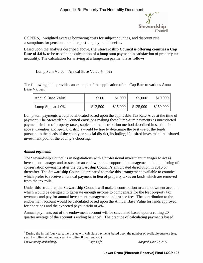
Tax Neutrality Methodology Page 4 of 5 Adopted: June 27, 2012
CalPERS), weighted average borrowing costs for subject counties, and discount rate assumptions for pension and other post-employment benefits.
Based upon the analysis described above, the Stewardship Council is offering counties a Cap Rate of 4.0% to be used in the calculation of a lump-sum payment in satisfaction of property tax neutrality. The calculation for arriving at a lump-sum payment is as follows:
Lump Sum Value = Annual Base Value ÷ 4.0%
The following table provides an example of the application of the Cap Rate to various Annual Base Values:
Annual Base Value $500 $1,000 $5,000 $10,000
Lump Sum at 4.0% $12,500 $25,000 $125,000 $250,000
Lump-sum payments would be allocated based upon the applicable Tax Rate Area at the time of payment. The Stewardship Council envisions making these lump-sum payments as unrestricted payments in lieu of property taxes, subject to the distribution method described in section 4.c above. Counties and special districts would be free to determine the best use of the funds pursuant to the needs of the county or special district, including, if desired investment in a shared investment pool of the county’s choosing.
Annual payments The Stewardship Council is in negotiations with a professional investment manager to act as investment manager and trustee for an endowment to support the management and monitoring of conservation covenants after the Stewardship Council’s anticipated dissolution in 2016 or thereafter. The Stewardship Council is prepared to make this arrangement available to counties which prefer to receive an annual payment in lieu of property taxes on lands which are removed from the tax rolls.
Under this structure, the Stewardship Council will make a contribution to an endowment account which would be designed to generate enough income to compensate for the lost property tax revenues and pay for annual investment management and trustee fees. The contribution to the endowment account would be calculated based upon the Annual Base Value for lands approved for donations and the expected payout ratio of 4%.
Annual payments out of the endowment account will be calculated based upon a rolling 20 quarter average of the account’s ending balance3. The practice of calculating payments based
3 During the initial four years, the trustee will calculate payments based upon the number of available quarters (e.g. year 1 – rolling 4 quarters, year 2 – rolling 8 quarters, etc.)
Appendix 5: Property Tax Neutrality Document
Lower Drum (Pinecroft Reserve) Final LCCP 105

Tax Neutrality Methodology Page 5 of 5 Adopted: June 27, 2012
upon a rolling average (smoothing) has been shown to reduce the number of significant declines in annual distributions, and increase the total value of payments and invested assets4.
Annual payments to counties would be allocated based upon the applicable Tax Rate Area at the time of payment by the receiving county. The Stewardship Council envisions making these annual payments as unrestricted payments in lieu of property taxes, subject to the distribution method described in section 4.c above. Counties and special districts would be free to determine the best use of the funds pursuant to the needs of the county or special district.
Participating counties would be enrolled in a common service model in the investment management account. All counties would share a common investment policy and investment management agreement. Funds will be invested in a commingled account, with the investment manager providing an individual accounting to each individual county.
Considerations of the Annual Payment Approach The viability of the annual payment option is subject to a level of participation by the counties which meets the minimum account size (estimated at $1 million).
Under this approach annual payments may exceed the original Annual Base Value in some years, and be lower in others, as the payment amount is reliant upon the ending market value of the account.
The Stewardship Council’s transaction process is expected to occur serially, over the span of several years. It is likely that the viability and pricing of the annual payment approach will not be known for the initial transactions. Therefore, the Stewardship Council may make the initial annual payments directly to counties until the minimum account size is reached.
Please see Appendix A for more details on the annual payment option.
4 Smarter Giving for Private Foundations, AllianceBernstein, https://www.alliancebernstein.com/Research-Publications/Black-Books/Foundations-and-Endowments/Stories/Foundations_BlackBook.htm
Appendix 5: Property Tax Neutrality Document
Lower Drum (Pinecroft Reserve) Final LCCP 106

Appendix A: Annual Payment Details Page 1 of 4 Adopted: June 27, 2012
Appendix A Annual Payment Details
TRUSTEE SELECTION The Stewardship Council is performing due diligence for the selection of an investment manager and trustee to administer the trust account for annual payments to counties. Selection will be based upon many factors, including (but not limited to): organization history and reputation, investment management experience, fee structure, and administrative capabilities. Additional information on the selection process can be provided upon request.
Trustee’s Responsibilities: Upon the Stewardship Council’s funding of the trust account, the trustee would assume all responsibilities for making annual payments to counties in lieu of property taxes, including:
Trust administration • Interpret the trust document. • Distribute trust assets according to the trust document. • Perform principal and income accounting. • Prepare and file tax returns. • Address specific beneficiary issues, reporting, etc. Investment management • Invest the trust portfolio assets objectively for the benefit of all interested parties. • Manage portfolio assets in a tax-efficient and tax-effective manner. • Review investment performance to ensure the portfolio is meeting the established goals and
objectives.
THE ANNUAL PAYMENT STRUCTURE Using the inputs described in the term sheet, the Stewardship Council will make a contribution to the trust account on behalf of the participating county. The following example illustrates the funding and payout process. EXAMPLE: Calculation of Contribution to Trust Account
Annual Base Value: $5,000 per year
Annual Payout Percentage: 4.00%
Contribution Calculation: $5,000 ÷ 0.04 = $125,000
Appendix 5: Property Tax Neutrality Document
Lower Drum (Pinecroft Reserve) Final LCCP 107

Appendix A: Annual Payment Details Page 2 of 4 Adopted: June 27, 2012
The actual annual payout is dependent upon the following factors:
Annual Rate of Return: The annual rate of return will depend upon investment selections and market and economic performance. While past results are not an accurate predictor of future results, the annual return of the S&P 500 has averaged approximately 9%-10% since 19251.
Estimated Annual Fees: Annual investment management and trust administration fees will be deducted from the account and are expected to be approximately 1% - 2%, depending upon the selected investment manager and trustee.
As envisioned, the trustee will make annual payments based upon a rolling 20 quarter average of the account balance2. The practice of calculating payments based upon a rolling average (smoothing) has been shown to reduce the number of significant declines in annual distributions, and increase the total value of payments and invested assets3. However, this does not guarantee against the possibility of losses in investment principal resulting in payments in some years being less than the county would have otherwise received from property taxes.
The following examples illustrate the payment methodology in two theoretical scenarios. Scenario A shows anticipated annual payments to a county with a stable rate of return. While it is unrealistic to expect no volatility in investment returns, Scenario A shows that the growth in annual payments should keep pace with, or exceed annual inflation, when invested in a balanced portfolio 4.
Scenario B shows actual market returns for the S&P 500 index from 1980 to 2010. While historical returns do not predict future performance, the time period in Scenario B provides a more realistic assumption of variability in stock market returns. Please note that the proposed investment portfolio would not include a 100% allocation to the S&P 500 or to equities. A model portfolio would include diversification among equities (small cap, large cap, international) and fixed income investments. This diversification would likely reduce the estimated annual return and reduce volatility.
Please note that both of the scenarios are provided for illustrative purposes only and do not constitute a prediction of future performance on behalf of the Stewardship Council or the prospective investment manager.
1 Based upon Historical Average Return of the S&P 500 index 1925-2010. http://apps.finra.org/investor_information/smart/401k/401104.asp Past performance does not guarantee future results. 2 During the initial four years, the trustee will calculate payments based upon the number of available quarters (e.g. year 1 – rolling 4 quarters, year 2 – rolling 8 quarters, etc.). 3 Smarter Giving for Private Foundations, AllianceBernstein, https://www.alliancebernstein.com/Research-Publications/Black-Books/Foundations-and-Endowments/Stories/Foundations_BlackBook.htm 4 Bureau of Labor Statistics, CPI Rate: Jan 1913 to Nov 2011 http://www.bls.gov/data/inflation_calculator.htm
Appendix 5: Property Tax Neutrality Document
Lower Drum (Pinecroft Reserve) Final LCCP 108

Appendix A: Annual Payment Details Page 3 of 4 Adopted: June 27, 2012
Scenario A: $125,000 earning a stable return5 Beginning Annual Return Annual Fees Ending
Year Balance % $ Distribution (4%) ‐1% Balance 0 125,000 9.00% 11,250 ‐ (1,250) 135,000 1 135,000 9.00% 12,150 (5,400) (1,350) 140,400 2 140,400 9.00% 12,636 (5,508) (1,404) 146,124 3 146,124 9.00% 13,151 (5,620) (1,461) 152,194 4 152,194 9.00% 13,697 (5,737) (1,522) 158,632 5 158,632 9.00% 14,277 (5,859) (1,586) 165,464 6 165,464 9.00% 14,892 (6,103) (1,655) 172,598 7 172,598 9.00% 15,534 (6,360) (1,726) 180,046 8 180,046 9.00% 16,204 (6,631) (1,800) 187,818 9 187,818 9.00% 16,904 (6,916) (1,878) 195,927
10 195,927 9.00% 17,633 (7,215) (1,959) 204,387 11 204,387 9.00% 18,395 (7,526) (2,044) 213,211 12 213,211 9.00% 19,189 (7,851) (2,132) 222,417 13 222,417 9.00% 20,018 (8,190) (2,224) 232,020 14 232,020 9.00% 20,882 (8,544) (2,320) 242,038 15 242,038 9.00% 21,783 (8,913) (2,420) 252,489 16 252,489 9.00% 22,724 (9,297) (2,525) 263,390 17 263,390 9.00% 23,705 (9,699) (2,634) 274,763 18 274,763 9.00% 24,729 (10,118) (2,748) 286,626 19 286,626 9.00% 25,796 (10,554) (2,866) 299,002 20 299,002 9.00% 26,910 (11,010) (2,990) 311,912 21 311,912 9.00% 28,072 (11,486) (3,119) 325,379 22 325,379 9.00% 29,284 (11,981) (3,254) 339,428 23 339,428 9.00% 30,549 (12,499) (3,394) 354,084 24 354,084 9.00% 31,868 (13,038) (3,541) 369,372 25 369,372 9.00% 33,243 (13,601) (3,694) 385,320 26 385,320 9.00% 34,679 (14,189) (3,853) 401,957 27 401,957 9.00% 36,176 (14,801) (4,020) 419,313 28 419,313 9.00% 37,738 (15,440) (4,193) 437,417 29 437,417 9.00% 39,368 (16,107) (4,374) 456,304 30 456,304 9.00% 41,067 (16,802) (4,563) 476,005
5 Annual return based upon historical performance of the S&P 500 index 1925-2010. These figures are provided for illustrative purposes only and do not constitute a prediction of future performance on behalf of the Stewardship Council or the prospective investment manager.
Appendix 5: Property Tax Neutrality Document
Lower Drum (Pinecroft Reserve) Final LCCP 109

Appendix A: Annual Payment Details Page 4 of 4 Adopted: June 27, 2012
Scenario B: $125,000 at historical S&P 500 returns6 Beginning Annual Return Annual Fees Ending
Year Balance % $ Distribution (4%) (1%) Balance 1980 125,000 25.8% 32,213 0 (1,250) 155,963 1981 125,000 ‐9.7% (12,163) (6,239) (1,250) 105,349 1982 105,349 14.8% 15,550 (4,214) (1,053) 115,631 1983 115,631 17.3% 19,969 (4,420) (1,156) 130,025 1984 130,025 1.4% 1,820 (4,680) (1,300) 125,865 1985 125,865 26.3% 33,140 (4,769) (1,259) 152,977 1986 152,977 14.6% 22,365 (5,039) (1,530) 168,774 1987 168,774 2.0% 3,426 (5,546) (1,688) 164,966 1988 164,966 16.6% 27,401 (5,941) (1,650) 184,777 1989 184,777 31.7% 58,556 (6,379) (1,848) 235,106 1990 235,106 ‐3.1% (7,288) (7,253) (2,351) 218,214 1991 218,214 30.5% 66,490 (7,775) (2,182) 274,747 1992 274,747 7.6% 20,936 (8,622) (2,747) 284,313 1993 284,313 10.1% 28,659 (9,577) (2,843) 300,551 1994 300,551 1.3% 3,967 (10,503) (3,006) 291,009 1995 291,009 37.6% 109,361 (10,951) (2,910) 386,510 1996 386,510 23.0% 88,743 (12,297) (3,865) 459,090 1997 459,090 33.4% 153,152 (13,772) (4,591) 593,880 1998 593,880 28.6% 169,731 (16,248) (5,939) 741,424 1999 741,424 21.0% 155,996 (19,775) (7,414) 870,230 2000 870,230 ‐9.1% (79,191) (24,409) (8,702) 757,927 2001 757,927 ‐11.9% (90,118) (27,380) (7,579) 632,850 2002 632,850 ‐22.1% (139,860) (28,770) (6,329) 457,891 2003 457,891 28.7% 131,369 (27,683) (4,579) 556,999 2004 556,999 10.9% 60,601 (26,207) (5,570) 585,823 2005 585,823 4.9% 28,764 (23,932) (5,858) 584,797 2006 584,797 15.8% 92,339 (22,547) (5,848) 648,741 2007 648,741 5.5% 35,616 (22,674) (6,487) 655,196 2008 655,196 ‐37.0% (242,423) (24,252) (6,552) 381,969 2009 381,969 26.5% 101,069 (22,852) (3,820) 456,366 2010 456,366 15.1% 68,729 (21,817) (4,564) 498,715
Annualized Return : 9.6% (1980‐2010)
6 Annual return based upon historical performance of the S&P 500 index 1980-2010. These figures are provided for illustrative purposes only and do not constitute a prediction of future performance on behalf of the Stewardship Council or the prospective investment manager.
Appendix 5: Property Tax Neutrality Document
Lower Drum (Pinecroft Reserve) Final LCCP 110

StewardshipCouncil
Yuba-Bear River Watershed
Lower Drum Planning Unit: Map 2
N E VA D AC O U N T Y
P L A C E RC O U N T Y
E L D O R A D OC O U N T Y
12
3
4567ÍN
Legal Parcel Boundary and Id Number#
PG&E Lands Under Water
FERC Boundary
July 2014
<
BEAR RIVERCAMPGROUND(OPERATED BY
PLACER COUNTY)CAMPGROUNDCARETAKER HOUSE(LEASE)
N E V A D AC O U N T Y
P L A C E RC O U N T Y
%&'80
C O L F A XB ea
r R iv e r Cana l
Acreage and location of lands preliminarilydesignated for retention by PG&E outside the
FERC boundary are approximate. FERC boundaryis approximate and may change over time.
!
ID# 879
39 ac.
!ID# 871
21 ac.
0 0.25 0.5 0.75 Miles
BLM
Private
BOR
Day Use Area
DamÒ
Campground< Fishing
Parking
Powerhouse±P H
Trail
State
Donated Lands
Certain Considerations May MakeDonation Inadvisable
PG&E Retained Lands
Appendix 6: Map
Lower Drum (Pinecroft Reserve) Final LCCP 111

I.02-04-026 APPENDIX A
-38-
APPENDIX E LAND CONSERVATION COMMITMENT
STATEMENT OF PURPOSE
PG&E shall ensure that the Watershed Lands it owns and Carizzo Plains are conserved for a broad range of beneficial public values, including the protection of the natural habitat of fish, wildlife and plants, the preservation of open space, outdoor recreation by the general public, sustainable forestry, agricultural uses, and historic values. PG&E will protect these beneficial public values associated with the Watershed Lands and Carizzo Plains from uses that would conflict with their conservation. PG&E recognizes that such lands are important to maintaining the quality of life of local communities and all the people of California in many ways, and it is PG&E’s intention to protect and preserve the beneficial public values of these lands under the terms of any agreements concerning their future ownership or management.
PG&E Environmental Enhancement Corporation will develop a plan for
protection of these lands for the benefit of the citizens of California. Protecting such lands will be accomplished through either (1) PG&E’s donation of conservation easements to one or more public agencies or qualified conservation organizations consistent with these objectives, or (2) PG&E’s donation of lands in fee to one or more public entities or qualified conservation organizations, whose ownership would be consistent with these conservation objectives.
COMMITMENTS 1. PG&E Shall Place Permanent Conservation Easements on or Donate Watershed
Lands: The Watershed Lands and Carizzo Plains shall (1) be subject to permanent conservation easements restricting development of the lands so as to protect and preserve their beneficial public values, and/or (2) be donated in fee simple to one or more public entities or qualified non-profit conservation organizations, whose ownership will ensure the protection of these beneficial public values. PG&E will not be expected to make fee simple donations of Watershed Lands that contain PG&E’s or a joint licensee’s hydroelectric project features. In instances where PG&E has donated land in fee, some may be sold to private entities subject to conservation easements and others, without significant public interest value, may be sold to private entities with few or no restrictions. The conservation easements shall provide for the preservation of land areas for the protection of the natural habitat of fish, wildlife and plants, the preservation of open space, outdoor recreation by the general public, sustainable forestry, agricultural uses, and historic values and, shall prevent any other uses that will significantly impair or interfere with those values. Conservation easements on the Watershed Lands will include an express reservation of a right for continued operation and maintenance of hydroelectric facilities and associated water delivery facilities, including project replacements and improvements required to meet existing and
Appendix 7: Settlement Agreement, Appendix E
Lower Drum (Pinecroft Reserve) Final LCCP 112

I.02-04-026 APPENDIX A
- 39-
future water delivery requirements for power generation and consumptive water use by existing users, compliance with any FERC license, FERC license renewal or other regulatory requirements. In addition, easements will honor existing agreements for economic uses, including consumptive water deliveries. The conservation easements shall be donated to and managed by one or more non-profit conservation trustees, qualified conservation organizations or public agencies with the experience and expertise to fully and strictly implement the conservation easements.
2. Process For Development of the Conservation Easements and Land Donation Plan:
PG&E will work with PG&E Environmental Enhancement Corporation and the Commission in the development and implementation of the conservation easements and land donation plan. PG&E Environmental Enhancement Corporation will recommend to PG&E (1) conservation objectives for the properties, including identification of conservation values, (2) criteria for ultimate disposition of the properties, (3) conservation easements guidelines, and (4) land disposition plans.
3. Reporting Responsibilities: PG&E Environmental Enhancement Corporation will prepare a report to the Commission within 18 months of the Effective Date describing the status of the conservation easement and land disposition plan. PG&E Environmental Enhancement Corporation will make the report available to the public upon request. Every two years following the first report, PG&E Environmental Enhancement Corporation will prepare a report to the Commission on the implementation of the conservation easement and land disposition plan.
(END OF APPENDIX A)
Appendix 7: Settlement Agreement, Appendix E
Lower Drum (Pinecroft Reserve) Final LCCP 113

Advice 4728-E
Attachment B
Grant Deed

Grant Deed (REV. 02/07) RECORDING REQUESTED BY AND RETURN TO: PACIFIC GAS AND ELECTRIC COMPANY Land Department Attention: Paul Coviello 1850 Gateway Blvd, Room 7043C Concord, CA 94520
Exhibit Version
No Recording Fee Pursuant to Government Code 27383
THE UNDERSIGNED GRANTOR(S) DECLARE(S) DOCUMENTATRY TRANSFER TAX IS $0 Transfer Tax Exempt due to Revenue & Taxation Code 11922 See Signature of Grantor Below Signature of declarant or agent determining tax
(SPACE ABOVE FOR RECORDER'S USE ONLY)
LD DEED
02898.357 3061165v2 - 1 -
GRANT DEED, RESERVATION OF RIGHTS AND EASEMENTS, AND ASSIGNMENT OF RIGHTS
I. CONVEYANCE OF FEE
PACIFIC GAS AND ELECTRIC COMPANY, a California corporation (“Grantor”), hereby grants, without warranty express or implied, to COUNTY OF PLACER, a political subdivision of the State of California, (“Grantee”), the real property (“Property”), situated in the unincorporated area of the County of Placer, State of California, described as follows: as described in EXHIBIT A attached hereto and made a part hereof. In connection with such grant, Grantor and Grantee have agreed, for good and valuable consideration, that Grantor shall reserve certain easements and rights, as more fully described below. II. RECITALS
A. Grantor is a party to that certain Settlement Agreement (“Settlement Agreement”) as modified and approved by the Public Utilities Commission of the State of California (“CPUC”) in its Opinion and Order of December 18, 2003 (Decision 03-12-035).
B. In furtherance of the Settlement Agreement, and to provide additional detail regarding the implementation of the “Land Conservation Commitment” (defined below), the parties to the Settlement Agreement and other interested parties entered into that certain

- 2 -
Stipulation Resolving Issues Regarding the Land Conservation Commitment dated September 25, 2003 (“Stipulation”).
C. The Settlement Agreement and the Stipulation (collectively, “Governing Documents”) require Grantor to ensure that approximately 140,000 acres of watershed lands , all owned by Grantor (collectively, “Watershed Lands”), including the Property, are conserved for a broad range of beneficial public values, including the protection of the natural habitat of fish, wildlife and plants; the preservation of open space; outdoor recreation by the general public; sustainable forestry; agricultural uses; and historic values. The obligations of Grantor to convey fee interests and/or conservation easements and protect such beneficial public values on the Watershed Lands, as well as certain other obligations related thereto, are set forth in detail in Appendix E of the Settlement Agreement (as further explicated in Section 12 of the Stipulation), and are defined therein as the “Land Conservation Commitment.”
D. Pursuant to the Governing Documents, the Pacific Forest and Watershed Lands Stewardship Council, a California non-profit public benefit corporation (“Stewardship Council”) was created to oversee and carry out the Land Conservation Commitment. Pursuant to the Governing Documents, the Stewardship Council developed a plan for protection of the Watershed Lands for the benefit of the citizens of California (“Land Conservation Plan” or “LCP”). The LCP includes, among other things, objectives to preserve and/or enhance the beneficial public values identified on each parcel of Watershed Lands.
E. Grantor has used and continues to use the Property for the purposes of generating and transmitting hydroelectric energy, managing and monitoring the flow of water over the existing waterways for consumptive and non-consumptive uses, conducting various biological and land use studies mandated by the Federal Energy Regulatory Commission (“FERC”) (collectively, “Hydroelectric Facilities and associated Water Delivery Facilities”), and for other purposes as described more fully in the Reservation of Rights contained herein.
F. Consistent with the terms of the Governing Documents, Grantor and Grantee desire to ensure the permanent protection of the beneficial public values on the Property as identified in the LCP while allowing the ongoing use of the Property by Grantor for hydroelectric operations, water delivery and other related activities, and acknowledging and honoring the existing third party uses.

- 3 -
III. RESERVATION OF RIGHTS AND EASEMENTS
Grantor expressly reserves the right to engage in or invite or permit others to engage in
the activities and uses set forth below (collectively, the “Reserved Rights”) as Grantor may determine in Grantor's sole discretion exercised in good faith is required for Grantor’s continued operation and maintenance of Hydroelectric Facilities and associated Water Delivery Facilities. Grantor will use reasonable efforts to notify and consult with Grantee in advance of the exercise of the Reserved Rights, and use reasonable efforts to employ methods and practices that will not significantly impair the beneficial public values.
An exercise of Grantor's Reserved Rights shall be "required" (as used in the preceding paragraph) where Grantor determines in its sole discretion exercised in good faith that such exercise is necessary to fulfill requirements or directives of any one or more of the following: (a) the CPUC or the FERC, (b) other local, state or federal governmental entities, (c) any applicable law, ordinance, rule or regulation of local, state or federal governmental entity, (d) any third party agreement entered into by Grantor in good faith or by which Grantor is bound, or (e) professional engineering and design standards governing the ownership, maintenance, and/or operation of the Hydroelectric Facilities and associated Water Delivery Facilities. (a) Grantor reserves, for its beneficial uses, all riparian water rights inherent in and part and parcel of the Property; all appropriative surface water rights (including, but not limited to, any appropriative surface water rights having a point of diversion, place of storage, or place of use on the Property); all prescriptive surface water rights; and all other right, title and interest of any nature whatsoever in and to the surface waters (including subsurface flow) which are now or hereafter located or flowing upon or abutting the Property. (b) Grantor reserves the permanent right to operate, maintain, repair, alter, replace and expand existing and future Hydroelectric Facilities and associated Water Delivery Facilities, including project replacements and improvements required to meet existing and future water delivery and other requirements for power generation and consumptive water use by existing and future users, compliance with any FERC License, FERC License renewal or other regulatory or legal requirements. In furtherance of and without in any way limiting the generality of the foregoing, the following rights will be expressly reserved:
(1) All riparian water rights inherent in and part and parcel of the Property, all appropriative surface water rights (including, but not limited to, any appropriative surface water rights having a point of diversion, place of storage, or place of use on the Property); all prescriptive surface water rights; and all other right, title and interest of any nature whatsoever in and to the surface waters (including subsurface flow) which are now or hereafter located or flowing upon or abutting the Property; (2) The rights for Grantor’s existing and future facilities for transformation, transmission and distribution of electric energy and for communication purposes within the strips of land described below and also the rights to reconstruct, replace, remove, maintain and use the

- 4 -
same as Grantor shall at any time and from time to time deem necessary, together with the rights to excavate for, construct, install, repair, reconstruct, replace, remove, maintain and use, at any time and from time to time, additional facilities for the transformation, transmission and distribution of electric energy and for communication purposes, consisting of such devices and equipment with suitable concrete pads and adequate protection therefor necessary for transforming electric energy, one or more lines of towers, poles and/or other structures, wires and cables, including both underground and overhead ground wires, and all necessary and proper foundations, footings, cross arms and other appliances and fixtures for use in connection with said towers, poles and/or other structures, wires and cables; all to be on land described as follows:
(A) Strips of land of the uniform width of 20 feet, lying 10 feet on each side of the alignment of the existing electric distribution and communications pole line facilities; strips of land of the uniform width of 10 feet, lying 5 feet on each side of the alignment of the existing underground electric and communication facilities;
(3) The right of ingress to and egress over and across the Property roperty by means of any and all existing and future roads and lanes thereon; if such there be, otherwise by such route or routes as shall occasion the least practicable damage and inconvenience to Grantee and to use said roads, lanes, or routes to provide access to any of PG&E’s easements and facilities on lands adjacent to the Property. (4) The right to install, maintain and use gates in all fences which now or shall hereafter cross the Property. (5) The right to trim and cut down and clear away any and all trees and brush now or hereafter on or near Grantor's facilities and the further right to trim and to cut down and clear away any trees on the property adjacent to said facilities which in the opinion of Grantor may be a hazard to such facilities by reason of the danger of falling thereon or contacting transmission or distribution wires, or may interfere with the exercise of Grantor’s reserved rights. IV. TERMS OF GRANT
The conveyance by Grantor to Grantee pursuant to this Grant Deed, Reservation of Rights and Easements, and Assignment of Rights is subject to: (a) a lien securing payment of real estate taxes and assessments; (b) all matters that would be disclosed by a physical inspection or survey of the Property or that are actually known to Grantee; and (c) all contracts, leases, licenses, covenants, conditions, easements, restrictions, liens, encumbrances and other exceptions of record or unrecorded.
The provisions hereof shall inure to the benefit of and bind the successors and assigns of the respective parties hereto, and all covenants shall apply to and run with the Property. All future conveyances of the fee interest in the Property shall be consistent with the terms of the

- 5 -
Governing Documents. In accordance with Section 12 b (4) of the Stipulation, Grantee and its successors and assigns shall not convey all or any portion of the fee interest in the Property to any governmental entity, public agency or any Native American tribe that may currently have, or come to possess, authority to expand Grantor’s obligations under Part 1 of the Federal Power Act, without the prior written consent of the Grantor, which consent shall be in Grantor's sole discretion exercised in good faith. VI. MISCELLANEOUS
If any provision of this Grant Deed, Reservation of Rights and Easements, and Assumption of Rights shall be unenforceable or invalid, the same shall not affect the remaining provisions hereof and to this end the provisions hereof are intended to be and shall be severable.
The real property hereby conveyed is no longer necessary or useful to Grantor in the performance by it of its duties to the public.
The California Public Utilities Commission, in Decision No. ____________, has
approved transfer of the Property under State of California Public Utilities Code Section 851. Dated _________________________ , 20____. PACIFIC GAS AND ELECTRIC COMPANY, a California corporation By Attested

02898.357 3061165v2 - 1 -
[Administrative Block for PG&E Reference] [To be added]

02898.357 3061165v2 - 1 -
EXHIBIT A
Property Description

- 2 -

- 3 -

- 4 -

- 5 -
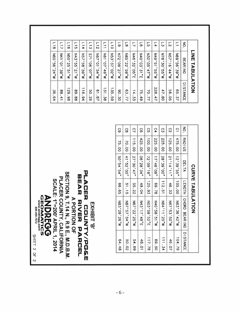
- 6 -

02898.357 3061165v2 - 1 -
A notary public or other officer completing this certificate verifies only the identity of the individual who signed the document to which this certificate is attached, and not the truthfulness, accuracy, or validity of that document.
State of California ) County of _______________ )
On ____________________, before me, ____________________________, a Notary Public, personally appeared _______________________________, who proved to me on the basis of satisfactory evidence to be the person(s) whose name(s) is/are subscribed to the within instrument and acknowledged to me that he/she/they executed the same in his/her/their authorized capacity(ies), and that by his/her/their signature(s) on the instrument the person(s), or the entity upon behalf of which the person(s) acted, executed the instrument.
I certify under PENALTY OF PERJURY under the laws of the State of California that the foregoing paragraph is true and correct.
WITNESS my hand and official seal.
Signature

Advice 4728-E
Attachment C
Conservation Easement

02898.357 3061136v1 Page 1 of 22
Recorded at the request of, and when recorded return to: Placer Land Trust Attn: Executive Director 11661 Blocker Drive, Suite 110 Auburn, CA 95603
DEED OF CONSERVATION EASEMENT (Bear River Pinecroft Reserve, Placer County)
On this ______ day of ________, the County of Placer, a political subdivision of the State of California , having an address at 11476 C Avenue, Auburn, CA, 95603 (hereinafter the “Grantor”), for full and fair consideration paid, hereby grants to Placer Land Trust, a California nonprofit public benefit corporation, having an address at 11661 Blocker Drive, Suite 110, Auburn, CA, 95603 (hereinafter the “Grantee”) the following described conservation easement (hereinafter the “Easement”) on real estate in the County of Placer in the State of California, currently designated as portions of Placer County Assessor’s Parcel Number 101-120-001, and more particularly described in Exhibit A, attached hereto and made a part hereof by reference (hereinafter the “Property”), exclusively for the purpose as follows: 1. PURPOSE. The purpose of this Easement (hereinafter the “Purpose”) is to protect and
preserve the Conservation Values (as defined in Exhibit C herein) in perpetuity by preventing any use of the Property that will significantly impair the Conservation Values. Grantor and Grantee intend that, subject to the provisions of this Easement, this Easement will confine the use of the Property only to such activities that are consistent with the Purpose and terms of this Easement.
As used in this Easement, the term “impair” or “impairment” means to diminish in
quantity, quality, value, strength or viability. As used in this Easement, the term “significantly” or “significant,” when used with “impair” and “impairment” respectively, means a greater than negligible adverse impact, for more than a transient period.
It is intended that this Easement shall allow uses on the Property that are consistent with
the protection and preservation of each of the Conservation Values in harmony with each other. While permitted actions required or taken to protect and preserve one or more individual Conservation Values may impair, on an individual and stand-alone basis, one or

02898.357 3061136v1 Page 2 of 22
more other Conservation Values, Grantor and Grantee understand that achieving the Purpose requires the preservation and protection, on balance, of all of the Beneficial Public Values actually existing on the Property outside the Building Envelope, to the extent possible. It is recognized that in protecting and/or enhancing one or more of the Conservation Values, another ConservationValue may be impaired, but this is not meant to be a permanent occurrence, nor a reason to re-prioritize one Conservation Value over another. All attempts should be made to balance on a collective basis, the Conservation Values on the whole property whenever possible. This Easement prohibits the use of the Property for any purpose that would significantly impair the Purpose on a collective, not individual, basis, taking into account the relative condition and quality of each of the Conservation Values on the Property as of the Effective Date.
2. RECITALS. The following recitals are incorporated in this Easement.
A. The Grantor is the sole owner in fee simple of the Property, which consists of two
separate non-contiguous parcels totaling approximately 10.12 acres of land. B. Grantee is a publicly supported, tax-exempt nonprofit public benefit organization under
Section 501(c)(3) and qualified to acquire and hold conservation easements for public benefit under Section 170(h), respectively, of the Internal Revenue Code of 1986, as amended, and the regulations promulgated thereunder (hereinafter the “Internal Revenue Code”). Grantee is also qualified to acquire and hold conservation easements in California under Sections 815 and 816 of the California Civil Code. Grantee’s primary purpose is the preservation of natural and agricultural land in Placer County.
C. Pacific Gas and Electric Company, a public utility corporation (hereinafter “PG&E”),
transferred to Grantor fee title in the Property in accordance with that certain Grant Deed, recorded in the Official Records of the County of Placer, concurrently with the recording of this Easement (hereinafter the “Grant Deed”), attached hereto as Exhibit B and incorporated herein by reference, subject to PG&E’s reservation of certain rights in and to the Property, as set forth in the Grant Deed (hereinafter “PG&E Reserved Rights”).
D. PG&E transferred fee title to the Property to Grantor in connection with PG&E’s
implementation of the “Land Conservation Commitment,” defined below, provided for in the following documents and described more fully below:
(a) That certain Settlement Agreement (hereinafter the “Settlement Agreement”) as modified and approved by the Public Utilities Commission of the State of California (hereinafter the “Commission”) in its Opinion and Order of December 18, 2003 (Decision 03-12-035); and
(b) That certain Stipulation Resolving Issues Regarding the Land Conservation Commitment dated September 25, 2003 (hereinafter the “Stipulation”).
E. The Settlement Agreement and the Stipulation (hereinafter, collectively, the “Governing
Documents”) require PG&E to ensure that approximately 140,000 acres of watershed lands, all located in California and owned by PG&E as of the date the Governing

02898.357 3061136v1 Page 3 of 22
Documents were entered into (hereinafter, collectively, the “Watershed Lands”), are conserved for a broad range of beneficial public values, including the protection of the natural habitat of fish, wildlife and plants; the preservation of open space; outdoor recreation by the general public; sustainable forestry; agricultural uses; and historic values (hereinafter, collectively, the “Beneficial Public Values” or “BPVs”). The Stipulation provides that the conservation easements will preserve or enhance reasonable public access. Land Conservation Commitment constitutes the obligations of PG&E to convey fee title and conservation easements to Watershed Lands, and to protect the Beneficial Public Values of the Watershed Lands, as well as certain other obligations related thereto (hereinafter the “Land Conservation Commitment”), as set forth in detail in the Governing Documents.
F. The Property is included in the Watershed Lands, and contains significant natural
values of great importance to Grantor, Grantee, the people of Placer County and the State of California. The Property includes the specific Beneficial Public Values identified on Exhibit C attached hereto and incorporated herein by reference (hereinafter, collectively, the “Conservation Values”). The Conservation Values are further described in the Baseline Documentation Report for Bear River Pinecroft Reserve, Placer County, dated ______, incorporated by this reference and on file in the office of the Grantee (hereinafter the “Baseline Documentation Report”), which consists of reports, maps, photographs, and other documentation that the Grantor and Grantee agree provide, collectively, an accurate representation of the Property and the existing Beneficial Public Values at the time of this Easement and which is intended to serve as an objective, though nonexclusive, information baseline for monitoring compliance with the terms of this Easement.
G. The protection of the Property is consistent with multiple goals and objectives of the
State of California. The Legislature of the State of California, as set forth in California Civil Code section 815 et seq., has found and declared it to be the public policy and in the public interest of this state to encourage the preservation of land predominantly in its natural, scenic, agricultural, historical, forested, or open space condition.
H. The protection of the Property is consistent with the County of Placer’s public policy to
“protect and conserve open space, natural resources and agricultural lands throughout the county” and is consistent with the goals of the Placer County General Plan (1994) and the Placer Legacy Open Space and Agricultural Conservation Program (2000).
I. The Governing Documents require that conservation easements include an express
reservation of a right for continued operation and maintenance of hydroelectric facilities and associated water delivery facilities, including, project replacements and improvements required to meet existing and future water delivery requirements for power generation and consumptive water use by existing users, compliance with any Federal Energy Regulatory Commission (hereinafter the “FERC”) license, FERC license renewal or other regulatory requirements.

02898.357 3061136v1 Page 4 of 22
J. The Governing Documents also include a requirement that conservation easements encumbering Watershed Lands honor existing agreements for economic uses, including consumptive water deliveries; however, in the case of this Property, there are no such agreements in existence as of the date of this Easement.
K. Pursuant to the Governing Documents, the Pacific Forest and Watershed Lands
Stewardship Council, a California nonprofit public benefit corporation (hereinafter the “Stewardship Council”), was created to oversee and carry out the Land Conservation Commitment. Pursuant to the Governing Documents, the Stewardship Council developed a plan for protection of the Watershed Lands for the benefit of the citizens of California (hereinafter the “Land Conservation Plan” or “LCP”). The LCP includes, among other things, objectives to preserve and/or enhance the Beneficial Public Values identified on each parcel of Watershed Lands, including the Property.
L. Grantor and Grantee each desires through this Easement to ensure the permanent
protection of the Conservation Values on the Property, subject to PG&E’s Reserved Rights, and subject to those specific rights permitted in the Easement, including but not limited to those permitted in the Building Envelope, as further described and depicted in Exhibit D, attached hereto and made a part hereof by reference (hereinafter the “Building Envelope”). Grantor and Grantee further intend to continue to permit compatible and beneficial uses of the Property including but not limited to outdoor recreation by the general public and a residence for a caretaker to manage the Property.
M. Grantor and Grantee intend that Grantor’s management of the Property shall further be
subject to that certain Management Plan for Bear River Pinecroft Reserve, Placer County, dated _____, 2014, as it may be amended, an adaptive management document containing specific terms and conditions that may change over time upon the agreement of Grantor and Grantee, that is completely subservient to this Easement, located on file at the offices of both Grantor and Grantee, an incorporated by this reference (“Management Plan”).
N. In furtherance of the Land Conservation Commitment and the above-described public
policy purposes, Grantor intends, as owner of the Property, to convey to Grantee the right to preserve and protect the Conservation Values of the Property in perpetuity according to the terms and conditions of this Easement.
3. INCORPORATION OF PURPOSE AND RECITALS.
NOW THEREFORE, in consideration of the foregoing Purpose and Recitals, for the benefit of the general public, and pursuant to the laws of the State of California; the Grantor and Grantee have established this Easement on, over, and across the Property consisting of the foregoing Purpose and Recitals and the following terms, covenants, restrictions, conditions, exhibits, and affirmative rights that the Grantor has voluntarily granted to Grantee, which shall run with and bind the Property in perpetuity.
4. RESTRICTIONS AND RESERVED RIGHTS. To further accomplish the Purpose of this

02898.357 3061136v1 Page 5 of 22
Easement, the Grantor and Grantee agree to the following restrictions and reserved rights.
4.1 Subdivision. The Property shall remain in unified ownership, which may be joint or undivided, but without division, subdivision, partition or other legal or de facto creation of lots or parcels in separate ownership. The foregoing does not prohibit the lease of all or a portion of the Property if otherwise consistent with the terms of this Easement.
4.2 Development. No new structures, temporary or permanent, may be constructed,
located, placed, or installed on the Property, with the following exceptions.
(a) Recreational and Maintenance Structures and Improvements. Grantor reserves to itself and its successors and assigns the following development rights and allowable activities, as specifically allowed and described in the Management Plan: the right to construct, erect, install, maintain, alter, improve, remove, and replace recreational and maintenance structures and improvements that are necessary to facilitate the recreational use of the Property as part of the Conservation Values, including but not limited to, boundary monuments, fences, gates, benches, interpretive kiosks and displays, hardscape or natural trails, bollards, boardwalks and bridges, and a water system to provide water to visitors of the Property and the nearby Bear River Campground.
(b) Building Envelope. In addition to the rights and activities described in Section
4.2(a) above, Grantor reserves to itself and its successors and assigns the right to construct, erect, maintain, alter, improve, remove, and replace structures and improvements within the Building Envelope, as defined, set forth, and limited by the terms in Exhibit D.
(c) Property Signage. Property signage as required by PG&E, Stewardship Council,
Commission, Grantor or Grantee to acknowledge persons or organizations contributing funds or approval for the creation of the Easement or the protection of the Property is allowed as generally described in the Management Plan. Signs clarifying allowed or prohibited uses, interpretive and educational signs, directional and informational signs, signs as needed for Americans with Disabilities Act compliance or for public health and safety, and warning signs for waterways, are allowed.
4.3 Transfer of Rights. All rights to develop or use the Property that are specifically
prohibited in this Easement or otherwise inconsistent with the Purpose of this Easement are extinguished, and cannot be used now or in the future to use or transfer development rights to other land not subject to this Easement, or to permit, entitle or otherwise facilitate increased development density or increased natural resource use or extraction on other land not subject to this Easement.
4.4 Land Use. Land uses that significantly impair the Conservation Values of the Property
or are inconsistent with the Purpose of this Easement are prohibited. Without limiting the generality of the foregoing, the following land uses and activities on the Property

02898.357 3061136v1 Page 6 of 22
are expressly prohibited:
(a) Industrial activity. Any and all industrial activity on the Property is prohibited. (b) Mining and excavation activity. Mining and the removal or extraction of soil or
minerals from the Property is prohibited. Filling, excavating, draining, dredging, mining, drilling, removing, exploring for or extracting minerals, loam, gravel, soil, rock, sand or other material on or below the surface of the Property, or granting or authorizing surface entry for any of these purposes, is prohibited. However, Grantor reserves the right to permit limited excavation of the surface of the Property to create recreational and maintenance structures and improvements as described in Sections 4.2(a) and 4.2(b) above, or for ecological or scientific research or archaeological investigation, if conducted under then current generally accepted professional standards without adverse impact to the Conservation Values.
(c) Commercial activity. Any and all commercial activity on the Property is
prohibited, except for activities that enhance or protect the Conservation Values. (d) Overgrazing. Overgrazing, as further defined in the Management Plan, is
prohibited. (e) Irrigation. Irrigation outside of the Building Envelope is prohibited, except as
necessary to facilitate restoration and enhancement of natural habitat and approved by Grantee.
(f) Off-road motorized vehicles. The use of motorized vehicles off of established road
is prohibited, except: (i) if by Grantor or under the Grantor’s control for property management, or (ii) if the use of motorized vehicles is by Grantee for the purposes of monitoring and enforcing this Easement.
(g) Roads. The construction or creation of new roads and/or parking area for the
public to access the Property for recreational use, or as necessary to properly manage and maintain the Property and its Conservation Values, is prohibited, unless included in the Management Plan or approved in advance by Grantee. Maintenance of existing roads is allowed.
(h) Dumping. The dumping or accumulation of trash, ashes, garbage, inoperative or
unserviceable vehicles, equipment or parts thereof, waste, or other debris on the Property including, without limitation Hazardous Materials, is prohibited. For the purposes of this instrument, “Hazardous Materials” shall mean any substance defined, listed, or otherwise classified pursuant to any federal, state, or local law, regulations, or requirements as hazardous, toxic, polluting, or otherwise contaminating to the air, water, or soil, or in any way harmful or threatening to human health or the environment. This prohibition shall not be construed to prevent the use, storage, or disposal of organic matter or compost that does not significantly impair the Conservation Values. No filling, dumping, excavation, or other alteration may be made to the surface or subsurface of the Property or to its
02898.357 3061136v1 Page 7 of 22
surface waters or wetlands; except as may be necessary to create recreational and maintenance structures and improvements as described in Sections 4.2(a) and 4.2(b) herein, or for ecological or scientific research or archaeological investigation, if conducted under the current generally accepted professional standards without adverse impact to the Conservation Values.
4.5 Water Quality and Water Protection. Activities and uses otherwise permitted under
this Easement, which result in significant damage or degradation of water quality, are prohibited. Stockpiling animal wastes, compost, loose soil or toxic materials in a manner whereby runoff or leakage adversely affects water quality, is prohibited. Discharge of any septic waste, wastewater, toxic waste, pollution, or other environmentally harmful substances into surface waters, springs or drainages on the Property is prohibited.
4.6 Water and Mineral Rights. Grantor warrants that the Property includes all surface
and subsurface mineral rights, including all mining and quarrying rights and all right to excavate or remove subsurface oil, gas, and other minerals, all geothermal energy rights (hereinafter, collectively the “Mineral Rights”). To the best of Grantor’s knowledge, the Property includes all water and water rights, ditches and ditch rights, springs and spring rights, reservoir and storage rights, wells and groundwater rights, and other rights in and to the use of water historically used on the or otherwise appurtenant to the Property (hereinafter, collectively, the “Water Rights”).
Grantor reserves all Water Rights, provided that such Water Rights, if any, are used on
the Property in a manner not inconsistent with the purpose and terms of this Easement, and provided that any and all Water Rights necessary to maintain or restore the Conservation Values are used accordingly.
Grantor shall not transfer, encumber, sell, lease, or otherwise separate the Mineral
Rights or Water Rights from the Property, or in the case of Water Rights, in any way diminish or reduce the historic use of the Water Rights, without the consent of the Grantee. Grantor shall not abandon or allow the abandonment of, by action or inaction, any of the Water Rights without the consent of the Grantee.
4.7 Surface Alterations. As of the date of this Easement, there are surface alterations on
the Property, as documented in the Baseline Documentation Report. Any new alteration to the surface of the Property is prohibited, with the exception of the following reserved rights of the Grantor:
(a) Grantor reserves the right to make new surface alterations reasonably necessary to
manage the Property, to enhance or restore habitat consistent with the Conservation Values, and to create and maintain recreational and maintenance structures and improvements as described in Sections 4.2(a) and 4.2(b) above, provided the alterations do not significantly impair the Conservation Values.
(b) Subject to Exhibit D, the Grantor reserves the right to make surface alterations
within the Building Envelope.

02898.357 3061136v1 Page 8 of 22
4.8 Fire Suppression. This Easement shall not prohibit Grantor from complying with any
applicable local, state, and federal laws or guidelines regarding the prevention and suppression of wildfire.
4.9 Public Access and Informal Uses. Grantor and Grantee recognize that the Property
has been used by third parties for recreational, cultural, and other non-commercial or informal purposes without formal written agreements to conduct such activities (hereinafter “Informal Uses”). Grantor and Grantee further recognize that access to the Property is inherent or may be inherent in the enjoyment of the Conservation Values and the Informal Uses. Consistent with the objectives articulated in the Governing Documents to provide continued reasonable access by the public to the Watershed Lands, Grantor shall allow public access to the Property that is substantially consistent with the public access existing on the Effective Date of this Easement. Grantor reserves the right to make reasonable rules and regulations to control, limit, or, as necessary, exclude Informal Uses and public access. Grantor shall not allow Informal Uses that significantly impair the Conservation Values.
As outlined in paragraph 5(b) herein, Grantee or its designee may access the Property
for purposes of monitoring and enforcing this Easement. Additionally, Grantee or its designee may lead educational tours as allowed, limited, and described in the Management Plan.
If Grantor desires to allow new public access or Informal Uses or expansion of public
access or Informal Uses on the Property, Grantee’s advance written approval is required, which approval shall not be unreasonably withheld.
Grantor and Grantee claim all of the rights and immunities against liability for injury to
the fullest extent allowable by law. As part of Grantee’s annual compliance monitoring, (a) Grantor and Grantee shall
consult on the known Informal Uses and public access on the Property for the purpose of Grantee’s assessment of Grantor’s compliance with the requirements set forth above in this section; and (b) with respect to known Informal Uses and public access on the Property, Grantor and Grantee will consult and develop recommendations, if any, regarding the necessity of controlling, limiting, or excluding Informal Uses or public access to ensure the preservation of the Conservation Values.
4.10 PG&E Reserved Rights. All rights and obligations of Grantor and Grantee under this
Easement are subject to the PG&E Reserved Rights specified in the Grant Deed in Exhibit B. In the event PG&E notifies Grantor of its intention to exercise any of the PG&E Reserved Rights, Grantor shall notify Grantee, in writing, of said intention within sixty (60) days.
4.11 Cultural Resources. There shall be no activities, actions or uses that disturb or impair
any cultural resources (as defined in Title XIV of the California Code of Regulations)
02898.357 3061136v1 Page 9 of 22
on the Property in violation of any applicable law, statute or regulation.
5. GRANTEE’S AFFIRMATIVE RIGHTS. To accomplish the purpose of this Easement the following rights are conveyed to Grantee by this Easement:
(a) To identify, preserve and protect the Conservation Values, and to prevent any activity on
or use of the Property that is inconsistent with the Purpose of this Easement. (b) To access, enter upon, monitor, inspect, observe, and study the Property, including the
right to access the Property, including the Building Envelope, by motorized vehicle over and on roads owned by Grantor and any rights-of-way or other access ways now or hereafter available to Grantor for access to the Property, at reasonable times not more often than four times per year except when necessary to prevent a violation or potential violation of the terms of this Easement or to monitor and observe specific activities to ensure compliance with the terms of this Easement. Grantor shall provide Grantee with keys, combinations, instructions or other means to open any locked gates that are on the Property and/or that are necessary to access the Property. Grantee will make reasonable efforts to notify Grantor prior to entry onto the Property except when immediately necessary to prevent a violation of the terms of this Easement. Notwithstanding anything to the contrary contained herein, Grantee when entering or traveling on the Property for inspection or monitoring purposes shall be entitled to travel on all existing roads on the Property.
(c) To prevent any activity on, use of or practice on the Property that is inconsistent with the
purpose and terms of this Easement and to require the restoration of such areas or features of the Property that may be damaged by any inconsistent activity or use, pursuant to the remedies set forth in Section 8 below.
(d) To require that Grantor’s reserved rights be exercised in a manner that does not
significantly impair the Conservation Values. (e) To erect and maintain Property signage as described in the Management Plan. (f) To pursue damages from third parties for damage to the Conservation Values, but not to
the exclusion of any right of the Grantor to seek damages or relief from any third party for damage to the Property.
6. RIGHTS OF LANDOWNER. In addition to any specific reserved rights set forth in
Section 4 above, Grantor reserves to itself, its representatives, assigns, and all future transferees, all rights accruing from its ownership of the Property, including the right to engage in, or permit or invite others to engage in, all uses of the Property that do not significantly impair the Conservation Values, are not expressly prohibited herein, and are not inconsistent with the Purpose of this Easement. Without limiting the generality of the foregoing, the following activities and uses are specifically reserved as Grantor’s rights as owner of the Property: (a) The ownership and right to sell or transfer the Property in its entirety.

02898.357 3061136v1 Page 10 of 22
(b) Those rights relative to the Building Envelope specified in the Easement. (c) The right to control predatory and invasive animals (including feral pigs) by the use of
selective control techniques. (d) The right to utilize the Property for recreational or educational purposes that do not
significantly impair the Conservation Values and that require or cause no significant surface alteration or other development or impairment of the land outside of the Building Envelope.
(e) All rights for the management and improvement of the Property that are specifically
allowed by the Management Plan and otherwise consistent with the terms of this Easement.
7. NOTICE TO GRANTEE, GRANTEE APPROVAL.
7.1 Means of Notice. Any notices to Grantee required in this Easement shall be sent by first class postage prepaid mail, or other courier providing reliable proof of delivery, or served personally to the following person and address, or other person or address as may be hereafter specified:
Placer Land Trust Attn: Executive Director 11661 Blocker Drive, Suite 110 Auburn, CA 95603
All other communication shall be made by reasonable means under the circumstances,
provided that facsimile and electronic mail (hereinafter “E-mail”) will not be deemed received unless accompanied by delivery of one of the foregoing methods. For routine communication, Grantee may be contacted by telephone, facsimile, or E-mail as follows:
Telephone: (530) 887-9222 Facsimile: (530) 888-7720
E-mail: [email protected] It shall be the duty and responsibility of the Grantee, or its assigns, representatives or
successors to notify the Grantor of any and all change of address to which legal notice is to be directed, in writing, by certified U.S. Mail, or other such equivalent mail delivery, within thirty (30) days of such change. Grantee will also endeavor to inform Grantor of any other changes to its contact information.
7.2 Purpose and Content of Notice. The purpose of requiring Grantor to notify Grantee
prior to undertaking certain activities as permitted and limited in Sections 4 and 6 above, is to afford Grantee an adequate opportunity to monitor the activities in question to ensure that they are designed and carried out in a manner consistent with the terms and Purpose of this Easement. Further, the purpose of notice is to prevent Easement

02898.357 3061136v1 Page 11 of 22
violations through a cooperative approach. Notices to Grantee or requests for Grantee consent, required or contemplated hereunder, must include, at a minimum, sufficient information, including the nature, scope, design, location, timetable, and any other material aspect of the proposed activity, in sufficient detail to enable Grantee to determine whether proposed plans are consistent with the requirements of this Easement.
7.3 Process of Notice and Approval. Whenever notice to Grantee is required, and unless
otherwise specified to the contrary in this Easement, Grantor shall notify Grantee in writing not less than 30 days prior to the date Grantor intends to undertake the activity in question. Where Grantee’s approval is required, as in Section 4 above, Grantee shall grant or withhold its approval in writing within 30 days of receipt of Grantor’s written request therefore. Grantee’s approval may be withheld only upon a reasonable determination by Grantee that the action as proposed would be inconsistent with the Purpose of this Easement and the protection of the Conservation Values.
7.4 Failure to Respond. If Grantee approval is required under the terms of this Easement
prior to the exercise of a reserved right that is the subject of the notification and request for approval, failure of Grantee to respond within thirty (30) days shall be deemed to be approval of any activity proposed in such notice.
7.5 Transfers of Ownership. Grantor may transfer of any interest in the Property,
including but not limited to any sale, gift, conveyance, or phased transfer subject to Grantee’s approval and the conditions herein; provided, however, Grantee shall not convey any additional conservation easement interest, deed restriction or other property interest that imposes any additional restrictions on any specific Conservation Value that modifies in any way the balancing of all of the Conservation Values required under Section 1 herein. Grantor agrees to give written notice to Grantee of the intended transfer at least sixty (60) days prior to the date of such transfer. Prior to any such transfer, Grantor shall provide written notice to the prospective transferee(s) that the Property is subject to this Easement, with a copy of this notice provided to Grantee. Prior to Grantor’s transfer of the Property, Grantor shall pay, or cause to be paid, to Grantee an unrestricted sum of Ten Thousand Dollars ($10,000.00) in consideration of the increased cost of Easement stewardship. If Grantor fails to provide the notice and $10,000.00 as required herein, Grantee may withhold approval of the transfer. Grantor shall provide Grantee with written proof of any transfer of ownership within fifteen (15) days after the date of any such transfer, which notice shall include a certified copy of the grant deed.
8. GRANTEE’S REMEDIES.
8.1 Corrective Action. If Grantee determines that a violation of the terms of this Easement has occurred or is threatened or impending, Grantee shall give written notice to Grantor within three (3) business days of Grantee’s determination. If the violation has occurred, Grantee has the right and authority to demand corrective action from the party causing the violation, sufficient to cure the violation and, where the violation involves injury to

02898.357 3061136v1 Page 12 of 22
the Property resulting from any use or activity inconsistent with the purpose of this Easement, to restore the portion of the Property so injured to its prior condition in accordance with a plan approved by Grantee.
8.2 Injunctive Relief. If Grantor fails to cure the violation within 30 days after receipt of
notice thereof from Grantee, or under circumstances where the violation cannot reasonably be cured within a 30-day period, fails to begin curing such violation within the 30-day period, or fails to continue diligently to cure such violation until finally cured, Grantee may bring an action at law or in equity in a court of competent jurisdiction to enforce the terms of this Easement, to enjoin the violation, ex parte as necessary, by temporary or permanent injunction, and to require the restoration of the Property to the condition that existed prior to any such injury. Nothing in this Easement shall be construed to impair Grantee’s right to seek temporary or permanent injunctive relief, including emergency relief, ex parte as necessary, to enforce the terms of this Easement against a violation or threatened violation hereof.
8.3 Damages. Grantee shall be entitled to recover actual damages from Grantor for actions
by Grantor in violation of the terms of this Easement or causing injury to any Conservation Values protected by this Easement, including, without limitation, actual damages for the loss of scenic, aesthetic, or environmental values. Without limiting Grantor’s liability therefor, Grantee, in its sole discretion, may apply any damages recovered to the cost of undertaking any corrective action on the Property. In any action brought to enforce the obligations of Grantor under this Agreement, the judgment or decree shall be enforceable as far as the issue of monetary damages only in an amount not to exceed the value of the Property as determined by an appraisal process as generally set forth in Section 13.2 herein.
8.4 Emergency Enforcement. If Grantee, in its reasonable discretion, determines that
immediate action is required to prevent or mitigate significant damage to the Conservation Values of the Property, Grantee may pursue its remedies under this Section 8 without prior notice to Grantor or without waiting for the period provided for cure to expire. In the event Grantee takes action pursuant to this Section, Grantee shall as soon as reasonably practical give notice to Grantor of the situation giving rise to the need for immediate action and the action taken and to be taken.
8.5 Scope of Relief. Grantee’s rights under this Section 8 apply equally in the event of
either actual or threatened violations of the terms of this Easement. Grantor agrees that Grantee’s remedies at law for any violation of the terms of this Easement are inadequate and that Grantee shall be entitled to the injunctive relief described in paragraph 8.2 above, both prohibitive and mandatory, in addition to such other relief to which Grantee may be entitled, including specific performance of the terms of this Easement, without the necessity of proving either actual damages or the inadequacy of otherwise available legal remedies. Grantee’s remedies described in this Section 8 shall be cumulative and shall be in addition to all remedies now or hereafter existing at law or in equity.

02898.357 3061136v1 Page 13 of 22
8.6 Costs of Enforcement. All reasonable costs incurred by Grantee in enforcing the terms of this Easement against Grantor following a breach by Grantor of the terms of this Easement that remains uncured after the expiration of the cure period, including, without limitation, costs and expenses of suit and reasonable attorneys’ fees, and any costs of restoration necessitated by Grantor’s violation of the terms of this Easement shall be borne by Grantor; provided, however, that if Grantor ultimately prevails in a judicial enforcement action Grantee shall pay all costs and expenses of suit and reasonable attorneys’ fees incurred by Grantor in the defense of such action. Grantor or Grantee, as applicable, shall reimburse the prevailing party for any reasonable costs of enforcement, including court costs, reasonable attorney’s fees, and any other payments ordered through mediation as described in Section 10 below, or as ordered by a court of competent jurisdiction.
8.7 Forbearance. Forbearance by Grantee to exercise its rights under this Easement in the
event of any breach of any term of this Easement by Grantor shall not be deemed or construed to be a waiver by Grantee of such term or of any subsequent breach of the same or any other term of this Easement or of any of Grantee’s rights under this Easement. No delay or omission by Grantee in the exercise of any right or remedy upon any breach by Grantor shall impair such right or remedy or be construed as a waiver.
8.8 Acts Beyond Grantor’s Control. Nothing contained in this Easement shall be
construed to entitle Grantee to bring any action against Grantor for any injury to or change in the Property resulting from natural environmental causes beyond Grantor’s control, including, without limitation, fire, flood, storm, and earth movement caused by earthquake, or from any prudent action taken by Grantor under emergency conditions to prevent, abate, or mitigate significant injury to the Property resulting from such causes. In addition, Grantor shall have no liability under this Easement to prevent or remediate any naturally-occurring deterioration or degradation of the Conservation Values or damage to the Property or Conservation Values caused by acts of Grantee or third parties; provided that Grantor shall have taken reasonably prudent landowner actions to prevent such damage caused by third parties.
9. NOTICE TO GRANTOR.
9.1 Means of Notice. Any notices to Grantor required in this Easement shall be sent by first class postage prepaid mail, or other courier providing reliable proof of delivery, or served personally to the following person and address, or other person or address as may be hereafter specified:
County of Placer Facility Services Department Attention: Property Manager 11476 C Avenue Auburn, CA 95603 Telephone: (530) 886-4900 Fax: (530) 889-6857

02898.357 3061136v1 Page 14 of 22
It shall be the duty and responsibility of the Grantor, or its heirs, assigns,
representatives or successors to notify the Grantee of any and all change of address to which legal notice is to be directed, in writing, by certified U.S. Mail, or other such equivalent mail delivery, within 30 days of such change. Grantor will also endeavor to inform Grantee of any other changes to their contact information.
Any notices to Sierra Nevada Conservancy (“SNC”), as relates to Section 12.2 herein,
shall be sent by first class postage prepaid mail, or other courier providing reliable proof of delivery, or served personally to the following person and address, or other person or address as may be hereafter specified:
Sierra Nevada Conservancy Attention: Executive Director 11521 Blocker Drive, Suite 205 Auburn, CA 95603
9.2 Grantor’s Designee. In the event that the Property is ever owned by a public or quasi-
public agency, trust, business entity, or any common or jointly held ownership, the Grantor shall provide Grantee with written notice of a designated representative, who shall be responsible for the receipt of notices on behalf of Grantor hereunder. The approval of, or notice to, the designated representative shall be deemed the approval of, or notice to, the entity or all owners, as the case may be.
10. MEDIATION. If a dispute arises between the Grantor and Grantee (hereinafter, each
individually a “Party”, and collectively the “Parties”) concerning use or activities on the Property, or the terms and conditions of this Easement, either Party may refer the dispute to mediation by request made in writing to the other, and the Parties agree not to proceed with the use or activity pending resolution of the dispute. Within ten (10) days of the receipt of such a request, the Parties shall select a single trained and impartial mediator. If the Parties are unable to agree on the selection of a single mediator, then the Parties shall, within fifteen (15) days of receipt of the initial request, jointly apply to a proper court for the appointment of a trained and impartial mediator. Mediation shall then proceed in accordance with the following guidelines: (a) Purpose. The purpose of the mediation is to: (i) promote discussion between the Parties;
(ii) assist the Parties to develop and exchange pertinent information concerning the issues in dispute; and (iii) assist the Parties to develop proposals which will enable them to arrive at a mutually acceptable resolution of the controversy. The mediation is not intended to result in any express or de facto modification or amendment of the terms, conditions, or restrictions of this Easement.
(b) Participation. The mediator may meet with the Parties and their counsel jointly or ex
parte. The Parties agree that they will participate in the mediation process in good faith and expeditiously, attending all sessions scheduled by the mediator. Representatives of the Parties with settlement authority will attend mediation sessions as requested by the mediator.

02898.357 3061136v1 Page 15 of 22
(c) Confidentiality. All information presented to the mediator shall be deemed confidential
and shall be disclosed by the mediator only with the consent of the Parties or their respective counsel. The mediator shall not be subject to subpoena by any Party. No statements made or documents prepared for mediation sessions shall be disclosed in any subsequent proceeding or construed as an admission of a Party.
(d) Time Period. Neither Party shall be obligated to continue the mediation process beyond
a period of ninety (90) days from the date of receipt of the initial request or if the mediator concludes that there is no reasonable likelihood that continuing mediation will result in a mutually agreeable resolution of the dispute.
(e) Costs. The costs of the mediator shall be borne equally by Grantor and Grantee; the
Parties shall bear their own expenses, including attorneys’ fees, individually. 11. COSTS, LIABILITIES, TAXES AND ENVIRONMENTAL COMPLIANCE.
11.1 Control. Grantor acknowledges that Grantee has neither possessory rights in the Property, nor any responsibility or right to control, maintain, or keep up the Property other than those rights assigned to Grantee in Section 5 above, and those rights assigned to Grantee in the Management Plan. Nothing in this Easement shall be construed as giving rise, in the absence of a judicial decree, to any right or ability in Grantee to exercise physical or managerial control over the day-to-day operations of the Property, or any of Grantor’s activities on the Property, or otherwise to become an “owner” or “operator” with respect to the Property within the meaning of the Comprehensive Environmental Response, Compensation and Liability Act of 1980, as amended (42 USCA Section 9601 et seq.) or any successor or related law (hereinafter “CERCLA”), and corresponding state statute.
11.2 Taxes. Grantor shall pay and discharge before delinquency all taxes, assessments,
fees, and charges of whatever description levied on or assessed against the Property and any uses thereof by competent authority (hereinafter, collectively “Taxes”), including any Taxes imposed upon, or incurred as a result of, this Easement, and shall furnish Grantee with satisfactory evidence of payment upon request. Grantee may, at its discretion, pay any outstanding Taxes and shall then be entitled to reimbursement by Grantor.
11.3 Monetary Liens and Mortgages. Grantor represents that as of the date of this grant,
there are no monetary liens or mortgages outstanding against the Property. Grantor has the right to use the Property as collateral to secure the repayment of debt, provided that any lien or other rights granted for such purpose, regardless of date, are subordinate to Grantee’s rights under this Easement. Under no circumstances may Grantee’s rights be extinguished or otherwise affected by the recording, foreclosure, or any other action taken concerning any subsequent lien or other interest in the Property, including without limitation those arising out of any work performed for, materials furnished to, or obligations incurred by Grantor.

02898.357 3061136v1 Page 16 of 22
11.4 Hold Harmless. Grantor shall indemnify, defend, and hold harmless Grantee and its members, directors, officers, employees, agents, and contractors and the heirs, personal representatives, successors, from and against any and all liabilities, penalties, fines, charges, costs, losses, damages, expenses, causes of action, claims, demands, orders, judgments, or administrative actions, including, without limitation, reasonable attorneys’ fees, arising from or in any way connected with: (1) injury to or the death of any person, or physical damage to any property, resulting from any act, omission, condition, or other matter related to or occurring on or about the Property, in each case, due solely to the acts of Grantor and its employees, agents, and contractors and the heirs, personal representatives, successors; (2) the violation or alleged violation of, or other failure to comply with, any state, federal, or local law, regulation, or requirement, including, without limitation, CERCLA and corresponding state statute by Grantor and its employees, agents, and contractors and the heirs, personal representatives, successors, in any way affecting, involving, or relating to the Property; and (3) the release in, on, from, or about the Property by Grantor and its employees, agents, and contractors and the heirs, personal representatives, successors, at any time, of any substance now or hereafter defined, listed, or otherwise classified pursuant to any federal, state, or local law, regulation, or requirement as hazardous, toxic, polluting, or otherwise contaminating to the air, water, or soil, or in any way harmful or threatening to human health or the environment.
11.5 Liability Insurance. Grantor retains all responsibilities and shall bear all costs and
liabilities of any kind related to the ownership, operation, upkeep, and maintenance of the Property, including the maintenance of adequate liability insurance coverage. Grantor shall provide Grantee with a certificate of insurance naming Grantee as additional insured.
11.6 Permits and Applicability of Other Laws. Grantor remains solely responsible for
obtaining any applicable governmental permits and approvals for any construction or other activity or use permitted by this Easement, and all such construction or other activity or use shall be undertaken in accordance with all applicable federal, state, and local laws, regulations, and requirements. Nothing herein shall be construed to: (i) supersede or exempt the Property from the application of laws and regulations affecting land uses on the Property, or to (ii) permit any activity otherwise prohibited by existing or future laws and regulations imposed by any federal, state, or local government or governmental agency having jurisdiction of the Property, or to (iii) prohibit the imposition of further land use restrictions consistent with the terms of this Easement and Management Plan by Grantor or by operation of law.
11.7 Environmental Laws and Remediation. Grantor is solely responsible, and Grantee
has no responsibility whatsoever, for the operation of the Property or the monitoring of hazardous and other conditions thereon. Grantor is solely responsible for compliance with any federal, state, local, or administrative agency statute, regulation, rule, ordinance, order, or requirement relating to environmental conditions or hazardous substances. Notwithstanding any other provision of this Easement to the contrary, the Parties do not intend, and the Easement shall not be construed, such that it creates in

02898.357 3061136v1 Page 17 of 22
the Grantee obligations or liabilities of a person described in 42 U.S. Code Section 9607(a)(3) or any successor or related law.
If there occurs a release in, on, or about the Property of any substance which causes
damage to the values protected by this Easement and either Grantor caused the release or Grantor is required by federal, state, local, or administrative agency statute, regulation, rule, ordinance, order, or requirement to take steps to assure its containment and remediation, including any cleanup and restoration that may be required, Grantor agrees to take all such steps unless the release was caused by Grantee, in which case Grantee shall be responsible for those costs.
12. CONSERVATION EASEMENT REQUIREMENTS UNDER STATE AND FEDERAL
LAW. 12.1 Qualified Organization. As described in Recital B, Grantee is an organization
qualified to accept and hold conservation easements. The acceptance of this Deed of Conservation Easement is consistent with the Grantee’s mission to work with willing landowners to permanently preserve natural and agricultural lands in the Placer County region.
12.2 Voluntary and Involuntary Assignment, Executory Limitation, Successors.
Grantee may voluntarily assign its rights and obligations under this Easement and its interest in this Easement only to an organization that is: (i) qualified to hold a conservation easement under Section 815.3 of the California Civil Code, (ii) experienced in holding and monitoring conservation easements on properties similar to the Property, and (iii) willing and financially able to assume all of the responsibilities imposed on the Grantee under this Easement. Before assigning its interest in this Easement, Grantee shall provide written notice of such intention to transfer to both the SNC or its successor organization, and the Grantor (hereinafter “Transfer Notice”). Grantee will provide the Transfer Notice to Grantor and SNC at least 60 days prior to the date of transfer. The Transfer Notice shall identify the proposed assignee and include a description of how the proposed assignee meets the assignee designation criteria set forth in this section. The failure of Grantee to provide the Transfer Notice shall not affect the validity of such assignment nor shall it impair the validity of this Easement or limit its enforceability in any way. If SNC or the Grantor does not approve the proposed assignee, SNC or the Grantor shall provide the other party and the Grantee with the reasons behind such decision. SNC’s or Grantor’s approval of the transfer may not be unreasonably withheld.
Further, if Grantee shall cease to exist or to be authorized to acquire and hold
conservation easements under Sections 815 and 816 of the California Civil Code, then SNC shall, in consultation with Grantor, select an assignee that meets all the designation criteria specified in this section. If SNC is unable to identify an assignee that: (i) meets all the designation criteria specified in this section, and (ii) is willing to accept such assignment, then SNC may elect to serve as such assignee. Notwithstanding the foregoing, SNC may elect to exercise the rights of Grantee

02898.357 3061136v1 Page 18 of 22
hereunder during any period that a successor assignee for Grantee is not yet in place. As conditions to any assignment of this Easement, Grantee and/or SNC shall: (i)
require the assignee to expressly agree in writing to assume Grantee’s obligations hereunder, and (ii) ensure that assignee has the resources to fulfill its obligations under the Easement.
Upon any liquidation or dissolution of SNC, SNC or the State of California shall have
the right to assign SNC’s rights and obligations under this section to another entity that has a conservation mission and level of expertise consistent with that of SNC and sufficient resources and capacity to carry out the obligations of SNC.
The covenants, terms, conditions, and restrictions of this Easement shall be binding
upon, and inure to the benefit of, the Parties hereto and any heirs, successors, and assigns and shall continue as a servitude running in perpetuity with the Property. A Party’s rights and obligations under this Easement terminate upon transfer of the Party’s interest in the Easement or Property, except that liability for acts or omissions occurring prior to transfer shall survive transfer.
13. EXTINGUISHMENT, VALUATION, AND CONDEMNATION.
13.1 Extinguishment. The Grantor and Grantee, and subsequent landowners and holders of the Easement, cannot voluntarily extinguish the Easement. If circumstances arise in the future that render the purpose of this Easement impossible to accomplish, this Easement can only be terminated or extinguished, whether in whole or in part, by judicial proceedings in a court of competent jurisdiction. The amount of the proceeds to which Grantee shall be entitled, after the satisfaction of prior claims, from any sale, exchange, or involuntary conversion of all or any portion of the Property subsequent to such termination or extinguishment, shall be the stipulated fair market value of the Easement, or proportionate part thereof, as determined in accordance with paragraph 13.2 below.
13.2 Valuation. This Easement constitutes a real property interest immediately vested in
Grantee, which the Parties stipulate to have a fair market value determined by the standard practice of determining the appraised value of the Property with and without the Easement at the time of termination. This appraisal valuation is to be completed following accepted Internal Revenue Service and Unified Standards of Professional Appraisal Practice (USPAP) standards, by an appraiser approved by Grantee and Grantor with experience valuing conservation easements. The appraisal will determine the value of the Easement being the difference between the value of the Property at its highest and best use according to economic value, and the value of the Property with this Easement in effect, as of the date of the appraisal. The appraisal will take into account investments made by any party into the Property that may affect valuation.
13.3 Condemnation. If all or any part of the Property is acquired by exercise of the power
of eminent domain or by purchase in lieu of a related condemnation proceeding,

02898.357 3061136v1 Page 19 of 22
whether by public, corporate, or other authority, so as to terminate this Easement, in whole or in part, Grantor and Grantee shall act jointly to recover the full value of the interests in the Property subject to the taking or in lieu purchase and all direct or incidental damages resulting there from and to have their interests valued separately to the extent reasonably possible. All expenses reasonably incurred by Grantor and Grantee in connection with the taking or in lieu purchase shall first be paid out of the amount recovered. Then, the Grantee’s share of the amount recovered after expenses shall be equal to the proportion that the value of the portion of the Easement that is so taken (based upon the total value for the Easement set forth in Section 13.2 above) bears to the fair market value of the fee interest in the Property that is so taken. Any remaining amount shall be paid to the Grantor.
13.4 Application of Proceeds. Grantee shall use any proceeds received under the
circumstances described in this Section 13 in a manner consistent with its stated conservation purposes.
14. GENERAL PROVISIONS.
14.1 Controlling Law. This Easement is subject to the laws and jurisdiction of the State of California. In the event that any court action should be brought in conjunction with this Easement, it shall be subject to interpretation under the laws of the State of California, and any legal proceedings shall be brought under the jurisdiction of the Superior Court of the County of Placer, State of California. Grantor and Grantee each waive any federal court removal and/or original jurisdiction rights it may have.
14.2 Liberal Construction. This Easement shall be liberally construed in favor of the grant
to affect the purpose of this Easement and the policy and purpose of California State Civil Code, Sections 815 and 816. If any provision in this instrument is found to be ambiguous, an interpretation consistent with the purpose of this Easement that would render the provision valid shall be favored over any interpretation that would render it invalid.
14.3 Joint Obligation. A person’s obligation hereunder as Grantor, or successor owner of
the Property, shall be joint and several, and will cease, if and when such person or entity ceases to have any present, partial, contingent, collateral, or future interest in the Property (or pertinent portion thereof), but only to the extent that the Property (or relevant portion thereof) is then in compliance herewith. Responsibility of owners for breaches of this Easement that occur prior to the transfer of title will survive such transfer, provided that the new owner shall also be responsible for bringing the Property into compliance.
14.4. Subsequent Deeds and Transfers. Grantor agrees to incorporate the terms of this
Easement by reference in any deed or other legal instrument by which they divest themselves of any interest in all or a portion of the Property, including, without limitation, a leasehold interest. Grantor shall adhere to Section 7.5 herein for any such divestment or transfer. Grantor further agrees to give written notice to Grantee of the

02898.357 3061136v1 Page 20 of 22
transfer of any interest at least thirty (30) days prior to the date of such transfer. The grant or transfer of any new or existing easement or license for public or private ingress and egress through or across the Property or benefitting any other Property not subject to this Easement is prohibited. The failure of Grantor to perform any act required by this paragraph shall not impair the validity of this Easement or limit its enforceability in any way.
14.5. Estoppel Certificates. Upon request by Grantor, Grantee shall execute and deliver to
Grantor, or to any party designated by Grantor, any document, including an estoppel certificate, which indicates the extent to which, to the best of Grantee’s knowledge after due inquiry, the Property is in compliance with the terms of this Easement, after an inspection by Grantee made at Grantor’s cost within a reasonable time after Grantor’s written request therefore. Such certificate shall be limited to the condition of the Property as of Grantee’s most recent inspection.
14.6 Amendment. The Parties recognize that circumstances could arise which justify
amendment of certain of the terms, covenants, or restrictions contained in this Easement, and that some activities may require the discretionary consent of Grantee. To this end, Grantor and Grantee have the right to agree to amendments and discretionary consents to this Easement without prior notice to any other party, provided that in the sole and exclusive judgment of the Grantee, such amendment or discretionary consent furthers or is not inconsistent with the purpose of this Easement. Amendments will become effective upon the signature of both Parties and recording at the Placer County Recorder’s Office. Notwithstanding the foregoing, the Grantor and Grantee have no right or power to consent to any action or agree to any amendment that would be inconsistent with the Purpose of this Easement, including but not limited to any increase in the level of residential development permitted by the terms of this Easement or limit the term or result in termination of this Easement, or adversely affect the qualification of this Easement or the status of Grantee under applicable laws, including the Internal Revenue Code.
14.7 Economic Hardship. In making this grant, Grantor has considered the possibility that
uses prohibited by the terms of this Easement may become more economically valuable than permitted uses, and that neighboring properties may in the future be put entirely to such prohibited uses. It is the intent of both Parties that any such changes shall not be deemed to be circumstances justifying the termination or extinguishment of this Easement pursuant to Section 13 above. In addition, the inability of Grantor, or its heirs, successors, or assigns, to conduct or implement any or all of the uses permitted under the terms of this Easement, or the unprofitability of doing so, shall not impair the validity of this Easement or be considered grounds for its termination or extinguishment.
14.8 Waiver of Certain Defenses. The failure or delay of Grantee, for any reason
whatsoever, to discover a violation or initiate an action to enforce this Easement shall not constitute a waiver or estoppel of its rights to do so at a delayed or later time. Grantor hereby waives any defense of latches, estoppel or prescription with regard to

02898.357 3061136v1 Page 21 of 22
the enforcement of all other terms of this Easement. 14.9 Severability. If any provision of this Easement or the application of any provision to
a particular person or circumstance is found to be invalid, the remainder of this Easement and the application of such provision to any other person, or in any other circumstance, shall remain valid.
14.10 Entire Agreement. This instrument (including all Attachments) sets forth the entire
agreement of the Parties with respect to the Easement and supersedes all prior discussions, negotiations, understandings, or agreements relating to the Easement, all of which are merged herein.
14.11 No Forfeiture. Nothing contained herein will result in a forfeiture of this Easement or
reversion to Grantor of any rights conveyed hereby. 14.12 Standing to Enforce. Excepting the rights of SNC set forth in Section 12.2 herein,
Grantee and Grantor may bring an action to enforce this Easement, and nothing herein should be construed to grant any other individual or entity standing to bring an action hereunder, nor any rights in the Property by adverse possession or otherwise, provided that nothing in this Easement shall affect any public rights in or to the Property acquired by common law, adverse possession, prescription, or other law, independently of this Easement.
14.13 Captions. The captions in this instrument have been inserted solely for convenience
of reference and are not a part of this instrument and shall have no effect upon construction or interpretation.
14.14 Counterparts. The Parties may execute this instrument in two or more counterparts,
which shall, in the aggregate, be signed by all Parties; each counterpart shall be deemed an original instrument as against any Party who has signed it. In the event of any disparity between the counterparts produced, the recorded counterpart shall be controlling.
14.15 Recordation. Grantee shall record this instrument in timely fashion in the official
records of Placer County, California, and may re-record it at any time as may be required to preserve its rights in this Easement.
TO HAVE AND TO HOLD the said Easement unto the said Grantee and its successors and assigns forever. IN WITNESS WHEREOF Grantor and Grantee have set their hands on the day and year first above written. Grantor: County of Placer 11476 C Avenue

02898.357 3061136v1 Page 22 of 22
Auburn, CA 95603 __________________________________________ Mary Dietrich Director of Facility Services
As authorized by the Board of Supervisors Resolution No.________ Date of Board Approval: ______
Grantee: Placer Land Trust 11661 Blocker Drive, Suite 110 Auburn, CA 95603 __________________________________________ Fred Yeager President __________________________________________ Larry Welch Secretary SCHEDULE OF EXHIBITS Exhibit A Legal Description of Property Exhibit B Grant Deed & PG&E Reserved Rights Exhibit C Existing Beneficial Public Values (Conservation Values) Exhibit D Building Envelope Description, Restrictions and Allowable Activities Note: Notary acknowledgements also attached as unnumbered pages.

02898.357 3061136v1 Exhibit A, Page 1 of 5
Exhibit A
Legal Description of Property

02898.357 3061136v1 Exhibit A, Page 2 of 5

02898.357 3061136v1 Exhibit A, Page 3 of 5

02898.357 3061136v1 Exhibit A, Page 4 of 5
Exhibit A (continued) MAP

02898.357 3061136v1 Exhibit A, Page 5 of 5

02898.357 3061136v1 Exhibit B
Exhibit B
Grant Deed and PG&E Reserved Rights
[ATTACHED ON THE FOLLOWING PAGES]

02898.357 3061136v1 Exhibit C
Exhibit C
Existing Beneficial Public Values (Conservation Values) The purpose of conservation easements for Land Conservation Commitment is to protect the Beneficial Public Values (BPVs) of the properties in the Land Conservation Plan (LCP). The specific BPVs for this Property (Conservation Values) are summarized below and described in more detail in the Baseline Documentation Report:
(a) Habitat for plants, trees and wildlife that are native to the area.
(b) Scenic character of the Property, including viewsheds from adjoining public roadways.
(c) Future recreational access and use of the Property, including non-motorized multiple-use trail use, picnicking, and similar passive recreational uses that are not incompatible with the Conservation Values of the Property.

02898.357 3061136v1 Exhibit D, Page 1 of 3
Exhibit D
Building Envelope Description, Restrictions and Allowable Activities 1. DESCRIPTION The Building Envelope is the central portion of the Property, approximately one-half acre (0.5 acres) in size and further described below, where future development is anticipated and allowed in order to enhance the recreational use and public benefit of the Property.
a) Geographic Description The Building Envelope is geographically located using Geographic Positioning Systems (GPS) and Geographic Information Systems technology, which at the time of the recordation of this Easement locates geographic points with a degree of accuracy within approximately 30 feet; the Parties agree that the geographic description of the Building Envelope may vary by this 30-foot amount. The coordinate system for the GPS points listed below is NAD_1983_StatePlane_California_II_FIPS_0402_Feet. The Building Envelope is contained within an area bounded by the following GPS points, listed clockwise starting at GPS Point 1:
GPS Point Northing Easting Description
1 2158088.55 6849296.99 Point on the northwest corner of the Building Envelope
2 2157964.26 6849540.62 Point on the northeast corner of the Building Envelope
3 2157936.08 6849525.7 Point on the southeast corner of the Building Envelope
4 2157954.87 6849458.86 Point on the south boundary of the Building Envelope
5 2157928.35 6849362.18 Point on the south boundary of the Building Envelope
6 2157997.4 6849247.83 Point on the southwest corner of the Building Envelope
Although it is not required by this Easement, the Grantor may, at its own cost, survey the Building Envelope to create a legal description to more precisely define this area; in such case, the resulting legal description, if approved by the Parties in writing, would replace the above geographic description of the Building Envelope.

02898.357 3061136v1 Exhibit D, Page 2 of 3
b) Map This map of the Property shows the approximate location of the Building Envelope, with GPS points noted.

02898.357 3061136v1 Exhibit D, Page 3 of 3
2. RESTRICTIONS The objective of the Building Envelope contingency within this Easement is to allow the development of additional recreational structures and infrastructure to protect and enhance the Conservation Values, and improve proper maintenance and security of the Property. Grantor shall ensure that no activity in the Building Envelope is inconsistent with the protection of the Conservation Values on the remainder of the Property, with the exception of those activities in the Building Envelope that may affect the scenic values of the Property. 3. ALLOWABLE ACTIVITIES Grantor reserves to itself and its successors and assigns the right to construct, maintain, alter, and improve, remove, and replace structures in the Building Envelope, subject to the restrictions in this Easement. Grantor shall be entitled to make other use of the Building Envelope as permitted by the Placer County’s F-B-100 Zoning Ordinance that is in effect on the Property as of the date of this Easement, provided such use is not inconsistent with the protection of the Conservation Values. This Easement anticipates and allows public recreational use of the Property, including the Building Envelope. Specifically within the Building Envelope, this Easement also anticipates and allows construction and maintenance activities including, but not limited to, site preparation, grading, leveling, landscaping, irrigation, tree and vegetation trimming and removal, mowing, fuel load reduction, placement of storage sheds, and similar activities. Furthermore, specifically within the Building Envelope, this Easement also anticipates and allows the development of a caretaker’s residence). The development of a caretaker’s residence may include the construction of a concrete pad. The residential structure must have a maximum size of 1,200 square feet, and must be developed in accordance with the F-B-100 zoning district regulations found in the Placer County Zoning Ordinance.

Advice 4728-E
Attachment D
State Board of Equalization Land Appraisal Record

Lower Drum - Pinecroft ReserveBear River Canal
20.00 Acres

Advice 4728-E
Attachment E1
Environmental Agreement (Fee Grantee)
Exhibit Version
02898.357 2143807v2
RECORDING REQUESTED BY AND WHEN RECORDED MAIL TO:
[INSERT NAME OF PG&E REPRESENTATIVE] PACIFIC GAS AND ELECTRIC COMPANY
LD #
ENVIRONMENTAL AGREEMENT (Fee Grantee)
THIS ENVIRONMENTAL AGREEMENT ("Agreement"), dated as of ___________, _____, executed by and between COUNTY OF PLACER, a political subdivision of the State of California ("Grantee") and PACIFIC GAS AND ELECTRIC COMPANY, a California corporation ("Grantor"), is entered into with reference to that certain Transaction Agreement dated ___________, ____, by and among Grantee, Placer Land Trust and Grantor ("Transaction Agreement"), pursuant to which Grantee is acquiring from Grantor that certain real property described on Attachment A hereto and made a part hereof (the "Property").
For good and valuable consideration, the receipt and sufficiency of which are hereby acknowledged, Grantor and Grantee hereby agree as follows:
1. Definitions. The following terms have the meanings ascribed to them below for purposes of this Agreement:
1.1. "Closing Date" means __________________.
1.2 "Environmental Requirements" means all applicable present and future laws, statutes, regulations, rules, ordinances, codes, licenses, permits, orders, approvals, plans, authorizations, judicial, administrative and regulatory decrees, directives and judgments of all governmental agencies, departments, commissions and boards, relating to the protection of human health or safety, or regulating or relating to industrial hygiene or environmental conditions, or the protection of the environment, or pollution or contamination of the air, soil, surface water or groundwater, including, without limitation, all requirements and regulations pertaining to reporting, licensing, permitting, investigating and remediating emissions, discharges, releases or threatened releases of Hazardous Substances, whether solid, liquid or gaseous in nature, into the air, surface water, or land, or relating to the manufacture, processing, distribution, use, treatment, storage, disposal, transport or handling of Hazardous Substances, whether solid, liquid or gaseous in nature.
1.3. "Hazardous Substances" means any hazardous or toxic material or waste that is or becomes regulated by any local governmental authority, the State of California or the United States Government under any Environmental Requirements. For purposes of this Agreement, Hazardous Substances include, without limitation, any material or substance:

02898.357 2143807v2 2
(a) now or hereafter defined as a "hazardous substance," "hazardous waste," "hazardous material," "extremely hazardous waste," "restricted hazardous waste" or "toxic substance" or words of similar import under any applicable local, state or federal law or under the regulations adopted or promulgated pursuant thereto, including, without limitation, the Comprehensive Environmental Response, Compensation, and Liability Act (42 U.S.C. § 9601 et seq.) ("CERCLA"); the Hazardous Materials Transportation Act (49 U.S.C. § 5101 et seq.); the Resource Conservation and Recovery Act (42 U.S.C. § 6901 et seq.); the Federal Water Pollution Control Act (33 U.S.C. § 1151 et seq.); the Clean Air Act (42 U.S.C. § 7401 et seq.); the Safe Drinking Water Act (42 U.S.C. § 300f et seq.); the River and Harbor Act of 1899 (33 U.S.C. § 401 et seq.); the National Emission Standard for Asbestos (40 C.F.R. § 61.140 et seq.), the OSHA Construction Standards (29 C.F.R. § 1926.1001 et seq.); the Toxic Substances Control Act (15 U.S.C. § 2601 et seq.); the Oil Pollution Act (33 U.S.C. § 2701 et seq.); the Federal Insecticide, Fungicide, and Rodenticide Act (7 U.S.C. §136 et seq.); the Emergency Planning and Community Right-to-Know Act (42 U.S.C. § 11001 et seq.); the Atomic Energy Act of 1954, (42 U.S.C. §2011 et seq.); the Nuclear Waste Policy Act of 1982 (42 U.S.C. §10101 et seq.); the Medical Waste Management Act (Cal. Health & Safety Code §25015 et seq.); the Porter-Cologne Water Quality Control Act (Cal. Water Code § 13000 et seq.); the Safe Drinking Water and Toxic Enforcement Act of 1986 (Cal. Health & Safety Code § 25249.5 et seq.); the Carpenter-Presley-Tanner Hazardous Substance Account Act ( Cal. Health and Safety Code § 25300 et seq.); the Hazardous Waste Act (Cal. Health & Safety Code § 25100 et seq.); and all rules and regulations of the United States or California Environmental Protection Agency or any successor agency, or any other state or federal department, board or agency, or any other agency or governmental board or entity having jurisdiction, as any of the foregoing have been, or are hereafter amended from time to time; or
(b) that is toxic, explosive, corrosive, flammable, infectious, radioactive, carcinogenic, mutagenic or otherwise hazardous, and is now or hereafter regulated as a Hazardous Substance by any governmental authority, agency, department, commission, board, agency or instrumentality of the United States, any State of the United States or any political subdivision thereof; or which cause, or is listed by the State of California as being known to the State of California to cause, cancer or reproductive toxicity; or
(c) the presence of which on the Property poses or threatens to pose a hazard to the health or safety of persons or to the environment; or
(d) that contains gasoline, diesel fuel or other petroleum hydrocarbons; or
(e) that contains lead-based paint or other lead contamination, polychlorinated biphenyls or asbestos or asbestos-containing materials or urea formaldehyde foam insulation; or
(f) that contains radon gas.
1.4. "Remediation" refers to the process of, and all work and planning performed in connection with, the investigation, testing for, monitoring, remediation, containment, transportation, removal and disposal or recycling of Hazardous Substances from the Property and any other property to which Hazardous Substances originating on the Property have migrated or may migrate in the future, and the repair and restoration of the Property, and restoration and mitigation of affected natural resources, regardless of whether such actions are required by Environmental Requirements.

02898.357 2143807v2 3
1.5. “Necessary Remediation” means Remediation required by any governmental agency which has jurisdiction over the Remediation pursuant to the Environmental Requirements, to address Hazardous Substances, to enable the current use of the Property as of the Closing Date.
1.6 “Lease” means the Lease of Lands Agreement executed March 8, 1994 between Grantor and Grantee, as amended by the following amendments: (i) Lease Amendment dated May 5, 1998, (ii) Lease Extension dated March 28, 2001, and (iii) Second Amendment to Lease Agreement dated June 1, 2009.
1.6 “Commencement Date” means June 1, 1993, the term commencement date of the Lease.
2. Allocation of Responsibility for Hazardous Substances.
2.1. Generally. In general, Grantor shall (as between Grantor and Grantee) bear the cost for the Necessary Remediation of Hazardous Substances which have been released to soil and/or groundwater prior to the Commencement Date. Grantor shall have the right, but not the obligation, to perform the Remediation for which it is responsible. Grantee shall (as between Grantor and Grantee) bear responsibility for the reasonable management of Hazardous Substances existing on the Property, and, shall bear the cost, risk and responsibility for releases of Hazardous Substances to soil or groundwater occurring on and after the Commencement Date. Grantee shall have the obligation to perform all Necessary Remediation with funding supplied by Grantor for the Necessary Remediation for which Grantor is responsible, unless Grantor elects to perform the Remediation. To ensure that Grantee understands the risks inherent in Grantee's execution of this Agreement, Grantor has strongly advised Grantee to investigate the condition and suitability of all aspects of the Property and all matters affecting the value or desirability of the Property, or that may be perceived to affect the value or desirability of the Property, including, without limitation, the potential environmental hazards arising from the presence of Hazardous Substances on, under, about, adjacent to or affecting the Property. Grantee hereby acknowledges and confirms that it has been afforded the opportunity to, and has, as of the date hereof, performed all environmental inspections, tests and studies, including, without limitation, invasive testing and/or groundwater sampling on, under, about or adjacent to the Property, which Grantee and its environmental consultants and engineers have deemed necessary to assess the condition of the Property and to assume the risk of the release and indemnity provided for in this Agreement.
2.2. Environmental Reports. Grantor, as part of the Land Conservation Commitment, has prepared certain Environmental Reports concerning the Property. Copies of these Environmental Reports have been provided to Grantee.
2.3. Grantor Responsibility for the Cost of Necessary Remediation of Pre-Commencement Date Hazardous Substance Releases.
(a) As set forth in this Section 2.3(a), Grantor shall retain responsibility for the cost of Necessary Remediation of Hazardous Substance releases in soil and groundwater, which were present on the Property prior to the Commencement Date, provided that Grantee did not cause, in whole or in part, such Hazardous Substance contamination and provided that such Necessary Remediation is not the result, in whole or in part, of Grantee’s active or passive negligence. If Grantor released Hazardous Substances to soil or groundwater on the Property on or after the Commencement Date, or if Grantor releases

02898.357 2143807v2 4
Hazardous Substances to soil or groundwater on the Property on or after the Closing Date, Grantor shall be responsible for the cost of Necessary Remediation of such releases. Without limiting the foregoing general retention of responsibility, more specifically, Grantor shall retain responsibility for the Necessary Remediation of Hazardous Substances in the following circumstances:
(i) Grantor shall be responsible for the cost of Necessary Remediation of releases of Hazardous Substance present in soil and groundwater on the Property prior to the Commencement Date, including Necessary Remediation of Hazardous Substances which were either:
1. Caused by the Grantor;
2. Caused by a lessee or tenant of the Property other than Grantee; or
3. Caused by another third party.
(ii) Grantor shall be responsible for the cost of Necessary Remediation related to asbestos or lead paint that were released to soil or groundwater prior to the Commencement Date.
(b) Grantor’s retention of responsibility in this Section 2.3 shall exclude:
(i) Remediation of naturally-occurring Hazardous Substances,
(ii) Remediation of Hazardous Substances present at background or ambient concentrations;
(iii) Remediation of contamination caused in whole or in part by Grantee or as a result of Grantee’s active or passive negligence, including Grantee’s exacerbation of any Hazardous Substance release present as of the Commencement Date, as identified in the Environmental Reports;
(iv) Remediation of lessee or tenant-owned Hazardous Substances which had not been released to soil or groundwater as of the Commencement Date;
(v) Liability to parties other than Grantee (i.e. successors and assigns of Grantee); and
(vi) Responsibility assumed by Grantee pursuant to this Agreement, including as set forth in Sections 2.1 and 2.4 of this Agreement.
(c) Grantor shall have the right, but not the obligation, to perform all Remediation for which it is responsible under this Agreement, if Grantor so chooses. Grantor shall have the right, but not the obligation, to reasonably control any Remediation activities for which Grantor is responsible if the Grantor so chooses, including when the work is performed by Grantee, and shall have the right to coordinate all communications with any governmental agency regarding the same. Grantee shall not communicate with any governmental agency

02898.357 2143807v2 5
regarding any Remediation activities for which Grantor is responsible without the prior notice to, consultation with and obtaining the consent of the Grantor, which shall not be unreasonably withheld or delayed, and, if such consent is granted, without allowing the Grantor to participate in and lead any such communications. Grantor shall have the right, but not the obligation, to remediate to a more stringent level than that which constitutes Necessary Remediation, at Grantor’s cost.
2.4. Grantee Responsibility for Necessary Remediation of Certain Hazardous Substances.
(a) Grantee shall be responsible for the Necessary Remediation of Hazardous Substance contamination at the Property if the Grantee caused all or part of such contamination, whether occurring before, on or after the Closing Date, or if such contamination or the cost of the Necessary Remediation of such contamination resulted, in whole or in part, from Grantee’s active or passive negligence.
(b) Grantee shall be responsible for the Necessary Remediation of Hazardous Substances released to soil or groundwater on and after the Commencement Date (except for Hazardous Substance releases by Grantor on or after the Commencement Date).
(c) Grantee shall be responsible for the Necessary Remediation related to asbestos or lead paint in buildings or other structures, owned by Grantee before, on or after the Closing Date. Grantee shall be responsible for the Remediation of Hazardous Substances released by Grantee at any time, including releases from lessee or tenant-owned structures before, on or after the Closing Date.
(d) Grantee’s obligation to perform all Necessary Remediation. Grantee shall have responsibility to reasonably manage all Hazardous Substances on the Property, and to perform all Necessary Remediation on the Property, unless Grantor elects to perform such Remediation pursuant to Section 2.3(c) of this Agreement.
2.5. Performance and Completion of Necessary Remediation. Any Necessary Remediation performed hereunder shall be conducted in a manner consistent with applicable Environmental Requirements and shall be considered complete when the party conducting the Necessary Remediation obtains from the California Department of Toxic Substances Control or other governmental agency with jurisdiction over the matter, a “No Further Action Letter,” “Certificate of Completion,” or other governmental certification indicating that additional Remediation is not required for the current land use.
2.6. Access; Property Restoration; Recording or Deed Restriction. Grantee hereby acknowledges and agrees that Grantor shall have a reasonable right of access to and entry on the Property at all times upon twenty-four (24) hour notice to conduct all necessary actions to address any Hazardous Substances for which Grantor has responsibility under this Agreement. Grantor’s actions to address the Hazardous Substances for which it has responsibility shall be made with reasonable efforts to not interfere with the Grantee’s use of the Property. Upon completion of the actions to address the Hazardous Substances for which it has responsibility, Grantor shall make reasonable efforts to restore the Property to the condition it was in prior to the commencement of the actions to address Hazardous Substances for which it has responsibility. Grantor and Grantee acknowledge and agree that attainment of an appropriate remediation standard for Necessary Remediation at the Property may require recordation of a deed restriction limiting certain uses of the Property or other similar land use

02898.357 2143807v2 6
control instruments concerning the Property. In the event that such a deed restriction or land use control instrument is required, Grantee shall cooperate in the recording of such document in the appropriate office of the County where the Property is located.
3. Release.
3.1. Grantee, for itself, and for any future owners of all or a part of the Property, and each of their respective predecessors, successors, assigns, licensees, officers, directors, employees, agents, partners, shareholders, transferees, parent and subsidiary corporations, legal representatives, heirs, beneficiaries, executors and administrators (together with Grantee, "Releasing Parties") hereby fully and forever releases, exonerates, discharges and covenants not to sue Grantor and/or each and all of its past, present and future officers, directors, partners, employees, agents, representatives, shareholders, attorneys, affiliates, parent and subsidiary corporations, divisions, insurance carriers, heirs, legal representatives, beneficiaries, executors, administrators, predecessors, transferees, successors (including, without limitation, lenders who become successors-in-title) and assigns (hereinafter "Released Parties") of, from and for any and all losses (including diminution in the value of the Property and other consequential damages), costs, claims, demands, actions, suits, orders, causes of action, obligations, controversies, debts, expenses, accounts, damages, judgments and liabilities of whatever kind or nature, and by whomsoever asserted, in law, equity or otherwise (each a "Claim" and, collectively, "Claims") that the Releasing Parties or the Property may suffer or claim to suffer, based in whole or in part on the presence, or threatened or suspected presence, generation, processing, use, management, treatment, storage, disposal, Remediation, transportation, recycling, emission or release or threatened emission or release, whether in the past, present or future, of any Hazardous Substances on, about, from, adjacent to or affecting the Property, including, without limitation, Claims arising from the passive or active negligence of the Released Parties. Notwithstanding the foregoing, Grantee and the Releasing Parties do not release, exonerate, discharge and covenant not to sue Grantor for Claims for which Grantor is responsible under Section 2 of this Agreement.
3.2. Grantee represents and warrants to Grantor that it is the sole and lawful owner of all right, title and interest in and to every Claim that Grantee purports to release herein, and that it has not heretofore assigned or transferred, or purported to assign or transfer, to any person, firm, association, corporation or other entity, any right, title or interest in any such Claim. In the event that such representation is false, and any such Claim is asserted against any of the Released Parties, by any party or entity who is the assignee or transferee of such Claim, then Grantee shall fully indemnify, defend and hold harmless the Released Party against whom such Claim is asserted from and against such Claim and from all actual costs, fees, expenses, liabilities and damages that that party incurs as a result of the assertion of such Claim.
4. Indemnity.
4.1. By Grantor. Grantor agrees and covenants, at its sole cost and expense, to indemnify, protect, defend and hold Grantee harmless, from and against any and all Claims (including, without limitation, the payment of damages, the payment of the actual fees and expenses of experts, attorneys and others and the payment of "response costs" under CERCLA or any other Environmental Requirements) arising from or relating, in whole or in part, to Grantor’s failure to perform or discharge Grantor’s responsibilities and obligations set forth in Section 2.3 of this Agreement. Notwithstanding the foregoing, Grantor shall have no obligation to indemnify, protect, defend or hold the Grantee harmless, from and against any Claims for which Grantee is responsible under Section 2.4 of this Agreement.

02898.357 2143807v2 7
4.2. By Grantee. Grantee agrees and covenants, at its sole cost and expense, to indemnify, protect, defend and hold Grantor harmless, from and against any and all Claims (including, without limitation, the payment of damages, the payment of the actual fees and expenses of experts, attorneys and others and the payment of "response costs" under CERCLA or any other Environmental Requirements) arising from or relating, in whole or in part, to Grantee’s failure to perform or discharge Grantee’s responsibilities and obligations set forth in Section 2.4 of this Agreement, including, without limitation, all costs and expenses incurred by Grantor to indemnify, protect, defend and hold Easement Grantee harmless, from and against any and all Claims for which Grantee is responsible hereunder. Notwithstanding the foregoing, Grantee shall have no obligation to indemnify, protect, defend or hold the Grantor harmless, from and against any Claims for which Grantor is responsible under Section 2.3 of this Agreement.
5. Statutory Waiver.
5.1. Grantee acknowledges that it may hereinafter discover facts different from or in addition to those that it now knows or believes to be true with respect to the matters which are the subject of this Agreement, and agrees that this Agreement shall remain in effect in all respects, notwithstanding the discovery of such different or additional facts. In addition, Grantee understands and agrees that its agreements and covenants contained in this Agreement extend to all claims of any nature and kind, known or unknown, suspected or unsuspected, based in whole or in part on facts existing in the past or as of the date hereof, and in that regard, Grantee acknowledges that it has read, considered and understands the provisions of Section 1542 of the California Civil Code which reads as follows:
Section 1542. General Release
A GENERAL RELEASE DOES NOT EXTEND TO CLAIMS WHICH THE CREDITOR DOES NOT KNOW OR SUSPECT TO EXIST IN HIS OR HER FAVOR AT THE TIME OF EXECUTING THE RELEASE, WHICH IF KNOWN BY HIM OR HER MUST HAVE MATERIALLY AFFECTED HIS OR HER SETTLEMENT WITH THE DEBTOR.
5.2 Based upon the advice of its counsel, Grantee knowingly and voluntarily waives and relinquishes any and all rights that it may have under Section 1542 as well as under the provisions of all comparable, equivalent, or similar statutes and principles of common law or other decisional law of any and all states of the United States or of the United States. Grantee understands and acknowledges the significance and consequences of this waiver and hereby assumes the risk of any injuries, losses or damages that may arise from such waiver.
Grantee: COUNTY OF PLACER, a political subdivision of the State of California
By:_________________________
Print Name: _________________

02898.357 2143807v2 8
6. Notice by Grantee. Grantee shall promptly notify Grantor of any discovery of a release of Hazardous Substances on the Property. Grantee shall promptly notify Grantor of any notice of potential liability for costs of Remediation (whether or not covered by Section 2), and following such notification (or the determination by Grantor of its potential liability for such costs) provide such information and reports with respect to such potential liability and the status of Hazardous Substances on the Property as Grantor shall reasonably request.
7. Grantee's Representations and Warranties. Grantee represents and warrants to Grantor as follows:
7.1. Grantee has in all respects voluntarily and knowingly executed this Agreement.
7.2. Grantee has had an opportunity to seek and has sought independent legal advice from attorneys of its choice with respect to the advisability of executing this Agreement.
7.3. Grantee has made such investigation of the facts pertaining to this Agreement as it deems necessary.
7.4. The terms of this Agreement are contractual and are the result of negotiation between Grantee and Grantor.
7.5. This Agreement has been carefully read by Grantee and the contents hereof are known and understood by Grantee.
7.6. Grantee is duly organized, validly existing and in good standing under the laws of the state of its organization and is qualified to do business in the state in which the Property is located and the persons executing this Agreement on behalf of Grantee have the full right and authority to execute this Agreement on behalf of Grantee and to bind Grantee without the consent or approval of any other person or entity. This Agreement is (i) duly authorized, properly executed and delivered by Grantee, (ii) legal, valid and binding obligations of Grantee enforceable in accordance with its terms at the time of the Closing Date, and (iii) not in violation of any agreement or judicial order to which Grantee is a party or to which it is subject.
8. Mandatory Negotiation and Mediation.
8.1. Except as provided in Section 8.2, Grantor and Grantee agree to first negotiate and then mediate with respect to any claim or dispute arising out of or relating to this Agreement, before resorting to court action. Either party may initiate settlement negotiations by providing written notice to the other party, setting forth the subject of the claim or dispute. Grantee and Grantor agree to cooperate in scheduling negotiations and to participate in the settlement negotiations in good faith. If Grantee and Grantor fail to settle such claim or dispute within thirty (30) days after the date of mailing of the notice initiating settlement negotiations or within such additional time period as the parties may agree in writing, the parties agree to submit the matter to JAMS (or other similar organization such as the American Arbitration Association mutually agreed upon by the parties) for mediation. If an organization other than JAMS is agreed upon by the parties to conduct the mediation hereunder, all references to JAMS shall be deemed changed to the selected organization. Either party may commence mediation by providing to JAMS and the other party a written request for mediation, setting forth the subject of the claim or dispute and the relief requested. Except as provided herein or by written

02898.357 2143807v2 9
agreement of the parties, the mediation shall be conducted in San Francisco pursuant to the JAMS rules. The parties will cooperate in selecting a mediator from the JAMS panel of neutrals, and in scheduling the mediation proceedings. The parties agree to participate in the mediation in good faith, and to share equally in its costs. All offers, promises, conduct and statements, whether oral or written, made in the course of the mediation by either of the parties, their employees, agents, experts and attorneys, and by the mediator and any other JAMS employees, are confidential, privileged and inadmissible for any purpose, including impeachment, in any litigation or other proceeding involving the parties, but evidence that is otherwise admissible or discoverable shall not be rendered inadmissible or non-discoverable as a result of its use in the mediation. If JAMS should no longer exist at the time the claim or dispute arises, the matter shall be submitted to its successor entity, or if there is no such successor entity, to the American Arbitration Association or other similar organization mutually agreed upon by the parties, and except as provided herein or by mutual agreement of the parties, the mediation rules of such successor or alternate organization shall apply. Except as may be expressly set forth in any written settlement agreement, should the matter be settled by negotiation or mediation prior to commencing court action, each party shall pay its own attorneys' fees and costs. Except as provided in Section 8.2, neither party may commence an action arising out of or relating to this Agreement until expiration of the negotiation period and completion of the initial mediation session in accordance with this Section 8.1. If either party commences an action with respect to a claim or dispute covered by this Section 8.1 without first attempting to resolve the matter through negotiation and mediation, or refuses to negotiate or mediate after a request has been made, then that party shall not be entitled to recover attorneys' fees and costs, even if such fees and costs would otherwise be available to that party in such action.
8.2. Either party may seek equitable relief to preserve the status quo prior to participating in the negotiation and mediation proceedings required pursuant to Section 8.1. In addition, matters that are within the jurisdiction of probate, small claims, or bankruptcy court are excluded from mandatory negotiation and mediation hereunder.
8.3. The provisions of this Section 8 may be enforced by any court of competent jurisdiction, and the party seeking enforcement shall be entitled to an award of all fees and costs, including reasonable attorneys' fees, to be paid by the party against which enforcement is ordered. The covenants of Grantor and Grantee contained in this Section 8 shall survive the expiration or earlier termination of this Agreement or the Closing Date.
9. Miscellaneous.
9.1. Grantee acknowledges (a) this Agreement is the result of extensive good faith negotiations between Grantee and Grantor through their respective counsel, (b) Grantee's counsel has carefully reviewed and examined this Agreement before execution by Grantee, and (c) any statute or rule of construction that ambiguities are to be resolved against the drafting party shall not be employed in the interpretation of this Agreement.
9.2. In the event that either party shall bring an action to enforce its rights under this Agreement, or relating to the interpretation hereof, whether for declaratory or other relief, the prevailing party in any such proceeding shall be entitled to recover from the other party reasonable attorneys' fees and all costs, expenses and disbursements that the prevailing party incurred in connection with such proceeding and any appeal thereof (including, but not limited to, the reasonable costs of discovery, investigation, preparation for trial, professional or expert consultation and testimony). Grantee shall also pay all attorneys' fees and costs Grantor

02898.357 2143807v2 10
incurs in defending this Agreement or otherwise protecting Grantor's rights in any voluntary or involuntary bankruptcy case, assignment for the benefit of creditors, or other insolvency, liquidation or reorganization proceeding involving Grantee or this Agreement, including all motions and proceedings related to relief from an automatic stay, lease assumption or rejection, use of cash collateral, claim objections, disclosure statements and plans of reorganization. A party shall be deemed to have prevailed in any such action (without limiting the generality of the foregoing) if such action is dismissed upon the payment by the other party of the sums allegedly due or the performance of obligations allegedly not complied with, or if such party obtains substantially the relief sought by it in the action, irrespective of whether such action is prosecuted to judgment. The non-prevailing party shall also pay the attorneys' fees and costs incurred by the prevailing party in any post-judgment proceedings to collect and enforce the judgment. For purposes hereof, the reasonable fees of Grantor's in-house attorneys who perform services in connection with any such action are recoverable, and shall be based on the fees regularly charged by private attorneys with the equivalent number of years of experience in the relevant subject matter area of the law, in law firms in the City of San Francisco with approximately the same number of attorneys as are employed by Grantor's Law Department. Any such fees and costs incurred prior to judgment, award, or decree may be included in any judgment, award or decree entered in such proceeding in favor of the prevailing party. Any such fees, costs and expenses incurred by the prevailing party in enforcing a judgment, award or decree in its favor shall be recoverable separately from and in addition to any other amount included in such judgment, award or decree. This provision is separate and several and shall survive the merger of this Agreement into any judgment on this Agreement.
9.3. This Agreement shall be binding upon and inure to the benefit of the heirs, successors and assigns of Grantee and Grantor. No transfer of an interest in the Property or this Agreement by Grantee or its assignees shall operate to relieve Grantee of its obligations hereunder. This Agreement shall not create or bestow any right in any third party. Grantee and Grantor agree that no third party beneficiary to this Agreement exists and that nothing contained herein shall be construed as giving any other person or entity third party beneficiary status.
9.4. The failure of Grantor to insist upon strict compliance with any of the terms hereof shall not be considered to be a waiver of any of such terms, nor shall it militate against the right of Grantor to insist upon strict compliance herewith at any later time.
9.5. This Agreement shall not constitute or be construed as an admission of liability or fact by Grantor for any purpose whatsoever.
9.6. Grantee shall execute, acknowledge and deliver to Grantor all documents, and shall take all actions reasonably required by Grantor from time to time to confirm or effect the matters set forth herein, or otherwise to carry out the purposes of this Agreement.
9.7. The representations, warranties, covenants, and agreements of Grantee contained in this Agreement shall survive the Closing Date.
9.8. Time is of the essence of this Agreement.
9.9. This Agreement shall be governed by the laws of the State of California.

02898.357 2143807v2 11
9.10. Should any portion, word, clause, phrase, sentence or paragraph of this Agreement be declared void or unenforceable, such portion shall be considered independent and severable from the remainder, and the validity of the remainder shall remain unaffected.
9.11. This Agreement sets forth the entire understanding of Grantee and Grantor in connection with the subject matter hereof, and Grantee acknowledges that Grantor has made no statement, representation or warranty relating to the Property upon which Grantee has relied or that acted as an inducement for Grantee to enter into this Agreement. Grantee's obligations under this Agreement may not be altered or amended in any respect except by a writing executed by both Grantee and Grantor. This Agreement may be executed in two or more counterparts, each of which shall be deemed an original, but all of which together shall constitute one and the same instrument.

Exhibit Version
02898.357 2143807v2
IN WITNESS WHEREOF, Grantor and Grantee have caused this Agreement to be duly executed as of the date first written above.
GRANTOR:
PACIFIC GAS AND ELECTRIC COMPANY, a California corporation
By: _____________________________
Print Name: ______________________
GRANTEE:
COUNTY OF PLACER, a political subdivision of the State of California
By:
Print Name:
Its:
By:
Print Name:
Its:

Exhibit Version
02898.357 2143807v2
[Administrative Block for PG&E reference]

Exhibit Version
02898.357 2143807v2
ATTACHMENT A
LEGAL DESCRIPTION

Exhibit Version
02898.357 2143807v2
A notary public or other officer completing this certificate verifies only the identity of the individual who signed the document to which this certificate is attached, and not the truthfulness, accuracy, or validity of that document.
State of California ) County of _______________ )
On ____________________, before me, ____________________________, a Notary Public, personally appeared _______________________________, who proved to me on the basis of satisfactory evidence to be the person(s) whose name(s) is/are subscribed to the within instrument and acknowledged to me that he/she/they executed the same in his/her/their authorized capacity(ies), and that by his/her/their signature(s) on the instrument the person(s), or the entity upon behalf of which the person(s) acted, executed the instrument.
I certify under PENALTY OF PERJURY under the laws of the State of California that the foregoing paragraph is true and correct.
WITNESS my hand and official seal.
Signature

Advice 4728-E
Attachment E2
Environmental Agreement (Easement Grantee)

Exhibit Version
02898.357 2143901v3
RECORDING REQUESTED BY AND WHEN RECORDED MAIL TO:
[INSERT NAME OF PG&E REPRESENTATIVE] PACIFIC GAS AND ELECTRIC COMPANY
LD #
ENVIRONMENTAL AGREEMENT (Easement Grantee – Conveyed Fee)
THIS ENVIRONMENTAL AGREEMENT ("Agreement"), dated as of ___________, _____, executed by and between PLACER LAND TRUST, a California non-profit public benefit corporation ("Easement Grantee") and PACIFIC GAS AND ELECTRIC COMPANY, a California corporation ("Grantor"), is entered into with reference to that certain Transaction Agreement dated ___________, ____, by and among Easement Grantee, the County of Placer, a political subdivision of the State of California (“Fee Grantee”) and Grantor ("Transaction Agreement"), pursuant to which Fee Grantee is acquiring from Grantor that certain real property described on Attachment A hereto and made a part hereof (the "Property"), and Easement Grantee is acquiring a conservation easement over the Property.
For good and valuable consideration, the receipt and sufficiency of which are hereby acknowledged, Grantor and Easement Grantee hereby agree as follows:
1. Definitions. The following terms have the meanings ascribed to them below for purposes of this Agreement:
1.1. "Closing Date" means __________________.
1.2. "Environmental Requirements" means all applicable present and future laws, statutes, regulations, rules, ordinances, codes, licenses, permits, orders, approvals, plans, authorizations, judicial, administrative and regulatory decrees, directives and judgments of all governmental agencies, departments, commissions and boards, relating to the protection of human health or safety, or regulating or relating to industrial hygiene or environmental conditions, or the protection of the environment, or pollution or contamination of the air, soil, surface water or groundwater, including, without limitation, all requirements and regulations pertaining to reporting, licensing, permitting, investigating and remediating emissions, discharges, releases or threatened releases of Hazardous Substances, whether solid, liquid or gaseous in nature, into the air, surface water, or land, or relating to the manufacture, processing, distribution, use, treatment, storage, disposal, transport or handling of Hazardous Substances, whether solid, liquid or gaseous in nature.
1.3. "Hazardous Substances" means any hazardous or toxic material or waste that is or becomes regulated by any local governmental authority, the State of California or the United States Government under any Environmental Requirements. For purposes of this Agreement, Hazardous Substances include, without limitation, any material or substance:

02898.357 2143901v3 2
(a) now or hereafter defined as a "hazardous substance," "hazardous waste," "hazardous material," "extremely hazardous waste," "restricted hazardous waste" or "toxic substance" or words of similar import under any applicable local, state or federal law or under the regulations adopted or promulgated pursuant thereto, including, without limitation, the Comprehensive Environmental Response, Compensation, and Liability Act (42 U.S.C. § 9601 et seq.) ("CERCLA"); the Hazardous Materials Transportation Act (49 U.S.C. § 5101 et seq.); the Resource Conservation and Recovery Act (42 U.S.C. § 6901 et seq.); the Federal Water Pollution Control Act (33 U.S.C. § 1151 et seq.); the Clean Air Act (42 U.S.C. § 7401 et seq.); the Safe Drinking Water Act (42 U.S.C. § 300f et seq.); the River and Harbor Act of 1899 (33 U.S.C. § 401 et seq.); the National Emission Standard for Asbestos (40 C.F.R. § 61.140 et seq.), the OSHA Construction Standards (29 C.F.R. § 1926.1001 et seq.); the Toxic Substances Control Act (15 U.S.C. § 2601 et seq.); the Oil Pollution Act (33 U.S.C. § 2701 et seq.); the Federal Insecticide, Fungicide, and Rodenticide Act (7 U.S.C. §136 et seq.); the Emergency Planning and Community Right-to-Know Act (42 U.S.C. § 11001 et seq.); the Atomic Energy Act of 1954, (42 U.S.C. §2011 et seq.); the Nuclear Waste Policy Act of 1982 (42 U.S.C. §10101 et seq.); the Medical Waste Management Act (Cal. Health & Safety Code §25015 et seq.); the Porter-Cologne Water Quality Control Act (Cal. Water Code § 13000 et seq.); the Safe Drinking Water and Toxic Enforcement Act of 1986 (Cal. Health & Safety Code § 25249.5 et seq.); the Carpenter-Presley-Tanner Hazardous Substance Account Act ( Cal. Health and Safety Code § 25300 et seq.); the Hazardous Waste Act (Cal. Health & Safety Code § 25100 et seq.); and all rules and regulations of the United States or California Environmental Protection Agency or any successor agency, or any other state or federal department, board or agency, or any other agency or governmental board or entity having jurisdiction, as any of the foregoing have been, or are hereafter amended from time to time; or
(b) that is toxic, explosive, corrosive, flammable, infectious, radioactive, carcinogenic, mutagenic or otherwise hazardous, and is now or hereafter regulated as a Hazardous Substance by any governmental authority, agency, department, commission, board, agency or instrumentality of the United States, any State of the United States or any political subdivision thereof; or which cause, or is listed by the State of California as being known to the State of California to cause, cancer or reproductive toxicity; or
(c) the presence of which on the Property poses or threatens to pose a hazard to the health or safety of persons or to the environment; or
(d) that contains gasoline, diesel fuel or other petroleum hydrocarbons; or
(e) that contains lead-based paint or other lead contamination, polychlorinated biphenyls or asbestos or asbestos-containing materials or urea formaldehyde foam insulation; or
(f) that contains radon gas.
1.4. "Remediation" refers to the process of, and all work and planning performed in connection with, the investigation, testing for, monitoring, remediation, containment, transportation, removal and disposal or recycling of Hazardous Substances from the Property and any other property to which Hazardous Substances originating on the Property have migrated or may migrate in the future, and the repair and restoration of the Property, and restoration and mitigation of affected natural resources, regardless of whether such actions are required by Environmental Requirements.

02898.357 2143901v3 3
1.5. “Necessary Remediation” means Remediation required by any governmental agency which has jurisdiction over the Remediation pursuant to the Environmental Requirements, to address Hazardous Substances, to enable the current use of the Property as of the Closing Date.
2. Allocation of Responsibility for Hazardous Substances.
2.1. Generally. In general, Grantor shall (as between Grantor and Easement Grantee) bear the cost for the Necessary Remediation of Hazardous Substances which have been released to soil and/or groundwater prior to the Closing Date.
2.2. Environmental Reports. Grantor, as part of the Land Conservation Commitment, has prepared certain Environmental Reports concerning the Property. Copies of these Environmental Reports have been provided to Easement Grantee.
2.3. Grantor Responsibility for the Cost of Necessary Remediation of Pre-Closing Hazardous Substance Releases.
(a) As set forth in this Section 2.3(a), Grantor shall retain responsibility for the cost of Necessary Remediation of Hazardous Substance releases in soil and groundwater, which are present on the Property prior to the Closing Date, provided that Easement Grantee did not cause, in whole or in part, such Hazardous Substance contamination and provided that such Necessary Remediation is not the result, in whole or in part, of Easement Grantee’s negligence. If Grantor releases Hazardous Substances to soil or groundwater on the Property on or after the Closing Date, Grantor shall be responsible for the cost of Necessary Remediation of such releases.
(b) Grantor’s retention of responsibility in this Section 2.3 shall exclude:
(i) Remediation of naturally-occurring Hazardous Substances,
(ii) Remediation of Hazardous Substances present at background or ambient concentrations;
(iii) Remediation of contamination caused in whole or in part by Fee Grantee and/or Easement Grantee or as a result of Fee Grantee’s and/or Easement Grantee’s negligence, including Fee Grantee’s and/or Easement Grantee’s exacerbation of any Hazardous Substance release present as of the Closing Date, as identified in the Environmental Reports;
(iv) Remediation of lessee or tenant-owned Hazardous Substances which had not been released to soil or groundwater as of the Closing Date;
(v) Liability to parties other than Easement Grantee (i.e. successors and assigns of Easement Grantee); and
(vi) Responsibility assumed by Easement Grantee pursuant to this Agreement, including as set forth in Section 2.4 of this Agreement.

02898.357 2143901v3 4
(c) Grantor shall have the right to perform all Remediation for which it is responsible under this Agreement. Unless mandated by court order, subpoena or other judicial or governmental demand, Easement Grantee shall not communicate with any governmental agency regarding any Remediation activities for which Grantor is responsible without the prior notice to, consultation with and obtaining the consent of the Grantor, which shall not be unreasonably withheld or delayed, and, if such consent is granted, without allowing the Grantor to participate in and lead any such communications. Grantor shall have the right, but not the obligation, to remediate to a more stringent level than that which constitutes Necessary Remediation, at Grantor’s cost.
2.4. Easement Grantee Responsibility for Necessary Remediation of Certain Hazardous Substances. Easement Grantee shall be responsible for the Necessary Remediation of Hazardous Substance contamination at the Property if the Easement Grantee caused all or part of such contamination.
2.5. Performance and Completion of Necessary Remediation. Any Necessary Remediation performed hereunder shall be conducted in a manner consistent with applicable Environmental Requirements and shall be considered complete when the party conducting the Necessary Remediation obtains from the California Department of Toxic Substances Control or other governmental agency with jurisdiction over the matter, a “No Further Action Letter,” “Certificate of Completion,” or other governmental certification indicating that additional Remediation is not required for the current land use.
2.6. Access; Property Restoration; Recording or Deed Restriction. Easement Grantee hereby acknowledges and agrees that Grantor shall have a reasonable right of access to and entry on the Property at all times upon twenty-four (24) hour notice to conduct all necessary actions to address any Hazardous Substances for which Grantor has responsibility under this Agreement. Grantor’s actions to address the Hazardous Substances for which it has responsibility shall be made with reasonable efforts to not interfere with the Easement Grantee’s use of the Property. Upon completion of the actions to address the Hazardous Substances for which it has responsibility, Grantor shall make reasonable efforts to restore the Property to the condition it was in prior to the commencement of the actions to address Hazardous Substances for which it has responsibility. Grantor and Easement Grantee acknowledge and agree that attainment of an appropriate remediation standard for Necessary Remediation at the Property may require recordation of a deed restriction limiting certain uses of the Property or other similar land use control instruments concerning the Property. In the event that such a deed restriction or land use control instrument is required, Easement Grantee shall cooperate in the recording of such document in the appropriate office of the County where the Property is located.
3. Indemnity.
3.1. By Grantor. Grantor agrees and covenants, at its sole cost and expense, to indemnify, protect, defend and hold Easement Grantee harmless, from and against any and all losses (including diminution in the value of the Property and other consequential damages), costs, claims, demands, actions, suits, orders, causes of action, obligations, controversies, debts, expenses, accounts, damages, judgments and liabilities of whatever kind or nature, and by whomsoever asserted, in law, equity or otherwise (each a "Claim" and, collectively, "Claims"), including, without limitation, the payment of damages, the payment of the actual fees and expenses of experts, attorneys and others and the payment of "response costs" under CERCLA or any other Environmental Requirements, arising from or relating, in whole or in part, to Grantor’s failure to perform or discharge Grantor’s responsibilities and obligations set forth in

02898.357 2143901v3 5
Section 2.3 of this Agreement. Notwithstanding the foregoing, Grantor shall have no obligation to indemnify, protect, defend or hold the Easement Grantee harmless, from and against any Claims for which Easement Grantee is responsible under Section 2.4 of this Agreement.
3.2. By Easement Grantee. Easement Grantee agrees and covenants, at its sole cost and expense, to indemnify, protect, defend and hold Grantor harmless, from and against any and all Claims (including, without limitation, the payment of damages, the payment of the actual fees and expenses of experts, attorneys and others and the payment of "response costs" under CERCLA or any other Environmental Requirements) arising from or relating, in whole or in part, to Easement Grantee’s failure to perform or discharge Easement Grantee’s responsibilities and obligations set forth in Section 2.4 of this Agreement. Notwithstanding the foregoing, Easement Grantee shall have no obligation to indemnify, protect, defend or hold the Grantor harmless, from and against any Claims for which Grantor is responsible under Section 2.3 of this Agreement.
4. Notice by Easement Grantee. Easement Grantee shall promptly notify Grantor of any discovery of a release of Hazardous Substances on the Property. Easement Grantee shall promptly notify Grantor of any notice of potential liability for costs of Remediation (whether or not covered by Section 2), and following such notification (or the determination by Grantor of its potential liability for such costs) provide such information and reports with respect to such potential liability and the status of Hazardous Substances on the Property as Grantor shall reasonably request.
5. Easement Grantee's Representations and Warranties. Easement Grantee represents and warrants to Grantor as follows:
5.1. Easement Grantee has in all respects voluntarily and knowingly executed this Agreement.
5.2. Easement Grantee has had an opportunity to seek and has sought independent legal advice from attorneys of his or its choice with respect to the advisability of executing this Agreement.
5.3. Easement Grantee has made such investigation of the facts pertaining to this Agreement as it deems necessary.
5.4. The terms of this Agreement are contractual and are the result of negotiation between Easement Grantee and Grantor.
5.5. This Agreement has been carefully read by Easement Grantee and the contents hereof are known and understood by Easement Grantee.
5.6. Easement Grantee is duly organized, validly existing and in good standing under the laws of the state of its organization and is qualified to do business in the state in which the Property is located and the persons executing this Agreement on behalf of Easement Grantee have the full right and authority to execute this Agreement on behalf of Easement Grantee and to bind Easement Grantee without the consent or approval of any other person or entity. This Agreement is (i) duly authorized, properly executed and delivered by Easement Grantee, (ii) legal, valid and binding obligations of Easement Grantee enforceable in accordance with its terms at the time of the Closing Date, and (iii) not in violation of any agreement or judicial order to which Easement Grantee is a party or to which it is subject.

02898.357 2143901v3 6
6. Mandatory Negotiation and Mediation.
6.1. Except as provided in Section 6.2, Grantor and Easement Grantee agree to first negotiate and then mediate with respect to any claim or dispute arising out of or relating to this Agreement, before resorting to court action. Either party may initiate settlement negotiations by providing written notice to the other party, setting forth the subject of the claim or dispute. Easement Grantee and Grantor agree to cooperate in scheduling negotiations and to participate in the settlement negotiations in good faith. If Easement Grantee and Grantor fail to settle such claim or dispute within thirty (30) days after the date of mailing of the notice initiating settlement negotiations or within such additional time period as the parties may agree in writing, the parties agree to submit the matter to JAMS (or other similar organization such as the American Arbitration Association mutually agreed upon by the parties) for mediation. If an organization other than JAMS is agreed upon by the parties to conduct the mediation hereunder, all references to JAMS shall be deemed changed to the selected organization. Either party may commence mediation by providing to JAMS and the other party a written request for mediation, setting forth the subject of the claim or dispute and the relief requested. Except as provided herein or by written agreement of the parties, the mediation shall be conducted in Placer County/Sacramento area pursuant to the JAMS rules. The parties will cooperate in selecting a mediator from the JAMS panel of neutrals, and in scheduling the mediation proceedings. The parties agree to participate in the mediation in good faith, and to share equally in its costs. All offers, promises, conduct and statements, whether oral or written, made in the course of the mediation by either of the parties, their employees, agents, experts and attorneys, and by the mediator and any other JAMS employees, are confidential, privileged and inadmissible for any purpose, including impeachment, in any litigation or other proceeding involving the parties, but evidence that is otherwise admissible or discoverable shall not be rendered inadmissible or non-discoverable as a result of its use in the mediation. If JAMS should no longer exist at the time the claim or dispute arises, the matter shall be submitted to its successor entity, or if there is no such successor entity, to the American Arbitration Association or other similar organization mutually agreed upon by the parties, and except as provided herein or by mutual agreement of the parties, the mediation rules of such successor or alternate organization shall apply. Except as may be expressly set forth in any written settlement agreement, should the matter be settled by negotiation or mediation prior to commencing court action, each party shall pay its own attorneys' fees and costs. Except as provided in Section 6.2, neither party may commence an action arising out of or relating to this Agreement until expiration of the negotiation period and completion of the initial mediation session in accordance with this Section 6.1. If either party commences an action with respect to a claim or dispute covered by this Section 6.1 without first attempting to resolve the matter through negotiation and mediation, or refuses to negotiate or mediate after a request has been made, then that party shall not be entitled to recover attorneys' fees and costs, even if such fees and costs would otherwise be available to that party in such action.
6.2. Either party may seek equitable relief to preserve the status quo prior to participating in the negotiation and mediation proceedings required pursuant to Section 6.1. In addition, matters that are within the jurisdiction of probate, small claims, or bankruptcy court are excluded from mandatory negotiation and mediation hereunder.
6.3. The provisions of this Section 6 may be enforced by any court of competent jurisdiction, and the party seeking enforcement shall be entitled to an award of all fees and costs, including reasonable attorneys' fees, to be paid by the party against which enforcement is ordered. The covenants of Grantor and Easement Grantee contained in this

02898.357 2143901v3 7
Section 6 shall survive the expiration or earlier termination of this Agreement or the Closing Date.
7. Miscellaneous.
7.1. Easement Grantee acknowledges (a) this Agreement is the result of good faith negotiations between Easement Grantee and Grantor, including consultation with their respective counsel, (b) Easement Grantee's counsel has carefully reviewed and examined this Agreement before execution by Easement Grantee, and (c) any statute or rule of construction that ambiguities are to be resolved against the drafting party shall not be employed in the interpretation of this Agreement.
7.2. In the event that either party shall bring an action to enforce its rights under this Agreement, or relating to the interpretation hereof, whether for declaratory or other relief, the prevailing party in any such proceeding shall be entitled to recover from the other party reasonable attorneys' fees and all costs, expenses and disbursements that the prevailing party incurred in connection with such proceeding and any appeal thereof (including, but not limited to, the reasonable costs of discovery, investigation, preparation for trial, professional or expert consultation and testimony). Easement Grantee shall also pay all attorneys' fees and costs Grantor incurs in defending this Agreement or otherwise protecting Grantor's rights in any voluntary or involuntary bankruptcy case, assignment for the benefit of creditors, or other insolvency, liquidation or reorganization proceeding involving Easement Grantee or this Agreement. Such attorneys' fees and costs shall include all motions and proceedings related to relief from an automatic stay, use of cash collateral, claim objections, disclosure statements and plans of reorganization. A party shall be deemed to have prevailed in any such action (without limiting the generality of the foregoing) if such action is dismissed upon the payment by the other party of the sums allegedly due or the performance of obligations allegedly not complied with, or if such party obtains substantially the relief sought by it in the action, irrespective of whether such action is prosecuted to judgment. The non-prevailing party shall also pay the attorneys' fees and costs incurred by the prevailing party in any post-judgment proceedings to collect and enforce the judgment. Any such fees and costs incurred prior to judgment, award, or decree may be included in any judgment, award or decree entered in such proceeding in favor of the prevailing party. Any such fees, costs and expenses incurred by the prevailing party in enforcing a judgment, award or decree in its favor shall be recoverable separately from and in addition to any other amount included in such judgment, award or decree. This provision is separate and several and shall survive the merger of this Agreement into any judgment on this Agreement.
7.3. This Agreement shall be binding upon and inure to the benefit of the heirs, successors and assigns of Easement Grantee and Grantor. No transfer of an interest in the Property or this Agreement by Easement Grantee or its assignees shall operate to relieve Easement Grantee of its obligations hereunder. This Agreement shall not create or bestow any right in any third party. Easement Grantee and Grantor agree that no third party beneficiary to this Agreement exists and that nothing contained herein shall be construed as giving any other person or entity third party beneficiary status.
7.4. The failure of Grantor or Easement Grantee to insist upon strict compliance with any of the terms hereof shall not be considered to be a waiver of any of such terms, nor shall it militate against the right of Grantor or Easement Grantee to insist upon strict compliance herewith at any later time.

02898.357 2143901v3 8
7.5. This Agreement shall not constitute or be construed as an admission of liability or fact by Grantor or Easement Grantee for any purpose whatsoever.
7.6. Grantor and Easement Grantee shall execute, acknowledge and deliver to the other party all documents, and shall take all actions reasonably required by the other party from time to time to confirm or effect the matters set forth herein, or otherwise to carry out the purposes of this Agreement.
7.7. The representations, warranties, covenants, and agreements of Grantor and Easement Grantee contained in this Agreement shall survive the Closing Date.
7.8. Time is of the essence of this Agreement.
7.9. This Agreement shall be governed by the laws of the State of California.
7.10. Should any portion, word, clause, phrase, sentence or paragraph of this Agreement be declared void or unenforceable, such portion shall be considered independent and severable from the remainder, and the validity of the remainder shall remain unaffected.
7.11. This Agreement sets forth the entire understanding of Easement Grantee and Grantor in connection with the subject matter hereof, and Grantor and Easement Grantee acknowledge that neither party has made any statement, representation or warranty relating to the Property upon which the other party has relied or that acted as an inducement to enter into this Agreement. Grantor's and Easement Grantee's respective obligations under this Agreement may not be altered or amended in any respect except by a writing executed by both Easement Grantee and Grantor. This Agreement may be executed in two or more counterparts, each of which shall be deemed an original, but all of which together shall constitute one and the same instrument.

Exhibit Version
02898.357 2143901v3
IN WITNESS WHEREOF, Grantor and Easement Grantee have caused this Agreement to be duly executed as of the date first written above.
GRANTOR:
PACIFIC GAS AND ELECTRIC COMPANY, a California corporation
By: _____________________________
Print Name: ______________________
EASEMENT GRANTEE:
PLACER LAND TRUST, a California non-profit public benefit corporation
By: Fred Yeager, President
By: Larry Welch, Secretary

Exhibit Version
02898.357 2143901v3
[Administrative Block for PG&E reference]

Exhibit Version
02898.357 2143901v3
ATTACHMENT A
LEGAL DESCRIPTION

Exhibit Version
02898.357 2143901v3
A notary public or other officer completing this certificate verifies only the identity of the individual who signed the document to which this certificate is attached, and not the truthfulness, accuracy, or validity of that document.
State of California ) County of _____________ )
On ____________________, before me, ____________________________, a Notary Public, personally appeared _______________________________, who proved to me on the basis of satisfactory evidence to be the person(s) whose name(s) is/are subscribed to the within instrument and acknowledged to me that he/she/they executed the same in his/her/their authorized capacity(ies), and that by his/her/their signature(s) on the instrument the person(s), or the entity upon behalf of which the person(s) acted, executed the instrument.
I certify under PENALTY OF PERJURY under the laws of the State of California that the foregoing paragraph is true and correct.
WITNESS my hand and official seal.
Signature

PG&E Gas and Electric Advice Filing List General Order 96-B, Section IV
AT&T Don Pickett & Associates, Inc. OnGrid Solar
Albion Power Company Douglass & Liddell Pacific Gas and Electric Company
Alcantar & Kahl LLP Downey & Brand Praxair
Anderson & Poole Ellison Schneider & Harris LLP Regulatory & Cogeneration Service, Inc.
BART G. A. Krause & Assoc. SCD Energy Solutions
Barkovich & Yap, Inc. GenOn Energy Inc. SCE
Bartle Wells Associates GenOn Energy, Inc. SDG&E and SoCalGas
Braun Blaising McLaughlin, P.C. Goodin, MacBride, Squeri, Schlotz & Ritchie
SPURR
CENERGY POWER Green Power Institute San Francisco Water Power and Sewer
CPUC Hanna & Morton Seattle City Light
California Cotton Ginners & Growers Assn In House Energy Sempra Energy (Socal Gas)
California Energy Commission International Power Technology Sempra Utilities
California Public Utilities Commission Intestate Gas Services, Inc. SoCalGas
California State Association of Counties Kelly Group Southern California Edison Company
Calpine Leviton Manufacturing Co., Inc. Spark Energy
Casner, Steve Linde Sun Light & Power
Center for Biological Diversity Los Angeles County Integrated Waste Management Task Force
Sunshine Design
City of Palo Alto Los Angeles Dept of Water & Power Tecogen, Inc.
City of San Jose MRW & Associates Tiger Natural Gas, Inc.
Clean Power Manatt Phelps Phillips TransCanada
Coast Economic Consulting Marin Energy Authority Troutman Sanders LLP
Commercial Energy McKenna Long & Aldridge LLP Utility Cost Management
Cool Earth Solar, Inc. McKenzie & Associates Utility Power Solutions
County of Tehama - Department of Public Works
Modesto Irrigation District Utility Specialists
Crossborder Energy Morgan Stanley Verizon
Davis Wright Tremaine LLP NLine Energy, Inc. Water and Energy Consulting
Day Carter Murphy NRG Solar Wellhead Electric Company
Defense Energy Support Center Nexant, Inc. Western Manufactured Housing Communities Association (WMA)
Dept of General Services ORA YEP Energy
Division of Ratepayer Advocates Office of Ratepayer Advocates


![[PPT]PowerPoint Presentation - MOHAN Foundation - Organ ... · Web viewOrgan Donation Presentation Organ Donation What is Organ donation Organ donation is the process of removing](https://img.pdfslide.net/doc/110x75/5adac0627f8b9a6d7e8d1ad7/pptpowerpoint-presentation-mohan-foundation-organ-vieworgan-donation-presentation.jpg)