Embed Size (px)
Citation preview

Annual Report and Accounts2001-2002
Delivering data to benefit Britain
Published by TSO (The Stationery Office)and available from:Onlinewww.tso.co.uk/bookshop
Mail, Telephone, Fax & E-mailTSOPO Box 29, Norwich NR3 1GNTelephone orders/General enquiries 0870 600 5522Fax orders 0870 600 5533Order through the Parliamentary Hotline Lo-call 0845 7 023474E-mail [email protected] 0870 240 3701
TSO Shops123 Kingsway, London WC2B 6PQ020 7242 6393 Fax 020 7242 639468-69 Bull Street, Birmingham B4 6AD0121 236 9696 Fax 0121 236 96999-21 Princess Street, Manchester M60 8AS0161 834 7201 Fax 0161 833 063416 Arthur Street, Belfast BT1 4GD028 9023 8451 Fax 028 9023 540118-19 High Street, Cardiff CF10 1PT029 2039 5548 Fax 029 2038 434771 Lothian Road, Edinburgh EH3 9AZ0870 606 5566 Fax 0870 606 5588
The Parliamentary Bookshop12 Bridge Street, Parliament Square,London SW1A 2JXTelephone orders/General enquiries 020 7219 3890Fax orders 020 7219 3866
TSO Accredited Agents(see Yellow Pages)
and through good booksellers

Written, designed and printed byOrdnance Survey, Romsey Road,SOUTHAMPTON, United Kingdom,SO16 4GU.
Printed in the UK for The Stationery OfficeLimited on behalf of the Controller of HerMajesty’s Stationery Office
07/02
Phone: 08456 05 05 05(calls charged at local rate)Textphone: 023 8079 2906(hearing impaired users only please)Fax: 023 8079 2615Email: [email protected] site: www.ordnancesurvey.co.uk
Trademark acknowledgement
Ordnance Survey, the OS Symbol, ADDRESS-POINT,askGIraffe, Code-Point, DNF, Land-Line,Land-Line.Plus, Landranger, NLUD, Pathfinder andSuperplan are registered trademarks andDigital National Framework, Explorer, Get-a-map,MapZone, Meridian, OS, OS MasterMap, OS Select,Our Favourite Places, Outdoor Leisure, Pre-Build,PRISM, Routeplanner and TOID are trademarks ofOrdnance Survey, the national mapping agency ofGreat Britain.
Abbey National is a registered trademark of AbbeyNational plc. Autodesk is a registered trademark ofAutodesk Incorporated. Barclays is a registeredtrademark of Barclays Bank plc. Centrica is aregistered trademark of GB Gas Holdings Ltd. Digimapand Edina are registered trademarks of the Universityof Edinburgh. East Midlands Electricity and PowerGenare registered trademarks of The Power GenerationCompany. EuroGeographics is a registered trademarkof EuroGeographics. Flemings is a registeredtrademark of JP Morgan Chase & Co. John Lewis is aregistered trademark of John Lewis plc. Kelloggs is aregistered trademark of Kellogg Company. Milupa is aregistered trademark of Nutricia International BV.Oracle is a registered trademark of Oracle Corporation.PointX is a registered trademark of PointX Ltd. SAP isa registered trademark of SAP AktiengesellschaftSysteme. Siemens is a registered trademark ofSiemens Aktiengesellschaft. Sun is a registeredtrademark of Sun Microsystems, Incorporated. Trimbleis a registered trademark of Trimble Navigation Ltd.Windows is a registered trademark of MicrosoftCorporation.
Ordnance Survey acknowledges all other trademarks.
© Crown copyright
1
Annual Report and Accounts2001–02
Presented to Parliament pursuant to section 4(6) of theGovernment Trading Funds Act 1973 as amended bythe Government Trading Act 1990
Ordered by the House of Commons to be printed17 July 2002
HC892London: The Stationery Office£16.60

2

3
Contents
Chief Executive’s statement 4
Report of the Principal Finance Officer 8
Targets and actual performance 10
Our Directors 11
Some highlights of 2001–02 12
Underpinning public services 14
Joined-up geography
to modernise government
Exchanging expertise
Putting our work on the map
A commitment to education
Developing the market
by stimulating innovation 20
OS MasterMap – beyond the DNF
Supporting our partners
Introducing innovation
Pricing and licensing
Ordnance Survey Outdoors Show
Focusing on our customers 28
One-stop shop for customer service
Our new web site
Online gateway to customer service
Mapping round the clock
Building a solid foundation
to meet our vision 30
Software systems for customer satisfaction
Enhancing today’s infrastructure
Surveying the country from top to toe
Online service
Shaping our business for future success 34
Motivating teams from the top
Learning from external experience and expertise
Enhancing skills and recognising potential
Raising the return on our assets
Recruitment activity 38
Customer satisfaction survey 39
Safety, health and environmental review 40
Annual Accounts
for the year ended 31 March 2002 41
3

4
Events at both home and abroadhave brought many challenges andopportunities during the past year. Iam, however, very pleased to reportthat we have succeeded in meetingall the performance targets set bythe Government and that our growingrevenue passed £100 million for thefirst time this year.
As the mapping agency of GreatBritain, Ordnance Survey’s consistent,definitive and comprehensive dataprovides a fundamental frameworkthat underpins many areas ofnational life.
Initiatives have ranged from providinghighly-detailed mapping of ruralareas to help tackle the spread offoot and mouth disease to supplyingthe geographical data underpinningthe 2001 Census, and from helping toboost tourism by encouraging peopleback into the countryside tosupporting the national curriculum inschools with two exciting educationinitiatives – free maps for 11-year-oldsand Our Favourite Places™, an onlinetourist guide especially for children.
Playing a leading role in national lifeis certainly not a new experience forus; for many years our data hasadded value to the everyday lives ofmillions of people. Indeed, only threeyears ago independent expertsestimated that our data underpinsaround £100 billion of economicactivity in Great Britain each year.
With the development of newproducts, such as OS MasterMap™ –our groundbreaking new concept inmapping – we believe that thiscontribution will continue to grow asmore and more organisations use itas the underlying framework forjoining up information from both thepublic and private sectors.
Our data is, therefore, not only avaluable and fundamental part of ourwork, but its constant revision makesit an invaluable asset to Great Britainas a whole. Around 5 000 dailychanges to our database provide ourcustomers with the most up-to-dategeographical information available,helping to join up both organisationsand the services they offer.
In addition, we continue to developthe Global Positioning System (GPS)services available on the NationalGPS Network web site –www.gps.gov.uk. During the past yearwe have been working with OrdnanceSurvey Ireland and Ordnance SurveyNorthern Ireland to create a newgeoid model that will convert GPSderived heights to Ordnance Surveydatum heights to an accuracy of afew centimetres.
Work has also taken place to furtherimprove the accuracy of ourcoordinate transformation servicelinking together National Gridreferences and GPS coordinates. Inearly summer 2002 we will bereleasing a new coordinatetransformation that doubles theaccuracy of the current system towithin 10 centimetres.
This will make a significant differenceto those needing a high level ofprecision in their work, such as civilengineers, land and hydrographicsurveyors, field data collectors andearth scientists.
ChiefExecutive’sstatement

5
Pioneering products
Undoubtedly the highlight of the yearfor both Ordnance Survey and manyof its customers was the November2001 launch of OS MasterMap. Thedelivery of this revolutionary newdatabase and online service, featuringdefinitive digital data for the whole ofGreat Britain, on time and to budgetwas the culmination of two years ofwork at a total cost of £17 million.
OS MasterMap provides intelligentand accessible data with the flexibilityto link information across andbetween organisations. With morethan 100 customers in the first fourmonths, we firmly believe ourstrategy of investing in market-leading products is right for thecontinued success of the businessand the greater prosperity of GreatBritain.
Pre-Build™ data is another example ofhow we are developing products bylistening to our customers andresponding to their specific needs. Upto now, utilities, telecommunication
companies and other organisationspreparing work schedules andoperations in a specific area have hadto source information about planneddevelopments from the individualdevelopers involved. By doing this workfor them, we can offer highly-detaileddigital mapping pinpointing buildingsand roads before they are built.
Changing conditions,consistent data
While 2001–02 has been asuccessful year for us in so manyways, our business is not immune tomarket downturns. We too have facedmany challenges over the past12 months as a result of both globaland national events.
Rural economies reliant on tourism andagriculture were dealt a double blowduring the period of this report, firstwith the outbreak of foot and mouth,then by the downturn in internationaltravel after the terrorist attacks of 11September. The after-effects of theseevents reverberated across manymarket sectors, resulting in a
widespread tightening of pursestrings. Yet in spite of the widespreadclosure of the country paths anddeclining visitor numbers inevitablyaffecting sales of our paper mapproducts during the first quarter,sales recovered strongly to end theyear on target.
The July launch of our biggest-everintegrated marketing campaign forpaper maps played an important partin reversing the trend. With thestrapline Your passport to GreatBritain, the campaign was a majorinitiative to help rebuild confidence inthe countryside and aid theregeneration of the rural economythrough leisure and tourism. Thiscommitment continued with oursponsorship of the Ordnance SurveyOutdoors Show – the UK’sbiggest-ever exhibition for outdoorenthusiasts.
Sales of our digital products alsoovercame unfavourable economicconditions to end the year slightlyabove target. While retaining ourposition in traditional markets, the

6
widely-anticipated breakthroughs innewer hi-tech industries, such astelecommunications andlocation-based services, were slowerto materialise.
Nonetheless, there were advances,and with products such asOS MasterMap and our new GPSservices, we have been at theforefront of supplying the data thatunderpins several pioneering projectsin this sector.
Many of our partners also performedwell during the past year, introducingnew products and services that addvalue to our data. These partners,including those developing innovativenew applications, are vital to thegrowth of our business and have akey part to play in achieving ourgoals.
Investing for the future
Ordnance Survey has operated as aTrading Fund since 1999. While thisgives us more scope to develop newinitiatives, with this freedom comes
greater responsibility for our ownbusiness planning and finances. Wemust also ensure we balance thepublic interest aspect of our workwith our commercial activities tosustain any investment programme.
Last year we stated our intention totransform Ordnance Surveytechnologically, commercially andculturally. Today’s organisation isalready radically different to that of ayear ago, but we know that there isstill much work to do to deliver therange of services and products thatour customers expect.
We are working to a comprehensivefinancial plan that projects significantinvestments over a three-year periodwith profits recorded in the past twoyears funding new developments.This represents the most intensiveinvestment programme ever to beundertaken by Ordnance Survey.
Ministerial approval for our three-yearBusiness Plan representsGovernment support for our directionand vision. The highest possible
accolade was also awarded to oure-business strategy by the Office ofthe e-Envoy, which furtherdemonstrated confidence in ourplans.
The trading loss recorded this year isthe result of our deliberate decisionto invest for the future rather thanhold back to balance the books. It isa carefully planned strategy, which isenabling us to drive towards ourvision that, together with ourpartners, we will be the contentprovider of choice for location-basedinformation in the new informationeconomy.
This year we launched our developerprogramme for innovators andentrepreneurs who are creating newways to use our data. Once thisyear-long research and developmentphase is completed we hope thatthey will progress to become fullpartners. These partners add valueto our data by using it as the bedrockfor a huge range of applications thatprovide solutions for a wide variety ofcustomers.
6

7
We are also investing more heavilythan ever before in our infrastructure,acquiring vital new technology totransform the organisation to meetthe challenges and opportunities ofthe information age. Our customersare already benefiting from thisreinvestment programme withongoing improvements to our data,equipment, service and staff training.
Our people, as well as our products,are also one of our most importantassets and staff development hasbeen another key investment area inthe past year.
A major new initiative to transformour business culture at every levelreached its first milestone with aweek-long interactive event inDecember called the OS Experience.Attended by some 1 853 staff(around 96%), it was a springboardfor change that gave every employeethe opportunity to learn more aboutour vision and prepare for the future.
Recruitment of new employees atall levels of the organisation, aswell as recognising and developingpotential among our existing staff,has also been crucial in ensuringwe have the right staff with the coreskills to take the business forward.
During the past year three newdirectors with extensive experience ofthe geographical information industryhave joined the organisation –Managing Director of Digital Brands,James Brayshaw; Chief TechnologyOfficer (CTO), Ed Parsons; andDirector of Data Collection andManagement, Neil Ackroyd. We alsowelcomed Piers White as a Non-Executive Director. He succeedsMichael Pattison CBE, who servedfour years on our board.
We also said goodbye to two otherdirectors. Nick Land left OrdnanceSurvey to become the first Director ofEuroGeographics®, the association ofEuropean national mappingorganisations, while Ian Logan retiredafter many years of service.
We have also reorganised the wholeorganisation, including forming twocustomer-focused business groupsfor graphic and digital brands, eachheaded by a Managing Director whois in turn supported by a Head ofMarketing and a Head of Sales.
The year ahead
As I write we are expecting a reporton the findings from Stage Two of ourQuinquennial Review into our future
status. Announcing the results ofStage One of the review, our Ministerduring the period of this report, SallyKeeble MP, said in December thatshe was minded to accept therecommendation to set up agovernment-owned public limitedcompany with government owning100% of the shares. A second stageis now underway to look at the costs,benefits and practicalities of such amove. We expect a final decision tobe made by the summer.
The future can never be certain, butour continued development andcommitment to progress andcustomer satisfaction is assured. Werecognise that there is still muchwork to be done in achieving ourvision but we are confident that wecan face the challenges of the futureto deliver even more benefits to GreatBritain than ever before.
Vanessa V Lawrence
Director Generaland Chief Executive
Vanessa Lawrence demonstrates OSMasterMap to Sally Keeble MP, our Ministerfor the period of this report.

8
Reportof thePrincipalFinanceOfficer
Operating results
Despite a difficult tradingenvironment, Ordnance Survey hassuccessfully progressed anambitious investment programme togrow future revenues.
Turnover from operating activitiesgrew by over 3% to £102 631 000.This was a satisfying result in thecontext of economic circumstances.Several major markets for ourproducts were depressed throughmost of the year. For instance, manycustomers in the high-tech sector,and telecommunications in particular,have deferred investmentprogrammes in the light of thedifficult global trading environment.Similarly, consumer demand for ourpaper maps suffered as a result ofthe foot and mouth outbreak, andreduced tourist activity generally.
The financial year 2001–02represented the first full 12 months ofan investment programme which isbringing about a step-change inOrdnance Survey’s commitment to
delivering future revenue growth bydeveloping new products, deliverymechanisms and businessinfrastructure. In the year, thisinvestment required a draw-downagainst reserves, incurring anoperating loss of £7 562 000. Thisresult is consistent with OrdnanceSurvey’s business model to achievean average 9% return on capitalemployed over five financial yearscommencing on 1 April 1999.
Investment programme
The level of investment, as notedabove, accelerated dramatically overthe previous year. Taking capital andnon-capital investment expendituretogether, the programme increased
Year to Year to31 March 2002 31 March 2001
£’000 £’000
Turnover from operating activities 102 631 99 558
Profit/(loss) on ordinary activities (7 562) 8 106
Investment programme 35 339 19 467
by more than 80% to a total spend of£35 339 000. The programmeresulted in additions to fixed assetsof £13 438 000, which principallyconstitute IT assets depreciated overless than 5 years. As a result,depreciation charged in the yearincreased to £6 442 000 (2000–01 –£4 610 000), and we expect toexperience similar increases over thenext two years as this profile ofcapital expenditure continues.However, the majority of investmentspend was on non-capital items,notably re-engineered data within theNational Topographic Database. Thisreflects Ordnance Survey’scommitment to enhancing andextending the content, currency andaccuracy of its data for the future

9
benefit of its customers. It also helpsto increase the value of thecontribution that Ordnance Surveymakes towards promoting growth ofuse of geographic information as wellas the value of the underlying dataitself (see below). This is the core ofOrdnance Survey’s vision.
Capital and reserves
The movement on the GeneralReserve, reducing by £6 163 000 to£35 320 000 at 31 March 2002,principally reflects the retained lossfor the year. In contrast, totalrecognised losses were £3 949 000,resulting from the revaluation offixed assets in accordance withTreasury rules. Long-term loanscontinued to be paid off inaccordance with the terms agreed atthe commencement of the TradingFund on 1 April 1999. Thesemovements, together with anincrease in long-term provisions forearly retirement of £1 606 000,result in a net reduction in capitaland reserves of £3 180 000, to£81 933 000 at 31 March 2002.
The value of the business
There is growing recognition acrossthe business and accounting fieldsthat annual financial reports fail toadequately represent the underlyingvalue of the organisation –specifically, the intangible assets andnon-financial measures that are thetrue drivers of future value. ForOrdnance Survey, there are twoprincipal intangible assets: theOrdnance Survey brand itself and thedata held in our geospatialdatabases. Unquestionably, theseassets would have significant value ifput up for sale but are not reflectedon the balance sheet. Nevertheless,the reader of Ordnance Survey’sfinancial statements must take theseassets into account when seeking tounderstand the true value ofOrdnance Survey’s business and thatof the asset base that will be used togenerate future growth.
As far as the brand is concerned, theaccounting position is clear –Financial Reporting Standard 10(FRS10) prohibits the capitalisationof internally generated brands.Ordnance Survey takes a similar viewwith respect to the data, arguing thatthe data is akin to intellectualproperty and as such is an intangibleasset. Under FRS10, internallygenerated fixed assets arecapitalised only where there is areadily ascertainable market valueevidenced by an active market insimilar assets. As the data held in thedatabases is unique and has neverchanged hands, we consider that novalue could be attached to it in thefinancial statements. Instead,ongoing costs of maintaining the datahave been charged to the operatingaccount as incurred, and itsaccounting treatment and importanceas an intangible asset disclosed byway of a note.
Our auditor, the Comptroller andAuditor General who is the head ofthe National Audit Office (NAO), hasqualified the audit certificate eachyear since 1999–2000. He arguesthat the data comprises an accuraterepresentation of a physical realitythat is not affected by opinion, taste,judgement, reputation or belief andtherefore differs from other intangibleassets such as brands, and shouldtherefore be capitalised inaccordance with FRS15.
Furthermore, NAO consider the datato be analogous to internallygenerated software which, whenused in conjunction with databasemanagement systems andassociated hardware (both of whichOrdnance Survey does capitalise), isof continuing use in the business andwhich supports the generation offuture economic benefits. In theopinion of the NAO, it is thereforeinappropriate to capitalise thedatabase management system andhardware in the balance sheetwithout also recognising the value ofthe data itself. In a report prepared in
autumn 2000, NAO have assessedthe various methods of calculating avalue for the data, proposing a valueof not less than £50 million on thebasis of future income generation.
There has been no material changein Ordnance Survey’s position sincethe creation of the Trading Fund in1999, and we continue to disagreewith NAO over the accountingtreatment of the data. This issue isnot unique to Ordnance Survey nor toGovernment, and is a topicalexample of the wider internationaldebate over reporting intangibles andthe true value of businesses infinancial statements which theAccounting Standards Board will beactively investigating. OrdnanceSurvey continues to monitordevelopments, and in the meantimeurges readers of these financialstatements to take account of thevalue of both the Ordnance Surveybrand and geospatial data ingenerating current and futurerevenues and, in turn, their value tostakeholders such as customers andthe UK economy.
Outlook
Ordnance Survey is committed tocontinuing to invest accumulatedreserves and future revenue toenhance our data and productofferings. As a broader range ofcustomers make ever wider use ofour products to enhance their ownbusiness effectiveness, we will seekto reduce unit prices while generatingincreased revenues to fund thisinvestment. The Board believes thatOrdnance Survey will achieve thesurpluses required under the TradingFund Order, and from 2004–05commence dividend payments to ourgovernment sponsors.
David WilleyDeputy Chief Executiveand Director of Business Change

10
Targetsand actualperformance
Agency Performance Monitors Target Actual2001–02 performance
Finance Revenue target £85.6m £86.6m(excluding NIMSA and non-trading)
Output Real world features At least 99.5% 99.8%represented in the databasewithin six months of completion
Quality of Service Despatch small-scale 93% within 95.5%map products ordered two working days
98% within 99%ten working days
Efficiency Achieve efficiency savings 3% 8.1%associated with data collection, against the baseline against the baselineproducing and distributing of 1999–2000products and servicesand support activities
Environment Reduce carbon emissions from At least 1% 38%Ordnance Survey Headquarters year on year
E-business Increase the number of visitors 50% 71%to the Ordnance Survey website
10

11
Vanessa Lawrence David Willey Neil Ackroyd James BrayshawDirector General Deputy Chief Executive Director of Data Collection Managing Directorand Chief Executive and Director of Business and Management of Digital Brands
Change
Steve Erskine Bryan Nanson Ed Parsons Duncan ShiellManaging Director Director of Human Chief Technology Officer Head of Strategyof Graphic Brands Resources and Corporate
Services
Non-Executive Directors
Gwynneth Flower Lynn Mathieson Piers White Michael Pattison CBE
OurDirectors
11

12
Somehighlightsof 2001–02
Our successes during the past yearhave been many and varied. Manyof our achievements are describedin the following pages. Here are justa few of the highlights...
April 2001
• We source approximately 1 390handheld GPS kits and providedata, paper mapping and staff tohelp the government fight foot andmouth outbreaks across Britain.
May 2001
• Our main web site is described as‘outstanding’ and receives amaximum five star rating in aSunday Times table.
‘This outstanding site gives access to the vast
banks of authoritative material at the disposal
of Britain’s national mapping agency…This is
achieved with such simplicity, it makes one
rather proprietorially proud.’
The Sunday Times, May 2001.
June 2001
• Development of the DigitalNational Framework™ (DNF®)reaches a significant milestone asthe Early Adopters Testbed goeslive on schedule. The testbedallows core customers andpartners to order test DNF datafrom a number of areas using aweb-based product selector.
July 2001
• We champion a responsible returnto the countryside with a packageof improvements to our paper maprange and our biggest-everpromotional campaign.
August 2001
• HM Land Registry (HMLR) is thefirst customer to benefit from asecure web gateway givingpersonalised online access toproducts and services.
‘From our point of view this exciting
development builds on, and is a logical next
step to, joint activities that have gone on over
the last two years to develop our business
relationship. It is really putting working together
into practice.’
Bob Ashwin, HMLR’s Director of Geographic
Information.
September 2001
• We celebrate two separatehonours from the Office of thee-Envoy. Our e-business strategysecures the highest award formeeting the vision that all dealingswith government should becapable of online delivery by2005. Vanessa Lawrence isappointed a Governmente-Champion.
October 2001
• Tourists at the New Forest VisitorCentre try out our trial interactivetouch screen kiosk which allowsthem to print out tailor-made miniversions of our most popularmaps.
November 2001
• Launch on time and to budget ofOS MasterMap – a massivedatabase and online servicedeveloped under the project title ofthe DNF.
‘Because it is web friendly, we can network
OS MasterMap across our Intranet and allow all
our officers to see the location of calls. We can
highlight down to the corner of a building where
a crime has been committed.‘
Bob Ovens, Deputy Chief Constable Dumfries
and Galloway Police.
December 2001
• The first calls are taken at our newCustomer Contact Centre – the
first point of contact for allenquiries about Ordnance Survey.
January 2002
• Our Favourite Places, the firstonline national tourist guideproduced by children for children,is launched as part of ournew-look MapZone™ web site.
‘At a time when the government and the tourism
industry are working hard to win back tourists, it
is very welcome that young people are doing
their bit to attract visitors to Britain’s rich and
varied attractions.’
Dr Kim Howells MP, Minister for Tourism,
Film and Broadcasting at the launch of
Our Favourite Places.
February 2002
• The Rural Payments Agency (RPA),an Executive Agency of DEFRA,becomes the first governmentdepartment to use OS MasterMap.
March 2002
• Outdoor enthusiasts flock to thehugely successful OrdnanceSurvey Outdoors Show at the NECin Birmingham where our new-lookOS Landranger Maps are unveiled.
‘Walkers in Britain are lucky. Not only do we
have a real variety of landscapes but also some
of the best maps in the world.’
The Rambler, Winter 2001.
We are delighted to support the
work of newly formed Cancer
Research UK, our corporate
charity for 2002. At a national level
we are one of the sponsors of
cycle for life, a major fundraising
initiative supporting research into
cancers that affect men. We are
also the local sponsor of the
hugely successful Race for Life
event in Southampton. Our web
site will support both initiatives
with mapping, event information
and a link to the Cancer Research
UK web site.

1313

14
Underpinningpublicservices
‘It’s only when you start looking at the many
benefits that geographic information can bring
to society that it becomes clear how significant
intelligent mapping can be in improving the
good governance of this country and enhancing
the quality of life for the citizen.’
Sally Keeble MP, Minister for Ordnance Survey
during the period of this report.
Ordnance Survey’s economiccontribution to Great Britain isenormous, with both our data andservices playing an integral part inunderpinning national life.
As part of government – we are anExecutive Agency and an independentdepartment in our own right – we areresponsible for creating and updatingthe definitive map of the whole ofGreat Britain to a consistent standard.This includes the most detailedmapping of remote areas, which is inpart funded through the NationalInterest in Mapping ServicesAgreement (NIMSA), our agreementwith the government to fund specificmapping activities that could not bejustified on purely commercial grounds.NIMSA currently representsapproximately 15% of our total income.
The importance of NIMSA, whichalso contributes to the administrationof emergency mappingarrangements, was demonstrated thisyear by our contribution to the fightagainst the spread of foot and mouthdisease; a clear example of how ourmapping plays a crucial role in thenational interest.
As well as providing over 46 000emergency maps to those tackling
the foot and mouth outbreak, we alsosupplied digital data and used ourexpertise to source a large number ofhandheld GPS kits to help speed upwork to control the disease withprecision and accuracy.
More than 120 Ordnance Surveystaff were also seconded to the thenMinistry of Agriculture, Fisheries andFood (MAFF) – now the Departmentfor Environment, Food and RuralAffairs (DEFRA) – offices throughoutthe country. Among the assistancethey provided was GPS training forboth British and foreign veterinarysurgeons tackling the outbreak,helping to control movement licensingof livestock and sharing theirpractical knowledge of geographicalinformation systems (GIS).
Our mapping for emergenciesservice, which also provides help andadvice on the most appropriateproducts, brings together staff fromour Southampton headquarters, ournationwide field offices and many ofour stockists.
Each feature in OS MasterMap has a unique Topographic Identifier or TOID™ that enables theeasy exchange of information across and between organisations in both the public and privatesectors.

15
Joined-up geography tomodernise government
Our link with the Office for NationalStatistics (ONS) is an excellentexample of how intelligent mappingcan assist another governmentagency to fulfil its public service roleefficiently and effectively,demonstrating the value of joined-upgovernment.
Geographical information (GI) providesthe structure for collecting, analysingand presenting statistical informationcollected in the 2001 Census, which forthe first time used our digital mapping.
Putting population data into a clear,unambiguous geographical contextis essential for their work.ADDRESS-POINT®, our detaileddataset of more than 25 millionBritish postal addresses, providesONS with an accurate, instant linkbetween a postal address and itsgeographic location. It also enablesONS to share and link informationabout individual addresses as eachone has a unique referencenumber.
DEFRA is also setting the pace forjoined-up government by becoming
the first government department touse OS MasterMap. The dataunderpins a new land register ofBritain’s 1.7 million land parcelsdeveloped by the RPA, an ExecutiveAgency of DEFRA.
Currently, around 50 significantcustomers within government areusing our digital data for the easyexchange of information across andbetween organisations, joining-upgovernment, modernising systemsand improving services. We havebeen working hard to furtherstrengthen this core-customer baseby offering all governmentdepartments access to our currentproducts under one single pilotagreement, the next phase of whichwill come into effect from April 2002.
We also predict growth in the centralgovernment sector as moredepartments use our data to helpmeet online delivery targets and thegovernment’s vision that all servicesshould be available electronically by2005. In the coming months we willcontinue to investigate ways in whichour data can support the wide rangeof online citizen information servicesprovided by government departmentsand local authorities.
With many authorities at theforefront of GI development, thelocal government sector is afast-moving market that has beenquick to test the benefits ofOS MasterMap to improve services.Its inclusion in the Local AuthorityService Level Agreement makes thedata available to 570 localauthorities, police and fire servicesand national parks.
Associating the different kinds ofdata with this multilayered digitalmapping, will transform the waypublic services are managed anddelivered. For example, linking roadjunctions with traffic statistics toreduce road deaths; public parkswith contractors’ details for moreaccurate maintenance estimates;and council tax rates to individualbuildings for more efficient revenuecollection.
Winning a contract to supply data tothe new Greater London Authority(GLA) was a significant boost to ourfigures and a further example of howour data supports all levels ofgovernment. The GLA will use it inLondon-wide strategic planning forservices, including housing,education and transport.
15

16
Exchanging expertise
As a world-leading, trusted supplier ofmapping data, we are ideally placedto raise awareness of the importanceof geographical information amongkey decision makers both at homeand abroad.
Although our focus is Great Britain,our expertise is sought across theworld. During the past year visitorsfrom Kenya and South Africa, Korea,Brazil and China, as well as Europe,have come to our head office to learnabout our activities. Coastal zonemapping, land use databases,surveying technology andOS MasterMap were just a few of thetopics discussed. In addition, wewere delighted to welcome PamelaMalam, deputy director for theeastern region of the US GeologicalSurvey, on a four-month secondmentto examine parallels between bothorganisations’ e-business strategiesand share expertise.
As well as welcoming overseasvisitors to our offices, ourrepresentatives also play an activeinternational role in a range ofconferences and working parties. Inparticular, our membership of theOpenGIS Consortium (OGC) allowsus to play a key part in settingstandards, for example thedevelopment and adoption ofGeography Mark-up Language (GML).Ordnance Survey is pioneering theuse of GML and was one of the firstdata providers to adopt this newglobal format for storing andtransporting geographicalinformation. We are also representedon the management board andworking groups of EuroGeographics,the association of European nationalmapping organisations, and have ateam working on changes to the landregistry system in Croatia.
Our Director General and ChiefExecutive, Vanessa Lawrence, hasalso been a keynote speaker at
events in Australia, Bahrain, Spain,Sweden and Ireland. During theseofficial visits she has shared howOrdnance Survey has refocused tomeet the challenges of the newinformation economy as well aspromoting the power of GIS in general.
The three Ordnance Surveys – thenational mapping organisations ofIreland, Northern Ireland and GreatBritain – are also continuing to worktogether to improve the consistencyof their data and the ways in whichthey deliver it to customers. To thisend they are developing a commongeoreferencing standard for mappingagency data to support thefoundations for evolving spatial datainfrastructures (SDIs). OrdnanceSurvey Ireland has recentlycommitted to using the uniqueTopographic Identifier (TOID)reference numbers in the same wayas Ordnance Survey does in OSMasterMap, and Ordnance Survey ofNorthern Ireland also plan tointroduce this form of identifier infuture products. All three mappingagencies will continue to worktogether to evolve greaterharmonisation in the data theyprovide. More information about thethree Ordnance Surveys is availableonline by following the links from theweb sites of any one of theorganisations.
A team from Ordnance Survey wasalso seconded into the Associationfor Geographic Information (AGI) toassist in the transfer of askGIraffe®
from Ordnance Survey to AGI.AskGIraffe is a not-for-profit web sitegateway aimed at increasingawareness and access togeographical information in the UK. Itplays an important role in the drive forjoined-up government by telling thepublic what types of data areavailable and where they can befound. The management of the website is funded by NIMSA andsubcontracted to the AGI byOrdnance Survey.
‘As government organisations, we should be
collaborative and not competitive. In the spirit of
public service, any benefit that our
organisations can gain by an exchange of ideas
can only help to serve our citizenry better.’
Pamela Malam, deputy director for the eastern
region of the US Geological Survey.

17
Putting our work on the map
Closer to home we held exhibitions inPortcullis House in Westminster, theScottish Parliament and the WelshAssembly, and attended each of thethree national party conferences todemonstrate how our latest productscan help enhance public services.Throughout the year we also welcomedan increasing number of MPs to ourSouthampton headquarters – includingthe Department for Transport, LocalGovernment and the Regions (DTLR)Urban Affairs sub-committee.
This cross-party committee of MPsmade a fact-finding visit away fromtheir usual committee rooms at theHouse of Commons for a formalpublic hearing about our work. Aswell as the future potential of thebusiness, the hearing also focusedon our pricing and licensing policies,our relationships with private andpublic sector customers andpartners, and the NIMSA contract. Italso heard that we came second in aMORI poll among MPs asked to rate70 private and public sector companiesand organisations for their favourability.
Our government relations programmenot only raises awareness of ourwork among MPs but also gives us avaluable insight into how ourcomputer mapping can help them intheir work, and Ordnance Surveylaunched its free election mappingweb site as a valuable resource forthe 2001 General Election campaign.
The site featured individual mapsshowing each of the 659constituencies in the UK, along withdetailed street-level mapping for everyarea to help those delivering leaflets
and canvassing for votes on behalf ofall candidates. In the first fortnight ofthe site’s use, more than 300 000 mapswere sourced from the site by peopleinvolved in, or following, the campaign.
As well as keeping the landscape ofWales fully mapped out, we have alsoworked to put the Welsh language onthe map – in many cases quiteliterally. More and more bilingualplace names feature on oursmall-scale products, including ourpopular range of OS Landranger Maps,Explorer™ maps and OS Travel Maps.
With the launch of our WelshLanguage Scheme during the year,we are taking this commitment onestep further with a promise to adoptthis principle of equality in customerrelations, promotional literature andexhibitions. Appointing our first WelshMedia Executive, Bryn Jones, is acrucial step towards meeting thescheme’s objectives. A fluent Welshspeaker, his responsibilities includemanaging and coordinating corporatemarketing activities for Wales.
In Scotland our team has beenstrengthened by the appointment ofDr Hugh Buchanan, who works toensure that we understandgovernment policy and serviceobjectives. Our Gaelic Names Policyrecognises the importance of thelanguage in Scotland. A Gaelic NamesLiaison Committee, facilitated byComunn na Gàidhlig and supportedby a number of Local AdvisoryGroups in the main Gaelic speakingareas, is reviewing all Gaelic namesthat appear on OS Landranger Mapand Explorer mapping to ensureconsistency of spelling across allOrdnance Survey products.
Vanessa Lawrence is shown a model of newdevelopments in the Kingdom of Bahrainduring the GIS 2002 conference, where shegave a keynote speech on the power of GISand the refocus of Ordnance Survey to reflectthe new information economy. Vanessa isaccompanied by (left) His Excellency SheikhKhalid bin Abdullah Al Khalifa, Minister ofHousing and Agriculture; and (right) HisExcellency Sheikh Fahmi bin Ali Aljowder,Minister of Works.
Dr Hugh Buchanan, Ordnance Survey’sParliamentary and Government Adviser forScotland.
John Walter Jones, Chief Executive of theWelsh Language Board congratulatesVanessa Lawrence on the launch ofOrdnance Survey’s Welsh Language scheme.
18
A commitment to education
As the provider of definitive map datafor the whole of Great Britain,Ordnance Survey plays an importantpart in making mapping available toschools.
Our free maps for schools scheme,launched in March 2002, will giveevery 11-year-old in Great Britain thechance to own a free Explorer map oftheir local area. With a potential retailvalue to schools of £5 million, it is oneof the biggest education initiatives ofits kind and could benefit as many as750 000 pupils in 7 800 schools.
The Explorer maps (or Pathfinder®
equivalents in some parts of northernScotland) provide vital help ingeography, citizenship, local historyand other studies. As well as helpingchildren to develop their concepts ofdistance, direction and scale, mapscan support a wealth of problemsolving, decision making and otheressential life skills. They arespecifically mentioned in the Englishand Welsh national curriculums andthe 5–14 National Guidelines inScotland.
The free maps campaign follows thesuccessful launch of Our FavouritePlaces, an online travel guide writtenby children for children. The web-basedcurriculum resource features adetailed interactive map that can bepersonalised with photos, artworkand written comments. Our FavouritePlaces is part of the new-lookMapZone™ (www.mapzone.co.uk),our interactive web site createdespecially for children to discover theimportant role maps play in everydaylife.
Our support for higher education isdemonstrated by our MScprogramme, which offers students
sponsorship and the opportunity toundertake research with OrdnanceSurvey as an industrial partner. Weprovide funding to a maximum of£500 as well as the data andtechnical support required tocomplete the project. Students thenpresent their findings at a speciallyorganised workshop at OrdnanceSurvey.
After a very successful first year, weare now assessing applications forthe 2002–03 programme. Possibleresearch areas include ancestry inOS MasterMap, 3-D generalisationfor mobile mapping, and theinvestigation and collation ofgeographic footprints.
Digital mapping data for bothacademic research and teaching isalso available from EDINA®, anational datacentre based at theUniversity of Edinburgh. In the firsttwo years of operation, its dedicatedweb site – EDINA Digimap® – hasmade more than 450 000 maps onscreen with 152 000 data filesdownloaded. In addition, 60 institutionshave signed up to the service andthis figure is expected to continuegrowing. The web site gives highereducation students and staff accessto a wide range of our data products,including Land-Line.Plus®,Meridian™2 and 1:50 000 ScaleColour Raster.
EDINA Digimap has a number offeatures that distinguish it from otherweb-based mapping services. Userscan not only customise maps onscreen but can also create their ownhigh-quality mapping by selectingspecific Ordnance Survey data tilesand importing them into suitableapplication software. A moreadvanced tool, Digimap Carto, offersflexibility of scale, content and mapsize.
‘There was a buzz of activity every time we
worked with the maps. The pupils certainly
benefited from them. They were ideal in
fieldwork and in follow-up lessons.’
Clive Walters, head of geography at Morriston
Comprehensive School, Swansea, which took
part in the free maps for schools pilot
programme.

1919

20
Developingthe marketbystimulatinginnovation
‘OS MasterMap is a major development. I
believe it will significantly enhance the use of
GIS within the UK. I would go so far as to see it
as the most significant event in the UK GIS
industry in the past 20 years.’
Andrew Duff, Technical Director of ESRI (UK).
To achieve our vision, it is vital thatwe position ourselves at theforefront of the fast-pacedinformation economy, both in ouroutlook and the services andproducts we offer.
OS MasterMap –beyond the DNF
Delivered on time and to its budget of£17 million as promised: the mostdefinitive, flexible and intelligentdigital mapping of Great Britain everproduced. Unveiled at GIS 2001following two years of intensive workand industry anticipation,OS MasterMap went online on 30November 2001.
With more than 100 key customersafter only four months, OS MasterMapis setting new standards in digitaldata. Rapid growth in usage isexpected in the months ahead; in thepublic sector with the introduction of apilot pan-central government servicelevel agreement and in the privatesector with the gradual migration ofkey industry sectors from our Land-Line® data. A number of our LicensedPartners are currently working withOS MasterMap data and offer bothtranslators and software to maximiseits uses for our customers.
Unlike our other vector data products,OS MasterMap data is polygonised torepresent actual features, withinferred links creating a real-worldimage. Over 400 million features –from large land areas right down tofree-standing pillar boxes – have beengiven a unique reference number ofup to 16 digits called a TOID. TheTOID acts as a hook that a number ofusers can use to share informationabout the same feature, whether thatis a building, field or road. Forexample, data on a neighbourhood’sincidence of poor health can be
associated with other agencies’ socialdeprivation indices and employmentstatistics to identify trends.
OS MasterMap data is supplied inGML – the growing internationalstandard for storing and transportinggeographical data. Becausecompanies are rapidly movingtowards e-business practices,OS MasterMap is ordered anddelivered online (or CD/DVD), withmanageable change-only update filesfor greater business efficiency.
The flexibility of OS MasterMap allowscustomers to select the precise areaof coverage they need, with a currentchoice from nine themed layers. And,as it is not restricted by fixed maptiles, it is truly seamless. The result isa customer-focused data supplyservice, allowing users to choose andpay for only the specific informationthey need.
To date, we have invested a total of£17 million in developing anddelivering OS MasterMap. This isonly the beginning of our vision, withfurther investment planned to providea round-the-clock supply, additionallayers of information and enhancedservices through portals andcustomer web sites. Investmentpriorities for 2002–03 lie with theprovision of additional data layerssuch as points of interest, imagery,integrated transport network,addresses, pre-build data and height.We see this as an investment notonly in this unique georeferencingsystem but also in the future of ourwhole digital data portfolio.

21
Supporting our partners
In September we launched a twinprogramme of investment andsupport aimed at developing themarkets in mapping andlocation-based services. As a dataprovider, we do not compete in theapplications market. Instead, we workclosely with partners who developinnovative business ideas andsoftware using our core data.
The first strand of our partnershipstrategy is a web-based supportprogramme for innovators withideas that they want to develop. Forminimal cost, developers receive upto £40 000 of sample data to workwith non-commercially, and receivefull technical support from us duringtheir one-year contract. TheDeveloper Programme is open toanyone, from individual entrepreneursto multi-national companies. Aftertheir contract has expired (or at anytime during it) there is an option tobecome a full Partner, if appropriate.
This year 235 developers havesigned up to the programme,including PowerGen® (East MidlandsElectricity®), Sun® Microsystems andthe International Centre for DigitalContent. WAP (wireless applicationprotocol) and 3-G (third-generation)mobile technology is increasinglyincorporating digital data forlocation-based services and, togetherwith our partners, we are keen tomake further inroads into this market.The wide range of applications underdevelopment include radio wavepropagation modelling and a PDA 3Dvirtual reality location finder. Amongothers, an advanced driver training
simulator and software for a videogame are being developed usingOS MasterMap data.
The second strand of the partnershipinitiative, launched in November,involves a targeted approach toexisting and potential partners whosebusiness ideas are ready to go tomarket. A package of investmentunderpins a range of benefits forpartners, including e-business links,access to sample data and technicaland marketing support. This strandcoincided with the launch ofOS MasterMap, and work is alreadywell underway to develop the rangeof applications and translatorsmaximising the data’s potential.
Our partners create a wide range ofapplications and solutions forcustomers, based on our data. Forexample, GeoBusiness Solutions hasdeveloped a desktop GISunderpinned by Code-Point® data toassist Odeon Cinemas with theirmarketing strategies. Code-Pointdisplays the location of around 1.6million postcode units in Britain, auseful tool when combined withinternal or external data for Odeon’scustomer tracking and site locationanalysis.
Another partner, JamBustersSoftware, provides employers withGIS technology-based car share andworkplace travel plan solutions toreduce traffic congestion and on-siteparking strains. The software featuresinteractive Ordnance Survey mappingand can be installed on a stand-alonePC, on a corporate Intranet or evenon a remote web server accessiblethrough the Internet.
21
‘Throughout our discussions we were
impressed by the determination of everyone we
dealt with at Ordnance Survey to ensure the
basis of our partnership enhanced the value of
our unique car share software to the most
important people – our customers’
Stuart Mitchell, Director of JamBusters
Software.
GeoBusiness Solutions, an Ordnance SurveyLicensed Partner, has developed a desktopGIS underpinned by Code-Point data to assistOdeon Cinemas with their marketingstrategies.

22
Introducing innovation
We ourselves continue to look fornew ways in which we can help tointroduce innovation to themarketplace. This year we have builton the work of PointX®, a jointventure with a private sector partnerto create a definitive positional index ofmillions of points of interest in Britain,both natural and man-made. Thedatabase, to be launched in autumn2002, will help meet the growingdemand for information services usingmobile technology and the Internet.
Our research team also plays animportant role in helping us preparefor future market developmentsthrough long-term projects. Market-ledresearch carried out over the pastyear includes the application ofgeneralisation techniques to thecreation of Ordnance Survey1: 25 000 scale mapping and workingwith the DTLR to create the countydemonstrator for the National LandUse Database (NLUD®). We are alsoexploring new ways of presenting our
data, for example, throughe-publishing, and examining newmethods of data collection – inparticular the efficiency and costsavings of remote sensed data.
A proactive technology trackingprogramme supports this research byidentifying the threats andopportunities to our business andestablishing research priorities.Our workshops are also proving to bevaluable opportunities to pullspecialist groups together to exploreresearch issues such asgeneralisation, data quality andheight. Future topics for discussioninclude visualisation, imagery, spatialcognition, databases, mobile devicesand GPS. The workshops allow us tobuild a network of specialist contactsfor specific subjects.
They build on the success of ourskills database, launched in 2001,which allows universities andresearch organisations to registertheir interest in joining our VirtualResearch Unit.

2323

24
Pricing and licensing
We are continually improving ourpractices to make it easier to dobusiness with us. A major strategicinitiative of our e-strategy focuses onstrengthening and developing ourexisting markets and creating newopportunities. Pricing and licensingform a core strand of this initiative, toensure that we stay in touch withboth our customers’ evolving needsand those of the market.
We use our experience at theforefront of licensing governmentdata for onward commercialexploitation to produce appropriatepricing and licensing models for thedifferent markets in which our data isused. As a matter of principle we aimto make our pricing and licensingarrangements simple, equitable andtransparent so that we present a levelplaying field for customers using ourmapping within each market sector.
We constantly review the pricingstructure of our products, to ensurethat our charges are appropriate.This year we significantly lowered thecost of ADDRESS-POINT to make itmore accessible, with a more flexiblepricing structure based on thegeographic areas covered and thenumber of terminals on which thedata is used.
We are confident that these changeswill make ADDRESS-POINT moreaccessible to customers who can useit to identify prospects for countlessbusiness uses. For example, it can beused to display the location anddistribution of their customers’addresses to provide a valuableinsight into purchasing behaviour.
Combining this data with marketintelligence gained from customerloyalty programmes gives a spatialcontext in identifying customer needsfor effective customer relationshipmanagement.
OS MasterMap’s simple pricingstructure demonstrates our wayforward, with a basic price related tothe number of TOIDs ordered. Thereis a sliding scale as the quantityrises, but the overall cost is allinclusive, without separate licensingand copyright charges.
Copyright administration has beencut to make the licensing processeasier for our business customers.From less than £1 a week, businessusers can now make unlimited copiesof our maps for use on web sites andin many brochures, leaflets andcatalogues. More than 13 000customers have taken advantage ofthe new arrangements, which aresimply based on the number ofoffices where copies are made, unlikethe old pay-per-copy system. Newcustomers can sign up online via ourweb site.
In our drive towards e-business, wehave certainly not forgotten ourleisure customers. This year ourpaper map products (includingCD-ROMs) generated £8.8 million inrevenue. We have been listeningcarefully to our customers and havemade some significant changes toour paper maps, both in style andcontent. We have introduced newtitles, revamped some of ourbest-loved series and simplified thewhole process of choosing the rightmap, with further improvementsplanned for the coming months.
Our hugely popular 1:50 000 scaleLandranger® series has undergone amakeover to reinforce its position asthe passport to town and country forplanning days out. The maps have aclearer specification and some newsymbols to make map reading easier.Now sporting the OS brand prefix,the OS Landranger Map seriesretains its distinctive pink cover, butfeatures a contemporary design andinspirational photography.
Many new Explorer titles at1: 25 000 scale have beenpublished this year, particularly inScotland. The remaining Pathfindermaps will be gradually replaced byExplorer titles by the spring of 2003.We have also merged ourOutdoor Leisure™ maps, producedat the same 1: 25 000 scale, into thepopular orange-covered series,creating just one range of maps forthe outdoor enthusiast. Our 2002Great Britain Routeplanner™, eightregional Road Maps and anexpanded range of Tour maps havealso been grouped into one newseries under the brand nameOS Travel Map. This practical series,which helps customers select themost appropriate map for theirneeds, will continue to grow in thenext financial year.
Our popular Interactive Atlas of GreatBritain on CD-ROM went into its fifthedition this year, with flexible1:250 000 scale mapping for thewhole country on two discs. Specialfeatures of the atlas includeinteractive symbols, speciallyselected 1: 50 000 and 1: 25 000scale mapping extracts, animatedfly-through sequences and a mapskills tutorial.
24

2525
26
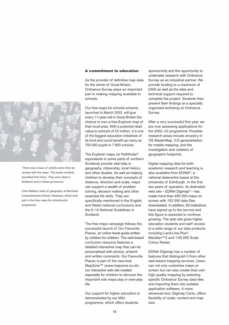
Ordnance SurveyOutdoors Show
More than 27 000 people attendedthis three-day sell-out event in Marchat the NEC in Birmingham. Visitorsenjoyed demonstrations and talks,took part in interactive activities andbrowsed 120 exhibition stands fromcompanies associated with a widerange of outdoor activities.
We also previewed our newOS Select™ – Landranger®, an onlinepersonalised map service that allowspeople to order a site-centred map oftheir home or favourite place.
The show was a huge success andsignalled our commitment toencourage a responsible andpleasurable return to the Britishcountryside.
26

2727

28
Our new web site
In the information economytransactions are increasingly madeonline, both by business and leisureconsumers. To reflect our brandvalues and promote our commitmentto e-business, we have invested inenhancements to our web sitewww.ordnancesurvey.co.uk.
Developments include:
• a larger window on the freeGet-a-map™ screen, making itclearer to view selected mapping;
• a new OS MasterMap section,giving information about theproduct, its uses and links topartners who have developedapplications or translators;
• a large section about ourpartnership strategy, includingonline information and applicationfor the Developer Programme;
• MapZone, our web area forchildren, which now includes OurFavourite Places, the onlinetourism guide written by and forchildren. MapZone has beenadded to Yahoo’s list of sites thatare safe for children to access;
• an improved Leisure map shopwith a simpler purchasing facility.Customers can select any map byits number and series, or searchby place name, postcode orNational Grid reference to displaythe relevant maps covering thatarea. The online shop has doubledits business in the past year withover 38 000 online orders;
• an improved search engine calledSearch Us, to make it easier forvisitors to find what they arelooking for; and
• a map edition checker to allowweb site users to check that theyhave the most up-to-date map.
The new-look site has proved sopopular that it now receives over15 000 visitors each day. It has alsoreceived high accolades from thetrade and media. New technology isalso being introduced which willenable even greater flexibility andfunctionality in the future.
Focusingon ourcustomers
‘Internet Business Rating *****.
If the government’s Ordnance Survey site is an
example of the shape of things to come, the
2005 deadline for getting public services online
is the least of Mr Blair’s worries. The site is
smooth, very deep and a cinch to navigate.
Best of all, it’s actually fun to use. A five-minute
surf becomes a worthwhile lesson in online
excellence.’
Internet Business, February 2002.
At Ordnance Survey we aredetermined to put our customersfirst, because we appreciate justhow important their needs are. Weconstantly look for ways toimprove our customer service,providing easier and moreeffective ways to do business withus. This year we have invested inimprovements to our CustomerHelpLine, and alternative methodsfor customers to access ourmapping, both online and throughsite-specific outlets.
One-stop shopfor customer service
We want to continually improve ourcustomer service and aim tostreamline our processes to provide amore efficient and helpful service forour customers.
One of our main priorities this yearhas been to develop across-Ordnance Survey customerrelationship strategy. A key outcomewas the establishment of ourCustomer Contact Centre (CCC) inDecember as the main point ofcontact into Ordnance Survey. Bybringing together specialist staff invarious areas of customer contact,the CCC is now a one-stop shop fortelephone, email and writtenenquiries concerning:
• data supply;• trade sales;• agents team;• commercial sales (partners) and
commercial licences;• commercial contracts;• copyright;• digital sales support; and• digital solutions.
Creating a one-stop shop for allenquiries also means that ouraccount management teams canfocus on working proactively withboth existing and potential customersto grow the business. We intend tobuild on our customer relationshipstrategy across Ordnance Survey inthe next financial year, and furtherimprove services.

29
Mapping round the clock
‘We believe the Ordnance Survey kiosk will be
an excellent addition to the range of services
we provide. The chance to produce instant,
individualised maps is something which should
prove extremely popular.’
Anthony Climpson, New Forest District Council
Tourism and Publicity Officer.
A key aim of our commitment to putcustomers first is to make our graphicmapping available 24 hours a day,7 days a week – not simply as off theshelf products, but through as manychannels as possible.
In October the prototype of amap-printing kiosk was installed inthe Lyndhurst Visitor InformationCentre in the New Forest for athree-month period. Created byAvatar Interactive Ltd andeMapSite.com, the kiosk allowedusers to select an area of mappingon screen and pay for a high-qualityfull-colour printout on either A4 or A3paper at a scale of 1:50 000 or1:250 000. For central southernEngland, users could also choose1:25 000 scale plus street-levelmapping.
The kiosk generated a great deal ofinterest among the public and themedia, and the feedback from thetrial has been invaluable.
Online gatewayto customer service
As part of our new web sitedevelopment, we are creatingpersonalised secure sites for keycustomers and partners. We havespent a significant amount of timeresearching what our customerswould like to see featured, and thefindings have helped to shape ourproject strategy.
The sites, which are still underdevelopment, will provide aportal-style customised view of thepublic web site, as well as bespokefeatures for targeted customers,including secure documents such asaccount information and service levelagreements. There is also access toforums, personalised contact detailsand technical information.
Our aim is to provide a more personal,tailored service to key customers andpartners where the web can improveservice delivery, boosting customersatisfaction and maintaining closebusiness links. We are currentlyworking with a number of users froma variety of organisations, and intendto develop this service further duringthe next financial year.
29

30
Buildinga solidfoundationto meetour vision
‘[In Ordnance Survey] we now have a
forward-looking modern organisation with a
£100 million income and a reputation for
technical expertise that is the envy of the
world.’
Mike Fort, Civil Engineering Surveyor,
February 2002.
To be able to deliver on ourpromises and achieve our vision inthe current information economy,we must have the technologicalcapabilities to do so.
This year we have begun investingheavily in a three-year programme ofinfrastructure improvements that isled by our CTO, Ed Parsons. Sinceautumn 2001, we have invested atotal of £37.3 million in meeting oure-strategy. This includes £18 millionin enhancing our IT infrastructure andrefining our internal processes toensure that we can provide ourcustomers with a first-class service.
Our e-strategy also ensures that wemeet Modernising Governmenttargets for delivering all serviceselectronically by 2005. By upgradingand integrating our business systemsand processes, we will not onlysimplify our ways of working but alsobenefit from cost savings andefficiency gains. Our customers willbenefit from reliable access to all ofour web services and increasedcapabilities for online transactions.
Our commitment gained a doubleboost this year: in September, theOffice of the e-Envoy awarded oure-strategy the highest accolade, andin the same month our Director
General and Chief Executive,Vanessa Lawrence, was appointedan e-Champion – one of a smallgroup of senior people in governmentchosen to drive forward the processof helping the government meet itse-delivery targets.
In March this year our e-strategy andmodern business approach led torecognition in the BT Vision 100 awardsprogramme for 2002. The schemeidentifies 100 innovative and visionaryUK organisations that have achievedstrategic goals over 12 months, basedon five areas: visionary leadership,visionary human resource management,corporate social responsibility,intellectual asset management andthe connected enterprise.
Contenders were short-listed by ateam of business journalists andresearchers led by the CranfieldSchool of Management. A panel ofopinion leaders and analysts selectthe final 100, where we featuredalongside organisations such as theEden Project, the John Lewis®
Partnership and easyJet.
31
Software systems forcustomer satisfaction
In partnership with Siemens®
Business Services (SBS), we areinvesting in an organisation-wideoverhaul of our back office businesssystems and the business processesthey support. Over the years, wehave employed a range of differentbest of breed applications acrossdepartments, but these do not easilywork together. A single, integratedEnterprise-wide Software Suite (ESS)will replace our existing range ofsystems and processes – withupgrades where necessary – bringingin significant efficiency and costsavings.
Following a detailed investigation intopossible solutions, we chose SAP®
software that will be introduced overa period of three years. ESS willprovide a simple and consistent routefor all our staff to perform their dailytasks, access systems and updatepersonal information. The ESS
project is likely to touch everymember of our workforce, whether itbe through scheduling of work,recording of annual leave or throughchanging the way basic workprocesses are carried out. Rapidintegration of our databases into acentrally-managed source ofcustomer contact information is alsoplanned as part of our improvementsin Customer RelationshipManagement (CRM).
In-house, we are also investing in therollout of Windows® 2000 to alldesktops, laptops, printers, plottersand back office systems, forcompletion by summer 2002.
Enhancing today’sinfrastructure
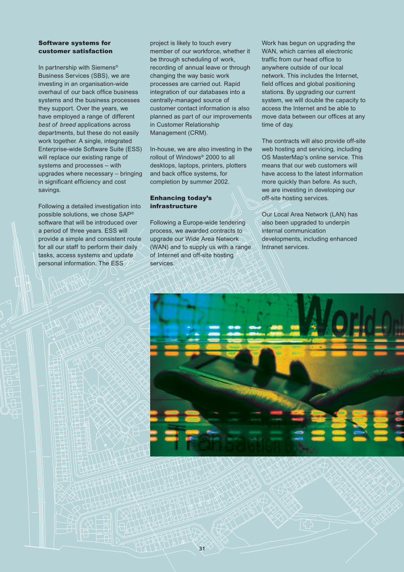
Following a Europe-wide tenderingprocess, we awarded contracts toupgrade our Wide Area Network(WAN) and to supply us with a rangeof Internet and off-site hostingservices.
Work has begun on upgrading theWAN, which carries all electronictraffic from our head office toanywhere outside of our localnetwork. This includes the Internet,field offices and global positioningstations. By upgrading our currentsystem, we will double the capacity toaccess the Internet and be able tomove data between our offices at anytime of day.
The contracts will also provide off-siteweb hosting and servicing, includingOS MasterMap’s online service. Thismeans that our web customers willhave access to the latest informationmore quickly than before. As such,we are investing in developing ouroff-site hosting services.
Our Local Area Network (LAN) hasalso been upgraded to underpininternal communicationdevelopments, including enhancedIntranet services.
31

32
Surveying the countryfrom top to toe
Our reputation as a world leader inour field is founded upon our ability toprovide high-quality, consistent andup-to-date mapping data that meetsthe demands of both the public andprivate sectors. With the face ofGreat Britain changing fast, ournational network of more than 400field surveyors working from around70 offices nationwide, is responsiblefor putting these changes on the map.
Our data-collection activities areanother area of our work where we aretaking advantage of new technology todrive forward innovation. We havealready undertaken a major investmentin state-of-the-art GPS receiverscapable of centimetric level precisionfor the capture of detail. Our surveyingteam combines these with a broadrange of the latest hi-tech measuringtechniques to digitally update ourcentral database and every dayaround 5 000 changes are made to the400 million features already mappedout in it. Around 65 000 overlappingphotographs, taken every year fromspecially equipped aircraft, supportthese ground-based surveys.
To ensure that our customers receivean optimum service, this year westarted upgrading the way in whichwe maintain and store our data.Currently, data is updated andmaintained by surveyors in tile form(in blocks). Because OS MasterMapis a seamless dataset, maintaining it
by tiles is impractical and inefficient.To streamline our processes, a newdatabase is being developed toprovide a seamless maintenanceenvironment.
To support this, we are also making asubstantial investment in thedevelopment of a new hand-held FieldObject Editor system that will becompatible with the new database andwill replace our surveyors’ currentdata capture system. Furthermore,broadband and cellularcommunications will, in the future,enable our surveyors to access andupdate the OS MasterMap databasemore easily from field locations, and incontrast to previous systems, the datacan also be used by more than oneperson at any one time. Theseinvestments will yield efficiencysavings in the way we collect data andmanage our databases, which arealready more up to date now than atany other time in our 211-year history.
Online Service
OS Master Map is setting newstandards in e-business, with onlineregistration, ordering and delivery ofdata. Our online service went live atthe end of November to coincide withthe launch of OS MasterMap. So far,over 250 customers have registeredonline and over 100 contracts havebeen created. The service enablescustomers to generate an estimatefor their area of choice, set up acontract and order data for deliveryeither online or on CD or DVD.

3333

34
Shapingour businessfor futuresuccess
‘…work to date has focused on building strong
teams within the organisation by making sure
that the right people are in place at all levels of
management and gaining their commitment to
change.’
Engineering Surveying Showcase, October 2001.
With a vision that embracestechnological change and adetermination to play a pivotal rolein the digital economy, OrdnanceSurvey is marking a new era in itshistory. To achieve our goals webelieve it is imperative to involveevery single member of staff, at alllevels across the organisation, inour plans and aspirations.
We have embarked upon a two-yearprogramme to mobilise the entireorganisation towards contributing toour vision. The OS Experience wasthe first milestone in the initiative,which we call Project Platinum. TheOS Experience was a week-longinteractive event that was aspringboard for the changes we mustmake in order to meet our businessobjectives. Attended by 1 853 people(some 96% of our workforce), it gaveevery employee the opportunity todiscover what our vision means forthem and how they can contribute toour success. Feedback and input fromemployees was key to the success ofthe OS Experience. Whereverpossible their views are now beingincorporated into our policy and plans.
Following extensive market researchand focus groups with customers, itwas decided that our corporateimage was outdated and did notaccurately convey our modern brandvalues and practices.
To bring our image up to date andreflect both our e-strategy andprogressive business model, we feltthat it was time to rebrand. This didnot involve any change to ourwell-established name or logo, but itdid introduce an overall moderncorporate image based on colours offresh platinum and magenta, whichwas launched in September at GIS
2001. Our new corporate identity hasbeen well received, although werecognise that branding is only asmall step towards initiating a deeperlevel of change to our corporatebusiness practices.
Motivating teams from the top
Employing the right staff with theright skills is crucial to OrdnanceSurvey’s success in an ever-changing,competitive marketplace.
Significant investments are beingmade in all our resources, not leastour people who are one of our mostvaluable assets. We are committed todeveloping a high performing, highlymotivated organisation and weredelighted to retain our Investor inPeople award for the fourth yearrunning. Investment in the comingyear will concentrate on enhancingour sales capability.
A strong leadership team that is notafraid to make tough decisions tomeet the challenges ahead is crucialto our success. Our Directors andSenior Management team has beenstrengthened in the past 12 monthsto mix the best of private and publicsector skills and experience. Externalrecruitment to bring in new skills andthe appointment of interim managersare playing an important role inshaping our workforce.

35
Learning from externalexperience and expertise
E-business engineering specialistJames Brayshaw, our new ManagingDirector of Digital Brands, has a trackrecord in successfully positioningnew products as market leaders. Hewas formerly Director of Sales atBidcom Ltd – an e-constructionproject portal and e-businesssolutions provider to the construction,engineering and property markets.James introduced US-basedCitadon’s ProjectNet to the UKmarket and over the past 18 monthshas established ProjectNet as theleading brand in its field.
He is supported by Gill Woodward,our new Head of Marketing in DigitalBrands, who has wide experience indeveloping and managing marketsand products in a number of sales,marketing and management roles inthe IT sector.
Gill’s counterpart in the graphic brandsside of the business is Eric Bates, amarketeer who has held senior salesand marketing positions in companiessuch as Kelloggs® and Milupa®.
Heading up our extensive DataCollection and Managementdepartment of 740 survey,management, and support staff isGPS and surveying specialist NeilAckroyd. Throughout his career, hehas been closely involved in definingnew surveying standards in geodesyand the adoption of GPS.
Previously the European TechnicalManager for location-based servicescompany Trimble®, Neil had a primaryrole in the adoption of GPStechnology across both the publicand private sectors, as well assetting-up and developing Trimble’ssupport organisation. He alsofocused on managing the company’sbusiness in the construction industry– developing the use of satellite,laser and conventional total stations
for surveying and constructionapplications.
Ensuring that we have theinfrastructure to underpin all ourbusiness activities is CTO EdParsons, who is driving forward ourmajor investment in IT. Ed hasdeveloped his whole career in thegeographic information andlocation-based services industries,and joined us from Autodesk® Ltd,where he was GIS ApplicationsManager for Europe, the Middle Eastand Africa.
The CTO evaluates the state ofexternal markets to ensure that itsneeds are reflected back into thebusiness. One of Ed’s first tasks onjoining Ordnance Survey was tointegrate all business areasresponsible for IT into oneinformation systems department withclear roles and responsibilities.
Joining our Non-Executive Directorsthis year is Piers White, anexperienced Financial Servicespractitioner who has run substantialbusinesses for Barclays® and, morerecently, Flemings® and AbbeyNational®. For much of the last 20years Piers has been involved in orinitiated substantial changeprogrammes. He brings a wealth offinancial and business managementexperience to the Ordnance SurveyBoard and his appointment – by ourMinister during the period of thisreport, Sally Keeble MP – brings anadditional external perspective tohelp guide our policies.
During the past year we have alsoemployed interim managers to helpachieve specific objectives in areassuch as business-to-businessmarketing and the development ofour partnership programme. And therecruitment of new staff, such asprofessional lawyers in ourintellectual property and legaldepartment, has also added valuableexpertise to our in-house skill base.

3636

37
Enhancing skills andrecognising potential
‘Obtaining this qualification...has certainly made
us more aware of what we do for our
customers, proving to us that we can and
frequently do provide excellent customer
service.’
Susan Perrin, successful customer service
NVQ candidate.
The development of in-house staff isjust as important as integrating newfaces into the organisation and weare determined to enhance ourexisting skills as well as developingnew ones.
Identifying and developing potentialsenior management and technicalspecialists is essential to the future ofthe business. Development centres,where staff can assess theirstrengths and weaknesses, are a keypart in ensuring we have fully trained,capable and enthusiastic people tomeet our goals. During the past year135 existing staff were promoted intonew roles.
Of course our surveyors benefit fromongoing training in all the latest datacollection techniques but we are alsokeen to develop the specialist skillswe need to do business quickly andefficiently in the future. For example,a number of our cartographers haveattended courses that includedgraphic design to generate new ideasand explore new ways of presentinginformation using technologies suchas Personal Digital Assistants (PDAs)as well as traditional paper maps.
We also encourage staff whoregularly deal with customers tostudy for the customer service NVQ,and last year 12 employees gainedthis qualification; six at level 2 and sixat level 3. Twelve members of staffwere also successful in completing alevel 3 NVQ in management and afurther 24 gained NVQs covering
various IT skills, including softwaredevelopment and supporting ITsystems. We can now also carry outour own assessment of NVQcandidates working towards ITqualifications following the successfultraining and qualification of eightmembers of staff as assessors andOrdnance Survey’s accreditation asan NVQ assessment centre.
Raising the returnon our assets
Reducing our operating costs byefficiently managing our assets hasenabled us to become self-sufficientin the generation of our ownelectricity with a combined heat andpower scheme. The £1.4 millioninvestment will be recouped throughsavings to our electricity bill andexemption from the Climate Changelevy.
The scheme uses an on-site gas-firedgenerator, which allows the entireheat for our headquarter’s buildingsto be produced as a by-product ofgenerating electricity for lighting,bringing Ordnance Survey into linewith government initiatives to reducecarbon emissions.
Our new state-of-the-art BusinessCentre helps to maintain ourreputation for being at the forefront ofmapping technology as well asproviding a platform to display ourrich heritage. The £2 million facility,which can also be used by ourpartners and customers, includes a150-seat lecture theatre, twoconference and three training rooms,a multimedia exhibition area and ahigh-tech computerised mappingdemonstration area.
Returns on our assets are alsoachieved through the rental ofCompass House, formerly our NorthBlock accommodation. We haveleased surplus space to HM Customsand Excise and P&O Nedlloyd.
Our new state-of-the-art Business Centre.

38
Recruitment activityThe following information outlines Ordnance Survey’s recruitment activity during the year 1 April 2001 to 31 March2002. Ordnance Survey is fully committed to the principles of fair and open competition and selection on merit laiddown in the Civil Service Commissioners’ Recruitment Code. Systems are in place to ensure that recruitment is carriedout in accordance with those principles. Application of the principles of the Code in the year April 2001 to March 2002produced the results in the following tables:
Equal opportunities statistics by Ordnance Survey role
Total applications
Role Total Male Female White Ethnic Non- Disabled
minority respondent
Senior Civil Service 228 203 25 40 0 188 0
Senior Manager (Head) 105 96 9 80 10 15 0
Senior Manager 829 696 133 651 50 128 7
Middle Manager 240 166 74 211 6 23 2
Technical/Business Manager 787 514 273 650 27 110 11
Technical/Business Officer 538 408 130 455 19 64 3
Technical/Service Provider 1328 796 532 1162 44 122 38
Support 447 338 109 392 15 40 55
Information Systems (combined boards) 117 100 17 91 5 21 4
Grand total 4619 3317 1302 3732 176 711 120
Selected for interview
Role Total Male Female White Ethnic Non- Disabled
minority respondent
Senior Civil Service 24 21 3 3 0 21 0
Senior Manager (Head) 8 7 1 8 0 0 0
Senior Manager 41 26 15 32 1 8 0
Middle Manager 30 19 11 28 1 1 0
Technical/Business Manager 81 48 33 69 3 9 2
Technical/Business Officer 104 72 32 90 3 11 2
Technical/Service Provider 163 65 98 141 6 16 3
Support 74 45 29 68 0 6 0
Information Systems (combined boards) 31 25 6 25 2 4 0
Grand total 556 328 228 464 16 76 7
Successful aSuccessful aSuccessful aSuccessful aSuccessful at intert intert intert intert intervievievievieviewwwww
Role Total Male Female White Ethnic Non- Disabled
minority respondent
Senior Civil Service 3 3 0 0 0 3 0
Senior Manager (Head) 2 1 1 2 0 0 0
Senior Manager 7 3 4 5 0 2 0
Middle Manager 6 4 2 6 0 0 0
Technical/Business Manager 23 12 11 21 0 2 0
Technical/Business Officer 36 26 10 30 1 5 1
Technical/Service Provider 47 18 29 44 1 2 0
Support 15 10 5 13 0 2 0
Grand total 139 77 62 121 2 16 1
One person was re-employed.
39
Serving our customers and servingthem well is of paramountimportance to us. That is why weremain committed to consulting thosewho actually use our products andservices, listening to customercomments, and implementing thefindings from our regular customersatisfaction surveys.
A key element in helping us to betterunderstand the requirements of ourcustomers is the main customersatisfaction survey. Every year weask our leisure map consumers,business customers and partners fortheir views on our service. This isundertaken on an annual basis,amongst consumers and ourbusiness customers/partners – in theyear 2001 over 600 customers tookpart.
The survey provides us with ameasure of customer satisfactionand commitment and helps us toidentify key areas for improvement.
Key findings from the CustomerSatisfaction Survey 2001 aresummarised below:
• The majority of our customers aregenerally satisfied with the currentlevel and nature of contact withOrdnance Survey.
• About 85% of customers rated thequality of Ordnance Survey’sservice as excellent to good.
• A little over 60% think thatOrdnance Survey is very good orfairly good at taking customers’needs into account.
• There has been an increase in thenumber of courtesy calls made byOrdnance Survey.
• Electronic communication betweenOrdnance Survey and itscustomers has seen a significantincrease from last year – up 13%for email and 19% for web.
• There has been an increase in theuse of digital mapping data.
• 72% of customers have notexperienced any problem with thelevel of service provided byOrdnance Survey over the last 12months.
• Over 50% of those who have hadcause to complain were satisfiedwith the outcome of their complaint.
Customersatisfactionsurvey
Results 2001–02
Total number of enquiries 78 809
Contact via:
Phones 55 375
Emails 15 417
Fax/letter 8 017
Total number of complaints/feedback 2 761
We now provide a quicker, less formalprocess for registering complaintsand feedback. A new email addressappears on both our web site and onnew map covers, making it easier tocontact us.
The survey has highlighted a numberof key strengths such as havingknowledgeable staff, being friendlyand approachable, understandingwhat the customer wants, and beinga specialist in mapping information.
More importantly the survey hashelped to identify and prioritise keyareas for improvement, such as beingflexible and adaptive to your needs.Ordnance Survey will continue toimprove upon such areas.
In order to secure our future as theworld’s leading mapping organisationthrough achieving our vision of beingthe content provider of choice forlocation-based information in the neweconomy, one thing remainsabsolutely paramount: ourcommitment to serving our customersand serving them well. The followingtable shows the number ofcustomers who have contacted us forgeneral enquiries and the number ofcomplaints and feedback received.

40
Safety, healthand environmental review
Safety and health
Our Directors place paramountemphasis on safety and health, andare constantly looking into ways ofimproving the safety, health andworking conditions of staff. This tableshows the accident statistics for theyear:
Environment
Directors put great emphasis on theenvironmental performance of thebusiness.
Following an environmental review,which did not show anycontraventions, we have started onthe introduction of an EnvironmentalManagement System (EMS) tomaintain and improve on that record.An EMS allows our organisation toset up procedures to assess anypossible significant impacts on theenvironment. We can minimise anyimpacts by setting objectives andtargets, therefore reducingenvironmental impacts, costs andensuring the business runs moreefficiently. Environmental impactreduction – such as oil interceptors inplace at our head office to reduce
Ordnance Survey has won theRoSPA (Royal Society for thePrevention of Accidents) gold awardfor the second successive year forachieving a high standard of healthand safety management in theworkplace. To qualify for the awardwe had to demonstrate consistentlygood or continuously improvingaccident prevention performance overthe last five years.
To ensure proof of delivery of ourhealth and safety managementsystem, we are auditing health andsafety systems over a three-yearrolling programme. Taking promptaction where necessary enables usto continually improve on health andsafety performance throughout thebusiness.
impact on watercourses – and ourparticipation in thegovernment-backed Watermarkproject, enable us to measure ourwater consumption againstbenchmarks.
Additionally we have successfullyinstalled a 1.67-megawatt combinedheat and power (CHP) system thatwill reduce both energy consumptionand carbon emissions from carbondioxide.
As part of our EMS we are looking atways of improving our Travel Plan.One project is the use of two electricalvehicles (one at our head office andone at our London Group office) aspool cars to save on the use ofprimary fuels. The car located at ourhead office site will be powered by theexcess electricity of the CHP.
Variations from
Results 2001–02 2000–01
Accidents 92 -34.7%
Days absence due to accidents 73 -37%
Accident rate per 100 staff 4.7 -26.6%
Days absence per accident 1.0 +25%
Serious accidents reported to Health and Safety Executive 6 -54%
Figures include all Ordnance Survey permanent staff, contractors and agency staff.

41
Annual Accountsfor the year ended 31 March 2002

42

43
Contents
Foreword to the accounts 45
Statement of Agency’s and
Chief Executive’s responsibilities 48
Statement on internal control 49
The Certificate and Report of the
Comptroller and Auditor General
to the Houses of Parliament 50
The Report of the Comptroller
and Auditor General
to the Houses of Parliament 52
Operating account 55
Statement of total recognised
gains and losses 55
Balance sheet 56
Cash flow statement 57
Notes to the accounts 58
Accounts direction given by the Treasury 71
Treasury Minute dated 29 March 1999 72

44

45
Forewordto theaccounts
Status
Ordnance Survey is a governmentdepartment founded in 1791,operating under legislation that datesback to 1841. It is responsible for theofficial, definitive surveying andtopographical mapping of GreatBritain. In 1990 Ordnance Surveywas established as an ExecutiveAgency and with effect from 1 April1999 Ordnance Survey attainedTrading Fund status under theprovisions of the Government TradingFunds Act 1973, as amended.
The holder of the combined post ofDirector General and Chief Executiveis also the Accounting Officer. During2001–02 the Secretary of State forthe Department for Transport, LocalGovernment and the Regions (DTLR)had ministerial responsibility forOrdnance Survey.
Aim and strategicobjectives
Ordnance Survey aims to satisfy thenational interest and customer needfor accurate and readily availablegeospatial data and maps of thewhole of Great Britain in the mosteffective and efficient way. This aim ispursued through a set of strategicobjectives that cover all aspects ofmaintaining the National TopographicDatabase sufficiently up to date andof suitable quality to meet the currentand future data, graphic andinformation needs of a wide range ofcustomers. The strategic objectivesinclude the delivery of national interestservices and activities as defined in aformal agreement with governmentand the provision of national coverageof medium- and small-scale maps.
Further details of the aims, objectives,accountability and responsibility arecontained in Ordnance Survey’s
Framework Document published inApril 1999.
Management Board
There are two corporate boards inthe Ordnance Survey seniormanagement structure. These are:
• The Strategy Board – responsiblefor determining the long-termstrategy of Ordnance Survey andoversight of the successfuldischarge of the remit assigned toOrdnance Survey by Ministers. UntilDecember 2001 the Strategy Boardcomprised the Chief Executive,Director of Business Change, Headof Strategy and Non-ExecutiveDirectors. From January 2002 theBoard was extended to include allOrdnance Survey Directors andNon-Executive Directors.
• The Operating Board –responsible for all operationalmatters within Ordnance Survey ata corporate level and forimplementation of the strategyagreed by the Strategy Board andcomprising all Ordnance SurveyDirectors and the Head of Strategy.
At 31 March 2002 theStrategy Board comprised
Vanessa LawrenceChief ExecutiveDavid WilleyDirector of Business Changeand Deputy Chief ExecutiveDuncan ShiellHead of StrategySteve ErskineDirector of Graphic BrandsJames BrayshawDirector of Digital Brands(from 1 November 2001)Neil AckroydDirector of Data Collection andManagement (from 4 September 2001)
Bryan NansonDirector of Staff Development andCorporate ServicesEd ParsonsChief Technology Officer(from 5 June 2001)
Gwynneth FlowerNon-Executive DirectorLynn MathiesonNon-Executive DirectorPiers WhiteNon-Executive Director(from October 2001)
The Non-Executive Directors areappointed by the Secretary of State.Their remuneration and terms ofappointment are agreed at the timeof their appointment, which isnormally for two years with theoption for this to be extended for afurther two years. In October 2001Piers White replaced MichaelPattison, who had served four yearsas a Non-Executive Director.
The Operating Board
In addition to the Ordnance Surveydirectors on the Strategy Board asdetailed above, the followingdirectors served on the OrdnanceSurvey Operating Board during2001–02:
Stephen GapperActing Director of Digital Brands(to 31 October 2001)Nick LandDirector of Market Development(to 30 November 2001)Ian LoganDirector of Data Collectionand Management (to 30 April 2001)Graham LittleActing Director of Data Collectionand Management (from 30 April 2001to 3 September 2001)
46
Audit Committeeat 31 March 2002
Gwynneth Flower, Lynn Mathieson,Piers White and David Willey weremembers of the Ordnance SurveyAudit Committee at 31 March 2002.
Auditor
The Auditor is Sir John Bourn,Comptroller and Auditor General.
Business activities
Ordnance Survey delivers its remit ofmaintaining the National TopographicDatabase (NTD) of Great Britain andproviding national coverage ofmedium- and small-scale maps togovernment, business and consumermarkets. Surveying and mappingactivity that ensures consistentnational standards but does not havean immediate commercial justificationis funded by an agreement withcentral government (the NationalInterest Mapping ServicesAgreement – NIMSA). Data graphicsand information services are mainlydirected to the government andbusiness markets, while theconsumer market is concentrated onmedium- and small-scale maps.Increasingly some medium-scaledata products serve both thebusiness and consumer markets.Ordnance Survey encourages thegrowth of a licensed partnercommunity designed to add value todata taken from the NTD.
On 30 March 2001 Ordnance Surveyacquired a 40% share in PointX Ltd,a joint venture company set up todevelop and market a points ofinterest database covering Great
Britain. The aim of PointX Ltd is tolead the points of interest market bydelivering the most comprehensive,current and consistent national data.On 20 November 2001 OrdnanceSurvey increased its share to 50%(see Note 7).
Business objectives2001–02
Details of the non-financial businesstargets for 2001–02 are contained inthe Annual Report.
Financial objectives
The Government Trading Funds Act1973 lays upon the Ministerresponsible for each fund thefinancial objectives of:
• managing the revenue of thefunded operations so that therevenue of the fund consistsprimarily of receipts in respect ofgoods and services provided in thecourse of the funded operations,and is not less than sufficient,taking one year with another, tomeet outgoings which are properlychargeable to the revenue account;and
• achieving such further financialobjectives as the Treasury mayfrom time to time, by Minute laidbefore the House of Commons,indicate as having been determinedby the responsible Minister (withTreasury concurrence) to bedesirable of achievement.
The longer-term financial objective ofOrdnance Survey is:
• to achieve an average annualreturn on capital employed
(ROCE) on the surplus on ordinaryactivities before interest of at least9% of net assets employed overthe period 1 April 1999 to 31March 2004.
The additional financial target for2001–02 set by the Secretary ofState for Transport, LocalGovernment and the Regions is:
• to raise income of £85.6 millionthrough sales, licensing and otheractivities, excluding Governmentfunding towards the NIMSA.
Results for the year
The deficit for the year is £6 452 000,which was transferred from thegeneral reserve as shown in Note 13.
Details of the achievement of thefinancial target is shown in Note 20.Further details are contained in theAnnual Report.
Research anddevelopment
Ordnance Survey continues toundertake a diverse programme ofmarket-led research covering bothproduct development and processimprovement, focused on addressingthe current and future needs of thebusiness. A further significantincrease in research investment overthe last year has enabled theimplementation of a forward-looking,blue-sky research and innovationstrategy addressing a fundamentalresearch agenda in informationscience, centred around future usersand uses of location-basedinformation. It addresses novelmeans of data collection, storage,

47
maintenance and delivery oflocation-based information andservices to new user communitiesusing new channels. Greateremphasis is being placed oninnovation and the exploitation ofintellectual capital developed throughthis research and innovation strategy.
Ordnance Survey’s Virtual ResearchUnit continues to developpartnerships with the academiccommunity, other national mappingagencies and research departmentsin commercial organisations usingexpertise across the world indelivering its research agenda.
Research in Ordnance Survey issupported by a proactive technologytracking programme that ensuresthreats and opportunities to thebusiness are identified and helps toestablish research priorities.
Creditor payment policy
Ordnance Survey adheres to theBetter Payment Practice Code. In2001–02, 97.8% (99.1% in 2000–01)of all approved invoices were paid byOrdnance Survey within thecontractual conditions, or within 30days of receipt of a valid invoice.
Employment of peoplewith disabilities
As part of the Ordnance SurveyDiversity Plan, directors supportpolicies for giving full and fairconsideration to applications foremployment made by people withdisabilities, having regard to theirparticular aptitudes and abilities.There is also support for continuingthe employment of employees who
have become temporarily orpermanently disabled during theperiod when they were employed byOrdnance Survey, and for thetraining, career development andpromotion of people with disabilities.Ordnance Survey is registered withthe Employment Service as anemployer who is Positive AboutDisabled People.
Employee involvement
Internal communications arecontinuously monitored for theeffectiveness of existing businesscommunication channels, and theeffectiveness of the communicationsof others in Ordnance Survey,through local and business structuredfeedback channels on behalf of allemployees. Guidance, advice,information and internal consultancyare available wherever and wheneverit is required and standards are setfor business communication activityto maximise the effect and focus ofcommunication across the business.
Primary communication channels areunder continuous review anddevelopment, concentratingspecifically this year on maximisingthe potential e-delivery of businessinformation in many formats. Theseinclude continuing development ofthe Intranet, promotion anddevelopment of video conferencingand plasma screen technology, andincreasing use of the internalnewscaster software. In addition toimproving the currency ofinformation, these developmentsresult in cost savings andenvironmental benefits, including areduction in the need for travel andthe production of paper copies.
There has been a structured trainingprogramme across the business toimprove face-to-face communication,briefing and leadership skills,together with a business-wideendeavour to ensure that allemployees are part of thecommunication experience and thatall contributions are appreciated andconsidered.
Ordnance Survey continues to berecognised as an Investor in People(IIP), the national quality standard foreffective investment in the trainingand development of staff and will beapplying in 2002 for its fourth CharterMark. Ordnance Survey’s qualitysystems have been developed toEFQM principles.
The Ordnance Survey DepartmentalWhitley Council provides for regularconsultations with employees’representatives.
Events since the end ofthe financial year
There have been no significantevents since the end of the financialyear that would affect the results forthe year or the balance sheet at yearend.
Accounts
The Directors present the accountsfor the year ended 31 March 2002.
Vanessa V LawrenceDirector General and Chief Executive28 June 2002

48
Under Section 4(6) of theGovernment Trading Funds Act 1973the Treasury has directed OrdnanceSurvey to prepare a statement ofaccounts for each financial year inthe form and on the basis set out inthe Accounts Direction that isreproduced at the end of theseaccounts. The accounts areprepared on an accruals basis andmust give a true and fair view of theAgency’s state of affairs at the yearend and of its income andexpenditure, total recognised gainsand losses, and cash flows for thefinancial year.
In preparing the accounts the Agencyis required to:
• observe the Accounts Directionissued by the Treasury, includingthe relevant accounting anddisclosure requirements, and applysuitable accounting policies on aconsistent basis;
• make judgements and estimates ona reasonable basis;
• state whether applicable accountingstandards have been followed, anddisclose and explain any materialdepartures in the financialstatements; and
• prepare the financial statements onthe going concern basis unless it isinappropriate to presume that theAgency will continue in operation.
The Treasury has appointed the ChiefExecutive of Ordnance Survey as theAccounting Officer for the Agency. Herrelevant responsibilities as AccountingOfficer, including responsibility for thepropriety and regularity of the publicfinances and for the keeping of properrecords, are set out in the FrameworkDocument, and in the AccountingOfficers’ Memorandum issued by theTreasury and published in GovernmentAccounting (The Stationery Office).
Statement of Agency’sand Chief Executive’s responsibilities

49
As Accounting Officer, I haveresponsibility for maintaining a soundsystem of internal control thatsupports the achievement ofdepartmental policies, aims andobjectives set by Ordnance Survey’sMinisters, while safeguarding thepublic funds and departmental assetsfor which I am personally responsible,in accordance with theresponsibilities assigned to me inGovernment Accounting.
The system of internal control isdesigned to manage rather thaneliminate the risk of failure to achievepolicies, aims and objectives; it cantherefore only provide reasonableand not absolute assurance ofeffectiveness.
The system of internal control isbased on an ongoing processdesigned to identify the principal risksto the achievement of OrdnanceSurvey policies, aims and objectives,to evaluate the nature and extent ofthose risks and to manage themefficiently, effectively andeconomically. This process has beenin place for the year ended 31 March2002 and up to the date of theapproval of the annual report andaccounts, and accords with Treasuryguidance.
As Accounting Officer, I also haveresponsibility for reviewing theeffectiveness of the system of internalcontrol. Ordnance Survey hasestablished the following processes:
• A Strategy Board that meetsmonthly to consider the plans andstrategic direction of OrdnanceSurvey (the Board includes threeNon-Executive Directors) and anOperating Board that includes allthe Directors of Ordnance Surveyand which meets weekly. Riskmanagement has been an item onall departmental management teamagendas from April 2001.
• Periodic reports from the Chairmanof the Audit Committee, to theBoards, concerning internal control.
• Regular reports by Internal Audit,to standards defined in theGovernment Internal Audit Manual,which include the Head of InternalAudit’s independent opinion on theadequacy and effectiveness ofOrdnance Survey’s system ofinternal control together withrecommendations for improvement.
• A strategic risk and controlassessment was carried out in2001–02.
• Regular reports from managers onthe steps they are taking to managebusiness critical risks in their areas
of responsibility, including progressreports on key projects.
• A regular programme of facilitatedworkshops to identify and keep upto date the record of risks facingthe organisation.
• A programme of risk awarenesstraining.
• Established key performanceindicators.
• Maintenance of anorganisation-wide risk registersystem with registers beingmaintained at Board anddepartmental management teamlevel.
My review of the effectiveness of thesystem of internal control is informedby the work of the internal auditorsand the executive managers withinOrdnance Survey who haveresponsibility for the developmentand maintenance of the internalcontrol framework, and commentsmade by the external auditors in theirmanagement letter and other reports.
Vanessa V LawrenceDirector General and Chief Executive28 June 2002
Statement oninternal control

50
I certify that I have audited thefinancial statements on pages 55 to70 under the Government TradingFunds Act 1973. These financialstatements have been preparedunder the historical cost conventionas modified by the revaluation ofcertain fixed assets and theaccounting policies set out on pages58 to 60.
Respective responsibilities ofOrdnance Survey, the ChiefExecutive and Auditor
As described on page 48, OrdnanceSurvey and the Chief Executive areresponsible for the preparation of thefinancial statements in accordancewith the Government Trading FundsAct 1973 and Treasury directionsmade thereunder and for ensuringthe regularity of financialtransactions. Ordnance Survey andthe Chief Executive are alsoresponsible for the preparation of theForeword and other contents of theAnnual Report. My responsibilities,as independent auditor, areestablished by statute and guided bythe Auditing Practices Board and theauditing profession’s ethicalguidance.
I report my opinion as to whether thefinancial statements give a true andfair view and are properly prepared inaccordance with the GovernmentTrading Funds Act 1973 and Treasurydirections made thereunder, andwhether in all material respects theexpenditure and income have beenapplied to the purposes intended byParliament and the financialtransactions conform to theauthorities which govern them. I alsoreport if, in my opinion, the Forewordis not consistent with the financialstatements, if the Accounting Officerhas not kept proper accountingrecords, or if I have not received all
the information and explanations Irequire for my audit.
I read the other information containedin the Annual Report, and considerwhether it is consistent with theaudited financial statements. Iconsider the implications for mycertificate if I become aware of anyapparent misstatements or materialinconsistencies with the financialstatements.
I review whether the statement onpage 49 reflects the Agency’scompliance with Treasury’s guidanceCorporate Governance: Statement onInternal Control. I report if it does notmeet the requirements specified bythe Treasury, or if the statement ismisleading or inconsistent with otherinformation I am aware of from myaudit of the financial statements.
Basis of audit opinion
I conducted my audit in accordancewith United Kingdom AuditingStandards issued by the AuditingPractices Board, except that thescope of my work was limited asexplained below.
An audit includes examination, on atest basis, of evidence relevant to theamounts, disclosures and regularityof financial transactions included inthe financial statements. It alsoincludes an assessment of thesignificant estimates and judgementsmade by Ordnance Survey and theChief Executive in the preparation ofthe financial statements, and ofwhether the accounting policies areappropriate to the Agency’scircumstances, consistently appliedand adequately disclosed.
I planned and performed my audit soas to obtain all the information andexplanations which I considered
necessary in order to provide me withsufficient evidence to give reasonableassurance that the financialstatements are free from materialmisstatement, whether caused byerror or by fraud or other irregularityand that, in all material respects, theexpenditure and income have beenapplied to the purposes intended byParliament and the financialtransactions conform to theauthorities which govern them.
However, the evidence available tome was limited because £2.2 millionof the £23.832 million tangible fixedassets appropriated to the TradingFund on 1 April 1999 comprises thestated value of the databasemanagement system for the NationalTopographic Database for which noadequate accounting records exist.The database management systemwas developed by Ordnance Surveyin 1994. At that time OrdnanceSurvey’s accounting policy was tocharge the costs of softwaredevelopment as an expense in theOperating Statement.
On becoming a Trading Fund on 1April 1999, Ordnance Survey changedits accounting policy to recognise thedatabase management system as atangible fixed asset in accordancewith current accounting standards andTreasury guidance. The databasemanagement system was brought toaccount within fixed assets at itsdepreciated net book value of £2.2million, based on an original estimatedcost of £4.8 million. No accountingrecords have been retained to supportthe original estimated cost of thisdatabase management system. Therewere no other audit procedures that Icould adopt to confirm that this assetwas properly valued.
In forming my opinion I alsoevaluated the overall adequacy of the
The Certificate and Report of theComptroller and Auditor Generalto the Houses of Parliament
51
presentation of information in thefinancial statements.
Adverse Opinion
Ordnance Survey’s turnover of £102.6million derives principally from theexploitation of data contained on theNational Topographic Database, thecreation of which has been fundedfrom public monies over many years.As disclosed in Note 1.7 to theaccounts, the Agency has notcapitalised the costs of setting up andmaintaining the National TopographicDatabase in its Balance Sheet. In theAgency’s view, the database is anintangible fixed asset that does notmeet the conditions for capitalisationset by Financial Reporting Standard10. In my opinion, the NationalTopographic Database is a tangiblefixed asset that should be capitalisedin accordance with FinancialReporting Standard 15. Having takenexpert advice about the valuation ofthe database, in my view the value tothe business is not less than £50million. Had the National TopographicDatabase been capitalised at thatvalue, the effect would have been toincrease tangible fixed assetsincluded in the Balance Sheet at 31March 2002 from £39 million to £89million.
In my opinion:
• in view of the effect of thedecision not to capitalise theNational Topographic Database asa tangible fixed asset inaccordance with FinancialReporting Standard 15, thefinancial statements do not give atrue and fair view of the state ofaffairs of Ordnance Survey at31 March 2002 or of its deficit,total recognised gains and lossesand cash flows for the year thenended;
• in all other respects, and exceptfor any adjustments that mighthave been necessary had I beenable to obtain sufficient evidenceconcerning the databasemanagement system, the financialstatements have been properlyprepared in accordance with theGovernment Trading Funds Act1973 and directions madethereunder by the Treasury; and
• in all material respects theexpenditure and income havebeen applied to the purposesintended by Parliament and thefinancial transactions conform tothe authorities which govern them.
In respect alone of the limitation onmy work relating to the databasemanagement system included withinfixed assets:
• I have not obtained all theinformation and explanations that Iconsidered necessary for thepurpose of my audit; and
• proper accounting records havenot been maintained.
Details of these matters are set out inmy report on the 2001–02 Accounts.
John BournComptroller and Auditor General15 July 2002
National Audit Office157–197 Buckingham Palace RoadVictoriaLONDONSW1W 9SP

52
The Report of the Comptroller andAuditor General to the Houses ofParliament
Accounting for theNational TopographicDatabase
Background
1. Ordnance Survey (the Agency)is a government departmentfounded in 1791, and isresponsible for the official,definitive surveying andtopographical mapping of GreatBritain. Having become anExecutive Agency in 1990,Ordnance Survey acquiredTrading Fund status in April1999 under the provisions of the1973 Government TradingFunds Act (as amended).
2. I have qualified my opinion onOrdnance Survey’s accounts ineach of its first three years as aTrading Fund due to mydisagreement with the Agency’sdecision not to capitalise theNational Topographic Database.The detailed reasons for mydisagreement are set out in myreport on the 1999–2000accounts (HC 26, 2000–01).
3. The purpose of this report is toinform Parliament of a numberof subsequent developmentswhich I consider to be relevantto the debate over theappropriate accountingtreatment for the NationalTopographic Database. Thesedevelopments concern changesin accounting standards,enhanced disclosure inOrdnance Survey’s annualreport and accounts of theimportance of the NationalTopographic Database and therecommendation from Stage 1of Ordnance Survey’sQuinquennial Review that itbecomes a public limitedcompany with shares whollyowned by the government.
The National TopographicDatabase
4. Over many decades OrdnanceSurvey has created, andcontinues to maintain, theNational Topographic Databaseas a definitive computerised mapof Great Britain. The Agency’smain remit is the maintenance ofthe National TopographicDatabase and the provision ofproducts and services from it andhence the database is of centralimportance to Ordnance Survey’sbusiness. In 2001–02 OrdnanceSurvey’s turnover from theexploitation of data held on thedatabase was £102.6 million. Aswell as generating revenuesdirectly for Ordnance Survey, theAgency has noted in its AnnualReport that independentconsultants estimated some threeyears ago that around £100-billionworth of business and publicservices in Great Britain rely eachyear on Ordnance Survey data.
5. Over the past three years, some£17 million has been invested inre-engineering the 400 millionfeatures recorded on the NationalTopographic Database into aconsistent polygonous formatbringing significant benefits in theway that information is integrated,manipulated, analysed andpresented.
Disagreement over theaccounting treatmentapplied to the NationalTopographic Database
6. The National TopographicDatabase comprises two keyelements: software (the databasemanagement system) andtopographical data (thedatabase). In accordance withFinancial Reporting Standard 15
Tangible Fixed Assets, OrdnanceSurvey capitalises the databasemanagement system as atangible fixed asset in itsaccounts. No value is attached inthe Balance Sheet to the coredatabase nor to the costs ofre-engineering and updatingexisting data. Instead, ongoingcosts of maintaining the databasehave been charged to theOperating Statement as incurred.
7. The accounting treatment appliedto the database reflects theAgency’s view that the databaseis a collection of information akinto intellectual property and, assuch, is an intangible fixed asset.Financial Reporting Standard 10Goodwill and Intangible Assetsrequires that internally generatedfixed assets are capitalised onlywhere there is a readilyascertainable market valueevidenced by an active market insimilar assets. As the NationalTopographic Database is uniqueand has never changed hands,the Agency considers that novalue could or should be attachedto it in the financial statements.The Agency has noted that thereare no examples in the privatesector of internally generateddatabases being capitalisedexcept where they have been soldas part of a commercialtransaction.
8. The Agency also considers thatthe revenue stream generated bythe National TopographicDatabase is dependent upon thecurrency of the information heldand that the level of currencyrequired by its customers can onlybe sustained through aprogramme of continual revision.The Agency does not thereforeregard its data as having asufficiently long depreciable life towarrant capitalisation.

53
9. My decision to qualify OrdnanceSurvey’s accounts in 1999–2000and subsequent years reflects myopinion that the accountingtreatment applied to thedatabase should reflect the pastinvestment of public funds in theNational Topographic Database.This past public investmentshould, in my opinion, have beenreflected in the public dividendcapital and net assets vested inthe Trading Fund at its inceptionon 1 April 1999. After takingprofessional advice on thevaluation of the database, myopinion was that the value of thedatabase to the business was notless than £50 million in 2000 andthat there was accordingly amaterial understatement ofcapital employed in OrdnanceSurvey’s accounts.
10. My opinion remains that thedatabase is more appropriatelyaccounted for as a tangible fixedasset and should be capitalisedin accordance with TreasuryGuidance and FinancialReporting Standard 15. Unlikeintangible fixed assets such astrademarks, brands or patents,the database is an accuraterepresentation of a physicalreality that is not affected byopinion, taste, judgement,reputation or belief.
11. Furthermore, I consider that thedatabase is analogous tointernally generated software,which is also data held inelectronic form. TreasuryGuidance and FinancialReporting Standard 10 requirethe capitalisation of internallygenerated software as a tangiblefixed asset, recognising that itrepresents expenditure that is ofcontinuing use in a business andwhich supports the generation offuture economic benefits.
Developments in accountingstandards
12. Since I first qualified my opinionon the Ordnance Survey accountsin 1999–00, the AccountingStandards Board’s Urgent IssuesTaskforce (UITF) has issuedAbstract 29 Website developmentcosts. The UITF’s Abstracts havethe same force as accountingstandards. The issues addressedin Abstract 29 are relevant to theconsideration of accounting forthe Ordnance Survey database.Abstract 29 covers web sitecontent costs, being expenditureincurred on preparing,accumulating and posting the website content. Abstract 29 requiresweb site content costs to becapitalised as tangible fixedassets to the extent that theexpenditure is separatelyidentifiable and leads to thecreation of an enduring assetdelivering benefits at least asgreat as the amount capitalised.
13. There is a clear analogy betweenexpenditure on web site contentcosts incurred to secure the futurerevenue generating capacity of anentity’s web site and the costs ofcollecting and engineeringOrdnance Survey data to ensurethe currency and future revenuegenerating capacity of theNational Topographic Database.
14. There is a growing recognitionacross business and accountingfields that financial statementsincreasingly do not necessarilyrepresent the true value ofbusinesses. The economy isdriven increasingly by assets suchas information, intellectualproperty and human capital ratherthan by assets such as plant andmachinery. Such assets are oftenexcluded from financialstatements as they are
considered to be intangible assetsthat do not meet the capitalisationcriteria set out in FinancialReporting Standards 10. However,the UITF, having accepted theneed to recognise the value ofweb site development costs inentities’ balance sheets, alsoconcluded that such costsrepresent tangible fixed assets inAbstract 29.
15. Ordnance Survey continues tobelieve, however, that currentaccounting standards do notsupport the capitalisation of thedatabase in its accounts. TheAnnual Report accompanyingOrdnance Survey’s 2001–02accounts nevertheless urgesreaders of the financialstatements to take account of thedatabase when seeking tounderstand the true value of thebusiness and the asset base usedto generate current and futurerevenues and Note 1.7 to theaccounts draws the reader’sattention to the report of thePrincipal Finance Officer. Iwelcome this new statement inthe accounts.
Quinquennial Review
16. Ordnance Survey is currentlyundergoing a QuinquennialReview, a requirement for allagencies and Non-DepartmentalPublic Bodies. The Review is splitinto two stages. Stage 1 of theReview involved canvassingstakeholders, considering thecontribution made by the agencyto wider governmental objectivesand assessing the effectivenessof the organisational structure indelivering its services. A numberof options for the future status ofOrdnance Survey includingabolition, continued Trading Fundstatus, merger or rationalisation

54
and privatisation were considered.17. The review team recommended
that Ordnance Survey shouldmake the transition from TradingFund to a wholly governmentowned public limited company(plc). This option was seen asgiving Ordnance Survey theadditional commercial freedomsessential to driving out furtherperformance improvements andachieving greater agility in themarket place. In December 2001Ordnance Survey’s Ministerannounced that she was mindedto accept the recommendationand Stage 2 of the Review iscurrently looking at the costs,benefits and practicalities of sucha move. The Stage 2 review teamis expected to report its findingslater in 2002. In my view , it willbe important that any change inthe status of Ordnance Surveysafeguards the past publicinvestment by the taxpayer in theNational Topographic Databaseby ensuring that its value to thebusiness is properly reflected inthe financial statements.
Conclusion
18. I have qualified my opinion onOrdnance Survey’s 2001–02accounts because of mycontinuing disagreement withOrdnance Survey’s decision notto capitalise the NationalTopographic Database. TheNational Topographic Databasehas been funded from publicmonies over many years andOrdnance Survey’s turnover
(£102.6 million in 2001–02)derives principally from theexploitation of data held on thedatabase. In my opinion thefailure to capitalise the databaseresults in a materialunderstatement of capitalemployed in the Balance Sheet.
19. The Agency considers that theaccounting treatment it hasapplied to the NationalTopographic Database conformsto both current accountingstandards and standard practiceamongst businesses thatgenerate revenues fromdatabases and informationcollections. Consequently it hasinformed me that, until and unlessthe current accounting standardsand recommendations change, itdoes not intend to revise itsaccounting treatment. Inevertheless welcome theadditional disclosures made bythe Agency in the financialstatements to draw readers’attention to this important asset.
John BournComptroller and Auditor General15 July 2002
National Audit Office157–197 Buckingham Palace RoadVictoriaLONDONSW1W 9SP
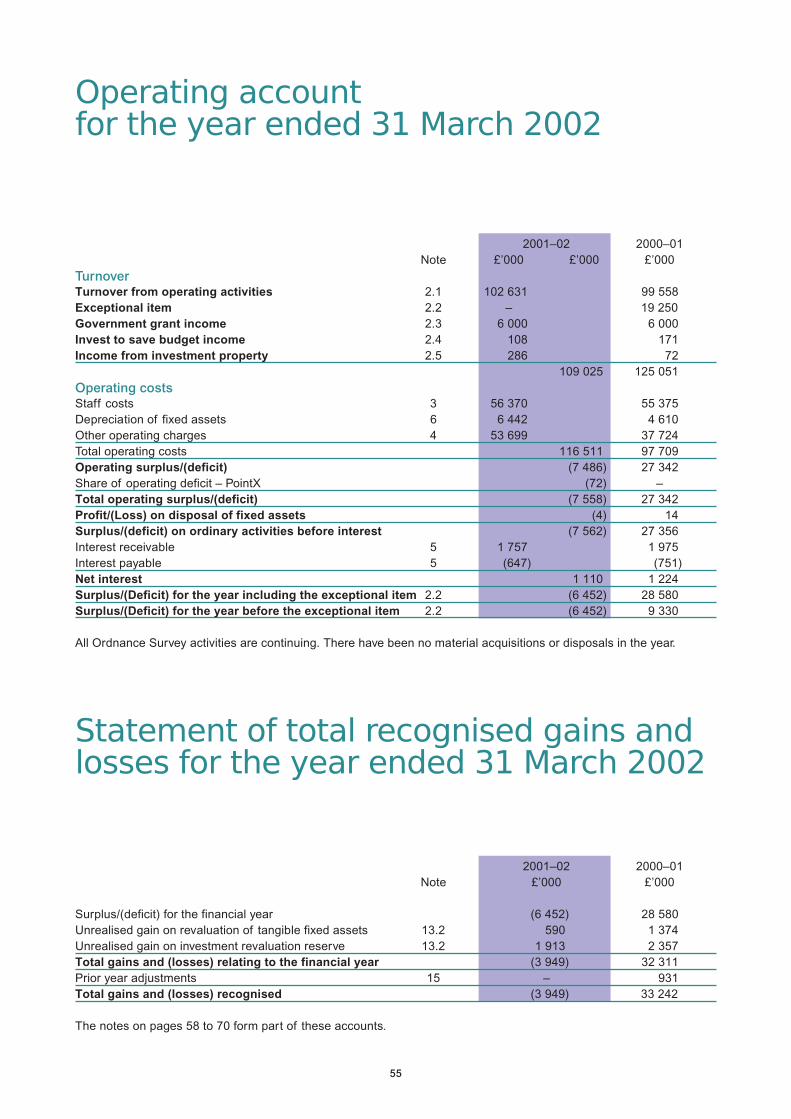
55
Operating accountfor the year ended 31 March 2002
2001–02 2000–01Note £’000 £’000 £’000
TurnoverTurnover from operating activities 2.1 102 631 99 558Exceptional item 2.2 – 19 250Government grant income 2.3 6 000 6 000Invest to save budget income 2.4 108 171Income from investment property 2.5 286 72
109 025 125 051Operating costsStaff costs 3 56 370 55 375Depreciation of fixed assets 6 6 442 4 610Other operating charges 4 53 699 37 724Total operating costs 116 511 97 709Operating surplus/(deficit) (7 486) 27 342Share of operating deficit – PointX (72) –Total operating surplus/(deficit) (7 558) 27 342Profit/(Loss) on disposal of fixed assets (4) 14Surplus/(deficit) on ordinary activities before interest (7 562) 27 356Interest receivable 5 1 757 1 975Interest payable 5 (647) (751)Net interest 1 110 1 224Surplus/(Deficit) for the year including the exceptional item 2.2 (6 452) 28 580Surplus/(Deficit) for the year before the exceptional item 2.2 (6 452) 9 330
All Ordnance Survey activities are continuing. There have been no material acquisitions or disposals in the year.
Statement of total recognised gains andlosses for the year ended 31 March 2002
2001–02 2000–01Note £’000 £’000
Surplus/(deficit) for the financial year (6 452) 28 580Unrealised gain on revaluation of tangible fixed assets 13.2 590 1 374Unrealised gain on investment revaluation reserve 13.2 1 913 2 357Total gains and (losses) relating to the financial year (3 949) 32 311Prior year adjustments 15 – 931Total gains and (losses) recognised (3 949) 33 242
The notes on pages 58 to 70 form part of these accounts.

56
Balance sheetat 31 March 2002
31 March 2002 31 March 2001Note £’000 £’000 £’000
Fixed assetsTangible fixed assets 6.1 38 978 31 465Fixed asset investments
Property 6.2 6 430 4 517Other Investments – PointX 7 68 –
45 476 35 982Current assetsStocks and work-in-progress (WIP) 8 1 677 3 416Debtors 9.1 12 754 22 315Prepayments 9.2 1 979 1 420Cash at bank and in hand 35 285 37 765
51 695 64 916Current liabilitiesCreditors: amounts falling due within one year 10 (15 238) (15 298)Bank overdraft – (487)
(15 238) (15 785)Net current assets 36 457 49 131Total assets less current liabilities 81 933 85 113
Financed by:Provision for liabilities and charges 11 8 898 7 292
Capital and reservesPublic Dividend Capital 14 000 14 000Loans repayable after one year 12 11 018 12 353General reserve 13.1 35 320 41 483Revaluation reserve – tangible fixed assets 13.2 7 113 6 314Investment revaluation reserve 13.2 5 584 3 671
73 035 77 821Total 81 933 85 113
The Accounts were approved on 28 June 2002.
Vanessa V LawrenceChief Executive and Agency Accounting Officer
The notes on pages 58 to 70 form part of these accounts.

57
Cash Flow Statementfor the year ended 31 March 2002
Note 2001–02 2000–01£’000 £’000
Reconciliation of operating surplus for the yearto net cash flow from operating activitiesOperating surplus/(deficit) (7 562) 27 356Depreciation charges 6 6 442 4 610(Profit)/Loss on disposal of fixed assets 4 (14)Decrease/(increase) in stocks/WIP 8 1 739 (815)(Increase)/decrease in debtors/prepayments 9 9 685 (9 080)Decrease in prefunded pension commitments 9 296 –Increase in creditors 10 115 999General reserve/creditors’ adjustment 10 498 597Increase in long-term liabilities 11 615 1 520Net cash inflow from operating activities 11 832 25 173
Cash flow statementNet cash inflow from operating activities 11 832 25 173Financing costs – net receipts/payments 14.1 1 121 1 144Net capital expenditure 14.2 (13 329) (9 149)Net other investment – PointX 14.3 (68) –Cash inflow/(outflow) before financing (444) 17 168Financing 12 (1 549) (1 549)
Increase/(decrease) in cash (1 993) 15 619
Cash movementIncrease/(decrease) in cash in the year (1 993) 16 106(Increase) in bank overdraft – (487)Cash at 1 April 37 278 21 659
Cash at 31 March 35 285 37 278
All Ordnance Survey movements in cash relate to cash flows from operating activities and there is no other net debt.
The notes on pages 58 to 70 form part of these accounts.

58
Notes to theaccounts
Note 1.Accounting policies
The following accounting policieshave been applied consistently indealing with items that areconsidered material in relation toOrdnance Survey accounts.
1.1 Accounting conventions
These accounts have been preparedunder the historical cost convention,modified to include the revaluation offixed assets, to meet the accountingand disclosure requirements of theCompanies Act 1985 and accountingstandards issued or adopted by theAccounting Standards Board so faras those requirements areappropriate.
They are in accordance with theTreasury Direction that isreproduced at the end of theaccounts.
1.2 Freehold land and buildings
Title to the freehold headquarters sitein Southampton is held by theDepartment for Transport, LocalGovernment and the Regions in thename of the Secretary of State. Thecontrol and management of thisfreehold land and buildings werevested in Ordnance Survey from 1April 1974 as if legal transfer hadbeen effected.
The land and buildings were revaluedon 31 March 2002 by Chesterton plcin accordance with the Appraisal andValuation Manual produced by theRoyal Institution of CharteredSurveyors (September 1995 asamended). The amount of thisvaluation was £23 740 000 consistingof £17 310 000 Existing Use Valueand £6 430 000 for the Open MarketValue in respect of investment
property. The Existing Use Valuecomprised £8 905 000 for land and£8 405 000 for buildings.
The basis of valuation for OrdnanceSurvey occupied buildings is ExistingUse Value assuming vacantpossession. The values are includedin these accounts on the OrdnanceSurvey balance sheet and details arecontained in Note 6.1.
There were no additions to land inthe year.
Ordnance Survey, (under Treasuryguidance) is deemed to be the ownerof one common user estate property.This is included in Land andBuildings on the Balance Sheet andwas revalued on 31 March 2002 byChesterton plc. The basis of thevaluation is Existing Use Valueassuming vacant possession and theamount of the valuation was £95 000(Land £60 000 Buildings £35 000).
1.3 Investment properties
Investment properties are included inthe balance sheet at their OpenMarket Value. No depreciation ischarged on these assets. Details areincluded in Note 6.2 and rentalincome is shown in Note 2.5.
1.4 Other fixed assets
• The minimum level for capitalisationas a fixed asset is £5 000, with theexception of InformationTechnology (IT) infrastructure andsupport systems hardware, whichis normally £1 000.
• All IT workstations (officecomputers and laptops) aregrouped as one asset.
• The values of other fixed assetshave been restated usingappropriate indices published bythe Office for National Statistics.
Movements in fixed assets aredisclosed in Note 6.
1.5 Depreciation
Depreciation is calculated so as towrite off the valuation of freeholdbuildings and other fixed assets byequal instalments over theirestimated useful lives determined byprofessional assessment. Lives arenormally as follows:
Freehold buildings 45 yearsMachinery, equipmentand fixtures 3 to 10 yearsComputersand IT equipment 2 to 5 yearsIT Software 3 to 10 yearsVehicles 4 years
Freehold land is not depreciated.
The depreciation charge for the yearon buildings is calculated at the yearend on the valuation by Chestertonplc (see Note 1.2). For all other fixedassets, the depreciation charge forthe year is calculated on the averageasset values for the year (average ofvalues recalculated annually usingindices issued by the Office forNational Statistics).
1.6 Stocks andwork-in-progress
Stocks and work-in-progress arevalued as follows:• Maps – at the lower of cost and net
realisable value. Costs of large-scale maps (at scale of1:10 000 or greater) are charged tothe operating account as incurred.
• Work-in-progress – at the lower ofcost and net realisable value. Costrepresents materials and labourand other directly attributableoverheads.
• Amounts recoverable on contracts– at the value of work carried out

59
after provision for contingenciesand anticipated future losses.
1.7 National TopographicDatabase
The background to the accountingtreatment of the data that constitutesthe National Topographic Database(NTD) is set out in the report of thePrincipal Finance Officer. This noteshould be read in conjunction with thatReport. It is important to distinguishthe data itself from the software andhardware (the database managementsystem), which enables the data to besecurely held and updated.
The NTD itself is accounted for as anintangible fixed asset under FRS10.With changes to the data happeningin real time, the costs of surveying,otherwise acquiring, rectifying andloading the data are charged to theOperating Account as incurred.Consequently, no value for the NTDappears on the balance sheet,notwithstanding its centralimportance to Ordnance Surveyactivities and revenue generation.
The database management system istreated as a fixed asset in the normalway. The system comprises,principally, internally generatedsoftware that has been developedand enhanced over several years andwritten off over its expected workinglife. The replacement databasemanagement system in course ofconstruction at 31 March 2001 cameinto use in 2001–02 and wascapitalised in the year (see Note 6).
1.8 Turnover
Turnover comprises invoiced salesof mapping data, information,customer-tailored services andcopyright revenue (net of tradediscount) and is shown net of Value
Added Tax (VAT).
Copyright licences issued can coverperiods beyond the end of thefinancial year. Copyright turnover isrecognised in the year in which it isearned, being the year in whichOrdnance Survey material is printedby the licence holder.
Unpaid copyright invoices forlicence fees that may relate toperiods after 31 March 2002 areincluded in trade debtors thatrepresent all invoices unpaid at 31March 2002.
The proportion of the value ofinvoices excluding VAT raised in2001–02 that relate to the periodafter 31 March 2002, irrespective ofthe date of payment, is included increditors as copyright and otherrevenue in advance.
1.9 Pension and earlyretirement costs
Past and present employees arecovered by the provisions of thePrincipal Civil Service PensionScheme. Contributions in respect ofaccruing superannuation liabilities,calculated at rates determined fromtime to time by the Treasury, arecharged to the Operating Account inthe year in which they fall due.Details are contained in Note 3.5.
Some staff may be retired earlyunder restructuring arrangements atthe discretion of Ordnance Survey.The Department is required to paythe pensions of employees who retireearly (excluding actuarily reducedretirement and medical retirement)until they reach normal pensionableage. 100% of the costs of fundingearly leavers prior to 31 March 2001have been provided for in earlieryears with the provision being
increased in subsequent years tomeet the known liability for theseleavers (see Notes 3.2 and 11).Funds are released from theprovision annually to fund pensionsand related benefits payments to theretired employees until normalretirement age. Under the differentfunding arrangements that appliedbetween October 1994 and 31 March1997, 80% of the costs were metcentrally from the CivilSuperannuation Vote. In order toreflect the 100% cost of allemployees leaving under the revisedarrangements during this period, the80% funded centrally has beentransferred from the provision to thegeneral reserve in these accounts(see Note 10).
Until 1999, when Ordnance Surveywas an on-vote Executive Agency, itmade payments to the CivilSuperannuation Vote to prefundsome of the liabilities relating tocompensation for early retirement.Some unused balances for futureyears remain at 31 March 2002 andin accordance with 2001–02 TradingFund Guidance, the provisions andprepayments are shown separatelyon the Balance Sheet (see also Note11). In previous years a net liabilityhas been shown. Details of the costsof leavers in 2001–02 are providedfor in the Operating Account (seeNotes 2.3 and 3.2).
1.10 Research and development
Expenditure on research anddevelopment is treated as anoperating charge in the year in whichit is incurred.
1.11 Operating leases
Rentals payable under operatingleases are charged to the OperatingAccount as incurred.

60
1.12 Taxation
Ordnance Survey is not liable toCorporation Tax on its profits.
1.13 Foreign currencytransactions
Transactions denominated in foreigncurrencies are translated into sterlingat the rates of exchange ruling at thedates of the transactions. Exchangerate differences are charged to theOperating Account as incurred (seeNote 4). Monetary assets andliabilities denominated in foreigncurrencies at the balance sheet dateare translated at the rates ruling atthat date.
2. Turnover
2.1 Operating turnover
Ordnance Survey operating turnoveris principally generated by the salesof mapping data, information,customer-tailored services andcopyright revenue.
The total operating turnover of£102 631 000 for 2001–02(£99 558 000 in 2000–01) includes£15 987 245 (£13 454 136 in2000–01) received from theDepartment for Transport, LocalGovernment and the Regions inrespect of the provision of nationalinterest mapping through a servicesagreement (NIMSA).
2.2 Exceptional item
In March 2001 Ordnance Surveyand Centrica® reached agreement toresolve a long-running copyrightaction against the AutomobileAssociation (now owned byCentrica) for the use of OrdnanceSurvey mapping. The out-of-courtsettlement was for payment of
£20 000 000 over two years and anagreement to become a licensee, soallowing the use of OrdnanceSurvey material in future publishingand information activities. Thepayment covers backdated royaltypayments, interest on theseamounts, Ordnance Survey’s costsand an advance of £750 000 on theroyalties payable for twelve monthsfrom 2 March 2001.
£19 250 000 was included as anexceptional item in the 2000–01Operating Account. The £750 000related to trading turnover and wasprimarily included as copyright inadvance in the 2000–01 accounts(see Note 1.8 above). £10 000 000was received in March 2001 and theremaining £10 000 000 in March2002.
The surplus for the year in theOperating Account for 2000–01 isstated both before and after inclusionof this exceptional item. For details ofits treatment in respect of OrdnanceSurvey’s financial targets see note 20.
2.3 Government grant income
The Trading Fund plan for OrdnanceSurvey agreed between theDepartment for Transport, LocalGovernment and the Regions (DTLR)and the Treasury included a majorinitiative to contain costs in order toallow Ordnance Survey to sustainadequate profitability into the future. In2001–02 DTLR provided a grant of£6 000 000, which was towards thecosts of funding early retirementsarising from restructuring. The costsare included in the Operating Account.
2.4 Invest to save budgetincome
Development projects run incollaboration with other organisations
received investment supportamounting to £300 000 in1999–2000. By the end of 2000–01,£234 080 had been released to investto save budget income as costs wereincurred. The balance of £65 920 isbeing used as part of the integratedcoastal map zone project, adevelopment project betweenOrdnance Survey, the UKHydrographic Office, the BritishGeological Survey and OrdnanceSurvey Northern Ireland. In 2001–02£108 000 was released to invest tosave budget income.
2.5 Income from investmentproperty
Details of this property are includedin Note 1.3. Rental received in2001–02 totalled £286 000 (£72 000in 2000–01).

61
2.6 The geographical turnover of non-United Kingdom business is as follows:
2001–02 2000–01£’000 £’000
Countries within the European Union 386 592United States of America 285 305Eastern Europe 3 432Asia 4 11Rest of the World 48 226
3 Staff numbers and costs
3.1 Total staff numbers
The average monthly number of whole-time equivalent persons employed byOrdnance Survey (including the Board of Management) during the year was as follows:
2001–02 2000–01Operations 1 212 1 263Sales and Marketing 304 276Corporate Services 332 325
1 848 1 864
3.2 Total staff costs
The aggregate payroll costs were as follows:2001–02 2000–01
£’000 £’000Wages and salaries 42 302 41 074Social Security costs 3 085 2 965Superannuation 5 555 5 329Early retirement costs in year 2 145 1 715Additional provision for long-term early retirement commitments(Notes 1.9 and 11) 3 283 4 292
56 370 55 375

62
3.3 Directors’ emoluments
The most senior members and key decision makers of Ordnance Survey are the members of the Strategy andOperating Boards, details of whom are contained in the Foreword to the Accounts. The salary and pensioncommitments of the most senior members of Ordnance Survey were as follows:
Age Salary Real Total Salary(at 31 March 2001–02 increase in accrued 2000–01
2002) including pension pension includingperformance at 60 at 60 at performance
pay 31 March 2002 pay
£’000 £’000 £’000 £’000Vanessa Lawrence Chief Executive 39 125–130 0–2.5 0–5 65–70
See Note c belowDavid Willey Director and Deputy Chief Executive 43 75–80 2.5–5 15–20 65–70Neil Ackroyd Director (from 4 September 2001) 40 45–50 0–2.5 0–5 –James Brayshaw Director (from 1 November 2001) 41 35–40 0–2.5 0–5 –Steve Erskine Director 44 60–65 2.5–5 20–25 50–55Stephen Gapper Acting Director (to 31 October 2001) See Note d below –Nick Land Director (to 30 November 2001) 40 100–105 0–25 5–10 45–50
See Note e belowGraham Little Acting Director(1 May to 3 September 2001) 53 40–45 0–2.5 10–15 35–40Ian Logan Director (to 30 April 2001) 59 5–10 2.5–5.0 30–35 55–60Bryan Nanson Director (Note g below) 55 65–70 2.5–5 30–35 55–60Ed Parsons Chief Technology Officer(from 5 June 2001) 36 60–65 0–2.5 0–5 –Duncan Shiell Head of Strategy 53 60–65 0–2.5 20–25 50–55
Notes:a Salary includes gross salary, performance pay and all allowances that are subject to UK taxation.
b With the exception of Mr Stephen Gapper, the Chief Executive and Ordnance Survey Directors in the table above are members
of the Principal Civil Service Pension Scheme. This is a statutory scheme which provides benefits on a final salary basis at a
normal retirement age of 60. Benefits accrue at the rate of 1/80th of pensionable salary for each year of service. In addition, a
lump sum equivalent to 3 years’ pension is payable on retirement. Members pay contributions of 1.5% of pensionable earnings.
Pensions increase in line with the retail price index. On death, pensions are payable to the surviving spouse at a rate of half the
member’s pension. On death in service, the scheme pays a lump sum benefit of twice pensionable pay and also provides a
service enhancement on computing the spouse’s pension. The enhancement depends on length of service and cannot exceed
10 years. Medical retirement is possible in the event of serious ill-health. In this case pensions are brought into payment
immediately without actuarial reduction and with service enhanced as for widow(er) pensions.
c The Chief Executive’s remuneration for 2001–02 includes a bonus of £6 871 paid in respect of 2000–01. The bonus payable for
2001–02 has yet to be approved by Ministers.
d Until 31 October 2001, Mr Stephen Gapper served as acting Director of Digital Brands. Ordnance Survey entered into a framework
agreement with Greatstone UK Ltd. for the provision of general management and IT services, including the services of Mr Gapper.
Mr Gapper was a director of Greatstone UK Ltd throughout this period. Mr Gapper has withheld consent to disclose the amount
paid by Ordnance Survey to Greatstone UK Ltd for his services.
e Nick Land left Ordnance Survey on 30 November 2001. Included in his salary for 2001–02 is an ex gratia payment of £50 000.
f Ian Logan retired from Ordnance Survey on 30 April 2001.
g Bryan Nanson is leaving Ordnance Survey on voluntary early retirement terms in May 2002. Provision of £249 777 in respect of
the liability for costs to be paid by Ordnance Survey in 2002–03 and for future years is included in these accounts.

63
3.4 Payments to Non-Executive Directors
Ordnance Survey Non-Executive Directors are not Ordnance Survey employees and are not members of the PrincipalCivil Service Pension Scheme.
Fees paid to Non-Executive Directors were as follows:
2001–02 2000–01£’000 £’000
Gwynneth Flower 5–10 5–10Lynn Mathieson 5–10 5–10Michael Pattison (to 31 October 2001) 0–5 5–10Piers White (from 1 November 2001) 5–10 –
3.5 Superannuation
Present and past employees are covered by the provisions of the Principal Civil Service Pension Scheme which isnon-contributory and non-funded. Liability for payment of future benefits is a charge on the Consolidated Fund.For 2001–02 contributions of £5 555 007 (£5 328 700 for 2000–01) were paid to the Paymaster at rates determinedfrom time to time by the Government Actuary and advised by the Treasury. The rates for 2001–02 were between 12%and 20.5% depending upon the pay band of each employee (between 12% and 18.5% in 2000–01).
4 Other operating charges
Included in other operating charges are:2001–02 2000–01
£’000 £’000Staff travel, subsistence and hospitality 4 722 4 448Research and development 574 442Charges for operating leases 1 912 1 774Auditors’ remuneration and expenses 76 78Foreign exchange rate (gains)/losses(net) 9 (45)Hire of plant and machinery 450 28
5 Interest receivable and payable
2001–02 2000–01£’000 £’000
Interest receivable fromBalances at the account with HM Paymaster 168 172Short-term deposits with the National Loans Fund 1 587 1 803Interest received on trade debt 2 –Interest receivable 1 757 1 975Interest payableOn deemed loans (643) (717)Other (4) (34)Interest payable (647) (751)
Net interest 1 110 1 224

64
6 Fixed assets
6.1 Tangible fixed assets
Freehold Equipment, Vehicles Assets Totalland and facilities and underbuildings fixtures construction
£’000 £’000 £’000 £’000 £’000Cost or valuationAt 1 April 2001 16 095 28 783 758 4 007 49 643Capitalised in year – 4 007 – (4 007) –Additions 1 032 12 071 144 191 13 438Disposals – (2 524) (226) – (2 750)Revaluation 278 (371) – – (93)At 31 March 2002 17 405 41 966 676 191 60 238
DepreciationAt 1 April 2001 – 17 623 555 – 18 178Charged in year 563 5 789 90 – 6 442Disposals – (2 452) (225) – (2 677)Revaluation (563) (120) – – (683)At 31 March 2002 – 20 840 420 – 21 260
Net book valueAt 1 April 2001 16 095 11 160 203 4 007 31 465At 31 March 2002 17 405 21 126 256 191 38 978
Note:Assets shown as being under construction at 31 March 2002 relate to development of a customer web site (£135 000),work on improved security (£18 000) and new speedgate turnstiles (£38 000). Assets under construction at 31 March2001 totalled £4 007 000 (the development of the new topographic database management system, installation of acombined heat and power system and replacement fire alarm system) and were capitalised in 2001–02.The value of fixed assets determined according to the historical cost accounting rules is as follows:
Freehold Equipment, Vehicles Totalland and facilities andbuildings fixtures
£’000 £’000 £’000 £’000Net book valueAt 31 March 2001 10 233 14 695 223 25 151At 31 March 2002 10 514 21 084 267 31 865
6.2 Fixed asset investments2001–02 2000–01
£’000 £’000Balance at 1 April 4 517 2 160Revaluation in the year 1 913 2 357Balance at 31 March 6 430 4 517
Note: The value of the fixed asset investments determined according to the historical cost accounting rules is £846 000.

65
7 Other Investments – PointXOn 30 March 2001 Ordnance Survey acquired a 40% share in PointX Limited, a joint venture company set up todevelop and market a points of interest database covering Great Britain. Ordnance Survey is represented on the Boardby a Director and a senior manager who is seconded to the company as Managing Director.
At 31 March 2001 Ordnance Survey owned 40% of the total of the shares in PointX, being 400 (100%) £1 A ordinaryshares. Other investors owned all the B and C ordinary shares. All shares were ranked equally. On 20 November 2001one of the investors went into receivership and Ordnance Survey increased its ownership to 50% of the total shares. At31 March 2002 Ordnance Survey therefore owned 400 £1 A and 100 £1 C ordinary shares.
PointX had no turnover during the year ended 31 March 2002. Its deficit/net liability position reflects the fact that 2001–02was a set-up year prior to the expected launch of the points of interest database in 2002–03.
An interest-free loan was agreed on 30 March 2001 and £533 000 was therefore provided for in the 2000–01 accounts.As a result of increasing its share in PointX the provision was increased to £750 000 of which £139 600 was drawndown in 2001–02. Following advice from the National Audit Office the provision has been removed and only the amountdrawn down in 2001–02 (£139 600) is included on the balance sheet. The undrawn amount is disclosed in Note 16 –Financial Commitments. To reflect this change debtors and creditors for 2000–01 have been restated with no overalleffect on the balance sheet.
No dividend shall be declared or paid whilst any of the loan to PointX remains outstanding.
The investment in PointX at 31 March is as follows: 2001–02 2000–01 £’000 £’000
Share of gross assets 61 –Share of gross liabilities (133) –Loan 140 –Total 68 –
8 Stocks and work-in-progress2001–02 2000–01
£’000 £’000Finished goods 1 414 2 443Work-in-progress 263 973Total 1 677 3 416Note: Included in work-in-progress are long-term contract balances of £164 000 (£499 000 in 2000–01).
9.1 Debtors2001–02 2000–01
£’000 £’000Amounts falling due within one year:Trade debtors (see also Note 2.2) 8 739 18 125Accrued income 3 262 3 190Staff debtors and advances 114 169Accrued interest receivable 120 131Value added tax 290 411Subtotal 12 525 22 026
Amounts falling due over one year:Staff debtors and advances 229 289Total 12 754 22 315Notes:a Trade debts are shown after a provision of £470 000. Bad Debts totalling £44 000 were written off in 2001–02
(£111 000 in 2000–01).b No debts were owed by Directors at year end.
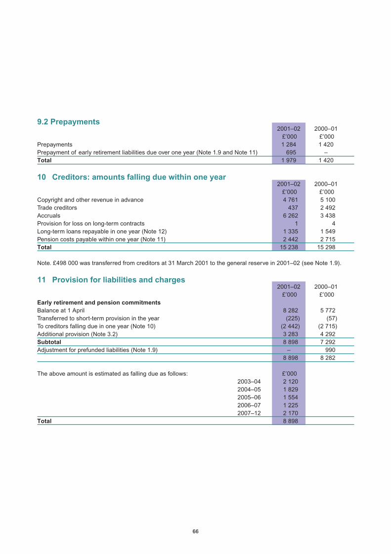
66
9.2 Prepayments2001–02 2000–01
£’000 £’000Prepayments 1 284 1 420Prepayment of early retirement liabilities due over one year (Note 1.9 and Note 11) 695 –Total 1 979 1 420
10 Creditors: amounts falling due within one year2001–02 2000–01
£’000 £’000Copyright and other revenue in advance 4 761 5 100Trade creditors 437 2 492Accruals 6 262 3 438Provision for loss on long-term contracts 1 4Long-term loans repayable in one year (Note 12) 1 335 1 549Pension costs payable within one year (Note 11) 2 442 2 715Total 15 238 15 298
Note. £498 000 was transferred from creditors at 31 March 2001 to the general reserve in 2001–02 (see Note 1.9).
11 Provision for liabilities and charges2001–02 2000–01
£’000 £’000Early retirement and pension commitmentsBalance at 1 April 8 282 5 772Transferred to short-term provision in the year (225) (57)To creditors falling due in one year (Note 10) (2 442) (2 715)Additional provision (Note 3.2) 3 283 4 292Subtotal 8 898 7 292Adjustment for prefunded liabilities (Note 1.9) – 990
8 898 8 282
The above amount is estimated as falling due as follows: £’0002003–04 2 1202004–05 1 8292005–06 1 5542006–07 1 2252007–12 2 170
Total 8 898

67
12 Long-term loans
Government loans, repayable by instalments, and bearing interestat rates between 4.75% and 4.875% per annum are: 2001–02 2000–01Amounts repayable: £’000 £’000In one year 1 335 1 549In two to five years 3 730 4 347After five years 7 288 8 006Total 12 353 13 902
13 Reserves
13.1 Reconciliation of movements in general reserve2001–02 2000–01
£’000 £’000At 1 April 41 483 14 013Prior year adjustment (Note 15) – (1 264)Sub total 41 483 12 749Surplus/(deficit) for the year (6 452) 28 580Pension costs – transfers to general reserve (Note 10) 498 597Fixed assets (Note 13.2) (209) (443)At 31 March 35 320 41 483
13.2 Revaluation reserves2001–02 2000–01
£’000 £’000Balance at 1 April 9 985 5 811Arising on revaluation during the year (net) 2 503 3 731General reserve transfer 209 443Balance at 31 March 12 697 9 985Net reserve movements in the yearTangible fixed assets 590 1 374Investment assets 1 913 2 357
Notes:The revaluation reserve represents the difference between the net book values of the fixed assets on a revalued andon a historic cost basis.
The transfer from the general reserve represents the enhanced depreciation on the current accounting basis over thehistoric cost depreciation charged during the year.

68
14 Gross cash flows
14.1 Financing charges and income2001–02 2000–01
£’000 £’000Interest received 1 768 1 895Interest paid (647) (751)Net interest 1 121 1 144
14.2 Capital expenditure
Payments to acquire tangible fixed assets 13 397 9 216Receipts from sales of tangible fixed assets (68) (67)Net capital expenditure 13 329 9 149
14.3 Investment expenditure
Share of PointX assets (72) –Loan 140 –Net investment 68 –
15 Prior year adjustment
2000–01In 2000–01 Ordnance Survey effected a change in accounting policy to reflect the apportionment of revenue in respectof data supplied to Superplan Agents in order to reflect the revenue over the period of the licences. These licencescover a period of twelve months from the supply of the data. As a result of this change debtors were decreased by£218 000 and creditors increased by £1 046 000. The effect of this change of accounting policy was a net increase inthe surplus for 2000–01 of £76 000.
16 Financial commitments2001–02 2000–01
£’000 £’000No provisions have been made in these accounts in respect of:Contracted capital commitments 441 2 460Capital authorised by Directors but not contracted 464 336Undrawn loan commitment – PointX (Note 7) 610 533
17 Operating lease commitments
At 31 March 2002 Ordnance Survey had annual commitments under non-cancellable operating leases as set outbelow:
Land and Buildings Other
2001–02 2000–01 2001–02 2000–01£’000 £’000 £’000 £’000
Within one year 443 223 264 403Between two and five years 348 427 636 607After five years 206 305 – –

69
18 Related partytransactions
Ordnance Survey is a governmentdepartment operating under aTrading Fund and is also anExecutive Agency. In the course of itsnormal business Ordnance Surveyprovides mapping data and copyrightto both the private and public sectors.During the year Ordnance Surveyhas had a significant number ofmaterial transactions with othergovernment departments and centralgovernment bodies. Most of thesetransactions have been with theDepartment for Transport, LocalGovernment and the Regions and itsExecutive Agencies; with HM LandRegistry; the Department of theEnvironment, Food and Rural Affairs;the Ministry of Defence and DefenceAgencies; and with the ScottishOffice and its Agencies. Income wasalso received from HM Customs andExcise (see Notes 1.3 and 2.5).
Ordnance Survey had materialtransactions with the Inland Revenueand Benefits Agency for payment ofrents and service charges whereOrdnance Survey occupiesaccommodation in buildings for whichthe Inland Revenue or BenefitsAgency is the major occupier.
As explained in Note 7, OrdnanceSurvey and PointX Ltd are relatedparties.
The framework agreement betweenOrdnance Survey and Greatstone UKLtd, referred to in Note 3.3 (d) above,involved payments for generalmanagement and IT services totalling£381 096. Mr Stephen Gapper, actingDirector of Digital Brands until 31October 2001, was a director of
Greatstone UK Ltd throughout theperiod of the framework agreement.No other Management Boardmembers, key management staff orother related parties has undertakenany material transactions withOrdnance Survey during the year.
19 Contingent liabilities
There were no contingent liabilities at31 March 2002.
20 Financial targets andresults
The financial objective for the year2001–02 was as follows:
Target AchievedTo achieve arevenue target(excluding £’000 £’000NIMSA) 85 600 86 643
The longer-term financial objective ofOrdnance Survey is to achieve anaverage annual return on capitalemployed (ROCE) on the surplus onordinary activities before interest ofat least 9% of net assets employedover the period 1 April 1999 to 31March 2004.
The operating surplus from1999–2000 to 2001–02, including theexceptional item referred to in Note2.2, represents a return on capitalemployed of 19.3% over the firstthree years of this five-year target(excluding the exceptional item itwould have been 10.7%).
The above information relates to therequirements of the OrdnanceSurvey Framework Document and theFees and Charges Guide and is notfor the purposes of SSAP 25.
Further background to the tradingyear is contained in the AnnualReport.
21 Losses, specialpayments and gifts
a Customer RelationshipManagementIn 2000–01 Ordnance Surveycommenced work on a CustomerRelationship Management (CRM)project at an estimated cost of£4 076 000 for the provision oftechnical and processinfrastructures supported by theformation of an integratedCustomer Service Centre. Theinfrastructure consisted of a suiteof Oracle® software applications.In October 2001 Directorsdecided to stop development onthe Oracle CRM suite as a resultof a related decision to implementa fully integrated technologyplatform for all business systemsin Ordnance Survey based onSAP software. Development ofthe Oracle CRM application wassuspended and Ordnance Surveyincurred a constructive loss of£2 084 000.
b In 2001–02 special paymentstotalling £65 000 were made tothree employees in respect ofcompensation in lieu of noticeand loss of employment
c Bad debt write-offs of £44 000were incurred in the year.
d Other costs falling into thecategory of losses, specialpayments and gifts were belowthe level, currently £100 000, atwhich they needed to be reportedseparately.

70
22 Financial Instruments
Ordnance Survey’s treasuryoperations are governed by theOrdnance Survey Trading Fund Order1999, under the Government’sTrading Fund Act 1973(a) assupplemented by the FrameworkDocument agreed with theDepartment for Transport, LocalGovernment and the Regions andapproved by HM Treasury.
Ordnance Survey’s financialinstruments comprise cash depositsand other items, such as tradedebtors, trade creditors andprovisions. The main purpose of thesefinancial instruments is to financeOrdnance Survey’s operations.
The main risks arising from OrdnanceSurvey’s financial instruments areliquidity and interest rate risks.
Ordnance Survey’s policies formanaging these risks are set toachieve compliance with theregulatory framework. OrdnanceSurvey does not have significantexposure to foreign currency risk.Hedging of foreign currency is notundertaken.
Interest rate riskOrdnance Survey finances itsoperations through retained profits. Inexceptional circumstances OrdnanceSurvey may also be funded byadditional monies from government tofund specific investments. Sumsretained in the business but surplus toimmediate requirements are depositedin a short-term interest bearingaccount with the National Loans Fund.
Liquidity riskOrdnance Survey has maintainedshort-term liquidity throughout the
year by management of its cashdeposits. Ordnance Survey mayborrow such sums as it may requireto meet its working capital needs andfinance its capital investmentprogramme. Borrowing for in-yearfluctuations is subject to a temporaryborrowing limit agreed with HMTreasury. Such loans are normallyrepayable in year.
Short-term debtors and creditors areexcluded from the followingdisclosures.
Interest rate risk profileThe interest rate profile of OrdnanceSurvey’s financial assets andliabilities at 31 March 2002 are setout below. All balances are held insterling:
Financial assetsFixed Rate Floating rate Total
31 March 2002£’000 £’000 £’000
Cash on deposit – 29 000 29 000Loan to PointX (note 7) – – 140
Cash on deposit at 31 March 2002 consists of four short-term loans to the National Loans Fund for a weightedaverage period of 98.8 days at a weighted average interest rate of 3.94 per cent.Details of the interest-free loan to PointX are contained in Note 7.
Financial liabilitiesFixed Rate Floating rate Total
31 March 2002£’000 £’000 £’000
Government loans (note 12) 12 353 – 12 353
The fair value of all assets and liabilities approximates to book value.

71
1. This direction applies toOrdnance Survey.
2. Ordnance Survey shall prepareaccounts for the financial yearending 31 March 2002 incompliance with the accountingprinciples and disclosurerequirements of the edition ofTrading Funds – AccountsGuidance issued by HM Treasury(the Guidance) which is in forcefor 200l–02.
3. The accounts shall be preparedso as to give a true and fair viewof the income and expenditure,total recognised gains and losses,and cash flows of OrdnanceSurvey, and of the state of affairsas at 31 March 2002.
4. Compliance with the requirementsof the Guidance will, in all butexceptional circumstances, benecessary for the accounts to givea true and fair view. If, in theseexceptional circumstances,compliance with the requirements
Accounts Direction given by the Treasuryin accordance with Section 4(6)(a) of theGovernment Trading Funds Act 1973.
of the Guidance is inconsistentwith the requirement to give a trueand fair view, the requirements ofthe Guidance should be departedfrom only to the extent necessaryto give a true and fair view. Insuch cases, informed andunbiased judgement should beused to devise an appropriatealternative treatment that shouldbe consistent with both theeconomic characteristics of thecircumstances concerned and thespirit of the Guidance. Anymaterial departure from theGuidance should be discussed inthe first instance with theTreasury.
David LowethHead of the Central AccountancyTeam, Her Majesty’s Treasury
18 February 2002

72
1. Section 4(1) of the GovernmentTrading Funds Act 1973 providesthat a trading fund establishedunder that Act shall be under thecontrol and management of theresponsible Minister and indischarge of his function inrelation to the fund it shall be hisduty:
(a) to manage the funded operationsso that the revenue of the fund:
(i) consists principally of receipts inrespect of goods or servicesprovided in the course of thefunded operations; and
(ii) is not less than sufficient, takingone year with another, to meetoutgoings which are properlychargeable to revenue account;and
(b) to achieve such further financialobjectives as the Treasury mayfrom time to time, by Minute laidbefore the House of Commons,indicate as having beendetermined by the responsibleMinister (with Treasuryconcurrence) to be desirable ofachievement.
Treasury minute dated29 March 1999
2. The Trading Fund for OrdnanceSurvey will be established on 1April 1999 under the OrdnanceSurvey Trading Fund Order 1999(SI 1999 No. 965).
3. The Secretary of State for theEnvironment, Transport and theRegions, being the responsibleMinister, has determined (withTreasury concurrence) that afurther financial objectivedesirable of achievement byOrdnance Survey Trading Fundfor the period from 1 April 1999 to31 March 2004 shall be toachieve a return averaged overthe period as a whole, of at least9 per cent, in the form of asurplus on ordinary activitiesbefore interest expressed as apercentage of average capitalemployed. Capital employed shallequate to the total assets fromwhich shall be deducted the totalof the current liabilities.
4. Let a copy of this Minute be laidbefore the House of Commonspursuant to section 4(1)(b) of theGovernment Trading Funds Act1973.

Written, designed and printed byOrdnance Survey, Romsey Road,SOUTHAMPTON, United Kingdom,SO16 4GU.
Printed in the UK for The Stationery OfficeLimited on behalf of the Controller of HerMajesty’s Stationery Office
07/02
Phone: 08456 05 05 05(calls charged at local rate)Textphone: 023 8079 2906(hearing impaired users only please)Fax: 023 8079 2615Email: [email protected] site: www.ordnancesurvey.co.uk
Trademark acknowledgement
Ordnance Survey, the OS Symbol, ADDRESS-POINT,askGIraffe, Code-Point, DNF, Land-Line,Land-Line.Plus, Landranger, NLUD, Pathfinder andSuperplan are registered trademarks andDigital National Framework, Explorer, Get-a-map,MapZone, Meridian, OS, OS MasterMap, OS Select,Our Favourite Places, Outdoor Leisure, Pre-Build,PRISM, Routeplanner and TOID are trademarks ofOrdnance Survey, the national mapping agency ofGreat Britain.
Abbey National is a registered trademark of AbbeyNational plc. Autodesk is a registered trademark ofAutodesk Incorporated. Barclays is a registeredtrademark of Barclays Bank plc. Centrica is aregistered trademark of GB Gas Holdings Ltd. Digimapand Edina are registered trademarks of the Universityof Edinburgh. East Midlands Electricity and PowerGenare registered trademarks of The Power GenerationCompany. EuroGeographics is a registered trademarkof EuroGeographics. Flemings is a registeredtrademark of JP Morgan Chase & Co. John Lewis is aregistered trademark of John Lewis plc. Kelloggs is aregistered trademark of Kellogg Company. Milupa is aregistered trademark of Nutricia International BV.Oracle is a registered trademark of Oracle Corporation.PointX is a registered trademark of PointX Ltd. SAP isa registered trademark of SAP AktiengesellschaftSysteme. Siemens is a registered trademark ofSiemens Aktiengesellschaft. Sun is a registeredtrademark of Sun Microsystems, Incorporated. Trimbleis a registered trademark of Trimble Navigation Ltd.Windows is a registered trademark of MicrosoftCorporation.
Ordnance Survey acknowledges all other trademarks.
© Crown copyright

Annual Report and Accounts2001-2002
Delivering data to benefit Britain
Published by TSO (The Stationery Office)and available from:Onlinewww.tso.co.uk/bookshop
Mail, Telephone, Fax & E-mailTSOPO Box 29, Norwich NR3 1GNTelephone orders/General enquiries 0870 600 5522Fax orders 0870 600 5533Order through the Parliamentary Hotline Lo-call 0845 7 023474E-mail [email protected] 0870 240 3701
TSO Shops123 Kingsway, London WC2B 6PQ020 7242 6393 Fax 020 7242 639468-69 Bull Street, Birmingham B4 6AD0121 236 9696 Fax 0121 236 96999-21 Princess Street, Manchester M60 8AS0161 834 7201 Fax 0161 833 063416 Arthur Street, Belfast BT1 4GD028 9023 8451 Fax 028 9023 540118-19 High Street, Cardiff CF10 1PT029 2039 5548 Fax 029 2038 434771 Lothian Road, Edinburgh EH3 9AZ0870 606 5566 Fax 0870 606 5588
The Parliamentary Bookshop12 Bridge Street, Parliament Square,London SW1A 2JXTelephone orders/General enquiries 020 7219 3890Fax orders 020 7219 3866
TSO Accredited Agents(see Yellow Pages)
and through good booksellers