Embed Size (px)
Citation preview
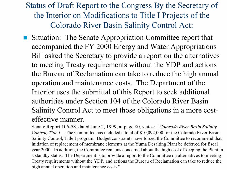
Status of Draft Report to the Congress By the Secretary of the Interior on Modifications to Title I Projects of the
Colorado River Basin Salinity Control Act:Situation: The Senate Appropriation Committee report that accompanied the FY 2000 Energy and Water Appropriations Bill asked the Secretary to provide a report on the alternativesto meeting Treaty requirements without the YDP and actions the Bureau of Reclamation can take to reduce the high annual operation and maintenance costs. The Department of the Interior uses the submittal of this Report to seek additional authorities under Section 104 of the Colorado River Basin Salinity Control Act to meet those obligations in a more cost-effective manner. Senate Report 106-58, dated June 2, 1999, at page 80, states: "Colorado River Basin Salinity Control, Title I. --The Committee has included a total of $10,092,000 for the Colorado River Basin Salinity Control, Title I program. Budget constraints have forced the Committee to recommend that initiation of replacement of membrane elements at the Yuma Desalting Plant be deferred for fiscal year 2000. In addition, the Committee remains concerned about the high cost of keeping the Plant in a standby status. The Department is to provide a report to the Committee on alternatives to meeting Treaty requirements without the YDP, and actions the Bureau of Reclamation can take to reduce the high annual operation and maintenance costs."
Draft Yuma Desalting Plant Report by the Secretary of the Interior Report to the Congress -- continued
Note: The U.S. and Mexican Sections of the International Boundary and Water Commission approved Minute No. 242 on August 30, 1973. The Minute amended the 1944 Mexican Water Treaty when approved by the governments of both countries. The agreed upon salinity management objective was to remove the influence of the Wellton-Mohawk I&DD saline agricultural drainage water from the water delivered to Mexico at the Northerly International Boundary (NIB). The WMIDD drainage water is shunted to the Cienega de Santa Clara through the Main Outlet Drain Extension (MODE). The remaining Yuma area agricultural drainage water continues to be included in the NIB deliveries. Minute 242 recognizes the drainage water reaching the River increases the River salinity as it flows from Imperial Dam to the NIB. The amount and concentration of that Yuma area drainage varies from year to year. The agreed-upon salinity management was to limit the increase in the flow-weighted average annual salinity between Imperial Dam and the NIB to no more than 115 parts per million (ppm), +/- 30 ppm.
Draft Yuma Desalting Plant Report by the Secretary of the Interior Report to the Congress -- continued
The seven Colorado River Basin States have submitted comments on the draft report by Interior to the Congress. The States’comments reflect agreement that:– The first priority needs to be obtaining full operational readiness of the
Yuma Desalting Plant (YDP) as soon as practicable, recognizing that additional Congressional appropriations need to be obtained to correct deficiencies, get the YDP fully operational and to operate the Plant.
– The YDP is the primary measure authorized by Congress to minimize adverse effects on the use of Colorado River water. It continues to be the only permanent and definitive solution that provides protection to U.S. water supplies and improves the water quality of return flows so that they can be beneficially used by Mexico.
– On account of the full use of the Lower Division States’ entitlements within years in which a “normal water supply” determination has been made, little opportunity exists to lease water, e.g. enter into forbearance agreements, without competing with water users in those States.
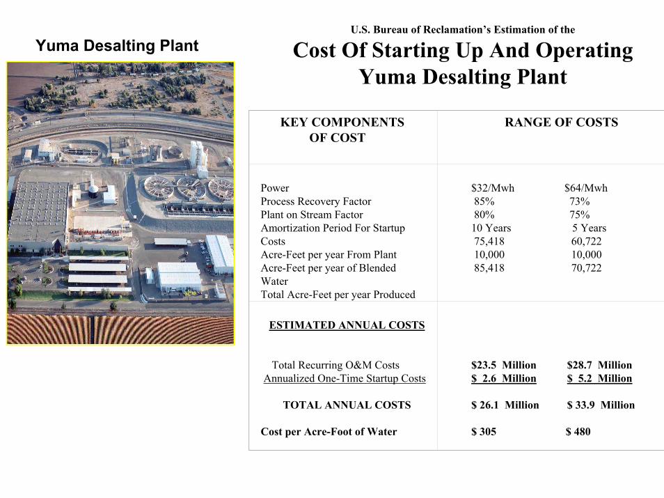
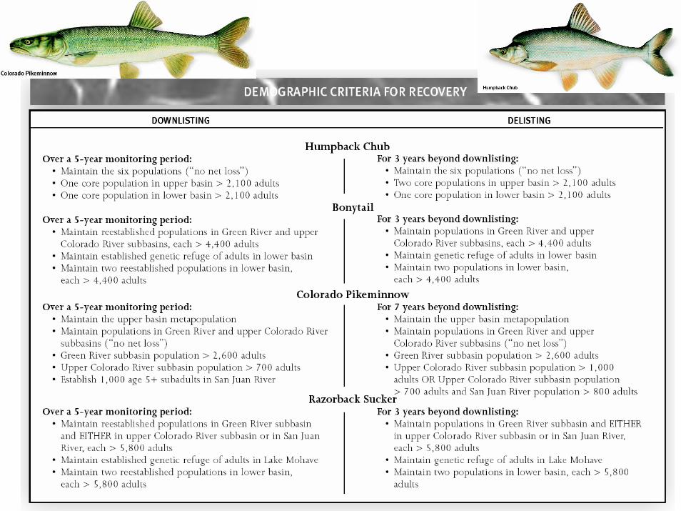
Yuma Desalting Plant
KEY COMPONENTSOF COST
RANGE OF COSTS
PowerProcess Recovery FactorPlant on Stream FactorAmortization Period For Startup CostsAcre-Feet per year From PlantAcre-Feet per year of Blended WaterTotal Acre-Feet per year Produced
$32/Mwh $64/Mwh85% 73%80% 75%10 Years 5 Years75,418 60,72210,000 10,00085,418 70,722
ESTIMATED ANNUAL COSTS
Total Recurring O&M CostsAnnualized One-Time Startup Costs
TOTAL ANNUAL COSTS
Cost per Acre-Foot of Water
$23.5 Million $28.7 Million$ 2.6 Million $ 5.2 Million
$ 26.1 Million $ 33.9 Million
$ 305 $ 480
U.S. Bureau of Reclamation’s Estimation of the
Cost Of Starting Up And OperatingYuma Desalting Plant
Draft Yuma Desalting Plant Report by the Secretary of the Interior Report to the Congress -- continued
Bottom Line: USBR doesn’t want to operate the YDP due to operating expense – its is proposing leasing water from willing sellers on a year-to-year basis to provide a replacement water supply to offset the MODE flows Potential Sources Of Replacement Water To Meet Title I Objectives Presented in the Draft Report:– Forbearance Agreements (USBR’s main emphasis)– Non-system Supplies From Groundwater & Other
Sources– Investing In Advanced Irrigation Techniques To Reduce
Use [as was done with the Wellton-Mohawk Irrigation and Drainage District to reduce saline agricultural drainage flow volumes]
Minute No. 306 to the Mexican Water Treaty
CONCEPTUAL FRAMEWORK FORUNITED STATES - MEXICO STUDIES FOR FUTURE
RECOMMENDATIONS CONCERNING THE RIPARIAN AND ESTUARINE ECOLOGY OF THE LIMITROPHE
SECTION OF THE COLORADO RIVER AND ITS ASSOCIATED DELTA
Signed December 12, 2000 by the Commissioners of the United States and Mexican Sections of the
International Boundary and Water CommissionDepartment of State
Minute No. 306 provides:The IBWC will establish a framework for cooperation by the United States and Mexico in developing binational studies, including possible approaches to ensure use of water for ecological purposes, and recommend cooperative projects in the interests ofboth governments in preserving the riparian and estuarine ecology of the Colorado River boundary segment and delta.
The IBWC will examine the effect of flows on the existing riparian and estuarine ecology of the Colorado River boundary segment anddelta with a focus on defining the habitat needs of species of concern to each country. This work will be carried out through an existing binational technical task force that was established tofacilitate studies related to the Colorado River delta and SantaClara Slough.
The IBWC will establish a forum for the exchange of information and advice among government and non-government organizations in the United States and Mexico.
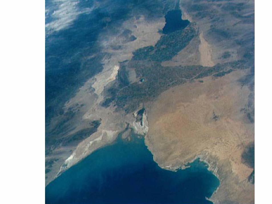
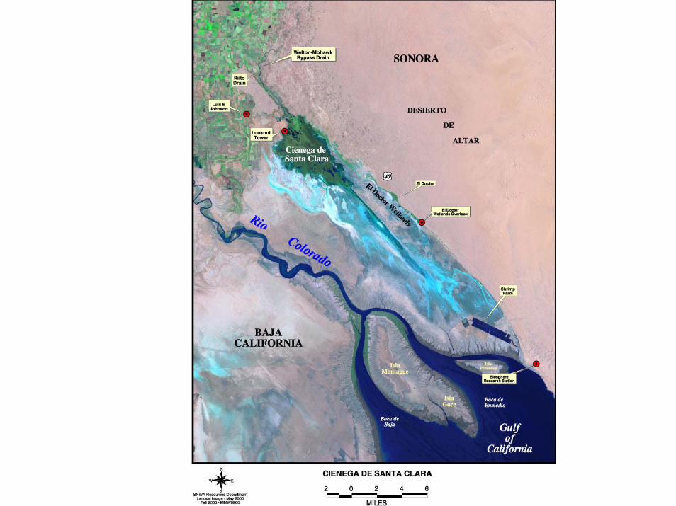
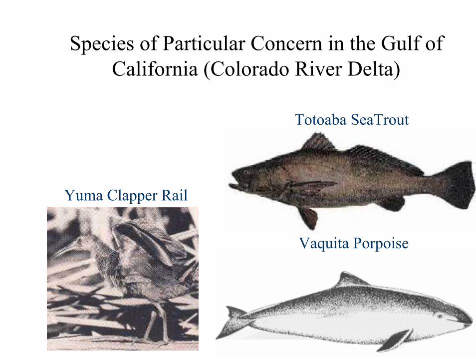
Species of Particular Concern in the Gulf of California (Colorado River Delta)
Vaquita Porpoise
Totoaba SeaTrout
Yuma Clapper Rail
Mapping Conservation Priorities in the Colorado River Delta: A State-of-Knowledge Workshop was held on October 15-17, 2002
Centro de Investigación en Alimentación y Desarrollo (CIAD), Environmental Defense, the Sonoran Institute, and the University of Arizona brought a bi-national group of experts, scientists with on-the-ground experience in the Delta and residents with local knowledge of together again in a highly focused workshop to develop a “map of the possible.” The goal of this project is to synthesize existing information to guide conservation goals in the lower delta over the next twodecades. From the workshop we will develop a suite of products, including a map, a GIS database, workshop proceedings, and an interactive website that allows users to explore the GIS database.
Representatives of the Basin States were invited to participate in the Workshop as “observers.” Larry Anderson of the Utah Division of Water Resources and Wayne Cook of the Upper Colorado River Commission attended and represented the Upper Basin States.
Held as a follow-on to the Bi-National Educational Symposium held on September 11-12, 2001 at the University of Baja-California in Mexicali, Mexico.
Mapping Conservation Priorities in the Colorado River Delta: A State-of-Knowledge Workshop was held on October 15-17, 2002
Workshop held “to complete three key aspects of the map:1. Ecological assessment of specific sites within each delta ecosystem type, including: a. risk potential, specifically related to possible depletion
of water and/or possible inundation with too much water (e.g. scouring from floods), vegetation clearing, and water quality; and
b. restoration potential based on habitat fragment size, relation to wildlife corridors, distance from the Colorado River, and proportion of native to non-native species.
2. A hydrologic component that indicates the quantity, quality, and timing of water flows required to support each habitat type. 3. A gap analysis identifying additional research needs for developing a detailed restoration plan.”
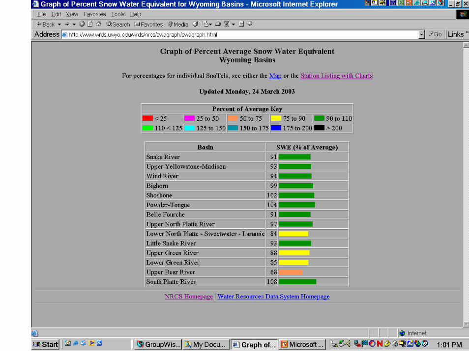
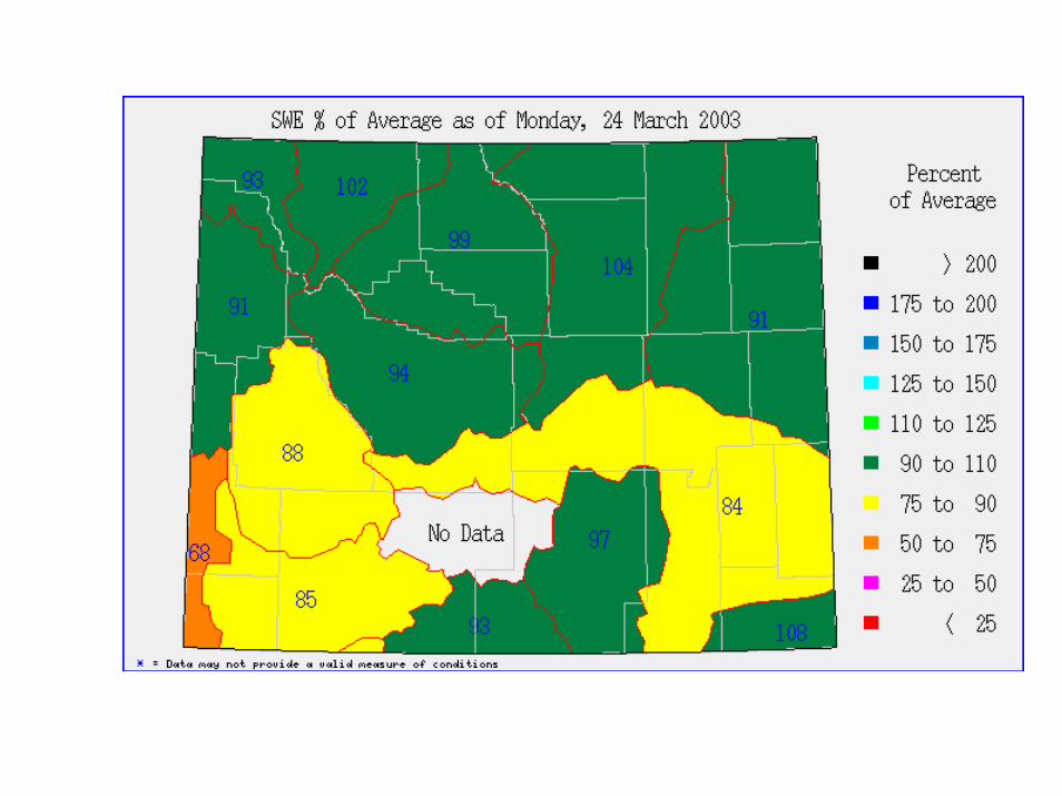
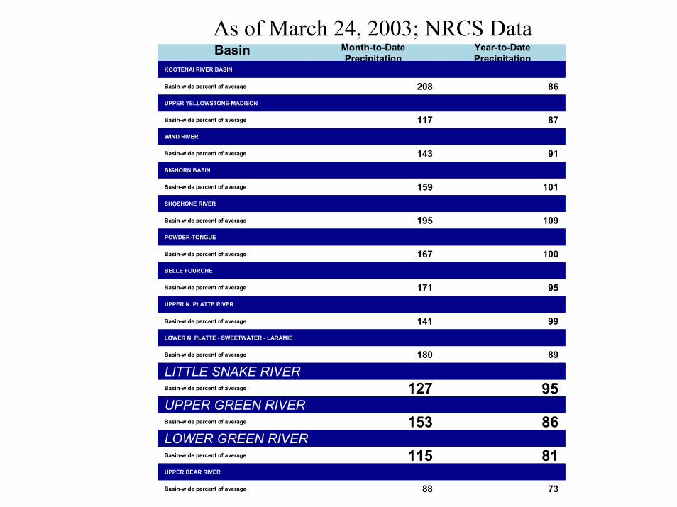
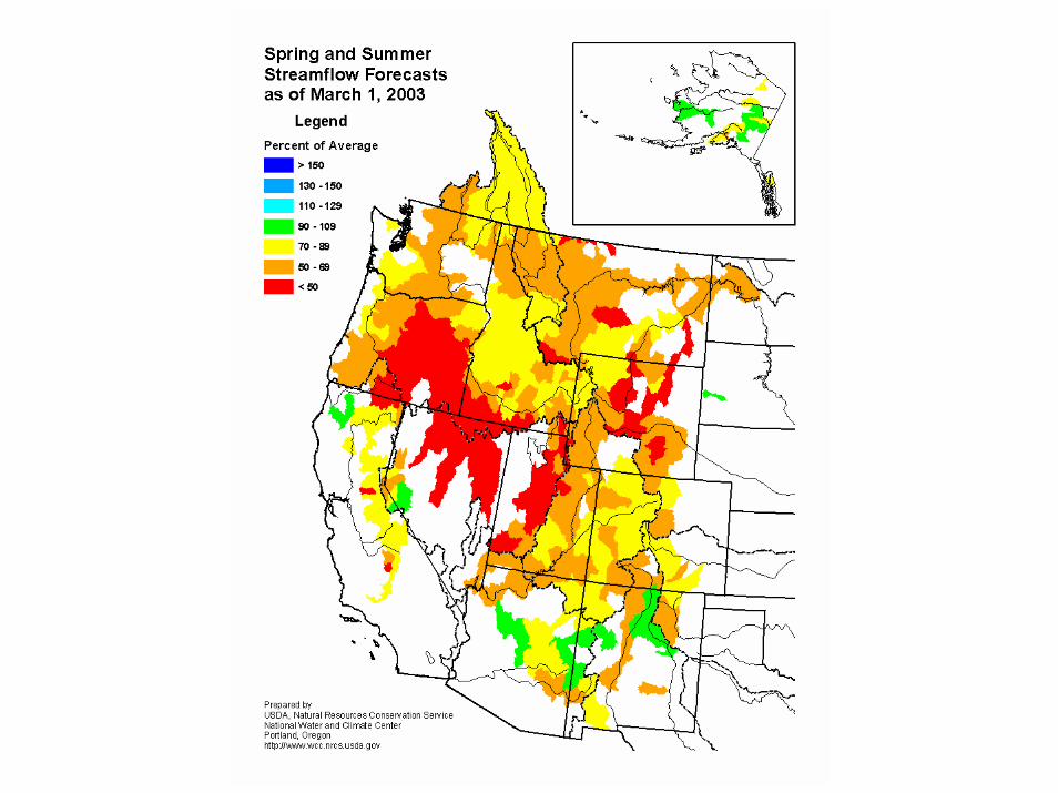
As of March 24, 2003; NRCS DataBasin Month-to-Date
PrecipitationYear-to-Date Precipitation
KOOTENAI RIVER BASIN
Basin-wide percent of average 208 86UPPER YELLOWSTONE-MADISON
Basin-wide percent of average 117 87WIND RIVER
Basin-wide percent of average 143 91 BIGHORN BASIN
Basin-wide percent of average 159 101 SHOSHONE RIVER
Basin-wide percent of average 195 109POWDER-TONGUE
Basin-wide percent of average 167 100BELLE FOURCHE
Basin-wide percent of average 171 95UPPER N. PLATTE RIVER
Basin-wide percent of average 141 99 LOWER N. PLATTE - SWEETWATER - LARAMIE
Basin-wide percent of average 180 89
LITTLE SNAKE RIVERBasin-wide percent of average 127 95UPPER GREEN RIVERBasin-wide percent of average 153 86LOWER GREEN RIVERBasin-wide percent of average 115 81UPPER BEAR RIVER
Basin-wide percent of average 88 73