Embed Size (px)
Citation preview
")
")") ")")
##
_̂
_̂
_̂!(
!(
!(
!(!(
!(
!(
!(
!(
!(
!(
!(
!(
FORT BEND COUNTY
WALLER COUNTY
LIBERTY COUNTY
MONTGOMERY COUNTY
BRAZORIA COUNTY
GALVESTON COUNTY
CHAMBERS COUNTY
§̈¦10
§̈¦45
§̈¦610
§̈¦45£¤290
£¤59
£¤59
!(6
!(3
!(225!(146
!(288
!(249
!(35
!(6
!(249
z{8
z{H
z{WP
%,8
µ
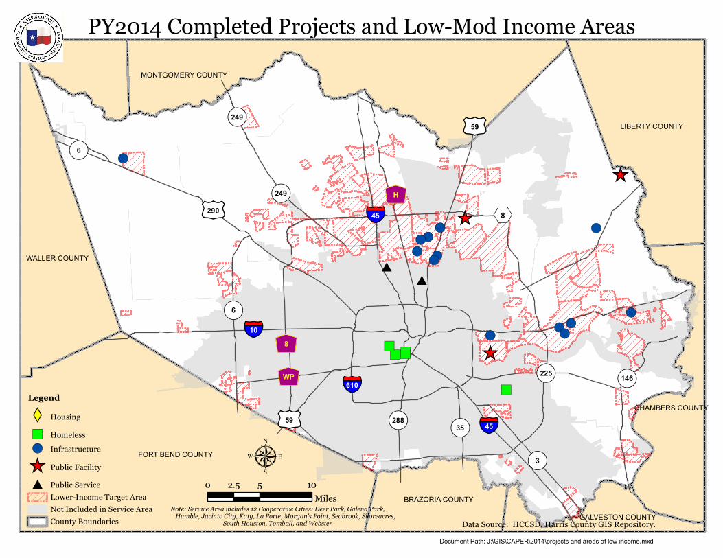
PY2014 Completed Projects and Low-Mod Income Areas
Legend
XW Housing") Homeless!( Infrastructure
_̂ Public Facility# Public Service
Lower-Income Target AreaNot Included in Service AreaCounty Boundaries
0 5 102.5Miles
Note: Service Area includes 12 Cooperative Cities: Deer Park, Galena Park, Humble, Jacinto City, Katy, La Porte, Morgan's Point, Seabrook, Shoreacres,
South Houston, Tomball, and Webster Data Source: HCCSD, Harris County GIS Repository.Document Path: J:\GIS\CAPER\2014\projects and areas of low income.mxd
")
")") ")")
##
_̂
_̂
_̂!(
!(
!(
!(!(
!(
!(
!(
!(
!(
!(
!(
!(
FORT BEND COUNTY
WALLER COUNTY
LIBERTY COUNTY
MONTGOMERY COUNTY
BRAZORIA COUNTY
GALVESTON COUNTY
CHAMBERS COUNTY
§̈¦10
§̈¦45
§̈¦610
§̈¦45£¤290
£¤59
£¤59
!(6
!(3
!(225!(146
!(288
!(249
!(35
!(6
!(249
z{8
z{H
z{WP
%,8
µ
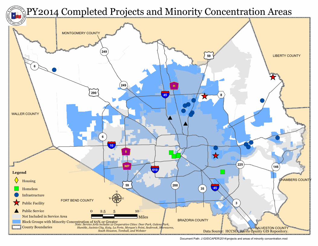
PY2014 Completed Projects and Minority Concentration Areas
Legend
XW Housing") Homeless!( Infrastructure
_̂ Public Facility# Public Service
Not Included in Service AreaBlock Groups with Minority Concentration of 65% or GreaterCounty Boundaries
0 5 102.5Miles
Note: Service Area includes 12 Cooperative Cities: Deer Park, Galena Park, Humble, Jacinto City, Katy, La Porte, Morgan's Point, Seabrook, Shoreacres,
South Houston, Tomball, and Webster Data Source: HCCSD, Harris County GIS Repository.Document Path: J:\GIS\CAPER\2014\projects and areas of minority concentration.mxd
XW
XW
XW
XW
XW
XW
XW
XW
XW
XW
XW
XW
XW
XW
XW
XW
XW
XW
XW
XW
XW
XW
XW
XW
XW
XW
XW
XWXWXW
XWXW
XW
XW
XW
XW
XW
XW
XWXW
XW
XW
XW
XW
XW
XW
XW
XW
XW
XW
XW
XW
XW
XW
XW
XW
XW
XW
XW
XW
XW
XW
XW XW
XWXW
XW
XW
XW
FORT BEND COUNTY
WALLER COUNTY
LIBERTY COUNTY
MONTGOMERY COUNTY
BRAZORIA COUNTY
GALVESTON COUNTY
CHAMBERS COUNTY
§̈¦10
§̈¦45
§̈¦610
§̈¦45£¤290
£¤59
£¤90
£¤59
!(6
!(3
!(225!(146
!(288
!(249
!(35
!(6
!(249
z{8
z{H
z{WP
%,8
µ
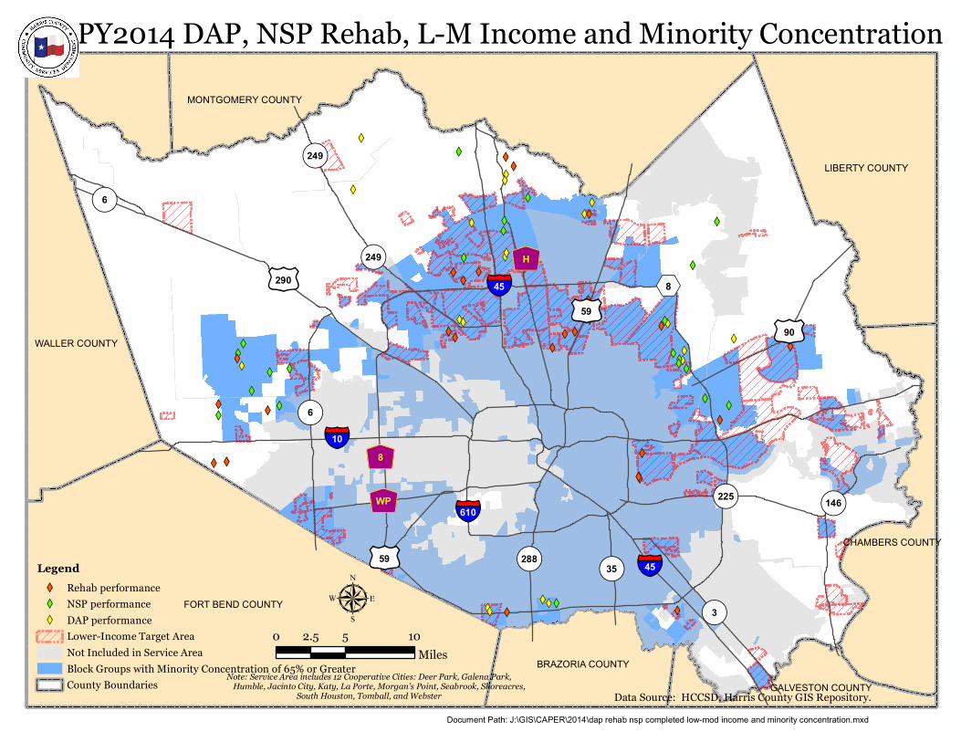
PY2014 DAP, NSP Rehab, L-M Income and Minority Concentration
LegendXW Rehab performanceXW NSP performanceXW DAP performance
Lower-Income Target AreaNot Included in Service AreaBlock Groups with Minority Concentration of 65% or GreaterCounty Boundaries
0 5 102.5Miles
Note: Service Area includes 12 Cooperative Cities: Deer Park, Galena Park, Humble, Jacinto City, Katy, La Porte, Morgan's Point, Seabrook, Shoreacres,
South Houston, Tomball, and Webster Data Source: HCCSD, Harris County GIS Repository.Document Path: J:\GIS\CAPER\2014\dap rehab nsp completed low-mod income and minority concentration.mxd
RICE
KIRBY
LAKE
KELV
IN
UNIVERSITY
PLUMB
GREENBRIAR
WAKEFOREST
MORN
INGS
IDE
AMHERST
TIMES
QUENBY
ANNAPOLIS
FORDHAM
SHAKESPEARE
DUNSTAN
CHARLOTTE
BOLSOVER
FENWOOD
ROBINHOOD
WHITNEY
CHAUCERTANGLEY
JARRARD
LAFAYETTE
GEORGETOWN
BROMPTON
ROBINHOOD
AMHERST
TANGLEY
BOLSOVER
ROBINHOOD
QUENBY
DUNSTAN
ROBINHOODQUENBY
ANNAPOLIS
TANGLEY
TANGLEY
Precinct 1Precinct 3
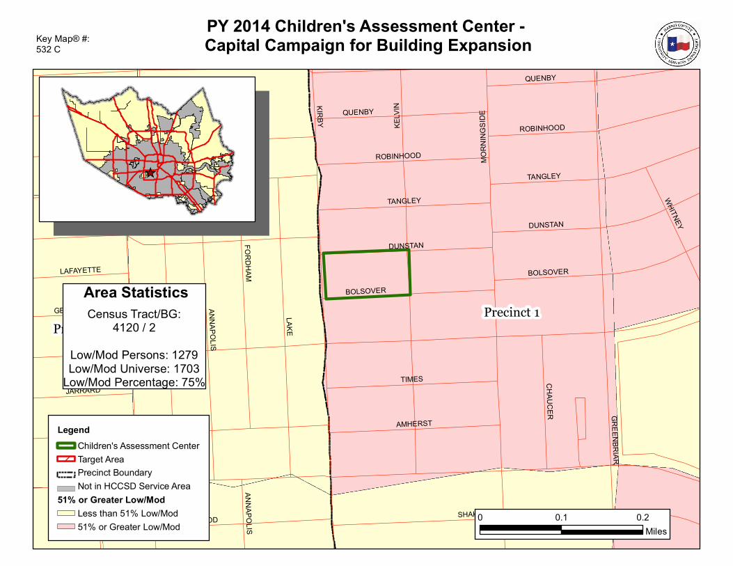
PY 2014 Children's Assessment Center - Capital Campaign for Building Expansion
LegendChildren's Assessment CenterTarget AreaPrecinct BoundaryNot in HCCSD Service Area
51% or Greater Low/ModLess than 51% Low/Mod51% or Greater Low/Mod
0 0.1 0.2Miles
Key Map® #: 532 C
_̂
Area StatisticsCensus Tract/BG:
4120 / 2Low/Mod Persons: 1279Low/Mod Universe: 1703
Low/Mod Percentage: 75%
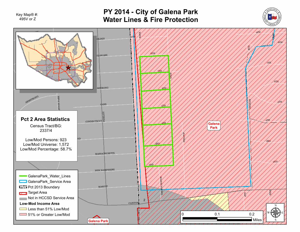
Galena Park
GalenaPark
CLINTON
CRAI
G
6TH
8TH
SAGE
9TH
4TH
7THPENNSYLVANIA
7TH
9TH
FIDEL
ITY
2ND
AVE K
RHODE ISLAND
MIDWAY
BANK
CLIN
TON
PARK
8TH
PINE
4TH
GRAH
AM
BOLDEN
DELAWARE
GANS
6TH
5TH
8TH
4TH
3RD
CONNECTICUT
MASSACHUSETTS
ARMSTRONG
MASCOT
NEW HAMPSHIRE
GALE
NA M
ANOR
5TH
GANS
2ND
3RD
DE HAVEN
BOLDEN
ARMSTRONG
PHIL
POP
1
2
PY 2014 - City of Galena ParkWater Lines & Fire Protection
GalenaPark_Water_LinesGalenaPark_Service AreaPct 2013 BoundaryTarget AreaNot in HCCSD Service Area
Low-Mod Income AreaLess than 51% Low/Mod51% or Greater Low/Mod
Key Map® #: 495V or Z
_̂
µ0 0.1 0.2Miles
Pct 2 Area StatisticsCensus Tract/BG:
2337/4Low/Mod Persons: 923
Low/Mod Universe: 1,572Low/Mod Percentage: 58.7%
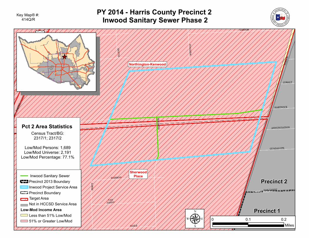
Northington-Kenwood
SherwoodPlace
£¤59
PERC
Y
WEST
WAY
EAST
EXUS
59
HARMON
CHARWONEAST
EX
MIERIANNE
COBALT
HARTWICK
ILLEN
E
HIRS
CH
ANNUNCIATION
GUADALUPE
US 59
-EAST
EX; H
OPPE
R
VAN ZANDT
ALLW
OOD
GASTON
HAILE
VANZANDT
US 59
HOV
US 59
EAST
EX-U
S 59;
HOPP
ERGASTON
Precinct 1Precinct 1
Precinct 2Precinct 2
PY 2014 - Harris County Precinct 2 Inwood Sanitary Sewer Phase 2
Inwood Sanitary SewerPrecinct 2013 Boundary Inwood Project Service AreaPrecinct BoundaryTarget AreaNot in HCCSD Service Area
Low-Mod Income AreaLess than 51% Low/Mod51% or Greater Low/Mod
Key Map® #: 414Q/R
µ 0 0.1 0.2Miles
Pct 2 Area StatisticsCensus Tract/BG:
2317/1; 2317/2Low/Mod Persons: 1,689Low/Mod Universe: 2,191
Low/Mod Percentage: 77.1%
_̂
TELGE RD
CYPRESS N
HOUSTON RD
JARVIS RD
HUFF
MEIST
ER RD
SKIN
NERR
D
QUEE
N STO
NBL
VD
WHISPERINGVALLEY DR
CYPRESS NHOUSTON BLVD
BARK
ERCY
PRES
S RD
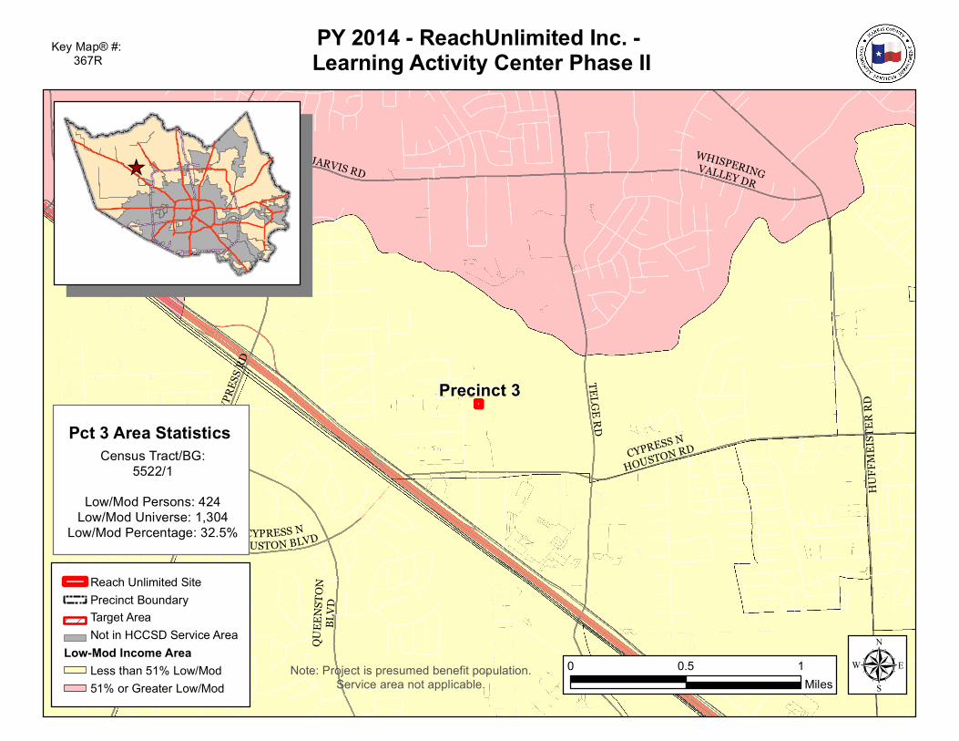
Precinct 3Precinct 3
PY 2014 - ReachUnlimited Inc. - Learning Activity Center Phase II
Reach Unlimited SitePrecinct BoundaryTarget AreaNot in HCCSD Service Area
Low-Mod Income AreaLess than 51% Low/Mod51% or Greater Low/Mod
Key Map® #: 367R
_̂
µ0 0.5 1Miles
Pct 3 Area StatisticsCensus Tract/BG:
5522/1Low/Mod Persons: 424
Low/Mod Universe: 1,304Low/Mod Percentage: 32.5%
Note: Project is presumed benefit population. Service area not applicable.
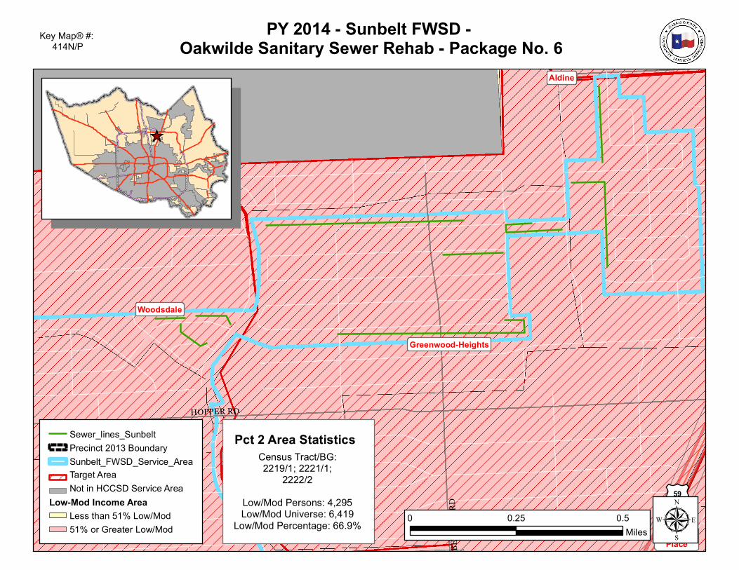
Aldine
Greenwood-Heights
SherwoodPlace
Woodsdale
£¤59
BENT
LEY R
D
HOPPER RD
PY 2014 - Sunbelt FWSD - Oakwilde Sanitary Sewer Rehab - Package No. 6
Sewer_lines_SunbeltPrecinct 2013 BoundarySunbelt_FWSD_Service_AreaTarget AreaNot in HCCSD Service Area
Low-Mod Income AreaLess than 51% Low/Mod51% or Greater Low/Mod
Key Map® #: 414N/P
_̂
µ0 0.25 0.5Miles
Pct 2 Area StatisticsCensus Tract/BG:2219/1; 2221/1;
2222/2Low/Mod Persons: 4,295Low/Mod Universe: 6,419
Low/Mod Percentage: 66.9%
Greenwood-Heights
SherwoodPlace
£¤59
2
CEDARHILL
KEITH
WILL
IE MOCK
CENT
RAL
CEDARHILL
ROSEMARY
SHELTON
HANLEY
MOHAWK
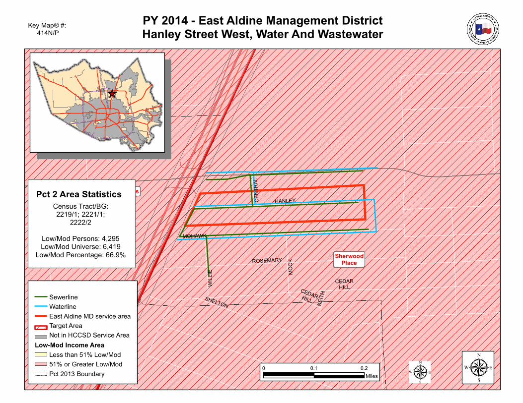
PY 2014 - East Aldine Management DistrictHanley Street West, Water And Wastewater
SewerlineWaterlineEast Aldine MD service areaTarget AreaNot in HCCSD Service Area
Low-Mod Income AreaLess than 51% Low/Mod51% or Greater Low/ModPct 2013 Boundary
Key Map® #: 414N/P
µ0 0.1 0.2Miles
Pct 2 Area StatisticsCensus Tract/BG:2219/1; 2221/1;
2222/2Low/Mod Persons: 4,295Low/Mod Universe: 6,419
Low/Mod Percentage: 66.9%
_̂
µ